13
www.dendrochronicle.co.uk Hidden Heritage of a Landscape: Woodland Heritage & Dendrochronology at Arrochar Coralie M Mills October 2013

www.dendrochronicle.co.uk
Hidden Heritage of a Landscape:
Woodland Heritage & Dendrochronology at Arrochar
Coralie M Mills
October 2013

Hidden Heritage of a Landscape: Woodland Heritage & Dendrochronology at Arrochar
Prepared for Hidden Heritage Project: Arrochar and Tarbet Community Development Trust
Author Coralie M Mills
Project No. 84
Date of Report October 2013
Enquiries to Dr Coralie Mills
Dendrochronicle 31/3 Brighton Place Portobello Edinburgh EH15 1LL T: 0131 258 3199 M: 07549 180666 W: www.dendrochronicle.co.uk E: [email protected]
Woodland Heritage & Dendrochronology at Arrochar | Mills 2013
w w w . d e n d r o c h r o n i c l e . c o . u k P a g e | 1
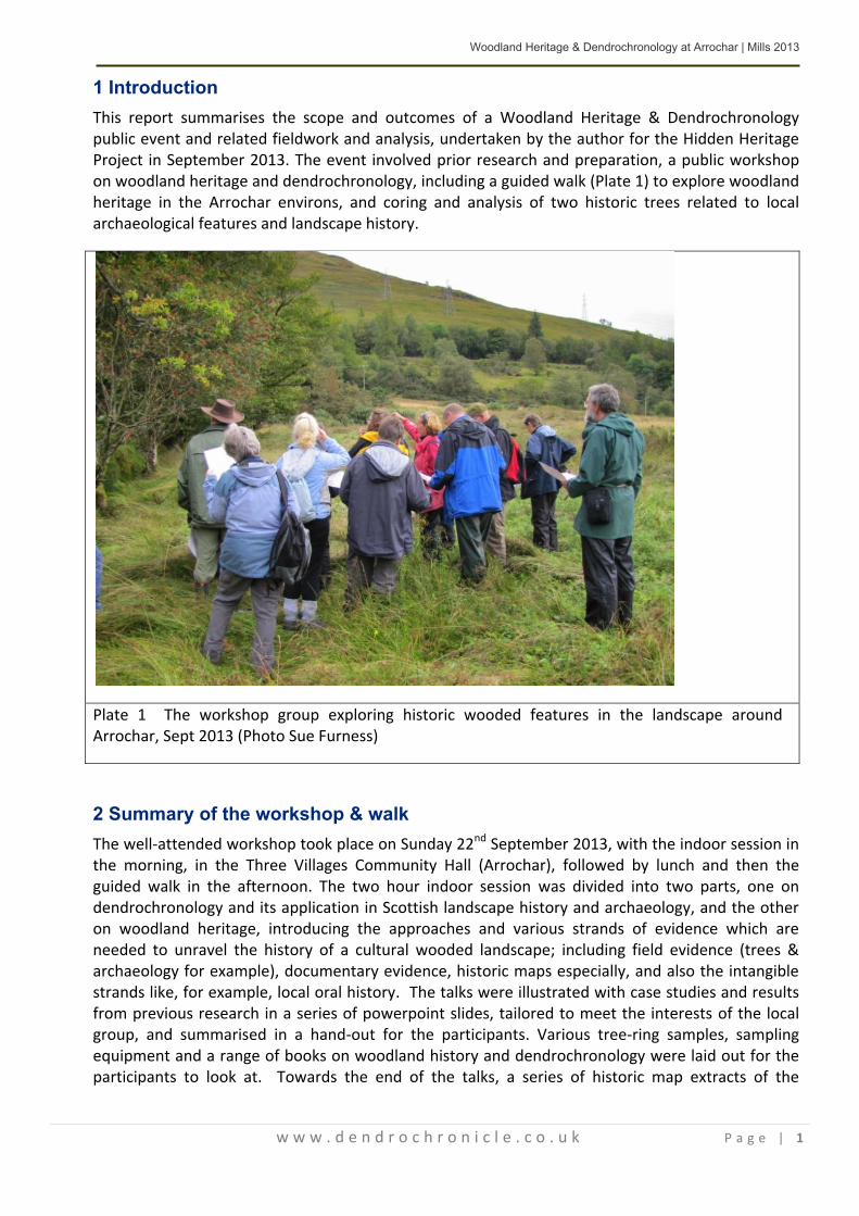
1 Introduction This report summarises the scope and outcomes of a Woodland Heritage & Dendrochronology public event and related fieldwork and analysis, undertaken by the author for the Hidden Heritage Project in September 2013. The event involved prior research and preparation, a public workshop on woodland heritage and dendrochronology, including a guided walk (Plate 1) to explore woodland heritage in the Arrochar environs, and coring and analysis of two historic trees related to local archaeological features and landscape history.
Plate 1 The workshop group exploring historic wooded features in the landscape around Arrochar, Sept 2013 (Photo Sue Furness)
2 Summary of the workshop & walk The well-attended workshop took place on Sunday 22nd September 2013, with the indoor session in the morning, in the Three Villages Community Hall (Arrochar), followed by lunch and then the guided walk in the afternoon. The two hour indoor session was divided into two parts, one on dendrochronology and its application in Scottish landscape history and archaeology, and the other on woodland heritage, introducing the approaches and various strands of evidence which are needed to unravel the history of a cultural wooded landscape; including field evidence (trees & archaeology for example), documentary evidence, historic maps especially, and also the intangible strands like, for example, local oral history. The talks were illustrated with case studies and results from previous research in a series of powerpoint slides, tailored to meet the interests of the local group, and summarised in a hand-out for the participants. Various tree-ring samples, sampling equipment and a range of books on woodland history and dendrochronology were laid out for the participants to look at. Towards the end of the talks, a series of historic map extracts of the

Woodland Heritage & Dendrochronology at Arrochar | Mills 2013
w w w . d e n d r o c h r o n i c l e . c o . u k P a g e | 2
Arrochar area were shown, to introduce the participants to key features they would encounter on the walk.
The subsequent walk route for the group included historic planted features in the environs of Arrochar, relating to the grounds and estate of Inverioch House (now the Claymore Hotel), formerly the seat of the MacFarlane clan chiefs, built for them in the late 17th Century and subsequently much modified and extended over time. There may be even earlier occupation here; Pont ‘s late 16th Century map does show a settlement at Inverioch. Historic map research undertaken for this event revealed that a number of wooded landscape features were already established around Inverioch House by the time of Roy’s Military Survey in the mid-18th Century. These included a rectangular plantation and a number of tree-lined enclosures, to the north and east. Remarkably vestiges of these features still survive in the landscape today, as was discovered in some rapid reconnaissance work the day before the workshop, with Fiona Jackson and Sue Furness, which allowed a good walk route for the workshop to be identified.
Plate 2 The plantation embankment, a probable early 18th Century feature, near Inverioch House (Photo C Mills)
Plate 3 Deciphering faded lettering on one of the gate piers at the ‘Church Road’ entrance, originally the main entrance, to Inverioch House (Photo Sue Furness)
On our workshop walk we went from the community hall in Arrochar, through the grounds of the Claymore Hotel, where some mature exotic specimen trees survive. We then followed the old driveway to the NE of the house, over its arched stone bridge, to explore a relict historic plantation, with massive enclosure banks lined with mature beech (Plate 2), and historic trees and stumps within, some of which are oak. A rough ring count of one oak stump gave a count in excess of 200 years but stump surfaces would need to be cleaned up to obtain more reliable ring counts; this would give a minimum age for the old trees in the plantation. The rectangular plantation enclosure
Woodland Heritage & Dendrochronology at Arrochar | Mills 2013
w w w . d e n d r o c h r o n i c l e . c o . u k P a g e | 3
must be the same feature as first captured on Roy’s map, and since bisected by the A83, albeit the tree cover within it has probably changed over time. The southern end of this feature is at grid reference NN297039, and the part of the old plantation we explored is just down-slope of the village’s telephone exchange, below a southwards bend in the A83. We did not have time to explore the upper end of the plantation to the north of the A83 but it would be worthwhile to do so in the future. A modern Google Earth satellite image still reveals the overall rectangular footprint of the plantation both north and south of the A83, although the tree cover appears different and probably younger to the north. The two halves probably evolved differently after the A road was built.
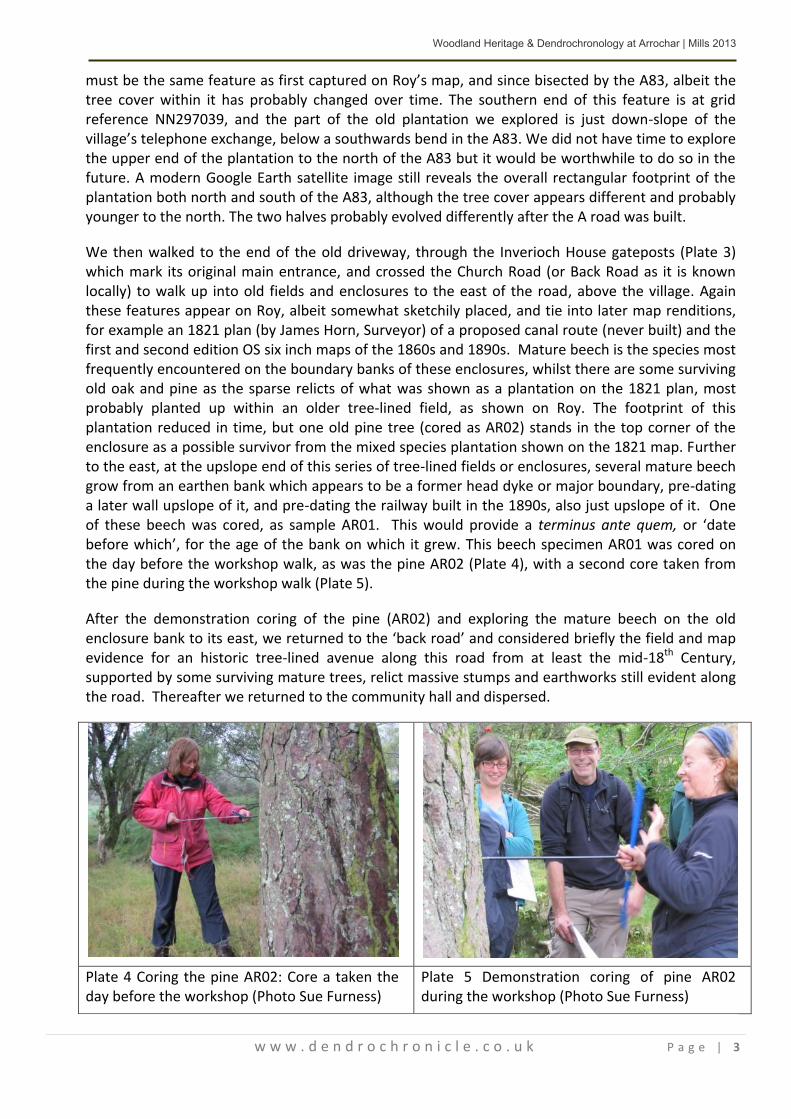
We then walked to the end of the old driveway, through the Inverioch House gateposts (Plate 3) which mark its original main entrance, and crossed the Church Road (or Back Road as it is known locally) to walk up into old fields and enclosures to the east of the road, above the village. Again these features appear on Roy, albeit somewhat sketchily placed, and tie into later map renditions, for example an 1821 plan (by James Horn, Surveyor) of a proposed canal route (never built) and the first and second edition OS six inch maps of the 1860s and 1890s. Mature beech is the species most frequently encountered on the boundary banks of these enclosures, whilst there are some surviving old oak and pine as the sparse relicts of what was shown as a plantation on the 1821 plan, most probably planted up within an older tree-lined field, as shown on Roy. The footprint of this plantation reduced in time, but one old pine tree (cored as AR02) stands in the top corner of the enclosure as a possible survivor from the mixed species plantation shown on the 1821 map. Further to the east, at the upslope end of this series of tree-lined fields or enclosures, several mature beech grow from an earthen bank which appears to be a former head dyke or major boundary, pre-dating a later wall upslope of it, and pre-dating the railway built in the 1890s, also just upslope of it. One of these beech was cored, as sample AR01. This would provide a terminus ante quem, or ‘date before which’, for the age of the bank on which it grew. This beech specimen AR01 was cored on the day before the workshop walk, as was the pine AR02 (Plate 4), with a second core taken from the pine during the workshop walk (Plate 5).
After the demonstration coring of the pine (AR02) and exploring the mature beech on the old enclosure bank to its east, we returned to the ‘back road’ and considered briefly the field and map evidence for an historic tree-lined avenue along this road from at least the mid-18th Century, supported by some surviving mature trees, relict massive stumps and earthworks still evident along the road. Thereafter we returned to the community hall and dispersed.
Plate 4 Coring the pine AR02: Core a taken the day before the workshop (Photo Sue Furness)
Plate 5 Demonstration coring of pine AR02 during the workshop (Photo Sue Furness)

Woodland Heritage & Dendrochronology at Arrochar | Mills 2013
w w w . d e n d r o c h r o n i c l e . c o . u k P a g e | 4
There were many good questions and comments from the participants throughout the day, and much useful contribution of local knowledge. Further useful contributions have been since the event, for example on some documentary evidence for early 18th C planting by the MacFarlanes, through the Hidden Heritage Project’s Facebook page.
3 Methods for the dendrochronological work Prior historic map research, together with rapid field reconnaissance on the day before the workshop, revealed a number of relict historic wooded features in the landscape within easy walking distance of Arrochar village, from which to select suitable trees for coring. The budget allowed for two trees to be sampled from these relict features, really a small pilot study to reveal the potential for further such work in the area, and to allow a demonstration of tree coring to the workshop attendees. One beech and one Scots pine were selected for coring and analysis, chosen on the basis of historic map evidence and association with historic enclosures. They were sampled with a Swedish Increment Corer.
Tree location and other key attributes, such as stem girth, sample height and core direction were recorded for each core-sampled tree (Table 1). Tree location was recorded as 10 figure NGR using a GPS handheld device, model Garmin GPSMAP 60CSx, which works especially well under tree canopy. Each tree was given a unique analytical number and each individual sample or radius measured was given a suffix letter. Preparation and analysis of samples was undertaken in September-October 2013.
Standard dendrochronological techniques were employed in the analytical work. The cores were gently dried under binding and weights, to prevent warping, then mounted with wood glue into routed wooden holders. The surfaces of the samples were prepared for measurement by gentle sanding, using sequentially finer grades of sandpaper. The tree-ring width sequences were measured on a Heidenhain measuring table, under a low-power microscope, linked to a P.C. Data capture, analysis and plotting were undertaken using the ‘Dendro’ suite of programs (Tyers 1999). Although more relevant where multiple samples are taken from each species, it is useful to note that the program produces `t' values as a measure of the degree of correlation between sequences; as a general rule of thumb values above 3.5 are considered to be significant, although the length of overlap also has to be taken into account. Visual cross-matching of the graphed tree-ring width sequences is also undertaken. Where more than one sample is available from the same tree or species, this cross-matching process helps to eliminate potential inaccuracies caused by breaks in cores or very compressed bands of growth, and provides a much more reliable result than simple counting of rings. However, beech (Fagus sylvatica L.) has not been used very extensively in the UK for dendrochronology, and as a diffuse to semi-ring porous species has rather unclear ring patterns compared to truly ring-porous species like oak. Therefore, there is limited Scottish reference data against which to check the measured tree-ring patterns
Where cores do not reach centre, an estimate of the number of rings missed is made using the pith offset method, which involves overlying a transparent template with several sets of concentric circles, each at different ‘ring width’ intervals. Matching the width and curvature of the inner rings of the sample to the most similar set of concentric circles on the template allows one to estimate the number of rings missing to centre, assuming a constant interval. This, together with an estimate used for the number of years it would take for a stem to reach core sampling height, allows allocation of estimated ‘birth’ date or sprouting date for the tree (Mills 2011a). It is not feasible to

Woodland Heritage & Dendrochronology at Arrochar | Mills 2013
w w w . d e n d r o c h r o n i c l e . c o . u k P a g e | 5
take core samples at ground level because (a) room is needed to turn the corer handle and (b) ring patterns become distorted if too near the root plate. In the case of designed landscapes, where it appears likely that trees have been planted, then it is the planting date rather than the sprouting date which is of most relevance in understanding the landscape’s history, and so the likely age of the sapling at planting also has to be taken into account when interpreting the tree-ring results.
4 Results Two trees were cored: the species sampled were beech (Fagus sylvatica L., Core Sample AR01) and Scots pine (Pinus sylvestris L., Core Samples AR02a and AR02b). In the case of the pine tree, AR02, the two sequences were checked for cross-matching and then combined into a ‘new raw’ average sequence for the tree. The data presented below in Table 1 and Table 2 is of the resultant combined sequences. The raw data for individual cores is held in the analyst’s databank for future reference.
Table 1 Key attributes of the Arrochar tree-ring samples
Sample / species
Sample type
NGR Direction core taken from
Stem girth(m) at 1.3m height
Sample height (m)
Average ring width (mm)
Context
AR01 beech Core NN 30214
03777 E 2.20 0.9 1.10
Growing on earth bank, possible head dyke at top of series of rectangular fields or enclosures
AR02 Scots pine Core x 2 NN 30012
03699 NE (a) W (b) 2.57 1.05 (a)
0.95 (b) 1.19
Within SW corner of an embanked enclosure with beech planted on banks, interpreted as part of plantation shown on Canal Plan of 1821
The dendrochronological ageing and dating results are given in Table 2. Since only one tree of each species was cored, the date spans cannot be considered as independently verified. In general, multiple samples are required to replicate growth signals well enough to date across longer distances (se English Heritage Dendrochronology Guidelines 1999). Furthermore there is very little beech data in Scotland, and the little available, from Dougalston near Milngavie (Mills 2013), did not match the single Arrochar sequence. Since both Arrochar trees cored were living at the time of sampling, and the cores had intact bark edges, the dates in Table 2 are based on an assumption that the last ring under the bark is the 2013 growing season, which by late September would be nearly complete. There remains the possibility of residual ring errors, especially in the single beech sample which proved very slow grown and contorted, and very difficult to measure, especially from the late 19th C to the mid 20th C. However, it should be noted there is some good internal verification between the two pine cores from AR02, matching with a t-value of 5.6, and the combined sequence did match at the correct end date (AD 2013) with a sequence from Glen Falloch (Wilson et al 2011) with a t-value of 3.8. Any residual ring errors in the beech would be of no more than a few rings, and very probably the pine sequence is correct. Given the other estimates involved, for the number of rings missing to centre, and the rate of vertical growth (see Table 2), any residual errors would make little difference to the general age estimates produced.
Woodland Heritage & Dendrochronology at Arrochar | Mills 2013
w w w . d e n d r o c h r o n i c l e . c o . u k P a g e | 6
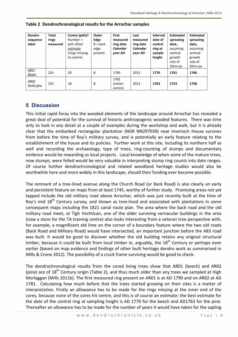
Table 2 Dendrochronological results for the Arrochar samples
Dendro sequence label
Total rings measured
Centre (pith)? Number = pith offset estimate (rings missing to centre)
Outer Edge B = bark edge present
First measured ring date Calendar year AD
Last measured ring date Calendar year AD
Inferred date of central ring at sample height
Estimated sprouting date, assuming vertical growth rate of 10cm pa
Estimated sprouting date, assuming vertical growth rate of 20cm pa
AR01 Beech 224 20 B 1790 2013 1770 1761 1766
AR02 Scots pine 233 18 B
1781 (rotten centre)
2013 1763 1753 1758
5 Discussion This initial rapid foray into the wooded elements of the landscape around Arrochar has revealed a great deal of potential for the survival of historic anthropogenic wooded features. There was time only to look in any detail at a couple of examples during the workshop and walk, but it is already clear that the embanked rectangular plantation (NGR NN297039) near Inverioch House survives from before the time of Roy’s military survey, and is potentially an early feature relating to the establishment of the house and its policies. Further work at this site, including its northern half as well and recording the archaeology, type of trees, ring-counting of stumps and documentary evidence would be rewarding as local projects. Local knowledge of when some of the mature trees, now stumps, were felled would be very valuable in interpreting stump ring counts into date ranges. Of course further dendrochronological and related woodland heritage studies would also be worthwhile here and more widely in this landscape, should their funding ever become possible. The remnant of a tree-lined avenue along the Church Road (or Back Road) is also clearly an early and persistent feature on maps from at least 1745, worthy of further study. Promising areas not yet tapped include the old military road above Arrochar, which was just recently built at the time of Roy’s mid 18th Century survey, and shown as tree-lined and associated with plantations in some consequent maps including the 1821 canal route plan. The area where the back road and the old military road meet, at Tigh Vechtican, one of the older surviving vernacular buildings in the area (now a store for the TA training centre) also looks interesting from a veteran tree perspective with, for example, a magnificent old lime on the corner of a boundary feature where the two old roads (Back Road and Military Road) would have intersected, an important junction before the A83 road was built. It would be good to discover whether the old building retains any original structural timber, because it could be built from local timber in, arguably, the 18th Century or perhaps even earlier (based on map evidence and findings of other built heritage dendro work as summarised in Mills & Crone 2012). The possibility of a cruck frame surviving would be good to check. The dendrochronological results from the cored living trees show that AR01 (beech) and AR02 (pine) are of 18th Century origin (Table 2), and thus much older than any trees we sampled at High Morlaggan (Mills 2011b). The first measured ring present on AR01 is at AD 1790 and on AR02 at AD 1781. Calculating how much before that the trees started growing on their sites is a matter of interpretation. Firstly an allowance has to be made for the rings missing at the inner end of the cores, because none of the cores hit centre, and this is of course an estimate: the best estimate for the date of the central ring at sampling height is AD 1770 for the beech and AD1763 for the pine. Thereafter an allowance has to be made for the number of years it would have taken for the sapling

Woodland Heritage & Dendrochronology at Arrochar | Mills 2013
w w w . d e n d r o c h r o n i c l e . c o . u k P a g e | 7
to reach sampling height (see Mills 2011a for further discussion). This depends on the growing conditions and especially the degree to which the saplings were subjected to grazing pressure. Thus Table 2 presents two vertical growth rates, either 10cm or 20cm per annum, but in a heavily browsed situation the rate could be slower. Using these estimates we arrive at estimated sprouting dates of between AD1761-66 for the beech and AD1753-58 for the pine. The remaining unknown factor is what age and size the saplings were planted out at, because the planting out date is far more relevant to ageing a tree-planted feature than is the sprouting date. It is likely that these trees were both planted out as saplings, rather than as seed in situ. The most relevant work on contemporary practices is the 18th Century treatise on forestry by William Boutcher (1775), a nurseryman in Edinburgh and clearly widely influential in the Scottish landowning classes. The treatise provides a chapter on each tree species in fashion at the time, including beech, and is likely to reflect widespread practices of the age in Scotland. However, Boutcher’s guidance on the rearing and use of saplings is not straightforward to interpret regarding, for example, the age at which beech trees would have been planted out, and not easy to summarise either, because there are many possible stages and permutations: propagation, planting out in the nursery, planting out again in the nursery at 2-3 years, planting in position at 3-5 years if the saplings are doing well, but otherwise continuing in the nursery for a further year or two and with subsequent extra possible replanting and pruning stages if they are not doing so well or if larger specimens are required. Ultimately one could interpret Boutcher’s guidance as indicating sapling planting out ages anywhere between about 3-5 years and 18 years. All in all, it would seem likely the pine AR02 was planted as a young sapling in an enclosed and protected plantation, and a planting date in the late 1750s to 1760s seems most likely. Therefore, our pine is part of the plantation shown as well-established within this enclosure on the canal plan of 1821. It had been there for more than fifty years by then, but probably had not yet been planted at the time of Roy’s military survey c 1750, which matches the evidence well because Roy is showing trees on the banks but not within them here.
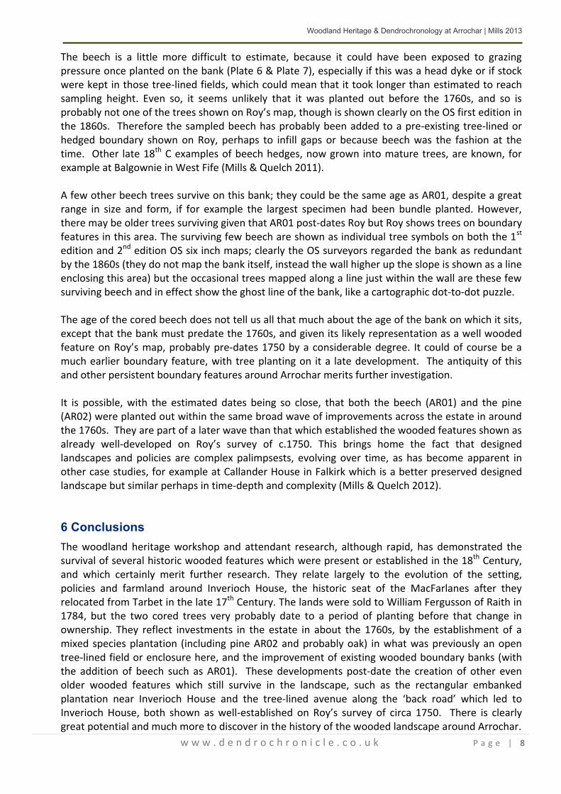
Plate 6 Beech AR01, showing its situation on an old bank (from upslope side, photo Sue Furness)
Plate 7 Coring beech AR01 (Photo Sue Furness)
Woodland Heritage & Dendrochronology at Arrochar | Mills 2013
w w w . d e n d r o c h r o n i c l e . c o . u k P a g e | 8
The beech is a little more difficult to estimate, because it could have been exposed to grazing pressure once planted on the bank (Plate 6 & Plate 7), especially if this was a head dyke or if stock were kept in those tree-lined fields, which could mean that it took longer than estimated to reach sampling height. Even so, it seems unlikely that it was planted out before the 1760s, and so is probably not one of the trees shown on Roy’s map, though is shown clearly on the OS first edition in the 1860s. Therefore the sampled beech has probably been added to a pre-existing tree-lined or hedged boundary shown on Roy, perhaps to infill gaps or because beech was the fashion at the time. Other late 18th C examples of beech hedges, now grown into mature trees, are known, for example at Balgownie in West Fife (Mills & Quelch 2011). A few other beech trees survive on this bank; they could be the same age as AR01, despite a great range in size and form, if for example the largest specimen had been bundle planted. However, there may be older trees surviving given that AR01 post-dates Roy but Roy shows trees on boundary features in this area. The surviving few beech are shown as individual tree symbols on both the 1st edition and 2nd edition OS six inch maps; clearly the OS surveyors regarded the bank as redundant by the 1860s (they do not map the bank itself, instead the wall higher up the slope is shown as a line enclosing this area) but the occasional trees mapped along a line just within the wall are these few surviving beech and in effect show the ghost line of the bank, like a cartographic dot-to-dot puzzle. The age of the cored beech does not tell us all that much about the age of the bank on which it sits, except that the bank must predate the 1760s, and given its likely representation as a well wooded feature on Roy’s map, probably pre-dates 1750 by a considerable degree. It could of course be a much earlier boundary feature, with tree planting on it a late development. The antiquity of this and other persistent boundary features around Arrochar merits further investigation. It is possible, with the estimated dates being so close, that both the beech (AR01) and the pine (AR02) were planted out within the same broad wave of improvements across the estate in around the 1760s. They are part of a later wave than that which established the wooded features shown as already well-developed on Roy’s survey of c.1750. This brings home the fact that designed landscapes and policies are complex palimpsests, evolving over time, as has become apparent in other case studies, for example at Callander House in Falkirk which is a better preserved designed landscape but similar perhaps in time-depth and complexity (Mills & Quelch 2012).
6 Conclusions The woodland heritage workshop and attendant research, although rapid, has demonstrated the survival of several historic wooded features which were present or established in the 18th Century, and which certainly merit further research. They relate largely to the evolution of the setting, policies and farmland around Inverioch House, the historic seat of the MacFarlanes after they relocated from Tarbet in the late 17th Century. The lands were sold to William Fergusson of Raith in 1784, but the two cored trees very probably date to a period of planting before that change in ownership. They reflect investments in the estate in about the 1760s, by the establishment of a mixed species plantation (including pine AR02 and probably oak) in what was previously an open tree-lined field or enclosure here, and the improvement of existing wooded boundary banks (with the addition of beech such as AR01). These developments post-date the creation of other even older wooded features which still survive in the landscape, such as the rectangular embanked plantation near Inverioch House and the tree-lined avenue along the ‘back road’ which led to Inverioch House, both shown as well-established on Roy’s survey of circa 1750. There is clearly great potential and much more to discover in the history of the wooded landscape around Arrochar.

Woodland Heritage & Dendrochronology at Arrochar | Mills 2013
w w w . d e n d r o c h r o n i c l e . c o . u k P a g e | 9
7 Acknowledgments
I am most grateful to Sue Furness and Fiona Jackson for involving me in the Hidden Heritage Project, and for all their help and hospitality. The work presented here would not have been possible without the support for the project by the various funding bodies, especially the Heritage Lottery Fund and Argyll and the Islands LEADER. Sincere thanks also go to the Arrochar, Tarbet and Ardlui Heritage Group for very useful local historical information, and to the landowners, Luss Estates for access and permission. Finally I would like to thank everyone who came to the workshop and shared their local knowledge and expertise with me and the group.
8 References
Boutcher, W 1775 A Treatise on Forest Trees (1st Edition 1775, 2nd Edition 1778). See PDF at http://books.google.co.uk/books?id=-XtJAAAAYAAJ&printsec=frontcover&source=gbs_ge_summary_r&cad=0#v=onepage&q&f=false
English Heritage 1999 Dendrochronology Guidelines http://www.english-heritage.org.uk/publications/dendrochronology-guidelines/
Mills, CM 2011a Old oak coppices, South Loch Katrine: their dendrochronology and history. Report for FCS (Cowal and Trossachs District) & Loch Lomond & Trossachs National Park Authority. Mills, CM 2011b High Morlaggan: Dendrochronology of hawthorn and rowan. Report for Morlaggan Rural Settlement Group. Mills, CM 2013 Dougalston, near Milngavie: preliminary dendrochronological investigations in a designed wooded landscape. Report for Professor Paul Bishop of Glasgow University.
Mills, CM & Crone, A 2012 ‘Dendrochronological evidence for Scotland’s native timber resources over the last 1000 years’, Scottish Forestry 66, 18-33. Mills, CM & Quelch, P 2011 ‘Historic Woodland Survey at Balgownie Wood: A Case Study’, Report for Forestry Commission Scotland. Mills, CM & Quelch P 2012 Callander Wood, Falkirk: Historic Woodland Evaluation. Report for Forestry Commission Scotland.
Tyers, I 1999 Dendro for Windows Program Guide 2nd edition. ARCUS Report 50
R. Wilson, N. J. Loader, M. Rydval, H. Patton, A. Frith, C. M. Mills, A. Crone, C. Edwards, L. Larsson & B E. Gunnarson 2011 ‘Reconstructing Holocene climate from tree rings: The potential for a long chronology from the Scottish Highlands’ The Holocene July 19, 2011 0959683611405237, first published on July 19, 2011 doi:10.1177/0959683611405237

www.dendrochronicle.co.uk

www.dendrochronicle.co.uk


