Hart District Council Local Plan Site Assessment: Stage 2 – High Level Site Assessment – SHL127 – Land at Paulʼs Field, Eversley Confidential Draft - 1.1 – May 2015 Adams Hendry Consulting Ltd 1 High Level Site Assessment Proforma Site Reference SHL127 Site Name Land at Paulʼs Field Parish Eversley Site Address Land at Paulʼs Field, Eversley Capacity Assessment and Categorisation Site Size (ha) 2.8ha Estimated Capacity 50 Comments on capacity The capacity was calculated using the site area and a dph figure of 24 (in accordance with gross-to-net ratio of 80%) Housing Strategy Category(s) Strategy 2 (dispersal strategy) Land Supply Category Category C: Large and ʻlocal strategicʼ sites adjoining existing urban areas Key to Site Assessments: Site Assessment Assessment Criteria Assessment comments Coloured assessment Accessibility to Employment and services o Bus Stop – (Jarvis Close, services: 82 and 83) 0.18km o Railway Station – (Sandhurst) 5.61km o Employment Centre – (Blackbushe Business Park) 4km o Public Open Space – (Eversley recreation/cricket ground) 0.78km o Health Facility – (Monteagle Surgery) 2.39km o Primary School – (Charles Kingsleyʼs Primary School) 0.94km o Secondary School – (Yateley School) 3.03km o Supermarket – (Waitrose, Yateley) 2.39km Infrastructure provision • Schools: There is a pressure for places at Primary education level. Although there are no identified deficits in capacity at Primary, Junior or Infant Schools within the Eversley/Yateley/Frogmore area they are full or close to full. Additional housing will exacerbate this situation. There are no planned expansions of any of the schools in the area, if there is any significant development that is not forecast will cause increased pressures on the local primary, junior and infant schools. Charles Kingsleyʼs Primary in Eversley is a 1 FE school with little if any anticipated capacity to provide additional places. There are no planned expansions to the Yateley Secondary School however Calthorpe Park School in Fleet has a planned expansion. • Retail: Eversley has a Londis convenience shop but apart from this there are no other retail shops within the No overriding constraint to development of the site Constraint requiring further detailed assessment Major constraint undermining suitability of site
Transcript
Hart District Council Local Plan Site Assessment: Stage 2 – High Level Site Assessment – SHL127 – Land at Paulʼs Field, Eversley Confidential Draft - 1.1 – May 2015
Adams Hendry Consulting Ltd 1
High Level Site Assessment Proforma Site Reference SHL127 Site Name Land at Paulʼs Field Parish Eversley Site Address Land at Paulʼs Field, Eversley Capacity Assessment and Categorisation Site Size (ha) 2.8ha Estimated Capacity 50 Comments on capacity The capacity was calculated using the site area and a dph figure of 24 (in accordance with gross-to-net ratio of 80%)
Housing Strategy Category(s) Strategy 2 (dispersal strategy) Land Supply Category Category C: Large and ʻlocal strategicʼ sites adjoining
existing urban areas Key to Site Assessments: Site Assessment Assessment Criteria Assessment comments Coloured
assessment Accessibility to Employment and services
o Bus Stop – (Jarvis Close, services: 82 and 83) 0.18km o Railway Station – (Sandhurst) 5.61km o Employment Centre – (Blackbushe Business Park) 4km o Public Open Space – (Eversley recreation/cricket ground) 0.78km o Health Facility – (Monteagle Surgery) 2.39km o Primary School – (Charles Kingsleyʼs Primary School) 0.94km o Secondary School – (Yateley School) 3.03km o Supermarket – (Waitrose, Yateley) 2.39km
Infrastructure provision
• Schools: There is a pressure for places at Primary education level. Although there are no identified deficits in capacity at Primary, Junior or Infant Schools within the Eversley/Yateley/Frogmore area they are full or close to full. Additional housing will exacerbate this situation. There are no planned expansions of any of the schools in the area, if there is any significant development that is not forecast will cause increased pressures on the local primary, junior and infant schools. Charles Kingsleyʼs Primary in Eversley is a 1 FE school with little if any anticipated capacity to provide additional places. There are no planned expansions to the Yateley Secondary School however Calthorpe Park School in Fleet has a planned expansion.
• Retail: Eversley has a Londis convenience shop but apart from this there are no other retail shops within the
No overriding constraint to development of the site Constraint requiring further detailed assessment Major constraint undermining suitability of site
Hart District Council Local Plan Site Assessment: Stage 2 – High Level Site Assessment – SHL127 – Land at Paulʼs Field, Eversley Confidential Draft - 1.1 – May 2015
Adams Hendry Consulting Ltd 2
village. The closest supermarkets are Waitrose in Yateley or Morrisons in Elvetham Heath, which are much more likely to service the Eversley area; The retail study shows that these stores are currently overtrading, and additional large developments within the Hart District will place more pressure on these retail services and further floorspace will be required to meet the demand. It is acknowledged however that Farnborough is more likely to draw shoppers for comparative shops than Fleet due to the wider variety and additional leisure facilities available.
• Health: The closest health facilities are in Yateley. There are no planned expansions of health facilities in the
Yateley area, but it is likely that any significant level of development will require additional provision. There are a series of expansions planned at the Frimley Park Hospital, Frimley (outside of Hart) including a new emergency department and regional cardiology centre which will improve the current level of access to these services for the eastern areas of the Hart District area.
• Transport (road): There are few improvements being planned locally to roads within the village including
junction improvements to Webbʼs Corner (Warbrook Lane/St Neots Road), and the A3272 and B3016 junction; as well as a study to investigate how to reduce the rat runs along the B3016 and B3272. The A30 stretch between the A327 and A331 at Blackwater where a new roundabout and a left only priority will help traffic accessing the A30 from Eversley. There will also be improved access to junction 4a of the M3.
• Transport (other): There is a proposal for a new 2.5km cycle link between Eversley and Yateley with traffic-
free sections. An upgrade to a boardwalk for footpath 24 has been proposed due to the regular flooding of the route. The local bus services in Eversley (no.s 82/83) are restricted to one or two services a day on weekdays only. The bus times are tailored towards school transport. Blackwater railway station waiting facilities are being improved along with a new platform footbridge.
• Green Infrastructure: The Hart SANG catchment area map shows that this site is located outside of the
Hawley Meadows and Blackwater Park SANG Catchment area. Therefore it is unlikely that there will be a sufficient enough infrastructure for a development of this size.
There is a lack of provision in certain types of infrastructure in the area and development on the site will only increase the pressure on existing services. It is unlikely that the site is of sufficient size to provide all of the supporting infrastructure onsite.
Current Use and Relevant Planning History
The southern part of the site comprises a small residential close with approximately 11 dwellings. To the north, the main part of the site comprises half of a large agricultural field. There is no planning history.
Hart District Council Local Plan Site Assessment: Stage 2 – High Level Site Assessment – SHL127 – Land at Paulʼs Field, Eversley Confidential Draft - 1.1 – May 2015
Adams Hendry Consulting Ltd 3
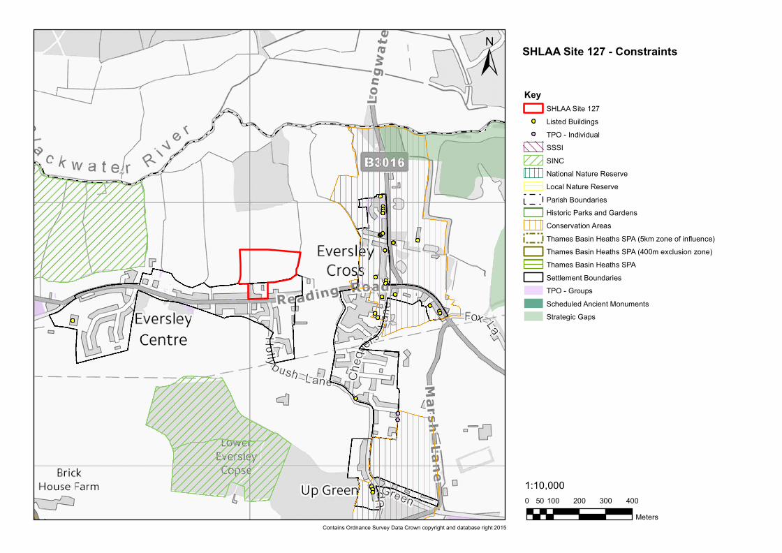
Nature Conservation Site is within the 5km Thames Basin Heaths SPA Zone of Influence. Development on a site of this scale will not be within the capacity of the Hawley Meadows and Blackwater Park SANG to mitigate its potential impact on the TBH SPA. Therefore, the potential for delivering new SANGs provision either on or off site would need to be investigated. There are no nature conservation constraints on the site.
Minerals Resources The Hampshire Minerals and Waste Plan Policies Map indicates that the majority of the site may be subject to minerals safeguarding for sharp sand and gravel (Policy 15 of the Hampshire minerals and waste plan). The extent to which this represents a constraint to development would need to be assessed.
Landscape HCC Integrated LCA (2012) Landscape type: Lowland mosaic heath associated Landscape character: Northeast Hampshire Plantations and Heath Hart District LCA 1997: Landscape type: Flood plain and fringing farmland Landscape Character Area: Blackwater Valley Main features of the Blackwater Valley LCA: A distinctively riparian character of the flat, low-lying valley floor with riverside pastures. The LCA features gentle valley sides with a woodland backdrop. There is a varying character from the pastoral, rural and generally unspoilt character of the western valley, open water and wetlands in the centre and urban development, roads and railways along the east side. The LCA has a sparse pattern of settlement to the west with roads and buildings located on higher ground avoiding the wet valley floor. Summary Assessment: The southern part of the site is within the existing built-up area of Eversley Centre and would present no significant issues for the landscape if re-developed. The majority of the site occupies the southern half of a pasture, which extends northwards towards an area of woodland and the Blackwater River beyond that. The pasture and its surrounding fields appear very typical of the Blackwater Valley LCA with no development and retaining an unspoiled character. Were the site to be developed, it would greatly alter the built form of Eversley Centre, which, to the north of the Reading Road exists only as ribbon development along the road. Extending the built form of the settlement north into the Blackwater Valley would be likely to cause significant harm to the character of the landscape in this area.
Agricultural Land This is a mixed site of Grade 3 agricultural land, which might include ʻbest and most versatile landʼ and non-agricultural land.
Hart District Council Local Plan Site Assessment: Stage 2 – High Level Site Assessment – SHL127 – Land at Paulʼs Field, Eversley Confidential Draft - 1.1 – May 2015
Adams Hendry Consulting Ltd 4
Heritage Assets There are no heritage assets on this site, however the neighbouring property east of the access to this site, the White House, is a locally listed building.
Water resources and quality
There are no Groundwater Source Protection Zones or licensed water abstraction points in close proximity to the site.
Air Quality There are not believed to be any Air Quality Management Areas in close proximity to this site. However there two aggregate quarries in the local area, one 0.79km east of the site, and a second larger quarry 1.92km southwest of the site. Both sites could be sources of dust and air pollution to the site.
Flood risk The whole site area is within Flood Zone 1 and there is a limited risk of groundwater flooding. There is some risk of surface water flooding at the east and west boundaries of the site, associated with current field drainage.
Location and scale of development
The site is mostly occupying greenfield land, with a small section to the south located within the settlement area of Eversley Centre and developed as 11 dwellings. The site is relatively well screened to the east and the west, although it is completely open to the north. The village of Eversley Centre is a small settlement, characterised by a low-density single row of houses north of the Reading Road. Therefore, any significant development to the north of this, particularly if it were medium or high density would be incongruous and would harm the rural character of the village.
Un-neighbourly Uses
There two aggregate quarries in the local area, one 0.79km east of the site, and a second larger quarry 1.92km southwest of the site. Both sites could be sources of noise pollution to the site. Additionally Blackbushe Airport is 2.3km southeast of the site, and could also be a potential source of noise pollution.
Availability Assessment
The site is believed to be available although this would need to be confirmed by the landowner.
Site Access
The site is currently accessed from Paulʼs Field Close, where there is an opening to the field to the north. This would appear to be the only possible access to the site. A thorough review of the junction at Paulʼs Field would need to be undertaken to assess whether improvements are needed to help cope with the increased traffic a development of this size is likely to bring to the area. It may be necessary to introduce further traffic calming schemes on the Reading Road. There is good pedestrian access to the site with a pedestrian crossing by Paulʼs Field close, wide pavements on both sides of the road leading to the village centre and bus stops.
Summary of Constraints
• Development to the north of the existing Paulʼs Field Close risks causing harm to the landscape character and the rural character of the village of Eversley Centre;
• Accessibility to some services and facilities is poor and there are infrastructure deficiencies that would be exacerbated;
Hart District Council Local Plan Site Assessment: Stage 2 – High Level Site Assessment – SHL127 – Land at Paulʼs Field, Eversley Confidential Draft - 1.1 – May 2015
Adams Hendry Consulting Ltd 5
• The site is subject to minerals safeguarding; • The nearby quarries may cause air quality or environmental noise impacts; • Site availability is not certain.
Summary of Opportunities
Assuming the constraints on landscape and character can be overcome, this site has the potential to deliver a significant number of new homes.
Focus of further assessment, should the site be shortlisted by the Council
• Consideration is needed of the mitigation that would be required to reduce or address the impact of development on the landscape and settlement character;
• The extent to which the quarries and Blackbushe airport may impact on the site needs to be considered; • Engagement with the County Council is needed over the issue of minerals safeguarding; • Site availability needs to be ascertained.
Site Assessment Completed by
Name: PH Date: 07/05/2015
HDC Conclusion and recommendation
Shortlist the site:
Do not shortlist the site:
HDC Comments:
0 100 200 300 40050Meters
1:10,000
±Key
SHLAA Site 127Listed Buildings
! TPO - IndividualSSSISINCNational Nature ReserveLocal Nature ReserveParish BoundariesHistoric Parks and GardensConservation AreasThames Basin Heaths SPA (5km zone of influence)Thames Basin Heaths SPA (400m exclusion zone)Thames Basin Heaths SPASettlement BoundariesTPO - GroupsScheduled Ancient MonumentsStrategic Gaps
Contains Ordnance Survey Data Crown copyright and database right 2015
SHLAA Site 127 - Constraints
0 100 200 300 40050Meters
1:10,000
±Key
SHLAA Site 127Flood Zone 3Flood Zone 2Reservoir Flood OutlinesSurface Water Flooding (1 in 30 year AEP)Surface Water Flooding (1 in 100 year AEP)Groundwater Flooding (Limited)Groundwater Flooding (Potential flooding to basements)Groundwater Flooding (Potential flooding at surface)
Contains Ordnance Survey Data Crown copyright and database right 2015