118
HIGHLANDS RANCH PLANNED DEVELOPMENT GUIDE SUMMARY Combined Version of Amendments 1 - 73 As of October 2015

HIGHLANDS RANCH PLANNED
DEVELOPMENT GUIDE SUMMARY
Combined Version of Amendments 1 - 73
As of October 2015

2
Table of Contents PRE-PREAMBLE ........................................................................................................................ 3 PREAMBLE ................................................................................................................................ 3 SECTION I - PURPOSE, OBJECTIVES AND INTENT ............................................................... 8 SECTION II - AUTHORITY ......................................................................................................... 9 SECTION III - CONTROL PROVISIONS ................................................................................... 10 SECTION IV - DEFINITIONS .................................................................................................... 11 SECTION V - GENERAL PROVISIONS.................................................................................... 23 SECTION VI - LOW DENSITY, MEDIUM LOW DENSITY, AND MEDIUM DENSITY ONE-
FAMILY RESIDENTIAL - Planning Areas 1 through 7, 20, 23 through 33, and 40 through 59 .................................................................................................................................. 27
FIGURE VI-A: CONTEMPORARY DEVELOPMENT STANDARDS GRAPHIC ...................... 30 FIGURE VI-1: RESIDENTIAL DEVELOPMENT STANDARDS .............................................. 31
SECTION VII - HIGH DENSITY RESIDENTIAL - Planning Areas 60 through 69, 82 through 84 and 87 ........................................................................................................................... 33
FIGURE VII-1: Planning Area 68 ............................................................................................ 35 SECTION VIII - CIVIC CENTER - Planning Area 71 ................................................................. 36
FIGURE VIII-A-1: PLANNING AREA 71 ................................................................................. 43 SECTION VIII-B - TOWN CENTER - Planning Areas 72, 73, and 73-A..................................... 44 SECTION VIII-C - CORRIDOR ACTIVITY CENTER - Planning Area 74 ................................... 48 SECTION VIII-D - CORRIDOR ACTIVITY CENTER - Planning Area 74-A ............................... 52 SECTION IX - COMMUNITY ACTIVITY CENTER - Planning Areas 70, 89, 90 and 91 ............. 53
FIGURE IX-1: Planning Area 70 Height Restriction Graphic ................................................... 56 Planning Area 91 Design Standards....................................................................................... 57
SECTION X-A - INDUSTRIAL PARK - Planning Areas 75 through 78, 80, 86 and 88 ............... 60 FIGURE X-A-1: Planning Areas 76 Subareas A and B ........................................................... 65
SECTION X-B - INDUSTRIAL PARK- Planning Areas 81, 84 85 & 87 ...................................... 66 SECTION X-C - PLAZA CENTER - Planning Areas 77-A, 77-B and 79 .................................... 71
FIGURE X-C-1: Planning Areas 77-A and 77-B ..................................................................... 75 SECTION X-C - INDUSTRIAL PARK - Planning Area 85-A ...................................................... 76 SECTION XI - AUTOMOBILE SERVICE STATIONS ................................................................ 77 SECTION XII - SHOP-N-RIDES ................................................................................................ 79 SECTION XIII - NONURBAN AREA .......................................................................................... 82 SECTION XIV - ACCESSORY USES ..................................................................................... 101 SECTION XV - SIGNS ............................................................................................................ 103 SECTION XVI - OFF-STREET PARKING ............................................................................... 108
FIGURE XVI-1: Parking Diagram A ...................................................................................... 113 FIGURE XVI-2: Parking Diagram A ...................................................................................... 114
SECTION XVII - LEGAL DESCRIPTION ................................................................................. 115 SECTION XVIII – PLANNED DEVELOPMENT SUMMARY .................................................... 118

3
PRE-PREAMBLE The text in this document is only a summary and may contain inaccurate information. It should not be relied upon and should be reviewed in conjunction with the original recorded amendments.
PREAMBLE This Development Guide sets forth land uses and development standards for the New Town of Highlands Ranch, a planned community in the unincorporated area of the County of Douglas, State of Colorado; regulates the use of land and the use, bulk, maximum height, minimum lot area, minimum lot width, and minimum yard spaces of buildings; provides for a substantial Nonurban Use Area; provides regulations for uses permitted therein and accessory buildings and uses; provides additional supplementary regulations; and defines certain terms used therein. This Development Guide is authorized under Section 13, PC-Planned Community District Regulations of the Douglas County Zoning Resolution.
The Highlands Ranch, is a large, compact parcel of land under single development control, and is suitable for creation of a New Town;
This large and compact parcel of land is particularly well suited for long-range comprehensive planning, which, in turn, will aid in the protection of the environment, while at the same time facilitating the development of an aesthetically pleasing New Town to serve the living needs of the existing and future residents of Douglas County; and
The Planned Unit Development Act of 1972 and the Douglas County Zoning Resolution permit adoption of a development guide within the context of the planned community district zoning regulations applicable to such land in order to establish and implement such a long-range comprehensive plan, and a long-range comprehensive plan has been formulated for the New Town of Highlands Ranch encompassing such beneficial features as a balance of residential, commercial, educational, recreational, industrial, and nonurban uses; a compact form; provisions for the utilization of transit; improvement of air quality; enhancement of public safety; creation of an aesthetically pleasing living environment; and promotion of high standards of developmental quality by stringent site planning and landscaping controls, all for the benefit of the existing and future citizens of Douglas County;
In order to implement the comprehensive plan, Mission Viejo Company has offered certain assurances and commitments which shall be, after the effective date of the approval of rezoning to Planned Community District and the approval of this Development Guide, binding upon Mission Viejo Company with respect to land within Highlands Ranch it owns, and binding upon its successors and assigns with respect to land within Highlands Ranch it does not own. Such assurances and commitments are as follows:
A. Reservation of Nonurban Area
Mission Viejo Company shall create an extensive Nonurban Area within the New Town of Highlands Ranch and shall:
1) Permanently reserve approximately 20 square miles (approximately 60%) of Highlands Ranch as Nonurban Area.
4
2) Allocate up to $2,000,000 to the improvement of 2 major parks.
3) Allocate up to $100,000 to the preparation of a Nonurban Area Management Plan.
4) Preserve Wildcat Mountain and other significant ridges and natural features as defined in the Nonurban Area Management Plan.
5) Submit for review and have approved by Douglas County a Regional Trail Plan for Highlands Ranch by May 24, 1990. Such plan shall establish the location of regional trail corridors, the intended use(s) for each corridor and any conditions governing their use and dedication or conveyance as easements.
6) At the request of the County and at no cost to the County, convey to Douglas County rights-of-way for regional trail corridors as generally depicted on the Development Plan.
7) At the request of the County and at no cost to the County, dedicate to Douglas County up to 202 acres of land for the expansion of Highland Heritage Regional Park. Such land shall be credited for public use under the Highlands Ranch Open Space Agreement.
8) At the request of the County and at no cost to the County, dedicate to Douglas County a 2-acre library site as generally depicted on the Highlands Ranch Development Plan or at such other location agreeable to Mission Viejo Company and the County. Such site shall be credited for public use under the Highlands Ranch Open Space Agreement. Mission Viejo Company shall allocate up to $200,000 for the construction of a library at Highlands Ranch. This commitment is contingent on Douglas County contributing an equal amount toward the library construction and on the development of a long range library plan that details the capital facility needs of the County for libraries, the location and size of the needed libraries and recommended methods for funding the capital construction and operation and maintenance of these libraries.
9) At the request of the Douglas County School District and at no cost to the District, dedicate up to 472 acres of land suitable for the construction of schools.
10) Mission Viejo Company shall convey Subareas A and B, as generally depicted on Civic Center, Section VIll-A, to the appropriate governmental entity as mutually determined by Douglas County and Mission Viejo Company. Said determination will be based on ownership of the facilities constructed at the time of construction.
11) Mission Viejo Company shall cause the development of the Town Square generally depicted as Subarea A, Civic Center, Section VIll-A, within one year after completion of any structures in Subarea B.
B. Preservation of Historical and Cultural Features
Mission Viejo Company shall:
1) Vest ownership of the Highlands Ranch Mansion, the Old Cheese Ranch House and the Douglas Pasture structures in entities which agree contractually to preserve and maintain such structures for the public benefit.

5
2) Offer dedication of the Highlands Ranch Mansion outbuildings for use as part of a high school or other agricultural educational program.
3) Provide for preservation or salvage of known and significant paleontological and archaeological sites located in the Nonurban Area, and test known and significant archaeological sites in all other areas in order to mitigate adverse impacts and assist in avoiding loss or destruction of significant cultural resources.
C. Implementation of Water and Soil Conservation Measures
Mission Viejo Company shall:
1) Evaluate water supply, wastewater, and water runoff as an integrated water resource system.
2) Develop and implement a water and soil conservation program including:
a) Metered services.
b) Instructing homeowners concerning water conservation techniques.
c) Where practical, preservation of significant and valuable natural vegetation.
d) Where practical, preservation of general alignments of significant drainage courses which exist within the Nonurban Area.
3) Cooperate with the Environmental Protection Agency, the Urban Drainage and Flood Control District, and the Denver Regional Council of Governments in developing nonpoint source water pollution control measures.
D. Implementation of Energy Conservation Programs
Mission Viejo Company shall:
1) Where practical, employ energy conservation measure in home construction including:
a) Evaluation of structural designs to assure optimum practical insulation values.
b) Provision for an energy conservation program in all-electric homes consisting of automatic thermostat control or load-shedder devices.
c) Installation of energy-efficient appliances.
d) Provision for dual glazed windows.
2) When practical, utilize solar energy by:
a) Positioning buildings so that major walls take advantage of passive solar energy.
b) Providing windows in south walls to utilize winter sun energy.
c) Providing for overhangs or other shading devices so that windows are shaded in summer.

6
3) Work in close cooperation with the Colorado Office of Energy Conservation to monitor advances in energy conservation techniques that may be applied to future development phases of Highlands Ranch.
E. Provision for a Broad Range of Housing
Mission Viejo Company shall:
1) Provide a broad range of housing types and prices to accommodate buyers in a wide income spectrum.
2) Evaluate new and innovative methods of home financing to make housing in Highlands Ranch affordable to those employed therein.
F. Provision for Cost Effective Community Services
Mission Viejo Company shall:
1) Act as a catalyst for the creation of public or quasi-public entities to provide a community transit system, and further, assist in funding such community transit system during the first four years of operation.
2) Assist Douglas County School District in financing the initial school building program until the New Town of Highlands Ranch develops a tax base which, when combined with other revenue sources available to the District, shall permit the construction and operation of schools on a basis comparable to other areas in Douglas County without such assistance.
3) Financially assist in the provision of local governmental services including sheriff, fire, water, park and recreation, and street maintenance without financial burden to other areas of Douglas County.
4) Financially assist the initial construction of capital facilities necessary for adequate water and sewer services, streets, storm drains, and schools until bonding capacity is available therefor.
G. Provisions for Transportation Services
Mission Viejo Company shall:
1) At the request of the County and at no cost to the County, convey to Douglas County rights-of-way for arterial highways as generally depicted on the Development Plan.
2) At the request of the County and at no cost to the County dedicate to Douglas County or Colorado Department of Highways, the right-of-way necessary for the potential reconstruction of the interchanges with C-470 of Broadway, University and Quebec. Said dedication shall apply only to land owned by the applicant and undeveloped as of May 24, 1988.
The value of such properties so dedicated when conveyed shall be credited toward any future offsite improvement requirements that may be imposed on the applicant as a result of Highlands Ranch impacts.
3) At the request of the County and at no cost to the County, dedicate to Douglas County or the Colorado Department of Highways the right-of-way necessary to expand US 85 as required by Colorado Department of Highways. Said dedication

7
shall apply only to land owned by the applicant and undeveloped as of May 24, 1988.
The value of such properties so dedicated when conveyed shall be credited toward any future offsite improvement requirements that may be imposed on the applicant as a result of Highlands Ranch impacts excepting that right-of-way necessary for turn lanes and accel/decel lanes necessary for Highlands Ranch.
4) Mission Viejo Company and its assigns shall financially participate in a Countywide Master Transportation Plan to a degree that is fair and equitable with other participating developers, governmental bodies and quasi-governmental bodies. Mission Viejo Company shall be credited, in an amount to be determined by the Board at the time a County Master Transportation Plan is initiated, toward their share of the cost of the study in recognition of the traffic analysis completed for the Rezoning approved May 24, 1988.
5) Mission Viejo Company shall, subject to the approval of the Regional Transportation District ("RTD"), convey to RTD up to 4 acres for a Park-N-Ride site within Planning Area 71 or in a nearby Planning Area at a site mutually determined acceptable by Mission Viejo Company, Douglas County and RTD. Prior to development of any additional land within Planning Area 71 other than Highlands Ranch Filing No. 127-A and Filing No. 131-A, the location of the Park-N-Ride shall be determined. The Park-N-Ride site shall be designated as Nonurban Area, and the County shall approve converting an equal amount of the existing nonurban acres for nonresidential use through the County process.
In order to assure the Board of County Commissioners and Planning Commission that development activities in the New Town of Highlands Ranch are in harmony with the purpose, objectives and intent of this Development Guide, and in order to be continually aware of Mission Viejo Company's sensitivity to the desires and concerns of the citizens of Douglas County, Mission Viejo Company shall file a written report with, and appear before, both the Board and Planning Commission at least once each year subsequent to the rezoning to Planned Community District and the approval of this Development Guide to advise the County of existing and proposed development in Highlands Ranch. Said reports and appearances shall continue as long as development in Highlands Ranch by Mission Viejo Company continue and are desired by either or both the Board and Planning Commission, and shall include such matters as general housing information, the status of all commercial and industrial development and public services, the performance and fulfillment by the Company of its assurances and commitments, and the development and management of the Highlands Ranch Nonurban Area. Adequate notice, as determined by Douglas County, shall be required for the yearly review meetings.
Mission Viejo Company has developmental control over Highlands Ranch by virtue of an option to purchase it, and therefore, the approval and adoption of the rezoning and this Development Guide shall not be effective or binding until evidence of title to Highlands Ranch shall be furnished to the Douglas County Clerk in the form of a certified copy of a deed to said property designating Mission Viejo Company as grantee. If Mission Viejo Company does not acquire said property, the rezoning and this Development Guide shall not be effective or binding unless and until Highland Venturers, a Colorado general partnership and the owner in fee simple of said property, or its successor and assign, shall elect, in writing, to be bound by the terms and conditions of this Development Guide

8
SECTION I - PURPOSE, OBJECTIVES AND INTENT A. Purpose. The purpose of this HIGHLANDS RANCH DEVELOPMENT GUIDE
(hereinafter sometimes referred to as “this Development Guide) is to insure that Highlands Ranch is developed as a comprehensively planned New Town with adequate provisions for the orderly development and improvement of the property. The property to which this Development Guide is applicable (hereinafter sometimes referred to as (“Highlands Ranch”) is described in Section XVIII. All section references, unless otherwise stated, are to Sections in this Development Guide.
B. Objectives. The New Town of Highlands Ranch is intended to accommodate a balanced mix of residential, commercial, industrial, educational, recreational and nonurban land uses. This Development Guide allows opportunities for innovative community design while at the same time being responsive to changing community needs. The New Town of Highlands Ranch is planned and designed to provide for a wide variety of and range of housing.
C. Legislative Intent. It is also the intent of this Development Guide to be consistent with, and to assist in implementation of, the legislative declarations contained in the Planned Unit Development Act of 1972 of the State of Colorado, to:
1. Provide for necessary commercial, recreational, and educational facilities
conveniently located to residential areas;
2. Provide for well-located, clean, safe, and pleasant industrial development involving a minimum of strain on transportation facilities;
3. Ensure that the provisions of the zoning laws which direct the uniform treatment of dwelling type, bulk, density, and open space within each zoning district will not be applied to the improvement of land by other than lot-by-lot development in a manner which would distort the objectives of the zoning laws;
4. Encourage innovations in residential, commercial, and industrial development and renewal so that the growing demands of the population may be met by greater variety in type, design, and layout of buildings and by the conservation and more efficient use of open space ancillary to said buildings;
5. Encourage a more efficient use of land and public services, or private services in lieu thereof, and to reflect changes in the technology of land development so the resulting economies may ensure to the benefit to those that need homes;
6. Lessen the burden of traffic on streets and highways;
7. Encourage the building of a new town incorporating the best features of modern design;
8. Conserve and enhance the value of land;
9. Provide a procedure which can relate the type, design, and layout of residential, commercial, and industrial development to the particular site, thereby encouraging preservation of the site’s natural characteristics; and
10. Encourage integrated planning in order to achieve the above purposes.

9
SECTION II - AUTHORITY A. Authority. The authority for this Development Guide is Section 13 (PC – Planned
Community District) of Douglas County Zoning Resolution. The authority for Section 13 of the Douglas County Zoning Resolution is the Planned Unit Development Act of 1972.
B. Adoption. The adoption of this Development Guide shall evidence the finding and decision of the Douglas County Board of County Commissioners that this Development Guide for the Highlands Ranch is authorized by the provisions of Section 13 of the Douglas County Zoning Resolution, and that such Section 13 and the Development Guide comply with the Planned Unit Development Act of 1972.
C. Enforcement. The provisions of the Development Guide relating to the use of land and the location of open space shall run in favor of Douglas County and shall be enforceable, at law or in equity, by Douglas County without any limitation on any power or authority otherwise granted by law. All provisions of this Development Guide shall run in favor of the residents, occupants and owners of the land within Highlands Ranch to the extent expressly provided in this Development Guide and in accordance with its terms and conditions.
D. Modification. No provisions of this Development Guide may be substantially modified, removed or released by Douglas County of such modification, removal or release:
1. Affects the rights of residents, occupants and owners established by this
Development Guide to maintain and enforce the provisions of this Resolution; or
2. Is inconsistent with the efficient development and preservation of Highlands Ranch in accordance with this Development Guide; or
3. Affects in a substantially adverse manner either the enjoyment of the land abutting upon or across the street from Highlands Ranch, or the public interest; or
4. Is granted solely to confer a special benefit upon any person.

10
SECTION III - CONTROL PROVISIONS A. Control Over Use. After the effective date of this rezoning to Planned Community District
and subject to the provisions of Section 20 (Non-Conforming Uses and Non-Conforming Buildings) of the Douglas County Zoning Resolution:
1. Any new building or other structure, and any parcel of land, may be used; and
2. The use of any existing building other structure or parcel of land may be changed
or extended; and
3. Any existing building or other structure may be enlarged, reconstructed, structurally altered, converted or relocated;
For any purpose permitted or required by the provisions of this Development Guide applicable to the area in which such building, other structure or parcel of land id located, and for no other purpose. Such use, change, extension enlargement, reconstruction, structural alteration, conversion or relocation shall be subject to all other standards and requirements set forth or referred to in the standards and requirements for that area, and to any other applicable standards and requirements of this Development Guide.
B. Control Over Location and Bulk. After the effective date of this Development Guide and
subject to the provisions of Section 20 (Non-Conforming Uses and Non-Conforming Buildings) of the Douglas County Zoning Resolution, the location and bulk of all buildings and other structures, existing and future, shall be in conformity with:
1. All standards and requirements set forth or referred to in the standards and
requirements for the area in which such buildings and other structures are located; and
2. Any other applicable standards and requirements of this Development Guide. C. Incorporation of Development Plan. The plan of development for Highlands Ranch,
including the location and boundaries of Planning Areas, the uses, the circulation elements, and the densities established by this Development Guide, is shown upon the “HGHLANDS RANCH PLANNED COMMUNITY DEVELOPMENT PLAN” (hereinafter sometimes referred to as “Development Plan”), which Development Plan is hereby incorporated by reference into this Development Guide as Section XVIII, together with everything shown thereon and all amendments thereto.
11
SECTION IV - DEFINITIONS A. Purpose and Intent. The purpose of this Section is to make certain the meanings of
certain words, terms and phrases used in this Development Guide. Any words, terms and phrases contained in this Development Guide shall be defined and interpreted in accordance with the definitions contained in this Section, unless the context is not clear, Mission Viejo Company shall provide their understanding of the meaning to the Douglas County Planning Department, and if uncertainty still remains, the matter will be referred to the Douglas County Board of Commissioners for final determination.
B. Rules of Construction. The following rules of construction shall govern the interpretation and construction of the provisions of this Development Guide.
1. All words, terms and phrases not defined herein but defined in other resolutions or codes of the County relative to land development or construction shall be construed as defined in such resolutions or codes, unless the context indicates a different meaning was intended.
2. All words, terms and phrases neither defined herein nor in such other resolutions or codes shall be given their usual and customary meanings, unless the context clearly indicates a different meaning was intended.
3. The text of this Development Guide shall control over captions, titles and maps.
4. The word “shall” is mandatory and not permissive; the word “may” is permissive and not mandatory.
5. Words used in the singular include the plural, and words in the plural include the singular, unless the context indicates the contrary.
6. Words used in the present tense include the future tense, and words used in the future tense include the present tense.
7. The phrase “used for” includes “arranged for,” “designed for,” “intended for,” “maintained for” and “occupied for.”
8. The particular or specific controls over the general.
C. Definitions. The following words, terms and phrases shall be defined as set forth hereinafter.
1. Abutting Land: A parcel of land which has a common property line with another parcel of land.
2. Accessory Buildings: A subordinate building, the use of which is customarily incidental to that of the main building or to the main use of the land, and which is located on the same lot with the main building or use, excepting therefrom buildings defined herein as farm and garden buildings.
3. Accessory Use: A use naturally and normally incidental and subordinate to, and devoted exclusively to, the main use of the premises.
12
4. Administrative Office: A place of business for the rendering of service or general administration, but excluding retail sales.
5. Alley: A public or private passageway dedicated or permanently reserved as means of secondary access to abutting property and designated and alley on a final plat. An alley shall not be considered to be a street.
6. Animal Clinic or Animal Hospital: A building or other structures where animals are given medical and surgical treatment, primarily on an outpatient basis, and where only short-term critical patients are kept longer than 24 hours.
7. Area Per Dwelling Unit: The amount of land in square feet within the boundaries of a lot or project divided by the total number of dwelling units in such lot or project.
8. Automobile Repair Specialty Shop: A retail and service place of business engaged in minor automotive maintenance and repairs such as lubricating and minor tune-ups, and the sale of goods and services for automotive vehicles, including brake, muffler and tire shops, and their accessory uses, but excluding therefrom activities such as the sale of gasoline and diesel fuel, and heavier automotive repairs such as transmission and other major engine repairs.
9. Automobile, Trailer and Mobile Home Sales Lot: An open area used for the display, sales or rental of new or used automobiles or mobile homes and trailer coaches, but excluding therefrom repair, repainting or remodeling of same.
10. Automobile Service Station: See Section XI.
11. Basement: The part of the building particularly or completely underground.
12. Board or Board of County Commissioners: Board of County Commissioners of Douglas County; the governing body of the county.
13. Borrow Site: An area used for the extraction of earthen materials such as sand, gravel or dirt which is outside the area of immediate development.
14. Building: Any permanent structure or portion thereof, built for the shelter or enclosure of human beings, animals, chattels, or property of any kind, but excluding therefrom advertising signboards and fences.
15. Building, Principal or Main: A building, or buildings, in which is conducted one or of the principal permitted uses of the lot or project in which it is situated.
16. Building Height: The vertical distance measured from the highest point of the ground-level grade to the elevation of the highest point of the roof level. Building height limitations shall not apply to church spires, belfries, cupolas, penthouses or domes not use for human occupancy, to chimneys, ventilators, skylights, water tanks, silos, parapet walls, cornices without windows, antennas, utility poles and necessary mechanical appurtenances usually carried above the roof level.
17. Building Line: Imaginary lines on a lot delineating the closest points from lot lines, public streets, Planning Area or project area boundaries, or other applicable perimeter lines, where any main building may be constructed.
13
18. Business or Commerce: Activities involving the provision of services, purchases, sales, or other transactions relating to the handling or disposition of any articles, substances, commodities or intangibles for profit or livelihood; the ownership or management of real estate; and the maintenance and use of offices by professions and trades rendering services.
19. Campground, Private: A camping area operated by a private organization or institution for its members and invitees, designed and designated for camping and to accommodate the temporary (not to exceed 30 days in any 1 calendar year) parking or placement of camping and travel trailers, motor homes (not to exceed 32 feet), truck campers, and tents used for human occupancy.
20. Campground, Public: A camping area operated for the general public, designed and designated for camping and to accommodate, for remuneration, the temporary (not to exceed 30 days in any 1 calendar year), parking or placement of camping and travel trailers, motor homes (not to exceed 32 feet), truck campers, and tents used for human occupancy.
21. Caretaker Apartment: A dwelling unit accessory to any building arranged, designed and intended for occupancy by a person or persons owning, employed inn or dealing with, and responsible for security and maintenance of such buildings or the uses permitted therein.
22. Carport: A roofed structure, or a portion of a building, open on 2 or more sides, designed primarily for the parking of automobiles.
23. Child Care Center: A service commercial facility in which care is provided for children for periods of less than 24 hours at a time.
24. Civic Center: See Section VIII-A
25. Club: An association of persons gathered together for some common purpose, but excluding therefrom groups and associations organized primarily to render services which are customarily provided by businesses.
26. Cluster Development: See Section VI.E.3.c.(1)
27. Common Area or Common Element, Residential: The total area and structures within a project in a Community Activity Center, Civic Center, Town Center, or Industrial Park Planning Area, for Shop-N-Ride which are designed, designated and maintained for common use and enjoyment by the owners and tenants of the project and their invitees such as parking facilities and their appurtenances, enclosed and open malls, sidewalks, landscape areas, public toilets, and service facilities.
28. Common Area or Common Element, Residential: The total area and structures within a residential project which are designed, designated, and maintained for common use and enjoyment by the owners of the project and their invitees such as recreation areas and facilities, landscape areas, open space areas, natural areas, hallways, and entryways.
29. Community Activity Center: See Section IX

14
30. Community Information Center: A temporary or permanent structure or facility, including associated parking areas, which is used principally for dissemination of community news and events, and for information concerning real estate held for sale or lease during the development of Highlands Ranch.
31. Condominium: An individual air space dwelling unit together with the interest in the common elements appurtenant to such units.
32. Condominium Project: A project divided into condominiums including all structures and common areas and elements situated therein.
33. Construction: The actual placement and fastening of construction materials in a fixed position. If a basement is being excavated, such excavation shall be deemed to be actual construction. If demolition or removal of any existing building or structure has commenced preparatory to construction, such demolition or removal shall be deemed to be actual construction. The term construction shall apply to building, roadways, utilities, other structures, and landscaping.
33a. Contemporary Development: See Section VI.E.3.b
34. Convalescent Home, Nursing Home, Rest Home, and Home for the Aged: A service commercial facility which provides bed and ambulatory care for patients with postoperative convalescent, chronic illness or dietary problems, and persons unable to care for themselves, but excluding therefrom care for alcoholics, drug addicts, or persons with mental or contagious diseases or afflictions.
35. Convenience Commercial: A retail or service commercial use which serves the immediate trade areas surrounding the use by providing groceries, sundries and miscellaneous service including, but not limited to supermarkets, drugstores, convenience stores, restaurants, general merchandise, dry goods, financial, medical, and other services.
36. Conventional Development: A form of development consisting of lots and buildings wherein each lot fronts on a street, buildings conform to traditional front, side and rear yard requirements; commonly-owned and special use areas, if any, are secondary and supplementary to the development design.
37. Country Club: A club organized and operated primarily for social and recreational purposes including incidental accessory uses and structures and parking areas,
38. County: Douglas County, Colorado.
39. Covered Parking: Parking facilities, which are protected by a roof or enclosed within a structure.
40. Density: The number of dwelling units per gross residential acre in a specific portion of land.
41. Douglas County Zoning Resolution: The Zoning Resolution regulation uses of land applicable in Douglas County.

15
42. Driveway: A private vehicular passageway for the exclusive use of the owners and occupants of the lot or project and their invitees. A driveway shall not be considered to be a street.
43. Dwelling: A building or portion thereof used exclusively for residential occupancy including one-family dwellings, two family dwellings, multiple-family dwellings; panelized, prefabricated, modular, or other factory-produced buildings and mobile homes; but excluding there from hotels, motels, tents, seasonal vacation cabins, and other structures designed or used primarily for temporary occupancy.
44. Dwelling, Multiple-Family: A dwelling situated on 1lot and arranged, designed and intended for occupancy by 3 or more families living independently of each other, but excluding there from hotels and motels.
45. Dwelling, One-Family: A dwelling situated on 1 lot and arranged, designed and intended for occupancy by not more than 1 family, and which has no less than 1 bedroom.
46. Dwelling, One family, Attached: A dwelling containing more than 1 dwelling unit wherein each dwelling unit is structurally independent from all others and is situated on its own lot, except with respect to such a dwelling unit in a condominium project; is arranged, designed and intended for occupancy by not more than 1 family; and has no less than 1 bedroom.
47. Dwelling, Two-Family: A dwelling situated on 1 lot and arranged, designed and intended for occupancy by 2 families living independently of each other, wherein each dwelling unit has its own kitchen, living area and bathrooms.
48. Dwelling Unit: One or more rooms arranged, designed and intended as a unit for occupancy by 1 family living independently of others, situated in a one-family, two-family or multiple family dwelling, or mobile home.
48a. Elderly Housing: Such facilities, which may be referred to as “Elderly Housing” may include housing for individuals, a majority of whom are 55 years old or older. Such facilities may qualify as housing exempt from the prohibition against discrimination based on familial status as set forth in the Fair Housing Act and the rules and regulations of the United States Department of Housing and Urban Development, as set forth in 24 C.F.R. Chapter 1, Part 100, Sections 302-304.
Elderly Housing may consist of any one or more of the following: § Retirement Housing: Retirement Housing is designed for independent
living for residents, a majority of whom are 55 years of age or older. Each private living unit may have a full kitchen or one or more bathrooms. Retirement Housing may be located in multi-unit, multi-story structures (Including by way of example, but not limitation, condominium units, apartment units, cooperatives, town homes and duplexes), or detached living units (including by way of example, but not limitation, villas and cottages). Services for the primary benefit and enjoyment of residents and their guests such as group trips or recreation or other services may be available.

16
§ Congregated Housing: Congregated Housing is specially planned, designed, and managed multi-unit housing with private living quarters and self-contained apartments. Congregate Housing may also include residential accommodations with kitchen and bath facilities. It is designed to provide supportive environments, but also to accommodate a relatively independent lifestyle. Support services, such as meals, laundry, housekeeping, transportation, and social and recreational activities, may be provided for the primary use, benefit and enjoyment of residents and their guests.
§ Assisted Living Housing: Assisted Living Housing contains living units and is designed to support resident independence in a residential setting and to further promote and permit the concept of “aging in place”. Assisted Living Housing may offer a range of services, available on a 24-hour basis, for support of resident choice, dignity, privacy, individuality, independence and homelike surroundings for the primary use, benefit and enjoyment of residents and their guests.
§ Immediate Care Facility: An Immediate Care Facility is designed for persons who do not require round-the-clock nursing, but who do need “preventive care” with less than continuous licensed nursing care or observation. It provides 24-hour service with physicians and nurses in supervisory roles. Such facilities emphasize personal and social care.
§ Skilled Nursing Facility (Nursing Home): A Skilled Nursing Facility (SNF) provides a full range of 24-hour direct medical care, nursing, and other health services. Nurses provide services prescribed by the resident’s physician. It is for persons who need health supervision, but not hospitalization. The emphasis is on nursing care, but restorative physical, occupational, speech, and respiratory services are also provided. A Skilled Nursing Facility also constitutes a “Nursing Home” as defined in Section IV of the Development Guide.
§ Continuing Care Retirement Community: A continuing care retirement community (CCRC) is a comprehensive facility for seniors that is planned, designed, and operated to provide a full range of accommodations, services and conveniences for persons, a majority of whom are 55 years of age or older, including one or more of the following: Retirement Housing, Congregate Housing, Assisted Living Housing, Immediate Care Facility, Skilled Nursing Facility and Memory Support Facility. Residents may move from one level to another as their needs change. Such facilities may offer a guarantee of lifetime care, including health care, secured by contracts that require payment of an entrance fee, as well as regular monthly maintenance fees. Health care may be provided as part of the standard fee or may be charged on pay-for-service basis. CCRCs may offer rentals, ownership or other use options. CCRCs may include amenities and accessory uses ordinarily and customarily related to the residential units built within the development (including for example, parking fees, community or recreation centers, club houses, dining facilities, exercise facilities, swimming pools, and tennis courts) as well as retail, convenience and service facilities operated primarily for the residents and employees of the CCRC, and their respective guests and invitees (including, for example but not by way of limitation, food and
17
beverage service including the sale and service of alcoholic beverages, convenience stores, liquor stores, beauty salons, and financial facilities).
§ Dwelling Unit density standards shall not apply to the development of Elderly Housing. Development of Elderly Housing shall be governed by Non-Residential Use Development Standards.
49. Executive Apartment: A dwelling unit accessory to any industrial, commercial or
office main building which it is arranged, designed and intended for occupancy by a person or persons owning, employed by or dealing with a business contained within such building.
50. Family: An individual, or 2 or more persons related by blood or marriage, or a group of not more than 5 persons (excluding servants) living together as a single housekeeping unit in a dwelling unit.
51. Farm and Garden Building: A building or structure used to shelter or enclose livestock, poultry, feed, flowers, field equipment, or similar items.
52. Floodplain: The area adjoining any river, watercourse, lake or other body of standing water which is subject to inundation by a 100-year flood.
53. Floor Area, Gross: The total horizontal floor area measured in the square feet, of all floors of a building, excluding therefrom walls, stairwells, elevator shafts, covered malls, walkways, roof patio area, covered entries, covered parking, covered driveways, covered loading areas, utility rooms and storage areas.
54. Floor Area Ratio: The numerical value obtained by dividing the gross floor area of all buildings located upon a lot or parcel of land by the total area of such lot or parcel.
55. Garage, Private: A building, or portion thereof, used primarily for the parking of automobiles belonging to the occupants of the land upon which it is situated and their invites.
56. Garage, Public: A building, or portion thereof, other than a private garage, used for the parking of automobiles.
57. Grade, Ground Level: The elevation of the finished lot service measured at any point along the perimeter of building.
58. Gross Nonresidential Acres: The total number of acres within the boundaries of a nonresidential lot or project, excluding therefrom arterial streets.
59. Gross Residential Acres: The total number of acres within the boundaries of a residential lot or project, excluding therefrom arterial streets.
60. Home Occupation: Any business use which is conducted principally within a dwelling by the occupants thereof and no others, is clearly incidental, and secondary to the use of the dwelling for dwelling purposes, and does not change the character of the dwelling, excluding therefrom such uses as a medical clinic, kennel, animal clinic or animal hospital, or any similar use generating more than occasional and minimal vehicular and pedestrian traffic.

18
61. Hospital: A service commercial building pr portion thereof used primarily for the overnight accommodation and medical and surgical care of the sick, injured, and infirm, including sanitariums, but excluding therefrom medical clinics, rest homes, convalescent homes and homes for the aged.
62. Hotel: Any building arranged, designed and intended as a temporary lodging place for human beings, with or without meals, in which there are 6 or more guest rooms or suites.
63. Household Pets: Small animals customarily permitted to be kept in dwellings for company or pleasure, including, but not limited to dogs, rabbits, chickens, and common house birds, provided that such animals not kept to supplement food supplies or for any commercial purpose other than the offering for sale of 1 litter, brood or offspring of a household pet domiciled on the premises, at any one time, that is less than 4 months old.
64. Industrial Park: See Section X
65. Institution: A social, educational, governmental, health, charitable, or religious organization.
66. Joint Use of Parking: The shared use of off street parking facilities by more than one type of land use where the same parking spaces taken into account in satisfaction of the parking requirements of each use.
67. Kennel: Any building, structure or open space, or portion thereof, used for the breeding, raising, boarding, or selling of 5 or more dogs that are more than 4 months old or of more than one litter.
68. Landscaping: Improvement to any area, of land by the planting of a combination of trees, shrubs and ground cover, or the installation of other materials such as rock and bark.
69. Lot: A parcel of land designated as a lot on a recorded plat, or, in the absence thereof, on a plat on file in the office of the Douglas County Tax Assessor.
70. Lot, Flag or Panhandle: A lot, the sole access of which to a public street is by means of a corridor access way not less than 12 feet or more than 30 feet in width.
71. Lot Area: The total horizontal area within the lot lines of a lot.
72. Lot Line, Front: The property line dividing a lot from the public street providing access thereto, provided that with respect to a corner lot, the front line shall be determined by the orientation of the building.
73. Lot Line, Rear: The property line opposite the front lot line.
74. Lot Line, Side: Any lot line other than the front lot line and rear lot line.
75. Lot Width: The distance of an imaginary line on a lot parallel to the front lot line and measured between the side lot lines at the building line nearest the public street providing access thereto.

19
76. Mobile Home: A structure transportable on its owns wheels used or designated to be used for living and sleeping purposes, containing its own axel or axels and requiring only minor work after arrival on its site to become suitable for occupancy.
77. Mobile Office: A vehicle, with or without self-motive power, designed and equipped for human occupancy for industrial, commercial or professional purposes, including but not limited to, temporary offices for the sale of homes and temporary construction management and a supervisor trailers.
78. Motel: A hotel primarily for transients traveling by automobile.
78a. Multi-Use development: A building or project containing a building that integrates residential and non-residential uses into a single building or project.
79. Nonurban Area: Areas within highlands ranch used for such uses as recreation, education, and other uses approved by Douglas County in connection with its approval of the Nonurban Area Management Plan.
80. Nonurban Area Management Plan: A plan which sets forth permitted uses of land within the Nonurban Area as shown in the Development Plan, and the recommended ownership and ways and means of operation and maintenance of such area.
81. Nursing Home: An establishment, other than a hospital, licensed by the state, which operates and maintains continuous day and night facilities providing room and board, personal service and skilled nursing.
82. Open Space: Public or private land and aquatic areas which are acquired, regulated, or managed to protect the natural environment and significant cultural resources; provide recreational and agricultural opportunities; shape the pattern of urban development; or any combination thereof, including yards, common areas and common elements, but excluding therefrom any buildings.
83. Parking Areas: A portion of land. Other than a street, used for the parking of automobiles and available for general public use, either free or for remunerations.
84. Planning Area: An area of the land identified by a number and by letters PA on the Development Plan, the boundaries of which are arterial streets, nonurban areas and other lines set forth on the Development Plan. The specific uses in, and the corresponding, development standards and requirements applicable to any area of land are determined by the Planning Area within which such area is placed, and the provisions of the Development Guide or, with respect to the Nonurban Area Management Plan.
85. Planning Commission or Commission: The Douglas County Planning Commission.
86. Planning Office: The Douglas County Planning Office.

20
87. Prefabricated or Modular Living Unit: Any structure or component thereof designed primarily for residential occupancy, either permanent or temporary, including a mobile home, which is wholly or in substantial part made, fabricated formed, or assembled in manufacturing facilities for installation, or assembly and installation at its intended location.
88. Professional Office: A place of business for any of the following: accountants, architects, attorneys, bookkeeping services, brokers (of stock , bonds, real estate), building designers, persons licensed by the State to practice any of the healing arts, corporate offices, drafting services, financial institutions including banks, savings and loan association, insurance companies, credit unions, and credit-reporting agencies, development companies, engineers, surveyors and planners, insurance agencies and brokers, interior decorators and designers (no retail sales allowed on premises), laboratories, medical and dental, landscape architects, pharmacies, notaries public, public stenographers, typing and secretarial services, and other similar businesses and professionals.
89. Project: One or more lots planned, designed and developed as a unified entity such as a condominium development, contemporary development, traditional development cluster development, commercial development, or industrial development.
90. Public Facilities: Facilities to provide for the public uses including, but not limited to, governmental offices, public utilities, fire stations, police stations, schools, libraries and public parks.
91. Public Sewerage and Public Water Facilities: Facilities of a municipality, public utility, nonprofit corporation, sanitation or water or other special district, which are constructed, operated and maintained to provide water and sewerage service to Highlands Ranch.
92. Public Utilities: Facilities of a public utility.
93. Public Utility: Every firm, partnership, association, cooperative, company, corporation and governmental agency, and the directors, trustees or receivers thereof, whether elected or appointed, which is engaged in providing railroad, airline, bus, electric, rural electric, telephone, telegraph, communications, gas, gas pipeline carrier, water, sewerage, pipeline, street transporting, sleeping car, expresses, or private car line facilities and services.
94. Recreation Commercial: A commercial use characterized by the provision of recreational facilities and services for remuneration, such as theaters, bowling alleys, tennis courts, recreation centers and similar uses.
95. Recreation Vehicle: A motor home, travel or camping trailer, boat, van or truck camper, with or without self-motive power, designed for temporary human habitation.
96. Recreation Vehicle Storage: An area of land and associated structures arranges designed and intended to accommodate the temporary parking or storage of unoccupied recreation vehicles.

21
97. Retail Commercial: A commercial use characterized by the selling of tangible goods, wares, and merchandise directly to the consumer.
98. Riding, Hiking and Biking Trails: A trail or passageway arranged, designed and intended for use by equestrians, pedestrians, and cyclists using nonmotorized bicycles.
99. Right-of-Way of Passageway: An area or strip of land, either publicly or privately owned, over which a right of passage has been recorded for the use by vehicles, or pedestrians, or both.
100. Service Commercial: A commercial use characterized by the selling of services and intangibles directly to the consumer.
101. Service Industry: An industrial use characterized by the selling of services, as opposed to the manufacture of products, such as repairing services, printing facilities, recording studios, and recreational vehicle storage, warehousing and self-storage.
102. Setback: The length of any required setback shall be measured perpendicular to and measured from the lot line.
103. Setback, Front: A setback extending across a lot between the principal building nearest the public street providing access thereto and the front lot line.
104. Setback, Rear: A setback extending across the full width of a lot between the principal building on the lot nearest to the rear lot line, and the rear lot line.
105. Setback, Side: A setback extending from the front lot line to the rear lot line between the principal building nearest to a side lot line, and such side lot line.
106. Shop-N-Ride: See Section XIII
107. Sign: Anything designed to inform or attract the attention of people, but excluding therefrom any flag, badge or insignia of any governmental agency, or of any civic, charitable, religious or fraternal organization.
108. Sign, Low-Silhouette: A sign which does not project higher than 10 feet above ground.
109. Site Development Plan: The procedures, requirements and standards for site development plans specified on the Douglas County Zoning Resolution.
110. Special Community Event: A temporary event, sponsored by a Highlands Service Club, homeowners association, property owners’ association other community organization or the owner of a major portion of the land within Highlands Ranch, such as fireworks, parades, swim meets, community picnics, athletic events, nonmotorized vehicle races, rodeos, Christmas and holiday pageants, and other outdoor programs.
111. Stable, Private: A building, or portion thereof, and accessory structures used to shelter and feed horses which are used exclusively by the owners or occupants
22
of property upon which the stable is situated, and their guests. No fee shall be charged for any service connected therewith.
112. Stable, Public: A stable other than a private stable.
113. Street: A public or private right-of-way for motor vehicles other than an alley or driveway.
114. Structure: Anything constructed or erected in, under, over, or upon the land, or attached to something in, under, over, or upon the land, but excluding therefrom off-street parking areas, fences and walls used as fences 6 feet in height or less, and public utilities.
115. Structure, Permanent: A structure which is built of such materials and in such a manner that it would reasonably be expected to last and remain useful for more than 5 years.
116. Structure, Temporary: A structure which is not a permanent structure or one which is constructed for special purposes in contemplation of removal upon accomplishment of such purpose.
117. Temporary Contractor Storage Yard: A place for temporary storage of materials used for the construction of structures, roadways, public utilities, and landscaping.
118. Town Center: See Section VIII-B.
119. Traditional Development See Section VI.
120. Use: The purpose for which land or portions thereof, or buildings are arranged, designed and intended, or the purpose of which either land or building, or portions thereof are or may be occupied or maintained.

23
SECTION V - GENERAL PROVISIONS A. Purpose. The purpose of this section is to provide general provisions and clarifications of
standards and requirements for development which occurs in the New Town of Highlands Ranch.
B. Affect of Douglas County Zoning Resolution. The provisions of Sections XVIII (Uses Not Itemized), XX (Non-Conforming Uses and Non-Conforming Buildings), XXII (Interpretation) excluding therefrom Section 22.2, XXIII (Board of Adjustments), XXIV (Enforcement), XXV (Violations and Penalties), XXVI (Amendments to the Zoning Resolution or Zoning District Map), and XXVII (Separability), of the Douglas County Zoning Resolution and the successors thereof, as now in effect and as hereafter amended, are by this reference incorporated herein as if set forth in full, to the extent not inconsistent with the provisions of this Development Guide.
C. Conflict. The provisions of the Development Guide shall prevail and govern the development of the Highlands Ranch provide, however, where the provisions of the Development Guide do not clearly address a specific subject, the provisions of the Douglas County Zoning Resolution, or any other ordinances, resolutions or regulations of Douglas County shall prevail.
D. Development Phasing. Any project may be constructed in phases, provided that there is compliance with the development standards and requirements applicable to each such phase and any phases previously completed.
E. Density Standards. The dwelling unit density permitted in any Residential Planning Area shall apply to the entire Planning Area and shall not be specifically applicable to any portion thereof. Density of any Residential Planning Area shall be computed by dividing the total number of dwelling units in the Planning in the Planning Area by the gross residential acres in the Planning Area.
F. Density Variations. In no event shall the total number of residential dwelling units set forth in the Development Plan for all Highlands Ranch be exceeded. At the time the total number of residential dwelling units for all of Highlands Ranch as set for the in the Development Plan id attained, any remaining undeveloped land in any Residential Planning Area shall be held as open space or added to the Nonurban Area, as determined by the board. Any Residential Planning Area may contain up to 1.2 times the total number of dwelling units set forth in the Development Plan for such Planning Area may be accomplished through a transfer of dwelling within any such Planning Area may be accomplished through a transfer of dwelling from any other Residential Planning Area without any amendment of this Development Guide and subject to review by the Planning Area Commission. Residential dwelling units may be transferred to a Civic Center or Town Center Planning area subject to the Site Development Plan requirements of the Douglas County Zoning Resolution. In addition to the variations provided for above, due to the commercial activity in the area of Quebec Street and County Line Road, the combination of Planning Area 5, Planning Area 54, Planning Area 67, and Planning Area 73 may contain, at the option of the subdivider, more than 1.2 times the total number of residential dwelling units set forth for it in the Development Plan, but in no event more than an average of 5.1 such dwelling units per acre or a total

24
of 2,409 dwelling units. The dwelling units may be distributed between those planning areas (5, 54, 67, and 73) at the option of the subdivider.
G. Planning Area Boundaries.
Whenever a Planning Area abuts an arterial street as shown on the Development Plan, the Planning Area Boundary is the abutting right-of-way line of such arterial. Whenever a Planning Area boundary abuts either; another Planning Area or the Nonurban Area, the Planning Area boundary is as shown on the Development Plan or may be refined, based on the following procedure:
1. Upon submittal to Douglas County of a Sketch/Preliminary Plan which has a Planning Area/Nonurban Area boundary which differs from that shown on the adopted Development Plan, the applicant shall document the total number of acres affected and Sketch/Preliminary Plan compliance with the following criteria:
a. The total acreage devoted to the affected Planning Areas not increased;
b. The total acreage devoted to the affected Nonurban Areas is not decreased;
c. The Nonurban Area which is replacing the existing Nonurban Area is of equal or similar usability of suitability for nonurban uses, and/or other additional Nonurban Areas are provided adjacent to or within the Planning Area. Such factors as location, accessibility, slope, and views shall be considered; and
d. Less than 25% of the Planning area acreage is affected by the boundary change.
2. If the Planning Director determines that the Sketch/Preliminary Plan complies with the criteria in Section G.I., then it can be processed as a subdivision concurrent with a Minor Amendment to the Development Plan to be processed in conformance with the Douglas County Zoning Resolution, as amended. If, however, the Planning Director determines that the Sketch/Preliminary Plan does not conform to these criteria, then a Major Amendment to the Development Plan is required, and shall be processed in conformance with the Douglas County Zoning Resolution, as amended.
3. Modifications to arterial street alignments may be accomplished without any amendment to this development guide.
H. Construction Standards. Construction shall comply with applicable provisions of the Uniform Building and Mechanical Code, the National Electrical Code, the Colorado Plumbing Code, and other such Codes and the successors thereof, setting forth construction standards as promulgated by the International Conference of Building Officials or other standards-establishing bodies, and adopted by Douglas County.
I. Utility Connections. Connections to public water and public sewerage facilities shall be required for each principal building constructed in the future within Highlands Ranch, except for those within the Nonurban Area or as otherwise provided in Section 13 of the Douglas County Zoning Resolution.

25
J. Floodplain. Any development within any floodplain in Highlands Ranch shall conform to the floodplain regulations set forth in the Douglas County Zoning Resolution and regulations adopted by the Urban Drainage and Flood Control District.
K. Agricultural Uses. Agricultural and ranch activities and uses, and all accessory structures and uses which are customarily incidental or appropriate to farming and ranching, shall be permitted within Highlands Ranch. In those areas of Highlands Ranch under development, an orderly transition from agricultural to urban uses will be undertaken to assure that agricultural uses will not be detrimental to Highlands Ranch.
L. Setback Encroachments. Cornices, canopies, eaves, fireplaces and similar architectural features may extend not more than 4 feet into any setback required by applicable development standards. Items, including but not limited to, covered and uncovered patios, swimming pools, gazebos, and garden equipment storage sheds are permitted in the rear setback.
M. Underground Utility requirements. All electrical and communications distribution lines shall be placed underground, except in the Nonurban Area and unless specifically determined otherwise by the Planning Commission. All electrical transmission lines may be placed aboveground unless it is determined by the person or entity which causes their installation to be desirable and economically feasible to place them underground.
N. Borrow Sites. Any area within Highlands Ranch may be used as a borrow site for construction materials provided however that such area shall be reseeded with appropriate plant materials subsequent to borrow operations. Borrow sites proposed within the Nonurban Area must be approved as a Use by Special review per the Requirements of the Douglas County Zoning Resolution.
O. Mineral Resources. In order to provide the owners of severed mineral rights within the New Town of Highlands Ranch and opportunity to rights within the New Town of Highlands Ranch an opportunity to explore for and develop mineral resources, while also protecting persons residing or doing business within the developed portions of the New Town of Highlands Ranch from the Hazards and other effects of mineral development, the following provisions shall be applicable within the New Towns of Highlands Ranch.
1. Exploration for an extraction of mineral resources shall not be permitted any Urban Area of community Related Nonurban Area within Highlands Ranch. “Urban Area” shall mean the Planning Area to be developed for residential, commercial and industrial uses as shown on the Planned Community District Development Plan for Highlands Ranch (“Plan”), which contains approximately 8,530 acres. “Community Related Nonurban Area” shall mean that Portion of the Nonurban Area shown on the Plan lying generally in the northern part of Highlands Ranch within and surrounding the foregoing Planning Areas, which contains approximately 3,349 acres.
2. Use of the surface shall not be permitted in any Ranch Homesite Areas within Highlands Ranch for exploration or extraction of mineral resources. “Ranch Homesite Areas” shall mean the Ranch Homesite Areas on the Plan, containing approximately 1,330 acres.
3. Exploration for and extraction of underground mineral resources shall be permitted from sites in the Rural Nonurban Area and on the Conservation
26
Easement Area of Highlands Ranch, subject to the Use by Special Review and Site Development Plan requirements specified in the Douglas County Zoning Resolution, to the requirements of any other applicable resolutions or regulations heretofore or hereafter adopted by the Board of County Commissioners of Douglas County, Colorado and to the specific requirements hereinafter set forth. “Rural Nonurban Areas” shall mean those portions of the Nonurban Areas shown on the Plan which lie in the southerly par of Highlands Ranch, easterly of the Conservation Easement Area, which contains approximately 3,082 acres. “Conservation Easement Area” shall mean those portions of the Nonurban Area of Highlands Ranch lying in the southerly part of Highlands Ranch, westerly of the Rural Nonurban Area, which is subject to a Conservation Easement requiring use thereof predominately for agricultural and nonurban uses and which contains approximately 5,146 acres.
4. The owner of mineral rights may, at any time, apply to Douglas County for the designation of a site or sites for mineral development within the rural Nonurban Area or the Conservation Easement Area in accordance with the Use by Special Review and Site Development Plan procedures of the Douglas County Zoning Resolutions. A site or sites for mineral development shall be designated pursuant to such application If the owner of the mineral, after notice to the owner of the surface estate and hearing before the Planning Commission and the Board of County Commissioners of Douglas County, establishes that the owner of the mineral rights has the right to use the surface for mineral development and of the owner of the mineral rights agrees to comply with any conditions imposed by the by the Planning Commission or the Board of County Commissioners with respect to the location and size of each site and the planting, landscaping and maintenance of each site.
5. The Site Development Plan submitted by the owner of the mineral rights with any application for designation of a site of sites for mineral development shall provide for planting and landscaping, and maintenance thereof, consistent with the surrounding land uses.
6. In the event there is no discovery or production of mineral from any site approved for exploration and extraction of mineral resources, or if the site shall cease to be used for mineral development, the site shall promptly be restored, as neat as may be, to its original condition.

27
SECTION VI - LOW DENSITY, MEDIUM LOW DENSITY, AND MEDIUM DENSITY ONE-FAMILY RESIDENTIAL - Planning Areas 1
through 7, 20, 23 through 33, and 40 through 59 A. Purpose and Intent. The purpose of this Section is to make provisions for most of the
residential needs of the New Town of Highlands Ranch while establishing a pleasing environment for the families that reside therein. The development standards set forth herein permit conventional, traditional contemporary and cluster development.
This Section is intended to permit in Planning Areas 1 through 7, 20, 23 through 33, and 40 through 59 the following uses, among others: one-family dwellings, either detached or attached, parks, churches, schools, and recreation facilities. This Section is also intended to allow for serviced to such uses by Shop-N-Rides, transit facilities, public facilities, and the arterial street system.
B. Uses Permitted by Right. The following uses are permitted in Planning Areas 1 through 7, 20, 23 through 33, and 40 through 59 as a matter of right.
1. One family dwellings, and detached or attached is constructed in accordance with the alternative development standards set forth below, including prefabricated or modular living units, but excluding therefrom mobile homes.
2. Private and public schools, colleges and universities.
3. Private and public recreation facilities, such as recreation centers, golf courses and parks.
4. Public and quasi-public buildings and structures and structures including, but not limited to:
a. Police stations, fire stations, libraries, and e emergency care facilities.
b. Public utilities.
5. Institutional facilities:
a. Churches, temples and other religious institutions
b. Museums
c. Elderly Housing
6. Child Care centers.
7. Model homes and sales offices accessory thereto.
8. Community information centers.
9. Special community events.
10. Temporary contractor storage yards.
11. Riding, hiking and biking trails.
28
12. Shop-n-Rides as provides in Section XII.
13. Accessory buildings and uses as provided in Section XIV.
14. Signs as provided in Section XV.
15. Off-street parking as provided in Section XVI.
16. Any other uses consistent with the purpose of this Section and compatible with the uses set forth herein as approved by the Douglas County Planning Director.
C. Uses Permitted by Right – Mobile Homes. The following use is permitted in Planning Areas 20, 23 through 32, and 40 through 52 as a matter of right, subject to the Site Development Plan requirements of the Douglas County Zoning Resolution.
1. Mobile Home parks and subdivisions.
D. Conventional Development Standards. Residential development and projects permitted as a matter of right in Low, Medium-Low and Medium Density Residential Planning Areas may be constructed in a conventional manner in accordance with the development standards shown on Figure VI-1.
E. Alternative Development Standards. In order to provide the New Town of Highlands Ranch with a more varied and interesting urban pattern and flexibility I residential development, and to encourage the assemblage of open space for more scenic, passive and active recreational uses, alternative development standards have been formulated and are set forth below:
1. The objective of these alternative development standards are to:
a. Encourage a variety in the physical development pattern of Highlands Ranch.
b. Provide a variety of housing developments greater than would be possible through the application throughout the entire residential community of the standards set forth in Subsection D above.
c. Encourage the use of a more creative approach to the development of land.
d. Encourage a more efficient, aesthetic and desirable use of open space.
2. The principle of these alternative development standards are to:
a. Provide that the density of building intensity of any residential lot or project proposed pursuant to these alternative development standards will conform to the provisions to Section V, General Provisions
b. Provide a variety of dwelling and building designs.
c. Provide high standards of development and provide amenities appropriate to the densities involved in the project.
d. Improve the environment by requiring adequate landscaping.
e. Discourage uniform appearing row housing, all with architecturally similar front elevations.

29
f. Provide for a variety of housing types in order to best meet the housing demands of all age groups.
g. Provide for a variety of housing within the urban pattern of Highlands Ranch.
h. Provide for a desirable family living environment for people living in one-family residential projects.
3. Residential projects permitted as a matter of right in Low, Medium-Low, and Medium density Residential Planning Areas may be constructed in accordance with the development standards for Traditional, Contemporary and Cluster projects shown on Figure VI-1, and described below.
a. Traditional Development: A traditional home development is a residential project consisting of lots smaller than conventional size, where outdoor space is provided for outdoor garden and patio areas.
b. Contemporary Development: A residential project consisting of dwelling units sited in such a manner so as to provide space for garden and patio areas on the side, rear and or corner of the lot in order to efficiently develop residential land and to utilize the lot or project area most effectively.
c. Cluster Development:
1) A cluster development is a residential project which, in contrast to conventional development, allows a greater percentage of land within the project to be allotted to common areas and elements and reduces the need for streets by grouping the residential units together. The more casual orientation of the buildings and open spaces serves as a needed variation from the usual patterns that evolve from conventional development.
2) Cluster projects in Low, Medium-Low and Medium Density Residential Planning Areas shall consist of one-family dwellings, whether detached or attached, along with substantial common areas and elements available for common use by the residents within the project.
3) Frontage on public or private streets is not required of all lots in a cluster project. Not more than one dwelling unit shall be constructed upon each lot within a cluster project unless they are part of a condominium project. All dwelling units within a cluster project shall have access to all common areas and elements.
4) The development standards for a cluster project are as shown on Figure VI-1.
F. Nonresidential Use Development Standards. Any nonresidential use permitted as a matter of right by the provisions of this Section shall be subject to the Community Activity Center development standards provided in Section IX, except that Shop-n-Rides shall be subject to the Shop-n-Rides development standards provided in Section XII.

30
FIGURE VI-A: CONTEMPORARY DEVELOPMENT STANDARDS GRAPHIC

31
FIGURE VI-1: RESIDENTIAL DEVELOPMENT STANDARDS
Notes:
1) Projects with a lot size less than 3,500 square feet require processing of a site plan through the County.
2) A minimum of 300 square feet outdoor living space shall be provided either at the side, rear or corner of the dwelling unit, as follows: a) Side oriented minimum setback 13' on one side, or where an exclusive use easement is provided, then the minimum building
separation shall be 13', or if any dwelling is angled 30° or greater than the minimum building separation from the corner of the angled dwelling to the side of the adjacent dwelling shall be a minimum of 10', or
b) Rear oriented-minimum rear setback 20', or (c) corner oriented-minimum corner setback at either rear lot corner of minimum 13'x23' to create an outdoor pocket a minimum of 300 square feet. Remainder of rear and side lot setback for (c) is 5'. See 6-5-C.
3) At least one-third of each lot shall be devoted to outdoor living areas, including but not limited to, landscaped areas, patios, walkways, fences, gardens, and similar features, but excluding therefrom driveways and uncovered parking spaces.
4) The minimum setback abutting arterial highways shall be 30' measured from the arterial right of way line.
5) The minimum setback abutting local streets and collectors shall be 15' measured from the street right of way line:
6) Lots platted or within Sketch/Preliminary Plans approved prior to May 1998 shall have minimum setbacks: 5' side or 20' rear adjacent to arterials, collectors or local streets.
7) Lots within Preliminary Plans Nos. 100, 110, and 113 shall have minimum setbacks: Front 11.5', Side 5', and Rear 20'.
8) Lots within Preliminary Plan No. 101 shall have minimum setbacks: Front 11.5', Side 5' and Rear 15'.
9) In Planning Area 58, up to 270 lots may have a minimum lot area of between 2,700 square feet and 3,000 square feet provided that all other Contemporary Residential Development Standards apply, such lots shall also be required to adhere to the following standards:
a) Additional front yard and street landscaping at minimum one canopy tree per lot adjacent to the street,
Minimum Lot Area
Minimum Lot Width/Depth Minimum Front Setback
Minimum Side
Setback
Minimum Rear
Setback
Maximum Building Height
Conventional 5,000 sq. ft.
None To Dwelling Front: 11.5' or 8' if no sidewalk or none
if private street or driveway To Garage:
16.5' or 13' if no sidewalk or none if private street or driveway
5 feet
See notes 4, 5, 6, and 11 below
20 feet
See notes 4 and 6 below
35 feet
Alternative -Traditional
5,000 sq. ft.
None To Dwelling Front: 11.5' or 8' if no sidewalk or none
if private street or driveway To Garage:
16.5' or 13' if no sidewalk or none if private street or driveway
5 feet See notes
4, 5, 6, and 11 below
20 feet
See notes 4, 10 and 11 below
35 feet
Alternative -Contemporary
3,000 sq. ft.
See Notes 1, 3, and 9
below
None To Dwelling Front: 10' or 8' if no sidewalk or none if
private street or driveway To Porch Front:
6’ or 2' if no sidewalk or none if private street or driveway
To Garage: 16.5' or 13' if no sidewalk or
none if private street or driveway
None See notes
4, 5, 6, and 11 below
None
See notes 2, 4, 5, 10
and 11 below
35 feet
Cluster See notes 1 & 3 below
None To Dwelling Front: 11.5' or 8' if no sidewalk or none
if private street or driveway To Garage:
16.5' or 13' if no sidewalk or none if private street or driveway
See notes 2 & 4 below
See notes 2 & 4 below
35 feet

32
b) Active park amenities shall be provided as shown on Highlands Ranch Preliminary Plan No. 122, 2nd Revision and colored graphics, and
c) A maximum of 25% of all dwelling may be constructed with a garage setback less than the main building setback.
10) In Planning Area 58, on lots to be developed under Traditional or Contemporary Standards the architecture of an individual residence may include an overhang of interior living space of not more than 2'. The overhang shall be allowed only at the rear elevation of the house.
11) In Planning Areas 6 and 33, on lots to be developed under Traditional or Contemporary Standards the architecture of an individual residence may include an overhang of interior living space of not more than 2'. The overhang shall be allowed only at the rear elevation of the house.
Notes:
1) Minimum Project Area – Not less than 5 acres, unless a smaller area is approved by the Board of County Commissioners.
2) Project Area Boundary Setback – A minimum 20’ shall be required in areas abutting all project area boundary lines, except abutting arterial highways where the minimum setback shall be 30’ measured from arterial right of way line.
3) Minimum Common Areas and Elements – To allow for the unique arrangement of buildings and common areas and elements within a cluster development, no minimum common areas and elements are required for and lot within a cluster project, provided, however, that a minimum of one-third of the total project area shall be devoted to common areas and elements. The common areas and elements may include, but not be limited to, landscape areas, walkways, swimming pools, tennis courts, play areas, fountains and patio areas, but shall not exclude therefrom driveways and all off-street parking facilities.
4) Lots platted with Sketch/Preliminary Plan approval prior to May 1988 shall have a setback in areas abutting all project area boundary lines and abutting arterial streets.
General Notes:
1) Signs shall be permitted as provided in Section XV.
2) Off-street parking shall be permitted as required by Section XVI.
3) Mission Viejo Company, its heirs and assigns, will have the responsibility through its Architectural Committee to review projects developed under the Traditional and Contemporary categories, for consideration and provision of visual variety through the use of model and front elevation mix, material and color variation so that dwelling units adjacent to and across the street vary in visual appearance. In addition the homebuilder shall provide one front yard tree for each lot.
4) The Sketch Plan and Preliminary Plan shall designate which lots shall be developed under the conventional or alternative development standards.
5) The final plat shall include a chart designated the specific development category for each lot.
Minimum Lot Area
Minimum Lot Width/Depth Minimum Front Setback
Minimum Side
Setback
Minimum Rear
Setback
Maximum Building Height
Cluster See note 1 & 3 below
None To Dwelling Front: 11.5' or 8' if no sidewalk or
none if private street or driveway
To Garage: 16.5' or 13' if no sidewalk or
none if private street or driveway
See notes 2 & 4 below
See notes 2 & 4 below
35 feet

33
SECTION VII - HIGH DENSITY RESIDENTIAL - Planning Areas 60 through 69, 82 through 84 and 87
A. Purpose and Intent. The purpose of this Section is to allow for more concentrated residential development in the central portions of Highlands Ranch situated near the Town Center and Industrial Park Planning Areas, thus reducing vehicle miles traveled to employment and shopping centers. Such reduction will, in turn, reduce air pollutants and traffic congestion and enhance traffic safety, all to the benefit of the residents of Highlands Ranch.
B. Uses Permitted by Right. The following uses are permitted in Planning Areas 60 through 69, 82 through 84 and 87 as a matter of right.
1. All residential and nonresidential uses permitted as a matter of right in Section VI.
2. Two family dwellings.
3. Multiple family dwellings.
C. Conventional Development Standards. Residential development and projected permitted as a matter of right in High Density Planning Areas may be developed in a conventional manner, subject to the following development standards:
1. Minimum lot area: 6,000 square feet.
2. Minimum lot width: 50 feet.
3. The following setback is required.
a. Minimum Front Setback: 8 feet when there is no sidewalk and 11.5 feet with a sidewalk, provided that with respect to a flag or panhandle lot, the length of the corridor or access way shall be excluded in applying such minimum to such lot.
b. Minimum Side Setback: 10 feet between buildings, except when abutting an arterial highway where minimum side setback shall be 30 feet measured from the arterial right-of-way line. Lots platted or with sketch/preliminary plan approval prior to May 1988 shall have a 5-foot minimum to such lot.
c. Minimum Rear Setback: 20 feet, except when abutting an arterial highway where the minimum rear setback shall be 30 feet measured from the arterial right-of-way line. Lots platted or with sketch preliminary plans approval prior to May 1988 shall have a 20-foot minimum rear setback.
4. Maximum building height: 50 feet.
5. Minimum lot area required for each dwelling unit: 1,500 square feet.
6. Any residential development or project of one-family dwellings in a High Density Planning Area, other than patio home and cluster projects, shall comply with the conventional development standards set forth in Section VI.D.

34
D. Alternative Development Standards. In order to provide the New Town of Highlands Ranch with a more varied and interesting urban pattern and flexibility in residential development, and to encourage the assemblage of open space for more scenic, passive and active recreational uses, alternative development standards have been formulated, as follows:
1. Traditional, contemporary and cluster projects may be constructed in accordance with the provision of Section VI.E., Alternative Development Standards, except as provided below:
a. One-family, two-family or multiple-family dwellings, or any combination thereof, may be constructed within any such project or lot therein;
b. The maximum building height shall be 50 feet, except as increased by the Douglas County Board of Adjustment.
E. Condominium Projects. Residential development and projects permitted as a matter of right in High Density Residential Planning Areas may be constructed as condominium projects.
F. Nonresidential Use Development Standards. Any nonresidential use permitted as a matter of right by the provisions of this Section shall be subject to the Community Activity Center development standards provided in Section IX, except that Shop-N-Rides shall be subject to the Shop-N-Ride development standards provided in Section XIII.

35
FIGURE VII-1: Planning Area 68

36
SECTION VIII - CIVIC CENTER - Planning Area 71 A. Purpose and Intent. The purpose of this Section is to establish land use and
development standards for the Civic Center located within the New Town of Highlands Ranch. The Civic Center is planned to be a vibrant, mixed-use, compact center for Highlands Ranch. The mix of land uses establishes places for a full range of civic activity including a public library, central park, a cultural center for performances, a senior center, transit services, institutional and governmental functions. The Civic Centers also provides for high density residential housing opportunities that are proximate to places to shop, to work, to recreate, and to access to public transit. These development standards are designed to promote more intense and efficient use of land to create opportunities for a walkable pedestrian district that is transit supportive.
The planning area has been divided into six subareas to reflect their unique land use mixture and design character.
· Subarea A is designated for a central park called the Civic Green.
· Subarea B is designated for public and quasi-public uses forming the central civic district in proximity to the Civic Green. The 3.4-acre parcel is reserved for a public library, the 4.2-acre parcel for a Regional Transportation District Park-n-Ride, the 3.2-acre parcel for a cultural and senior center, and the 3.5-acre parcel for additional civic center functions.
· Subarea C comprises the central commercial core characterized by compact building arrangements around the square.]
· Subarea D includes commercial and residential uses similar to other areas of Highlands Ranch.
· Subarea E is a more dense residential neighborhood oriented to the civic and commercial uses within the Civic Center.
· Subarea F is a commercial and professional office district within the Civic Center.

37
B. Uses Permitted by Right. The following uses are permitted in Planning Area 71 as a matter of right, subject to the Site Development Plan Requirements of the Douglas County Zoning Resolution.
Land Use Categories Commercial and Office Uses
Subarea A
Subarea B
Subarea C
Subarea D
Subarea E
Subarea F
Retail Commercial X X X X Service Commercial including but not limited to banks and bars X X X X
Child Care Centers X X X X Administrative, government or professional offices X X X
Multi-use development X X X X Hotels and Motels X X X X Recreation commercial X X X X Public and Private Colleges, Universities and Technical Schools X X X
Private clubs, lodge halls & union halls X X X Automobile service stations as provided in Section XI, and automobile repair specialty shops
X X
Residential Uses Multiple family dwellings, one family attached dwellings, and executive and caretaker apartments
X X
Model homes and sales offices accessory thereto X X
Civic Uses Public park X X X Fountains, plazas, outdoor amphitheaters, outdoor skating rinks, picnic shelters, and other similar facilities
X X X
Special community events X X X X X X Temporary concessions which are sponsored by nonprofit, Highlands ranch organizations subject to a use permit as may be required by Douglas County
X X X
Public and quasi-public buildings and structures including but not limited to: § Government offices X X X § Libraries X § Municipal Courts X X X § Police Stations X X X § Fire Stations X X X § Emergency Care Facilities X X X
Auditoriums X Indoor Theaters X X X

38
Land Use Categories Civic Uses Cont.
Subarea A
Subarea B
Subarea C
Subarea D
Subarea E
Subarea F
Complementary uses such as service commercial including coffee shops, newsstands, daycare facilities, flower shops, or other similar uses as approved by Douglas County Planning Director
X
Transit facilities or other facilities designed to enhance the use of public transit
X X X X X
Institutional facilities including but not limited to: § Museums X X X X § Art galleries X X X X § Cultural Centers X X X X § Churches, temples and other
Religious Institutions X X X X
§ Convention Centers X X X § Post Offices X X X X X § Hospitals, Medical Clinic,
Elderly Housing X X X X
§ Public Schools X X X X § Public Recreation X X X X § Community Information
Centers X X X X X
Street vendors subject to a use permit from Douglas County or its assigns
X X
Support Uses Signs as provided in XV X X X X X X Off-street parking as provided in Section XVI X X X X X X
Any other uses consistent with the purpose of this Section and compatible with the uses set forth herein as approved by the Douglas County Planning Director
X X X X X X
Temporary contractor storage yards are permitted for up to two years or as extended in one-year increments by the board of Douglas County Commissioners
X X X

39
C. Development Standards. Development permitted in the Civic Center Planning Area shall be constructed in accordance with an approved Site Development Plan and the following development standards, except to the extent modified by such plan.
Development Standards Subarea
A Subarea
B Subarea
C Subarea
D Subarea
E Subarea
F Minimum lot area None None None None None None Minimum lot width and depth None None None None None None Maximum building height § Residential uses N/A N/A N/A N/A N/A N/A § All other uses 90' 90' 50' 90' 90' 90'
Minimum average building height None None 28' None None None
Setback Abutting interior public or private streets measured from curb face
Minimum 20'
Minimum 20'
Maximum 10 (1)
Minimum 20'
Minimum 5'
Minimum 5'
Abutting the boundaries of the Civic Center Planning Area 30' 30' 30' 30' 30' 30'
From property lines which merely separate uses None None None None None None
Landscaping Acreage of the lot on which landscaping shall installed (2) 15% 15% See (3)
below 15% 15% 15%
Depth of landscaping along property lines abutting streets excluding driveways, alleys and street openings
20' 20' None 20' 5' 20'
Bicycle parking spaces per required automobile parking space
1 per 20 1 per 20 1 per 20 1 per 20 1 per 20 1 per 20
(1) Where outdoor dining is provided, the setback is a maximum of 10 feet from the curb face to the outdoor dining area. (2) With the approval of the Douglas County Planning Director, adjacent parkway landscaping may be used to satisfy all or part of the 15% minimum landscaping requirement, particularly for zero-lot line buildings. (3) Landscaping in subarea C shall include street trees in tree wells along fronting streets or drives and landscaping parking islands per Douglas County regulations. No other landscaping shall be required. (4) Subareas A and B shall be considered “Nonurban Area” for purposes of acreage calculation, and the acres are included in the Nonurban Area category of the Statistical Summary on the Zoning Map.
1. All lighting shall be designed and located to reduce power consumption to the lowest practical level to direct rays to the lot or project.
2. Except for multi-use development, all loading and unloading shall be performed on the lot or project. Except for multi-use development, loading platforms and areas shall be screened from view from adjacent streets, highways and residential areas in a manner prescribed in paragraph 5 below.
Trash and storage areas shall be shielded from view by placement within buildings, or by enclosure within opaque walls or fences not less than 6 feet in

40
height, but in no case lower than trash containers within the enclosure. Wall and fence materials of the enclosures shall complement the exterior building materials, and shall have metal doors. No trash enclosures shall be allowed to front on the private drives within the “retail/entertainment district”, Ridgeline Blvd, or Burgundy Street.
3. All Permitted uses and their resulting products shall be contained entirely within a fully enclosed structure, excluding therefrom such uses as off-street parking; trash storage; loading; sale of nursery stock; automobile washing; outdoor dining; temporary contractor storage yards; outdoor recreation activities; special community events; and similar uses.
4. Screening shall be provided as set forth in subparagraph a below, and shall consist of one or any combination of the materials set forth in subparagraphs b, c, or d below.
a. When roof-mounted, the equipment and all ductwork shall be integrated into the architecture of the building and screened form view by any street and any abutting residential use by integral building elements. Cross sections will be used to demonstrate compliance with this standard.
b. Wall: A wall consisting of concrete block, stone brick, brick, or similar solid masonry material.
c. Berm: A berm constructed of earthen materials and landscaped.
d. Fence: An opaque fence constructed of wood or other materials.
5. Landscaping shall be installed and maintained subject to the following standards:
a. All landscaping shall be separated from abutting parking areas and driveways by curbs at least 6 inches higher than the abutting vehicular driving surfaces in order to provide such landscaping protection form vehicular damage.
b. Landscaping at driveway, alley and street opening intersection shall be installed and maintained in such a manner as not to hinder the visibility of motorists.
c. Irrigation facilities shall be installed and maintained to serve all vegetated areas.
d. Required landscaping shall be maintained in the manner and degree necessary to keep plants reasonably healthy and presentable, including pruning, mowing, weeding, fertilizing, watering, and replacement of plants when necessary.
6. All parking lots and driveways shall be maintained in a reasonably neat ad clean manner in order to reduce particulate and nonpoint source pollution.
7. Common parking areas are encouraged and shall receive parking credit for shared parking. Public Parking lots and/or garages may be utilized to satisfy the minimum parking requirements.
8. Within subareas B, C and F of Planning Area 71-Civic Center, as depicted on Figure VII-A-1, special signage shall be permitted to help establish a distinctly fun
41
and unique character for such districts within the Civic Center. Such signage is subject to the following:
a. Building Mounted Signs.
i. Building mounted signs shall not exceed 1.25 square feet (sum total) per 1.0 linear feet of building face
ii. No single sign may be larger than 200 square feet.
iii. For the following sign types, building mounted signage may be any combination of type and number, subject to the requirements listed herein:
1. Signs attached parallel to the wall (i.e. signs in relief).
2. Signs attached perpendicular to the wall (i.e., “blade” and “fin” signs). These shall extend no more than 30 inches from the wall surface.
3. Wall surface painted signs, limited to 2 building faces per building.
4. Roof signs. These must be mounted at the parapet or eave and shall extend 28 inches or less above the parapet or eave.
5. Awnings, which shall not be internally illuminated.
6. Window signs. Any signage, whether at a window or beyond it, that is legible and understand as signage from a distance of 10’ or more, qualifies as window signage. Interior architectural elements and retail products do not qualify as window signage.
7. Exposed neon and LED (light emitting diode) signs, subject to review and approval by the Douglas County Director of Community Development. Technical specifications such as proposed nit levels, etc., shall be provided as requested to assist in the Director’s determination.
b. Other Signage
The following sign types do not require a sign permit from Douglas County and are not allowed unless expressly permitted and governed by and active special district, homeowners’ association, or business owners’ association. Private, individual building or retailers’ covenants do not qualify as one of these types of organizations. In the case of conflicting claims, Douglas County may, at its sole discretion, designate a qualifying organization.
i. Seasonal theme signs or banners.
ii. Community event signs or banners.
iii. Grand opening signs or banners.
iv. Sandwich boards signs.
c. Signage Definition
Signage of all materials and types qualify as signs, including signage that is printed, painted, iconographic, symbolic, pictorial, photographic, or with

42
or without verbiage. Interior architectural elements and display of products do not qualify as signage.
D. Residential Use Development Standards. Except as provided above for multi-use development, any residential use permitted as a matter of right by the provisions of this Section shall be subject to the development standards provided in Section VI, or as modified in Section VII and VIII-A. There is no minimum lot size, lot area or project size. There is no minimum square footage per residential unit. There is no minimum lot width or depth.
E. Highlands Ranch Town Center Design Guidelines. In addition to the development standards above, development within Planning Area 71 - Civic Center is subject to review under the Highlands Ranch Town Center Design Guidelines (“Design Guidelines”). These Design Guidelines are used by Shea Properties, Douglas County and Highlands Ranch Community Association to review specific project proposals. Amendments to the Design Guidelines may proposed from time to time by any of the three parties and shall be mutually agreed upon by Shea Properties, the Board of Directors of Highlands Ranch Community Association, and the Douglas County Planning and Community Development Director, with such consent not unreasonably withheld.

43
FIGURE VIII-A-1: PLANNING AREA 71

44
SECTION VIII-B - TOWN CENTER - Planning Areas 72, 73, and 73-A A. Purpose and Intent. The purpose of this Section is to establish land uses and
development standards for two Town Centers located within the New Town of Highlands Ranch, and to promote high standards of developmental quality through stringent site planning and landscaping requirements. The concentration of professional, retail and service uses into two individual focal points will satisfy the community’s primary requirements for such facilities, while eliminating the traditional dispersal pattern of similar land uses throughout the community, and thereby facilitate the feasibility of public transit. The provisions of this Section also encourage a concentrated mixture of uses and buildings which will aid in the reduction of vehicle miles traveled, otherwise associated with more traditional dispersal of destinations within a community, and thereby reduce air pollutants and traffic congestion and enhance traffic safety.
B. Uses Permitted by Right. The following uses are permitted in Planning Areas 72 and 73 as a matter of right, subject to the Site Development Plan requirements of the Douglas County Zoning Resolution.
1. Retail commercial
2. Service commercial
3. Recreation commercial
4. Administrative offices and professional offices
5. Public and quasi-public buildings and structures including, but not limited to:
a. Police stations, fire stations, public schools, libraries, emergency care facilities, and public recreation
b. Public utilities
6. Institutional facilities including, but not limited to:
a. churches, temples and other religious institutions
b. museums
c. cultural centers
d. art galleries
e. convention centers
f. hospitals, medical clinics, convalescent homes, nursing homes, rest homes and homes for the aged
7. Hotels and motels
8. Transit facilities and other facilities designed to enhance the public transit
9. Public and private colleges, universities and technical schools
10. Multiple family dwellings, executive and caretaker apartments

45
11. Private clubs, lodge halls and union halls
12. Automobile service stations as provided in Section XI, and automobile repair specialty shops
13. Model homes and sales offices accessory thereto
14. Community information centers
15. Special community events
16. Temporary contractors storage yards are permitted for up to two years or as extended in one year increments by the Board of Douglas County Commissioners
17. Shop-N-Rides as provided in Section XII
18. Accessory buildings and uses as provided in Section XIV
19. Signs as provide in Section XV
20. Off-street parking as provided in Section XVI
21. Any other uses consistent with the purposes of this Section and compatible with the uses set forth herein as approved by the Douglas County Planning Director
C. Uses Permitted by Right. The following is permitted in Planning Area 73-A as a matter of right, subject to Site Development Plan requirements of the Douglas County Zoning Resolution:
1. Service Industry.
D. Development Standards. Development permitted in Town Center Planning Areas shall be constructed in accordance with an approved Site Development Plan, and the following development standards except to the extent modified by such Plan:
1. Minimum lot area: 20,000 square feet unless such development is designed as a project or projects, and in such case there is not minimum lot area.
2. Minimum lot width and depth: 50 feet, unless such development is designed as a project or projects, and in such cases there is no minimum lot width or depth.
3. Maximum building height: 50 feet for residential uses and 90 feet for all other uses, except as increased by the Board of County Commissioners. Site plans submitted to the County Referral Group will include shadow studies as may affect the County Line Road, C-470 and other County maintained roads.
4. The following setback is required:
a. Minimum setback of 20 feet shall be required in areas abutting perimeter and interior public streets, and 30 feet in areas abutting the boundaries of the Town Center Planning Areas abutting the boundaries of the Town Center Planning Areas or arterial highways measured from the right-of-

46
way line, provided such setback shall be 50 feet wherever such boundaries abut, without street separation, Residential Planning Areas, and provide further, that with respect to a flag or panhandle lot, the length of the corridor or accessway shall be excluded in applying minimum to such lot.
b. No setback shall be required adjacent to property lines which merely separate uses.
5. All lighting shall be designed and located to reduce power consumption to its lowest practical level to direct light rays to the lot or project.
6. All loading and unloading shall be performed on the lot or project. Loading platforms and areas shall be screened from view from adjacent streets, highways and residential areas in a manner prescribed by paragraph 9 below.
7. Trash and storage areas shall be shielded from view by placement within buildings, or by enclosure within opaque walls or fences not less than 5 feet in height. Wall and fence materials shall compliment exterior building materials.
8. All permitted uses and their resulting products shall be contained entirely within a fully enclosed structure, excluding therefrom such uses as off-street parking; trash storage; loading; sale of nursery stock; automobile washing; outdoor dining; automobile, mobile home and recreation vehicle sales; temporary contractor storage yards; outdoor recreation activities; special community events; and similar uses.
9. Screening shall be provided as set forth in subparagraphs a and b below, and shall consist of one or any combination of the materials set forth in subparagraphs c, d, or e below.
a. Screening shall be constructed along property lines where the Town Center Planning Areas abut any Residential Planning Area without street separation. The height of such screening shall be indicated on the Site Development Plan.
b. All mechanical equipment placed on any roof or otherwise outside of any building including, but nor limited to air-conditioning, heating and ventilating equipment, and vents shall be screened from view from any street and any abutting Residential Planning Area.
c. Wall: A wall consisting of concrete block, stone, brick, tile, or similar solid masonry material.
d. Berm: A berm constructed of earthen material and landscape.
e. Fence: An opaque fence constructed of wood or other materials.
10. Landscaping shall be installed and maintained subject to the following standards:
a. Landscaping shall be installed on at least 15 percent of the acreage of each lot or, if the development is in a project, 15 percent of each project. With the approval of the Planning Director, adjacent parkway landscaping may be used to satisfy up to one-third of the 15 percent minimum landscaping requirement for a specific parcel.

47
b. Landscaping shall be installed along all property lines abutting streets to a depth of not less than 20 feet, excluding therefrom driveways, alleys and street openings.
c. All landscaping shall be separated from abutting parking areas and driveways by curbs at least 4 inches higher than the abutting vehicular driving surfaces in order to provide such landscaping protection from vehicular damage.
d. Landscaping at driveway, alley and street opening intersections shall be installed and maintained in such a manner as not hinder the visibility of motorists.
e. Irrigation facilities shall be installed and maintained to serve all vegetated areas.
f. Required landscaping shall be maintained in the manner and degree necessary to keep plants reasonably healthy and presentable including pruning, mowing, weeding, fertilizing, watering, and replacement of plants when necessary.
11. All parking lots and driveways shall be maintained in a reasonably neat and clean manner in order to reduce particular and nonpoint source pollution.
E. Residential Use Development Standards. Any residential use permitted as a matter of
right by the provisions of this Section shall be subjected to the development standards provided in Section VI. The minimum project size shall be 5 acres, unless a smaller area is approved by the Board of County Commissioners or project is included in a multi-use project that integrates residences with nonresidential uses into a single project.

48
SECTION VIII-C - CORRIDOR ACTIVITY CENTER - Planning Area 74 A. Purpose and Intent. The purpose of this Section is to establish land uses and
development standards for the Corridor Activity Center located within the New Town of Highlands Ranch, and to promote high standards of developmental quality. The concentration of professional, retail, services, and recreational uses in planned centers within the C-470 corridor area that are designed to limit highway access to logical access points will satisfy the area’s need for such facilities, while eliminating the traditional multiple access patterns of similar land uses along major highways, thereby reducing traffic congestion and enhancing public safety.
B. Uses Permitted by Right. The following uses are permitted in Planning Area 74 as a matter of right, subject to the site Development Plan requirements of the Douglas County Zoning Resolution.
1. Retail commercial
2. Service commercial
3. Parks and recreational facilities including, but not limited to:
a. regional, community and neighborhood parks
b. community and neighborhood recreation centers (public or private)
c. commercial recreation facilities
d. public or private golf courses and country club and associated uses
e. public and private reservoirs, lakes and ponds
4. Administrative offices and professional offices
5. Hotels and motels
6. Public and quasi-public buildings and structures including, but not limited to:
a. police stations, fire stations, public schools, libraries, emergency care facilities, and public recreation
b. public utilities
7. Institutional facilities including, but not limited to:
a. churches, temples or other religious institutions
b. museums
c. cultural centers
d. art galleries
8. Transit facilities or other facilities designed to enhance the use of public transit
9. Public or private colleges, universities and technical schools
10. Multiple family dwellings, executive and caretaker apartments

49
11. Private clubs, lodge halls and union halls
12. Automobile service stations as provided in Section XI
13. Model homes and sales offices accessory thereto
14. Community information centers
15. Special community events
16. Temporary contractor storage yards are permitted for up to two years or as extended in one-year increments by the board of Douglas County Commissioners
17. Shop-N-Rides as provided in Section XII
18. Accessory buildings and uses as provided in Section XIV
19. Signs as provided in Section XV
20. Off-street parking as provided in section XVI
21. Any other uses consistent with the purpose of the Section and compatible with the uses set forth herein as approved by the Douglas County Planning Director
C. Use by Special Review. The following use is permitted in Planning Area 74 subject to the Use by Special Review and Site Development Plan requirements of the Douglas County Zoning Resolution:
1. Mobile home sales
D. Development Standards. Development permitted in the Corridor Activity Center Planning Area shall be constructed in accordance with an approved Site Development Plan, and the following development standards except to the extent modified by such Plan:
1. Minimum lot area: 20,000 square feet unless such development is designed as a project or projects, and in such case there is no minimum lot area.
2. Minimum lot width and depth: 50 feet unless such development is designed as a project or projects, and in such case there is no minimum lot width or depth.
3. Maximum building height: 50 feet for residential uses and 70 feet for all other uses, except as increased by the Board of County Commissioners
4. The following setback is required:
a. Minimum setback of 20 feet shall be required in areas abutting perimeter and interior public streets, and interior public streets, and 30 feet in areas abutting the boundaries of the Corridor Activity Center Planning Area or arterial highways, measured from the arterial right-of-way line.
b. No setback shall be required adjacent to property lines which merely separate uses, except where residential uses within the planning area

50
abut commercial or business uses, in which case a minimum setback of 20 feet is required.
5. All lighting shall be designed and located to reduce power consumption to its lowest practical level and to direct light rays to the lot or project.
6. All loading and unloading shall be performed on the lot or project. Loading platforms and areas shall be screened from view from adjacent streets, highways and residential areas in a manner prescribed by paragraph 9 below.
7. Trash and storage areas shall be shielded from view by placement within buildings, or by enclosure within opaque walls or fences not less than 5 feet in height. Wall and fence materials shall complement exterior building materials.
8. All permitted uses and their resulting products shall be contained entirely within a fully enclosed structure, excluding therefrom such as off-street parking; trash storage; loading; sale of nursery stock; automobile washing; outdoor dining; automobile, mobile home and recreation vehicle sales; temporary contractor storage yards; outdoor recreation activities; special community events; and similar uses.
9. Screening shall be provided as set forth in subparagraph a. and b. below, and shall consist of one or any combination of the materials set forth in subparagraphs c, d, or e below.
a. Screening shall be constructed along property lines where the Corridor Activity Center Planning Area abuts any Residential Planning Area without street separation. The height is such screening shall be indicated on the Site Development Plan.
b. All mechanical equipment placed on any roof or otherwise outside of any building including, but not limited to air-conditioning, heating and ventilating equipment, and vents shall be screened from view from any street and any abutting Residential Planning Area.
c. Wall: A wall consisting of concrete block, stone, brick, tile, or similar solid masonry material.
d. Berm: A berm constructed of earthen materials and landscaped.
e. Fence: An opaque fence constructed of wood or other materials.
10. Landscaping shall be installed and maintained subject to the following standards:
a. Landscaping shall be installed on at least 15 percent of the acreage of each lot or, if the development is in a project, 15 percent of each project. With the approval of the Douglas County Planning Director, adjacent parkway landscaping may be used to satisfy up to one-third of the 15 percent minimum landscaping requirement for a special parcel.
b. Landscaping shall be installed along all property lines abutting streets to a depth of not less than 10 feet, excluding therefrom driveways, alleys and street openings.

51
c. All landscaping shall be separated from abutting parking areas and driveways by curbs at least 4 inches higher than the abutting vehicular driving surfaces in order to provide such landscaping protection from vehicular damage.
d. Landscaping at driveway, alley and street opening intersections shall be installed and maintained is such a manner as not to hinder the visibility of motorists.
e. Irrigation facilities shall be installed and maintained to serve all vegetated areas.
f. Required landscaping shall be maintained in the manner and degree necessary to keep plants reasonably health and presentable including pruning, mowing, weeding, fertilizing watering, and replacement of plants when necessary.
11. All parking lots and driveways shall be maintained I a reasonably neat and clean manner in order to reduce particulate and nonpoint source pollution.
E. Residential Use Development Standards. As residential use permitted as a matter of right by the provisions of this Section shall be subject to the development standards provided in Section VI. The minimum project size shall be 5 acres, unless a smaller area is approved by the Board of County Commissioners or project is included in a multi-use project that integrates residences with nonresidential uses into a single project.

52
SECTION VIII-D - CORRIDOR ACTIVITY CENTER - Planning Area 74-A
A. Purpose and Intent. The purpose of this section is to allow the sale, leasing, rental, parking, and storage of motor vehicles on certain properties within the Corridor Activity Center.
B. Uses Permitted by Right. The following uses are permitted in Planning Area 74-A as a matter of right, subject to the Site Development Plan requirements of the Douglas County Zoning Resolution.
1. All of the uses permitted by right in Planning Area 74 as set forth in Section VIII-C(B).
2. Sale, leasing, rental, parking, and storage of motor vehicles (not including inoperable auto storage).
C. Development Standards. Development permitted in the Corridor Activity Center Planning Area shall be constructed in accordance with an approved Site Development Plan, and must comply with those standards pertaining to Planning Area 74 and set forth in Section VIII-C.

53
SECTION IX - COMMUNITY ACTIVITY CENTER - Planning Areas 70, 89, 90 and 91
A. Purpose and Intent. The purpose and intent of this Section is to establish land uses and development standards for the use and design of a Community Activity Center, and promote high standards of developmental quality through stringent sire planning and landscaping requirements. The Center will serve to satisfy the convenience need of the residents of the New Town of Highlands Ranch by making available goods and services such as health care, groceries, sundries, transit, postal facilities, and other similar essential uses and services. The Center is so located that a range of community services is available to the initial residents of the community, thereby minimizing the need to travel outside of Highlands Ranch or those services.
B. Uses Permitted by Right. The following uses are permitted as a matter of right in Planning Areas 70, 89, 90 and 91, subject to the Site Development Plan requirements of the Douglas County Zoning Resolution.
1. Convenience commercial.
2. Recreation commercial.
3. Administrative offices and professional offices.
4. Public and quasi-public buildings and structures including, but not limited to:
a. Police stations, fire stations, public schools, libraries, emergency care facilities, and public recreation.
b. Public utilities
5. Institutional facilities including, but not limited to:
a. Churches, temples, and other religious institutions.
b. Museums.
c. Cultural centers.
d. Art galleries.
e. Convention center, except in Planning Area 89.
f. Hospitals, except in Planning Areas 89 and 91, medical clinics, and elderly housing.
6. Private recreation areas and facilities.
7. Hotels and motels
8. Automobile service stations as provided in Section XI and automobile repair specialty shops.
9. Transit facilities and other facilities designed to enhance the use of public transit.
10. Executive and caretaker apartments.

54
11. Model homes and sales offices accessory thereto.
12. Community information centers.
13. Special community centers, Public Park Commons.
14. Temporary contractor storage yards are permitted for up to two years or as extended in one year increments by the Board of Douglas County Commissioners.
15. Accessory buildings and uses as provided in Section XIV.
16. Signs as provided in Section XV.
17. Off-street parking as provided in Section XVI.
18. Any other uses consistent with the purposes of this Section and compatible with the uses set forth herein.
C. Development Standards. Development permitted in the Community Activity Center Planning Area shall be constructed in accordance with an approved Site Development Plan, and the following development standards except to the extent modified by such Plan:
1. Minimum lot area: 10,000 square feet, unless such development is designed as a project or projects, and in such cases there is no minimum lot area.
2. Minimum lot width and depth: 50 feet, unless such development is designed as a project or projects, and in such case there is no required minimum lot width or depth.
3. Maximum building height: 50 feet, except in the area shown on Figure IX-1 where no more than four buildings up to 110 feet in height are permitted, or as increased by the Board of County Commissioners. Site plans submitted to the County Referral Group will include shadow studies as may affect C-470, Centennial Blvd. or other County maintained roads.
4. The following setbacks are required:
a. Minimum setback of 20 feet shall be required in areas abutting perimeter and interior public streets and 30 feet in areas abutting the boundaries of the Community Activity Center Planning Area, provided that with respect to a flag or panhandle lot, the length of the corridor or accessway shall be excluded in applying such minimum to such lot.
b. No setback shall be required adjacent to property lines which merely separate uses.
5. All lighting shall be designed and located to reduce power consumption to its
lowest practical level and to direct light rays to the lot or project.
6. All loading and unloading shall be performed on the lot or project. Loading platforms and areas shall be screened from view from adjacent streets, highways and residential areas in a manner prescribed by a paragraph 9, below.

55
7. Trash and storage areas shall be shielded from view by placement within buildings, or by enclosure within opaque walls of fences not less than 5 feet in height. Wall and fence materials shall compliment exterior building materials.
8. All permitted uses and their resulting products shall be contained entirely within a fully enclosed structure, excluding therefrom such uses as off-street parking; trash storage; loading; sale of nursery stock; automobile washing; outdoor dining; automobile , mobile homes and recreation vehicle sales; temporary contractor storage yards; outdoor recreation activities; special community events; and similar uses.
9. Screening shall be provided as set forth in subparagraphs c, d, or e, below.
a. Screening shall be constructed along property lines where the Corridor Activity Center Planning Area abuts any Residential Planning Area without street separation. The height of such screening shall be indicated on the site development plan.
b. All mechanical equipment placed on the roof or otherwise outsides of any building, including but not limited to, air conditioning, heating and ventilating equipment, and vents, shall be screened from view from any street and any abutting Residential Planning Area.
c. Wall: A wall consisting of concrete block, stone, tile or similar solid masonry material.
d. Berm: A berm constructed of earthen materials and landscaped.
e. Fence: An opaque fence constructed of wood or other materials.
10. Landscaping shall be installed and maintained subject to the following standards.
a. Landscaping shall be installed on a least 15 percent of the acreage of each lot or, if the development is in a project, 15 percent of each projects and for the portion of PA 70 south of C-470, the landscaping requirements will be a minimum of 18 percent. With the approval of the Planning Director, adjacent parkway landscaping may be used to satisfy up to one-third of the 15 percent minimum landscaping requirement of a specific parcel.
b. Landscaping shall be installed along all property lines abutting streets to a depth of not less than 10 feet, excluding therefrom driveways, alleys and street openings.
c. All landscaping shall be separated from abutting parking areas and driveways by curbs at least 4 inches higher than the abutting vehicular driving surfaces in order to provide such landscaping protection from vehicular damage.
d. Landscaping at driveway, alley and street intersections shall be installed and maintained in such a manner as not to hinder the visibility of motorists.
e. Irrigation facilities shall be installed and maintained to serve all vegetated areas.
f. Required landscaping shall be maintained in the manner and degree necessary to keep plants reasonably healthy and presentable, including

56
pruning, mowing, weeding, fertilizing, watering, and replacement of plant when necessary.
11. All parking lots and driveways shall be maintained in a reasonably neat and clean manner in order to reduce particulate and nonpoint source pollution.
FIGURE IX-1: Planning Area 70 Height Restriction Graphic

57
Planning Area 91 Design Standards The purpose of these standards is to assure that the sire and architectural design of the various commercial buildings within Planning Area 91 (Daniels Park Village) are of consistently high quality and harmonious with each other. The design elements of each building will be of a quality craftsmanship that incorporates and reinforces the design concepts of the adjacent Filing 122 (Firelight) south of Wildcat Reserve Parkway. Planning Area 91 shall incorporate mixed-use development by physically and aesthetically integrating with the residential development of Planning Area 69. This mixed-use relationship will accommodate retail, office and other convenience commercial uses, but will be in character with, and at the scale of, the surrounding residential uses. Freestanding buildings, such as restaurants, may be allowed to express a particular theme, but must reflect compatible colors, materials, and building forms harmonious with the architectural theme for Planning Area 91 and 69. At the residential/Retail Interface, a village commons (public park), will serve as a unifying element to the adjacent land uses and as a gateway from the residential development into the commercial site and vice versa. This gateway will be extended visually and physically into the center of the residential development of Planning Area 69 and the commercial development of Planning Area 91. A. Site Plan Configuration
1. The concept for the commercial center is a coherent clustering of buildings that form a visual enclosure of parking area to enhance the pedestrian oriented use of the site. The enclosure shall be key to the sense of place for the commercial area of planning Area 91.
2. Parking shall be de-emphasized by locating parking such that it is not appreciably visible form any main streets, by dividing parking into smaller lots, and by using significant landscape features to break up the parking.
3. All buildings are to be set perpendicular to the adjacent streets and to the anchor store to enhance enclosure of the parking area.
4. Individual building pad sites shall contribute to the overall pedestrian orientation of the commercial development. All such freestanding buildings should have their primary entry doors located on pedestrian pathways that connect each of these pads to a network leading to the village commons.
5. The vision of the village commons is to help aid in the establishment of an active and vibrant neighborhood center. The village commons can serve as a gathering space, help to enhance the pedestrian orientation of the development, and help in providing a sense of community identity.
a. The village commons shall be a minimum of 15,000 square feet, designed to transition the commercial and residential development.
58
b. The village commons shall be a accessible through clear, safe pedestrian connections that connect visually and physically to other outdoor spaces interior to the commercial development.
c. Adjacent stores shall front the village commons in order to emphasize the pedestrian scale, as well as the importance of the village commons as the interface between the residential and commercial development.
d. The village commons is meant for passive activity with features such as, but not limited to, seating, tables, paths, and other similar uses. Greater activity levels may be considered if deemed appropriate by Douglas County.
6. Above-store residential and office uses will be allowed.
7. Landscaping shall be used to create visual links between uses, screening of parking areas, separation of cars and people, and contribute to the small village atmosphere of the overall development.
B. Architectural Elevations
1. Commercial buildings shall be designed to have sloped elements and materials intended to extend the “National Park” architectural theme of Filing 122 (Firelight) to Planning Area 91. Reference pages 7-10 of the Firelight Architectural Design Guidelines, dated 8/2000.
2. The primary building surfaces will be brick, stone, split-face/colored concrete block, and/or stucco with predominantly wood detailing. Additional or substitute materials may be considered during the Site Improvement Plan process and subject to approval by the County.
3. The use of varying cornice heights and forms is encouraged, though HVAC must be completely screened.
4. The use of elements such as arcades and integrated landscape elements; that define, link, and organize the pedestrian spaces is encouraged.
5. Buildings shall incorporate rusticated bases, wainscoting, and other transitional elements; continuous cladding materials and flush surfaces brought straight to the ground are not acceptable, including glazing brought to ground level.
6. Building designs shall assure that rear elevations will be articulated to minimize the ‘back of building’ appearance by incorporating four-sided architectural elements. Spandrel glass or other fenestration shall be required along backs of buildings. Side elevations shall also use glazing to enhance the pedestrian character of the building.
C. Building Mass
1. The general design theme is based upon the use of masonry and stucco materials. Larger buildings should incorporate material treatments that break down the size and mass of the buildings into smaller, people-friendly scale. Smaller buildings, while no having the same large size issues, should enhance scale of the development.

59
2. Articulation of surfaces and stories is encouraged by use of varying textured materials, expressed structural rhythm, and use of openings and recesses that create texture and shadow patterns, and provide variety in building plane and surface.
FIGURE IX-2: Planning Area 91

60
SECTION X-A - INDUSTRIAL PARK - Planning Areas 75 through 78, 80, 86 and 88
A. Purpose and Intent. The purpose and intent of this Section is to establish land uses and development standards for an Industrial Park within the New Town of Highlands Ranch, and promote high standards of development quality through stringent site planning and landscaping requirements. It is the intent of this section to encourage the development of businesses and industries primarily engaged in research, development and testing; compatible light general manufacturing; service industries; warehousing; and construction and activities relating thereto.
B. Uses Permitted by Right. The following uses are permitted in Planning Areas 75, 76 (Subarea A) through 78, 80, 86 and 88 as a matter of right, subject to Site Development Plan requirements of the Douglas County Zoning Resolution.
1. Scientific and applied research, development and testing; manufacturing, compounding, assembling, processing, or treatment of products; distribution centers; food and beverage processing; and similar non-offensive light industrial uses.
2. Administrative offices and professional offices.
3. Service industries.
4. Sales at wholesale and storage of any commodity, except live animals, commercial explosives, or above-ground bulk storage of flammable liquids or gases unless, and only to the extent that storage of such liquids or gases is necessary for energy or heating devices to serve the uses in the project or lot.
5. Construction industries and those relating thereto including, but not limited to general contractors, engineering contractors, specialty contractors, and temporary contractor storage yards.
6. The sale at retail and storage of hardware, any commodity manufactured, processed or fabricated on the premises, and equipment, supplies and materials (except commercial explosives) for agriculture, mining, business, industry, transportation, or construction.
7. The sale, parking and storage of motor vehicles, mobile homes and recreation vehicles.
8. Service commercial and recreation commercial, primarily to serve the employees in the industrial park including, but not limited to restaurants, barber shops, cleaners, and recreation facilities.
9. Hospitals and medical clinic (but only in Subarea A of Planning Area 76).
10. Hotels and motels.
11. Retail commercial.

61
12. Public and quasi-public buildings and structures including, but not limited to:
a. Police stations, fire stations, libraries, public recreation, and emergency care facilities.
b. Public utilities.
13. Public and private schools and technical schools.
14. Transit facilities or other facilities designed to enhance the use of public transit.
15. Executive and caretaker apartments.
16. Automobile service stations as provided in Section XI, automobile repair specialty shops and automobile garages and body shops.
17. Kennels, animal clinics and animal hospitals.
18. Community professional centers.
19. Special community events.
20. Shop-N-Rides as provided in Section XII.
21. Accessory buildings and uses as provided in Section XIV.
22. Signs as provided in Section XV.
23. Off-street parking as provided in Section XVI.
24. Any other uses consistent with the purpose and compatible with the use forth herein.
C. Uses Permitted by Right. The following uses are permitted in Planning Area 76 (Subarea B) as a matter of right, subject to the site Development Plan requirements of the Douglas County Zoning Resolution.
1. Scientific and applied research, development testing; manufacturing and assembling; distribution centers; and similar non-offensive light industrial uses.
2. Administrative offices and professional offices.
3. Service industries.
4. Service commercial and recreation commercial, primarily so serve the employees in the industrial park, including, but not limited to restaurants, barber shops, cleaners, and recreation facilities.
5. Hotels and motels.
6. Retail commercial.
7. Public and quasi-public buildings and structures including, but not limited to:

62
a. Police stations, fire stations, libraries, public recreation, and emergency care facilities.
b. Public utilities.
8. Public and private schools and technical schools.
9. Transit facilities and other facilities designed to enhance the use of public transit.
10. Animal clinics and animal hospitals.
11. Community information centers.
12. Special community events.
13. Accessory buildings and uses as provided in Section XIV.
14. Signs as provided in Section XV.
15. Off-street parking as provided in Section XVI.
16. Any other uses consistent with the purposes and compatible with the uses set forth herein.
17. All use permitted as a matter of right in Section VII - High Density Residential, subject to the following limitations: no multi-family residential buildings shall exceed two (2) stories in height; the minimum setback on the western boundary shall be 75 feet; and the setback area on the west shall landscaped and bermed in accordance with the ultimately approved site plan.
D. Developmental Standards. Development permitted in Industrial Park Planning Areas 75, 76 (Subareas A and B) through 78, 80, 86 and 88 shall be constructed in accordance with an approved Site Development Plan, and the following developments standards except to the extent modified by such Plan:
1. Minimum lot area: 10,000 square feet, unless such development is designed as a project or projects, and in such cases there is no minimum lot area.
2. Minimum lot depth: 100 feet, unless such development is designed as a project or projects, and in such cases there is no required lot width or depth.
3. Maximum building height: 90 feet, except as increased by the Board of County Commissioners. For buildings in a Planning Area 78 taller than 50 feet, site plans and building Elevations will be referred to the Board of Directors the Highlands Ranch Community Association, Inc. as part of site plan processing with Douglas County. For buildings in Planning Area 76 (Subarea B) the maximum building height is 60 feet or 4 stories, whichever is less.
4. The following setback is required:
a. Minimum setback of 20 feet shall be required in areas abutting perimeter and interior public streets and 30 feet in areas abutting the boundaries of the Industrial Park Planning Area, provided such setback shall be 50 feet wherever such boundaries abut, without street separation, Residential
63
Planning Areas or existing dwelling units, and provided further that with respect to a flag or panhandle lot, the length of the corridor or accessway shall be excluded in applying such minimum to such lot.
b. No setback shall be required adjacent to property lines which merely separate uses.
c. Minimum setback from Town Center Drive along the south boundary of Subarea B, Planning Area 76, shall be as follows:
§ 50 feet for any building § 25 feet for any parking area
5. All lighting shall be designed and located to reduce power consumption to its lowest practical level and to direct light rays to the lot or project.
6. All loading and unloading shall be performed on the lot or project. Loading platforms and areas shall be screened from view from adjacent streets, highways and residential areas in a manner prescribed by paragraph 9 below.
7. Trash and storage areas shall be shielded from view by placement within building, or enclosure within opaque walls or fences not less than 5 feet in height. Wall and fence materials shall complement exterior building materials.
8. All permitted uses and their resulting products shall be contained entirely within a fully enclosed structure, excluding therefrom such uses as off-street parking; trash storage; loading; sales of nursery stock; automobile washing; outdoor dining; automobile, mobile home and recreation vehicle sales; temporary contractor storage yards; outdoor recreation activities; special community events; and similar uses.
9. Screening shall be provided as set forth in subparagraphs a. and b. below, and shall consist of one or any combination of the material set forth in subparagraphs c, d, or e, below.
a. Screening shall be constructed along Industrial Park Planning Area boundary lines which abut any Residential Planning Area or existing dwelling units without street separation. The height of such screening shall be indicated on the site development plan.
b. All mechanical equipment placed on any roof or otherwise outside of any building including, but limited to, air-conditioning, heating and ventilating equipment, and vents, shall be screened from view form any street and any abutting Residential Planning Area or existing dwelling units.
c. Wall: a wall consisting of concrete block, stone, brick tile or similar solid masonry material.
d. Berm: A berm constructed of earthen materials and landscaped.
e. Fence: An opaque fence constructed of wood or other materials.
10. Landscaping shall be installed and maintained subject to the following standards:
64
a. Landscaping shall be installed on at least 15 percent of the acreage of each lot (25% in Planning Area 76, Subarea B) or, if the development is in a project, 15 percent of each project (25% in Planning Area 76, Subarea B). With the approval of the Planning Director, adjacent parkway landscaping may be used to satisfy up to one-third of the 15 percent minimum landscaping requirement of a specific parcel.
b. Landscaping shall be installed along all property lines abutting streets to a depth of not less than 10 feet, excluding therefrom driveways, alleys and street openings. For Planning Area 76 (Subarea B) landscaping shall be installed to a depth not less than 30 feet along Lucent Boulevard and to a depth not less than 25 feet along Town Center Drive.
c. All landscaping shall be separated from abutting parking areas and driveways by curbs at least 4 inches higher than the abutting vehicular driving surfaces in order to provide such landscaping protection from vehicular damage.
d. Landscaping at driveway, alley and street intersections shall be installed and maintained in such a manner as not to hinder the visibility of motorists.
e. Irrigation facilities shall be installed and maintained to serve all vegetated areas.
f. Required landscaping shall be maintained in the manner and degree necessary to keep plans reasonably healthy and presentable, including pruning, mowing, weeding, fertilizing, watering and replacement of plants when necessary.
11. All parking lots and driveways shall be maintained in a reasonably neat and clean manner in order to reduce particulate and nonpoint source pollution.
12. Unless otherwise specified, no permitted business or industrial operation shall cause or produce a nuisance to adjacent sites. Such nuisances include, but are not limited to, excessive amounts of radio frequency interference, sound, vibration, electro-mechanical disturbance, electromagnetic disturbance, radiation, air or water pollution, dust, emission of toxic or non-toxic odors, or emission of toxic matter.
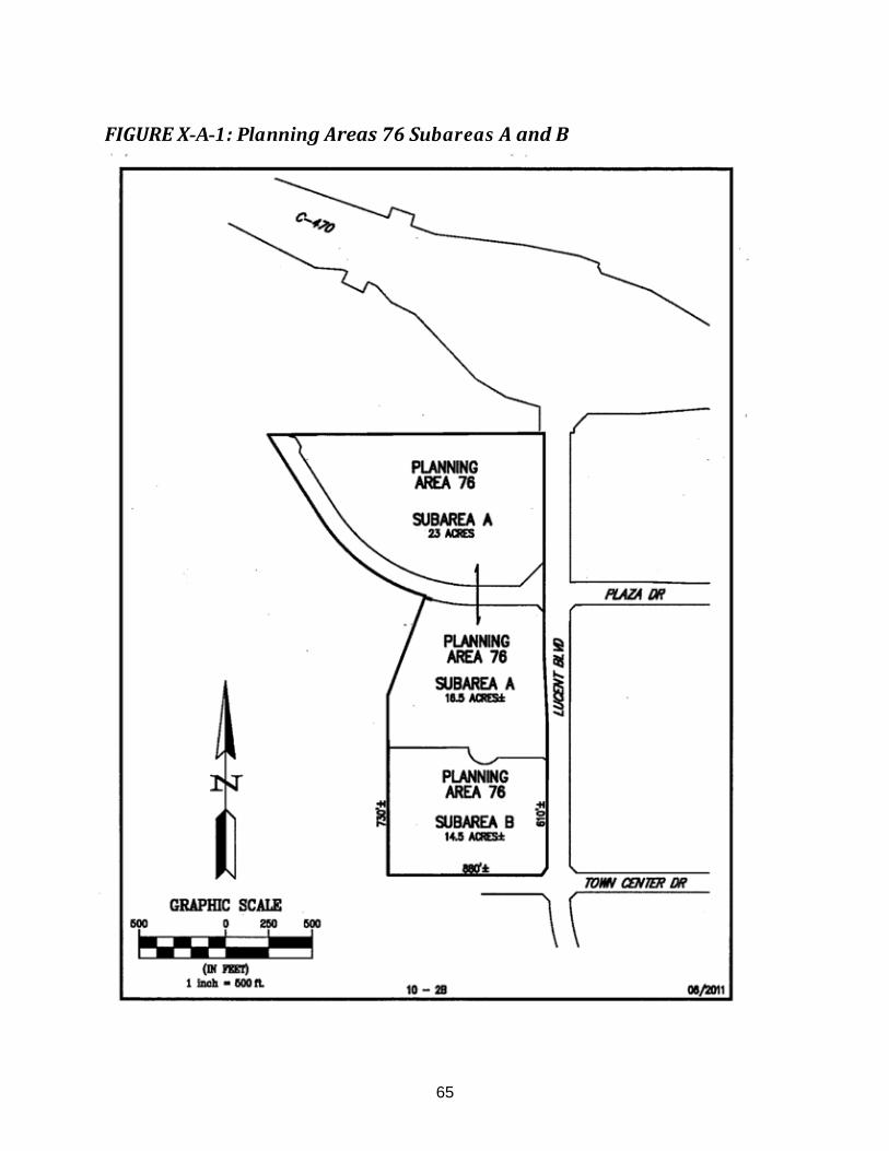
65
FIGURE X-A-1: Planning Areas 76 Subareas A and B

66
SECTION X-B - INDUSTRIAL PARK - Planning Areas 81, 84, 85, & 87 A. Purpose and Intent. The purpose of this Section is to establish land uses and
development standards for an Industrial Park within the New Town of Highlands Ranch, and promote high standards of developmental quality through stringent site planning and landscaping requirements. It is the intent of this Section to encourage the development of businesses and industries primarily engaged in research, development and testing; existing residences and new single-family attached, two-family and multi-family dwellings; compatible light general manufacturing; service industries; warehousing; and construction and activities relating thereto.
B. Uses Permitted by Right. The following uses are permitted in Planning Areas 81, 84, 85
and 87 as a matter of right, subject to the Site Development Plan requirements of the Douglas County Zoning Resolution. Prior to or in conjunction with the development of Planning Area 87 the landowner shall vacate the appropriate portions of Plum Valley Subdivision Final Plat.
1. Scientific and applied research, development and testing; manufacturing,
compounding, assembling, processing, or treatment of products; distribution centers; food and beverage processing; and similar non-offensive light industrial uses.
2. Administrative offices and professional offices. 3. Service industries. 4. Sale at wholesale and storage of any commodity, except commercial explosives,
or above ground bulk storage of flammable liquids or gases unless, and only to the extent that, storage of such liquids or gases is necessary for energy or heating devices to serve the uses in the project or lot.
5. Construction industries and those relating thereto, including, but not limited to,
general contractors, engineering contractors, specialty contractors, and temporary contractor storage yards.
6. The sale at retail and storage of hardware, any commodity manufactured,
processed, or fabricated on the premises, and equipment, supplies and materials (except commercial explosives) for agriculture, mining, business, industry, transportation, or construction.
7. The sale, parking and storage of motor vehicles. 8. Service commercial and recreation commercial, primarily to serve the employees
in the industrial park, including but not limited to restaurants, barber shops, cleaners, and recreation facilities.
9. Hotels and motels. 10. Retail Commercial.

67
11. Public and quasi-public buildings and structures, including but not limited to:
a. Police stations, fire stations, libraries, public recreation and emergency care facilities.
b. Public utilities.
12. Public and private schools and technical schools. 13. Transit facilities or other facilities designed to enhance the use of public transit. 14. Executive and caretaker apartments. 15. Automobile service stations as provided in Section XI, automobile repair specialty
shops, and automobile garages and body shops. 16. Kennels, animal clinics and animal hospitals. 17. Community information centers. 18. Special community events. 19. One-family attached, two-family and multiple-family dwellings as provided in
Section VII except that (contrary to Section V. F.) in no event shall the total number of residential dwelling units set forth in the Development Plan for Planning Areas 81 and 87 be exceeded nor shall any dwelling units be transferred from these Planning Areas or to any other Planning Area or from any other Planning Area to these Planning Areas.
20. Existing dwellings and a limited number of additional dwellings and associated
structures necessary to continue the use of the property at time of rezoning until such time as the property on which these dwellings are located is devoted to another permitted use.
21. Shop-N-Rides as provided in Section XII. 22. Accessory buildings and uses as provided in Section XIV. 23. Signs as provided in Section XV. 24. Off-street parking as provided in Section XVI. 25. Any other uses consistent with the purposes and compatible with the uses set
forth herein.
C. Uses By Special Review. The following uses are permitted in Planning Areas 81, 84, 85, and 87 subject to the Use by Special Review and the Site Development Plan requirements of the Douglas County Zoning Resolution. Prior to or in conjunction with the development of Planning Area 87, the landowner shall vacate the appropriate portions of Plum Valley Subdivision Final Plat.
1. Recreational Vehicle Sales.

68
2. Mobile Homes Sales. 3. Heavy Equipment Storage.
D. Development Standards. Development permitted in Industrial Park Planning Areas 81,
84, 85 and 87 shall be constructed in accordance with an approved Site Development Plan, and the following development standards except to the extent modified by such Plan:
1. Minimum lot area: 10,000 square feet, unless such development is designed
as a project or projects, and in such case there is no minimum lot area. 2. Minimum lot width and depth: 100 feet, unless such development is designed as
a project or projects, and in such case there is no required minimum lot width or depth.
3. Maximum building height: 90 feet, except as increased by the Board of County
Commissioners. 4. The following setback is required:
a. Minimum setback of 20 feet shall be required in areas abutting perimeter and interior public streets and 30 feet in areas abutting the boundaries of the Industrial Park Planning Area, provided such setback shall be 50 feet wherever such boundaries abut, without street separation, Residential Planning Areas or existing dwelling units, and provided further, that with respect to a flag or panhandle lot, the length of the corridor or accessway shall be excluded in applying such minimum to such lot.
b. No setback shall be required adjacent to property lines which merely separate uses.
5. All lighting shall be designed and located to reduce power consumption to its
lowest practical level and to direct light rays to the lot or project. 6. All loading and unloading shall be performed on the lot or project. Loading
platforms and areas shall be screened from view from adjacent streets, highways and residential areas in a manner prescribed by paragraph 9, below.
7. Trash and storage areas shall be shielded from view by placement within
buildings, or enclosure within opaque walls or fences not less than 5 feet in height. Wall and fence materials shall complement exterior building materials.
8. All permitted uses and their resulting products shall be contained entirely within a
fully enclosed structure, excluding therefrom such uses as off-street parking; trash storage; loading; sale of nursery stock; automobile washing; outdoor dining; automobile, mobile home and recreation vehicle sales; temporary contractor storage yards; outdoor recreation activities; special community events; and similar uses.
69
9. Screening shall be provided as set forth in subparagraphs a. and b., below, and shall consist of one or any combination of the materials set forth in subparagraphs c., d., or e., below.
a. Screening shall be constructed along Industrial Park Planning Area boundary lines which abut any Residential Planning Area or existing dwelling units without street separation. The height of such screening shall be indicated on the site development plan.
b. All mechanical equipment placed on any roof or otherwise outside of any building, including but not limited to, air-conditioning, heating and ventilating equipment, and vents, shall be screened from view from any street and any abutting Residential Planning Area or existing dwelling units.
c. Wall: A wall consisting of concrete block, stone, brick, tile or similar solid masonry material.
d. Berm: A berm constructed of earthen materials and landscaped.
e. Fence: An opaque fence constructed of wood or other materials.
10. Landscaping shall be installed and maintained subject to the following standards:
a. Landscaping shall be installed on at least 15 percent of the acreage of each lot or, if the development is in a project, 15 percent of each project. With the approval of the Planning Director, adjacent parkway landscaping may be used to satisfy up to one-third of the 15 percent minimum landscaping requirement of a specific parcel.
b. Landscaping shall be installed along all property lines abutting streets to a depth of not less than 10 feet, excluding therefrom driveways, alleys and street openings.
c. All landscaping shall be separated from abutting parking areas and driveways by curbs at least 4 inches higher than the abutting vehicular driving surfaces in order to provide such landscaping protection from vehicular damage.
d. Landscaping at driveway, alley and street intersections shall be installed and maintained in such a manner as not to hinder the visibility of motorists.
e. Irrigation facilities shall be installed and maintained to serve all vegetated areas.
f. Required landscaping shall be maintained in the manner and degree necessary to keep plants reasonably healthy and presentable, including pruning, mowing, weeding, fertilizing, watering, and replacement of plants when necessary.
11. All parking lots and driveways shall be maintained in a reasonably neat and clean
manner in order to reduce nonpoint source pollution and particulates. 12. Unless otherwise specified, no permitted business or industrial operation shall
cause or produce a nuisance to adjacent sites. Such nuisances include, but are not limited to, excessive amounts of radio frequency interference, sound, vibration, electro-mechanical disturbance, electromagnetic disturbance, radiation,

70
air or water pollution, dust, emission of toxic or nontoxic odors, or emission of toxic matter.
E. Residential Use Development Standards. Any residential use permitted as a matter of
right by the provisions of this Section shall be subject to the High Density Residential development standards provided in Section VII, A-E. The minimum project size shall be 5 acres, unless a smaller area is approved by the Board of County Commissioners or project is included in a multi-use project that integrates residences with nonresidential uses into a single project.

71
SECTION X-C - PLAZA CENTER - Planning Areas 77-A, 77-B and 79 A. Purpose and Intent. The intent of this section is to allow for development with multiple
uses. The Highlands Ranch Plaza Center encourages flexible land uses that include housing, retail, office, commercial services, and civic uses, to create economic and social vitality, and provide market flexibility. This district promotes development and future redevelopment to create multi-use areas that are built to a human scale for aesthetics, pedestrian comfort, and safety.
Ensure development in the form of high intensity and high quality, both in land use and architecture to provide a mixture of employment, retail, and civic uses to establish a stand-alone, self-supporting, economic center. A residential component shall be encouraged.
B. Uses Permitted by Right. The following uses are permitted in Planning Areas 77-A, 77-B and 79 as a matter of right, subject to Site Development Plan requirements of the Douglas County Zoning Resolution.
1. Laboratory and medical research, development and testing.
2. Administrative offices.
3. Professional offices.
4. Government offices.
5. Recreation commercial.
6. Retail commercial.
7. Restaurant, with pick up window, standalone or integrated with other permitted uses in a single building.
8. Financial institutions and coffee shops with drive through facility.
9. Multiple family dwellings, for sale or lease, subject to the following requirements: a minimum of 10 units per building. First floor retail is allowed, but not required. Private leasing and sales office allowed.
10. Hotels.
11. Art galleries, museums, studios.
12. Public parks, plazas, and pedestrian areas.
13. Public and quasi-public buildings and structures including, but not limited to:
a. Libraries, public recreation, and emergency care facilities.
b. Communication facilities including towers or spires
14. Municipal buildings.

72
15. Hospital and medical clinic (up to 100 beds)
16. Public and private colleges, universities, and technical schools.
17. Transit facilities or other facilities designed to enhance the use of public transit.
18. Special community events.
19. Street vendors and food trucks subject to a use permit from Douglas County. Must be parked adjacent to public amenity areas.
20. Temporary concessions which are sponsored by nonprofit, Highlands Ranch organizations subject to a use permit as may be required by Douglas County.
21. Accessory buildings and uses as provided in Section XIV.
22. Off-street parking as provided in Section XVI.
23. Any other uses consistent with the purposes of this Section and compatible with the uses set forth herein as approved by the Planning Services Director.
C. Uses Permitted by Right. The following uses are permitted in Planning Area 77-B as a matter of right, subject to Site Development Plan requirements of the Douglas County Zoning Resolution.
1. Single family dwellings, for sale and attached or detached, as permitted as a matter of right in Section VI – Low Density, Medium-Low Density, and Medium Density One- Family Residential and Section VII-High Density Residential.
D. Development Standards. Development permitted in Plaza Center Planning Areas 77-A,
77-B and 79 shall be constructed in accordance with an approved Site Development Plan, and the following development standards except to the extent modified by such Plan: 1. Minimum lot area: 5,000 square feet, unless such development is designed as a
project or projects and in such cases there is no minimum lot area. Excludes Planning Area 77-B, towers, spires and community elements.
2. Maximum building height for PA 77-A and 79: 70 feet, except for communication towers or spires.
3. Maximum building height for PA 77-B: 50 feet.
4. The following setback is required:
a. Minimum setback of 20 feet shall be required in areas abutting all project boundary lines.
b. No setback shall be required adjacent to property lines which merely separate uses.
5. All lighting shall be designed to comply with the Douglas County regulations.

73
6. All loading and unloading shall be performed on the lot or project. Loading platforms and areas shall be positioned to minimize from view in a manner described by paragraph 8 below.
7. Trash and storage areas shall be shielded from view by placement within building, or enclosure within opaque walls or fences not less than 5 feet in height. Wall and fence materials shall complement exterior building materials.
8. Screening shall be provided as set forth in subparagraphs a and b below, and shall consist of one or any combination of the material set forth in subparagraphs c, d or e below.
a. Screening shall be constructed along Plaza Center Planning Area boundary lines which abut any Residential Planning Area or existing dwelling units without street separation. The height of such screening shall be indicated on the site development plan.
b. All mechanical equipment placed on any roof or otherwise outside of any building including, but limited to, air-conditioning, heating and ventilating equipment, and vents, shall be screened from view form any street and any abutting Residential Planning Area or existing dwelling units.
c. Wall: a wall consisting of concrete block, stone, brick tile or similar solid masonry material. Retaining walls are allowed up to 20 feet in height as one wall.
d. Berm: A berm constructed of earthen materials and landscaped.
e. Fence: An opaque fence constructed of wood or other materials.
9. Landscaping shall be installed and maintained subject to the following standards:
a. Landscaping shall be installed on at least 15 percent of the acreage of each lot or, if the development is in a project, 15 percent of each project. With the approval of the Planning Director, adjacent parkway landscaping may be used to satisfy up to one-third of the 15 percent minimum landscaping requirement of a specific parcel and/or project. Parkway landscaping shall be defined as landscaping and landscaping improvements located within public rights of way. In PA77-B, common area spaces, such as, but not limited to, porches, patios, decks, outdoor shelters and outdoor living areas shall be considered as landscaping.
b. Landscaping shall be installed along all property lines abutting perimeter public streets to a depth of not less than 10 feet, excluding there from driveways, alleys and street openings.
c. All landscaping shall be separated from abutting parking areas and driveways by curbs at least 4 inches higher than the abutting vehicular driving surfaces in order to provide such landscaping protection from vehicular damage.
d. Landscaping at driveway, alley and street intersections shall be installed and maintained in such a manner as not to hinder the visibility of motorists.
e. Irrigation facilities shall be installed and maintained to serve all vegetated areas.
74
f. Required landscaping shall be maintained in the manner and degree necessary to keep plants reasonably healthy and presentable, including pruning, mowing, weeding, fertilizing, watering and replacement of plants when necessary.
10. All parking lots and driveways shall be maintained in a reasonably neat and clean manner in order to reduce particulate and nonpoint source pollution.
11. Unless otherwise specified, no permitted business or industrial operation shall cause or produce a nuisance to adjacent sites. Such nuisances include, but are not limited to, excessive amounts of radio frequency interference, sound, vibration, electro-mechanical disturbance, electromagnetic disturbance, radiation, air or water pollution, dust, emission of toxic or non- toxic odors, or emission of toxic matter.

75
FIGURE X-C-1: Planning Areas 77-A and 77-B

76
SECTION X-C - INDUSTRIAL PARK - Planning Area 85-A A. Purpose and Intent. The purpose of this section is to establish higher density residential
near a Transit Oriented Development. A maximum of 285 residential units are allocated to the Industrial Park Planning Area 85-A while still maintaining the high standards of developmental quality specified in Section VII and X of the Highlands Ranch Planned Development.
B. Uses Permitted by Right. The following uses are permitted in Planning Area 85-A as a matter of right, subject to the Site Development Plan requirements of the Douglas County Zoning Resolution.
1. All of the uses permitted by right in Planning Area 85 as set forth in Section X-B.
C. Development Standards. Development permitted in the Industrial Park Planning Area 85-A shall be constructed in accordance with an approved Site Development Plan, and must comply with those set forth in Section VII C-E.

77
SECTION XI - AUTOMOBILE SERVICE STATIONS A. Purpose and Intent. The purpose of this Section is to establish development standards
for the design and use of automobile service stations. It is the intent of this Section to encourage the development of properly located and aesthetically pleasing automobile service stations to serve primarily the needs of the motorists of Highlands Ranch.
B. Uses Permitted by Right. Automobile service stations providing only the following goods and services are permitted as a matter of right in the Community Activity Center, Civic Center, Town Center, and Industrial Park Planning Areas, and with limited uses within Shop-N-Rides, subject to the Site Development Plan requirements of the Douglas County Zoning Resolution.
1. Sale of petroleum products, propane, butane, and natural gas.
2. Sale of tires, batteries and related automotive accessories.
3. Minor automobile maintenance such as tuneups, fanbelt maintenance, alternator repair, car washing, and car lubrications.
4. Incidental food and beverage sales.
5. Recreation vehicle waste disposal facilities.
6. Signs as provided in Section XV.
C. Limitation of Activities. Automobile service stations are permitted in any Shop- N-Ride, provided the use thereof shall be limited to the sale of petroleum products, propane, butane, and natural gas. Major engine, transmission, drive train, and other heavy mechanical repairs shall be prohibited within any automobile service station.
D. Development Standards. Automobile service stations may be constructed in Planning Areas permitting such use, in accordance with an approved Site Development Plan, and the following development standards except to the extent modified by such Plan.
1. Minimum lot area: 10,000 square feet.
2. Minimum lot width and depth: 100 feet.
3. Maximum building height: 35 feet, except as increased by the Douglas County Board of Adjustment
4. The following setback is required:
a. Minimum side and rear setback and front setback when front does not abut a public street: 20 feet, provided that with respect to a flag or panhandle lot, the length of the corridor or accessway shall be excluded in applying such minimum to such lot.
b. Minimum front setback when front abuts a public street: 10 feet, provided that with respect to a flag or panhandle lot, the length of the corridor or accessway shall be excluded in applying such minimum to such lot.

78
5. All lighting shall be designed and located to reduce power consumption to the lowest practical level and to direct light rays to the lot or project.
6. Trash and storage areas shall be shielded from view by placement within buildings, or by enclosure within opaque walls or fences not less than 5 feet in height. Wall and fence materials shall complement exterior building materials.
7. All facilities other than gasoline pump islands, recreation vehicle waste disposal facilities, and trash and storage areas shall be contained entirely within a fully enclosed structure.
8. All automobile service stations located at intersections, excluding therefrom stations in Shop-N-Rides, shall be designed so that the gasoline pump islands and interior working areas are screened from view from the intersection by means of aesthetically pleasing screening techniques such as reversing the building (commonly referred to as inside-out stations) or landscaping, or both.
9. Wherever an automobile service station abuts a Residential Planning Area, a 6-foot high opaque wall or fence shall be erected along said common boundary.
10. Wherever an automobile service station is an integral part of a Shop-N-Ride, the above standards relating to minimum lot area, width, and depth shall apply to the entire Shop-N-Ride and not merely the automobile service station portion thereof.
11. Landscaping shall be installed and maintained subject to the following standards:
a. Landscaping shall be installed on at least 15 percent of the acreage of each automobile service station. With the approval of the Planning Director, adjacent parkway landscaping may be used to satisfy up to one-third of the 15 percent minimum landscaping requirement of a specific parcel.
b. All landscaping shall be separated from abutting parking areas and driveways by curbs at least 4 inches higher than the abutting vehicular driving surfaces in order to provide such landscaping protection from vehicular damage.
c. Landscaping at driveway, alley and street intersections shall be installed and maintained in such a manner as not to hinder the visibility of motorists.
d. Required landscaping shall be maintained in the manner and degree necessary to keep plants reasonably healthy and presentable, including pruning, mowing, weeding, fertilizing, watering, and replacement of plants when necessary.
12. Balloons, flags, spotlights, and similar devices shall be prohibited, provided however, that nothing herein shall preclude the flying of the flag of the United States, the State or the County, or the use of ornamental landscape lighting as accent lights only.
13. All parking lots and driveways shall be maintained in a reasonably neat and clean manner in order to reduce particulate and nonpoint source pollution.

79
SECTION XII - SHOP-N-RIDES A. Purpose and Intent. The purpose of this Section is to establish land uses and
development standards for Shop-N-Ride facilities. Each Shop-N-Ride shall be conveniently located and aesthetically pleasing, and shall include off-street parking and waiting facilities and convenience commercial uses to serve primarily the residents of the immediate neighborhood. The specific location of each Shop-N-Ride shall be set forth in an approved Site Development Plan.
B. Uses Permitted by Right. The following uses are permitted as a matter of right in Shop-N-Rides, subject to the Site Development Plan requirements of the Douglas County Zoning Resolution.
1. Indoor and outdoor waiting areas for transit users.
2. Convenience commercial.
3. Automobile service stations, limited to the sale of petroleum products only.
4. Dwelling units for the owners and lessees of the Shop-N-Ride facilities, provided said dwelling units are an integral part of the Shop-N-Ride main building.
5. Special community events.
6. Signs as provided in Section XV.
7. Off-street parking as provided in Section XVI.
C. Development Standards. Shop-N-Rides may be constructed in accordance with an approved Site Development Plan, and the following development standards except to the extent modified by such Plan:
1. Maximum Number of Shop-N-Rides: 11.
2. Maximum lot area of a single site: 12 acres.
3. Total Acreage for all Shop-N-Ride sites: 35 acres.
4. Minimum lot area: 1 acre.
5. Minimum lot width and depth: 100 feet.
6. Maximum building height: 35 feet.
7. The following setback is required:
a. Minimum side and rear setback and front setback when front does not abut a public street: 20 feet, provided that with respect to a flag or panhandle lot, the length of the corridor or accessway shall be excluded in applying such minimum to such lot.
b. Minimum front setback when front abuts a public street: 10 feet, provided that with respect to a flag or panhandle lot, the length of the corridor or
80
accessway shall be excluded in applying such minimum to such lot.
8. All lighting shall be designed and located to reduce power consumption to its lowest practical level and to direct light rays to the lot or project.
9. Trash and storage areas shall be shielded from view by placement within buildings, or by enclosure within opaque walls or fences not less than 5 feet in height. Wall and fence materials shall complement exterior building materials.
10. All facilities other than gasoline pump islands, off-street parking areas and outdoor waiting areas shall be contained entirely within a fully enclosed structure.
11. Wherever any Shop-N-Ride is located within a Residential Planning Area, an opaque 5-foot high wall or fence shall be erected along the boundaries abutting such Planning Area.
12. Landscaping shall be installed and maintained subject to the following standards:
a. Landscaping shall be installed on at least 15 percent of the acreage of each Shop-N-Ride. With the approval of the Planning Director, adjacent parkway landscaping may be used to satisfy up to one-third of the 15 percent minimum landscaping requirement of a specific parcel.
b. Landscaping shall be installed along all property lines abutting streets to a depth of not less than 10 feet, excluding therefrom driveways, alleys and street openings.
c. All landscaping shall be separated from abutting parking areas and driveways by curbs at least 4 inches higher than the abutting vehicular driving surfaces in order to provide such landscaping protection from vehicular damage.
d. Landscaping at driveway, alley and street intersections shall be installed and maintained in such a manner as not to hinder the visibility of motorists.
e. Irrigation facilities shall be installed and maintained to serve all vegetated areas.
f. Required landscaping shall be maintained in the manner and degree necessary to keep plants reasonably healthy and presentable, including pruning, mowing, weeding, fertilizing, watering, and replacement of plants when necessary.
13. Balloons, flags, spotlights, and similar devices shall be prohibited, provided, however, that nothing herein shall preclude the flying of the flag of the United States, the State or the County, or the use of ornamental landscape lighting as accent lighting only.
14. All parking lots and driveways shall be maintained in a reasonably neat and clean manner in order; to reduce particulate and nonpoint source pollution.
15. All exterior loud speakers used for transit information shall be operated at a volume level that does not unreasonably interfere with adjacent residents.

81
16. The architectural treatment of Shop-N-Rides in locations other than Nonresidential Planning Areas shall be compatible with adjacent residential developments.

82
SECTION XIII - NONURBAN AREA A. Purpose and Intent. The purpose of this Section is to establish land uses and
development standards which will result in the retention of a significant amount of the new Town of Highlands Ranch for nonurban uses. It is the intent of the Nonurban Area to provide land for education and recreational opportunities, public facilities, quasi- public facilities, other uses which are oriented toward community activities and services within the new Town. Further it is the intent of this Section to exclude urban development from areas which provide buffer zones within or surrounding development areas, and to preserve such natural resources as significant vegetation landforms and creek beds: historical and cultural resources such as historic buildings archaeological and paleontological sites: and significant wildlife habitat areas. This section of the Development Guide in conjunction with the Open Space Agreement (Highlands Ranch) adopted in October 1980 and the Conservation Easement (Highlands Ranch) adopted in April 1980 by the Board of Douglas County Commissioners constitutes the Nonurban Area Management Plan. This section also satisfies Section 3.9 of the Open Space Conservation Agreement (Highlands Ranch) adopted in November. 1988 and Section 3.3 of the Wildcat Regional Park Agreement (Highlands Ranch) adopted in November, 1996.
B. Uses Permitted by Right in the Nonurban Area Exclusive of the Open Space Conservation Area. The following uses are permitted in the Nonurban Area exclusive of the Open Space Conservation Area as a matter of right, subject to the Site Development Plan requirements for buildings as provided in the Douglas County Zoning Resolution.
1. Farm and garden buildings.
2. Public and private schools and associated agricultural or educational programs including but not limited to:
a. Public and private elementary, junior high and senior high schools b. Preschools c. Daycare Centers
3. Parks and recreational facilities, including but not limited to:
a. Regional, community and neighborhood parks b. Community and neighborhood recreation centers (public or private) c. Public or private golf courses and country clubs and associated uses d. Public and private campgrounds e. Public and private reservoirs, lakes and ponds
4. Agricultural and ranching uses such as grazing, feed production, tree farms, and
other similar uses and farm and garden buildings accessory thereto.
5. Public and quasi-public facilities including but not limited to:
a. Religious institutions
b. Public utility buildings, structures and facilities including but not limited to:
1) Water and wastewater treatment plants

83
2) Reservoirs, lakes, ponds 3) Electrical, telephone, or natural gas distribution or treatment
facilities 4) Flood control facilities 5) Cable T.V. facilities
c. Libraries and museums
d. Special district offices
e. Douglas County offices and stations
f. Public services offices such as U.S. West, IREA. Public Service Company
6. Park-N-Rides* 7. Historic structures 8. Paleontological sites 9. Archaeological sites 10. Easements 11. Open space buffers 12. Natural preservation areas (nature study areas) 13. Wildlife habitat areas and wildlife corridors 14. Riding, hiking and biking trails and associated vista and rest stops 15. Streets 16. Signs as provided in Section XV. 17. Off-street parking as provided in Section XVI. 18. Other uses which serve all of a portion of the new Town of Highlands Ranch and
similar to and consistent with the Uses by Right or Uses by Special Review may be permitted with the approval of the Planning Director either as a Use by Right or with Board approval as a Use by Special Review as determined by the Planning Director.
C. Uses bv Special Review in the Nonurban Area Exclusive of the Open Space Conservation Area. The following uses are permitted in the Nonurban Area exclusive of the Open Space Conservation area subject to the Use by Special Review and the Site Development Plan requirements for buildings as provided in the Douglas County Zoning Resolution.
1. Public or private universities, colleges and junior colleges

84
2. Major facilities of a public utility
3. Kennels and equestrian facilities
4. Borrow sites
5. Commercial recreation
6. Office
Approval of these uses requires a Public Hearing before the Board of Douglas County Commissioners with Notice given at least (30) thirty days prior to the hearing of the time and place in at least one publication in a newspaper of general circulation in Douglas County and at the discretion of the Planning Director a Public Hearing before the Planning Commission.
D. Development Standards for the Nonurban Area Exclusive of the Open Space Conservation Area. Development permitted in the Nonurban Area exclusive of the Open Space Conservation Area shall be constructed in accordance with an approved Site Plan, subject to the following development standards except to the extent modified by such Site Plan:
1. Minimum lot area: none
2. Minimum lot width and depth: none
3. Maximum building height: 50 feet, except as increased by the Douglas County Board of Adjustment.
The following setback is required.
a. Minimum setback: none, except adjacent to a public street where 20 feet is the minimum yard.
b. No setback shall be required adjacent to property lines which merely separate uses within the Nonurban Area.
4. All lighting shall be designed and located to reduce power consumption to its lowest practical level and to direct light rays to the lot or project.
5. Trash and storage areas shall be shielded from view by placement within buildings, or by enclosure within opaque walls or fences not less than 5 feet in height. Wall and fence materials shall complement exterior building materials.
6. All parking lots and driveways shall be maintained in a reasonably neat and clean manner in order to reduce particulate and nonpoint source pollution.

85
E. Uses Permitted by Right in the Active Recreation and Public Facility Area Portion of the Open Space Conservation Area; the 1200-Acre Area. Planning Areas B, C, D, E, and F as depicted on the Highlands Ranch Development Plan.
1. Uses permitted by right subject to Douglas County site improvement plan review and approval:
a. Agriculture
1) Farms and ranches for production and sale of crops and livestock including tree farms and associated structures.
Cattle, buffalo, and horse ranching, including raising, breeding, feeding and selling livestock and other animals pending review and associated structures.
2) Gardens, tree farms, and associated structures.
3) Agricultural education and research facilities.
4) Arboreta.
5) Community gardens.
b. Public and quasi-public facilities
1) Law Enforcement offices and stations
2) Fire stations
3) Libraries
4) Public utility buildings, structures and facilities including. but not limited to:
a) Water and wastewater treatment plants, not exceeding 100,000 gallon capacity, water wells, wellhead treatment equipment, water distribution lines and appurtenances;
b) Sludge application to properly reuse the by-product of treated effluent to enhance soil condition and forage. In the event a local, state or federal regulatory agency determines that sludge application is in non-compliance with applicable law, application will be stopped pending further review by the appropriate agency;
c) Potable water reservoirs; buried water tanks with exposed lid not exceeding 5 million gallon storage capacity and surface reservoirs;
d) Electrical, (not to exceed 115 KV), telephone, communication, or natural gas distribution facilities;
d) Flood control facilities required by applicable regulation;
f) Cellular communication facilities pursuant to Douglas County Zoning Resolution.
g) Drainage discharge and flood control lines, systems and facilities including, but not limited to impoundment reservoirs

86
and retaining basins, ditches, conduits and culverts required by applicable regulation.
c. Religious institutions including but not limited to churches and retreat facilities not to exceed 350 seats in the main worship area.
d. Public and private colleges and universities, environmental education camps, and satellite educational facilities operated by public and/or private colleges and universities with structures not exceeding 50,000 sq. ft. in areas where access is available.
e. Public or private parks and recreational facilities including but not limited to:
1) Regional, community and neighborhood parks. Passive park uses should be sited or located on the portions of the park that borders the most environmentally sensitive areas.
2) Golf courses and country clubs and associated uses.
3) Commercial recreation with structures not to exceed 50,000 sq. ft.
4) Recreation centers with structures not to exceed 50,000 sq. ft.
5) Equestrian center, dressage riding area, stables with sites not to exceed 20 acres in area, and polo fields.
6) Sports training center with structures not to exceed 50,000 sq. ft.
7) Skateboard and in-line skating facilities including in-line hockey
8) Trails including pedestrian, bicycle and equestrian
9) Special community events
10) Community camps for all ages in areas with good access and limited to marginal or good and better wildlife habitat areas depicted on Exhibit F of the OSCA Plan. Limited overnight camping shall be allowed.
f. Cultural facilities
1) Museums.
2) Cultural centers with structures not to exceed 50.000 sq. ft.
3) Amphitheater limited to cultural or instructional programs of a limited nature constructed compatible with the natural surroundings with sites not to exceed 1 acre.
4) Archaeological sites
5) Archaeological and interpretive centers with sites not to exceed 10 acres.
6) Limited use of existing historic structures for a contemporary use including, but not limited to ranch headquarters, caretaker structures, heritage center, cultural uses and living history museum without expanding the square footage of existing buildings.

87
g. Wildlife support
1) Animal rehabilitation center or wildlife hospital with sites not to exceed 1 acre.
2) Wildlife interpretive centers at interface between 1,200-acre area and 7000-acre area with sites not to exceed 10 acres.
3) Wildlife conservation area and wildlife habitat enhancement area.
4) Wildlife migration corridors.
5) Controlled wildlife viewing areas.
h. Public and private roads or streets.
i. One residence used by landowner of a ranch or farm to manage the property and/or one residence for purposes of housing a caretaker to manage the subject property.
j. Other uses which serve all or a portion of Highlands Ranch and similar to and consistent with the uses by right, subject to review and approval by the Douglas County Planning Director based on a recommendation from the HRCA.
k. Easements
l. Signs as provided in Section XV of the Highlands Ranch Development Guide except that entry signs shall not exceed 50 square feet for any one sign with a total of 100 square feet per entry and a maximum height of 8 feet: permanent directional, future use, principal use or building directional signs shall not exceed 50 square feet or 10 feet in height: and shall use consistent designs, colors and materials.
F. Uses Permitted by Right in the Golf Course Area Portion of the Open Space Conservation Area
(A portion of the 1200-acre area depicted as Planning Area A on the Highlands Ranch Development Plan)
Uses permitted by right subject to Douglas County site improvement plan review and approval:
a. Agriculture
1) Cattle, buffalo and horse ranching, including raising, breeding, feeding and selling livestock and other animals pending review and associated structures excluding feedlots.
b. Public and quasi-public facilities
1) Public utility buildings, structures and facilities including, but not limited to:
a) Water wells, wellhead treatment equipment, water distribution lines and appurtenances.
b) Electrical (not to exceed 115 KV), telephone, communication, or natural gas distribution facilities.

88
c) Flood control facilities required by applicable regulation.
d) Cellular communication facilities pursuant to Douglas County Zoning Resolution.
e) Drainage and discharge and flood control lines, systems and facilities including, but not limited to impoundment reservoirs and retaining basins, ditches, conduits and culverts required by applicable regulation.
c. Public or private recreation facilities including but not limited to:
1) Golf courses and country clubs and associated uses.
2) Recreation centers with structures not to exceed 50,000 sq. ft.
3) Trails including pedestrian, bicycle and equestrian
4) Special community events.
d. Other uses which serve all or a portion of Highlands Ranch and similar to and consistent with the uses by right, subject to review and approval by the Douglas County Planning Director based on a recommendation from the HRCA.
e. Easements
f. Public and private roads or streets
g. Signs as provided in Section XV of the Highlands Ranch Development Guide except that entry signs shall not exceed 50 square feet for any one sign with a total of 100 square feet per entry and a maximum height of 8 feet; permanent directional, future use, principal use or building directional signs shall not exceed 50 square feet or 8 feet in height; and shall use consistent designs, colors and materials.
G. Uses Permitted by Right in the Cultural and Educational Area Portion of the Open Space Conservation Area (A portion of the 1200-acre area depicted as Planning Area G on the Highlands Ranch Development Plan)
Uses permitted by right subject to Douglas County site improvement plan review and approval:
a. Agriculture
1) Cattle, buffalo and horse ranching, including raising, breeding, feeding and selling livestock and other animals pending review and associated structures excluding feedlots.
b. Public and quasi-public facilities
1) Public utility buildings, structures and facilities including, but not limited to:
a) Water wells, wellhead treatment equipment, water distribution lines and appurtenances:
b) Electrical (not to exceed 115 KV), telephone, communication, or
89
natural gas distribution facilities.
c) Flood control facilities required by applicable regulation.
d) Cellular communication facilities pursuant to Douglas County Zoning Resolution.
e) Drainage and discharge and flood control lines, systems and facilities including, but not limited to impoundment reservoirs and retaining basins, ditches, conduits and culverts required by applicable regulation.
c. Public or private recreation facilities including but not limited to:
1) Trails including pedestrian, bicycle and equestrian
2) Equestrian center, dressage riding area, stables with sites not to exceed 20 acres in area.
3) Community camps for all ages in areas with good access and limited to marginal or good and better wildlife habitat areas depicted on Exhibit F of the OSCA Plan. Limited overnight camping shall be allowed.
4) Special community events.
d. Cultural facilities
1) Museums
2) Cultural centers with structures not to exceed 50,000 sq. ft.
3) Amphitheater limited to cultural or instructional programs of a limited nature constructed compatible with the natural surroundings with sites not to exceed 1 acre.
4) Archaeological sites;
5) Archaeological and interpretative centers with sites not to exceed 10 acres.
e. Wildlife support
1) Animal rehabilitation center or wildlife hospital with sites not to exceed 1 acre.
2) Wildlife interpretative centers at interface between 1200-acre area and 7000-acre area with sites not to exceed 10 acres.
3) Controlled wildlife viewing areas
f. Public and private roads or streets
g. Other uses which serve all or a portion of Highlands Ranch and similar to and consistent with the uses by right, subject to review and approval by the Douglas County Planning Director based on a recommendation from the HRCA.
h. Easements
i. Signs as provided in Section XV of the Highlands Ranch Development Guide except that entry signs shall not exceed 50 sq. ft. or any one sign with a total of

90
100 sq. ft. per entry and a maximum height of 8 ft. permanent directional, future use, principal use or building directional signs shall not exceed 50 sq. ft. or 8 ft. in height; and shall use consistent designs, colors and material.
H. Uses permitted by Right in the Driver Training Facility Area portion of the Open Space Conservation Area. (A portion of the 1200-acre area depicted in Planning Area I on the Highlands Ranch Development Plan)
Uses permitted by right subject to Douglas County Site Improvement Plan review and approval:
a. Law enforcement training facility for police and fire emergency equipment and citizen driver training.
b. Water wells, well-head treatment equipment, water or natural gas distribution facilities.
c. Electrical (not to exceed 115 KV), telephone, communication or natural gas distribution facilities.
d. Flood control facilities required by applicable regulation.
e. Drainage discharge and flood control lines, systems and facilities including, but not limited to: impoundment reservoirs and retaining basins, ditches, conduits and culverts required by applicable regulation.
f. Driver's training activity shall occur only during daylight hours without necessitating the use of headlights in accordance with state laws defining use of headlights. Except as needed for minimal security needs, no lighting shall be allowed.
g. Public and private roads or streets.
h. Easements
i. Signs as provided in Section XV of the Highlands Ranch Development Guide except that entry signs shall not exceed 50 sq. ft. for any one sign with a total of 100 sq. ft. per entry and a maximum height of 8 ft. permanent directional, future use, principal use or building directional signs shall not exceed 50 sq. ft. or 8 ft. in height and shall use consistent design, colors and materials.
j. Other uses which serve all or a portion of Highlands Ranch similar to and consistent with the Uses by Right, subject to review and approval by the Douglas County Planning Director based on a recommendation from the HRCA.
I. Uses Permitted by Right in the Playfield Area Portion of the Open Space Conservation Area
(A portion of the 1200-acre area depicted as Planning Area H on the Highlands Ranch Development Plan)
Uses permitted by right subject to Douglas County site improvement plan review and approval:
a. Agriculture
1) Cattle, buffalo and horse ranching, including raising, breeding, feeding and

91
selling livestock and other animals pending review and associated structures, excluding feedlots.
b. Public and quasi-public facilities
1) Public utility buildings, structures and facilities including, but not limited to:
a) Water wells, wellhead equipment, water distribution lines and appurtenances:
b) Electrical (not to exceed 115 KV), telephone, communication, or natural gas distribution facilities.
c) Flood control facilities required by applicable regulation.
d) Cellular communication facilities pursuant to Douglas County Zoning Resolution.
e) Drainage and discharge and flood control lines, systems and facilities including, but not limited to impoundment reservoirs and retaining basins, ditches, conduits and culverts required by application regulation.
c. Public recreation facilities including, but not limited to:
1) Playfields as part of a high school/middle school campus.
2) Trails including pedestrian, bicycle and equestrian.
3) Special community events.
d. Other uses which serve all or a portion of Highlands Ranch and similar to and consistent with the uses by right, subject to review and approval by the Douglas county Planning Director based on a recommendation from the HRCA.
e. Easements
f. Signs as provided in Section XV of the Highlands Ranch Development Guide except that entry signs shall not exceed 50 sq. ft. for any one sign with a total of 100 sq. ft. per entry and a maximum height of 8 ft., permanent directional future use, principal use or building directional signs shall not exceed 50 sq. ft. or 8 ft. in height: shall use consistent designs, colors and materials
g. Public and private road or streets.
J. Uses Permitted by Right in the Open Space Area Portion of the Open Space Conservation Area (The 7000-Acre Area)
Uses permitted by right, subject to Douglas County site improvement plan review and approval:
a. Wildlife support.
1) Wildlife conservation area and wildlife habitat enhancement area.
2) Wildlife interpretive centers at interface between 1200-acre area and 7000-acre area with sites not to exceed 10 acres.
3) Wildlife migration corridors.

92
4) Controlled wildlife viewing areas.
b. Cultural facilities.
1) Limited use of existing historic structures for a contemporary use including but not limited to ranch headquarters, caretaker structures, heritage center, and living history museum without expanding the square footage of existing buildings.
2) Archaeological sites:
3) Archaeological interpretive center sites not to exceed 10 acres.
c. Agriculture.
1) Cattle, buffalo and horse ranching including raising, breeding, feeding, and selling of livestock and other animals pending review and associated structures excluding feedlots.
d. Public and quasi-public facilities.
1) Public utility buildings, structures and facilities including but not limited to:
a) Water and wastewater treatment plants not exceeding 100,000 gallon capacity, water wells well-head treatment equipment, water distribution lines and appurtenances.
b) Sludge application to properly reuse the by-product of treated effluent to enhance soil condition and forage. In the event a local, state or federal regulatory agency determines that sludge application is in non-compliance with applicable law; application will be stopped pending further review by the appropriate agency.
c) Potable water reservoirs: water tanks not exceeding 5 million gallons storage capacity.
d) Electrical (not to exceed 115 KV), telephone, communication, or natural gas distribution facilities:
e) Flood control facilities required by applicable regulation.
f) Drainage discharge and flood control lines, systems and facilities including, but not limited to: impoundment reservoirs and retaining basin, ditches, conduits and culverts required by applicable regulation.
g) Easements
e. Recreational facilities and uses, including but not limited to:
1) Community camps for all ages for supervised educational experiences in areas with good access and limited to marginal or good wildlife habitat areas or near the edge between good and better wildlife habitat areas as depicted on Exhibit F of the OSCA Plan. Limited overnight camping shall be allowed. Facilities allowed include structures up to a total of 10,000 sq. ft. per camp for dining, restrooms, changing rooms, showers, enclosed storage and campfire pits, instructional seating areas, tent pads and associated improvements.
2) Riding, hiking and biking trails, interpretive trails, trails for people with

93
disabilities, ski touring trails, and associated vista rest stops and picnic areas and parking associated with a trail head staging area in areas near to existing roads.
3) Fishing ponds and casting pools in better wildlife areas.
4) Limited hunting for wildlife management according to Division of Wildlife guidelines only with permission from the landowner.
5) Polo fields.
f. Existing access roads with limited use in best wildlife areas as depicted on Exhibit F of the OSCA Plan.
g. Open space buffers.
h. Public and private roads, streets or arterials and public transportation facilities limited to near or on existing roads or as depicted on Douglas County Master Plan.
i. Interpretive identification signs shall not exceed 35 sq. ft. per sign face and trail identification signs shall not exceed 10 sq. ft. and a maximum height of 6 feet and shall use consistent designs, colors and materials.
j. One residence used by landowner of a ranch or farm to manage property and/or one residence for purposes of housing a caretaker to manage the subject property.
k. Other uses which serve all or a portion of Highlands Ranch similar to and consistent with the uses by right. Subject to review and approval by the Douglas County Planning Director based on a recommendation from the HRCA.
K. Uses Permitted by Right in the Law Enforcement Training Facility Area of the Open Space Conservation Area
(A portion of the 7000-acre area depicted in Planning Area J on the Highlands Ranch Development Plan)
Uses permitted by right subject to Douglas County site improvement plan review and approval:
a. Law enforcement training facility.
b. Water wells, well-head treatment equipment, water distribution lines and appurtenances.
c. Electrical (not to exceed 115 KV), telephone, communication or natural gas distribution facilities.
d. Flood control facilities required by applicable regulation.
e. Drainage discharge and flood control lines, systems and facilities including. but not limited to: Impoundment reservoirs and retaining basins, ditches, conduits and culverts required by applicable regulation.
f. Public and private roads or streets.
g. One residence used by landowner to manage property and/or one residence for purpose of housing a caretaker to manage the subject property.

94
h. Easements
i. Signs as provided in Section XV of the Highlands Ranch Development Guide except that entry signs shall not exceed 50 sq. ft. for any one sign with a total of 100 sq. ft. per entry and a maximum height of 8 feet; permanent directional, future use, principal use or building directional signs shall not exceed 50 sq. ft. or 8 ft. in height; and shall use consistent designs, colors and materials.
j. Other uses which serve all or a portion of Highlands Ranch similar to and consistent with the Uses by Right, subject to review and approval by the Douglas County Planning Director based on a recommendation from the HRCA.
L. Uses Permitted by Special Review In the Open Space Conservation Area (8200-acre area)
Subject to Douglas County USR permit process per Douglas County Zoning Resolution:
a. Exploration for and extraction of mineral resources excluding sand and gravel and rock quarrying, subject to a mineral extraction plan approved by Douglas County.
b. Water and wastewater treatment plants exceeding 100,000 gallon capacity;
c. Community camps for all ages in the Open Space Area for supervised educational experiences in areas with good access and limited to marginal or good wildlife habitat areas or near the edge between good and better wildlife habitat areas as depicted on Exhibit F on the OSCA Plan. Limited overnight camping shall be allowed. Facilities allowed include structures exceeding a total of 10,000 sq. ft. per camp for dining, restrooms, changing rooms, showers, enclosed storage; and campfire pits. Instructional seating areas, tent pads and associated improvements.
d. Limited use of existing structures for a contemporary use including, but not limited to ranch headquarters, caretaker structures, heritage center, and living history museum in excess of the square footage of existing buildings.
M. Uses Permitted by Special Review in Active Recreation and Public Facility Area a portion of the 1200-acre area as depicted in Planning Areas B-F on the Highlands Ranch Development Plan.
Subject to Douglas County USR permit process per Douglas County Zoning Resolution:
a. Religious institutions including but not limited to churches and retreat facilities with an excess of 350 seats in the main worship area:
b. Electrical facilities over 115 KV, cable television, radio and communication reception and transmission facilities with landscaped buffer where appropriate:
c. Public and private colleges and universities, environmental education camps, and satellite education facilities operated by public and/or private colleges and universities with structures in excess of 50,000 sq. ft. in areas where access is available.
d. Commercial recreation with structures in excess of 50,000 sq. feet.
e. Recreation centers with structures in excess of 50,000 sq. ft.

95
f. Recreational water park.
g. Equestrian Center, dressage riding area, stables with sites in excess of 20 acres in area.
h. Ice-skating rink and related facilities.
i. Sports training center with structures in excess of 50,000 sq. ft.
j. Commercial tobogganing and sledding hills located on north facing slopes with limited vegetation removal needed which may include artificial snowmaking equipment.
k. Cultural Center with structures in excess of 50,000 sq. ft.
l. Amphitheater limited to cultural or instructional programs of a limited nature constructed compatible with the natural surroundings with sites in excess of 1 acre.
m. Animal rehabilitation center or wildlife hospital with sites in excess of 1-acre.
n. Wildlife interpretive centers at interface between 1200-acre area and 7000-acre area with sites in excess of 10 acres.
o. Dog training area
p. Cemetery and mausoleum.
N. Uses Permitted by Special Review in Law Enforcement Training Facility Area (A portion of the 7000-acre area depicted in Planning Area J on the Highlands Ranch Development Plan)
Subject to Douglas County USR permit process per Douglas County Zoning Resolution
a. Electrical facilities over 115 KV, cable television, radio and communication reception and transmission facilities with landscaped buffer where appropriate.
O. Development Standards for the Open Space Conservation Area
a. Minimum lot area: none
b. Minimum lot width and depth: none
c. Maximum building height: 35 feet as defined on page 4-3 of the Highlands Ranch Development Guide.
d. The following setback is required:
1) Minimum setback: none, except adjacent to a public street where 20 feet is the minimum and adjacent to Planning Areas 57 and 58 where 30 feet is minimum.
2) No setbacks shall be required adjacent to property lines which merely separate uses within the Open Space Conservation Area.
e. All lighting shall be designed and located to reduce power consumption to its lowest practical level and to direct light rays to the lot or project to avoid disruption to adjoining uses. Lighting levels should be limited to applicable

96
standards.
f. Trash and storage areas shall be shielded from view by placement within buildings or by enclosure within opaque walls or fences not less than 5 feet in height. Wall and fence materials shall complement exterior building materials. Trash areas should be bear-proofed.
g. All parking lots and driveways shall be maintained in a reasonably neat and clean manner in order to reduce particulate and nonpoint source pollution.
h. Building colors should be generally warm and rich in tone in the range of natural colors and earth tones with low reflective value.
i. Building massing should be simple and include strongly integrated geometric forms which closely reflect the activities that occur in the building.
j. Buildings should be scaled to complement their surroundings.
k. Glazing shall be of a non-reflective style.
l. Design structures to step down hillsides and to fit the sloping terrain.
m. For further direction refer to the goals and policies of the Highlands Ranch Open Space Conservation Area Plan.
n. Wherever appropriate new wildlife friendly fencing will be installed according to Colorado Division of Wildlife Standards.
P. Acreage Calculation for the Active Recreation and Public Facility Area, the Cultural and Educational Area, the Playfield Area, Driver Training Area and Golf Course Area
a. Intent
In accordance with the 1988 OSCA Agreement and this Plan it is the intent of the "Active Recreation and Public Facility Area, the Cultural and Educational Area, the Playfield Area, Driver Training Area and the Golf Course Area" to provide up to 1200 acres for public and commercial recreation and public facility land uses.
In calculating the extent of acreage counted toward the 1200 acres for a given land use, the guiding principle shall be that of overall site integrity. In most cases the calculation shall include the entire property boundary: however it is anticipated that in some cases sufficiently large and important portions of the site may be left out of the 1200 acre accounting, as these areas are either characteristic of the "Open Space Area" or fall within specific wildlife movement corridors or buffers identified on Exhibits F and L of the OSCA Plan.
Areas that may be excluded from the 1200 acre accounting include:
1) 100-year flood plain when left in a natural unchannelized/unimproved state:
2) Significant drainage ways associated with wildlife movement corridors:
3) Land with slopes exceeding 20% grade, excluded from site development:
4) Undisturbed grassland, shrubland, riparian, or woodland vegetation that is not integral to an overall site development plan. In general, for example, land lying between golf course fairways would be considered part of the 1200-acre accounting: unless contained in areas defined by 1, 2, or 3 above and:

97
5) Collector and arterial roads such as Monarch Blvd., Daniels Park Road, Grigs Road.
b. Accounting Maintenance and Final Determination
Douglas County will maintain a tabulation of acres attributed to the "Active Recreation and Public Facility Area, the Recreational and Education Area, the Playfield Area, Driving Training Area and the Golf Course Area" (the 1200-acre area) updated with each approved land use application. The County shall make the final determination on inclusion or exclusion of acreage in the 1200- acre tabulation.
Given both natural and man-made constraints, the Plan and its accounting methodology do not guarantee that the full 1200 acres for active recreation and public facilities will be realized.
No acreage south of the regional trail west of Monarch Blvd. extended and no acreage east of the regional trail east of Monarch Blvd. extended shall be developed in accordance with the "Active Recreation and Public Facility Area, the Recreation and Education Area, the Playfield Area, Driver Training Area, and the Golf Course Area". The only exception may be a portion of a wildlife or nature interpretive center or other permitted uses within Planning Area G and permitted uses within Planning Area I.
Q. Planning Area Boundaries
The boundaries of Planning Areas A-J as depicted on the Highlands Ranch Development Plan may be modified pursuant to the procedure outlined in Section V.G of the Highland Ranch Development Guide.
R. Cultural and Historical Protection Overlay Zone
1. Intent
Native American Indian cultural activities continue today at the Tall Bull Memorial Grounds located within Daniels Park, immediately adjacent to the Highlands Ranch Open Space Conservation Area. These activities include social gatherings, communal spiritual events such as teepee ceremonies and private spiritual undertakings such as vision quests. The grounds provide spiritual sanctuary to 50 American Indian nations, the Native American Church, and various councils and institutions. Maintaining peaceful and visually unobstructed surroundings is of paramount concern. Significant portions of the Highlands Ranch Open Space Area are visible from the Tall Bull Memorial Grounds. Additional, significant cultural and historical resources lie within this area and deserve special protection. The most visually prominent resources include Daniels Park Road, Grigs/Lafayette Ranch, and the Douglas Pasture Ranch.
2. Permitted Land Uses
Land Uses shall be permitted in accordance with the provisions of the respective planning areas.

98
3. Development Review Standards
a. Visual Analysis
For all development requiring buildings within the Cultural and Historical Protection Overlay Zone ("The Zone") as depicted on the Highlands Ranch Development Plan, a visual analysis shall be conducted relative to at least two points within the Tall Bull Memorial Grounds. These points shall include at a minimum the central ceremonial ring and a high point along the southern boundary. The first priority shall be to place structures in the Zone such that they will not be seen from these points. In the event that structures cannot be fully invisible from within the Tall Bull Memorial Grounds, appropriate natural visual screening shall be required.
b. Lighting Standards
Except for more restrictive standards stated herein, all outdoor lighting within the Zone shall be in accordance with the Douglas County Zoning Resolution, as amended.
Outdoor lighting within the Zone shall be limited to the minimum required for security, utilitarian and safety purposes.
All outdoor lighting within the Zone shall be shielded to the extent that the source of illumination (bulb or direct lamp image) is not visible from any adjacent property. Within the Zone no light trespass beyond the facility served shall be allowed or after one-hour beyond business closure, whichever is more restrictive.
No outdoor facility shall be illuminated after 10 p.m. unless for safety reasons.
Maximum fixture height for all lighting within the Zone shall be 24'.
c. Buildings within the Zone portion of Planning Area E shall be sited as far away from Tall Bull Memorial rounds as possible.
d. Development Proposal Referrals
All development proposals within the Cultural and Historical Protection Overlay Zone shall be referred to the Tall Bull Memorial Grounds Council for their participation and input in the design review process.
S. Monarch Blvd. Contribution
Within Planning Areas D, E, and F of the Open Space Conservation Area, a fair and equitable contribution of $ 69/ADT will be paid to Douglas County by the landowner for the following land uses, including other similar land uses as determined by the Planning Director in accordance with applicable provisions of the Highlands Ranch Development Guide and Plan and the Open Space Conservation Area Plan:
a. Uses Permitted by Right
1) Religious institutions at 13.13 ADT/acre;

99
2) Colleges and universities at 47.6 ADT/acre:
3) Commercial recreation with structures not to exceed 50,000 sq. ft. at 24 ADT/acre:
4) Recreation centers with structures not to exceed 50,000 sq. ft. at 24 ADT/acre; and
5) Sports training center with structures not to exceed 50,000 sq. ft. at 24 ADT/acre.
b) Uses Permitted by Special Review
1) Exploration for and extraction of mineral resources*;
2) Religious institutions including but not limited to churches and retreat facilities with an excess of 350 seats in the main worship area at 13.13 ADT/acre;
3) Colleges and universities with structures in excess of 50,000 sq. ft. at 47.6 ADT/acre;
4) Commercial recreation with structures in excess of 50,000 sq. ft. at 24 ADT/acre;
5) Recreation centers with structures in excess of 50,000 sq. ft. at 24 ADT/ acre;
6) Recreational water park*;
7) Equestrian Center in excess of 20-acres in area*;
8) Ice-skating rink and related facilities*;
9) Commercial tobogganing and sledding*;
10) Cultural Center with structures in excess of 50.000 sq. ft.*;
11) Amphitheater in excess of 1 acre*; and
12) Dog Training Area.*
* Trip generation to be determined at time of approval of use by special review required traffic report.
The following land uses will not be required to make a contribution:
c. Uses Permitted by Right
1) All agricultural land uses as described in Article XIII-Nonurban Area Section E, Subsection a, of the Highlands Ranch Development Guide and Plan and Chapter 2, Section B, Subsection 2a of the Highlands Ranch Open Space Conservation Area Plan.
2) All public and quasi-public facilities land uses as described in Article XIII-Nonurban Area, Section E, Subsection b of the Highlands Ranch Development Guide and Plan and Chapter 2. Section B, Subsection 2.b of the Highlands Ranch Open Space Conservation Area Plan;
3) Public or private parks and recreation facilities as described in Article XIII-Nonurban Area, Section E, Subsection e, items ll, 2), 5), 7), 8), 9), 10) of the Highlands Ranch Development Guide and Plan and Chapter 2,

100
Section B, Subsection 2e, items 1), 2), 5), 7), 8), 9), 10) of the Highlands Ranch Open Space Conservation Area Plan;
4) Cultural facilities as described in Article XIII- Nonurban Area. Section E, Subsection f of the Highlands Ranch Development Guide and Plan and Chapter 2, Section B. Subsection 2f of the Highlands Ranch Open Space Conservation area Plan; and
5) Wildlife support land uses as described in Article XIII-Nonurban Area. Section E. Subsection g of the Highlands Ranch Development Guide and Plan and Chapter 2, Section B, Subsection 2g of the Highlands Ranch Open Space Conservation Area Plan.
6) Permitted land uses as described in Article XIII- Nonurban Area, Section E, Subsections h, I, k, l and Chapter 2, Section B, Subsections 2h, I, k, l of the Highlands Ranch Open Space Conservation Area Plan.
d. Uses by Special Review
1) Uses permitted by special review as described in Article XIII-Nonurban
Area, Section L, Subsections b, c, d of the Highlands Ranch Development Guide and Plan and Chapter 2, Section B, Subsection 9, items b, c, d of the Highlands Ranch Open Space Conservation Area Plan; and:
2) Uses permitted by special review as described in Article XIII-Nonurban
Area, Section M, Subsections b, m, n, p of the Highlands Ranch Development Guide and Plan and Chapter 2, Section B, Subsection 10, items b, m, n, p of the Highlands Ranch Open Space Conservation Area Plan.
The payment of this contribution must be made prior to recordation of an approved final plat or prior to site improvement plan approval, if no final plat is involved. This requirement is above and beyond the prior commitment of Shea Homes concerning the construction of 4100 linear feet of South Quebec Street (Monarch Blvd). The developer of parcels within Planning Areas D. E and F shall however be responsible for causing the construction of local streets, acceleration/deceleration lanes on Monarch Blvd. as required by Douglas County, proportionate share of signage, signalization and the addition of travel lanes on Monarch Blvd. as may be required by Douglas County for the development within Planning Areas D. E. and F. Upon the conveyance of the 33 acre Driver Training Facility Area (Planning Area I) to Douglas County at no cost to the County. Douglas County shall establish a credit of $ 82,500 to the grantor of the land or its assigns (33 acres x $ 2500/acre) toward any required payment of the $ 69/ADT contribution. The total amount of OSCA contributions pursuant to this commitment of $ 69/ADT shall not exceed $ 966,301.
101
SECTION XIV - ACCESSORY USES A. Purpose and Intent. The purpose of this Section is to establish land uses and
development standards for accessory buildings and uses permitted within all Planning Areas of Highlands Ranch in order to secure compatibility with surrounding land uses.
B. Buildings and Uses Permitted by Right. The following accessory buildings and uses are permitted within all Planning Areas, including Residential Planning Areas and the Nonurban Area, as a matter of right.
1. Home occupations
2. Farm livestock and household pets
3. Private stables
4. Private greenhouses
5. Private swimming pools
6. Private fallout shelters
7. Caretaker quarters
8. Off-street parking facilities
C. Development Standards. Permitted accessory buildings and uses shall be constructed and used in accordance with the following development standards:
1. Each accessory building shall comply with the development standards set forth for the Planning Area in which it is located.
2. Private uncovered swimming pools may project into any required yard provided that any such use is setback a minimum of 5 feet from any property line and does not encroach into utility easements.
3. Home Occupations.
a. Such use shall be conducted entirely within the principal dwelling, and only by the inhabitants thereof.
b. Such use shall be clearly incidental and secondary to the use of the dwelling for dwelling purposes and shall not change the character thereof.
c. The total area used for such purposes shall not exceed one-half the gross floor area of the first floor of the dwelling unit.
d. There shall be no exterior advertising other than identification of the home occupation by a sign permitted by Section XV.

102
e. There shall be no sale of stock, supplies, or products conducted on the premises, except sales which are incidental and secondary to the home occupation.
f. There shall be no exterior storage of material or equipment used in connection with the home occupation.
g. There shall be no offensive noise, vibration, smoke, dust, odors, heat or glare noticeable at or beyond the property line.
h. Off-street parking as provided in Section XVI.
4. Farm Livestock and Household Pets
a. Noncommercial farm livestock shall be permitted as an accessory use in those portions of the Nonurban Area designated as ranch homesites.
b. Riding horses for use only by occupants and their guests shall be permitted as an accessory use in those portions of the Nonurban Area designated as ranch homesites.
c. Household pets, not exceeding 4 animals of more than 4 months of age per dwelling unit, shall be permitted as an accessory use in all Residential Planning Areas.

103
SECTION XV - SIGNS A. Purpose of Application. The purpose of this Section is to establish standards for the
erection and use if signs within Highlands Ranch.
The following standards, including locational limitations, shall apply to all signs within Highlands Ranch. Such signs shall also be subject to the State Roadside Advertising Regulations and the standards adopted by Douglas County with respect to structural safety, materials and design.
B. General Standards. The following standards shall apply to signs in all Planning Areas. Some additional sign regulations exist for Planning Area 71 as noted in Section VII-A.
1. No sign exceeding 6 square feet in surface area shall be erected, constructed, or placed on any building, structure or lot unless a permit therefore has been issued. No such permit shall be issued unless the proposed sign complies with the standards of this Section and such further standards as may be adopted by the Board after recommendation by the Planning Commission with respect to structural safety, materials and design. The sign permit fee shall be established by the Board.
2. All signs erected in any public right-of-way by a public agency authorized to control traffic shall be exempt from the provisions of this section.
3. a. Signs located at arterial highway intersections and entries identifying
Highlands Ranch and its population which are integral parts of an entry treatment utilizing landscaping, masonry, or other materials to define and provide an aesthetically pleasing entry are permitted, provided that no such entry treatment shall hinder motorist visibility. The total surface area of all signs at such entry shall not exceed 200 square feet, the surface area of any one such sign shall not exceed 100 square feet, and no such sign shall project higher than 20 feet above ground.
b. One double-faced or two single-faced signs identifying Highlands Ranch are permitted along and visible from C-470 between each interchange, provided no such sign shall exceed 150 square feet per sign face nor project higher than 15 feet above ground.
4. The following directional signs for the aid of those traveling within Highlands Ranch are permitted:
a. Temporary signs directing the public to various model complexes, sales offices, leasing offices, and community facilities are permitted for up to five years, provided such signs do not exceed 150 square feet in surface area per sign face nor project higher than 15 feet above ground level.
b. Permanent signs directing the public to emergency and community facilities and residential and nonresidential sales offices, using words or maps, provided such signs do not exceed 100 square feet in surface area each nor project higher than 10 feet at ground level.

104
5. Signs informing of special community events are permitted in each Planning Area, provided such signs are erected or displayed no earlier than 2 weeks preceding the event and are removed no later than 2 days subsequent to the event.
6. Temporary signs informing prospective community residents of land uses being constructed or to be constructed in the future; or identifying project name, owner, architect, engineer, construction company, etc. are permitted for up to 5 years after erection, provided that no such sign shall exceed 100 square feet in surface area nor shall project 10 feet above ground, and all such signs shall be uniform in color, size and materials throughout Highlands Ranch and consistent with its architectural theme.
7. Two temporary signs, lighted or unlighted, accessory to each model, complex, sales office, leasing office and model dwelling unit from which only new homes, residential lots and new nonresidential properties are sold or leased, are permitted while such office is being used for purposes, provided such signs shall not exceed 36 square feet each in surface area, and shall indicate only the name of the project or projects available for sale or lease.
8. The following signs are prohibited in Highlands Ranch:
a. Any portable sign located on one or more wheels.
b. Any revolving beacon, fountain, flashing, and rotating sign, and any other sign with any type of movement or intermittent lighting effect.
c. Any flag, banner, or other device designed to wave, flap, rotate, or otherwise move with the wind, excluding therefrom any flag or emblem of any government or governmental agency or of any civil, charitable, religious, or fraternal organization.
d. Any sign for the purposes of advertising of products or services available elsewhere than on the lot or project where such sign is situated.
e. Any sign attached to a building which:
1) Projects perpendicular to the building, except as provided in Section XV.D.2., below.
2) Is parallel with a wall of the building but projects more than 18 inches from the wall.
3) Extends above the roof line or above the top of the parapet of the front wall, whichever is higher.
f. Any sign which hinders the visibility of traffic control devises or directional signs.
g. Any sign painted upon the exterior of a building.
9. The surface area of any sign shall be calculated in accordance with the following standards.
a. The structure and bracing of a sign shall be omitted from the calculation unless such structure or bracing is made part of the message or face of the sign.

105
b. The surface area of any sign which has two or more display faces shall include the area all faces.
c. The surface area of any sign with a backing or background that is part of the overall sign display shall be calculated by determining the sum of the areas of each square, rectangle triangle, circle, and portion of a circle, or any combination thereof, which creates the smallest single continuous perimeter enclosing the outer limits of the display surface or face of the sign, including all nonstructural frames, backing faceplates, trim and other component parts not used solely for structural safety.
d. The surface area of any sign with a backing or background that is part of the overall sign display shall be calculated by determining the sum of the areas of each square, rectangle triangle, circle, and portion of a circle, or any combination thereof, which creates the smallest single continuous perimeter enclosing the outer limits of each word, figure, picture or other representation, including all nonstructural frames, faceplates, trim and other component parts not used solely for structural safety.
e. The surface area of any sign having parts both with and without backing or background shall be calculated by determining the sum total of the areas of each square, rectangle, triangle, circle and portion of a circle, or any combination thereof, which creates the smallest single continuous perimeter enclosing the outer limits of, (1) the display surface or face of the sign, including all nonstructural frames, backing or background, and (2) each word, figure, picture or other representation, including all nonstructural frames, faceplates, trim and other component parts not used solely for structural safety, for parts thereof having no backing or background.
10. Signs and sign structures shall be maintained at all times in a state of reasonably good repair, with all braces, bolts, clips, supporting frame and fastenings reasonably free from deterioration, insect infestation, rot, rust or loosening. Signs shall be able to withstand anticipated wind pressures for the area in which they are located. The County Building Inspector shall have the authority to order the repair, alteration, or removal of a sign or sign structure which constitutes a hazard to life or property, and in the event that such a sign has not been repaired, altered or removed to remedy such a hazard within 30 days after written notification from such Inspector, the County shall have the authority to so repair, alter or remove such sign or sign structure at the expense of the owner of the lot upon which such sign is located.
11. Signage shall not be required to meet the minimum setback requirements of the zone district in which it is located, but shall not impair visibility for traffic movement. Signage along County Line Road and U.S. 85 shall have a minimum setback of 30 feet measured from County Line Road and U.S. 85 right-of-way line.
C. Residential Signs. In all Residential Planning areas, the following signs are permitted subject to the following standards:
1. One sign identifying each dwelling unit is permitted, provided the surface area of such sign does not exceed 3 square feet.

106
2. One FOR SALE or FOR RENT sign is permitted for each dwelling unit, provided such sign is unlighted and the surface area does not exceed 6 square feet.
3. One sign identifying each public or quasi-public use is permitted per project entry, provided the surface area of such sign or signs does not exceed 36 square feet per sign face.
4. Two signs or one double-faced sign identifying each residential project is permitted per project entry, provided the surface area of such sign or signs does not exceed 36 square feet per sign face.
5. Temporary signs advertising the sale or rental of land or dwelling units under construction or to be constructed are permitted for up to five years, provided that not more than 2 such signs are located adjacent to each street abutting the subdivision, each sign is unlighted, the surface area of each such sign does not exceed 100 square feet per sign face, and each sign does not exceed 12 feet in height.
6. One sign identifying each home occupation is permitted, provided such sign shall be unlighted, shall be affixed to the front wall or placed in a front window of the principal building, and does not exceed 3 square feet in surface area.
D. Nonresidential Area Signs. In Nonresidential Areas, the following signs are permitted subject to the following standards:
1. For each principal use, one free-standing sign that does not project higher than 15 feet above the ground and one wall-mounted sign attached parallel to and within 18 inches of the wall of the principal building is permitted for each building face. No such sign shall exceed 200 square feet in surface area.
2. One additional sign identifying each principal use is permitted provided such sign shall be unlighted; shall be affixed to the front wall or door, suspended from and overhang, or placed in a front window of the principal building; and does not exceed 6 square feet in area.
3. For each business, a maximum of 3 window signs if the building face at the main entrance of the business is equal to or less than 50 lineal feet in length, a maximum of 6 window signs if the building face at the main entrance of the business is greater than 50 lineal feet and equal to or less than 300 lineal feet in length, or 6 window signs plus one additional window sign per additional 50 lineal feet in excess of 300 lineal feet of building face at the main entrance of the business. Each window sign shall not exceed 6 square feet in area. For the purposes of this subsection any nonresidential building, or individual unit within a nonresidential building, shall be considered a business.
4. Within a Community Activity Center or Corridor Activity Center, 4 double-faced or single-faced signs identifying the Center, lighted or unlighted, are permitted provided such signs shall be low-silhouette signs, shall not project higher than 10 feet above ground, and shall not exceed 150 square feet in surface area per display face.

107
5. Within each Civic Center, Town Center and Industrial Park Planning Area, 4 double-faced or single-face signs identifying the Civic Center, Town Center or Industrial Park, lighted or unlighted, are permitted provided such signs shall be low-silhouette signs, shall not project higher than 10 feet above ground, and shall not exceed 150 square feet each in surface area per display face.
6. Within each Shop-N-Ride, 1 double-faced or single-faced sign identifying the Shop-N-Ride, lighted or unlighted, is permitted provided such sign shall be a low-silhouette sign, shall not project higher than 10 feet above ground, and shall not exceed 100 square feet of surface area per display face.
7. Temporary signs advertising the sale or rental of land, dwelling units, or nonresidential space are permitted, provided that not more than 2 such signs are located adjacent to each street abutting the project, each sign is unlighted, the surface area of each sign does not exceed 100 square feet per sign face, and each sign does not exceed 12 feet in height.
8. Within a nonresidential project containing from two to ten buildings, or lots, one sign identifying the buildings, lots and building tenants within the complex is permitted per entry provided such sign shall not exceed 100 square feet an such sign shall not project higher than 10 feet above ground. For nonresidential projects containing more than 10 buildings or lots, such sign shall not exceed 200 square feet and such sign shall not project higher than 10 feet above the ground.
E. Automobile Service Station Signs. Auto mobile service station signs are permitted subject to the following standards:
1. One identification sign, lighted or unlighted, is permitted for each automobile service station street frontage, provided such sign shall not project higher than 10 feet above ground, and shall not exceed 50 square feet in surface area.
2. Other signs or displays may be permitted with a total aggregate sign area not to exceed 200 square feet.

108
SECTION XVI - OFF-STREET PARKING A. Purpose and Intent. The purpose of this Section is to establish development standards
to satisfy the motor vehicle off-street parking needs generated by land uses in Highlands Ranch. It is intended that implementation of these standards will result in sufficient, properly located and designed off-street parking facilities to reduce traffic congestion and air pollutants, enhance public safety, provide for the parking of motor vehicles at locations other than streets, and provide a more aesthetically pleasing community.
B. General Standards and Requirements. Off-street parking facilities are permitted and required in accordance with the following standards:
1. All required off-street parking facilities shall be designed, constructed and maintained so as to be useable and accessible at all times, and shall be conveniently located to the use or uses they serve in order not to discourage their utilization.
2. All off-street parking facilities shall be designed so that motorists are not encouraged or required to back directly from a parking space into a public street, excluding therefrom such facilities serving one-family and two-family dwellings.
3. Common or joint use of parking facilities shall be permitted if traffic congestion or less than adequate parking for the uses involved is avoided thereby.
4. Except for required off-street parking facilities for one-family dwellings not contained within a cluster development, such facilities do not have to be located on the same lot as the use or uses which generate the requirement, provided the total parking requirements for each use is satisfied. Public garages may be utilized to satisfy the parking requirements for any permitted use in the Civic Center, Town Center and Industrial Park Planning Areas.
5. Except for uncovered parking facilities for one-family and two-family dwellings not contained within a cluster development, such facilities may be located in any required front, side or rear yard, and garages and carports may be located in any required rear or side yard, subject to any landscaping, screening or other specific or more restrictive provisions established for the Planning Area in which they are situated.
6. All parking spaces, driveways and maneuvering areas, excluding therefrom those serving ranch homesites, shall be paved with asphalt, concrete or other all-weather surfacing, and shall be maintained.
7. All lighting for illumination of parking areas and driveways shall be designed and located to direct light rays to the lot or project.
8. Parking area signs, each not to exceed 2 square feet in surface area, and directional instructions lettered on the paved surface of driveways and parking areas are permitted for all parking facilities. Such signs and instructions may contain only the name of the owner or occupant of the use served, and such words and symbols that are directly related or essential to parking or the direction of vehicular traffic within the parking area and access driveways.

109
9. Wherever 2 or more different uses exist on the same lot or project, the total parking requirement therefore shall be the sum of the parking requirements for each such use.
10. Fractions resulting from calculations required by the provisions of this Section shall be rounded off as follows: (a) fractions of 1/2 or more shall be rounded to the next higher whole number, and (b) fractions of less than 1/2 shall be rounded to the next lower whole number.
11. Subject to any applicable Site Development Plan requirements, the number of parking spaces required by the provisions of this Section for any specific development or project may be decreased by up to 25 percent of such requirement, subject to the approval of the Planning Office based upon a Transportation Management Plan supplied by the applicant. Such plan may include, but not be limited to, provisions for public transit, carpooling, staggered work hours or other means of reducing off street parking needs. Such decreases in such requirements in excess of 25 percent are permitted, subject to the approval of the Planning Commission; however, the land area that would have been required to satisfy the provisions of this section would still be provided.
12. Whenever the use of any lot or project is changed, enlarged, expanded or intensified from that for which the existing parking facilities were provided, additional parking facilities to meet the requirements of this Section shall be provided for the changed, enlarged, expanded or intensified use.
13. Parking facilities shall not be used for the sale, repair, dismantling or service of any vehicles, equipment, materials or supplies, nor for the storage of such equipment, materials or supplies.
14. All driveways providing access to parking facilities or providing for vehicular traffic circulation within any lot or project, except for parking aisles shall have a minimum width of 18 feet for one-way traffic and 24 feet for two-way traffic.
C. Residential Standards and Requirements. Off-street parking facilities shall be provided for all residential uses in accordance with Diagram A of this Section and the following standards:
1. Each required off-street parking space shall have a minimum unobstructed area of 9 feet in width, 18 feet in length.
2. Off-street parking spaces located parallel to and abutting an aisle may be reduced to 8 feet in width.
3. Off-street parking aisle widths, space sizes and other dimensions shall have the minimum measurements shown in Diagram A of this Section.
4. The minimum number of off-street parking spaces required for each category of residential use shall be calculated in accordance with the following standards:
a. One-family and two-family dwellings: 2 spaces for each dwelling unit.
b. Multiple-family dwellings:

110
1) 1 bedroom unit: 1.3 spaces for each such dwelling unit.
2) 2 bedroom unit: 1.6 spaces for each such dwelling unit.
3) 3 or more bedroom unit: 2 spaces.
4) Visitor parking: 0.5 spaces for each dwelling unit.
c. Home occupation: 1 space for each home occupation in addition to the parking spaces otherwise required for the dwelling unit.
d. Mobile homes: 2 spaces for each mobile home.
D. Nonresidential Standards and Requirements. Off-street parking facilities shall be provided for nonresidential uses, including those situated in Residential Planning Areas, in accordance with Diagram A of this Section and the following standards:
1. Each required off-street parking space shall have a minimum unobstructed area of 9 feet in width, 18 feet in length for full-sized parking spaces. Compact parking spaces that meet the requirements of subsection D.6 below may be 9 feet in width, 16 feet in length.
2. Off-street parking spaces located parallel to and abutting an aisle may be reduced to 8 feet in width.
3. Off-street parking aisle widths, space sizes and other dimensions shall have the minimum measurements shown in Diagram A of this Section.
a. Drive aisles may be reduced to 24 feet within the following:
1) An office project.
2) Within mixed use office/commercial projects in which 50% of the gross floor area is used for office purposes (at the time of plan approval).
3) A residential project.
4. The minimum number of off-street parking spaces required for each category of nonresidential use shall be calculated in accordance with the following standards.
a. Office uses: One off-street parking space per 300 square feet of gross floor area.
b. Other business and commercial uses: One off-street parking space per 250 square feet of gross floor area.
c. Furniture stores and appliance stores: One space for each 500 square feet of gross floor area.
d. Motels and hotels: Two spaces, plus one space for each rental unit.
e. Cafes, cocktail lounges, taverns, and restaurants: One space for each 200 square feet of gross floor area.
f. Drive-in restaurants: One space for each 100 square feet of gross floor area, but in no event less than ten spaces.
g. Health studios and spas: One space for each 200 square feet of gross floor area.
111
h. Hospitals, medical clinics, animal hospitals and similar facilities: One space for each 400 square feet of gross floor area.
i. Educational uses:
1) Elementary and junior high schools: Two spaces for each classroom.
2) Senior high schools, colleges, universities, and other institutions of higher learning: One space for each employee and faculty member plus one space for each 4 students the school is designed to accommodate.
j. Churches, auditoriums and similar places of public assemblage: One space for each 100 square feet of gross floor area.
k. Private clubs, lodge halls and similar uses: One space for each 100 square feet of gross floor area.
I. Recreation uses:
1) Bowling alleys: Five spaces for each alley. 2) Stables: One space for each 5 horses the stable is designed to
accommodate. 3) Golf courses: Four spaces for each hole. 4) Handball, racquetball, squash, and similar courts: Two spaces for
each court. 5) Swimming pools: One space for each 100 square feet of water
surface area, but in no event less than ten spaces. 6) Tennis courts: Two spaces for each court. 7) Recreation centers: One space for each 200 square feet of gross
floor area.
m. Industrial uses: One space for each 400 square feet of gross floor area, including areas used for office or sales purposes.
n. Warehouses and wholesale business: One space for each 1,000 square feet of gross floor area, including areas used for office or sales purposes.
5. A minimum of two parking spaces for the physically handicapped shall be provided for each nonresidential use and, in addition, not less than 2% of the total number of spaces required for nonresidential uses and projects which provide 25 or more parking spaces shall be designated for use by the physically handicapped. Each space for the physically handicapped shall have a minimum unobstructed area of 12 feet in width and 18 feet in length, be located as close as practical to the main entrance of the pace of business, and be identified by appropriate signing incorporating the international symbol of the physically handicapped.
6. Compact parking spaces, dimensioned at 9 feet in width and 16 feet in length may be allowed when the following criteria is met:
a. Compact spaces shall be fully segregated from full size parking by landscape islands or other hardscape improvements.
b. Each compact space shall abut a landscape area that allows the curb to

112
provide a wheel stop condition.
c. No more than 25% of total available spaces may be utilized as compact spaces; this calculation of available spaces does not include handicap spaces.
d. Compact parking shall be allowed in parking areas greater than 20 spaces in size, exclusive of handicap spaces.
e. Compact parking shall be oriented 90 degrees to the driveway.
f. Compact parking shall be clearly labeled or otherwise distinguished from full-sized parking areas.

113
FIGURE XVI-1: Parking Diagram A

114
FIGURE XVI-2: Parking Diagram A

115
SECTION XVII - LEGAL DESCRIPTION The New Town of Highlands Ranch, the land subject to this Resolution, is described as that portion of the Highlands Ranch property situated in Douglas County, State of Colorado, described as follows:
Township 6 South, Range 67 West of the 6th Principal Meridian:
All of Section 5;
the SE 1/4 and the South 1/2 of the NE 1/4 of Section 6;
all of Section 7 except one square acre in the NW corner of Section 7 conveyed to the directors of School District Number 9;
all of Section 8 except the North 465 feet of the East 380 feet of the NE 1/4 NE 1/4 NE 1/4 of Section 8 conveyed to Public Service Company of Colorado by deed recorded in Book 172 at Page 12;
the North 1/2 and the NE 1/4 SE 1/4 of Section 17;
all of Section 18;
all of Section 19;
the West 1/2 of the NW 1/4, the SW 1/4 and the West 1/2 of the SE 1/2 of Section 20;
the West 1/2 of Section 28 except that part conveyed to the Public Service Company of Colorado in deed recorded in Book 167 at Page 251;
all of Section 29 except that parcel conveyed to Public Service Company of Colorado in deed recorded in Book 167 at Page 251;
all of Section 30.
Township 7 South, Range 67 West of the 6th Principal Meridian:
The West 1/2 and the NE 1/4 of Section 6 except that portion contained in deed recorded in Book 61 at Page 80.
Township 6 South, Range 68 West of the 6th Principal Meridian:
All of Section 1;
all of Section 2;
all of Section 3 except that portion deeded to the Department of Highways of the State of Colorado by deed recorded in Book 159 at Page 399 and re-recorded in Book 160 at Page 117 and except those tracts deeded to the Northern Colorado Irrigation Company in Book 38 at Page 129 and in Book 93 at Page 64 and except the tract conveyed in Book 169 at Page 342, and the tract conveyed in Book 176 at Page 133;
116
the SE 1/4 NE 1/4, the North 1/2 of the SE 1/4, the SE 1/4 SE 1/4, and SW 1/4 of Section 4 except a strip of land 1,320 feet long and 22 feet wide off the east side of the NE 1/4 of said SW 1/4 and a strip of land 20 feet long and 22 feet wide off the east side of the SE 1/4 of said SW 1/4 and adjoining the strip of land last above described on the south;
the SE 1/4, the NW 1/4 SW 1/4, the SE 1/4 SW 1/4, the NE 1/4 SW 1/4, and that part of the East 1/2 of the N 1/4 of Section 5 described as follows:
Beginning at the northeast corner of said Section 5; thence west 1,130 feet, thence south 700 feet, thence south 50° 30' west 418 feet, thence south 20° 30' west 300 feet, thence south 1,671 feet, thence east 1,571 feet, thence north 2,902 feet to point of beginning;
Except that part described in deed recorded in Book 101 at Page 90, and except that part described in deed recorded in Book 183 at Page 423, and except that part conveyed to the Department of Highways of the State of Colorado in deed recorded in Book 159 at Page 397, and except a strip 150 feet wide for Canal through SE 1/4 of said Section 5, as conveyed to Northern Colorado Irrigation Company by deed recorded in Book N at Page 266, and except for strip 100 feet wide for Canal through the SW 1/4 and NE 1/4 of said Section 5 as conveyed in deed recorded in Book N at Page 132, and except that part lying within the Right-of-Way for U.S. Highway 85;
all of Section 8 except the tract described as follows:
Starting at a point, point of beginning, which lies on the north and south centerline of said Section 8, 100 feet south of the north one-quarter corner to said Section 8, thence south on centerline a distance of 674 feet, thence east 395 feet, thence north 430 feet, thence north 58° 15’ west 460 feet, more or less, to point of beginning and except that tract described in the Declaration of Taking for the Chatfield Dam Project recorded in Book 203 at Page 383, and except that part lying within the Right-of-Way for U.S. Highway 85;
all of Section 9;
all of Section 10;
all of Section 11 except that portion of the SE 1/4 SW 1/4 of said Section 11, more particularly described as follows:
Commencing at the southwest corner of said Section 11, measure east to a point 1,589.5 feet distant, thence north a distance of 20 feet to the point of beginning, thence north 6° 8' east, a distance of 243.3 feet to a point; thence east, a distance of 249 feet to a point; thence south 242 feet to a point 20 feet north of the south line of said Section 11, thence west 275 feet to the point of beginning;
all of Section 12;
all of Section 13;
all of Section 14;
all of Section 15;
117
all of Section 16;
the North 1/2 and the SE 1/4 of Section 17 except that part of the NW 1/4 lying westerly of the easterly Right-of-Way line of U.S. Highway 85;
all of Section 22;
all of Section 23;
all of Section 24;
all of Section 25;
all of Section 26;
all of Section 27;
all of Section 35;
all of Section 36;
Township 7 South, Range 68 West of the 6th Principal Meridian:
all of Section 1 except that portion contained in deed recorded in Book 61 at Page 80;
the East 1/2 and the East 1/2 of the West 1/2 of Section 2 except that portion contained in deed recorded in Book 61 at Page 80;
the North 1/2 of the NE 1/4 of Section 11 except that portion contained in deed recorded in Book 61 at Page 80.
Township 6 South, Range 68 West of the 6th Principal Meridian:
Section 11;
and also excepting that portion of Section 11 described in deeds recorded in Book 363 at Pages 950 through 953, inclusive.
Section 14;
except that portion of Section 14 described in deeds recorded in Book 363 at Pages 950 through 953, inclusive.

118
SECTION XVIII – PLANNED DEVELOPMENT SUMMARY See the most recently approved Planned Development Amendment.


