Page 1
Highway Bridge Report - May 18, 2017
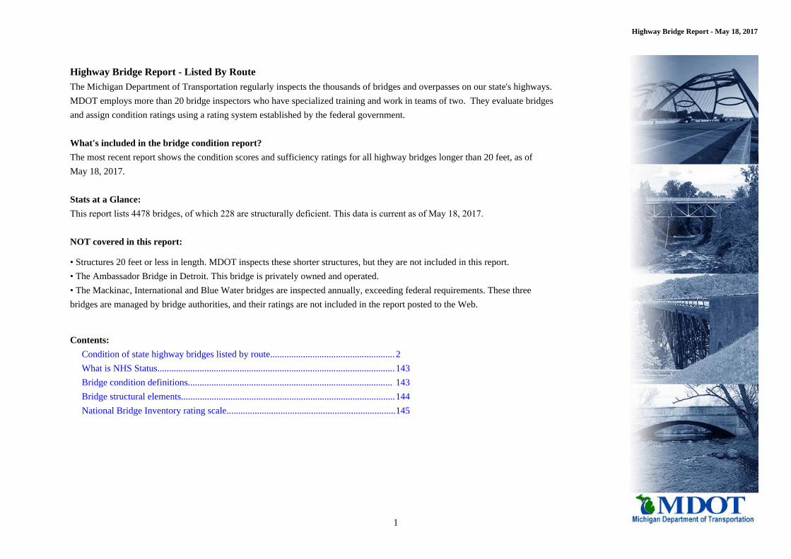
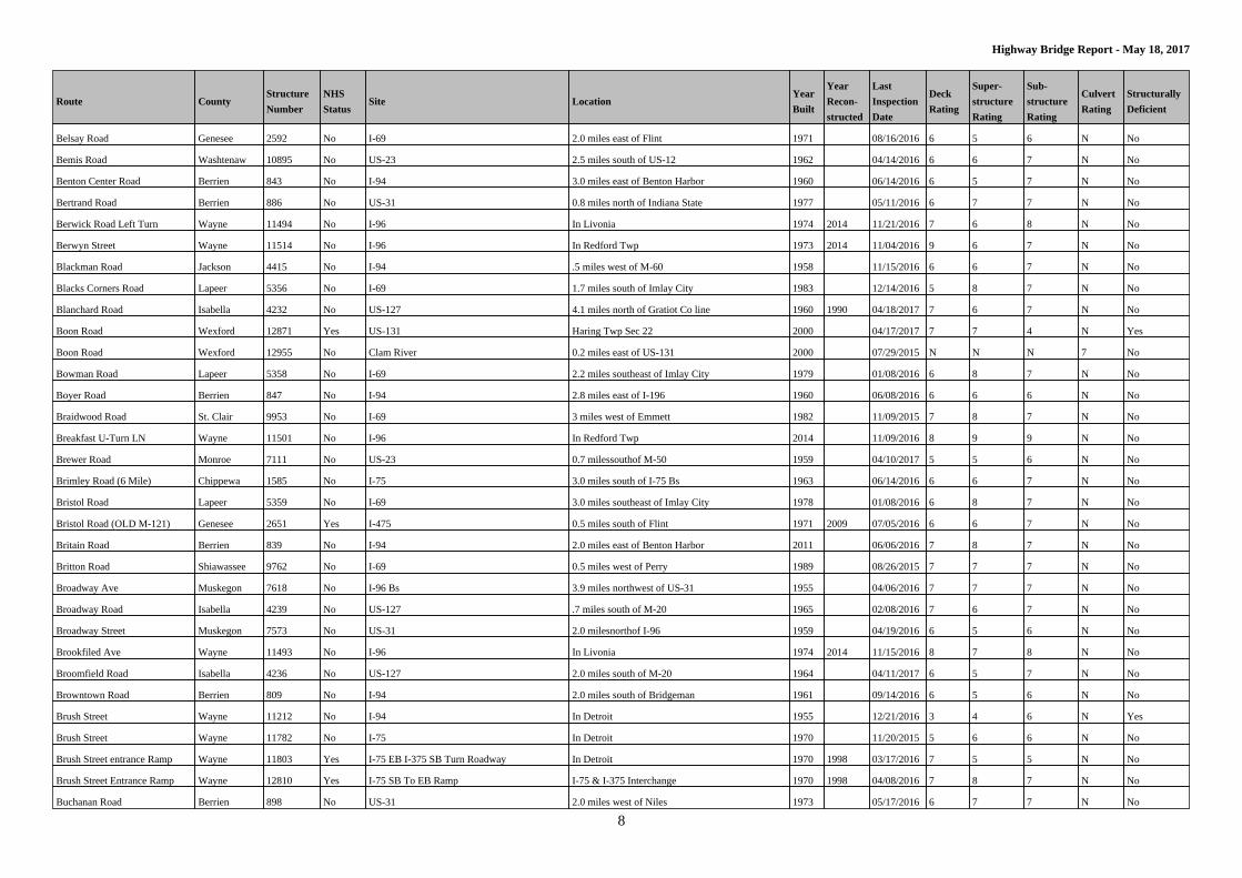
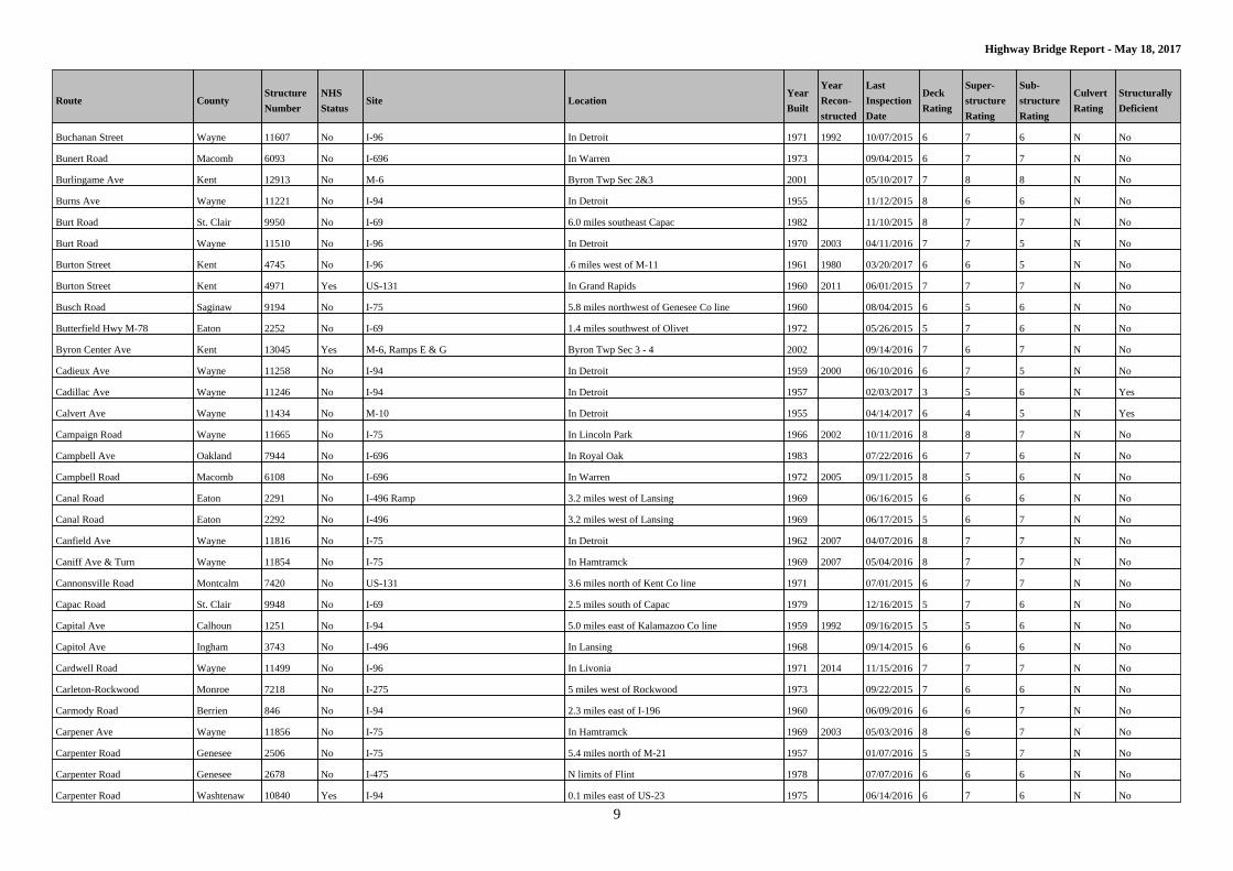
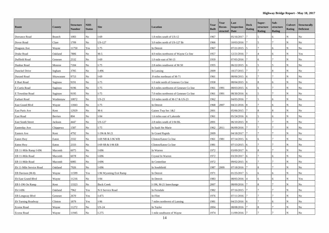
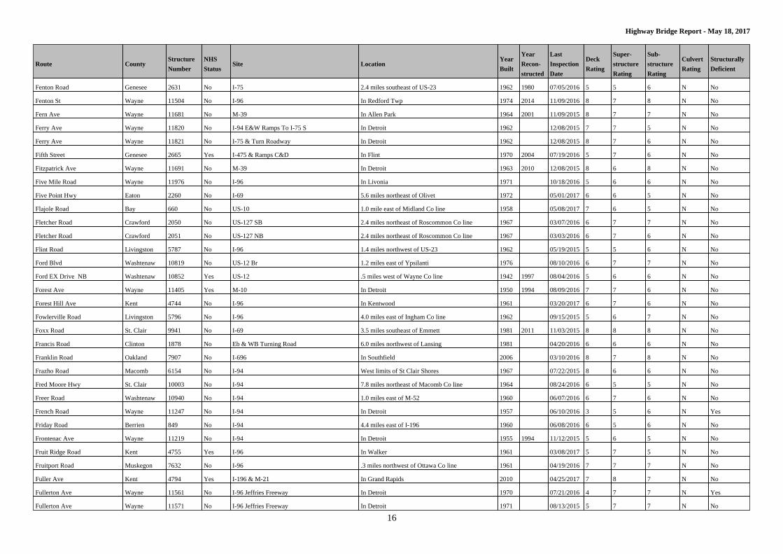
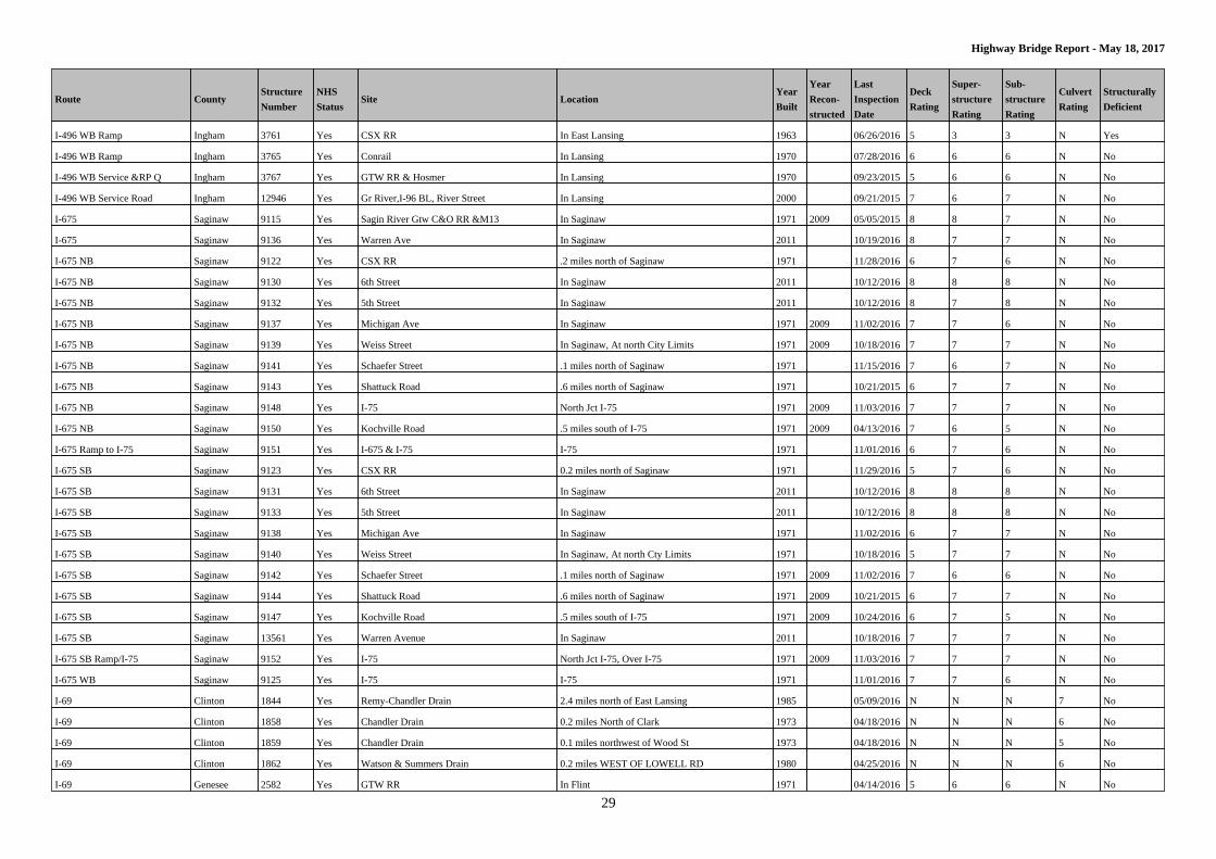
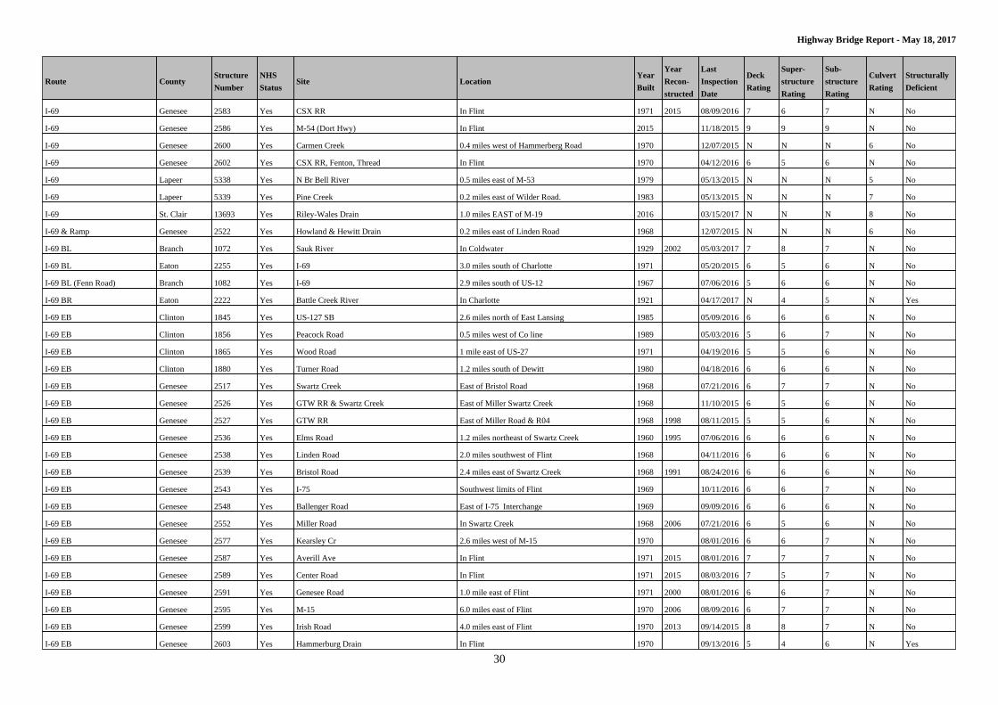
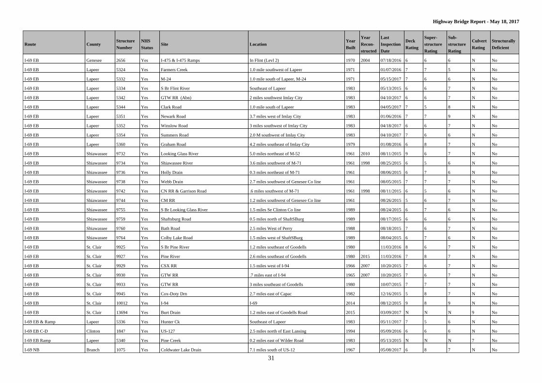
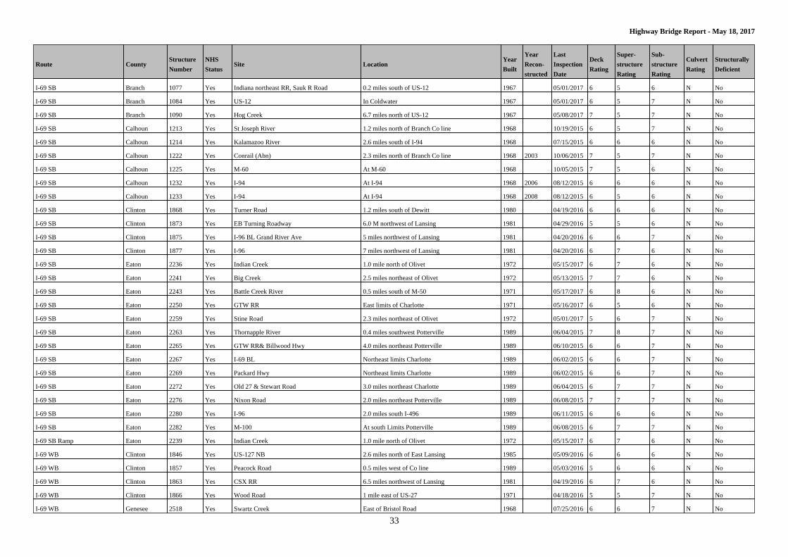
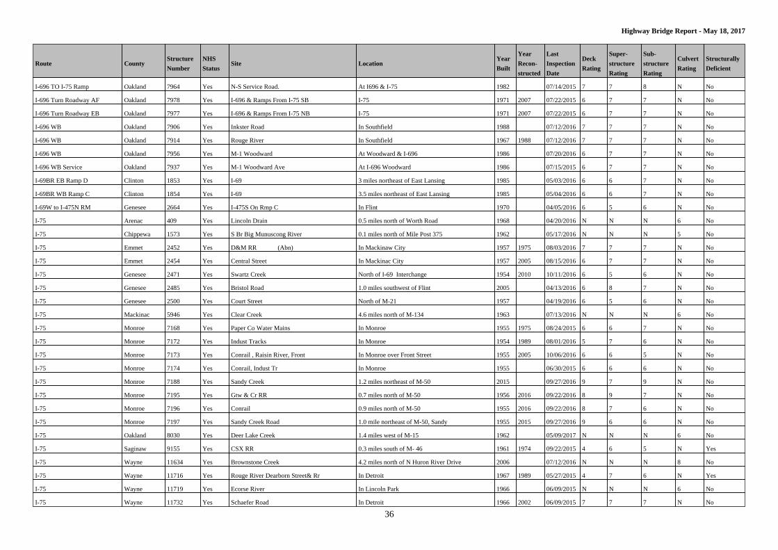
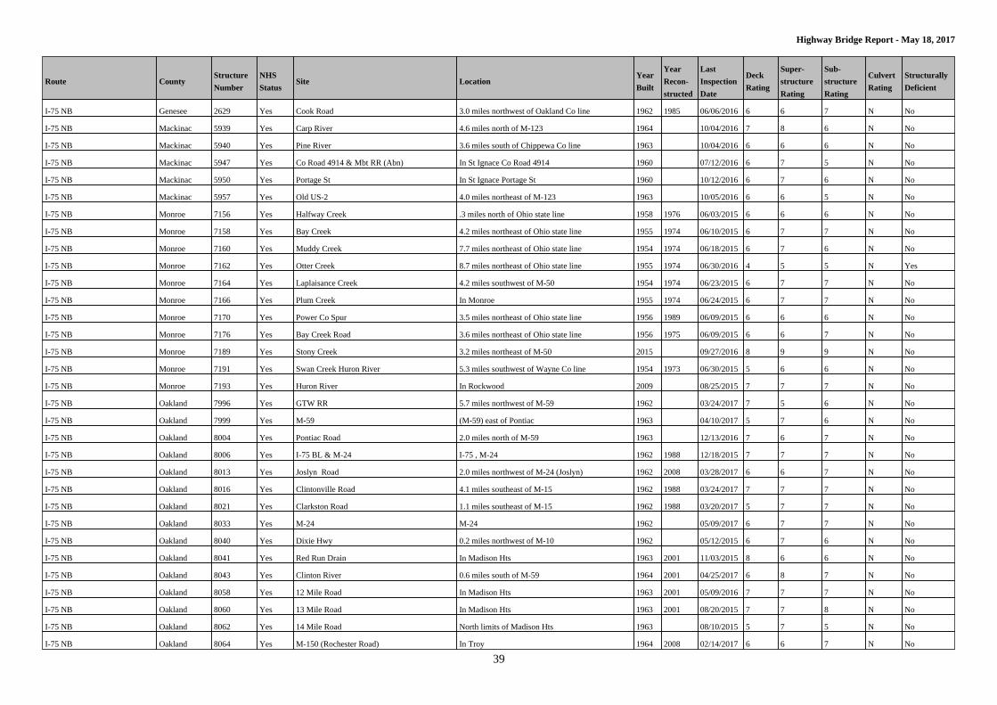
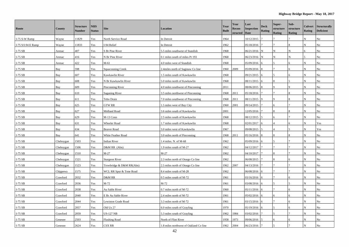
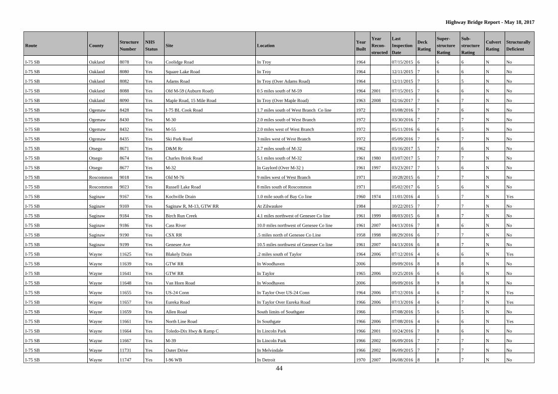
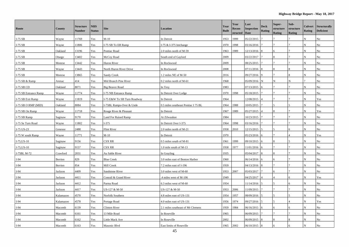
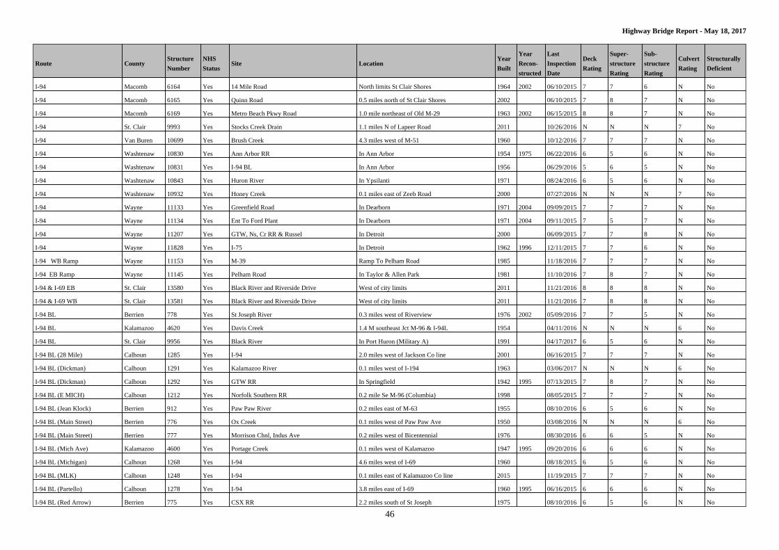
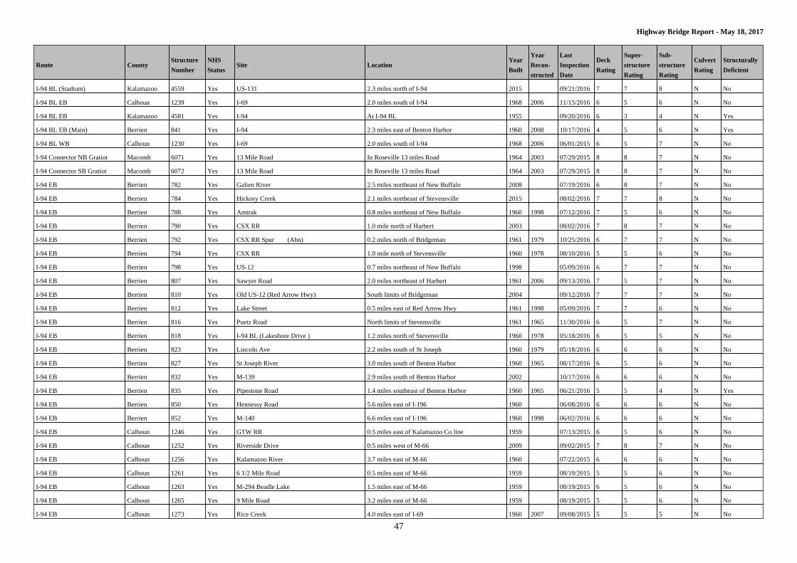
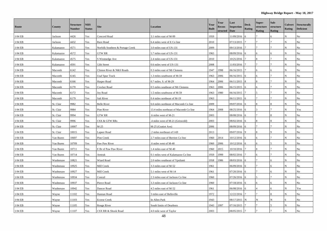
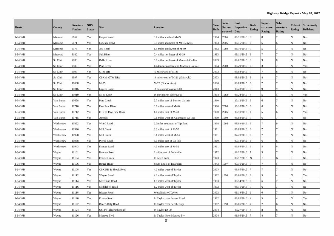
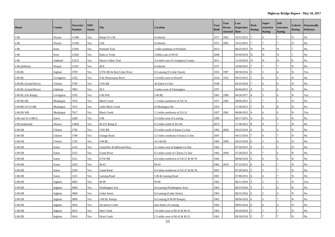
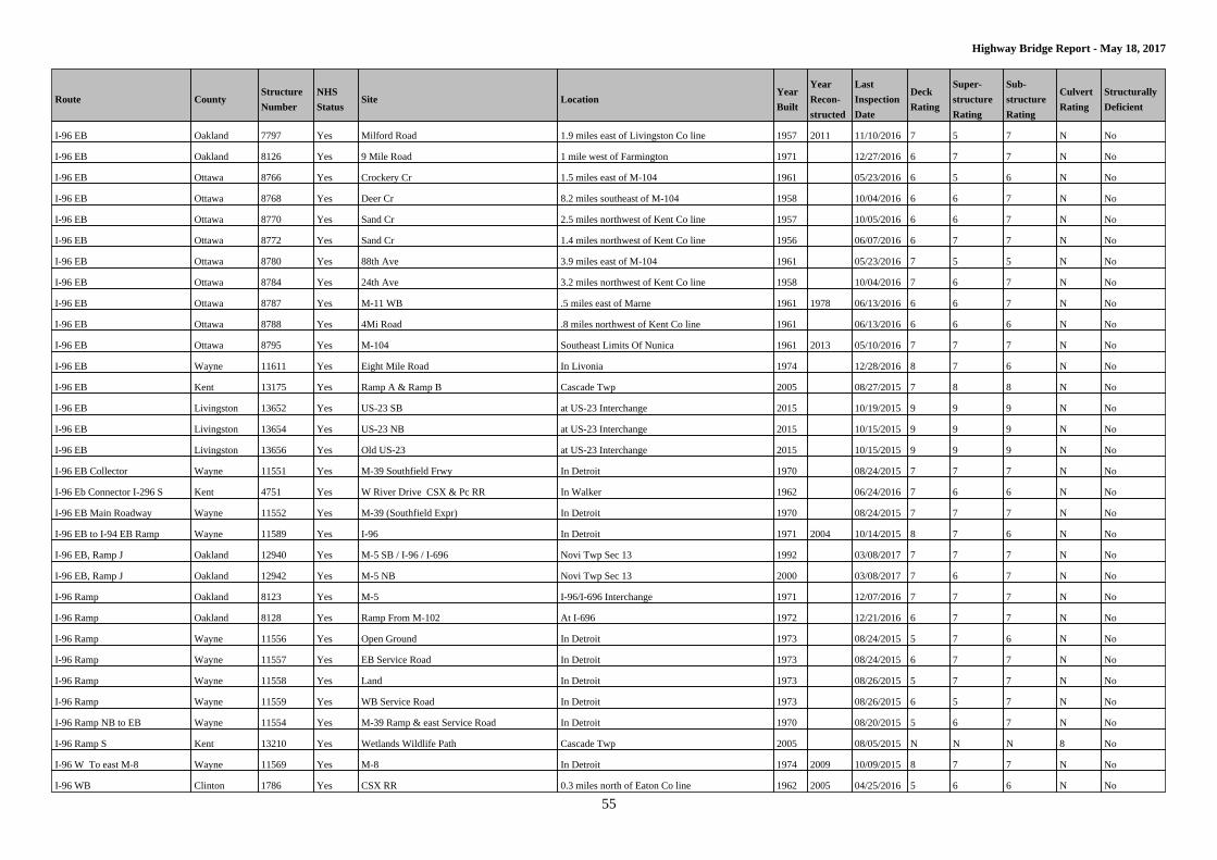
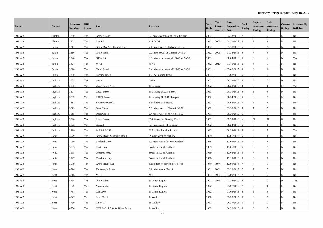
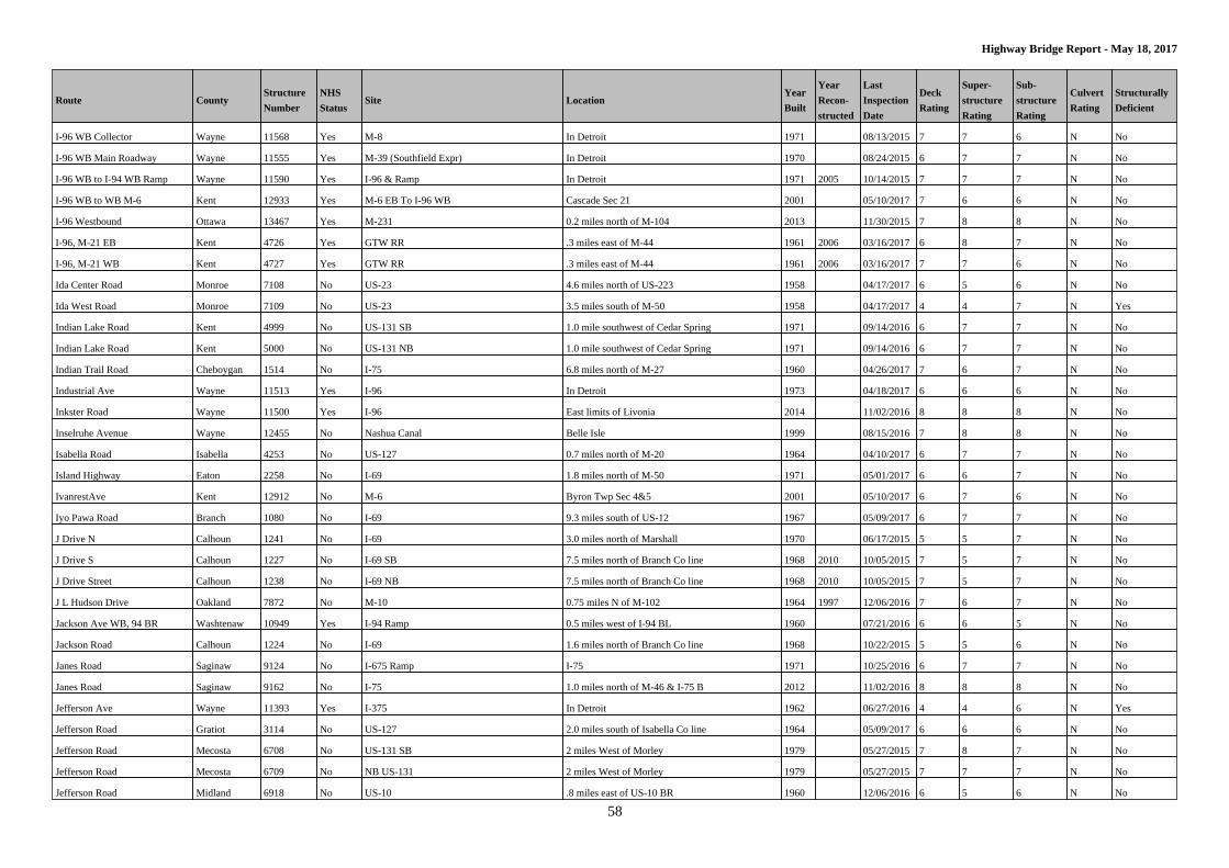
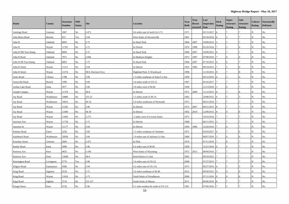
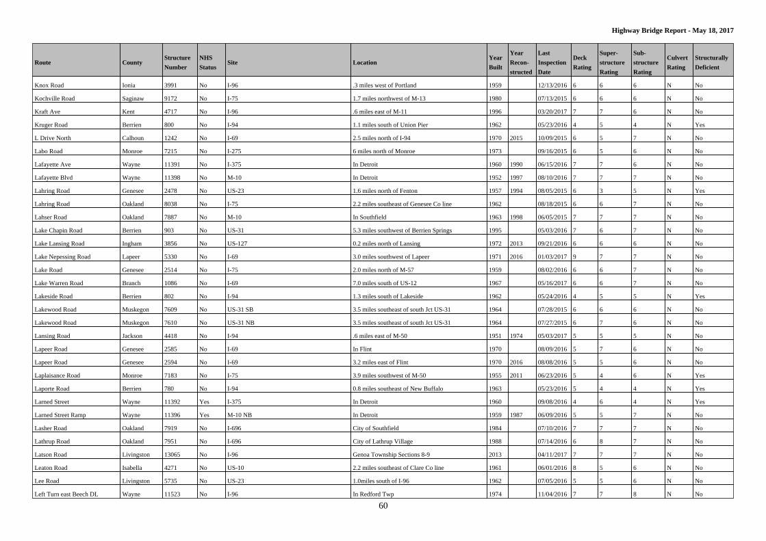
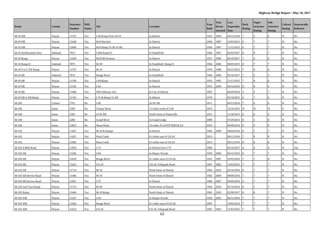
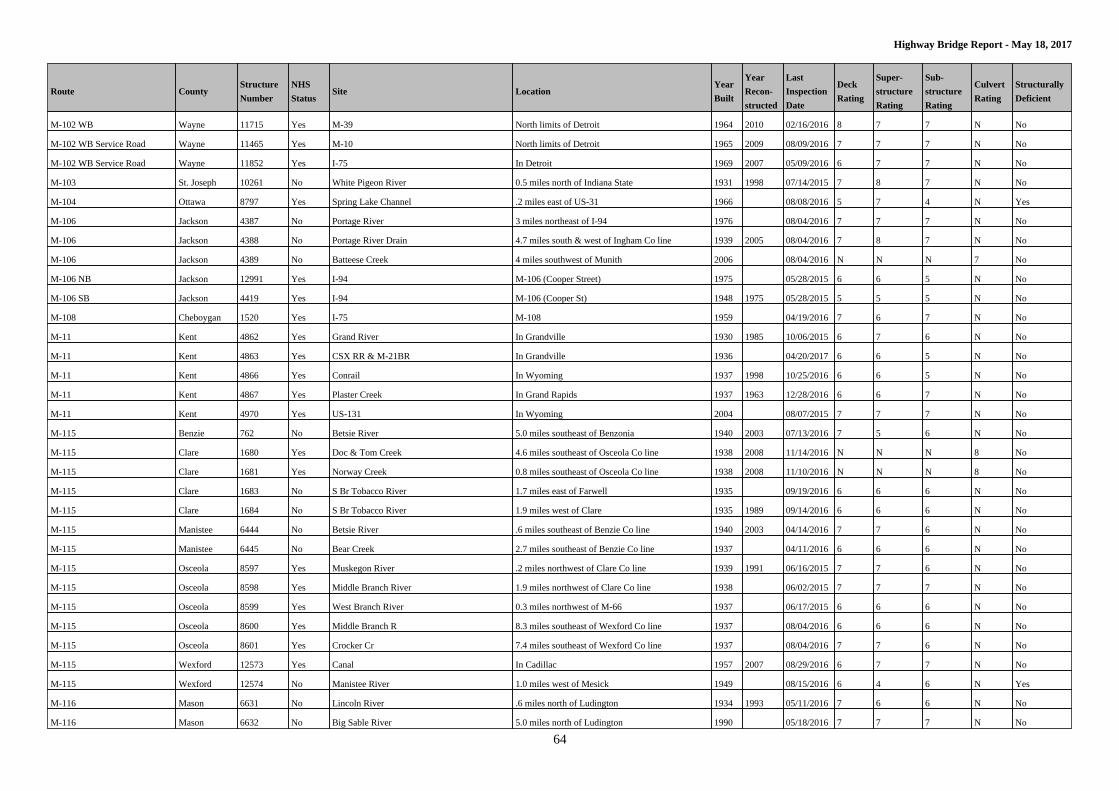
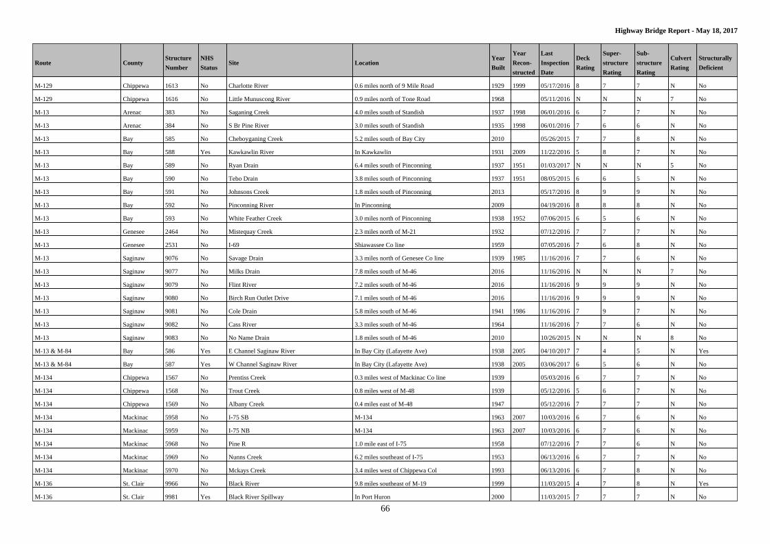
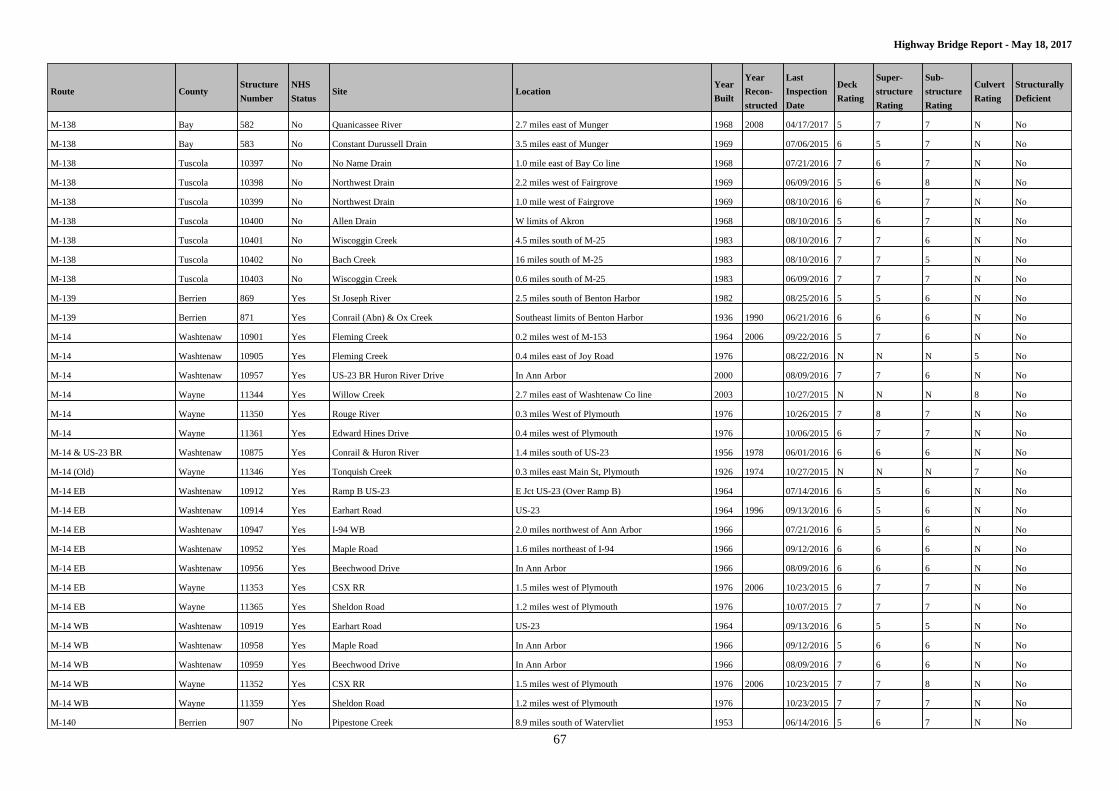
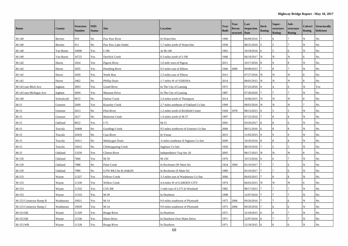
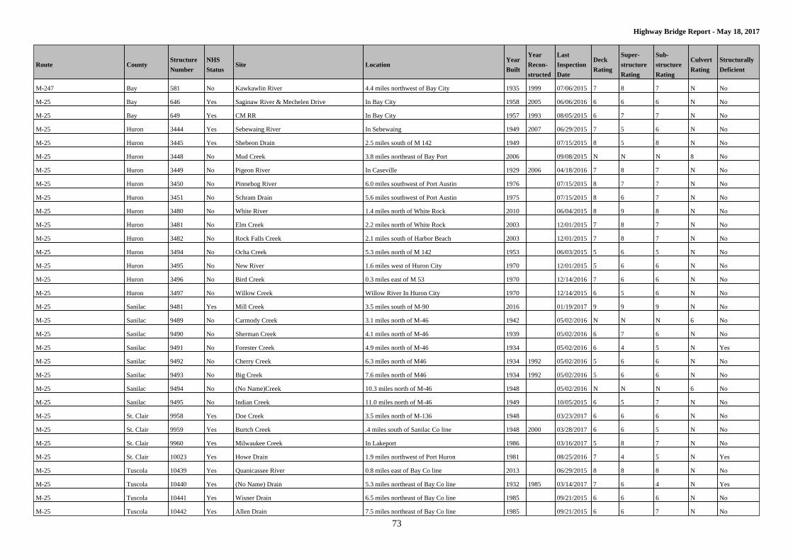
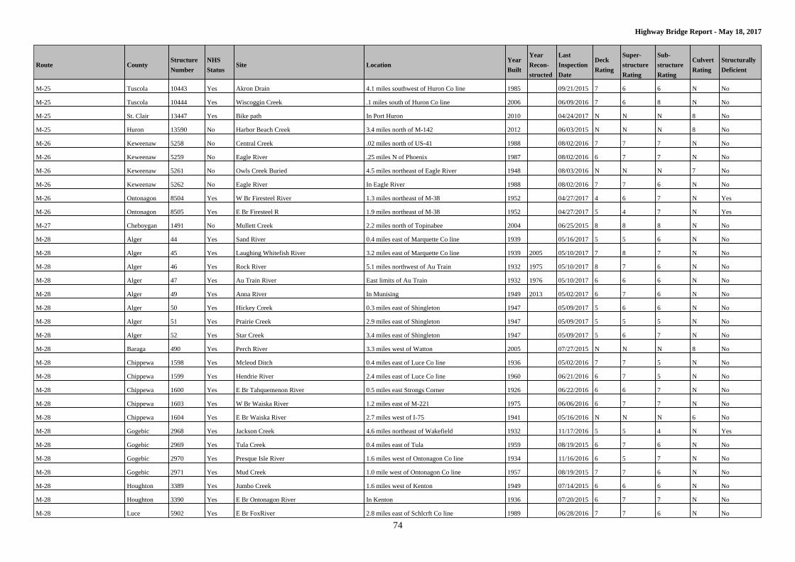
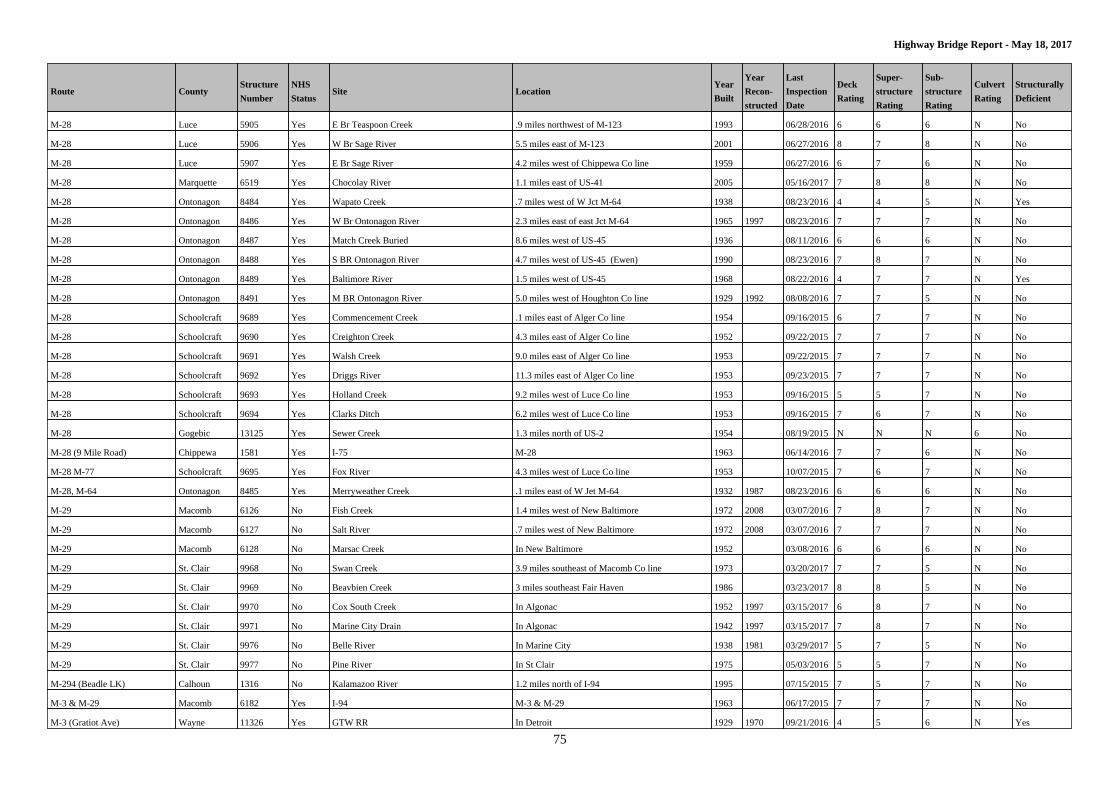
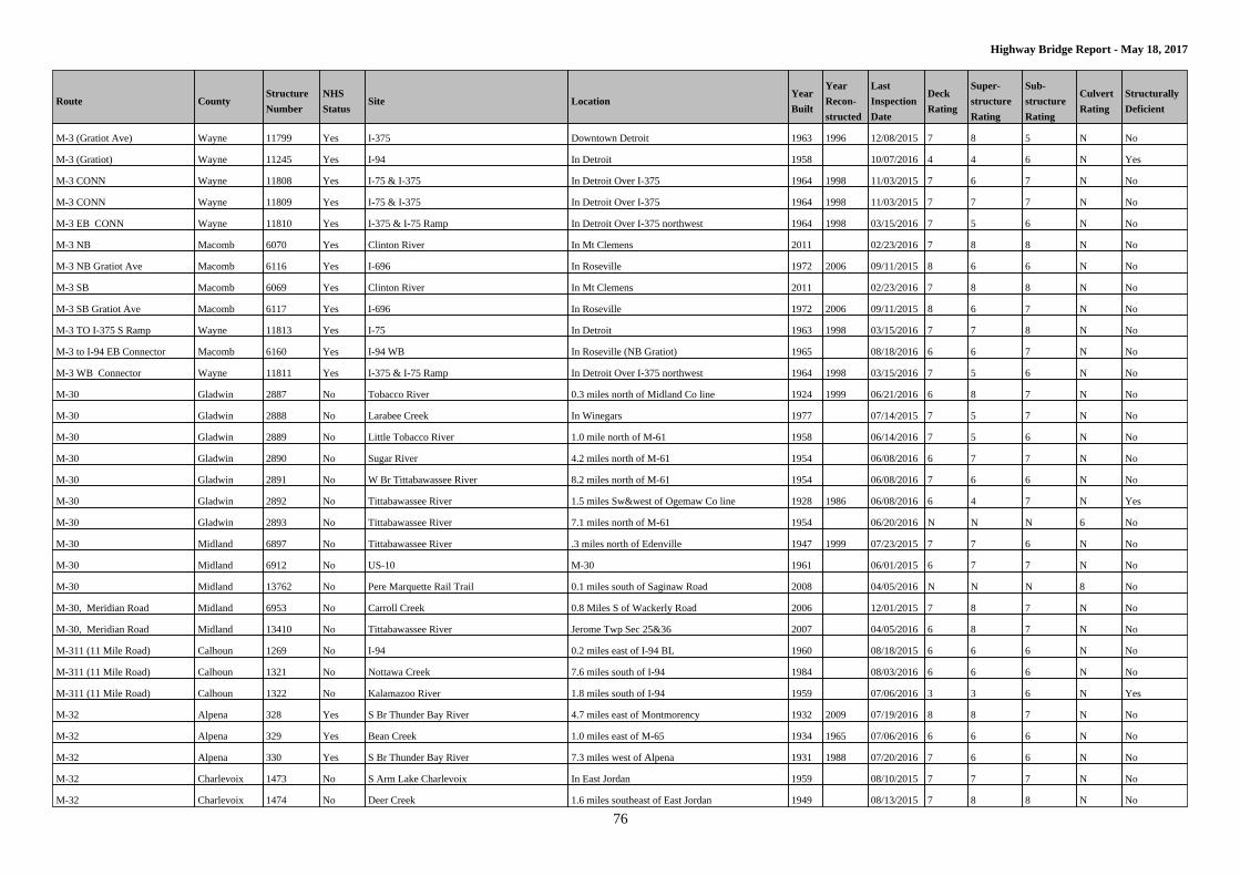
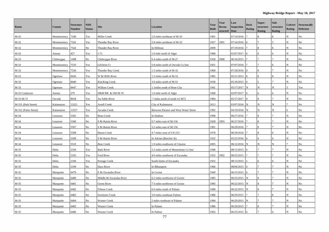
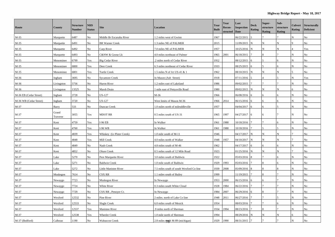
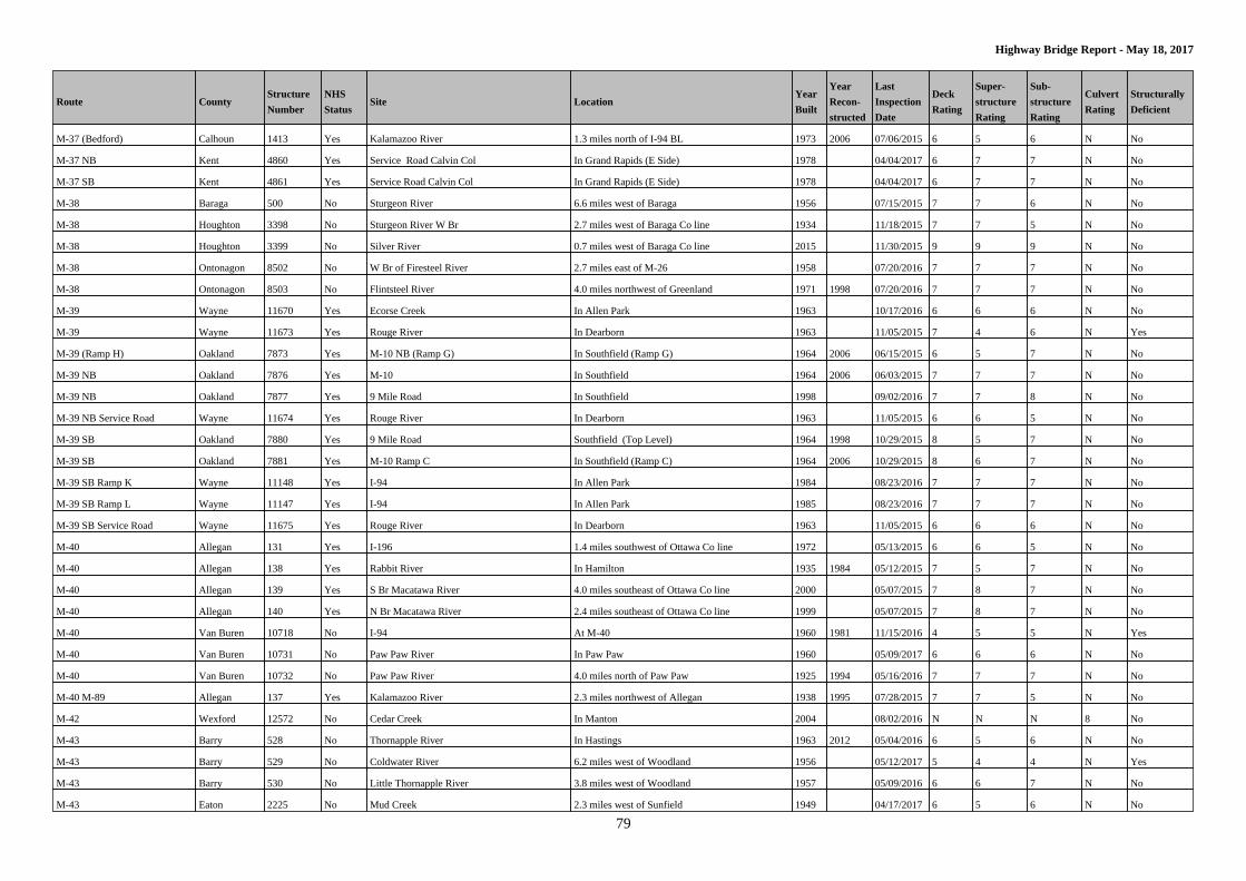
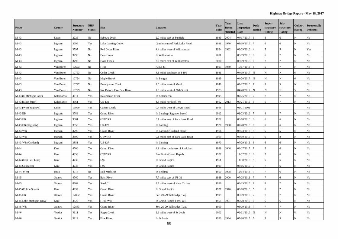
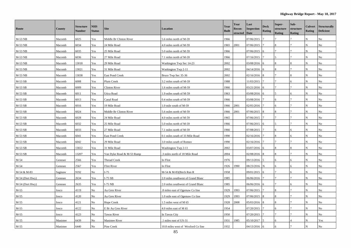
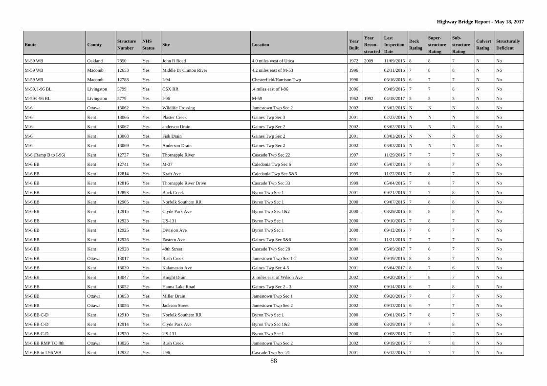
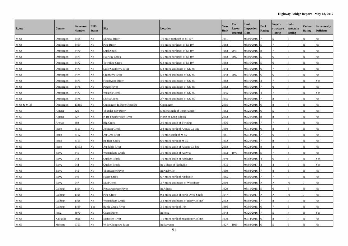
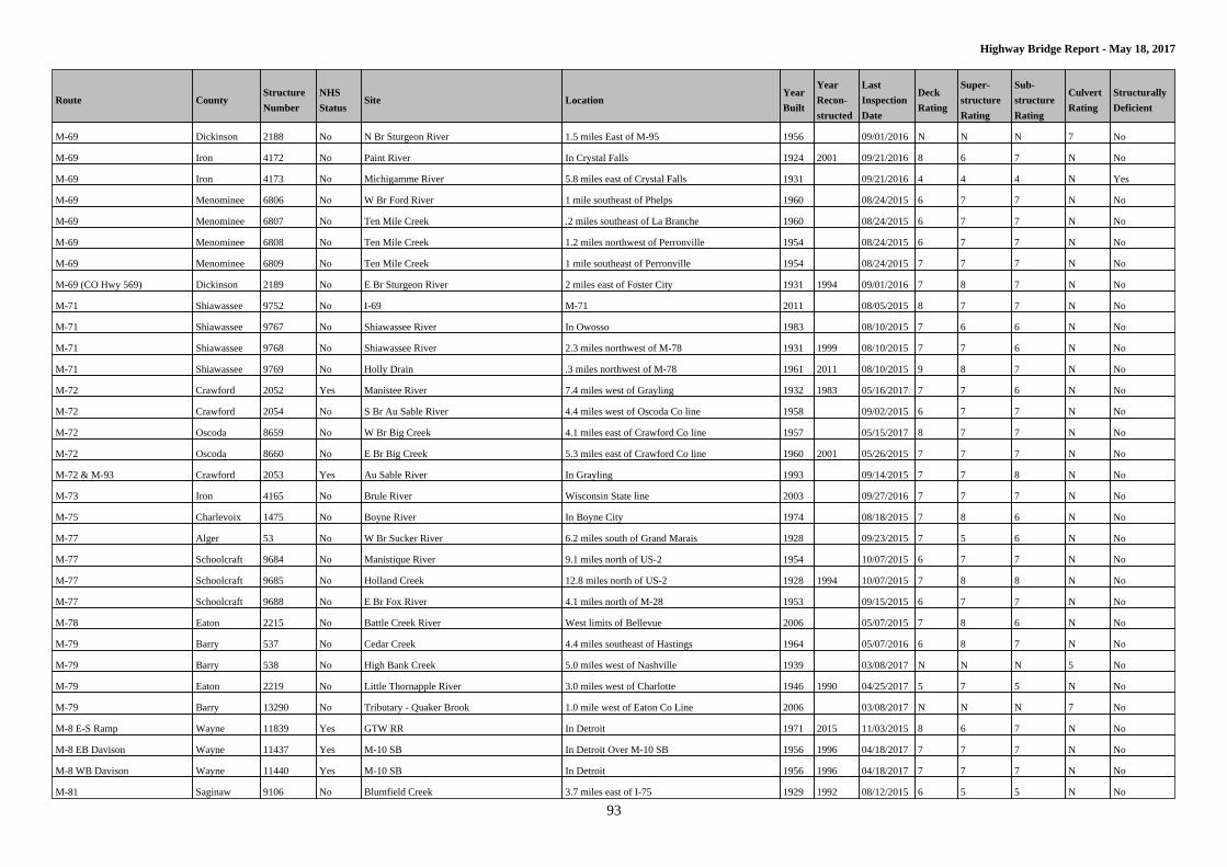
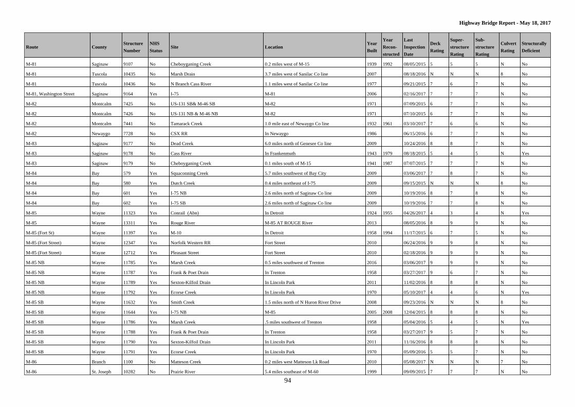
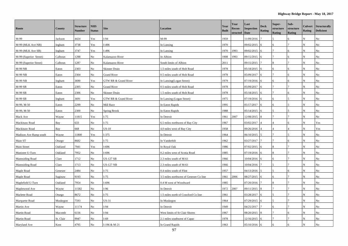
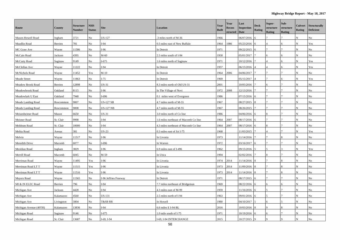
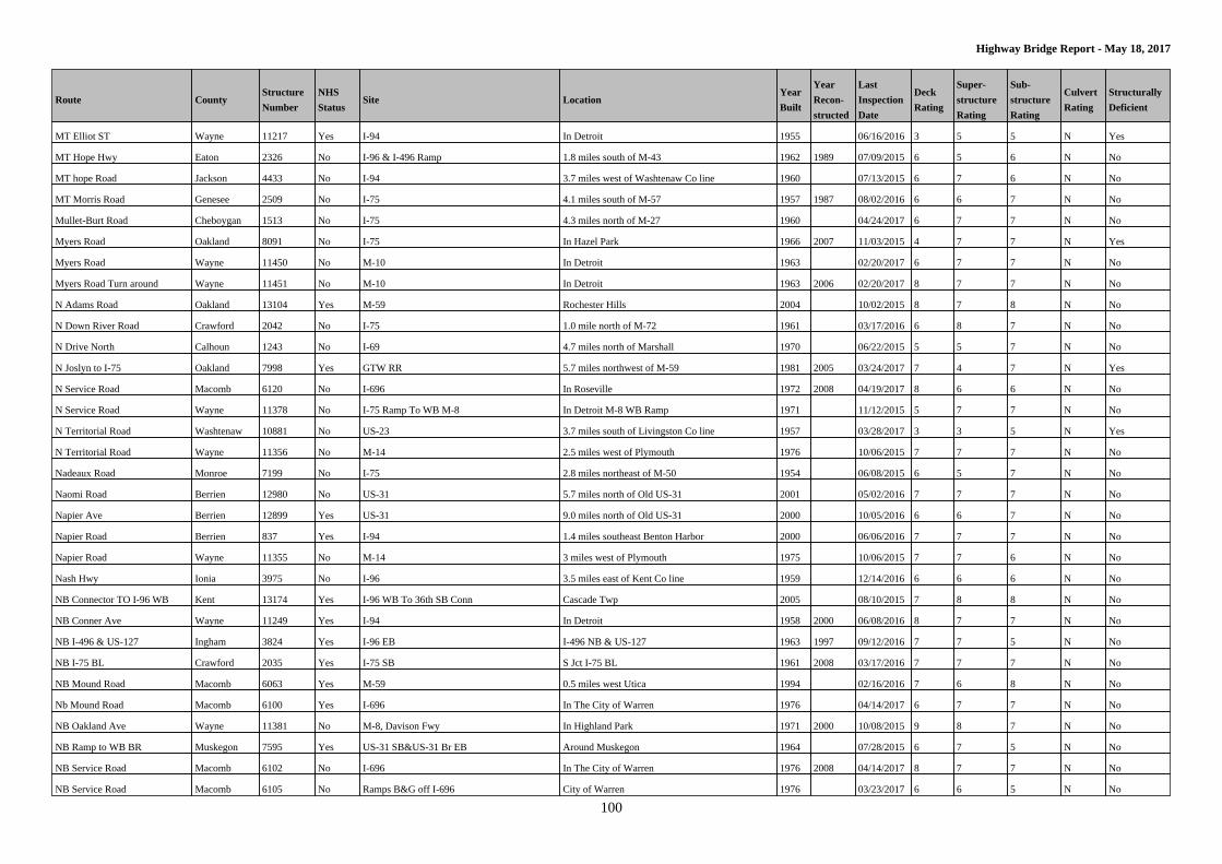
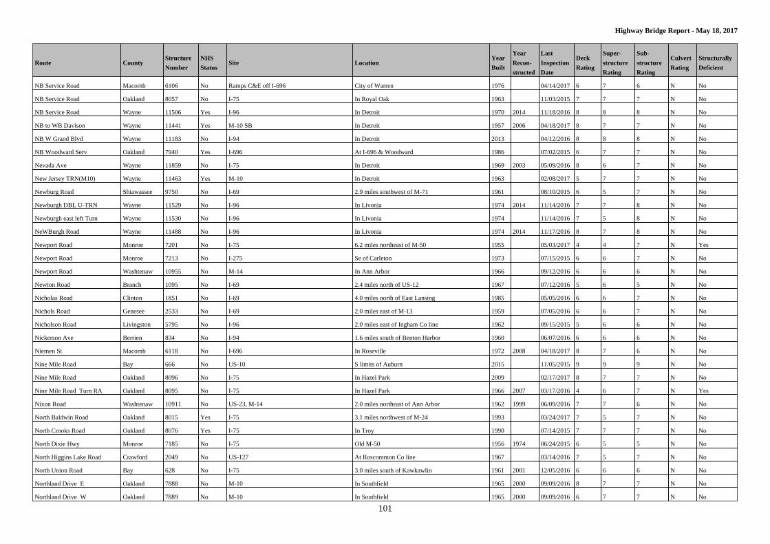
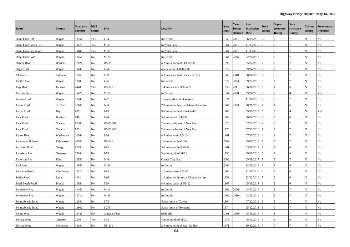
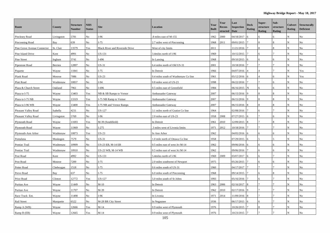
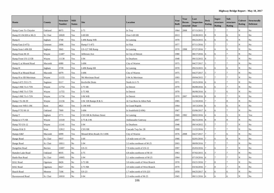
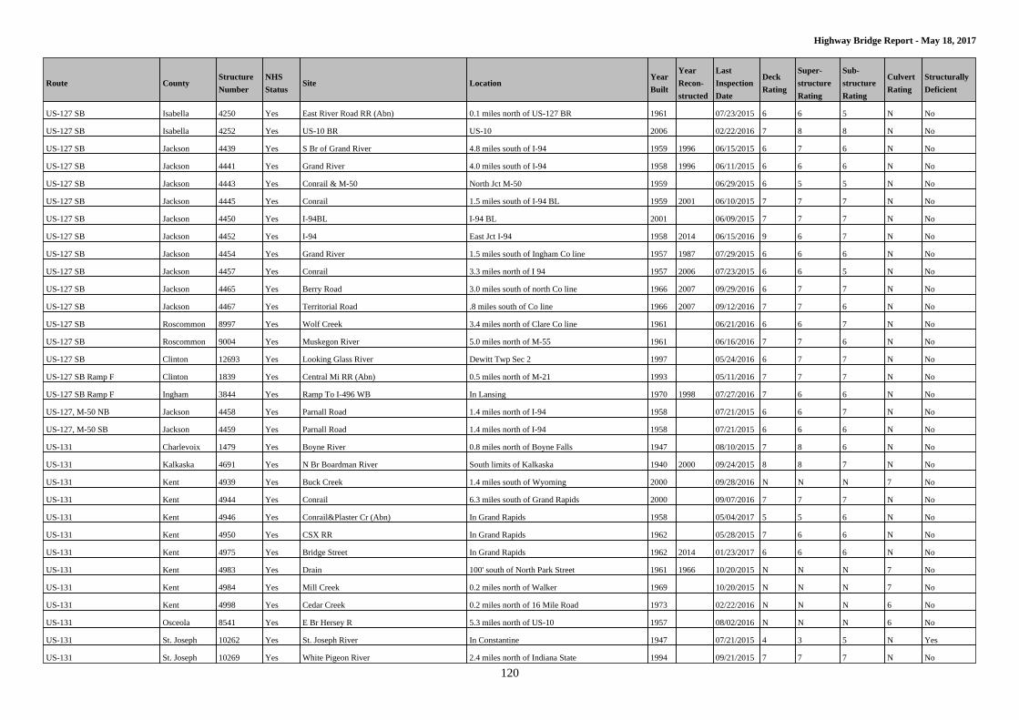
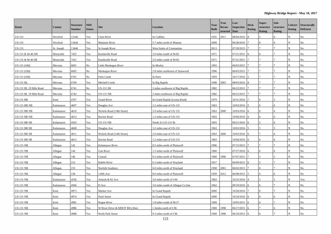
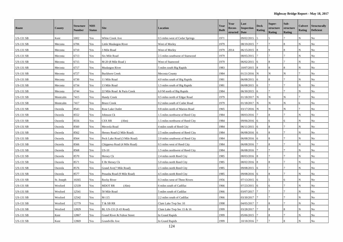
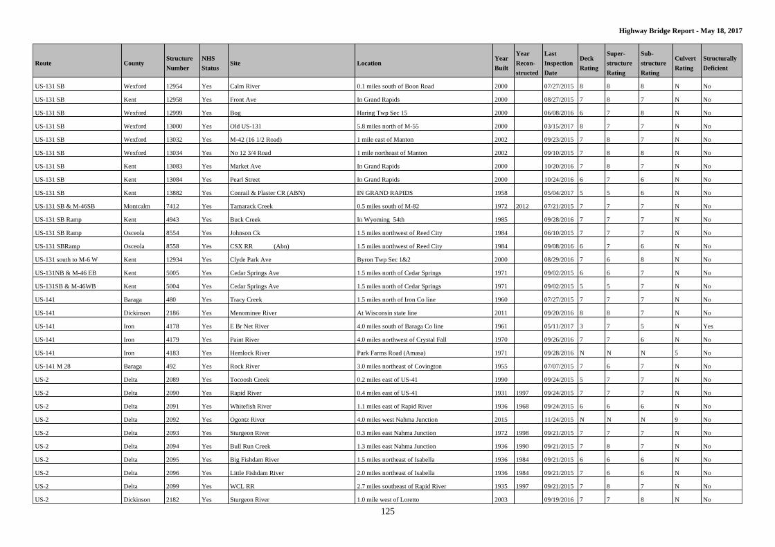
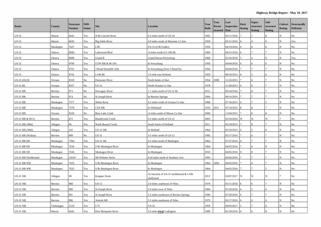
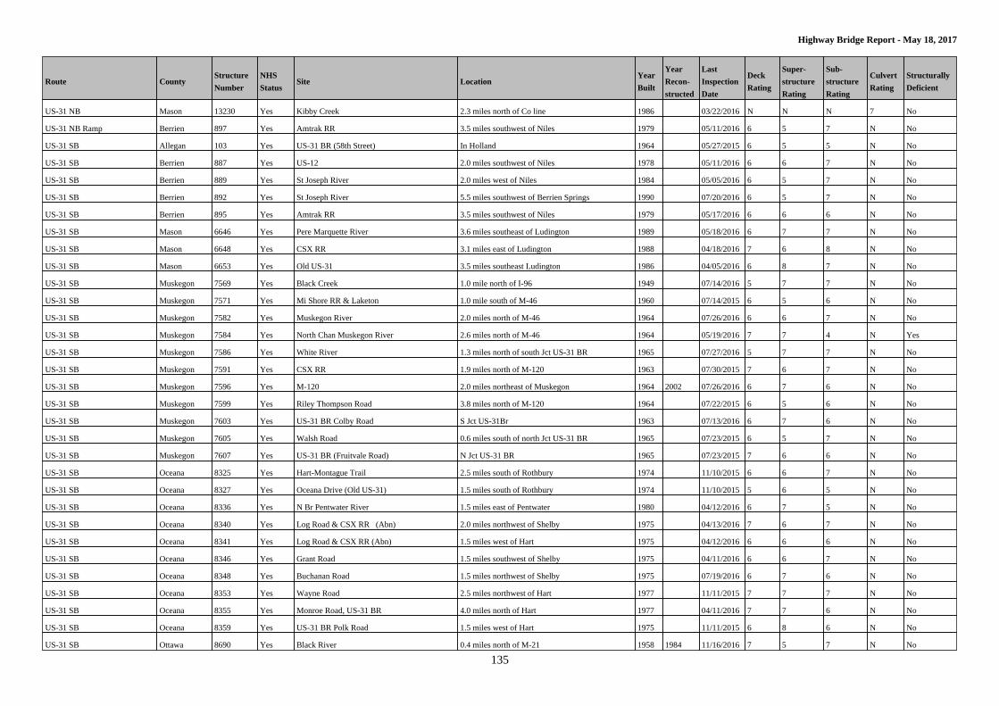
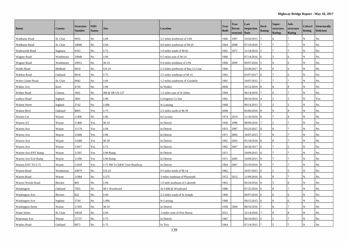
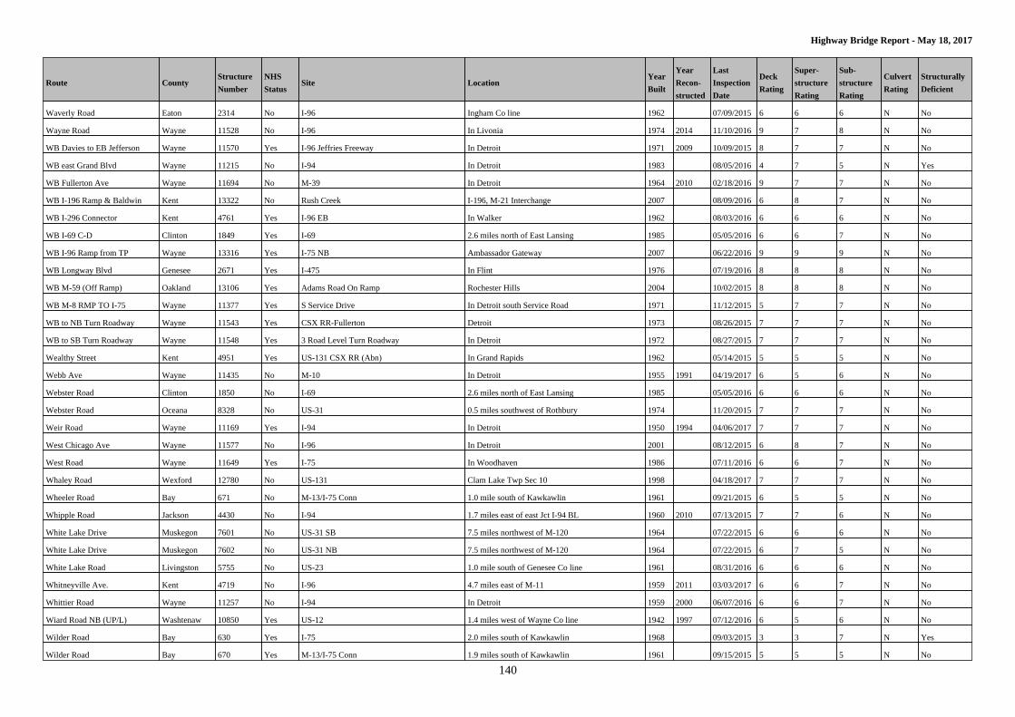
Highway Bridge Report - Listed By Route The Michigan Department of Transportation regularly inspects the thousands of bridges and overpasses on our state's highways.
MDOT employs more than 20 bridge inspectors who have specialized training and work in teams of two. They evaluate bridges
and assign condition ratings using a rating system established by the federal government.
What's included in the bridge condition report?
The most recent report shows the condition scores and sufficiency ratings for all highway bridges longer than 20 feet, as of
May 18, 2017.
Stats at a Glance:
This report lists 4478 bridges, of which 228 are structurally deficient. This data is current as of May 18, 2017.
NOT covered in this report:
• Structures 20 feet or less in length. MDOT inspects these shorter structures, but they are not included in this report.
• The Ambassador Bridge in Detroit. This bridge is privately owned and operated.
• The Mackinac, International and Blue Water bridges are inspected annually, exceeding federal requirements. These three
bridges are managed by bridge authorities, and their ratings are not included in the report posted to the Web.
Contents:
Condition of state highway bridges listed by route..................................................... 2
What is NHS Status..................................................................................................... 143
Bridge condition definitions....................................................................................... 143
Bridge structural elements...........................................................................................144
National Bridge Inventory rating scale........................................................................145
1
Page 2
2
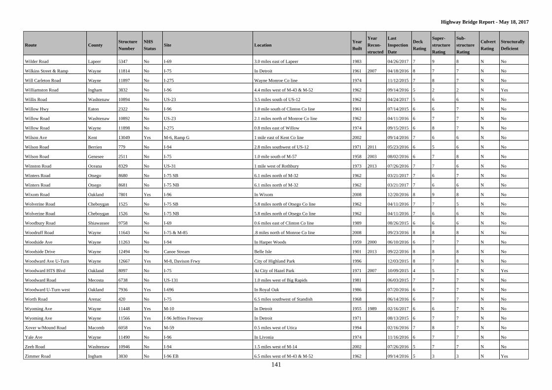
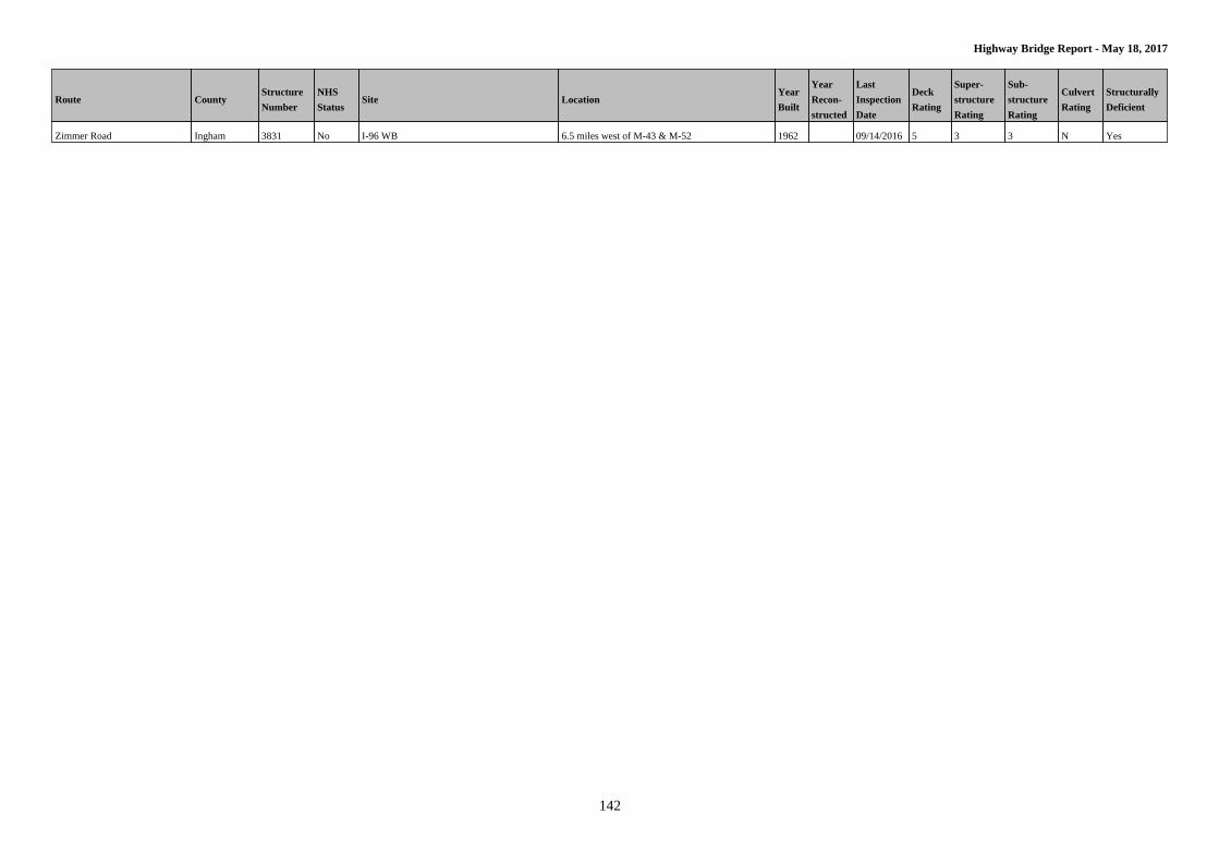
Highway Bridge Report - May 18, 2017
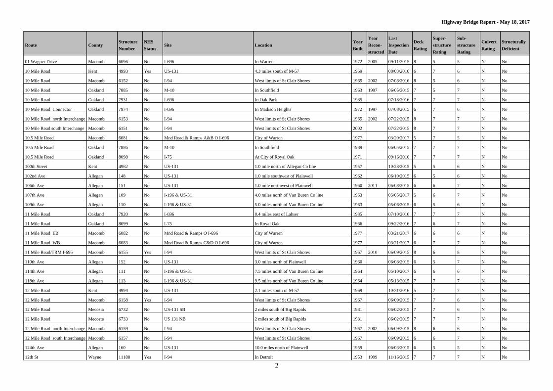
Route CountyStructure
Number
NHS
StatusSite Location
Year
Built
Year
Recon-
structed
Last
Inspection
Date
Deck
Rating
Super-
structure
Rating
Sub-
structure
Rating
Culvert
Rating
Structurally
Deficient
01 Wagner Drive Macomb 6096 No I-696 In Warren 1972 2005 09/11/2015 8 5 5 N No
10 Mile Road Kent 4993 Yes US-131 4.3 miles south of M-57 1969 08/03/2016 6 7 6 N No
10 Mile Road Macomb 6152 No I-94 West limits of St Clair Shores 1965 2002 07/08/2016 8 5 6 N No
10 Mile Road Oakland 7885 No M-10 In Southfield 1963 1997 06/05/2015 7 5 7 N No
10 Mile Road Oakland 7931 No I-696 In Oak Park 1985 07/18/2016 7 7 7 N No
10 Mile Road Connector Oakland 7974 No I-696 In Madison Heights 1972 1997 07/08/2015 6 7 6 N No
10 Mile Road north Interchange Macomb 6153 No I-94 West limits of St Clair Shores 1965 2002 07/22/2015 8 7 7 N No
10 Mile Road south Interchange Macomb 6151 No I-94 West limits of St Clair Shores 2002 07/22/2015 8 7 7 N No
10.5 Mile Road Macomb 6081 No Mnd Road & Ramps A&B O I-696 City of Warren 1977 03/20/2017 5 7 5 N No
10.5 Mile Road Oakland 7886 No M-10 In Southfield 1989 06/05/2015 7 7 7 N No
10.5 Mile Road Oakland 8098 No I-75 At City of Royal Oak 1971 09/16/2016 7 7 7 N No
100th Street Kent 4962 No US-131 1.0 mile north of Allegan Co line 1957 10/28/2015 5 5 6 N No
102nd Ave Allegan 148 No US-131 1.0 mile southwest of Plainwell 1962 06/10/2015 6 5 6 N No
106th Ave Allegan 151 No US-131 1.0 mile northwest of Plainwell 1960 2011 06/08/2015 6 6 7 N No
107th Ave Allegan 109 No I-196 & US-31 4.0 miles north of Van Buren Co line 1963 05/05/2017 5 6 7 N No
109th Ave Allegan 110 No I-196 & US-31 5.0 miles north of Van Buren Co line 1963 05/06/2015 6 5 6 N No
11 Mile Road Oakland 7920 No I-696 0.4 miles east of Lahser 1985 07/10/2016 7 7 7 N No
11 Mile Road Oakland 8099 No I-75 In Royal Oak 1966 09/22/2016 7 6 7 N No
11 Mile Road EB Macomb 6082 No Mnd Road & Ramps O I-696 City of Warren 1977 03/21/2017 6 6 6 N No
11 Mile Road WB Macomb 6083 No Mnd Road & Ramps C&D O I-696 City of Warren 1977 03/21/2017 6 7 7 N No
11 Mile Road/TRM I-696 Macomb 6155 Yes I-94 West limits of St Clair Shores 1967 2010 06/09/2015 8 6 8 N No
110th Ave Allegan 152 No US-131 3.0 miles north of Plainwell 1960 06/08/2015 6 5 7 N No
114th Ave Allegan 111 No I-196 & US-31 7.5 miles north of Van Buren Co line 1964 05/10/2017 6 6 6 N No
118th Ave Allegan 113 No I-196 & US-31 9.5 miles north of Van Buren Co line 1964 05/13/2015 7 7 7 N No
12 Mile Road Kent 4994 No US-131 2.1 miles south of M-57 1969 10/31/2016 5 7 7 N No
12 Mile Road Macomb 6158 Yes I-94 West limits of St Clair Shores 1967 06/09/2015 7 7 6 N No
12 Mile Road Mecosta 6732 No US-131 SB 2 miles south of Big Rapids 1981 06/02/2015 7 7 6 N No
12 Mile Road Mecosta 6733 No US 131 NB 2 miles south of Big Rapids 1981 06/02/2015 7 7 7 N No
12 Mile Road north Interchange Macomb 6159 No I-94 West limits of St Clair Shores 1967 2002 06/09/2015 8 6 6 N No
12 Mile Road south Interchange Macomb 6157 No I-94 West limits of St Clair Shores 1967 06/09/2015 6 6 7 N No
124th Ave Allegan 160 No US-131 10.0 miles north of Plainwell 1959 06/03/2015 6 5 5 N No
12th St Wayne 11188 Yes I-94 In Detroit 1953 1999 11/16/2015 7 7 7 N No
Page 3
3
Highway Bridge Report - May 18, 2017
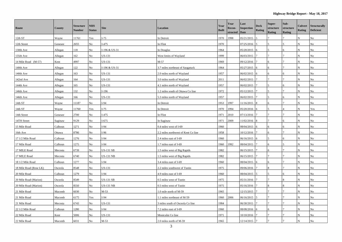
Route CountyStructure
Number
NHS
StatusSite Location
Year
Built
Year
Recon-
structed
Last
Inspection
Date
Deck
Rating
Super-
structure
Rating
Sub-
structure
Rating
Culvert
Rating
Structurally
Deficient
12th ST Wayne 11761 Yes I-75 In Detroit 1970 1998 05/21/2015 5 7 7 N No
12th Street Genesee 2655 No I-475 In Flint 1970 07/25/2016 5 5 5 N No
130th Ave Allegan 118 No I-196 & US-31 In Douglas 1964 05/20/2015 6 5 6 N No
135th Ave Allegan 162 No US-131 West limits of Wayland 1999 06/03/2015 7 7 7 N No
14 Mile Road (M-57) Kent 4997 No US-131 M-57 1969 09/12/2016 7 6 7 N No
140th Ave Allegan 122 No I-196 & US-31 3.7 miles northeast of Saugatuck 1964 05/27/2015 6 6 7 N No
140th Ave Allegan 163 No US-131 2.0 miles north of Wayland 1957 06/02/2015 6 6 6 N No
142nd Ave Allegan 164 No US-131 3.0 miles north of Wayland 2011 06/02/2015 7 7 7 N No
144th Ave Allegan 165 No US-131 4.1 miles north of Wayland 1957 06/02/2015 7 5 6 N No
146th Ave Allegan 132 No I-196 1.2 miles south of Ottawa Co line 1972 05/12/2015 7 5 7 N No
146th Ave Allegan 166 No US-131 5.3 miles north of Wayland 1957 06/02/2015 7 5 6 N No
14th ST Wayne 11187 No I-94 In Detroit 1953 1997 11/16/2015 8 6 7 N No
14th ST Wayne 11760 Yes I-75 In Detroit 1970 1994 05/20/2016 6 5 4 N Yes
14th Street Genesee 2700 No I-475 In Flint 1971 2010 07/13/2016 7 7 7 N No
14TH Street Saginaw 9129 No I-675 In Saginaw 1971 2009 11/02/2016 8 7 6 N No
15 Mile Road Calhoun 1271 No I-94 0.4 miles west of I-69 1960 08/04/2015 6 6 6 N No
16th Ave Ottawa 8786 No I-96 2.2 miles northwest of Kent Co line 1958 10/12/2016 7 6 7 N No
17 1/2 Mile Road Calhoun 1276 No I-94 2.4 miles east of I-69 1960 06/16/2015 6 5 6 N No
17 Mile Road Calhoun 1275 No I-94 1.7 miles east of I-69 1960 1992 08/04/2015 7 6 5 N No
17 MILE Road Mecosta 6739 No US-131 SB 1.5 miles west of Big Rapids 1982 06/15/2015 7 6 7 N No
17 MILE Road Mecosta 6740 No US-131 NB 1.5 miles west of Big Rapids 1982 06/15/2015 7 7 7 N No
18 1/2 Mile Road Calhoun 1277 No I-94 3.4 miles east of I-69 1960 08/04/2015 6 6 7 N No
18 Mile Road (Rose LK) Osceola 8548 No US-131 2.2 miles southwest of Tustin 1975 09/06/2016 7 8 7 N No
20 Mile Road Calhoun 1279 No I-94 4.9 miles east of I-69 1960 08/04/2015 5 5 6 N No
20 Mile Road (Marion) Osceola 8549 No US-131 SB 0.5 miles west of Tustin 1975 05/31/2016 7 7 8 N No
20 Mile Road (Marion) Osceola 8550 No US-131 NB 0.5 miles west of Tustin 1975 05/16/2016 7 8 8 N No
21 Mile Road Macomb 6030 No M-53 1.0 mile north of M-59 1965 12/15/2015 7 7 7 N No
21 Mile Road Macomb 6175 Yes I-94 1.1 miles northeast of M-59 1960 2006 06/16/2015 5 7 7 N No
21 Mile Road Mecosta 6743 No US-131 3 miles south of Osceola Co line 1984 06/30/2015 7 7 7 N No
22 1/2 Mile Road Calhoun 1280 No I-94 7.2 miles east of I-69 1960 08/08/2016 6 6 7 N No
22 Mile Road Kent 5006 No US-131 Montcalm Co line 1971 10/10/2016 7 7 7 N No
22 Mile Road Macomb 6031 No M-53 2.0 miles north of M-59 1965 12/14/2015 7 7 7 N No
Page 4
4
Highway Bridge Report - May 18, 2017
Route CountyStructure
Number
NHS
StatusSite Location
Year
Built
Year
Recon-
structed
Last
Inspection
Date
Deck
Rating
Super-
structure
Rating
Sub-
structure
Rating
Culvert
Rating
Structurally
Deficient
23 Mile Road Calhoun 1281 No I-94 7.9 miles east of I-69 1959 08/03/2015 6 6 6 N No
23 Mile Road Macomb 6027 Yes M-53 3.0 miles north of M-59 1965 2013 12/11/2015 6 7 7 N No
24 Mile Road Calhoun 1282 No I-94 8.9 miles east of I-69 1959 08/03/2015 5 5 6 N No
24th ST Wayne 11184 No I-94 In Detroit 1968 1996 07/20/2016 7 7 5 N No
24th Street Van Buren 10721 No I-94 1.0 mile west of Kalamazoo Co line 1959 1981 11/09/2016 5 5 6 N No
26 Mile Road Macomb 6029 Yes M-53 6.2 miles north of M-59 2009 05/11/2016 8 8 8 N No
26 Mile Road Macomb 6184 No I-94 1.5 miles southwest of St Clair Co line 1963 06/11/2015 6 7 7 N No
27 Mile Road Calhoun 1284 No I-94 3.0 miles west of Jackson Co line 1960 06/16/2015 6 5 6 N No
28 Mile Road Macomb 13015 No M-53 Washington Twp 22-27 2002 03/07/2016 7 7 8 N No
28th Street (CR657) Van Buren 10720 No I-94 3.0 miles west of Kalamazoo Co line 1960 1993 11/09/2016 7 7 7 N No
29 Mile Road Calhoun 1286 No I-94 1.0 mile west of Jackson Co line 1960 08/03/2015 6 6 6 N No
3 Mile Road Kent 4735 No I-96 3.0 mile southest & south of US-131 1961 1981 06/18/2015 6 6 7 N No
30th ST Wayne 11178 No I-94 In Detroit 1951 1996 07/20/2016 7 7 7 N No
32nd Street Kent 4846 No M-37 .6 miles south of M-11 1948 04/17/2017 6 5 7 N No
32nd Street Kent 4969 No US-131 In Wyoming 1958 1993 09/27/2016 6 7 6 N No
32nd Street (CR653) Van Buren 10719 No I-94 5.0 miles west of Kalamazoo Co line 1960 11/09/2016 6 5 5 N No
33 Mile Road Macomb 13012 No M-53 Bruce Twp Sec 26-35 2002 03/07/2016 6 6 8 N No
36th Street Kent 4968 Yes US-131 In Wyoming 2011 01/03/2017 7 8 7 N No
4 Mile Road Crawford 2034 Yes I-75 4.0 miles south of Grayling 1961 03/07/2016 5 7 6 N No
4 Mile Road Mecosta 6712 No Us 131 3 miles northwest of Morley 1979 06/10/2015 7 7 7 N No
41st Street Van Buren 10716 No I-94 3.0 miles west of M-40 1960 2006 11/09/2016 6 6 6 N No
44th Ave (CR376) Van Buren 10685 No I-196 1.0 mile northeast of Berrien Co line 1963 2011 09/14/2016 6 6 7 N No
44th Street Kent 4836 Yes I-196 In Grandville 1972 08/15/2016 6 7 6 N No
44th Street Kent 4967 Yes US-131 In Wyoming 2008 07/12/2016 7 9 8 N No
46th Street Van Buren 10707 No I-94 1.5 miles west of M-51 1959 11/09/2016 6 6 7 N No
48th Ave Ottawa 8783 No I-96 6.5 miles northwest of Kent Co line 1957 06/07/2016 7 7 7 N No
4th Street Kalamazoo 4588 No I-94 2.1 miles east of Van Buren Co line 1959 09/07/2016 6 5 6 N No
5 Lakes Road Lapeer 5348 No I-69 4.0 Meastof Lapeer 1983 04/26/2017 7 9 8 N No
50thStreet Van Buren 10706 No I-94 3.6 miles west of M-51 1959 11/07/2016 6 6 7 N No
52nd Street (CR365) Van Buren 10705 No I-94 4.6 miles west of M-51 1960 11/07/2016 6 6 7 N No
54th Street Kent 4966 Yes US-131 In Wyoming 1985 01/03/2017 8 7 7 N No
54th Street (CR215) Van Buren 10704 No I-94 7.9 miles east of Berrien Co line 1959 11/01/2016 6 6 6 N No
Page 5
5
Highway Bridge Report - May 18, 2017
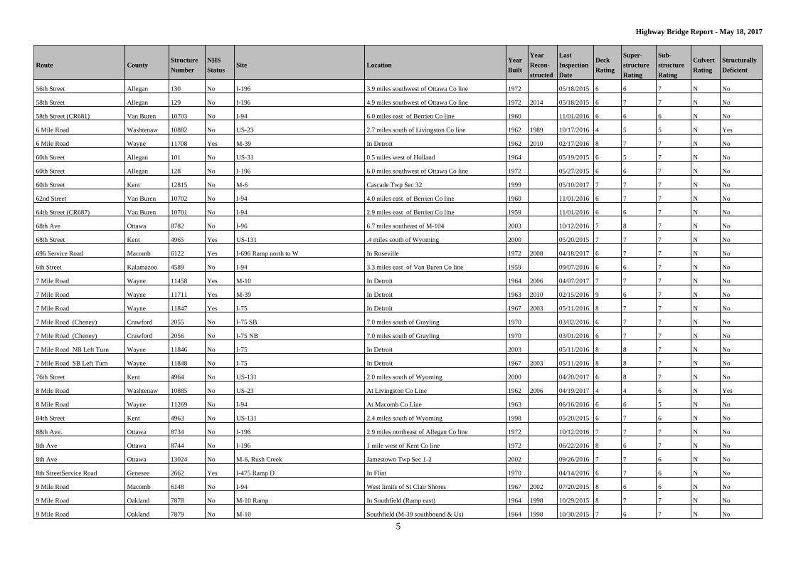
Route CountyStructure
Number
NHS
StatusSite Location
Year
Built
Year
Recon-
structed
Last
Inspection
Date
Deck
Rating
Super-
structure
Rating
Sub-
structure
Rating
Culvert
Rating
Structurally
Deficient
56th Street Allegan 130 No I-196 3.9 miles southwest of Ottawa Co line 1972 05/18/2015 6 6 7 N No
58th Street Allegan 129 No I-196 4.9 miles southwest of Ottawa Co line 1972 2014 05/18/2015 6 7 7 N No
58th Street (CR681) Van Buren 10703 No I-94 6.0 miles east of Berrien Co line 1960 11/01/2016 6 6 6 N No
6 Mile Road Washtenaw 10882 No US-23 2.7 miles south of Livingston Co line 1962 1989 10/17/2016 4 5 5 N Yes
6 Mile Road Wayne 11708 Yes M-39 In Detroit 1962 2010 02/17/2016 8 7 7 N No
60th Street Allegan 101 No US-31 0.5 miles west of Holland 1964 05/19/2015 6 5 7 N No
60th Street Allegan 128 No I-196 6.0 miles southwest of Ottawa Co line 1972 05/27/2015 6 6 7 N No
60th Street Kent 12815 No M-6 Cascade Twp Sec 32 1999 05/10/2017 7 7 7 N No
62nd Street Van Buren 10702 No I-94 4.0 miles east of Berrien Co line 1960 11/01/2016 6 7 7 N No
64th Street (CR687) Van Buren 10701 No I-94 2.9 miles east of Berrien Co line 1959 11/01/2016 6 6 7 N No
68th Ave Ottawa 8782 No I-96 6.7 miles southeast of M-104 2003 10/12/2016 7 8 7 N No
68th Street Kent 4965 Yes US-131 .4 miles south of Wyoming 2000 05/20/2015 7 7 7 N No
696 Service Road Macomb 6122 Yes I-696 Ramp north to W In Roseville 1972 2008 04/18/2017 6 7 7 N No
6th Street Kalamazoo 4589 No I-94 3.3 miles east of Van Buren Co line 1959 09/07/2016 6 6 7 N No
7 Mile Road Wayne 11458 Yes M-10 In Detroit 1964 2006 04/07/2017 7 7 7 N No
7 Mile Road Wayne 11711 Yes M-39 In Detroit 1963 2010 02/15/2016 9 6 7 N No
7 Mile Road Wayne 11847 Yes I-75 In Detroit 1967 2003 05/11/2016 8 7 7 N No
7 Mile Road (Cheney) Crawford 2055 No I-75 SB 7.0 miles south of Grayling 1970 03/02/2016 6 7 7 N No
7 Mile Road (Cheney) Crawford 2056 No I-75 NB 7.0 miles south of Grayling 1970 03/01/2016 6 7 7 N No
7 Mile Road NB Left Turn Wayne 11846 No I-75 In Detroit 2003 05/11/2016 8 8 7 N No
7 Mile Road SB Left Turn Wayne 11848 No I-75 In Detroit 1967 2003 05/11/2016 8 8 7 N No
76th Street Kent 4964 No US-131 2.0 miles south of Wyoming 2000 04/20/2017 6 8 7 N No
8 Mile Road Washtenaw 10885 No US-23 At Livingston Co Line 1962 2006 04/19/2017 4 4 6 N Yes
8 Mile Road Wayne 11269 No I-94 At Macomb Co Line 1963 06/16/2016 6 6 5 N No
84th Street Kent 4963 No US-131 2.4 miles south of Wyoming 1998 05/20/2015 6 7 6 N No
88th Ave. Ottawa 8734 No I-196 2.9 miles northeast of Allegan Co line 1972 10/12/2016 7 7 7 N No
8th Ave Ottawa 8744 No I-196 1 mile west of Kent Co line 1972 06/22/2016 8 6 7 N No
8th Ave Ottawa 13024 No M-6, Rush Creek Jamestown Twp Sec 1-2 2002 09/26/2016 7 7 6 N No
8th StreetService Road Genesee 2662 Yes I-475 Ramp D In Flint 1970 04/14/2016 6 7 6 N No
9 Mile Road Macomb 6148 No I-94 West limits of St Clair Shores 1967 2002 07/20/2015 8 6 6 N No
9 Mile Road Oakland 7878 No M-10 Ramp In Southfield (Ramp east) 1964 1998 10/29/2015 8 7 7 N No
9 Mile Road Oakland 7879 No M-10 Southfield (M-39 southbound & Us) 1964 1998 10/30/2015 7 6 7 N No
Page 6
6
Highway Bridge Report - May 18, 2017
Route CountyStructure
Number
NHS
StatusSite Location
Year
Built
Year
Recon-
structed
Last
Inspection
Date
Deck
Rating
Super-
structure
Rating
Sub-
structure
Rating
Culvert
Rating
Structurally
Deficient
9 Mile Road NB Turn Road Macomb 6149 No I-94 West limits of St Clair Shores 1967 07/20/2015 6 6 6 N No
9 Mile Road SB Turn Road Macomb 6147 No I-94 In St Clair Shores 1964 07/20/2015 7 7 7 N No
9th Street Kalamazoo 4590 Yes I-94 4.8 miles east of Van Buren Co line 1996 09/07/2016 7 6 7 N No
A Drive N Calhoun 1229 No I-69 3.0 miles south of I-94 1968 2006 06/01/2015 6 5 7 N No
Adams Road Ottawa 8732 No I-196 1 mile east of Holland 1972 10/11/2016 7 7 7 N No
Addison Road Wayne 11170 No I-94 In Detroit 1949 1996 04/13/2016 7 7 7 N No
Ainger Road Eaton 2254 No I-69 1.0 mile north of Olivet 1972 05/26/2015 5 7 7 N No
Airline Hwy Muskegon 7625 No US-31 US-31& I-96 Intersection 1961 08/03/2015 5 6 5 N No
Airline Road Muskegon 7626 No US-31 Ramp US-31& I-96 Intersection 1961 08/03/2015 6 6 5 N No
Airport Road Clinton 1871 No I-69 4.0 miles northwest of Lansing 1981 04/18/2016 6 6 7 N No
Airport Road Jackson 4416 Yes I-94 1.1 miles east of M-60 1958 1982 05/08/2017 6 6 6 N No
Airport Road Muskegon 7619 No I-96 Bs 0.4 miles northwest of US-31 1959 2000 08/04/2015 6 6 6 N No
Alexander Road Otsego 8684 No I-75 SB 2.3 miles southwest of Cheboygan Co line 1962 04/21/2016 7 7 7 N No
Alexander Road Otsego 8685 No I-75 NB 2.3 miles southwest of Cheboygan Co line 1962 04/21/2016 7 7 7 N No
Allard Ave Wayne 11264 No I-94 In Harper Woods 1959 2001 06/13/2016 7 8 7 N No
Allen Cove Road Monroe 7180 No I-75 5.7 miles southwest of Monroe 1974 06/11/2015 6 6 7 N No
Allen Road St. Clair 9936 No I-69 2.1 miles northeast of I-94 1966 1999 04/24/2017 5 5 6 N No
Allington Road St. Clair 10004 No I-94 6.7 miles southwest of M-25 1964 2008 08/11/2016 6 4 7 N Yes
Altamont Street Marquette 6507 No US-41 M-28 In Marquette 1963 06/11/2015 6 7 6 N No
Alward Road Clinton 12673 No US-127 1 mile south of Green Road 1996 05/16/2016 7 6 7 N No
Amelith Road Bay 600 No I-75 1.0 mile north of Saginaw Co line 1960 2006 09/14/2016 7 6 7 N No
Ample Valley Road Roscommon 9020 No I-75, M-55 0.4 miles north of Maple Valley 1971 10/27/2015 6 7 6 N No
Ann Arbor Road Wayne 11966 Yes I-275 .5 miles west of Livonia limits 1972 10/18/2016 6 7 7 N No
Ann Arbor Trail Wayne 11967 No I-275 .3 miles west of Livonia limits 1972 2012 10/18/2016 7 7 6 N No
Apple Drive Ottawa 8794 No I-96 2.5 miles southest of Muskegon Co line 1961 2013 11/09/2016 7 7 7 N No
Arlene Drive Genesee 2498 No I-75 South of M-21 1957 2010 08/22/2016 6 6 7 N No
Arsenal Ave Macomb 6107 No I-696 In Warren & Centerline 1972 2005 09/23/2015 7 7 7 N No
Ashman Road Midland 6920 No US-10 In Midland 1960 12/06/2016 6 5 6 N No
Ashton Road Osceola 8574 No US-131 0.5 miles west of Ashton 1985 09/08/2015 7 6 7 N No
Auburn Road Oakland 7845 No M-59 1.0 mile west of M-150 1972 2009 11/09/2015 8 8 8 N No
Aurelius Road Ingham 3823 No I-96 In Lansing 1963 2016 08/29/2016 9 6 6 N No
B Ave Kalamazoo 4567 No US-131 1.0 mile south of Allegan Co line 1962 09/19/2016 7 6 6 N No
Page 7
7
Highway Bridge Report - May 18, 2017
Route CountyStructure
Number
NHS
StatusSite Location
Year
Built
Year
Recon-
structed
Last
Inspection
Date
Deck
Rating
Super-
structure
Rating
Sub-
structure
Rating
Culvert
Rating
Structurally
Deficient
Bagley Ave Ramp S Wayne 11402 Yes M-10 In Detroit 1954 1997 08/17/2016 5 6 7 N No
Bailey Drive Clare 1727 No US-127 1.7 miles south of Roscommon Co line 1966 09/09/2015 7 7 7 N No
Baker Road Saginaw 9158 No I-75 3.6 miles southeast of M-46 2015 11/30/2015 9 9 9 N No
Baker Road Washtenaw 10945 Yes I-94 3.9 miles west of M-14 2006 07/25/2016 7 7 6 N No
Baldwin Road Genesee 2480 No US-23 5.0 miles north of Fenton 1957 02/08/2016 6 6 6 N No
Baldwin Road Genesee 2626 No I-75 1.2 miles northwest of Oakland Co line 1962 06/23/2016 6 5 6 N No
Baldwin Road Lapeer 5331 No I-69 1.0 mile southwest of Lapeer 1971 01/07/2016 6 8 7 N No
Bancroft Road Shiawassee 9749 No I-69 3.9 miles southwest of M-71 1966 08/12/2015 6 7 7 N No
Barbeau Road Chippewa 1578 No I-75 6.8 miles south of M-28 1962 06/07/2016 5 7 6 N No
Barkman Ave Macomb 6125 No I-696 In Roseville 1972 09/29/2015 5 6 6 N No
Barnes Road Ingham 3704 No US-127 5.1 miles south of M-36 1966 2014 06/06/2016 5 5 7 N No
Barney Road (H Ave) Kalamazoo 4609 No US-131 Br 2.5 miles east of US-131 1964 1998 10/04/2016 7 5 6 N No
Barrett Ave Wayne 11250 No I-94 In Detroit 1958 1999 06/08/2016 6 7 6 N No
Barth Road St. Clair 9944 No I-69 4 miles east of Goodells 1981 2016 08/29/2016 9 9 8 N No
Base Line Hwy Eaton 2251 No I-69 2.4 miles southwest of Olivet 1972 05/08/2017 6 7 7 N No
Baseline Road Isabella 4255 No US-127 1.1 miles north of US-127 BR 1965 2015 04/05/2017 7 6 8 N No
Bay Road Bay 659 No US-10 0.4 miles east of Midland Co line 1999 08/10/2016 7 6 7 N No
Bay Road Mackinac 5960 No I-75 SB 1.7 miles south of Chippewa Co line 1963 10/05/2016 7 7 7 N No
Bay Road Mackinac 5961 No I-75 NB 1.7 miles south of Chippewa Co line 1963 10/05/2016 7 7 7 N No
Beach Street (Old M-56) Genesee 2607 No I-69 In Flint 1970 01/05/2016 7 7 7 N No
Beal City Road Isabella 4256 No US-127 3.1 miles north of US-127 BR 1964 2015 04/05/2017 6 5 7 N No
Beaubien Street Wayne 11213 No I-94 In Detroit 1955 08/05/2016 3 4 5 N Yes
Beck Road Oakland 7802 Yes I-96 In Novi 2003 12/20/2016 8 8 7 N No
Beck Road Wayne 11358 Yes M-14 1.0 miles west of Plymouth 1976 10/06/2015 5 6 6 N No
Beech Daly Road Wayne 11502 No I-96 In Redford Twp 1974 2014 11/10/2016 9 7 8 N No
Beecher Road Genesee 2501 No I-75 1 mile north of M-21 1958 2010 09/06/2016 6 5 7 N No
Begole Road Gratiot 3104 No US-127 0.6 miles north of Alma city limits 1961 05/18/2015 5 5 6 N No
Belanger Ave Macomb 6124 No I-696 In Roseville 1972 09/15/2015 5 6 6 N No
Belford Road Oakland 8039 No I-75 1.1 miles southeast of Genesee Co line 1962 08/18/2015 6 5 7 N No
Belle Isle Traffic Wayne 12392 No Detroit River Detroit River at Belle Isle 1929 1998 10/16/2015 6 5 5 N No
Belleville Road Wayne 11099 Yes I-94 3.0 miles east of Washtenaw Co line 1974 03/18/2016 7 8 7 N No
Bellevue Road Ingham 3702 No US-127 West limits of Leslie 1966 2014 06/09/2016 6 6 7 N No
Page 8
8
Highway Bridge Report - May 18, 2017
Route CountyStructure
Number
NHS
StatusSite Location
Year
Built
Year
Recon-
structed
Last
Inspection
Date
Deck
Rating
Super-
structure
Rating
Sub-
structure
Rating
Culvert
Rating
Structurally
Deficient
Belsay Road Genesee 2592 No I-69 2.0 miles east of Flint 1971 08/16/2016 6 5 6 N No
Bemis Road Washtenaw 10895 No US-23 2.5 miles south of US-12 1962 04/14/2016 6 6 7 N No
Benton Center Road Berrien 843 No I-94 3.0 miles east of Benton Harbor 1960 06/14/2016 6 5 7 N No
Bertrand Road Berrien 886 No US-31 0.8 miles north of Indiana State 1977 05/11/2016 6 7 7 N No
Berwick Road Left Turn Wayne 11494 No I-96 In Livonia 1974 2014 11/21/2016 7 6 8 N No
Berwyn Street Wayne 11514 No I-96 In Redford Twp 1973 2014 11/04/2016 9 6 7 N No
Blackman Road Jackson 4415 No I-94 .5 miles west of M-60 1958 11/15/2016 6 6 7 N No
Blacks Corners Road Lapeer 5356 No I-69 1.7 miles south of Imlay City 1983 12/14/2016 5 8 7 N No
Blanchard Road Isabella 4232 No US-127 4.1 miles north of Gratiot Co line 1960 1990 04/18/2017 7 6 7 N No
Boon Road Wexford 12871 Yes US-131 Haring Twp Sec 22 2000 04/17/2017 7 7 4 N Yes
Boon Road Wexford 12955 No Clam River 0.2 miles east of US-131 2000 07/29/2015 N N N 7 No
Bowman Road Lapeer 5358 No I-69 2.2 miles southeast of Imlay City 1979 01/08/2016 6 8 7 N No
Boyer Road Berrien 847 No I-94 2.8 miles east of I-196 1960 06/08/2016 6 6 6 N No
Braidwood Road St. Clair 9953 No I-69 3 miles west of Emmett 1982 11/09/2015 7 8 7 N No
Breakfast U-Turn LN Wayne 11501 No I-96 In Redford Twp 2014 11/09/2016 8 9 9 N No
Brewer Road Monroe 7111 No US-23 0.7 milessouthof M-50 1959 04/10/2017 5 5 6 N No
Brimley Road (6 Mile) Chippewa 1585 No I-75 3.0 miles south of I-75 Bs 1963 06/14/2016 6 6 7 N No
Bristol Road Lapeer 5359 No I-69 3.0 miles southeast of Imlay City 1978 01/08/2016 6 8 7 N No
Bristol Road (OLD M-121) Genesee 2651 Yes I-475 0.5 miles south of Flint 1971 2009 07/05/2016 6 6 7 N No
Britain Road Berrien 839 No I-94 2.0 miles east of Benton Harbor 2011 06/06/2016 7 8 7 N No
Britton Road Shiawassee 9762 No I-69 0.5 miles west of Perry 1989 08/26/2015 7 7 7 N No
Broadway Ave Muskegon 7618 No I-96 Bs 3.9 miles northwest of US-31 1955 04/06/2016 7 7 7 N No
Broadway Road Isabella 4239 No US-127 .7 miles south of M-20 1965 02/08/2016 7 6 7 N No
Broadway Street Muskegon 7573 No US-31 2.0 milesnorthof I-96 1959 04/19/2016 6 5 6 N No
Brookfiled Ave Wayne 11493 No I-96 In Livonia 1974 2014 11/15/2016 8 7 8 N No
Broomfield Road Isabella 4236 No US-127 2.0 miles south of M-20 1964 04/11/2017 6 5 7 N No
Browntown Road Berrien 809 No I-94 2.0 miles south of Bridgeman 1961 09/14/2016 6 5 6 N No
Brush Street Wayne 11212 No I-94 In Detroit 1955 12/21/2016 3 4 6 N Yes
Brush Street Wayne 11782 No I-75 In Detroit 1970 11/20/2015 5 6 6 N No
Brush Street entrance Ramp Wayne 11803 Yes I-75 EB I-375 SB Turn Roadway In Detroit 1970 1998 03/17/2016 7 5 5 N No
Brush Street Entrance Ramp Wayne 12810 Yes I-75 SB To EB Ramp I-75 & I-375 Interchange 1970 1998 04/08/2016 7 8 7 N No
Buchanan Road Berrien 898 No US-31 2.0 miles west of Niles 1973 05/17/2016 6 7 7 N No
Page 9
9
Highway Bridge Report - May 18, 2017
Route CountyStructure
Number
NHS
StatusSite Location
Year
Built
Year
Recon-
structed
Last
Inspection
Date
Deck
Rating
Super-
structure
Rating
Sub-
structure
Rating
Culvert
Rating
Structurally
Deficient
Buchanan Street Wayne 11607 No I-96 In Detroit 1971 1992 10/07/2015 6 7 6 N No
Bunert Road Macomb 6093 No I-696 In Warren 1973 09/04/2015 6 7 7 N No
Burlingame Ave Kent 12913 No M-6 Byron Twp Sec 2&3 2001 05/10/2017 7 8 8 N No
Burns Ave Wayne 11221 No I-94 In Detroit 1955 11/12/2015 8 6 6 N No
Burt Road St. Clair 9950 No I-69 6.0 miles southeast Capac 1982 11/10/2015 8 7 7 N No
Burt Road Wayne 11510 No I-96 In Detroit 1970 2003 04/11/2016 7 7 5 N No
Burton Street Kent 4745 No I-96 .6 miles west of M-11 1961 1980 03/20/2017 6 6 5 N No
Burton Street Kent 4971 Yes US-131 In Grand Rapids 1960 2011 06/01/2015 7 7 7 N No
Busch Road Saginaw 9194 No I-75 5.8 miles northwest of Genesee Co line 1960 08/04/2015 6 5 6 N No
Butterfield Hwy M-78 Eaton 2252 No I-69 1.4 miles southwest of Olivet 1972 05/26/2015 5 7 6 N No
Byron Center Ave Kent 13045 Yes M-6, Ramps E & G Byron Twp Sec 3 - 4 2002 09/14/2016 7 6 7 N No
Cadieux Ave Wayne 11258 No I-94 In Detroit 1959 2000 06/10/2016 6 7 5 N No
Cadillac Ave Wayne 11246 No I-94 In Detroit 1957 02/03/2017 3 5 6 N Yes
Calvert Ave Wayne 11434 No M-10 In Detroit 1955 04/14/2017 6 4 5 N Yes
Campaign Road Wayne 11665 No I-75 In Lincoln Park 1966 2002 10/11/2016 8 8 7 N No
Campbell Ave Oakland 7944 No I-696 In Royal Oak 1983 07/22/2016 6 7 6 N No
Campbell Road Macomb 6108 No I-696 In Warren 1972 2005 09/11/2015 8 5 6 N No
Canal Road Eaton 2291 No I-496 Ramp 3.2 miles west of Lansing 1969 06/16/2015 6 6 6 N No
Canal Road Eaton 2292 No I-496 3.2 miles west of Lansing 1969 06/17/2015 5 6 7 N No
Canfield Ave Wayne 11816 No I-75 In Detroit 1962 2007 04/07/2016 8 7 7 N No
Caniff Ave & Turn Wayne 11854 No I-75 In Hamtramck 1969 2007 05/04/2016 8 7 7 N No
Cannonsville Road Montcalm 7420 No US-131 3.6 miles north of Kent Co line 1971 07/01/2015 6 7 7 N No
Capac Road St. Clair 9948 No I-69 2.5 miles south of Capac 1979 12/16/2015 5 7 6 N No
Capital Ave Calhoun 1251 No I-94 5.0 miles east of Kalamazoo Co line 1959 1992 09/16/2015 5 5 6 N No
Capitol Ave Ingham 3743 No I-496 In Lansing 1968 09/14/2015 6 6 6 N No
Cardwell Road Wayne 11499 No I-96 In Livonia 1971 2014 11/15/2016 7 7 7 N No
Carleton-Rockwood Monroe 7218 No I-275 5 miles west of Rockwood 1973 09/22/2015 7 6 6 N No
Carmody Road Berrien 846 No I-94 2.3 miles east of I-196 1960 06/09/2016 6 6 7 N No
Carpener Ave Wayne 11856 No I-75 In Hamtramck 1969 2003 05/03/2016 8 6 7 N No
Carpenter Road Genesee 2506 No I-75 5.4 miles north of M-21 1957 01/07/2016 5 5 7 N No
Carpenter Road Genesee 2678 No I-475 N limits of Flint 1978 07/07/2016 6 6 6 N No
Carpenter Road Washtenaw 10840 Yes I-94 0.1 miles east of US-23 1975 06/14/2016 6 7 6 N No
Page 10
10
Highway Bridge Report - May 18, 2017
Route CountyStructure
Number
NHS
StatusSite Location
Year
Built
Year
Recon-
structed
Last
Inspection
Date
Deck
Rating
Super-
structure
Rating
Sub-
structure
Rating
Culvert
Rating
Structurally
Deficient
Carpenter Road Washtenaw 10891 No US-23 1.2 miles north of Monroe Co line 1962 1998 04/11/2016 6 5 6 N No
Carter Road Bay 663 No US-10 1.0 miles west of Fisherville 1958 04/06/2016 6 5 6 N No
Cascade Road EB (SCH Kent 13820 No I-96 1 miles S of M-21 2016 11/08/2016 8 9 9 N No
Cascade Road WB (SCH Kent 13821 No I-96 1 miles N of M-21 2016 11/08/2016 9 9 9 N No
Casino Way Wayne 12449 No Canoe Stream Belle Isle 1947 09/22/2016 6 6 7 N No
Cass Ave Wayne 11209 No I-94 In Detroit 1955 11/10/2016 3 6 4 N Yes
Cass Ave Wayne 11778 No I-75 In Detroit 1967 2007 04/08/2016 8 7 7 N No
Cecil Ave Wayne 11173 No I-94 In Detroit 1950 1996 04/25/2017 7 7 6 N No
Center Road Clinton 1852 No I-69 4.0 milesnorthof East Lansing 1985 05/04/2016 6 6 7 N No
Centerline Road Clinton 12773 No US-127 4.0 miles south of St Johns 1993 05/16/2016 7 6 7 N No
Central Ave Berrien 930 No I-196 2.5 miles north of Riverside 1962 06/14/2016 6 5 6 N No
Central Ave Wayne 11172 No I-94 In Detroit 1950 04/06/2017 7 6 6 N No
Central Avenue Wayne 12453 No Canoe Stream Belle Isle 1947 2008 09/22/2016 7 8 7 N No
Central Avenue Wayne 12454 No Canoe Stream Belle Isle 1913 08/15/2016 N 5 6 N No
Central Park Blvd Oakland 7947 No I-696 In Southfield 1986 07/13/2016 6 7 6 N No
Central Road Branch 1081 No I-69 7.6 miles north of Indiana State 1967 05/16/2017 6 5 6 N No
Centre Ave (Q Ave) Kalamazoo 4552 Yes US-131 2.8 miles south of I-94 1963 1997 08/09/2016 6 5 6 N No
Chadwick Road Clinton 12672 No US-127 1.2 miles north Looking Glass River 1996 05/25/2016 7 7 7 N No
Chalmers Ave Wayne 11252 No I-94 In Detroit 1958 2000 06/08/2016 7 7 7 N No
Champion Street Marquette 6508 No US-41 M-28 In Marquette 1963 06/04/2015 7 7 7 N No
Chandler Road Clinton 1848 No I-69 2.3 milesnorthof East Lansing 1985 05/05/2016 6 6 7 N No
Charles Moran Road Mackinac 5954 No I-75 SB 2.4 miles northeast of M-123 1963 10/06/2016 7 7 7 N No
Charles Moran Road Mackinac 5955 No I-75 NB 2.4 miles northeast of M-123 1963 10/06/2016 7 7 7 N No
Chauvez Road Mason 6651 No US-31 3.6 miles south Ludington 1986 04/07/2016 7 7 7 N No
Chene Ramp to I-94 Wayne 11224 Yes East Grand Blvd City of Detroit 1983 04/22/2016 6 5 4 N Yes
Chene Street Wayne 11214 No I-94 In Detroit 1956 06/17/2016 3 4 5 N Yes
Cheney Ave Kent 4732 No I-96 In Grand Rapids 1960 2016 10/10/2016 8 7 7 N No
Cherry Hill Road Wayne 11949 No I-275 2 miles northwest of Wayne 1974 11/08/2016 7 8 7 N No
Chicago Blvd Wayne 11433 No M-10 In Detroit 1955 1994 04/03/2017 7 5 6 N No
Chilson Road Livingston 5782 No I-96 3.0 miles southeast of M-155 1962 2000 04/19/2017 6 5 6 N No
Chip Road Bay 632 No I-75 6.0 miles northwest of Bay City 1967 09/09/2015 4 4 7 N Yes
Church Road St. Clair 9999 No I-94 3.2 miles northeast of Macomb Co line 1964 2007 08/17/2016 6 7 7 N No
Page 11
11
Highway Bridge Report - May 18, 2017
Route CountyStructure
Number
NHS
StatusSite Location
Year
Built
Year
Recon-
structed
Last
Inspection
Date
Deck
Rating
Super-
structure
Rating
Sub-
structure
Rating
Culvert
Rating
Structurally
Deficient
Church Street Genesee 2606 No I-69 In Flint 1970 09/17/2016 6 7 7 N No
Cicotte Ave Wayne 11729 No I-75 In Lincoln Park 1966 2002 06/09/2015 7 7 7 N No
Clairmont Ave Wayne 11431 No M-10 In Detroit 1954 1995 04/04/2017 6 7 6 N No
Clarabella Road Clare 1690 No US-10 Conn Isabella Co line 1961 09/12/2016 7 6 6 N No
Clare Street Ingham 3737 No I-496 West limits of Lansing 1969 2000 09/29/2015 6 6 6 N No
Clark Ave Wayne 11740 Yes I-75 In Detroit 1970 06/11/2015 5 7 7 N No
Clark Road Clinton 1819 No US-127 0.5 miles east of Gunnisonville 1994 05/10/2016 7 6 7 N No
Clark Road Clinton 1864 No I-69 & US-127 3 miles north of Ingham Co line 1971 04/29/2016 6 6 7 N No
Clark Road Clinton 1870 No I-69 0.75 miles southeast of Dewitt 1980 04/18/2016 6 6 6 N No
Clay Ave Wayne 11844 No I-75 In Detroit 1969 2007 04/21/2016 8 6 7 N No
Clear Lake Road Jackson 4434 No I-94 .9 miles west of Washtenaw Co line 1960 07/06/2015 6 6 6 N No
Clemens Street Ingham 3772 No I-496 & CSX RR In Lansing 1969 2013 09/24/2015 7 6 6 N No
Cleveland Ave Berrien 821 No I-94 2.6 miles northeast of Stevensville 1960 06/07/2016 5 5 6 N No
Clifford Street Wayne 11779 No I-75 In Detroit 1967 1998 05/13/2015 7 7 6 N No
Clinton R Road Macomb 6012 No M-53 1.2 miles south of M-59 1966 12/10/2015 7 7 6 N No
Clintonia Road Clinton 1787 No I-96 At Ionia Co line 1958 2005 04/12/2016 6 6 6 N No
Clyde Road Livingston 5751 No US-23 3.2 miles north of M-59 1961 08/23/2016 6 5 5 N No
Co Line Road Macomb 6185 No I-94 St Clair Co line 1963 06/16/2015 6 7 7 N No
Cody Estey Road Bay 640 No I-75 3.0 miles west of Pinconning 1968 2010 09/22/2016 6 8 6 N No
Coe Road Isabella 4230 No US-127 1.0 mile north of Gratiot Co line 1965 03/21/2017 7 7 7 N No
Coggins Road Bay 638 No I-75 3.0 miles southwest of Pinconning 1968 2011 09/14/2015 6 8 7 N No
Coit Ave Kent 4788 No I-196 & M-21 In Grand Rapids 2009 03/23/2017 8 6 8 N No
Coldwater Road Genesee 2507 No I-75 6.1 miles south of M-57 1957 09/09/2016 5 5 7 N No
Coldwater Road Genesee 2680 No I-475 1 mile north of Flint City limits 1977 07/12/2016 6 7 7 N No
Coleman Road Isabella 4259 No US-127 SB 4.1 miles south of US-10 1965 04/11/2017 7 6 8 N No
Coleman Road Isabella 4262 No US-127 NB 4.1 miles south of US-10 1965 04/10/2017 7 6 6 N No
Coleman Road Midland 6924 No US-10 1.0 mile east of Isabella Co line 1962 06/01/2015 7 7 6 N No
College Ave Kent 4791 No I-196 In Grand Rapids 2008 04/25/2017 7 7 7 N No
College Road Ingham 3826 No I-96 5.3 miles southeast of Lansing 1963 09/08/2016 6 6 6 N No
Columbia Road Ingham 3711 No US-127 In Mason 1966 2014 06/09/2016 6 6 7 N No
Commer Ave Wayne 11855 No I-75 In Hamtramck 1969 2007 05/03/2016 8 7 7 N No
Concord Ave Wayne 11218 No I-94 In Detroit 1958 11/20/2015 4 6 6 N Yes
Page 12
12
Highway Bridge Report - May 18, 2017
Route CountyStructure
Number
NHS
StatusSite Location
Year
Built
Year
Recon-
structed
Last
Inspection
Date
Deck
Rating
Super-
structure
Rating
Sub-
structure
Rating
Culvert
Rating
Structurally
Deficient
Cone Road Monroe 7084 No US-23 5.2 milesnorthof M-50 1961 05/14/2015 5 6 7 N No
Conrad Road Mason 6654 No US-31 3.4 miles east of Ludington 1987 04/06/2016 6 7 7 N No
Consear Road Monroe 7104 No US-23 3.0 milesnorthof Ohio state line 1959 04/24/2017 4 4 6 N Yes
Coolidge Road Oakland 7933 No I-696 In Oak Park 1985 07/11/2016 6 6 7 N No
Coolidge Road U-Turn Oakland 7932 No I-696 W of Coolidge Hwy 1985 07/11/2016 6 5 7 N No
Coolidge Road U-Turn Oakland 7934 No I-696 East of Coolidge 1985 07/11/2016 6 7 7 N No
Copeland Road Branch 1079 No I-69 10.0 miles south of US-12 1967 05/09/2017 6 6 7 N No
Cornell Ave Genesee 2697 No I-475 North of Flint 1977 04/18/2017 7 5 6 N No
Cornell Road Oakland 7994 No M-39 In Southfield 1963 2000 06/05/2015 8 7 6 N No
Corporate Drive Oakland 7945 No I-696 0.2 miles East of Lahser 1985 07/13/2016 7 7 7 N No
Cotton Road Macomb 6176 No I-94 1.0 mile south of M-29 1963 2006 06/17/2015 5 6 7 N No
County Line Road Berrien 855 No I-94 8.6 miles east of I-196 1960 06/02/2016 7 7 6 N No
County Road 100 Roscommon 9026 No I-75 SB 3.0 miles northwest of M-18 1971 05/03/2017 6 7 6 N No
County Road 100 Roscommon 9027 No I-75 NB 3.0 miles northwest of M-18 1971 10/12/2015 6 8 7 N No
County Road 300 Roscommon 9006 No US-127 2.5 miles north of M-55 1967 08/27/2015 7 6 6 N No
County Road 402 Roscommon 8999 No US-127 SB 2.8 miles north of Clare Co line 1967 08/17/2015 7 8 7 N No
County Road 402 Roscommon 9000 No US-127 NB 2.8 miles north of Clare Co line 1967 08/18/2015 7 8 7 N No
County Road 612 Crawford 2047 No I-75 SB 5.1 miles south of Otsego Co line 1961 03/31/2016 6 6 6 N No
County Road 612 Crawford 2048 No I-75 NB 5.1 miles south of Otsego Co line 1961 03/31/2016 6 6 5 N No
Court Street - WB Genesee 2666 Yes I-475 In Flint 1970 2004 07/07/2016 5 5 7 N No
Couzens Street Oakland 7973 No I-696 In Madison Heights 1972 07/08/2015 6 7 7 N No
Covert Road Ingham 3703 No US-127 4.2 miles north of Jackson Co line 1967 06/06/2016 5 5 7 N No
Creyts Road Eaton 2312 No I-96 EB 2.0 miles west of Ingham Co line 1962 07/09/2015 6 6 7 N No
Creyts Road Eaton 2313 No I-96 WB 2.0 miles west of Ingham Co line 1962 2001 07/09/2015 6 7 6 N No
Creyts Road NB Eaton 2293 No I-496 3.0 miles west of Lansing 1969 06/22/2015 6 6 5 N No
Creyts Road SB Eaton 2298 No I-496 3.0 miles west of Lansing 1982 06/22/2015 6 6 7 N No
Crooks Road Oakland 7843 Yes M-59 3.4 miles east of I-75 2011 09/08/2016 7 8 8 N No
Crosby Road Wexford 12739 No US-131 City of Cadillac 1997 08/29/2016 7 7 7 N No
Crouse Road Livingston 5750 No US-23 1.6 miles north of M-59 1961 08/23/2016 6 5 6 N No
Crowner Road Eaton 2334 No GTW RR State Secondary Complex 1973 2007 10/20/2015 6 7 6 N No
Curtis Ave Wayne 11710 No M-39 In Detroit 1963 2010 02/15/2016 9 9 7 N No
Curtis Road Washtenaw 10922 No M-14 3 miles west of Wayne Co line 1975 2006 09/21/2016 7 7 7 N No
Page 13
13
Highway Bridge Report - May 18, 2017
Route CountyStructure
Number
NHS
StatusSite Location
Year
Built
Year
Recon-
structed
Last
Inspection
Date
Deck
Rating
Super-
structure
Rating
Sub-
structure
Rating
Culvert
Rating
Structurally
Deficient
Cutler Road Ionia 4000 No I-96 2.9 miles northwest of Clinton Co line 1957 09/27/2016 5 4 6 N Yes
Cutler Road Montcalm 7429 No US-131 SB 4 miles northwest of Howard City 1979 07/08/2015 7 8 7 N No
Cutler Road Montcalm 7430 No US-131 NB & Ramp 4.0 miles northwest of Howard City 1978 07/08/2015 7 7 8 N No
Dafter Road Chippewa 1580 No I-75 1.1 miles south of M-28 1963 12/07/2016 7 7 6 N No
Dagget Road Montcalm 7418 No US-131 1.3 miles north of Kent Co line 1971 10/15/2015 7 7 7 N No
Dallas Dbl U-Turn Oakland 7967 No I-75 In Royal Oak 1971 2007 07/16/2015 7 7 7 N No
Davis Hwy Eaton 2278 No I-69 4.0 miles northeast Potterville 1989 06/10/2015 6 6 7 N No
DaviSBurg Road Oakland 8034 No I-75 3.3 miles northwest of M-10 1962 08/17/2015 6 6 7 N No
Davison Ramp (M-8) Wayne 11868 Yes I-75 In Detroit over I-75 Ramp 1969 05/11/2016 5 7 6 N No
Davison Ramp to I-75 Wayne 11871 Yes Dequindre Ave In Detroit over Dequindre 1971 05/13/2016 5 7 6 N No
Davison south Service Road Wayne 11866 Yes I-75 Ramp C In Detroit over Ramp C 1969 2003 05/13/2016 7 7 8 N No
Davison to I-75 Ramp Wayne 11840 Yes GTW RR, I-75 & Davison (M-8) In Detroit 1971 10/08/2015 5 7 6 N No
Dayburg Road Branch 1097 No I-69 5.5 miles north of US-12 1967 05/16/2017 7 5 6 N No
Dean Lake Ave Kent 4734 No I-96 2.8 mile southest & south of US-131 1961 06/24/2015 6 7 7 N No
Dearing Road Jackson 4413 No I-94 3.2 miles west of M-60 1958 11/14/2016 6 7 6 N No
Dequindre Wayne 11865 Yes I-75 Ramp To Davison In Detroit 1969 2003 05/11/2016 7 7 7 N No
Dequindre Ave Oakland 7976 Yes I-696 In Warren & Madison Hts 1972 07/08/2015 6 7 7 N No
Dequindre Ave Wayne 11853 No I-75 In Hamtramck 1969 2007 03/16/2017 8 7 7 N No
Dequindre Ave Wayne 11869 No M-8 Davison In Detroit 1969 2003 05/13/2016 7 8 8 N No
Dequindre Left Turn Oakland 7975 Yes I-696 In Madison Heights 1972 07/08/2015 6 7 7 N No
Dequindre U-Turn Wayne 11862 No I-75 In Detroit 1969 2007 05/09/2016 8 7 7 N No
Dettman Road Jackson 4421 No I-94 .2 miles west of E Jct US-127 2009 05/28/2015 7 7 7 N No
Dewitt Road Clinton 1869 No I-69 0.6 miles southeast of Dewitt 1980 04/19/2016 6 7 6 N No
Dexter Road Washtenaw 10953 No M-14 0.6 miles northeast of I-94 1966 2000 09/07/2016 5 6 6 N No
Dexter-Belden Ave Wayne 11445 No M-10 John Lodge Frwy In Detroit 1955 1994 02/16/2017 6 6 7 N No
Diamond Ave Kent 4793 No I-196 & M-21 In Grand Rapids 2010 04/18/2017 6 7 7 N No
Dickerson Ave Wayne 11251 No I-94 In Detroit 1958 2001 06/08/2016 7 7 7 N No
Dietz Road Ingham 3833 No I-96 1.6 miles west of M-43 & M-52 1961 09/15/2016 5 5 5 N No
Dixboro Road Washtenaw 10915 No M-14 1.6 miles east of east Jct US-23 1964 09/14/2016 6 6 6 N No
Dixon Road Monroe 7110 No US-23 2.2 miles south of M-50 1959 04/17/2017 5 5 6 N No
Dodge Road Genesee 2510 No I-75 2.1 miles south of M-57 1958 08/02/2016 5 6 7 N No
Dorr Road Livingston 5784 No I-96 1.6 miles southeast of I-96 BL 1961 05/19/2015 6 6 6 N No
Page 14
14
Highway Bridge Report - May 18, 2017
Route CountyStructure
Number
NHS
StatusSite Location
Year
Built
Year
Recon-
structed
Last
Inspection
Date
Deck
Rating
Super-
structure
Rating
Sub-
structure
Rating
Culvert
Rating
Structurally
Deficient
Dorrance Road Branch 1083 No I-69 1.8 miles south of US-12 1967 05/16/2017 7 5 6 N No
Dover Road Clare 1709 No US-127 3.0 miles north of US-127 Br 1966 10/03/2016 7 5 7 N No
Dragoon Ave Wayne 11750 Yes I-75 In Detroit 1967 07/21/2015 5 7 6 N No
Drake Road Oakland 7806 No M-5 4.0 miles northwest of Wayne Co line 1957 12/21/2016 7 4 6 N Yes
Duffield Road Genesee 2532 No I-69 1.0 mile east of M-13 1959 07/05/2016 7 6 7 N No
Dunbar Road Monroe 7184 No I-75 2.8 miles southwest of M-50 1955 06/22/2015 6 5 5 N No
Dunckel Drive Ingham 3785 No I-496 In Lansing 2009 10/27/2015 7 7 8 N No
Durand Road Shiawassee 9753 No I-69 .8 miles northeast of M-71 1961 08/06/2015 6 7 7 N No
E Burt Road Saginaw 9191 No I-75 1.0 mile north of Genesee Co line 1958 08/04/2015 6 8 6 N No
E Curtis Road Saginaw 9196 No I-75 8.3 miles northwest of Genesee Co line 1961 1991 08/03/2015 6 6 7 N No
E Townline Road Saginaw 9195 No I-75 7.0 miles northwest of Genesee Co line 1961 1991 08/30/2016 6 5 7 N No
Earhart Road Washtenaw 10872 No US-23 3.0 miles north of M-17 & US-23 1962 04/05/2016 7 5 6 N No
East Grand Blvd Wayne 11843 No I-75 In Detroit 1968 2007 04/21/2016 8 7 6 N No
East Paris Ave Kent 12929 No M-6 Gaines Twp Sec 1&2 2001 05/06/2015 7 8 8 N No
East Road Berrien 804 No I-94 1.6 miles east of Lakeside 1961 05/24/2016 6 5 6 N No
East South Street Jackson 4447 No US-127 2.8 miles south of I-94 BL 2001 06/10/2015 8 7 7 N No
Easterday Ave Chippewa 1587 No I-75 In Sault Ste Marie 1962 2011 06/09/2016 7 7 7 N No
Eastern Ave Kent 4792 No I-196 & M-21 In Grand Rapids 2009 04/18/2017 7 7 7 N No
Eaton Hwy Eaton 2332 No I-69 NB & I-96 WB Clinton/Eaton Co line 1961 1981 07/14/2015 6 6 7 N No
Eaton Hwy Eaton 2333 No I-69 SB & I-96 EB Clinton/Eaton Co line 1981 07/13/2015 6 7 7 N No
EB 11-Mile Ramp I-696 Macomb 6075 No I-696 In Warren 1972 03/09/2017 6 8 7 N No
EB 11-Mile Road Macomb 6078 No I-696 Crystal In Warren 1972 03/20/2017 6 7 6 N No
EB 11-Mile Road Macomb 6085 No I-696 In Centerline 1972 09/02/2015 6 7 7 N No
Eb 11-Mile Service Road Oakland 7926 No I-696 In Southfield 1987 2009 07/18/2016 7 8 7 N No
EB Davison (M-8) Wayne 11599 Yes I-96 Wyoming Exit Ramp In Detroit 1971 01/25/2017 5 6 6 N No
Eb East Grand Blvd Wayne 11216 No I-94 In Detroit 1983 08/05/2016 4 6 6 N Yes
EB I-196 On Ramp Kent 13323 No Buck Creek I-196, M-21 Interchange 2007 08/09/2016 7 8 7 N No
Eb I-696 Oakland 7962 Yes N-S Service Road In Ferndale 1982 07/16/2015 7 7 7 N No
EB Longway Blvd Genesee 2670 Yes I-475 In Flint 1976 07/11/2016 7 7 7 N No
Eb Turning Roadway Clinton 1879 Yes I-96 7 miles northwest of Lansing 1981 04/25/2016 6 7 6 N No
Ecorse Road Wayne 11272 No US-24 In Taylor 2004 08/08/2016 7 8 7 N No
Ecorse Road Wayne 11945 No I-275 1 mile southwest of Wayne 1974 11/09/2016 7 7 7 N No
Page 15
15
Highway Bridge Report - May 18, 2017
Route CountyStructure
Number
NHS
StatusSite Location
Year
Built
Year
Recon-
structed
Last
Inspection
Date
Deck
Rating
Super-
structure
Rating
Sub-
structure
Rating
Culvert
Rating
Structurally
Deficient
Ecorse Road WB Wayne 11093 No US-12 EB 4.8 miles east of Ypsilanti 2005 08/05/2015 8 8 7 N No
Egling Road St. Clair 9952 No I-69 4 miles west of Emmett 1982 11/09/2015 6 7 7 N No
Elba Road Lapeer 5327 No I-69 6.0 miles southwest of Lapeer 1971 01/05/2016 5 7 7 N No
Eleven Mile Road Bay 664 No US-10 2.0 miles west of Auburn 1958 04/06/2016 6 6 6 N No
Ellsworth Road Washtenaw 10842 Yes I-94 South limits of Ann Arbor 1995 06/14/2016 7 6 7 N No
Ellsworth Road Washtenaw 10874 Yes US-23 0.3 miles north of I-94 1962 04/04/2016 6 6 6 N No
Elm Road Ingham 3840 No I-96 1.2 miles east of M-52 1962 09/16/2016 5 4 3 N Yes
Elm Road Jackson 4420 No I-94 1.0 mile east of M-106 1949 05/18/2016 4 4 5 N Yes
Elmhurst Ave Wayne 11574 No I-96 In Detroit 1972 2009 03/11/2016 8 8 7 N No
Empire Road Berrien 838 No I-94 1.7 miles east of Benton Harbor 1960 06/06/2016 6 6 7 N No
Erie Road Monroe 7178 No I-75 4.7 miles northeast of Ohio state line 1956 06/10/2015 5 6 6 N No
Euclid Ave Berrien 913 No I-94 BL (Main Street) 1.5 miles east of Benton Harbor 1968 06/08/2016 7 5 7 N No
Euclid Ave Wayne 11430 No M-10 In Detroit 1954 2000 09/16/2016 8 7 4 N Yes
Eureka Road Wayne 11903 Yes I-275 In Romulus 1974 09/15/2015 6 8 6 N No
Everett Street Ingham 3746 No I-496 In Lansing 1969 09/10/2015 6 6 7 N No
Evergreen Road Oakland 7921 No I-696 In Southfield 1985 07/10/2016 6 6 7 N No
Evergreen Road Wayne 11485 Yes I-96 & CSX RR In Detroit 1971 10/25/2016 7 7 7 N No
Evergreen Road NB Oakland 7883 No M-10 In Southfield 1974 06/05/2015 5 5 7 N No
Evergreen Road NB Wayne 11338 Yes M-153 In Dearborn 1972 2008 12/02/2015 8 8 8 N No
Evergreen Road SB Oakland 7884 No M-10 In Southfield 1963 1997 06/05/2015 6 5 6 N No
Evergreen Road SB Wayne 11339 Yes M-153 In Dearborn 1972 2008 12/02/2015 8 8 8 N No
F Drive North Calhoun 1267 No I-94 1.0 mile west of I-94 BL 1960 08/05/2015 6 5 5 N No
Fairfield Ave Macomb 6097 No I-696 In Warren 1973 2008 03/24/2017 7 6 7 N No
Farmington left Turn Wayne 11526 Yes I-96 In Livonia 1974 11/10/2016 7 7 8 N No
Farmington left Turn Wayne 11527 Yes I-96 In Livonia 1974 11/10/2016 7 7 8 N No
Farmington Road Oakland 7902 No I-696 3.7 miles east of I-96 1962 1997 05/03/2017 8 6 6 N No
Farmington Road Wayne 11492 Yes I-96 In Livonia 1974 2014 11/17/2016 7 7 8 N No
Farrand Road Genesee 2513 No I-75 1.0 mile north of M-57 1958 2002 08/30/2016 7 6 7 N No
Fausett Road Livingston 5752 No US-23 5.0 miles north of M-59 1961 08/05/2015 5 5 5 N No
Featherstone Road Oakland 8001 No I-75 0.4 miles north of M-59 1990 04/17/2017 7 7 6 N No
Featherstone Road Oakland 8002 No I-75 0.4 miles north of M-59 1990 04/17/2017 6 6 7 N No
Fenkell Ave Wayne 11706 No M-39 In Detroit 1962 2010 11/13/2015 8 8 8 N No
Page 16
16
Highway Bridge Report - May 18, 2017
Route CountyStructure
Number
NHS
StatusSite Location
Year
Built
Year
Recon-
structed
Last
Inspection
Date
Deck
Rating
Super-
structure
Rating
Sub-
structure
Rating
Culvert
Rating
Structurally
Deficient
Fenton Road Genesee 2631 No I-75 2.4 miles southeast of US-23 1962 1980 07/05/2016 5 5 6 N No
Fenton St Wayne 11504 No I-96 In Redford Twp 1974 2014 11/09/2016 8 7 8 N No
Fern Ave Wayne 11681 No M-39 In Allen Park 1964 2001 11/09/2015 8 7 7 N No
Ferry Ave Wayne 11820 No I-94 E&W Ramps To I-75 S In Detroit 1962 12/08/2015 7 7 5 N No
Ferry Ave Wayne 11821 No I-75 & Turn Roadway In Detroit 1962 12/08/2015 8 7 6 N No
Fifth Street Genesee 2665 Yes I-475 & Ramps C&D In Flint 1970 2004 07/19/2016 5 7 6 N No
Fitzpatrick Ave Wayne 11691 No M-39 In Detroit 1963 2010 12/08/2015 8 6 8 N No
Five Mile Road Wayne 11976 No I-96 In Livonia 1971 10/18/2016 5 6 6 N No
Five Point Hwy Eaton 2260 No I-69 5.6 miles northeast of Olivet 1972 05/01/2017 6 6 5 N No
Flajole Road Bay 660 No US-10 1.0 mile east of Midland Co line 1958 05/08/2017 7 6 5 N No
Fletcher Road Crawford 2050 No US-127 SB 2.4 miles northeast of Roscommon Co line 1967 03/07/2016 6 7 7 N No
Fletcher Road Crawford 2051 No US-127 NB 2.4 miles northeast of Roscommon Co line 1967 03/03/2016 6 7 6 N No
Flint Road Livingston 5787 No I-96 1.4 miles northwest of US-23 1962 05/19/2015 5 5 6 N No
Ford Blvd Washtenaw 10819 No US-12 Br 1.2 miles east of Ypsilanti 1976 08/10/2016 6 7 7 N No
Ford EX Drive NB Washtenaw 10852 Yes US-12 .5 miles west of Wayne Co line 1942 1997 08/04/2016 5 6 6 N No
Forest Ave Wayne 11405 Yes M-10 In Detroit 1950 1994 08/09/2016 7 7 6 N No
Forest Hill Ave Kent 4744 No I-96 In Kentwood 1961 03/20/2017 6 7 6 N No
Fowlerville Road Livingston 5796 No I-96 4.0 miles east of Ingham Co line 1962 09/15/2015 5 6 7 N No
Foxx Road St. Clair 9941 No I-69 3.5 miles southeast of Emmett 1981 2011 11/03/2015 8 8 8 N No
Francis Road Clinton 1878 No Eb & WB Turning Road 6.0 miles northwest of Lansing 1981 04/20/2016 6 6 6 N No
Franklin Road Oakland 7907 No I-696 In Southfield 2006 03/10/2016 8 7 8 N No
Frazho Road Macomb 6154 No I-94 West limits of St Clair Shores 1967 07/22/2015 8 6 6 N No
Fred Moore Hwy St. Clair 10003 No I-94 7.8 miles northeast of Macomb Co line 1964 08/24/2016 6 5 5 N No
Freer Road Washtenaw 10940 No I-94 1.0 miles east of M-52 1960 06/07/2016 6 7 6 N No
French Road Wayne 11247 No I-94 In Detroit 1957 06/10/2016 3 5 6 N Yes
Friday Road Berrien 849 No I-94 4.4 miles east of I-196 1960 06/08/2016 6 5 6 N No
Frontenac Ave Wayne 11219 No I-94 In Detroit 1955 1994 11/12/2015 5 6 5 N No
Fruit Ridge Road Kent 4755 Yes I-96 In Walker 1961 03/08/2017 5 7 5 N No
Fruitport Road Muskegon 7632 No I-96 .3 miles northwest of Ottawa Co line 1961 04/19/2016 7 7 7 N No
Fuller Ave Kent 4794 Yes I-196 & M-21 In Grand Rapids 2010 04/25/2017 7 8 7 N No
Fullerton Ave Wayne 11561 No I-96 Jeffries Freeway In Detroit 1970 07/21/2016 4 7 7 N Yes
Fullerton Ave Wayne 11571 No I-96 Jeffries Freeway In Detroit 1971 08/13/2015 5 7 7 N No
Page 17
17
Highway Bridge Report - May 18, 2017
Route CountyStructure
Number
NHS
StatusSite Location
Year
Built
Year
Recon-
structed
Last
Inspection
Date
Deck
Rating
Super-
structure
Rating
Sub-
structure
Rating
Culvert
Rating
Structurally
Deficient
Gardenia Road Oakland 8056 No I-75 In Royal Oak 1963 1996 08/10/2015 7 7 6 N No
Garfield Road Bay 665 No US-10 1.0 mile west of Auburn 1958 08/10/2016 5 5 5 N No
Garfield Road Calhoun 1244 No I-69 8.5 miles north of Marshall 1970 06/22/2015 5 5 6 N No
Garfield Street U-Turn Wayne 11503 No I-96 In Redford Twp 1974 2014 11/04/2016 8 8 8 N No
Geddes Road Washtenaw 10871 No US-23 1.6 milesnorthof M-17 & US-23 1961 05/09/2016 6 5 6 N No
General Motor Company D Ingham 3792 No M-43 West limits of Lansing 1968 08/12/2016 6 6 6 N No
Gibbs Road Jackson 4425 No I-94 1.5 miles east of M-99 1959 11/09/2016 6 6 7 N No
Gibraltar Road Wayne 11645 No I-75 0.7 miles north of M-85 1971 07/11/2016 6 7 6 N No
Giddings Road Oakland 8012 No I-75 0.8 miles northwest of M-24 1962 03/24/2017 7 6 7 N No
Girard Road Branch 1098 No I-69 6.5 miles north of US-12 1967 05/16/2017 6 5 7 N No
Glendale Ave Wayne 11436 No M-10 In Detroit 1955 2006 02/16/2017 8 7 7 N No
Glendale Ave Wayne 11512 No I-96 In Detroit 1970 1995 12/07/2015 7 7 7 N No
Glenlord Road Berrien 820 No I-94 2.2 miles northeast of Stevensville 1960 06/07/2016 5 5 5 N No
Goddard Ave Wayne 11380 No M-8 In Detroit 1971 2009 11/12/2015 8 7 8 N No
Golf Road Lapeer 5329 No I-69 2.0 miles west of Lapeer 1971 01/05/2016 7 7 5 N No
Goodall Road Shiawassee 9754 No I-69 2.7 miles southwest of Genesee Co line 1961 08/05/2015 6 6 7 N No
Goodells Road St. Clair 9943 No I-69 0.7 miles South of Goodells 1980 10/07/2015 7 8 7 N No
Gotfredson Road Washtenaw 10924 No M-14 4.0 miles west of Plymouth 1975 2006 09/22/2016 7 7 7 N No
Grand Ave Ingham 3745 No I-496 In Lansing 1968 09/15/2015 5 6 7 N No
Grand Blanc Road Genesee 2482 No US-23 7.3 miles north of Fenton 1957 2005 01/05/2016 6 6 6 N No
Grand Blanc Road Genesee 2630 No I-75 3.0 miles southeast of US-23 1962 1980 06/22/2016 6 5 7 N No
Grand River Ave Livingston 5736 Yes US-23 SB .5 miles south of I-96 1962 1984 07/28/2015 6 7 7 N No
Grand River Ave Livingston 5737 Yes US-23 NB .5 miles south of I-96 1962 07/14/2015 6 6 6 N No
Grand River Ave Oakland 8124 No I-275, I-96 S of I-96/I-696 Interchange 1972 12/12/2016 6 7 7 N No
Grand River Ave Wayne 11185 Yes I-94 In Detroit 1954 1996 06/13/2016 6 6 5 N No
Grand River Ave Wayne 11403 Yes M-10 In Detroit 1953 1996 08/09/2016 7 6 5 N No
Grand River Ave Wayne 11576 Yes I-96 In Detroit 1972 2009 09/14/2016 7 7 7 N No
Grand River Ave Exit R Wayne 11595 Yes I-96 Ramp In Detroit 1971 2004 10/12/2015 8 7 7 N No
Grand River Entrance to I-94 W Wayne 11591 Yes Ramp To I-94 In Detroit Over I-94 west 1971 2004 10/12/2015 8 8 7 N No
Grand River Left Turn (M-5) Wayne 11563 Yes I-96 Jeffries Freeway In Detroit 1971 2005 08/17/2015 7 8 7 N No
Grand River Road Shiawassee 9748 No I-69 7.8 miles northeast of M-52 1961 08/06/2015 5 5 6 N No
Grand Traverse Street Genesee 2605 No I-69 In Flint 1970 10/05/2016 7 7 7 N No
Page 18
18
Highway Bridge Report - May 18, 2017
Route CountyStructure
Number
NHS
StatusSite Location
Year
Built
Year
Recon-
structed
Last
Inspection
Date
Deck
Rating
Super-
structure
Rating
Sub-
structure
Rating
Culvert
Rating
Structurally
Deficient
Grange Hall Road Oakland 8037 No I-75 3.3 miles southeast of Genesee Co line 1961 08/18/2015 6 5 7 N No
Grant Road Clare 1697 No US-10 5 miles north of Clare 1973 10/05/2016 6 6 7 N No
Grant Road Wayne 11906 No I-275 In Romulus 1974 12/15/2016 6 7 7 N No
Grass Lake Road Isabella 4260 No US-127 2.1 miles south of US-10 1964 04/11/2017 7 6 7 N No
Green Ave Wayne 11736 No I-75 In Detroit 1967 06/10/2015 6 6 7 N No
Green Road Clinton 12674 No US-127 1 mile north of Alward Road 1996 05/25/2016 7 7 7 N No
Greenfield Road Oakland 7929 Yes I-696 1/4 miles N of 10 miles 1987 07/08/2016 7 7 7 N No
Greenfield Road Wayne 11315 Yes US-12 In Dearborn 1961 2007 10/06/2016 8 8 8 N No
Greenfield Road Wayne 11335 Yes M-153 In Dearborn 1961 2006 12/07/2016 7 7 8 N No
Greenfield Road Wayne 11461 Yes M-10 In Detroit 1964 02/20/2017 6 6 7 N No
Greenfield Road Wayne 11544 Yes I-96 & CSX RR In Detroit 1972 08/19/2015 7 7 7 N No
Greenfield Road Left Turn Wayne 11468 Yes M-10 In Detroit 1964 2006 02/27/2017 7 7 6 N No
Greenfield Road Turn Wayne 11462 No M-10 In Detroit 1964 02/20/2017 6 7 7 N No
Greenlawn Ave Wayne 11447 No M-10 In Detroit 1955 02/02/2017 5 6 7 N No
Greenwood Road Ogemaw 8425 No I-75 7.0 miles south of West Branch 1970 03/17/2016 7 7 7 N No
Grove Street Washtenaw 10848 No I-94 In Ypsilanti 1972 2005 08/02/2016 6 6 6 N No
Groveland Ave Macomb 6115 No I-696 In Roseville 1972 2005 09/29/2015 8 7 7 N No
GTW RR Service Road Genesee 2646 No I-475 In Flint 1970 07/13/2016 6 7 7 N No
H Ave Kalamazoo 4562 No US-131 5.8 milesnorthof I-94 1962 09/20/2016 6 7 6 N No
Hadley Road Lapeer 5328 No I-69 4.5 miles west of Lapeer 1971 01/05/2016 6 7 7 N No
Hagadorn Road Ingham 3827 No I-96 6.0 miles southeast of Lansing 1962 09/08/2016 6 5 3 N Yes
Haggerty Road Oakland 7804 Yes M-5 East limits of Novi 1957 2001 12/21/2016 7 5 6 N No
Haggerty Road Oakland 7899 Yes I-696 0.5 miles northeast of I-96 1961 2001 05/03/2017 7 6 6 N No
Haggerty Road Oakland 8116 Yes I-96 EB E limits of Novi 1972 12/16/2016 6 6 7 N No
Haggerty Road Oakland 8117 Yes I-96 WB E limits of Novi 1971 12/06/2016 6 6 6 N No
Haggerty Road Wayne 11100 No I-94 5.3 miles east of Washtenaw Co line 1974 12/22/2016 7 7 7 N No
Haggerty Road Wayne 11354 No M-14 0.6 miles west of west Lts Livonia 1977 10/23/2015 7 7 7 N No
Hall Street Kent 4972 Yes US-131 & Century Ave In Grand Rapids 1961 2011 10/15/2015 7 7 7 N No
Halstead Road Oakland 7900 No I-696 1.7 miles northeast of I-96 2008 03/11/2016 8 8 7 N No
Hamilton Ave Wayne 11368 No M-8, Davison Frwy Highland Park E Lodge Fwy 1996 11/10/2015 8 7 8 N No
Hamilton Ave Wayne 11432 No M-10 0.1 miles east of Chicago B 1954 1994 06/14/2016 7 7 6 N No
Hammett Road Oceana 8356 No Us 31 1 mile east of Pentwater 1979 11/23/2015 6 7 6 N No
Page 19
19
Highway Bridge Report - May 18, 2017
Route CountyStructure
Number
NHS
StatusSite Location
Year
Built
Year
Recon-
structed
Last
Inspection
Date
Deck
Rating
Super-
structure
Rating
Sub-
structure
Rating
Culvert
Rating
Structurally
Deficient
Hannan Road. Wayne 11943 No I-275 In Romulus 1974 2012 11/07/2016 8 8 8 N No
Harbert Road Berrien 806 No I-94 1.5 miles east of Harbert 1961 2013 09/13/2016 6 5 7 N No
Harper Ave Wayne 11223 No I-94 In Detroit 1958 06/16/2016 5 7 5 N No
Harper Ave Wayne 11256 No I-94 In Detroit 1959 1997 06/09/2016 6 5 6 N No
Harper Ave Wayne 11260 No I-94 In Detroit 1959 2001 06/07/2016 7 7 7 N No
Harper Ave. Wayne 11268 Yes I-94 In Harper Woods 1960 1996 06/16/2016 7 7 7 N No
Harper Road Ingham 3722 No US-127 1.2 miles north of M-36 1966 06/06/2016 5 6 6 N No
Harris Road Washtenaw 10854 No I-94 1.0 miles east of Ypsilanti 1971 2005 08/02/2016 6 6 6 N No
Harrison Road Clare 1696 No US-10 5 miles northwest of Clare 1973 10/05/2016 7 6 8 N No
Harvard Oakland 7946 No I-696 Southfield west Cent Pk Blvd. 1987 07/12/2016 7 7 6 N No
Hasting Street Wayne 11394 No I-375 In Detroit 1962 10/11/2016 5 5 5 N No
Hastings Road Ionia 3974 No I-96 1.0 mile east of Kent Co line 1958 12/12/2016 7 6 6 N No
Hatton Road Clare 1710 No US-127 SB 4.6 miles south of M-61 1966 10/03/2016 7 6 7 N No
Hatton Road Clare 1711 No US-127 NB 4.6 miles south of M-61 1966 10/03/2016 7 7 7 N No
Hawkins Road Jackson 4422 No I-94 .5 miles west of E Jct I-94 BL 2009 05/10/2017 7 7 7 N No
Hayes Road Macomb 6095 No I-696 In Warren & Roseville 1973 2005 09/04/2015 7 6 7 N No
Hayes Road Oceana 8344 No US-31 SB 2.5 miles southwest of Shelby 1975 07/19/2016 7 7 7 N No
Hayes Road Oceana 8345 No US-31 NB 2.5 miles southwest of Shelby 1975 07/19/2016 7 7 7 N No
Hebron Town Hall R Cheboygan 1517 No I-75 4.4 miles south of US-31 1960 04/19/2017 7 7 7 N No
Helmer Road Calhoun 1250 No I-94 3.0 miles east of Kalamazoo Co line 1959 09/16/2015 5 5 5 N No
Hemphill Road Genesee 2652 No I-475 South Flint City limits 1971 04/07/2016 5 6 5 N No
Henry Road Jackson 4463 No US-127 5.5 miles north of I-94 1966 07/08/2015 7 7 7 N No
Herricksville Road Branch 1099 No I-69 8.5 miles north of US-12 1967 05/16/2017 6 5 6 N No
Hess Road Saginaw 9160 No I-75 0.8 miles south of M-46 2015 12/02/2015 8 9 8 N No
Higgins Lake Park Roscommon 9009 No US-127 SB 7.0 miles north of M-55 1967 08/24/2015 7 6 7 N No
Higgins Lake Park Roscommon 9010 No US-127 NB 7.0 miles north of M-55 1967 08/25/2015 7 6 5 N No
Highland Road Berrien 840 No I-94 2.2 miles east of Benton Harbor 1960 06/06/2016 5 6 6 N No
Hile Road Muskegon 7581 No US-31 0.3 miles south of I-96 1959 09/08/2015 6 6 6 N No
Hill Road Genesee 2483 Yes US-23 2.0 miles south of M-121 2005 01/09/2017 6 6 7 N No
Hill Road Genesee 2632 Yes I-75 1.2 miles southeast of US-23 1962 2002 06/22/2016 6 6 7 N No
Hill Road Genesee 2649 Yes I-475 2.5 miles south of Flint City 1971 2009 07/05/2016 6 6 7 N No
Hines Drive Wayne 11348 Yes Old M-14 (Ann Arbor Road) In Livonia 1948 12/22/2016 5 4 6 N Yes
Page 20
20
Highway Bridge Report - May 18, 2017
Route CountyStructure
Number
NHS
StatusSite Location
Year
Built
Year
Recon-
structed
Last
Inspection
Date
Deck
Rating
Super-
structure
Rating
Sub-
structure
Rating
Culvert
Rating
Structurally
Deficient
Holbrook Ave Wayne 11845 No I-75 In Detroit 1969 2007 04/24/2017 4 6 6 N Yes
Holcomb Road Oakland 8031 No I-75 0.7 miles west of M-15 1962 07/02/2015 6 7 7 N No
Holly Road Genesee 2627 Yes I-75 2.2 miles northwest of Oakland Co line 1962 1996 06/22/2016 6 7 6 N No
Holly Road Oakland 8036 No I-75 5.4 miles northwest of M-10 1962 05/15/2017 6 7 7 N No
Holt Road Ingham 3723 Yes US-127 3.4 miles north of M-36 1966 2014 07/06/2016 6 6 6 N No
Hoover Road Macomb 6090 No I-696 In Warren 1972 2010 08/03/2016 8 6 7 N No
Hope Road Midland 6913 No US-10 1.7 miles southeast of M-30 1961 09/12/2016 5 6 7 N No
Hotchkiss Road Bay 603 No I-75 3.0 milesnorthof Saginaw Co line 1960 02/02/2017 7 7 6 N No
Hotchkiss Road Bay 650 No M-47 2.0 miles south of US10 1966 2005 12/01/2016 5 6 5 N No
Howard Street Wayne 11399 Yes M-10 In Detroit 1953 2001 08/10/2016 7 8 7 N No
Howe Road Clinton 12695 No US-127 Dewitt Twp Sec 2-11 1997 05/10/2016 7 7 7 N No
Hubbard Ave EB Wayne 11685 No M-39 In Dearborn 1964 1996 02/19/2016 6 7 6 N No
Hubbard Ave WB Wayne 11686 No M-39 In Dearborn 1964 1996 02/19/2016 7 7 6 N No
Hubbell Ave Wayne 11560 No I-96 Jeffries Freeway In Detroit 1970 08/18/2015 5 7 7 N No
Hungerford Street Ingham 3749 No I-496 West limits of Lansing 1969 09/10/2015 6 5 6 N No
Hurd Road Monroe 7198 No I-75 1.4 miles northeast of M-50 1956 05/03/2017 7 6 6 N No
Huron River Drive Wayne 11900 No I-275 1.0 mile southeast of New Boston 1974 2010 12/08/2016 8 7 7 N No
I-194 Calhoun 1200 Yes Kalamazoo River 2.5 miles north of I-94 1966 07/27/2015 6 5 5 N No
I-194 Calhoun 1202 Yes GTW RR 3.2 miles north of I-94 1966 07/16/2015 6 5 6 N No
I-194 Calhoun 1204 Yes Conrail (Abn) 3.0 miles north of I-94 1966 07/22/2015 6 5 7 N No
I-194 Calhoun 1208 Yes Burnham Street 2.8 miles north of I-94 1966 09/01/2015 6 6 6 N No
I-194 Calhoun 1209 Yes I-94 BL (Dickman Road) 3.1 miles north of I-94 1966 09/01/2015 6 5 6 N No
I-194 Calhoun 1210 Yes Fountain Street 3.3 miles north of I-94 1966 2013 09/01/2015 6 5 7 N No
I-194 & M-66 NB Calhoun 1254 Yes I-94 At M-66 1960 1994 08/24/2015 7 6 7 N No
I-194 & M-66 SB Calhoun 1255 Yes I-94 At M-66 1960 1994 08/24/2015 7 6 7 N No
I-194 NB Calhoun 1205 Yes Golden Ave 1.7 miles north of I-94 1960 09/02/2015 6 6 5 N No
I-194 NB Off Ramp Calhoun 1203 Yes Conrail (Abn) 3.0 miles north of I-94 1966 09/01/2015 6 5 7 N No
I-194 SB Calhoun 1206 Yes Golden Ave 1.7 miles north of I-94 1960 09/02/2015 6 6 6 N No
I-196 Allegan 105 Yes Plummerville Creek 0.2 miles north of 120th Avenue 2010 03/16/2017 N N N 7 No
I-196 Ottawa 8731 Yes Rush Creek 0.1 miles west of Kent Co line 1974 02/14/2017 N N N 7 No
I-196 Van Buren 10690 Yes Deerlick Creek 0.1 miles north of M-140 2006 04/19/2017 N N N 6 No
I-196 & Ramp G Kent 4773 Yes GTW RR (Abn) In Grand Rapids 1964 03/20/2017 7 7 7 N No
Page 21
21
Highway Bridge Report - May 18, 2017
Route CountyStructure
Number
NHS
StatusSite Location
Year
Built
Year
Recon-
structed
Last
Inspection
Date
Deck
Rating
Super-
structure
Rating
Sub-
structure
Rating
Culvert
Rating
Structurally
Deficient
I-196 & US-31 NB Allegan 119 Yes Old Allegan Road 0.3 miles east of Saugatuck 1964 10/19/2016 6 6 6 N No
I-196 & US-31 SB Allegan 99 Yes Kuipers DrainAt Junction of US-31 southbound and I-196
westbound1963 03/07/2017 N N N 7 No
I-196 & US-31 SB Allegan 120 Yes Old Allegan Road 0.3 miles east of Saugatuck 1964 10/19/2016 6 6 6 N No
I-196 BL (N Shore) Allegan 106 Yes I-196 & US-31 0.5 miles north of Van Buren Co line 1963 2014 05/06/2015 6 5 6 N No
I-196 BL EB Ottawa 8706 Yes Black River 0.8 miles northeast of US-31 1955 08/18/2015 6 6 7 N No
I-196 BL EB Ottawa 8708 Yes Br of Black River 2.0 miles northeast of US-31 1955 04/22/2016 6 6 7 N No
I-196 BL EB (Phoenix) Van Buren 10694 Yes I-196 0.5 miles east of South Haven 1972 2008 10/18/2016 7 5 6 N No
I-196 BL WB Ottawa 8707 Yes Black River 0.8 miles northeast of US-31 1930 1997 08/18/2015 7 8 6 N No
I-196 BL WB Ottawa 8709 Yes Br of Black River 2.0 miles northeast of US-31 1955 04/10/2017 6 7 5 N No
I-196 BL WB (Phoenix) Van Buren 10695 Yes I-196 0.5 miles east of South Haven 1963 2008 10/18/2016 7 5 6 N No
I-196 bs (Franklin) Kent 4947 Yes US-13, I-196 Bs & CSX RR In Grand Rapids 1960 10/24/2016 4 5 6 N Yes
I-196 east & US-31 North Allegan 107 Yes 71st Street 3.0 miles north of Van Buren Co line 1963 05/06/2015 6 7 7 N No
I-196 east & US-31 North Allegan 115 Yes Kalamazoo River In Saugatuck 1964 07/08/2015 6 5 5 N No
I-196 EB Allegan 123 Yes CSX RR 1.0 mile west of M-40 1972 2014 05/19/2015 6 7 7 N No
I-196 EB Allegan 125 Yes CSX RR 1.3 miles southwest of Ottawa Co line 1972 05/13/2015 6 6 6 N No
I-196 EB Allegan 133 Yes Ottogan Street At Ottawa Co Line 1972 05/12/2015 7 6 7 N No
I-196 EB Kent 4774 Yes Broadway Ave & Turner Av In Grand Rapids 1964 2002 09/18/2016 7 6 6 N No
I-196 EB Kent 4812 Yes Chicago Drive In Grandville 1965 07/13/2016 6 6 6 N No
I-196 EB Kent 4815 Yes M-11 In Grandville (M-11 28Th) 1965 06/06/2016 6 7 7 N No
I-196 EB Kent 4823 Yes M-45 In Grand Rapids (M-45) 1964 1991 06/21/2016 6 5 5 N No
I-196 EB Kent 4824 Yes M-45Eb Ramp To I-196WB In Grand Rapids 1964 06/21/2016 5 6 6 N No
I-196 EB Kent 4838 Yes 36th Street In Grandville 1972 2007 08/23/2016 8 7 7 N No
I-196 EB Ottawa 8722 Yes Black Riv 3.5 miles east of Holland 1972 05/19/2016 6 7 7 N No
I-196 EB Ottawa 8724 Yes Black River 2 miles east of Zeeland 1972 05/18/2016 6 7 7 N No
I-196 EB Ottawa 8733 Yes 96th Ave 1.5 milesnorthof Allegan Co line 1972 04/19/2016 8 7 7 N No
I-196 EB Ottawa 8735 Yes I-196 BL(Byron Road) East limits of Zeeland 1972 05/16/2016 6 6 7 N No
I-196 EB Ottawa 8736 Yes 64th Ave 3 miles east of Zeeland 1972 05/16/2016 7 5 7 N No
I-196 EB Ottawa 8738 Yes 48th Ave 4.4 miles northeast of I 96 BL 1971 05/17/2016 7 7 7 N No
I-196 EB Ottawa 8740 Yes 32nd Ave 1 mile south of Hudsonville 1972 05/17/2016 7 7 7 N No
I-196 EB Ottawa 8742 Yes 22nd Ave 2.2 milesnorthof Jamestown 1972 05/12/2016 7 7 7 N No
I-196 EB M-21 Kent 4769 Yes Grand River In Grand Rapids 1964 08/11/2016 4 5 5 N Yes
I-196 EB M-21 Kent 4781 Yes Monroe In Grand Rapids 1964 2004 04/04/2017 7 7 7 N No
Page 22
22
Highway Bridge Report - May 18, 2017
Route CountyStructure
Number
NHS
StatusSite Location
Year
Built
Year
Recon-
structed
Last
Inspection
Date
Deck
Rating
Super-
structure
Rating
Sub-
structure
Rating
Culvert
Rating
Structurally
Deficient
I-196 EB M-21 Kent 4800 Yes Buck Creek In Grandville 2007 08/09/2016 7 8 8 N No
I-196 EB M-21 Kent 4803 Yes CSX RR & I-196 Rmp In Grandville 2007 10/06/2015 7 8 8 N No
I-196 EB M-21 Kent 4833 Yes Service Road Northeast Limits of Grandville 1965 06/06/2016 7 7 7 N No
I-196 EB, M-21 EB Kent 4771 Yes GTW RR In Grand Rapids 1964 2006 09/14/2015 7 8 7 N No
I-196 M-21 EB Kent 4782 Yes Ottawa Ave & Ramp A In Grand Rapids 1963 2006 04/19/2017 6 8 6 N No
I-196 M-21 EB Kent 4785 Yes US-131BR & Ionia In Grand Rapids 1964 2006 04/19/2017 7 8 6 N No
I-196 M-21 EB Kent 4789 Yes Lafayette Ave In Grand Rapids Lafayette 2009 04/10/2017 7 8 7 N No
I-196 M-21 EB Kent 4796 Yes Plymouth Road In Grand Rapids 1963 07/07/2016 6 6 6 N No
I-196 M-21 EB Kent 4801 Yes Mound Road & Grand River In Grand Rapids 1963 2013 04/04/2017 6 5 7 N No
I-196 M-21 WB Kent 4783 Yes Ottawa Ave & Ramp A In Grand Rapids 1963 2006 04/19/2017 7 7 7 N No
I-196 M-21 WB Kent 4786 Yes US-131BR & Ionia In Grand Rapids Division 1964 2006 04/19/2017 7 8 7 N No
I-196 M-21 WB Kent 4790 Yes Lafayette Ave In Grand Rapids Lafayette 2009 04/10/2017 7 7 7 N No
I-196 M-21 WB Kent 4797 Yes Plymouth Road In Grand Rapids 1963 07/07/2016 6 6 6 N No
I-196 M-21 WB Kent 4802 Yes Mound Road & Grand River In Grand Rapids 1963 11/18/2015 7 6 6 N No
I-196 NB Berrien 919 Yes Paw Paw River 5.0 miles northeast Benton Harbor 1963 08/17/2016 7 5 7 N No
I-196 NB Berrien 921 Yes CSX RR In Riverside 1963 2011 06/01/2016 6 5 6 N No
I-196 NB Berrien 923 Yes I-94 4.0 miles northeast Benton Harbor 2005 06/01/2016 6 8 7 N No
I-196 NB Berrien 927 Yes Coloma Road In Riverside 1963 2011 06/14/2016 6 5 7 N No
I-196 NB Van Buren 10683 Yes CSX RR (Abandoned) 3.0 M South of South Haven 1963 1995 07/05/2016 7 7 6 N No
I-196 NB Van Buren 10686 Yes 32nd Ave (CR378) 5.2 miles northeast of Berrien Co line 1963 2014 10/17/2016 5 6 7 N No
I-196 NB Van Buren 10688 Yes 20th Ave (CR380) 1.8 miles southwest of M-140 2011 10/17/2016 7 8 7 N No
I-196 NB Van Buren 10691 Yes CR RR (Abn) & Black River 0.3 miles south of Allegan Co line 1963 1993 07/21/2016 7 5 5 N No
I-196 Off Ramp Kent 4787 Yes US-131BR & Ionia In Grand Rapids Division 1964 2004 09/08/2015 7 8 6 N No
I-196 Ramp A M-21 Kent 4818 Yes M-21Br (Chicago Drive ) In Wyoming 1965 06/02/2016 7 6 7 N No
I-196 Ramp M-21BR Kent 4805 Yes CSX RR In Wyoming 1965 06/28/2016 6 5 5 N No
I-196 SB Berrien 920 Yes Paw Paw River 5.0 miles northeast Benton Harbor 1963 08/17/2016 6 5 7 N No
I-196 SB Berrien 922 Yes CSX RR In Riverside 1963 2011 06/01/2016 5 5 6 N No
I-196 SB Berrien 924 Yes I-94 4.0 miles northeast Benton Harbor 2005 06/01/2016 7 8 7 N No
I-196 SB Berrien 928 Yes Coloma Road In Riverside 1963 2011 06/14/2016 6 5 7 N No
I-196 SB Van Buren 10684 Yes CSX RR (Abandoned) 3.0 miles South of South Haven 1963 1995 07/05/2016 7 7 6 N No
I-196 SB Van Buren 10687 Yes 32nd Ave (CR378) 5.1 miles northeast of Berrien Co line 1963 2014 10/17/2016 6 6 7 N No
I-196 SB Van Buren 10689 Yes 20th Ave (CR380) 1.8 miles southwest of M-140 2011 10/17/2016 7 8 7 N No
Page 23
23
Highway Bridge Report - May 18, 2017
Route CountyStructure
Number
NHS
StatusSite Location
Year
Built
Year
Recon-
structed
Last
Inspection
Date
Deck
Rating
Super-
structure
Rating
Sub-
structure
Rating
Culvert
Rating
Structurally
Deficient
I-196 SB Van Buren 10692 Yes CR RR (Abn) & Black River 0.3 miles south of Allegan Co line 1963 2006 07/22/2016 7 5 5 N No
I-196 W & US-31 South Allegan 108 Yes 71st Street 3.0 miles north of Van Buren Co line 1963 05/05/2017 6 7 7 N No
I-196 WB Allegan 124 Yes CSX RR 1.0 mile west of M-40 1972 05/19/2015 5 7 7 N No
I-196 WB Allegan 126 Yes CSX RR 1.3 miles southwest of Ottawa Co line 1972 05/13/2015 6 6 7 N No
I-196 WB Allegan 127 Yes US-31 NB 6.6 miles southwest of Ottawa Co line 1972 05/24/2016 6 5 6 N No
I-196 WB Allegan 134 Yes Ottogan Street At Ottawa Co Line 1972 05/12/2015 7 5 7 N No
I-196 WB Kent 4764 Yes Grand R,I-296,Scrib&Turn In Grand Rapids 1964 05/28/2015 5 7 4 N Yes
I-196 WB Kent 4813 Yes Chicago Drive In Grandville 1972 07/13/2016 6 7 7 N No
I-196 WB Kent 4814 Yes M-11 In Grandville 1965 06/06/2016 6 7 7 N No
I-196 WB Kent 4837 Yes 36th Street In Grandville 1972 2007 08/23/2016 7 7 7 N No
I-196 WB Ottawa 8723 Yes Black Riv 3.5 miles east of Holland 1972 05/19/2016 7 7 7 N No
I-196 WB Ottawa 8725 Yes Black Riv 2 miles east of Zeeland 1972 05/18/2016 6 5 7 N No
I-196 WB Ottawa 8737 Yes 64th Ave 3 miles east of Zeeland 1972 05/16/2016 6 7 7 N No
I-196 WB Ottawa 8739 Yes 48th Ave 4.4 miles northeast I 96 BL 1971 05/17/2016 7 7 7 N No
I-196 WB Ottawa 8741 Yes 32nd Ave 1 mile south of Hudsonville 1972 05/17/2016 6 6 6 N No
I-196 WB Ottawa 8743 Yes 22nd Ave 2.2 milesnorthof Jamestown 1972 2001 05/12/2016 7 7 8 N No
I-196 WB Ottawa 8745 Yes 96th Ave 1.5 milesnorthof Allegan Co line 1972 05/11/2016 7 7 7 N No
I-196 WB Ottawa 8746 Yes I-196BL (Byron Road) East Limits of Zeeland 1972 05/16/2016 6 7 7 N No
I-196 WB Fr US-131 Kent 4766 Yes I-196 EB In Grand Rapids 1964 11/21/2016 6 7 7 N No
I-196 WB M-21 Kent 4799 Yes Buck Creek In Grandville 2007 08/09/2016 8 8 7 N No
I-196 WB M-21 Kent 4804 Yes CSX RR In Grandville 2007 08/16/2016 6 8 8 N No
I-196 WB M-21 Kent 4834 Yes Service Road Northeast Limits of Grandville 1965 06/06/2016 7 6 6 N No
I-196 WB M-21 WB Kent 4772 Yes GTW RR In Grand Rapids 1964 2006 09/14/2015 7 8 7 N No
I-196 WB Off Ramp Kent 4798 Yes Danly Machine Bldg In Grand Rapids 1964 2004 09/09/2015 7 5 6 N No
I-196 WB Ramp Kent 4784 Yes Ottawa Ave & Ramp A In Grand Rapids 1963 2005 04/19/2017 7 7 7 N No
I-196 WB Ramp To M-11 Kent 4816 Yes I-196 EB In Grandville (I-196 EB) 1965 11/16/2016 7 7 7 N No
I-196 WB to I-296 N Kent 4765 Yes Scribner Ave In Grand Rapids 1964 11/21/2016 6 6 7 N No
I-196 WB to I-296 S Kent 4767 Yes I-196 EB In Grand Rapids 1964 11/16/2016 6 6 7 N No
I-196 WB to M-6 EB Ottawa 12938 Yes I-196 EB Georgetown Twp 35 2004 09/29/2016 7 8 8 N No
I-196 west & US-31 South Allegan 116 Yes Kalamazoo River In Saugatuck 1964 07/08/2015 6 5 6 N No
I-196, M-21 EB Kent 4806 Yes Conrail (No Tracks)(Abn) In Wyoming 1963 06/06/2016 6 7 7 N No
I-196, M-21 EB Kent 4808 Yes Conrail (Abn) In Grand Rapids 1964 09/28/2015 6 5 6 N No
Page 24
24
Highway Bridge Report - May 18, 2017
Route CountyStructure
Number
NHS
StatusSite Location
Year
Built
Year
Recon-
structed
Last
Inspection
Date
Deck
Rating
Super-
structure
Rating
Sub-
structure
Rating
Culvert
Rating
Structurally
Deficient
I-196, M-21 EB Kent 4810 Yes CSX RR In Grand Rapids 1964 2002 09/27/2016 7 8 7 N No
I-196, M-21 EB Kent 4819 Yes Butterworth In Grand Rapids 1964 09/21/2015 7 5 7 N No
I-196, M-21 EB Kent 4825 Yes Bridge Street In Grand Rapids 1964 2006 09/15/2015 6 5 6 N No
I-196, M-21 EB Kent 4827 Yes Valley Ave & Garfield In Grand Rapids 1964 1997 09/29/2015 5 5 6 N No
I-196, M-21 EB Kent 4829 Yes Lane Ave In Grand Rapids 1964 2002 08/15/2016 7 8 7 N No
I-196, M-21 EB Kent 4831 Yes StocKing Ave In Grand Rapids 1963 2002 08/17/2016 6 6 7 N No
I-196, M-21 WB Kent 4807 Yes Conrail (No Tracks)(Abn) In Wyoming 1963 1998 06/02/2016 7 7 6 N No
I-196, M-21 WB Kent 4809 Yes Conrail (Abn) In Grand Rapids 1964 1998 09/28/2015 6 5 7 N No
I-196, M-21 WB Kent 4811 Yes CSX RR In Grand Rapids 1964 2002 09/27/2016 7 8 6 N No
I-196, M-21 WB Kent 4820 Yes Butterworth Street In Grand Rapids 1964 09/21/2015 6 5 6 N No
I-196, M-21 WB Kent 4826 Yes Bridge Street In Grand Rapids 1964 2006 09/15/2015 6 7 7 N No
I-196, M-21 WB Kent 4828 Yes Valley Ave & Garfield In Grand Rapids 1964 1997 09/29/2015 6 5 6 N No
I-196, M-21 WB Kent 4830 Yes Lane Ave In Grand Rapids (Lane Ave) 1964 2007 08/22/2016 6 6 7 N No
I-196, M-21 WB Kent 4832 Yes StocKing Ave In Grand Rapids 1963 2002 08/22/2016 7 8 7 N No
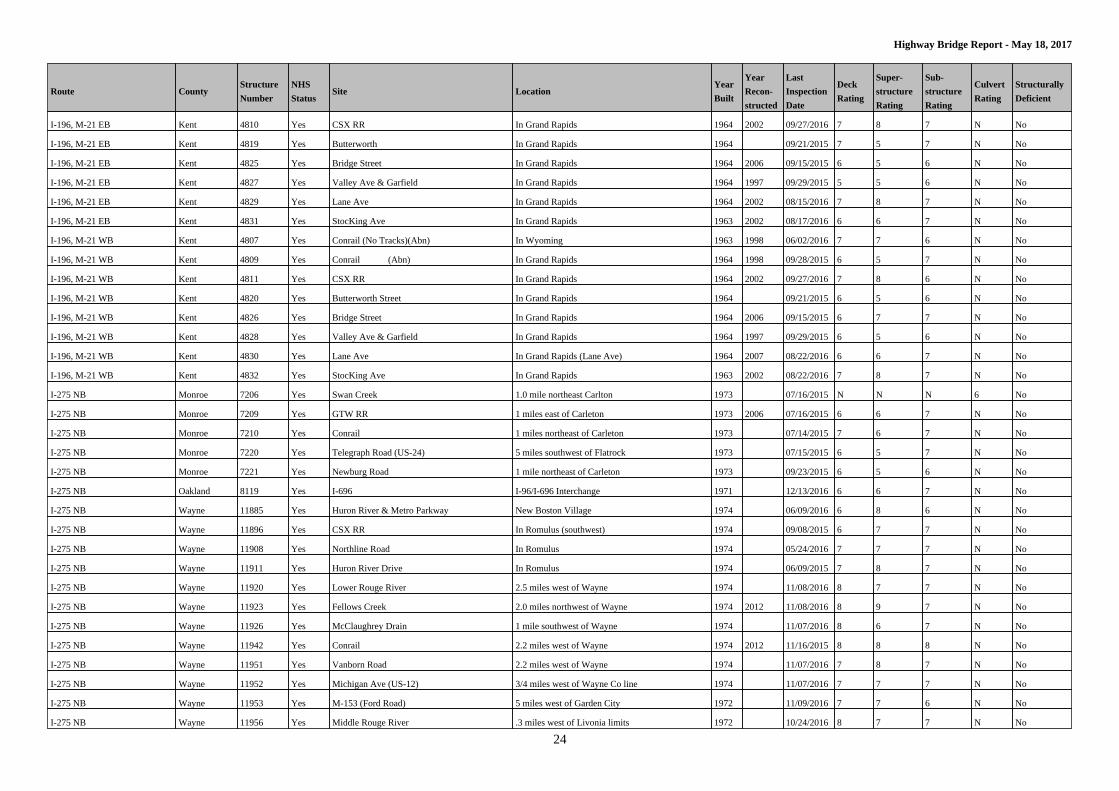
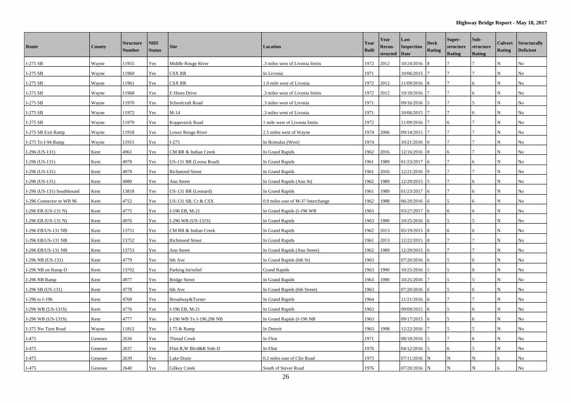
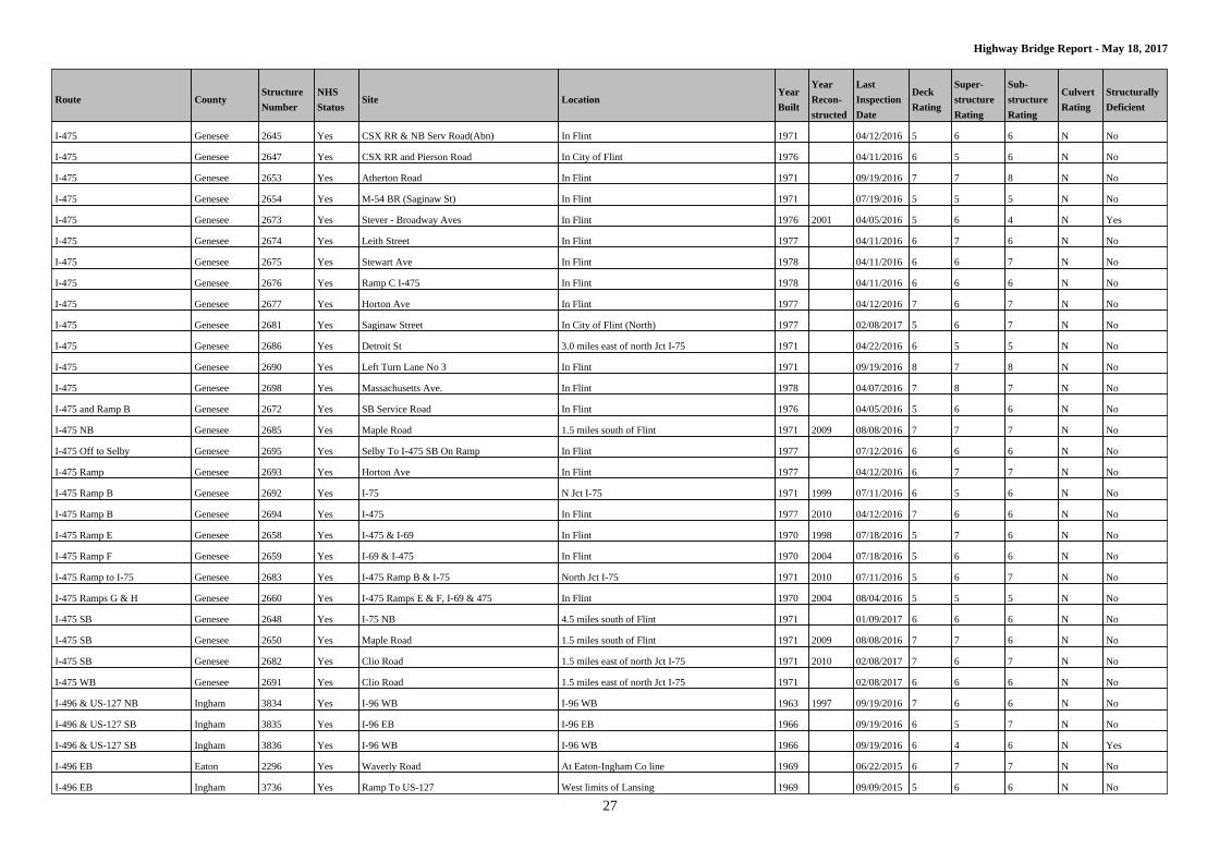
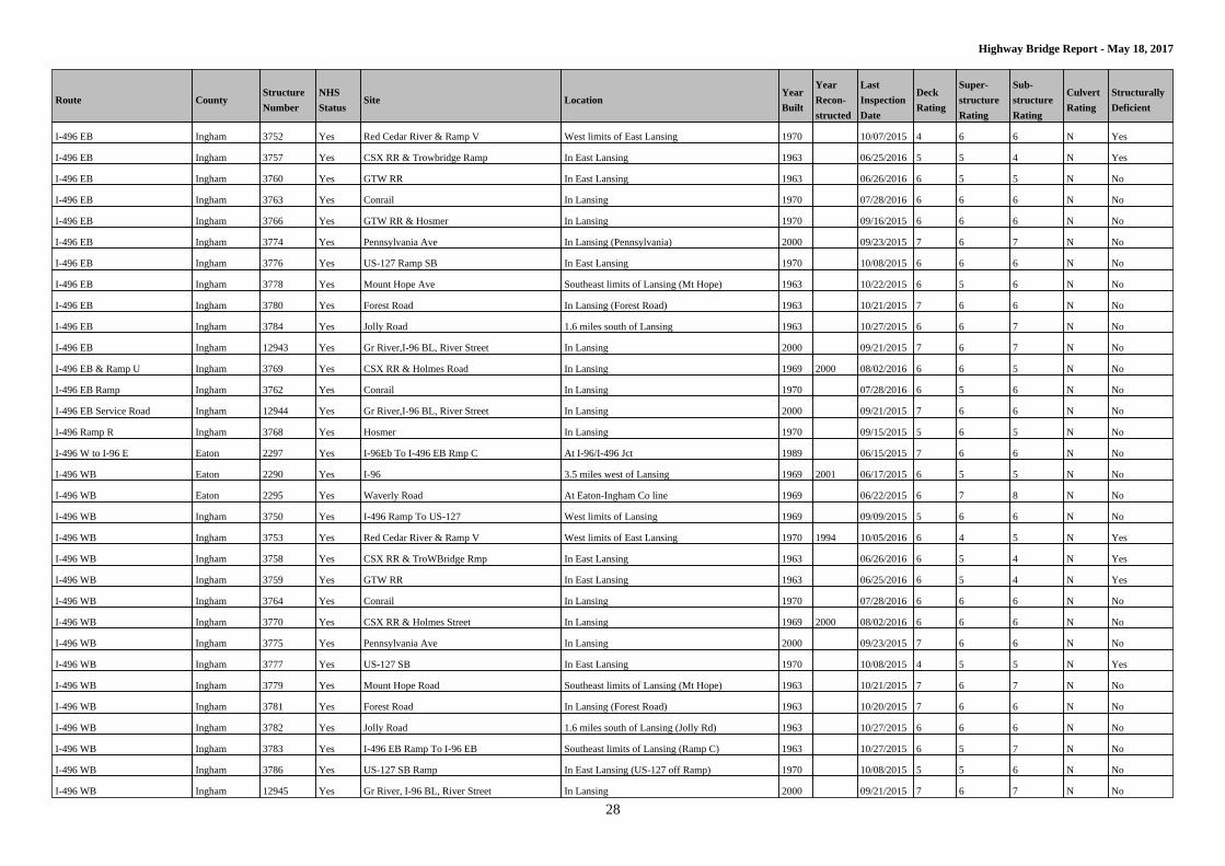
I-275 NB Monroe 7206 Yes Swan Creek 1.0 mile northeast Carlton 1973 07/16/2015 N N N 6 No
I-275 NB Monroe 7209 Yes GTW RR 1 miles east of Carleton 1973 2006 07/16/2015 6 6 7 N No
I-275 NB Monroe 7210 Yes Conrail 1 miles northeast of Carleton 1973 07/14/2015 7 6 7 N No
I-275 NB Monroe 7220 Yes Telegraph Road (US-24) 5 miles southwest of Flatrock 1973 07/15/2015 6 5 7 N No
I-275 NB Monroe 7221 Yes Newburg Road 1 mile northeast of Carleton 1973 09/23/2015 6 5 6 N No
I-275 NB Oakland 8119 Yes I-696 I-96/I-696 Interchange 1971 12/13/2016 6 6 7 N No
I-275 NB Wayne 11885 Yes Huron River & Metro Parkway New Boston Village 1974 06/09/2016 6 8 6 N No
I-275 NB Wayne 11896 Yes CSX RR In Romulus (southwest) 1974 09/08/2015 6 7 7 N No
I-275 NB Wayne 11908 Yes Northline Road In Romulus 1974 05/24/2016 7 7 7 N No
I-275 NB Wayne 11911 Yes Huron River Drive In Romulus 1974 06/09/2015 7 8 7 N No
I-275 NB Wayne 11920 Yes Lower Rouge River 2.5 miles west of Wayne 1974 11/08/2016 8 7 7 N No
I-275 NB Wayne 11923 Yes Fellows Creek 2.0 miles northwest of Wayne 1974 2012 11/08/2016 8 9 7 N No
I-275 NB Wayne 11926 Yes McClaughrey Drain 1 mile southwest of Wayne 1974 11/07/2016 8 6 7 N No
I-275 NB Wayne 11942 Yes Conrail 2.2 miles west of Wayne 1974 2012 11/16/2015 8 8 8 N No
I-275 NB Wayne 11951 Yes Vanborn Road 2.2 miles west of Wayne 1974 11/07/2016 7 8 7 N No
I-275 NB Wayne 11952 Yes Michigan Ave (US-12) 3/4 miles west of Wayne Co line 1974 11/07/2016 7 7 7 N No
I-275 NB Wayne 11953 Yes M-153 (Ford Road) 5 miles west of Garden City 1972 11/09/2016 7 7 6 N No
I-275 NB Wayne 11956 Yes Middle Rouge River .3 miles west of Livonia limits 1972 10/24/2016 8 7 7 N No
Page 25
25
Highway Bridge Report - May 18, 2017
Route CountyStructure
Number
NHS
StatusSite Location
Year
Built
Year
Recon-
structed
Last
Inspection
Date
Deck
Rating
Super-
structure
Rating
Sub-
structure
Rating
Culvert
Rating
Structurally
Deficient
I-275 NB Wayne 11957 Yes Tonquish Creek 3.5 miles southeast of Plymouth 1972 11/09/2016 8 8 7 N No
I-275 NB Wayne 11959 Yes CSX RR 1 mile west of Livonia 1972 2012 11/09/2016 8 7 7 N No
I-275 NB Wayne 11962 Yes CSX RR In Livonia 1971 10/24/2016 5 7 5 N No
I-275 NB Wayne 11973 Yes M-14 .3 miles west of Livonia 1971 10/18/2016 6 7 5 N No
I-275 NB Wayne 11978 Yes East Hines Drive .3 miles west of Livonia limits 1972 10/12/2015 8 7 7 N No
I-275 NB Wayne 11980 Yes Koppernick Road 1 mile west of Livonia 1972 11/09/2016 7 7 7 N No
I-275 NB Wayne 11981 Yes Schoolcraft Road .2 miles west of Livonia 1971 09/28/2016 7 6 6 N No
I-275 NB Collector Wayne 11974 Yes M-14 .3 miles west of Livonia 1971 08/10/2016 6 6 5 N No
I-275 NB Collector Wayne 11982 Yes Schoolcraft Road .2 miles west of Livonia 1971 2001 09/28/2016 8 8 6 N No
I-275 NB On Ramp Wayne 11922 Yes Lower Rouge River 0.25 miles west of Wayne 1974 11/08/2016 7 7 7 N No
I-275 NB To I-96 EB Wayne 11971 Yes Schoolcraft Road .3 miles west of Livonia 1971 2001 09/28/2016 8 8 6 N No
I-275 Ramp Wayne 11924 Yes Mcclaughrey Drain 1 mile southwest of Wayne 1974 2012 11/07/2016 8 7 7 N No
I-275 Ramp Wayne 11927 Yes Mcclaughery Drain 1 mile southwest of Wayne 1974 2012 11/07/2016 8 7 7 N No
I-275 Ramp N Wayne 11963 Yes CSX RR In Livonia 1971 2001 10/06/2015 7 7 5 N No
I-275 SB Monroe 7205 Yes N Br Swan Creek 1 mile northeast Carlton 1973 07/14/2015 N N N 6 No
I-275 SB Monroe 7207 Yes GTW RR 1 mile east of Carleton 1973 2006 07/16/2015 7 6 6 N No
I-275 SB Monroe 7208 Yes Conrail 1 mile northeast of Carleton 1973 2006 07/14/2015 6 7 7 N No
I-275 SB Monroe 7211 Yes I-75 5 miles north of Monroe 1973 2011 07/15/2015 7 7 7 N No
I-275 SB Monroe 7214 Yes Telegraph Road (US-24) 5 miles southwest of Flatrock 1973 07/15/2015 5 6 6 N No
I-275 SB Monroe 7219 Yes Newburg Road 1 mile northeast of Carleton 1973 09/23/2015 6 6 6 N No
I-275 SB Wayne 11884 Yes Huron River & Metro Parkway New Boston Village 1974 1998 06/09/2016 6 6 6 N No
I-275 SB Wayne 11895 Yes CSX RR In Romulus 1973 09/08/2015 7 7 7 N No
I-275 SB Wayne 11904 Yes Northline Road In Romulus 1974 09/21/2015 7 7 7 N No
I-275 SB Wayne 11905 Yes Huron River Drive In Romulus 1974 09/14/2015 7 8 7 N No
I-275 SB Wayne 11919 Yes Lower Rouge River 2.5 miles west of Wayne 1974 11/08/2016 7 7 7 N No
I-275 SB Wayne 11921 Yes Fellows Creek 2.0 miles northwest of Wayne 1974 11/08/2016 7 8 7 N No
I-275 SB Wayne 11925 Yes McClaughrey Drain 1 mile southwest of Wayne 1974 11/07/2016 8 6 7 N No
I-275 SB Wayne 11941 Yes Conrail 2.2 miles west of Wayne 1974 11/16/2015 8 8 8 N No
I-275 SB Wayne 11946 Yes Van Born Road 2.2 miles west of Wayne 1974 08/10/2016 7 8 7 N No
I-275 SB Wayne 11947 Yes Michigan Ave (US-12) 3/4 miles west of Wayne 1974 11/07/2016 7 7 7 N No
I-275 SB Wayne 11950 Yes M-153 (Ford Road) 5 miles west of Garden City 1972 11/09/2016 7 6 6 N No
I-275 SB Wayne 11954 Yes Tonquish Creek 3.5 miles southeast of Plymouth 1972 11/09/2016 8 8 7 N No
Page 26
26
Highway Bridge Report - May 18, 2017
Route CountyStructure
Number
NHS
StatusSite Location
Year
Built
Year
Recon-
structed
Last
Inspection
Date
Deck
Rating
Super-
structure
Rating
Sub-
structure
Rating
Culvert
Rating
Structurally
Deficient
I-275 SB Wayne 11955 Yes Middle Rouge River .3 miles west of Livonia limits 1972 2012 10/24/2016 8 7 7 N No
I-275 SB Wayne 11960 Yes CSX RR In Livonia 1971 10/06/2015 7 7 7 N No
I-275 SB Wayne 11961 Yes CSX RR 1.0 mile west of Livonia 1972 2012 11/09/2016 8 7 6 N No
I-275 SB Wayne 11968 Yes E Hines Drive .3 miles west of Livonia limits 1972 2012 10/18/2016 7 7 6 N No
I-275 SB Wayne 11970 Yes Schoolcraft Road .3 miles west of Livonia 1971 09/16/2016 5 7 5 N No
I-275 SB Wayne 11972 Yes M-14 .3 miles west of Livonia 1971 10/06/2015 7 7 6 N No
I-275 SB Wayne 11979 Yes Koppernick Road 1 mile west of Livonia limits 1972 11/09/2016 7 6 7 N No
I-275 SB Exit Ramp Wayne 11918 Yes Lower Rouge River 2.5 miles west of Wayne 1974 2006 09/14/2015 7 7 7 N No
I-275 To I-94 Ramp Wayne 11915 Yes I-275 In Romulus (West) 1974 10/21/2016 6 7 7 N No
I-296 (US-131) Kent 4961 Yes CM RR & Indian Creek In Grand Rapids 1962 2016 12/16/2016 8 6 7 N No
I-296 (US-131) Kent 4978 Yes US-131 BR (Leona Road) In Grand Rapids 1961 1989 01/23/2017 6 7 6 N No
I-296 (US-131) Kent 4979 Yes Richmond Street In Grand Rapids 1961 2016 12/21/2016 9 7 7 N No
I-296 (US-131) Kent 4980 Yes Ann Street In Grand Rapids (Ann St) 1962 1989 12/29/2015 5 7 6 N No
I-296 (US-131) Southbound Kent 13818 Yes US-131 BR (Leonard) In Grand Rapids 1961 1989 01/23/2017 6 7 6 N No
I-296 Connector to WB 96 Kent 4752 Yes US-131 SB, Cr & CSX 0.9 miles east of M-37 Interchange 1962 1988 06/20/2016 6 5 6 N No
I-296 EB (US-131 N) Kent 4775 Yes I-196 EB, M-21 In Grand Rapids (I-196 WB 1963 03/27/2017 6 6 6 N No
I-296 EB (US-131 N) Kent 4976 Yes I-296 WB (US-131S) In Grand Rapids 1963 1990 10/25/2016 6 5 5 N No
I-296 EB/US-131 NB Kent 13751 Yes CM RR & Indian Creek In Grand Rapids 1962 2013 05/19/2015 8 6 6 N No
I-296 EB/US-131 NB Kent 13752 Yes Richmond Street In Grand Rapids 1961 2013 12/22/2015 8 7 7 N No
I-296 EB/US-131 NB Kent 13753 Yes Ann Street In Grand Rapids (Ann Street) 1962 1989 12/29/2015 6 7 7 N No
I-296 NB (US-131) Kent 4779 Yes 6th Ave In Grand Rapids (6th St) 1963 07/20/2016 6 5 6 N No
I-296 NB on Ramp D Kent 13702 Yes Parking lot/relief Grand Rapids 1963 1990 10/25/2016 5 5 6 N No
I-296 NB Ramp Kent 4977 Yes Bridge Street In Grand Rapids 1963 1990 10/25/2016 7 5 5 N No
I-296 SB (US-131) Kent 4778 Yes 6th Ave In Grand Rapids (6th Street) 1963 07/20/2016 6 5 6 N No
I-296 to I-196 Kent 4768 Yes Broadway&Turner In Grand Rapids 1964 11/21/2016 6 7 7 N No
I-296 WB (US-131S) Kent 4776 Yes I-196 EB, M-21 In Grand Rapids 1963 09/09/2015 6 5 6 N No
I-296 WB (US-131S) Kent 4777 Yes I-196 WB To I-196,296 NB In Grand Rapids (I-196 NB 1963 09/17/2015 6 5 6 N No
I-375 Nw Turn Road Wayne 11812 Yes I-75 & Ramp In Detroit 1963 1998 12/22/2016 7 5 5 N No
I-475 Genesee 2636 Yes Thread Creek In Flint 1971 08/18/2016 5 7 6 N No
I-475 Genesee 2637 Yes Flint R,W Blvd&R Side D In Flint 1976 04/12/2016 5 6 5 N No
I-475 Genesee 2639 Yes Lake Drain 0.2 miles east of Clio Road 1973 07/11/2016 N N N 6 No
I-475 Genesee 2640 Yes Gilkey Creek South of Stever Road 1976 07/20/2016 N N N 6 No
Page 27
27
Highway Bridge Report - May 18, 2017
Route CountyStructure
Number
NHS
StatusSite Location
Year
Built
Year
Recon-
structed
Last
Inspection
Date
Deck
Rating
Super-
structure
Rating
Sub-
structure
Rating
Culvert
Rating
Structurally
Deficient
I-475 Genesee 2645 Yes CSX RR & NB Serv Road(Abn) In Flint 1971 04/12/2016 5 6 6 N No
I-475 Genesee 2647 Yes CSX RR and Pierson Road In City of Flint 1976 04/11/2016 6 5 6 N No
I-475 Genesee 2653 Yes Atherton Road In Flint 1971 09/19/2016 7 7 8 N No
I-475 Genesee 2654 Yes M-54 BR (Saginaw St) In Flint 1971 07/19/2016 5 5 5 N No
I-475 Genesee 2673 Yes Stever - Broadway Aves In Flint 1976 2001 04/05/2016 5 6 4 N Yes
I-475 Genesee 2674 Yes Leith Street In Flint 1977 04/11/2016 6 7 6 N No
I-475 Genesee 2675 Yes Stewart Ave In Flint 1978 04/11/2016 6 6 7 N No
I-475 Genesee 2676 Yes Ramp C I-475 In Flint 1978 04/11/2016 6 6 6 N No
I-475 Genesee 2677 Yes Horton Ave In Flint 1977 04/12/2016 7 6 7 N No
I-475 Genesee 2681 Yes Saginaw Street In City of Flint (North) 1977 02/08/2017 5 6 7 N No
I-475 Genesee 2686 Yes Detroit St 3.0 miles east of north Jct I-75 1971 04/22/2016 6 5 5 N No
I-475 Genesee 2690 Yes Left Turn Lane No 3 In Flint 1971 09/19/2016 8 7 8 N No
I-475 Genesee 2698 Yes Massachusetts Ave. In Flint 1978 04/07/2016 7 8 7 N No
I-475 and Ramp B Genesee 2672 Yes SB Service Road In Flint 1976 04/05/2016 5 6 6 N No
I-475 NB Genesee 2685 Yes Maple Road 1.5 miles south of Flint 1971 2009 08/08/2016 7 7 7 N No
I-475 Off to Selby Genesee 2695 Yes Selby To I-475 SB On Ramp In Flint 1977 07/12/2016 6 6 6 N No
I-475 Ramp Genesee 2693 Yes Horton Ave In Flint 1977 04/12/2016 6 7 7 N No
I-475 Ramp B Genesee 2692 Yes I-75 N Jct I-75 1971 1999 07/11/2016 6 5 6 N No
I-475 Ramp B Genesee 2694 Yes I-475 In Flint 1977 2010 04/12/2016 7 6 6 N No
I-475 Ramp E Genesee 2658 Yes I-475 & I-69 In Flint 1970 1998 07/18/2016 5 7 6 N No
I-475 Ramp F Genesee 2659 Yes I-69 & I-475 In Flint 1970 2004 07/18/2016 5 6 6 N No
I-475 Ramp to I-75 Genesee 2683 Yes I-475 Ramp B & I-75 North Jct I-75 1971 2010 07/11/2016 5 6 7 N No
I-475 Ramps G & H Genesee 2660 Yes I-475 Ramps E & F, I-69 & 475 In Flint 1970 2004 08/04/2016 5 5 5 N No
I-475 SB Genesee 2648 Yes I-75 NB 4.5 miles south of Flint 1971 01/09/2017 6 6 6 N No
I-475 SB Genesee 2650 Yes Maple Road 1.5 miles south of Flint 1971 2009 08/08/2016 7 7 6 N No
I-475 SB Genesee 2682 Yes Clio Road 1.5 miles east of north Jct I-75 1971 2010 02/08/2017 7 6 7 N No
I-475 WB Genesee 2691 Yes Clio Road 1.5 miles east of north Jct I-75 1971 02/08/2017 6 6 6 N No
I-496 & US-127 NB Ingham 3834 Yes I-96 WB I-96 WB 1963 1997 09/19/2016 7 6 6 N No
I-496 & US-127 SB Ingham 3835 Yes I-96 EB I-96 EB 1966 09/19/2016 6 5 7 N No
I-496 & US-127 SB Ingham 3836 Yes I-96 WB I-96 WB 1966 09/19/2016 6 4 6 N Yes
I-496 EB Eaton 2296 Yes Waverly Road At Eaton-Ingham Co line 1969 06/22/2015 6 7 7 N No
I-496 EB Ingham 3736 Yes Ramp To US-127 West limits of Lansing 1969 09/09/2015 5 6 6 N No
Page 28
28
Highway Bridge Report - May 18, 2017
Route CountyStructure
Number
NHS
StatusSite Location
Year
Built
Year
Recon-
structed
Last
Inspection
Date
Deck
Rating
Super-
structure
Rating
Sub-
structure
Rating
Culvert
Rating
Structurally
Deficient
I-496 EB Ingham 3752 Yes Red Cedar River & Ramp V West limits of East Lansing 1970 10/07/2015 4 6 6 N Yes
I-496 EB Ingham 3757 Yes CSX RR & Trowbridge Ramp In East Lansing 1963 06/25/2016 5 5 4 N Yes
I-496 EB Ingham 3760 Yes GTW RR In East Lansing 1963 06/26/2016 6 5 5 N No
I-496 EB Ingham 3763 Yes Conrail In Lansing 1970 07/28/2016 6 6 6 N No
I-496 EB Ingham 3766 Yes GTW RR & Hosmer In Lansing 1970 09/16/2015 6 6 6 N No
I-496 EB Ingham 3774 Yes Pennsylvania Ave In Lansing (Pennsylvania) 2000 09/23/2015 7 6 7 N No
I-496 EB Ingham 3776 Yes US-127 Ramp SB In East Lansing 1970 10/08/2015 6 6 6 N No
I-496 EB Ingham 3778 Yes Mount Hope Ave Southeast limits of Lansing (Mt Hope) 1963 10/22/2015 6 5 6 N No
I-496 EB Ingham 3780 Yes Forest Road In Lansing (Forest Road) 1963 10/21/2015 7 6 6 N No
I-496 EB Ingham 3784 Yes Jolly Road 1.6 miles south of Lansing 1963 10/27/2015 6 6 7 N No
I-496 EB Ingham 12943 Yes Gr River,I-96 BL, River Street In Lansing 2000 09/21/2015 7 6 7 N No
I-496 EB & Ramp U Ingham 3769 Yes CSX RR & Holmes Road In Lansing 1969 2000 08/02/2016 6 6 5 N No
I-496 EB Ramp Ingham 3762 Yes Conrail In Lansing 1970 07/28/2016 6 5 6 N No
I-496 EB Service Road Ingham 12944 Yes Gr River,I-96 BL, River Street In Lansing 2000 09/21/2015 7 6 6 N No
I-496 Ramp R Ingham 3768 Yes Hosmer In Lansing 1970 09/15/2015 5 6 5 N No
I-496 W to I-96 E Eaton 2297 Yes I-96Eb To I-496 EB Rmp C At I-96/I-496 Jct 1989 06/15/2015 7 6 6 N No
I-496 WB Eaton 2290 Yes I-96 3.5 miles west of Lansing 1969 2001 06/17/2015 6 5 5 N No
I-496 WB Eaton 2295 Yes Waverly Road At Eaton-Ingham Co line 1969 06/22/2015 6 7 8 N No
I-496 WB Ingham 3750 Yes I-496 Ramp To US-127 West limits of Lansing 1969 09/09/2015 5 6 6 N No
I-496 WB Ingham 3753 Yes Red Cedar River & Ramp V West limits of East Lansing 1970 1994 10/05/2016 6 4 5 N Yes
I-496 WB Ingham 3758 Yes CSX RR & TroWBridge Rmp In East Lansing 1963 06/26/2016 6 5 4 N Yes
I-496 WB Ingham 3759 Yes GTW RR In East Lansing 1963 06/25/2016 6 5 4 N Yes
I-496 WB Ingham 3764 Yes Conrail In Lansing 1970 07/28/2016 6 6 6 N No
I-496 WB Ingham 3770 Yes CSX RR & Holmes Street In Lansing 1969 2000 08/02/2016 6 6 6 N No
I-496 WB Ingham 3775 Yes Pennsylvania Ave In Lansing 2000 09/23/2015 7 6 6 N No
I-496 WB Ingham 3777 Yes US-127 SB In East Lansing 1970 10/08/2015 4 5 5 N Yes
I-496 WB Ingham 3779 Yes Mount Hope Road Southeast limits of Lansing (Mt Hope) 1963 10/21/2015 7 6 7 N No
I-496 WB Ingham 3781 Yes Forest Road In Lansing (Forest Road) 1963 10/20/2015 7 6 6 N No
I-496 WB Ingham 3782 Yes Jolly Road 1.6 miles south of Lansing (Jolly Rd) 1963 10/27/2015 6 6 6 N No
I-496 WB Ingham 3783 Yes I-496 EB Ramp To I-96 EB Southeast limits of Lansing (Ramp C) 1963 10/27/2015 6 5 7 N No
I-496 WB Ingham 3786 Yes US-127 SB Ramp In East Lansing (US-127 off Ramp) 1970 10/08/2015 5 5 6 N No
I-496 WB Ingham 12945 Yes Gr River, I-96 BL, River Street In Lansing 2000 09/21/2015 7 6 7 N No
Page 29
29
Highway Bridge Report - May 18, 2017
Route CountyStructure
Number
NHS
StatusSite Location
Year
Built
Year
Recon-
structed
Last
Inspection
Date
Deck
Rating
Super-
structure
Rating
Sub-
structure
Rating
Culvert
Rating
Structurally
Deficient
I-496 WB Ramp Ingham 3761 Yes CSX RR In East Lansing 1963 06/26/2016 5 3 3 N Yes
I-496 WB Ramp Ingham 3765 Yes Conrail In Lansing 1970 07/28/2016 6 6 6 N No
I-496 WB Service &RP Q Ingham 3767 Yes GTW RR & Hosmer In Lansing 1970 09/23/2015 5 6 6 N No
I-496 WB Service Road Ingham 12946 Yes Gr River,I-96 BL, River Street In Lansing 2000 09/21/2015 7 6 7 N No
I-675 Saginaw 9115 Yes Sagin River Gtw C&O RR &M13 In Saginaw 1971 2009 05/05/2015 8 8 7 N No
I-675 Saginaw 9136 Yes Warren Ave In Saginaw 2011 10/19/2016 8 7 7 N No
I-675 NB Saginaw 9122 Yes CSX RR .2 miles north of Saginaw 1971 11/28/2016 6 7 6 N No
I-675 NB Saginaw 9130 Yes 6th Street In Saginaw 2011 10/12/2016 8 8 8 N No
I-675 NB Saginaw 9132 Yes 5th Street In Saginaw 2011 10/12/2016 8 7 8 N No
I-675 NB Saginaw 9137 Yes Michigan Ave In Saginaw 1971 2009 11/02/2016 7 7 6 N No
I-675 NB Saginaw 9139 Yes Weiss Street In Saginaw, At north City Limits 1971 2009 10/18/2016 7 7 7 N No
I-675 NB Saginaw 9141 Yes Schaefer Street .1 miles north of Saginaw 1971 11/15/2016 7 6 7 N No
I-675 NB Saginaw 9143 Yes Shattuck Road .6 miles north of Saginaw 1971 10/21/2015 6 7 7 N No
I-675 NB Saginaw 9148 Yes I-75 North Jct I-75 1971 2009 11/03/2016 7 7 7 N No
I-675 NB Saginaw 9150 Yes Kochville Road .5 miles south of I-75 1971 2009 04/13/2016 7 6 5 N No
I-675 Ramp to I-75 Saginaw 9151 Yes I-675 & I-75 I-75 1971 11/01/2016 6 7 6 N No
I-675 SB Saginaw 9123 Yes CSX RR 0.2 miles north of Saginaw 1971 11/29/2016 5 7 6 N No
I-675 SB Saginaw 9131 Yes 6th Street In Saginaw 2011 10/12/2016 8 8 8 N No
I-675 SB Saginaw 9133 Yes 5th Street In Saginaw 2011 10/12/2016 8 8 8 N No
I-675 SB Saginaw 9138 Yes Michigan Ave In Saginaw 1971 11/02/2016 6 7 7 N No
I-675 SB Saginaw 9140 Yes Weiss Street In Saginaw, At north Cty Limits 1971 10/18/2016 5 7 7 N No
I-675 SB Saginaw 9142 Yes Schaefer Street .1 miles north of Saginaw 1971 2009 11/02/2016 7 6 6 N No
I-675 SB Saginaw 9144 Yes Shattuck Road .6 miles north of Saginaw 1971 2009 10/21/2015 6 7 7 N No
I-675 SB Saginaw 9147 Yes Kochville Road .5 miles south of I-75 1971 2009 10/24/2016 6 7 5 N No
I-675 SB Saginaw 13561 Yes Warren Avenue In Saginaw 2011 10/18/2016 7 7 7 N No
I-675 SB Ramp/I-75 Saginaw 9152 Yes I-75 North Jct I-75, Over I-75 1971 2009 11/03/2016 7 7 7 N No
I-675 WB Saginaw 9125 Yes I-75 I-75 1971 11/01/2016 7 7 6 N No
I-69 Clinton 1844 Yes Remy-Chandler Drain 2.4 miles north of East Lansing 1985 05/09/2016 N N N 7 No
I-69 Clinton 1858 Yes Chandler Drain 0.2 miles North of Clark 1973 04/18/2016 N N N 6 No
I-69 Clinton 1859 Yes Chandler Drain 0.1 miles northwest of Wood St 1973 04/18/2016 N N N 5 No
I-69 Clinton 1862 Yes Watson & Summers Drain 0.2 miles WEST OF LOWELL RD 1980 04/25/2016 N N N 6 No
I-69 Genesee 2582 Yes GTW RR In Flint 1971 04/14/2016 5 6 6 N No
Page 30
30
Highway Bridge Report - May 18, 2017
Route CountyStructure
Number
NHS
StatusSite Location
Year
Built
Year
Recon-
structed
Last
Inspection
Date
Deck
Rating
Super-
structure
Rating
Sub-
structure
Rating
Culvert
Rating
Structurally
Deficient
I-69 Genesee 2583 Yes CSX RR In Flint 1971 2015 08/09/2016 7 6 7 N No
I-69 Genesee 2586 Yes M-54 (Dort Hwy) In Flint 2015 11/18/2015 9 9 9 N No
I-69 Genesee 2600 Yes Carmen Creek 0.4 miles west of Hammerberg Road 1970 12/07/2015 N N N 6 No
I-69 Genesee 2602 Yes CSX RR, Fenton, Thread In Flint 1970 04/12/2016 6 5 6 N No
I-69 Lapeer 5338 Yes N Br Bell River 0.5 miles east of M-53 1979 05/13/2015 N N N 5 No
I-69 Lapeer 5339 Yes Pine Creek 0.2 miles east of Wilder Road. 1983 05/13/2015 N N N 7 No
I-69 St. Clair 13693 Yes Riley-Wales Drain 1.0 miles EAST of M-19 2016 03/15/2017 N N N 8 No
I-69 & Ramp Genesee 2522 Yes Howland & Hewitt Drain 0.2 miles east of Linden Road 1968 12/07/2015 N N N 6 No
I-69 BL Branch 1072 Yes Sauk River In Coldwater 1929 2002 05/03/2017 7 8 7 N No
I-69 BL Eaton 2255 Yes I-69 3.0 miles south of Charlotte 1971 05/20/2015 6 5 6 N No
I-69 BL (Fenn Road) Branch 1082 Yes I-69 2.9 miles south of US-12 1967 07/06/2016 5 6 6 N No
I-69 BR Eaton 2222 Yes Battle Creek River In Charlotte 1921 04/17/2017 N 4 5 N Yes
I-69 EB Clinton 1845 Yes US-127 SB 2.6 miles north of East Lansing 1985 05/09/2016 6 6 6 N No
I-69 EB Clinton 1856 Yes Peacock Road 0.5 miles west of Co line 1989 05/03/2016 5 6 7 N No
I-69 EB Clinton 1865 Yes Wood Road 1 mile east of US-27 1971 04/19/2016 5 5 6 N No
I-69 EB Clinton 1880 Yes Turner Road 1.2 miles south of Dewitt 1980 04/18/2016 6 6 6 N No
I-69 EB Genesee 2517 Yes Swartz Creek East of Bristol Road 1968 07/21/2016 6 7 7 N No
I-69 EB Genesee 2526 Yes GTW RR & Swartz Creek East of Miller Swartz Creek 1968 11/10/2015 6 5 6 N No
I-69 EB Genesee 2527 Yes GTW RR East of Miller Road & R04 1968 1998 08/11/2015 5 5 6 N No
I-69 EB Genesee 2536 Yes Elms Road 1.2 miles northeast of Swartz Creek 1960 1995 07/06/2016 6 6 6 N No
I-69 EB Genesee 2538 Yes Linden Road 2.0 miles southwest of Flint 1968 04/11/2016 6 6 6 N No
I-69 EB Genesee 2539 Yes Bristol Road 2.4 miles east of Swartz Creek 1968 1991 08/24/2016 6 6 6 N No
I-69 EB Genesee 2543 Yes I-75 Southwest limits of Flint 1969 10/11/2016 6 6 7 N No
I-69 EB Genesee 2548 Yes Ballenger Road East of I-75 Interchange 1969 09/09/2016 6 6 6 N No
I-69 EB Genesee 2552 Yes Miller Road In Swartz Creek 1968 2006 07/21/2016 6 5 6 N No
I-69 EB Genesee 2577 Yes Kearsley Cr 2.6 miles west of M-15 1970 08/01/2016 6 6 7 N No
I-69 EB Genesee 2587 Yes Averill Ave In Flint 1971 2015 08/01/2016 7 7 7 N No
I-69 EB Genesee 2589 Yes Center Road In Flint 1971 2015 08/03/2016 7 5 7 N No
I-69 EB Genesee 2591 Yes Genesee Road 1.0 mile east of Flint 1971 2000 08/01/2016 6 6 7 N No
I-69 EB Genesee 2595 Yes M-15 6.0 miles east of Flint 1970 2006 08/09/2016 6 7 7 N No
I-69 EB Genesee 2599 Yes Irish Road 4.0 miles east of Flint 1970 2013 09/14/2015 8 8 7 N No
I-69 EB Genesee 2603 Yes Hammerburg Drain In Flint 1970 09/13/2016 5 4 6 N Yes
Page 31
31
Highway Bridge Report - May 18, 2017
Route CountyStructure
Number
NHS
StatusSite Location
Year
Built
Year
Recon-
structed
Last
Inspection
Date
Deck
Rating
Super-
structure
Rating
Sub-
structure
Rating
Culvert
Rating
Structurally
Deficient
I-69 EB Genesee 2656 Yes I-475 & I-475 Ramps In Flint (Levl 2) 1970 2004 07/18/2016 6 6 6 N No
I-69 EB Lapeer 5324 Yes Farmers Creek 1.0 mile southwest of Lapeer 1971 01/07/2016 7 7 5 N No
I-69 EB Lapeer 5332 Yes M-24 1.0 mile south of Lapeer, M-24 1971 05/15/2017 7 6 6 N No
I-69 EB Lapeer 5334 Yes S Br Flint River Southeast of Lapeer 1983 05/13/2015 6 6 7 N No
I-69 EB Lapeer 5342 Yes GTW RR (Abn) 2 miles southwest Imlay City 1983 04/10/2017 6 6 7 N No
I-69 EB Lapeer 5344 Yes Clark Road 1.0 mile south of Lapeer 1983 04/05/2017 7 5 8 N No
I-69 EB Lapeer 5351 Yes Newark Road 3.7 miles west of Imlay City 1983 01/06/2016 7 7 9 N No
I-69 EB Lapeer 5352 Yes Winslow Road 3 miles southwest of Imlay City 1983 04/18/2017 6 6 7 N No
I-69 EB Lapeer 5354 Yes Summers Road 2.0 M southwest of Imlay City 1983 04/10/2017 7 6 6 N No
I-69 EB Lapeer 5360 Yes Graham Road 4.2 miles southeast of Imlay City 1979 01/08/2016 6 8 7 N No
I-69 EB Shiawassee 9732 Yes Looking Glass River 5.0 miles northeast of M-52 1961 2010 08/11/2015 9 6 7 N No
I-69 EB Shiawassee 9734 Yes Shiawassee River 3.6 miles southwest of M-71 1961 1998 08/25/2015 6 5 6 N No
I-69 EB Shiawassee 9736 Yes Holly Drain 0.3 miles northeast of M-71 1961 08/06/2015 6 7 6 N No
I-69 EB Shiawassee 9738 Yes Webb Drain 2.7 miles southwest of Genesee Co line 1961 08/05/2015 7 7 7 N No
I-69 EB Shiawassee 9742 Yes CN RR & Garrison Road .6 miles southwest of M-71 1961 1998 08/11/2015 6 5 6 N No
I-69 EB Shiawassee 9744 Yes CM RR 1.2 miles southwest of Genesee Co line 1961 08/26/2015 5 6 7 N No
I-69 EB Shiawassee 9755 Yes S Br Looking Glass River 1.5 miles Se Clinton Co line 1989 08/24/2015 6 7 6 N No
I-69 EB Shiawassee 9759 Yes Shaftsburg Road 0.5 miles north of ShaftSBurg 1989 08/17/2015 6 6 6 N No
I-69 EB Shiawassee 9760 Yes Bath Road 2.5 miles West of Perry 1988 08/18/2015 7 6 7 N No
I-69 EB Shiawassee 9764 Yes Colby Lake Road 1.5 miles west of ShaftSBurg 1989 08/04/2015 6 7 6 N No
I-69 EB St. Clair 9925 Yes S Br Pine River 1.2 miles southeast of Goodells 1980 11/03/2016 8 6 7 N No
I-69 EB St. Clair 9927 Yes Pine River 2.6 miles southeast of Goodells 1980 2015 11/03/2016 7 8 7 N No
I-69 EB St. Clair 9929 Yes CSX RR 1.5 miles west of I-94 1966 2007 10/20/2015 7 6 7 N No
I-69 EB St. Clair 9930 Yes GTW RR .7 miles east of I-94 1965 2007 10/20/2015 7 6 7 N No
I-69 EB St. Clair 9933 Yes GTW RR 3 miles southeast of Goodells 1980 10/07/2015 7 7 7 N No
I-69 EB St. Clair 9945 Yes Cox-Doty Drn 2.7 miles east of Capac 1982 12/16/2015 5 8 7 N No
I-69 EB St. Clair 10012 Yes I-94 I-69 2014 08/12/2015 9 8 9 N No
I-69 EB St. Clair 13694 Yes Burt Drain 1.2 miles east of Goodells Road 2015 03/09/2017 N N N 9 No
I-69 EB & Ramp Lapeer 5336 Yes Hunter Ck Southeast of Lapeer 1983 05/11/2017 7 5 6 N No
I-69 EB C-D Clinton 1847 Yes US-127 2.5 miles north of East Lansing 1994 05/09/2016 6 6 6 N No
I-69 EB Ramp Lapeer 5340 Yes Pine Creek 0.2 miles east of Wilder Road 1983 05/13/2015 N N N 7 No
I-69 NB Branch 1075 Yes Coldwater Lake Drain 7.1 miles south of US-12 1967 05/08/2017 6 8 7 N No
Page 32
32
Highway Bridge Report - May 18, 2017
Route CountyStructure
Number
NHS
StatusSite Location
Year
Built
Year
Recon-
structed
Last
Inspection
Date
Deck
Rating
Super-
structure
Rating
Sub-
structure
Rating
Culvert
Rating
Structurally
Deficient
I-69 NB Branch 1076 Yes Sauk River 0.8 miles south of US-12 1967 05/03/2017 6 7 7 N No
I-69 NB Branch 1078 Yes Indiana northeast RR, Sauk R Road 0.2 miles south of US-12 1967 05/01/2017 6 5 6 N No
I-69 NB Branch 1087 Yes US-12 In Coldwater 2002 05/01/2017 7 6 7 N No
I-69 NB Branch 1091 Yes Hog Creek 6.7 miles north of US-12 1967 05/08/2017 7 5 6 N No
I-69 NB Calhoun 1215 Yes St Joseph River 1.2 miles north of Branch Co line 1968 10/19/2015 6 5 6 N No
I-69 NB Calhoun 1216 Yes Kalamazoo River 2.6 miles south of I-94 1968 07/15/2015 7 6 6 N No
I-69 NB Calhoun 1223 Yes Conrail (Abn) 2.3 miles north of Branch Co line 1968 2003 10/06/2015 7 5 7 N No
I-69 NB Calhoun 1235 Yes M-60 At M-60 1968 10/05/2015 7 5 6 N No
I-69 NB Calhoun 1236 Yes I-94 At I-94 1968 2006 08/12/2015 6 6 6 N No
I-69 NB Calhoun 1237 Yes I-94 At I-94 1968 08/12/2015 6 6 7 N No
I-69 NB Clinton 1874 Yes EB Turning Roadway 6.0 miles northwest of Lansing 1981 04/29/2016 6 5 6 N No
I-69 NB Clinton 1876 Yes I-96 BL Grand River Ave 5 miles northwest of Lansing 1981 04/21/2016 5 6 7 N No
I-69 NB Eaton 2237 Yes Indian Creek 1.0 mile north of Olivet 1972 05/15/2017 6 7 6 N No
I-69 NB Eaton 2238 Yes Battle Creek River 0.5 miles south of M-50 1961 1971 05/17/2017 5 6 6 N No
I-69 NB Eaton 2242 Yes Big Creek 2.5 miles northeast of Olivet 1972 05/13/2015 6 7 6 N No
I-69 NB Eaton 2249 Yes GTW RR East limits of Charlotte 1961 1971 04/25/2017 5 4 5 N Yes
I-69 NB Eaton 2261 Yes Stine Road 2.3 miles northeast of Olivet 1972 05/01/2017 6 6 6 N No
I-69 NB Eaton 2262 Yes Thornapple River 0.4 miles southwest Potterville 1989 06/04/2015 7 8 7 N No
I-69 NB Eaton 2264 Yes GTW RR& Billwood Hwy 4.0 miles northeast Potterville 1989 06/09/2015 6 6 7 N No
I-69 NB Eaton 2266 Yes I-69 BL Northeast limits Charlotte 1989 06/02/2015 6 6 7 N No
I-69 NB Eaton 2268 Yes Packard Hwy Northeast limits Charlotte 1989 06/02/2015 6 6 7 N No
I-69 NB Eaton 2271 Yes Old 27 & Stewart Road 3.0 miles northeast Charlotte 1989 06/04/2015 5 7 7 N No
I-69 NB Eaton 2273 Yes M-100 At south Limits Potterville 1989 06/08/2015 7 7 7 N No
I-69 NB Eaton 2275 Yes Windsor & Nixon Hwy 2.0 miles northeast Potterville 1989 06/04/2015 6 7 7 N No
I-69 NB Eaton 2279 Yes I-96 2.0 miles south I-496 1989 06/11/2015 6 6 6 N No
I-69 NB Ramp Eaton 2240 Yes Indian Creek 1.0 mile north of Olivet 1972 05/15/2017 6 7 6 N No
I-69 on Ramp & (9TH ) Genesee 2661 Yes I-69 & I-475 Ramp A In Flint 1970 04/14/2016 6 7 7 N No
I-69 Ramp D WB Genesee 2584 Yes CSX RR In Flint 2003 08/09/2016 7 8 7 N No
I-69 Ramp E Genesee 2545 Yes I-75 EB I-69 Ramp To NB I-75 1969 10/11/2016 6 6 6 N No
I-69 Ramp F Genesee 2546 Yes I-75 WB I-69 Ramp To SB I-75 1960 2004 10/11/2016 6 6 6 N No
I-69 SB Branch 1073 Yes Coldwater Lake Drain 7.1 miles south of US-12 1967 2000 05/08/2017 6 8 7 N No
I-69 SB Branch 1074 Yes Sauk River 0.8 miles south of US-12 1967 05/03/2017 6 7 7 N No
Page 33
33
Highway Bridge Report - May 18, 2017
Route CountyStructure
Number
NHS
StatusSite Location
Year
Built
Year
Recon-
structed
Last
Inspection
Date
Deck
Rating
Super-
structure
Rating
Sub-
structure
Rating
Culvert
Rating
Structurally
Deficient
I-69 SB Branch 1077 Yes Indiana northeast RR, Sauk R Road 0.2 miles south of US-12 1967 05/01/2017 6 5 6 N No
I-69 SB Branch 1084 Yes US-12 In Coldwater 1967 05/01/2017 6 5 7 N No
I-69 SB Branch 1090 Yes Hog Creek 6.7 miles north of US-12 1967 05/08/2017 7 5 7 N No
I-69 SB Calhoun 1213 Yes St Joseph River 1.2 miles north of Branch Co line 1968 10/19/2015 6 5 7 N No
I-69 SB Calhoun 1214 Yes Kalamazoo River 2.6 miles south of I-94 1968 07/15/2015 6 6 6 N No
I-69 SB Calhoun 1222 Yes Conrail (Abn) 2.3 miles north of Branch Co line 1968 2003 10/06/2015 7 5 7 N No
I-69 SB Calhoun 1225 Yes M-60 At M-60 1968 10/05/2015 7 5 6 N No
I-69 SB Calhoun 1232 Yes I-94 At I-94 1968 2006 08/12/2015 6 6 6 N No
I-69 SB Calhoun 1233 Yes I-94 At I-94 1968 2008 08/12/2015 6 5 6 N No
I-69 SB Clinton 1868 Yes Turner Road 1.2 miles south of Dewitt 1980 04/19/2016 6 6 6 N No
I-69 SB Clinton 1873 Yes EB Turning Roadway 6.0 M northwest of Lansing 1981 04/29/2016 5 5 6 N No
I-69 SB Clinton 1875 Yes I-96 BL Grand River Ave 5 miles northwest of Lansing 1981 04/20/2016 6 6 7 N No
I-69 SB Clinton 1877 Yes I-96 7 miles northwest of Lansing 1981 04/20/2016 6 7 6 N No
I-69 SB Eaton 2236 Yes Indian Creek 1.0 mile north of Olivet 1972 05/15/2017 6 7 6 N No
I-69 SB Eaton 2241 Yes Big Creek 2.5 miles northeast of Olivet 1972 05/13/2015 7 7 6 N No
I-69 SB Eaton 2243 Yes Battle Creek River 0.5 miles south of M-50 1971 05/17/2017 6 8 6 N No
I-69 SB Eaton 2250 Yes GTW RR East limits of Charlotte 1971 05/16/2017 6 5 6 N No
I-69 SB Eaton 2259 Yes Stine Road 2.3 miles northeast of Olivet 1972 05/01/2017 5 6 7 N No
I-69 SB Eaton 2263 Yes Thornapple River 0.4 miles southwest Potterville 1989 06/04/2015 7 8 7 N No
I-69 SB Eaton 2265 Yes GTW RR& Billwood Hwy 4.0 miles northeast Potterville 1989 06/10/2015 6 6 7 N No
I-69 SB Eaton 2267 Yes I-69 BL Northeast limits Charlotte 1989 06/02/2015 6 6 7 N No
I-69 SB Eaton 2269 Yes Packard Hwy Northeast limits Charlotte 1989 06/02/2015 6 6 7 N No
I-69 SB Eaton 2272 Yes Old 27 & Stewart Road 3.0 miles northeast Charlotte 1989 06/04/2015 6 7 7 N No
I-69 SB Eaton 2276 Yes Nixon Road 2.0 miles northeast Potterville 1989 06/08/2015 7 7 7 N No
I-69 SB Eaton 2280 Yes I-96 2.0 miles south I-496 1989 06/11/2015 6 6 6 N No
I-69 SB Eaton 2282 Yes M-100 At south Limits Potterville 1989 06/08/2015 6 7 7 N No
I-69 SB Ramp Eaton 2239 Yes Indian Creek 1.0 mile north of Olivet 1972 05/15/2017 6 7 6 N No
I-69 WB Clinton 1846 Yes US-127 NB 2.6 miles north of East Lansing 1985 05/09/2016 6 6 6 N No
I-69 WB Clinton 1857 Yes Peacock Road 0.5 miles west of Co line 1989 05/03/2016 5 6 6 N No
I-69 WB Clinton 1863 Yes CSX RR 6.5 miles northwest of Lansing 1981 04/19/2016 6 7 6 N No
I-69 WB Clinton 1866 Yes Wood Road 1 mile east of US-27 1971 04/18/2016 5 5 7 N No
I-69 WB Genesee 2518 Yes Swartz Creek East of Bristol Road 1968 07/25/2016 6 6 7 N No
Page 34
34
Highway Bridge Report - May 18, 2017
Route CountyStructure
Number
NHS
StatusSite Location
Year
Built
Year
Recon-
structed
Last
Inspection
Date
Deck
Rating
Super-
structure
Rating
Sub-
structure
Rating
Culvert
Rating
Structurally
Deficient
I-69 WB Genesee 2528 Yes GTW RR & Swartz Creek East of Miller Swartz Creek 1968 1998 11/10/2015 6 5 5 N No
I-69 WB Genesee 2529 Yes GTW RR East of Miller Road & R06 1968 1998 08/25/2016 6 6 7 N No
I-69 WB Genesee 2537 Yes Elms Road 1.2 miles northeast of Swartz Creek 1960 1995 07/06/2016 6 6 6 N No
I-69 WB Genesee 2540 Yes Bristol Road 2.4 miles east of Swartz Creek 1968 1991 08/24/2016 5 6 6 N No
I-69 WB Genesee 2544 Yes I-75 Southwest limits of Flint 1969 04/13/2016 5 5 4 N Yes
I-69 WB Genesee 2549 Yes Ballenger Road East of I-75 Interchange 1969 09/09/2016 6 5 5 N No
I-69 WB Genesee 2553 Yes Linden Road 2.0 miles east of Swartz Creek 1968 09/12/2016 6 6 6 N No
I-69 WB Genesee 2554 Yes Miller Road In Swartz Creek 1968 2006 07/21/2016 7 6 7 N No
I-69 WB Genesee 2576 Yes Kearsley Creek 2.6 miles west of M-15 1970 08/01/2016 7 6 7 N No
I-69 WB Genesee 2588 Yes Averill Ave In Flint 1971 2015 08/01/2016 7 7 7 N No
I-69 WB Genesee 2590 Yes Center Road In Flint 1971 2015 08/03/2016 7 6 7 N No
I-69 WB Genesee 2593 Yes Irish Road 4.0 miles east of Flint 1970 2013 09/14/2015 8 8 7 N No
I-69 WB Genesee 2597 Yes M-15 6.0 miles east of Flint 1970 2006 08/09/2016 6 6 7 N No
I-69 WB Genesee 2598 Yes Genesee Road 1.0 mile east of Flint 1971 08/01/2016 6 7 7 N No
I-69 WB Genesee 2604 Yes Hammerburg Drain In Flint 1970 09/13/2016 6 4 5 N Yes
I-69 WB Genesee 2657 Yes I-475 & I-475 Ramps In Flint Lvl 2 1970 2004 07/18/2016 6 6 6 N No
I-69 WB Lapeer 5325 Yes Farmers Creek 1.0 mile southwest of Lapeer 1971 01/07/2016 6 7 5 N No
I-69 WB Lapeer 5333 Yes M-24 1.0 mile south of Lapeer, M-24 1971 05/01/2017 6 6 6 N No
I-69 WB Lapeer 5335 Yes S Br Flint River Southeast of Lapeer 1983 05/14/2015 6 5 7 N No
I-69 WB Lapeer 5337 Yes Hunter Ck South of Lapeer 1983 05/14/2015 7 5 7 N No
I-69 WB Lapeer 5343 Yes GTW RR (Abn) 2.0 miles southwest of Imlay City 1983 04/10/2017 7 6 7 N No
I-69 WB Lapeer 5345 Yes Clark Road 1.0 mile south of Lapeer 1983 04/05/2017 8 8 8 N No
I-69 WB Lapeer 5353 Yes Winslow Road 3 miles southwest of Imlay City 1983 04/18/2017 6 6 7 N No
I-69 WB Lapeer 5355 Yes Summers Road 2.0 miles southwest of Imlay City 1983 04/10/2017 6 6 7 N No
I-69 WB Lapeer 5361 Yes Graham Road 4.2 miles southeast of Imlay City 1979 01/08/2016 6 7 7 N No
I-69 WB Lapeer 5362 Yes Newark Road 3.7 miles west of Imlay City 1983 01/06/2016 6 7 9 N No
I-69 WB Shiawassee 9733 Yes Lookin Glass River 5.0 miles northeast of M-52 1961 2010 08/11/2015 9 6 7 N No
I-69 WB Shiawassee 9735 Yes Shiawassee River 3.6 miles southwest of M-71 1961 1998 08/25/2015 6 5 6 N No
I-69 WB Shiawassee 9737 Yes Holly Drain 0.3 miles northeast of M-71 1961 08/06/2015 6 7 6 N No
I-69 WB Shiawassee 9739 Yes Webb Drain 2.7 miles southwest of Genesee Co line 1961 08/05/2015 7 7 7 N No
I-69 WB Shiawassee 9743 Yes CN RR & Garrison Road .6 miles southwest of M-71 1961 1998 08/11/2015 6 5 6 N No
I-69 WB Shiawassee 9745 Yes CM RR 1.2 miles southwest of Genesee Co line 1961 08/26/2015 5 6 7 N No
Page 35
35
Highway Bridge Report - May 18, 2017
Route CountyStructure
Number
NHS
StatusSite Location
Year
Built
Year
Recon-
structed
Last
Inspection
Date
Deck
Rating
Super-
structure
Rating
Sub-
structure
Rating
Culvert
Rating
Structurally
Deficient
I-69 WB Shiawassee 9756 Yes S Br Looking Glass River 1.5 miles Se Clinton Co line 1989 08/24/2015 6 7 7 N No
I-69 WB Shiawassee 9761 Yes Bath Road 2.5 miles west of Perry 1988 08/18/2015 7 7 6 N No
I-69 WB Shiawassee 9765 Yes Colby Lake Road 1.5 miles west of ShaftSBurg 1989 08/04/2015 6 7 6 N No
I-69 WB Shiawassee 9766 Yes Shaftsburg Road 0.5 miles north of ShaftSBurg 1989 08/06/2015 6 6 6 N No
I-69 WB St. Clair 9926 Yes S Br Pine River 1.2 miles southeast of Goodells 1980 11/03/2016 8 6 7 N No
I-69 WB St. Clair 9928 Yes Pine River 2.6 miles southeast of Goodells 1980 11/03/2016 7 8 6 N No
I-69 WB St. Clair 9931 Yes CSX RR 1.5 miles west of I-94 1966 2007 10/20/2015 7 7 7 N No
I-69 WB St. Clair 9932 Yes GTW RR .7 miles east of I-94 1965 2007 10/20/2015 7 5 7 N No
I-69 WB St. Clair 9934 Yes GTW RR 3 miles southeast of Goodells 1980 10/07/2015 6 7 7 N No
I-69 WB St. Clair 9946 Yes Cox-Doty Drn 2.7 miles southeast Capac 1982 12/16/2015 6 8 7 N No
I-69 WB St. Clair 10014 Yes I-94 I-69 2013 10/28/2015 9 9 9 N No
I-69 WB St. Clair 13695 Yes Burt Drain 1.2 miles east of Goodells Road 2016 03/09/2017 N N N 9 No
I-69 WB Ramp Lapeer 5341 Yes Pine Creek 0.2 miles east of Wilder Road 1983 05/13/2015 N N N 7 No
I-69 WB Ramp C Genesee 2555 Yes Miller Road In Swartz Creek 1968 1991 07/21/2016 7 6 6 N No
I-69 WB Ramps H&F Genesee 2550 Yes Ballenger Road WB I-69 Ramp To I-75 1969 09/09/2016 5 5 6 N No
I-69 WB to I-96 EB Eaton 2317 Yes Grand River 6 miles northwest of Lansing 1981 07/27/2015 6 6 6 N No
I-696 Oakland 7901 Yes Drake Road 2.7miles east of I-96 Over Drake 1960 2009 07/12/2016 8 7 8 N No
I-696 Oakland 7918 Yes M-10 In Southfield 1967 1988 04/07/2017 7 5 6 N No
I-696 Oakland 7966 Yes I-75 & 4 Ramps In Royal Oak 1971 07/12/2016 7 8 7 N No
I-696 Oakland 7969 Yes N Service Road In Madison Heights 1971 2007 07/16/2015 7 7 7 N No
I-696 EB Oakland 7905 Yes Inkster Road In Southfield 1988 07/14/2016 7 7 7 N No
I-696 EB Oakland 7913 Yes Rouge River In Southfield 1967 1988 03/17/2016 7 8 7 N No
I-696 EB Oakland 7957 Yes M-1 Woodward At I-696 & Woodward 1986 07/20/2016 6 7 7 N No
I-696 EB & WB Oakland 7963 Yes N-S Service Road In City of Royal Oak 1982 07/16/2015 7 8 8 N No
I-696 EB Service Oakland 7939 Yes M-1 Woodward At I-696 & Woodward 1986 07/02/2015 5 8 7 N No
I-696 Ramp east to N Macomb 6121 Yes I-94, 11 Mile Road & Ramps Roseville & St Clair Shores 1972 2010 03/29/2016 7 7 7 N No
I-696 Ramp EB Oakland 7979 Yes I-75 & Ramps To I-75 NB I-75 1971 2007 07/22/2015 7 7 7 N No
I-696 Ramp north to W Macomb 6123 Yes I-94 In St. Clair Shores 1972 10/10/2016 6 7 6 N No
I-696 Ramp WB Oakland 7980 Yes I-75 & Ramps To I-75 SB I-75 / I-696 Intrchange 1971 2007 07/22/2015 6 7 7 N No
I-696 Ramps AF&EF Oakland 7968 Yes N Service Road In Madison Heights 1971 07/16/2015 7 6 7 N No
I-696 Ramps GH&GD Oakland 7970 Yes N Service Road In Madison Heights 1971 2007 07/16/2015 7 7 7 N No
I-696 SB TO I-96 R Oakland 8118 Yes M-102 I-96/I-696 Interchange 1971 1998 12/14/2016 7 5 7 N No
Page 36
36
Highway Bridge Report - May 18, 2017
Route CountyStructure
Number
NHS
StatusSite Location
Year
Built
Year
Recon-
structed
Last
Inspection
Date
Deck
Rating
Super-
structure
Rating
Sub-
structure
Rating
Culvert
Rating
Structurally
Deficient
I-696 TO I-75 Ramp Oakland 7964 Yes N-S Service Road. At I696 & I-75 1982 07/14/2015 7 7 8 N No
I-696 Turn Roadway AF Oakland 7978 Yes I-696 & Ramps From I-75 SB I-75 1971 2007 07/22/2015 6 7 7 N No
I-696 Turn Roadway EB Oakland 7977 Yes I-696 & Ramps From I-75 NB I-75 1971 2007 07/22/2015 6 7 7 N No
I-696 WB Oakland 7906 Yes Inkster Road In Southfield 1988 07/12/2016 7 7 7 N No
I-696 WB Oakland 7914 Yes Rouge River In Southfield 1967 1988 07/12/2016 7 7 7 N No
I-696 WB Oakland 7956 Yes M-1 Woodward At Woodward & I-696 1986 07/20/2016 6 7 7 N No
I-696 WB Service Oakland 7937 Yes M-1 Woodward Ave At I-696 Woodward 1986 07/15/2015 6 7 7 N No
I-69BR EB Ramp D Clinton 1853 Yes I-69 3 miles northeast of East Lansing 1985 05/03/2016 6 6 7 N No
I-69BR WB Ramp C Clinton 1854 Yes I-69 3.5 miles northeast of East Lansing 1985 05/04/2016 6 6 7 N No
I-69W to I-475N RM Genesee 2664 Yes I-475S On Rmp C In Flint 1970 04/05/2016 6 5 6 N No
I-75 Arenac 409 Yes Lincoln Drain 0.5 miles north of Worth Road 1968 04/20/2016 N N N 6 No
I-75 Chippewa 1573 Yes S Br Big Munuscong River 0.1 miles north of Mile Post 375 1962 05/17/2016 N N N 5 No
I-75 Emmet 2452 Yes D&M RR (Abn) In Mackinaw City 1957 1975 08/03/2016 7 7 7 N No
I-75 Emmet 2454 Yes Central Street In Mackinac City 1957 2005 08/15/2016 6 7 7 N No
I-75 Genesee 2471 Yes Swartz Creek North of I-69 Interchange 1954 2010 10/11/2016 6 5 6 N No
I-75 Genesee 2485 Yes Bristol Road 1.0 miles southwest of Flint 2005 04/13/2016 6 8 7 N No
I-75 Genesee 2500 Yes Court Street North of M-21 1957 04/19/2016 6 5 6 N No
I-75 Mackinac 5946 Yes Clear Creek 4.6 miles north of M-134 1963 07/13/2016 N N N 6 No
I-75 Monroe 7168 Yes Paper Co Water Mains In Monroe 1955 1975 08/24/2015 6 6 7 N No
I-75 Monroe 7172 Yes Indust Tracks In Monroe 1954 1989 08/01/2016 5 7 6 N No
I-75 Monroe 7173 Yes Conrail , Raisin River, Front In Monroe over Front Street 1955 2005 10/06/2016 6 6 5 N No
I-75 Monroe 7174 Yes Conrail, Indust Tr In Monroe 1955 06/30/2015 6 6 6 N No
I-75 Monroe 7188 Yes Sandy Creek 1.2 miles northeast of M-50 2015 09/27/2016 9 7 9 N No
I-75 Monroe 7195 Yes Gtw & Cr RR 0.7 miles north of M-50 1956 2016 09/22/2016 8 9 7 N No
I-75 Monroe 7196 Yes Conrail 0.9 miles north of M-50 1955 2016 09/22/2016 8 7 6 N No
I-75 Monroe 7197 Yes Sandy Creek Road 1.0 mile northeast of M-50, Sandy 1955 2015 09/27/2016 9 6 6 N No
I-75 Oakland 8030 Yes Deer Lake Creek 1.4 miles west of M-15 1962 05/09/2017 N N N 6 No
I-75 Saginaw 9155 Yes CSX RR 0.3 miles south of M- 46 1961 1974 09/22/2015 4 6 5 N Yes
I-75 Wayne 11634 Yes Brownstone Creek 4.2 miles north of N Huron River Drive 2006 07/12/2016 N N N 8 No
I-75 Wayne 11716 Yes Rouge River Dearborn Street& Rr In Detroit 1967 1989 05/27/2015 4 7 6 N Yes
I-75 Wayne 11719 Yes Ecorse River In Lincoln Park 1966 06/09/2015 N N N 6 No
I-75 Wayne 11732 Yes Schaefer Road In Detroit 1966 2002 06/09/2015 7 7 7 N No
Page 37
37
Highway Bridge Report - May 18, 2017
Route CountyStructure
Number
NHS
StatusSite Location
Year
Built
Year
Recon-
structed
Last
Inspection
Date
Deck
Rating
Super-
structure
Rating
Sub-
structure
Rating
Culvert
Rating
Structurally
Deficient
I-75 Wayne 11733 Yes M-85 (Fort Street) In Detroit 1967 2002 06/09/2015 7 8 7 N No
I-75 Wayne 11734 Yes Fort Street In Detroit 1967 1981 05/19/2015 4 6 5 N Yes
I-75 Wayne 11838 Yes Conrail RR In Detroit 1969 2003 05/09/2016 7 8 7 N No
I-75 Wayne 11857 Yes Modern Ave In Detroit 1969 2003 05/05/2016 8 7 7 N No
I-75 Wayne 11858 Yes McNichols Road In Detroit 1969 2003 05/05/2016 8 8 8 N No
I-75 Wayne 11864 Yes Ramp To Davison (M-8) In Detroit 1969 05/11/2016 5 7 5 N No
I-75 Wayne 11870 Yes Ramp D To Davison (M-8) In Detroit 1969 2003 05/11/2016 7 7 7 N No
I-75 & M-125 Connector Monroe 7186 Yes I-75 1.6 miles north of State Line 1975 06/04/2015 5 7 7 N No
I-75 & M-125 Connector Monroe 13887 Yes Flat Creek WEST of SB I-75 1975 10/05/2015 N N N 7 No
I-75 & Ramp A Wayne 11630 Yes Frank & Poet Drain In Taylor 1966 10/25/2016 N N N 6 No
I-75 & Ramp S C&D Wayne 11867 Yes M-8 Davison & Service Roads In Detroit 1969 05/11/2016 5 7 6 N No
I-75 & US-23 NB Genesee 2489 Yes Brent Run Creek 5.0 miles south of Saginaw Co line 1958 2002 09/17/2016 7 8 7 N No
I-75 & US-23 NB Genesee 2491 Yes Pine Run Creek 0.4 miles north of M-57 1958 2004 10/17/2016 6 6 6 N No
I-75 & US-23 SB Genesee 2490 Yes Brent Run Creek 5.0 miles south of Saginaw Co line 1958 2001 09/17/2016 7 8 7 N No
I-75 & US-23 SB Genesee 2492 Yes Pine Run Creek 0.4 miles north of M-57 1958 2004 10/17/2016 6 6 6 N No
I-75 (NB Exit Ramp) Monroe 7169 Yes Laplaisance Creek 4.2 miles S.W. of M-50 1975 06/23/2015 6 7 6 N No
I-75 BL Mackinac 5952 Yes I-75 North Jct I-75 BL 1960 2015 10/11/2016 7 7 7 N No
I-75 BL Ogemaw 8418 No W Br Rifle River 0.3 miles southeast of M-55 1932 03/28/2017 6 4 6 N Yes
I-75 BL Roscommon 9028 No I-75 3.0 miles west of Roscommon 1971 09/01/2015 5 6 7 N No
I-75 BL northbound Oakland 7982 Yes GTW RR S Limits of Pontiac 1966 2004 08/14/2015 7 6 7 N No
I-75 BL northbound Oakland 7983 Yes Opdyke Road S Limits of Pontiac 1966 2004 05/08/2017 8 7 7 N No
I-75 BL Ramp EN TOP Oakland 8085 Yes I-75 SB & I-75BL 9.5 miles east of Pontiac 1964 10/05/2015 7 5 4 N Yes
I-75 BL southbound Oakland 7981 Yes GTW RR S Limits of Pontiac 2000 08/14/2015 7 8 8 N No
I-75 BL southbound Oakland 7984 Yes Opdyke Road S Limits of Pontiac 1966 2004 05/08/2017 8 7 7 N No
I-75 BS (Ashmun) Chippewa 1570 No Power Canal In Sault Ste Marie 1934 1998 06/15/2016 7 6 6 N No
I-75 BS (Portage) Chippewa 1571 No Power Canal In Sault Ste Marie 1970 1987 06/15/2016 7 7 8 N No
I-75 BS 3 Mile Road Chippewa 1586 No I-75 South limits of Sault Ste Marie 1962 06/15/2016 7 6 7 N No
I-75 Connector Monroe 7154 No Conrail & Gtw RR 3.0 miles north of Ohio state line 1938 08/02/2016 4 3 3 N Yes
I-75 Connector EB Oakland 8010 Yes M-24 M-24 (I-75 Connector To M-24) 1962 03/28/2017 6 6 7 N No
I-75 Connector WB Oakland 8011 Yes M-24 M-24 (I-75 Connector To I-75) 1962 03/28/2017 7 6 7 N No
I-75 E-N Ramp Wayne 11766 Yes M-10 In Detroit 1970 05/23/2016 5 4 4 N Yes
I-75 east N Turn Road Wayne 11801 Yes I-375 In Detroit Over I-375 1964 03/17/2016 6 7 7 N No
Page 38
38
Highway Bridge Report - May 18, 2017
Route CountyStructure
Number
NHS
StatusSite Location
Year
Built
Year
Recon-
structed
Last
Inspection
Date
Deck
Rating
Super-
structure
Rating
Sub-
structure
Rating
Culvert
Rating
Structurally
Deficient
I-75 N Ramp Wayne 11861 Yes I-75 In Detroit 1967 2003 05/09/2016 8 7 6 N No
I-75 N-I94 E Ramp Wayne 11827 Yes Russell StreetConnector In Detroit 1964 05/18/2016 8 7 7 N No
I-75 N-I94 W Ramp Wayne 11826 Yes I-75 & Ramp In Detroit 1964 2002 03/10/2016 8 6 5 N No
I-75 NB Arenac 408 Yes S Br Pine River 5.5 miles southwest of Standish 1968 06/21/2016 N N N 6 No
I-75 NB Arenac 417 Yes N Br Pine River 0.1 miles south of miles Pt 193 1968 06/23/2016 N N N 5 No
I-75 NB Arenac 423 Yes M-61 4.0 miles west of Standish 1968 05/09/2016 7 6 6 N No
I-75 NB Bay 597 Yes Squaconning Creek 2.4 miles north of Saginaw Co line 1960 2009 05/09/2016 8 8 7 N No
I-75 NB Bay 612 Yes Kawkawlin River 1.5 miles south of Kawkawlin 1968 09/21/2015 6 5 5 N No
I-75 NB Bay 613 Yes N Br Kawkawlin River 5.0 miles northwest of Kawkawlin 1968 06/10/2016 5 8 7 N No
I-75 NB Bay 614 Yes Tebo Drain 7.0 miles south of Pinconning 1968 2011 08/11/2015 8 9 6 N No
I-75 NB Bay 615 Yes Pinconning River 4.0 miles southwest of Pinconning 2011 08/06/2015 8 9 8 N No
I-75 NB Bay 616 Yes Saganing River 3.5 miles northwest of Pinconning 1968 2011 05/18/2016 7 7 8 N No
I-75 NB Bay 624 Yes GTW RR 1.5 miles west of Bay City 1960 2001 09/14/2015 6 6 7 N No
I-75 NB Bay 626 Yes Midland Road 3.6 miles south of Kawkawlin 2001 12/05/2016 7 8 7 N No
I-75 NB Bay 642 Yes Wheeler Road 1.7 miles south of Kawkawlin 1968 08/12/2015 5 5 6 N No
I-75 NB Bay 643 Yes White Feather Road 3.0 miles north of Pinconning 1968 2011 05/16/2016 8 7 8 N No
I-75 NB Bay 644 Yes Beaver Road 3.0 miles west of Kawkawlin 1967 1998 09/08/2015 5 4 6 N Yes
I-75 NB Bay 645 Yes M-13 Connector SB 2.5 miles south of Kawkawlin 1967 08/12/2015 5 6 7 N No
I-75 NB Cheboygan 1502 Yes Indian River 1.4 miles N of M-68 1962 05/09/2016 7 5 7 N No
I-75 NB Cheboygan 1505 Yes D&M RR (Abn) 1.9 miles south of M-27 1962 04/05/2017 7 6 5 N No
I-75 NB Cheboygan 1511 Yes M-27 M-27 1962 04/10/2017 8 7 6 N No
I-75 NB Cheboygan 1522 Yes Sturgeon River 2.3 miles north of Otsego Co line 1962 06/08/2015 6 8 7 N No
I-75 NB Cheboygan 1524 Yes Trowbridge & D&M RR(Abn) 2.5 miles north of Otsego Co line 1962 04/13/2016 6 7 7 N No
I-75 NB Chippewa 1574 Yes WCL RR Spur & Tone Road 8.4 miles south of M-28 1962 06/08/2016 6 7 6 N No
I-75 NB Crawford 2033 Yes D&M RR 0.5 miles south of M-72 1961 1991 03/16/2016 6 6 6 N No
I-75 NB Crawford 2037 Yes M-72 M-72 1961 03/10/2016 5 6 5 N No
I-75 NB Crawford 2039 Yes Au Sable River 0.7 miles north of M-72 1960 05/05/2016 6 7 6 N No
I-75 NB Crawford 2041 Yes E Br Au Sable River 2.4 miles north of M-72 1961 05/25/2016 6 6 6 N No
I-75 NB Crawford 2043 Yes Lewiston Grade Road 3.3 miles north of M-72 1961 03/14/2016 7 7 5 N No
I-75 NB Crawford 2058 Yes Old Us 27 6.0 miles south of Grayling 1970 05/19/2016 7 5 7 N No
I-75 NB Genesee 2502 Yes Flushing Road North of Flint River 1958 1973 09/06/2016 6 7 6 N No
I-75 NB Genesee 2623 Yes CSX RR 1.8 miles northwest of Oakland Co line 1962 2004 06/23/2016 7 5 7 N No
Page 39
39
Highway Bridge Report - May 18, 2017
Route CountyStructure
Number
NHS
StatusSite Location
Year
Built
Year
Recon-
structed
Last
Inspection
Date
Deck
Rating
Super-
structure
Rating
Sub-
structure
Rating
Culvert
Rating
Structurally
Deficient
I-75 NB Genesee 2629 Yes Cook Road 3.0 miles northwest of Oakland Co line 1962 1985 06/06/2016 6 6 7 N No
I-75 NB Mackinac 5939 Yes Carp River 4.6 miles north of M-123 1964 10/04/2016 7 8 6 N No
I-75 NB Mackinac 5940 Yes Pine River 3.6 miles south of Chippewa Co line 1963 10/04/2016 6 6 6 N No
I-75 NB Mackinac 5947 Yes Co Road 4914 & Mbt RR (Abn) In St Ignace Co Road 4914 1960 07/12/2016 6 7 5 N No
I-75 NB Mackinac 5950 Yes Portage St In St Ignace Portage St 1960 10/12/2016 6 7 6 N No
I-75 NB Mackinac 5957 Yes Old US-2 4.0 miles northeast of M-123 1963 10/05/2016 6 6 5 N No
I-75 NB Monroe 7156 Yes Halfway Creek .3 miles north of Ohio state line 1958 1976 06/03/2015 6 6 6 N No
I-75 NB Monroe 7158 Yes Bay Creek 4.2 miles northeast of Ohio state line 1955 1974 06/10/2015 6 7 7 N No
I-75 NB Monroe 7160 Yes Muddy Creek 7.7 miles northeast of Ohio state line 1954 1974 06/18/2015 6 7 6 N No
I-75 NB Monroe 7162 Yes Otter Creek 8.7 miles northeast of Ohio state line 1955 1974 06/30/2016 4 5 5 N Yes
I-75 NB Monroe 7164 Yes Laplaisance Creek 4.2 miles southwest of M-50 1954 1974 06/23/2015 6 7 7 N No
I-75 NB Monroe 7166 Yes Plum Creek In Monroe 1955 1974 06/24/2015 6 7 7 N No
I-75 NB Monroe 7170 Yes Power Co Spur 3.5 miles northeast of Ohio state line 1956 1989 06/09/2015 6 6 6 N No
I-75 NB Monroe 7176 Yes Bay Creek Road 3.6 miles northeast of Ohio state line 1956 1975 06/09/2015 6 6 7 N No
I-75 NB Monroe 7189 Yes Stony Creek 3.2 miles northeast of M-50 2015 09/27/2016 8 9 9 N No
I-75 NB Monroe 7191 Yes Swan Creek Huron River 5.3 miles southwest of Wayne Co line 1954 1973 06/30/2015 5 6 6 N No
I-75 NB Monroe 7193 Yes Huron River In Rockwood 2009 08/25/2015 7 7 7 N No
I-75 NB Oakland 7996 Yes GTW RR 5.7 miles northwest of M-59 1962 03/24/2017 7 5 6 N No
I-75 NB Oakland 7999 Yes M-59 (M-59) east of Pontiac 1963 04/10/2017 5 7 6 N No
I-75 NB Oakland 8004 Yes Pontiac Road 2.0 miles north of M-59 1963 12/13/2016 7 6 7 N No
I-75 NB Oakland 8006 Yes I-75 BL & M-24 I-75 , M-24 1962 1988 12/18/2015 7 7 7 N No
I-75 NB Oakland 8013 Yes Joslyn Road 2.0 miles northwest of M-24 (Joslyn) 1962 2008 03/28/2017 6 6 7 N No
I-75 NB Oakland 8016 Yes Clintonville Road 4.1 miles southeast of M-15 1962 1988 03/24/2017 7 7 7 N No
I-75 NB Oakland 8021 Yes Clarkston Road 1.1 miles southeast of M-15 1962 1988 03/20/2017 5 7 7 N No
I-75 NB Oakland 8033 Yes M-24 M-24 1962 05/09/2017 6 7 7 N No
I-75 NB Oakland 8040 Yes Dixie Hwy 0.2 miles northwest of M-10 1962 05/12/2015 6 7 6 N No
I-75 NB Oakland 8041 Yes Red Run Drain In Madison Hts 1963 2001 11/03/2015 8 6 6 N No
I-75 NB Oakland 8043 Yes Clinton River 0.6 miles south of M-59 1964 2001 04/25/2017 6 8 7 N No
I-75 NB Oakland 8058 Yes 12 Mile Road In Madison Hts 1963 2001 05/09/2016 7 7 7 N No
I-75 NB Oakland 8060 Yes 13 Mile Road In Madison Hts 1963 2001 08/20/2015 7 7 8 N No
I-75 NB Oakland 8062 Yes 14 Mile Road North limits of Madison Hts 1963 08/10/2015 5 7 5 N No
I-75 NB Oakland 8064 Yes M-150 (Rochester Road) In Troy 1964 2008 02/14/2017 6 6 7 N No
Page 40
40
Highway Bridge Report - May 18, 2017
Route CountyStructure
Number
NHS
StatusSite Location
Year
Built
Year
Recon-
structed
Last
Inspection
Date
Deck
Rating
Super-
structure
Rating
Sub-
structure
Rating
Culvert
Rating
Structurally
Deficient
I-75 NB Oakland 8066 Yes Livernois Road In Troy 1964 08/10/2015 7 6 7 N No
I-75 NB Oakland 8068 Yes Big Beaver Road In Troy 1964 07/13/2015 7 7 7 N No
I-75 NB Oakland 8073 Yes East Long Lake Road In Troy 1964 2008 07/14/2015 7 6 7 N No
I-75 NB Oakland 8077 Yes Coolidge Road In Troy 1964 07/15/2015 6 6 6 N No
I-75 NB Oakland 8079 Yes Square Lake Road In Troy 2017 03/29/2017 9 7 9 N No
I-75 NB Oakland 8081 Yes Adams Road In Troy (Over Adams Road) 2017 03/29/2017 9 9 9 N No
I-75 NB Oakland 8087 Yes Old M-59 (Auburn Road) 0.5 miles south of M-59 1964 2001 07/15/2015 7 8 7 N No
I-75 NB Oakland 8089 Yes Maple Road, 15 Mile Road In Troy (Over Maple Road) 1963 2008 02/16/2017 6 6 6 N No
I-75 NB Ogemaw 8429 Yes I-75 BL Cook Road 1.7 miles south of West Branch Co line 1972 03/15/2016 6 7 6 N No
I-75 NB Ogemaw 8431 Yes M-30 2.0 miles south of West Branch 1972 03/31/2016 7 7 8 N No
I-75 NB Ogemaw 8433 Yes M-55 2.0 miles west of West Branch 1972 05/02/2017 5 7 3 N Yes
I-75 NB Ogemaw 8434 Yes Ski Park Road 3 miles west of West Branch 1972 03/29/2016 6 5 7 N No
I-75 NB Otsego 8670 Yes D&M Rr 2.7 miles south of M-32 1962 03/16/2017 6 7 7 N No
I-75 NB Otsego 8675 Yes Charles Brink Road 5.1 miles south of M-32 1961 1980 03/09/2017 6 6 7 N No
I-75 NB Otsego 8678 Yes M-32 In Gaylord Over M-32 1961 1980 03/23/2017 6 5 6 N No
I-75 NB Roscommon 9019 Yes Old M-76 9 miles west of West Branch 1971 10/29/2015 6 7 6 N No
I-75 NB Roscommon 9024 Yes Russell Lake Road 8 miles south of Roscommon 1971 05/01/2017 6 5 6 N No
I-75 NB Saginaw 9166 Yes Kochville Drain 1.0 miles south of Bay Co line 1960 1974 08/18/2015 5 5 7 N No
I-75 NB Saginaw 9168 Yes Saginaw R, M13, GTW RR At Zilwaukee 1980 10/22/2015 7 7 7 N No
I-75 NB Saginaw 9183 Yes Birch Run Creek 4.1 miles northwest of Genesee Co line 1961 1999 08/03/2015 6 8 7 N No
I-75 NB Saginaw 9185 Yes Cass River 10.0 miles northwest of Genesee Co line 1961 2008 04/13/2016 7 8 6 N No
I-75 NB Saginaw 9189 Yes CSX RR .5 miles north of Genesee Co line 1958 1998 10/06/2015 6 7 7 N No
I-75 NB Saginaw 9198 Yes Genesee Ave 10.5 miles northwest of Genesee Co line 1961 2008 04/13/2016 7 8 7 N No
I-75 NB Wayne 11626 Yes Blakely Drain .2 miles south of Taylor 1964 2006 07/12/2016 4 7 7 N Yes
I-75 NB Wayne 11627 Yes Cr RR,Goddard Road,Sxtn Drive In Allen Park 1966 07/19/2016 6 4 5 N Yes
I-75 NB Wayne 11631 Yes Silver Creek 0.3 miles north of N Huron River Drive 2008 09/23/2016 N N N 8 No
I-75 NB Wayne 11638 Yes GTW RR In Woodhaven 2006 09/09/2016 8 8 8 N No
I-75 NB Wayne 11640 Yes GTW RR In Taylor 1965 2006 07/13/2016 6 6 7 N No
I-75 NB Wayne 11642 Yes North Huron River Drive In Rockwood 2008 09/23/2016 8 8 8 N No
I-75 NB Wayne 11647 Yes Van Horn Road In Woodhaven 2006 09/09/2016 8 9 8 N No
I-75 NB Wayne 11656 Yes Eureka Road In Taylor Over Eureka Road 1966 2006 09/09/2016 4 5 6 N Yes
I-75 NB Wayne 11658 Yes Allen Road South limits of Southgate 1966 07/08/2016 6 6 6 N No
Page 41
41
Highway Bridge Report - May 18, 2017
Route CountyStructure
Number
NHS
StatusSite Location
Year
Built
Year
Recon-
structed
Last
Inspection
Date
Deck
Rating
Super-
structure
Rating
Sub-
structure
Rating
Culvert
Rating
Structurally
Deficient
I-75 NB Wayne 11660 Yes North Line Road In Southgate 1966 2006 07/08/2016 5 6 6 N No
I-75 NB Wayne 11663 Yes Toledo-Dix Hwy & Ramp C In Lincoln Park 1966 2001 10/24/2016 7 7 7 N No
I-75 NB Wayne 11666 Yes M-39 In Lincoln Park 1966 2002 06/09/2016 7 8 7 N No
I-75 NB Wayne 11730 Yes Outer Drive In Melvindale 1966 2002 06/09/2015 7 7 7 N No
I-75 NB Wayne 11768 Yes M-10 In Detroit Over US-10 1970 1999 05/22/2015 6 7 7 N No
I-75 NB Wayne 11805 Yes I-75 S To EB Ramp I-75 & I-375 Intchange 1970 1998 03/16/2016 7 7 7 N No
I-75 NB Otsego 13401 Yes McCoy Road South end of Gaylord 2009 03/22/2017 7 8 7 N No
I-75 NB & Ramp Arenac 415 Yes Mid Branch Pine River 0.2 miles north of M-61 1968 05/09/2016 N N N 7 No
I-75 NB CD Oakland 8070 Yes Big Beaver Road In Troy 1983 07/13/2015 6 7 7 N No
I-75 NB Off Ramp Wayne 11717 Yes Rouge River, RR, Maint Road In Detroit 1967 1989 05/27/2015 6 8 7 N No
I-75 NB TO I-275 R Monroe 7212 Yes I-75 5 miles north of Monroe 1973 07/08/2015 6 6 7 N No
I-75 NB/SB & M-85 Wayne 11633 Yes Smith Creek 1.5 miles north of N Huron River Drive 2008 09/23/2016 N N N 8 No
I-75 north to M-10 Ramp Wayne 11773 Yes M-10 To I-75N Ramp In Detroit 1970 1998 05/18/2015 7 7 7 N No
I-75 Ramp A & C Genesee 2519 Yes Swartz Creek SB I-75 Rmp To I-69 1969 10/13/2015 6 6 7 N No
I-75 Ramp B Genesee 2525 Yes GTW RR & I-75 NB I-75 Rmp To WB I-69 1969 10/15/2015 5 4 5 N Yes
I-75 Ramp B Genesee 2541 Yes I-69 NB I-75 Ramp To WB I-69 1969 10/10/2016 5 7 6 N No
I-75 Ramp B Monroe 7187 Yes I-75 1.6 miles north of State line 1976 06/09/2015 5 6 6 N No
I-75 Ramp B Oakland 8023 Yes I-75 Ramp B & I-75 I-75 East of Pontiac 1990 04/24/2017 7 7 7 N No
I-75 Ramp C Genesee 2542 Yes I-69 SB I-75 Ramp To EB I-69 1969 10/10/2016 6 5 6 N No
I-75 Ramp C Genesee 2547 Yes I-75 SB I-75 Ramp To EB I-69 1969 10/17/2016 5 5 5 N No
I-75 Ramp C Oakland 8024 Yes I-75 Ramp C & I-75 I-75 East of Pontiac 1990 04/24/2017 6 7 7 N No
I-75 Ramp C Wayne 11629 Yes Frank & Poet Drain In Taylor 1966 10/25/2016 N N N 7 No
I-75 Ramp C NB Wayne 11668 Yes Toledo Dix Hwy Ramp D In Lincoln Park 1966 2002 10/14/2016 8 7 7 N No
I-75 Ramp D Genesee 2530 Yes GTW RR NB I-75 Ramp To EB I-69 1969 10/11/2016 6 6 6 N No
I-75 Ramp D SB Wayne 11669 Yes Toledo Dix Hwy & Ramp C In Lincoln Park 1966 2002 07/08/2016 7 8 7 N No
I-75 Ramp H & M Genesee 2520 Yes Swartz Creek WB I-69 Rmp To NB I-75 1969 10/11/2016 6 6 6 N No
I-75 Ramp L Genesee 2521 Yes Swartz Creek NB I-75 Rmp To Miller Road 1969 10/11/2016 7 7 7 N No
I-75 Ramp S C & D Genesee 2551 Yes Ballenger Road I-75 Ramp To EB I-69 1969 09/09/2016 6 5 5 N No
I-75 Ramp S H & M Genesee 2556 Yes I-69 Ramp L WB I-69 Ramp To NB I-75 1969 10/11/2016 6 6 6 N No
I-75 Ramp WB To SB Wayne 11751 Yes Ramp To WB I-96 In Detroit 1970 2007 05/20/2016 7 7 7 N No
I-75 S to I-94 E Ramp Wayne 11831 Yes I-94 In Detroit 1962 05/18/2016 5 7 6 N No
I-75 S-E Ramp Wayne 11832 Yes I-75 SB In Detroit 1962 12/11/2015 6 7 7 N No
Page 42
42
Highway Bridge Report - May 18, 2017
Route CountyStructure
Number
NHS
StatusSite Location
Year
Built
Year
Recon-
structed
Last
Inspection
Date
Deck
Rating
Super-
structure
Rating
Sub-
structure
Rating
Culvert
Rating
Structurally
Deficient
I-75 S-W Ramp Wayne 11829 Yes North Service Road In Detroit 1964 10/12/2015 7 7 7 N No
I-75 S/I-94 E Ramp Wayne 11833 Yes I-94 Relief In Detroit 1962 05/18/2016 7 7 8 N No
I-75 SB Arenac 407 Yes S Br Pine River 5.5 miles southwest of Standish 1968 06/21/2016 N N N 6 No
I-75 SB Arenac 416 Yes N Br Pine River 0.1 miles south of miles Pt 193 1968 06/23/2016 N N N 5 No
I-75 SB Arenac 422 Yes M-61 4.0 miles west of Standish 1968 05/09/2016 6 5 6 N No
I-75 SB Bay 598 Yes Squaconning Creek 2.4miles north of Saginaw Co line 1960 2009 05/09/2016 8 7 6 N No
I-75 SB Bay 607 Yes Kawkawlin River 1.5 miles south of Kawkawlin 1968 09/21/2015 6 5 6 N No
I-75 SB Bay 608 Yes N Br Kawkawlin River 5.0 miles north of Kawkawlin 1968 08/11/2015 6 8 5 N No
I-75 SB Bay 609 Yes Pinconning River 4.0 miles southwest of Pinconning 2011 08/06/2015 8 9 9 N No
I-75 SB Bay 610 Yes Saganing River 3.5 miles northwest of Pinconning 1968 2011 05/18/2016 7 7 8 N No
I-75 SB Bay 611 Yes Tebo Drain 7.0 miles southwest of Pinconning 1968 2011 08/11/2015 9 9 8 N No
I-75 SB Bay 625 Yes GTW RR 1.5 miles west of Bay City 1960 2001 09/14/2015 7 6 7 N No
I-75 SB Bay 627 Yes Midland Road 3.6 miles south of Kawkawlin 2001 12/05/2016 7 8 8 N No
I-75 SB Bay 629 Yes M-13 Conn 2.5 miles south of Kawkawlin 1968 08/12/2015 5 6 7 N No
I-75 SB Bay 631 Yes Wheeler Road 1.7 miles south of Kawkawlin 1968 02/01/2017 6 4 6 N Yes
I-75 SB Bay 634 Yes Beaver Road 3.0 miles west of Kawkawlin 1967 09/08/2015 5 4 5 N Yes
I-75 SB Bay 641 Yes White Feather Road 3.0 miles north of Pinconning 1968 2011 05/16/2016 8 8 8 N No
I-75 SB Cheboygan 1503 Yes Indian River 1.4 miles. N. of M-68 1962 05/09/2016 6 5 7 N No
I-75 SB Cheboygan 1506 Yes D&M RR (Abn) 1.9 miles south of M-27 1962 04/12/2017 7 7 7 N No
I-75 SB Cheboygan 1510 Yes M-27 M-27 1962 04/10/2017 7 8 7 N No
I-75 SB Cheboygan 1521 Yes Sturgeon River 2.3 miles north of Otsego Co line 1962 06/08/2015 7 8 6 N No
I-75 SB Cheboygan 1523 Yes Trowbridge & D&M RR(Abn) 2.5 miles north of Otsego Co line 1962 2007 04/13/2016 7 7 7 N No
I-75 SB Chippewa 1575 Yes WCL RR Spur & Tone Road 8.4 miles south of M-28 1962 06/08/2016 6 7 7 N No
I-75 SB Crawford 2032 Yes D&M RR 0.5 miles south of M-72 1961 03/16/2016 6 7 6 N No
I-75 SB Crawford 2036 Yes M-72 M-72 1961 03/08/2016 6 5 5 N No
I-75 SB Crawford 2038 Yes Au Sable River 0.7 miles north of M-72 1960 05/11/2016 6 7 6 N No
I-75 SB Crawford 2040 Yes E Br Au Sable River 2.4 miles north of M-72 1961 05/02/2016 6 6 6 N No
I-75 SB Crawford 2044 Yes Lewiston Grade Road 3.3 miles north of M-72 1961 03/15/2016 6 7 6 N No
I-75 SB Crawford 2057 Yes Old Us 27 6.0 miles south of Grayling 1970 05/19/2016 6 5 6 N No
I-75 SB Crawford 2059 Yes US-127 NB 5.3 miles south of Grayling 1962 1984 03/02/2016 7 5 7 N No
I-75 SB Genesee 2503 Yes Flushing Road North of Flint River 1958 1973 09/06/2016 5 6 6 N No
I-75 SB Genesee 2624 Yes CSX RR 1.8 miles northwest of Oakland Co line 1962 2004 06/23/2016 7 5 7 N No
Page 43
43
Highway Bridge Report - May 18, 2017
Route CountyStructure
Number
NHS
StatusSite Location
Year
Built
Year
Recon-
structed
Last
Inspection
Date
Deck
Rating
Super-
structure
Rating
Sub-
structure
Rating
Culvert
Rating
Structurally
Deficient
I-75 SB Genesee 2628 Yes Cook Road 3.0 miles northwest of Oakland Co line 1962 06/06/2016 6 5 7 N No
I-75 SB Genesee 2633 Yes US-23 NB 1.6 miles southeast of M-121 1962 1980 03/21/2016 5 6 6 N No
I-75 SB Mackinac 5938 Yes Carp River 4.6 miles north of M-123 1964 10/04/2016 7 7 7 N No
I-75 SB Mackinac 5941 Yes Pine River 3.6 miles south of Chippewa Co line 1963 10/04/2016 6 6 6 N No
I-75 SB Mackinac 5948 Yes Co Road 4914 & Mbt RR (Abn) In St Ignace Co Road 4914 1960 07/12/2016 6 7 5 N No
I-75 SB Mackinac 5951 Yes Portage St In St Ignace, Portage St 1960 10/11/2016 6 7 6 N No
I-75 SB Mackinac 5956 Yes Old US-2 4.0 miles northeast of M-123 1963 10/05/2016 6 7 7 N No
I-75 SB Monroe 7157 Yes Halfway Creek .3 miles north of Ohio state line 1957 1974 06/03/2015 6 6 6 N No
I-75 SB Monroe 7159 Yes Bay Creek 4.2 miles northeast of Ohio state line 1955 1974 06/10/2015 6 7 7 N No
I-75 SB Monroe 7161 Yes Muddy Creek 7.7 miles northeast of Ohio state line 1954 1974 06/18/2015 6 7 6 N No
I-75 SB Monroe 7163 Yes Otter Creek 8.7 miles northeast of Ohio state line 1955 1974 06/30/2016 4 6 5 N Yes
I-75 SB Monroe 7165 Yes Laplaisance Creek 4.2 miles southwest of M-50 1954 1974 06/23/2015 7 7 7 N No
I-75 SB Monroe 7167 Yes Plum Creek In Monroe 1955 1974 06/24/2015 6 7 7 N No
I-75 SB Monroe 7171 Yes Power Co Spur 3.5 miles northeast of Ohio state line 1956 1989 06/09/2015 6 6 7 N No
I-75 SB Monroe 7177 Yes Bay Creek Road 3.6 miles northeast of Ohio state line 1956 1975 06/09/2015 6 6 7 N No
I-75 SB Monroe 7190 Yes Stony Creek 3.2 miles northeast of M-50 2016 09/27/2016 9 9 9 N No
I-75 SB Monroe 7192 Yes Swan Creek 5.3 miles southwest of Wayne Co line 1954 1973 06/29/2016 5 6 6 N No
I-75 SB Oakland 7997 Yes GTW RR 5.7 miles northwest of M-59 1962 03/24/2017 7 5 6 N No
I-75 SB Oakland 8000 Yes M-59 East of Pontiac (M-59) 1963 04/10/2017 6 7 7 N No
I-75 SB Oakland 8007 Yes M-24 & I-75 BL I-75 , M-24 1962 1988 12/18/2015 7 7 7 N No
I-75 SB Oakland 8014 Yes Joslyn Road 2.0 miles northwest of M-24 (Joslyn) 1962 2008 03/28/2017 6 6 6 N No
I-75 SB Oakland 8017 Yes Clintonville Road 4.1 miles southeast of M-15 1962 1988 03/24/2017 7 7 7 N No
I-75 SB Oakland 8020 Yes Clarkston Road 1.1 miles southeast of M-15 1962 1988 03/20/2017 6 7 7 N No
I-75 SB Oakland 8042 Yes Red Run Drain In Madison Hts 1963 2001 07/13/2015 8 8 6 N No
I-75 SB Oakland 8044 Yes Clinton River 0.6 miles south of M-59 1964 1988 04/25/2017 6 8 7 N No
I-75 SB Oakland 8059 Yes 12 Mile Road In Madison Hts 1963 2001 07/29/2015 7 5 7 N No
I-75 SB Oakland 8061 Yes 13 Mile Road In Madison Hts 1963 2001 08/20/2015 7 6 8 N No
I-75 SB Oakland 8063 Yes 14 Mile Road North limits of Madison Hts 1963 1970 08/10/2015 5 7 5 N No
I-75 SB Oakland 8065 Yes M-150 (Rochester Road.) In Troy 1964 02/14/2017 4 6 7 N Yes
I-75 SB Oakland 8067 Yes Livernois Road In Troy 1964 08/10/2015 7 6 7 N No
I-75 SB Oakland 8069 Yes Big Beaver Road In Troy 1964 2008 07/13/2015 7 7 7 N No
I-75 SB Oakland 8074 Yes East Long Lake Road In Troy 1964 2008 07/14/2015 7 7 7 N No
Page 44
44
Highway Bridge Report - May 18, 2017
Route CountyStructure
Number
NHS
StatusSite Location
Year
Built
Year
Recon-
structed
Last
Inspection
Date
Deck
Rating
Super-
structure
Rating
Sub-
structure
Rating
Culvert
Rating
Structurally
Deficient
I-75 SB Oakland 8078 Yes Coolidge Road In Troy 1964 07/15/2015 6 6 6 N No
I-75 SB Oakland 8080 Yes Square Lake Road In Troy 1964 12/11/2015 7 6 6 N No
I-75 SB Oakland 8082 Yes Adams Road In Troy (Over Adams Road) 1964 12/11/2015 7 5 5 N No
I-75 SB Oakland 8088 Yes Old M-59 (Auburn Road) 0.5 miles south of M-59 1964 2001 07/15/2015 7 6 6 N No
I-75 SB Oakland 8090 Yes Maple Road, 15 Mile Road In Troy (Over Maple Road) 1963 2008 02/16/2017 7 6 7 N No
I-75 SB Ogemaw 8428 Yes I-75 BL Cook Road 1.7 miles south of West Branch Co line 1972 03/08/2016 7 7 6 N No
I-75 SB Ogemaw 8430 Yes M-30 2.0 miles south of West Branch 1972 03/30/2016 7 7 7 N No
I-75 SB Ogemaw 8432 Yes M-55 2.0 miles west of West Branch 1972 05/11/2016 6 6 5 N No
I-75 SB Ogemaw 8435 Yes Ski Park Road 3 miles west of West Branch 1972 05/09/2016 7 6 7 N No
I-75 SB Otsego 8671 Yes D&M Rr 2.7 miles south of M-32 1962 03/16/2017 5 7 6 N No
I-75 SB Otsego 8674 Yes Charles Brink Road 5.1 miles south of M-32 1961 1980 03/07/2017 5 7 7 N No
I-75 SB Otsego 8677 Yes M-32 In Gaylord (Over M-32 ) 1961 1997 03/23/2017 7 5 6 N No
I-75 SB Roscommon 9018 Yes Old M-76 9 miles west of West Branch 1971 10/28/2015 6 7 7 N No
I-75 SB Roscommon 9023 Yes Russell Lake Road 8 miles south of Roscommon 1971 05/02/2017 6 5 6 N No
I-75 SB Saginaw 9167 Yes Kochville Drain 1.0 mile south of Bay Co line 1960 1974 11/01/2016 4 5 7 N Yes
I-75 SB Saginaw 9169 Yes Saginaw R, M-13, GTW RR At Zilwaukee 1984 10/22/2015 7 7 7 N No
I-75 SB Saginaw 9184 Yes Birch Run Creek 4.1 miles northwest of Genesee Co line 1961 1999 08/03/2015 6 8 7 N No
I-75 SB Saginaw 9186 Yes Cass River 10.0 miles northwest of Genesee Co line 1961 2007 04/13/2016 7 8 6 N No
I-75 SB Saginaw 9190 Yes CSX RR .5 miles north of Genesee Co Line 1958 1998 08/29/2016 6 7 7 N No
I-75 SB Saginaw 9199 Yes Genesee Ave 10.5 miles northwest of Genesee Co line 1961 2007 04/13/2016 6 8 7 N No
I-75 SB Wayne 11625 Yes Blakely Drain .2 miles south of Taylor 1964 2006 07/12/2016 4 6 6 N Yes
I-75 SB Wayne 11639 Yes GTW RR In Woodhaven 2006 09/09/2016 8 8 8 N No
I-75 SB Wayne 11641 Yes GTW RR In Taylor 1965 2006 10/25/2016 6 6 6 N No
I-75 SB Wayne 11648 Yes Van Horn Road In Woodhaven 2006 09/09/2016 8 9 8 N No
I-75 SB Wayne 11655 Yes US-24 Conn In Taylor Over US-24 Conn 1964 2006 07/12/2016 4 6 7 N Yes
I-75 SB Wayne 11657 Yes Eureka Road In Taylor Over Eureka Road 1966 2006 07/13/2016 4 6 7 N Yes
I-75 SB Wayne 11659 Yes Allen Road South limits of Southgate 1966 07/08/2016 5 6 5 N No
I-75 SB Wayne 11661 Yes North Line Road In Southgate 1966 2006 07/08/2016 4 6 6 N Yes
I-75 SB Wayne 11664 Yes Toledo-Dix Hwy & Ramp C In Lincoln Park 1966 2001 10/24/2016 7 8 6 N No
I-75 SB Wayne 11667 Yes M-39 In Lincoln Park 1966 2002 06/09/2016 7 7 7 N No
I-75 SB Wayne 11731 Yes Outer Drive In Melvindale 1966 2002 06/09/2015 7 7 7 N No
I-75 SB Wayne 11747 Yes I-96 WB In Detroit 1970 2007 06/08/2016 8 8 7 N No
Page 45
45
Highway Bridge Report - May 18, 2017
Route CountyStructure
Number
NHS
StatusSite Location
Year
Built
Year
Recon-
structed
Last
Inspection
Date
Deck
Rating
Super-
structure
Rating
Sub-
structure
Rating
Culvert
Rating
Structurally
Deficient
I-75 SB Wayne 11769 Yes M-10 In Detroit 1953 1999 05/22/2015 7 7 7 N No
I-75 SB Wayne 11806 Yes I-75 SB To EB Ramp I-75 & I-375 Intchange 1970 1998 03/16/2016 7 7 7 N No
I-75 SB Oakland 13196 Yes Pontiac Road 2.0 miles north of M-59 1963 1989 12/13/2016 8 6 7 N No
I-75 SB Otsego 13402 Yes McCoy Road South end of Gaylord 2009 03/22/2017 7 8 7 N No
I-75 SB Monroe 13442 Yes Huron River In Rockwood 2009 08/25/2015 7 7 7 N No
I-75 SB Wayne 13443 Yes North Huron River Drive In Rockwood 2008 07/11/2016 8 8 8 N No
I-75 SB Monroe 13865 Yes Sandy Creek 1.2 miles NE of M-50 2016 09/27/2016 9 7 8 N No
I-75 SB & Ramp Arenac 414 Yes Mid Branch Pine River 0.2 miles north of M-61 1968 05/09/2016 N N N 7 No
I-75 SB CD Oakland 8071 Yes Big Beaver Road In Troy 1983 07/13/2015 6 7 7 N No
I-75 SB Entrance Ramp Wayne 11774 Yes I-75 NB Entrance Ramp In Detroit Over Lodge 1970 1998 05/18/2015 7 7 7 N No
I-75 SB Exit Ramp Wayne 11819 Yes I-75 E&W To SB Turn Roadway In Detroit 1964 12/08/2015 4 7 7 N Yes
I-75 SB O RMP (MID) Oakland 8084 Yes I-75BL Ramps-Over & Unde 0.5 miles southeast Pontiac I 75 BL 1964 1988 10/05/2015 7 5 5 N No
I-75 SB On Ramp Wayne 11718 Yes Rouge River & Pleasant In Detroit 1967 1989 05/27/2015 4 8 7 N Yes
I-75 SB Ramp Saginaw 9170 Yes Land For Raised Ramp At Zilwaukee 1984 10/23/2015 7 7 7 N No
I-75 Se Turn Road Wayne 11802 Yes I-375 In Detroit Over I-375 1964 1998 03/16/2016 7 7 7 N No
I-75 US-23 Genesee 2488 Yes Flint River 2.0 miles north of M-21 1958 2010 12/15/2015 5 5 6 N No
I-75 W south Ramp Wayne 11771 Yes M-10 In Detroit 1970 05/23/2016 6 7 4 N Yes
I-75,US-10 Saginaw 9156 Yes CSX RR 0.5 miles south of M-81 1961 1999 09/10/2015 6 8 5 N No
I-75,US-10 Saginaw 9157 Yes CSX RR 1.0 mile south of M-13 1958 1977 11/01/2016 6 7 7 N No
I-75BL M-72 Crawford 2031 Yes Au Sable River In Grayling 1935 05/04/2017 8 8 7 N No
I-94 Berrien 829 Yes Blue Creek 3.0 miles east of Benton Harbor 1960 06/14/2016 6 6 7 N No
I-94 Berrien 854 Yes Mill Creek 7.2 miles east of I-196 1959 04/13/2016 8 7 7 N No
I-94 Jackson 4409 Yes Sandstone River 3.0 miles west of M-60 1953 2007 05/03/2017 7 6 7 N No
I-94 Jackson 4411 Yes Conrail & Grand River .4 miles west of M-106 1949 04/25/2017 4 4 6 N Yes
I-94 Jackson 4412 Yes Parma Road 6.3 miles west of M-60 1954 11/14/2016 5 5 6 N No
I-94 Jackson 4417 Yes US-127 & M-50 US-127 & M-50 1953 2006 11/09/2015 7 7 7 N No
I-94 Kalamazoo 4570 Yes Norfolk Southern 4.8 miles east of US-131 1954 1957 08/09/2016 5 5 5 N No
I-94 Kalamazoo 4578 Yes Portage Road 4.0 miles east of US-131 1956 1974 09/27/2016 5 5 4 N Yes
I-94 Macomb 6139 Yes Clinton River 2.1 miles southeast of Mt Clemens 1959 1984 06/16/2015 6 6 6 N No
I-94 Macomb 6161 Yes 13 Mile Road In Roseville 1965 06/09/2015 7 7 7 N No
I-94 Macomb 6162 Yes Little Mack Ave In Roseville 2002 06/09/2015 8 8 8 N No
I-94 Macomb 6163 Yes Masonic Blvd East limits of Roseville 1965 2002 06/10/2015 8 6 6 N No
Page 46
46
Highway Bridge Report - May 18, 2017
Route CountyStructure
Number
NHS
StatusSite Location
Year
Built
Year
Recon-
structed
Last
Inspection
Date
Deck
Rating
Super-
structure
Rating
Sub-
structure
Rating
Culvert
Rating
Structurally
Deficient
I-94 Macomb 6164 Yes 14 Mile Road North limits St Clair Shores 1964 2002 06/10/2015 7 7 6 N No
I-94 Macomb 6165 Yes Quinn Road 0.5 miles north of St Clair Shores 2002 06/10/2015 7 8 7 N No
I-94 Macomb 6169 Yes Metro Beach Pkwy Road 1.0 mile northeast of Old M-29 1963 2002 06/15/2015 8 8 7 N No
I-94 St. Clair 9993 Yes Stocks Creek Drain 1.1 miles N of Lapeer Road 2011 10/26/2016 N N N 7 No
I-94 Van Buren 10699 Yes Brush Creek 4.3 miles west of M-51 1960 10/12/2016 7 7 7 N No
I-94 Washtenaw 10830 Yes Ann Arbor RR In Ann Arbor 1954 1975 06/22/2016 6 5 6 N No
I-94 Washtenaw 10831 Yes I-94 BL In Ann Arbor 1956 06/29/2016 5 6 5 N No
I-94 Washtenaw 10843 Yes Huron River In Ypsilanti 1971 08/24/2016 6 5 6 N No
I-94 Washtenaw 10932 Yes Honey Creek 0.1 miles east of Zeeb Road 2000 07/27/2016 N N N 7 No
I-94 Wayne 11133 Yes Greenfield Road In Dearborn 1971 2004 09/09/2015 7 7 7 N No
I-94 Wayne 11134 Yes Ent To Ford Plant In Dearborn 1971 2004 09/11/2015 7 5 7 N No
I-94 Wayne 11207 Yes GTW, Ns, Cr RR & Russel In Detroit 2000 06/09/2015 7 7 8 N No
I-94 Wayne 11828 Yes I-75 In Detroit 1962 1996 12/11/2015 7 7 6 N No
I-94 WB Ramp Wayne 11153 Yes M-39 Ramp To Pelham Road 1985 11/18/2016 7 7 7 N No
I-94 EB Ramp Wayne 11145 Yes Pelham Road In Taylor & Allen Park 1981 11/10/2016 7 8 7 N No
I-94 & I-69 EB St. Clair 13580 Yes Black River and Riverside Drive West of city limits 2011 11/21/2016 8 8 8 N No
I-94 & I-69 WB St. Clair 13581 Yes Black River and Riverside Drive West of city limits 2011 11/21/2016 7 8 8 N No
I-94 BL Berrien 778 Yes St Joseph River 0.3 miles west of Riverview 1976 2002 05/09/2016 7 7 5 N No
I-94 BL Kalamazoo 4620 Yes Davis Creek 1.4 M southeast Jct M-96 & I-94L 1954 04/11/2016 N N N 6 No
I-94 BL St. Clair 9956 Yes Black River In Port Huron (Military A) 1991 04/17/2017 6 5 6 N No
I-94 BL (28 Mile) Calhoun 1285 Yes I-94 2.0 miles west of Jackson Co line 2001 06/16/2015 7 7 7 N No
I-94 BL (Dickman) Calhoun 1291 Yes Kalamazoo River 0.1 miles west of I-194 1963 03/06/2017 N N N 6 No
I-94 BL (Dickman) Calhoun 1292 Yes GTW RR In Springfield 1942 1995 07/13/2015 7 8 7 N No
I-94 BL (E MICH) Calhoun 1212 Yes Norfolk Southern RR 0.2 mile Se M-96 (Columbia) 1998 08/05/2015 7 7 7 N No
I-94 BL (Jean Klock) Berrien 912 Yes Paw Paw River 0.2 miles east of M-63 1955 08/10/2016 6 5 6 N No
I-94 BL (Main Street) Berrien 776 Yes Ox Creek 0.1 miles west of Paw Paw Ave 1950 03/08/2016 N N N 6 No
I-94 BL (Main Street) Berrien 777 Yes Morrison Chnl, Indus Ave 0.2 miles west of Bicentennial 1976 08/30/2016 6 6 5 N No
I-94 BL (Mich Ave) Kalamazoo 4600 Yes Portage Creek 0.1 miles west of Kalamazoo 1947 1995 09/20/2016 6 6 6 N No
I-94 BL (Michigan) Calhoun 1268 Yes I-94 4.6 miles west of I-69 1960 08/18/2015 6 5 6 N No
I-94 BL (MLK) Calhoun 1248 Yes I-94 0.1 miles east of Kalamazoo Co line 2015 11/19/2015 7 7 7 N No
I-94 BL (Partello) Calhoun 1278 Yes I-94 3.8 miles east of I-69 1960 1995 06/16/2015 6 6 6 N No
I-94 BL (Red Arrow) Berrien 775 Yes CSX RR 2.2 miles south of St Joseph 1975 08/10/2016 6 5 6 N No
Page 47
47
Highway Bridge Report - May 18, 2017
Route CountyStructure
Number
NHS
StatusSite Location
Year
Built
Year
Recon-
structed
Last
Inspection
Date
Deck
Rating
Super-
structure
Rating
Sub-
structure
Rating
Culvert
Rating
Structurally
Deficient
I-94 BL (Stadium) Kalamazoo 4559 Yes US-131 2.3 miles north of I-94 2015 09/21/2016 7 7 8 N No
I-94 BL EB Calhoun 1239 Yes I-69 2.0 miles south of I-94 1968 2006 11/15/2016 6 5 6 N No
I-94 BL EB Kalamazoo 4581 Yes I-94 At I-94 BL 1955 09/20/2016 6 3 4 N Yes
I-94 BL EB (Main) Berrien 841 Yes I-94 2.3 miles east of Benton Harbor 1960 2008 10/17/2016 4 5 6 N Yes
I-94 BL WB Calhoun 1230 Yes I-69 2.0 miles south of I-94 1968 2006 06/01/2015 6 5 7 N No
I-94 Connector NB Gratiot Macomb 6071 Yes 13 Mile Road In Roseville 13 miles Road 1964 2003 07/29/2015 8 8 7 N No
I-94 Connector SB Gratiot Macomb 6072 Yes 13 Mile Road In Roseville 13 miles Road 1964 2003 07/29/2015 8 8 7 N No
I-94 EB Berrien 782 Yes Galien River 2.5 miles northeast of New Buffalo 2008 07/19/2016 6 8 7 N No
I-94 EB Berrien 784 Yes Hickory Creek 2.1 miles northeast of Stevensville 2015 08/02/2016 7 7 8 N No
I-94 EB Berrien 788 Yes Amtrak 0.8 miles northeast of New Buffalo 1960 1998 07/12/2016 7 5 6 N No
I-94 EB Berrien 790 Yes CSX RR 1.0 mile north of Harbert 2003 08/02/2016 7 8 7 N No
I-94 EB Berrien 792 Yes CSX RR Spur (Abn) 0.2 miles north of Bridgeman 1961 1979 10/25/2016 6 7 7 N No
I-94 EB Berrien 794 Yes CSX RR 1.0 mile north of Stevensville 1960 1978 08/10/2016 5 5 6 N No
I-94 EB Berrien 798 Yes US-12 0.7 miles northeast of New Buffalo 1998 05/09/2016 6 7 7 N No
I-94 EB Berrien 807 Yes Sawyer Road 2.0 miles northeast of Harbert 1961 2006 09/13/2016 7 5 7 N No
I-94 EB Berrien 810 Yes Old US-12 (Red Arrow Hwy) South limits of Bridgeman 2004 09/12/2016 7 7 7 N No
I-94 EB Berrien 812 Yes Lake Street 0.5 miles east of Red Arrow Hwy 1961 1998 05/09/2016 7 7 6 N No
I-94 EB Berrien 816 Yes Puetz Road North limits of Stevensville 1961 1965 11/30/2016 6 5 7 N No
I-94 EB Berrien 818 Yes I-94 BL (Lakeshore Drive ) 1.2 miles north of Stevensville 1960 1978 05/18/2016 6 5 5 N No
I-94 EB Berrien 823 Yes Lincoln Ave 2.2 miles south of St Joseph 1960 1979 05/18/2016 6 6 6 N No
I-94 EB Berrien 827 Yes St Joseph River 3.0 miles south of Benton Harbor 1960 1965 08/17/2016 6 5 6 N No
I-94 EB Berrien 832 Yes M-139 2.9 miles south of Benton Harbor 2002 10/17/2016 6 6 6 N No
I-94 EB Berrien 835 Yes Pipestone Road 1.4 miles southeast of Benton Harbor 1960 1965 06/21/2016 5 5 4 N Yes
I-94 EB Berrien 850 Yes Hennessy Road 5.6 miles east of I-196 1960 06/08/2016 6 6 6 N No
I-94 EB Berrien 852 Yes M-140 6.6 miles east of I-196 1960 1998 06/02/2016 6 6 6 N No
I-94 EB Calhoun 1246 Yes GTW RR 0.5 miles east of Kalamazoo Co line 1959 07/13/2015 6 5 6 N No
I-94 EB Calhoun 1252 Yes Riverside Drive 0.5 miles west of M-66 2009 09/02/2015 7 8 7 N No
I-94 EB Calhoun 1256 Yes Kalamazoo River 3.7 miles east of M-66 1960 07/22/2015 6 6 6 N No
I-94 EB Calhoun 1261 Yes 6 1/2 Mile Road 0.5 miles east of M-66 1959 08/19/2015 5 5 6 N No
I-94 EB Calhoun 1263 Yes M-294 Beadle Lake 1.5 miles east of M-66 1959 08/19/2015 6 5 6 N No
I-94 EB Calhoun 1265 Yes 9 Mile Road 3.2 miles east of M-66 1959 08/19/2015 5 5 6 N No
I-94 EB Calhoun 1273 Yes Rice Creek 4.0 miles east of I-69 1960 2007 09/08/2015 5 5 5 N No
Page 48
48
Highway Bridge Report - May 18, 2017
Route CountyStructure
Number
NHS
StatusSite Location
Year
Built
Year
Recon-
structed
Last
Inspection
Date
Deck
Rating
Super-
structure
Rating
Sub-
structure
Rating
Culvert
Rating
Structurally
Deficient
I-94 EB Jackson 4426 Yes Concord Road 3.1 miles east of M-99 1959 11/09/2016 6 7 6 N No
I-94 EB Jackson 4432 Yes Race Road 6.4 miles west of E Co line 2010 07/13/2015 7 7 7 N No
I-94 EB Kalamazoo 4571 Yes Norfolk Southern & Portage Creek 3.0 miles east of US-131 2009 09/13/2016 7 7 7 N No
I-94 EB Kalamazoo 4572 Yes GTW RR 5.7 miles east of US-131 1965 08/09/2016 6 6 6 N No
I-94 EB Kalamazoo 4575 Yes S Westnedge Ave 2.4 miles east of US-131 2010 10/25/2016 7 8 7 N No
I-94 EB Kalamazoo 4591 Yes 12th Street 0.6 miles west of US-131 2008 11/03/2016 7 7 7 N No
I-94 EB Macomb 6142 Yes Clinton River & N&S Roads 0.3 miles east of Mt Clemens 1947 1998 06/16/2015 7 6 6 N No
I-94 EB Macomb 6145 Yes Usaf Spur Track 1.3 miles southwest of M-59 1963 2006 06/16/2015 6 6 7 N No
I-94 EB Macomb 6166 Yes Harper Road 0.7 miles. S. of M-29 1964 2006 06/11/2015 8 8 7 N No
I-94 EB Macomb 6170 Yes Crocker Road 0.5 miles southeast of Mt Clemens 1963 2006 06/15/2015 6 6 7 N No
I-94 EB Macomb 6172 Yes Joy Road 1.5 miles southwest of M-59 1963 1980 06/16/2015 7 5 7 N No
I-94 EB Macomb 6179 Yes Salt River 0.4 miles northeast of M-19 1963 06/11/2015 6 7 7 N No
I-94 EB St. Clair 9982 Yes Belle River 6.6 miles northeast of Macomb Co line 2009 09/07/2016 6 8 8 N No
I-94 EB St. Clair 9984 Yes Pine River 13.4 miles northeast of Macomb Co line 1964 2008 08/25/2016 6 3 7 N Yes
I-94 EB St. Clair 9994 Yes GTW RR .6 miles west of M-21 2003 08/08/2016 6 7 8 N No
I-94 EB St. Clair 9996 Yes CSX & GTW RRs .4 miles west of M-21 (Griswold) 2003 08/02/2016 6 8 8 N No
I-94 EB St. Clair 10007 Yes M-25 M-25 (Gratiot Ave) 2006 08/09/2016 6 7 7 N No
I-94 EB St. Clair 10015 Yes Lapeer Road .2 miles northeast of I-69 2013 09/07/2016 9 8 9 N No
I-94 EB Van Buren 10697 Yes Pine Creek 2.7 miles east of Berrien Co line 1960 2014 10/12/2016 6 6 7 N No
I-94 EB Van Buren 10709 Yes Paw Paw River .6 miles west of M-40 1960 2006 10/12/2016 6 6 5 N No
I-94 EB Van Buren 10711 Yes E Br of Paw Paw River 1.4 miles east of M-40 1960 2015 10/10/2016 7 8 7 N No
I-94 EB Van Buren 10714 Yes Amtrak 0.1 miles west of Kalamazoo Co line 1959 1999 08/02/2016 7 6 7 N No
I-94 EB Washtenaw 10821 Yes Wiard Road 2.0 miles southeast of Ypsilanti 1958 1986 08/03/2016 6 7 6 N No
I-94 EB Washtenaw 10925 Yes Mill Creek 3.3 miles east of M-52 1961 06/09/2016 6 7 6 N No
I-94 EB Washtenaw 10927 Yes Mill Creek 5.1 miles west of M-14 1961 07/20/2016 6 7 6 N No
I-94 EB Washtenaw 10934 Yes Conrail 2.3 miles east of Jackson Co line 1960 07/26/2016 6 5 7 N No
I-94 EB Washtenaw 10937 Yes Pierce Road 3.3 miles east of Jackson Co line 1960 07/18/2016 6 6 6 N No
I-94 EB Washtenaw 10942 Yes Dancer Road 4.5 miles east of M-52 1961 06/08/2016 6 4 6 N Yes
I-94 EB Wayne 11102 Yes Hannan Road 3 miles east of Belleville 1972 12/22/2016 7 7 8 N No
I-94 EB Wayne 11103 Yes Ecorse Creek In Allen Park 1943 08/17/2015 N N N 6 No
I-94 EB Wayne 11105 Yes Rouge River South limits of Dearborn 1943 1997 07/16/2015 7 7 5 N No
I-94 EB Wayne 11107 Yes CSX RR & Shook Road 4.0 mile west of Taylor 2003 08/05/2015 7 7 7 N No
Page 49
49
Highway Bridge Report - May 18, 2017
Route CountyStructure
Number
NHS
StatusSite Location
Year
Built
Year
Recon-
structed
Last
Inspection
Date
Deck
Rating
Super-
structure
Rating
Sub-
structure
Rating
Culvert
Rating
Structurally
Deficient
I-94 EB Wayne 11111 Yes Wayne Road 4.3 miles west of Taylor 1962 1996 08/11/2015 6 6 6 N No
I-94 EB Wayne 11113 Yes Merriman Road 1.9 miles west of Taylor 1993 08/11/2015 6 6 7 N No
I-94 EB Wayne 11115 Yes Middlebelt Road 1.2 miles west of Taylor 1993 08/11/2015 7 5 7 N No
I-94 EB Wayne 11117 Yes Inkster Road West limits of Taylor 2002 08/11/2015 6 6 7 N No
I-94 EB Wayne 11119 Yes Ecorse Road In Taylor over Ecorse Road 1962 1997 08/11/2015 6 5 5 N No
I-94 EB Wayne 11121 Yes Beech-Daly Road In Taylor over Beech-Daly 1962 1977 08/05/2015 5 6 5 N No
I-94 EB Wayne 11123 Yes US-24 (Telegraph Road) In Taylor US-24 2004 10/27/2015 8 8 8 N No
I-94 EB Wayne 11125 Yes Monroe Blvd In Taylor Over Monroe Blvd 2004 08/05/2015 7 8 7 N No
I-94 EB Wayne 11127 Yes Pelham Road West limits of Allen Park 1975 2004 08/05/2015 7 7 7 N No
I-94 EB Wayne 11129 Yes Outer Drive In Allen Park 1998 08/06/2015 7 7 7 N No
I-94 EB Wayne 11131 Yes Oakwood Blvd In Allen Park 1996 08/06/2015 7 7 7 N No
I-94 EB Wayne 11150 Yes M-39 In Allen Park 1984 11/17/2016 7 6 7 N No
I-94 EB Wayne 11191 Yes I-94 Ramp To M-10 In Detroit Over Ramp D-A 1955 1995 04/18/2016 7 7 5 N No
I-94 EB Wayne 11907 Yes I-275 In Romulus 1972 2011 12/05/2016 8 8 7 N No
I-94 EB Wayne 11914 Yes I-275 SB To I-94 EB Ramp In Romulus 1972 2011 12/05/2016 8 7 7 N No
I-94 EB St. Clair 13160 Yes Griswold Road Port Huron Twp Sec 8-17 2003 07/19/2016 6 7 8 N No
I-94 EB Kalamazoo 13297 Yes US-131 SB To I-94 EB Conn I-94/US-131 Interchange 2008 09/07/2016 7 8 7 N No
I-94 EB & CD Ramp Kalamazoo 4593 Yes US-131 SB At US-131 SB 2008 10/31/2016 7 8 7 N No
I-94 EB & CD Ramp Kalamazoo 4595 Yes US-131 NB At US-131 NB 2008 10/31/2016 7 7 7 N No
I-94 EB Entrance Ramp Wayne 11822 Yes I-75 Ramp To I-94 In Detroit 1961 12/11/2015 6 7 6 N No
I-94 EB Ramp Wayne 11146 Yes Pelham Rmp East of Pelham south of I-94 1984 11/10/2016 6 7 8 N No
I-94 EB Ramp Wayne 11149 Yes M-39 In Allen Park 1984 11/18/2016 7 6 6 N No
I-94 EB Ramp to I-96 W Wayne 11592 Yes I-94 In Detroit 1971 10/12/2015 7 7 7 N No
I-94 EB to I-69 WB St. Clair 13534 Yes I-69 I-69/I-94 Interchange 2015 10/27/2015 8 9 9 N No
I-94 Eb-I-75 NB Ramp Wayne 11824 Yes I-75 In Detroit 1964 09/17/2015 6 7 6 N No
I-94 Ramp (WB Beach) Macomb 6140 Yes Clinton River Spillway 2.0 miles southeast of Mt Clemens 1963 2003 06/16/2015 7 6 6 N No
I-94 W-S Ramp Wayne 11823 Yes I-94 EB To I-75 NB Ramp In Detroit 1964 2007 12/11/2015 8 7 6 N No
I-94 W-S Ramp Wayne 11825 Yes I-94 In Detroit 1962 2002 12/11/2015 8 7 7 N No
I-94 W-S Ramp Wayne 11830 Yes I-75 & Ramp In Detroit 1962 2002 10/12/2015 8 6 7 N No
I-94 WB Berrien 783 Yes Galien River 2.5 miles northeast of New Buffalo 2008 07/19/2016 6 7 7 N No
I-94 WB Berrien 785 Yes Hickory Creek 2.1 miles northeast of Stevensville 2013 08/02/2016 7 8 8 N No
I-94 WB Berrien 789 Yes Amtrak 0.8 miles northeast of New Buffalo 1960 1998 07/12/2016 6 5 5 N No
Page 50
50
Highway Bridge Report - May 18, 2017
Route CountyStructure
Number
NHS
StatusSite Location
Year
Built
Year
Recon-
structed
Last
Inspection
Date
Deck
Rating
Super-
structure
Rating
Sub-
structure
Rating
Culvert
Rating
Structurally
Deficient
I-94 WB Berrien 791 Yes CSX RR 1.0 mile north of Harbert 2003 08/02/2016 6 8 7 N No
I-94 WB Berrien 793 Yes CSX RR Spur (Abn) 0.2 miles north of Bridgeman 1961 1979 10/25/2016 7 7 7 N No
I-94 WB Berrien 795 Yes CSX RR 1.0 mile north of Stevensville 1960 1999 08/10/2016 6 5 6 N No
I-94 WB Berrien 799 Yes US-12 0.7 miles northeast of New Buffalo 1998 05/09/2016 6 7 7 N No
I-94 WB Berrien 808 Yes Sawyer Road 2.0 miles northeast of Harbert 1961 2006 09/13/2016 7 5 6 N No
I-94 WB Berrien 811 Yes Old US-12 (Red Arrow Hwy) South limits of Bridgeman 2004 09/12/2016 6 7 7 N No
I-94 WB Berrien 813 Yes Lake Street 0.5 miles east of Red Arrow Hwy 1961 1998 05/09/2016 7 7 6 N No
I-94 WB Berrien 817 Yes Puetz Road North limits of Stevensville 1961 1997 11/30/2016 6 5 7 N No
I-94 WB Berrien 819 Yes I-94 BL (Lakeshore Drive ) 1.2 miles north of Stevensville 1960 1978 05/18/2016 6 6 5 N No
I-94 WB Berrien 824 Yes Lincoln Ave 2.2 miles south of St Joseph 1960 1979 05/18/2016 6 6 6 N No
I-94 WB Berrien 828 Yes St Joseph River 3.0 miles south of Benton Harbor 1960 1965 08/17/2016 6 5 6 N No
I-94 WB Berrien 833 Yes M-139 2.9 miles south of Benton Harbor 2002 10/17/2016 6 6 7 N No
I-94 WB Berrien 836 Yes Pipestone Road 1.4 miles southeast Benton Harbor 1960 1965 06/21/2016 5 5 4 N Yes
I-94 WB Berrien 851 Yes Hennessy Road 5.6 miles east of I-196 1960 06/02/2016 6 6 7 N No
I-94 WB Berrien 853 Yes M-140 6.6 miles east of I-196 1960 06/02/2016 4 5 5 N Yes
I-94 WB Calhoun 1247 Yes GTW RR 0.5 miles east of Kalamazoo Co line 1959 07/13/2015 6 5 6 N No
I-94 WB Calhoun 1253 Yes Riverside Drive 0.5 miles west of M-66 2009 09/02/2015 7 7 7 N No
I-94 WB Calhoun 1257 Yes Kalamazoo River 3.7 miles east of M-66 1960 07/22/2015 6 6 6 N No
I-94 WB Calhoun 1262 Yes 6 1/2 Mile Road 0.5 miles east of M-66 1959 08/19/2015 5 5 6 N No
I-94 WB Calhoun 1264 Yes M-294 Beadle Lake 1.5 miles east of M-66 1959 08/19/2015 5 5 6 N No
I-94 WB Calhoun 1266 Yes 9 Mile Road 3.2 miles east of M-66 1959 08/19/2015 6 6 6 N No
I-94 WB Calhoun 1274 Yes Rice Creek 4.0 miles east of I-69 1960 2007 09/08/2015 5 5 6 N No
I-94 WB Jackson 4427 Yes Concord Road 3.1 miles east of M-99 1959 11/09/2016 6 7 6 N No
I-94 WB Jackson 4431 Yes Race Road 6.4 miles west of E Co Line 2010 07/13/2015 7 7 7 N No
I-94 WB Kalamazoo 4573 Yes GTW RR 5.7 miles east of US-131 1965 08/09/2016 6 6 6 N No
I-94 WB Kalamazoo 4574 Yes Norfolk Southern & Portage Creek 3.0 miles east of US-131 2011 09/13/2016 6 8 7 N No
I-94 WB Kalamazoo 4576 Yes S Westnedge Ave 2.4 miles east of US-131 2011 10/25/2016 7 8 7 N No
I-94 WB Kalamazoo 4592 Yes 12th Street 0.6 miles west of US-131 2007 11/03/2016 6 8 8 N No
I-94 WB Kalamazoo 4594 Yes US-131 SB At US-131 SB 2007 10/31/2016 7 8 7 N No
I-94 WB Kalamazoo 4596 Yes US-131 NB At US-131 NB 2007 10/31/2016 7 8 7 N No
I-94 WB Macomb 6141 Yes Clinton River & N&S Roads .2 miles east of Mt Clemens 1963 1998 06/16/2015 7 7 6 N No
I-94 WB Macomb 6146 Yes Usaf Spur Track 1.3 miles southwest of M-59 1963 2006 06/16/2015 6 6 6 N No
Page 51
51
Highway Bridge Report - May 18, 2017
Route CountyStructure
Number
NHS
StatusSite Location
Year
Built
Year
Recon-
structed
Last
Inspection
Date
Deck
Rating
Super-
structure
Rating
Sub-
structure
Rating
Culvert
Rating
Structurally
Deficient
I-94 WB Macomb 6167 Yes Harper Road 0.7 miles south of M-29 1964 2006 06/11/2015 8 8 7 N No
I-94 WB Macomb 6171 Yes Crocker Road 0.5 miles southeast of Mt Clemens 1963 2006 06/15/2015 6 6 6 N No
I-94 WB Macomb 6173 Yes Joy Road 1.5 miles southwest of M-59 1963 1980 06/16/2015 7 5 7 N No
I-94 WB Macomb 6180 Yes Salt River 0.4 miles northeast of M-19 1963 06/11/2015 6 7 7 N No
I-94 WB St. Clair 9983 Yes Belle River 6.6 miles northeast of Macomb Co line 2009 09/07/2016 8 9 8 N No
I-94 WB St. Clair 9985 Yes Pine River 13.4 miles northeast of Macomb Co line 1964 2008 08/29/2016 6 3 7 N Yes
I-94 WB St. Clair 9995 Yes GTW RR .6 miles west of M-21 2003 08/08/2016 7 7 8 N No
I-94 WB St. Clair 9997 Yes CSX & GTW RRs .4 miles west of M-21 (Griswold) 2003 08/02/2016 6 8 7 N No
I-94 WB St. Clair 10008 Yes M-25 M-25 (Gratiot Ave) 2006 08/09/2016 6 7 7 N No
I-94 WB St. Clair 10016 Yes Lapeer Road .2 miles northeast of I-69 2013 10/28/2015 9 9 9 N No
I-94 WB St. Clair 10019 Yes M-25 Conn In Port Huron Over M-25 1964 1982 08/24/2016 4 5 5 N Yes
I-94 WB Van Buren 10698 Yes Pine Creek 2.7 miles east of Berrien Co line 1960 10/12/2016 5 6 7 N No
I-94 WB Van Buren 10710 Yes Paw Paw River 0.6 miles west of M-40 1960 2006 10/10/2016 6 6 5 N No
I-94 WB Van Buren 10712 Yes E Br of Paw Paw River 1.4 miles east of M-40 1960 2006 10/10/2016 4 5 6 N Yes
I-94 WB Van Buren 10715 Yes Amtrak 0.1 miles west of Kalamazoo Co line 1959 1999 08/02/2016 7 6 7 N No
I-94 WB Washtenaw 10822 Yes Wiard Road 2.0miles southeast of Ypsilanti 1958 1986 08/03/2016 6 7 6 N No
I-94 WB Washtenaw 10926 Yes Mill Creek 3.3 miles east of M-52 1961 06/09/2016 6 7 7 N No
I-94 WB Washtenaw 10928 Yes Mill Creek 5.1 miles west of M-14 1961 07/20/2016 6 7 7 N No
I-94 WB Washtenaw 10938 Yes Pierce Road 3.3 miles east of Co line 1960 07/18/2016 6 6 6 N No
I-94 WB Washtenaw 10943 Yes Dancer Road 4.5 miles east of M-52 1961 06/08/2016 6 5 6 N No
I-94 WB Wayne 11101 Yes Hannan Road 3 miles east of Belleville 1972 12/22/2016 7 5 7 N No
I-94 WB Wayne 11104 Yes Ecorse Creek In Allen Park 1943 08/17/2015 N N N 6 No
I-94 WB Wayne 11106 Yes Rouge River South limits of Dearborn 1943 1997 07/16/2015 7 7 5 N No
I-94 WB Wayne 11108 Yes CSX RR & Shook Road 4.0 miles west of Taylor 2003 08/05/2015 7 7 7 N No
I-94 WB Wayne 11112 Yes Wayne Road 4.3 miles west of Taylor 1962 1996 09/06/2016 6 5 4 N Yes
I-94 WB Wayne 11114 Yes Merriman Road 1.9 miles west of Taylor 1993 08/14/2015 6 6 7 N No
I-94 WB Wayne 11116 Yes Middlebelt Road 1.2 miles west of Taylor 1993 08/11/2015 7 6 7 N No
I-94 WB Wayne 11118 Yes Inkster Road West limits of Taylor 2002 08/14/2015 6 6 7 N No
I-94 WB Wayne 11120 Yes Ecorse Road In Taylor over Ecorse Road 1962 08/05/2016 4 5 4 N Yes
I-94 WB Wayne 11122 Yes Beech-Daly Road In Taylor over Beech-Daly 1962 1998 08/05/2015 7 7 6 N No
I-94 WB Wayne 11124 Yes US-24(Telegraph Road) In Taylor US-24 2004 10/27/2015 8 8 8 N No
I-94 WB Wayne 11126 Yes Monroe Blvd In Taylor Over Monroe Blv 2004 08/05/2015 7 8 7 N No
Page 52
52
Highway Bridge Report - May 18, 2017
Route CountyStructure
Number
NHS
StatusSite Location
Year
Built
Year
Recon-
structed
Last
Inspection
Date
Deck
Rating
Super-
structure
Rating
Sub-
structure
Rating
Culvert
Rating
Structurally
Deficient
I-94 WB Wayne 11128 Yes Pelham Road West limits of Allen Park 1975 2004 08/05/2015 7 7 7 N No
I-94 WB Wayne 11130 Yes Outer Drive In Allen Park 1996 08/06/2015 7 7 7 N No
I-94 WB Wayne 11132 Yes Oakwood Blvd In Allen Park 1996 08/06/2015 7 7 7 N No
I-94 WB Wayne 11151 Yes M-39 In Allen Park 1984 11/18/2016 6 7 6 N No
I-94 WB Wayne 11196 Yes I-94 Ramp From M-10 In Detroit 1955 1995 04/22/2016 6 5 5 N No
I-94 WB Wayne 11909 Yes I-275 In Romulus 1972 2011 12/05/2016 7 7 7 N No
I-94 WB Wayne 11912 Yes I-275 SB To I-94 EB Ramp In Romulus 1972 2011 12/05/2016 8 7 7 N No
I-94 WB St. Clair 13161 Yes Griswold Road Port Huron Twp Sec 7 & 18 2003 07/19/2016 6 7 7 N No
I-94 WB Kalamazoo 13298 Yes US-131 SB To I-94 EB Conn I-94/US-131 Interchange 2007 09/07/2016 7 8 7 N No
I-94 WB Collector Wayne 11910 Yes I-275 In Romulus 1972 2010 10/21/2016 8 6 7 N No
I-94 WB Collector Wayne 11913 Yes I-275 SB To I-94 EB Ramp In Romulus 1972 2010 10/21/2016 8 6 5 N No
I-94 WB Ramp Wayne 11152 Yes M-39 Ramp To SB M-39 1985 11/17/2016 7 8 6 N No
I-94 WB Ramp Wayne 13355 Yes I-94EB Ramp To M-39 NB Ramp To NB M39 1985 11/17/2016 7 7 7 N No
I-94 WB Ramp B Berrien 797 Yes CSX RR 1.0 mile north of Stevensville 1978 08/11/2016 5 5 7 N No
I-94 WB Ramp to I-96 E Wayne 11593 Yes I-94 In Detroit 1971 2005 10/12/2015 8 7 7 N No
I-94BL, US-127 BR, M-50 Jackson 4407 Yes Grand River In Jackson (Clinton St) 1967 05/02/2017 5 6 6 N No
I-94BL, US-127 BR, M-50 Jackson 4408 Yes Grand River In Jackson (milwaukee St) 1915 1967 05/02/2017 4 6 6 N Yes
I-94Eb Ramp Wayne 11144 Yes Greenfield Road In Dearborn 1971 09/09/2015 6 7 7 N No
I-94Eb Ramp to M-10 Wayne 11193 Yes I-94 WB & M-10 SB In Detroit Ramp B-G 1953 10/06/2016 4 4 4 N Yes
I-94WB Ramp to M-10 Wayne 11194 Yes I-94 EB & M-10 NB In Detroit Ramp F-C 1953 1996 09/14/2016 6 5 5 N No
I-96 Clinton 1784 Yes Husted & Langenberg Drn 0.5 miles West of M-100 1957 04/18/2016 N N N 6 No
I-96 Ingham 3837 Yes Kalamink Creek 1 mile east of M-52 1962 09/16/2016 N N N 6 No
I-96 Ionia 3980 Yes Libhart Creek At mile Post 68.4 1958 01/06/2016 N N N 6 No
I-96 Kent 4748 Yes Indian Creek In Walker 1961 06/22/2016 6 6 6 N No
I-96 Muskegon 7628 Yes Hile Road 0.4 miles southeast of US-31 1961 04/19/2016 6 5 6 N No
I-96 Oakland 7787 Yes Huron River 0.5 miles east of Livingston Co line 1948 2011 11/10/2016 6 5 6 N No
I-96 Oakland 7790 Yes Upper Rouge River 2.0 miles southeast of Farmington 1956 12/21/2016 N N N 7 No
I-96 Oakland 7796 Yes Kent Lake Road .7 miles east of Livingston Co line 1948 2011 10/12/2016 7 7 7 N No
I-96 Oakland 8129 Yes M-5 I-96/I-696 Interchange 1972 12/07/2016 7 7 7 N No
I-96 Ottawa 8774 Yes Br of Sand Cr .2 miles northwest of Kent Co line 1961 06/07/2016 8 7 7 N No
I-96 Wayne 11480 Yes Rouge River In Detroit 1970 2003 04/12/2016 8 8 8 N No
I-96 Wayne 11587 Yes Ramp From I-94 In Detroit 1971 2005 10/12/2015 7 7 6 N No
Page 53
53
Highway Bridge Report - May 18, 2017
Route CountyStructure
Number
NHS
StatusSite Location
Year
Built
Year
Recon-
structed
Last
Inspection
Date
Deck
Rating
Super-
structure
Rating
Sub-
structure
Rating
Culvert
Rating
Structurally
Deficient
I-96 Wayne 11588 Yes Ramp To I-94 In Detroit 1971 2005 10/12/2015 7 8 7 N No
I-96 Wayne 11594 Yes I-94 In Detroit 1971 2005 10/12/2015 7 7 7 N No
I-96 Ionia 13392 Yes Portland Trail 1 mile southeast of Portland 2013 08/25/2015 N N N 7 No
I-96 Kent 13395 Yes Rails to Trails 3 Miles east of M-50 2008 03/09/2016 N N N 7 No
I-96 Oakland 13513 Yes Huron Valley Trail 3.4 miles east of Livingston County 2011 11/10/2016 N N N 8 No
I-96 (Jeffries) Wayne 11567 Yes M-8 In Detroit 1971 10/09/2015 7 7 7 N No
I-96 BL Ingham 3709 Yes GTW RR & Red Cedar River In Lansing (S Cedar Street) 1952 1997 08/30/2016 6 5 4 N Yes
I-96 BL Livingston 5762 Yes S Br Shiawassee River 1.9 miles west of Howell 1918 1932 09/22/2015 5 6 6 N No
I-96 BL (Grand River) Clinton 1783 Yes CSX RR At Eaton Co line 1938 04/25/2016 7 6 6 N No
I-96 BL (Grand River) Oakland 7805 Yes M-5 2 miles west of Farmington 1957 06/04/2015 6 5 6 N No
I-96 BL (On Ramp) Livingston 5783 Yes I-96 WB I-96 BL 1961 1996 04/26/2017 4 5 6 N Yes
I-96 BS EB Muskegon 7616 Yes Black Creek 1.3 miles northwest of US-31 1957 1981 08/06/2015 5 7 5 N No
I-96 BS US-31 BR Muskegon 7615 Yes Little Black Creek In Muskegon Hts 1953 11/30/2015 7 8 8 N No
I-96 BS WB Muskegon 7617 Yes Black Creek 1.3 miles northwest of US-31 1957 1981 08/06/2015 4 6 6 N Yes
I-96 east To I-496 E Eaton 2289 Yes I-96 3.5 miles west of Lansing 1969 06/17/2015 6 6 5 N No
I-96 Eastbound Ottawa 13466 Yes M-231 Ramp E 0.2 miles north of M-104 2013 11/30/2015 8 9 7 N No
I-96 EB Clinton 1785 Yes CSX RR 0.3 miles north of Eaton Co line 1962 2006 04/25/2016 6 6 6 N No
I-96 EB Clinton 1789 Yes Grange Road 3.5 miles southeast of Ionia Co line 2007 04/13/2016 7 6 7 N No
I-96 EB Clinton 1793 Yes I-96 BL At I-96 BL 1962 2009 04/25/2016 6 5 6 N No
I-96 EB Eaton 2310 Yes Grand Riv & Billwood Hwy 2.1 miles west of Ingham Co line 1962 07/30/2015 6 5 5 N No
I-96 EB Eaton 2315 Yes Grand River 0.2 miles south of Clinton Co line 1962 2006 07/28/2015 6 7 6 N No
I-96 EB Eaton 2321 Yes GTW RR 0.6 miles northwest of US-27 & M-78 1962 08/04/2016 6 6 6 N No
I-96 EB Eaton 2323 Yes M-43 M-43 1962 2010 07/15/2015 6 6 7 N No
I-96 EB Eaton 2329 Yes Canal Road 0.4 miles northwest of US-27 & M-78 2001 07/20/2016 5 5 7 N No
I-96 EB Eaton 2331 Yes Lansing Road I-96 & Lansing Road 2001 07/08/2015 6 6 7 N No
I-96 EB Ingham 3802 Yes M-99 M-99 1962 08/11/2016 4 5 5 N Yes
I-96 EB Ingham 3804 Yes Washington Ave In Lansing (Washington Ave) 1962 08/23/2016 5 5 6 N No
I-96 EB Ingham 3806 Yes Cedar Street In Lansing (Cedar Street) 1963 08/31/2016 6 5 6 N No
I-96 EB Ingham 3808 Yes I-96 BL Ramps In Lansing (I-96 Bl Ramps) 1962 08/04/2016 6 5 7 N No
I-96 EB Ingham 3810 Yes Sycamore Creek East limits of Lansing 1962 08/02/2016 6 6 6 N No
I-96 EB Ingham 3812 Yes Deer Creek 5.0 miles west of M-43 & M-52 1962 09/20/2016 5 7 7 N No
I-96 EB Ingham 3814 Yes Doan Creek 2.5 miles west of M-43 & M-52 1961 09/20/2016 5 7 7 N No
Page 54
54
Highway Bridge Report - May 18, 2017
Route CountyStructure
Number
NHS
StatusSite Location
Year
Built
Year
Recon-
structed
Last
Inspection
Date
Deck
Rating
Super-
structure
Rating
Sub-
structure
Rating
Culvert
Rating
Structurally
Deficient
I-96 EB Ingham 3819 Yes Sloan Creek 350 Ft west of Burkley Road 1962 09/23/2016 N N N 6 No
I-96 EB Ingham 3821 Yes Conrail 5.0 miles south of Lansing 1962 08/04/2016 6 6 6 N No
I-96 EB Ingham 3838 Yes M-52/M-43 M-52 (Stockbridge Road) 1962 09/28/2016 6 4 7 N Yes
I-96 EB Ionia 3978 Yes Grand River & Market Road .2 miles west of Portland 1959 12/06/2016 5 7 6 N No
I-96 EB Ionia 3988 Yes Portland Road 6.0 miles east of M 66 (Portland) 1958 12/06/2016 5 6 6 N No
I-96 EB Ionia 3992 Yes Kent Road South limits of Portland 1959 12/05/2016 6 6 6 N No
I-96 EB Ionia 3994 Yes Okemos Road South limits of Portland 1959 12/05/2016 7 7 7 N No
I-96 EB Ionia 3996 Yes Charlotte Hwy South limits of Portland 1959 12/13/2016 6 7 5 N No
I-96 EB Ionia 3998 Yes Grand River Ave East limits of Portland (Old 16) 1959 1984 12/06/2016 6 7 7 N No
I-96 EB Kent 4709 Yes Thornapple River 3.2 miles east of M-11 1961 2001 03/23/2017 7 7 7 N No
I-96 Eb Kent 4715 Yes M-11 M-11 1961 1980 03/09/2017 7 7 7 N No
I-96 EB Kent 4723 Yes Grand River In Grand Rapids 1962 1978 07/14/2016 6 3 6 N Yes
I-96 EB Kent 4728 Yes Monroe Ave In Grand Rapids 1962 07/07/2016 6 6 6 N No
I-96 EB Kent 4730 Yes Coit Ave In Grand Rapids 1962 07/06/2016 6 6 7 N No
I-96 EB Kent 4738 Yes I-196 WB & M-21 In Grand Rapids 1963 07/11/2016 6 4 5 N Yes
I-96 EB Kent 4746 Yes Sand Creek In Walker 1960 03/23/2017 N 7 6 N No
I-96 EB Kent 4749 Yes GTW RR In Walker 1961 06/27/2016 6 7 7 N No
I-96 EB Kent 4753 Yes CSX & Cr RR & W River Drive In Walker 1962 06/23/2016 7 6 6 N No
I-96 EB Kent 4757 Yes Bristol Road In Walker 1961 03/07/2017 6 7 6 N No
I-96 EB Kent 4762 Yes US-131 In Walker 1962 06/24/2016 6 6 6 N No
I-96 EB Livingston 5765 Yes US-23 SB US-23 2016 10/25/2016 9 9 9 N No
I-96 EB Livingston 5767 Yes US-23 NB US-23 2016 10/25/2016 9 9 9 N No
I-96 EB Livingston 5771 Yes S Br Shiawassee River 1.5 miles southeast of M-59 1962 04/24/2017 5 8 6 N No
I-96 EB Livingston 5775 Yes MDOT RR 2.2 miles southeast of M-155 1962 04/18/2017 6 5 6 N No
I-96 EB Livingston 5777 Yes CSX RR 3.5 miles southeast of M-155 1962 1997 04/10/2017 6 5 5 N No
I-96 EB Livingston 5785 Yes Grand River Ave 2.4 miles northwest of US-23 1962 1993 05/18/2016 6 5 6 N No
I-96 EB Livingston 5789 Yes Old US-23 US-23 2016 10/25/2016 9 9 9 N No
I-96 EB Livingston 5791 Yes W Br Red Cedar River .2 miles east of Ingham Co line 1961 09/14/2015 6 7 7 N No
I-96 EB Livingston 5793 Yes Middle BR Red Cedar 3.4 miles east of Ingham Co line 1961 09/14/2015 6 7 7 N No
I-96 EB Muskegon 7623 Yes Norris Creek .9 miles northwest of Ottawa Co line 1961 1992 08/12/2015 7 7 5 N No
I-96 EB Muskegon 7630 Yes Airline Road 2.0 miles northwest of Ottawa Co line 1961 1991 08/04/2015 6 6 5 N No
I-96 EB Oakland 7794 Yes CSX RR In Novi 2008 12/20/2016 8 8 9 N No
Page 55
55
Highway Bridge Report - May 18, 2017
Route CountyStructure
Number
NHS
StatusSite Location
Year
Built
Year
Recon-
structed
Last
Inspection
Date
Deck
Rating
Super-
structure
Rating
Sub-
structure
Rating
Culvert
Rating
Structurally
Deficient
I-96 EB Oakland 7797 Yes Milford Road 1.9 miles east of Livingston Co line 1957 2011 11/10/2016 7 5 7 N No
I-96 EB Oakland 8126 Yes 9 Mile Road 1 mile west of Farmington 1971 12/27/2016 6 7 7 N No
I-96 EB Ottawa 8766 Yes Crockery Cr 1.5 miles east of M-104 1961 05/23/2016 6 5 6 N No
I-96 EB Ottawa 8768 Yes Deer Cr 8.2 miles southeast of M-104 1958 10/04/2016 6 6 7 N No
I-96 EB Ottawa 8770 Yes Sand Cr 2.5 miles northwest of Kent Co line 1957 10/05/2016 6 6 7 N No
I-96 EB Ottawa 8772 Yes Sand Cr 1.4 miles northwest of Kent Co line 1956 06/07/2016 6 7 7 N No
I-96 EB Ottawa 8780 Yes 88th Ave 3.9 miles east of M-104 1961 05/23/2016 7 5 5 N No
I-96 EB Ottawa 8784 Yes 24th Ave 3.2 miles northwest of Kent Co line 1958 10/04/2016 7 6 7 N No
I-96 EB Ottawa 8787 Yes M-11 WB .5 miles east of Marne 1961 1978 06/13/2016 6 6 7 N No
I-96 EB Ottawa 8788 Yes 4Mi Road .8 miles northwest of Kent Co line 1961 06/13/2016 6 6 6 N No
I-96 EB Ottawa 8795 Yes M-104 Southeast Limits Of Nunica 1961 2013 05/10/2016 7 7 7 N No
I-96 EB Wayne 11611 Yes Eight Mile Road In Livonia 1974 12/28/2016 8 7 6 N No
I-96 EB Kent 13175 Yes Ramp A & Ramp B Cascade Twp 2005 08/27/2015 7 8 8 N No
I-96 EB Livingston 13652 Yes US-23 SB at US-23 Interchange 2015 10/19/2015 9 9 9 N No
I-96 EB Livingston 13654 Yes US-23 NB at US-23 Interchange 2015 10/15/2015 9 9 9 N No
I-96 EB Livingston 13656 Yes Old US-23 at US-23 Interchange 2015 10/15/2015 9 9 9 N No
I-96 EB Collector Wayne 11551 Yes M-39 Southfield Frwy In Detroit 1970 08/24/2015 7 7 7 N No
I-96 Eb Connector I-296 S Kent 4751 Yes W River Drive CSX & Pc RR In Walker 1962 06/24/2016 7 6 6 N No
I-96 EB Main Roadway Wayne 11552 Yes M-39 (Southfield Expr) In Detroit 1970 08/24/2015 7 7 7 N No
I-96 EB to I-94 EB Ramp Wayne 11589 Yes I-96 In Detroit 1971 2004 10/14/2015 8 7 6 N No
I-96 EB, Ramp J Oakland 12940 Yes M-5 SB / I-96 / I-696 Novi Twp Sec 13 1992 03/08/2017 7 7 7 N No
I-96 EB, Ramp J Oakland 12942 Yes M-5 NB Novi Twp Sec 13 2000 03/08/2017 7 6 7 N No
I-96 Ramp Oakland 8123 Yes M-5 I-96/I-696 Interchange 1971 12/07/2016 7 7 7 N No
I-96 Ramp Oakland 8128 Yes Ramp From M-102 At I-696 1972 12/21/2016 6 7 7 N No
I-96 Ramp Wayne 11556 Yes Open Ground In Detroit 1973 08/24/2015 5 7 6 N No
I-96 Ramp Wayne 11557 Yes EB Service Road In Detroit 1973 08/24/2015 6 7 7 N No
I-96 Ramp Wayne 11558 Yes Land In Detroit 1973 08/26/2015 5 7 7 N No
I-96 Ramp Wayne 11559 Yes WB Service Road In Detroit 1973 08/26/2015 6 5 7 N No
I-96 Ramp NB to EB Wayne 11554 Yes M-39 Ramp & east Service Road In Detroit 1970 08/20/2015 5 6 7 N No
I-96 Ramp S Kent 13210 Yes Wetlands Wildlife Path Cascade Twp 2005 08/05/2015 N N N 8 No
I-96 W To east M-8 Wayne 11569 Yes M-8 In Detroit 1974 2009 10/09/2015 8 7 7 N No
I-96 WB Clinton 1786 Yes CSX RR 0.3 miles north of Eaton Co line 1962 2005 04/25/2016 5 6 6 N No
Page 56
56
Highway Bridge Report - May 18, 2017
Route CountyStructure
Number
NHS
StatusSite Location
Year
Built
Year
Recon-
structed
Last
Inspection
Date
Deck
Rating
Super-
structure
Rating
Sub-
structure
Rating
Culvert
Rating
Structurally
Deficient
I-96 WB Clinton 1790 Yes Grange Road 3.5 miles southeast of Ionia Co line 2007 04/13/2016 7 6 7 N No
I-96 WB Clinton 1794 Yes I-96 BL At I-96 BL 1962 2009 04/21/2016 6 5 6 N No
I-96 WB Eaton 2311 Yes Grand Riv & Billwood Hwy 2.1 miles west of Ingham Co line 1962 07/30/2015 6 5 5 N No
I-96 WB Eaton 2316 Yes Grand River 0.2 miles south of Clinton Co line 1962 2006 07/28/2015 6 7 6 N No
I-96 WB Eaton 2320 Yes GTW RR 0.6 miles northwest of US-27 & M-78 1962 08/04/2016 6 6 4 N Yes
I-96 WB Eaton 2324 Yes M-43 M-43 1962 2010 07/15/2015 6 6 7 N No
I-96 WB Eaton 2328 Yes Canal Road 0.4 miles northwest of US-27 & M-78 2001 07/08/2015 6 6 6 N No
I-96 WB Eaton 2330 Yes Lansing Road I-96 & Lansing Road 2001 07/08/2015 6 6 7 N No
I-96 WB Ingham 3803 Yes M-99 M-99 1962 08/29/2016 6 5 5 N No
I-96 WB Ingham 3805 Yes Washington Ave In Lansing 1962 08/22/2016 4 5 6 N Yes
I-96 WB Ingham 3807 Yes Cedar Street In Lansing (Cedar Street) 1963 08/31/2016 6 5 6 N No
I-96 WB Ingham 3809 Yes I-96Bl Ramps In Lansing (I-96 Bl Ramps) 1962 08/24/2016 6 6 7 N No
I-96 WB Ingham 3811 Yes Sycamore Creek East limits of Lansing 1962 08/02/2016 6 6 6 N No
I-96 WB Ingham 3813 Yes Deer Creek 5.0 miles west of M-43 & M-52 1962 09/20/2016 5 7 7 N No
I-96 WB Ingham 3815 Yes Doan Creek 2.4 miles west of M-43 & M-52 1961 09/20/2016 6 7 7 N No
I-96 WB Ingham 3820 Yes Sloan Creek 350 Ft west of Burkley Road 1962 09/23/2016 N N N 6 No
I-96 WB Ingham 3822 Yes Conrail 5.0 miles south of Lansing 1962 08/24/2016 6 6 6 N No
I-96 WB Ingham 3839 Yes M-52 & M-43 M-52 (Stockbridge Road) 1962 09/23/2016 5 4 5 N Yes
I-96 WB Ionia 3979 Yes Grand River & Market Road .2 miles west of Portland 1959 12/06/2016 6 6 6 N No
I-96 WB Ionia 3989 Yes Portland Road 6.0 miles east of M 66 (Portland) 1958 12/06/2016 6 7 6 N No
I-96 WB Ionia 3993 Yes Kent Road South limits of Portland 1959 12/05/2016 6 6 5 N No
I-96 WB Ionia 3995 Yes Okemos Road South limits of Portland 1959 12/05/2016 5 7 6 N No
I-96 WB Ionia 3997 Yes Charlotte Hwy South limits of Portland 1959 12/13/2016 6 6 6 N No
I-96 WB Ionia 3999 Yes Grand River Ave East limits of Portland (Old 16) 1959 1984 12/06/2016 7 7 7 N No
I-96 WB Kent 4710 Yes Thornapple River 3.2 miles east of M-11 1961 2001 03/23/2017 7 7 7 N No
I-96 WB Kent 4716 Yes M-11 M-11 1961 1980 03/09/2017 7 7 7 N No
I-96 WB Kent 4724 Yes Grand River In Grand Rapids 1962 1978 07/14/2016 6 4 5 N Yes
I-96 WB Kent 4729 Yes Monroe Ave In Grand Rapids 1962 07/07/2016 7 7 6 N No
I-96 WB Kent 4731 Yes Coit Ave In Grand Rapids 1962 07/06/2016 6 6 6 N No
I-96 WB Kent 4747 Yes Sand Creek In Walker 1960 03/23/2017 6 8 7 N No
I-96 WB Kent 4750 Yes GTW RR In Walker 1961 06/27/2016 6 6 7 N No
I-96 WB Kent 4754 Yes CSX & Cr RR & W River Drive In Walker 1962 06/23/2016 6 6 5 N No
Page 57
57
Highway Bridge Report - May 18, 2017
Route CountyStructure
Number
NHS
StatusSite Location
Year
Built
Year
Recon-
structed
Last
Inspection
Date
Deck
Rating
Super-
structure
Rating
Sub-
structure
Rating
Culvert
Rating
Structurally
Deficient
I-96 WB Kent 4758 Yes Bristol Road In Walker 1961 03/07/2017 6 6 7 N No
I-96 WB Kent 4763 Yes US-131 In Walker 1962 06/24/2016 7 6 6 N No
I-96 WB Livingston 5766 Yes US-23 SB US-23 2016 10/25/2016 9 9 9 N No
I-96 WB Livingston 5772 Yes S Br Shiawassee River 1.5 miles southeast of M-59 1962 04/24/2017 5 8 7 N No
I-96 WB Livingston 5776 Yes MDOT RR 2.2 miles southeast of M-155 1962 04/19/2017 6 5 6 N No
I-96 WB Livingston 5778 Yes CSX RR 3.5 miles southeast of M-155 1962 1996 04/10/2017 7 5 6 N No
I-96 WB Livingston 5786 Yes Grand River Ave 2.4 miles northwest of US-23 1962 05/18/2016 6 5 7 N No
I-96 WB Livingston 5790 Yes Old US-23 US-23 2016 10/25/2016 9 9 9 N No
I-96 WB Livingston 5792 Yes W Br Red Cedar River .2 miles east of Ingham Co line 1961 09/14/2015 7 7 7 N No
I-96 WB Livingston 5794 Yes Middle BR Red Cedar 3.4 miles east of Ingham Co line 1961 09/14/2015 6 7 7 N No
I-96 WB Muskegon 7624 Yes Norris Creek .9 miles northwest of Ottawa Co line 1961 1992 08/12/2015 6 6 5 N No
I-96 WB Muskegon 7631 Yes Airline Road 2.0miles northwest of Ottawa Co line 1961 1991 08/04/2015 6 6 6 N No
I-96 WB Oakland 7795 Yes CSX RR In Novi 2008 12/20/2016 8 9 9 N No
I-96 WB Oakland 7798 Yes Milford Road 1.9 miles east of Livingston Co line 1957 2011 11/10/2016 7 6 7 N No
I-96 WB Oakland 8120 Yes I-696 I-96/I-696 Interchange 1971 12/13/2016 6 6 7 N No
I-96 WB Oakland 8122 Yes M-5 I-96/I-696 Interchange 1971 12/07/2016 7 7 7 N No
I-96 WB Oakland 8127 Yes 9 Mile Road 1 mile west of Farmington 1972 12/27/2016 7 7 7 N No
I-96 WB Ottawa 8767 Yes Crockery Cr 1.5 miles east of M-104 1953 05/23/2016 6 8 8 N No
I-96 WB Ottawa 8769 Yes Deer Cr 8.2 miles southeast of M-104 1958 10/04/2016 6 7 7 N No
I-96 WB Ottawa 8771 Yes Sand Cr 2.5 miles northwest of Kent Co Line 1957 10/05/2016 6 6 7 N No
I-96 WB Ottawa 8773 Yes Sand Cr 1.3 miles northwest of Kent Co Line 1960 06/07/2016 N 8 7 N No
I-96 WB Ottawa 8781 Yes 88th Ave 3.9 miles east of M-104 1961 05/23/2016 6 6 6 N No
I-96 WB Ottawa 8785 Yes 24th Ave 3.2 miles northwest of Kent Co line 1958 10/04/2016 7 6 7 N No
I-96 WB Ottawa 8789 Yes 4Mi Road .8 miles northwest of Kent Co line 1961 06/13/2016 6 6 5 N No
I-96 WB Ottawa 8796 Yes M-104 Southeast Limits Of Nunica 1961 2013 05/10/2016 7 7 7 N No
I-96 WB Wayne 11612 Yes Eight Mile Road In Livonia 1974 12/28/2016 8 7 6 N No
I-96 WB Kent 13172 Yes Ramp A Cascade Twp 2005 08/10/2015 7 8 7 N No
I-96 WB Kent 13173 Yes Ramp B Cascade Twp 2005 08/11/2015 7 8 7 N No
I-96 WB Livingston 13653 Yes US-23 SB at US-23 Interchange 2015 10/19/2015 9 9 9 N No
I-96 WB Livingston 13655 Yes US-23 NB at US-23 2015 10/19/2015 9 9 9 N No
I-96 WB Livingston 13657 Yes Old US-23 at US-23 Interchange 2015 10/19/2015 9 9 9 N No
I-96 WB Collector Wayne 11553 Yes M-39 (Southfield Expr) In Detroit 1970 08/24/2015 6 7 7 N No
Page 58
58
Highway Bridge Report - May 18, 2017
Route CountyStructure
Number
NHS
StatusSite Location
Year
Built
Year
Recon-
structed
Last
Inspection
Date
Deck
Rating
Super-
structure
Rating
Sub-
structure
Rating
Culvert
Rating
Structurally
Deficient
I-96 WB Collector Wayne 11568 Yes M-8 In Detroit 1971 08/13/2015 7 7 6 N No
I-96 WB Main Roadway Wayne 11555 Yes M-39 (Southfield Expr) In Detroit 1970 08/24/2015 6 7 7 N No
I-96 WB to I-94 WB Ramp Wayne 11590 Yes I-96 & Ramp In Detroit 1971 2005 10/14/2015 7 7 7 N No
I-96 WB to WB M-6 Kent 12933 Yes M-6 EB To I-96 WB Cascade Sec 21 2001 05/10/2017 7 6 6 N No
I-96 Westbound Ottawa 13467 Yes M-231 0.2 miles north of M-104 2013 11/30/2015 7 8 8 N No
I-96, M-21 EB Kent 4726 Yes GTW RR .3 miles east of M-44 1961 2006 03/16/2017 6 8 7 N No
I-96, M-21 WB Kent 4727 Yes GTW RR .3 miles east of M-44 1961 2006 03/16/2017 7 7 6 N No
Ida Center Road Monroe 7108 No US-23 4.6 miles north of US-223 1958 04/17/2017 6 5 6 N No
Ida West Road Monroe 7109 No US-23 3.5 miles south of M-50 1958 04/17/2017 4 4 7 N Yes
Indian Lake Road Kent 4999 No US-131 SB 1.0 mile southwest of Cedar Spring 1971 09/14/2016 6 7 7 N No
Indian Lake Road Kent 5000 No US-131 NB 1.0 mile southwest of Cedar Spring 1971 09/14/2016 6 7 7 N No
Indian Trail Road Cheboygan 1514 No I-75 6.8 miles north of M-27 1960 04/26/2017 7 6 7 N No
Industrial Ave Wayne 11513 Yes I-96 In Detroit 1973 04/18/2017 6 6 6 N No
Inkster Road Wayne 11500 Yes I-96 East limits of Livonia 2014 11/02/2016 8 8 8 N No
Inselruhe Avenue Wayne 12455 No Nashua Canal Belle Isle 1999 08/15/2016 7 8 8 N No
Isabella Road Isabella 4253 No US-127 0.7 miles north of M-20 1964 04/10/2017 6 7 7 N No
Island Highway Eaton 2258 No I-69 1.8 miles north of M-50 1971 05/01/2017 6 6 7 N No
IvanrestAve Kent 12912 No M-6 Byron Twp Sec 4&5 2001 05/10/2017 6 7 6 N No
Iyo Pawa Road Branch 1080 No I-69 9.3 miles south of US-12 1967 05/09/2017 6 7 7 N No
J Drive N Calhoun 1241 No I-69 3.0 miles north of Marshall 1970 06/17/2015 5 5 7 N No
J Drive S Calhoun 1227 No I-69 SB 7.5 miles north of Branch Co line 1968 2010 10/05/2015 7 5 7 N No
J Drive Street Calhoun 1238 No I-69 NB 7.5 miles north of Branch Co line 1968 2010 10/05/2015 7 5 7 N No
J L Hudson Drive Oakland 7872 No M-10 0.75 miles N of M-102 1964 1997 12/06/2016 7 6 7 N No
Jackson Ave WB, 94 BR Washtenaw 10949 Yes I-94 Ramp 0.5 miles west of I-94 BL 1960 07/21/2016 6 6 5 N No
Jackson Road Calhoun 1224 No I-69 1.6 miles north of Branch Co line 1968 10/22/2015 5 5 6 N No
Janes Road Saginaw 9124 No I-675 Ramp I-75 1971 10/25/2016 6 7 7 N No
Janes Road Saginaw 9162 No I-75 1.0 miles north of M-46 & I-75 B 2012 11/02/2016 8 8 8 N No
Jefferson Ave Wayne 11393 Yes I-375 In Detroit 1962 06/27/2016 4 4 6 N Yes
Jefferson Road Gratiot 3114 No US-127 2.0 miles south of Isabella Co line 1964 05/09/2017 6 6 6 N No
Jefferson Road Mecosta 6708 No US-131 SB 2 miles West of Morley 1979 05/27/2015 7 8 7 N No
Jefferson Road Mecosta 6709 No NB US-131 2 miles West of Morley 1979 05/27/2015 7 7 7 N No
Jefferson Road Midland 6918 No US-10 .8 miles east of US-10 BR 1960 12/06/2016 6 5 6 N No
Page 59
59
Highway Bridge Report - May 18, 2017
Route CountyStructure
Number
NHS
StatusSite Location
Year
Built
Year
Recon-
structed
Last
Inspection
Date
Deck
Rating
Super-
structure
Rating
Sub-
structure
Rating
Culvert
Rating
Structurally
Deficient
Jennings Road Genesee 2687 No I-475 0.6 miles east of north Jct I-75 1971 02/15/2017 6 7 7 N No
John Beers Road Berrien 815 Yes I-94 West limits of Stevensville 1961 05/18/2016 6 5 7 N No
John R Oakland 8093 No I-75 In Hazel Park 1966 2007 10/09/2015 5 7 7 N No
John R Wayne 11781 No I-75 In Detroit 1970 1998 05/20/2016 7 5 6 N No
John R NB Turn Ramp Oakland 8094 No I-75 In Hazel Park 1966 2007 10/09/2015 6 7 7 N No
John R Road Oakland 7971 No I-696 In Madison Heights 1972 1997 07/08/2016 7 6 6 N No
John R SB Turn Ramp Oakland 8092 No I-75 In Hazel Park 1966 2007 07/10/2015 6 6 7 N No
John R Street Wayne 11211 No I-94 In Detroit 1955 1995 09/14/2015 7 5 6 N No
John R Street Wayne 11374 No M-8, Davison Frwy Highland Park E Woodward 1996 11/10/2015 8 7 8 N No
Jones Road Clinton 1788 No I-96 1.3 miles southeast of Ionia Co line 1958 04/12/2016 6 5 6 N No
Jonesville Road Branch 1096 No I-69 3.4 miles north of US-12 1967 05/16/2017 7 7 7 N No
Jordan Lake Road Ionia 3977 No I-96 3.0 miles west of M 66 1958 12/13/2016 5 6 7 N No
Joseph Campau Wayne 11379 No M-8 In Detroit 1971 2009 11/12/2015 8 7 8 N No
Joy Road Washtenaw 10880 No US-23 1.5 miles north of M-14 1962 10/08/2015 6 5 5 N No
Joy Road Washtenaw 10923 No M-14 5.0 miles southwest of Plymouth 1975 09/21/2016 7 7 7 N No
Joy Road Wayne 11581 No I-96 In Detroit 1972 2007 09/11/2015 8 7 7 N No
Joy Road Wayne 11690 No M-39 In Detroit 1962 2010 12/09/2015 8 8 8 N No
Joy Road Wayne 11965 No I-275 .5 miles west of Livonia limits 1972 10/24/2016 7 7 7 N No
Junction Ave Wayne 11739 No I-75 In Detroit 1968 06/11/2015 5 7 7 N No
Junction St Wayne 11177 No I-94 In Detroit 1950 1996 12/20/2016 7 6 7 N No
Kalamo Road Eaton 2256 No I-69 1.5 miles southeast of Charlotte 1971 05/03/2017 6 7 6 N No
Kalmbach Road Washtenaw 10936 No I-94 1.9 miles east of Jackson Co line 1960 06/07/2016 5 6 6 N No
Kearsley Street Genesee 2669 No I-475 In Flint 1976 07/11/2016 7 8 7 N No
Keefer Road Ionia 3990 No I-96 6.4 miles east of M 66 1958 12/21/2016 6 6 7 N No
Kenowa Ave Kent 4835 No I-196 West limits of Wyoming 1972 2013 08/04/2016 7 7 7 N No
Kenowa Ave Kent 13048 No M-6 Kent/Ottawa Co line 2002 09/10/2015 7 7 7 N No
Kensington Road Livingston 5770 Yes I-96 3.4 miles east of US-23 2008 07/27/2015 7 7 7 N No
Kilgore Road Kalamazoo 4586 No I-94 4.2 miles east of US-131 1973 09/27/2016 6 5 5 N No
King Road Saginaw 9159 No I-75 2.6 miles southeast of M-46 2015 09/30/2015 9 9 9 N No
King Road Wayne 11650 No I-75 North limits of Woodhaven 2006 07/11/2016 8 8 8 N No
Kipp Road Ingham 3710 No US-127 South limits of Mason 2011 06/06/2016 8 7 7 N No
Knapp Street Kent 4736 No I-96 4.1 mile southest & south of US-131 1961 07/06/2016 7 5 7 N No
Page 60
60
Highway Bridge Report - May 18, 2017
Route CountyStructure
Number
NHS
StatusSite Location
Year
Built
Year
Recon-
structed
Last
Inspection
Date
Deck
Rating
Super-
structure
Rating
Sub-
structure
Rating
Culvert
Rating
Structurally
Deficient
Knox Road Ionia 3991 No I-96 .3 miles west of Portland 1959 12/13/2016 6 6 6 N No
Kochville Road Saginaw 9172 No I-75 1.7 miles northwest of M-13 1980 07/13/2015 6 6 6 N No
Kraft Ave Kent 4717 No I-96 .6 miles east of M-11 1996 03/20/2017 7 7 6 N No
Kruger Road Berrien 800 No I-94 1.1 miles south of Union Pier 1962 05/23/2016 4 5 4 N Yes
L Drive North Calhoun 1242 No I-69 2.5 miles north of I-94 1970 2015 10/09/2015 6 5 7 N No
Labo Road Monroe 7215 No I-275 6 miles north of Monroe 1973 09/16/2015 6 5 6 N No
Lafayette Ave Wayne 11391 No I-375 In Detroit 1960 1990 06/15/2016 7 7 6 N No
Lafayette Blvd Wayne 11398 No M-10 In Detroit 1952 1997 08/10/2016 7 7 7 N No
Lahring Road Genesee 2478 No US-23 1.6 miles north of Fenton 1957 1994 08/05/2015 6 3 5 N Yes
Lahring Road Oakland 8038 No I-75 2.2 miles southeast of Genesee Co line 1962 08/18/2015 6 6 7 N No
Lahser Road Oakland 7887 No M-10 In Southfield 1963 1998 06/05/2015 7 7 7 N No
Lake Chapin Road Berrien 903 No US-31 5.3 miles southwest of Berrien Springs 1995 05/03/2016 7 6 7 N No
Lake Lansing Road Ingham 3856 No US-127 0.2 miles north of Lansing 1972 2013 09/21/2016 6 6 6 N No
Lake Nepessing Road Lapeer 5330 No I-69 3.0 miles southwest of Lapeer 1971 2016 01/03/2017 9 7 7 N No
Lake Road Genesee 2514 No I-75 2.0 miles north of M-57 1959 08/02/2016 6 6 7 N No
Lake Warren Road Branch 1086 No I-69 7.0 miles south of US-12 1967 05/16/2017 6 6 7 N No
Lakeside Road Berrien 802 No I-94 1.3 miles south of Lakeside 1962 05/24/2016 4 5 5 N Yes
Lakewood Road Muskegon 7609 No US-31 SB 3.5 miles southeast of south Jct US-31 1964 07/28/2015 6 6 6 N No
Lakewood Road Muskegon 7610 No US-31 NB 3.5 miles southeast of south Jct US-31 1964 07/27/2015 6 7 6 N No
Lansing Road Jackson 4418 No I-94 .6 miles east of M-50 1951 1974 05/03/2017 5 5 5 N No
Lapeer Road Genesee 2585 No I-69 In Flint 1970 08/09/2016 5 7 6 N No
Lapeer Road Genesee 2594 No I-69 3.2 miles east of Flint 1970 2016 08/08/2016 5 5 6 N No
Laplaisance Road Monroe 7183 No I-75 3.9 miles southwest of M-50 1955 2011 06/23/2016 5 4 6 N Yes
Laporte Road Berrien 780 No I-94 0.8 miles southeast of New Buffalo 1963 05/23/2016 5 4 4 N Yes
Larned Street Wayne 11392 Yes I-375 In Detroit 1960 09/08/2016 4 6 4 N Yes
Larned Street Ramp Wayne 11396 Yes M-10 NB In Detroit 1959 1987 06/09/2016 5 5 7 N No
Lasher Road Oakland 7919 No I-696 City of Southfield 1984 07/10/2016 7 7 7 N No
Lathrup Road Oakland 7951 No I-696 City of Lathrup Village 1988 07/14/2016 6 8 7 N No
Latson Road Livingston 13065 No I-96 Genoa Township Sections 8-9 2013 04/11/2017 7 7 7 N No
Leaton Road Isabella 4271 No US-10 2.2 miles southeast of Clare Co line 1961 06/01/2016 8 5 6 N No
Lee Road Livingston 5735 No US-23 1.0miles south of I-96 1962 07/05/2016 5 5 6 N No
Left Turn east Beech DL Wayne 11523 No I-96 In Redford Twp 1974 11/04/2016 7 7 8 N No
Page 61
61
Highway Bridge Report - May 18, 2017
Route CountyStructure
Number
NHS
StatusSite Location
Year
Built
Year
Recon-
structed
Last
Inspection
Date
Deck
Rating
Super-
structure
Rating
Sub-
structure
Rating
Culvert
Rating
Structurally
Deficient
Left Turn east Inkster Wayne 11521 Yes I-96 East limits Of Livonia 1971 2014 11/02/2016 8 7 8 N No
Left Turn east Middlebelt Wayne 11519 Yes I-96 In Livonia 1971 2014 11/07/2016 8 8 8 N No
Left Turn east of Levan Wayne 11525 No I-96 In Livonia 1974 2014 11/14/2016 9 8 8 N No
Left Turn Lane Macomb 6088 No I-696 In Warren & Centerline 1972 2007 09/03/2015 5 7 7 N No
Left Turn Lane Macomb 6089 No I-696 In Warren west of Hoover 1972 2010 09/04/2015 8 7 8 N No
Left Turn Lane Macomb 6091 No I-696 In Warren east of Hoover 1972 2010 09/04/2015 8 7 7 N No
Left Turn Lane No 1 Genesee 2688 No I-475 At south limits of Flint 1971 2010 07/05/2016 6 7 7 N No
Left Turn Lane No 2 Genesee 2689 No I-475 At south limits of Flint 1971 04/07/2016 5 6 5 N No
Left Turn Structure Oakland 7890 Yes M-10 In Southfield 1965 2006 06/03/2015 8 6 7 N No
Left Turn west Beech DL Wayne 11522 No I-96 In Redford Twp 1974 11/04/2016 7 7 7 N No
Left Turn west Inkster Wayne 11520 Yes I-96 East limits Of Livonia 1971 2014 11/02/2016 8 7 8 N No
Left Turn west Middlebelt Wayne 11518 Yes I-96 In Livonia 1971 2014 11/09/2016 9 8 8 N No
Left Turn west of Levan Wayne 11524 No I-96 In Livonia 1974 2014 11/14/2016 9 8 8 N No
Leonard Road Street Kent 4737 Yes I-96 In Grand Rapids 1961 1976 07/11/2016 7 6 7 N No
Leroy Road Osceola 8547 No US-131 1.3 miles West Leroy 1985 08/02/2016 6 7 7 N No
Levan Road Wayne 11489 No I-96 In Livonia 1974 11/21/2016 7 7 8 N No
Levering Road Cheboygan 1516 No I-75 8.8 miles south of US-31 1960 04/24/2017 6 7 7 N No
Liberty Road Washtenaw 10832 No I-94 0.7 miles south of I-94 BL 1956 06/28/2016 6 5 6 N No
Lincoln Drive Oakland 7927 No I-696 City of Southfield 1987 07/14/2016 7 8 7 N No
Lincoln Road Arenac 424 No I-75 SB 2.4 miles south of Sterling 1968 05/10/2016 6 5 5 N No
Lincoln Road Arenac 425 No I-75 NB 2.4 miles south of Sterling 1968 05/10/2016 5 5 5 N No
Linwood Ave Wayne 11186 Yes I-94 In Detroit 1953 1997 11/16/2015 8 6 6 N No
Linwood Ave Wayne 11444 Yes M-10 John Lodge Frwy In Detroit 1955 1994 04/17/2017 7 7 7 N No
Linwood Road Bay 636 No I-75 7.0 miles north of Kawkawlin 1968 2010 09/22/2016 7 8 7 N No
Livernois Ave Wayne 11175 Yes I-94 In Detroit 1950 1997 04/24/2017 8 6 7 N No
Livernois Ave Wayne 11446 Yes M-10 In Detroit 1955 2006 02/16/2017 8 7 7 N No
Livernois Ave Wayne 11578 Yes I-96 In Detroit 1972 2009 08/12/2015 8 8 7 N No
Livernois Ave Wayne 11738 Yes I-75 In Detroit 1967 06/11/2015 6 7 6 N No
Livernois Ave U-turn Wayne 11469 No M-10 In Detroit 1987 04/17/2017 7 6 7 N No
Livernois Left Turn Wayne 11579 No I-96 In Detroit 1972 2009 08/12/2015 8 7 7 N No
Livernois Road Oakland 7844 No M-59 4.4 miles east of I-75 1966 08/20/2015 8 7 8 N No
Livingston Road Berrien 814 No I-94 1.0 mile north of Bridgeman 1961 09/12/2016 6 5 7 N No
Page 62
62
Highway Bridge Report - May 18, 2017
Route CountyStructure
Number
NHS
StatusSite Location
Year
Built
Year
Recon-
structed
Last
Inspection
Date
Deck
Rating
Super-
structure
Rating
Sub-
structure
Rating
Culvert
Rating
Structurally
Deficient
LK George Road Lapeer 5349 No I-69 6.0 miles east of Lapeer 1983 10/03/2016 7 8 7 N No
LK Montcalm Road Montcalm 7423 No US-131 SB 1.1 miles south of M-82 1971 07/08/2015 7 7 7 N No
LK Montcalm Road Montcalm 7424 No US-131 NB 1.1 miles south of M-82 1971 07/08/2015 7 7 7 N No
LK Pleasant Road Lapeer 5350 No I-69 4.5 miles west of Imlay City 1983 10/03/2016 7 9 7 N No
Lochmore Ave Wayne 11265 No I-94 In Harper Woods 1959 2001 06/13/2016 8 6 7 N No
London Moore Road Wayne 11662 No I-75 In Lincoln Park 1966 2002 10/11/2016 7 7 7 N No
Long Lake Road Clare 1725 No US-127 SB 4.0 miles south of Roscommon Co line 1966 09/19/2016 7 7 7 N No
Long Lake Road Clare 1726 No US-127 NB 4.0 miles south of Roscommon Co line 1966 09/19/2016 7 6 7 N No
Lonyo Ave Wayne 11171 No I-94 In Detroit 1949 2006 06/10/2015 8 7 7 N No
Loomis Road Isabella 4270 No US-10 3.4 Mi northwest of Midland Co line 1962 2006 03/21/2017 7 7 7 N No
Lovers Lane Kalamazoo 4577 No I-94 3.2 miles east of US-131 2006 09/07/2016 7 7 7 N No
Lowell Road Clinton 1872 No I-69 5.5 miles northwest of Lansing 1981 04/19/2016 6 6 7 N No
Lucky Place Wayne 11225 No I-94 In Detroit 1983 04/22/2016 6 5 6 N No
Lune Pier Road Monroe 7179 No I-75 5.8 miles northeast of Ohio state line 1956 06/11/2015 6 6 7 N No
Luther Road Osceola 8546 No US-131 2.0 miles southwest of Leroy 1985 05/31/2016 6 8 7 N No
Lyndon Ave Wayne 11704 No M-39 In Detroit 1961 2010 02/18/2016 9 8 9 N No
M 21 Genesee 2499 Yes I-75 Near west limits of Flint 2009 02/08/2016 7 8 8 N No
M L King (Stimson) Wayne 11404 Yes M-10 In Detroit 1952 2005 08/09/2016 4 6 7 N Yes
M-1 Oakland 7858 Yes M-102 8 Mile Road & Ramps north limits of Detroit 1956 2006 04/11/2017 6 7 7 N No
M-1 NB Ramp Oakland 7859 Yes M-102 8 Mile Road At north Limits of Detroit 1956 09/15/2015 8 8 8 N No
M-1 SB Northwestern Oakland 7908 Yes I-696 In Southfield (I-696) 1964 1988 05/02/2017 5 5 7 N No
M-1 SB Ramp Oakland 7860 Yes M-102 8 Mile Road At north Limits of Detroit 1956 2003 09/15/2015 8 8 7 N No
M-1 Wooward Ave Wayne 11210 Yes I-94 In Detroit 1955 1999 11/17/2015 8 9 9 N No
M-1 Wooward Ave Wayne 11615 Yes M-8 Davison Frwy In Highland Park 1996 11/10/2015 8 8 7 N No
M-1 Wooward Ave Wayne 11780 Yes I-75 In Detroit 1967 2006 04/08/2016 9 9 8 N No
M-10 (Ramp B) Oakland 7874 Yes M-10 Ramp In Southfield (Ramp A) 1964 2006 12/07/2016 6 7 7 N No
M-10 BR Oakland 8137 Yes Clinton River In Pontiac 1964 12/08/2016 N N N 6 No
M-10 N to I-75 S Ramp Wayne 11770 Yes M-10 In Detroit 1970 11/16/2016 5 7 6 N No
M-10 N-W Ramp Wayne 11772 Yes I-75 & Exit Ramps In Detroit 1970 1998 05/22/2015 7 7 6 N No
M-10 NB Oakland 7871 Yes Rouge River In Southfield 1929 1969 05/12/2017 5 6 5 N No
M-10 NB Oakland 7892 Yes US-24 In Southfield 1964 2006 05/09/2017 6 5 5 N No
M-10 NB Wayne 11195 Yes I-94 In Detroit 1953 2004 04/14/2016 8 8 6 N No
Page 63
63
Highway Bridge Report - May 18, 2017
Route CountyStructure
Number
NHS
StatusSite Location
Year
Built
Year
Recon-
structed
Last
Inspection
Date
Deck
Rating
Super-
structure
Rating
Sub-
structure
Rating
Culvert
Rating
Structurally
Deficient
M-10 NB Wayne 11197 Yes I-94 Ramp From M-10 In Detroit 1953 2004 04/22/2016 7 5 6 N No
M-10 NB Wayne 11438 Yes M-8 Davison In Detroit 1956 1987 12/03/2015 6 7 7 N No
M-10 NB Wayne 13499 Yes M-8 Ramp To M-10 SB In Detroit 1956 1987 11/12/2015 6 7 7 N No
M-10 Northwestern Hwy Oakland 7912 Yes I-696 Ramp D In Southfield 1964 1997 05/02/2017 8 8 7 N No
M-10 Ramp Wayne 11439 Yes M-8 EB Davison In Detroit 1957 1996 04/19/2017 7 6 6 N No
M-10 Ramp H Oakland 7875 Yes M-39 In Southfield Ramp H 1964 2006 06/05/2015 8 7 7 N No
M-10 S to I-75E Ramp Wayne 11767 Yes M-10 In Detroit 1970 1998 05/21/2015 7 6 6 N No
M-10 SB Oakland 7870 Yes Rouge River In Southfield 1964 2006 05/16/2017 7 5 5 N No
M-10 SB Wayne 11190 Yes I-94 Ramp In Detroit 1953 1995 11/17/2015 7 8 6 N No
M-10 SB Wayne 11192 Yes I-94 In Detroit 1953 2004 04/14/2016 8 8 6 N No
M-10 SB Wayne 11408 Yes WB Jefferson Ave In City of Detroit 1987 06/09/2016 5 5 7 N No
M-10 SB to EB Ramp Wayne 11765 Yes I-75 & Ramp To SB In Detroit 1970 05/18/2015 6 7 6 N No
M-100 Clinton 1791 No I-96 At M-100 2011 04/13/2016 7 6 6 N No
M-100 Eaton 2283 No County Drain 3.5 miles north of I-69 2015 12/16/2015 N N N 9 No
M-100 Eaton 2285 No GTW RR North limits of Potterville 2015 11/30/2015 9 9 9 N No
M-100 Eaton 2286 No Grand River In Grand Ledge 1989 07/29/2015 6 5 6 N No
M-100 Eaton 13823 No Sharp Drain 3.6 miles N of POTTERVILLE 2016 09/09/2016 9 9 9 N No
M-102 Wayne 11467 Yes M-10 & Ramps In Detroit 1965 2009 08/04/2016 8 7 7 N No
M-102 Wayne 11621 Yes Plum Creek 0.5 miles east of US-24 2013 09/12/2016 7 8 8 N No
M-102 Wayne 13482 Yes Plum Creek 0.5 miles east of US-24 2013 09/12/2016 8 8 8 N No
M-102 8 Mile Road Wayne 11850 Yes I-75 In Detroit Over I-75 1969 03/16/2017 4 6 4 N Yes
M-102 EB Wayne 11266 Yes I-94 In Harper Woods 1959 2000 06/15/2016 6 7 7 N No
M-102 EB Wayne 11619 Yes Rouge River 0.1 miles west of US-24 1931 1987 10/05/2016 7 7 8 N No
M-102 EB Wayne 11622 Yes US-24 US-24, Telegraph Road 1967 2002 12/03/2015 7 7 7 N No
M-102 EB Wayne 11714 Yes M-39 North limits of Detroit 1964 2010 02/16/2016 8 7 7 N No
M-102 EB Service Road Wayne 11466 Yes M-10 North limits of Detroit 1965 2009 08/09/2016 7 7 7 N No
M-102 EB Service Road Wayne 11851 Yes I-75 In Detroit 1969 2007 05/09/2016 6 7 7 N No
M-102 Left Turn Ramp Wayne 11713 Yes M-39 North limits of Detroit 1964 2010 02/16/2016 8 7 7 N No
M-102 Ramp Wayne 11464 Yes M-10 Ramp North limits of Detroit 1965 2010 02/08/2017 8 8 7 N No
M-102 WB Wayne 11267 Yes I-94 In Harper Woods 1959 2002 06/15/2016 7 7 7 N No
M-102 WB Wayne 11620 Yes Rouge River 0.1 miles west of US-24 1987 10/05/2016 7 7 7 N No
M-102 WB Wayne 11623 Yes US-24 US-24, Telegraph Road 1967 2002 12/03/2015 7 7 7 N No
Page 64
64
Highway Bridge Report - May 18, 2017
Route CountyStructure
Number
NHS
StatusSite Location
Year
Built
Year
Recon-
structed
Last
Inspection
Date
Deck
Rating
Super-
structure
Rating
Sub-
structure
Rating
Culvert
Rating
Structurally
Deficient
M-102 WB Wayne 11715 Yes M-39 North limits of Detroit 1964 2010 02/16/2016 8 7 7 N No
M-102 WB Service Road Wayne 11465 Yes M-10 North limits of Detroit 1965 2009 08/09/2016 7 7 7 N No
M-102 WB Service Road Wayne 11852 Yes I-75 In Detroit 1969 2007 05/09/2016 6 7 7 N No
M-103 St. Joseph 10261 No White Pigeon River 0.5 miles north of Indiana State 1931 1998 07/14/2015 7 8 7 N No
M-104 Ottawa 8797 Yes Spring Lake Channel .2 miles east of US-31 1966 08/08/2016 5 7 4 N Yes
M-106 Jackson 4387 No Portage River 3 miles northeast of I-94 1976 08/04/2016 7 7 7 N No
M-106 Jackson 4388 No Portage River Drain 4.7 miles south & west of Ingham Co line 1939 2005 08/04/2016 7 8 7 N No
M-106 Jackson 4389 No Batteese Creek 4 miles southwest of Munith 2006 08/04/2016 N N N 7 No
M-106 NB Jackson 12991 Yes I-94 M-106 (Cooper Street) 1975 05/28/2015 6 6 5 N No
M-106 SB Jackson 4419 Yes I-94 M-106 (Cooper St) 1948 1975 05/28/2015 5 5 5 N No
M-108 Cheboygan 1520 Yes I-75 M-108 1959 04/19/2016 7 6 7 N No
M-11 Kent 4862 Yes Grand River In Grandville 1930 1985 10/06/2015 6 7 6 N No
M-11 Kent 4863 Yes CSX RR & M-21BR In Grandville 1936 04/20/2017 6 6 5 N No
M-11 Kent 4866 Yes Conrail In Wyoming 1937 1998 10/25/2016 6 6 5 N No
M-11 Kent 4867 Yes Plaster Creek In Grand Rapids 1937 1963 12/28/2016 6 6 7 N No
M-11 Kent 4970 Yes US-131 In Wyoming 2004 08/07/2015 7 7 7 N No
M-115 Benzie 762 No Betsie River 5.0 miles southeast of Benzonia 1940 2003 07/13/2016 7 5 6 N No
M-115 Clare 1680 Yes Doc & Tom Creek 4.6 miles southeast of Osceola Co line 1938 2008 11/14/2016 N N N 8 No
M-115 Clare 1681 Yes Norway Creek 0.8 miles southeast of Osceola Co line 1938 2008 11/10/2016 N N N 8 No
M-115 Clare 1683 No S Br Tobacco River 1.7 miles east of Farwell 1935 09/19/2016 6 6 6 N No
M-115 Clare 1684 No S Br Tobacco River 1.9 miles west of Clare 1935 1989 09/14/2016 6 6 6 N No
M-115 Manistee 6444 No Betsie River .6 miles southeast of Benzie Co line 1940 2003 04/14/2016 7 7 6 N No
M-115 Manistee 6445 No Bear Creek 2.7 miles southeast of Benzie Co line 1937 04/11/2016 6 6 6 N No
M-115 Osceola 8597 Yes Muskegon River .2 miles northwest of Clare Co line 1939 1991 06/16/2015 7 7 6 N No
M-115 Osceola 8598 Yes Middle Branch River 1.9 miles northwest of Clare Co line 1938 06/02/2015 7 7 7 N No
M-115 Osceola 8599 Yes West Branch River 0.3 miles northwest of M-66 1937 06/17/2015 6 6 6 N No
M-115 Osceola 8600 Yes Middle Branch R 8.3 miles southeast of Wexford Co line 1937 08/04/2016 6 6 6 N No
M-115 Osceola 8601 Yes Crocker Cr 7.4 miles southeast of Wexford Co line 1937 08/04/2016 7 7 6 N No
M-115 Wexford 12573 Yes Canal In Cadillac 1957 2007 08/29/2016 6 7 7 N No
M-115 Wexford 12574 No Manistee River 1.0 miles west of Mesick 1949 08/15/2016 6 4 6 N Yes
M-116 Mason 6631 No Lincoln River .6 miles north of Ludington 1934 1993 05/11/2016 7 6 6 N No
M-116 Mason 6632 No Big Sable River 5.0 miles north of Ludington 1990 05/18/2016 7 7 7 N No
Page 65
65
Highway Bridge Report - May 18, 2017
Route CountyStructure
Number
NHS
StatusSite Location
Year
Built
Year
Recon-
structed
Last
Inspection
Date
Deck
Rating
Super-
structure
Rating
Sub-
structure
Rating
Culvert
Rating
Structurally
Deficient
M-117 Mackinac 5963 Yes Doe Creek 2.2 miles north of Engadine 1954 06/20/2016 6 6 7 N No
M-120 Muskegon 7549 No Cedar Creek 8.6 miles northeast of US-31 1929 04/14/2016 N 6 7 N No
M-120 Muskegon 7550 No Cedar Creek 5.2 miles southwest of M-82 1935 1969 04/14/2016 7 7 7 N No
M-120 Muskegon 7551 No Cedar Creek 4.2 miles southwest of M-82 1935 1969 04/14/2016 7 7 7 N No
M-120 Muskegon 7552 No Markle Drain 2.8 miles south of M-82 2005 04/14/2016 N N N 8 No
M-120 Muskegon 7556 Yes CSX RR 0.2 miles northeast of north Muskegon 1985 04/13/2016 6 6 8 N No
M-120 Muskegon 7611 Yes Muskegon River In Muskegon 2001 07/16/2015 6 8 5 N No
M-120 Newaygo 7717 No Braton Creek 4.7 miles south of Hesperia 1935 06/15/2016 7 8 7 N No
M-120 NB Muskegon 7613 Yes Cedar Creek In north Muskegon 1996 07/28/2015 7 7 7 N No
M-120 SB Muskegon 7612 Yes Cedar Creek In north Muskegon 1996 07/28/2015 7 7 8 N No
M-123 Chippewa 1563 No Tahquamenon River 4.8 miles south of Paradise 1952 06/21/2016 6 6 6 N No
M-123 Chippewa 1565 No E Br Tahquemenon River 2.0 miles north of M-28 1964 05/09/2016 N N N 7 No
M-123 Chippewa 1566 No Kneebone Creek Southeast Limits of Trout Lake 2003 05/09/2016 N N N 8 No
M-123 Luce 5897 No Tahquamenon River 1.3 miles north of Newberry 1978 06/23/2016 7 7 7 N No
M-123 Luce 5900 No Auger Creek 7.5 miles north of Newberry 1937 06/23/2016 N N N 5 No
M-123 Luce 5901 No Murphy Creek 9.8 miles north of Newberry 2010 06/23/2016 N N N 8 No
M-123 Mackinac 5953 No I-75 M-123 1963 10/11/2016 6 6 6 N No
M-123 Mackinac 5973 No Carp River 2.8 miles northwest of Green 1961 07/13/2016 7 7 7 N No
M-124 Jackson 4385 No Raisin River 1.3 miles east of M-50 2000 04/17/2017 7 7 7 N No
M-124 Jackson 4386 No Lagoon River .1 miles north of Lenawee Co line 1931 04/17/2017 6 N 6 N No
M-125 Monroe 7137 No Indian Creek At Ohio state line 1934 08/05/2015 5 5 6 N No
M-125 Monroe 7138 No Otter Creek 4.7 miles southwest of M-50 1964 2006 08/10/2015 6 6 6 N No
M-125 Monroe 7139 No Plum Creek 1.1 miles southwest of M-50 1985 08/10/2015 5 6 7 N No
M-125 Monroe 7140 No Raisin River In Monroe 1927 1990 08/11/2015 7 7 6 N No
M-125 Monroe 7141 No Little Sandy Creek 2.3 miles south of US-24 2005 08/11/2015 7 7 7 N No
M-125 Monroe 7142 No Br Sandy Creek 1.5 miles south of US-24 2005 08/11/2015 7 7 7 N No
M-125 I-75 Connector Monroe 13835 No Little Lake Creek 2.85 miles N OHIO STATE LINE 1937 08/04/2015 N N N 6 No
M-129 Chippewa 1605 No Big Munuscong River 1.2 miles south of PickfoRoad 1949 1995 05/10/2016 6 7 6 N No
M-129 Chippewa 1609 No Fletcher Creek 0.5 miles north of Tone Road 1929 12/06/2016 6 5 4 N Yes
M-129 Chippewa 1610 No S Br Charlotte River 0.2 miles north of 12 Mile Road 2010 05/11/2016 8 8 8 N No
M-129 Chippewa 1611 No Br Charlotte River 0.3 miles south of 9 Mile Road 1999 05/17/2016 N N N 7 No
M-129 Chippewa 1612 No Br Charlotte River 0.2 miles north of 9 Mile Road 1999 05/17/2016 N N N 7 No
Page 66
66
Highway Bridge Report - May 18, 2017
Route CountyStructure
Number
NHS
StatusSite Location
Year
Built
Year
Recon-
structed
Last
Inspection
Date
Deck
Rating
Super-
structure
Rating
Sub-
structure
Rating
Culvert
Rating
Structurally
Deficient
M-129 Chippewa 1613 No Charlotte River 0.6 miles north of 9 Mile Road 1929 1999 05/17/2016 8 7 7 N No
M-129 Chippewa 1616 No Little Munuscong River 0.9 miles north of Tone Road 1968 05/11/2016 N N N 7 No
M-13 Arenac 383 No Saganing Creek 4.0 miles south of Standish 1937 1998 06/01/2016 6 7 7 N No
M-13 Arenac 384 No S Br Pine River 3.0 miles south of Standish 1935 1998 06/01/2016 7 6 6 N No
M-13 Bay 585 No Cheboyganing Creek 5.2 miles south of Bay City 2010 05/26/2015 7 7 8 N No
M-13 Bay 588 Yes Kawkawlin River In Kawkawlin 1931 2009 11/22/2016 5 8 7 N No
M-13 Bay 589 No Ryan Drain 6.4 miles south of Pinconning 1937 1951 01/03/2017 N N N 5 No
M-13 Bay 590 No Tebo Drain 3.8 miles south of Pinconning 1937 1951 08/05/2015 6 6 5 N No
M-13 Bay 591 No Johnsons Creek 1.8 miles south of Pinconning 2013 05/17/2016 8 9 9 N No
M-13 Bay 592 No Pinconning River In Pinconning 2009 04/19/2016 8 8 8 N No
M-13 Bay 593 No White Feather Creek 3.0 miles north of Pinconning 1938 1952 07/06/2015 6 5 6 N No
M-13 Genesee 2464 No Mistequay Creek 2.3 miles north of M-21 1932 07/12/2016 7 7 7 N No
M-13 Genesee 2531 No I-69 Shiawassee Co line 1959 07/05/2016 7 6 8 N No
M-13 Saginaw 9076 No Savage Drain 3.3 miles north of Genesee Co line 1939 1985 11/16/2016 7 7 6 N No
M-13 Saginaw 9077 No Milks Drain 7.8 miles south of M-46 2016 11/16/2016 N N N 7 No
M-13 Saginaw 9079 No Flint River 7.2 miles south of M-46 2016 11/16/2016 9 9 9 N No
M-13 Saginaw 9080 No Birch Run Outlet Drive 7.1 miles south of M-46 2016 11/16/2016 9 9 9 N No
M-13 Saginaw 9081 No Cole Drain 5.8 miles south of M-46 1941 1986 11/16/2016 7 9 7 N No
M-13 Saginaw 9082 No Cass River 3.3 miles south of M-46 1964 11/16/2016 7 7 6 N No
M-13 Saginaw 9083 No No Name Drain 1.8 miles south of M-46 2010 10/26/2015 N N N 8 No
M-13 & M-84 Bay 586 Yes E Channel Saginaw River In Bay City (Lafayette Ave) 1938 2005 04/10/2017 7 4 5 N Yes
M-13 & M-84 Bay 587 Yes W Channel Saginaw River In Bay City (Lafayette Ave) 1938 2005 03/06/2017 6 5 6 N No
M-134 Chippewa 1567 No Prentiss Creek 0.3 miles west of Mackinac Co line 1939 05/03/2016 6 7 7 N No
M-134 Chippewa 1568 No Trout Creek 0.8 miles west of M-48 1939 05/12/2016 5 6 7 N No
M-134 Chippewa 1569 No Albany Creek 0.4 miles east of M-48 1947 05/12/2016 7 7 7 N No
M-134 Mackinac 5958 No I-75 SB M-134 1963 2007 10/03/2016 6 7 6 N No
M-134 Mackinac 5959 No I-75 NB M-134 1963 2007 10/03/2016 6 7 6 N No
M-134 Mackinac 5968 No Pine R 1.0 mile east of I-75 1958 07/12/2016 7 7 6 N No
M-134 Mackinac 5969 No Nunns Creek 6.2 miles southeast of I-75 1953 06/13/2016 6 7 7 N No
M-134 Mackinac 5970 No Mckays Creek 3.4 miles west of Chippewa Col 1993 06/13/2016 6 7 8 N No
M-136 St. Clair 9966 No Black River 9.8 miles southeast of M-19 1999 11/03/2015 4 7 8 N Yes
M-136 St. Clair 9981 Yes Black River Spillway In Port Huron 2000 11/03/2015 7 7 7 N No
Page 67
67
Highway Bridge Report - May 18, 2017
Route CountyStructure
Number
NHS
StatusSite Location
Year
Built
Year
Recon-
structed
Last
Inspection
Date
Deck
Rating
Super-
structure
Rating
Sub-
structure
Rating
Culvert
Rating
Structurally
Deficient
M-138 Bay 582 No Quanicassee River 2.7 miles east of Munger 1968 2008 04/17/2017 5 7 7 N No
M-138 Bay 583 No Constant Durussell Drain 3.5 miles east of Munger 1969 07/06/2015 6 5 7 N No
M-138 Tuscola 10397 No No Name Drain 1.0 mile east of Bay Co line 1968 07/21/2016 7 6 7 N No
M-138 Tuscola 10398 No Northwest Drain 2.2 miles west of Fairgrove 1969 06/09/2016 5 6 8 N No
M-138 Tuscola 10399 No Northwest Drain 1.0 mile west of Fairgrove 1969 08/10/2016 6 6 7 N No
M-138 Tuscola 10400 No Allen Drain W limits of Akron 1968 08/10/2016 5 6 7 N No
M-138 Tuscola 10401 No Wiscoggin Creek 4.5 miles south of M-25 1983 08/10/2016 7 7 6 N No
M-138 Tuscola 10402 No Bach Creek 16 miles south of M-25 1983 08/10/2016 7 7 5 N No
M-138 Tuscola 10403 No Wiscoggin Creek 0.6 miles south of M-25 1983 06/09/2016 7 7 7 N No
M-139 Berrien 869 Yes St Joseph River 2.5 miles south of Benton Harbor 1982 08/25/2016 5 5 6 N No
M-139 Berrien 871 Yes Conrail (Abn) & Ox Creek Southeast limits of Benton Harbor 1936 1990 06/21/2016 6 6 6 N No
M-14 Washtenaw 10901 Yes Fleming Creek 0.2 miles west of M-153 1964 2006 09/22/2016 5 7 6 N No
M-14 Washtenaw 10905 Yes Fleming Creek 0.4 miles east of Joy Road 1976 08/22/2016 N N N 5 No
M-14 Washtenaw 10957 Yes US-23 BR Huron River Drive In Ann Arbor 2000 08/09/2016 7 7 6 N No
M-14 Wayne 11344 Yes Willow Creek 2.7 miles east of Washtenaw Co line 2003 10/27/2015 N N N 8 No
M-14 Wayne 11350 Yes Rouge River 0.3 miles West of Plymouth 1976 10/26/2015 7 8 7 N No
M-14 Wayne 11361 Yes Edward Hines Drive 0.4 miles west of Plymouth 1976 10/06/2015 6 7 7 N No
M-14 & US-23 BR Washtenaw 10875 Yes Conrail & Huron River 1.4 miles south of US-23 1956 1978 06/01/2016 6 6 6 N No
M-14 (Old) Wayne 11346 Yes Tonquish Creek 0.3 miles east Main St, Plymouth 1926 1974 10/27/2015 N N N 7 No
M-14 EB Washtenaw 10912 Yes Ramp B US-23 E Jct US-23 (Over Ramp B) 1964 07/14/2016 6 5 6 N No
M-14 EB Washtenaw 10914 Yes Earhart Road US-23 1964 1996 09/13/2016 6 5 6 N No
M-14 EB Washtenaw 10947 Yes I-94 WB 2.0 miles northwest of Ann Arbor 1966 07/21/2016 6 5 6 N No
M-14 EB Washtenaw 10952 Yes Maple Road 1.6 miles northeast of I-94 1966 09/12/2016 6 6 6 N No
M-14 EB Washtenaw 10956 Yes Beechwood Drive In Ann Arbor 1966 08/09/2016 6 6 6 N No
M-14 EB Wayne 11353 Yes CSX RR 1.5 miles west of Plymouth 1976 2006 10/23/2015 6 7 7 N No
M-14 EB Wayne 11365 Yes Sheldon Road 1.2 miles west of Plymouth 1976 10/07/2015 7 7 7 N No
M-14 WB Washtenaw 10919 Yes Earhart Road US-23 1964 09/13/2016 6 5 5 N No
M-14 WB Washtenaw 10958 Yes Maple Road In Ann Arbor 1966 09/12/2016 5 6 6 N No
M-14 WB Washtenaw 10959 Yes Beechwood Drive In Ann Arbor 1966 08/09/2016 7 6 6 N No
M-14 WB Wayne 11352 Yes CSX RR 1.5 miles west of Plymouth 1976 2006 10/23/2015 7 7 8 N No
M-14 WB Wayne 11359 Yes Sheldon Road 1.2 miles west of Plymouth 1976 10/23/2015 7 7 7 N No
M-140 Berrien 907 No Pipestone Creek 8.9 miles south of Watervliet 1953 06/14/2016 5 6 7 N No
Page 68
68
Highway Bridge Report - May 18, 2017
Route CountyStructure
Number
NHS
StatusSite Location
Year
Built
Year
Recon-
structed
Last
Inspection
Date
Deck
Rating
Super-
structure
Rating
Sub-
structure
Rating
Culvert
Rating
Structurally
Deficient
M-140 Berrien 910 No Paw Paw River In Watervliet 1996 06/09/2016 7 6 7 N No
M-140 Berrien 911 No Paw Paw Lake Outlet 1.7 miles north of Watervliet 1958 08/31/2016 5 5 7 N No
M-140 Van Buren 10696 Yes I-196 At M-140 1963 10/18/2016 6 5 6 N No
M-140 Van Buren 10722 Yes Deerlick Creek 0.3 miles north of I-196 1948 04/19/2017 N N N 6 No
M-142 Huron 3454 Yes Pigeon River 1.0 mile west of Pigeon 2011 10/17/2016 8 9 8 N No
M-142 Huron 3455 Yes Pinnebog River 0.5 miles east of Elkton 1946 2000 09/08/2015 7 8 7 N No
M-142 Huron 3459 Yes Nettle Run 2.3 miles east of Elkton 2012 07/27/2016 N N N 8 No
M-142 Huron 3462 No Phillip Drain 1.7 miles W of VERONA 2014 08/05/2015 N N N 8 No
M-143 east Mich Ave Ingham 3693 Yes Grand River In The City of Lansing 1975 07/25/2016 6 4 6 N Yes
M-143 east Michigan Ave Ingham 3694 Yes Museum Drive In The City of Lansing 1987 07/20/2016 7 7 7 N No
M-149 Schoolcraft 9672 No Dufour Creek 2.4 miles north of Thompson 2014 10/06/2015 N N N 8 No
M-15 Genesee 2609 Yes Kearsley Creek 2.7 miles northeast of Oakland Co line 1999 08/03/2016 N N N 7 No
M-15 Genesee 2613 No Flint River 1.2 miles north of Richfield Center 1928 1978 08/13/2015 6 5 5 N No
M-15 Genesee 2617 No Butternut Creek 1.4 miles north of M-57 1997 07/25/2016 7 8 8 N No
M-15 Oakland 8022 Yes I-75 M-15 2005 03/20/2017 8 8 6 N No
M-15 Tuscola 10408 No Goodings Creek 9.5 miles northwest of Genesee Co line 2000 08/11/2016 6 8 8 N No
M-15 Tuscola 10410 No Cass River In Vassar 2015 11/05/2015 9 9 9 N No
M-15 Tuscola 10411 No Sheboygan Drain .6 miles southeast of Saginaw Co line 2009 10/20/2016 8 8 8 N No
M-15 Tuscola 10412 No Cheboyganing Creek Saginaw Co line 1929 08/10/2016 7 5 5 N No
M-15 Oakland 13250 Yes Clinton River Independence Twp Sec 20 2005 08/17/2015 N N N 8 No
M-150 Oakland 7846 Yes M-59 M-150 1970 10/13/2016 6 6 7 N No
M-150 Oakland 7988 No Paint Creek In Rochester (W Main St) 1924 1994 05/10/2017 7 7 6 N No
M-150 Oakland 7989 No GTW RR,Clin R,1St&2St In Rochester (S Main St) 1989 05/10/2017 7 7 6 N No
M-153 Wayne 11327 Yes Fellows Creek 3.3 miles east of Washtenaw Co line 2006 06/03/2015 7 8 8 N No
M-153 Wayne 11330 Yes Willow Creek 4.4 miles W of GARDEN CITY 1974 06/03/2015 N N N 6 No
M-153 Wayne 11332 Yes CSX RR 1 mile east of I-275 In Westland 1982 08/17/2015 7 7 7 N No
M-153 Wayne 11333 Yes M-39 In Dearborn 1998 12/07/2016 7 7 7 N No
M-153 Connector Ramp B Washtenaw 10921 Yes M-14 9.0 miles southwest of Plymouth 1975 2006 09/20/2016 7 7 6 N No
M-153 Connector Ramp C Washtenaw 10920 Yes M-14 9.0 miles southwest of Plymouth 1975 2006 09/20/2016 7 6 6 N No
M-153 EB Wayne 11329 Yes Rouge River In Dearborn 1971 12/18/2015 6 6 7 N No
M-153 EB Wayne 11336 Yes Hines Drive In Dearborn Over Hines Drive 1971 12/07/2016 6 7 7 N No
M-153 WB Wayne 11328 Yes Rouge River In Dearborn 1971 12/18/2015 6 6 6 N No
Page 69
69
Highway Bridge Report - May 18, 2017
Route CountyStructure
Number
NHS
StatusSite Location
Year
Built
Year
Recon-
structed
Last
Inspection
Date
Deck
Rating
Super-
structure
Rating
Sub-
structure
Rating
Culvert
Rating
Structurally
Deficient
M-153 WB Wayne 11337 Yes Hines Drive In Dearborn Over Hines Drive 1971 2005 12/07/2016 4 8 7 N Yes
M-153, Wyoming Ave Wayne 11142 Yes I-94 West limits of Detroit 1949 1995 09/14/2015 6 6 6 N No
M-155 Livingston 5801 No S BR Shiawassee River 2.0 miles southwest of Howell 2007 10/13/2015 N N N 7 No
M-155 (Mason Road) Livingston 5780 No I-96 M-155 1962 2000 04/18/2017 7 5 6 N No
M-156 Lenawee 5503 No Bear Creek 2.7 miles south of M-34 1925 05/24/2016 5 5 5 N No
M-156 Lenawee 5504 No Silver Creek In Morenci 1935 2000 05/23/2016 7 6 7 N No
M-179 (129th Ave) Allegan 161 No US-131 6.0 miles north of M-222 1959 06/03/2015 5 5 5 N No
M-18 Gladwin 2871 No Tobacco River In Beaverton 1939 05/23/2016 5 5 6 N No
M-18 Gladwin 2872 No Farm Drain 3.6 miles southwest of Gladwin 1937 1940 06/01/2016 7 7 6 N No
M-18 Gladwin 2873 No Cedar Creek In Gladwin 2001 06/02/2016 6 8 8 N No
M-18 Gladwin 2877 No S Br Little Sugar River 2.2 miles southeast of Oberlin 1923 06/02/2016 7 7 7 N No
M-18 Gladwin 2878 No N Br Cedar River 1.6 miles southeast of Skeels 1923 1976 10/08/2015 7 5 6 N No
M-18 Midland 6885 No Buff Creek .8 miles north of US-10 2001 06/27/2016 8 8 8 N No
M-18 Midland 6910 No US-10 M-18 1962 2013 09/26/2016 7 6 7 N No
M-18 Roscommon 9015 No S Br Au Sable River East limits of Roscommon 1935 1995 06/14/2016 6 8 5 N No
M-18 Roscommon 9025 No I-75 2.0 miles south of Roscommon 1971 10/13/2015 7 6 6 N No
M-189 Iron 4174 No Brule River Wisconsin State Line 1989 09/27/2016 7 8 7 N No
M-19 Huron 3478 No Cass River 1.4 miles north of Sanilac Co line 1957 05/23/2016 6 5 5 N No
M-19 Macomb 6132 No Ashery Creek 1.0 mile south of Memphis 1928 2000 04/15/2016 8 8 7 N No
M-19 Macomb 6134 No S Br Salt River 1.5 miles west of I-94 1985 04/15/2016 8 8 7 N No
M-19 Macomb 6135 No Salt River 5.2 miles southwest of St Clair Co line 1991 04/04/2016 7 7 7 N No
M-19 Macomb 6136 No Salt River 3.3 miles southwest of St Clair Co line 1991 04/05/2016 7 7 7 N No
M-19 Macomb 6137 No Salt River 2.7 miles southwest of St Clair Co line 1991 04/05/2016 7 8 7 N No
M-19 Sanilac 9465 No Elk Creek 6.1 miles south of M-46 2000 09/26/2016 7 7 6 N No
M-19 Sanilac 9466 No Br of Elk Creek 5.9 miles south of M-46 2000 09/27/2016 N N N 7 No
M-19 Sanilac 9468 No Hale Creek Watertown Twp Sec 28 & 29 2002 10/05/2015 N N N 8 No
M-19 Sanilac 9470 No Br Cass River 6.7 miles north of M-46 2007 09/14/2015 N N N 8 No
M-19 Sanilac 9471 No Middle Br Cass River 7.8 miles north of M-46 1952 06/21/2016 6 5 6 N No
M-19 Sanilac 9472 No Br Cass River 8.1 miles north of M-46 1952 06/14/2016 5 5 7 N No
M-19 Sanilac 9473 No S Fork Cass River 2.2 miles south of Huron Co line 1957 2016 08/31/2016 9 5 8 N No
M-19 St. Clair 9896 No Belle River .3 miles north of Macomb Co line 2005 05/10/2016 7 8 7 N No
M-19 St. Clair 9897 No Cowhey Creek 1.8 miles south of M-21 2007 10/26/2016 N N N 8 No
Page 70
70
Highway Bridge Report - May 18, 2017
Route CountyStructure
Number
NHS
StatusSite Location
Year
Built
Year
Recon-
structed
Last
Inspection
Date
Deck
Rating
Super-
structure
Rating
Sub-
structure
Rating
Culvert
Rating
Structurally
Deficient
M-19 St. Clair 9900 No Emmett Drain .5 miles north of M-21 1987 11/02/2015 7 8 7 N No
M-19 St. Clair 9901 No Sullivan Drive 1.7 miles north of M-21 1987 11/03/2015 6 8 7 N No
M-19 St. Clair 9902 No Pine River 2.8 miles north of M-21 2008 11/03/2015 N N N 8 No
M-19 St. Clair 9903 No Mill Creek .1 miles south of M-136 2008 11/03/2015 8 8 8 N No
M-19 St. Clair 13696 No County Drain North end of M-19/I-69 Interchange 1981 03/15/2017 N N N 6 No
M-19 (Kinney Road) St. Clair 9955 No I-69 1 mile south of Emmett 1981 11/03/2015 7 6 7 N No
M-19 New Haven Road Macomb 6183 No I-94 M-19 1963 01/24/2017 6 7 5 N No
M-199 (26 Mile Road) Calhoun 1283 No I-94 4.8 miles west of Jackson Co line 1960 08/08/2016 6 5 6 N No
M-20 Isabella 4263 No Chippewa River 7.2 miles east of Mecosta Co line 1934 1973 03/08/2017 6 7 7 N No
M-20 Isabella 4264 No N Br Chippewa River 4.5 miles west of US-27 BR 1934 1964 03/16/2017 6 7 7 N No
M-20 Isabella 4265 No Chippewa River In Mt Pleasant 1996 03/21/2017 7 7 8 N No
M-20 Mecosta 6736 Yes US-131 SB 1.0 miles. west of Big Rapids 1981 06/08/2015 7 7 7 N No
M-20 Mecosta 6737 No US-131 NB 1.0 miles west of Big Rapids 1981 06/08/2015 6 6 7 N No
M-20 Mecosta 6746 No Muskegon River In Big Rapids (Maple St) 1983 06/29/2015 7 7 7 N No
M-20 Mecosta 6747 No Ryan Cr Sec 13 Big Rapids Twp 2000 06/29/2015 7 8 8 N No
M-20 Mecosta 6748 No E Br Little Muskegon In Mecosta 2000 07/01/2015 7 8 8 N No
M-20 Midland 6889 Yes Chippewa River 1.7 miles east of Isabella Co line 1940 1996 06/03/2015 7 7 6 N No
M-20 Midland 6890 Yes Prairie Creek 1.2 miles east of Meridian Road 1938 1979 06/03/2015 5 5 6 N No
M-20 Midland 6891 Yes CSX/Titabawassee Rv(Abn) In Midland 1955 05/23/2016 4 5 4 N Yes
M-20 Newaygo 7713 No White River 6.5 miles east of Hesperia 1970 2008 06/15/2016 6 6 7 N No
M-20 Oceana 8362 No N Br White River 9.4 miles east of US-31 1963 04/13/2016 6 6 5 N No
M-20 Oceana 8363 No White River .8 miles west of Newaygo Co line 1963 04/13/2016 6 6 6 N No
M-20 Mecosta 13563 No Schrader Creek 0.25 miles north of Nine Mile Road 2012 10/17/2016 8 9 8 N No
M-20 Mecosta 13564 No Schrader Creek 0.33 miles north of Nine Mile Road 2012 10/17/2016 7 8 8 N No
M-20 & US-10 BR Midland 6894 Yes Waldo Road In Midland Waldo Road M-20 1960 03/21/2017 6 5 6 N No
M-20 & US-10 BR Midland 6895 Yes Waldo Road In Midland Waldo Road M-20 1960 03/22/2017 5 5 6 N No
M-20 & US-10 BR EB Midland 6892 Yes Old US-10, Saginaw Road In Midland (Saginaw Road) 1960 03/22/2017 6 5 8 N No
M-20 & US-10 BR WB Midland 6893 Yes Old US-10, Saginaw Road. In Midland (Saginaw Road) 1960 03/22/2017 5 5 7 N No
M-20 (Eight Mile Road) Mecosta 6759 No Muskegon River 4 miles west of Stanwood 1977 10/19/2015 6 5 5 N No
M-20 (Pine Hill) Newaygo 7785 No White River In White Cloud 2005 06/22/2016 8 8 7 N No
M-20 EXT Oceana 8332 No US-31 1.8 miles west of New Era 1974 07/27/2016 7 7 7 N No
M-203 Houghton 3393 No Swede Town Creek 1.0 miles northwest of Hecala Street 1900 07/28/2015 6 6 7 N No
Page 71
71
Highway Bridge Report - May 18, 2017
Route CountyStructure
Number
NHS
StatusSite Location
Year
Built
Year
Recon-
structed
Last
Inspection
Date
Deck
Rating
Super-
structure
Rating
Sub-
structure
Rating
Culvert
Rating
Structurally
Deficient
M-204 Leelanau 5495 No Lk Leelanau Narrows Lake Leelanau 1939 09/14/2015 6 7 7 N No
M-21 Clinton 1881 No Lost Creek 3.5 miles west of Fowler 2005 10/06/2016 N N N 8 No
M-21 Clinton 1882 No North Swigart Drain 0.4 miles west of Forest Hill 1977 10/10/2016 5 6 6 N No
M-21 Clinton 1883 No Waltz & Sturgis Drain Sorrel Street In Fowler 2005 10/06/2016 6 7 7 N No
M-21 Clinton 1886 No Kneeland Drain 0.1 miles west of Francis Road 2005 10/10/2016 N N N 7 No
M-21 Clinton 1887 No South Fork of Hayworth Creek 1.1 miles east of Lowell Road 2005 10/10/2016 N N N 7 No
M-21 Clinton 1889 No Little Maple River 2.0 miles west of Ovid 1929 2004 10/19/2016 7 8 6 N No
M-21 Clinton 1890 No Alder Creek 1.2 miles west of Ovid 1949 10/19/2016 6 5 6 N No
M-21 Clinton 1891 No Maple River In Ovid 1997 10/19/2016 6 6 7 N No
M-21 Genesee 2572 No Mistequay Creek 2.1 miles east of Shiawassee Co line 2010 03/14/2016 8 9 9 N No
M-21 Genesee 2573 Yes Swartz Creek In Flint 1918 10/05/2016 6 6 5 N No
M-21 Genesee 2575 Yes CSX RR In Flint 1918 1964 10/06/2016 5 4 6 N Yes
M-21 Ionia 4002 No Toles Creek 2.6 miles east of Kent Co line 1929 12/12/2016 N N N 7 No
M-21 Ionia 4003 No Red Creek 6.3 miles east of Kent Co line 1929 01/04/2017 N N N 7 No
M-21 Ionia 4004 No Bellany Creek 2.3 miles west of Ionia 1930 12/12/2016 N N N 6 No
M-21 Ionia 4009 No Prairie Creek 2.6 miles east of M 66 1929 01/04/2017 5 6 6 N No
M-21 Ionia 4010 No Spires Creek 0.3 miles west of Muir 1932 01/04/2017 N N N 6 No
M-21 Ionia 4011 No Maple River 1.0 mile east of Muir 1929 2005 10/17/2016 6 5 7 N No
M-21 Ionia 4012 No Stoney Creek 1.5 miles east of Muir 1929 10/17/2016 6 6 6 N No
M-21 Kent 4854 No Grand River 6.4 miles east of I-96 2010 10/20/2016 8 8 8 N No
M-21 Kent 4855 No Flat River In Lowell (118 W Main St) 1941 2010 10/27/2016 N 8 7 N No
M-21 Kent 4856 No Flat River In Lowell (107 east Main Street) 1940 2010 10/27/2016 7 8 7 N No
M-21 Kent 4858 Yes GTW RR 3.5 miles west of Ada 1977 2015 12/07/2015 9 9 7 N No
M-21 Shiawassee 9771 No Lewis Drain 1.4 miles east of Clinton Co line 1998 07/28/2015 N N N 7 No
M-21 Shiawassee 9773 No Shiawassee River In Owosso 1970 07/28/2015 6 6 7 N No
M-21 Shiawassee 9774 No Thompson Drain .6 miles west of Genesee Co line 2009 07/27/2015 N N N 7 No
M-21 Shiawassee 9778 No Limbard County Drain 1.6 miles west of Genesee Co line 2009 07/27/2015 N N N 7 No
M-21 BR Kent 4853 Yes Plaster Creek In Wyoming 1916 08/04/2016 N 6 6 N No
M-21 EB Kent 4742 Yes I-96 & M-21 .4 miles east of Grand Rapids 1961 06/07/2016 6 5 6 N No
M-21 WB Kent 4740 Yes I-96 EB Ramp 0.2miles east of Grand Rapids 1961 06/20/2016 6 6 7 N No
M-21 WB Kent 4741 Yes I-96 & M-21 .3 miles east of Grand Rapids 1961 06/07/2016 7 5 5 N No
M-216 St. Joseph 10287 No Flowerfield Creek 1.0 mile west of US-131 1989 09/14/2015 6 8 7 N No
Page 72
72
Highway Bridge Report - May 18, 2017
Route CountyStructure
Number
NHS
StatusSite Location
Year
Built
Year
Recon-
structed
Last
Inspection
Date
Deck
Rating
Super-
structure
Rating
Sub-
structure
Rating
Culvert
Rating
Structurally
Deficient
M-22 Benzie 752 No Betsie River Ne limits of Elberta 1924 1995 07/11/2016 7 8 6 N No
M-22 Benzie 754 No Platte River 7.5 miles southwest of Leelanau Co line 2014 07/20/2016 8 8 8 N No
M-22 Leelanau 5490 No Glen Lake Narrows 2.8 miles south of Glen Arbor 2009 09/15/2015 7 8 6 N No
M-22 Leelanau 5491 No Crystal River 1.0 mile northeast of Glen Arbor 2002 09/16/2015 8 8 8 N No
M-22 Leelanau 5493 No Outlet Lake Leelanau In Leland 1929 1998 05/03/2016 7 8 6 N No
M-22 Leelanau 5497 No Cedar Creek 1.5 miles north of Grand Traverse Co line 2006 09/17/2015 8 8 8 N No
M-22 Manistee 6443 No Richley Creek 2.5 miles south of Benzie Co line 1964 07/14/2016 6 6 7 N No
M-221 Chippewa 1597 No Waiska River 2.3 miles north of M-28 1977 06/22/2016 6 7 6 N No
M-222 Allegan 135 No Kalamazoo River In Allegan 1955 2009 07/07/2015 6 5 7 N No
M-222 Allegan 157 No US-131 6.0 miles north of Plainwell 2015 06/08/2015 9 9 8 N No
M-227 (F Drive Street) Calhoun 1228 No I-69 9.5 miles north of Branch Co line 1968 10/13/2015 6 5 6 N No
M-227 (S Kalamazoo) Calhoun 1415 No Kalamazoo River 0.1 miles south of Industrial Road 1916 1984 06/22/2015 N 5 6 N No
M-231 Ottawa 13300 No Sterns Creek 2.7 miles N of M-45 2014 11/02/2016 8 9 8 N No
M-231 Ottawa 13302 No Little Robinson Creek 3.7 miles N of M-45 2013 10/29/2015 8 8 8 N No
M-231 Ottawa 13449 No Rich Street 0.5 miles N of M-45 2014 05/10/2016 8 8 8 N No
M-231 Ottawa 13452 No Buchanan Street 1.0 miles N of M-45 2014 11/02/2016 8 8 8 N No
M-231 Ottawa 13456 No Sleeper Street 3.5 miles N of M-45 2014 10/26/2015 9 9 9 N No
M-231 Ottawa 13458 No North Cedar Drive 4.2 miles N of M-45 2012 10/29/2015 9 7 9 N No
M-231 Ottawa 13460 No Grand River 4.5 miles N of M-45 2013 10/08/2015 9 9 9 N No
M-231 Ottawa 13462 No Leonard Street 1 miles S of I-96 2013 11/02/2016 7 8 8 N No
M-231 Ottawa 13675 No Beeline Drain 2.5 miles N of M-45 2015 03/20/2017 N N N 7 No
M-231 Ottawa 13677 No unnamed Creek 275 FT S of CYPRUS ST 2014 01/19/2017 N N N 7 No
M-24 Lapeer 5300 No Farmer's Creek 0.1 miles S of W GENESEE ST 2015 11/09/2015 N N N 9 No
M-24 Lapeer 5301 No S Br Flint River 1.8 miles north of M-21 1948 1999 05/14/2015 6 6 6 N No
M-24 Lapeer 5302 No Plum Creek 2.8 miles north of M-21 2012 05/14/2015 9 9 8 N No
M-24 Lapeer 5303 No N Br Flint River 0.6 miles south of M-90 1983 05/14/2015 5 5 7 N No
M-24 Lapeer 5304 No Fostoria Drain 1.5 miles north of M-90 1974 05/14/2015 6 7 5 N No
M-24 Oakland 7985 Yes Paint Creek In Lake Orion 1988 03/28/2017 6 8 6 N No
M-24 Oakland 8032 Yes I-75 SB M-24 2004 05/09/2017 7 8 7 N No
M-24 Tuscola 10428 No Cass R .6 miles south of M-81 In Caro 1941 1989 07/27/2016 7 5 6 N No
M-24 Connector EB Oakland 8008 Yes I-75 M-24 (I-75 SB To M-24) 1962 2002 03/28/2017 8 6 4 N Yes
M-24 Connector WB Oakland 8009 Yes I-75 M-24 (M-24 Connector To I-75) 1962 2002 03/28/2017 8 6 4 N Yes
Page 73
73
Highway Bridge Report - May 18, 2017
Route CountyStructure
Number
NHS
StatusSite Location
Year
Built
Year
Recon-
structed
Last
Inspection
Date
Deck
Rating
Super-
structure
Rating
Sub-
structure
Rating
Culvert
Rating
Structurally
Deficient
M-247 Bay 581 No Kawkawlin River 4.4 miles northwest of Bay City 1935 1999 07/06/2015 7 8 7 N No
M-25 Bay 646 Yes Saginaw River & Mechelen Drive In Bay City 1958 2005 06/06/2016 6 6 6 N No
M-25 Bay 649 Yes CM RR In Bay City 1957 1993 08/05/2015 6 7 7 N No
M-25 Huron 3444 Yes Sebewaing River In Sebewaing 1949 2007 06/29/2015 7 5 6 N No
M-25 Huron 3445 Yes Shebeon Drain 2.5 miles south of M 142 1949 07/15/2015 8 5 8 N No
M-25 Huron 3448 No Mud Creek 3.8 miles northeast of Bay Port 2006 09/08/2015 N N N 8 No
M-25 Huron 3449 No Pigeon River In Caseville 1929 2006 04/18/2016 7 8 7 N No
M-25 Huron 3450 No Pinnebog River 6.0 miles southwest of Port Austin 1976 07/15/2015 8 7 7 N No
M-25 Huron 3451 No Schram Drain 5.6 miles southwest of Port Austin 1975 07/15/2015 8 6 7 N No
M-25 Huron 3480 No White River 1.4 miles north of White Rock 2010 06/04/2015 8 9 8 N No
M-25 Huron 3481 No Elm Creek 2.2 miles north of White Rock 2003 12/01/2015 7 8 7 N No
M-25 Huron 3482 No Rock Falls Creek 2.1 miles south of Harbor Beach 2003 12/01/2015 7 8 7 N No
M-25 Huron 3494 No Ocha Creek 5.3 miles north of M 142 1953 06/03/2015 5 6 5 N No
M-25 Huron 3495 No New River 1.6 miles west of Huron City 1970 12/01/2015 5 6 6 N No
M-25 Huron 3496 No Bird Creek 0.3 miles east of M 53 1970 12/14/2016 7 6 6 N No
M-25 Huron 3497 No Willow Creek Willow River In Huron City 1970 12/14/2015 6 5 6 N No
M-25 Sanilac 9481 Yes Mill Creek 3.5 miles south of M-90 2016 01/19/2017 9 9 9 N No
M-25 Sanilac 9489 No Carmody Creek 3.1 miles north of M-46 1942 05/02/2016 N N N 6 No
M-25 Sanilac 9490 No Sherman Creek 4.1 miles north of M-46 1939 05/02/2016 6 7 6 N No
M-25 Sanilac 9491 No Forester Creek 4.9 miles north of M-46 1934 05/02/2016 6 4 5 N Yes
M-25 Sanilac 9492 No Cherry Creek 6.3 miles north of M46 1934 1992 05/02/2016 5 6 6 N No
M-25 Sanilac 9493 No Big Creek 7.6 miles north of M46 1934 1992 05/02/2016 5 6 6 N No
M-25 Sanilac 9494 No (No Name)Creek 10.3 miles north of M-46 1948 05/02/2016 N N N 6 No
M-25 Sanilac 9495 No Indian Creek 11.0 miles north of M-46 1949 10/05/2015 6 5 7 N No
M-25 St. Clair 9958 Yes Doe Creek 3.5 miles north of M-136 1948 03/23/2017 6 6 6 N No
M-25 St. Clair 9959 Yes Burtch Creek .4 miles south of Sanilac Co line 1948 2000 03/28/2017 6 6 5 N No
M-25 St. Clair 9960 Yes Milwaukee Creek In Lakeport 1986 03/16/2017 5 8 7 N No
M-25 St. Clair 10023 Yes Howe Drain 1.9 miles northwest of Port Huron 1981 08/25/2016 7 4 5 N Yes
M-25 Tuscola 10439 Yes Quanicassee River 0.8 miles east of Bay Co line 2013 06/29/2015 8 8 8 N No
M-25 Tuscola 10440 Yes (No Name) Drain 5.3 miles northeast of Bay Co line 1932 1985 03/14/2017 7 6 4 N Yes
M-25 Tuscola 10441 Yes Wisner Drain 6.5 miles northeast of Bay Co line 1985 09/21/2015 6 6 6 N No
M-25 Tuscola 10442 Yes Allen Drain 7.5 miles northeast of Bay Co line 1985 09/21/2015 6 6 7 N No
Page 74
74
Highway Bridge Report - May 18, 2017
Route CountyStructure
Number
NHS
StatusSite Location
Year
Built
Year
Recon-
structed
Last
Inspection
Date
Deck
Rating
Super-
structure
Rating
Sub-
structure
Rating
Culvert
Rating
Structurally
Deficient
M-25 Tuscola 10443 Yes Akron Drain 4.1 miles southwest of Huron Co line 1985 09/21/2015 7 6 6 N No
M-25 Tuscola 10444 Yes Wiscoggin Creek .1 miles south of Huron Co line 2006 06/09/2016 7 6 8 N No
M-25 St. Clair 13447 Yes Bike path In Port Huron 2010 04/24/2017 N N N 8 No
M-25 Huron 13590 No Harbor Beach Creek 3.4 miles north of M-142 2012 06/03/2015 N N N 8 No
M-26 Keweenaw 5258 No Central Creek .02 miles north of US-41 1988 08/02/2016 7 7 7 N No
M-26 Keweenaw 5259 No Eagle River .25 miles N of Phoenix 1987 08/02/2016 6 7 7 N No
M-26 Keweenaw 5261 No Owls Creek Buried 4.5 miles northeast of Eagle River 1948 08/03/2016 N N N 7 No
M-26 Keweenaw 5262 No Eagle River In Eagle River 1988 08/02/2016 7 7 6 N No
M-26 Ontonagon 8504 Yes W Br Firesteel River 1.3 miles northeast of M-38 1952 04/27/2017 4 6 7 N Yes
M-26 Ontonagon 8505 Yes E Br Firesteel R 1.9 miles northeast of M-38 1952 04/27/2017 5 4 7 N Yes
M-27 Cheboygan 1491 No Mullett Creek 2.2 miles north of Topinabee 2004 06/25/2015 8 8 8 N No
M-28 Alger 44 Yes Sand River 0.4 miles east of Marquette Co line 1939 05/16/2017 5 5 6 N No
M-28 Alger 45 Yes Laughing Whitefish River 3.2 miles east of Marquette Co line 1939 2005 05/10/2017 7 8 7 N No
M-28 Alger 46 Yes Rock River 5.1 miles northwest of Au Train 1932 1975 05/10/2017 8 7 6 N No
M-28 Alger 47 Yes Au Train River East limits of Au Train 1932 1976 05/10/2017 6 6 6 N No
M-28 Alger 49 Yes Anna River In Munising 1949 2013 05/02/2017 6 7 6 N No
M-28 Alger 50 Yes Hickey Creek 0.3 miles east of Shingleton 1947 05/09/2017 5 6 6 N No
M-28 Alger 51 Yes Prairie Creek 2.9 miles east of Shingleton 1947 05/09/2017 5 5 5 N No
M-28 Alger 52 Yes Star Creek 3.4 miles east of Shingleton 1947 05/09/2017 5 6 7 N No
M-28 Baraga 490 Yes Perch River 3.3 miles west of Watton 2005 07/27/2015 N N N 8 No
M-28 Chippewa 1598 Yes Mcleod Ditch 0.4 miles east of Luce Co line 1936 05/02/2016 7 7 5 N No
M-28 Chippewa 1599 Yes Hendrie River 2.4 miles east of Luce Co line 1960 06/21/2016 6 7 5 N No
M-28 Chippewa 1600 Yes E Br Tahquemenon River 0.5 miles east Strongs Corner 1926 06/22/2016 6 6 7 N No
M-28 Chippewa 1603 Yes W Br Waiska River 1.2 miles east of M-221 1975 06/06/2016 6 7 7 N No
M-28 Chippewa 1604 Yes E Br Waiska River 2.7 miles west of I-75 1941 05/16/2016 N N N 6 No
M-28 Gogebic 2968 Yes Jackson Creek 4.6 miles northeast of Wakefield 1932 11/17/2016 5 5 4 N Yes
M-28 Gogebic 2969 Yes Tula Creek 0.4 miles east of Tula 1959 08/19/2015 6 7 6 N No
M-28 Gogebic 2970 Yes Presque Isle River 1.6 miles west of Ontonagon Co line 1934 11/16/2016 6 5 7 N No
M-28 Gogebic 2971 Yes Mud Creek 1.0 mile west of Ontonagon Co line 1957 08/19/2015 7 7 6 N No
M-28 Houghton 3389 Yes Jumbo Creek 1.6 miles west of Kenton 1949 07/14/2015 6 6 6 N No
M-28 Houghton 3390 Yes E Br Ontonagon River In Kenton 1936 07/20/2015 6 7 7 N No
M-28 Luce 5902 Yes E Br FoxRiver 2.8 miles east of Schlcrft Co line 1989 06/28/2016 7 7 6 N No
Page 75
75
Highway Bridge Report - May 18, 2017
Route CountyStructure
Number
NHS
StatusSite Location
Year
Built
Year
Recon-
structed
Last
Inspection
Date
Deck
Rating
Super-
structure
Rating
Sub-
structure
Rating
Culvert
Rating
Structurally
Deficient
M-28 Luce 5905 Yes E Br Teaspoon Creek .9 miles northwest of M-123 1993 06/28/2016 6 6 6 N No
M-28 Luce 5906 Yes W Br Sage River 5.5 miles east of M-123 2001 06/27/2016 8 7 8 N No
M-28 Luce 5907 Yes E Br Sage River 4.2 miles west of Chippewa Co line 1959 06/27/2016 6 7 6 N No
M-28 Marquette 6519 Yes Chocolay River 1.1 miles east of US-41 2005 05/16/2017 7 8 8 N No
M-28 Ontonagon 8484 Yes Wapato Creek .7 miles west of W Jct M-64 1938 08/23/2016 4 4 5 N Yes
M-28 Ontonagon 8486 Yes W Br Ontonagon River 2.3 miles east of east Jct M-64 1965 1997 08/23/2016 7 7 7 N No
M-28 Ontonagon 8487 Yes Match Creek Buried 8.6 miles west of US-45 1936 08/11/2016 6 6 6 N No
M-28 Ontonagon 8488 Yes S BR Ontonagon River 4.7 miles west of US-45 (Ewen) 1990 08/23/2016 7 8 7 N No
M-28 Ontonagon 8489 Yes Baltimore River 1.5 miles west of US-45 1968 08/22/2016 4 7 7 N Yes
M-28 Ontonagon 8491 Yes M BR Ontonagon River 5.0 miles west of Houghton Co line 1929 1992 08/08/2016 7 7 5 N No
M-28 Schoolcraft 9689 Yes Commencement Creek .1 miles east of Alger Co line 1954 09/16/2015 6 7 7 N No
M-28 Schoolcraft 9690 Yes Creighton Creek 4.3 miles east of Alger Co line 1952 09/22/2015 7 7 7 N No
M-28 Schoolcraft 9691 Yes Walsh Creek 9.0 miles east of Alger Co line 1953 09/22/2015 7 7 7 N No
M-28 Schoolcraft 9692 Yes Driggs River 11.3 miles east of Alger Co line 1953 09/23/2015 7 7 7 N No
M-28 Schoolcraft 9693 Yes Holland Creek 9.2 miles west of Luce Co line 1953 09/16/2015 5 5 7 N No
M-28 Schoolcraft 9694 Yes Clarks Ditch 6.2 miles west of Luce Co line 1953 09/16/2015 7 6 7 N No
M-28 Gogebic 13125 Yes Sewer Creek 1.3 miles north of US-2 1954 08/19/2015 N N N 6 No
M-28 (9 Mile Road) Chippewa 1581 Yes I-75 M-28 1963 06/14/2016 7 7 6 N No
M-28 M-77 Schoolcraft 9695 Yes Fox River 4.3 miles west of Luce Co line 1953 10/07/2015 7 6 7 N No
M-28, M-64 Ontonagon 8485 Yes Merryweather Creek .1 miles east of W Jet M-64 1932 1987 08/23/2016 6 6 6 N No
M-29 Macomb 6126 No Fish Creek 1.4 miles west of New Baltimore 1972 2008 03/07/2016 7 8 7 N No
M-29 Macomb 6127 No Salt River .7 miles west of New Baltimore 1972 2008 03/07/2016 7 7 7 N No
M-29 Macomb 6128 No Marsac Creek In New Baltimore 1952 03/08/2016 6 6 6 N No
M-29 St. Clair 9968 No Swan Creek 3.9 miles southeast of Macomb Co line 1973 03/20/2017 7 7 5 N No
M-29 St. Clair 9969 No Beavbien Creek 3 miles southeast Fair Haven 1986 03/23/2017 8 8 5 N No
M-29 St. Clair 9970 No Cox South Creek In Algonac 1952 1997 03/15/2017 6 8 7 N No
M-29 St. Clair 9971 No Marine City Drain In Algonac 1942 1997 03/15/2017 7 8 7 N No
M-29 St. Clair 9976 No Belle River In Marine City 1938 1981 03/29/2017 5 7 5 N No
M-29 St. Clair 9977 No Pine River In St Clair 1975 05/03/2016 5 5 7 N No
M-294 (Beadle LK) Calhoun 1316 No Kalamazoo River 1.2 miles north of I-94 1995 07/15/2015 7 5 7 N No
M-3 & M-29 Macomb 6182 Yes I-94 M-3 & M-29 1963 06/17/2015 7 7 7 N No
M-3 (Gratiot Ave) Wayne 11326 Yes GTW RR In Detroit 1929 1970 09/21/2016 4 5 6 N Yes
Page 76
76
Highway Bridge Report - May 18, 2017
Route CountyStructure
Number
NHS
StatusSite Location
Year
Built
Year
Recon-
structed
Last
Inspection
Date
Deck
Rating
Super-
structure
Rating
Sub-
structure
Rating
Culvert
Rating
Structurally
Deficient
M-3 (Gratiot Ave) Wayne 11799 Yes I-375 Downtown Detroit 1963 1996 12/08/2015 7 8 5 N No
M-3 (Gratiot) Wayne 11245 Yes I-94 In Detroit 1958 10/07/2016 4 4 6 N Yes
M-3 CONN Wayne 11808 Yes I-75 & I-375 In Detroit Over I-375 1964 1998 11/03/2015 7 6 7 N No
M-3 CONN Wayne 11809 Yes I-75 & I-375 In Detroit Over I-375 1964 1998 11/03/2015 7 7 7 N No
M-3 EB CONN Wayne 11810 Yes I-375 & I-75 Ramp In Detroit Over I-375 northwest 1964 1998 03/15/2016 7 5 6 N No
M-3 NB Macomb 6070 Yes Clinton River In Mt Clemens 2011 02/23/2016 7 8 8 N No
M-3 NB Gratiot Ave Macomb 6116 Yes I-696 In Roseville 1972 2006 09/11/2015 8 6 6 N No
M-3 SB Macomb 6069 Yes Clinton River In Mt Clemens 2011 02/23/2016 7 8 8 N No
M-3 SB Gratiot Ave Macomb 6117 Yes I-696 In Roseville 1972 2006 09/11/2015 8 6 7 N No
M-3 TO I-375 S Ramp Wayne 11813 Yes I-75 In Detroit 1963 1998 03/15/2016 7 7 8 N No
M-3 to I-94 EB Connector Macomb 6160 Yes I-94 WB In Roseville (NB Gratiot) 1965 08/18/2016 6 6 7 N No
M-3 WB Connector Wayne 11811 Yes I-375 & I-75 Ramp In Detroit Over I-375 northwest 1964 1998 03/15/2016 7 5 6 N No
M-30 Gladwin 2887 No Tobacco River 0.3 miles north of Midland Co line 1924 1999 06/21/2016 6 8 7 N No
M-30 Gladwin 2888 No Larabee Creek In Winegars 1977 07/14/2015 7 5 7 N No
M-30 Gladwin 2889 No Little Tobacco River 1.0 mile north of M-61 1958 06/14/2016 7 5 6 N No
M-30 Gladwin 2890 No Sugar River 4.2 miles north of M-61 1954 06/08/2016 6 7 7 N No
M-30 Gladwin 2891 No W Br Tittabawassee River 8.2 miles north of M-61 1954 06/08/2016 7 6 6 N No
M-30 Gladwin 2892 No Tittabawassee River 1.5 miles Sw&west of Ogemaw Co line 1928 1986 06/08/2016 6 4 7 N Yes
M-30 Gladwin 2893 No Tittabawassee River 7.1 miles north of M-61 1954 06/20/2016 N N N 6 No
M-30 Midland 6897 No Tittabawassee River .3 miles north of Edenville 1947 1999 07/23/2015 7 7 6 N No
M-30 Midland 6912 No US-10 M-30 1961 06/01/2015 6 7 7 N No
M-30 Midland 13762 No Pere Marquette Rail Trail 0.1 miles south of Saginaw Road 2008 04/05/2016 N N N 8 No
M-30, Meridian Road Midland 6953 No Carroll Creek 0.8 Miles S of Wackerly Road 2006 12/01/2015 7 8 7 N No
M-30, Meridian Road Midland 13410 No Tittabawassee River Jerome Twp Sec 25&36 2007 04/05/2016 6 8 7 N No
M-311 (11 Mile Road) Calhoun 1269 No I-94 0.2 miles east of I-94 BL 1960 08/18/2015 6 6 6 N No
M-311 (11 Mile Road) Calhoun 1321 No Nottawa Creek 7.6 miles south of I-94 1984 08/03/2016 6 6 6 N No
M-311 (11 Mile Road) Calhoun 1322 No Kalamazoo River 1.8 miles south of I-94 1959 07/06/2016 3 3 6 N Yes
M-32 Alpena 328 Yes S Br Thunder Bay River 4.7 miles east of Montmorency 1932 2009 07/19/2016 8 8 7 N No
M-32 Alpena 329 Yes Bean Creek 1.0 miles east of M-65 1934 1965 07/06/2016 6 6 6 N No
M-32 Alpena 330 Yes S Br Thunder Bay River 7.3 miles west of Alpena 1931 1988 07/20/2016 7 6 6 N No
M-32 Charlevoix 1473 No S Arm Lake Charlevoix In East Jordan 1959 08/10/2015 7 7 7 N No
M-32 Charlevoix 1474 No Deer Creek 1.6 miles southeast of East Jordan 1949 08/13/2015 7 8 8 N No
Page 77
77
Highway Bridge Report - May 18, 2017
Route CountyStructure
Number
NHS
StatusSite Location
Year
Built
Year
Recon-
structed
Last
Inspection
Date
Deck
Rating
Super-
structure
Rating
Sub-
structure
Rating
Culvert
Rating
Structurally
Deficient
M-32 Montmorency 7540 Yes Miller Creek 2.0 miles northeast of M-33 1991 07/14/2016 7 8 8 N No
M-32 Montmorency 7541 Yes Thunder Bay River 2.8 miles northeast of M-33 1927 1991 07/14/2016 6 7 5 N No
M-32 Montmorency 7542 No Thunder Bay River In Hillman 2009 07/19/2016 7 8 8 N No
M-33 Arenac 427 Yes I-75 1.0 mile north of Alger 1968 02/07/2017 6 6 6 N No
M-33 Cheboygan 1498 No Cheboygan River 0.4 miles south of M-27 1958 2008 06/16/2015 7 7 7 N No
M-33 Montmorency 7535 Yes Gilchrist Cr 5.8 miles north of Oscoda Co line 1951 07/07/2016 7 7 6 N No
M-33 Montmorency 7536 Yes Thunder Bay Creek 1.5 miles south of M-32 1968 07/28/2016 8 8 7 N No
M-33 Ogemaw 8436 Yes W Br Rifle River 1.5 miles south of M-55 1985 05/21/2015 8 8 8 N No
M-33 Ogemaw 8440 Yes KlacKing Creek 3.9 miles north of M-55 1936 05/18/2015 6 5 7 N No
M-33 Ogemaw 8447 Yes Wilkins Creek 1.1miles south of Rose City 1941 05/17/2017 N N N 3 Yes
M-33 Connector Arenac 379 Yes D&M RR & Old M-76 1.0 mile north of Alger 1968 02/07/2017 6 6 6 N No
M-33 M-72 Oscoda 8658 Yes Au Sable River .7 miles north of south Jct M72 1984 05/17/2017 8 8 7 N No
M-331 (Park Street) Kalamazoo 13221 Yes Axtell Creek City of Kalamazoo 2012 03/07/2016 N N N 7 No
M-331 (Parks Street) Kalamazoo 13557 Yes Arcadia Creek Between Eleanor and West Water Street 1992 04/19/2016 N N N 6 No
M-34 Lenawee 5505 No Bean Creek In Hudson 1998 06/27/2016 7 8 7 N No
M-34 Lenawee 5506 No S Br Raisin River 0.7 miles east of M-156 1928 1993 06/27/2016 7 8 7 N No
M-34 Lenawee 5507 No S Br Raisin River 3.2 miles east of M-156 1991 06/29/2016 7 8 7 N No
M-34 Lenawee 5508 No Hazen Creek 4.7 miles west of US-223 1978 06/29/2016 7 8 6 N No
M-34 Lenawee 5509 No S Br Raisin River In Adrian (Beecher St) 1932 05/25/2016 6 6 6 N No
M-34 Lenawee 5510 No Bear Creek 1.9 miles southwest of Clayton 2005 06/12/2016 N N N 7 No
M-35 Delta 2104 Yes Bark River 2.5 miles north of Menominee Co line 1948 08/13/2015 6 7 7 N No
M-35 Delta 2105 Yes Ford River 4.0 miles southwest of Escanaba 1932 1992 08/25/2015 7 7 7 N No
M-35 Delta 2106 Yes Portage Creek South limits of Escanaba 1932 08/13/2015 5 6 6 N No
M-35 Delta 2109 No Days River In BRampton 1966 08/06/2015 6 7 7 N No
M-35 Marquette 6479 No E Br Escanaba River In Gwinn 1940 06/15/2015 6 7 7 N No
M-35 Marquette 6480 No Middle Br Escanaba River 6.2 miles northwest of Gwinn 1985 06/25/2015 N 8 7 N No
M-35 Marquette 6481 No Green River 7.5 miles northwest of Gwinn 1985 06/22/2015 N 8 7 N No
M-35 Marquette 6482 No Fifteen Creek 6.0 miles south of Palmer 1988 06/22/2015 N 8 7 N No
M-35 Marquette 6483 No Sweitzers Creek 3.0 miles southeast Palmer 1986 06/29/2015 7 7 8 N No
M-35 Marquette 6484 No Warner Creek 2 miles southeast of Palmer 1984 06/29/2015 N 7 7 N No
M-35 Marquette 6485 No Warner Creek In Palmer 1986 06/29/2015 7 8 7 N No
M-35 Marquette 6486 No Warner Creek In Palmer 1965 06/25/2015 6 7 6 N No
Page 78
78
Highway Bridge Report - May 18, 2017
Route CountyStructure
Number
NHS
StatusSite Location
Year
Built
Year
Recon-
structed
Last
Inspection
Date
Deck
Rating
Super-
structure
Rating
Sub-
structure
Rating
Culvert
Rating
Structurally
Deficient
M-35 Marquette 6487 No Middle Br Escanaba River 1.2 miles west of Gwinn 1967 06/22/2015 5 7 7 N No
M-35 Marquette 6491 No BR Warner Creek 1.3 miles NE of PALMER 2015 11/09/2015 N N N 9 No
M-35 Marquette 6492 No Carp River 7.0 miles NE of PALMER 1957 10/25/2016 N N N 4 Yes
M-35 Marquette 6493 No C&NW & Goose Lk 4.0 miles northeast of Palmer 1965 2001 06/18/2015 7 8 7 N No
M-35 Menominee 6799 Yes Big Cedar River .2 miles north of Cedar River 1952 08/12/2015 6 5 6 N No
M-35 Menominee 6800 Yes Deer Creek 6.3 miles northeast of Cedar River 1933 08/25/2015 6 5 6 N No
M-35 Menominee 6801 Yes Turtle Creek 1.5 miles N of Jct US-41 & 1 1962 08/10/2015 N N N 5 No
M-36 Ingham 3695 No Sycamore Creek In Mason (Ash Street) 1918 07/11/2016 5 4 5 N Yes
M-36 Livingston 5756 No Huron River 1.2 miles east of Lakeland 1986 09/02/2015 7 7 7 N No
M-36 Livingston 13525 No Marsh Drain 1 mile east of Pettysville Road 1980 09/02/2015 N N N 6 No
M-36 EB (Cedar Street) Ingham 3728 No US-127 M-36 1966 06/08/2016 6 6 6 N No
M-36 WB (Cedar Street) Ingham 3720 No US-127 West limits of Mason M-36 1966 2014 06/15/2016 6 6 6 N No
M-37 Barry 533 No Duncan Creek 1.0 miles north of milesddleville 1957 04/04/2017 6 6 5 N No
M-37Grand
Traverse3055 Yes MDOT RR 0.5 miles south of US-31 1965 1997 04/27/2017 6 6 7 N No
M-37 Kent 4759 Yes I-96 EB In Walker 1961 1988 10/18/2016 7 7 6 N No
M-37 Kent 4760 Yes I-96 WB In Walker 1961 1988 10/18/2016 7 5 5 N No
M-37 Kent 4839 Yes Whiskey (Lt Plster Creek) 1.0 mile south of M-11 1946 04/17/2017 N N N 7 No
M-37 Kent 4848 Yes Mill Creek 4.0 miles north of Walker 1948 1957 04/10/2017 N N N 7 No
M-37 Kent 4849 No Nash Creek 4.8 miles south of M-46 1962 04/17/2017 6 6 6 N No
M-37 Kent 4852 No Olson Creek 0.5 miles south of 12 Mile Road 1923 01/25/2016 N N N 7 No
M-37 Lake 5270 No Pere Marquette River 3.0 miles south of Baldwin 1922 05/03/2016 8 7 6 N No
M-37 Lake 5271 No Baldwin Creek 1.0 mile south of Baldwin 1929 1993 05/03/2016 7 8 6 N No
M-37 Lake 5272 No Little Manistee River 7.5 miles south of south Wexford Co line 1939 2008 05/09/2016 8 8 8 N No
M-37 Muskegon 7614 No CSX RR 1.1 miles south of Bailey 1999 11/19/2015 7 8 7 N No
M-37 Newaygo 7723 No Muskegon River In Newaygo 1953 2000 06/15/2016 6 6 7 N No
M-37 Newaygo 7724 No White River 0.3 miles south White Cloud 1928 1984 06/22/2016 7 7 7 N No
M-37 Newaygo 7729 No CSX RR , Penoyer Cr. In Newaygo 1984 2007 06/29/2016 6 8 7 N No
M-37 Wexford 12532 No Pine River 2 miles. north of Lake Co line 1948 2011 06/27/2016 7 7 5 N No
M-37 Wexford 12533 No Slagle Creek 6.0 miles south of Mesick 1954 08/03/2016 7 7 6 N No
M-37 Wexford 12537 Yes Manistee River .9 miles north of Sherman 1934 1994 08/23/2016 7 8 7 N No
M-37 Wexford 12538 Yes Wheeler Creek 1.0 mile north of Sherman 1994 08/29/2016 N N N 6 No
M-37 (Bedford) Calhoun 1190 No Wabascon Creek 2.8 miles north M-89 (michigan) 1929 1990 08/31/2015 7 7 7 N No
Page 79
79
Highway Bridge Report - May 18, 2017
Route CountyStructure
Number
NHS
StatusSite Location
Year
Built
Year
Recon-
structed
Last
Inspection
Date
Deck
Rating
Super-
structure
Rating
Sub-
structure
Rating
Culvert
Rating
Structurally
Deficient
M-37 (Bedford) Calhoun 1413 Yes Kalamazoo River 1.3 miles north of I-94 BL 1973 2006 07/06/2015 6 5 6 N No
M-37 NB Kent 4860 Yes Service Road Calvin Col In Grand Rapids (E Side) 1978 04/04/2017 6 7 7 N No
M-37 SB Kent 4861 Yes Service Road Calvin Col In Grand Rapids (E Side) 1978 04/04/2017 6 7 7 N No
M-38 Baraga 500 No Sturgeon River 6.6 miles west of Baraga 1956 07/15/2015 7 7 6 N No
M-38 Houghton 3398 No Sturgeon River W Br 2.7 miles west of Baraga Co line 1934 11/18/2015 7 7 5 N No
M-38 Houghton 3399 No Silver River 0.7 miles west of Baraga Co line 2015 11/30/2015 9 9 9 N No
M-38 Ontonagon 8502 No W Br of Firesteel River 2.7 miles east of M-26 1958 07/20/2016 7 7 7 N No
M-38 Ontonagon 8503 No Flintsteel River 4.0 miles northwest of Greenland 1971 1998 07/20/2016 7 7 7 N No
M-39 Wayne 11670 Yes Ecorse Creek In Allen Park 1963 10/17/2016 6 6 6 N No
M-39 Wayne 11673 Yes Rouge River In Dearborn 1963 11/05/2015 7 4 6 N Yes
M-39 (Ramp H) Oakland 7873 Yes M-10 NB (Ramp G) In Southfield (Ramp G) 1964 2006 06/15/2015 6 5 7 N No
M-39 NB Oakland 7876 Yes M-10 In Southfield 1964 2006 06/03/2015 7 7 7 N No
M-39 NB Oakland 7877 Yes 9 Mile Road In Southfield 1998 09/02/2016 7 7 8 N No
M-39 NB Service Road Wayne 11674 Yes Rouge River In Dearborn 1963 11/05/2015 6 6 5 N No
M-39 SB Oakland 7880 Yes 9 Mile Road Southfield (Top Level) 1964 1998 10/29/2015 8 5 7 N No
M-39 SB Oakland 7881 Yes M-10 Ramp C In Southfield (Ramp C) 1964 2006 10/29/2015 8 6 7 N No
M-39 SB Ramp K Wayne 11148 Yes I-94 In Allen Park 1984 08/23/2016 7 7 7 N No
M-39 SB Ramp L Wayne 11147 Yes I-94 In Allen Park 1985 08/23/2016 7 7 7 N No
M-39 SB Service Road Wayne 11675 Yes Rouge River In Dearborn 1963 11/05/2015 6 6 6 N No
M-40 Allegan 131 Yes I-196 1.4 miles southwest of Ottawa Co line 1972 05/13/2015 6 6 5 N No
M-40 Allegan 138 Yes Rabbit River In Hamilton 1935 1984 05/12/2015 7 5 7 N No
M-40 Allegan 139 Yes S Br Macatawa River 4.0 miles southeast of Ottawa Co line 2000 05/07/2015 7 8 7 N No
M-40 Allegan 140 Yes N Br Macatawa River 2.4 miles southeast of Ottawa Co line 1999 05/07/2015 7 8 7 N No
M-40 Van Buren 10718 No I-94 At M-40 1960 1981 11/15/2016 4 5 5 N Yes
M-40 Van Buren 10731 No Paw Paw River In Paw Paw 1960 05/09/2017 6 6 6 N No
M-40 Van Buren 10732 No Paw Paw River 4.0 miles north of Paw Paw 1925 1994 05/16/2016 7 7 7 N No
M-40 M-89 Allegan 137 Yes Kalamazoo River 2.3 miles northwest of Allegan 1938 1995 07/28/2015 7 7 5 N No
M-42 Wexford 12572 No Cedar Creek In Manton 2004 08/02/2016 N N N 8 No
M-43 Barry 528 No Thornapple River In Hastings 1963 2012 05/04/2016 6 5 6 N No
M-43 Barry 529 No Coldwater River 6.2 miles west of Woodland 1956 05/12/2017 5 4 4 N Yes
M-43 Barry 530 No Little Thornapple River 3.8 miles west of Woodland 1957 05/09/2016 6 6 7 N No
M-43 Eaton 2225 No Mud Creek 2.3 miles west of Sunfield 1949 04/17/2017 6 5 6 N No
Page 80
80
Highway Bridge Report - May 18, 2017
Route CountyStructure
Number
NHS
StatusSite Location
Year
Built
Year
Recon-
structed
Last
Inspection
Date
Deck
Rating
Super-
structure
Rating
Sub-
structure
Rating
Culvert
Rating
Structurally
Deficient
M-43 Eaton 2226 No Sebewa Drain 2.0 miles east of Sunfield 1949 2004 04/17/2017 6 8 6 N No
M-43 Ingham 3796 Yes Lake Lansing Outlet .2 miles east of Park Lake Road 1931 1970 08/10/2016 7 6 6 N No
M-43 Ingham 3797 No Red Cedar River 4.4 miles west of Williamston 1924 1932 08/09/2016 4 5 5 N Yes
M-43 Ingham 3798 No Deer Creek In Williamston 2001 08/09/2016 6 6 7 N No
M-43 Ingham 3799 No Doan Creek 2.2 miles east of Williamston 2000 08/09/2016 6 7 7 N No
M-43 Van Buren 10693 No I-196 At M-43 1963 1989 10/17/2016 6 5 7 N No
M-43 Van Buren 10723 No Cedar Creek 4.1 miles southeast of I-196 1941 04/19/2017 N N N 6 No
M-43 Van Buren 10724 No Maple Brook In Bangor 1939 04/20/2017 N N N 6 No
M-43 Van Buren 10727 No Brandywine Creek 1.6 miles west of M-40 1948 07/27/2016 7 5 5 N No
M-43 Van Buren 10729 No No. Branch Paw Paw River 1.5 miles west of 26th Street 1973 04/20/2017 N N N 5 No
M-43 (E Michigan Ave) Kalamazoo 4614 Yes Kalamazoo River In Kalamazoo 1995 07/25/2016 7 7 7 N No
M-43 (Main Street) Kalamazoo 4561 Yes US-131 4.3 miles north of I-94 1962 2013 09/21/2016 6 5 7 N No
M-43 (West Saginaw) Eaton 13990 Yes Carrier Creek 0.4 miles west of Creyts Road 1956 01/01/1901 No
M-43 EB Ingham 3789 Yes Grand River In Lansing (Saginaw Street) 2012 08/03/2016 7 8 7 N No
M-43 EB Ingham 3801 Yes GTW RR 0.1 miles east of Park Lake Road 1977 08/10/2016 6 6 6 N No
M-43 EB (Saginaw) Ingham 3850 Yes US-127 In Lansing 1970 1998 07/28/2016 6 6 6 N No
M-43 WB Ingham 3790 Yes Grand River In Lansing (Oakland Street) 1966 08/03/2016 5 5 5 N No
M-43 WB Ingham 3800 Yes GTW RR 0.1 miles east of Park Lake Road 2009 08/10/2016 7 6 8 N No
M-43 WB (Oakland) Ingham 3851 Yes US-127 In Lansing 1970 07/29/2016 6 6 6 N No
M-44 Kent 4706 Yes Grand River 4.9 miles southwest of Rockford 1929 2006 03/27/2017 7 5 6 N No
M-44 Kent 4859 Yes GTW RR East limits Grand Rapids 1977 11/07/2016 6 7 6 N No
M-44 (East Belt Line) Kent 4739 Yes I-96 In Grand Rapids 1961 11/30/2016 5 5 5 N No
M-44 Connector Kent 4733 Yes I-96 In Grand Rapids 1999 08/16/2016 7 7 6 N No
M-44, M-91 Ionia 4014 No Mid Mich RR In Belding 1950 1998 12/14/2016 7 7 6 N No
M-45 Ottawa 8760 Yes Bass River 7.7 miles east of US-31 1929 2000 07/05/2016 7 7 6 N No
M-45 Ottawa 8762 Yes Sand Cr 2.7 miles west of Kent Co line 1999 08/25/2015 7 8 7 N No
M-45 (Fulton Street) Kent 4932 Yes Grand River In Grand Rapids 1927 1976 08/10/2016 5 6 7 N No
M-45 EB Ottawa 12852 Yes Grand River Sec. 20-29 Tallmadge Twp 1999 06/09/2016 7 7 7 N No
M-45 Lake Michigan Drive Kent 4822 Yes I-196 WB In Grand Rapids I-196 WB 1964 1991 06/28/2016 6 6 6 N No
M-45 WB Ottawa 12853 Yes Grand River Sec. 20-29 Tallmadge Twp. 1999 06/09/2016 7 7 7 N No
M-46 Gratiot 3111 Yes Sugar Creek 2.3 miles west of St Louis 2002 02/11/2016 N N N 8 No
M-46 Gratiot 3112 Yes Pine River In St Louis 1930 1984 05/20/2015 5 5 5 N No
Page 81
81
Highway Bridge Report - May 18, 2017
Route CountyStructure
Number
NHS
StatusSite Location
Year
Built
Year
Recon-
structed
Last
Inspection
Date
Deck
Rating
Super-
structure
Rating
Sub-
structure
Rating
Culvert
Rating
Structurally
Deficient
M-46 Gratiot 3127 Yes Pine River 0.6 miles east of Co line 1936 1994 06/10/2015 7 6 6 N No
M-46 Gratiot 3128 Yes W Br Pine River 2.1 miles west of US 27 2006 12/01/2016 N N N 8 No
M-46 Gratiot 3130 Yes Bush Creek 3.5 miles east of St Louis 1960 05/14/2015 7 5 5 N No
M-46 Kent 4935 No Ball Creek In Kent City 1977 10/07/2015 6 6 5 N No
M-46 Kent 4936 No Rogue River 3.0 miles east of Kent City 2000 10/07/2015 8 7 8 N No
M-46 Kent 4937 No Duke Creek 3.5 miles east of Kent City 2004 10/07/2015 8 8 8 N No
M-46 Kent 5001 No US-131 0.5 miles west of Cedar Springs 1971 09/14/2016 6 6 5 N No
M-46 Montcalm 7442 Yes Tamarack Creek 5.3 miles east of US-131 1960 07/05/2016 7 6 7 N No
M-46 Muskegon 7557 No Hall Drain 9.0 miles east of US-31 1958 07/07/2015 N 6 7 N No
M-46 Muskegon 7558 No Big Drain 11.5 miles east of US-31 1958 1999 07/12/2016 6 6 6 N No
M-46 Muskegon 7559 No Crockery Creek 4.6 miles west of M-37 1958 1999 07/14/2016 7 6 7 N No
M-46 Saginaw 9094 Yes Tittabawassee River 0.4 miles west of M-47 1954 1993 08/17/2015 6 5 6 N No
M-46 Saginaw 9095 Yes Overflow East 0.1 miles west of M-47 1954 1993 08/17/2015 6 5 6 N No
M-46 Saginaw 9096 Yes Saginaw River In Saginaw 1957 1997 08/17/2015 6 6 6 N No
M-46 Saginaw 9161 Yes I-75 M-46 1961 09/02/2015 5 5 4 N Yes
M-46 Sanilac 9476 Yes N Branch White Creek 2.2 miles east of Tuscola Co line 1932 1982 05/11/2016 6 6 5 N No
M-46 Sanilac 9477 Yes S Br Cass River 2.0 miles west of M19 2007 09/20/2016 7 8 7 N No
M-46 Sanilac 9478 Yes Black River 5.6 miles east of M-19 1947 05/11/2016 5 5 4 N Yes
M-46 Tuscola 10413 Yes Cass River 5.5 miles west of M-24 1934 1979 09/15/2015 6 7 7 N No
M-46 Tuscola 10414 Yes Houghton Creek 5.1 miles west of M-24 1939 09/15/2015 7 7 7 N No
M-46 Tuscola 10425 Yes Sucker Creek 6.9 miles east of M-24 1967 1988 08/18/2016 6 6 4 N Yes
M-46 Tuscola 10427 Yes White Creek #2 2.8 miles east of Kingston 1966 08/18/2016 N N N 4 Yes
M-46 Tuscola 13591 Yes Sucker Creek 2.8 miles east of M-24 2012 10/20/2016 N N N 8 No
M-46 EB Saginaw 9092 Yes Swan Creek 1.6 miles east of M-52 1958 2015 09/01/2016 6 5 7 N No
M-46 & US-127 BR Gratiot 3105 Yes US-127 M 46 & north Jct US 27 BR 1961 05/18/2015 6 5 6 N No
M-46 (Apple Street) Muskegon 7575 Yes US-31 M-46 1960 07/14/2015 5 5 6 N No
M-46 (Exten) Montcalm 7427 Yes US-131 2.5 miles northwest of Howard City 1979 10/20/2015 7 8 7 N No
M-46 WB Saginaw 9093 Yes Swan Creek 1.6 miles east of M-52 1958 09/01/2016 6 5 7 N No
M-46, M-66 Montcalm 7445 Yes Flat River .5 miles southeast of west Jct M-66 1937 10/27/2015 6 6 6 N No
M-47 NB Bay 661 Yes US-10 11.5 miles west of Bay City 2014 03/02/2016 9 9 9 N No
M-47 NB Saginaw 9104 Yes CSX RR 1.7 miles south of north Co line 1960 2004 02/18/2016 8 8 7 N No
M-47 SB Saginaw 9105 Yes CSX RR 1.7 miles south of north Co line 1960 2004 02/18/2016 8 8 7 N No
Page 82
82
Highway Bridge Report - May 18, 2017
Route CountyStructure
Number
NHS
StatusSite Location
Year
Built
Year
Recon-
structed
Last
Inspection
Date
Deck
Rating
Super-
structure
Rating
Sub-
structure
Rating
Culvert
Rating
Structurally
Deficient
M-48 Chippewa 1576 No I-75,US-2 2.0 miles north of Mackinac Co line 1962 06/14/2016 5 6 5 N No
M-48 Chippewa 1577 No I-75 5.0 miles north of Mackinac Co line 1963 06/07/2016 7 6 5 N No
M-48 Chippewa 1588 No Big Munuscong River 2.9 miles east of I-75 1955 05/04/2016 7 6 6 N No
M-48 Chippewa 1593 No E Br Munuscong River 1.6 miles east of M-129 1929 05/04/2016 5 5 5 N No
M-48 Chippewa 1594 No E Br Munuscong River 2.4 miles northwest of Stalwart 1930 05/03/2016 N N N 6 No
M-49 Hillsdale 3258 No St. Joseph River Northeast Limits of Camden 1985 05/10/2016 6 6 7 N No
M-49 Hillsdale 3261 No St Joseph River In Litchfield 1949 05/11/2016 6 7 7 N No
M-49 Hillsdale 13060 No Sand Creek 3.1 miles south of Litchfield 2001 05/11/2016 N N N 7 No
M-5 Oakland 12941 Yes I-96/I-696 Novi Twp Sec 13 1992 03/08/2017 7 7 7 N No
M-5 Oakland 13716 Yes Upper Rouge River 0.2 miles east of Orchard Lake 1963 06/04/2015 N N N 6 No
M-5 (Old M-102) Oakland 7898 Yes I-696 EB I-96 (I-696 EB) 2008 03/17/2016 8 8 8 N No
M-5 EB Oakland 7807 Yes Farmington Road In Farmington 1956 1997 07/16/2015 7 6 6 N No
M-5 EB Wayne 11473 Yes Rouge River In Detroit 2003 03/07/2017 7 8 8 N No
M-5 Grand River Wayne 11705 Yes M-39 (Southfield Exp) In Detroit 1963 1995 06/07/2016 7 6 6 N No
M-5 Grand River Ave Wayne 11564 Yes I-96 Jeffries Freeway In Detroit 1971 2005 08/17/2015 7 7 7 N No
M-5 Grand River Ave Wayne 11776 Yes I-75 In Detroit 1967 1998 11/18/2016 8 7 7 N No
M-5 NB CD Oakland 8135 Yes 12 Mile Road I-96, I-696, M-5 Interchange 1993 03/10/2017 7 8 7 N No
M-5 NB Mainline Oakland 8133 Yes 12 Mile Road I-96, I-696,M-5 Interchange 1993 03/10/2017 7 7 7 N No
M-5 SB Mainline Oakland 8134 Yes 12 Mile Road I-96, I-696 M-5 Interchange 1993 03/10/2017 6 7 7 N No
M-5 south BD CD Oakland 8136 Yes 12 Mile Road I-96, I696,M-5 Interchange 1993 03/10/2017 7 6 7 N No
M-5 WB Oakland 7808 Yes Farmington Road In Farmington 1956 1997 07/15/2015 7 6 6 N No
M-5 WB Oakland 7810 Yes Grand River EB Connector 0.2 Mi E. of Farmington 1957 1997 12/21/2016 7 6 6 N No
M-5 WB Wayne 11474 Yes Rouge River In Detroit 2003 03/07/2017 7 8 8 N No
M-50 Eaton 2229 No Little Thornapple River 6.4 miles northwest of Charlotte 2013 06/03/2015 8 8 7 N No
M-50 Eaton 2230 No Thornapple River 9.5 miles northwest of Charlotte 2013 06/03/2015 7 9 7 N No
M-50 Eaton 2231 No Sebewa Drain 5.5 miles southeast of Barry Co line 1934 06/03/2015 6 6 7 N No
M-50 Eaton 2232 No Mud Creek 1.6 miles southeast of Barry Co line 2013 06/03/2015 N N N 7 No
M-50 Eaton 2235 No Creek 0.4 miles southeast of Allegan Road 2013 06/03/2015 N N N 8 No
M-50 Eaton 2257 Yes I-69 & US-27 East limits of Charlotte 1971 05/03/2017 7 6 4 N Yes
M-50 Ionia 3966 No Duck Creek 3.5 miles east of Kent Co line 2002 01/03/2017 N N N 8 No
M-50 Ionia 3967 No Tupper River .5 miles northwest of Barry Co line 1934 12/06/2016 6 6 6 N No
M-50 Jackson 4398 No Goose Creek North limits of Brooklyn 2000 08/15/2016 7 8 7 N No
Page 83
83
Highway Bridge Report - May 18, 2017
Route CountyStructure
Number
NHS
StatusSite Location
Year
Built
Year
Recon-
structed
Last
Inspection
Date
Deck
Rating
Super-
structure
Rating
Sub-
structure
Rating
Culvert
Rating
Structurally
Deficient
M-50 Jackson 4405 No Sandstone Creek In Tomkins Center 1927 08/23/2016 6 6 6 N No
M-50 Jackson 4446 Yes US-127 South Jct M-50 2012 06/11/2015 8 8 8 N No
M-50 Kent 4721 No I-96 M-50 2014 12/06/2016 8 9 8 N No
M-50 Kent 4930 No Tyler Creek 1.3 miles west of Ionia Co line 1940 07/06/2016 6 6 7 N No
M-50 Lenawee 5534 No Wilson Creek 1.0 mile west of M-52 1997 07/25/2016 N N N 8 No
M-50 Lenawee 5536 No Raisin River In Tecumseh 1953 09/27/2016 5 6 7 N No
M-50 Lenawee 5537 No Schreeder Brook 1.1 miles east of Britton 2000 09/28/2016 6 7 7 N No
M-50 Lenawee 5539 No S Br Macon Creek 0.8 miles west of Ridgeway 2000 09/27/2016 5 6 7 N No
M-50 Lenawee 5540 No Wilson Spring Drain West limits of Britton 2000 09/28/2016 7 7 7 N No
M-50 Monroe 7070 No Raisin River In Dundee Monroe Street 1937 2000 08/03/2015 6 7 5 N No
M-50 Monroe 7113 No S Br Macon River 2.5 miles west of Dundee 1953 05/10/2017 6 6 6 N No
M-50 NB Jackson 4460 Yes US-127 M-50 NB 2 miles north of I-94 2005 07/21/2015 7 7 7 N No
M-50, US-127 BR Jackson 4399 Yes Grand River 3.0 miles southeast of Jackson 2005 08/10/2016 8 8 8 N No
M-50, US-127 BR Jackson 4404 Yes Conrail In Jackson (West Ave) 2012 10/24/2016 7 8 7 N No
M-51 Berrien 914 No Mckinzie Creek At Cass Co line 2009 05/03/2016 7 8 8 N No
M-51 Cass 1420 No Pokagon Creek In Pokagon 1931 04/10/2017 N N N 6 No
M-51 Cass 1421 No Dowagiac Creek 0.3 miles west of Dowagiac 1949 1998 04/25/2017 6 5 6 N No
M-51 Cass 1422 No Dowagiac River 3.0 miles south of Van Buren Co line 1952 2012 04/25/2017 7 6 6 N No
M-51 Van Buren 10708 No I-94 At M-51 1960 2006 11/09/2016 5 5 6 N No
M-51 Van Buren 10730 No Dowagiac Creek 2.7 miles southwest of Decatur 1953 09/13/2016 5 6 7 N No
M-51 Cass 13491 No Peavine Creek 4 Miles S of Dowagiac 2009 03/08/2017 N N N 7 No
M-52 Ingham 3787 No Red Cedar River .6 miles north of M-43 1952 07/13/2016 6 6 6 N No
M-52 Lenawee 5524 No Nile Ditch 1.4 miles north of Ohio state Line 1963 07/11/2016 6 6 7 N No
M-52 Lenawee 5525 No Black Creek .5 miles south of Jasper 1947 2006 07/11/2016 7 8 7 N No
M-52 Lenawee 5530 No S Br Raisin River In Adrian (N Main St) 1948 2006 07/25/2016 6 6 7 N No
M-52 Lenawee 5531 No Beaver Creek 0.8 M north of Adrian Garage 1919 1984 07/25/2016 6 7 7 N No
M-52 Lenawee 5533 No Evans Creek 4.0 miles northwest of Tecumseh 1962 07/25/2016 7 7 7 N No
M-52 Saginaw 9061 No Pickerel Creek 3.4 miles north of M-57 1950 1989 07/08/2015 6 7 6 N No
M-52 Saginaw 9062 No S Br Bad River In St Charles 1977 07/18/2016 5 6 5 N No
M-52 Saginaw 9063 No N Br Bad River In St Charles 1929 1999 07/08/2015 7 7 6 N No
M-52 Saginaw 9064 No Beaver Creek North limits of St Charles 1977 07/08/2015 6 7 5 N No
M-52 Saginaw 9065 No Marsh Creek 4.0 miles north of St Charles 1965 2006 03/15/2017 5 4 4 N Yes
Page 84
84
Highway Bridge Report - May 18, 2017
Route CountyStructure
Number
NHS
StatusSite Location
Year
Built
Year
Recon-
structed
Last
Inspection
Date
Deck
Rating
Super-
structure
Rating
Sub-
structure
Rating
Culvert
Rating
Structurally
Deficient
M-52 Saginaw 9066 No Williams Creek 0.7 miles south of M-46 1957 2006 03/07/2017 5 6 7 N No
M-52 Shiawassee 9723 No LooKing Glass River 2.9 miles north of M-78 2000 08/24/2015 6 8 7 N No
M-52 Shiawassee 9724 No Maple River 4.0 miles southwest of M-21 1969 08/13/2015 5 7 7 N No
M-52 Shiawassee 9727 No Shiawassee River In Owosso 2004 08/13/2015 7 6 7 N No
M-52 Shiawassee 9728 No Shiawassee River 2.7 miles south of Saginaw Co line 1999 08/13/2015 6 6 6 N No
M-52 Shiawassee 9763 No I-69 0.5 miles north of Perry 1989 08/25/2015 7 6 7 N No
M-52 Washtenaw 10809 No Letts Drain In Chelsea 1951 08/18/2016 6 6 7 N No
M-52 Washtenaw 10810 No Raisin River In Manchester 1939 2011 08/18/2016 7 6 7 N No
M-52 Washtenaw 10939 No I-94 1.5 miles south of Chelsea 1960 07/19/2016 6 6 7 N No
M-53 Huron 3465 Yes E Br Pigeon River 2.0 miles north of Sanilac Co line 1940 05/03/2017 5 6 6 N No
M-53 Huron 3466 Yes Pinnebog River 6.0 miles southwest of Bad Axe 1994 05/03/2017 6 7 7 N No
M-53 Lapeer 5313 Yes Clinton River In Almont 1999 04/24/2017 7 8 6 N No
M-53 Lapeer 5314 Yes Western Drain 2.6 miles south of Imlay City 1963 2013 04/03/2017 6 7 6 N No
M-53 Lapeer 5316 Yes Branch Belle River 3.0 miles north of Almont 2009 08/16/2016 N N N 8 No
M-53 Lapeer 5318 Yes Elk Lake Creek 3.8 miles North of Imlay Cty 1979 04/03/2017 5 5 5 N No
M-53 Lapeer 5319 Yes Peters Drain .2 miles south of Sanilac Co Line 2007 11/29/2016 N N N 7 No
M-53 Lapeer 5357 Yes I-69 1.7 miles south of Imlay City 1979 02/01/2016 7 7 7 N No
M-53 Macomb 6004 Yes Bear Creek In Warren 1960 03/29/2016 N N N 6 No
M-53 Macomb 6005 Yes Red Run Drain In Warren 1964 1995 03/29/2016 7 6 7 N No
M-53 Macomb 6006 Yes Beaver Creek In Warren 1964 1998 03/29/2016 7 7 7 N No
M-53 Sanilac 9448 Yes White Creek 5.8 miles north of M-46 2006 10/05/2016 8 8 8 N No
M-53 Sanilac 9449 Yes S BR Cass River 9.5 miles north of M-46 1977 2016 02/02/2017 9 5 7 N No
M-53 Sanilac 9450 Yes Greenman Creek 5.8 miles south of Huron Co line 1927 1939 02/16/2017 4 4 6 N Yes
M-53 Sanilac 9451 Yes N BR Cass River 2.5 miles south of Huron Co line 1985 06/21/2016 6 7 6 N No
M-53 Macomb 13532 Yes Sterling Relief Drain 0.5 miles north of 15 Mile Road 1964 10/18/2016 N N N 7 No
M-53 Macomb 13533 Yes Moores Drain South of 17 Mile Road 1988 10/18/2016 N N N 7 No
M-53 (Vandyke Street) Wayne 11220 Yes I-94 In Detroit 2013 11/12/2015 9 9 9 N No
M-53 NB Macomb 6007 Yes Plum Creek 3.2 miles south of M-59 1964 11/03/2015 7 7 7 N No
M-53 NB Macomb 6010 Yes Clinton River 1.6 miles south of M-59 1966 03/21/2016 6 6 5 N No
M-53 NB Macomb 6017 Yes 19 Mile Road 1.0 mile south of M-59 1966 2001 02/05/2016 7 6 7 N No
M-53 NB Macomb 6018 Yes Utica Road 1.9 miles south of M-59 1966 02/09/2016 7 6 7 N No
M-53 NB Macomb 6019 Yes Canal Road 0.4 miles south of M-59 1966 02/09/2016 7 5 7 N No
Page 85
85
Highway Bridge Report - May 18, 2017
Route CountyStructure
Number
NHS
StatusSite Location
Year
Built
Year
Recon-
structed
Last
Inspection
Date
Deck
Rating
Super-
structure
Rating
Sub-
structure
Rating
Culvert
Rating
Structurally
Deficient
M-53 NB Macomb 6025 Yes Middle Br Clinton River 5.6 miles north of M-59 1966 07/06/2015 7 7 7 N No
M-53 NB Macomb 6034 Yes 24 Mile Road 4.0 miles north of M-59 1965 2001 07/06/2015 7 8 7 N No
M-53 NB Macomb 6035 Yes 25 Mile Road 5.0 miles north of M-59 1966 07/06/2015 6 7 7 N No
M-53 NB Macomb 6036 Yes 27 Mile Road 7.1 miles north of M-59 1966 07/16/2015 7 5 7 N No
M-53 NB Macomb 13018 Yes 29 Mile Road Washington Twp Sec 14-23 2002 03/08/2016 6 8 8 N No
M-53 NB Macomb 13021 Yes 31 Mile Road Washington Twp 2-11 2002 04/14/2016 6 8 7 N No
M-53 NB Macomb 13038 Yes East Pond Creek Bruce Twp Sec 35-36 2002 02/16/2016 8 7 8 N No
M-53 SB Macomb 6008 Yes Plum Creek 3.2 miles south of M-59 1988 11/03/2015 7 7 6 N No
M-53 SB Macomb 6009 Yes Clinton River 1.6 miles south of M-59 1966 03/21/2016 6 7 7 N No
M-53 SB Macomb 6011 Yes Utica Road 1.9 miles south of M-59 1963 03/08/2016 6 5 6 N No
M-53 SB Macomb 6013 Yes Canal Road 0.4 miles south of M-59 1966 03/08/2016 7 6 7 N No
M-53 SB Macomb 6016 Yes 19 Mile Road 1.0 mile south of M-59 1966 2001 02/05/2016 7 6 7 N No
M-53 SB Macomb 6024 Yes Middle Br Clinton River 5.6 miles north of M-59 1966 2001 07/06/2015 8 8 7 N No
M-53 SB Macomb 6028 Yes 24 Mile Road 4.0 miles north of M-59 1965 07/06/2015 7 7 7 N No
M-53 SB Macomb 6032 Yes 25 Mile Road 5.0 miles north of M-59 1966 07/06/2015 6 5 7 N No
M-53 SB Macomb 6033 Yes 27 Mile Road 7.1 miles north of M-59 1966 07/08/2015 7 6 6 N No
M-53 SB Macomb 6041 Yes East Pond Creek 0.1 miles south of 33 Mile Road 1990 02/16/2016 7 8 6 N No
M-53 SB Macomb 6042 Yes 29 Mile Road 3.0 miles south of Romeo 1990 02/16/2016 7 7 7 N No
M-53 SB Macomb 13022 Yes 31 Mile Road Washington Twp 2-11 2002 03/07/2016 6 8 8 N No
M-53 SB Macomb 13207 Yes Van Dyke Road & M-53 Ramp .3 miles north of 18 Mile Road 2004 02/08/2016 8 8 7 N No
M-54 Genesee 2566 Yes Thread Creek In Flint 1976 09/13/2016 5 6 6 N No
M-54 Genesee 2567 Yes Flint River In Flint 1926 1990 08/23/2016 N 6 6 N No
M-54 & M-83 Saginaw 9192 No I-75 M-54 & M-83(Birch Run R 1958 09/01/2015 6 7 6 N No
M-54 (Dort Hwy) Genesee 2634 Yes I-75 SB 2.0 miles southwest of Grand Blanc 1985 06/06/2016 7 7 7 N No
M-54 (Dort Hwy) Genesee 2635 Yes I-75 NB 2.0 miles southwest of Grand Blanc 1985 06/06/2016 6 7 6 N No
M-55 Iosco 4119 No Au Gres River .8 miles east of Ogemaw Co line 1929 1993 07/06/2015 7 8 7 N No
M-55 Iosco 4120 No Au Gres River 1.0 mile east of Ogemaw Co line 1929 1993 07/06/2015 8 8 7 N No
M-55 Iosco 4121 No Hope Creek 1.5 miles west of M 65 1928 2008 05/03/2016 8 8 7 N No
M-55 Iosco 4122 No E Br Au Gres River 4.0 miles east of M 65 1954 07/20/2015 7 6 7 N No
M-55 Iosco 4123 No Tawas River In Tawas City 1950 07/20/2015 7 7 7 N No
M-55 Manistee 6439 No Manistee River .1 miles east of US-31 1931 1985 05/10/2017 5 6 4 N Yes
M-55 Manistee 6440 No Pine Creek 10.8 miles west of Wexford Co line 1932 04/13/2016 6 6 7 N No
Page 86
86
Highway Bridge Report - May 18, 2017
Route CountyStructure
Number
NHS
StatusSite Location
Year
Built
Year
Recon-
structed
Last
Inspection
Date
Deck
Rating
Super-
structure
Rating
Sub-
structure
Rating
Culvert
Rating
Structurally
Deficient
M-55 Manistee 6441 No Pine River 4.2 miles west of Wexford Co line 1934 1989 05/31/2016 6 6 6 N No
M-55 Missaukee 7029 No W Br Muskegon River 3.4 miles west of Roscommon Co line 1931 1989 07/07/2016 6 6 7 N No
M-55 Missaukee 7030 No Muskegon River 1.8 miles west of Roscommon Co line 1935 1989 06/30/2016 7 7 6 N No
M-55 Missaukee 7033 No Clam River 8 miles east of Cadillac 1973 06/04/2015 7 7 7 N No
M-55 Ogemaw 8412 No Br of Rifle River 1.6 miles east of West Branch 1938 05/19/2015 8 7 6 N No
M-55 Ogemaw 8415 No Rifle River 2.3 miles east of M-33 1937 1992 04/19/2016 7 7 6 N No
M-55 Ogemaw 8416 No Au Gres River 1.4 miles west of Iosco Co line 1929 1992 04/18/2016 8 8 5 N No
M-55 Roscommon 9003 No US-127 M-55 1961 2008 08/31/2015 7 8 6 N No
M-55 Wexford 12738 No US-131 1/4 miles east of Cadillac 1997 08/24/2016 6 7 6 N No
M-55 Ramp Roscommon 9021 Yes I-75 0.4 miles north of Maple Valley 1971 10/26/2015 6 7 6 N No
M-55 WB Roscommon 9022 Yes I-75 0.4 miles north of Maple Valley 1971 10/14/2015 6 6 7 N No
M-55, M-18 Roscommon 9011 No Denton Cr .5 miles northeast of Prudenville 1959 06/15/2016 5 6 6 N No
M-553 Marquette 13102 No Carp River 0.5 miles south of M-554 2002 05/20/2015 7 7 7 N No
M-553 (CO Road 553) Marquette 6531 No C & N west RR 4.0 miles north of M35 1976 05/31/2016 5 4 6 N Yes
M-57 Genesee 2618 No Flint River 1.0 mile east of Montrose 1926 1992 08/30/2016 6 5 5 N No
M-57 Genesee 2619 No Brent Run Creek 1.9 miles east of Montrose 1966 03/07/2017 6 7 6 N No
M-57 Genesee 2620 Yes Pine Run Creek In Clio 1915 1960 07/21/2016 5 6 5 N No
M-57 Gratiot 3115 No Pine Creek 5.8 miles west of US 27 2000 08/24/2015 7 6 7 N No
M-57 Gratiot 3119 No Bear Creek 3.5 miles east of US 27 2011 11/04/2015 7 9 8 N No
M-57 Gratiot 3120 No County Drain 1.0 mile southeast of Ashley 1939 2006 09/13/2016 8 5 6 N No
M-57 Kent 4938 No White Pine Trail (RR Abn) 3.0 miles south of Cedar Springs 1969 09/14/2016 6 7 7 N No
M-57 Montcalm 7431 No Flat River In Greenville 1948 2000 07/07/2015 7 7 7 N No
M-57 Montcalm 7432 No Dickinson Creek 2.7 miles west of M-66 1953 10/21/2015 N 7 5 N No
M-57 Montcalm 7433 No Prairie Creek 4.5 miles east of M-66 1953 10/21/2015 6 5 7 N No
M-57 Montcalm 7434 No Butternut Creek W of Carson City limits 1940 10/21/2015 5 5 7 N No
M-57 Montcalm 7435 No Fish Creek W of Carson City limits 1931 1953 10/21/2015 6 5 6 N No
M-57 Saginaw 9035 No Lamb Creek 4.3 miles east of Gratiot Co line 1959 2006 12/07/2016 6 7 7 N No
M-57 Saginaw 9036 No Shiawassee River In Chesaning 2016 01/23/2017 9 9 9 N No
M-57 Saginaw 9037 No Bear Creek 8.2 miles west of Genesee Co line 2002 07/12/2016 N N N 7 No
M-57 Saginaw 9038 No Northwood Creek 2.1 miles west of Genesee Co line 1985 10/18/2016 6 5 7 N No
M-57 Saginaw 9039 No Mistequay Creek .6 miles west of Genesee Co line 1940 1990 07/08/2015 6 8 7 N No
M-57 Saginaw 9043 No East Br of Griffus Creek 0.3 miles west of Brennan Road 1935 04/18/2017 N N N 5 No
Page 87
87
Highway Bridge Report - May 18, 2017
Route CountyStructure
Number
NHS
StatusSite Location
Year
Built
Year
Recon-
structed
Last
Inspection
Date
Deck
Rating
Super-
structure
Rating
Sub-
structure
Rating
Culvert
Rating
Structurally
Deficient
M-57 Gratiot 12950 No US-127 Washington Twp Sec 8 & 17 2000 07/20/2015 7 6 7 N No
M-57 (Vienna Road) Genesee 2512 Yes I-75 At M-57 1998 08/30/2016 7 6 6 N No
M-58 EB TO I-675 E Saginaw 9116 Yes GTW,Scx RR & Davenport S In Saginaw Over Davenport 1971 2009 05/06/2015 8 8 8 N No
M-59 Livingston 5797 Yes Shiawassee River .6 miles northwest of Howell 2006 09/09/2015 N N N 8 No
M-59 Livingston 5798 Yes Bogue Creek 0.1 miles east of Michigan Road 2000 09/14/2015 7 7 7 N No
M-59 Macomb 6014 Yes M-53 M-59 WB Ov M-53 1994 03/08/2016 6 5 7 N No
M-59 Macomb 6043 Yes Clinton River In Utica 1994 02/08/2016 7 8 7 N No
M-59 Oakland 7816 Yes Clinton River 4.0 miles west of Pontiac 1965 06/18/2015 7 8 7 N No
M-59 (east Huron Street) Oakland 13757 Yes Pontiac Creek East side US-24 BR 1964 12/01/2016 N N N 6 No
M-59 EB Macomb 6015 Yes M-53 M-59 EB Ov M-53 1994 03/08/2016 6 5 6 N No
M-59 EB Macomb 6047 Yes Gloede Drain 3.1 miles east of M-53 1993 02/22/2016 N N N 7 No
M-59 EB Macomb 6049 Yes N Br Clinton River 0.7 miles west of M-97 1996 02/22/2016 7 8 8 N No
M-59 EB Macomb 6057 Yes Dequinder Road Oakland Co line 1972 2009 05/03/2017 8 7 7 N No
M-59 EB Macomb 6059 Yes Ryan Road 1.5 miles west of Utica 1972 2009 05/03/2017 8 7 7 N No
M-59 EB Oakland 7831 Yes Clinton River 1.2 miles east of I-75 1966 1999 05/22/2015 6 8 7 N No
M-59 EB Oakland 7832 Yes Clinton River East limits of Pontiac 1967 11/23/2016 7 7 7 N No
M-59 EB Oakland 7837 Yes GTW RR 2.5 miles east of I-75 1966 2010 05/26/2015 6 6 7 N No
M-59 EB Oakland 7842 Yes East BoulevaRoad In Pontiac 1967 11/16/2015 7 6 7 N No
M-59 EB Oakland 7847 Yes John R Road 4.0 miles west of Utica 1972 2009 11/09/2015 9 8 7 N No
M-59 EB Macomb 12654 Yes N Br Clinton River 0.7 miles west of M-97 1996 02/17/2016 8 8 8 N No
M-59 EB Macomb 12787 Yes I-94 Chesterfield/Harrison Twp 1996 06/16/2015 6 7 7 N No
M-59 EB Livingston 13308 Yes T&SB RR In Howell 2007 09/10/2015 7 7 7 N No
M-59 WB Livingston 5800 Yes T&SB RR In Howell 2006 09/10/2015 7 8 6 N No
M-59 WB Macomb 6048 Yes Middle Br Clinton River 4.2 miles east of M-53 1996 02/22/2016 7 8 8 N No
M-59 WB Macomb 6050 Yes Gloede Drain 3.1 miles east of M-53 1993 02/22/2016 N N N 7 No
M-59 WB Macomb 6060 Yes Ryan Road 1.5 miles west of Utica 1971 2009 05/03/2017 8 8 7 N No
M-59 WB Macomb 6064 Yes Dequindre Road Oakland Co line 1972 2009 05/03/2017 8 7 8 N No
M-59 WB Oakland 7833 Yes Clinton River East limits of Pontiac 1967 1998 05/22/2015 7 7 7 N No
M-59 WB Oakland 7834 Yes Clinton River 1.2 miles east of I-75 1966 1999 05/22/2015 6 8 7 N No
M-59 WB Oakland 7838 Yes GTW RR 2.5 miles east of I-75 1967 2010 05/26/2015 6 5 7 N No
M-59 WB Oakland 7848 Yes University Drive Connector In Pontiac 1966 05/17/2017 7 7 7 N No
M-59 WB Oakland 7849 Yes East BoulevaRoad In Pontiac 1966 05/21/2015 7 6 7 N No
Page 88
88
Highway Bridge Report - May 18, 2017
Route CountyStructure
Number
NHS
StatusSite Location
Year
Built
Year
Recon-
structed
Last
Inspection
Date
Deck
Rating
Super-
structure
Rating
Sub-
structure
Rating
Culvert
Rating
Structurally
Deficient
M-59 WB Oakland 7850 Yes John R Road 4.0 miles west of Utica 1972 2009 11/09/2015 8 8 7 N No
M-59 WB Macomb 12653 Yes Middle Br Clinton River 4.2 miles east of M-53 1996 02/11/2016 7 8 8 N No
M-59 WB Macomb 12788 Yes I-94 Chesterfield/Harrison Twp 1996 06/16/2015 6 7 7 N No
M-59, I-96 BL Livingston 5799 Yes CSX RR .4 miles east of I-96 2006 09/09/2015 7 7 8 N No
M-59/I-96 BL Livingston 5779 Yes I-96 M-59 1962 1992 04/18/2017 5 5 5 N No
M-6 Ottawa 13062 Yes Wildlife Crossing Jamestown Twp Sec 2 2002 03/02/2016 N N N 8 No
M-6 Kent 13066 Yes Plaster Creek Gaines Twp Sec 3 2001 02/23/2016 N N N 8 No
M-6 Kent 13067 Yes anderson Drain Gaines Twp Sec 2 2002 03/02/2016 N N N 8 No
M-6 Kent 13068 Yes Fisk Drain Gaines Twp Sec 2 2001 03/03/2016 N N N 8 No
M-6 Kent 13069 Yes Anderson Drain Gaines Twp Sec 2 2002 03/03/2016 N N N 8 No
M-6 (Ramp B to I-96) Kent 12737 Yes Thornapple River Cascade Twp Sec 22 1997 11/29/2016 7 7 7 N No
M-6 EB Kent 12741 Yes M-37 Caledonia Twp Sec 6 1997 05/07/2015 7 8 7 N No
M-6 EB Kent 12814 Yes Kraft Ave Caledonia Twp Sec 5&6 1999 11/22/2016 7 8 7 N No
M-6 EB Kent 12816 Yes Thornapple River Drive Cascade Twp Sec 33 1999 05/04/2015 7 8 7 N No
M-6 EB Kent 12893 Yes Buck Creek Byron Twp Sec 1 2001 09/21/2016 7 7 8 N No
M-6 EB Kent 12905 Yes Norfolk Southern RR Byron Twp Sec 1 2000 09/07/2016 7 8 8 N No
M-6 EB Kent 12915 Yes Clyde Park Ave Byron Twp Sec 1&2 2000 08/29/2016 8 8 8 N No
M-6 EB Kent 12923 Yes US-131 Byron Twp Sec 1 2000 09/10/2015 7 8 7 N No
M-6 EB Kent 12925 Yes Division Ave Byron Twp Sec 1 2000 09/12/2016 7 8 7 N No
M-6 EB Kent 12926 Yes Eastern Ave Gaines Twp Sec 5&6 2001 11/21/2016 7 7 7 N No
M-6 EB Kent 12928 Yes 48th Street Cascade Twp Sec 28 2000 05/09/2017 7 6 7 N No
M-6 EB Ottawa 13017 Yes Rush Creek Jamestown Twp Sec 1-2 2002 09/19/2016 8 8 7 N No
M-6 EB Kent 13039 Yes Kalamazoo Ave Gaines Twp Sec 4-5 2001 05/04/2017 8 7 6 N No
M-6 EB Kent 13047 Yes Knight Drain .6 miles east of Wilson Ave 2002 09/20/2016 7 8 7 N No
M-6 EB Kent 13052 Yes Hanna Lake Road Gaines Twp Sec 2 - 3 2002 09/14/2016 6 7 8 N No
M-6 EB Ottawa 13053 Yes Miller Drain Jamestown Twp Sec 1 2002 09/20/2016 7 8 7 N No
M-6 EB Ottawa 13056 Yes Jackson Street Jamestown Twp Sec 2 2002 09/13/2016 6 7 7 N No
M-6 EB C-D Kent 12910 Yes Norfolk Southern RR Byron Twp Sec 1 2000 09/01/2015 7 8 7 N No
M-6 EB C-D Kent 12914 Yes Clyde Park Ave Byron Twp Sec 1&2 2000 08/29/2016 7 7 8 N No
M-6 EB C-D Kent 12920 Yes US-131 Byron Twp Sec 1 2000 09/08/2016 7 7 7 N No
M-6 EB RMP TO 8th Ottawa 13026 Yes Rush Creek Jamestown Twp Sec 2 2002 09/19/2016 7 7 8 N No
M-6 EB to I-96 WB Kent 12932 Yes I-96 Cascade Twp Sec 21 2001 05/12/2015 7 7 7 N No
Page 89
89
Highway Bridge Report - May 18, 2017
Route CountyStructure
Number
NHS
StatusSite Location
Year
Built
Year
Recon-
structed
Last
Inspection
Date
Deck
Rating
Super-
structure
Rating
Sub-
structure
Rating
Culvert
Rating
Structurally
Deficient
M-6 EB to US-131 SB Kent 12935 Yes Clyde Park Ave Byron Twp Sec 1&2 2000 08/29/2016 7 8 8 N No
M-6 EB, Ramp D Ottawa 12937 Yes M-6 WB , Ramp C Georgetown Twp Sec 35 2004 09/29/2016 7 8 7 N No
M-6 Ramp M Kent 12919 Yes US-131 SB C-D & Ramp C Byron Twp Sec 1&2 2000 09/03/2015 6 7 7 N No
M-6 WB Kent 12742 Yes M-37 Calendonia Twp Sec 6 1997 05/07/2015 7 7 8 N No
M-6 WB Kent 12813 Yes CSX RR Cascade Twp Sec 28 1999 11/22/2016 7 8 7 N No
M-6 WB Kent 12817 Yes Thornapple River Drive Cascade Twp Sec 33 1999 05/08/2017 7 6 7 N No
M-6 WB Kent 12818 Yes Kraft Ave Caldonia Twp Sec 5&6 1999 11/22/2016 7 7 8 N No
M-6 WB Kent 12900 Yes Buck Creek Byron Twp Sec 1 2000 09/21/2016 7 8 8 N No
M-6 WB Kent 12904 Yes Norfolk Southern RR Byron Twp Sec 1 2000 09/07/2016 7 7 7 N No
M-6 WB Kent 12916 Yes Clyde Park Ave Byron Twp Sec 1&2 2000 08/29/2016 7 7 7 N No
M-6 WB Kent 12922 Yes US-131 Byron Twp Sec 1 2000 09/09/2015 7 7 7 N No
M-6 WB Kent 12924 Yes Division Ave Byron Twp Sec 1 2000 09/12/2016 7 8 7 N No
M-6 WB Kent 12927 Yes Eastern Ave Gaines Twp Sec 5&6 2001 11/21/2016 7 7 7 N No
M-6 WB Kent 12931 Yes 48th Street Cascade Twp Sec 28 2000 05/09/2017 7 8 8 N No
M-6 WB Ottawa 13016 Yes Rush Creek Jamestown Twp Sec 1-2 2002 09/19/2016 7 8 7 N No
M-6 WB Kent 13040 Yes Kalamazoo Ave Gaines Twp Sec 4-5 2001 05/04/2017 8 7 8 N No
M-6 WB Kent 13046 Yes Rush Creek .6 miles east of Wilson Ave 2002 09/10/2015 7 8 7 N No
M-6 WB Kent 13051 Yes Hanna Lake Road Gaines Twp Sec 2 - 3 2002 09/26/2016 7 8 8 N No
M-6 WB Ottawa 13055 Yes Jackson Street Jamestown Twp Sec 2 2002 09/13/2016 6 7 7 N No
M-6 WB Ottawa 13058 Yes Miller Drain Jamestown Twp Sec 1 2002 08/30/2016 7 8 7 N No
M-6 WB C-D Kent 12908 Yes Norfolk Southern RR Byron Twp Sec 1 2000 09/07/2016 8 8 8 N No
M-6 WB C-D Kent 12917 Yes Clyde Park Ave Byron Twp Sec 1&2 2000 08/29/2016 7 6 8 N No
M-6 WB C-D Kent 12921 Yes US-131 Byron Twp Sec 1 2000 09/09/2015 7 8 7 N No
M-6 WB Ramp to 8th Ottawa 13025 Yes Rush Creek Jamestown Twp Sec 1 2002 08/31/2016 7 8 8 N No
M-6 WB to US-131 N Kent 12907 Yes Norfolk Southern RR Byron Twp Sec 1 2000 09/07/2016 7 7 6 N No
M-6 WB, Ramp C Ottawa 12936 Yes I-196 EB Georgetown Twp Sec 34 2001 09/14/2016 6 7 7 N No
M-6, Ramp A Kent 12901 Yes I-96 & Thornapple River Cascade Twp Sec 22 2001 11/29/2016 6 7 7 N No
M-6, Ramps J & T Kent 12918 Yes US-131 NB C-D & Ramp B Byron Twp Sec 1 2000 09/03/2015 7 7 7 N No
M-60 Jackson 4390 No N Br Kalamazoo River In Conco Road 1932 05/01/2017 7 7 6 N No
M-60 Jackson 4391 No Sandstone River 3.4 miles northeast of Spring Arbor 1928 06/03/2015 5 6 5 N No
M-60 St. Joseph 10272 No Portage River In Three Rivers (E Mich) 1925 09/09/2015 N 5 6 N No
M-60 St. Joseph 10273 No Wood Lake Drain In Mendon 1929 04/26/2017 6 6 7 N No
Page 90
90
Highway Bridge Report - May 18, 2017
Route CountyStructure
Number
NHS
StatusSite Location
Year
Built
Year
Recon-
structed
Last
Inspection
Date
Deck
Rating
Super-
structure
Rating
Sub-
structure
Rating
Culvert
Rating
Structurally
Deficient
M-60 & M-66 St. Joseph 10274 No North Ottawa Creek 1.2 miles east of Jct M-66 1931 07/20/2015 6 5 5 N No
M-60 & M-99 Calhoun 1193 No Kalamazoo River In Homer 1933 1993 06/16/2015 6 8 7 N No
M-60 & US-131 BR St. Joseph 10270 No Rocky River In Three Rivers 1966 09/14/2015 6 6 7 N No
M-60 & US-131 BR St. Joseph 10271 No Rocky River Race In Three Rivers (195 W Mi) 1942 09/14/2015 6 5 6 N No
M-60 EB Jackson 4393 Yes Conrail & I-94 BL I-94 BL (Michigan Ave) 1958 2011 06/03/2015 6 7 6 N No
M-60 EB Jackson 4396 Yes I-94 I-94 1958 05/02/2017 4 5 4 N Yes
M-60 WB Jackson 4394 Yes Conrail & I-94 BL I-94 BL 1958 2011 06/03/2015 6 7 6 N No
M-60 WB Jackson 4397 Yes I-94 I-94 1958 05/02/2017 4 5 4 N Yes
M-61 Arenac 376 No M BR Pine River 2.0 miles west of Standish 1952 05/10/2016 5 5 7 N No
M-61 Arenac 377 No M BR Pine River 1.7 miles west of Standish 1952 05/10/2016 5 5 6 N No
M-61 Clare 1728 No Muskegon River 2.8 miles east of Osceola Co line 1951 09/21/2016 7 6 8 N No
M-61 Gladwin 2880 No Tittabawassee River 0.3 miles east of M-30 1958 12/19/2016 7 5 6 N No
M-61 Gladwin 2881 No Molasses River 4.5 miles east of M-30 1998 03/02/2016 6 8 8 N No
M-61 Osceola 8605 No Middle BR Muskegon Riv 5 miles southeast of Marion 1973 06/03/2015 8 8 7 N No
M-62 Cass 1425 No Dowagiac Creek 0.1 miles north of Lagrange 1941 04/05/2017 N N N 6 No
M-62 Cass 1426 No Dowagiac Creek Mill Race 0.2 miles north of Lagrange 1941 04/05/2017 N N N 6 No
M-62 Cass 1427 No Dowagiac Creek 2.3 miles southeast of Dowagiac 1941 04/25/2017 6 6 6 N No
M-62 Cass 1428 No Dowagiac Creek 0.1 miles east of Dowagiac 1950 2013 04/25/2017 6 6 6 N No
M-62 Cass 1429 No Dowagiac River 2.3 miles west of Dowagiac 1953 04/17/2017 7 6 7 N No
M-62 Cass 1430 No Dowagiac Creek 1.9 miles west of Dowagiac 1952 04/17/2017 7 5 6 N No
M-62 Cass 1431 No Dowagiac Creek 0.5 miles west of Dowagiac 1954 04/17/2017 6 5 7 N No
M-63 Berrien 825 Yes I-94 3.2 miles south of Benton Harbor 1960 09/12/2016 6 6 6 N No
M-63 Berrien 875 Yes Yellow Creek 0.3 miles northwest of Scottdale 1949 04/12/2016 7 6 6 N No
M-63 Berrien 876 Yes Hickory Creek 0.5 miles south of St Joseph 1969 2002 06/08/2016 7 8 7 N No
M-63 Berrien 880 Yes St Joseph River In St Joseph 1949 2007 05/11/2016 5 5 5 N No
M-63 Berrien 881 Yes CSX RR & Whitwam Drive In St Joseph 2000 06/08/2016 7 8 7 N No
M-63 Berrien 885 No Higman Park Road 1.0 mile north of Benton Harbor 1954 2008 06/08/2016 7 5 7 N No
M-63 Berrien 931 No I-196 3.0 miles north of Riverside 1962 06/21/2016 4 3 5 N Yes
M-64 Gogebic 2966 No W Br Big Presque Isle Rv 3.2 miles south of Marenisco 1928 08/18/2015 6 6 6 N No
M-64 Ontonagon 8463 No Sleepy Creek 4.5 miles north of M-28 1960 08/17/2016 5 6 7 N No
M-64 Ontonagon 8464 No Mineral River 6.7 miles south of M-107 1939 08/17/2016 6 7 7 N No
M-64 Ontonagon 8465 No Mineral River 4.6 miles south of M-107 1954 08/17/2016 6 7 7 N No
Page 91
91
Highway Bridge Report - May 18, 2017
Route CountyStructure
Number
NHS
StatusSite Location
Year
Built
Year
Recon-
structed
Last
Inspection
Date
Deck
Rating
Super-
structure
Rating
Sub-
structure
Rating
Culvert
Rating
Structurally
Deficient
M-64 Ontonagon 8468 No Mineral River 1.0 mile northeast of M-107 1941 08/09/2016 7 5 7 N No
M-64 Ontonagon 8469 No Pine River 4.0 miles northeast of M-107 1968 08/09/2016 5 7 7 N No
M-64 Ontonagon 8470 No Duck Creek 4.9 miles northeast of M-107 1968 2013 08/09/2016 8 7 7 N No
M-64 Ontonagon 8471 No Halfway Creek 5.5 miles northeast of M-107 1968 2007 08/09/2016 5 6 7 N No
M-64 Ontonagon 8472 No Townline Creek 6.3 miles northeast of M-107 1968 08/10/2016 5 6 7 N No
M-64 Ontonagon 8473 No Little Cranberry River 5.8 miles southwest of US-45 1948 08/10/2016 6 7 7 N No
M-64 Ontonagon 8474 No Cranberry River 5.2 miles southwest of US-45 1948 2007 08/10/2016 6 6 7 N No
M-64 Ontonagon 8475 No Floodwood River 4.0 miles southwest of US-45 1968 08/10/2016 4 7 7 N Yes
M-64 Ontonagon 8476 No Potato River 3.6 miles southwest of US-45 1952 08/10/2016 7 6 7 N No
M-64 Ontonagon 8477 No Weigels Creek 2.9 miles southwest of US-45 1945 08/10/2016 4 7 7 N Yes
M-64 Ontonagon 8478 No Dreiss Creek 2.7 miles southwest of US-45 1945 08/09/2016 7 8 7 N No
M-64 & M-38 Ontonagon 13265 No Ontonagon R, River Road,Rr Ontonagon 2005 05/23/2016 6 8 8 N No
M-65 Alpena 326 No Thunder Bay River 5 miles south of Long Rapids 1953 07/25/2016 6 5 7 N No
M-65 Alpena 327 No N Br Thunder Bay River North of Long Rapids 2013 07/21/2016 8 8 8 N No
M-65 Arenac 403 No Big Creek 2.0 miles south of Twining 1936 05/19/2016 7 7 5 N No
M-65 Iosco 4111 No Johnson Creek 2.8 miles north of Arenac Co line 1950 07/13/2015 6 8 8 N No
M-65 Iosco 4112 No Au Gres River 1.0 mile south of M 55 1951 07/13/2015 7 6 7 N No
M-65 Iosco 4115 No Br Hale Creek 6.0 miles north of M 55 1952 07/21/2015 7 8 7 N No
M-65 Iosco 13132 No Au Sable River 4.5 miles south of Alcona Co line 2003 07/23/2015 8 8 6 N No
M-66 Barry 541 No Wanondaga Creek 3.0 miles south of Assyria 1933 1971 05/03/2016 5 7 5 N No
M-66 Barry 543 No Quaker Brook 1.9 miles south of Nashville 1940 05/03/2016 4 6 6 N Yes
M-66 Barry 544 No Quaker Brook In Village of Nashville 1975 04/05/2017 4 4 5 N Yes
M-66 Barry 545 No Thornapple River In Nashville 1999 05/03/2016 7 8 6 N No
M-66 Barry 546 No Hager Creek 6.7 miles north of Nashville 1955 05/09/2016 7 7 7 N No
M-66 Barry 547 No Mud Creek 3.7 miles southwest of Woodbury 2010 05/09/2016 N N N 7 No
M-66 Calhoun 1194 No Nottawassepee River In Athens 1929 08/11/2015 5 6 6 N No
M-66 Calhoun 1195 No Pine Creek 0.2 miles south of north Drive South 1947 03/16/2017 N N N 7 No
M-66 Calhoun 1198 No Wanondaga Creek 3.2 miles southwest of Barry Co line 2012 09/08/2015 7 8 7 N No
M-66 Calhoun 1199 Yes Battle Creek River 3.5 miles north of I-94 1966 07/06/2015 6 7 6 N No
M-66 Ionia 3970 No Grand River In Ionia 1948 09/20/2016 7 5 4 N Yes
M-66 Kalkaska 4696 No Manistee River 1.1 miles north of missaukee Co line 1979 09/14/2015 6 8 7 N No
M-66 Mecosta 6753 No W Br Chippewa River In Barryton 1927 1999 08/08/2016 6 5 6 N No
Page 92
92
Highway Bridge Report - May 18, 2017
Route CountyStructure
Number
NHS
StatusSite Location
Year
Built
Year
Recon-
structed
Last
Inspection
Date
Deck
Rating
Super-
structure
Rating
Sub-
structure
Rating
Culvert
Rating
Structurally
Deficient
M-66 Mecosta 6754 No N Br Chippewa River In Barryton 1927 1999 08/08/2016 6 7 5 N No
M-66 Mecosta 6755 No N Br Chippewa River 1.0 miles north of Barryton 1927 1999 08/08/2016 6 5 6 N No
M-66 Missaukee 7023 No Middle Br Clam River .3 miles north of Osceola Co line 1929 1989 07/25/2016 6 6 6 N No
M-66 Missaukee 7024 No N Br Clam River 2.7 miles east of Mcbain 1933 1989 08/30/2016 6 7 5 N No
M-66 Missaukee 7025 No Clam River 3.6 miles north of Mcbain 1929 08/31/2016 8 7 6 N No
M-66 Osceola 8586 No Doc & Tom Creek 2.8 miles north of US-10 1924 07/13/2015 5 6 6 N No
M-66 Osceola 8587 No Muskegon River 3.2 miles north of US-10 1940 1994 07/07/2015 7 6 4 N Yes
M-66 Osceola 8588 No Whetstone Creek 4.8 miles north of US-10 1959 07/06/2015 6 6 6 N No
M-66 Osceola 8592 No W Branch River (Coyle Cr) 0.1 miles north of M-115 1940 2015 08/08/2016 8 8 7 N No
M-66 Osceola 8593 No Middle Branch River 2.2 miles north of M-61 1995 09/19/2016 7 7 8 N No
M-66 Osceola 8594 No Middle Branch River 3.8 miles north of M-61 1939 09/19/2016 5 6 6 N No
M-66 Osceola 8595 No Middle Branch River 4.5 miles north of M-61 1939 09/19/2016 8 7 5 N No
M-66 St. Joseph 10276 No Prairie River 0.4 miles south of Findley Road 1931 1980 09/09/2015 7 6 6 N No
M-66 St. Joseph 10278 No St. Joseph River 0.3 miles south of M-60 1965 07/20/2015 5 5 7 N No
M-66 St. Joseph 10280 No NYC RR (Abn) 5.0 miles west of Colon 1965 07/21/2015 5 5 7 N No
M-66 Barry 13356 No Quaker Brook 2.5 miles south of Nashville 2006 03/08/2017 N N N 7 No
M-66 NB Ionia 3985 No I-96 M-66 1959 10/21/2016 7 7 7 N No
M-66 SB Ionia 3986 No I-96 M-66 1959 10/21/2016 7 6 7 N No
M-67 Alger 40 No Scotts Creek West limits of Trenary 1953 05/03/2017 5 5 6 N No
M-67 Alger 41 No Dexter Creek 3.7 miles northeast of Trenary 1929 05/03/2017 5 6 5 N No
M-67 Alger 42 No Black Creek 2.6 miles south of Chatham 1929 05/03/2017 6 6 6 N No
M-68 Cheboygan 1487 No Sturgeon River 0.8 miles west of I-75 1927 1992 06/04/2015 8 8 8 N No
M-68 Cheboygan 1488 No Pigeon River 1.0 mile west of Afton 1939 06/24/2015 5 8 6 N No
M-68 Cheboygan 1507 No I-75 SB M-68 1962 04/18/2017 8 7 7 N No
M-68 Cheboygan 1508 No I-75 NB M-68 1962 04/18/2017 7 7 6 N No
M-68 Emmet 2451 No Crooked River In Alanson 1937 2012 07/09/2015 8 7 7 N No
M-68 Presque Isle 8952 No Rainy River 4.0 miles east of Cheboygan Co line 1954 05/09/2017 5 7 6 N No
M-68 Presque Isle 8953 No Ocqueoc River 8.2 miles east of Cheboygan Co line 1954 08/11/2015 6 8 7 N No
M-68 Presque Isle 8954 No Little Ocqueoc River 9.6 miles west of US-23 1959 06/01/2016 7 8 7 N No
M-68 Presque Isle 8955 No Trout River 2.2 miles west of US-23 1956 08/19/2015 6 8 7 N No
M-68, M-33 Cheboygan 1489 No Milligan Creek 3.3 miles west of Tower 1958 06/10/2015 8 7 7 N No
M-68, M-33 Cheboygan 1490 No Black River East limits of Tower 2002 06/23/2015 8 7 8 N No
Page 93
93
Highway Bridge Report - May 18, 2017
Route CountyStructure
Number
NHS
StatusSite Location
Year
Built
Year
Recon-
structed
Last
Inspection
Date
Deck
Rating
Super-
structure
Rating
Sub-
structure
Rating
Culvert
Rating
Structurally
Deficient
M-69 Dickinson 2188 No N Br Sturgeon River 1.5 miles East of M-95 1956 09/01/2016 N N N 7 No
M-69 Iron 4172 No Paint River In Crystal Falls 1924 2001 09/21/2016 8 6 7 N No
M-69 Iron 4173 No Michigamme River 5.8 miles east of Crystal Falls 1931 09/21/2016 4 4 4 N Yes
M-69 Menominee 6806 No W Br Ford River 1 mile southeast of Phelps 1960 08/24/2015 6 7 7 N No
M-69 Menominee 6807 No Ten Mile Creek .2 miles southeast of La Branche 1960 08/24/2015 6 7 7 N No
M-69 Menominee 6808 No Ten Mile Creek 1.2 miles northwest of Perronville 1954 08/24/2015 6 7 7 N No
M-69 Menominee 6809 No Ten Mile Creek 1 mile southeast of Perronville 1954 08/24/2015 7 7 7 N No
M-69 (CO Hwy 569) Dickinson 2189 No E Br Sturgeon River 2 miles east of Foster City 1931 1994 09/01/2016 7 8 7 N No
M-71 Shiawassee 9752 No I-69 M-71 2011 08/05/2015 8 7 7 N No
M-71 Shiawassee 9767 No Shiawassee River In Owosso 1983 08/10/2015 7 6 6 N No
M-71 Shiawassee 9768 No Shiawassee River 2.3 miles northwest of M-78 1931 1999 08/10/2015 7 7 6 N No
M-71 Shiawassee 9769 No Holly Drain .3 miles northwest of M-78 1961 2011 08/10/2015 9 8 7 N No
M-72 Crawford 2052 Yes Manistee River 7.4 miles west of Grayling 1932 1983 05/16/2017 7 7 6 N No
M-72 Crawford 2054 No S Br Au Sable River 4.4 miles west of Oscoda Co line 1958 09/02/2015 6 7 7 N No
M-72 Oscoda 8659 No W Br Big Creek 4.1 miles east of Crawford Co line 1957 05/15/2017 8 7 7 N No
M-72 Oscoda 8660 No E Br Big Creek 5.3 miles east of Crawford Co line 1960 2001 05/26/2015 7 7 7 N No
M-72 & M-93 Crawford 2053 Yes Au Sable River In Grayling 1993 09/14/2015 7 7 8 N No
M-73 Iron 4165 No Brule River Wisconsin State line 2003 09/27/2016 7 7 7 N No
M-75 Charlevoix 1475 No Boyne River In Boyne City 1974 08/18/2015 7 8 6 N No
M-77 Alger 53 No W Br Sucker River 6.2 miles south of Grand Marais 1928 09/23/2015 7 5 6 N No
M-77 Schoolcraft 9684 No Manistique River 9.1 miles north of US-2 1954 10/07/2015 6 7 7 N No
M-77 Schoolcraft 9685 No Holland Creek 12.8 miles north of US-2 1928 1994 10/07/2015 7 8 8 N No
M-77 Schoolcraft 9688 No E Br Fox River 4.1 miles north of M-28 1953 09/15/2015 6 7 7 N No
M-78 Eaton 2215 No Battle Creek River West limits of Bellevue 2006 05/07/2015 7 8 6 N No
M-79 Barry 537 No Cedar Creek 4.4 miles southeast of Hastings 1964 05/07/2016 6 8 7 N No
M-79 Barry 538 No High Bank Creek 5.0 miles west of Nashville 1939 03/08/2017 N N N 5 No
M-79 Eaton 2219 No Little Thornapple River 3.0 miles west of Charlotte 1946 1990 04/25/2017 5 7 5 N No
M-79 Barry 13290 No Tributary - Quaker Brook 1.0 mile west of Eaton Co Line 2006 03/08/2017 N N N 7 No
M-8 E-S Ramp Wayne 11839 Yes GTW RR In Detroit 1971 2015 11/03/2015 8 6 7 N No
M-8 EB Davison Wayne 11437 Yes M-10 SB In Detroit Over M-10 SB 1956 1996 04/18/2017 7 7 7 N No
M-8 WB Davison Wayne 11440 Yes M-10 SB In Detroit 1956 1996 04/18/2017 7 7 7 N No
M-81 Saginaw 9106 No Blumfield Creek 3.7 miles east of I-75 1929 1992 08/12/2015 6 5 5 N No
Page 94
94
Highway Bridge Report - May 18, 2017
Route CountyStructure
Number
NHS
StatusSite Location
Year
Built
Year
Recon-
structed
Last
Inspection
Date
Deck
Rating
Super-
structure
Rating
Sub-
structure
Rating
Culvert
Rating
Structurally
Deficient
M-81 Saginaw 9107 No Cheboyganing Creek 0.2 miles west of M-15 1939 1992 08/05/2015 5 5 5 N No
M-81 Tuscola 10435 No Marsh Drain 3.7 miles west of Sanilac Co line 2007 08/18/2016 N N N 8 No
M-81 Tuscola 10436 No N Branch Cass River 1.1 miles west of Sanilac Co line 1977 09/21/2015 7 6 7 N No
M-81, Washington Street Saginaw 9164 Yes I-75 M-81 2006 02/16/2017 7 7 7 N No
M-82 Montcalm 7425 No US-131 SB& M-46 SB M-82 1971 07/09/2015 6 7 7 N No
M-82 Montcalm 7426 No US-131 NB & M-46 NB M-82 1971 07/10/2015 6 7 7 N No
M-82 Montcalm 7441 No Tamarack Creek 1.0 mile east of Newaygo Co line 1932 1961 03/10/2017 7 6 6 N No
M-82 Newaygo 7728 No CSX RR In Newaygo 1986 06/15/2016 6 7 7 N No
M-83 Saginaw 9177 No Dead Creek 6.0 miles north of Genesee Co line 2009 10/24/2016 8 8 7 N No
M-83 Saginaw 9178 No Cass River In Frankenmuth 1943 1979 08/18/2015 5 4 5 N Yes
M-83 Saginaw 9179 No Cheboyganing Creek 0.1 miles south of M-15 1941 1987 07/07/2015 7 7 7 N No
M-84 Bay 579 Yes Squaconning Creek 5.7 miles southwest of Bay City 2009 03/06/2017 7 8 7 N No
M-84 Bay 580 Yes Dutch Creek 0.4 miles northeast of I-75 2009 09/15/2015 N N N 8 No
M-84 Bay 601 Yes I-75 NB 2.6 miles north of Saginaw Co line 2009 10/19/2016 8 7 8 N No
M-84 Bay 602 Yes I-75 SB 2.6 miles north of Saginaw Co line 2009 10/19/2016 7 7 8 N No
M-85 Wayne 11323 Yes Conrail (Abn) In Detroit 1924 1955 04/26/2017 4 3 4 N Yes
M-85 Wayne 13311 Yes Rouge River M-85 AT ROUGE River 2013 08/05/2016 8 9 9 N No
M-85 (Fort St) Wayne 11397 Yes M-10 In Detroit 1958 1994 11/17/2015 6 7 5 N No
M-85 (Fort Street) Wayne 12347 Yes Norfolk Western RR Fort Street 2010 06/24/2016 9 9 8 N No
M-85 (Fort Street) Wayne 12712 Yes Pleasant Street Fort Street 2010 02/18/2016 9 9 9 N No
M-85 NB Wayne 11785 Yes Marsh Creek 0.5 miles southwest of Trenton 2016 03/06/2017 9 9 9 N No
M-85 NB Wayne 11787 Yes Frank & Poet Drain In Trenton 1958 03/27/2017 9 6 7 N No
M-85 NB Wayne 11789 Yes Sexton-Kilfoil Drain In Lincoln Park 2011 11/02/2016 8 8 8 N No
M-85 NB Wayne 11792 Yes Ecorse Creek In Lincoln Park 1970 05/10/2017 4 4 6 N Yes
M-85 SB Wayne 11632 Yes Smith Creek 1.5 miles north of N Huron River Drive 2008 09/23/2016 N N N 8 No
M-85 SB Wayne 11644 Yes I-75 NB M-85 2005 2008 12/04/2015 8 8 8 N No
M-85 SB Wayne 11786 Yes Marsh Creek .5 miles southwest of Trenton 1958 05/04/2016 5 4 5 N Yes
M-85 SB Wayne 11788 Yes Frank & Poet Drain In Trenton 1958 03/27/2017 9 5 7 N No
M-85 SB Wayne 11790 Yes Sexton-Kilfoil Drain In Lincoln Park 2011 11/16/2016 8 8 8 N No
M-85 SB Wayne 11791 Yes Ecorse Creek In Lincoln Park 1970 05/09/2016 5 5 7 N No
M-86 Branch 1100 No Matteson Creek 0.2 miles west Matteson Lk Road 2010 05/08/2017 N N N 7 No
M-86 St. Joseph 10282 No Prairie River 5.4 miles southeast of M-60 1999 09/09/2015 7 7 7 N No
Page 95
95
Highway Bridge Report - May 18, 2017
Route CountyStructure
Number
NHS
StatusSite Location
Year
Built
Year
Recon-
structed
Last
Inspection
Date
Deck
Rating
Super-
structure
Rating
Sub-
structure
Rating
Culvert
Rating
Structurally
Deficient
M-86 St. Joseph 10283 No Prairie River 3.8 miles west of M-66 2016 11/28/2016 9 7 9 N No
M-86 St. Joseph 10285 No Swan Creek In Colon 2008 09/09/2015 7 7 7 N No
M-86 (S Main St) St. Joseph 10281 No St. Joseph River In Three Rivers 2000 07/21/2015 7 7 6 N No
M-88 Antrim 360 No Intermediate River In Bellaire 1931 2000 09/22/2015 7 5 6 N No
M-89 Allegan 86 No Kalamazoo River Overflow 6.0 miles east of Fennville 1952 07/25/2016 4 4 7 N Yes
M-89 Allegan 87 No Kalamazoo River 6.0 miles east of Fennville 1950 07/22/2015 6 5 6 N No
M-89 Allegan 89 Yes Kalamazoo River In the City of Allegan 1943 1947 07/07/2015 6 5 5 N No
M-89 Allegan 90 Yes Schnable River 4.8 miles northwest of Otsego 1988 06/09/2015 6 7 7 N No
M-89 Allegan 91 Yes Kalamazoo River 1.4 miles west of Otsego 1930 1992 07/15/2015 7 7 6 N No
M-89 Allegan 94 No Kalamazoo River In Plainwell 2003 06/09/2015 7 7 8 N No
M-89 Allegan 114 No I-196 & US-31 12.0 miles north of Van Buren Co line 1964 2009 05/13/2015 6 7 7 N No
M-89 Calhoun 1211 No Wabascon Creek 2.4 miles east of Kalamazoo Co line 1947 08/11/2015 5 5 7 N No
M-89 Kalamazoo 4616 No Gull Creek 0.1 miles west of 37th Street 1949 08/04/2016 5 5 6 N No
M-89 Kalamazoo 4617 No Augusta Creek 0.1 miles east of 42nd Street 1993 09/20/2016 7 7 7 N No
M-89 (Allegan Street) Allegan 92 Yes Kalamazoo River Mill Race In Plainwell 2012 05/18/2015 7 7 7 N No
M-89 (Washington) Calhoun 1191 Yes Battle Creek River 0.2 miles north of I-94 BL 1982 08/11/2015 5 5 7 N No
M-89 (Washington) Calhoun 1192 Yes GTW RR & Kalamazoo River 0.1 miles north of I-94 BL 1982 07/22/2015 6 6 5 N No
M-89 EB Allegan 149 Yes US-131 West limits of Plainwell 1960 2012 06/10/2015 6 5 7 N No
M-89 WB Allegan 150 Yes US-131 West limits of Plainwell 1960 2012 06/10/2015 6 5 7 N No
M-90 Lapeer 5363 No Flint River 1.0 mile west of North Branch 1997 04/18/2017 6 8 8 N No
M-90 Lapeer 5364 No N Branch Flint River .8 miles east of M-24 1965 04/25/2017 5 5 4 N Yes
M-90 Sanilac 9454 No Spring Creek 0.7 miles east of M-19 2000 05/10/2016 N N N 7 No
M-90 Sanilac 9455 No Potts Drain 2.2 miles east of M-19 1961 05/11/2016 9 7 7 N No
M-90 Sanilac 9456 No W Br Mills Creek 6.8 miles east of M-19 2006 05/10/2016 N N N 7 No
M-90 Sanilac 9457 No E Br Mills Creek 7.5 miles east of M-19 2000 05/10/2016 N N N 7 No
M-90 Sanilac 9458 No Mills Creek 5.0 miles west of US-25 1940 05/10/2016 6 6 5 N No
M-90 Sanilac 9459 No Black River 4.7 miles west US-25 In Croswel 1948 11/21/2016 6 5 6 N No
M-91 Montcalm 7438 No Wabasis Creek 1.0 mile north of Ionia Co line 1957 11/05/2015 6 5 7 N No
M-91 Montcalm 7439 No Flat River In Greenville 1994 10/27/2015 7 7 6 N No
M-91 Montcalm 7440 No Flat River 9.5 miles north of M-57 1994 11/05/2015 6 8 6 N No
M-93 Crawford 2045 No I-75 SB M-93 1961 03/30/2016 6 7 5 N No
M-93 Crawford 2046 No I-75 NB M-93 1961 03/30/2016 6 7 6 N No
Page 96
96
Highway Bridge Report - May 18, 2017
Route CountyStructure
Number
NHS
StatusSite Location
Year
Built
Year
Recon-
structed
Last
Inspection
Date
Deck
Rating
Super-
structure
Rating
Sub-
structure
Rating
Culvert
Rating
Structurally
Deficient
M-94 Alger 35 No Slapneck Creek 1.6 miles west of Forest Lake 1952 05/04/2017 5 6 6 N No
M-94 Alger 36 No Au Train River West limits of Forest Lake 1919 1955 05/04/2017 6 6 6 N No
M-94 Alger 39 No WCL RR 5.2 miles southwest of Munising 1945 05/02/2017 6 6 6 N No
M-94 Marquette 6477 No Nelson Creek 1.6 miles east of US-41 1953 05/19/2015 5 6 6 N No
M-94 Schoolcraft 9674 No Manistique River In Manistique 1918 2004 10/06/2015 7 8 7 N No
M-94 Schoolcraft 9677 No Indian River 1.5 miles north of US-2 1954 10/06/2015 7 7 7 N No
M-94 Schoolcraft 9678 No Sturgeon Hole Creek 7.5 miles north of Manistique 1957 09/14/2015 7 7 7 N No
M-94 Schoolcraft 9679 No Big Ditch Creek 16.0 miles southeast of Alger Co line 1960 09/14/2015 7 7 7 N No
M-94 Schoolcraft 9680 No S Br Stutts Creek 7.1 miles southeast of Alger Co line 1959 09/14/2015 6 6 7 N No
M-94 Schoolcraft 9681 No Middle Br Stutts Creek 6.1 miles southeast of Alger Co line 1959 09/17/2015 6 6 7 N No
M-94 Schoolcraft 9682 No N Br Stutts Creek 2.5 miles southeast of Alger Co line 1960 09/17/2015 6 8 7 N No
M-94 (CO Road 460) Marquette 6542 No E Br Chocolay River 1.8 miles West of Us41 1964 1985 10/18/2016 N N N 0 Yes
M-94 (CO Road 462) Marquette 6541 No C & N west RR 0.4 miles East of 553 1976 1997 06/15/2015 7 6 6 N No
M-95 Dickinson 2173 No Menominee River 1.7 miles south of KingsfoRoad 1973 09/20/2016 6 5 6 N No
M-95 Dickinson 2174 Yes W Br Sturgeon River 6.8 miles south of M-69 1935 09/22/2016 8 8 7 N No
M-95 Dickinson 2176 Yes Private RR (Abn) 7.9 miles south of M-69 1968 09/22/2016 4 7 7 N Yes
M-95 Dickinson 2177 Yes Ford River 1.4 miles south of Channing 1928 09/01/2016 5 6 6 N No
M-95 Marquette 6471 Yes Michigamme River .2 miles north of Dickinson Co line 1938 1991 06/30/2015 7 7 6 N No
M-95 Marquette 6472 Yes Trout Falls Creek 9.8 miles south of US-41 1958 06/24/2015 6 7 5 N No
M-95 Marquette 6473 Yes Michigamme River 6.9 miles south of US-41 1958 06/24/2015 7 6 5 N No
M-95 Marquette 6474 Yes Black River 3.2 miles south of US-41 1942 06/23/2015 7 6 6 N No
M-96 Kalamazoo 4598 No Mill Race In Augusta (E&W Mich Ave) 2010 10/04/2016 7 7 7 N No
M-96 (Columbia) Calhoun 1207 Yes I-194 2.1 miles north of I-94 1965 09/02/2015 6 5 7 N No
M-96 (Columbia) Calhoun 1309 Yes Raymond Road 1.9 miles east of I-194 2014 08/05/2015 8 9 7 N No
M-96 (E Columbia) Calhoun 1308 Yes Kalamazoo River 0.4 miles east of I-194 1994 07/06/2015 7 7 6 N No
M-96 (King Hwy) Kalamazoo 4601 No Kalamazoo River 0.2 miles east of Kalamazoo 1930 1975 09/07/2016 6 5 5 N No
M-96 (Mich Ave) Kalamazoo 4599 No Kalamazoo River At southeast limits of Augusta 1962 1994 07/25/2016 6 5 7 N No
M-96 W Columbia Calhoun 1400 Yes GTW RR 0.2 miles east of SKYLINE 1986 08/28/2015 8 7 7 N No
M-97 Macomb 6066 Yes Clinton River In Mt Clemens 1948 2005 10/04/2016 7 7 6 N No
M-97 Groesbeck Hwy Macomb 6094 Yes I-696 In Warren 1973 2010 10/04/2016 8 6 7 N No
M-99 Jackson 4382 No Spring Brook .1 miles south of Eaton Co line 1999 04/17/2017 7 7 7 N No
M-99 Jackson 4383 No South BR of RiceCreek 5.8 miles South of Springport 2012 07/22/2015 N N N 8 No
Page 97
97
Highway Bridge Report - May 18, 2017
Route CountyStructure
Number
NHS
StatusSite Location
Year
Built
Year
Recon-
structed
Last
Inspection
Date
Deck
Rating
Super-
structure
Rating
Sub-
structure
Rating
Culvert
Rating
Structurally
Deficient
M-99 Jackson 4424 Yes I-94 M-99 1959 11/09/2016 7 5 6 N No
M-99 (MLK Ave NB) Ingham 3738 Yes I-496 In Lansing 1970 09/02/2015 6 6 7 N No
M-99 (MLK Ave SB) Ingham 3747 Yes I-496 In Lansing 1970 1993 09/02/2015 6 7 6 N No
M-99 (Superior Street) Calhoun 1288 No Kalamazoo River In Albion 1908 1993 09/15/2015 6 7 6 N No
M-99 (Superior Street) Calhoun 1287 No Kalamazoo River South limits of Albion 2011 09/15/2015 7 8 7 N No
M-99 NB Eaton 2303 No Skinner Drain 1.5 miles south of Holt Road 1978 05/18/2015 6 6 6 N No
M-99 NB Eaton 2304 No Grand River 0.5 miles south of Holt Road 1978 05/09/2017 6 7 6 N No
M-99 NB Ingham 3690 Yes GTW RR & Grand River In Lansing(Logan Street) 1979 07/19/2016 6 6 6 N No
M-99 SB Eaton 2305 No Grand River 0.5 miles south of Holt Road 1978 05/09/2017 6 7 7 N No
M-99 SB Eaton 2306 No Skinner Drain 1.5 miles south of Holt Road 1978 05/18/2015 6 7 6 N No
M-99 SB Ingham 3691 Yes GTW RR & Grand River In Lansing (Logan Street) 1975 07/19/2016 6 6 5 N No
M-99, M-50 Eaton 2299 No Mill Race In Eaton Rapids 1995 05/17/2017 6 6 5 N No
M-99, M-50 Eaton 2300 No Spring Brook In Eaton Rapids 1988 05/14/2015 6 5 5 N No
Mack Ave Wayne 11815 Yes I-75 In Detroit 1961 2007 12/08/2015 8 7 7 N No
Mackinaw Road Bay 633 No I-75 6.5 miles northwest of Bay City 1967 03/02/2017 4 4 6 N Yes
Mackinaw Road Bay 668 No US-10 4.0 miles west of Bay City 1958 09/26/2016 4 4 4 N Yes
Madison Ave Ramp south Wayne 11800 Yes I-375 In Detroit 1964 06/10/2015 5 7 5 N No
Main ST Otsego 8682 No I-75 In Vanderbilt 1962 03/27/2017 7 7 6 N No
Main Street Oakland 7941 Yes I-696 In Royal Oak 1986 07/02/2015 6 8 7 N No
Manistee U-Turn Oakland 7952 No I-696 0.2 miles west of Scotia Road 1985 07/19/2016 6 8 7 N No
Mannsiding Road Clare 1712 No US-127 SB 2.3 miles south of M-61 1966 10/04/2016 6 6 7 N No
Mannsiding Road Clare 1713 No US-127 NB 2.3 miles south of M-61 1966 10/04/2016 7 5 7 N No
Maple Road Genesee 2484 No I-75 0.4 miles south of Flint 1957 04/13/2016 5 5 6 N No
Maple Road Saginaw 9193 No I-75 3.5 miles northwest of Genesee Co line 1961 2006 08/27/2015 6 6 7 N No
Maplefield U-Turn Oakland 7954 No I-696 0.4 M west of Woodward 1985 07/20/2016 7 8 7 N No
Maplewood Ave Wayne 11582 No I-96 In Detroit 1972 2007 09/11/2015 8 7 7 N No
Marlette Road Otsego 8672 No I-75 1.5 miles north of Crawford Co line 1961 03/28/2017 6 5 7 N No
Marquette Road Muskegon 7593 No US-31 In Muskegon 1964 07/29/2015 6 5 7 N No
Martin Ave Wayne 11174 No I-94 In Detroit 1949 04/25/2017 7 6 7 N No
Martin Road Macomb 6156 No I-94 West limits of St Clair Shores 1967 08/20/2015 8 7 6 N No
Martin Road St. Clair 9947 No I-69 2.1 miles southwest of Capac 1978 12/16/2015 6 7 7 N No
Maryland Ave Kent 4795 No I-196 & M-21 In Grand Rapids 1963 05/10/2016 6 6 6 N No
Page 98
98
Highway Bridge Report - May 18, 2017
Route CountyStructure
Number
NHS
StatusSite Location
Year
Built
Year
Recon-
structed
Last
Inspection
Date
Deck
Rating
Super-
structure
Rating
Sub-
structure
Rating
Culvert
Rating
Structurally
Deficient
Mason-Howell Road Ingham 3721 No US-127 .3 miles north of M-36 1966 06/07/2016 6 7 7 N No
Maudlin Road Berrien 781 No I-94 0.5 miles east of New Buffalo 1964 1986 05/23/2016 6 4 6 N Yes
MC Graw Ave Wayne 11586 No I-96 In Detroit 1971 09/22/2015 6 7 7 N No
McCain Road Jackson 4395 No M-60 2.5 miles south of I-94 1958 05/01/2017 7 6 6 N No
McCarty Road Saginaw 9149 No I-675 1.6 miles north of Saginaw 1971 10/12/2016 7 4 6 N Yes
McClellan Ave Wayne 11222 No I-94 In Detroit 1957 06/15/2016 4 4 6 N Yes
McNichols Road Wayne 11452 Yes M-10 In Detroit 1964 2006 04/06/2017 7 7 7 N No
Meade Street Wayne 11863 No I-75 In Detroit 1969 05/15/2017 4 7 6 N Yes
Meadow Brook Road Berrien 12898 No US-31 8.3 miles north of Old US-31 2001 10/05/2016 7 6 7 N No
Meadowbrook Road Oakland 8115 No I-96 In The Village of Novi 1972 2008 12/13/2016 7 7 7 N No
Meadowlark U East Oakland 7948 No I-696 0.1 miles west of Evergreen 1986 07/15/2016 6 7 7 N No
Meads Landing Road Roscommon 9007 No US-127 SB 4.7 miles north of M-55 1967 08/27/2015 8 7 7 N No
Meads Landing Road Roscommon 9008 No US-127 NB 4.7 miles north of M-55 1967 08/26/2015 7 7 7 N No
Meisenheimer Road Mason 6650 No US-31 3.0 miles north of Co line 1986 04/06/2016 6 8 7 N No
Meisner Road St. Clair 9998 No I-94 1.6 miles northeast of Macomb Co line 1964 2007 08/17/2016 6 7 7 N No
Meldrum Road St. Clair 10000 No I-94 4.3 miles northeast of Macomb Co line 1964 2007 08/17/2016 6 8 7 N No
Melita Road Arenac 381 No US-23 0.3 miles east of Jct I-75 1968 11/03/2015 7 4 7 N Yes
Melvin Wayne 11517 No I-96 In Livonia 1973 11/14/2016 7 7 8 N No
Meredith Drive Macomb 6077 No I-696 In Warren 1972 03/16/2017 6 7 7 N No
Meridian Road Ingham 3829 No I-96 6.9 miles east of I-496 1962 09/15/2016 5 5 3 N Yes
Merrill Road Macomb 6045 No M-59 In Utica 1994 02/02/2016 7 8 7 N No
Merriman Road Wayne 11495 Yes I-96 In Livonia 1974 2014 11/14/2016 8 7 8 N No
Merriman Road LT T Wayne 11515 Yes I-96 In Livonia 1973 2014 11/09/2016 8 7 8 N No
Merriman Road LT T Wayne 11516 Yes I-96 In Livonia 1973 2014 11/14/2016 8 7 8 N No
Meyers Road Wayne 11565 No I-96 Jeffries Freeway In Detroit 1971 08/17/2015 6 7 7 N No
MI & IN ELEC Road Berrien 796 No I-94 7.7 miles northeast of Bridgeman 1969 08/22/2016 6 6 6 N No
Michigan Ave Jackson 4428 No I-94 4.3 miles east of M-99 1959 11/16/2016 6 5 7 N No
Michigan Ave Kalamazoo 4560 No US-131 2.5 miles north of I-94 1963 09/01/2016 6 5 7 N No
Michigan Ave Livingston 5804 No T&SB RR In Howell 1980 04/10/2017 5 6 5 N No
Michigan Avenue (40TH) Kalamazoo 13836 No I-94 6.6 miles E I-94 BL 2016 10/03/2016 8 9 8 N No
Michigan Road Saginaw 9146 No I-675 1.0 mile south of I-75 1971 10/19/2016 6 6 7 N No
Michigan Road St. Clair 13687 No I-69, I-94 I-69, I-94 INTERCHANGE 2015 10/27/2015 9 9 9 N No
Page 99
99
Highway Bridge Report - May 18, 2017
Route CountyStructure
Number
NHS
StatusSite Location
Year
Built
Year
Recon-
structed
Last
Inspection
Date
Deck
Rating
Super-
structure
Rating
Sub-
structure
Rating
Culvert
Rating
Structurally
Deficient
Michigan Street Kent 4708 Yes US-131 BR In Grand Rapids 2007 10/06/2015 7 8 7 N No
Middelbelt Road Wayne 11497 Yes I-96 In Livonia 1971 11/07/2016 7 6 6 N No
Middlebelt Road Oakland 7904 No I-696 5.7 miles east of I-96 1961 2002 05/03/2017 7 7 6 N No
Milan-Oakville Road Monroe 7087 No US-23 Washtenaw Co line 1950 05/12/2015 6 6 6 N No
Milham Road (O Ave) Kalamazoo 4553 No US-131 0.6 miles south of I-94 1999 08/08/2016 7 6 7 N No
Mill Street Otsego 8683 No I-75 Northwest Limits of Vanderbilt 1962 03/20/2017 7 7 7 N No
Miller Road Genesee 2486 Yes I-75 West limits of Flint 1954 2010 09/12/2016 7 3 6 N Yes
Miller Road St. Clair 9949 No I-69 5 miles southeast of Capac 1982 11/10/2015 6 7 8 N No
Miller Road Washtenaw 10954 No M-14 1.3 miles northeast of I-94 1966 09/07/2016 5 6 7 N No
Miller Road Wayne 11137 No I-94 In Dearborn 1970 2004 09/14/2015 7 7 6 N No
Miller Road (L Ave) Kalamazoo 4580 No I-94 7.0 miles east of US-131 1955 09/27/2016 5 5 5 N No
Millet Road Eaton 2281 No I-69 NB 1.5 miles south I-496 1989 06/15/2015 7 6 7 N No
Millet Road Eaton 2327 No I-96 3.0 miles south of M-43 2001 07/13/2015 6 6 7 N No
Milwaukee Ave Wayne 11426 No M-10 In Detroit 1949 1995 04/04/2017 6 6 5 N No
Milwaukee Ave Wayne 11842 No I-75 In Detroit 1969 2007 02/17/2017 4 6 5 N Yes
Milwaukee Road Monroe 7083 No US-23 3.7 miles north of M-50 1961 05/19/2015 5 6 7 N No
ML King JR Blvd Wayne 11608 Yes I-96 In Detroit 1971 10/07/2015 7 7 7 N No
Mohawk Ave Oakland 7942 No I-696 In Royal Oak 1983 07/21/2016 6 7 7 N No
Mohawk Ave Oakland 7943 No I-696 In Royal Oak 1984 07/02/2015 7 7 8 N No
Monroe Ave Wayne 11390 No I-375 In Detroit 1959 1996 06/14/2016 6 7 7 N No
Morang Ave Wayne 11259 No I-94 In Detroit 1959 2000 06/07/2016 7 6 7 N No
Moross Road NB Wayne 11261 Yes I-94 In Detroit 2003 06/07/2016 7 7 7 N No
Moross Road SB Wayne 11262 Yes I-94 In Detroit 2003 06/07/2016 8 7 8 N No
Morrice Road Shiawassee 9746 No I-69 2.3 miles northeast of M-52 1966 08/06/2015 6 7 7 N No
Morris Road Lapeer 5346 No I-69 0.7 miles east of Lapeer 1983 04/05/2017 7 6 8 N No
Morrish Road Genesee 2535 No I-69 0.5 miles north of Swartz Creek 1960 07/06/2016 6 6 5 N No
Morrison Lake Road Ionia 3976 No I-96 5 miles east of Kent Co line 1958 12/21/2016 6 6 6 N No
Morse Lake Ave. Kent 4720 No I-96 1.9 miles west of M-50 & M-91 1959 1980 11/10/2016 7 6 7 N No
Mortar Creek Road Monroe 7182 No I-75 2.5 miles southwest of Monroe 1974 06/15/2015 6 7 7 N No
Mostetler Road Clare 1720 No US-127 NB 1.3 miles north US-127Br, M-61 1966 10/06/2016 7 7 7 N No
Mostetler Road Clare 1721 No US-127 SB 1.3 miles north US-127Br, M-61 1966 10/06/2016 7 6 6 N No
Mount Vernon Street Oakland 7882 No M-10 In Southfield (M-10) 1963 1997 06/03/2015 5 7 8 N No
Page 100
100
Highway Bridge Report - May 18, 2017
Route CountyStructure
Number
NHS
StatusSite Location
Year
Built
Year
Recon-
structed
Last
Inspection
Date
Deck
Rating
Super-
structure
Rating
Sub-
structure
Rating
Culvert
Rating
Structurally
Deficient
MT Elliot ST Wayne 11217 Yes I-94 In Detroit 1955 06/16/2016 3 5 5 N Yes
MT Hope Hwy Eaton 2326 No I-96 & I-496 Ramp 1.8 miles south of M-43 1962 1989 07/09/2015 6 5 6 N No
MT hope Road Jackson 4433 No I-94 3.7 miles west of Washtenaw Co line 1960 07/13/2015 6 7 6 N No
MT Morris Road Genesee 2509 No I-75 4.1 miles south of M-57 1957 1987 08/02/2016 6 6 7 N No
Mullet-Burt Road Cheboygan 1513 No I-75 4.3 miles north of M-27 1960 04/24/2017 6 7 7 N No
Myers Road Oakland 8091 No I-75 In Hazel Park 1966 2007 11/03/2015 4 7 7 N Yes
Myers Road Wayne 11450 No M-10 In Detroit 1963 02/20/2017 6 7 7 N No
Myers Road Turn around Wayne 11451 No M-10 In Detroit 1963 2006 02/20/2017 8 7 7 N No
N Adams Road Oakland 13104 Yes M-59 Rochester Hills 2004 10/02/2015 8 7 8 N No
N Down River Road Crawford 2042 No I-75 1.0 mile north of M-72 1961 03/17/2016 6 8 7 N No
N Drive North Calhoun 1243 No I-69 4.7 miles north of Marshall 1970 06/22/2015 5 5 7 N No
N Joslyn to I-75 Oakland 7998 Yes GTW RR 5.7 miles northwest of M-59 1981 2005 03/24/2017 7 4 7 N Yes
N Service Road Macomb 6120 No I-696 In Roseville 1972 2008 04/19/2017 8 6 6 N No
N Service Road Wayne 11378 No I-75 Ramp To WB M-8 In Detroit M-8 WB Ramp 1971 11/12/2015 5 7 7 N No
N Territorial Road Washtenaw 10881 No US-23 3.7 miles south of Livingston Co line 1957 03/28/2017 3 3 5 N Yes
N Territorial Road Wayne 11356 No M-14 2.5 miles west of Plymouth 1976 10/06/2015 7 7 7 N No
Nadeaux Road Monroe 7199 No I-75 2.8 miles northeast of M-50 1954 06/08/2015 6 5 7 N No
Naomi Road Berrien 12980 No US-31 5.7 miles north of Old US-31 2001 05/02/2016 7 7 7 N No
Napier Ave Berrien 12899 Yes US-31 9.0 miles north of Old US-31 2000 10/05/2016 6 6 7 N No
Napier Road Berrien 837 Yes I-94 1.4 miles southeast Benton Harbor 2000 06/06/2016 7 7 7 N No
Napier Road Wayne 11355 No M-14 3 miles west of Plymouth 1975 10/06/2015 7 7 6 N No
Nash Hwy Ionia 3975 No I-96 3.5 miles east of Kent Co line 1959 12/14/2016 6 6 6 N No
NB Connector TO I-96 WB Kent 13174 Yes I-96 WB To 36th SB Conn Cascade Twp 2005 08/10/2015 7 8 8 N No
NB Conner Ave Wayne 11249 Yes I-94 In Detroit 1958 2000 06/08/2016 8 7 7 N No
NB I-496 & US-127 Ingham 3824 Yes I-96 EB I-496 NB & US-127 1963 1997 09/12/2016 7 7 5 N No
NB I-75 BL Crawford 2035 Yes I-75 SB S Jct I-75 BL 1961 2008 03/17/2016 7 7 7 N No
NB Mound Road Macomb 6063 Yes M-59 0.5 miles west Utica 1994 02/16/2016 7 6 8 N No
Nb Mound Road Macomb 6100 Yes I-696 In The City of Warren 1976 04/14/2017 6 7 7 N No
NB Oakland Ave Wayne 11381 No M-8, Davison Fwy In Highland Park 1971 2000 10/08/2015 9 8 7 N No
NB Ramp to WB BR Muskegon 7595 Yes US-31 SB&US-31 Br EB Around Muskegon 1964 07/28/2015 6 7 5 N No
NB Service Road Macomb 6102 No I-696 In The City of Warren 1976 2008 04/14/2017 8 7 7 N No
NB Service Road Macomb 6105 No Ramps B&G off I-696 City of Warren 1976 03/23/2017 6 6 5 N No
Page 101
101
Highway Bridge Report - May 18, 2017
Route CountyStructure
Number
NHS
StatusSite Location
Year
Built
Year
Recon-
structed
Last
Inspection
Date
Deck
Rating
Super-
structure
Rating
Sub-
structure
Rating
Culvert
Rating
Structurally
Deficient
NB Service Road Macomb 6106 No Ramps C&E off I-696 City of Warren 1976 04/14/2017 6 7 6 N No
NB Service Road Oakland 8057 No I-75 In Royal Oak 1963 11/03/2015 7 7 7 N No
NB Service Road Wayne 11506 Yes I-96 In Detroit 1970 2014 11/18/2016 8 8 8 N No
NB to WB Davison Wayne 11441 Yes M-10 SB In Detroit 1957 2006 04/18/2017 8 7 7 N No
NB W Grand Blvd Wayne 11183 No I-94 In Detroit 2013 04/12/2016 8 8 8 N No
NB Woodward Serv Oakland 7940 Yes I-696 At I-696 & Woodward 1986 07/02/2015 6 7 7 N No
Nevada Ave Wayne 11859 No I-75 In Detroit 1969 2003 05/09/2016 8 6 7 N No
New Jersey TRN(M10) Wayne 11463 Yes M-10 In Detroit 1963 02/08/2017 5 7 7 N No
Newburg Road Shiawassee 9750 No I-69 2.9 miles southwest of M-71 1961 08/10/2015 6 5 7 N No
Newburgh DBL U-TRN Wayne 11529 No I-96 In Livonia 1974 2014 11/14/2016 7 7 8 N No
Newburgh east left Turn Wayne 11530 No I-96 In Livonia 1974 11/14/2016 7 5 8 N No
NeWBurgh Road Wayne 11488 No I-96 In Livonia 1974 2014 11/17/2016 8 7 8 N No
Newport Road Monroe 7201 No I-75 6.2 miles northeast of M-50 1955 05/03/2017 4 4 7 N Yes
Newport Road Monroe 7213 No I-275 Se of Carleton 1973 07/15/2015 6 6 7 N No
Newport Road Washtenaw 10955 No M-14 In Ann Arbor 1966 09/12/2016 6 6 6 N No
Newton Road Branch 1095 No I-69 2.4 miles north of US-12 1967 07/12/2016 5 6 5 N No
Nicholas Road Clinton 1851 No I-69 4.0 miles north of East Lansing 1985 05/05/2016 6 6 7 N No
Nichols Road Genesee 2533 No I-69 2.0 miles east of M-13 1959 07/05/2016 6 6 7 N No
Nicholson Road Livingston 5795 No I-96 2.0 miles east of Ingham Co line 1962 09/15/2015 5 6 6 N No
Nickerson Ave Berrien 834 No I-94 1.6 miles south of Benton Harbor 1960 06/07/2016 6 6 6 N No
Niemen St Macomb 6118 No I-696 In Roseville 1972 2008 04/18/2017 8 7 6 N No
Nine Mile Road Bay 666 No US-10 S limits of Auburn 2015 11/05/2015 9 9 9 N No
Nine Mile Road Oakland 8096 No I-75 In Hazel Park 2009 02/17/2017 8 7 7 N No
Nine Mile Road Turn RA Oakland 8095 No I-75 In Hazel Park 1966 2007 03/17/2016 4 6 7 N Yes
Nixon Road Washtenaw 10911 No US-23, M-14 2.0 miles northeast of Ann Arbor 1962 1999 06/09/2016 7 7 6 N No
North Baldwin Road Oakland 8015 Yes I-75 3.1 miles northwest of M-24 1993 03/24/2017 7 5 7 N No
North Crooks Road Oakland 8076 Yes I-75 In Troy 1990 07/14/2015 7 7 7 N No
North Dixie Hwy Monroe 7185 No I-75 Old M-50 1956 1974 06/24/2015 6 5 5 N No
North Higgins Lake Road Crawford 2049 No US-127 At Roscommon Co line 1967 03/14/2016 7 5 7 N No
North Union Road Bay 628 No I-75 3.0 miles south of Kawkawlin 1961 2001 12/05/2016 6 6 6 N No
Northland Drive E Oakland 7888 No M-10 In Southfield 1965 2000 09/09/2016 8 7 7 N No
Northland Drive W Oakland 7889 No M-10 In Southfield 1965 2000 09/09/2016 6 7 7 N No
Page 102
102
Highway Bridge Report - May 18, 2017
Route CountyStructure
Number
NHS
StatusSite Location
Year
Built
Year
Recon-
structed
Last
Inspection
Date
Deck
Rating
Super-
structure
Rating
Sub-
structure
Rating
Culvert
Rating
Structurally
Deficient
Northville Road Wayne 11362 Yes M-14 0.2 miles west of Plymouth 1976 10/07/2015 8 7 6 N No
Notten Road Washtenaw 10935 No I-94 .4 miles east of Jackson Co line 1960 06/06/2016 5 6 6 N No
Nottingham Road Wayne 11255 No I-94 In Detroit 1958 2000 06/06/2016 6 5 7 N No
Novi Road Oakland 7803 Yes I-96 In Novi 1979 12/22/2016 4 7 6 N Yes
NUM 10 Road Wexford 13036 No US-131 2 miles north of Manton 2002 09/24/2015 7 8 7 N No
NUM 16 Road Wexford 13033 No US-131 1 mile east of Manton 2002 09/21/2015 8 8 7 N No
NUM 30 Road Wexford 12956 No US-131 2 miles north of Boon Road 2000 03/13/2017 7 8 7 N No
NUM 36 Road Wexford 12740 No US-131 Haring Twp Sec 27&34 1997 08/22/2016 7 8 6 N No
Nunica Road (112th) Ottawa 8779 No I-96 .8 miles east of M-104 2012 10/11/2016 6 8 8 N No
Oak Road Genesee 2596 No I-69 2.0 miles west of Lapeer Co line 1971 08/01/2016 6 6 7 N No
Oakland Drive Kalamazoo 4597 Yes I-94 1.2 miles east of US-131 2007 11/03/2016 7 7 7 N No
Oakman Blvd Wayne 11442 No M-10 In Detroit 1955 2000 04/17/2017 7 7 7 N No
Oakman Blvd EB Wayne 11572 No I-96 Jeffries Freeway In Detroit 1971 2009 08/13/2015 8 7 7 N No
Oakman Blvd WB Wayne 11573 No I-96 Jeffries Freeway In Detroit 1971 08/13/2015 7 7 7 N No
Oakway Trail Wayne 12481 No Canoe Stream Belle Isle 1913 08/15/2016 N 6 5 N No
Oakwood Blvd Wayne 11682 Yes M-39 In Allen Park 1964 2001 11/09/2015 8 6 6 N No
Off Ramp GRNFLD. Wayne 11546 Yes Land In Detroit 1973 08/19/2015 7 8 7 N No
Okemos Road Ingham 3828 Yes I-96 3.3 miles east of I-496 1963 1991 09/13/2016 6 5 6 N No
Old I-96 Oakland 7786 No Rouge River In Farmington (E Grand River) 2006 05/06/2016 N N N 8 No
Old M-14 Wayne 11343 Yes Fellows Creek .3 miles east of Washtenaw Co line 2003 10/27/2015 N N N 8 No
Old M-14 Wayne 11345 Yes Middle Rouge River In Livonia 1925 10/27/2015 N 6 6 N No
Old M-17 EB Washtenaw 10849 No US-12 WB 1.5 miles east of Ypsilanti 1985 07/11/2016 6 7 5 N No
OLD M-21 Ottawa 8712 No Buttermilk Creek 4.9 miles southwest of Kent Co line 1949 05/12/2016 6 6 7 N No
OLD M-21 Ottawa 8715 Yes Rush Creek .2 miles southwest of Kent Co line 1933 1965 06/02/2016 7 6 6 N No
OLD M-21 EB Ottawa 8710 No Black Creek 7.5 miles northeast of US-31 1955 2010 04/20/2016 8 6 7 N No
OLD M-21 EB Ottawa 8713 Yes Rush Creek 3.7 miles southwest of Kent Co line 1941 04/25/2016 6 5 7 N No
OLD M-21 WB Ottawa 8711 No Black Creek Zeeland Twp Sec 10 2004 04/20/2016 7 8 8 N No
OLD M-21 WB Ottawa 8714 Yes Rush Creek 3.7 miles southwest of Kent Co line 1972 04/25/2016 6 7 7 N No
Old M-39-Schaefer Wayne 11342 Yes Entrance to Ford Plant In Dearborn 1957 1994 01/31/2017 7 8 7 N No
Old M-78 EB Shiawassee 9729 No S Br Looking Glass River 1.3 miles northeast of Clinton Co line 2009 08/25/2015 7 9 8 N No
Old Plank Road Oakland 7800 No I-96 5.1 miles east of Livingston Co line 2003 12/20/2016 7 8 8 N No
Old State Road Clare 1695 No US-10 2.0 miles north of Farwell 1973 10/10/2016 6 6 7 N No
Page 103
103
Highway Bridge Report - May 18, 2017
Route CountyStructure
Number
NHS
StatusSite Location
Year
Built
Year
Recon-
structed
Last
Inspection
Date
Deck
Rating
Super-
structure
Rating
Sub-
structure
Rating
Culvert
Rating
Structurally
Deficient
OLD State Road Mecosta 6728 No US-131 SB 5.5 miles south of Big Rapids 1979 05/08/2015 8 7 7 N No
OLD State Road Mecosta 6729 No US-131 NB 5.5 miles south of Big Rapids 1979 05/08/2015 7 8 7 N No
Old State Road Otsego 8673 No I-75 4.1 miles north of Crawford Co line 1961 03/16/2017 7 7 6 N No
OLD US 2 Chippewa 1579 No I-75 2.9 miles south of M-28 1963 06/08/2016 7 7 7 N No
Old US-12 Washtenaw 10941 No I-94 2.6 miles east of M-52 1960 06/07/2016 5 6 6 N No
OLD US-131 Osceola 8540 No Hersey River 0.2 miles south of US-10 1954 06/18/2015 7 6 7 N No
Old US-131 Wexford 12543 Yes US-131 1.8 miles south of Cadillac 1966 04/03/2017 7 8 7 N No
Old US-131 Wexford 13029 No US-131 3 miles north of Cadillac 2002 03/20/2017 7 7 6 N No
Old US-27 Calhoun 1234 No I-69 0.7 miles north of Branch Co line 1968 11/14/2016 6 5 7 N No
Old US-27, Alba Road Otsego 8676 Yes I-75 2.7 miles south of M-32 1961 1976 03/06/2017 7 6 6 N No
Old US-31 Allegan 112 No I-196 & US-31 8.0 miles north of Van Buren Co line 1964 1991 05/13/2015 5 5 6 N No
Old US-31 Allegan 117 No I-196 & US-31 1.5 miles south of Douglas 1964 05/13/2015 6 5 6 N No
Old US-31 Allegan 121 No I-196 & US-31 2.0 miles northeast of Saugatuck 1964 05/20/2015 6 5 5 N No
Old US-31 Mason 6636 No Pere Marquette River 2.3 miles south of US-10 1924 2000 05/02/2016 7 7 8 N No
Old US-31 Mason 6637 No Pere Marquette River 1.9 miles south of US-10 1925 2000 05/02/2016 7 7 8 N No
Old US-31 Mason 6639 No CSX RR .4 miles south of US-10 1935 1991 04/18/2016 5 8 7 N No
Old US-31 Mason 6649 No US-31 2.2 miles north of Co line 1986 04/06/2016 6 6 7 N No
Old US-31 Ottawa 8702 No US-31 In Ferrysburg 1957 05/23/2016 N 5 7 N No
Old US-31 Berrien 12698 Yes US-31 2.0 miles northwest Berrien Springs 1997 05/02/2016 6 7 7 N No
On Ramp GRNFLD. Wayne 11545 Yes Land In Detroit 1973 08/19/2015 7 8 7 N No
Onaway Road/Old M-68 Cheboygan 1509 No I-75 0.6 miles north of M-68 1962 04/12/2017 7 5 7 N No
Opdyke Road Oakland 7839 No M-59 East limits of Pontiac 1965 2009 09/08/2016 8 8 7 N No
Orchard Lake Road Oakland 7809 Yes M-5 2.0 miles northwest of Wayne Co line 1957 1997 12/21/2016 6 6 6 N No
Orchard Lake Road Oakland 7864 Yes US-24 In Pontiac 2000 10/02/2015 8 8 7 N No
Orchard Lake Road Oakland 7903 Yes I-696 4.7 miles east of I-96 1962 1988 03/11/2016 5 7 7 N No
Otter Creek Road Monroe 7181 No I-75 4.0 miles southwest of Monroe 1974 06/15/2015 6 6 6 N No
Otto Road Eaton 2270 No I-69 1.5 miles northeast Charlotte 1989 06/01/2015 6 7 7 N No
Outer Drive Saginaw 9126 Yes I-675 .1 miles west of I-75 1971 2009 10/25/2016 6 6 6 N No
Outer Drive Wayne 11509 No I-96 In Detroit 1970 2003 04/11/2016 6 6 7 N No
Outer Drive Wayne 11709 No M-39 In Detroit 1963 1991 11/16/2016 6 7 6 N No
Outer Drive EB Wayne 11453 No M-10 In Detroit 1964 2006 02/20/2017 7 7 7 N No
Outer Drive NB Wayne 11253 Yes I-94 In Detroit 1959 2001 06/09/2016 6 7 7 N No
Page 104
104
Highway Bridge Report - May 18, 2017
Route CountyStructure
Number
NHS
StatusSite Location
Year
Built
Year
Recon-
structed
Last
Inspection
Date
Deck
Rating
Super-
structure
Rating
Sub-
structure
Rating
Culvert
Rating
Structurally
Deficient
Outer Drive SB Wayne 11254 Yes I-94 In Detroit 1959 2001 06/09/2016 6 7 7 N No
Outer Drive south EB Wayne 11679 Yes M-39 In Allen Park 1964 2001 11/13/2015 7 7 7 N No
Outer Drive south WB Wayne 11680 Yes M-39 In Allen Park 1964 2001 11/13/2015 7 7 7 N No
Outer Drive WB Wayne 11454 No M-10 In Detroit 1964 2006 02/20/2017 8 7 7 N No
Oxbow Road Berrien 12827 No US-31 4.2 miles north of Old US-31 1999 05/02/2016 7 7 7 N No
Ozga Road Wayne 11143 No I-94 4 miles east of Belleville 1972 09/04/2015 7 7 7 N No
P Drive S Calhoun 1226 No I-69 4.3 miles north of Branch Co line 1968 2010 08/08/2016 6 5 7 N No
Pacific Ave Wayne 11583 No I-96 In Detroit 1972 2004 09/22/2015 8 8 7 N No
Page Road Jackson 4448 Yes US-127 1.4 miles south of I-94 BL 1958 2011 06/10/2015 9 6 6 N No
Pallister Ave Wayne 11428 No M-10 In Detroit 1954 2000 09/16/2016 8 7 4 N Yes
Palmer Road Wayne 11948 No I-275 1 mile northwest of Wayne 1974 11/08/2016 7 7 7 N No
Palms Road St. Clair 10002 No I-94 7.0 miles northeast of Macomb Co line 1964 2003 08/11/2016 7 6 6 N No
Parish Road Bay 635 No I-75 5.0 miles north of Kawkawlin 1968 09/01/2015 5 5 4 N Yes
Park Road Berrien 848 No I-94 3.5 miles east of I-196 1960 06/08/2016 6 5 6 N No
Park Road Oceana 8330 No US-31 SB 2 miles southwest of New Era 1973 07/12/2016 7 7 7 N No
Park Road Oceana 8331 No US-31 NB 2 miles southwest of New Era 1973 07/12/2016 7 8 7 N No
Parker Road Washtenaw 10944 No I-94 4.9 miles west of M-14 1961 07/20/2016 6 6 7 N No
Parkview (M Ave) Kalamazoo 4558 No US-131 1.6 miles north of I-94 2008 09/01/2016 7 7 7 N No
Parmater Road Otsego 8679 No I-75 3.0 miles north of M-32 1961 03/29/2017 7 6 6 N No
Pasadena Ave Genesee 2504 No I-75 3 miles north of M-21 1958 09/06/2016 5 6 6 N No
Patterson Ave Kent 12930 No M-6 Gaines Twp Sec 1 2000 05/09/2017 7 7 7 N No
Paul Ave Wayne 11687 No M-39 In Detroit 2005 12/09/2016 8 8 8 N No
Paw Paw Road Van Buren 10717 No I-94 1.2 miles west of M-40 1960 11/09/2016 6 5 6 N No
Peake Road Ionia 4001 No I-96 1.4 miles northwest of Clinton Co line 1958 12/12/2016 7 5 6 N No
Pearl Beach Road Branch 1085 No I-69 8.0 miles south of US-12 1967 05/16/2017 6 5 6 N No
Pembroke Ave Wayne 11460 No M-10 In Detroit 1963 2006 04/07/2017 7 8 7 N No
Pembroke Ave Wayne 11712 No M-39 In Detroit 1962 2010 02/15/2016 9 9 7 N No
Pennsylvania Road Wayne 11654 No I-75 South limits of Taylor 1964 07/12/2016 5 5 7 N No
Pennsylvania Road Wayne 11902 No I-275 South limits of Romulus 1974 05/12/2016 6 7 7 N No
Picnic Way Wayne 12482 No Canoe Stream Belle Isle 1901 1990 08/15/2016 7 8 7 N No
Pierson Road Genesee 2505 Yes I-75 4 miles north of M-21 1973 08/03/2016 6 6 6 N No
Pierson Road Montcalm 7419 No US-131 2.6 miles north of Kent Co line 1971 10/20/2015 7 7 7 N No
Page 105
105
Highway Bridge Report - May 18, 2017
Route CountyStructure
Number
NHS
StatusSite Location
Year
Built
Year
Recon-
structed
Last
Inspection
Date
Deck
Rating
Super-
structure
Rating
Sub-
structure
Rating
Culvert
Rating
Structurally
Deficient
Pinckney Road Livingston 5781 No I-96 .8 miles east of M-155 1962 2000 04/18/2017 6 6 6 N No
Pinconning Road Bay 639 No I-75 2.7 miles west of Pinconning 1968 2011 09/01/2015 7 8 8 N No
Pine Grove Avenue Connector St. Clair 13579 Yes Black River and Riverside Drive West of city limits 2011 11/21/2016 7 8 8 N No
Pine Island Drive Kent 4991 No US-131 3.4miles north of I-96 1969 10/15/2015 7 6 7 N No
Pine Street Ingham 3741 No I-496 In Lansing 1968 09/10/2015 6 6 6 N No
Pipestone Road Berrien 12897 No US-31 6.4 miles north of Old US-31 2001 10/18/2016 7 7 7 N No
Piquette Wayne 11841 No I-75 In Detroit 1966 04/07/2016 4 4 7 N Yes
Plank Road Monroe 7086 No US-23 0.4 miles south of Washtenaw Co line 1961 05/12/2016 6 4 6 N Yes
Platt Road Washtenaw 10837 No I-94 0.8 miles west of US-23 1998 06/22/2016 7 7 6 N No
Plaza & Church Street Oakland 7961 No I-696 0.5 miles east of Greenfield 1984 06/16/2015 N 6 6 N No
Plaza to I-75 Wayne 13403 Yes NB & SB Ramps to Vernor Ambassador Gateway 2007 06/15/2016 9 8 8 N No
Plaza to I-75 NB Wayne 13319 Yes I-75 NB Ramp to Vernor Ambassador Gateway 2007 06/15/2016 9 8 8 N No
Plaza to I-96 WB Wayne 13400 Yes I-75 NB and Vernor Ramps Ambassador Gateway 2007 06/15/2016 8 8 8 N No
Pleasant Valley Road Isabella 4231 No US-127 3.1 miles north of Gratiot Co line 1964 02/08/2016 7 6 7 N No
Pleasant Valley Road Livingston 5769 No I-96 2.0 miles east of US-23 1958 2008 07/27/2015 6 7 6 N No
Plymouth Road Wayne 11693 Yes M-39 (Southfield) In Detroit 1961 2010 12/09/2015 8 7 8 N No
Plymouth Road Wayne 11969 No I-275 .3 miles west of Livonia limits 1971 2012 10/18/2016 7 7 7 N No
Plymouth-Ann Arbor Washtenaw 10873 Yes US-23 In Ann Arbor 1962 04/05/2016 6 6 6 N No
Pontaluna Muskegon 7579 No US-31 1.0 mile north of Ottawa Co line 1958 07/29/2015 6 5 5 N No
Pontiac Trail Washtenaw 10909 No US-23 EB, M-14 EB 0.5 miles east of west Jct M-14 1962 09/06/2016 6 6 6 N No
Pontiac Trail Washtenaw 10910 No US-23 WB, M-14 WB 0.5 miles east of west Jct M-14 1962 09/06/2016 7 6 6 N No
Post Road Kent 4992 No US-131 5.4miles north of I-96 1969 2009 03/07/2017 6 6 7 N No
Post Road Monroe 7200 No I-75 2.0 miles southwest of Newport 1975 05/26/2015 7 6 6 N No
Potter Road Cheboygan 1518 No I-75 0.6 miles south of US-31 1960 04/17/2017 7 7 7 N No
Prevo Road Bay 637 No I-75 6.0 miles south of Pinconning 1968 09/14/2015 7 6 8 N No
Price Road Clinton 12772 Yes US-127 5.0 miles south of St Johns 1993 05/16/2016 7 6 7 N No
Puritan Ave Wayne 11449 No M-10 In Detroit 1963 2006 02/16/2017 8 7 7 N No
Puritan Ave Wayne 11707 No M-39 In Detroit 1962 2010 02/17/2016 9 7 7 N No
Race Track Ent. Wayne 11498 No I-96 In Livonia 1971 2014 11/09/2016 8 7 7 N No
Rail Street Marquette 6522 No M-28 BR City Street In Negaunee 1936 06/17/2015 6 6 7 N No
Ramp A (WB) Wayne 12666 Yes M-14 0.9 miles west of Plymouth 1976 10/26/2015 7 8 7 N No
Ramp B (EB) Wayne 12665 Yes M-14 0.9 miles west of Plymouth 1976 10/23/2015 7 7 7 N No
Page 106
106
Highway Bridge Report - May 18, 2017
Route CountyStructure
Number
NHS
StatusSite Location
Year
Built
Year
Recon-
structed
Last
Inspection
Date
Deck
Rating
Super-
structure
Rating
Sub-
structure
Rating
Culvert
Rating
Structurally
Deficient
Ramp Conn To Chrysler Oakland 8075 Yes I-75 In Troy 1964 2008 07/15/2015 7 7 7 N No
Ramp D I-94 EB to M-21 St. Clair 10020 Yes I-69 EB Over I-69 EB 2013 10/28/2015 8 9 6 N No
Ramp E Ingham 3740 Yes I-496 Ramp WB In Lansing 1970 09/23/2015 6 6 6 N No
Ramp East (I-475) Genesee 2696 Yes Ramp F I-475 In Flint 1977 07/11/2016 7 7 7 N No
Ramp from I-496 EB Ingham 3845 Yes US-127 NB Ramp In Lansing 1970 1998 07/27/2016 7 6 6 N No
Ramp From M-10 Wayne 11407 Yes Jefferson Ave In City of Detroit 1980 08/17/2016 6 6 7 N No
Ramp From US-12 EB Wayne 11138 Yes I-94 In Dearborn 1948 09/15/2015 8 7 7 N No
Ramp G at Mound Road Macomb 6080 Yes I-696 City of Warren 1975 04/27/2017 5 7 7 N No
Ramp H Ingham 3739 Yes I-496 Ramp EB In Lansing 1970 09/23/2015 6 6 6 N No
Ramp H at Mound Road Macomb 6079 Yes I-696 City of Warren 1975 04/27/2017 5 7 7 N No
Ramp H to SB Merriman Wayne 11155 Yes Nb Merriman Road I-94 At Merriman 1993 09/04/2015 7 7 7 N No
Ramp I-675 TO I-75 Saginaw 9117 Yes Kochville Drain North Jct I-75 1971 10/25/2016 6 6 7 N No
Ramp I-96E To I-75N Wayne 11754 Yes I-75 SB In Detroit 1970 06/08/2016 6 6 7 N No
Ramp I-96E To I-75N Wayne 11755 Yes I-75 NB In Detroit 1970 06/08/2016 6 7 6 N No
Ramp I-96E To I-75N Wayne 11756 Yes I-96 WB In Detroit 1970 2007 06/08/2016 8 8 7 N No
Ramp J To M-39 Wayne 11156 No I-94 EB Ramps B & G At Van Born In Allen Park 1985 11/10/2016 7 7 8 N No
Ramp over WB I-196 Kent 4821 Yes I-196 WB In Grand Rapids 1964 10/13/2016 6 6 6 N No
Ramp P TO M-10 Oakland 7909 Yes I-696 In Southfield (I-696) 1967 03/06/2017 6 6 7 N No
Ramp T Ingham 3771 Yes CSX RR & Holmes Street In Lansing 1969 1992 08/02/2016 4 6 5 N Yes
Ramp to I-75 SB Wayne 13318 Yes I-75 & I-96 Ambassador Gateway 2007 06/15/2016 8 8 8 N No
Ramp TO US-12 Wayne 11141 Yes I-94 In Dearborn 1948 09/14/2015 5 7 7 N No
Ramps B & D Kent 12812 Yes CSX RR Cascade Twp Sec 28 1999 11/22/2016 7 7 7 N No
Ramps E&F Macomb 6099 Yes Mound &Ser.Roads Ov I-696 City of Warren 1976 2008 04/27/2017 7 7 6 N No
Range Road St. Clair 9937 No I-69 1.0 mile west of I-94 1966 02/01/2016 7 6 8 N No
Range Road St. Clair 10011 No I-94 3.3 miles northeast of M-25 2003 08/09/2016 7 7 7 N No
Rangeline Road Berrien 12697 No US-31 7.9 miles north of US-12 1997 05/03/2016 7 6 7 N No
Rattalee Lake Road Oakland 8035 No I-75 4.8 miles northwest of M-10 1963 07/02/2015 6 7 7 N No
Rattle Run Road St. Clair 10005 No I-94 5.1 miles southwest of M-25 1964 07/19/2016 6 7 7 N No
RAU Road Ogemaw 8426 No I-75 SB 3.0 miles south of West Branch 1970 03/21/2016 7 8 7 N No
RAU Road Ogemaw 8427 No I-75 NB 3.0 miles south of West Branch 1970 03/16/2016 7 8 7 N No
Rauch Road Monroe 7106 No US-23 1.7 miles north of US-223 1959 04/25/2017 6 6 6 N No
Ravenswood Road St. Clair 10010 No I-94 2.3 miles north of M-25 1965 08/11/2016 6 6 6 N No
Page 107
107
Highway Bridge Report - May 18, 2017
Route CountyStructure
Number
NHS
StatusSite Location
Year
Built
Year
Recon-
structed
Last
Inspection
Date
Deck
Rating
Super-
structure
Rating
Sub-
structure
Rating
Culvert
Rating
Structurally
Deficient
Ravine Road Kalamazoo 4564 No US-131 1.5 miles north of north Jct US-131 1963 09/19/2016 5 5 6 N No
Rawsonville Road Washtenaw 10823 No I-94 .1 miles west of Wayne Co line 1973 08/03/2016 6 6 6 N No
Ready Road Monroe 7203 No I-75 In south Rockwood 1956 06/08/2015 6 6 6 N No
Ready Road Monroe 7217 No I-275 1.5 miles east of Carleton 1973 09/21/2015 5 6 6 N No
Red Arrow Hwy Berrien 925 No I-196 1.0 mile north of I-94 1963 06/01/2016 6 5 7 N No
Red River Ave U-T Oakland 7949 No I-696 East of Evergreen 1987 07/15/2016 6 7 7 N No
Reeves Road St. Clair 9954 No I-69 2 miles west of Emmett 1982 11/09/2015 7 7 8 N No
Renton Road Calhoun 1249 No I-94 1.0 mile east of Kalamazoo Co line 1959 09/16/2015 6 5 6 N No
Ridge Road Wayne 11357 No M-14 2.0 miles west of Plymouth 1976 10/06/2015 7 7 7 N No
Riggsville Road Cheboygan 1515 No I-75 8.3 miles north of M-27 1960 04/25/2017 7 7 7 N No
Riley Center Road St. Clair 9951 No I-69 7.0 miles southeast of Capac 1982 11/10/2015 6 8 8 N No
Riverside Road Berrien 929 No I-196 0.5 miles north of Riverside 1963 06/14/2016 6 5 6 N No
Riverview Drive Saginaw 9197 No I-75 9.7 miles northwest of Genesee Co line 1961 1985 08/03/2015 5 6 6 N No
RMP B M-21BR I-196 Kent 4817 Yes I-196 EB In Wyoming (I-196 EB) 1965 08/12/2015 7 5 6 N No
RMP, 8TH TO M-6 EB Ottawa 13028 Yes Rush Creek Jametown Twp Sec 2 2002 09/19/2016 7 8 7 N No
Roadside Park Road Mackinac 5933 Yes Creek 2.6 E. of Naubinway 1990 07/05/2016 7 7 7 N No
Roanoke U-TURN Oakland 7953 No I-696 0.7 miles west Woodward 1985 07/20/2016 6 8 7 N No
Robinwood Drive Wayne 11363 No M-14 0.3 miles North of Plymouth 1976 10/07/2015 7 7 7 N No
Rondo Road Cheboygan 1527 No I-75 SB 6.2 miles south of M-68 1962 04/14/2016 5 7 7 N No
Rondo Road Cheboygan 1528 No I-75 NB 6.2 miles south of M-68 1962 04/14/2016 6 6 7 N No
Rosa Parks Blvd Wayne 11443 No M-10 In Detroit 1957 1995 04/17/2017 7 6 7 N No
Rosa Parks ENT RMP Wayne 11762 Yes I-75 south Collector-Dist Road In Detroit 1970 2003 05/25/2015 7 7 7 N No
Rosa Parks EXT RMP Wayne 11763 Yes I-75 north Collector-Dist Road In Detroit 1970 2003 05/21/2015 8 8 6 N No
Rosebush Road Isabella 4257 No US-127 In Rosebush 1961 04/10/2017 6 5 7 N No
Roslyn Road Berrien 845 No I-94 3.3 miles southwest of Coloma 1960 06/13/2016 6 6 6 N No
Rotunda Drive Wayne 11136 No I-94 In Dearborn 1963 2005 09/11/2015 8 7 7 N No
Rotunda Drive Wayne 11683 No M-39 In Dearborn 1964 2005 05/10/2016 8 7 8 N No
Round Lake Road Clinton 12700 No US-127 0.1 miles north of Looking Glass River 1997 05/11/2016 6 6 7 N No
Russell Ave Genesee 2699 No I-475 In Flint 1977 07/12/2016 6 7 6 N No
Russell Road Muskegon 7598 No US-31 2.6 miles north of M-120 1964 07/27/2016 6 6 7 N No
Russell St Wayne 11783 No I-75 Connector To M-3 In Detroit 1970 2006 10/05/2016 7 7 5 N No
Ryan Street Macomb 6076 No I-696 In Warren 1972 03/15/2017 7 7 7 N No
Page 108
108
Highway Bridge Report - May 18, 2017
Route CountyStructure
Number
NHS
StatusSite Location
Year
Built
Year
Recon-
structed
Last
Inspection
Date
Deck
Rating
Super-
structure
Rating
Sub-
structure
Rating
Culvert
Rating
Structurally
Deficient
S B Service Road Genesee 2663 Yes Ramp D I-69&I475 Interchange In Flint 1970 04/11/2016 6 6 7 N No
S Huron River Drive Monroe 7204 No I-75 In south Rockwood 2008 09/01/2015 7 7 7 N No
S Service Road Macomb 6119 No I-696 In Roseville 1972 2008 04/19/2017 8 5 6 N No
S US-131 TO E I-94 Kalamazoo 13296 Yes US-131 SB I-94/US-131 Interchange 2008 09/07/2016 7 8 7 N No
S US-131 TO E I-94 Kalamazoo 13299 Yes US-131 NB I-94/US-131 Interchange 2008 09/07/2016 7 8 8 N No
Saginaw Street Genesee 2608 Yes I-69 In Flint 1970 01/05/2016 6 7 7 N No
Saginaw StreetU-TRN Wayne 11226 No I-94 In Detroit 1983 04/22/2016 5 7 6 N No
Saline Road Washtenaw 10834 Yes I-94 In Ann Arbor 1974 06/27/2016 6 6 7 N No
Salzburg Road Bay 604 No I-75 4.0 miles north of Saginaw Co line 1960 02/01/2017 6 6 6 N No
Salzburg Road Bay 651 No M-47 1.0 mile south of US10 1966 02/01/2017 5 5 6 N No
Sandstone Road Jackson 4414 No I-94 2.2 miles west of M-60 1958 11/15/2016 5 6 6 N No
Santa Barbara Oakland 7922 No I-696 In Lathrup Village 1987 07/10/2016 7 7 7 N No
Santa Barbara U EA Oakland 7950 No I-696 In Lathrup Village 1987 07/13/2016 6 6 7 N No
Sargent Road Jackson 4429 No I-94 .6 miles east of east Jct I-94 BL 2011 07/23/2015 7 7 7 N No
Sashabaw Road Oakland 8019 No I-75 2.2 miles southeast of M-15 1962 03/08/2017 6 7 6 N No
Savannah Ave Wayne 11860 No I-75 In Detroit 1967 05/09/2016 5 6 6 N No
SB Adams Road Oakland 13105 Yes M-59 Rochester Hills 2004 10/02/2015 8 7 8 N No
SB Baldwin Road Oakland 8025 Yes I-75 3.1 miles. Nw. of M-24 1993 03/22/2017 7 5 6 N No
SB Conner Ave Wayne 11248 Yes I-94 In Detroit 1958 1996 11/12/2015 7 7 6 N No
SB Crooks Road Oakland 8100 Yes I-75 In Troy 1990 07/14/2015 7 7 7 N No
SB I-496 to EB 96 Ingham 3825 Yes I-96 WB I-496 SB (Ramp C) 2008 09/19/2016 7 7 7 N No
SB I-75 Exit Ramp Wayne 13313 Yes I-96 EB Ambassador Gateway 2007 06/22/2016 9 9 8 N No
SB I-75 Ramp to TP Wayne 13312 Yes I-75 & I-96 Ambassador Gateway 2007 06/22/2016 9 9 9 N No
SB I-75 Ramp to Vernor Wayne 13314 Yes I-75 & I-96 WB Ambassador Gateway 2007 06/22/2016 9 9 9 N No
SB I-94 Ramp St. Clair 10017 Yes I-94 .7 miles west of Port Huron 2011 08/08/2016 8 8 8 N No
SB Mound Road Macomb 6062 Yes M-59 0.5 miles west of Utica 1994 02/16/2016 7 7 7 N No
SB Mound Road Macomb 6101 Yes I-696 City of Warren 1976 04/14/2017 7 7 7 N No
SB Oakland Ave Wayne 11376 No M-8, Davison Frwy In Highland Park 1971 2015 10/08/2015 9 9 7 N No
SB Service Road Macomb 6098 No Ramps A&F off I-696 City of Warren 1976 04/14/2017 6 7 7 N No
SB Service Road Macomb 6103 No I-696 City of Warren 1976 2008 04/14/2017 7 7 7 N No
SB Service Road Macomb 6104 No Ramps D&H off I-696 City of Warren 1976 04/14/2017 5 7 7 N No
SB Service Road Wayne 11507 Yes I-96 In Detroit 1970 2014 11/10/2016 9 8 7 N No
Page 109
109
Highway Bridge Report - May 18, 2017
Route CountyStructure
Number
NHS
StatusSite Location
Year
Built
Year
Recon-
structed
Last
Inspection
Date
Deck
Rating
Super-
structure
Rating
Sub-
structure
Rating
Culvert
Rating
Structurally
Deficient
SB to EB I-96 Wayne 11975 Yes I-275 NB .3 miles west of Livonia 1971 10/18/2016 5 6 5 N No
SB to EB I-96 Wayne 11977 Yes M-14 WB In Livonia 1971 10/18/2016 6 6 6 N No
SB to WB Turn Roadway Wayne 11540 Yes CSX RR & Fullerton Ave Detroit 1975 08/20/2015 6 8 7 N No
SB W Grand Blvd Wayne 11181 No I-94 In Detroit 2013 04/12/2016 8 8 8 N No
SB Woodward Service Oakland 7938 Yes I-696 At I-696 & Woodward 1986 07/20/2016 6 7 7 N No
Schaefer Hwy Wayne 11135 Yes I-94 In Dearborn 1978 09/11/2015 7 7 7 N No
Schaefer northwest Turn Wayne 11457 No M-10 In Detroit 1964 2000 04/10/2017 6 7 7 N No
Schaefer Road Wayne 11562 Yes I-96 Jeffries Freeway In Detroit 1971 08/17/2015 5 6 7 N No
Schaefer southeast Turn Wayne 11456 No M-10 In Detroit 1964 2000 04/10/2017 6 7 7 N No
Schaffer Wayne 11455 Yes M-10 In Detroit 1964 2000 04/10/2017 7 7 7 N No
Schmuhl Road Berrien 926 No I-196 1.5 miles north of I-94 1962 06/01/2016 7 7 6 N No
Schoenherr Left Turn Macomb 6109 No I-696 In Warren 1973 2010 10/04/2016 8 6 7 N No
Schoenherr Road Macomb 6092 Yes I-696 In Warren 1973 2010 10/04/2016 6 7 7 N No
Schoolcraft Ave Wayne 11695 No M-39 In Detroit 1961 2010 09/12/2016 8 7 7 N No
Schoolcraft CONN Wayne 11364 No M-14 1 mile west of west City limits Livonia 1977 10/07/2015 5 7 6 N No
Schoolcraft Road Wayne 11487 No I-96 In Livonia 1972 2014 11/18/2016 8 7 7 N No
Schoolcraft X-Over Wayne 11511 No I-96 In Detroit 1970 2003 04/11/2016 7 7 6 N No
SCIO Church Road Washtenaw 10833 No I-94 1.9 miles southwest of I-94 BL 1956 06/28/2016 5 5 5 N No
Scotia Road Oakland 7935 No I-696 0.5 M West of Coolidge 1985 07/19/2016 6 7 6 N No
Scott Road Clinton 1842 No US-127 0.5 northwest of St Johns 1994 06/13/2016 7 6 7 N No
Scott Road (38th) Kalamazoo 4583 No I-94 5.7 miles east of I-94 BL 1951 09/15/2016 6 5 6 N No
Scotten Ave Wayne 11180 No I-94 In Detroit 1953 1997 04/12/2016 7 8 7 N No
Scotten Ave Wayne 11316 No US-12 In Detroit 1941 1999 10/14/2016 7 6 8 N No
Scotten Ave Wayne 11598 No I-96 In Detroit 1972 10/09/2015 5 7 7 N No
Scribner Ave Kent 4780 No I-196 EB In Grand Rapids (I-196 EB) 1964 2008 04/19/2017 6 5 6 N No
Second Ave Wayne 11370 No M-8, Davison Frwy Highland Park W Woodward 1996 11/10/2015 8 7 8 N No
Second Blvd Wayne 11208 No I-94 In Detroit 1954 11/16/2016 3 4 6 N Yes
Second Blvd Wayne 11777 No I-75 In Detroit 1967 1996 05/18/2015 6 5 7 N No
Second Street Genesee 2668 No I-475 In Flint 1976 07/11/2016 6 7 7 N No
Segwun Road Kent 4722 No I-96 1.7 miles west of Ionia Co Line 1959 1980 03/01/2017 5 6 5 N No
Selby Street Genesee 2679 No I-475 North of City of Flint 1977 07/07/2016 6 7 7 N No
Seven Mile Road Bay 667 No US-10 6.0 miles west of Bay City 1958 06/01/2015 6 6 6 N No
Page 110
110
Highway Bridge Report - May 18, 2017
Route CountyStructure
Number
NHS
StatusSite Location
Year
Built
Year
Recon-
structed
Last
Inspection
Date
Deck
Rating
Super-
structure
Rating
Sub-
structure
Rating
Culvert
Rating
Structurally
Deficient
Seven Mile Road Wayne 11613 Yes I-96 In Livonia 1974 2007 12/12/2016 7 7 7 N No
Seward Ave Wayne 11429 No M-10 In Detroit 1954 2000 09/16/2016 8 7 4 N Yes
Seymour Road Genesee 2534 No I-69 1.5 miles northwest of Swartz Creek 1960 07/05/2016 6 6 7 N No
Shaffer Road Midland 6925 No US-10 3.2 miles E&Se of Isabella Co line 1962 06/01/2015 6 6 8 N No
Shafter Road (35th) Kalamazoo 4582 No I-94 4.2 miles east of I-94 BL 1951 2013 09/19/2016 6 5 6 N No
Shawnee Road Berrien 906 No US-31 1.5 miles west of Berrien Springs 1990 05/03/2016 6 6 7 N No
Shelby Road Oceana 8347 No US-31 0.75 miles west of Shelby 1975 07/26/2016 7 7 7 N No
Shepherd Road Isabella 4233 No US-127 5.7 miles north of Gratiot Co line 1964 04/18/2017 6 7 7 N No
Sherman Road Monroe 7085 No US-23 1.6 miles south of Washtenaw Co line 1961 05/18/2015 6 6 6 N No
Sherman Road Muskegon 7574 No US-31 2.3 miles north of I-96 1960 07/13/2015 6 5 6 N No
Sherwood Ave Macomb 6084 No I-696 & Ramps B, C, H & F City of Warren 1975 2008 04/27/2017 7 7 7 N No
Sherwood Road Eaton 2253 No I-69 1.0 mile west of Olivet 1972 05/27/2015 6 6 7 N No
Shettler Road Muskegon 7572 No US-31 0.7 miles north of I-96 1959 08/04/2015 7 6 7 N No
Shevlin Dbl U-Turn Oakland 7965 No I-75 In Hazel Park 1971 07/16/2015 6 6 7 N No
Shook Road Macomb 6168 Yes I-94 North of St Clair Shores 1963 1998 06/15/2015 7 7 7 N No
Sibley Road Wayne 11653 No I-75 .8 miles south of Taylor 2006 07/11/2016 8 8 8 N No
Sibley Road Wayne 11901 Yes I-275 0.7 miles east of New Boston 1974 03/16/2017 6 7 7 N No
Sigler Road Monroe 7202 No I-75 2.8 miles southwest of Wayne Co line 1954 05/03/2017 5 6 5 N No
Sigler Road Monroe 7216 No I-275 1.5 miles south of Carleton 1973 09/16/2015 6 6 7 N No
Sitts Road Ingham 3712 No US-127 In Mason 1967 2014 06/09/2016 6 6 6 N No
Six Mile Road Wayne 11614 Yes I-96 In Livonia 1974 10/05/2016 7 6 6 N No
Smith Creek Road St. Clair 10009 No I-94 .8 miles northeast of M-25 1965 2003 08/08/2016 6 7 6 N No
Snow Bowl Road Roscommon 9001 No US-127 SB 4.5 miles south of M-55 1967 08/19/2015 6 7 7 N No
Snow Bowl Road Roscommon 9002 No US-127 NB 4.5 miles south of M-55 1967 08/20/2015 6 6 7 N No
Snow Road Berrien 904 No US-31 4.6 miles southwest of Berrien Springs 1995 05/03/2016 7 6 7 N No
Snow Road Eaton 2294 No I-496 2.0 miles west of Lansing 1969 06/16/2015 5 6 6 N No
South Blvd Oakland 8086 No I-75 1.5 miles south of M-59 2001 09/13/2016 8 8 7 N No
South Hill Road Oakland 7799 No I-96 4.0 miles east of Livingston Co line 1999 12/20/2016 7 7 7 N No
South Huron Wayne 11899 No I-275 1.9 miles southeast of New Boston 1974 09/15/2016 6 7 6 N No
South Saginaw(OLDM-54) Genesee 2625 Yes I-75 Oakland Co line 1962 1980 08/04/2016 6 5 6 N No
Southern Road Branch 1089 No I-69 1.9 miles north of Indiana State 1967 05/09/2017 7 5 6 N No
Southfield Road Oakland 7924 Yes I-696 In Lathrup Village 1987 07/10/2016 7 7 7 N No
Page 111
111
Highway Bridge Report - May 18, 2017
Route CountyStructure
Number
NHS
StatusSite Location
Year
Built
Year
Recon-
structed
Last
Inspection
Date
Deck
Rating
Super-
structure
Rating
Sub-
structure
Rating
Culvert
Rating
Structurally
Deficient
Southfield U-Turn Oakland 7923 No I-696 In Lathrup Village 1987 07/10/2016 7 6 7 N No
Southfield U-Turn Oakland 7925 No I-696 In Lathrup Village 1987 2009 07/10/2016 7 7 7 N No
Spencer Road Livingston 5745 No US-23 .9 miles north of I-96 1962 08/01/2016 7 6 5 N No
Spencer Road Livingston 5788 No I-96 .8 miles northwest of US-23 1962 2015 10/25/2016 6 6 7 N No
Springport Road Jackson 4461 Yes US-127 0.3 miles north of I-94 1971 2007 07/08/2015 7 5 7 N No
Springwell Ave Wayne 11735 No I-75 In Detroit 1966 1987 06/10/2015 6 6 7 N No
Sprinkle Road Kalamazoo 4579 Yes I-94 6.2 miles east of US-131 2015 09/20/2016 7 8 7 N No
Sprinkle Road Kalamazoo 4606 Yes M-96 (King Highway) 1.9 M north of I-94 1967 2003 09/07/2016 7 7 6 N No
Squirrel Road Oakland 8083 No I-75 2.7 miles southeast of M-59 2017 03/29/2017 9 9 9 N No
Squirrel Road NB Oakland 7840 No M-59 Pontiac Twp. Sec. 25 1999 12/13/2016 7 6 7 N No
Squirrel Road SB Oakland 12831 No M-59 Pontiac Twp. Sec. 25 1999 12/13/2016 7 5 7 N No
St Charles Road Gratiot 3108 No US-127 North Ithaca City limits 1965 05/04/2017 6 6 7 N No
St Clair Hwy St. Clair 10001 No I-94 5.9 miles northeast of Macomb Co line 1964 2003 08/17/2016 7 6 7 N No
ST Joseph Hwy Eaton 2325 No I-96 1.0 mile south of M-43 1962 07/15/2015 6 5 6 N No
ST Joseph-Main Street Ingham 3748 No I-496 West limits of Lansing 1969 09/09/2015 5 5 7 N No
Stanley Road Genesee 2508 No I-75 5.1 miles south of M-57 1972 08/03/2016 6 6 7 N No
Stapleton Road St. Clair 9940 No I-69 2.5 miles southeast of Emmett 1981 11/03/2015 7 7 7 N No
Stark Road Midland 6914 No US-10 3.2 miles west of US-10 Br 1960 06/01/2015 5 5 6 N No
Stark Road Wayne 11491 No I-96 In Livonia 1974 2014 11/09/2016 8 8 8 N No
State Fair Ave Wayne 11849 No I-75 In Detroit 1967 1997 11/18/2016 7 7 6 N No
State Road Branch 1094 No I-69 1.4 miles north of US-12 1967 07/12/2016 4 6 5 N Yes
State Road Clinton 1894 No US-127 1 mile north of Ingham Co line 1971 09/28/2016 6 6 7 N No
State Road Shiawassee 9747 No I-69 5.8 miles northeast of M-52 1966 2011 08/06/2015 6 7 7 N No
State Road Washtenaw 10835 Yes I-94 South limits Ann Arbor 1972 06/27/2016 6 6 6 N No
State Street Livingston 5802 No T&SB RR In Howell 1987 04/10/2017 6 6 5 N No
Stephens Drive Macomb 6150 No I-94 West limits of St Clair Shores 1966 2002 07/20/2015 8 6 7 N No
Sterling Road Arenac 426 No I-75 2.0 miles west of Sterling 1968 09/22/2016 8 7 7 N No
Sternberg Road Muskegon 7580 Yes US-31 2.5 miles north of Ottawa Co line 1993 07/29/2015 7 7 7 N No
Sternberg Road Muskegon 7629 No I-96 1.3 miles southeast of US-31 1961 07/13/2016 7 6 7 N No
Sterns Road Monroe 7103 No US-23 1.5 miles north of Ohio state line 1959 04/24/2017 4 4 6 N Yes
Sterns Road Monroe 7175 No I-75 1.2 miles north of Ohio state line 2009 06/03/2015 8 8 7 N No
Stokes Road Branch 1088 No I-69 0.5 miles north of Indiana State 1967 05/09/2017 7 7 7 N No
Page 112
112
Highway Bridge Report - May 18, 2017
Route CountyStructure
Number
NHS
StatusSite Location
Year
Built
Year
Recon-
structed
Last
Inspection
Date
Deck
Rating
Super-
structure
Rating
Sub-
structure
Rating
Culvert
Rating
Structurally
Deficient
Stone School Road Washtenaw 10836 No I-94 In Ann Arbor 1954 06/21/2016 6 5 6 N No
Stony Creek Road Washtenaw 10893 No US-23 3.4 miles north of Monroe Co line 1962 04/27/2017 4 7 6 N Yes
Sturgeon Road Midland 6915 No US-10 1.0 mile west of US-10 Br 1960 06/02/2015 6 6 6 N No
Summerfield Road Monroe 7107 No US-23 3.6 miles north of US-223 1958 04/25/2017 9 9 9 N No
Summerton Road Isabella 4234 No US-127 4.0 miles south of M-20 1965 04/11/2017 7 6 7 N No
Sunfield Road Ionia 3987 No I-96 4.0 miles east of M 66 1959 12/14/2016 6 6 7 N No
Surrey Road Clare 1708 No US-127 SB 1.0 mile north of US-127 Br 1964 09/20/2016 6 7 7 N No
Surrey Road Clare 1714 No US-127 NB 1.0 mile north of US-127 Br 1964 09/20/2016 6 6 6 N No
Tabor Road Berrien 12826 No US-31 2.6 miles north of Old US-31 1999 05/02/2016 7 7 7 N No
Taft Road Ottawa 8704 No US-31 2.0 miles north of M-104 1958 04/04/2016 7 7 7 N No
Taft Road Clinton 12774 No US-127 3.0 miles south of St Johns 1993 05/12/2016 7 6 7 N No
Tamarack Road Montcalm 7428 No US-131 3.3 miles northwest Howard City 1979 10/08/2015 7 8 7 N No
Taylor Road Oceana 8350 No US-31 2 miles southwest of Hart 1976 11/20/2015 7 7 7 N No
Ten Mile Road Oakland 8125 No I-96 1 mile northwest of Farmington 1971 12/12/2016 7 6 6 N No
Territorial Road Berrien 842 No I-94 2.7 miles northeast ofbenton Harbor 1960 06/13/2016 6 6 5 N No
Terry Street Genesee 2684 No I-475 1.2 M north of Flint City limits 1977 07/07/2016 7 8 7 N No
Third Ave Genesee 2667 No I-475 In Flint 1976 07/19/2016 6 8 7 N No
Third Ave Wayne 11198 No I-94 In Detroit 1955 1996 11/17/2015 7 7 6 N No
Third Ave Wayne 11369 No M-8, Davison Frwy Highland Park E Hamilton 1996 11/10/2015 7 7 8 N No
Third Ave Wayne 11775 No I-75 In Detroit 1967 1998 05/18/2015 7 7 6 N No
Thompson Road Genesee 2479 No US-23 3.2 miles north of Fenton 1957 10/10/2016 6 6 7 N No
Thornapple River Drive Kent 4718 No I-96 2.0 miles east of M-11 1961 1980 03/20/2017 7 7 7 N No
Three Mile Road Bay 669 No US-10 2.0 miles west of Bay City 1958 12/03/2015 5 5 6 N No
Three Oaks Road Berrien 805 No I-94 1.5 miles southeast of Harbert 1960 09/13/2016 6 5 6 N No
Tireman Ave Wayne 11689 No M-39 In Detroit 2005 06/03/2015 8 8 7 N No
Tittabawassee Road Saginaw 9145 Yes I-675 2.6 miles north of Saginaw 1971 11/15/2016 7 7 7 N No
Toledo-Dix Highway Wayne 13582 Yes I-75 North of Woodhaven 2012 12/22/2016 8 8 9 N No
Topinabee Road Cheboygan 1512 No I-75 2.8 miles north of M-27 1960 06/30/2015 7 8 7 N No
Torrey Road Genesee 2481 No US-23 6.3 miles north of Fenton 1957 11/10/2015 5 6 6 N No
Townline Lake Road Clare 1722 No US-127 3.0 miles north M-61 1964 10/06/2016 6 6 6 N No
Townsend Road Clinton 12775 No US-127 1.2 miles east of St Johns 1993 05/12/2016 7 6 7 N No
TRN Roadway C (I-696) Oakland 8121 Yes I-96 & I-275 I-96 & I-696 Interchange 1972 12/13/2016 7 6 6 N No
Page 113
113
Highway Bridge Report - May 18, 2017
Route CountyStructure
Number
NHS
StatusSite Location
Year
Built
Year
Recon-
structed
Last
Inspection
Date
Deck
Rating
Super-
structure
Rating
Sub-
structure
Rating
Culvert
Rating
Structurally
Deficient
Truck Inspection to I-75 Wayne 13317 Yes I-75 NB Ramp to Vernor Ambassador Gateway 2007 06/15/2016 8 9 8 N No
Truck Ramp From TP Wayne 13315 Yes I-75 & I-96 Ambassador Gateway 2007 06/22/2016 9 9 9 N No
Trumbull Ave Wayne 11189 No I-94 In Detroit 2016 09/08/2016 9 9 9 N No
Trumbull Ave Wayne 11764 No I-75 In Detroit 1970 1995 05/21/2015 6 7 5 N No
Turn Roadway 3 Road LEVL Wayne 11541 Yes CSX RR & I-96 Roadways In Detroit 1973 08/20/2015 6 6 7 N No
Turn Roadway 3 Road LEVL Wayne 11549 Yes I-96 Roadways In Detroit 1972 08/27/2015 5 5 7 N No
Turn Roadway 4th LEVL Wayne 11542 Yes CSX RR & 3 Road Level T Road Detroit 1973 08/27/2015 6 7 7 N No
Turn Roadway EB to SB Wayne 11547 Yes WB & U-Turn Service Roads In Detroit 1972 08/20/2015 6 7 7 N No
Tyler Road Gratiot 3106 No US-127 SB 2.5 miles north of Ithaca 1964 05/08/2017 6 6 7 N No
Tyler Road Gratiot 3109 No US-127 NB 2.5 miles north of Ithaca 1964 05/08/2017 6 5 7 N No
Tyler Road Oceana 8352 No US-31 1.0 miles west of Hart 1976 11/20/2015 7 7 7 N No
Tyler Road Wayne 11944 No I-275 3.0 miles northeast of Belleville 1974 2012 11/07/2016 8 9 7 N No
U-Turn Augustine Macomb 6074 No I-696 0.1 miles east of Dequindre 1972 2002 03/14/2017 8 7 6 N No
U-Turn & Left Turn Macomb 6086 No I-696 In Warren & Centerline 1972 2010 09/03/2015 8 7 7 N No
U-Turn Battelle Oakland 7972 No I-696 In Madison Heights 1972 1997 07/16/2015 6 5 7 N No
U-Turn E/Mound Road Macomb 6065 No M-59 0.5 miles west of Utica 1994 02/16/2016 7 7 8 N No
U-Turn east of Greenfield Oakland 7930 No I-696 In Royal Oak Township 1987 07/07/2016 7 7 7 N No
U-Turn Elcapitan Macomb 6110 No I-696 In Warren west of Ryan 1972 03/15/2017 6 7 7 N No
U-Turn north of G River Wayne 11575 Yes I-96 In Detroit 1972 2009 03/11/2016 8 8 7 N No
U-Turn Service Road Wayne 11550 No M-39 (Southfield Expr) In Detroit 1970 08/20/2015 6 6 7 N No
U-Turn W/Mound Road Macomb 6061 No M-59 0.5 miles. West of Utica 1994 02/16/2016 7 7 7 N No
U-Turn west of Greenfield Oakland 7928 No I-696 City of Southfield 1987 07/07/2016 6 7 7 N No
Underwood Ave Wayne 11580 No I-96 In Detroit 1972 2009 09/15/2016 7 7 7 N No
Union Pier Road Berrien 801 No I-94 0.9 miles east of Union Pier 1962 05/24/2016 6 5 5 N No
University Drive Oakland 13198 Yes I-75 1.6 miles N of M-59 2015 02/08/2016 9 9 9 N No
University Drive (Connector) Oakland 7830 Yes Clinton River In Pontiac (Under M-59 WB) 1966 05/03/2017 7 6 6 N No
Upton Road Clinton 1855 No I-69 4 miles northeast of East Lansing 1985 05/04/2016 6 6 7 N No
US 31 NB Oceana 8354 Yes Wayne Road 2.5 miles northwest of Hart 1977 11/11/2015 7 6 7 N No
US 31 SB Oceana 8334 Yes S Br Pentwater River 3 miles northwest of Hart 1977 1987 11/18/2015 6 7 7 N No
US-10 Bay 652 Yes Culver Drain 2.0 miles east of Auburn 1956 08/11/2015 6 6 7 N No
US-10 Clare 1682 Yes Chippewa Creek 1.0 mile east of Osceola Co line 2016 08/01/2016 9 9 9 N No
US-10 Isabella 4272 Yes US-10 WB Ramp 1.4 miles southeast of Clare Co line 1962 10/13/2015 5 6 7 N No
Page 114
114
Highway Bridge Report - May 18, 2017
Route CountyStructure
Number
NHS
StatusSite Location
Year
Built
Year
Recon-
structed
Last
Inspection
Date
Deck
Rating
Super-
structure
Rating
Sub-
structure
Rating
Culvert
Rating
Structurally
Deficient
US-10 Lake 5273 Yes Baldwin Creek .9 miles east of Baldwin 1931 1984 04/25/2016 7 7 6 N No
US-10 Lake 5274 Yes Sanborn Creek 2.0 miles east of Baldwin 1934 05/03/2016 5 5 6 N No
US-10 Mason 6633 Yes Weldon Creek 6.3 miles east of US-31 1938 05/02/2016 N N N 6 No
US-10 Osceola 8578 Yes Johnson Creek 1.8 miles northwest of Reed City 1947 1984 06/25/2015 7 8 6 N No
US-10 Osceola 8579 Yes Hersey River In Reed City 1958 1985 06/24/2015 6 7 6 N No
US-10 Osceola 8581 Yes Twin Creek In Evart 1997 09/21/2016 8 8 8 N No
US-10 Osceola 8582 Yes Muskegon R In Evart 1934 1991 09/21/2016 7 8 7 N No
US-10 Osceola 8584 Yes Thorn Creek 0.9 miles northwest of Sears 2001 03/14/2016 N N N 8 No
US-10 BR Osceola 8580 No Hersey R In Reed City 1996 09/21/2016 8 8 6 N No
US-10 CON to US-127 Clare 1688 Yes US-127 NB & Eberhart Road 0.8 miles northwest of Isabella Co line 1961 09/21/2016 6 6 7 N No
US-10 east to US-127N Clare 1699 Yes US-127 4 miles north of Clare 1973 10/10/2016 6 6 6 N No
US-10 EB Bay 605 Yes I-75 1.5 miles west of Bay City 2015 12/10/2015 8 9 9 N No
US-10 EB Clare 1692 Yes MDOT RR 3 miles northwest of Farwell 1973 09/12/2016 6 6 7 N No
US-10 EB Clare 1694 Yes M-115 3.5 miles northwest of Farwell 1973 10/11/2016 5 6 6 N No
US-10 EB Midland 6896 Yes US-10Br WB & M-20 In Midland M-20 WB, US-10 1960 06/09/2015 6 6 6 N No
US-10 EB Midland 6899 Yes Bluff Creek .8 miles southeast of M-18 1962 2013 06/03/2015 7 5 7 N No
US-10 EB Midland 6901 Yes Mud Creek 2.8 miles southeast of M-18 1962 2013 06/03/2015 7 7 7 N No
US-10 EB Midland 6903 Yes Sanford Lake .2 miles northwest of M-30 2008 04/05/2016 7 7 8 N No
US-10 EB Midland 6905 Yes Sturgeon Creek 1.1 miles northwest of US-10 Br 1960 06/02/2015 6 6 6 N No
US-10 EB Midland 6916 Yes US-10 BR US-10 BR Eastman Road 2001 03/16/2016 6 7 6 N No
US-10 EB Midland 6921 Yes Patrick St Bay Co line Second St 1960 07/29/2015 6 6 8 N No
US-10 NB Bay 657 Yes GTW RR 0.3 miles east of Midland Co line 1961 1997 04/18/2016 6 6 7 N No
US-10 NB Bay 658 Yes E Packard (Union Road) 0.3 miles east of Midland Co line 1960 07/29/2015 5 6 8 N No
US-10 SB Bay 656 Yes GTW RR 0.3 miles east of Midland Co line 1961 04/18/2016 6 5 7 N No
US-10 WB Bay 606 Yes I-75 1.5 miles west of Bay City 2015 12/10/2015 9 9 9 N No
US-10 WB Clare 1689 Yes Eberhart Road 0.9 miles northwest of Isabella Co line 1961 09/21/2016 6 7 7 N No
US-10 WB Clare 1691 Yes MDOT RR 3 miles northwest of Farwell 1973 09/12/2016 6 6 6 N No
US-10 WB Clare 1693 Yes M-115 3.5 miles northwest of Farwell 1973 10/11/2016 5 6 7 N No
US-10 WB Clare 1698 Yes US-127 4 miles north of Clare 1973 11/22/2016 6 7 7 N No
US-10 WB Midland 6900 Yes Bluff Creek .8 miles southeast of M-18 1962 2013 06/03/2015 8 5 7 N No
US-10 WB Midland 6902 Yes Mud Creek 2.5 miles southeast of M-18 1962 2013 06/03/2015 7 7 7 N No
US-10 WB Midland 6904 Yes Sanford Lake .2 miles northwest of M-30 2008 04/05/2016 7 7 6 N No
Page 115
115
Highway Bridge Report - May 18, 2017
Route CountyStructure
Number
NHS
StatusSite Location
Year
Built
Year
Recon-
structed
Last
Inspection
Date
Deck
Rating
Super-
structure
Rating
Sub-
structure
Rating
Culvert
Rating
Structurally
Deficient
US-10 WB Midland 6906 Yes Sturgeon Creek 1.1 miles northwest of US-10 Br 1960 06/02/2015 6 6 6 N No
US-10 WB Midland 6917 Yes US-10 BR US-10 BR Eastman Road 2001 03/16/2016 6 7 6 N No
US-12 Berrien 856 No Galien River 3.0 miles east of New Buffalo 1953 07/19/2016 6 5 6 N No
US-12 Berrien 916 Yes St Joseph River 0.8 miles south of Niles 1954 1997 06/06/2016 6 5 5 N No
US-12 Branch 1064 Yes Prairie River 1.3 miles northeast St Joseph Co line 2011 05/03/2017 7 8 7 N No
US-12 Branch 1065 Yes Swan Creek 2.7 miles northeast of Bronson 2016 05/03/2017 8 8 8 N No
US-12 Branch 1066 Yes Coldwater River West limits of Coldwater 1939 1997 05/03/2017 7 7 6 N No
US-12 Branch 1068 Yes Michigan Southern RR 0.8 miles southwest of Batavia 1936 05/16/2016 4 4 4 N Yes
US-12 Branch 1069 Yes Hog Creek 3.0 miles East of Quincy 1934 1992 05/03/2017 7 6 7 N No
US-12 Cass 1432 No Christiana Creek In Adamsville 1941 1993 04/11/2017 7 7 7 N No
US-12 Cass 1433 No Brandywine Creek 0.8 miles southeast of M-60 1982 04/05/2017 N N N 6 No
US-12 Cass 1434 No Valley Creek 0.3 miles east of Union 2011 04/04/2017 7 8 8 N No
US-12 Cass 1439 Yes M-60 0.3 miles northeast of Berrien Co line 1960 04/11/2017 5 5 6 N No
US-12 Hillsdale 3267 Yes St Joseph River In Jonesville 1999 05/11/2016 6 7 6 N No
US-12 Lenawee 5541 Yes Raisin River In Clinton 1977 09/28/2016 6 7 6 N No
US-12 St. Joseph 10267 No St. Joseph River 0.1 miles east of Cass Co line 1989 07/21/2015 6 6 7 N No
US-12 St. Joseph 10268 Yes Fawn River 4.4 miles east of US-131 1983 07/14/2015 7 6 7 N No
US-12 Washtenaw 10812 Yes Saline River In Saline 1967 08/17/2016 6 6 7 N No
US-12 Washtenaw 10814 Yes Ann Arbor RR 3.4 miles northeast of Saline 1924 1979 08/17/2016 7 6 5 N No
US-12 Washtenaw 10841 Yes I-94 2.0 miles west of Ypsilanti 1975 06/14/2016 6 6 6 N No
US-12 Washtenaw 10896 Yes US-23 US-12 1962 04/14/2016 6 6 7 N No
US-12 Wayne 11400 Yes M-10 NB In Detroit 1954 1997 06/14/2016 6 6 6 N No
US-12 Wayne 11401 Yes M-10 SB In Detroit 1954 1997 06/14/2016 6 6 6 N No
US-12 Wayne 11748 Yes I-75 NB In Detroit 1970 1998 05/25/2016 8 6 6 N No
US-12 Wayne 11749 Yes I-75 SB In Detroit 1970 1998 05/25/2016 8 7 7 N No
US-12 Wayne 11753 Yes I-96 In Detroit 1970 2005 05/25/2016 8 6 7 N No
US-12 Lenawee 13194 Yes Pedestrian Walkway At MIS Speedway 2004 04/05/2016 N N N 8 No
US-12 Berrien 13629 No Squaw Creek East of I-94/US-12 interchange 2013 03/08/2016 N N N 7 No
US-12 Berrien 13944 Yes Brandywine Creek 0.88 miles NE of M-51 1957 04/13/2016 N N N 7 No
US-12 (Lower/Level) Washtenaw 10851 Yes Wiard Road SB 1.4 miles west of Co line 1942 1997 08/04/2016 5 6 6 N No
US-12 (Michigan Ave) Wayne 11139 Yes I-94 Ramp In Dearborn 1944 1968 09/15/2015 8 7 6 N No
US-12 (Michigan Ave) Wayne 11140 Yes I-94 In Dearborn 1948 1996 09/15/2015 7 6 6 N No
Page 116
116
Highway Bridge Report - May 18, 2017
Route CountyStructure
Number
NHS
StatusSite Location
Year
Built
Year
Recon-
structed
Last
Inspection
Date
Deck
Rating
Super-
structure
Rating
Sub-
structure
Rating
Culvert
Rating
Structurally
Deficient
US-12 (Midlevel) Washtenaw 10853 Yes Ford Exit Drive SB 0.5 miles west of Co line 1942 1995 08/04/2016 6 6 5 N No
US-12 BR Washtenaw 10818 Yes Conrail In Ypsilanti (E Mich Ave) 1934 2000 08/08/2016 6 6 6 N No
US-12 BR (Main) Berrien 857 No St Joseph River At US-12 BR & US-31 BR Jct 2015 07/20/2016 9 8 9 N No
US-12 BR, M-17 Washtenaw 10815 Yes Huron River In Ypsilanti (E Mich Ave) 1912 08/08/2016 5 5 N N No
US-12 BR, Whittaker Washtenaw 10847 Yes I-94 S limits of Ypsilanti 1969 1998 08/02/2016 6 5 7 N No
US-12 EB Berrien 917 Yes M-51 0.8 miles south of Niles 1955 05/03/2016 5 5 6 N No
US-12 EB Washtenaw 10820 Yes I-94 1.0 mile east of Ypsilanti 1988 10/27/2016 6 6 7 N No
US-12 EB Washtenaw 10845 Yes Conrail .9 miles west of Wayne Co line 1944 1995 07/12/2016 6 5 6 N No
US-12 EB Wayne 11299 Yes Apple Run Drain 2.3 miles east of Washtenaw Co line 2003 10/05/2016 N N N 8 No
US-12 EB Wayne 11310 Yes Rouge River In Dearborn 2009 10/07/2016 7 8 8 N No
US-12 EB Wayne 11311 Yes US-24 In Dearborn Over US-24 1937 1983 12/09/2016 6 7 7 N No
US-12 EB Wayne 11313 Yes M-39 In Dearborn Over M-39 1970 09/07/2016 5 6 4 N Yes
US-12 WB Berrien 918 Yes M-51 0.8 miles south of Niles 1955 05/18/2016 5 6 6 N No
US-12 WB Washtenaw 10846 Yes Conrail .9 miles west of Wayne Co line 1944 1995 07/12/2016 6 5 6 N No
US-12 WB Wayne 11300 Yes Apple Run Drain 2.5 miles east of Washtenaw Co line 2003 10/05/2016 N N N 8 No
US-12 WB Wayne 11309 Yes Rouge River In Dearborn 2009 10/07/2016 7 8 8 N No
US-12 WB Wayne 11312 Yes US-24 In Dearborn Over US-24 1937 1983 12/09/2016 5 7 7 N No
US-12 WB Wayne 11314 Yes M-39 In Dearborn Over M-39 1970 09/07/2016 5 6 4 N Yes
US-127 Clinton 1795 Yes Looking Glass River 5.3 miles north of Ingham Co line 2010 06/01/2016 6 6 7 N No
US-127 Clinton 1814 Yes Remy Chandler Drain 0.25 miles north Clark Road 1994 05/23/2016 N N N 6 No
US-127 Hillsdale 3271 Yes Blanchard Drain 2.3 miles north of Ohio state line 1948 05/16/2016 5 6 6 N No
US-127 Hillsdale 3272 Yes Lime Creek 4.8 miles north of Ohio state line 1946 05/16/2016 N N N 6 No
US-127 Hillsdale 3273 Yes Bean Creek 2.4 miles southwest of Hudson 1947 2007 05/16/2016 6 7 6 N No
US-127 Hillsdale 3274 Yes Bean Creek 1.7 miles southwest of Hudson 1947 2007 05/16/2016 5 7 6 N No
US-127 Hillsdale 3275 Yes Beecher Creek 2.5 miles northwest of Hudson 1991 05/17/2016 7 7 5 N No
US-127 Ingham 3697 Yes Sycamore Creek 3.5 miles south of M-36 1956 06/08/2016 7 7 7 N No
US-127 Jackson 4435 Yes Grand River At US-127 & Jefferson Road 1955 06/15/2015 5 6 7 N No
US-127 Jackson 4437 Yes Grand River 500' north of Reed Road 1953 2002 06/15/2015 7 8 7 N No
US-127 Lenawee 5501 Yes Bean Creek 0.6 miles northeast of Hillsdale Co line 1998 05/17/2016 7 7 6 N No
US-127 Clinton 12770 Yes Krepps & Extention Drain 3.5 miles south of St Johns 1993 05/23/2016 N N N 6 No
US-127 Clinton 12771 Yes Spaulding Extn Drain 1.1 miles north of Taft Road 1993 05/23/2016 N N N 6 No
US-127 BL Clinton 1796 No Holdens Creek 4.3 miles south of St Johns 1923 1949 06/02/2016 5 5 5 N No
Page 117
117
Highway Bridge Report - May 18, 2017
Route CountyStructure
Number
NHS
StatusSite Location
Year
Built
Year
Recon-
structed
Last
Inspection
Date
Deck
Rating
Super-
structure
Rating
Sub-
structure
Rating
Culvert
Rating
Structurally
Deficient
US-127 BR Clare 1700 No S Br Tobacco River In Clare 1931 1991 08/19/2015 6 7 6 N No
US-127 BR Clinton 1810 Yes Pedestrain X-Ing In St Johns 2008 06/02/2016 N N N 7 No
US-127 BR Clinton 1843 Yes US-127 1.0 north of St Johns 1994 06/14/2016 7 5 7 N No
US-127 BR Clinton 1867 Yes I-69 North limits of Lansing 1971 2009 04/29/2016 6 6 5 N No
US-127 BR Gratiot 3113 Yes US-127 US-127 BR 1961 10/15/2015 6 5 7 N No
US-127 BR Gratiot 3125 Yes Pine River In City of Alma 1928 1999 07/29/2015 6 8 7 N No
US-127 BR Jackson 4403 Yes Conrail In Jackson 1966 08/10/2016 7 7 6 N No
US-127 BR NB Clinton 1797 Yes Spaulding Creek (Bad Cr) 1.3 miles south of St Johns 1940 1949 06/02/2016 6 6 6 N No
US-127 BR NB Isabella 4235 Yes US-127 SB south Jct US-127 BR 1961 04/24/2017 5 5 5 N No
US-127 BR NB Isabella 4254 Yes US-127 SB US-127 Br 1961 04/11/2017 5 5 5 N No
US-127 BR NB Isabella 4261 Yes US-127 SB US-127 BR north Clare Exit 1961 04/24/2017 4 4 5 N Yes
US-127 BR SB Clinton 1798 Yes Spaulding Creek (Bad Cr) 1.3 miles south of St Johns 1949 06/02/2016 6 6 6 N No
US-127 NB Clare 1702 Yes S Br Tobacco River North limits of Clare 1962 10/03/2016 6 6 7 N No
US-127 NB Clare 1706 Yes US-127 BR US-127 Br 2001 01/14/2016 6 8 6 N No
US-127 NB Clare 1715 Yes Townline Creek 0.7 miles south of Roscommon Co line 1962 09/12/2016 7 9 7 N No
US-127 NB Clare 1718 Yes US-127 BR & M-61 US-127 BR & M-61 1961 2007 10/19/2016 5 6 7 N No
US-127 NB Clare 1723 Yes US-127 BR 6.2 miles south of Roscommon Co line 1961 06/03/2015 7 8 9 N No
US-127 NB Clinton 1801 Yes County Drain 2.2 miles north of St Johns 1988 06/13/2016 6 7 5 N No
US-127 NB Clinton 1803 Yes Ferdun Creek 0.3 miles south of Gratiot Co line 1957 2009 06/03/2016 6 6 6 N No
US-127 NB Clinton 1830 Yes M-21 4.5 miles east of St Johns 1993 05/12/2016 7 6 7 N No
US-127 NB Clinton 1838 Yes Central Mi RR (Abn) 0.5 miles north of M-21 1993 05/11/2016 6 7 7 N No
US-127 NB Clinton 1893 Yes Access Road (Conrail Abn) 0.2 miles north of Ingham Co line 1971 09/29/2016 5 6 6 N No
US-127 NB Gratiot 3078 Yes Maple River 1.5 miles north of Clinton Co line 1988 07/15/2015 6 7 7 N No
US-127 NB Gratiot 3080 Yes N Br Bad River 5.3 miles southeast of Ithaca 1987 05/10/2017 5 7 6 N No
US-127 NB Gratiot 3082 Yes Pine River 0.5 miles west of St Louis 1961 06/17/2015 6 6 7 N No
US-127 NB Gratiot 3090 Yes MDOT RR 0.5 miles east of Ithaca 1959 05/03/2017 5 6 6 N No
US-127 NB Gratiot 3092 Yes Mid Mich RR 0.5 miles south of St Louis 1960 02/09/2016 5 6 6 N No
US-127 NB Gratiot 3094 Yes US-127 BR 1.0 mile east of Ithaca 1959 11/09/2016 5 6 7 N No
US-127 NB Gratiot 3097 Yes US-127 BR (Polk Road) 2.0 miles north of Ithaca 1961 05/04/2017 6 5 5 N No
US-127 NB Gratiot 3098 Yes US-127 BR 2.0 miles south of St Louis 1961 2004 02/08/2016 7 6 7 N No
US-127 NB Gratiot 3100 Yes US-127 BR 1.5 miles south of St Louis 1961 09/27/2016 6 5 6 N No
US-127 NB Gratiot 3102 Yes Michigan Ave Northeast limits of Alma 1961 08/17/2016 6 5 6 N No
Page 118
118
Highway Bridge Report - May 18, 2017
Route CountyStructure
Number
NHS
StatusSite Location
Year
Built
Year
Recon-
structed
Last
Inspection
Date
Deck
Rating
Super-
structure
Rating
Sub-
structure
Rating
Culvert
Rating
Structurally
Deficient
US-127 NB Ingham 3700 Yes Conrail & Huntoon Creek 0.3 miles north of Jackson Co line 1957 2007 06/13/2016 7 6 6 N No
US-127 NB Ingham 3717 Yes Sycamore Creek 2.7 miles north of M-36 1966 06/16/2016 6 6 5 N No
US-127 NB Ingham 3719 Yes Conrail 1.5 miles north of M-36 1966 06/15/2016 6 5 7 N No
US-127 NB Ingham 3725 Yes Willoughby Road 2.0 miles south of I-96 1966 07/07/2016 5 6 6 N No
US-127 NB Ingham 3727 Yes College Road .7 miles south of I-96 1966 07/11/2016 5 5 6 N No
US-127 NB Ingham 3842 Yes Red Cedar River & Ramp V In East Lansing 1964 07/28/2016 5 4 4 N Yes
US-127 NB Ingham 3852 Yes Kalamazoo Street In Lansing (Kalamazoo Street) 1970 07/18/2016 6 6 6 N No
US-127 NB Ingham 3853 Yes M-143 In Lansing (M143 Michigan) 1970 2011 07/20/2016 6 6 5 N No
US-127 NB Ingham 3854 Yes Vine Street In Lansing (Vine Street) 1970 07/18/2016 6 6 7 N No
US-127 NB Ingham 3855 Yes Sellers Street In Lansing 1970 1998 07/13/2016 7 6 5 N No
US-127 NB Isabella 4225 Yes Little Salt River 4.7miles north of Gratiot Co line 1961 04/17/2017 6 6 6 N No
US-127 NB Isabella 4237 Yes M-20 M-20 1961 01/19/2017 5 6 5 N No
US-127 NB Isabella 4240 Yes Chippewa River 1.9 miles northwest of M-20 1961 07/07/2015 6 6 6 N No
US-127 NB Isabella 4242 Yes Salt River In Rosebush 1961 03/02/2017 5 6 7 N No
US-127 NB Isabella 4249 Yes East River Road RR (Abn) 0.1 miles north of US-127 BR 1961 07/07/2015 6 6 7 N No
US-127 NB Isabella 4251 Yes US-10 BR US-10 2006 02/22/2016 7 8 8 N No
US-127 NB Jackson 4438 Yes S Br of Grand River 4.8 miles south of I-94 1959 1996 06/15/2015 6 8 6 N No
US-127 NB Jackson 4440 Yes Grand River 4.0 miles south of I-94 1958 1996 06/11/2015 6 6 6 N No
US-127 NB Jackson 4442 Yes Conrail & M-50 North Jct M-50 1959 06/29/2015 6 5 6 N No
US-127 NB Jackson 4444 Yes Conrail 1.5 miles south of I-94 BL 1959 2001 06/10/2015 8 8 7 N No
US-127 NB Jackson 4449 Yes I-94BL I-94 BL 2001 06/09/2015 8 7 7 N No
US-127 NB Jackson 4451 Yes I-94 East Jct I-94 1958 2014 06/15/2016 9 7 6 N No
US-127 NB Jackson 4453 Yes Grand River 1.5 miles south of Ingham Co line 1957 1987 07/29/2015 6 6 7 N No
US-127 NB Jackson 4456 Yes Conrail 3.4 miles north of I-94 1957 2006 07/22/2015 6 6 6 N No
US-127 NB Jackson 4464 Yes Berry Road 3.0 miles south of north Co line 1966 2007 09/28/2016 7 6 5 N No
US-127 NB Jackson 4466 Yes Territorial Road .8 miles south of Co Line 1966 2007 09/29/2016 7 6 6 N No
US-127 NB Roscommon 8998 Yes Wolf Creek 3.4 miles north of Clare Co line 1961 06/20/2016 6 6 7 N No
US-127 NB Roscommon 9005 Yes Muskegon River 5.0 miles north of M-55 1961 06/16/2016 6 7 6 N No
US-127 NB Clinton 12694 Yes Looking Glass River Dewitt Twp Sec 2 1997 05/24/2016 7 7 7 N No
US-127 NB Ramp A Clinton 1840 Yes Central Mi RR (Abn) 0.5 miles north of M-21 1993 05/11/2016 7 6 7 N No
US-127 SB Clare 1703 Yes S Br Tobacco River North limits of Clare 1962 2001 10/03/2016 6 6 7 N No
US-127 SB Clare 1707 Yes US-127 BR US-127 Br 2001 01/14/2016 6 8 6 N No
Page 119
119
Highway Bridge Report - May 18, 2017
Route CountyStructure
Number
NHS
StatusSite Location
Year
Built
Year
Recon-
structed
Last
Inspection
Date
Deck
Rating
Super-
structure
Rating
Sub-
structure
Rating
Culvert
Rating
Structurally
Deficient
US-127 SB Clare 1716 Yes Townline Creek 0.7 miles south of Roscommon Co line 1962 09/12/2016 7 9 7 N No
US-127 SB Clare 1719 Yes US-127 BR & M-61 US-127 BR & M-61 1961 2007 10/20/2015 5 5 6 N No
US-127 SB Clare 1724 Yes US-127 BR 6.2 miles south of Roscommon Co line 1961 06/03/2015 7 7 8 N No
US-127 SB Clinton 1802 Yes County Drain 2.2 miles north of St Johns 1957 06/13/2016 5 5 6 N No
US-127 SB Clinton 1804 Yes Ferdun Creek 0.3 miles south of Gratiot Co line 1956 06/03/2016 6 6 6 N No
US-127 SB Clinton 1829 Yes M-21 4.5 miles east of St Johns 1993 05/12/2016 7 6 7 N No
US-127 SB Clinton 1837 Yes Central Mi RR (Abn) 0.5 miles north of M-21 1993 05/11/2016 7 7 7 N No
US-127 SB Clinton 1892 Yes Access Road (Conrail Abn) 0.2 miles north of Ingham Co line 1971 09/28/2016 6 6 7 N No
US-127 SB Gratiot 3079 Yes Maple River 1.5 miles north of Clinton Co line 1955 07/15/2015 5 6 6 N No
US-127 SB Gratiot 3081 Yes N Br Bad River 5.3 miles southeast of Ithaca 1957 05/10/2017 6 6 6 N No
US-127 SB Gratiot 3083 Yes Pine River 0.5 miles west of St Louis 1961 06/17/2015 6 6 7 N No
US-127 SB Gratiot 3091 Yes MDOT RR 0.5 miles east of Ithaca 1959 05/03/2017 5 5 6 N No
US-127 SB Gratiot 3093 Yes Mid Michigan RR 0.5 miles south of St Louis 1960 02/08/2016 5 6 6 N No
US-127 SB Gratiot 3095 Yes US-127 BR 1.0 mile east of Ithaca 1959 11/09/2016 6 6 7 N No
US-127 SB Gratiot 3096 Yes US-127 BR (Polk Road) 2.0 miles north of Ithaca 1961 05/04/2017 5 5 6 N No
US-127 SB Gratiot 3099 Yes US-127 BR 2.0 miles south of St Louis 1961 2004 02/09/2016 6 5 6 N No
US-127 SB Gratiot 3101 Yes US-127 BR 1.5 miles south of St Louis 1961 05/09/2017 6 5 7 N No
US-127 SB Gratiot 3103 Yes Michigan Ave Northeast limits of Alma 1961 08/17/2016 6 5 6 N No
US-127 SB Ingham 3701 Yes Conrail & Huntoon Creek 0.3 miles north of Jackson Co line 1957 2007 06/13/2016 7 6 6 N No
US-127 SB Ingham 3716 Yes Sycamore Creek 2.7 miles north of M-36 1966 06/17/2016 6 6 5 N No
US-127 SB Ingham 3718 Yes Conrail 1.5 miles north of M-36 1966 06/16/2016 6 6 7 N No
US-127 SB Ingham 3724 Yes Willoughby Road 2.0 miles south of I-96 1966 07/07/2016 6 6 6 N No
US-127 SB Ingham 3726 Yes College Road .7 miles south of I-96 1966 07/11/2016 5 5 6 N No
US-127 SB Ingham 3843 Yes Red Cedar R.& Ramp V In East Lansing 1964 07/28/2016 5 4 5 N Yes
US-127 SB Ingham 3846 Yes Kalamazoo Street In Lansing 1970 1998 07/20/2016 7 6 6 N No
US-127 SB Ingham 3847 Yes M-143 In Lansing (M143 Michigan) 1970 2013 07/27/2016 6 6 5 N No
US-127 SB Ingham 3848 Yes Vine Street In Lansing (Vine Street) 1970 2013 07/18/2016 6 6 6 N No
US-127 SB Ingham 3849 Yes Sellers Street In City of Lansing 1970 2013 07/13/2016 7 6 6 N No
US-127 SB Isabella 4226 Yes Little Salt River 4.7miles north of Gratiot Co line 1961 04/17/2017 6 6 7 N No
US-127 SB Isabella 4238 Yes M-20 M-20 1961 01/19/2017 5 6 6 N No
US-127 SB Isabella 4241 Yes Chippewa River 1.9 miles northwest of M-20 1961 2000 07/07/2015 7 7 6 N No
US-127 SB Isabella 4243 Yes Salt River In Rosebush 1961 03/08/2017 5 6 7 N No
Page 120
120
Highway Bridge Report - May 18, 2017
Route CountyStructure
Number
NHS
StatusSite Location
Year
Built
Year
Recon-
structed
Last
Inspection
Date
Deck
Rating
Super-
structure
Rating
Sub-
structure
Rating
Culvert
Rating
Structurally
Deficient
US-127 SB Isabella 4250 Yes East River Road RR (Abn) 0.1 miles north of US-127 BR 1961 07/23/2015 6 6 5 N No
US-127 SB Isabella 4252 Yes US-10 BR US-10 2006 02/22/2016 7 8 8 N No
US-127 SB Jackson 4439 Yes S Br of Grand River 4.8 miles south of I-94 1959 1996 06/15/2015 6 7 6 N No
US-127 SB Jackson 4441 Yes Grand River 4.0 miles south of I-94 1958 1996 06/11/2015 6 6 6 N No
US-127 SB Jackson 4443 Yes Conrail & M-50 North Jct M-50 1959 06/29/2015 6 5 5 N No
US-127 SB Jackson 4445 Yes Conrail 1.5 miles south of I-94 BL 1959 2001 06/10/2015 7 7 7 N No
US-127 SB Jackson 4450 Yes I-94BL I-94 BL 2001 06/09/2015 7 7 7 N No
US-127 SB Jackson 4452 Yes I-94 East Jct I-94 1958 2014 06/15/2016 9 6 7 N No
US-127 SB Jackson 4454 Yes Grand River 1.5 miles south of Ingham Co line 1957 1987 07/29/2015 6 6 6 N No
US-127 SB Jackson 4457 Yes Conrail 3.3 miles north of I 94 1957 2006 07/23/2015 6 6 5 N No
US-127 SB Jackson 4465 Yes Berry Road 3.0 miles south of north Co line 1966 2007 09/29/2016 6 7 7 N No
US-127 SB Jackson 4467 Yes Territorial Road .8 miles south of Co line 1966 2007 09/12/2016 7 7 6 N No
US-127 SB Roscommon 8997 Yes Wolf Creek 3.4 miles north of Clare Co line 1961 06/21/2016 6 6 7 N No
US-127 SB Roscommon 9004 Yes Muskegon River 5.0 miles north of M-55 1961 06/16/2016 7 7 6 N No
US-127 SB Clinton 12693 Yes Looking Glass River Dewitt Twp Sec 2 1997 05/24/2016 6 7 7 N No
US-127 SB Ramp F Clinton 1839 Yes Central Mi RR (Abn) 0.5 miles north of M-21 1993 05/11/2016 7 7 7 N No
US-127 SB Ramp F Ingham 3844 Yes Ramp To I-496 WB In Lansing 1970 1998 07/27/2016 7 6 6 N No
US-127, M-50 NB Jackson 4458 Yes Parnall Road 1.4 miles north of I-94 1958 07/21/2015 6 6 7 N No
US-127, M-50 SB Jackson 4459 Yes Parnall Road 1.4 miles north of I-94 1958 07/21/2015 6 6 6 N No
US-131 Charlevoix 1479 Yes Boyne River 0.8 miles north of Boyne Falls 1947 08/10/2015 7 8 6 N No
US-131 Kalkaska 4691 Yes N Br Boardman River South limits of Kalkaska 1940 2000 09/24/2015 8 8 7 N No
US-131 Kent 4939 Yes Buck Creek 1.4 miles south of Wyoming 2000 09/28/2016 N N N 7 No
US-131 Kent 4944 Yes Conrail 6.3 miles south of Grand Rapids 2000 09/07/2016 7 7 7 N No
US-131 Kent 4946 Yes Conrail&Plaster Cr (Abn) In Grand Rapids 1958 05/04/2017 5 5 6 N No
US-131 Kent 4950 Yes CSX RR In Grand Rapids 1962 05/28/2015 7 6 6 N No
US-131 Kent 4975 Yes Bridge Street In Grand Rapids 1962 2014 01/23/2017 6 6 6 N No
US-131 Kent 4983 Yes Drain 100' south of North Park Street 1961 1966 10/20/2015 N N N 7 No
US-131 Kent 4984 Yes Mill Creek 0.2 miles north of Walker 1969 10/20/2015 N N N 7 No
US-131 Kent 4998 Yes Cedar Creek 0.2 miles north of 16 Mile Road 1973 02/22/2016 N N N 6 No
US-131 Osceola 8541 Yes E Br Hersey R 5.3 miles north of US-10 1957 08/02/2016 N N N 6 No
US-131 St. Joseph 10262 Yes St. Joseph River In Constantine 1947 07/21/2015 4 3 5 N Yes
US-131 St. Joseph 10269 Yes White Pigeon River 2.4 miles north of Indiana State 1994 09/21/2015 7 7 7 N No
Page 121
121
Highway Bridge Report - May 18, 2017
Route CountyStructure
Number
NHS
StatusSite Location
Year
Built
Year
Recon-
structed
Last
Inspection
Date
Deck
Rating
Super-
structure
Rating
Sub-
structure
Rating
Culvert
Rating
Structurally
Deficient
US-131 Wexford 12546 Yes Clam River In Cadillac 1935 2011 08/04/2016 8 5 6 N No
US-131 Wexford 13444 Yes Manistee River 5.7 miles north of Manton 2009 06/28/2016 7 8 6 N No
US-131 St. Joseph 13446 Yes St Joseph River West limits of Constantine 2013 07/20/2015 7 7 7 N No
US-131 & M-46 NB Montcalm 7422 Yes Kendaville Road 2.0 miles south of M-82 1971 07/21/2015 6 8 7 N No
US-131 & M-46 SB Montcalm 7421 Yes Kendaville Road 2.0 miles south of M-82 1971 07/21/2015 7 7 7 N No
US-131 (Old) Mecosta 6691 No Little Muskegon River In Morley 1993 06/03/2015 7 7 7 N No
US-131 (Old) Mecosta 6692 No Muskegon River 2.8 miles northwest of Stanwood 1996 06/03/2015 7 7 7 N No
US-131 (Old) Mecosta 6701 No Paris Creek In Paris 1929 10/17/2016 5 7 7 N No
US-131 BL Mecosta 6700 Yes Mitchell Creek In Big Rapids 1948 2003 08/03/2016 8 7 7 N No
US-131 BL 19 Mile Road Mecosta 6741 No US-131 SB 2 miles northwest of Big Rapids 1982 06/22/2015 7 7 7 N No
US-131 BL 19 Mile Road Mecosta 6742 Yes US-131 NB 2 miles northwest of Big Rapids 1982 06/22/2015 7 7 7 N No
US-131 BR Kent 4707 Yes Grand River In Grand Rapids (Leona Road) 1979 10/31/2016 7 6 5 N No
US-131 BR NB Kalamazoo 4607 Yes Douglas Ave 3.2 miles east of US-131 1963 10/03/2016 5 6 6 N No
US-131 BR NB Kalamazoo 4610 Yes Nichols Road (14th Street) 2.0 miles east of US-131 1963 2000 10/03/2016 6 8 6 N No
US-131 BR NB Kalamazoo 4613 Yes Ravine Road 1.2 miles east of US-131 1963 10/04/2016 6 6 6 N No
US-131 BR SB Kalamazoo 4563 Yes US-131 NB North Jct US-131 Br 1963 09/21/2016 6 5 6 N No
US-131 BR SB Kalamazoo 4608 Yes Douglas Ave 3.2 miles east of US-131 1963 10/03/2016 5 5 5 N No
US-131 BR SB Kalamazoo 4611 Yes Nichols Road (14th Street) 2.0 miles east of US-131 1963 2000 10/03/2016 6 7 6 N No
US-131 BR SB Kalamazoo 4612 Yes Ravine Road 1.2 miles east of US-131 1963 10/04/2016 6 6 6 N No
US-131 NB Allegan 142 Yes Kalamazoo River 0.5 miles north of Plainwell 1996 07/15/2015 7 7 7 N No
US-131 NB Allegan 144 Yes Gun River 1.5 miles north of Plainwell 1960 07/27/2016 6 6 6 N No
US-131 NB Allegan 146 Yes Conrail 0.5 miles north of Plainwell 1960 1996 07/07/2015 7 5 5 N No
US-131 NB Allegan 153 Yes Rabbit River 0.3 miles north of Wayland 1957 06/09/2015 6 5 7 N No
US-131 NB Allegan 155 Yes Norfolk Southern 6.0 miles north of Wayland 1958 2001 06/02/2015 7 8 7 N No
US-131 NB Allegan 158 Yes 120th Ave 8.0 miles north of Plainwell 1959 2012 06/08/2015 5 6 6 N No
US-131 NB Kalamazoo 4556 Yes Amtrak & Kl Ave 3.0 miles north of I-94 1963 10/25/2016 4 5 5 N Yes
US-131 NB Kalamazoo 4566 Yes D Ave 3.0 miles south of Allegan Co line 1962 09/19/2016 6 6 7 N No
US-131 NB Kent 4973 Yes Market Ave In Grand Rapids 2000 10/20/2016 7 8 7 N No
US-131 NB Kent 4974 Yes Pearl Street In Grand Rapids 2000 10/24/2016 6 8 6 N No
US-131 NB Kent 4981 Yes Rogue River 1.8 miles south of M-57 1969 10/05/2015 6 6 7 N No
US-131 NB Kent 4986 Yes W River Drive & MDOT RR (Abn) 1.3miles north of I-96 1969 1998 06/17/2015 6 7 6 N No
US-131 NB Kent 4988 Yes North Park Street 0.3 miles north of I-96 1969 1998 06/18/2015 6 6 7 N No
Page 122
122
Highway Bridge Report - May 18, 2017
Route CountyStructure
Number
NHS
StatusSite Location
Year
Built
Year
Recon-
structed
Last
Inspection
Date
Deck
Rating
Super-
structure
Rating
Sub-
structure
Rating
Culvert
Rating
Structurally
Deficient
US-131 NB Kent 4990 Yes 6 Mile Road 2.4 miles north of I-96 1969 1998 10/14/2015 7 6 6 N No
US-131 NB Kent 4996 Yes 13 Mile Road 1.1 miles south of M-57 1969 10/14/2015 6 7 7 N No
US-131 NB Kent 5003 Yes White Creek Ave 0.5 miles west of Cedar Springs 1971 09/02/2015 5 6 7 N No
US-131 NB Mecosta 6707 Yes Little Muskegon River West of Morley 1979 06/03/2015 7 5 8 N No
US-131 NB Mecosta 6711 Yes 3 Mile Road West of Morley 1979 2014 06/16/2015 7 8 7 N No
US-131 NB Mecosta 6714 Yes Six Mile Road 2.5 miles southwest of Stanwood 1979 08/05/2015 6 7 7 N No
US-131 NB Mecosta 6716 Yes M-20 (8 Mile Road ) West of Stanwood 1979 06/02/2015 7 8 7 N No
US-131 NB Mecosta 6718 Yes Muskegon River 5 miles south Big Rapids 1982 10/07/2015 8 8 8 N No
US-131 NB Mecosta 6726 Yes Buckhorn Creek Mecosta County 1984 01/21/2016 N N N 7 No
US-131 NB Mecosta 6731 Yes 11 Mile Road 4.0 miles south of Big Rapids 1981 06/08/2015 6 7 7 N No
US-131 NB Mecosta 6735 Yes 13 Mile Road 1.5 miles south of Big Rapids 1981 06/08/2015 7 7 7 N No
US-131 NB Mecosta 6745 Yes 22 Mile Road & Paris Creek 6.0 M north of Big Rapids 1984 06/30/2015 6 7 7 N No
US-131 NB Montcalm 7414 Yes Handy Creek 0.5 miles north of Edgar Road, M46 1979 01/18/2017 N N N 7 No
US-131 NB Montcalm 7416 Yes Bruce Creek 0.2 miles south of Cutler Road 1979 01/18/2017 N N N 6 No
US-131 NB Osceola 8545 Yes Rose Lake Outlet 0.8 miles north of Marion Road 1975 03/17/2016 N N N 7 No
US-131 NB Osceola 8551 Yes Johnson Ck 1.5 miles northwest of Reed City 1984 06/23/2015 7 8 7 N No
US-131 NB Osceola 8555 Yes CSX RR (Abn) 1.5 miles northwest of Reed City 1984 09/06/2016 7 7 7 N No
US-131 NB Osceola 8559 Yes Meceola Road 4 miles south of Reed City 1984 06/08/2015 5 7 7 N No
US-131 NB Osceola 8561 Yes Hersey Road (2 Mile Road) 2.5 miles southwest Reed City 1984 06/15/2015 6 8 7 N No
US-131 NB Osceola 8563 Yes Peck Lake Road (3 Mile Road) 2.0 miles southwest of Reed City 1984 06/08/2016 7 8 7 N No
US-131 NB Osceola 8565 Yes Chippewa Road (4 Mile Road) 0.5 miles west of Reed City 1984 06/08/2016 6 7 7 N No
US-131 NB Osceola 8567 Yes US-10 1.5 miles northwest of Reed City 1984 06/08/2016 7 7 7 N No
US-131 NB Osceola 8569 Yes Hersey Ck 2.4 miles north Reed City 1985 08/03/2016 7 7 7 N No
US-131 NB Osceola 8573 Yes Penasha Road (9 Mile Road) 4.5 miles north Reed City 1985 05/31/2016 6 8 7 N No
US-131 NB Osceola 8575 Yes Grand Ave(7 Mile Road) 2.5 miles north Reed City 1985 09/21/2015 7 6 7 N No
US-131 NB St. Joseph 10264 Yes Rocky River 0.3 miles west of Three Rivers 1951 07/13/2015 5 6 6 N No
US-131 NB Wexford 12540 Yes MDOT RR (Abn) 6 miles south of Cadillac 1975 07/23/2015 7 8 8 N No
US-131 NB Wexford 12544 Yes M-115 2.2 miles south of Cadillac 1966 03/29/2017 6 6 6 N No
US-131 NB Wexford 12545 Yes 50 Mile Road 5 miles south of Cadillac 1966 03/08/2017 7 6 7 N No
US-131 NB Wexford 12778 Yes T & SB RR Clam Lake Twp Sec 10 1998 03/09/2017 7 8 7 N No
US-131 NB Wexford 12828 Yes BL US-131 (S 43 Road) Clam Lake Twp Sec 15 & 16 1999 03/27/2017 6 8 8 N No
US-131 NB Kent 12866 Yes Grand River & Fulton Street In Grand Rapids 1999 09/21/2015 8 8 8 N No
Page 123
123
Highway Bridge Report - May 18, 2017
Route CountyStructure
Number
NHS
StatusSite Location
Year
Built
Year
Recon-
structed
Last
Inspection
Date
Deck
Rating
Super-
structure
Rating
Sub-
structure
Rating
Culvert
Rating
Structurally
Deficient
US-131 NB Kent 12868 Yes Grandville Ave In Grand Rapids 1999 10/18/2016 8 7 8 N No
US-131 NB Wexford 12953 Yes Clam River 0.1 miles south of Boon Road 2000 07/28/2015 8 8 8 N No
US-131 NB Kent 12957 Yes Front Ave In Grand Rapids 2000 08/27/2015 6 8 6 N No
US-131 NB Wexford 12998 Yes Bog Haring Twp Sec 15 2000 06/09/2016 8 6 7 N No
US-131 NB Wexford 13001 Yes Old US-131 5.8 miles north of M-55 2000 03/16/2017 8 7 7 N No
US-131 NB Wexford 13031 Yes M-42 (16 1/2 Road) 1 mile east of Manton 2002 09/22/2015 7 8 7 N No
US-131 NB Wexford 13035 Yes No 12 3/4 Road 1 mile northeast of Manton 2002 09/22/2015 7 8 8 N No
US-131 NB & M-46NB Montcalm 7413 Yes Tamarack Creek 0.5 miles south of M-82 1972 2012 07/21/2015 7 8 8 N No
US-131 NB Entrance Ramp Kent 4941 Yes Buck Creek In Wyoming 2000 09/28/2016 7 8 7 N No
US-131 NB Ramp Osceola 8553 Yes Johnson Ck 1.5 miles northwest of Reed City 1984 08/02/2016 7 7 7 N No
US-131 NB Ramp Osceola 8557 Yes CSX RR (Abn) 1.5 miles northwest of Reed City 1984 09/06/2016 7 7 7 N No
US-131 NB to M-6 E Kent 12911 Yes Norfolk Southern RR Byron Twp Sec 1 2000 09/01/2015 8 8 6 N No
US-131 Ramp A SB ON Kent 4953 Yes Land at Wealthy Street In Grand Rapids 1962 05/12/2015 6 7 6 N No
US-131 Ramp A TO M Kent 4949 Yes Vacant Land In Grand Rapids 1960 10/24/2016 6 9 7 N No
US-131 Ramp B M-21 Kent 4948 Yes Vacant Land In Grand Rapids 1960 10/24/2016 6 5 7 N No
US-131 Ramp B SB off Kent 4955 Yes Land at Wealthy Street In Grand Rapids 1962 05/14/2015 6 7 6 N No
US-131 Ramp C NB Off Kent 4954 Yes Land at Wealthy Street In Grand Rapids 1962 05/12/2015 6 7 6 N No
US-131 Ramp D NB ON Kent 4952 Yes Land at Wealthy Street In Grand Rapids 1962 05/14/2015 7 8 7 N No
US-131 SB Allegan 143 Yes Kalamazoo River 0.5 miles north of Plainwell 1996 07/15/2015 7 6 7 N No
US-131 SB Allegan 145 Yes Gun River 1.5 miles north of Plainwell 1960 07/27/2016 6 7 7 N No
US-131 SB Allegan 147 Yes Conrail 0.5 miles north of Plainwell 1960 1996 07/07/2015 6 5 5 N No
US-131 SB Allegan 154 Yes Rabbit River 0.3 miles north of Wayland 1957 06/09/2015 6 5 7 N No
US-131 SB Allegan 156 Yes Norfolk Southern 6.0 miles north of Wayland 1958 2001 06/02/2015 7 8 7 N No
US-131 SB Allegan 159 Yes 120th Ave 8.0 miles north of Plainwell 1959 2012 06/08/2015 6 6 6 N No
US-131 SB Kalamazoo 4557 Yes Amtrak & Kl Ave 3.0 miles north of I-94 1963 10/25/2016 4 5 6 N Yes
US-131 SB Kalamazoo 4565 Yes D Ave 3.0 miles south of Allegan Co line 1962 09/19/2016 6 5 7 N No
US-131 SB Kent 4942 Yes Buck Creek In Wyoming 2000 09/28/2016 7 8 8 N No
US-131 SB Kent 4982 Yes Rogue River 1.8 miles south of M-57 1969 10/05/2015 6 6 7 N No
US-131 SB Kent 4985 Yes W River Drive & MDOT RR (Abn) 1.3 miles north of I-96 1969 1998 06/17/2015 6 5 6 N No
US-131 SB Kent 4987 Yes North Park Street 0.3 miles north of I-96 1969 1998 06/18/2015 7 5 7 N No
US-131 SB Kent 4989 Yes 6 Mile Road 2.4 miles north of I-96 1969 10/14/2015 6 6 5 N No
US-131 SB Kent 4995 Yes 13 Mile Road 1.1 miles south of M-57 1969 10/14/2015 6 7 7 N No
Page 124
124
Highway Bridge Report - May 18, 2017
Route CountyStructure
Number
NHS
StatusSite Location
Year
Built
Year
Recon-
structed
Last
Inspection
Date
Deck
Rating
Super-
structure
Rating
Sub-
structure
Rating
Culvert
Rating
Structurally
Deficient
US-131 SB Kent 5002 Yes White Creek Ave 0.5 miles west of Cedar Springs 1971 09/02/2015 5 5 7 N No
US-131 SB Mecosta 6706 Yes Little Muskegon River West of Morley 1979 08/19/2015 7 7 8 N No
US-131 SB Mecosta 6710 Yes 3 Mile Road West of Morley 1979 2014 06/15/2015 8 9 8 N No
US-131 SB Mecosta 6713 Yes Six Mile Road 2.5 miles southwest of Stanwood 1979 08/05/2015 7 7 7 N No
US-131 SB Mecosta 6715 Yes M-20 (8 Mile Road ) West of Stanwood 1979 06/02/2015 6 8 7 N No
US-131 SB Mecosta 6717 Yes Muskegon River 5 miles south Big Rapids 1983 10/07/2015 8 8 8 N No
US-131 SB Mecosta 6727 Yes Buckhorn Creek Mecosta County 1984 01/21/2016 N N N 7 No
US-131 SB Mecosta 6730 Yes 11 Mile Road 4.0 miles south of Big Rapids 1981 06/08/2015 6 8 7 N No
US-131 SB Mecosta 6734 Yes 13 Mile Road 1.5 miles south of Big Rapids 1981 06/08/2015 6 7 7 N No
US-131 SB Mecosta 6744 Yes 22 Mile Road & Paris Creek 6.0 M north of Big Rapids 1984 06/30/2015 6 7 7 N No
US-131 SB Montcalm 7415 Yes Handy Creek 0.5 miles north of Edgar Road 1979 01/18/2017 N N N 7 No
US-131 SB Montcalm 7417 Yes Bruce Creek 0.2 miles south of Cutler Road 1979 01/18/2017 N N N 6 No
US-131 SB Osceola 8543 Yes Rose Lake Outlet 0.8 miles north of Marion Road 1965 03/17/2016 N N N 7 No
US-131 SB Osceola 8552 Yes Johnson Ck 1.5 miles northwest of Reed City 1984 08/03/2016 7 8 7 N No
US-131 SB Osceola 8556 Yes CSX RR (Abn) 1.5 miles northwest of Reed City 1984 09/06/2016 6 6 6 N No
US-131 SB Osceola 8560 Yes Meceola Road 4 miles south of Reed City 1984 06/11/2015 6 8 7 N No
US-131 SB Osceola 8562 Yes Hersey Road (2 Mile Road) 2.5 miles southwest of Reed City 1984 06/08/2016 6 8 7 N No
US-131 SB Osceola 8564 Yes Peck Lake Road (3 Mile Road) 2.0 miles southwest of Reed City 1984 06/08/2016 6 8 7 N No
US-131 SB Osceola 8566 Yes Chippewa Road (4 Mile Road) 0.5 miles west of Reed City 1984 06/08/2016 7 8 7 N No
US-131 SB Osceola 8568 Yes US-10 1.5 miles northwest of Reed City 1984 06/08/2016 7 7 7 N No
US-131 SB Osceola 8570 Yes Hersey Ck 2.4 miles north Reed City 1985 08/03/2016 8 7 7 N No
US-131 SB Osceola 8571 Yes E Br Hersey Ck 5.0 miles north Reed City 1985 08/02/2016 8 8 7 N No
US-131 SB Osceola 8576 Yes Grand Ave(7 Mile Road) 2.5 miles north Reed City 1985 09/08/2015 6 7 7 N No
US-131 SB Osceola 8577 Yes Penasha Road (9 Mile Road) 4.5 miles north Reed City 1985 09/08/2016 6 8 7 N No
US-131 SB St. Joseph 10265 Yes Rocky River 0.3 miles west of Three Rivers 1956 07/13/2015 6 5 6 N No
US-131 SB Wexford 12539 Yes MDOT RR (Abn) 6 miles south of Cadillac 1966 07/23/2015 6 6 7 N No
US-131 SB Wexford 12541 Yes 50 Mile Road 5 miles south of Cadillac 1966 03/07/2017 7 7 7 N No
US-131 SB Wexford 12542 Yes M-115 2.2 miles south of Cadillac 1966 03/30/2017 7 7 7 N No
US-131 SB Wexford 12779 Yes T & SB RR Clam Lake Twp Sec 10 1998 04/05/2017 7 8 7 N No
US-131 SB Wexford 12829 Yes BL US-131 (S 43 Road) Clam Lake Twp Sec 15 & 16 1999 03/28/2017 7 8 8 N No
US-131 SB Kent 12867 Yes Grand River & Fulton Street In Grand Rapids 1999 05/06/2015 7 8 7 N No
US-131 SB Kent 12869 Yes Grandville Ave In Grand Rapids 1999 10/18/2016 7 7 8 N No
Page 125
125
Highway Bridge Report - May 18, 2017
Route CountyStructure
Number
NHS
StatusSite Location
Year
Built
Year
Recon-
structed
Last
Inspection
Date
Deck
Rating
Super-
structure
Rating
Sub-
structure
Rating
Culvert
Rating
Structurally
Deficient
US-131 SB Wexford 12954 Yes Calm River 0.1 miles south of Boon Road 2000 07/27/2015 8 8 8 N No
US-131 SB Kent 12958 Yes Front Ave In Grand Rapids 2000 08/27/2015 7 8 7 N No
US-131 SB Wexford 12999 Yes Bog Haring Twp Sec 15 2000 06/08/2016 6 7 8 N No
US-131 SB Wexford 13000 Yes Old US-131 5.8 miles north of M-55 2000 03/15/2017 8 7 7 N No
US-131 SB Wexford 13032 Yes M-42 (16 1/2 Road) 1 mile east of Manton 2002 09/23/2015 7 8 7 N No
US-131 SB Wexford 13034 Yes No 12 3/4 Road 1 mile northeast of Manton 2002 09/10/2015 7 8 8 N No
US-131 SB Kent 13083 Yes Market Ave In Grand Rapids 2000 10/20/2016 7 8 7 N No
US-131 SB Kent 13084 Yes Pearl Street In Grand Rapids 2000 10/24/2016 6 7 6 N No
US-131 SB Kent 13882 Yes Conrail & Plaster CR (ABN) IN GRAND RAPIDS 1958 05/04/2017 5 5 6 N No
US-131 SB & M-46SB Montcalm 7412 Yes Tamarack Creek 0.5 miles south of M-82 1972 2012 07/21/2015 7 7 7 N No
US-131 SB Ramp Kent 4943 Yes Buck Creek In Wyoming 54th 1985 09/28/2016 7 7 7 N No
US-131 SB Ramp Osceola 8554 Yes Johnson Ck 1.5 miles northwest of Reed City 1984 06/10/2015 7 7 7 N No
US-131 SBRamp Osceola 8558 Yes CSX RR (Abn) 1.5 miles northwest of Reed City 1984 09/08/2016 6 7 6 N No
US-131 south to M-6 W Kent 12934 Yes Clyde Park Ave Byron Twp Sec 1&2 2000 08/29/2016 7 6 8 N No
US-131NB & M-46 EB Kent 5005 Yes Cedar Springs Ave 1.5 miles north of Cedar Springs 1971 09/02/2015 6 6 7 N No
US-131SB & M-46WB Kent 5004 Yes Cedar Springs Ave 1.5 miles north of Cedar Springs 1971 09/02/2015 5 5 7 N No
US-141 Baraga 480 Yes Tracy Creek 1.5 miles north of Iron Co line 1960 07/27/2015 7 7 7 N No
US-141 Dickinson 2186 Yes Menominee River At Wisconsin state line 2011 09/20/2016 8 8 7 N No
US-141 Iron 4178 Yes E Br Net River 4.0 miles south of Baraga Co line 1961 05/11/2017 3 7 5 N Yes
US-141 Iron 4179 Yes Paint River 4.0 miles northwest of Crystal Fall 1970 09/26/2016 7 7 6 N No
US-141 Iron 4183 Yes Hemlock River Park Farms Road (Amasa) 1971 09/28/2016 N N N 5 No
US-141 M 28 Baraga 492 Yes Rock River 3.0 miles northeast of Covington 1955 07/07/2015 7 6 7 N No
US-2 Delta 2089 Yes Tocoosh Creek 0.2 miles east of US-41 1990 09/24/2015 5 7 7 N No
US-2 Delta 2090 Yes Rapid River 0.4 miles east of US-41 1931 1997 09/24/2015 7 7 7 N No
US-2 Delta 2091 Yes Whitefish River 1.1 miles east of Rapid River 1936 1968 09/24/2015 6 6 6 N No
US-2 Delta 2092 Yes Ogontz River 4.0 miles west Nahma Junction 2015 11/24/2015 N N N 9 No
US-2 Delta 2093 Yes Sturgeon River 0.3 miles east Nahma Junction 1972 1998 09/21/2015 7 7 7 N No
US-2 Delta 2094 Yes Bull Run Creek 1.3 miles east Nahma Junction 1936 1990 09/21/2015 7 8 7 N No
US-2 Delta 2095 Yes Big Fishdam River 1.5 miles northeast of Isabella 1936 1984 09/21/2015 6 6 6 N No
US-2 Delta 2096 Yes Little Fishdam River 2.0 miles northeast of Isabella 1936 1984 09/21/2015 7 6 6 N No
US-2 Delta 2099 Yes WCL RR 2.7 miles southeast of Rapid River 1935 1997 09/21/2015 7 8 7 N No
US-2 Dickinson 2182 Yes Sturgeon River 1.0 mile west of Loretto 2003 09/19/2016 7 7 8 N No
Page 126
126
Highway Bridge Report - May 18, 2017
Route CountyStructure
Number
NHS
StatusSite Location
Year
Built
Year
Recon-
structed
Last
Inspection
Date
Deck
Rating
Super-
structure
Rating
Sub-
structure
Rating
Culvert
Rating
Structurally
Deficient
US-2 Gogebic 2945 Yes Powder Mill Creek West limits of Bessemer 1962 05/24/2016 4 6 6 N Yes
US-2 Gogebic 2946 Yes Black River 2.0 miles east of Bessemer 1947 2005 08/19/2015 6 7 6 N No
US-2 Gogebic 2947 Yes Diversion Ditch 1.75 miles west of Wakefield 1946 1962 08/19/2015 6 6 5 N No
US-2 Gogebic 2948 Yes Sunday Lake Outlet In Wakefield 1947 2005 08/19/2015 7 7 6 N No
US-2 Gogebic 2949 Yes Little Black River In Wakefield 1947 2005 08/19/2015 7 7 5 N No
US-2 Gogebic 2953 Yes Jackson Creek Buried 1.4 miles southeast of Wakefield 1936 08/18/2015 N N N 6 No
US-2 Gogebic 2954 Yes Little Presque Isle 4.4 miles northwest of M-64 1936 05/25/2016 7 7 5 N No
US-2 Gogebic 2955 Yes Big Presque Isle River 0.3 miles east of M-64 1937 2000 08/18/2015 7 7 5 N No
US-2 Gogebic 2956 Yes Slate River Buried 5.0 miles east of M-64 1936 08/18/2015 7 7 7 N No
US-2 Gogebic 2957 Yes Tenderfoot Creek 9.0 miles east of M-64 1964 08/18/2015 6 7 6 N No
US-2 Gogebic 2958 Yes Br Ontonagon River Cisco 14.0 miles east of M-64 1964 08/17/2015 6 7 7 N No
US-2 Gogebic 2959 Yes Middle Br Ontonagon 6.2 miles west of US-45 1964 08/17/2015 7 7 7 N No
US-2 Gogebic 2960 Yes Pelton Creek 4.3 miles west of Gogebic Sta 2002 08/18/2015 N N N 7 No
US-2 Gogebic 2961 Yes Groesbeck Creek 2.6 miles southeast of Gogebic Station 1927 08/18/2015 N N N 6 No
US-2 Gogebic 2963 Yes Cedar Creek Buried 5.0 miles southeast of US-45 1938 08/17/2015 N N N 5 No
US-2 Gogebic 2964 Yes S Br Paint River 0.2 miles west of Iron Co line 1939 08/17/2015 7 7 7 N No
US-2 Gogebic 2965 Yes C&Nw RR & Duck Creek (Abn) 0.3 miles east of US-45 1999 08/17/2015 6 8 8 N No
US-2 Iron 4166 Yes Cooks Run River 5.3 miles southeast of Gogebic Co line 1937 09/27/2016 5 6 7 N No
US-2 Iron 4167 Yes S Br Iron River 3.8 miles northwest of M-73 1934 1976 08/01/2016 7 7 7 N No
US-2 Iron 4170 Yes Chicagoan Creek 9.1 miles west of Crystal Falls 1929 09/28/2016 5 6 4 N Yes
US-2 Iron 4171 Yes Fortune Lake Outlet 4.3 miles west of Crystal Falls 1942 09/28/2016 5 5 7 N No
US-2 Mackinac 5928 Yes WCL RR 5.0 miles west of M-117 1938 07/05/2016 6 7 6 N No
US-2 Mackinac 5929 Yes Millecoquin River 4.8 miles east of M-117 1940 07/06/2016 5 6 7 N No
US-2 Mackinac 5930 Yes Black River 11.5 miles east of M-117 1939 07/06/2016 5 6 7 N No
US-2 Mackinac 5931 Yes Hog Island Creek 14.8 miles east of M-117 1939 1995 07/06/2016 7 7 7 N No
US-2 Mackinac 5932 Yes Davenport Creek 16.0 miles east of M-117 1939 1995 07/07/2016 7 8 7 N No
US-2 Mackinac 5935 Yes Cut River 4.3 miles northwest of Brevort 1947 2008 06/14/2016 8 5 6 N No
US-2 Mackinac 5936 Yes Brevort River 6.9 miles southeast of Brevort 1935 07/13/2016 4 6 6 N Yes
US-2 Mackinac 5937 Yes Point Auchene Creek 10.9 miles west of St Ignace 1937 07/07/2016 N N N 6 No
US-2 Menominee 6791 Yes Big Cedar River 1.3 miles northwest of Powers 1937 10/31/2016 4 5 6 N Yes
US-2 Menominee 6792 Yes Big Cedar River .4 miles northwest of Powers 1933 2005 08/20/2015 7 8 7 N No
US-2 Menominee 6797 Yes Wilson Creek 4.2 miles east of Powers 1931 08/26/2015 5 5 5 N No
Page 127
127
Highway Bridge Report - May 18, 2017
Route CountyStructure
Number
NHS
StatusSite Location
Year
Built
Year
Recon-
structed
Last
Inspection
Date
Deck
Rating
Super-
structure
Rating
Sub-
structure
Rating
Culvert
Rating
Structurally
Deficient
US-2 Menominee 6798 Yes 47 Creek 4.2 miles west of Delta Co line 1931 08/26/2015 6 6 6 N No
US-2 Schoolcraft 9673 Yes Manistique River In Manistique 1983 10/05/2015 6 7 7 N No
US-2 Schoolcraft 9676 Yes WCL RR 3.1 miles east of Manistique 1979 10/06/2015 6 8 8 N No
US-2 & US-41 NB Delta 2101 Yes Days River 3.5 miles north of M-35 1971 2006 09/24/2015 6 6 7 N No
US-2 & US-41 NB Delta 2103 Yes WCL RR East limits of Gladstone 1970 09/23/2015 7 7 7 N No
US-2 & US-41 SB Delta 2100 Yes Days River 3.5 miles north of M-35 1971 2006 09/24/2015 7 6 7 N No
US-2 & US-41 SB Delta 2102 Yes WCL RR East limits of Gladstone 1971 09/23/2015 6 7 6 N No
US-2 (Adams Street) Iron 4217 Yes Iron River 400 Ft north of south Genesee 1997 09/28/2016 7 7 7 N No
US-2 BR Gogebic 2943 No Montreal River In Ironwood 1964 2006 08/20/2015 7 6 6 N No
US-2 EB Gogebic 2950 Yes Montreal River In Ironwood 1961 1986 08/20/2015 7 6 6 N No
US-2 US-41 Menominee 6796 Yes Big Cedar River .6 miles east of Powers 1932 1987 08/26/2015 6 6 5 N No
US-2 WB Gogebic 2944 Yes Montreal River In Ironwood 1961 1986 08/20/2015 7 6 6 N No
US-2, I-75BL Mackinac 5949 Yes I-75 In St Ignace I-75 1957 1997 10/11/2016 7 7 6 N No
US-2, US-141 Dickinson 2178 Yes Menominee River 4.5 miles northwest Iron Mountain 1981 09/07/2016 7 7 6 N No
US-2, US-141 Dickinson 2179 Yes E&Ls RR 0.8 miles east of Wisconsin state line 1932 1974 09/07/2016 7 6 6 N No
US-2, US-141 Iron 4175 Yes Brule River Wisconsin State line 1941 1995 09/22/2016 7 7 6 N No
US-2, US-141 Iron 4176 Yes Dunn Creek 1.8miles south of Crystal Falls 1936 1979 09/26/2016 7 8 7 N No
US-2, US-41 Delta 2080 Yes Bark River 1.8 miles northeast of Bark River 1931 08/26/2015 7 7 7 N No
US-2, US-41 Delta 2081 Yes Ford River 0.5 miles east of Hyde 1941 08/26/2015 6 6 7 N No
US-2, US-41 Delta 2082 Yes Portage Creek 3.4 miles west of Escanaba 1928 1985 08/25/2015 7 8 6 N No
US-2, US-41 Delta 2083 Yes Willow Creek In Escanaba (W Ludington) 1979 08/06/2015 6 5 7 N No
US-2, US-41 Delta 2085 Yes Escanaba River 3.6 miles north of Escanaba 1929 1957 09/23/2016 5 5 4 N Yes
US-223 Lenawee 5512 Yes Wolf Creek 4.6 miles northwest of Adrian 1976 07/18/2016 6 7 6 N No
US-223 Lenawee 5513 Yes Wolf Creek 4.0 miles northwest of Adrian 1979 07/18/2016 7 7 6 N No
US-223 Lenawee 5517 Yes S Br Raisin Rriver .5 miles south of Adrian 1953 07/28/2016 5 7 7 N No
US-223 Lenawee 5518 Yes Raisin River In Palmyra 2012 06/23/2016 8 8 8 N No
US-223 Lenawee 5519 Yes Raisin River In Blissfield W Adrian St 1940 11/18/2016 6 6 6 N No
US-223 Lenawee 5521 Yes MDOT RR & M-34 In Adrian 2006 07/28/2016 6 6 7 N No
US-223 Lenawee 5522 Yes NW RR 1.0 mile south of Adrian 1941 1977 07/28/2016 6 5 5 N No
US-223 Monroe 7068 No Belle Drain 3.2 miles northwest of Ohio state line 2003 05/11/2017 6 7 7 N No
US-223 Monroe 7105 Yes US-23 At US-23, US-223 Interchange 1959 04/24/2017 6 6 6 N No
US-223 BR Lenawee 12652 No S Br Raisin River In Adrian (Church Street) 1934 1992 07/25/2016 7 8 7 N No
Page 128
128
Highway Bridge Report - May 18, 2017
Route CountyStructure
Number
NHS
StatusSite Location
Year
Built
Year
Recon-
structed
Last
Inspection
Date
Deck
Rating
Super-
structure
Rating
Sub-
structure
Rating
Culvert
Rating
Structurally
Deficient
US-23 Alcona 7 Yes Black River 8.7 miles north of Harrisville 1935 06/02/2016 7 7 7 N No
US-23 Alpena 331 Yes S Br Devil River 4.3 miles north of Alcona Co line 1936 05/01/2017 7 7 7 N No
US-23 Alpena 332 Yes N Br Devil River 4.5 miles north of Alcona Co line 1933 05/01/2017 6 7 7 N No
US-23 Alpena 335 Yes Thunder Bay River In Alpena 1932 1998 05/10/2017 8 8 8 N No
US-23 Alpena 336 Yes Long Lake Creek 4.4 miles south of Presque Isle 1939 07/13/2016 7 6 7 N No
US-23 Arenac 380 Yes N Br Pine River 1.0 mile west of M-13 1968 05/17/2016 N N N 6 No
US-23 Arenac 388 Yes N Br Pine River 1.8 miles northeast of Standish 2001 05/17/2016 N N N 7 No
US-23 Arenac 389 Yes Saverine Creek 3.0 miles southwest of Omer 2000 05/17/2016 7 7 7 N No
US-23 Arenac 390 Yes Rifle River In Omer 1972 2014 05/19/2016 6 7 6 N No
US-23 Arenac 391 Yes Middle Br Pine River In Standish 1994 05/17/2016 5 6 7 N No
US-23 Arenac 397 Yes Big Creek 2.3 miles east of M-65 1931 12/01/2015 5 6 6 N No
US-23 Arenac 398 Yes Au Gres River In Au Gres 1930 11/17/2016 6 5 7 N No
US-23 Arenac 399 Yes Drain 2.4 miles south of Iosco Co Line 1999 06/27/2016 N N N 8 No
US-23 Arenac 400 Yes Whitney Drain 1.0 mile south of Iosco Co Line 1972 05/19/2016 7 8 7 N No
US-23 Arenac 421 Yes I-75 5.0 miles southwest of Standish 1968 06/14/2016 6 6 7 N No
US-23 Cheboygan 1494 Yes Little Black River In Cheboygan Mackinaw St 2016 11/01/2016 9 9 9 N No
US-23 Cheboygan 1499 Yes Greene Creek 1.6 miles west of Presque Isle 1935 06/02/2015 N N N 7 No
US-23 Cheboygan 1500 Yes Elliot Creek 4.1 miles east of Cheboygan 1937 1986 06/09/2015 8 8 6 N No
US-23 Cheboygan 1501 Yes Cheboygan River In Cheboygan (State St) 1940 2003 06/13/2016 6 6 5 N No
US-23 Iosco 4125 Yes Tawas River In Tawas City 1984 07/14/2015 7 7 7 N No
US-23 Iosco 4128 Yes Private RR 2.2 miles north of Arenac Co line 1931 1989 07/14/2015 7 7 7 N No
US-23 Iosco 4129 Yes Au Sable River In Au Sable 1972 2004 07/16/2015 7 8 8 N No
US-23 Livingston 5732 Yes M-36 M-36 1960 2006 07/16/2015 5 5 6 N No
US-23 Monroe 7097 Yes Lockwood Creek 8.0 miles north of Ohio state line 1959 04/25/2017 N N N 6 No
US-23 Monroe 7112 Yes M-50 In Dundee 1958 04/26/2017 5 5 6 N No
US-23 Presque Isle 8963 Yes Swan River 1.8 miles northwest of M-65 1939 1993 08/25/2015 7 8 7 N No
US-23 Presque Isle 8964 Yes Trout River 1.3 miles northwest of M-68 1939 2002 05/08/2017 8 8 6 N No
US-23 Presque Isle 8965 Yes Ocqueoc River 12 miles southeast of Cheboygan Co line 1937 1994 08/12/2015 8 5 6 N No
US-23 Presque Isle 8966 Yes Black MallaRoad R. 9.7 miles southeast of Cheboygan Co line 1940 05/03/2017 6 6 7 N No
US-23 Washtenaw 13832 Yes Horseshoe Lake N of BARKER RD 1956 09/26/2016 N N N 6 No
US-23 BR Genesee 2477 No US-23 Owen Road (1 miles W / Fenton) 1957 1994 07/20/2016 6 7 5 N No
US-23 BR Presque Isle 8970 No Mich Limestone RR & Road In Rogers City 1975 08/20/2015 5 8 7 N No
Page 129
129
Highway Bridge Report - May 18, 2017
Route CountyStructure
Number
NHS
StatusSite Location
Year
Built
Year
Recon-
structed
Last
Inspection
Date
Deck
Rating
Super-
structure
Rating
Sub-
structure
Rating
Culvert
Rating
Structurally
Deficient
US-23 EB Connector Arenac 382 Yes M-13 2.0 miles southwest of Standish 1968 09/22/2016 7 6 7 N No
US-23 EB, M-14 EB Washtenaw 10907 Yes MDOT RR .9 miles east of west Jct M-14 1962 1998 07/13/2016 7 4 6 N Yes
US-23 Entrance Ramp B Washtenaw 10913 Yes Under M-14 (Ov US-23 NB) E Jct M-14 (Over US-23 N) 1964 08/29/2016 6 5 6 N No
US-23 NB Genesee 2467 Yes Shiawassee River In Fenton 1957 03/08/2016 5 7 6 N No
US-23 NB Genesee 2469 Yes Swartz Creek 2.5 miles south of Flint 1957 2002 10/06/2016 7 5 6 N No
US-23 NB Genesee 2475 Yes US-23 BR & GTW RR In Fenton 1958 03/29/2016 5 6 6 N No
US-23 NB Livingston 5730 Yes Huron River 2.2 miles north of M-36 1960 2011 07/20/2015 7 8 7 N No
US-23 NB Livingston 5733 Yes Silver Lake Road 1.8 miles north of M-36 1960 07/14/2015 6 6 6 N No
US-23 NB Livingston 5740 Yes Ore Creek 1.7 miles north of M-59 1959 2001 08/23/2016 5 6 7 N No
US-23 NB Livingston 5746 Yes Hyne Road 4.1 miles north of I-96 1962 2011 08/01/2016 5 5 7 N No
US-23 NB Livingston 5748 Yes M-59 M-59 2003 08/01/2016 7 7 6 N No
US-23 NB Livingston 5753 Yes Center Road 3.4 miles south of Genesee Co line 1961 08/06/2015 6 5 5 N No
US-23 NB Livingston 5768 Yes I-96 WB US-23 2016 10/25/2016 9 9 9 N No
US-23 NB Monroe 7073 Yes S Br Macon River 1.5 miles north of M-50 1961 2003 05/16/2017 6 6 6 N No
US-23 NB Monroe 7075 Yes Middle Br Macon River 1.7 miles north of M-50 1961 2003 05/17/2017 7 6 7 N No
US-23 NB Monroe 7077 Yes Bear Creek 3.5 miles north of M-50 1961 05/17/2017 6 7 7 N No
US-23 NB Monroe 7079 Yes N Br Macon River 4.7 miles north of M-50 1961 05/18/2015 7 7 6 N No
US-23 NB Monroe 7081 Yes Saline River In Milan 1961 05/13/2015 6 7 7 N No
US-23 NB Monroe 7089 Yes Ten Mile Creek .5 miles north of Ohio state line 1959 04/24/2017 6 7 7 N No
US-23 NB Monroe 7091 Yes N Br Ten Mile Creek 2.0 miles north of Ohio state line 1959 04/25/2017 6 7 6 N No
US-23 NB Monroe 7093 Yes Raisin River 1.0 mile south of M-50 1958 2003 05/15/2017 6 6 6 N No
US-23 NB Monroe 7101 Yes Indiana & Ohio RR 3.0 miles south of Dundee 1958 04/26/2017 6 5 5 N No
US-23 NB Washtenaw 10838 Yes I-94 US-23 1962 2005 06/20/2016 7 6 7 N No
US-23 NB Washtenaw 10863 Yes Conrail & Huron River 1.2 miles north of M-17 & US-23 1962 05/05/2016 5 5 6 N No
US-23 NB Washtenaw 10867 Yes US-23 Br .1 miles east of Ann Arbor 1962 05/03/2016 6 5 6 N No
US-23 NB Washtenaw 10869 Yes Huron River Drive .8 miles north of M-17 (Huron R) 1962 05/05/2016 5 5 5 N No
US-23 NB Washtenaw 10876 Yes MDOT RR .5 miles south of Livingston Co line 1958 2006 10/13/2016 4 5 6 N Yes
US-23 NB Washtenaw 10883 Yes Barker Road 0.7 miles south of Co line 1958 2006 10/14/2015 6 6 6 N No
US-23 NB, I-94 BL Washtenaw 10865 Yes Packard Road In Ann Arbor (Packard Road) 1962 05/03/2016 7 5 5 N No
US-23 north to M-14 S Washtenaw 10918 Yes US-23 SB W Jct US-23 (Lower) 1962 06/13/2016 5 5 5 N No
US-23 Ramp F I-75 Arenac 428 Yes I-75 5.0 miles southwest of Standish 1968 10/19/2016 7 6 8 N No
US-23 SB Emmet 2453 Yes I-75 In Mackinaw City 1957 08/18/2016 5 7 5 N No
Page 130
130
Highway Bridge Report - May 18, 2017
Route CountyStructure
Number
NHS
StatusSite Location
Year
Built
Year
Recon-
structed
Last
Inspection
Date
Deck
Rating
Super-
structure
Rating
Sub-
structure
Rating
Culvert
Rating
Structurally
Deficient
US-23 SB Genesee 2468 Yes Shiawassee River In Fenton 1957 03/08/2016 5 7 7 N No
US-23 SB Genesee 2470 Yes Swartz Creek 2.5 miles south of Flint 1957 2002 10/06/2016 7 5 6 N No
US-23 SB Genesee 2476 Yes US-23 BR & GTW RR In Fenton 1958 03/29/2016 6 6 6 N No
US-23 SB Livingston 5731 Yes Huron River 2.2 miles north of M-36 1960 2011 07/20/2015 7 8 7 N No
US-23 SB Livingston 5734 Yes Silver Lake Road 1.8 miles north of M-36 1960 07/14/2015 7 6 7 N No
US-23 SB Livingston 5739 Yes Ore Creek 1.7 miles north of M-59 1940 2001 08/23/2016 5 6 6 N No
US-23 SB Livingston 5747 Yes Hyne Road 4.1 miles north of I-96 1962 2011 08/01/2016 5 5 7 N No
US-23 SB Livingston 5749 Yes M-59 M-59 2003 08/01/2016 8 7 7 N No
US-23 SB Livingston 5754 Yes Center Road 3.4 miles south of Genesee Co line 1961 08/06/2015 7 5 6 N No
US-23 SB Monroe 7074 Yes S Br Macon River 1.5 miles north of M-50 1961 2003 05/16/2017 6 6 7 N No
US-23 SB Monroe 7076 Yes Middle Br Macon River 1.7 miles north of M-50 1961 2003 05/17/2017 7 7 7 N No
US-23 SB Monroe 7078 Yes Bear Creek 3.8 miles north of M-50 1961 05/17/2017 6 7 7 N No
US-23 SB Monroe 7080 Yes N Br Macon River 4.7 miles north of M-50 1961 05/18/2015 7 7 6 N No
US-23 SB Monroe 7082 Yes Saline River In Milan 1948 05/13/2015 6 7 6 N No
US-23 SB Monroe 7090 Yes Ten Mile Creek .5 miles north of Ohio state line 1959 04/24/2017 6 7 7 N No
US-23 SB Monroe 7092 Yes N Br Ten Mile Creek 2.0 miles north of Ohio state line 1959 04/25/2017 6 5 6 N No
US-23 SB Monroe 7094 Yes Raisin River 1.0 miles south of M-50 1958 2003 05/15/2017 6 6 7 N No
US-23 SB Monroe 7102 Yes Indiana & Ohio RR 3.0 miles south of Dundee 1958 04/26/2017 7 5 6 N No
US-23 SB Washtenaw 10864 Yes Conrail & Huron River 1.2 miles north of M-17 & US-23 1962 05/09/2016 5 5 5 N No
US-23 SB Washtenaw 10868 Yes US-23 BR .1 miles north of Ann Arbor 1962 05/03/2016 6 4 5 N Yes
US-23 SB Washtenaw 10870 Yes Huron River Drive .8 miles north of M-17 (Huron R) 1962 05/05/2016 5 5 5 N No
US-23 SB Washtenaw 10877 Yes MDOT RR .5 miles south of Livingston Co line 1958 2006 10/12/2015 5 5 6 N No
US-23 SB Washtenaw 10884 Yes Barker Road .7 miles south of Co line 1958 2006 10/14/2015 6 6 5 N No
US-23 SB Ramp Washtenaw 10839 Yes I-94 US-23 1962 06/20/2016 6 5 6 N No
US-23 SB, I-94 BL Washtenaw 10866 Yes Packard Road In Ann Arbor (Packard Road) 1962 05/02/2016 7 5 5 N No
US-23 WB, M-14 WB Washtenaw 10908 Yes MDOT RR .9 miles east of west Jct M-14 1962 07/13/2016 7 5 6 N No
US-24 Monroe 7115 Yes Indian Creek .5 miles north of Ohio state line 1925 1937 08/17/2015 N N N 5 No
US-24 Monroe 7121 Yes Ann Arbor RR .8 miles north of Ohio state line 1938 1992 08/17/2015 7 6 5 N No
US-24 Monroe 7122 Yes Otter Creek 4.1 miles southwest of M-50 1924 08/19/2015 N 5 5 N No
US-24 Monroe 7123 Yes Plum Cr 1.0 mile southwest of M-50 2000 08/19/2015 7 7 7 N No
US-24 Monroe 7124 Yes Raisin River & Elm Ave In Monroe 1988 08/20/2015 7 7 6 N No
US-24 Monroe 7125 Yes Sandy Cr 1.1 miles southwest of M-125 2006 08/26/2015 N N N 7 No
Page 131
131
Highway Bridge Report - May 18, 2017
Route CountyStructure
Number
NHS
StatusSite Location
Year
Built
Year
Recon-
structed
Last
Inspection
Date
Deck
Rating
Super-
structure
Rating
Sub-
structure
Rating
Culvert
Rating
Structurally
Deficient
US-24 Monroe 7128 Yes Little Sandy Creek 2.8 miles N of MONROE 2012 08/26/2015 N N N 8 No
US-24 Monroe 7129 Yes CSX RR 1.5 miles southwest of M-125 1925 2006 08/26/2015 6 7 6 N No
US-24 Monroe 7130 Yes Stony Creek .1 miles northeast of Jct M-125 1931 08/11/2015 6 6 6 N No
US-24 Monroe 7131 Yes Little Swan Creek 4.2 miles southwest of Wayne Co line 1922 1993 08/12/2015 7 7 7 N No
US-24 Monroe 7132 Yes Swan Creek 4.0 miles southwest of Wayne Co line 1922 1993 08/12/2015 7 7 6 N No
US-24 Monroe 7133 Yes Huron River Wayne Co line 2001 08/13/2015 6 7 7 N No
US-24 Oakland 7866 Yes Clinton River 3.6 miles southeast of M-15 2012 05/10/2017 8 9 7 N No
US-24 Oakland 7867 Yes Clinton River 1.5 miles southeast of M-15 1929 1989 05/10/2017 7 8 6 N No
US-24 Oakland 7891 Yes M-10 SB In Southfield 1964 1975 05/09/2017 6 5 5 N No
US-24 Wayne 11273 Yes Silver Creek 1.3 miles northeast of Monroe Co line 2005 09/06/2016 N N N 8 No
US-24 Wayne 11274 Yes Smith Creek 1.7 miles northeast of Flatrock 2011 12/28/2016 N N N 8 No
US-24 Wayne 11276 Yes Blakley Drain In Taylor 1986 08/17/2016 7 8 6 N No
US-24 Wayne 11284 Yes Conrail 4.5 miles north of Flat Rock 1935 1983 08/10/2016 6 7 6 N No
US-24 Wayne 11287 Yes Rouge River In Dearborn 1937 2006 08/09/2016 8 8 8 N No
US-24 & US-10 Oakland 7812 Yes Franklin River In Bingham Farms 1931 1977 11/04/2015 N N N 6 No
US-24 BR Oakland 8138 Yes Pontiac Creek BET University Drive & Huron 1973 12/08/2016 N N N 6 No
US-24 BR Oakland 13756 Yes Clinton River Orchard Lake Road 1964 12/12/2016 N N N 6 No
US-24 I-75 Connector NB Wayne 11879 Yes Conrail In Taylor 1963 2001 03/11/2016 7 6 7 N No
US-24 I-75 Connector NB Wayne 11882 Yes Racho Road In Taylor over Racho Road 1964 2001 03/15/2016 7 6 7 N No
US-24 I-75 Connector SB Wayne 11880 Yes Conrail In Taylor 1963 2001 03/11/2016 7 6 7 N No
US-24 I-75 Connector SB Wayne 11881 Yes Racho Road In Taylor over Racho Road 1964 2001 03/15/2016 7 6 7 N No
US-24 I-75 Connector SB Wayne 11883 Yes US-24 NB In Taylor over US-24 NB 1964 03/15/2016 6 6 6 N No
US-24 NB Oakland 7811 Yes Rouge River In Southfield 1953 1999 05/11/2017 7 8 4 N Yes
US-24 NB Oakland 7861 Yes Clinton River In Pontiac 1957 08/11/2015 9 7 7 N No
US-24 NB Wayne 11277 Yes Sexton Kilfoil Drain In Taylor 1986 2001 08/18/2016 7 8 7 N No
US-24 NB Wayne 11279 Yes Ecorse Creek In Dearborn Hts 1987 08/19/2016 7 8 7 N No
US-24 NB Wayne 11288 Yes Middle Rouge River In Dearborn Hts 1959 2006 08/09/2016 8 8 7 N No
US-24 NB Wayne 11290 Yes Rouge River 2.1 miles south of M-5 1960 1996 08/10/2016 7 4 7 N Yes
US-24 NB Wayne 11296 Yes Hines Drive In Dearborn Hts 1959 2006 08/04/2016 8 8 7 N No
US-24 NB TO 696 EB Oakland 7917 Yes M-10 EB In Southfield 1967 1988 07/12/2016 6 7 7 N No
US-24 north to M-10 W Oakland 7911 Yes I-696 In Southfield (I-696) 1967 03/10/2016 5 6 6 N No
US-24 SB Oakland 7813 Yes Rouge River In Southfield 1966 1999 05/11/2017 8 5 5 N No
Page 132
132
Highway Bridge Report - May 18, 2017
Route CountyStructure
Number
NHS
StatusSite Location
Year
Built
Year
Recon-
structed
Last
Inspection
Date
Deck
Rating
Super-
structure
Rating
Sub-
structure
Rating
Culvert
Rating
Structurally
Deficient
US-24 SB Oakland 7862 Yes Clinton River In Pontiac 1957 08/11/2015 7 7 7 N No
US-24 SB Wayne 11278 Yes Sexton Kilfoil Drain In Taylor 1964 2001 08/18/2016 6 7 6 N No
US-24 SB Wayne 11280 Yes Ecorse Creek In Dearborn Hts 1958 1990 08/19/2016 5 5 7 N No
US-24 SB Wayne 11281 Yes Frank & Poet Drain In Taylor 1964 2001 08/22/2016 7 8 7 N No
US-24 SB Wayne 11289 Yes Middle Rouge River In Dearborn Hts 1959 2006 08/09/2016 8 8 7 N No
US-24 SB Wayne 11291 Yes Rouge River 2.1 miles south of M-5 1960 1996 08/11/2016 7 4 7 N Yes
US-24 SB Wayne 11295 Yes Hines Drive In Dearborn Hts 1959 2006 08/04/2016 8 8 7 N No
US-24 telegraph Road Oakland 7910 Yes I-696 In Southfield (I-696) 1967 1975 05/01/2017 6 6 7 N No
US-24 telegraph Road Wayne 11292 Yes Rouge River 0.1 miles south of M-102 1967 11/05/2015 5 5 4 N Yes
US-24 telegraph Road Wayne 11505 Yes I-96 West limits of Detroit 1970 2003 04/14/2016 7 6 6 N No
US-27 BR Ingham 3715 Yes CSX RR & WB I-96 BR In Lansing 1960 08/11/2016 5 5 5 N No
US-27 BR Lansing Road Eaton 2277 Yes I-69 3.2 miles northeast Potterville 1989 06/09/2015 7 6 7 N No
US-31 Antrim 359 Yes Elk River In Elk Rapids 1953 09/17/2015 6 7 7 N No
US-31 Benzie 755 Yes Betsie River 1.2 miles south of Benzonia 1984 07/12/2016 8 6 7 N No
US-31 Benzie 756 Yes Platte River 0.8 miles west of Honor 1927 1999 07/19/2016 6 6 5 N Yes
US-31 Benzie 757 Yes Platte River 3.9 miles east of Honor 1926 1999 07/18/2016 7 6 6 N No
US-31 Benzie 760 Yes Case Road & AA RR (Abn) North limits of Benzonia 2000 04/20/2017 N 6 6 N No
US-31 Berrien 868 Yes Yellow Creek 0.9 miles north of Scottdale 1899 04/12/2016 N 6 6 N No
US-31 Berrien 893 Yes Lemon Creek 1.5 miles north of Snow Road 1990 04/04/2016 N N N 7 No
US-31 Charlevoix 1471 Yes Island Lake Outlet In Charlevoix 1949 1992 06/13/2016 6 6 6 N No
US-31 Emmet 2447 Yes Crooked Lake Outlet 0.4 miles south of Conway 1930 07/15/2015 7 7 6 N No
US-31 Emmet 2449 Yes Maple River South limits of Pellston 1941 07/07/2015 5 5 6 N No
US-31 Emmet 2450 Yes Carp Lake River 4.1 miles southwest of Cheboygan Co line 1933 07/07/2015 7 6 6 N No
US-31Grand
Traverse3046 Yes Cedar Hedge Creek 1.6 miles east of Benzie Co line 1927 1992 07/28/2016 7 8 7 N No
US-31Grand
Traverse3047 Yes Tonawanda Creek 0.9 miles east of M-137 1927 1992 07/21/2016 6 8 7 N No
US-31Grand
Traverse3049 Yes Boardman River In Traverse City 1951 06/01/2016 6 7 7 N No
US-31Grand
Traverse3050 Yes Acme Creek In Acme 1928 1986 06/29/2016 7 7 5 N No
US-31 Manistee 6436 Yes Manistee River In Manistee 1933 2005 05/18/2016 5 5 6 N No
US-31 Mason 6640 Yes S Br Lincoln River 4.2 miles north of US-10 1992 05/11/2016 7 7 7 N No
Page 133
133
Highway Bridge Report - May 18, 2017
Route CountyStructure
Number
NHS
StatusSite Location
Year
Built
Year
Recon-
structed
Last
Inspection
Date
Deck
Rating
Super-
structure
Rating
Sub-
structure
Rating
Culvert
Rating
Structurally
Deficient
US-31 Mason 6641 Yes N Br Lincoln River 6.3 miles north of US-10 1992 05/11/2016 7 7 8 N No
US-31 Mason 6642 Yes Big Sable River 4.9 miles south of Manistee Co line 1959 05/11/2016 6 4 6 N Yes
US-31 Muskegon 7627 Yes I-96 US-31 (I-96 Under) 1959 04/19/2016 6 6 6 N No
US-31 Ottawa 8696 Yes Lakewood Blvd .6 miles north of I-196 BL 1984 04/22/2016 6 7 7 N No
US-31 Ottawa 8699 Yes Grand R Grand Haven-Ferrysburg 1960 05/16/2016 5 4 6 N Yes
US-31 Ottawa 8700 Yes GTW RR & M-104 In Ferrysburg 1959 04/04/2016 6 6 6 N No
US-31 Ottawa 8701 Yes 3 Road Street(M-104) In Ferrysburg (Over 3 Road St) 1958 04/04/2016 7 7 7 N No
US-31 Ottawa 8705 Yes I-196 BL 1.0 mile east Holland 1959 08/10/2015 6 5 6 N No
US-31 (OLD) Oceana 8318 No Pentwater River North limits of Hart 1954 2008 11/23/2015 7 6 7 N No
US-31 BL Oceana 8357 No US-31 North Oceana Co line 1978 11/20/2015 6 6 7 N No
US-31 BR Berrien 873 No Dowagiac River 1.1 miles north of US-12 Br 2012 09/14/2016 7 8 7 N No
US-31 BR Berrien 874 No St Joseph River In Berrien Springs 1994 08/16/2016 7 7 7 N No
US-31 BR Muskegon 7577 Yes White River 4.2 miles south of Oceana Co line 1986 07/16/2015 6 7 5 N No
US-31 BR Muskegon 7578 Yes CSX RR In Whitehall 1933 2011 07/14/2015 8 8 7 N No
US-31 BR Oceana 8320 No Bass Lake Creek .6 miles south of Mason Co line 2000 11/04/2015 7 8 8 N No
US-31 BR & M-51 Berrien 872 Yes Brandywine Creek 0.2 miles north of US-12 2005 03/16/2016 N N N 7 No
US-31 BR (58th) Allegan 96 Yes North Branch Creek South limits of Holland 2011 05/18/2015 7 8 7 N No
US-31 BR (58th) Allegan 102 Yes US-31 NB In Holland 1964 05/19/2015 6 5 6 N No
US-31 BR (Walton) Berrien 899 No US-31 3.5 miles north of US-12 1995 05/17/2016 7 6 7 N No
US-31 BR EB Muskegon 7594 Yes US-31 SB 0.2 miles north of Muskegon 1964 07/27/2016 6 7 7 N No
US-31 BR EB Muskegon 7634 Yes S Br Muskegon River In Muskegon 1964 04/05/2016 7 6 8 N No
US-31 BR EB Muskegon 7636 Yes Muskegon River In Muskegon 2010 04/05/2016 8 8 7 N No
US-31 BR Northbound Muskegon 12610 Yes SB Webster Street 0.20 miles north of Southern Ave 1993 04/06/2016 7 7 7 N No
US-31 BR WB Muskegon 7633 Yes S Br Muskegon River In Muskegon 1964 2004 04/05/2016 7 8 7 N No
US-31 BR WB Muskegon 7635 Yes S Br Muskegon River In Muskegon 1964 04/05/2016 7 7 5 N No
US-31 NB Allegan 98 Yes Kuipper DrainAt Junction of US-31 northbound & I-196
eastbound2012 03/07/2017 N N N 7 No
US-31 NB Berrien 888 Yes US-12 2.0 miles southwest of Niles 1978 05/11/2016 6 6 7 N No
US-31 NB Berrien 890 Yes St Joseph River 2.0 miles west of Niles 1984 05/18/2016 6 5 6 N No
US-31 NB Berrien 891 Yes St Joseph River 5.5 miles southwest of Berrien Springs 1990 07/20/2016 6 7 7 N No
US-31 NB Berrien 896 Yes Amtrak RR 3.5 miles southwest of Niles 1979 05/17/2016 6 6 6 N No
US-31 NB Cheboygan 1519 Yes I-75 US-31 1959 04/03/2017 5 7 6 N No
US-31 NB Mason 6645 Yes Pere Marquette River 3.6 miles Se of Ludington 1989 05/18/2016 6 6 8 N No
Page 134
134
Highway Bridge Report - May 18, 2017
Route CountyStructure
Number
NHS
StatusSite Location
Year
Built
Year
Recon-
structed
Last
Inspection
Date
Deck
Rating
Super-
structure
Rating
Sub-
structure
Rating
Culvert
Rating
Structurally
Deficient
US-31 NB Mason 6647 Yes CSX RR 3.1 miles east of Ludington 1988 04/18/2016 7 7 7 N No
US-31 NB Mason 6652 Yes Old US-31 3.5 miles southeast Ludington 1986 04/05/2016 7 7 7 N No
US-31 NB Mason 6655 Yes US-10 & US-31 3 miles east of Ludington 1987 04/18/2016 7 7 7 N No
US-31 NB Muskegon 7568 Yes Black Creek 1.0 mile north of I-96 1959 07/14/2016 7 7 6 N No
US-31 NB Muskegon 7570 Yes Mi Shore RR & Laketon Av 1.0 mile south of M-46 1960 07/13/2015 6 7 7 N No
US-31 NB Muskegon 7583 Yes Muskegon River 2.0 miles north of M-46 1964 07/26/2016 7 5 8 N No
US-31 NB Muskegon 7585 Yes North Chan Muskegon River 2.6 miles north of M-46 1964 08/15/2016 6 6 5 N No
US-31 NB Muskegon 7587 Yes White River 1.3 miles north of south Jct US-31 BR 1965 07/27/2016 5 6 7 N No
US-31 NB Muskegon 7592 Yes CSX RR 1.9 miles north of M-120 1963 07/30/2015 7 7 7 N No
US-31 NB Muskegon 7597 Yes M-120 2.0 miles northeast of Muskegon 1964 09/13/2016 6 6 7 N No
US-31 NB Muskegon 7600 Yes Riley Thompson Road 3.8 miles north of M-120 1964 07/22/2015 5 5 5 N No
US-31 NB Muskegon 7604 Yes US-31 BR Colby Road S Jct US-31Br 1963 07/13/2016 7 7 6 N No
US-31 NB Muskegon 7606 Yes Walsh Road 0.6 miles south of north Jct US-31 BR 1965 07/27/2015 6 6 6 N No
US-31 NB Muskegon 7608 Yes US-31 BR (Fruitvale Road) N Jct US-31 BR 1965 07/23/2015 6 6 5 N No
US-31 NB Oceana 8326 Yes Hart-Montague Trail 2.5 miles south of Rothbury 1974 11/10/2015 7 7 7 N No
US-31 NB Oceana 8333 Yes Oceana Drive (Old US-31) 1.5 miles south of Rothbury 1974 11/10/2015 6 6 6 N No
US-31 NB Oceana 8335 Yes S Br Pentwater River 3 miles northwest of Hart 1977 11/18/2015 6 6 7 N No
US-31 NB Oceana 8337 Yes N Br Pentwater River 1.5 miles east of Pentwater 1980 04/12/2016 6 7 6 N No
US-31 NB Oceana 8342 Yes Log Road & CSX RR (Abn) 2.0 miles northwest of Shelby 1975 04/13/2016 6 6 7 N No
US-31 NB Oceana 8343 Yes Log Road & CSX RR (Abn) 1.5 miles west of Hart 1975 04/12/2016 6 6 5 N No
US-31 NB Oceana 8349 Yes Buchanan Road 1.5 miles northwest of Shelby 1975 07/19/2016 7 7 7 N No
US-31 NB Oceana 8351 Yes US-31 BR Polk Road 1.5 miles west of Hart 1975 11/11/2015 6 7 5 N No
US-31 NB Oceana 8358 Yes Grant Road 1.5 miles southwest of Shelby 1975 04/11/2016 6 6 7 N No
US-31 NB Oceana 8360 Yes US-31 BR Monroe Road 4.0 miles north of Hart 1977 04/11/2016 7 7 8 N No
US-31 NB Ottawa 8689 Yes Black River 0.4 miles north of M-21 1949 1984 11/16/2016 8 6 6 N No
US-31 NB Ottawa 8691 Yes Pigeon R 4.4 miles southeast of M-45 1949 04/22/2016 6 6 7 N No
US-31 NB Ottawa 8694 Yes CSX RR 0.5 miles north of M-21 1949 1984 01/09/2017 7 5 7 N No
US-31 NB Ottawa 8697 Yes S Channel Grand R In Grand Haven (N 7Th St) 1931 1980 08/18/2015 6 7 5 N No
US-31 NB Berrien 12750 Yes Matthew Road 5.6 miles north of US-12 1998 05/03/2016 7 7 7 N No
US-31 NB Berrien 12752 Yes St Joseph River 1.5 miles north of Old US-31 1998 08/15/2016 7 7 7 N No
US-31 NB Berrien 12896 Yes Pipestone Creek 7.2 miles north of Old US-31 2002 08/15/2016 7 7 7 N No
US-31 NB Mason 13228 Yes Quinn Creek .9 miles north of Co line 1986 03/22/2016 N N N 7 No
Page 135
135
Highway Bridge Report - May 18, 2017
Route CountyStructure
Number
NHS
StatusSite Location
Year
Built
Year
Recon-
structed
Last
Inspection
Date
Deck
Rating
Super-
structure
Rating
Sub-
structure
Rating
Culvert
Rating
Structurally
Deficient
US-31 NB Mason 13230 Yes Kibby Creek 2.3 miles north of Co line 1986 03/22/2016 N N N 7 No
US-31 NB Ramp Berrien 897 Yes Amtrak RR 3.5 miles southwest of Niles 1979 05/11/2016 6 5 7 N No
US-31 SB Allegan 103 Yes US-31 BR (58th Street) In Holland 1964 05/27/2015 6 5 5 N No
US-31 SB Berrien 887 Yes US-12 2.0 miles southwest of Niles 1978 05/11/2016 6 6 7 N No
US-31 SB Berrien 889 Yes St Joseph River 2.0 miles west of Niles 1984 05/05/2016 6 5 7 N No
US-31 SB Berrien 892 Yes St Joseph River 5.5 miles southwest of Berrien Springs 1990 07/20/2016 6 5 7 N No
US-31 SB Berrien 895 Yes Amtrak RR 3.5 miles southwest of Niles 1979 05/17/2016 6 6 6 N No
US-31 SB Mason 6646 Yes Pere Marquette River 3.6 miles southeast of Ludington 1989 05/18/2016 6 7 7 N No
US-31 SB Mason 6648 Yes CSX RR 3.1 miles east of Ludington 1988 04/18/2016 7 6 8 N No
US-31 SB Mason 6653 Yes Old US-31 3.5 miles southeast Ludington 1986 04/05/2016 6 8 7 N No
US-31 SB Muskegon 7569 Yes Black Creek 1.0 mile north of I-96 1949 07/14/2016 5 7 7 N No
US-31 SB Muskegon 7571 Yes Mi Shore RR & Laketon 1.0 mile south of M-46 1960 07/14/2015 6 5 6 N No
US-31 SB Muskegon 7582 Yes Muskegon River 2.0 miles north of M-46 1964 07/26/2016 6 6 7 N No
US-31 SB Muskegon 7584 Yes North Chan Muskegon River 2.6 miles north of M-46 1964 05/19/2016 7 7 4 N Yes
US-31 SB Muskegon 7586 Yes White River 1.3 miles north of south Jct US-31 BR 1965 07/27/2016 5 7 7 N No
US-31 SB Muskegon 7591 Yes CSX RR 1.9 miles north of M-120 1963 07/30/2015 7 6 7 N No
US-31 SB Muskegon 7596 Yes M-120 2.0 miles northeast of Muskegon 1964 2002 07/26/2016 6 7 6 N No
US-31 SB Muskegon 7599 Yes Riley Thompson Road 3.8 miles north of M-120 1964 07/22/2015 6 5 6 N No
US-31 SB Muskegon 7603 Yes US-31 BR Colby Road S Jct US-31Br 1963 07/13/2016 6 7 6 N No
US-31 SB Muskegon 7605 Yes Walsh Road 0.6 miles south of north Jct US-31 BR 1965 07/23/2015 6 5 7 N No
US-31 SB Muskegon 7607 Yes US-31 BR (Fruitvale Road) N Jct US-31 BR 1965 07/23/2015 7 6 6 N No
US-31 SB Oceana 8325 Yes Hart-Montague Trail 2.5 miles south of Rothbury 1974 11/10/2015 6 6 7 N No
US-31 SB Oceana 8327 Yes Oceana Drive (Old US-31) 1.5 miles south of Rothbury 1974 11/10/2015 5 6 5 N No
US-31 SB Oceana 8336 Yes N Br Pentwater River 1.5 miles east of Pentwater 1980 04/12/2016 6 7 5 N No
US-31 SB Oceana 8340 Yes Log Road & CSX RR (Abn) 2.0 miles northwest of Shelby 1975 04/13/2016 7 6 7 N No
US-31 SB Oceana 8341 Yes Log Road & CSX RR (Abn) 1.5 miles west of Hart 1975 04/12/2016 6 6 6 N No
US-31 SB Oceana 8346 Yes Grant Road 1.5 miles southwest of Shelby 1975 04/11/2016 6 6 7 N No
US-31 SB Oceana 8348 Yes Buchanan Road 1.5 miles northwest of Shelby 1975 07/19/2016 6 7 6 N No
US-31 SB Oceana 8353 Yes Wayne Road 2.5 miles northwest of Hart 1977 11/11/2015 7 7 7 N No
US-31 SB Oceana 8355 Yes Monroe Road, US-31 BR 4.0 miles north of Hart 1977 04/11/2016 7 7 6 N No
US-31 SB Oceana 8359 Yes US-31 BR Polk Road 1.5 miles west of Hart 1975 11/11/2015 6 8 6 N No
US-31 SB Ottawa 8690 Yes Black River 0.4 miles north of M-21 1958 1984 11/16/2016 7 5 7 N No
Page 136
136
Highway Bridge Report - May 18, 2017
Route CountyStructure
Number
NHS
StatusSite Location
Year
Built
Year
Recon-
structed
Last
Inspection
Date
Deck
Rating
Super-
structure
Rating
Sub-
structure
Rating
Culvert
Rating
Structurally
Deficient
US-31 SB Ottawa 8692 Yes Pigeon River 4.4 miles southeast of M-45 1958 04/22/2016 6 6 6 N No
US-31 SB Ottawa 8695 Yes CSX RR 0.5 miles north of M-21 1958 1984 01/09/2017 6 7 6 N No
US-31 SB Ottawa 8698 Yes S Channel Grand River In Grand Haven (N 7Th St) 1957 08/18/2015 6 6 6 N No
US-31 SB Berrien 12751 Yes Matthew Road 5.6 miles north of US-12 1998 05/03/2016 7 7 7 N No
US-31 SB Berrien 12753 Yes St Joseph River 1.5 miles north of Old US-31 1999 08/15/2016 7 7 7 N No
US-31 SB Berrien 12895 Yes Pipestone Creek 7.2 miles north of Old US-31 2000 08/15/2016 7 7 7 N No
US-31 SB Mason 13229 Yes Quinn Creek .9 miles north of Co line 1986 03/22/2016 N N N 7 No
US-31 SB Mason 13231 Yes Kibby Creek 2.3 miles north of Co line 1986 03/22/2016 N N N 7 No
US-31 SB Ramp Berrien 894 Yes Amtrak RR 3.5 miles southwest of Niles 1979 05/11/2016 6 5 7 N No
US-31, M-68 Emmet 2446 Yes Bear Creek In Petoskey (Mitchell St) 1930 07/01/2015 7 6 6 N No
US-31, M-72Grand
Traverse3051 Yes Mitchell Creek 3 Mile Road (east of Traverse City) 1956 06/09/2015 N N N 7 No
US-31BR Oceana 8319 No N Br Pentwater R 2.7 miles southeast of Pentwater 2001 11/23/2015 7 7 7 N No
US-41 Alger 32 Yes W Br WhitefishRiver 1.5 miles southwest of Trenary 1936 05/08/2017 5 7 5 N No
US-41 Alger 33 Yes W Br Whitefish River 8.1 miles northwest of Trenary 1936 05/08/2017 4 7 6 N Yes
US-41 Alger 34 Yes Huber Creek 9.4 miles northwest of Trenary 1987 05/02/2017 7 8 7 N No
US-41 Baraga 481 Yes Hickey Creek 6.5 miles west of Nestoria 1947 07/08/2015 8 8 7 N No
US-41 Baraga 482 Yes Sturgeon River 1.4 miles south of Alberta 1947 1998 07/16/2015 7 7 6 N No
US-41 Baraga 483 Yes Taylor Creek 4.0 miles south of Lanse 1951 07/15/2015 7 7 7 N No
US-41 Baraga 484 Yes Falls River In Lanse 1960 1998 07/15/2015 7 8 6 N No
US-41 Baraga 485 Yes Bayou & Blk Water Creek 2.1 miles southeast of Baraga 1933 07/21/2015 N N N 4 Yes
US-41 Baraga 488 Yes Little Carp River 2.0 miles north of Assinins 1937 07/21/2015 7 7 6 N No
US-41 Baraga 494 Yes Pelkie Creek 5.5 miles west of Nestoria 1947 07/08/2015 7 7 7 N No
US-41 Baraga 495 Yes Tioga River Buried 3.5 miles west of Nestoria 1947 07/08/2015 7 7 7 N No
US-41 Baraga 496 Yes Lake Ruth 4.8 miles west of Marquette Co line 1939 07/07/2015 6 6 6 N No
US-41 Baraga 499 Yes WCL RR 8.1 miles west of Marquette Co line 1940 07/07/2015 6 6 6 N No
US-41 Delta 2112 Yes Tacoosh Creek 0.4 miles north of US-2 1993 09/24/2015 7 7 7 N No
US-41 Delta 2113 Yes Rapid River 7.2 miles north of US-2 1937 09/21/2015 5 6 7 N No
US-41 Houghton 3400 Yes Snake River Buried 3.7 miles southeast of Chassel 1934 07/21/2015 7 6 7 N No
US-41 Houghton 3401 Yes Backwater Portage River 2.7 miles southeast of Chassel 1929 07/22/2015 5 5 6 N No
US-41 Houghton 3402 Yes Sturgeon River Slough 2.3 miles southeast of Chassel 1956 07/22/2015 6 6 6 N No
US-41 Houghton 3403 Yes Sturgeon River 1.8 miles southeast of Chassel 1960 07/22/2015 6 7 6 N No
US-41 Houghton 3404 Yes Pike River 0.7 miles south of Chassel 1954 07/29/2015 7 7 7 N No
Page 137
137
Highway Bridge Report - May 18, 2017
Route CountyStructure
Number
NHS
StatusSite Location
Year
Built
Year
Recon-
structed
Last
Inspection
Date
Deck
Rating
Super-
structure
Rating
Sub-
structure
Rating
Culvert
Rating
Structurally
Deficient
US-41 Houghton 3405 Yes Pilgrim River 2.8 miles southeast of Houghton 1916 1942 07/29/2015 6 6 7 N No
US-41 Keweenaw 5256 No Central Creek .7 miles northeast of M-26 1932 1999 08/03/2016 7 8 7 N No
US-41 Keweenaw 5257 No Fanny Hooe Creek 1.0 mile east of M-26 1928 08/03/2016 6 6 6 N No
US-41 Marquette 6497 Yes Carp River Buried 3.9 miles west of Ishpeming 1947 06/23/2015 7 7 7 N No
US-41 Marquette 6498 Yes Carp River In Ishpeming 1979 06/17/2015 7 7 7 N No
US-41 Marquette 6500 Yes Ls&I RR At west limits of Ishpeming 1979 06/17/2015 7 8 7 N No
US-41 Marquette 6511 Yes Cherry Creek Buried .9 miles southeast of M-28 1952 05/05/2017 7 6 7 N No
US-41 Marquette 6512 Yes Big Creek 2.1 miles southeast of M-28 1952 2004 05/05/2017 8 7 7 N No
US-41 Marquette 6513 Yes Chocolay River 7.5 miles southeast of M-28 1954 05/21/2015 6 6 5 N No
US-41 Marquette 6514 Yes Nelson Creek Buried 4.9 miles northwest of Alger Co line 1939 05/21/2015 N N N 7 No
US-41 Menominee 6788 Yes Little River 3.0 miles south of Carbondale 1929 1994 08/19/2015 7 8 7 N No
US-41 Menominee 6789 Yes C&Nw & E&Ls RR In Menominee 1998 08/17/2015 6 8 7 N No
US-41 Menominee 6790 Yes Hays Creek .1 miles south of Daggett 1934 08/19/2015 7 6 6 N No
US-41 M-28 Marquette 6496 Yes Escanaba River Middle Br 2.5 miles east of M-95 1989 06/23/2015 7 8 7 N No
US-41 In Menominee Menominee 6787 Yes Menominee River Wisconsin State line 2005 08/17/2015 7 7 7 N No
US-41 M-26 Keweenaw 5254 No Gratiot River 3.4 miles northeast of Mohawk 1953 08/03/2016 7 7 8 N No
US-41 M-28 Marquette 6495 Yes Peshekee River 2.3 miles west of Champion 1994 06/23/2015 7 7 7 N No
US-41 M-28 Marquette 6503 Yes Carp River In Marquette 1936 1973 05/15/2017 7 6 6 N No
US-41 Northbound Marquette 6501 Yes Carp River 1.3 miles west of M-35 1955 06/16/2015 5 7 7 N No
US-41 Southbound Marquette 6502 Yes Carp River 1.3 miles west of M-35 1958 06/16/2015 5 7 6 N No
US-41& M-26, RR (ABN) Houghton 3380 No Portage Lake & EB M-26 Houghton Hancock 1960 05/23/2016 6 5 6 N No
US-45 Gogebic 2972 Yes Duck Creek 1.5 miles south of Watersmeet 1948 08/17/2015 7 7 7 N No
US-45 Gogebic 2973 Yes Br Ontonagon River 0.5 miles north of Watersmeet 1953 08/17/2015 6 6 6 N No
US-45 Ontonagon 8493 Yes Roselawn Ck 5.2 miles north of Gogebic Co line 1957 07/21/2016 7 5 6 N No
US-45 Ontonagon 8494 Yes Clear Cr .4 miles south of M-28 1931 07/18/2016 6 6 6 N No
US-45 Ontonagon 8495 Yes E BR Baltimore River 4.5 miles S Bruce Crossing 2015 07/26/2016 N N N 8 No
US-45 Ontonagon 8496 Yes Clear Creek 1.7 miles S Bruce Crossing 1963 07/26/2016 N N N 7 No
US-45 Ontonagon 8497 Yes Clear Creek 1.2 miles S Bruce Crossing 1963 07/26/2016 N N N 7 No
US-45 Ontonagon 8498 Yes Clear Creek 0.9 miles S Bruce Crossing 1963 07/26/2016 N N N 7 No
US-45 Ontonagon 8499 Yes Baltimore River 7.4 miles north of M-28 1934 07/19/2016 5 6 6 N No
US-45 Ontonagon 8500 Yes E Br of Ontonagon River 2.0 miles south of M-26 1958 1995 07/19/2016 6 7 7 N No
US-8 Dickinson 2190 No Menominee River 2.0 miles south of Norway 1966 1984 09/15/2016 4 6 5 N Yes
Page 138
138
Highway Bridge Report - May 18, 2017
Route CountyStructure
Number
NHS
StatusSite Location
Year
Built
Year
Recon-
structed
Last
Inspection
Date
Deck
Rating
Super-
structure
Rating
Sub-
structure
Rating
Culvert
Rating
Structurally
Deficient
US23 BR north to US-23 N Washtenaw 10917 Yes US-23 SB (Ramp C) W Jct US-23 (Top Level) 1962 1998 06/13/2016 6 5 6 N No
UTICA Road Macomb 6044 No M-59 In Utica 1994 02/02/2016 7 8 7 N No
Van Born Road Wayne 11154 Yes M-39 At I-94 & M-39 Intrchange 1985 11/10/2016 7 7 7 N No
Van Buren Road Gratiot 3107 No US-127 SB 5.0 miles north of Ithaca 1965 05/08/2017 7 5 6 N No
Van Buren Road Gratiot 3110 No US-127 NB 5.0 miles north of Ithaca 1965 05/08/2017 7 6 7 N No
Van Dyke Ave (M53) Macomb 6087 Yes I-696 In Warren & Centerline 1972 2010 09/03/2015 8 5 8 N No
Van Horn Road Jackson 4462 No US-127 4.0 miles north of I-94 1966 07/08/2015 7 5 7 N No
Van Wagoner Road Ottawa 8703 No US-31 North limits of Ferrysburg 1957 04/04/2016 6 5 7 N No
Vassar Drive Wayne 11459 No M-10 In Detroit 1963 2000 04/07/2017 6 7 7 N No
Vermontville Hwy Eaton 2274 No I-69 East limits Potterville 1989 06/09/2015 7 6 6 N No
Vernon Road Isabella 4258 No US-127 6.1 miles south of US-10 1965 02/08/2016 7 6 7 N No
Vernon Road Shiawassee 9751 No I-69 1.5 miles southwest of M-71 1966 08/26/2015 5 7 7 N No
Vernor Ave Wayne 11746 Yes I-75 In Detroit 2007 11/18/2015 8 8 8 N No
Verona Road Calhoun 1231 No I-69 1.5 miles south of I-94 1968 06/17/2015 7 5 7 N No
Verona Road Calhoun 1270 No I-94 2.6 miles east of I-94 BL 1960 2007 08/05/2015 6 6 6 N No
Veterans Mem Pkwy Saginaw 9127 No I-675 In Saginaw 1971 2010 10/25/2016 8 8 6 N No
Veterans Mem Pkwy Saginaw 9128 No I-675 In Saginaw 1971 10/25/2016 5 5 6 N No
Village Road Wayne 11684 No M-39 0.25 miles south of River Rouge 1964 2001 11/03/2015 8 7 7 N No
Vining Road Wayne 12663 No Norfolk & Western RR City of Romulus 1996 08/11/2015 8 8 8 N No
Vining Road Wayne 12664 No I-94 Interchange City of Romulus 1996 09/04/2015 8 8 7 N No
Virgil Street Wayne 11508 No I-96 In Detroit 1970 04/18/2017 4 5 5 N Yes
Vista Avenue Wayne 12492 No Canoe Stream Belle Isle 1913 1960 08/15/2016 N 4 5 N Yes
Vorhies Road Washtenaw 10916 No M-14 2.5 miles east of east Jct US-23 1964 09/19/2016 6 6 7 N No
Vreeland Road Wayne 11646 No I-75 South limits of Woodhaven 2002 06/09/2016 7 8 8 N No
W Chicago Ave Wayne 11692 No M-39 In Detroit 1963 2010 12/08/2015 8 8 8 N No
W Gd Blvd & tireman Wayne 11584 No I-96 In Detroit 1972 2005 09/22/2015 8 7 5 N No
W Gd Blvd & tireman Wayne 11585 No I-96 In Detroit 1972 1996 09/22/2015 6 7 5 N No
W Grand Blvd Wayne 11427 No M-10 In Detroit 1950 1995 04/04/2017 6 6 6 N No
W Grand Blvd NB Wayne 11752 No I-75 In Detroit 2003 05/20/2016 8 8 8 N No
W Grand Blvd SB Wayne 11741 No I-75 In Detroit 2003 05/20/2016 8 8 8 N No
W River Road Midland 6911 No US-10 1.3 miles northwest of M-30 1962 2013 09/26/2016 7 6 8 N No
Wacousta Road Clinton 1792 No I-96 2.0 miles east of M-100 1962 2009 04/18/2016 7 6 6 N No
Page 139
139
Highway Bridge Report - May 18, 2017
Route CountyStructure
Number
NHS
StatusSite Location
Year
Built
Year
Recon-
structed
Last
Inspection
Date
Deck
Rating
Super-
structure
Rating
Sub-
structure
Rating
Culvert
Rating
Structurally
Deficient
Wadhams Road St. Clair 9935 No I-69 3.1 miles northwest of I-94 1966 1997 10/20/2015 7 6 7 N No
Wadhams Road St. Clair 10006 No I-94 4.0 miles southwest of M-25 1964 2008 07/19/2016 7 7 7 N No
Wadsworth Road Saginaw 9163 No I-75 1.0 miles south of M-81 1961 1971 11/14/2016 5 7 7 N No
Wagner Road Washtenaw 10948 No I-94 0.5 miles east of M-14 1960 07/14/2016 6 5 6 N No
Wagner Road Washtenaw 10951 No M-14 0.4 miles northeast of I-94 1966 2000 09/07/2016 5 6 6 N No
Waldo Road Midland 6919 No US-10 2.3 miles northwest of Bay Co Line 1960 03/28/2017 6 6 6 N No
Waldon Road Oakland 8018 No I-75 2.5 miles southeast of M-15 1962 03/07/2017 6 7 6 N No
Wales Center Road St. Clair 9942 No I-69 1.2 miles southwest of Goodells 1981 10/07/2015 7 7 7 N No
Walker Ave Kent 4756 No I-96 In Walker 2006 10/12/2016 8 8 8 N No
Walker Road Clinton 1841 No NB & SB US-127 1.2 miles east of St Johns 1994 06/14/2016 7 6 7 N No
wallace Road Ingham 3841 No I-96 Livingston Co line 1962 09/16/2016 4 2 2 N Yes
Walnut Street Ingham 3742 No I-496 In Lansing 1968 09/14/2015 5 5 5 N No
Walton Blvd Oakland 8005 Yes I-75 2.5 miles north of M-59 2008 05/06/2016 8 9 8 N No
Warner Crt Wayne 11496 No I-96 In Livonia 1974 2014 11/16/2016 8 7 8 N No
Warren AV Wayne 11406 Yes M-10 In Detroit 1950 1996 08/09/2016 7 5 7 N No
Warren Ave Wayne 11179 Yes I-94 In Detroit 1953 1997 03/23/2017 8 6 7 N No
Warren Ave Wayne 11606 Yes I-96 In Detroit 1971 2005 10/07/2015 7 8 7 N No
Warren Ave Wayne 11688 Yes M-39 In Detroit 1961 2005 05/18/2016 8 8 7 N No
Warren Ave Wayne 11817 Yes I-75 In Detroit 1962 2007 04/28/2017 6 7 5 N No
Warren Ave ENT Ramp Wayne 11597 Yes I-96 Ramp In Detroit 1971 10/09/2015 6 7 7 N No
Warren Ave Exit Ramp Wayne 11596 Yes I-96 Ramp In Detroit 1971 2005 10/09/2015 8 7 7 N No
Warren ENT TO I-75 Wayne 11818 Yes I-75 NB To E&W Turn Roadway In Detroit 1964 2007 03/10/2016 8 7 7 N No
Warren Road Washtenaw 10879 No US-23 0.5 miles north of M-14 1962 10/07/2015 6 5 5 N No
Warren Road Wayne 11964 No I-275 3 miles southeast of Plymouth 1972 2012 11/09/2016 8 8 7 N No
Warren Woods Road Berrien 803 No I-94 1.0 mile southeast of Lakeside 1962 05/24/2016 6 5 6 N No
Washington Oakland 7955 No M-1 Woodward At I-696 & Woodward 1986 07/25/2016 6 8 7 N No
Washington Ave Berrien 822 No I-94 2.3 miles south of St Joseph 1960 06/07/2016 6 6 6 N No
Washington Ave Ingham 3744 No I-496 In Lansing 1968 09/15/2015 6 6 6 N No
Washington Street Wayne 11395 No M-10 In Detroit 1958 2004 08/10/2016 7 8 7 N No
Water Street St. Clair 10018 No I-94 .3 miles west of Port Huron 2011 12/14/2016 7 9 8 N No
Waterman Ave Wayne 11737 No I-75 In Detroit 1967 06/10/2015 6 5 7 N No
Wattles Road Oakland 8072 No I-75 In Troy 1964 07/14/2015 7 5 7 N No
Page 140
140
Highway Bridge Report - May 18, 2017
Route CountyStructure
Number
NHS
StatusSite Location
Year
Built
Year
Recon-
structed
Last
Inspection
Date
Deck
Rating
Super-
structure
Rating
Sub-
structure
Rating
Culvert
Rating
Structurally
Deficient
Waverly Road Eaton 2314 No I-96 Ingham Co line 1962 07/09/2015 6 6 6 N No
Wayne Road Wayne 11528 No I-96 In Livonia 1974 2014 11/10/2016 9 7 8 N No
WB Davies to EB Jefferson Wayne 11570 Yes I-96 Jeffries Freeway In Detroit 1971 2009 10/09/2015 8 7 7 N No
WB east Grand Blvd Wayne 11215 No I-94 In Detroit 1983 08/05/2016 4 7 5 N Yes
WB Fullerton Ave Wayne 11694 No M-39 In Detroit 1964 2010 02/18/2016 9 7 7 N No
WB I-196 Ramp & Baldwin Kent 13322 No Rush Creek I-196, M-21 Interchange 2007 08/09/2016 6 8 7 N No
WB I-296 Connector Kent 4761 Yes I-96 EB In Walker 1962 08/03/2016 6 6 6 N No
WB I-69 C-D Clinton 1849 Yes I-69 2.6 miles north of East Lansing 1985 05/05/2016 6 6 7 N No
WB I-96 Ramp from TP Wayne 13316 Yes I-75 NB Ambassador Gateway 2007 06/22/2016 9 9 9 N No
WB Longway Blvd Genesee 2671 Yes I-475 In Flint 1976 07/19/2016 8 8 8 N No
WB M-59 (Off Ramp) Oakland 13106 Yes Adams Road On Ramp Rochester Hills 2004 10/02/2015 8 8 8 N No
WB M-8 RMP TO I-75 Wayne 11377 Yes S Service Drive In Detroit south Service Road 1971 11/12/2015 5 7 7 N No
WB to NB Turn Roadway Wayne 11543 Yes CSX RR-Fullerton Detroit 1973 08/26/2015 7 7 7 N No
WB to SB Turn Roadway Wayne 11548 Yes 3 Road Level Turn Roadway In Detroit 1972 08/27/2015 7 7 7 N No
Wealthy Street Kent 4951 Yes US-131 CSX RR (Abn) In Grand Rapids 1962 05/14/2015 5 5 5 N No
Webb Ave Wayne 11435 No M-10 In Detroit 1955 1991 04/19/2017 6 5 6 N No
Webster Road Clinton 1850 No I-69 2.6 miles north of East Lansing 1985 05/05/2016 6 6 6 N No
Webster Road Oceana 8328 No US-31 0.5 miles southwest of Rothbury 1974 11/20/2015 7 7 7 N No
Weir Road Wayne 11169 Yes I-94 In Detroit 1950 1994 04/06/2017 7 7 7 N No
West Chicago Ave Wayne 11577 No I-96 In Detroit 2001 08/12/2015 6 8 7 N No
West Road Wayne 11649 Yes I-75 In Woodhaven 1986 07/11/2016 6 6 7 N No
Whaley Road Wexford 12780 No US-131 Clam Lake Twp Sec 10 1998 04/18/2017 7 7 7 N No
Wheeler Road Bay 671 No M-13/I-75 Conn 1.0 mile south of Kawkawlin 1961 09/21/2015 6 5 5 N No
Whipple Road Jackson 4430 No I-94 1.7 miles east of east Jct I-94 BL 1960 2010 07/13/2015 7 7 6 N No
White Lake Drive Muskegon 7601 No US-31 SB 7.5 miles northwest of M-120 1964 07/22/2015 6 6 6 N No
White Lake Drive Muskegon 7602 No US-31 NB 7.5 miles northwest of M-120 1964 07/22/2015 6 7 5 N No
White Lake Road Livingston 5755 No US-23 1.0 mile south of Genesee Co line 1961 08/31/2016 6 6 6 N No
Whitneyville Ave. Kent 4719 No I-96 4.7 miles east of M-11 1959 2011 03/03/2017 6 6 7 N No
Whittier Road Wayne 11257 No I-94 In Detroit 1959 2000 06/07/2016 6 6 7 N No
Wiard Road NB (UP/L) Washtenaw 10850 Yes US-12 1.4 miles west of Wayne Co line 1942 1997 07/12/2016 6 5 6 N No
Wilder Road Bay 630 Yes I-75 2.0 miles south of Kawkawlin 1968 09/03/2015 3 3 7 N Yes
Wilder Road Bay 670 Yes M-13/I-75 Conn 1.9 miles south of Kawkawlin 1961 09/15/2015 5 5 5 N No
Page 141
141
Highway Bridge Report - May 18, 2017
Route CountyStructure
Number
NHS
StatusSite Location
Year
Built
Year
Recon-
structed
Last
Inspection
Date
Deck
Rating
Super-
structure
Rating
Sub-
structure
Rating
Culvert
Rating
Structurally
Deficient
Wilder Road Lapeer 5347 No I-69 3.0 miles east of Lapeer 1983 04/26/2017 7 9 8 N No
Wilkins Street & Ramp Wayne 11814 No I-75 In Detroit 1961 2007 04/18/2016 8 7 7 N No
Will Carleton Road Wayne 11897 No I-275 Wayne Monroe Co line 1974 11/12/2015 7 8 7 N No
Williamston Road Ingham 3832 No I-96 4.4 miles west of M-43 & M-52 1962 09/14/2016 5 2 2 N Yes
Willis Road Washtenaw 10894 No US-23 3.5 miles south of US-12 1962 04/24/2017 5 6 6 N No
Willow Hwy Eaton 2322 No I-96 1.0 mile south of Clinton Co line 1961 07/14/2015 6 6 7 N No
Willow Road Washtenaw 10892 No US-23 2.1 miles north of Monroe Co line 1962 04/11/2016 6 7 7 N No
Willow Road Wayne 11898 No I-275 0.8 miles east of Willow 1974 09/15/2015 6 8 7 N No
Wilson Ave Kent 13049 Yes M-6, Ramp G 1 mile east of Kent Co line 2002 09/14/2016 7 6 6 N No
Wilson Road Berrien 779 No I-94 2.8 miles southwest of US-12 1971 2011 05/23/2016 6 5 6 N No
Wilson Road Genesee 2511 No I-75 1.0 mile south of M-57 1958 2003 08/02/2016 6 7 8 N No
Winston Road Oceana 8329 No US-31 1 mile west of Rothbury 1973 2013 07/26/2016 7 7 6 N No
Winters Road Otsego 8680 No I-75 SB 6.1 miles north of M-32 1962 03/21/2017 7 6 7 N No
Winters Road Otsego 8681 No I-75 NB 6.1 miles north of M-32 1962 03/21/2017 7 6 6 N No
Wixom Road Oakland 7801 Yes I-96 In Wixom 2008 12/20/2016 8 9 8 N No
Wolverine Road Cheboygan 1525 No I-75 SB 5.8 miles north of Otsego Co line 1962 04/11/2016 7 7 5 N No
Wolverine Road Cheboygan 1526 No I-75 NB 5.8 miles north of Otsego Co line 1962 04/11/2016 7 6 6 N No
Woodbury Road Shiawassee 9758 No I-69 0.6 miles east of Clinton Co line 1989 08/26/2015 6 6 6 N No
Woodruff Road Wayne 11643 No I-75 & M-85 .8 miles north of Monroe Co line 2008 09/23/2016 8 8 8 N No
Woodside Ave Wayne 11263 No I-94 In Harper Woods 1959 2000 06/10/2016 6 7 7 N No
Woodside Drive Wayne 12494 No Canoe Stream Belle Isle 1901 2013 09/22/2016 8 8 8 N No
Woodward Ave U-Turn Wayne 12667 Yes M-8, Davison Frwy City of Highland Park 1996 12/03/2015 8 7 8 N No
Woodward HTS Blvd Oakland 8097 No I-75 At City of Hazel Park 1971 2007 10/09/2015 4 5 7 N Yes
Woodward Road Mecosta 6738 No US-131 1.0 miles west of Big Rapids 1981 06/03/2015 7 7 7 N No
Woodward U-Turn west Oakland 7936 Yes I-696 In Royal Oak 1986 07/20/2016 6 7 7 N No
Worth Road Arenac 420 No I-75 6.5 miles southwest of Standish 1968 06/14/2016 6 7 7 N No
Wyoming Ave Wayne 11448 Yes M-10 In Detroit 1955 1989 02/16/2017 6 6 7 N No
Wyoming Ave Wayne 11566 Yes I-96 Jeffries Freeway In Detroit 1971 08/13/2015 6 7 7 N No
Xover w/Mound Road Macomb 6058 Yes M-59 0.5 miles west of Utica 1994 02/16/2016 7 8 7 N No
Yale Ave Wayne 11490 No I-96 In Livonia 1974 11/16/2016 6 7 7 N No
Zeeb Road Washtenaw 10946 No I-94 1.5 miles west of M-14 2002 07/26/2016 5 7 7 N No
Zimmer Road Ingham 3830 No I-96 EB 6.5 miles west of M-43 & M-52 1962 09/14/2016 5 3 3 N Yes
Page 142
142
Highway Bridge Report - May 18, 2017
Route CountyStructure
Number
NHS
StatusSite Location
Year
Built
Year
Recon-
structed
Last
Inspection
Date
Deck
Rating
Super-
structure
Rating
Sub-
structure
Rating
Culvert
Rating
Structurally
Deficient
Zimmer Road Ingham 3831 No I-96 WB 6.5 miles west of M-43 & M-52 1962 09/14/2016 5 3 3 N Yes
Page 143
143
Highway Bridge Report - May 18, 2017
What is NHS Status?The Highway Bridge Report indicates which routes are included in the National Highway System (NHS). The NHS is
approximately 160,000 miles (256,000 kilometers) of roadway important to the nation's economy, defense, and mobility. It
includes:
• The Interstate Highway System
• Routes that provide access to a major port, airport, or public transportation facility
• Routes that provide access between major military installations
• Routes that are important to the United States' strategic defense policy
You can learn more about the NHS and view maps of the system at the Federal Highway Administration Web site:
http://www.fhwa.dot.gov/hep10/nhs/
Bridge Condition DefinitionsThe Federal Highway Administration has established definitions for the terms below. Structural deficiency ratings are based on
the National Bridge Inventory ratings scale.
Structurally Deficient (SD) Status - A highway bridge is classified as structurally deficient if the deck, superstructure,
substructure, or culvert is rated in "poor" condition (0 to 4 in the NBI rating scale). A bridge can also be classified as structurally
deficient if its load carrying capacity is significantly below current design standards, or if a waterway below frequently overtops
the bridge during floods.
Page 144
144
Highway Bridge Report - May 18, 2017
Bridge Structural ElementsUsing the National Bridge Inventory rating scale (established by the FHWA), bridge inspectors rate these structural elements for
each bridge:
Deck: The portion of the bridge that supports the superstructure and distributes all bridge loads to the ground surface.
Superstructure: The portion of the bridge that supports the deck and connects one substructure element to another.
Substructure: The portion of the bridge that supports the superstructure and distributes all bridge loads to the ground surface.
Culvert: (not pictured) A pipe or small structure used for drainage under a road, railroad, or other embankment. A culvert with a
span length greater than 20 feet is included in the National Bridge Inventory and receives a rating using the NBI scale.
Page 145
145
Highway Bridge Report - May 18, 2017
National Bridge Inventory Rating ScaleInspectors rate Michigan's bridges using the National Bridge Inventory (NBI) 0 to 9 scale. Inspectors give a rating to each of a bridge's primary elements: deck,
superstructure, and substructure.
9 - EXCELLENT CONDITION
8 - VERY GOOD CONDITION - no problems noted.
7 - GOOD CONDITION - some minor problems.
6 - SATISFACTORY CONDITION - structural elements show minor deterioration.
5 - FAIR CONDITION - all primary structural elements are sound, but may have minor corrosion, cracking, or chipping. May include minor erosion on bridge
piers.
4 - POOR CONDITION - advanced corrosion, deterioration, cracking, or chipping. Also, significant erosion of concrete bridge piers.
3 - SERIOUS CONDITION - corrosion, deterioration, cracking and chipping, or erosion of concrete bridge piers have seriously affected deck, superstructure, or
substructure. Local failures possible.
2 - CRITICAL CONDITION - advanced deterioration of deck, superstructure, or substructure. May have cracks in steel or concrete, or erosion may have
removed substructure support. It may be necessary to close the bridge until corrective action is taken.
1 - "IMMINENT" FAILURE CONDITION - major deterioration or corrosion in deck, superstructure, or substructure, or obvious vertical or horizontal
movement affecting structure stability. Bridge is closed to traffic, but corrective action may put it back in light service.
0 - FAILED CONDITION - out of service - beyond corrective action.
N - Not applicable
NOTE: The Highway Bridge Report shows some bridges built in 2015, 2016, and 2017 as structurally deficient. These bridges are either under construction or
the construction has recently been completed and the updated bridge inspection report has not yet been entered into the database.