21
HISSAR DISTRICT, HARYANA GOVERNMENT OF INDIA MINISTRY OF WATER RESOURCES CENTRAL GROUND WATER BOARD NORTH WESTERN REGION CHANDIGARH 2013

HISSAR DISTRICT, HARYANA
GOVERNMENT OF INDIA
MINISTRY OF WATER RESOURCES
CENTRAL GROUND WATER BOARD
NORTH WESTERN REGION
CHANDIGARH
2013

Contributors
Roopesh G.Krishnan
Scientist- ‘B’
Prepared under supervision of
A.K Bhatia
Regional Director
Our Vision
“Water Security through Ground water Management”

GROUND WATER INFORMATION BOOKLET
HISAR DISTRICT, HARYANA
C O N T E N T S
HISAR DISTRICT AT A GLANCE
1.0 INTRODUCTION 2.0 RAINFALL AND CLIMATE 3.0 GEOMORPHOLOGY AND SOIL TYPES 4.0 GROUND WATER SCENARIO
4.1 HYDROGEOLOGY
4.2 GROUND WATER RESOURCES
4.3 GROUND WATER QUALITY
4.4 STATUS OF GROUND WATER DEVELOPMENT
4.5 GEOPHYSICAL STUDIES 5.0 GROUND WATER MANAGEMENT STRATEGY
5.1 GROUND WATER DEVELOPMENT
5.2 WATER CONSERVATION AND ARTIFICIAL RECHARGE 6.0 GROUND WATER RELATED ISSUES AND PROBLEMS 7.0 RECOMMENDATIONS
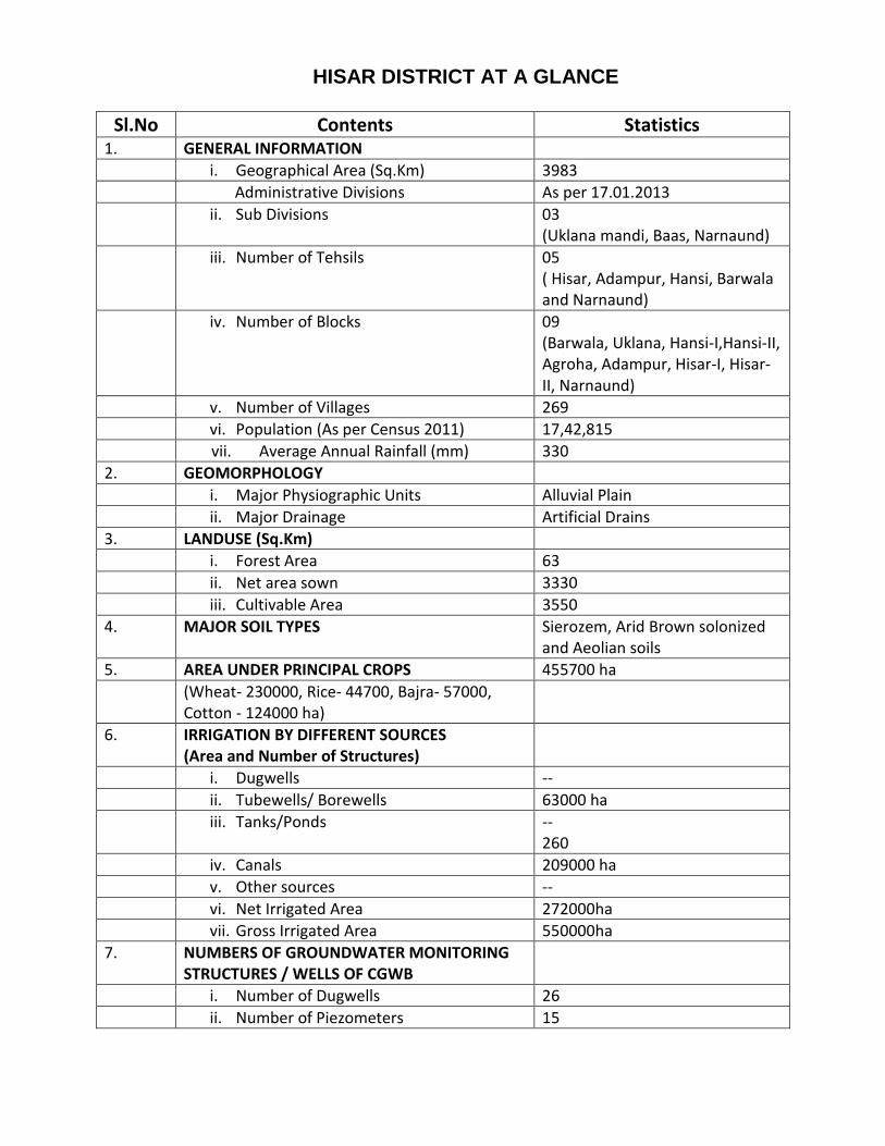
HISAR DISTRICT AT A GLANCE
Sl.No Contents Statistics 1. GENERAL INFORMATION
i. Geographical Area (Sq.Km) 3983
Administrative Divisions As per 17.01.2013
ii. Sub Divisions 03 (Uklana mandi, Baas, Narnaund)
iii. Number of Tehsils 05 ( Hisar, Adampur, Hansi, Barwala and Narnaund)
iv. Number of Blocks 09 (Barwala, Uklana, Hansi-I,Hansi-II, Agroha, Adampur, Hisar-I, Hisar- II, Narnaund)
v. Number of Villages 269
vi. Population (As per Census 2011) 17,42,815
vii. Average Annual Rainfall (mm) 330
2. GEOMORPHOLOGY
i. Major Physiographic Units Alluvial Plain
ii. Major Drainage Artificial Drains
3. LANDUSE (Sq.Km)
i. Forest Area 63
ii. Net area sown 3330
iii. Cultivable Area 3550
4. MAJOR SOIL TYPES Sierozem, Arid Brown solonized and Aeolian soils
5. AREA UNDER PRINCIPAL CROPS 455700 ha
(Wheat- 230000, Rice- 44700, Bajra- 57000, Cotton - 124000 ha)
6. IRRIGATION BY DIFFERENT SOURCES (Area and Number of Structures)
i. Dugwells --
ii. Tubewells/ Borewells 63000 ha
iii. Tanks/Ponds -- 260
iv. Canals 209000 ha
v. Other sources --
vi. Net Irrigated Area 272000ha
vii. Gross Irrigated Area 550000ha
7. NUMBERS OF GROUNDWATER MONITORING STRUCTURES / WELLS OF CGWB
i. Number of Dugwells 26
ii. Number of Piezometers 15

8. PREDOMINANT GEOLOGICAL FORMATIONS Alluvium
9. HYDROGEOLOGY
i. Major Water Bearing Formation Sand and gravel
ii. Pre-monsoon depth to water level 1.53 m to 19.25 m bgl
iii. Post-monsoon depth to water level 0.43 m to 18.3 m bgl
iv. Long-term water level trend in 10 yrs in m/yr (2002 – 2011)
Fall : -0.01 to -0.46 m/yr Rise: 0.02 to 0.41 m/yr
10. GROUNDWATER EXPLORATION BY CGWB
i. Number of wells drilled 28
Exploratory Well Observation Well Piezometer Slim Holes
11 -- 15 02
ii. Depth Range (m) 44 m to 324 m
iii. Discharge (lpm) 1905
iv. Storativity (S) 0.0072
v. Transmissivity (m2/day) 2440
11. GROUNDWATER QUALITY
i. Presence of chemical constituents more than the permissible limit
EC, in micromhos 290 – 5409
F, in mg/l 0.18 – 4.02
As, in mg/l Nil
Fe, in mg/l 1.94
ii. Type of water NaHCO3
12. DYNAMIC GROUNDWATER RESOURCES (MCM) As on 31.03.2011
i. Annual Replenishable Groundwater Resources
662.49
ii. Net Annual Groundwater Draft 602.85
iii. Projected Demand for Domestic and Industrial uses upto 2025
5.72
iv. Stage of Groundwater Development 91%
13. AWARENESS AND TRAINING ACTIVITY
14. EFFORTS OF ARTIFICIAL RECHARGE & RAINWATER HARVESTING
15. GROUNDWATER CONTROL AND REGULATION
i. Number of Over Exploited blocks 2
ii. Number of Critical blocks -
iii. Number of Semi Critical blocks 4
iv. Number of blocks notified Nil
16. MAJOR GROUNDWATER PROBLEMS AND ISSUES
Twin problem of water logging and salinity, water table depletion, fluoride and water marketing

GROUND WATER INFORMATION BOOKLET
HISAR DISTRICT, HARYANA
1.0 INTRODUCTION
Hisar, the west central most district of Haryana State with a total geographical area of
3983.00 sq. km is lies between the North latitudes 28o56’00”: 29o38’30” and East longitudes 75o
21’12”: 76o18’12”. The district is under control of Hisar division and administratively divided
into nine community development blocks namely Agroha, Adampur, Barwala, Bass (Hansi-II),
Hansi-I, Hisar-I, Hisar-II, Narnaund, and Uklana Mandi. The district has 05 towns namely Hisar,
Hansi, Narnaund, Barwala and Uklana and 269 villages.
The district area falls in Yamuna sub-basin of Ganga basin. There is no natural drainage
in the district area. However, the area is drained by network of canals and the artificial drains
(field drains/channels). These artificial drains are mainly confined in Bass, Hansi-I, Narnaund
and Barwala blocks. There are a total of 39 drains existing in the area, which run for a distance
of 126.25 km.
The area is irrigated by shallow tubewells and network of Bhakra Canal Systems and
Western Yamuna Canal Systems. The main canals are the Fatehabad branch of Bhakra Canal,
Barwala Branch, Balsamandh and Pabra Sub-branch of Barwala Link and Sirsa branch from
Bhakra Main Line, Hisar major distributary and Deosar feeder of Western Yamuna canal System
through Hansi branch. Canals are irrigating about 76.83 % (209000 ha) of the area, 23.17 %
(63000 ha) is irrigated by ground water. There are sand dunes in canal command area, over
which rain fed crops are grown. A total of 269 villages of the district come under Canal
Irrigation System.
The district has been covered under Hydrogeological Studies and Geophysical Surveys (Hansi,
Bass & Narnaund blocks) by the Central Ground Water Board. Besides, Ground Water
Exploration has also been carried out at 11 sites including 02 slim holes and 15 piezometers.
2.0 RAINFALL AND CLIMATE
The climate of Hisar owes to its continental location on the outer margins of the south-west
(SW) monsoon region. It has tropical monsoonal climate and is characterized as arid type of
climate. The district has characteristically four seasons during the year viz., Summer (March
to May), SW Monsoon (June to September), Post-Monsoon (October to November) and
Winter (December to February) season. SW monsoon also known as summer monsoon brings

PLATE-I

rain during last week of June to mid-September. The period from October onward until next
June remains almost dry except, few light showers received due to westerly
depressions/western disturbances (WDs). The summers are generally quite hot and winters
are fairly cool. The main characteristics of climate of in the district are its dryness, extremes
of temperature and scanty rainfall.
Rainfall: The normal annual rainfall of the district is 330 mm which is unevenly distributed
over the area 22 days .Around 75 to 80 per cent of the annual rainfall is received during
South West Monsoon season (June to September) with 50 per cent coefficient of variation
(CV). The average annual rainfall is around 450 mm, of which the average monthly rainfall
received during July and August months is 133.4 and 116.2 mm, respectively. The average
monthly rainfall during September is 54.5 mm and June 49.8 mm. The average rainfall
received during normal monsoon season is 283 mm. Generally rainfall in the district increases
from southwest to northeast.
Normal Annual Rainfall 330 mm
Normal Monsoon Rainfall 283 mm
Temperature Mean Maximum Mean Minimum
43oC (May & June) 5oC (January)
Normal Rainy days 22
3.0 GEOMORPHOLOGY AND SOIL TYPES
• GEOMORPHOLOGY
The district area forms a part of Indo-Gangetic plain. The area as a whole is almost flat
alluvial plain dotted with sand hummocks and sand dunes. The general altitude of the area
varies from 203 to 225 m amsl and having a gentle slope towards south-westerly direction.
Physiographically, the district is characterized by two distinct features i.e. upland plain and
Sand dune clusters.
• SOILS
The soils of the district are of three types i.e. Arid brown solonized (in north eastern
parts covering north eastern part of Narnaund and Uklana Mandi blocks.), Sierozem (in major
parts covering Barwala, Hansi-I, Bass (Hansi-II), Hisar-I & Agroha blocks and parts of Uklana,
Narnaund, Adampur & Hisar-II blocks) and desert soils (in southern western parts covering part
of Adampur and Hisar-II blocks).

4.0 GROUND WATER SCENARIO 4.1 HYDROGEOLOGY
The geological formations met within the district comprised unconsolidated alluvial
deposits of Quaternary age. The Central Ground Water Board has drilled 11 Exploratory Wells
including 02 slim holes (Rajthal and Bhatla) in the depth range of 152 m to 310 m. and 15
piezometers. Drilling has revealed the presence of 4 to 5 tier of aquifer groups down to the
drilled depth in the northern half of the district whereas 2 to 3 tier of aquifer group in the
southern half of the district. No exploratory well could be converted into production well either
because of insufficient granular zones or bad quality of ground water. It is also inferred that the
clay group of formations dominate over the sand group. The bed-rock has been touched in
boreholes drilled in south and south western part of the district and comprises of Granite and
Mica Schists of Pre-cambrian age. The thickness of alluvium varies from 228 (Dhiranwas, Block-
Hisar-II) to 310 m (Madha, Block Narnaund) and the thickness increases towards north – east
part of the district.
Aquifer System and Parameter
The principal aquifer material comprises of fine-grained sand mixed with gravel and
kankar forms the potential ground water reservoir. Ground water in the district occurs in the
alluvium under water table and semi-confined to confined conditions. In general, the water
table (unconfined) aquifers occurs from 10 m to 60 m depth below ground level in the district.
The ground water in unconfined condition is abstracted through hand pumps, dug wells and
shallow irrigation tubewells.
At Madha (Block-Narnaund) only the APT was conducted and was successful. The yield
(discharge) of the exploratory well determined to be of 1905 LPM with a drawdown of 9.30 m.
The transmissivity value of the aquifers worked out 2440 m2/day. The hydraulic conductivity
worked out to be 146 m/day.
Water Level Behaviour
The alluvium forms the principal ground water reservoir and the principal aquifer
material constitutes fine to medium grained sand and sand mixed with silt and kankar. The
depth to water level varies from 1.53 m to 19.25 m bgl during pre monsoon period and 0.43 m
to 18.30 mbgl during post monsoon period. The deeper water level has been recorded in south
western part in Adampur, where it rests between 10 and 15 m bgl and spread over 935.5 sq km
(23.48 %) in southern and north central part of the district covering part of Hisar-II, Agroha,
Uklana, and Barwala blocks;. The water level in the depth range of 5 m to 10 m bgl spreads over

PLATE -II

PLATE - III

large area, which is worked out to be 2046 sq km (51.36 %) in Hisar, Hansi, Narnaund and parts
of Barwala and Uklana blocks. The water level in the depth range of less than 5 m bgl spreads
over to be 678 sq km (17.02 %) as compared to the other depth ranges.
Water Logging
Water logging (water level < 2 m bgl) and prone to water logging (water level between 2
and 3 mbgl) conditions exists in the district covering part of Bass (Hansi-II), Hansi-I and Barwala
blocks. The water logged area accounts for 37.65 sq km (0.93 %) of the total district area during
Pre-monsoon and 264.55 sq km (6.55 %) during post-monsoon period. However, the area under
water logging conditions increases almost 7 fold in post monsoon period.
Ground Water Flow
The elevation of the water table in the district varies from 188.82 to 224.42 m amsl. The
average gradient of the water table worked out for the district in the order of 0.09 m/km. The
overall flow of the ground water is towards south-west direction. However, in northern,
western and south western and southern parts the ground water flow is towards south western
direction whereas in south eastern part is towards western and north western direction.
Seasonal Fluctuation
The seasonal fluctuation in water level ranges in the district from - 0.02 to 1.77 m. In
general there is rise in water table in almost whole of the district. About 67 % of the
hydrograph stations has shown seasonal rise in water levels whereas 33 % has shown seasonal
decline.
Long Term Trend
The long-term water level trend over a period of 10 years (2002- 2011) indicates a rising
as well as declining trend in the entire district area. The maximum rise in the order of 0.415
m/year has been observed at Barwala (Block- Barwala) whereas maximum decline in the order
of 0.462 m/year observed at Rajthal (Block- Narnaund). The long term declining trend has been
observed approximately in 55 % of the district varies between 0.0112 and 0.462 m/ year and
covering major part of Narnaund, Bass, Hansi-I, Hisar-I, Hisar-II and Adampur blocks in the
central part of the district and minor part of Uklana and Barwala blocks in the northern part of
the district. An area of 45 % approximately has shown rising trend of water levels varies
between 0.021 and 0.415 m/ year covering parts of Hisar-I, Hisar-II in the south western part
and Agroha, Hansi-I in the northern part of the district.

4.2 GROUND WATER RESOURCES
The block wise ground water resource potentials and draft for the district have been
worked out based on methodology recommended by ‘Ground Water Estimation Committee
(1997) ’as on 31.03.2009. The present stage of block wise ground water development varies
from 45 % (Barwala) to 176 % (Narnaund). The Narnaund block falls in over-exploited category.
The net annual ground water availability in the district is 662.49 MCM, out of which 598.36
MCM is comes in the head of ground water draft for irrigation sector. Thus, a balance of 58.41
MCM ground water for future development. The stage of groundwater development in the
district is 91 % and falls in semi critical category.
GROUND WATER RESOURCE AND DEVELOPMENT POTENTIAL OF HISAR DISTRICT, HARYANA AS ON 31
ST MARCH, 2011 in ha m
Block Name
Net Annual Ground Water Availability (Ham)
Existing Gross Ground Water Draft for irrigation (Ham)
Existing Gross Ground Water Draft for all uses (Ham)
Allocation domestic industrial up to next 25 years (Ham)
Net Ground Water Availability for future irrigation development (Ham)
Stage of Ground Water Develop-ment (%)
Category of Block
Adampur 4577 4027 4062 50 500 89 SEMICRITICAL
Agroha 5066 2938 2963 35 2093 58 SAFE Barwala 9106 3989 4060 100 5017 45 SAFE Hansi-I 10437 12213 12271 58 -1834 118 OVER EXPLOITED Hansi-II 6224 6219 6251 32 -27 100 SEMI CRITICAL Hissar-I 7935 6368 6427 75 1492 81 SEMICRITICAL Hissar-II 10059 5346 5445 140 4573 54 SAFE Narnaund 8377 14695 14727 32 -6350 176 OVER EXPLOITED Uklana 4468 4041 4079 50 377 91 SEMI CRITICAL TOTAL 66249 59836 60285 572 5841 91

PLATE-IV

4.3 GROUND WATER QUALITY
Domestic and Drinking Sector
Chemical quality of ground water representing shallow aquifers reveals that the ground
water is alkaline in nature and fresh to marginally and highly saline. Concentration of various
chemical parameters in most of the water samples is within the permissible limit except EC, F,
NO3, SO4, Hardness and Fe, the concentration of these parameters is found beyond permissible
limit set by BIS (1991) for safe drinking water. In general ground water is dominated by
bicarbonate and Chloride anions and among cations, none dominants. The aerial distribution of
specific conductance shows that saline waters (EC>3000) are found in pockets throughout the
district especially in western, south western and northern parts covering Hisar-I, Hisar-II,
Agroha, Adampur and Uklana block of the district. The specific conductance value ranges from
290 to 5409 micromhos/cm at 25oC.The area having less than 2000 EC constituting 62.92 %
(2450.95 sq km) whereas area having more than 2000 EC constituting 37.08 % (1577.4 sq km) of
the district area. It has also been studied that the distribution of specific conductivity of shallow
ground water is not distributed on any regular pattern but evidently is controlled by the
presence/ absence of the canal system and irrigation by canal. The high fluoride concentration
of more than 1.5 mg/l has been found in about 21 % of water samples and recorded maximum
up to 4.02 mg/l at Rajli Cross (Block-Hansi-II). The high concentration is found in Hisar-II,
Agroha, Bass, Barwala and Hansi-I blocks of the district. The trace metals analysis reveals that in
shallow ground water concentration of all metals except Iron, lead and to some extent
manganese is within desirable limit. Iron is found to be higher than the permissible limit of 1.0
mg/l at Muklan and Alipur (1.20 mg/l) and Dhansu (1.94 mg/l). Thus, by and large, quality of
ground water from shallow aquifer is of permissible class for domestic and drinking purposes.
Irrigation Sector
Specific Conductance (EC), Sodium Adsorption Ratio (SAR) and Residual Sodium
Carbonate (RSC) are the basic parameters considered for ascertaining the irrigational suitability
of ground water. Based on the plot of Specific Conductance (EC) and SAR on USSL diagram for
rating irrigation waters, it is observed that most of waters fall under C2S1, C3S1 and C4S1
Classes. Such waters are likely to cause medium to very high salinity hazards, but no sodium
hazards when used for customary irrigation. However, some waters having with S2 and S3
classes may cause sodium hazards when used for irrigation on normal soils. Such waters,
nevertheless, can be used on well-drained soils and for semi salt tolerant to salt tolerant crops
such as wheat, rice etc.
4.4 STATUS OF GROUND WATER DEVELOPMENT

The present stage of block wise ground water development varies from 45 % (block
Barwala) to 176 % (block-Narnaund). Out of nine blocks, 04 blocks (Barwala, Hansi- I, Hissar- I &
Hissar- II ) are fall in white category (Safe), 03 blocks (Agroha, Hansi-II & Uklana) fall in grey
category (Semicritical or safe with caution for future development) , 01 block ( Adampur) fall in
Critical category and 01 block (Narnaund) fall in over-exploited category. There is no scope of
large-scale ground water resource development in blocks falling under white category since
fresh water is underlain by saline to brackish water at deeper levels. However shallow
tubewells (down to 60 m depth) can be constructed at places where ground water is fresh in
pockets and along the canals. The shallow tubewells, which is an important unit as far as the
ground water development is concerned, have shown a tremendous growth in the district.
Most of the existing units are of cavity type in the area, filter type tubewells are commonly
found in the Narnaund block. The depth of shallow tubewells varies from 10 m to 60 m, with
discharge varying from 6 LPS to 15 LPS. The majority of shallow tubewells are of cavity type.
These tubewells are generally operated by centrifugal pump driven by either Electric Motor or
Diesel Engine of 5 to 10 Horse Power. Out of the total geographical area of 398300 ha of the
district, the net area sown is 333000 ha (2011-12) and 63000 ha area is irrigated by tube wells
209000 ha by canals and remaining by other means. There are 38,584 no of MIU’s installed in
the district with density of 9 MIU/sq km for irrigation purposes. The number of minor irrigation
units varies from 1,246 (Block- Agroha) to 11,989 (Block- Narnaund) and the density varies from
4 to 29 MIU/sq km. The block Narnaund, having 11,989 no of MIU’s with a density of 29 MIU/sq
km,and is maximum in the district. It has increased many folds during past 10 years, causing
over-exploitation of ground water. Thus there is need to notify the block. The drinking water
supply to all the rural as well as urban parts of the district is based mainly on canal water. At
few places ground water is also being used for water supply purposes. The total number of
rural water supply schemes, which are in function, is 187. The ground water based schemes are
run using about 142 tubewells drilled in the depth range of 30 m to 175 m with discharge about
480 LPM. The Urban water supply is canal water and groundwater based. Out of 05 towns, 02
towns namely Hansi and Narnaund are also based on ground water through tubewells. For
urban area 05 tubewells have been installed in Hansi which are mainly along the canal and 01
tubewell is installed in Narnaund. These tubewells are drilled in the depth range of 100 to 130
m with 375/200 mm dia assembly. These tubewells are installed to augment the drinking water
supply. However the quality of ground water is fresh to marginal. In Adampur and Barnala
blocks, the deep tubewells of 175m are feasible at some isolated places.

PLATE-V

4.5 GEOPHYSICAL STUDIES
CGWB has carried out surface geophysical studies in eastern part of the district covering
Bass, Narnaund and Hansi-I blocks to delineate the fresh and saline aquifer interface. The result
indicates that over small area in north, east and south-west fresh water has been inferred
within a depth of 20 to 60m. Such prominent locations are Rajpura, Narnaund, Bass,
Premnagar, Bad Chhapar and Samain. Comparatively large thickness of fresh water granular
zones of the order of 50 to 60 m has been inferred at Narnaund and Rajpura. At other places
namely Bass, Premnagar, Bad Chhapar and Samain only 12 to 13m thickness of fresh water
granular zone has been inferred. Major part of the Bass block is affected with the agony of
surface level salinity. About 90% of the area in combined blocks of Hansi and Bass (Hansi-II)
blocks has saline ground water at all levels.
5.0 GROUND WATER MANAGEMENT STRATEGY
5.1 Ground Water Development
The hydrogeological data generated through exploratory drilling reveals that the deeper
aquifer is either having insufficient granular zones or the quality of ground water is saline and at
most of the places salinity increases with depth, thus the area is not fit for deep ground water
exploitation. The shallow ground water is extensively exploited through shallow tubewells
mainly cavity type. The depth of shallow tubewells varies from 10 m to 60 m, with their
discharge varies from 6 LPS to 15 LPS. Most of the shallow tubewells are now being installed
along the canals, where the quality of ground water is improving by the recharging effect of
canal water seepage or canal water irrigation. The tubewells (mainly filter type) in the depth
range of 60 m are installed in the parts of Narnaund and Adampur blocks. Recently, PVC pipe
assembly is being commonly used.
5.2 Water Conservation and Artificial Recharge
There are in all 260 numbers of ponds/tanks in the district. Thereby the recharge to
ground water takes place in the order of 139 Ham. Out of nine blocks Narnaund and Agroha are
the blocks where maximum recharge from ponds takes place. Their block-wise distribution and
recharging contribution is as follows.

BLOCKWISE DETAILS OF LAKES AND PONDS AND RECHARGE
Sl.No Block Name
No. of tanks/ ponds
Average water spread area (ha)
No. of days water is available
Recharge in Ham during
Monsoon Non-Monsoon
Monsoon Non-Monsoon
Monsoon Non-Monsoon
1 Adampur 25 30 20 120 180 1326 2187
2 Agroha 30 60 40 120 180 1180 2315
3 Barwala 35 60 30 120 180 2252 4169
4 Hansi-I 25 30 20 120 180 2880 4357
5 Hansi-II 25 30 20 120 180 1754 2620
6 Hissar-I 35 40 30 120 180 1414 2728
7 Hissar-II 30 40 30 120 180 1254 2951
8 Narnaund 30 60 40 120 180 2931 3307
9 Uklana 25 40 20 120 180 960 1930
TOTAL 260 390 250 - - 15951 26564
The three multipurpose irrigation projects namely Hisar – Ghaggar Multipurpose Channel, Bass
Multipurpose Channel & Hansi Multipurpose Channel are being taken up by the Irrigation
Department. The main purpose of these multipurpose channels is to store rain water and flood
water and seepage from the field in water logged areas and to irrigate the area of its command.
6.0 GROUND WATER RELATED ISSUES & PROBLEMS
Twin Problem of Water Logging & Salinity
The south eastern and north central part of the district covering part of Bass (Hansi-II) and
Hansi-I, block are severely affected from water logging point of view. Besides, the part of
Barwala also exists under water logging conditions. The following measures are suggested to
reduce the impact of problem:
Installation of sub-surface and vertical drainage to drain out surplus water.
Use of multi well point system.
Reduction in canal allowance at least 25 % during the whole year.
Conjunctive use of surface/ canal water and ground water should also be in practice.
Encouraging salt tolerant crops like Barley, cotton, sunflower etc so that ground water
of marginally quality can be used for irrigation.
The phenomenon of water logging is associated with the twin problem of salinity. Conjunctive
use of surface and ground water of marginally saline quality gives better results.

Water Table Depletion
The long term depletion in water table is observed in the stretch of central part of the
district, covering part of Adampur, Hisar-II, Hansi-I, Uklana and Narnaund blocks, water table
has declined in the order of 0.01 to 0.46 m in ten years, which is worked out to be 0.46 m per
year. The maximum decline has been observed at Rajthal in Narnaund block. It is mainly due to
the change in cropping pattern. Paddy crop is being sown in the area, and its cultivation has
increased many fold over few years which has resulted in substantial decline of water level in
Narnaund block. Thus the Narnaund block falls in over exploited category.
Water Marketing
There is scarcity of fresh potable water in the district. In view of this, Water Marketing
has taken place on a large scale in the district. The water is being sold by the owner of shallow
tubewells sunk in fresh water areas for drinking and domestic purposes on monthly rental of Rs.
100/- for a supply of half to an hour per day. The user besides monthly rental has also to
deposit a refundable security of Rs. 1500/-. This trend of water marketing needs attention as it
is in practice on a large scale especially in the Adampur block of the district.
Fluoride
Fluoride (> 1.5 ppm) content in ground water is the sole criteria for the rejection of
ground water for drinking uses. The high concentration of fluoride is found in Hisar-II, Agroha,
Bass, Barwala and Hansi-I blocks of the district and recorded maximum up to 4.02mg/l at Rajli
Cross (Block-Hansi-II). The high fluoride concentration of more than 1.5 ppm has been found in
about 21 % of water samples. Therefore, precaution is required to be taken before such water
is supplied or used for drinking purposes.

7.0 RECOMMENDATIONS
1. Narnaund block of the district falls in over exploited category and present stage of
ground water development has reached 176 %, the block may be declared as ‘Notified
Area’ by the Central Ground Water Authority.
2. The shallow tubewells down to 10 m to 60 m depths can be constructed at places where
ground water is fresh i.e. along the canals and in pockets.
3. Sub-surface drainage and vertical drainage system may be provided in Bass (Hansi-II)
block and parts of Hansi-I and Barwala blocks to tackle the problem of water logging.
4. In order to arrest the declining trend of water levels in Adampur, Hisar-II, Hisar-I and
Narnaund blocks of the district artificial recharge practices should be taken up. For this
purpose, roof top rain water harvesting is one of the good exercises to be adopted.
5. Micro level ground water regulation and protection studies may be carried out to map
the aerial distribution of high fluoride concentration and salinity and the public may be
educated about its harmful effect on human health.
6. Intensive study may be carried out in Western Yamuna Canal command area of the
district covering Bass, Hansi-I and Narnaund blocks to work out the strategy for
conjunctive use of surface and ground water.
7. Water marketing should be checked, as it is in practice on a large scale in the district
especially in the Adampur block.
8. Mass Awareness Program should be organized to make people of the district aware
about the consequences of over-exploitation of ground water and for its economic use.


![[XLS] Matrix... · Web viewNAVSARI [GJ] 388 NAVSARI 01662-227442/5/8/56 SCO NO. 177 COMMERCIAL URBAL ESTATE NO. 1 HISSAR 125001 HARYANA COMMERCIAL BUILDINGA T ROADGUWAHATI 781001](https://static.documents.pub/doc/80x56/5b19e1e67f8b9a3c258cf0aa/xls-matrix-web-viewnavsari-gj-388-navsari-01662-2274425856-sco-no.jpg)