32
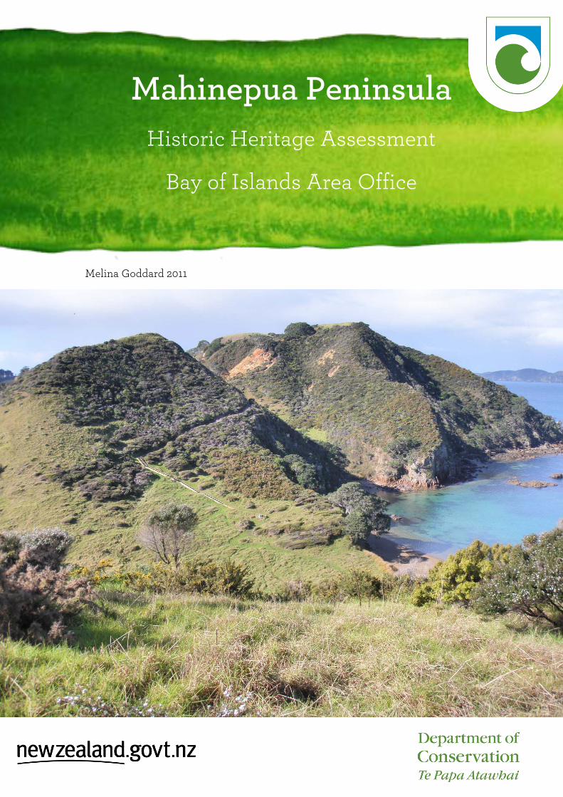
Mahinepua Peninsula Historic Heritage Assessment Bay of Islands Area Office Melina Goddard 2011
Mahinepua Peninsula Historic Heritage Assessment
Bay of Islands Area Office
Melina Goddard 2011
2
Mahinepua Peninsula: Historic Heritage Assessment Melina Goddard, DoC, Bay of Islands Area Office 2011 Cover image: Mahinepua Peninsula facing north east. The two peaks have P04/ to the front and P04/55 in the background. K. Upperton DoC Peer-reviewed by: Joan Maingay and Andrew Blanshard Publication information © Copyright New Zealand Department of Conservation (web pdf # needed) In the interest of forest conservation, DOC Science Publishing supports paperless electronic publishing.
3
Contents Site overview 5 Prehistoric description 5 Historic description 6 Fabric description 7 Cultural connections 10 National context 10 Prehistoric and historic significance 11 Fabric significance 11 Cultural significance 12 Management recommendations 12 Management chronology 12 Management documentation 13 Sources 13 Appendix: site record forms Endnotes Image: taken from pa site P04/55 facing west towards Stephenson Island
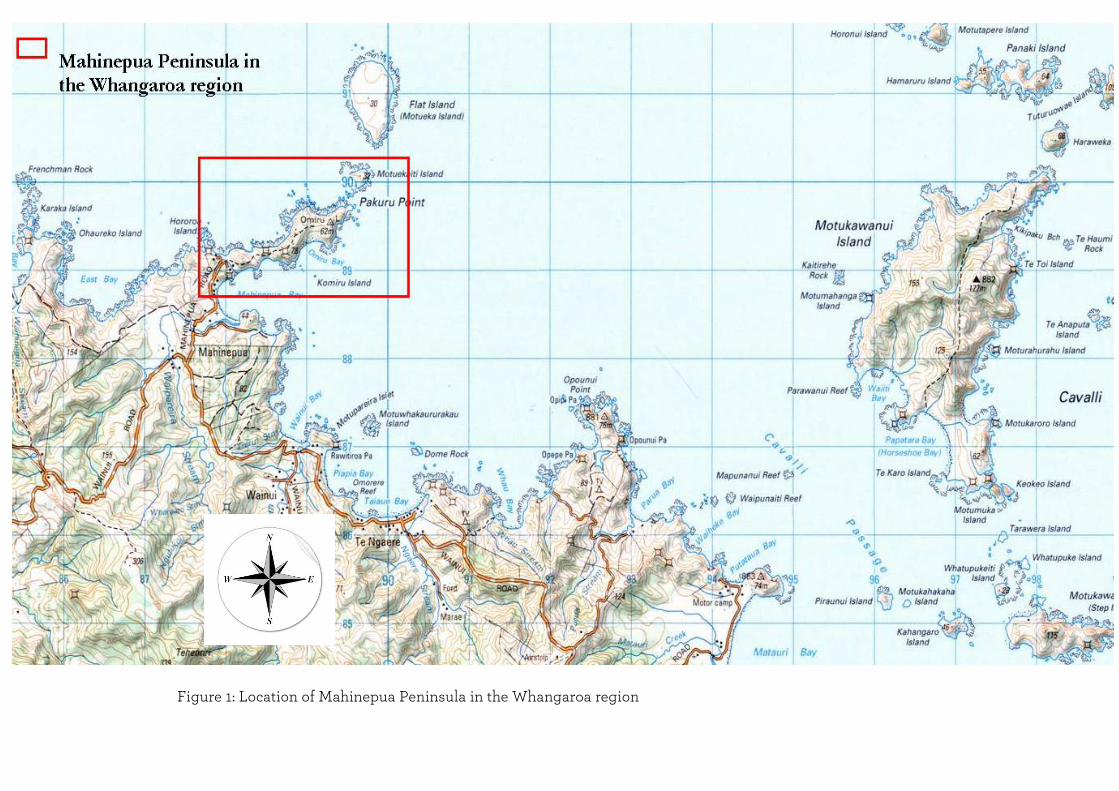
Figure 1: Location of Mahinepua Peninsula in the Whangaroa region
5
Site overview Mahinepua Peninsula is located on the east coast of Northland in the Northern Bay of Islands, approximately 8km east of the Whangaroa Harbour. The peninsula has panoramic views of Stephenson Island to the west and the Cavalli Islands to the east. Mahinepua was gazetted as a scenic reserve in 1978 and there is a 2.5km public access track that runs to the end of the peninsula. It is located within a rich prehistoric and historic region and has 14 recorded archaeological sites that consist of a pa site, terraces, pits, drains and stone heaps associated with gardening. The archaeology that is recorded on peninsula reflects brief periods of occupation rather than long term settlement.1 Land status: scenic reserve AHMP 18 Administered by: The Department of Conservation, Bay of Islands area office Access by: Mahinepua Road Visitor numbers: from June 2010 to June 2011: 17,050 (calculated as one way) Heritage status: archaeological sites protected under the Historic Places Act 1993 Site area: 36 hectares Functional location number: DN-61-200-2050
Prehistoric description Prehistoric Maori intensively settled Northland’s coastlines and inland places several centuries ago. The area between Whangaroa Harbour and the Bay of Islands supported a considerable population prior to European arrival and this is reflected in the numerous archaeological sites in the region. Mahinepua is located within this area and offered a warm climate with plentiful fishing grounds in relatively sheltered waters, and small bays where canoes could be safely beached. A variety of shellfish would have been available on the sandy beaches and also along the rocky coast. Kumara, taro and gourds would have been cultivated. There are 14 recorded archaeological sites located within the reserve, these include pa sites, midden, terraces, pits, slope lines, and stone heaps. The analysis of these sites and their individual features has contributed to understanding aspects of Mahinepua’s prehistory. This was undertaken by Ashby in 2009 as part of a Masters project, Mahinepua acting as the case study. Ashby surveyed the archaeological features present on the peninsula through analysing their spatial distributions against the environmental variables of soil, wind exposure, elevation, slope and natural defence in order to understand what factors may have influenced human landscape use over time. From his results an interpretation was produced of Maori landscape use on Mahinepua. Overall areas of human activity based upon the features were located in elevated positions, on relatively level ground, with a high level of natural defence. Subsistence was focussed on marine resources, a variety of birds and
6
agricultural foods such as bracken fern, kumara and taro. Gardening on the peninsula itself was considered to be limited. The geographical setting of Mahinepua between the Whangaroa Harbour and the Bay of Islands may have made it a strategic location with a focus upon communication. This is based on the peninsula’s visibility and easy access to a coastline that would have been a key maritime route between the two regions. Ashby concluded that the peninsulas land use history reflects mobility and communication rather than long term settlement. This is because the number of archaeological sites is small and could indicate relatively little effort had been invested in gardening or defensive fortifications.2
Historic description The historic description is defined here as the period at the time of and after European contact namely where written records begin. This is from the time of Cook’s arrival in 1769 up to the 1900’s. This history provides stories and information of early European and Maori interactions. There is little historical information known of Mahinepua itself. There is however an account of the immediate surrounding area of Lieutenant James Cook who visited this coastline in 1769 during November and December in the Endeavour. He sailed past a cluster of islands where several canoes came out to offer Cavalle fish (trevally) for trade, thus inspiring Cook to name the island group the Cavalles (today the Cavalli Islands near Mahinepua Peninsula). The account describes the coast as rocky with rolling country behind the shoreline that was cultivated in places.3 At European contact Mahinepua formed part of a borderland between Ngapuhi and Ngati Kahu and was subject to a continual flux of polities and population movements. Following the military conquests of Hongi Hika, occupation of the peninsula seems to have ceased until the land was eventually settled by Europeans who converted it into farmland before 1912.4 The Land Information Database has a survey map of the peninsula dated April 1912 titled Plan of Mahinepua A and B- Mahinepua Parish (fig 2). The peninsula is marked Block A and may have been owned by the Parish. The site record forms from 1976 list the owner of the peninsula as A.J Rhodes of Mahinepua Bay. It is possible that he and the Parish owned the peninsula some time after 1912 until it came under the control of the Bay of Islands Maritime and Historic Park in 1978.

7
Figure 2: Mahinepua Maori Land 8414, 1912. LINZ
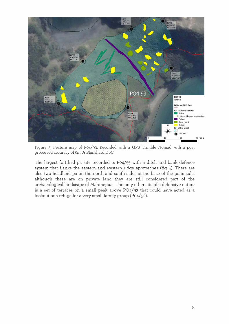
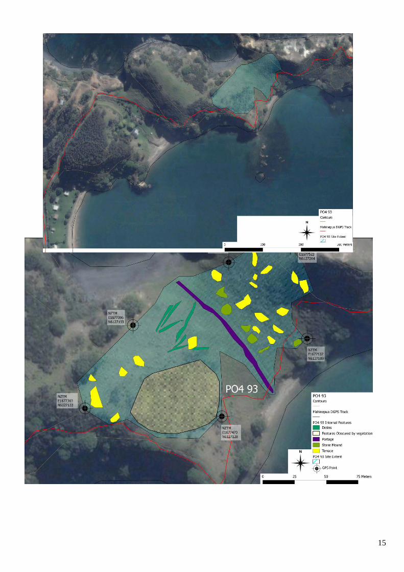
Fabric description J. Stretton did a ground survey of Mahinepua Peninsula in 1976 and recorded seven sites comprising pa sites, midden, terraces, pits, slope lines, and stone heaps. In 2009 DoC and Ashby re-surveyed the peninsula and updated the sites recording a further seven sites bringing the total archaeological sites to 14 within the reserve. One of the largest recorded sites is P04/93 located in the first valley of the peninsula (fig 3). There are 5 stone heaps now covered in kikuyu on the valley bottom and slope lines on the sides, both may have been associated with gardening practices. Some of the stones were found to be large and smooth and thus not consistent with the geology of the peninsula suggesting they were carried in. Oral traditions state that there was a canoe portage where canoes were transported from one bay to another. This created a short cut across rather than around the peninsula. The physical evidence for this is a small grooved track running across the valley bottom.
8
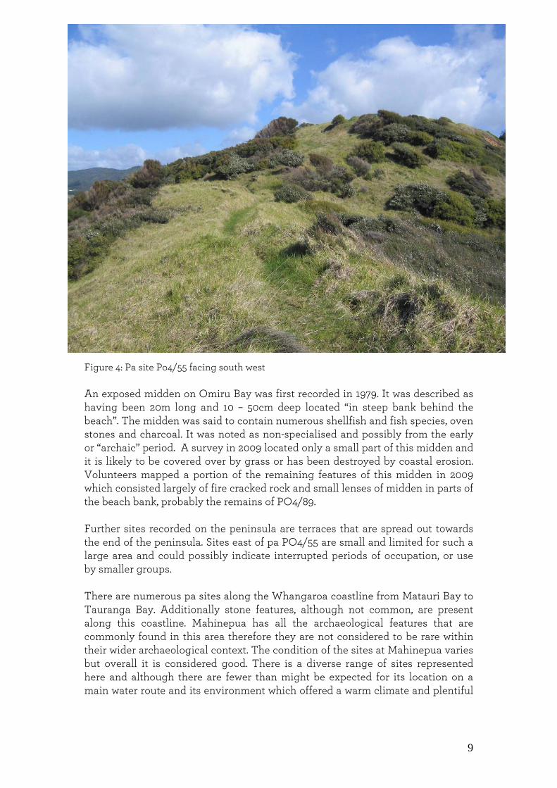
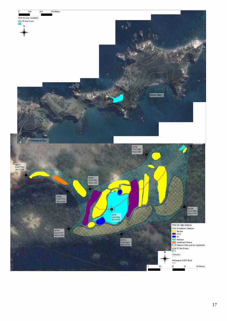
Figure 3: Feature map of P04/93. Recorded with a GPS Trimble Nomad with a post processed accuracy of 5m. A Blanshard DoC The largest fortified pa site recorded is P04/55 with a ditch and bank defence system that flanks the eastern and western ridge approaches (fig 4). There are also two headland pa on the north and south sides at the base of the peninsula, although these are on private land they are still considered part of the archaeological landscape of Mahinepua. The only other site of a defensive nature is a set of terraces on a small peak above PO4/93 that could have acted as a lookout or a refuge for a very small family group (P04/92).
9
Figure 4: Pa site Po4/55 facing south west An exposed midden on Omiru Bay was first recorded in 1979. It was described as having been 20m long and 10 – 50cm deep located “in steep bank behind the beach”. The midden was said to contain numerous shellfish and fish species, oven stones and charcoal. It was noted as non-specialised and possibly from the early or “archaic” period. A survey in 2009 located only a small part of this midden and it is likely to be covered over by grass or has been destroyed by coastal erosion. Volunteers mapped a portion of the remaining features of this midden in 2009 which consisted largely of fire cracked rock and small lenses of midden in parts of the beach bank, probably the remains of PO4/89. Further sites recorded on the peninsula are terraces that are spread out towards the end of the peninsula. Sites east of pa PO4/55 are small and limited for such a large area and could possibly indicate interrupted periods of occupation, or use by smaller groups. There are numerous pa sites along the Whangaroa coastline from Matauri Bay to Tauranga Bay. Additionally stone features, although not common, are present along this coastline. Mahinepua has all the archaeological features that are commonly found in this area therefore they are not considered to be rare within their wider archaeological context. The condition of the sites at Mahinepua varies but overall it is considered good. There is a diverse range of sites represented here and although there are fewer than might be expected for its location on a main water route and its environment which offered a warm climate and plentiful

10
seafood resources, this does not decrease its overall value and is merely a reflection on how prehistoric Maori used the landscape over time.
Cultural connections Mahinepua is not referred to historically but does have indirect links to the wider historical events that are associated with this region. It is of great significance to Ngati Ruamahue Ki Mahinepua. It is also of interest to New Zealanders as part of their country’s prehistory.
National context The archaeology that characterises this coastline between the Whangaroa Harbour and Matauri Bay consists of pa sites, kainga, midden including archaic sites, terraces, and gardening features such as stone walls, and stone heaps and slope lines. The Whangaroa region supported a considerable Maori population with close ties to the people of the Bay of Islands. When the first Europeans arrived in the Whangaroa district it was border country with Ngati Kahu. In the early 1800’s it was claimed as Ngapuhi territory by Chief Hongi Hika. Another people in the area at this time may have been Ngati Uru who had recently migrated to the Whangaroa area from the southern part of the Bay of Islands after the killing of French explorer Marion Du Fresne in 1770.5 Maori settlement entered a period of instability during the 1820’s as a result of the Ngapuhi raids during the musket wars. This allowed Europeans to move into the district where the original inhabitants were forced to leave. 6 Early European history for the area tends to focus on the Boyd incident that took place in the Whangaroa Harbour in 1807. The Star sailed by Captain Wilkinson was the first known vessel to visit Whangaroa Harbour and when it left took with it a young Maori named Te Ara (George). 7 When Te Ara returned to Whangaroa in 1809 on the HMS Boyd, he complained to the Chief Te Puhi of being ill treated on the voyage. As a result the captain of the Boyd and his sailors were killed at Te Puhi’s village near Kaeo. Te Puhi and his men also killed all who remained on the Boyd. As well as a tragic end for the people on the ship, Te Pahi — a chief from Te Puna in the Bay of Islands who had tried to assist the people of the Boyd — was killed and his village sacked. This resulted from several whalers mistakenly thinking that he was involved in the attack on the Boyd. The event destroyed relations between the Europeans living in the area and the local Maori. Later the Boyd was accidentally set on fire and drifted to a point up the harbour to the west of the township of Whangaroa, where the remains are located today. 8

11
Samuel Marsden and J.L Nicholas arrived at this stretch of coast on board the Active and landed in December 1814. Marsden’s aim was to make peace with the people of this area who had been at war since the Boyd massacre of 1809.9 The brig Active was reported as anchored off the Cavalli Islands “one league (5km) from the mainland and five leagues (25km) from Whangaroa (5km SE of Mahinepua Peninsula). It is suggested that this particular period of tension is reflected in the building of numerous fortified settlements along the coast. 10 In addition to providing a history of the area, the written accounts indicate the elements of subsistence along this coast. For example the Active reported that fern root was a major part of the diet, from which a sort of bread was made. Additionally, the fish offered to Cook in 1769 indicates that fish was a main component of the diet and also kumara, as its cultivation was noted by the Endeavour. The focus on fern root possibly explains the lack of pits recorded in the pa and the open settlements in the Opounui Point area, between Te Ngaere Bay and Matauri Bay. 11 It is also suggested that the lack of pits recorded in the Whangaroa district indicates that there was a focus on above-ground storage of crops. 12 The Methodist mission was established in Whangaroa in the 1820’s and 30’s and Europeans became regular visitors to the area. There was the development of timber harvesting (mainly Kauri), shipbuilding, whaling and gum digging. 13 Hongi Hika took advantage of this trading opportunity with the newly arriving European settlers. In 1826 he arrived with 400 warriors to avenge a series of insults to his wife and mother’s family and to establish a new trading settlement with the Europeans. Hongi and his warriors staged themselves at Tauranga Bay before raiding the harbour in January the next year. At this time, according to historical sources, the whole of the Whangaroa population and possibly those of Mahinepua moved to their hilltop pa to live. 14
Prehistoric and historic significance The prehistoric significance of Mahinepua lies in its fabric which explains part of the prehistory of the land as it was used by early Maori. There is great potential for interpretation on this peninsula. Mahinepua is part of the rich historical region stretching from Whangaroa to the Bay of Islands and its historic significance lies within its context.
Fabric significance
• The fabric significance of Mahinepua is wide ranging from the individual archaeological features to the landscape as a whole and its representation of New Zealand’s prehistory.
12
• Mahinepua is an example of a landscape with seemingly common archaeological features that can be analysed and interpreted and contribute to New Zealand’s prehistory.
• The detailed recording of the sites and their features on Mahinepua is
important. It is an example of how sites on DoC land should be recorded for effective management purposes.
• Mahinepua is significant as representative of a complete archaeological
landscape
Cultural significance It is of great significance to Ngati Ruamahue Ki Mahinepua, and is of importance to New Zealanders as a part of their country’s early history.
Management recommendations
• P04/55 is located on the track and has some well-defined features and therefore provides the best opportunity for public interpretation.
• Monitoring of the pa P04/55 where small areas are being worn by foot traffic.
• Monitoring of the pa sites located on private land with permission of owners to ensure their future preservation.
• Survey of Motuekaiti Island which is also under DoC management. • The creation of Interpretation of the peninsula and the Cavalli Islands.
Management chronology
• 1912: survey map of the peninsula and the beachfront of Mahinepua Bay that indicates parts that have been sold possibly to the Mahinepua parish. Maori Land 8414 LINZ.
• 1978: Mahinepua Peninsula was gazetted as a scenic reserve under Bay of Islands Maritime and Historic Park
• 1987: Department of Conservation took over the management • 4th September 2009: Archaeological survey and assessment for the
Mahinepua Peninsula track upgrade for the Historic Places Trust. • 9th November 2009: Section 14 authority granted by the Historic Places
Trust to repair and upgrade the Mahinepua peninsula track. Authority No: 2010/69.
• 24th May 2010 final report for the Mahinepua Peninsula track upgrade received by the Historic Places Trust.
13
Management documentation Current historic DoC management file numbers: HHA-01-02-03-01 NLB-1 01/01/1979; HHA-01-02-03-04 NLB-1 12/02/1981; HHA-01-02-03-02 NLB-1 01/03/1990; HHA-01-02-03-03 NLB-1 01/07/2010 Heritage assessment: yes 713871 Baseline inspection: Archaeological survey and assessment for the Mahinepua Peninsula track upgrade. M Goddard and A Blanshard, Department of Conservation Bay of Islands area office 2009.
Sources
Ashby, E., 2009. Constructing syntheses of CRM and academic based archaeologies: A case study of Mahinepua peninsula scenic reserve. A thesis submitted in the fulfilment for the degree of Master of Arts in Anthropology. University of Auckland. Carpenter, J. 2004. Archaeological Survey and Assessment of Lot DP 197131, Butterfly Bay, Whangaroa District. Northern Archaeological Research. Cloher, D.U. 2003. Hongi Hika: Warrior chief. Penguin Books, Auckland. Department of Conservation, 1989. The story of the Bay of Islands Maritime and Historic Park. Published by Bay of Islands Maritime and Historic Park. Fox, A. 1975. Report on the Archaeology of the Parua Bay District, Whangaroa, Northland. Auckland Museum Maingay, J. 1986. Initial Report on Northland Archaeology. Unpublished report for the Historic Places Trust. Salmond, A. 1991. Two Worlds: First meetings between Maori and European 1642-1772. Penguin books, Auckland, New Zealand.
14
Appendix NEW ZEALAND ARCHAEOLOGICAL ASSOCIATION SITE RECORD FORM (NZMS260) NZMS 260 map number PO4 NZMS 260 map name Whangaroa NZMS 260 map edition 2000
NZAA METRIC SITE NUMBER PO4/93 DATE VISITED 04/06/09 SITE TYPE Terrace and gardening site SITE NAME: MAORI OTHER
Grid Reference Easting .1 .6 |7 |7 |4 |7 .0. Northing .6 .1|2 |7 |1 |2 .8 .
1. Aids to relocation of site (attach a sketch map) Mahinepua peninsula, Northland. Peninsula overlooks the Cavalli islands. Site located in the first valley which has two sandy beaches on either side. The site was recorded using a Trimble Nomad GPS which allowed a post processed accuracy of 98% >5m. All GPS points are in New Zealand Traverse Mercator Projection, based on the NZ2000 Datum. 2. State of site and possible future damage Located in thick Kikuyu, patches of gorse and mixed shrub. Terraces and drains in good condition. At risk from erosion processes and visitor impacts 3. Description of site (Supply full details, history, local environment, references, sketches, etc. If extra sheets are attached,
include a summary here) This site was recorded in 1976 as a field system consisting of three garden drains running down the north western slope of the valley. Further recorded indicators of gardening in this valley are the remains of stones walls and stone heaps. Two stone walls were recorded on the foothill of the eastern slope of the valley. This included a “rubbly area” and two stone heaps that were recorded on the southern end of the valley. A single terrace described as stone faced was recorded on the eastern slope. In the valley bottom a long depression that runs from the beach on the southern end of the valley for 80m across until it fades out some 50m from the beach on the north end. Oral traditions state that this was a portage used by the ancestors who would drag their canoes from one bay to another. This site was relocated and updated in 2009. Twelve previously unrecorded terraces were found running down the eastern slope of the valley. Due to the length and thickness of the Kikuyu a probe was used to relocate the two stone walls and ‘rubbly area’ recorded in 1976. One wall like area of stones was found near the place recorded in 1976. To the north of this the area was probed and a further four raised stone areas were located and their extents were recorded by GPS. These stone mounds begin directly at the foot of the slope and finish approximately 1-2m from the portage line. Further up the eastern slope to the right of the walking track an area of stones and large rocks have been recorded. This is possibly a natural occurrence that may have rolled down the steep eastern slope of pinnacle peak. A total of seven well defined gardening lines were recorded on the northern end of the western valley slope. One of which runs down to a well defined terrace and another that runs out the side of the terrace. Above the gardening lines are five terraces some of them small suggesting possible use for gardening. The three gardening lines recorded on the southern end of the western slope could not be differentiated between the grass walking tracks that are currently in use here. In addition areas of gorse are obscuring parts of this slope (as shown in the shaded area). The portage recorded in 1976 cuts across the entire valley bottom and its use as a track today has assisted in its current definition. 4. Owner Department of Conservation Address Bay of Islands area office, Po box, 128, Kerikeri
Tenant/Manager Address
5. Nature of information (hearsay, brief or extended visit, etc.) Brief Photographs (reference numbers and where they are held)
Held in the Department of Conservation BOI Area Office
Aerial photographs (reference numbers and clarity of site) Google
15

16
NEW ZEALAND ARCHAEOLOGICAL ASSOCIATION SITE RECORD FORM (NZMS260) NZMS 260 map number PO4 NZMS 260 map name Whangaroa NZMS 260 map edition 2000
NZAA METRIC SITE NUMBER PO4/55 DATE VISITED may 2009 SITE TYPE PA SITE NAME: MAORI OTHER
Grid Reference NZTM Easting .1.6|7|7|8|1.1. Northing .6.1|2|7|2|4.0.
1. Aids to relocation of site (attach a sketch map) Mahinepua peninsula, Northland. Located on prominent hilltop east of PO4/91 2. State of site and possible future damage Site located in long grass, features are in good condition. Site is under no immediate threat. The site was recorded using a Trimble Nomad GPS which allowed a post processed accuracy of 98% >5m. All GPS points are in New Zealand Traverse Mercator Projection, based on the NZ2000 Datum. 3. Description of site (Supply full details, history, local environment, references, sketches, etc. If extra sheets are attached,
include a summary here) This hilltop was recorded in 1976 as having ditch and bank defence systems which were found to flank the ridge approaches on the north, east, south and west sides. Inside the ditch and bank systems there were two pits recorded, three terraces and two shallow depressions. On the east facing ridge four terraces were found extending beyond the defence. One of the terraces has a pit cut into it and also a narrow trench running along the terrace back. This site was relocated and updated in 2009. The southern side of the pa covered in scrub and therefore further features were not able to be located. At the highest point of the hill a tihi (platform) was recorded. On its western slope the tihi steps down directly onto a terrace. This terrace is then followed by a ditch and three more terraces, one of which is undefined. On the south western side of the platform is a pit followed by a terrace. The northern slope from the tihi is a pit which has two terraces either side this set is then followed by a single terrace. On its eastern slope the tihi drops down to a ditch which is then followed by six terraces three of which are orientated to the north. The density of features for this site are located on the eastern and western slopes. The eastern terraces look towards the Cavalli Islands and the western terraces look towards Stephenson Island and beyond. 4. Owner Department of Conservation Address Bay of Islands area office, P0 box 128, Kerikeri
Tenant/Manager Address
5. Nature of information (hearsay, brief or extended visit, etc.) Brief Photographs (reference numbers and where they are held)
Held in the Department of Conservation BOI Area Office
Aerial photographs (reference numbers and clarity of site) Google 6. Reported by A. Blanshard M.Goddard Address Bay of Islands area office, P0 box 128, Kerikeri
Filekeeper Date
7. Key words
17
18
NEW ZEALAND ARCHAEOLOGICAL ASSOCIATION SITE RECORD FORM (NZMS260) NZMS 260 map number PO4 NZMS 260 map name Whangaroa NZMS 260 map edition 2000
NZAA METRIC SITE NUMBER PO4/92 DATE VISITED 04/06/09 SITE TYPE terraces on peak SITE NAME: MAORI OTHER
Grid Reference Easting .1 .6 |7 |7 |5 |8 .6 . Northing .6 .1 |2 |7 |2 |5 .1 .
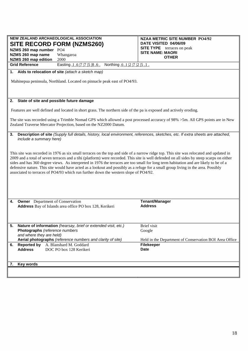
1. Aids to relocation of site (attach a sketch map) Mahinepua peninsula, Northland. Located on pinnacle peak east of PO4/93. 2. State of site and possible future damage Features are well defined and located in short grass. The northern side of the pa is exposed and actively eroding. The site was recorded using a Trimble Nomad GPS which allowed a post processed accuracy of 98% >5m. All GPS points are in New Zealand Traverse Mercator Projection, based on the NZ2000 Datum. 3. Description of site (Supply full details, history, local environment, references, sketches, etc. If extra sheets are attached,
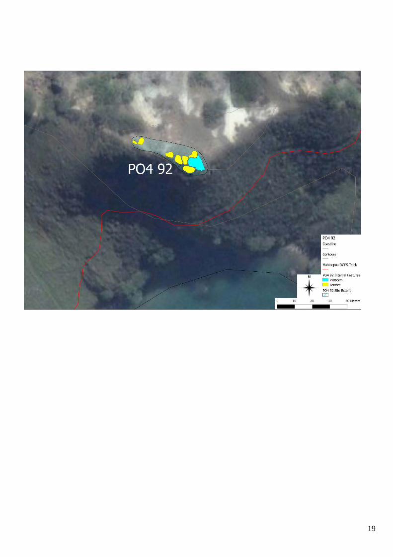
include a summary here) This site was recorded in 1976 as six small terraces on the top and side of a narrow ridge top. This site was relocated and updated in 2009 and a total of seven terraces and a tihi (platform) were recorded. This site is well defended on all sides by steep scarps on either sides and has 360 degree views. As interpreted in 1976 the terraces are too small for long term habitation and are likely to be of a defensive nature. This site would have acted as a lookout and possibly as a refuge for a small group living in the area. Possibly associated to terraces of PO4/93 which run further down the western slope of PO4/92. 4. Owner Department of Conservation Address Bay of Islands area office PO box 128, Kerikeri
Tenant/Manager Address
5. Nature of information (hearsay, brief or extended visit, etc.) Brief visit Photographs (reference numbers and where they are held)
Aerial photographs (reference numbers and clarity of site) Held in the Department of Conservation BOI Area Office 6. Reported by A. Blanshard M. Goddard Address DOC PO box 128 Kerikeri
Filekeeper Date
7. Key words
19
20
NEW ZEALAND ARCHAEOLOGICAL ASSOCIATION SITE RECORD FORM (NZMS260) NZMS 260 map number PO4 NZMS 260 map name Whangaroa NZMS 260 map edition 2000
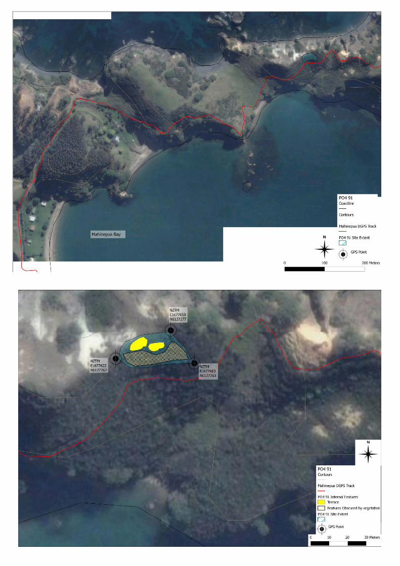
NZAA METRIC SITE NUMBER P04/91 DATE VISITED June 2009 SITE TYPE Terraces SITE NAME: MAORI OTHER
Grid Reference Easting .1 .6 |7 |7 |6 |5 .0 . Northing .6 .1 |2 |7 |2 |7 .7 .
1. Aids to relocation of site (attach a sketch map) Mahinepua peninsula, Northland. On the south facing side of narrow saddle immediately beyond the high pinnacle shaped peak (P04/92). The site was recorded using a Trimble Nomad GPS which allowed a post processed accuracy of 98% >5m. All GPS points are in New Zealand Traverse Mercator Projection, based on the NZ2000 Datum. 2. State of site and possible future damage Site located in long grass and bush. Northern face of slope actively eroding. 3. Description of site (Supply full details, history, local environment, references, sketches, etc. If extra sheets are attached,
include a summary here) Site recorded in 1976 as four small terraces on south facing slope overlooking Mahinepua Bay. Of the four terraces only two were relocated in the 2009 survey. Further terraces are likely to be present in the thick vegetation as indicated on the survey map. 4. Owner Department of Conservation Address Bay of Islands area office Po box 128, Kerikeri
Tenant/Manager Address
5. Nature of information (hearsay, brief or extended visit, etc.) Brief visit Photographs (reference numbers and where they are held)
Aerial photographs (reference numbers and clarity of site) Held in the Department of Conservation BOI Area Office
6. Reported by M. Goddard Address DOC Po box 128, Kerikeri
Filekeeper Date
7. Key words
21
22
NEW ZEALAND ARCHAEOLOGICAL ASSOCIATION SITE RECORD FORM (NZMS260) NZMS 260 map number PO4 NZMS 260 map name Whangaroa NZMS 260 map edition 2000
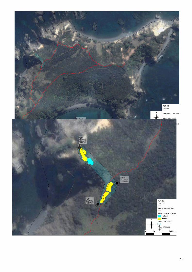
NZAA METRIC SITE NUMBER P04/90 DATE VISITED June 2009 SITE TYPE Terraces SITE NAME: MAORI OTHER
Grid Reference Easting .1.6|7|7|9|8.8. Northing .6.1|2|7|5|9.8.
1. Aids to relocation of site (attach a sketch map) Mahinepua peninsula, Northland. Located on the northern side near the end of the peninsula. On a small narrow ridge. The site was recorded using a Trimble Nomad GPS which allowed a post processed accuracy of 98% >5m. All GPS points are in New Zealand Traverse Mercator Projection, based on the NZ2000 Datum. 2. State of site and possible future damage Located in patches of thick scrub and long grass. Poorly defined and slumped in areas. 3. Description of site (Supply full details, history, local environment, references, sketches, etc. If extra sheets are attached,
include a summary here) Recorded in 1976 as three terraces and four shallow depressions (possible pits), on a narrow sloping ridge top. The 2009 survey relocated this site and recorded four terraces and a possible platform. The large terrace and platform recorded on the tip of the headland are obscured by thick scrub and therefore limited the interpretation of the features. No pits were recorded as their presence could not be confirmed on the surface. 4. Owner Department of Conservation Address Bay of Islands area office, PO box 128, Kerikeri
Tenant/Manager Address
5. Nature of information (hearsay, brief or extended visit, etc.) Brief visit Photographs (reference numbers and where they are held)
Held in the Department of Conservation BOI Area Office
Aerial photographs (reference numbers and clarity of site) Google 6. Reported by M.Goddard Address DOC, Po box 128, Kerikeri
Filekeeper Date
7. Key words
23
24
NEW ZEALAND ARCHAEOLOGICAL ASSOCIATION SITE RECORD FORM (NZMS260) NZMS 260 map number PO4 NZMS 260 map name Whangaroa NZMS 260 map edition 2000
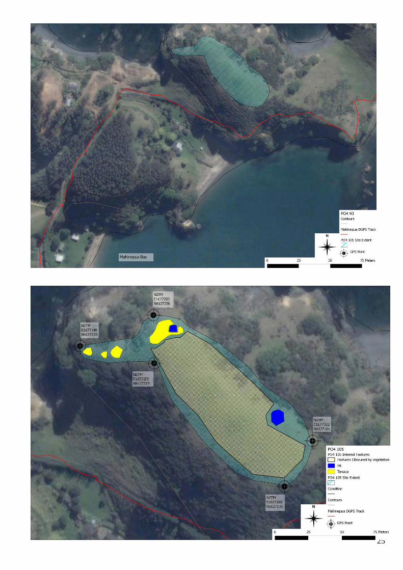
NZAA METRIC SITE NUMBER P04/105 DATE VISITED June 2009 SITE TYPE Pit and terrace SITE NAME: MAORI OTHER
Grid Reference Easting .1 .6 |7 |7 |2 |0.5. Northing .6 .1 |2 |7 |2 |2 .3 .
1. Aids to relocation of site (attach a sketch map) Mahinepua peninsula, Northland. Site located on top of the slope to the west of P04/93. The site was recorded using a Trimble Nomad GPS which allowed a post processed accuracy of 98% >5m. All GPS points are in New Zealand Traverse Mercator Projection, based on the NZ2000 Datum. 2. State of site and possible future damage Site covered in thick, high Kikuyu grass which made locating features difficult. Features that were visible were in good condition. 3. Description of site (Supply full details, history, local environment, references, sketches, etc. If extra sheets are attached,
include a summary here) Site recorded in 1976 as a pit and terrace site. Features located in 2009 were two pits and four terraces. The bulk of the features were recorded on the northern most end of the hilltop, with terraces running down the hillside. Further features more than likely exist but are obscured by thick kikuyu which is the area indicated on the map as the shaded portion. 4. Owner Department of Conservation Address Bay of Islands area office, PO box 128, Kerikeri.
Tenant/Manager Address
5. Nature of information (hearsay, brief or extended visit, etc.) Brief visit Photographs (reference numbers and where they are held)
Held in the Department of Conservation BOI Area Office
Aerial photographs (reference numbers and clarity of site) Google 6. Reported by A. Blanshard M.Goddard Address DOC, PO box 128, Kerikeri
Filekeeper Date
7. Key words
25
26
NEW ZEALAND ARCHAEOLOGICAL ASSOCIATION SITE RECORD FORM (NZMS260) NZMS 260 map number PO4 NZMS 260 map name Whangaroa NZMS 260 map edition 2000
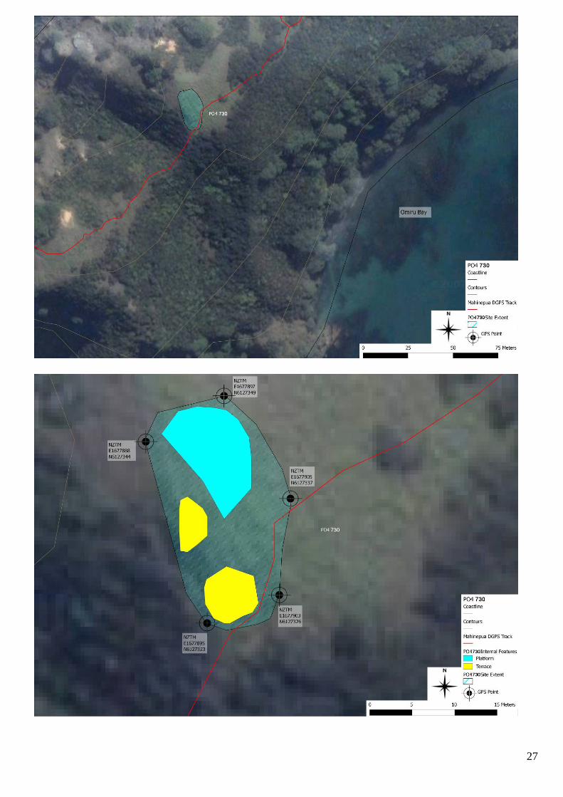
NZAA METRIC SITE NUMBER P04/730 DATE VISITED June 2009 SITE TYPE Terraces SITE NAME: MAORI OTHER
Grid Reference Easting .1 .6 |7 |7 |8 |9 .5 . Northing .6 .1 |2 |7 |3 |2 .3 .
1. Aids to relocation of site (attach a sketch map) Mahinepua peninsula, Northland. Located on a hilltop directly east of the pa P04/55. The site was recorded using a Trimble Nomad GPS which allowed a post processed accuracy of 98% >5m. All GPS points are in New Zealand Traverse Mercator Projection, based on the NZ2000 Datum. 2. State of site and possible future damage Area covered in thick long Kikuyu. In ok condition. 3. Description of site (Supply full details, history, local environment, references, sketches, etc. If extra sheets are attached,
include a summary here) Located in the 2009 survey. Area rises up from a small saddle and is relatively flat and wide. Two terraces were located on the western edge. One of them is small and may have been used largely for defensive purposes rather than as a living terrace. This terrace is situated against a possible platform area. An eastern edge for this platform was not found and as it gradually slopes downwards. A larger terrace was located near the current track to the south of these features. Thick, long kikuyu is obscuring any further features which are likely to exist in this area. Due to the growth of the kikuyu an accurate interpretation of the platform and the location of its edges could not be made. It is possible that this platform is in fact a terrace. 4. Owner Department of Conservation Address Bay of islands area office, PO box 128, Kerikeri
Tenant/Manager Address
5. Nature of information (hearsay, brief or extended visit, etc.) brief Photographs (reference numbers and where they are held)
Held in the Department of Conservation BOI Area Office
Aerial photographs (reference numbers and clarity of site) Google 6. Reported by A. Blanshard M. Goddard Address DOC PO box 128, Kerikeri
Filekeeper Date
7. Key words
27
28
NEW ZEALAND ARCHAEOLOGICAL ASSOCIATION SITE RECORD FORM (NZMS260) NZMS 260 map number P04 NZMS 260 map name Whangaroa NZMS 260 map edition 2000
NZAA METRIC SITE NUMBER P04/731 DATE VISITED June 2009 SITE TYPE Terraces SITE NAME: MAORI OTHER
Grid Reference NZTM Easting .1.6|7|7|4|6.6. Northing .6.1|2|7|2|7.6.
1. Aids to relocation of site (attach a sketch map) Mahinepua peninsula, Northland. Located on a hilltop to the north of the eastern slope of P04/93. The site was recorded using a Trimble Nomad GPS which allowed a post processed accuracy of 98% >5m. All GPS points are in New Zealand Traverse Mercator Projection, based on the NZ2000 Datum. 2. State of site and possible future damage In good condition. Located in grass and scrub patches. Continuing erosion on the northern cliff face. 3. Description of site (Supply full details, history, local environment, references, sketches, etc. If extra sheets are attached,
include a summary here) Site located in the 2009 survey. Two terraces recorded on the hilltop possibly associated to P04/93. The uppermost terrace overlooks the sea to the north and P04/93. The lower terrace is located on the southern side of the hill facing towards P04/93. 4. Owner Department of Conservation Address Bay of islands area office, PO box 128, Kerikeri
Tenant/Manager Address
5. Nature of information (hearsay, brief or extended visit, etc.) Brief Photographs (reference numbers and where they are held)
Held in the Department of Conservation BOI Area Office
Aerial photographs (reference numbers and clarity of site) Google 6. Reported by A. Blanshard M. Goddard Address DOC PO box 128, Kerikeri
Filekeeper Date
7. Key words
29
30
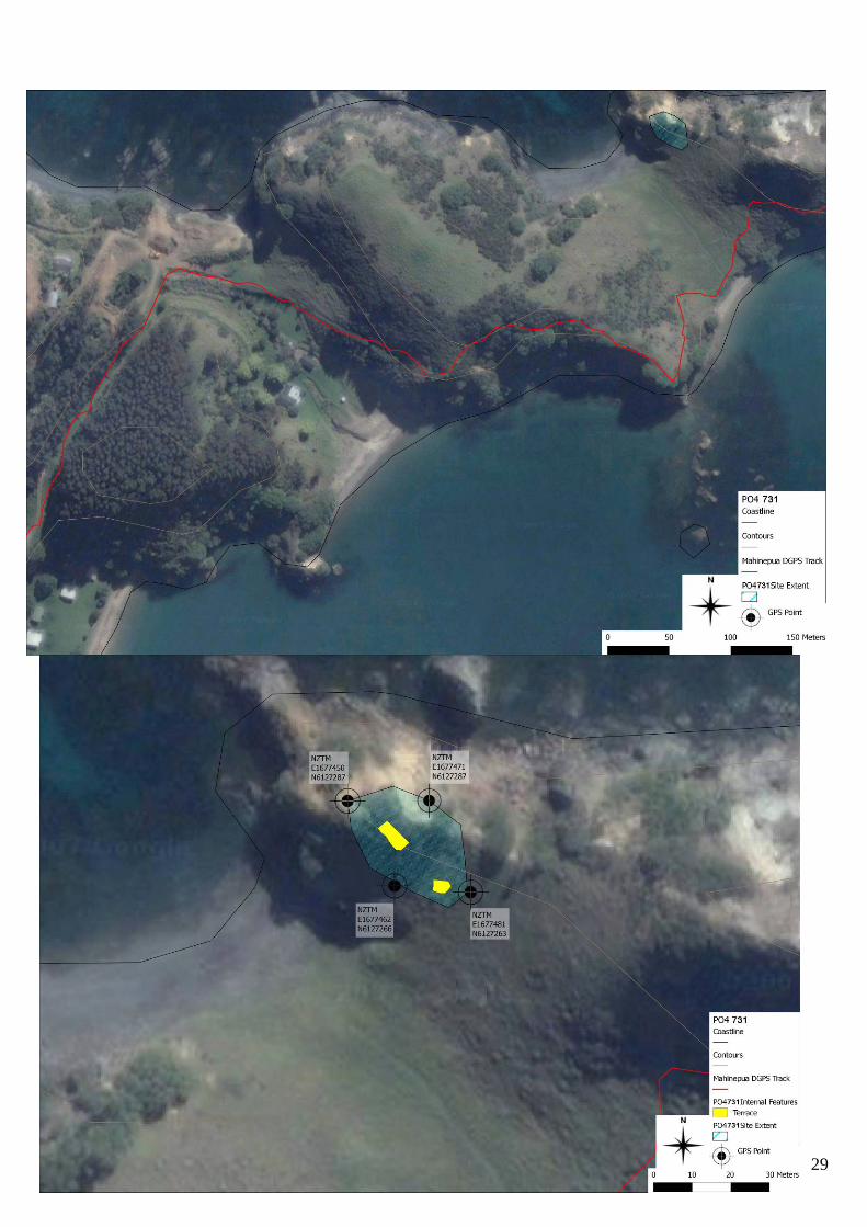
NEW ZEALAND ARCHAEOLOGICAL ASSOCIATION SITE RECORD FORM (NZMS260) NZMS 260 map number PO4/89 NZMS 260 map name Whangaroa NZMS 260 map edition 2000
NZAA METRIC SITE NUMBER P04/89 DATE VISITED 08/06/ 2009 SITE TYPE Midden SITE NAME: MAORI OTHER
Grid Reference NZTM Easting .1.6|7|8|1|7.1. Northing .6.1|2|7|3|8.0.
1. Aids to relocation of site (attach a sketch map) Mahinepua Peninsula, Northland. Located on the beach front at Omiru Bay on the south side of Mahinepua peninsula The site was recorded using a Trimble Nomad GPS which allowed a post processed accuracy of 98% >5m. All GPS points are in New Zealand Traverse Mercator Projection, based on the NZ2000 Datum. 2. State of site and possible future damage Site located on exposed and eroded beachfront bank. Midden intact but subject to severe continuing coastal erosion. 3. Description of site (Supply full details, history, local environment, references, sketches, etc. If extra sheets are attached,
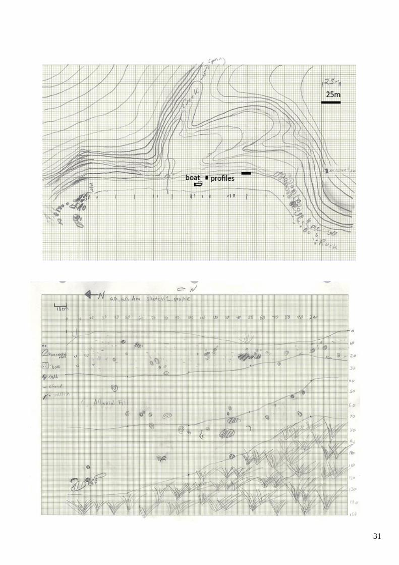
include a summary here) This site was recorded in 1979 as being a 20m long and 10 – 50cm deep midden located “in steep bank behind the beach”. The midden was said to contain numerous shellfish and fish species, oven stones and charcoal. The midden was noted as non-specialised and possibly from the early or “archaic” period. This particular site as described could not be relocated during survey in 2009. However, one thin section of midden was located on the beach front on an eroded face which is approximately 1.5m long with a lens approximately 50mm-100mm thick. Fire cracked rock and shellfish similar to those described in the 1979 survey were observed as well as ash and charcoal deposits. It is possible that this section of midden is a degraded part of the one recorded in the 70’s, as the bank on either side of this exposed section is covered in thick kikuyu grass and thus any possible continuation of midden obstructed from view. It may also be the case that over the last thirty years ongoing coastal erosion has destroyed much of what was previously recorded. Map displays two areas of exposed midden and one area of fire cracked rock located to the west. 4. Owner Department of Conservation Address Bay of Islands Area Office PO Box, 128, Kerikeri
Tenant/Manager Address
5. Nature of information (hearsay, brief or extended visit, etc.) Brief Photographs (reference numbers and where they are held)
Held in the Department of Conservation Area Office
Aerial photographs (reference numbers and clarity of site) Google 6. Reported by Edward Ashby, maps and photo by Blanshard, A.
Goddard. M. Address DOC PO box 128, Kerikeri
Filekeeper Date
7. Key words 8. New Zealand Register of Archaeological Sites (for office use) NZHPT Site Field Code
31
32
Endnotes 1 Ashby 2009:107 2 ibid 3 Salmond 1991:217-219 4 op.cit Ashby:107 5 Fox 1975:16 6 Carpenter 2004:7 7 Department of Conservation 1989:91 8 ibid 9 Op.cit Fox:16 10 ibid 11 Op.cit Fox:13 12 Maingay 1986:46-50 13 Op.cit Department of Conservation:92 14 Cloher 2003:263-270


