Historic Resources Survey Report West Adams-Baldwin Hills-Leimert Community Plan Area Prepared for: City of Los Angeles Department of City Planning Office of Historic Resources Prepared by: Architectural Resources Group, Inc. Pasadena, CA September 2012 Revised July 2016
Transcript
Historic Resources Survey Report
West Adams-Baldwin Hills-Leimert Community Plan Area
Prepared for:
City of Los Angeles Department of City Planning Office of Historic Resources Prepared by:
Architectural Resources Group, Inc. Pasadena, CA September 2012 Revised July 2016
SurveyLA West Adams-Baldwin Hills-Leimert Community Plan Area
Table of Contents Project Overview 1
SurveyLA Methodology Summary 1
Project Team 3
Survey Area 3
Designated Resources 11
Community Plan Area Survey Methodology 13
Summary of Findings 15
Summary of Property Types 15
Summary of Contexts and Themes 17
For Further Reading 46
Appendices
Appendix A: Individual Resources
Appendix B: Non-Parcel Resources
Appendix C: Historic Districts and Planning Districts
SurveyLA 1 West Adams-Baldwin Hills-Leimert Community Plan Area
Project Overview This historic resources survey report (“Survey Report”) has been completed on behalf of the City of Los Angeles Department of City Planning’s Office of Historic Resources (OHR) for the SurveyLA historic resources survey of the West Adams-Baldwin Hills-Leimert Community Plan Area (CPA). This project was originally undertaken as part of the first group of SurveyLA surveys from June 2010 to August 2011 by Architectural Resources Group, Inc. (ARG), with fieldwork assistance from Galvin Preservation Associates (now GPA Consulting). Since that time the survey findings were revised and updated by ARG to reflect the subsequent refinements in survey methodology as well as the development of additional historic contexts and themes relevant to the West Adams-Baldwin Hills-Leimert Park CPA. This Survey Report provides a summary of work completed, including a description of the Survey Area; an overview of the field methodology; a summary of relevant contexts, themes and property types; and complete lists of all recorded resources. This Survey Report is intended to be used in conjunction with the SurveyLA Field Results Master Report (“Master Report”), which provides a detailed discussion of SurveyLA methodology and explains the terms used in this report and associated appendices. The Master Report, Survey Report, and Appendices are available at www.surveyla.org.
SurveyLA Methodology Summary
Below is a brief summary of SurveyLA methodology. Refer to the Master Report discussed above for more information. Field Survey Methods
Properties surveyed for SurveyLA are evaluated for eligibility for listing in the National Register of Historic Places, California Register of Historical Resources, and for local designation as Los Angeles Historic-Cultural Monuments (HCM) or Historic Preservation Overlay Zones (HPOZ), commonly known as historic districts.
Field surveyors cover the entire area within the boundaries of a CPA. However, only resources that have been identified as significant within the contexts developed for SurveyLA are recorded.
Consultants making resource evaluations meet the Secretary of the Interior’s Professional Qualifications Standards in Architectural History, History, or a related field.
Surveys focus on identifying significant resources dating from about 1850 to 1980.
SurveyLA 2 West Adams-Baldwin Hills-Leimert Community Plan Area
All surveys are completed from the public right-of-way (from vehicles or on foot as needed).
Digital photographs are taken of all evaluated resources.
Field Surveys do not include: Individual resources and historic districts (including HPOZs) that are already
designated (listed in the National, California or local registers). Community Redevelopment Agency of Los Angeles (CRA/LA) surveys conducted
concurrent with SurveyLA. Potential HPOZ areas which have been surveyed within the last five years and
are in the process of being designated. SurveyLA Resource Types
SurveyLA identifies individual resources, non-parcel resources, historic districts, and district contributors and non-contributors. Each of these is described below. Appendices A, B, and C of this Survey Report are organized by resource type.
Individual Resources are generally resources located within a single assessor parcel such as a residence. However, a parcel may include more than one individual resource, if each appears to be significant.
Non-Parcel Resources are not associated with Assessor Parcel Numbers (APNs) and generally do not have addresses. Examples may include street trees, street lights, landscaped medians, bridges, and signs.
Historic Districts are areas that are related geographically and by theme. Historic districts may include single or multiple parcels depending on the resource. Examples of resources that may be recorded as historic districts include residential neighborhoods, garden apartments, commercial areas, large estates, school and hospital campuses, and industrial complexes.
District Contributors and Non-Contributors are buildings, structures, objects, sites and other features located within historic districts (such as residences, schools, and parks). Generally, non-contributing resources are those that are extensively altered, built outside the period of significance, or that do not relate to historic contexts and themes defined for the district.
Planning Districts are areas that are related geographically and by theme, but do not meet eligibility standards for designation. This is generally because the majority of the contributing features have been altered, resulting in a cumulative impact on the overall
SurveyLA 3 West Adams-Baldwin Hills-Leimert Community Plan Area
integrity of the area that makes it ineligible as a Historic District. The Planning District determination, therefore, is used as a tool to inform new Community Plans being developed by the Department of City Planning. These areas have consistent planning concepts, such as height, massing, setbacks, and street trees, which warrant consideration in the local planning process.
Project Team The West Adams-Baldwin Hills-Leimert CPA survey team included personnel from the firms of ARG and GPA. ARG staff included Charles E. Chase, Associate Principal; Katie E. Horak, Architectural Historian and Preservation Planner; Jennifer Trotoux, Architectural Historian and Preservation Planner; Katie Wollan, Architectural Historian and Preservation Planner; and Allison M. Lyons, Architectural Historian and Preservation Planner. Katie E. Horak served as the Project Manager. Additional assistance was provided by intern Sian Winship. GPA staff included Teresa Grimes, Principal Architectural Historian; Laura Vanaskie, Architectural Historian II; and Nicole Collum, Architectural Historian II. Additional assistance was provided by intern Catherine L. Smith.
Survey Area Description of the Survey Area
The identified Survey Area corresponds with the boundary of West Adams-Baldwin Hills-Leimert Community Plan Area (CPA). The roughly triangular-shaped CPA is located in the southeast portion of the City of Los Angeles, approximately seven miles from downtown. From east to west, the northern boundaries of the CPA are formed by Pico Boulevard, South Venice Boulevard, and 18th Street. The eastern boundary of the CPA is Arlington Avenue from Pico Boulevard running south to the Exposition Boulevard. South of Exposition Boulevard, the eastern boundary of the CPA is Van Ness Avenue. The southern and western boundaries of the CPA follow the irregular lines of the City boundary, bordering (roughly from east to west) the City of Inglewood, the unincorporated communities of View Park-Windsor Hills and Ladera Heights, the Kenneth Hahn State Recreation Area, and the City of Culver City. The westernmost boundary of the CPA is Canfield Avenue and Robertson Boulevard, crossing through the Beverlywood and Palms neighborhoods of Los Angeles (see Survey Area Map below). The West Adams-Baldwin Hills-Leimert CPA comprises 40,999 parcels. Of these, roughly 33,411 were surveyed by the SurveyLA team. SurveyLA generally does not include properties constructed after 1980; resources that have been designated under Federal, state, or local
SurveyLA 4 West Adams-Baldwin Hills-Leimert Community Plan Area
programs; or proposed HPOZs that have been surveyed within the last five years and in the process of designation.1
1 For designated resources within the CPA at the time of the survey, refer to the Designated Resources map below. For the most up-to-date information on designated resources, refer to zimas.lacity.org or www.HistoricPlacesLA.org, or contact the Department of City Planning’s Office of Historic Resources.
SurveyLA 5 West Adams-Baldwin Hills-Leimert Community Plan Area
Survey Area Map
SurveyLA 6 West Adams-Baldwin Hills-Leimert Community Plan Area
The natural topography of the West Adams-Baldwin Hills-Leimert CPA greatly influenced the patterns of development and circulation within the area. The CPA has a wide range of elevations, including substantial hills and small plateaus, as well as large expanses of flatlands. Many of the neighborhood patterns and transportation thoroughfares of the area were shaped by the natural features of the landscape. The CPA is generally flat throughout its northern and eastern sections, with a gradual southerly slope. To the west of Crenshaw Boulevard, south of Slauson Boulevard, there is a slightly elevated plateau named Angeles Mesa by real estate developers in the early 20th century. Buildings are sited on elevated terraces on the western side of Crenshaw in this area. Baldwin Hills, along the southwestern section of the CPA, is a hilly range with a vantage point from which one can see nearly all the iconic features of the northern Los Angeles basin, including the skylines of Downtown Los Angeles and Century City, the Santa Monica Mountains, and the Hollywood sign. The original topography of the area is evident in the name given to its Spanish land grant: Rancho Cienega o’ Paso de la Tijera. Prior to modern development, the land was mostly marshes (cienega is Spanish for “swamp”). Though this land has been drained and the creek beds have been controlled and diverted, several concrete channels cross through the CPA at its southwestern end. Paso de la tijera translates to “pass of scissors,” and references the passes between the peaks of the hills that looked like roads traversing an open pair of scissors.2 La Cienega and Stocker Boulevards cross through Baldwin Hills within the CPA.3 To the far west of the CPA, bordering the Palms and Beverlywood neighborhoods, are the low-elevation Cheviot Hills. The western sections of the CPA are in the foothills of this area and have a gradual westerly incline. The CPA is bounded and shaped by many man-made features, including wide boulevards that traverse the entire city from Downtown to the Pacific Ocean. Many of the major thoroughfares of the area are automobile roads that functioned historically as streetcar, motorcar, and railroad routes. These routes were influential in the development of neighborhoods in the northern, eastern, and southern sections of the CPA. Later residential and commercial development took advantage of automobile corridors and thoroughfares that connected the centrally-located CPA to the airports, harbor, and central business districts of greater Los Angeles County. The major east-west arteries within the CPA are: Pico Boulevard, Venice Boulevard, Washington Boulevard, Adams Boulevard, Jefferson Boulevard, Exposition Boulevard, Rodeo Road, Martin Luther King Jr. (formerly Santa Barbara) Boulevard, Coliseum Street, Santa Rosalia Drive, Vernon Avenue, 54th Street, Slauson Avenue, Florence Avenue, and Cadillac Avenue. The major north-south arteries within the CPA are: Arlington Avenue, Leimert Boulevard, Crenshaw Boulevard, Stocker Street, La Brea Avenue, Fairfax Avenue, La Cienega Boulevard, and Robertson Boulevard.
2 Kielbasa, John. Historic Adobes of Los Angeles County. Pittsburgh, PA: Dorrance Pub., 1997. 3 The hill to the west of La Cienega is known as the Kenneth Hahn State Recreation Area. To the east of Stocker is a hill known as View Park, which is not part of the City of Los Angeles.
SurveyLA 7 West Adams-Baldwin Hills-Leimert Community Plan Area
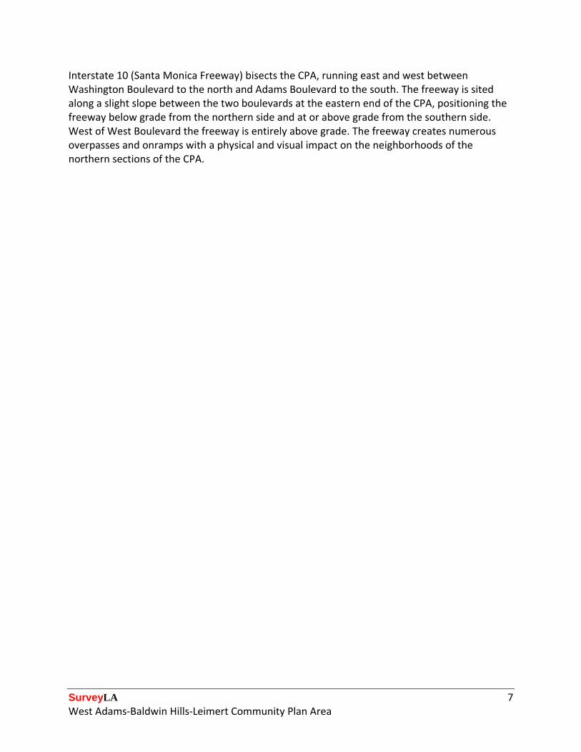
Interstate 10 (Santa Monica Freeway) bisects the CPA, running east and west between Washington Boulevard to the north and Adams Boulevard to the south. The freeway is sited along a slight slope between the two boulevards at the eastern end of the CPA, positioning the freeway below grade from the northern side and at or above grade from the southern side. West of West Boulevard the freeway is entirely above grade. The freeway creates numerous overpasses and onramps with a physical and visual impact on the neighborhoods of the northern sections of the CPA.
SurveyLA 8 West Adams-Baldwin Hills-Leimert Community Plan Area
Chronology Map of the West Adams-Baldwin Hills-Leimert CPA
SurveyLA 9 West Adams-Baldwin Hills-Leimert Community Plan Area
Development History
The West Adams-Baldwin Hills-Leimert CPA was incorporated into the City of Los Angeles gradually over 80 years in 21 separate annexations and one consolidation. The CPA includes the Los Angeles neighborhoods of Arlington Heights, Jefferson Park, Leimert Park, Hyde Park, Baldwin Hills-Crenshaw, Mid-City, Palms, and Beverlywood.4 The westernmost portion of the greater West Adams neighborhood, including the West Adams Terrace and Jefferson Park HPOZs, is within the boundaries of the CPA. The easternmost sections of the Palms and Beverlywood neighborhoods are also within the CPA. Hyde Park, which is located at the southern tip of the CPA, was an incorporated city prior to its consolidation into the City of Los Angeles in 1923. Established in 1887, Hyde Park was a stop on the Atchison, Topeka and Santa Fe Railway’s Harbor Subdivision, which linked downtown Los Angeles to the port at Wilmington. The area was largely built out with modest single-family homes in the first two decades of the 20th century. Perhaps due to its short period of incorporation (1922-1923), there is no evidence of a city center or municipal buildings that might have served this community. A handful of residences as well as a few institutional properties are all that remain of Hyde Park. The northern quadrant of the West Adams-Baldwin Hills-Leimert CPA developed in a southwesterly pattern beginning at the turn of the 20th century, as a growing network of streetcars and railroads enabled suburban development on land outside of the historic city center. The earliest subdivisions are located in the northeastern parts of the CPA, in the neighborhoods of Arlington Heights and Jefferson Park. The Arlington Heights area was particularly well served by public transit, with a streetcar traversing every major east-west artery. The interior streets filled with single- and multi-family houses beginning in the early 1900s and continuing through the boom of the 1920s. Many of the tracts that were established in the 1910s and ‘20s were equipped with restrictions on the size and appearance of building stock as well as on who could live within their boundaries. Covenants often barred minority residents from living within these tracts and as a result, much of the city was off-limits to non-white homeowners until the late 1940s, when racially restrictive housing covenants were ruled unconstitutional. Even after the 1948 Supreme Court decision, restrictive housing practices continued to be enforced by neighborhood groups and realtors who used intimidation—and at times, violence—to keep non-white residents out of neighborhoods. Leimert Park, laid out by Walter Leimert in 1927, was almost exclusively inhabited by white homeowners in the prewar era and had restrictive covenants in the deeds to ensure its homogeny. One group, the benignly-named Neighborly Endeavors, worked to keep the neighborhood free of non-whites in the 1950s, going so far as to burn crosses on front lawns
4 According to: "Mapping L.A. - Los Angeles Times." Mapping L.A. Los Angeles Times. Web. 03 June 2011.
SurveyLA 10 West Adams-Baldwin Hills-Leimert Community Plan Area
and vandalize the homes of unwanted neighbors.5 Despite their efforts, a number of black families moved into Leimert Park and stood their ground against the intimidation and violence. More and more upwardly-mobile African American families moved to Leimert Park after 1950 and their population grew from 70 persons to about 4,200 in one decade alone.6 By 1960, non-whites (including African Americans, Japanese Americans and Latin Americans) comprised half of the total population and Leimert Park became one of the city’s most diverse neighborhoods, with notable residents such as Ella Fitzgerald, Ray Charles, and Los Angeles’s first African American mayor, Tom Bradley. In the years leading up to World War II, there was a thriving Japanese American community in the Exposition Park and Jefferson Park neighborhoods, west of the University of Southern California (and just to the east of the West Adams-Baldwin Hills-Leimert CPA boundary). After the war and the period of forced internment, the area’s Japanese American residents returned to seinan (meaning Southwest) to resume life in their community. In the following years, many nissei (second-generation) pushed westward into the Crenshaw district, which after the war became a vibrant center of Japanese American commerce and culture. North of Leimert Park, there was a small district of undeveloped land to the east of Crenshaw that was the site of the notorious Black Dahlia murder in 1947. In the late 1950s, a group of Japanese American investors planned a shopping center on Crenshaw Boulevard and a subdivision of single-family residences and apartment buildings. The development of the Crenshaw Square shopping center and adjacent residential neighborhood was a sign of considerable nissei progress in Los Angeles, not only because of the scale and success of the development, but also due to the fact that the “principles behind the shopping center and the subdivision consciously promoted their ethnic character.”7 While Japanese American communities before the war tended to assimilate into existing neighborhoods, drawing little attention to their presence, in Crenshaw, Japanese culture was celebrated in the design of new buildings and landscapes. Without adjacent streetcar service, Baldwin Hills remained largely undeveloped until the late 1940s and ‘50s. When Baldwin Hills Village (now known as the Village Green), a groundbreaking garden apartment community, was constructed in 1941 it was surrounded by open fields on all sides.8 Baldwin Hills Village was also governed by restrictive housing practices and remained an all-white community until the 1960s. The complex received international acclaim for its design, low-density planning, and high quality of living; large multi-family developments sprang up on adjacent vacant land, apparently hoping to capitalize on the popularity of the complex. The Crenshaw Village apartment community was constructed in 1948 and was advertised as having “garden type private home apartments.”9 City directory research indicates that many of the
5 Charlotte Brooks, Alien Neighbors, Foreign Friends: Asian Americans, Housing and the Transformation of Urban California (Chicago: University of Chicago Press, 2009), 186. 6 Scott Kurishige, The Shifting Grounds of Race: Black and Japanese Americans in the Making of Multiethnic Los Angeles (Princeton: Princeton University Press, 2007), 252. 7 Kurishige, 256. 8 Baldwin Hills Village, known today as Village Green, is a National Historic Landmark, listed on the National Register of Historic Places, and is a Los Angeles Historic-Cultural Monument. 9 “Classified ad 8 – No Title,” Los Angeles Times, 25 August 1948.
SurveyLA 11 West Adams-Baldwin Hills-Leimert Community Plan Area
residents of Crenshaw Village were Jewish; at that time, Jewish residents were restricted from living at nearby Baldwin Hills Village.10 It appears that the flats of Baldwin Hills were home to a thriving Jewish community until the 1960s and ‘70s, when drug and gang activity became a growing presence in the neighborhood, and many of Los Angeles’s Jewish residents moved to west Los Angeles and parts of the San Fernando Valley. The 1950s and ‘60s brought residential development in the hilly area above Baldwin Hills, called Baldwin Hills Estates. The hills are populated with sprawling single-family homes, many with unobstructed northerly views of the Los Angeles basin and Santa Monica Mountains. The area, along with View Park to the south (which is outside of Los Angeles city limits), became home to a number of affluent African American residents in the 1960s and ‘70s, and remains today one of the wealthiest majority African American communities in the United States. Designated Resources
The following map depicts the location of designated resources within the West Adams-Baldwin Hills-Leimert CPA at the time of the survey. These include properties listed in the National Register of Historic Places, California Register of Historical Resources, and locally designated City Historic-Cultural Monuments (HCMs) and Historic Preservation Overlay Zones (HPOZs). Many properties within the CPA have been designated and were not evaluated as part of SurveyLA. This includes three locally-designated Historic Preservation Overlay Zone (HPOZs): the Jefferson Park HPOZ, the La Fayette Square HPOZ, and the West Adams Terrace HPOZ. For up-to-date information about designated resources, visit HistoricPlacesLA.org and ZIMAS.lacity.org, or contact the Los Angeles Department of City Planning’s Office of Historic Resources.
10 Los Angeles Street Address Directory, May 1956 (Pacific Telephone and Telegraph Company).
SurveyLA 12 West Adams-Baldwin Hills-Leimert Community Plan Area
Designated Resources Map
SurveyLA 13 West Adams-Baldwin Hills-Leimert Community Plan Area
Community Plan Area Survey Methodology The field survey was conducted using the methodology established by the Office of Historic Resources for SurveyLA, which includes the citywide Historic Context Statement and customized mobile Field Guide Survey System (FiGSS).11 Fieldwork was conducted in two phases: reconnaissance and documentation. The reconnaissance phase was conducted by a team of qualified survey professionals, all of whom meet the Secretary of the Interior’s Professional Qualifications Standards. This phase involved a detailed and methodological review of each neighborhood, street, and individual property within the Survey Area. It was during this phase that decisions were made about which properties and districts should be documented and how these properties should be evaluated. During this initial reconnaissance phase, surveyors reviewed pre-loaded data submitted by community members to MyHistoricLA, identified concentrations of resources that might be later recorded as eligible historic districts and planning districts, and developed lists of pre-field research tasks that would help inform the field survey. By making these decisions up front and as a team, this methodology ensures a more thoughtful approach to resource identification and evaluation, creates a greater consensus among the field survey teams, and produces more consistent survey results across CPAs. This approach also substantially streamlines the next phase of field survey, enabling the field teams to document large numbers of properties quickly and efficiently. For use in the reconnaissance phase, ARG created Geographic Information Systems (GIS) maps of each neighborhood; these maps were printed for use in the field. A blank map showing only street names, address numbers, and parcel lines was used by surveyors in the field for notes and comments about resources identified during the reconnaissance phase. Another map featured parcels shaded by decade of building construction, which helped to illustrate chronological development patterns and concentrations of resources. Once the reconnaissance phase was completed, the documentation phase began. During this phase, field work was conducted by teams of two. Properties that were identified during the previous phase, along with those that had significant associative qualities identified in pre-loaded data in the FiGSS, were recorded and evaluated for potential historic, cultural, or architectural significance. Documentation included a digital photograph, recordation of historic features and subsequent alterations, and the reason for a property’s potential historic significance. It was also during this phase that contexts and themes were applied and evaluation status codes were assigned. All fieldwork was conducted from the public right-of-way. Following the completion of fieldwork, all survey data was reviewed in detail by a qualified survey professional to ensure accuracy and consistency throughout the data set.
11 For more information about the SurveyLA methodology, see the SurveyLA Field Survey Results Master Report.
SurveyLA 14 West Adams-Baldwin Hills-Leimert Community Plan Area
Survey teams conducted research on individual properties and neighborhoods throughout the field survey process. When specific information was needed in order to complete an evaluation, additional research was conducted. Sources included building permits, historical newspapers and periodicals, Sanborn Fire Insurance maps, tract maps, and City directories. Other sources included the collections of the Los Angeles Public Library, Online Archive of California, and the University of Southern California (USC). This research helped with the identification of historic tract names and boundaries, names of tract subdividers, dates of subdivision, and original building uses and footprints. Additional research focused on the rich ethnic history of the CPA and the contributions of the Japanese American and African American communities to neighborhood development. Sources for this research included United States Census records, local periodicals such as the Los Angeles Sentinel and Rafu Shimpo, and a number of books which focus on the ethnic history of Los Angeles.
SurveyLA 15 West Adams-Baldwin Hills-Leimert Community Plan Area
Summary of Findings The following discussion of Contexts, Themes, and Property Types relates to the resources identified and recorded as eligible for designation.
Summary of Property Types The West-Adams-Baldwin Hills-Leimert CPA contains a diverse range of residential, commercial, and institutional properties. These properties were built over a broad period that ranges from the late 19th century to the post-World War II period. Accordingly, resources identified in the survey encompass an array of property types and periods of development, with residential and commercial resources being the most common. The following is a summary of those property types that were documented and evaluated as historically, culturally, or architecturally significant. Residential Properties
The West Adams-Baldwin Hills-Leimert CPA is largely comprised of single-family residential neighborhoods. Although a wide variety of other property types exist, the patterns of development in this area (primarily streetcar and automobile suburbanization) were conducive to widespread single-family residential development, most of which occurred prior to World War II. The neighborhoods of Arlington Heights, Jefferson Park, West Adams, and Hyde Park feature large concentrations of Arts and Crafts and Period Revival style single-family dwellings; these neighborhoods were developed during this period primarily due to their proximity to historic streetcar routes. Concentrations of single-family residences that were identified as eligible for historic district designation typically conveyed their significance both as excellent examples of architectural styles and as significant examples of streetcar-related development. Multi-family dwellings are present in the CPA as well. Early multi-family development in the Survey Area typically consisted of duplexes, fourplexes, and bungalow courts. Early examples of multi-family properties occur sporadically throughout the CPA. Most pre-World War II multi-family resources were recorded as contributors to larger, primarily single-family Craftsman and Period Revival style historic districts, or small multi-family historic districts significant for their property type and/or respective architectural style. The CPA’s postwar multi-family residential development included small-scale apartment houses and courtyard apartments recorded as contributors to larger postwar single-family historic districts, as well as garden apartment complexes. The survey identified four multi-family historic districts, most of which were primarily composed of postwar courtyard apartments.
SurveyLA 16 West Adams-Baldwin Hills-Leimert Community Plan Area
One large postwar multi-family historic district, Baldwin Plaza-Sunset Fields, was recorded for its excellent concentration of courtyard apartments and for its significant collection of Mid-Century Modern multi-family residences. Commercial Properties
Commercial property types are commonly found on the large thoroughfares that run east-west and north-south throughout the Survey Area. The survey identified a handful of 1920s and ‘30s commercial properties located along former streetcar lines (both mixed-use commercial/residential and one-story commercial strips), as well as two streetcar commercial historic districts – the 54th and Crenshaw district and the Pico Boulevard district. Some of the buildings were recorded as excellent examples of their respective styles in addition to their significance as intact examples of commercial properties along a historic streetcar route. Several resources were found to be significant as commercial properties related to the automobile. These properties included 1930s auto body repair shops, 1940s gas stations, a 1940s auto showroom, and a few mid-20th century car washes. The car washes were also recorded as excellent examples of Googie architecture. Other commercial properties found within the Survey Area included banks and financial institutions (some significant for their Japanese American and African American associations), 1920s to ‘40s neighborhood theaters, such as the Forum, Crenshaw, and Leimert Theaters, and post-World War II commercial signs, including a Pontiac Dealership sign, The Cork restaurant sign, and the Jack Stephan Plumbing and Heating signs. Institutional Properties
The survey identified a number of institutional property types interspersed throughout the CPA. They range in size and purpose, but most are linked to the expansion of the population of Los Angeles westward starting in the 1920s. Several public institutional properties within the CPA were found to be significant. Three intact LAUSD elementary schools constructed prior to the 1933 Long Beach Earthquake, one post-1933 public elementary school campus and one post-World War II public elementary school campus were identified in the Survey Area. Two DWP facilities (one Distributing Station and one Receiving Station) constructed in the 1920s and ‘40s, one 1930s telephone communications building, and a rare example of a pre-World War II fire station were also found to be significant.
SurveyLA 17 West Adams-Baldwin Hills-Leimert Community Plan Area
Private institutions in the Survey Area include St. Elmo Village, a historic district significant as an artists’ colony; the Agudath Achim Anshe Sfard synagogue, an excellent example of an early Jewish religious institution in the area; Fifth Avenue Christian Church, a turn-of-the-century religious building; and the residence of Jeanne Cordova, publisher of the Lesbian Tide magazine, a prominent publication associated with the city’s Gay Civil Rights movement. Twelve institutional resources were recorded as non-parcel resources. Eight are air raid sirens that are associated with civil defense efforts during World War II and the Cold War; three are excellent concentrations of early twentieth century streetlights; and one is a World War I monument. Other Properties
A turn-of-the-century cactus was recorded as a natural feature, and a 1930s bridge was found significant as an excellent example of an early infrastructure improvement along a heavily trafficked streetcar and automobile corridor.
Summary of Contexts and Themes Many of the Contexts and Themes developed as part of the SurveyLA Citywide Historic Context Statement are represented in the West Adams-Baldwin Hills-Leimert CPA. The following is a representative sampling of some of the more common Context/Theme combinations used in the survey, as well as some examples that are specific to this part of the city. Each Context/Theme is illustrated with examples from the Survey Area. For a complete list of individual resources identified as meeting eligibility standards and criteria for the National Register, California Register, and/or local listing, see Appendix A. For a complete list of non-parcel resources identified as meeting eligibility standards and criteria for the National Register, California Register, and/or local listing, see Appendix B. For a complete list of historic districts identified as meeting eligibility standards and criteria for the National Register, California Register, and/or local listing, see Appendix C. This appendix also includes Planning Districts, which do not meet eligibility standards and criteria for listing but may warrant special consideration for local planning purposes
SurveyLA 18 West Adams-Baldwin Hills-Leimert Community Plan Area
Context: Pre-Consolidation Communities of Los Angeles, 1862-1932 Theme: Hyde Park, 1887-1923 Subtheme: Important Events in Hyde Park History, 1887-1923
Resources evaluated under this Context/Theme include rare intact examples of development that pre-dates the 1923 consolidation of Hyde Park into the City of Los Angeles. Resources include residential and institutional properties associated with early development of the Hyde Park community.
Address: 3111 W. 71st Street Address: 6519 S. 8th Avenue Date: 1903 Name: Hyde Park School Date: 1922
Address: 6505 S. Crenshaw Boulevard Name: Hyde Park Congregational Church Social Hall Date: 1922
SurveyLA 19 West Adams-Baldwin Hills-Leimert Community Plan Area
Context: Residential Development and Suburbanization, 1850-1980 Sub-Context: Multi-Family Residential Development, 1910-1980 Theme: Multi-Family Residential, 1910-1980 Sub-Theme: Courtyard Apartments, 1910-1980
There are several excellent examples of 1920s, ‘30s and ‘40s courtyard apartments in the CPA. Eligible examples exhibit the distinguishing features of the property type, including a U-shaped or L-shaped footprint and unit entrances oriented toward a central courtyard. Many were also recorded under the Architecture and Engineering Context as excellent examples of their respective architectural styles.
Address: 3917-3921 Montclair Street Address: 3843-3853 W. 27th Street Date: 1924 Date: 1923
SurveyLA 20 West Adams-Baldwin Hills-Leimert Community Plan Area
Context: Residential Development and Suburbanization, 1850-1980 Sub-Context: Multi-Family Residential Development, 1910-1980 Theme: Multi-Family Residential, 1910-1980 Sub-Theme: The Bungalow Court, 1910-1939
Bungalow courts were an important multi-family housing type in Los Angeles during the early decades of the 20th century. Examples located in the CPA usually date from the 1920s and are typically located in neighborhoods comprising a variety of single- and multi-family property types. All eligible examples exhibit the essential character-defining features of the property type. Several were also recorded under the Architecture and Engineering context as excellent examples of their respective architectural styles.
Address: 1806-1808 S. 4th Avenue Address: 2867-2873 S. Edgehill Drive Date: 1912 Date: 1923
Address: 3022-3032 S. 9th Avenue Address: 6101 S. Victoria Avenue Date: 1925 Date: 1932
SurveyLA 21 West Adams-Baldwin Hills-Leimert Community Plan Area
Context: Residential Development and Suburbanization, 1850-1980 Sub-Context: Multi-Family Residential Development, 1910-1980 Theme: Multi-Family Residential, 1910-1980 Sub-Theme: Multi-Family Residential District, 1910-1980
This Context/Theme was used to evaluate significant concentrations of multi-family residential buildings. With the exception of the La Fayette Road Historic District (left), which is composed of a variety of 1920s and ‘30s multi-family as well as single-family residences, the districts recorded under this Sub-Theme comprised excellent concentrations of postwar courtyard apartment buildings. The Baldwin Plaza-Sunset Fields Historic District (right) contains one of the largest concentrations of 1950s and ‘60s courtyard apartment buildings in the city.
Location: La Fayette Road Location: Nicolet Avenue District Name: La Fayette Road Historic District Period of Significance: 1922-1939
District Name: Baldwin Plaza-Sunset Fields Historic District Period of Significance: 1954-1962
SurveyLA 22 West Adams-Baldwin Hills-Leimert Community Plan Area
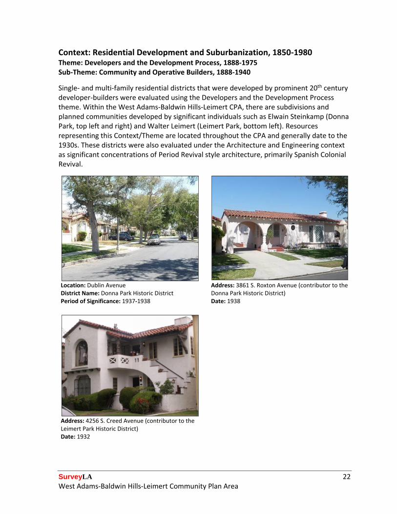
Context: Residential Development and Suburbanization, 1850-1980
Theme: Developers and the Development Process, 1888-1975 Sub-Theme: Community and Operative Builders, 1888-1940
Single- and multi-family residential districts that were developed by prominent 20th century developer-builders were evaluated using the Developers and the Development Process theme. Within the West Adams-Baldwin Hills-Leimert CPA, there are subdivisions and planned communities developed by significant individuals such as Elwain Steinkamp (Donna Park, top left and right) and Walter Leimert (Leimert Park, bottom left). Resources representing this Context/Theme are located throughout the CPA and generally date to the 1930s. These districts were also evaluated under the Architecture and Engineering context as significant concentrations of Period Revival style architecture, primarily Spanish Colonial Revival.
Location: Dublin Avenue District Name: Donna Park Historic District
Address: 3861 S. Roxton Avenue (contributor to the Donna Park Historic District)
Period of Significance: 1937-1938 Date: 1938
Address: 4256 S. Creed Avenue (contributor to the Leimert Park Historic District) Date: 1932
SurveyLA 23 West Adams-Baldwin Hills-Leimert Community Plan Area
Context: Residential Development and Suburbanization, 1850-1980 Theme: Ethnic Enclaves, 1880-1980
Two historic districts were recorded under the Ethnic Enclaves theme. The Crenshaw Seinan Historic District is significant for its association with the Japanese American community which relocated to the area after World War II. The district includes single- and multi-family dwellings, as well as two commercial buildings that were built by, owned by, and served Japanese American residents. The Leimert Park Historic District is significant for its association with the African American and Japanese American communities. Originally restricted to white residents, African American and Japanese American families moved into Leimert Park in the postwar era and by the 1960s it was one of the most vibrant residential and commercial centers of Los Angeles’ African American community.
Location: Norton Avenue District Name: Crenshaw Seinan Historic District
Address: 3824 S. Norton Avenue (contributor to the Crenshaw Seinan Historic District)
Period of Significance: 1956-1961 Date: 1956
Location: Creed Avenue District Name: Leimert Park Historic District
Address: 3910 S. Hepburn Avenue (contributor to the Leimert Park Historic District)
Period of Significance: 1927-1950 Name: Ray Charles Residence Date: 1945
SurveyLA 24 West Adams-Baldwin Hills-Leimert Community Plan Area
Context: Residential Development and Suburbanization, 1850-1980 Theme: Streetcar Suburbanization, 1888-1933 Sub-Theme: Suburban Planning and Development, 1888-1933
This Context/Theme was used to evaluate residential tracts or neighborhoods that were developed specifically due to their proximity to streetcar routes. These districts continue to evoke a sense of time and place through intact buildings and street features. At the time of their development, dwellings within these districts were only a short walk to streetcar stops enabling the easy transport of residents to other parts of the city. Many of these districts were also evaluated under the Architecture and Engineering context for having a significant concentrations of Craftsman and/or Period Revival style residences.
Location: Wellington Road District Name: Wellington Square Historic District
Address: 2120 S. Wellington Road (contributor to the Wellington Square Historic District)
Period of Significance: 1912-1942 Date: 1924
Location: 6th Avenue District Name: Central Arlington Heights South Historic District
Address: 1621 S. 5th Avenue (contributor to the Central Arlington Heights South Historic District) Date: 1911
Period of Significance: 1896-1938
SurveyLA 25 West Adams-Baldwin Hills-Leimert Community Plan Area
Context: Residential Development and Suburbanization, 1850-1980 Theme: Early Residential Development, 1880-1930 Sub-Theme: Early Single-Family Residential Development, 1880-1930
Resources were determined to be eligible as significant examples of early residential development within the CPA if they largely pre-dated the development of surrounding neighborhoods. In the West Adams-Baldwin Hills-Leimert CPA, this included late 19th century and early 20th century residences. These resources are rare remaining examples of the earliest periods of residential development in the area.
Address: 2861 S. Corning Avenue Address: 5615 W. Homeside Avenue Date: 1904 Date: 1890
Address: 4711 W. St. Elmo Drive Date: 1902
SurveyLA 26 West Adams-Baldwin Hills-Leimert Community Plan Area
Context: Commercial Development, 1850-1980 Theme: Banks and Financial Institutions, 1870-1980
This Context/Theme was applied to bank buildings that played a significant role in the financial and commercial development of a neighborhood or community, or that are rare remaining examples of early financial institutions in the area. Many were also evaluated under the Architecture and Engineering context as being significant examples of their respective architectural styles. Two of the banks pictured below are significant for their association with an ethnic community in Los Angeles. The Bank of Tokyo (top left) historically served south Crenshaw and Jefferson Park’s Japanese American community, while the Family Savings and Loan Association (top right) is significant for its association with the African American community in south Crenshaw. It was also constructed by noted African American architect, Paul R. Williams.
Address: 3501 W. Jefferson Boulevard Address: 3685 S. Crenshaw Boulevard Name: Bank of Tokyo Name: Family Savings and Loan Association Date: 1955 Date: 1963
Address: 4450 W. Adams Boulevard Name: Security First National Bank Date: 1930
SurveyLA 27 West Adams-Baldwin Hills-Leimert Community Plan Area
Commercial signs were evaluated under this Context/Theme as excellent and/or rare examples of their type. Examples include neon, blade, rooftop, and free standing signs associated with commercial development in the 1950s. Signs were evaluated independently of their associated buildings.
Address: 7520 S. Crenshaw Boulevard Address: 4331 W Adams Boulevard
Name: Johnny’s Date: 1956 (associated building)
Name: Stephan Plumbing & Heating Date: ca. 1955
Address: 2536 S. Palm Grove Avenue Name: The Cork Date: ca. 1955
SurveyLA 28 West Adams-Baldwin Hills-Leimert Community Plan Area
This Context/Theme was used to evaluate individual commercial properties and historic districts associated with historic streetcar routes in the CPA. Intact examples of this property type are increasingly rare in Los Angeles as old commercial buildings are altered or demolished to make way for new development. A number of individual resources as well as two historic districts – the 54th and Crenshaw and the Pico Boulevard districts – were identified in the CPA.
Address: 4567 W. Washington Boulevard Date: 1926
Address: 3301 W. 54th Street (contributor to the 54th and Crenshaw Streetcar Commercial Historic District)
Date: 1929
Address: 5359 W. Adams Boulevard Date: 1930
Location: Pico Boulevard
District Name: Pico Boulevard Streetcar Commercial Historic District
Period of Significance: 1906-1927
SurveyLA 29 West Adams-Baldwin Hills-Leimert Community Plan Area
Context: Public and Private Institutional Development, 1850-1980 Education, 1876-1980 Theme: Public Schools and the LAUSD, 1876-1980 Sub-Theme: Pre-1933 Long Beach Earthquake, 1920-1933
Three resources were identified as excellent and rare examples of school buildings constructed for the Los Angeles Unified School District (LAUSD) prior to the 1933 Long Beach Earthquake. The resources date to the 1920s and are located on larger campuses that were further developed in the post‐World War II era. The school campuses are located adjacent to neighborhoods developed with single-family residences in the 1910s and ‘20s. Virginia Elementary School was also recorded under the Architecture and Engineering context as an excellent example of the Renaissance Revival style.
Address: 2925 S. Virginia Road Address: 5939 S. 2nd Avenue Name: Virginia Elementary School Name: 59th Street Elementary School Date: 1924 Date: 1928
Address: 2700 W. 42nd Street Name: 42nd Street Elementary School Date: 1926
SurveyLA 30 West Adams-Baldwin Hills-Leimert Community Plan Area
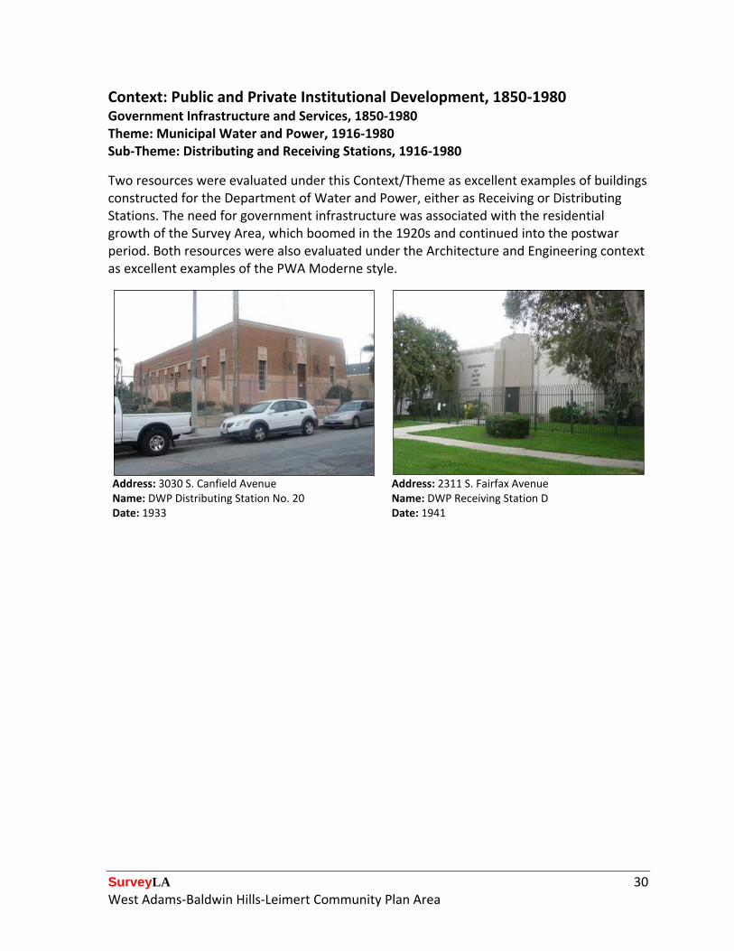
Context: Public and Private Institutional Development, 1850-1980 Government Infrastructure and Services, 1850-1980 Theme: Municipal Water and Power, 1916-1980 Sub-Theme: Distributing and Receiving Stations, 1916-1980
Two resources were evaluated under this Context/Theme as excellent examples of buildings constructed for the Department of Water and Power, either as Receiving or Distributing Stations. The need for government infrastructure was associated with the residential growth of the Survey Area, which boomed in the 1920s and continued into the postwar period. Both resources were also evaluated under the Architecture and Engineering context as excellent examples of the PWA Moderne style.
Address: 3030 S. Canfield Avenue Address: 2311 S. Fairfax Avenue Name: DWP Distributing Station No. 20 Name: DWP Receiving Station D Date: 1933 Date: 1941
SurveyLA 31 West Adams-Baldwin Hills-Leimert Community Plan Area
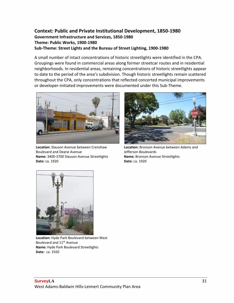
Context: Public and Private Institutional Development, 1850-1980 Government Infrastructure and Services, 1850-1980 Theme: Public Works, 1900-1980 Sub-Theme: Street Lights and the Bureau of Street Lighting, 1900-1980
A small number of intact concentrations of historic streetlights were identified in the CPA. Groupings were found in commercial areas along former streetcar routes and in residential neighborhoods. In residential areas, remaining concentrations of historic streetlights appear to date to the period of the area’s subdivision. Though historic streetlights remain scattered throughout the CPA, only concentrations that reflected concerted municipal improvements or developer-initiated improvements were documented under this Sub-Theme.
Location: Slauson Avenue between Crenshaw Boulevard and Deane Avenue
Location: Bronson Avenue between Adams and Jefferson Boulevards
Name: 3400-3700 Slauson Avenue Streetlights Date: ca. 1920
Name: Bronson Avenue Streetlights Date: ca. 1920
Location: Hyde Park Boulevard between West Boulevard and 11th Avenue Name: Hyde Park Boulevard Streetlights Date: ca. 1920
SurveyLA 32 West Adams-Baldwin Hills-Leimert Community Plan Area
Context: Public and Private Institutional Development, 1850-1980 Military Institutions and Activities, 1850-1980 Theme: Air Raid Sirens and Civil Defense, 1939-1960
Air raid sirens were installed throughout Los Angeles during World War II and the Cold War era. Air raid sirens within the CPA are located near prominent intersections along commercial corridors that border residential neighborhoods. Documented resources include intact examples of multiple air raid siren models, including Federal Model SD-10 “Wire Spool” (left) and Federal Model 500T, “Rotating” (right).
Location: East side of La Brea Boulevard, north of Jefferson Boulevard
Location: North side of Pico Boulevard, west of Victoria Avenue
Name: Air Raid Siren No. 55 Name: Air Raid Siren No. 139 Date: ca. 1940 Date: ca. 1940
SurveyLA 33 West Adams-Baldwin Hills-Leimert Community Plan Area
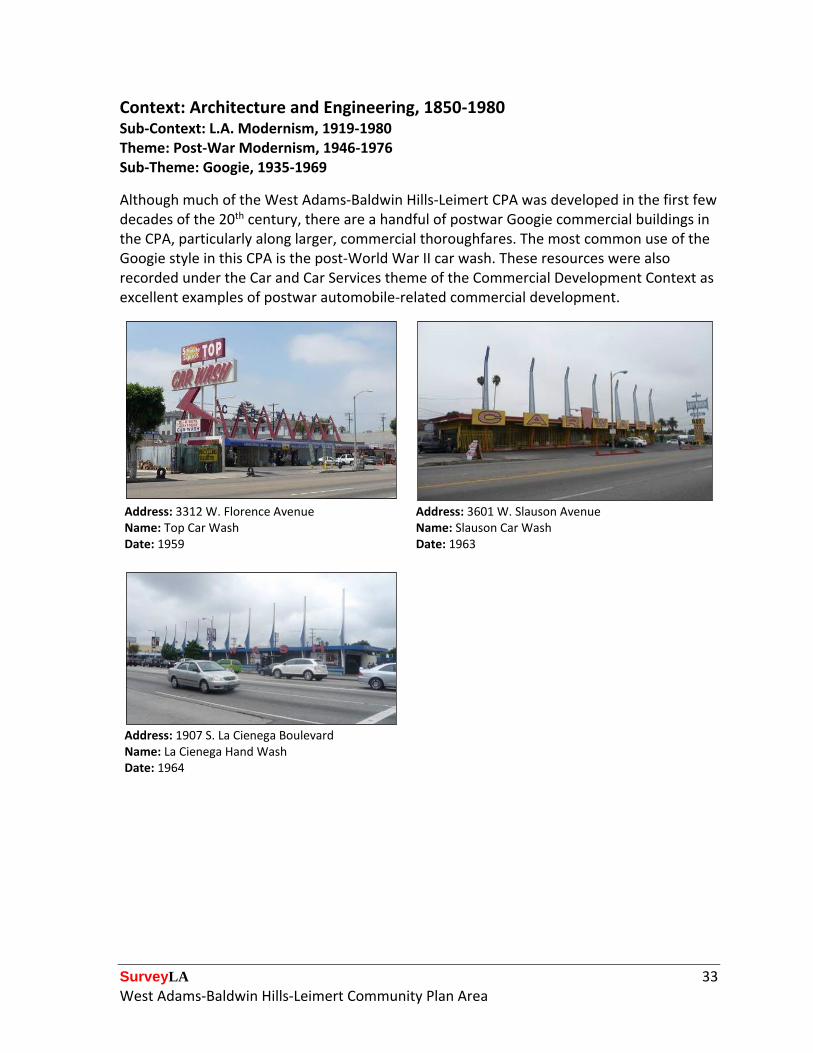
Although much of the West Adams-Baldwin Hills-Leimert CPA was developed in the first few decades of the 20th century, there are a handful of postwar Googie commercial buildings in the CPA, particularly along larger, commercial thoroughfares. The most common use of the Googie style in this CPA is the post-World War II car wash. These resources were also recorded under the Car and Car Services theme of the Commercial Development Context as excellent examples of postwar automobile-related commercial development.
Address: 3312 W. Florence Avenue Address: 3601 W. Slauson Avenue Name: Top Car Wash Name: Slauson Car Wash Date: 1959 Date: 1963
Address: 1907 S. La Cienega Boulevard Name: La Cienega Hand Wash Date: 1964
SurveyLA 34 West Adams-Baldwin Hills-Leimert Community Plan Area
The Post-War Modernism theme under the Architecture and Engineering context was used extensively in the West Adams-Baldwin Hills-Leimert CPA, particularly in Baldwin Hills which was largely developed in the post-World War II era. The hillside communities in Baldwin Hills have a number of Mid-Century Modern, post-and-beam residences designed by noted local architects. A district of Mid-Century Modern apartment buildings was also identified in the flats of Baldwin Hills; it is one of the largest, most intact groupings of this style and property type in the city. Residential properties accounted for the largest amount of resources evaluated under this Context/Theme; however, a few institutional and commercial properties were also recorded.
Address: 4245 Don Alanis Place Address: 5618 Sunlight Place Date: 1958 Date: 1958
SurveyLA 35 West Adams-Baldwin Hills-Leimert Community Plan Area
Context: Architecture and Engineering, 1850-1980 Sub-Context: L.A. Modernism, 1919-1980 Theme: Related Responses to Modernism, 1926-1970 Sub-Theme: Art Deco, 1926-1939
Due to its relatively short period of popularity, Art Deco is not a style that occurs in large numbers in most parts of the city. However, a few intact Art Deco buildings were identified and recorded under this Context/Theme, particularly along the commercial corridors of the CPA. Recorded examples retain the distinctive features of the style. Many were also recorded as significant examples of their respective property types. For instance, the building pictured at the top left is an excellent example of a pre-World War II automobile repair shop. In addition to the commercial examples identified, one multi-family residential building (bottom right) was recorded under the Art Deco Sub-Theme.
Address: 2544 S. Buckingham Road Address: 3016 W. Vernon Avenue Date: 1933 Date: 1930
Address: 5259 W. Adams Boulevard Address: 3006 W. Vernon Avenue Date: 1930 Date: 1939
SurveyLA 36 West Adams-Baldwin Hills-Leimert Community Plan Area
Context: Architecture and Engineering, 1850-1980 Sub-Context: L.A. Modernism, 1919-1980 Theme: Related Responses to Modernism, 1926-1970 Sub-Theme: Streamline Moderne, 1934-1945
A handful of resources were recorded under the Streamline Moderne Sub-Theme. These buildings represent a variety of property types, including multi‐family residences (top left), single-family residences (top right), and small commercial buildings (lower left). Eligible examples feature the distinctive characteristics of the style.
Address: 2716 W. 48th Street Address: 1836 Stearns Drive Date: 1939 Date: 1940
Address: 2620 S. Crenshaw Boulevard Name: Paintcraft Hardware Date: 1946
SurveyLA 37 West Adams-Baldwin Hills-Leimert Community Plan Area
Context: Architecture and Engineering, 1850-1980 Theme: Arts and Crafts Movement, 1895-1930 Sub-Theme: American Foursquares or Prairie Boxes, 1895-1914
This Context/Theme/Sub-Theme was used to evaluate buildings that are excellent examples of the American Foursquare architectural style. Most resources significant under this Sub-Theme are located in the northeastern neighborhoods of West Adams, Arlington Heights, and Jefferson Park. Eligible examples exhibit a high quality of design and craftsmanship; many feature the distinctive central dormer and wide, overhanging eaves, which are characteristic of the style.
Address: 1665 S. Arlington Avenue Address: 1802 S. Crenshaw Boulevard Date: 1905 Date: 1915
SurveyLA 38 West Adams-Baldwin Hills-Leimert Community Plan Area
Context: Architecture and Engineering, 1850-1980 Theme: Arts and Crafts Movement, 1895-1930 Sub-Theme: Craftsman, 1905-1930
This Context/Theme/Sub-Theme was used to evaluate single- and multi-family residences that exemplify the Craftsman style. These resources are located throughout the CPA on busy thoroughfares and within early residential subdivisions. Representative variations of the style include Swiss Chalet, Japanese, and Airplane bungalows. Concentrations of individual resources are located along Crenshaw Boulevard, in the neighborhoods adjacent to the historic route of the Pico Heights Streetcar line and within Angeles Mesa. Many of these resources are also contributors to historic districts that were evaluated under the Arts and Crafts Neighborhoods Sub-Theme.
Address: 1852 S. Crenshaw Boulevard Address: 1416 S. 4th Avenue Date: 1913 Date: 1907
Address: 1521 S. 5th Avenue Address: 2132 S. 9th Avenue Date: 1910 Date: 1912
SurveyLA 39 West Adams-Baldwin Hills-Leimert Community Plan Area
Context: Architecture and Engineering, 1850-1980 Theme: Housing the Masses, 1880-1975 Sub-Theme: Period Revival Neighborhoods, 1918-1942
A number of Period Revival residential historic districts were recorded under this Context/Sub-Theme in the CPA. Buildings in these districts retain a high quality of design and collectively contribute to a distinctive sense of place. Neighborhoods typically contain a combination of single-family (and some multi-family) residences in Spanish Colonial Revival, Mediterranean Revival, Tudor Revival, Dutch Colonial Revival, and American Colonial Revival styles. Commonly the works of a single developer or builder, these districts were often evaluated under the Developers and the Development Process theme as well.
Address: 1700 S. La Fayette Road (contributor to the La Fayette Road Historic District)
Address: 4169 S. 5th Avenue (contributor to the Leimert Park Historic District)
Date: 1925 Date: 1929
Location: W. 78th Place District Name: Crenshaw Knolls Historic District
Address: 3105 W 78th Place (contributor to the Crenshaw Knolls Historic District)
Period of Significance: 1936-1940 Date: 1937
SurveyLA 40 West Adams-Baldwin Hills-Leimert Community Plan Area
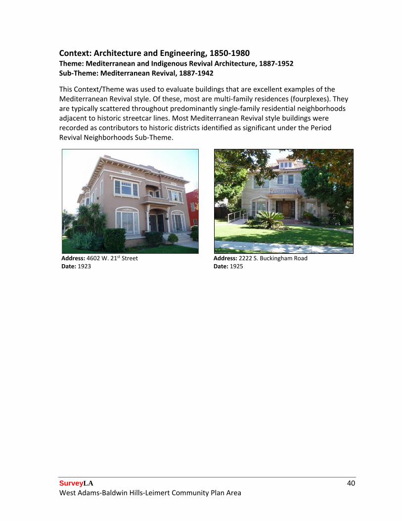
Context: Architecture and Engineering, 1850-1980 Theme: Mediterranean and Indigenous Revival Architecture, 1887-1952 Sub-Theme: Mediterranean Revival, 1887-1942
This Context/Theme was used to evaluate buildings that are excellent examples of the Mediterranean Revival style. Of these, most are multi‐family residences (fourplexes). They are typically scattered throughout predominantly single‐family residential neighborhoods adjacent to historic streetcar lines. Most Mediterranean Revival style buildings were recorded as contributors to historic districts identified as significant under the Period Revival Neighborhoods Sub-Theme.
Address: 4602 W. 21st Street Date: 1923
Address: 2222 S. Buckingham Road Date: 1925
SurveyLA 41 West Adams-Baldwin Hills-Leimert Community Plan Area
Spanish Colonial Revival style architecture is prevalent throughout the CPA. Resources were recorded as eligible if they are excellent examples of their style and exhibit high quality of design and distinctive features. Property types evaluated under this Sub-Theme include single-family residences, multi-family duplexes, fourplexes, bungalow courts, and courtyard apartments. Spanish Colonial Revival style residences were often recorded as contributors to historic districts identified as significant under the Period Revival Neighborhoods Sub-Theme.
Address: 4151 S. 3rd Avenue Address: 2335 S. Lucerne Avenue Date: 1930 Date: 1923
Address: 1650 S. 3rd Avenue Date: 1925
SurveyLA 42 West Adams-Baldwin Hills-Leimert Community Plan Area
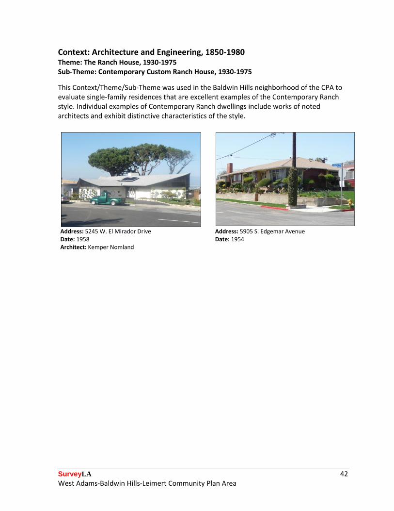
Context: Architecture and Engineering, 1850-1980 Theme: The Ranch House, 1930-1975 Sub-Theme: Contemporary Custom Ranch House, 1930-1975
This Context/Theme/Sub-Theme was used in the Baldwin Hills neighborhood of the CPA to evaluate single-family residences that are excellent examples of the Contemporary Ranch style. Individual examples of Contemporary Ranch dwellings include works of noted architects and exhibit distinctive characteristics of the style.
Address: 5245 W. El Mirador Drive Address: 5905 S. Edgemar Avenue Date: 1958 Architect: Kemper Nomland
Date: 1954
SurveyLA 43 West Adams-Baldwin Hills-Leimert Community Plan Area
Context: Architecture and Engineering, 1850-1980 Theme: Housing the Masses, 1880-1975 Sub-Theme: Ranch House Neighborhoods, 1938-1975
One large district – the Baldwin Hills Estates Historic District – was evaluated under this Context/Theme/Sub-Theme for its large number of Ranch style single-family residences. The houses in this district represent a diverse range of Ranch sub-styles, including predominantly Cinderella and Traditional Ranch. Although the Ranch style is commonly characterized by its one-story, rambling plan and massing, the examples in Baldwin Hills Estates take advantage of the hilly topography of the site by implementing split-level massing, locating the garage on the ground floor, beneath living quarters (depicted in the two examples below).
Location: Hillcrest Avenue District: Baldwin Hills Estates Historic District
Address: 4406 W. Don Diablo Drive (contributor to the Baldwin Hills Estates Historic District)
Period of Significance: 1955-1970 Date: 1956
SurveyLA 44 West Adams-Baldwin Hills-Leimert Community Plan Area
Context: Architecture and Engineering, 1850-1980 Theme: Housing the Masses, 1880-1975 Sub-Theme: Arts and Crafts Neighborhoods, 1890-1930
Several historic districts containing significant concentrations of Craftsman style architecture were identified in the CPA. These districts convey a strong sense of place through high quality of design and craftsmanship. Located predominantly in the Arlington Heights neighborhood, eligible resources include several early intact enclaves of Craftsman residences dating from the turn of the century to the 1910s. These districts were often evaluated under additional Context/Themes, such as Streetcar Suburbanization, as most were developed specifically due to their adjacency to historic streetcar lines.
Location: Bronson Avenue District Name: Central Arlington Heights West Historic District
Address: 1703 S. Bronson Avenue (contributor to the Central Arlington Heights West Historic District)
Period of Significance: 1905-1927 Date: 1905
Location: 18th Street District Name: 18th Street Residential Historic District Period of Significance: 1903-1915
Address: 2518 W. 18th Street (contributor to the 18th Street Residential Historic District) Date: 1907
SurveyLA 45 West Adams-Baldwin Hills-Leimert Community Plan Area
Context: Cultural Landscapes, 1875-1980 Sub-Context: Designed Landscapes, 1875-1980 Theme: Japanese Style Gardens, 1946-1969
The south Crenshaw area of the CPA is notable for being home to a large Japanese American community that relocated to the area after World War II. After internment, Japanese Americans found a cultural, residential, and commercial center in this area from about 1945 until the 1960s. A physical remnant of this community can be found on Norton and Bronson Avenues in the form of Japanese-style gardens in private front yards of single- and multi-family residences. These gardens, though modest, reflect Japanese methods of cultivation and design. The Japanese Style Gardens Theme within the Cultural Landscapes Context was used to document this concentration of Japanese-style landscapes in the Crenshaw Seinan Historic District. This district was also recorded as an ethnic enclave under the Residential Development and Suburbanization context.
Location: Norton Avenue District Name: Crenshaw Seinan Historic District
Address: 3870 S. Norton Avenue (contributor to the Crenshaw Seinan Historic District)
Period of Significance: 1956-1961 Date: 1956
Address: 3811 S. Norton Avenue (contributor to the Crenshaw Seinan Historic District)
Address: 3820 S. Norton Avenue (contributor to the Crenshaw Seinan Historic District)
Date: 1956 Date: 1956
SurveyLA 46 West Adams-Baldwin Hills-Leimert Community Plan Area
For Further Reading
Books and other published material:
Brooks, Charlotte. Alien Neighbors, Foreign Friends: Asian Americans, Housing and the
Transformation of Urban California. Chicago: University of Chicago Press, 2009.
Creason, Glen. Los Angeles in Maps. New York: Rizzoli International Publications, Inc., 2010.
Davis, Mike. City of Quartz. New York: Vintage Books, 1992.
Grimes, Teresa. Historic Resources Associated with African Americans in Los Angeles, National Register of Historic Places Multiple Property Documentation Form. Washington, D.C.: U.S. Dept. of the Interior, National Park Service, 2009.
Kielbasa, John. Historic Adobes of Los Angeles County. Pittsburgh, PA: Dorrance Pub., 1997.
Kurashige, Scott. The Shifting Grounds of Race: Black and Japanese Americans in the Making of Multiethnic Los Angeles. Princeton, NJ: Princeton University Press, 2008.
Meyers, Laura, ed. West Adams’ Landmarks of African American History. Los Angeles: West Adams Heritage Association, 2011.
Sides, Josh. L.A. City Limits: African American Los Angeles from the Great Depression to the Present. Berkeley: University of California Press, 2003.
Withey, Henry F. and Else Rathburn Withey. Biographical Dictionary of American Architects (Deceased). Los Angeles: Hennessey & Ingalls, Inc., 1970.
Online repositories of maps, photographs, periodicals, and other materials:
1900-1930 U.S. Federal Census (Population Schedule), Los Angeles, Los Angeles County, CA, jpeg image, (Online: The Generations Network, Inc., 2009) [Digital scan of original records in the National Archives, Washington, DC], subscription database, <http://www.ancestry.com/>, accessed March 2011.
Digital Sanborn Maps 1867-1970, Sanborn Fire Insurance Maps, accessed March 2011, <http://sanborn.umi.com.ezproxy.lapl.org/>.
Library of Congress, Chronicling America, Historic American Newspapers, Los Angeles Herald, accessed March 2011, <http://chroniclingamerica.loc.gov/>.
SurveyLA 47 West Adams-Baldwin Hills-Leimert Community Plan Area
Los Angeles Bureau of Engineering, Tract Maps, accessed March 2011, <http://eng.lacity.org/>.
Los Angeles Public Library, California Index, accessed March 2011 <http://www.lapl.org/resources/en/california_index.html>.
Los Angeles Public Library Photographic Collection, Historic Photographs, accessed March 2011, <http://photos.lapl.org>.
Los Angeles Times, Mapping L.A., accessed June 2011. <http://projects.latimes.com/mapping-la/neighborhoods/>.
ProQuest Newsstand, Historical Los Angeles Times, accessed March 2011, <http://search.proquest.com.ezproxy.lapl.org/>.
UCLA Digital Collections, Los Angeles Times Photograph Collection, accessed March 2011, <http://digital2.library.ucla.edu/>.
USC Digital Library, California Historical Society, accessed March 2011, <http://digitallibrary.usc.edu/search/controller/index.htm>.
USC Digital Library, Charlotta Bass/ California Eagle, accessed March 2011, <http://digitallibrary.usc.edu/search/controller/index.htm>.
USC Digital Library, LA Examiner, accessed March 2011, <http://digitallibrary.usc.edu/search/controller/index.htm>.
USC Digital Library, Whittington Photographs, accessed March 2011, <http://digitallibrary.usc.edu/search/controller/index.htm>.