86
Hobart Fire Management Area Fire Protection Plan 2017

Hobart Fire Management Area
Fire Protection Plan
2017

2
Document Control
Document History
Version Date Authors Section
1.0 16/9/14 AVK, MP, SB Draft
1.0b 23/9/14 SB,AVK 2nd draft
1.0c 5/12/14 SB, MP 3rd draft, with picture
1.0d 15/12/14 AvK, SB Draft for circulation
1.1 30/12/14 AvK, SB Finalised.
1.1b 13/01/15 SB FRU Mgr comments added
2.0 26/11/15 BSP Draft
2.1 29/11/15 AvK BSP 2nd Draft
2.1 29/11/15 AvK BSP 2nd Draft
2.3 01/12/2016 HFMAC 3rd Draft
2.4 9/12/2016 AvK, BSP FINAL
Document Endorsements
Agency Name & Title Signature Date
_____________________________________
Hobart FMAC Chairman – Axel von Krusenstierna
Date:
Accepted by State Fire Management Council
_____________________________________
Chairman – Ian Sauer
Date:

3

4
Table of Contents
1 Introduction .................................................................................................................................... 7
1.1 Background ............................................................................................................................. 7
1.2 Aim and Objectives ................................................................................................................. 7
1.3 Implementation Strategy ........................................................................................................ 8
1.4 Policy, Standards and Legislation ............................................................................................ 9
1.4.1 Standards ........................................................................................................................ 9
1.4.2 Legislation ....................................................................................................................... 9
2 Establishing the Context ............................................................................................................... 10
2.1 Description of the Hobart Fire Management Area ............................................................... 10
2.1.1 Location, Boundaries and Land Tenure ........................................................................ 11
2.1.2 Climate and Bushfire Season ........................................................................................ 15
2.1.3 Vegetation ..................................................................................................................... 16
2.1.4 Population and Demographics ...................................................................................... 18
2.2 Bushfire History ..................................................................................................................... 19
2.2.1 Bushfire Frequency ....................................................................................................... 19
2.2.2 Fire Ignition Cause ............................................................................................................. 19
2.3 Existing Bushfire Management Plans .................................................................................... 22
Chapter 3 Analysing and Evaluating Bushfire Risk ................................................................................ 23
3.1 Analysing Bushfire Risk ......................................................................................................... 23
3.2 Likelihood and Consequence ................................................................................................ 23
3.3 Overall Risk ............................................................................................................................ 23
3.4 Risk Analysis for the Hobart Fire Management Area ............................................................ 24
Chapter 4 Bushfire Risk Treatment ....................................................................................................... 28
4.1 General Risk Reduction Methods.......................................................................................... 28
4.2 Treatment Selection and Priorities ....................................................................................... 29
4.3 Community Assessment ........................................................................................................ 31
4.4 Annual Works Programs ....................................................................................................... 34
4.5 Implementation .................................................................................................................... 42
5 Monitoring and Review ................................................................................................................. 43
5.1 Review ................................................................................................................................... 43
5.2 Monitoring and Reporting .................................................................................................... 43
6 References .................................................................................................................................... 44
7 Appendices .................................................................................................................................... 45

5
Glossary
Asset A term used to describe anything valued by the community that may be adversely impacted by bushfire. This may include residential houses, infrastructure, agriculture, industry, environmental and heritage sites.
Bushfire Unplanned vegetation fire. A generic term which includes grass fires, forest fires and scrub fires both with and without a suppression objective.1
Bushfire hazard The potential or expected behaviour of a bushfire burning under a particular set of conditions, i.e. the type, arrangement and quantity of fuel, the fuel moisture content, wind speed, topography, relative humidity, temperature and atmospheric stability.
Bushfire risk management
A systematic process to coordinate, direct and control activities relating to bushfire risk; with the aim of limiting the adverse effects of bushfire on the community.
Consequence The outcome or impact of a bushfire event.
Fuel Break A natural or man-made change in fuel characteristics which affects fire behaviour so that fires burning into them can be more readily controlled. In the urban-rural interface, a fuel break is an area or strip of land where bushfire fuel continuity has been substantially altered through the strategic removal or modification of vegetation.
Human Settlement Area
SFMC has developed a spatial dataset used to define the extent and name of Human Settlement Areas (HSA) in Tasmania. The term Human Settlement Area is used instead of Community for the purposes of clarity. HSAs are defined as where people live or work.
Likelihood The chance of something occurring.
Risk The effect of uncertainty on objectives.2 (Note: Risk is often expressed in terms of a combination of the consequences of an event and the associated likelihood of occurrence.)
Risk acceptance The informed decision to accept a risk, based on the knowledge gained during the risk assessment process.
Risk analysis The application of consequence and likelihood to an event in order to determine the level of risk.
Risk assessment The systematic process of identifying, analysing and evaluating risk.
Risk criteria Standards (or statements) by which the results of risk assessments can be assessed. They relate quantitative risk estimates to qualitative value judgements about the significance of the risks. They are inexact and should
be seen as guidelines rather than rules.3
Risk evaluation The process of comparing the outcomes of risk analysis to the risk criteria in order to determine whether a risk is acceptable or tolerable.
Risk identification The process of recognising, identifying and describing risks.
Risk treatment A process to select and implement appropriate measures undertaken to modify risk.
1 Australasian Fire and Emergency Service Authorities Council 2012, AFAC Bushfire Glossary, AFAC Limited, East Melbourne, Australia 2 Standards Australia 2009, Risk management – Principles and guidelines, AS/NZS 31000:2009, Standards Australia, Sydney, Australia 3 Emergency Management Australia 1998, Australian Emergency Manuals Series – Manual 3 Australian Management Glossary, Emergency Management Australia, Dickson, Australia

6
Acronyms
BC Brighton Council
BPP Bushfire Planning and Policy Unit
CCC Clarence City Council
DOD Department of Defence
DVC Derwent Valley Council
FFDI Forest Fire Danger Index
FDR Fire Danger Rating
FIAT Forest Industry Association Tasmania
FMA Fire Management Area
FMAC Fire Management Area Committee
FPP Fire Protection Plan
FRU Fuel Reduction Unit
FT Forestry Tasmania
GFDI Grassland Fire Danger Index
GCC Glenorchy City Council
HCC Hobart City Council
HFMA Hobart Fire Management Area
HSA Human Settlement Area
KC Kingborough Council
PWS Parks and Wildlife Service
REMC Regional Emergency Management Council
SEMC State Emergency Management Committee
SFMC State Fire Management Council
TFGA Tasmania Farmers and Graziers Association
TFS Tasmania Fire Service
WPMT Wellington Park Management Trust

7
1 Introduction This fire protection plan for the Hobart Fire Management Area was prepared by the Hobart Fire
Management Area Committee (HFMAC) and State Fire Management Council (SFMC) executive to
cover 2017. It updates and expands on the previous fire protection plan which covered 2016.
This plan takes a risk management approach and includes a range of measures that would reduce
the bushfire risk within the Hobart Fire Management Area. It should be noted that it will not be
possible to prevent bushfires occurring within the Hobart Fire Management Area however
implementation of this plan should reduce bushfire risk.
The plan is based on risk modelling provided through the SFMC and the knowledge and expertise of
the committee members. It is intended that this and future versions of this plan will become more
comprehensive as further field investigations and detailed local-scale risk assessments are
undertaken and more information is gathered from landowners and managers.
This version of the plan includes information on strategic emergency vehicle access routes (fire
trails) and fuel breaks. The aim is to identify existing strategic access routes, note their current
condition and identify where new vehicle access is required for fire management. Similarly,
information on existing fuel breaks on public land has been gathered and the need for additional
breaks identified, particularly to protect high value assets.
1.1 Background Under Section 20 of the Fire Service Act 1979, fire management area committees are required to
submit to SFMC, on an annual basis, a fire protection plan for its fire management area.
It is a requirement of the fire protection plan that it is consistent with the State Fire Protection Plan
and the State Vegetation Fire Management Policy. The State Vegetation Fire Management Policy is
currently being reviewed.
1.2 Aim and Objectives The aim of this FPP is to document a coordinated and efficient approach towards the identification
and treatment of bushfire-related risk within the Hobart FMA.
The objective of this FPP is to effectively manage bushfire related risk within the Hobart FMA in order
to protect people, assets and other things valuable to the community. Specifically, the objectives of
this plan are to:
Guide and coordinate a tenure blind bushfire risk management program;
Document the process used to identify, analyse and evaluate risk, determine priorities and
develop a plan to systematically treat risk;
Facilitate the effective use of the financial and physical resources available for bushfire risk
management activities;
Integrate bushfire risk management into the business processes of Local Government, land
managers and other agencies;
Ensure integration between stakeholders;
Clearly and concisely communicate risk in a format that is meaningful to stakeholders and the
community; and
Monitor and review the implementation of the Plan, to ensure enhancements are made on
an on-going basis.

8
This plan only deals with reducing the risks to life, property and other assets of value from bushfires,
not other types of fire.
1.3 Implementation Strategy This plan takes a risk management approach and includes a wide range of measures to reduce the
bushfire risk within the Hobart FMA. These fall under the following broad strategies:
1) Reduce the risk of bushfires starting and spreading through:
a) Reducing the number of ignitions within the Hobart FMA
b) Reducing the risk of bushfires that do start spreading
c) Reducing the rate of spread and intensity of bushfires that can’t be immediately
controlled.
2) Reduce the risk of persons being injured or dying as a result of bushfires.
3) Identify and reduce the bushfire risk to the following assets:
a) Residential and other Class 1 to 9 buildings as defined in the National Construction Code
(for an explanation of these classes see Appendix 7)
b) Critical infrastructure including electricity supply, communications, drinking water
supplies, sewerage, transport infrastructure.
c) Cultural heritage values
d) Natural heritage values including threatened species and plant communities, biodiversity,
geoheritage, scenic values
e) Agricultural land and other assets used for primary production.
An outline of the measures being considered to implement this strategy is in Appendix 1.

9
1.4 Policy, Standards and Legislation The following policy, standards and legislation were considered to be applicable to the development
and implementation of the FPP.
Draft Clarence City Council Bushfire Management Strategy 2011
Environment Protection Policy (Air Quality) 2004
Forest Practices Code 2015
Hobart City Council Fire Management Strategy 2014
National Bushfire Management Policy Statement for Forests and Rangelands 2012
Interim Planning Directive 1 – Bushfire-Prone Areas Code
State Fire Protection Plan
State Policy on Water Quality Management 1997
State Strategic Fuel Management Plan
State Vegetation Fire Management Policy
Tasmanian Air Quality Strategy 2006
Tasmanian Electricity Code
Tasmanian Emergency Management Plan
Wellington Park Management Plan 2013
PWS Southern Region Fire Management Strategy 2011
1.4.1 Standards
AS/NZS ISO 31000:2009 - Risk Management – Principles and Guidelines
AS 3959 – 2009 – Construction of Buildings in Bushfire Prone Areas
1.4.2 Legislation
Aboriginal Relics Act 1975 (soon to be replaced)
Building Act 2000
Crown Lands Act 1976
Emergency Management Act 2006
Environment Protection and Biodiversity Conservation Act 1999 (Federal)
Environmental Management and Pollution Control Act 1994
Fire Service Act 1979
Forest Practices Act 1985, and Forest Practices Regulations 2007
Forestry Act 1920
Historic Cultural Heritage Act 1995
Local Government Act 1993
National Parks and Reserve Management Act 2002
Nature Conservation Act 2002
Threatened Species Protection Act 1995
Weed Management Act 1999
Wellington Park Act 1993

10
2 Establishing the Context
2.1 Description of the Hobart Fire Management Area
2.1.1 Location Boundaries and Land Tenure
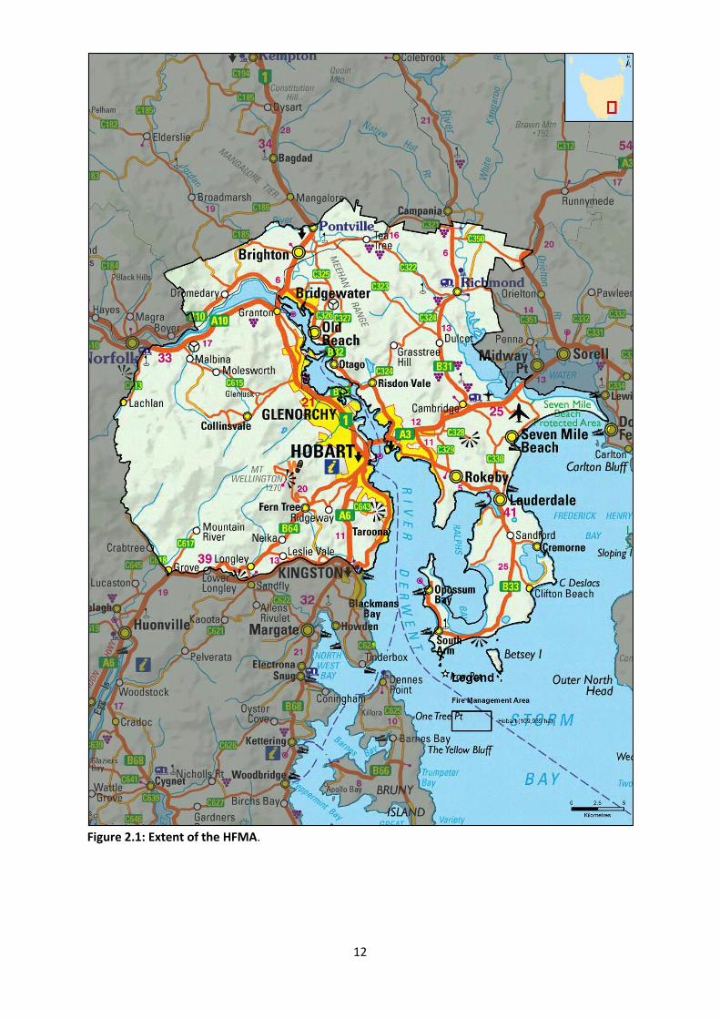
The Hobart Fire Management Area (HFMA) encompasses an area of approximately 110,000 ha. It
covers the greater Hobart area and surrounding suburbs. The plan area also covers satellite suburbs
and outlying communities including Lauderdale, Seven Mile Beach, Richmond, Brighton, Fern Tree,
Molesworth, Lachlan and Mountain River. It includes the local government areas of Hobart,
Glenorchy, Clarence, Brighton and parts of Kingborough and Derwent Valley (see Figure 2.1).
The HFMA has a number of distinctive geographical features; firstly the River Derwent which roughly
bisects the FMA: the Wellington Range which runs westward from the suburbs of Hobart and the
Meehan Range which runs roughly north to south on the eastern side of the Derwent River.
Altitudes within the HFMA range from sea level to 1271m above sea level at the pinnacle of kunanyi
/ Mount Wellington.
Land tenure is predominantly private with Wellington Park making up the largest area of publicly
owned land (see Figure 2.2).
Land Manager/Agency % of Land Managed within the FMA
Private Property 65
Wellington Park Management Trust 14
DPIPWE 8
Local Government 4
Other 9 Table 2.1 - Overview of major land management agencies within the Hobart FMA
This fire prevention plan only covers areas identified as Type 1 and Type 2 interface areas within the
Hobart FMA (see Figure 2.3).
The urban-rural interface is defined as: the line, area, or zone where structures and other human
development adjoin or overlap with undeveloped bushland. This is where the degree of risk to life
and property is most pronounced, and historically where the greatest losses have occurred.
The Tasmania Fire Service classifies the urban-rural interface into two distinct classes based on the
pattern of development within this zone:
Type 1 (Classic) Interfaces are areas where there is a clear distinction between built and natural
environments and here are multiple dwellings in close proximity.
11
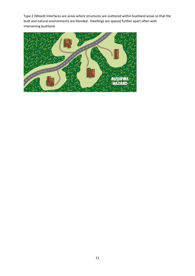
Type 2 (Mixed) Interfaces are areas where structures are scattered within bushland areas so that the
built and natural environments are blended. Dwellings are spaced further apart often with
intervening bushland.
12
Figure 2.1: Extent of the HFMA.

13
Figure 2.2: Broad land tenure across the HFMA

14
Figure 2.3 showing Type 1 and Type 2 interface areas in the HFMA

15
2.1.2 Climate and Bushfire Season
High risk fire weather can be expected from time to time in southern Tasmania when dry winters
and springs are followed by summers where fuels are very dry. The strong north-westerly winds
that often precede cold fronts in summer can contain dry air from the interior of the Australian
mainland. These winds pick up some surface moisture crossing Bass Strait, but as the air stream
descends from the Central Highlands dry air at a higher altitude descends to the surface resulting in
extremely low humidity. This combination of strong winds and low humidity creates the ideal
meteorological conditions for major bushfires in south-east Tasmania and particularly the Hobart
Fire Management Area. Fires that start under these conditions can be expected to move quickly
downwind, and then move more or less at right angles on a broad front when the subsequent south-
westerly wind change arrives. These fires can reach a very high intensity in a short time, even in
areas with relatively low fuel loads, and are very difficult to control until the weather conditions
abate. These were the conditions that produced the 1967, 1998, 2006 and 2013 bushfires around
Hobart.
Unlike the rest of Tasmania, the Derwent Valley and south east of Tasmania regularly experience
Extreme to Catastrophic fire danger ratings. The Hobart FMA is also one of the driest parts of
Tasmania (see Figure 2.4)
Relevant BOM weather stations located within the HFMA:
Grove
Hobart
Hobart Airport
kunanyi / Mt Wellington

16
Figure 2.4: Mean annual rainfall across Tasmanian Fire Management Areas
2.1.3 Vegetation
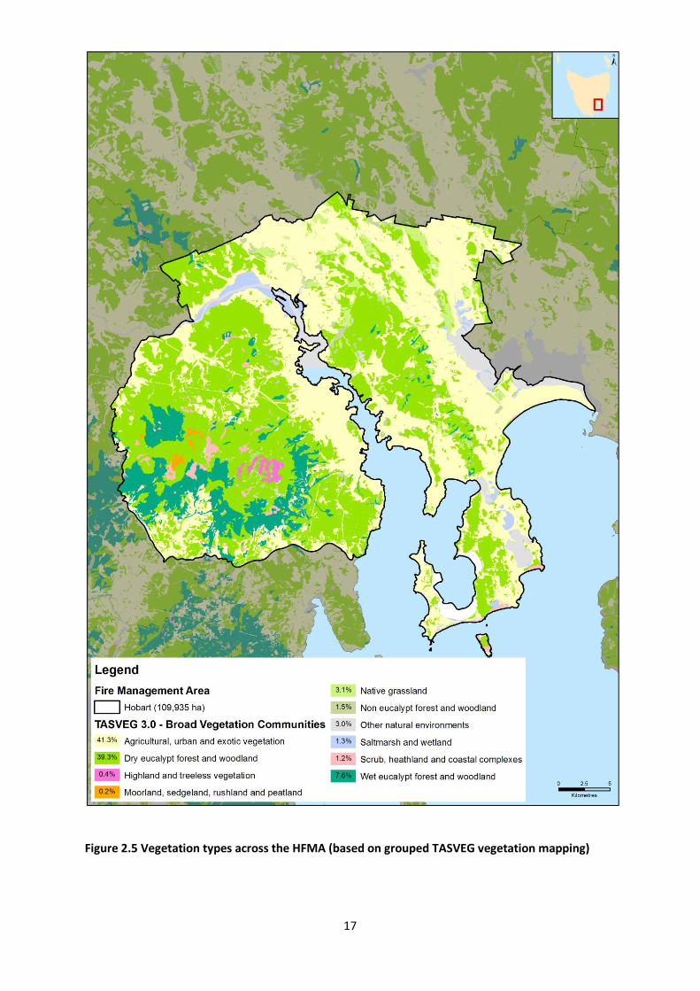
The vegetation within the Hobart FMA has been classified into broad fuel types with similar bushfire
hazard characteristics shown in figure 2.5.
Almost half the HFMA is covered by cleared land, either for urban development or for various types
of agriculture. The remaining native vegetation is predominantly dry Eucalypt forest and woodland.
Wet forest is mainly confined to the eastern and southern slopes of the Wellington Range.
17
Figure 2.5 Vegetation types across the HFMA (based on grouped TASVEG vegetation mapping)

18
2.1.4 Population and Demographics
Settlement is concentrated along the shores of the Derwent River Estuary and Fredrick Henry
Bay as shown on Figure 2.6. The only sizable settlements away from the coast are Brighton,
Richmond and Risdon Vale. Settlement in the HFMA is dominated by two urban areas on either
side of the Derwent River, as well as these large settlement areas there are a number of smaller
towns, villages and settlement areas separated from the main urban areas by bushland (for
example Risdon Vale, Ridgeway, Molesworth). The HFMA also contains large areas of rural
residential development (Type 2 Interface), mainly ~2 ha lots where homes are scattered and
there is no distinct urban/bushland boundary (for example Acton, Sandford, Leslie Vale).
Figure 2.6 Map of population density in the HFMA

19
2.2 Bushfire History
2.2.1 Black Tuesday Bushfires (7 February 1967)
On 7 February 1967. A total of 110 separate fire fronts burnt through some 2,640 square kilometres
of land in Southern Tasmania within the space of five hours. A large part of the Hobart FMA was
affected by the Black Tuesday bushfires.
In total, the fires claimed 62 lives in a single day. Property loss was also extensive with 1293 homes
and over 1700 other buildings destroyed. The fires destroyed 80 bridges, 4800 sections of power
lines, 1500 motor vehicles and over 100 other structures. It was estimated that at least 62,000 farm
animals were killed. The total damage amounted to $40,000,000 in 1967 Australian dollar values.
2.2.2 Bushfire Frequency
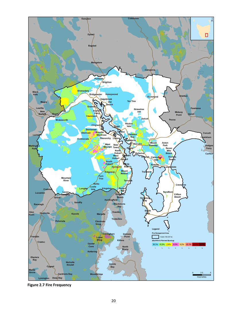
Fire frequency is defined as the total number of fires that occurred in the same area. Figure 2.7
shows areas known to have been affected by fire (including prescribed burns) in the HFMA since the
1967 bushfires based on records provided by the Tasmania Fire Service, local government,
Wellington Park Management Trust, Parks and Wildlife Service and other sources. However, the
records are incomplete and do not include burning carried out by private landowners. The figure
therefore substantially underestimates the area burnt and frequency of burning.
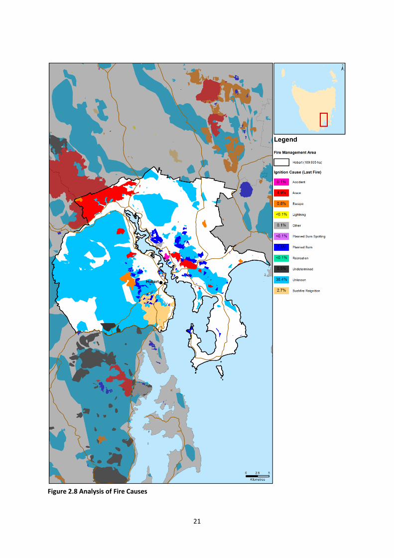
2.2.3 Fire Ignition Cause
The true causes of fire, either through ignition by lightning or caused by human actions have not
been well documented prior to 1990. Table 2.2 give a summary of ignition causes based on
available data since 1967.
Ignition source Percentage of ignitions (%)
Unknown 44
Arson 29
Undetermined 9
Recreation 8
Escape 3
Other 7 Table 2.2 Summary of ignition sources
Figure 2.8 shows the area burnt by fires started by different causes since 1967.
The number of bushfires in the HFMA started by non human related causes is very low. This indicates
that a significant reduction in the risk of fires starting can be achieved through public education and
vigilance.
20
Figure 2.7 Fire Frequency
21
Figure 2.8 Analysis of Fire Causes

22
2.3 Existing Bushfire Management Plans Over the last 15 years a number of land owners and management agencies within the HFMA have
prepared fire management plans and strategies for the land under their control. More recently the
TFS Bushfire Planning and Policy Unit has prepared tenure blind Community Bushfire Mitigation
Plans for high risk areas that did not have existing plans. Existing plans are listed in Appendix 2.
Some of these strategies and plans are being actively implemented, some have been partially
implemented and others have not yet been implemented, sometimes due to a lack of resources or
there being no obvious agency or person to take responsibility.

23
Figure 2.7 Areas of the HFMA currently under some form of fire risk management plan
3 Analysing and Evaluating Bushfire Risk
3.1 Analysing Bushfire Risk Following the Australian Standard of risk assessment (ISO 3100) bushfire risk has been considered
spatially, assessing a combination of likelihood and consequence (PWS 2011). The Bushfire Risk
Assessment Model (BRAM), data run of 24 March 2016 was used to give a preliminary indication of
landscape level risk for this plan. For details on the operation of the model, see Appendix 5.
To determine overall risk the NERAG (National Emergency Risk Assessment Guidelines August 2009)
document (see Appendix 6) was used. The level of risk is determined by combining consequences
and likelihood.
It must be noted that the BRAM and therefore the consequences, likelihood and risk outputs are
based on available spatial data. The analysis has been undertaken on a statewide basis, and maps
are presented as complete for Tasmania. There are however gaps in the data inside and outside
areas of public land. This includes fire history information, particularly on private land, which
contributes to ignition potential information (likelihood), and many of the agricultural values have
not been well captured (consequence). Notwithstanding these limitations, and where the inputs are
accurate, the model can provide an objective spatial analysis of bushfire risk in a landscape
consequence.
3.2 Likelihood and Consequence Likelihood is defined as a qualitative method to assess the likelihood rating to the consequences
occurring. The likelihood of an event was generated by the average combinations of the output
generated from the following spatial information: ignition potential, suppression capabilities and fire
behaviour potential, followed by assigning these output values to categories in a likelihood matrix.
This is taken to mean the likelihood of a fire occurring in a specific area which surpasses the ability of
the fire agencies to contain within the first 24 hours.
Consequences are defined as a qualitative rating of damage from fire to values. The consequences
were taken directly from the output generated through the Values at Risk spatial layer output.
3.3 Overall Risk A representation of risk (see Appendix 6) is developed when the factors of likelihood and
consequence are combined. The generated output map of risk shows qualitative areas of risk, not
areas of perceived risk.
The model assists in objectively defining areas where genuine risk is present. In-depth analysis will
indicate what factor is driving the risk for a given area, and thus guide the determination of
appropriate risk management techniques.
24
3.4 Risk Analysis for the Hobart Fire Management Area The BRAM bushfire risk model, discussed above, was used to examine risk across the HFMA. The
preliminary results of this risk analysis are shown in Figure 3.1. Some members of the Hobart FMAC
noted anomalies in the bushfire risk output shown in Figure 3.1 and these will be investigated and, if
necessary, corrected during further development of the plan.
The Phoenix Rapidfire software package (a bushfire simulator developed by Kevin Tolhurst and
Derek Chong at the University of Melbourne) was used to model the risk of fires impacting on
communities present in the HFMA. This modelling was done as part of the state wide strategic fuel
management assessment. The process involved modelling potential ignition points, incorporating
severe fire weather components and examining fire behaviour based on current fuel loads to
identify the potential impact on human settlement areas. Figure 3.2 shows a preliminary analysis of
potential ignition points that may impact on communities in the HFMA with areas (ha) of impact
under current fuel loads. For each ignition point the model was run for a period of 10 hours, and
assumes that there is no intervention to control the bushfire.
An understanding of where the fires that are likely to impact on communities originate is crucial. It
must be understood that such analysis has many limitations but does provide an indication of which
communities may be at risk as well as identifying areas where strategic burning will assist in
changing fire behaviour.
Strategic fuel reduction burning is one treatment to reduce risk to communities throughout the
HFMA. However, not all vegetation and land use types are treatable through burning. Figure 3.3
shows treatability of fuels through broad –area fuel reduction burning in the HFMA. In summary,
41% of fuels are treatable by burning, while 54% are untreatable, the remaining 5% being water
bodies. Note that figure 3.3 is a preliminary assessment that requires refinement, for example,
urban areas have been shown as “untreatable fuel”. These areas will be removed from the final map
when an assessment of bushfire prone areas within the Hobart FMA is completed.
The distinction between treatable and untreatable fuel was determined by considering the TASVEG
flammability attributes and gives only a general indication of suitability. At an operational level the
distinction between treatable and untreatable fuels will need to be determined in the field. It
should be noted that fuels that are not considered treatable by large burns may be treatable by
smaller planned burns and other methods of fuel reduction, (such as slashing or mulching, and
mechanical thinning and pile burning) particularly close to settlements and other assets at risk.
These areas will be identified through site inspections and considered a high priority for the
establishment of protective fuel breaks where they adjoin residential areas.
The untreatable portion (54% of the area) includes agricultural land. This is primarily because whilst
agricultural land will burn, it is not generally targeted for fuel reduction burning as the risk can be
seasonally variable and managed by other means. It is likely that the dryland agricultural land
through the region does contain areas of grasslands that are treatable through burning, however
current TASVEG mapping does not break the agricultural land mapping unit into different categories.
Land use mapping may be incorporated into future risk analyses as data become available allowing
refinement of this category.

25
Figure 3.1: Preliminary BRAM output for the Hobart FMAC

26
Figure 3.2: Preliminary analysis of potential ignition points that may impact on communities in the
HFMA with areas (ha) of impact under current fuel loads, using the Phoenix Rapidfire simulation
model

27
Figure 3.3: Preliminary analysis of treatability of fuels through fuel reduction burning in the HFMA

28
4 Bushfire Risk Treatment
4.1 General Risk Reduction Methods The following controls are currently in place across the Hobart FMA to assist in the strategic
management of bushfire related risk:
Legislative controls – including abatements, fire restrictions etc.;
Public education campaigns and the use of TFS and SFMC state-wide programs tailored to
suit local needs; (e.g. Private land burning; Community Protection Planning; Bushfire Ready
Neighbourhoods);
State-wide arson prevention programs developed in conjunction with TAS Police and TFS;
Setting of appropriate land subdivision and building standards in line with the Bushfire
Prone Areas Code and building regulations;
Performance monitoring and reporting of FPP outcomes to the relevant Emergency
Management Council and State Fire Management Council as required by the Tasmanian
Emergency Management Plan and the Fire Service Act;
Bushfire management strategies developed and implemented by Hobart City Council,
Clarence City Council, Wellington Park Management Trust, Department of Defence,
Glenorchy City Council and the University of Tasmania.
The means of implementing the bushfire risk reduction strategies in section 1.3 are summarised as:
Increasing the resistance of built and other assets to bushfire attack;
Fuel management – Treatments include the reduction / modification of bushfire fuels
through manual, chemical and prescribed burning methods;
Ignition management - Treatments aim to reduce the occurrence of human induced ignitions
in the landscape and reduce the risk of fires spreading out of control;
Preparedness – Treatments focus on providing suitable access and water supply
arrangements that will assist with fire fighting operations;
Planning – Treatments relate to the development of plans that will improve the ability of
firefighters and the community to respond to bushfire; and
Community Engagement and education – Treatments seek to build relationships, raise
awareness and change behaviours relating to the management of bushfire related risks
within the community.
These have been grouped into 7 broad treatment goals:
1. Reduce the Incidence and severity of bushfires
2. Reduce the bushfire risk to persons
3. Reduce the Bushfire risk to built assets
4. Reduce the bushfire risk to critical infrastructure
5. Reduce the bushfire risk to cultural heritage values
6. Reduce the bushfire risk to natural heritage values
7. Reduce the bushfire risk to primary production.

29
The 7 treatment goals provide a comprehensive framework for overall bushfire risk reduction. The
current status of these 7 goals and the actions recommended to achieve them is summarised in
Appendix 1.
Within the HFMA, the Parks and Wildlife Service, Tasmania Fire Service and Norske Skög have the
capability to plan and carry out planned burns. Clarence and Hobart Councils also have this
capability and both have active burning programs. Glenorchy City Council is developing a five year
burn program.
4.2 Treatment Selection and Priorities The determination of priorities and potential treatment methods is currently based largely on the
results produced by BRAM and Phoenix Rapidfire modelling, augmented with the knowledge and
expertise of the committee members. The plan aims to improve this through systematic field
investigations or fine-scale modelling when resources become available.
4.3 Treatment Completed during 2016 The following areas were hazard reduced during 2016 by the Fuel Reduction Unit of the TFS, PWS,
Hobart and Clarence Council’s or other agencies. The location of the burns is shown of figure 4.1.
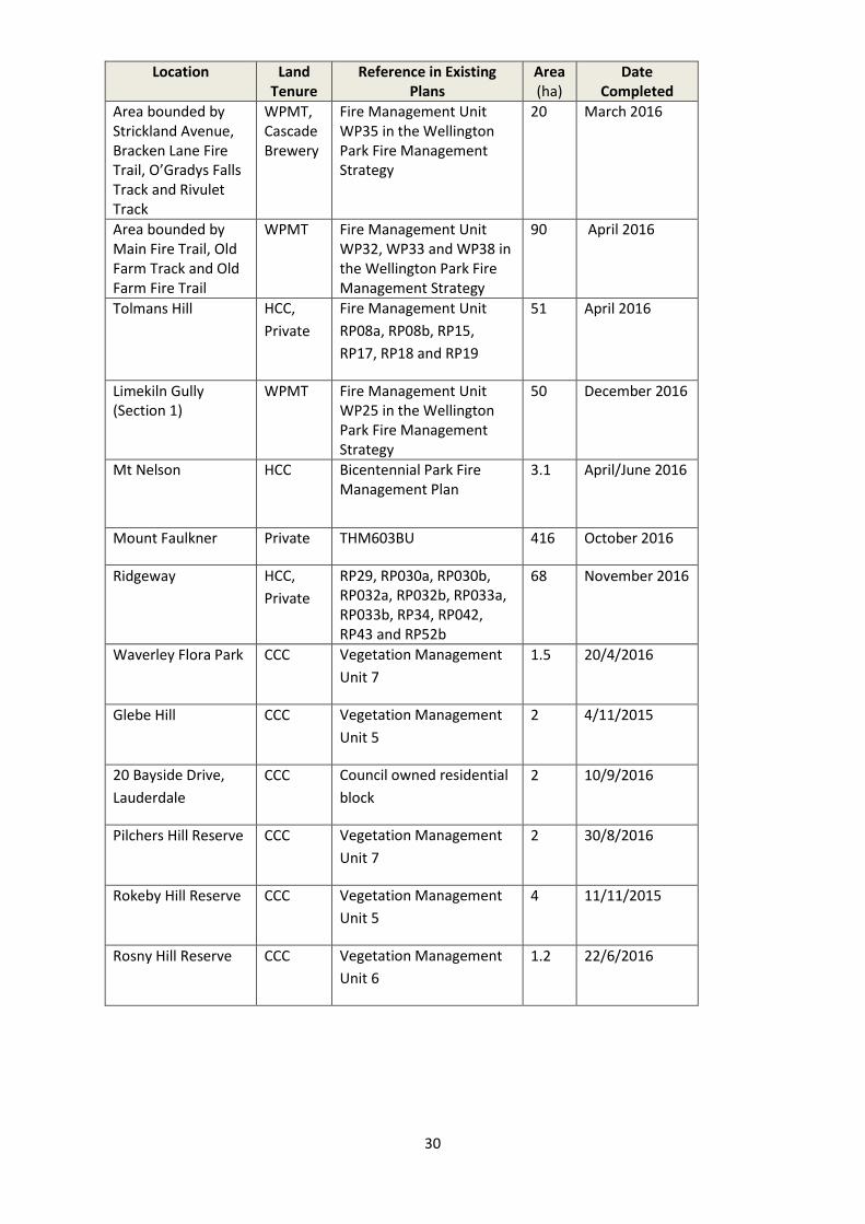
30
Location Land Tenure
Reference in Existing Plans
Area (ha)
Date Completed
Area bounded by Strickland Avenue, Bracken Lane Fire Trail, O’Gradys Falls Track and Rivulet Track
WPMT, Cascade Brewery
Fire Management Unit WP35 in the Wellington Park Fire Management Strategy
20 March 2016
Area bounded by Main Fire Trail, Old Farm Track and Old Farm Fire Trail
WPMT Fire Management Unit WP32, WP33 and WP38 in the Wellington Park Fire Management Strategy
90 April 2016
Tolmans Hill HCC,
Private
Fire Management Unit
RP08a, RP08b, RP15,
RP17, RP18 and RP19
51 April 2016
Limekiln Gully (Section 1)
WPMT Fire Management Unit WP25 in the Wellington Park Fire Management Strategy
50 December 2016
Mt Nelson HCC Bicentennial Park Fire Management Plan
3.1 April/June 2016
Mount Faulkner Private THM603BU 416 October 2016
Ridgeway HCC,
Private
RP29, RP030a, RP030b, RP032a, RP032b, RP033a, RP033b, RP34, RP042, RP43 and RP52b
68 November 2016
Waverley Flora Park CCC Vegetation Management
Unit 7
1.5 20/4/2016
Glebe Hill CCC Vegetation Management
Unit 5
2 4/11/2015
20 Bayside Drive,
Lauderdale
CCC Council owned residential
block
2 10/9/2016
Pilchers Hill Reserve CCC Vegetation Management
Unit 7
2 30/8/2016
Rokeby Hill Reserve CCC Vegetation Management
Unit 5
4 11/11/2015
Rosny Hill Reserve CCC Vegetation Management
Unit 6
1.2 22/6/2016

31
Figure 4.1 Areas burnt 2016 (to December 2016)

32
4.4 Community Assessment Strategic assessment tools have been used to conduct a preliminary assessment across the Hobart
FMA to identify areas of extensive bushland where relatively high intensity bushfires could occur and
where, due to more rugged terrain, they are likely to be more difficult to control. These areas are
shown on figures 4.2.
4.4.1 Potential burn areas that are relatively well understood to be high-risk
These areas are shown in figure 4.2 as purple circles
39. The Albion Heights/Bonnet Hill/Firthside areas
40. Dulcot
41. The Gellibrand Drive/Dorans Hill Rd Sandford
42. Goat Hills
43. Government Hills
45 Huon Rd/ Turnip Fields
46. Lachlan area
47. The Meehan Range from Quoin Ridge to Lauderdale, particularly the Mount Rumney/Mount
Canopus area
49. Mount Dromedary
50. Mount Faulkner/Big Rocky area
51. The Mount Nelson/Tolmans Hill/The Lea areas
52. Pottery Rd/Fossil Hills
53. The Ridgeway and Summerleas Road areas
54. Rokeby Hills/Acton
55. The Wellington Range, particularly the eastern slopes of kunanyi / Mount Wellington
56. Leslie Vale/Longley area
4.4.2 Potential burn areas requiring more detailed investigations
Communities within and bordering these areas are likely to be subjected to high intensity fires at
some time in the future. Further analysis will be required to determine the appropriate bushfire risk
reduction measures for individual communities.
38. Albion Heights West
48. Molesworth/Collinsvale/Glenlusk area
44. The Airport and immediate surrounds
A number of communities already have specific plans in place, these are summarised in Appendix 2.

33
Figure 4.2 Priority Areas

34
4.5 Strategic Fire Trails Currently identified strategic fire trails within the Hobart FMA and their condition are shown in
Appendix 3.
Strategic fire trails are those that provide important access routes for fire fighting, through or along
the perimeter of bushland areas, and are potential control lines for major fires. These trails need to
be maintained to a standard that allows for all weather vehicle access by fire fighting vehicles. This
will generally be Class 3 in the PWS fire trail classification system. Fire Trails that are currently
substandard should be upgraded to at least Class 5.
4.6 Strategic Fuel Breaks These are natural or man-made changes in fuel characteristics which affect fire behaviour so
that fires burning into them can be more readily controlled. The Draft Fuel Break Guidelines
(TFS, 2016) states that: “in the urban-rural interface, a fuel break is an area or strip of land
where bushfire fuel continuity has been substantially altered through the strategic removal or
modification of vegetation”. The fuel modification is generally carried out and the breaks
maintained by mechanical and/or manual removal of fuel rather than burning. Firebreaks are a
specific type of fuel break where all vegetation is removed. Fuel breaks provide access along
the urban/bushland perimeter and should, where possible include a fire trail. They increase the
separation between built assets and the bushfire hazard and may complement Hazard
Management Areas on private property. Fuel breaks facilitate fire fighting operations such as
back burning and direct attack and may provide control lines for planned burns.

35
The Draft Fuel Break Guidelines (TFS, 2016) defines 2 classes of fuel break:

36
Management Fuel Breaks form part of a broader Asset Protection Zone and need to be
complimented by other fuel management treatments to provide sufficient protection to life and
property during bushfires. Their main performance criteria is that the radiant heat impacting on
a structure on one side of the fuel break during back burning or planned burning of the
vegetation of the other side of the break will be less than 12.5 kilowatts per square metre
(kW/m2).
Protective Fuel Breaks provide protection to life and property on the urban-rural interface in
situations where it is unfeasible or undesirable to implement broader-scale fuel management
works within proximity to the interface. They will be wider than a Management Fuel Break in
the same location. Their main performance criteria is that the radiant heat impacting on a
structure on one side of the fuel break during a bushfire burning in the vegetation in the other
side of the break in conditions up to a Fire Danger Index (FDI) of 50 (Severe Fire Danger Rating)
will be less than 12.5 kilowatts per square metre (kW/m2).
As the HFMA regularly experiences FDIs greater than 50, there is a strong case for using a higher
FDI to determine what is an adequate width for Protective Fuel Breaks in the HFMA. In high risk
areas it is recommended that an FDI of 100 (Catastrophic Fire Danger Rating) is used.
Both Hobart and Clarence Councils maintain a network of fuel breaks between their larger bushland
reserves and surrounding urban areas. The University of Tasmania similarly maintains fuel breaks
around its bushland reserve on Mount Nelson.
The strategic fuel breaks in the Hobart FMA are shown in Appendix 4. At present Appendix 4 only
includes fuel breaks on public land.

37
4.7 Annual Works Programs The annual program of works for several of the HFMAC member agencies is tabulated below. It
includes works already planned by land management agencies and additional burns in key locations.
Land managers and fire agencies are responsible for incorporating the works into their respective
annual works programs and planning processes.
PWS and TFS management burn activity autumn and spring 2017:
Agency Location Approx. Area
Parks and Wildlife Service McKenzies Rd, Gordons Hill West, Signal Station South, Porter Bay, Cape Deslacs, Stringy Bark Gully North, Jordan River, Oakleigh Ave
250 ha
Tasmania Fire Service Mt Falkner, Knights Creek, Wellington Park, Tolmans Hill, Mt Nelson, Knocklofty, Lenah Valley, The Lea, Strickland Avenue, Ridgeway
2050 ha
In addition to these larger burns, the following burns are proposed by Clarence and Hobart City
Councils for 2017.
Clarence City Council management burn activity 2017
Reserve Vegetation Management Unit
Area (ha)
Glebe Hill Reserve 11 0.1
Mortimer Bay Reserve 3 3
Mortimer Bay Reserve 13 4
91 Direction Drive,
Otago
Council owned land 1
Pilchers Hill Reserve 7 46
Roscommon Reserve 7 1
Waverley Flora Park 14 1.1
Waverley Flora Park 2 7
Waverley Flora Park 11 2.5
Waverley Flora Park 14 1.1
Waverley Flora Park 20 2
Waverley Flora Park 26 3.2
Wiena Reserve 2 1.1
Natone Hill Reserve 2 4
Gellibrand Drive,
Sandford
Strategically
identified Council
managed roadside
reserves
0.4
38
Hobart City Council management burn activity 2017
No. Reserve VMU
ID
HCC Burn
ID
Area
(HCC)
Area
(Other)
Total
Area Scheduled Season
1 Queens Domain QD01
QD02 2017/18-05 8.31 0 8.31 2017/18 Spring 17
2 Bicentennial
Park
PH9
PH10 2016/17-01 2.8 0 2.8 2017/18
Autumn
18
3 Bicentennial
Park LS11a 2017/18-03 0.81 0.81 2017/18
Autumn
18
4 Bicentennial
Park LS17a 2017/18-04 0.7 0.7 2017/18
Autumn
18
5 McRobies
MG10
MG11
MG17
2017/18-02 15.5 0.6 16.1 2017/18 Autumn
18
6 Queens Domain QD22
QD23 2017/18-01 17.78 0 17.78 2017/18
Autumn
18
7 Queens Domain
QD12
QD13
QD14
2017/18-06 11.38 0 11.38 2017/18 Autumn
18
1 Bicentennial
Park BP22 2018/19-01 0.7 0.7 2018/19
Autumn
19
2 Bicentennial
Park LS15 2018/19-02 1.9 1.9 2018/19
Autumn
19
3 Bicentennial
Park
LS18a
LS18b 2018/19-03 1.4 1.4 2018/19
Autumn
19
4 Bicentennial
Park LS25a 2018/19-04 0.68 0.68 2018/19
Autumn
19
5 Bicentennial
Park
BP03
BP05
BP14
BP16
2018/19-05 9.12 0 9.12 2018/19 Autumn
19
6 Bicentennial
Park LS08a 2018/19-06 0.62 0.62 2018/19
Autumn
19
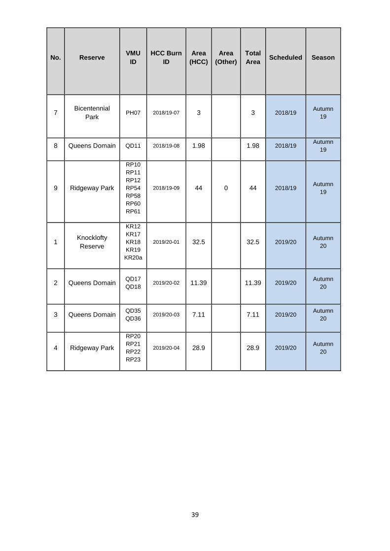
39
No. Reserve VMU
ID
HCC Burn
ID
Area
(HCC)
Area
(Other)
Total
Area Scheduled Season
7 Bicentennial
Park PH07 2018/19-07 3 3 2018/19
Autumn
19
8 Queens Domain QD11 2018/19-08 1.98 1.98 2018/19 Autumn
19
9 Ridgeway Park
RP10
RP11
RP12
RP54
RP58
RP60
RP61
2018/19-09 44 0 44 2018/19 Autumn
19
1 Knocklofty
Reserve
KR12
KR17
KR18
KR19
KR20a
2019/20-01 32.5 32.5 2019/20 Autumn
20
2 Queens Domain QD17
QD18 2019/20-02 11.39 11.39 2019/20
Autumn
20
3 Queens Domain QD35
QD36 2019/20-03 7.11 7.11 2019/20
Autumn
20
4 Ridgeway Park
RP20
RP21
RP22
RP23
2019/20-04 28.9 28.9 2019/20 Autumn
20

40
Fire trail works
Note that the City annually maintains 106 fuel breaks encompassing a total area of 52 ha.
Reserve Business
ID Fire Trail Name
Service
Classification
Ridgeway
R020-
001F,
R020-002F Wayleave FT
Class. 5
Ridgeway R014-001F Bramble East FT Class. 3
Ridgeway R024-002F Bramble West FT
Ridgeway Taswater
Water Mains Road FT
(R11) Class 5
Ridgeway R022-001F Ridgetop FT (R22) Class 5
Bicentennial
Park
BP118-
003W
B008-001F Marlborough FT (S7)
Class. 5
Knocklofty Giblin St Quarry FT Class. 3
Fire Trail and Fuel Break works:
Annual programs:
o HCC annual fire trail inspections and firebreak program
o CCC fire trail and firebreak works
o PWS works programs
o GCC fire break and fire trail works
New works [to be detailed in future versions of this plan]
41
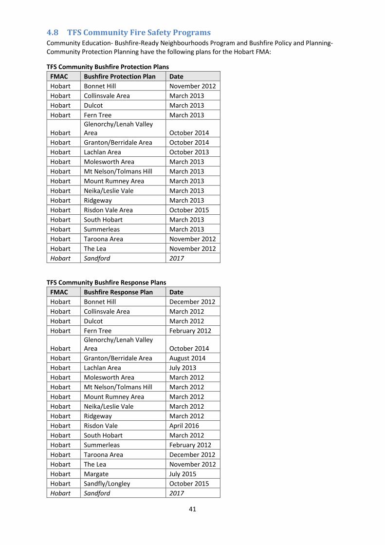
4.8 TFS Community Fire Safety Programs Community Education- Bushfire-Ready Neighbourhoods Program and Bushfire Policy and Planning- Community Protection Planning have the following plans for the Hobart FMA:
TFS Community Bushfire Protection Plans
FMAC Bushfire Protection Plan Date
Hobart Bonnet Hill November 2012
Hobart Collinsvale Area March 2013
Hobart Dulcot March 2013
Hobart Fern Tree March 2013
Hobart Glenorchy/Lenah Valley Area October 2014
Hobart Granton/Berridale Area October 2014
Hobart Lachlan Area October 2013
Hobart Molesworth Area March 2013
Hobart Mt Nelson/Tolmans Hill March 2013
Hobart Mount Rumney Area March 2013
Hobart Neika/Leslie Vale March 2013
Hobart Ridgeway March 2013
Hobart Risdon Vale Area October 2015
Hobart South Hobart March 2013
Hobart Summerleas March 2013
Hobart Taroona Area November 2012
Hobart The Lea November 2012
Hobart Sandford 2017
TFS Community Bushfire Response Plans
FMAC Bushfire Response Plan Date
Hobart Bonnet Hill December 2012
Hobart Collinsvale Area March 2012
Hobart Dulcot March 2012
Hobart Fern Tree February 2012
Hobart Glenorchy/Lenah Valley Area October 2014
Hobart Granton/Berridale Area August 2014
Hobart Lachlan Area July 2013
Hobart Molesworth Area March 2012
Hobart Mt Nelson/Tolmans Hill March 2012
Hobart Mount Rumney Area March 2012
Hobart Neika/Leslie Vale March 2012
Hobart Ridgeway March 2012
Hobart Risdon Vale April 2016
Hobart South Hobart March 2012
Hobart Summerleas February 2012
Hobart Taroona Area December 2012
Hobart The Lea November 2012
Hobart Margate July 2015
Hobart Sandfly/Longley October 2015
Hobart Sandford 2017

42
Community Bushfire Mitigation Plans
FMAC Bushfire Mitigation Plan Date
Hobart Lenah Valley South May 2015
Hobart Mt Nelson/The Lea August 2014
Hobart Mt Nelson/The Lea Stage 2 January 2016
Hobart Sandfly/Longley August 2016
Hobart Glenorchy South January 2016
Hobart UTAS December 2016
4.9 Implementation When the bushfire risk reduction measures identified in this plan are implemented there are a
number of issues that need to be considered by the responsible agency including environmental and
social impacts, risk assessments, coordination with other management activities, setting up any
required monitoring. Any planned burns will require burn plans and consideration of smoke impacts
on health and viticulture.
4.10 Community Engagement and Education
Bushfire-Ready Neighbourhoods Program - Tasmanian Fire Service
A Community Development Coordinator and regionally based Community Development Officers
(Hobart, Launceston and Burnie) have identified 22 communities/areas state-wide which are being
targeted by the Bushfire-ready neighbourhoods program as part of round 2 (2016 to 2018) of the
program. The program takes a community development (‘grass roots’) approach and recognises that
there isn’t a one size fits all approach to bushfire preparedness, highlighting that ‘we all play a part’ (
individuals, TFS, communities). Specifically the program takes a community led approach providing
local community members in higher bushfire risk areas community engagement activities for
preparing for and preventing bushfire/s. The program is facilitated by accessing existing community
networks and resources and developing localised strategies in bushfire preparedness. Some of the
planned community engagement activities include; community forums, information sessions for
communities and brigades alike, workshops, property assessments, field days, focussed group
activities and establishment of Bushfire-ready neighbourhood groups.
Round two communities in the Hobart FMAC are Sandford/South Arm.
For more information about the Bushfire-Ready Neighbourhoods Program visit: fire.tas.gov.au/brn

43
5 Monitoring and Review Monitoring and review processes are required to ensure that the plan remains current and valid.
5.1 Review This plan is subject to an annual review of at least chapters 4 and 5, and a comprehensive review
every five (5) years from the date of approval of the entire plan and appendices, unless significant
circumstances exist to warrant earlier review. This would include:
Changes to the FPP area, organisational responsibilities or legislation;
Changes to the bushfire risk in the area; or
Following a major fire event.
5.2 Monitoring and Reporting Progression towards completion of the treatments will be monitored and reviewed at least every six
(6) months.

44
5 References Australian Standard 3959 - 2009 Construction of Buildings in Bushfire-prone Areas. Standards
Australia, Sydney.
Hines F., Tolhurst K. G., Wilson A. A. G and McCarthy G. J. (2010) Overall Fuel Hazard Assessment
Guide 4th Edition. Fire Research Report 82, Department of Sustainability and Environment.
Melbourne.
Interim Planning Directive No 1, Bushfire-Prone Areas Code. Tasmanian Planning Commission,
Hobart.
National Emergency Risk Assessment Guidelines. National Emergency Management Committee
(2010), Tasmanian State Emergency Service, Hobart.
Parks and Wildlife Service (unpublished). Bushfire Risk Assessment Model Project Business Process
Model (2008). Department of Primary Industries, Parks, Water and Environment, Hobart.
Parks and Wildlife Service (unpublished). Tasmanian Bushfire Risk User Guide (2010). Department of
Primary Industries, Parks, Water and Environment, Hobart.
Parks and Wildlife Service (unpublished). Tasmanian Bushfire Risk Assessment Model (2013).
Department of Primary Industries, Parks, Water and Environment, Hobart.
Tasmania Fire Service 2016, Fuel Break Guidelines, guidelines for the design of fuel breaks in the
urban-rural interface (DRAFT). Tasmania Fire Service, Hobart

45
6 Appendices
Appendix 1 – Bushfire Risk Reduction Strategy Summary
Appendix 2 – Community Specific and General Bushfire Management Plans already in place
Appendix 3 – Strategic Fire Trails
Appendix 4 – Strategic Fuel Breaks
Appendix 5 - BRAM
Appendix 6 – NERAG risk assessment approach
Appendix 7 – Building Code of Australia Building Classes
Appendix 8 - Treatment schedule - annual works program

Appendix 1 - Bushfire Risk Reduction Strategy for Hobart FMA This strategy covers areas within the Hobart FMA classified as Type 1 and Type 2 urban/rural interfaces in the draft Fuel Break Guidelines (TFS 2016).
Note that this table is still under development and the actions and responsibility sections are still being discussed by the Committee.
STRATEGY IMPLEMENTATION CURRENT STATUS ACTIONS RESPONSIBILITY
1. Reduce incidence and Severity of Bushfires
a) Reduce Ignitions (bushfire prevention)
Assess main causes (malicious, escapes, lightning).
Identify ignition hotspots
Encourage public to report arsonists
Reduce accidental ignitions
Adequate TFS and other agency data to analyse.
Some programs to reduce ignitions in place such as the JFLIP.
a) Reduce fuel loads around ignition hotspots
b) Improve response to high ignition frequency areas
c) Police high ignition areas on Total Fire Ban Days
d) Prosecute arsonists
e) General education about risks of escapes from burning off
f) Slash roadside vegetation
g) Maintain vegetation in power line easements
h) Maintain electricity infrastructure
TFS
Agency/land managers
Councils
TasNetworks

47
STRATEGY IMPLEMENTATION CURRENT STATUS ACTIONS RESPONSIBILITY
b) Reduce risk of fires that do start spreading
Establish and maintain a strategic network of emergency vehicle access routes on public and private land
Improve response by fire management agencies including aerial attack.
Provide water supplies for fire fighting in more remote bushland areas.
Good trail network in some reserves but poor in others, trails on private land generally poorly known.
List of strategic fire trails being developed – see appendix 3.
a) Identify areas where existing trails need maintenance and new trails need to be constructed (tenure blind).
b) Encourage and assist landowners to maintain important trails on private property.
c) Provide standards for vehicle access constructions and procedures for inspection and maintenance.
d) Provide funding for access routes of high importance irrespective of tenure.
e) Maintain existing strategic water supply points and construct new ones along emergency vehicle access routes with inadequate supplies.
Agency/land managers
HFMAC
SFMC

48
STRATEGY IMPLEMENTATION CURRENT STATUS ACTIONS RESPONSIBILITY
c) Reduce rate of spread and intensity of bushfires
General hazard reduction in bushland
Established hazard management programs in Hobart and Clarence Council reserves, Wellington Park and on Defence land and PWS reserves
Situation in reserves managed by other Councils and private land needs to be determined.
Some major planned burn programs have not been fully implemented – Mt Faulkner, Meehan Range, Goat Hills
Some bushland areas not covered by planned burn strategies.
a) Identify high hazard and strategic hazard management areas (eg around known high ignition frequency areas).
b) Complete strategic bushfire risk management plans to identify likely ignition locations and fire paths to assist with prioritising bushfire risk reduction measures.
c) Complete Bushfire Mitigation Plans for areas not already covered.
d) Implement a tenure blind planned burning program in treatable vegetation.
e) Determine treatment options for high risk vegetation that can’t be burnt (grazing, slashing, manual thinning etc.)
TFS
PWS
FT
Local government
HFMAC

49
STRATEGY IMPLEMENTATION CURRENT STATUS ACTIONS RESPONSIBILITY
2. Bushfire risk to Persons
a) Reduce bushfire risk to persons
Improve awareness – recognise risks, what to do in different types of bushfire emergency
Fairly well covered in TFS brochures,media campaigns and community engagement programs . E.g..
TFS Women’s Preparedness Program
Bushfire Ready Neighbourhoods Program
Bushfire Ready Schools Program.
a) Prepare and distribute brochures and DVDs
b) Provide personnel to talk at community meetings, schools etc.
c) Publicise and encourage people to use official information channels including ABC local radio, TFS website, SMS, smartphone apps.
d) Improve bushfire reporting and modelling so persons at risk can be given timely and appropriate information.
e) Provide safety information to tourists visiting during the bushfire danger period (in accommodation, car rentals etc.)
TFS-BRN program
Agencies/Councils

50
STRATEGY IMPLEMENTATION CURRENT STATUS ACTIONS RESPONSIBILITY
Ensure safe evacuation in an emergency
Good information provided during emergencies (high priority for the TFS).
Neighbourhood safer places provided in some locations
a) Identify areas that are difficult/dangerous to evacuate due to access, high hazard levels etc.
b) Improve evacuation from high risk areas by providing alternative routes and hazard reduction along existing routes.
c) Provide residents with information on safer evacuation routes during bushfires.
d) Identify facilities that will be difficult to evacuate (hospitals, schools, nursing homes, tourist accommodation etc) and prepare evacuation plans
e) Reduce the bushfire risk around facilities that would be difficult to evacuate in case evacuation is not possible.
f) Identify persons living in bushfire prone areas who can’t self-evacuate and plan for assisted evacuation (get information from district nurses etc) or reduce the bushfire risk to their homes.
g) Expand and publicise Neighbourhood Safer Places program.
TFS CPP program
Dept Education
DHHS
Property/facility owners
Close parks and reserves during high bushfire risk weather
Being implemented in Wellington Park and HCC reserves.
a) Expand system to other parks and reserves in high bushfire risk areas.
PWS/local government

51
STRATEGY IMPLEMENTATION CURRENT STATUS ACTIONS RESPONSIBILITY
3. Reduce Bushfire Risk to Built Assets
a) Reduce bushfire risk to residential and other class 1 to 9 buildings
Ensure all new class 1 to 9 buildings in bushfire prone areas are constructed to AS3959 -2009
Now mandatory in all interim and new planning schemes.
Being adopted by all Councils in accordance with the bushfire prone areas code.
a) Encourage owners to maintain buildings constructed to AS 3959 – 2009.
TFS
Tasmanian Planning Commission
Councils (planning sections)
Government agencies with built assets
Retrofit older houses and other important buildings to AS3959 – 2009
Guidelines for retrofitting available from CFA.
No program to encourage retrofitting private and commercial buildings in Tasmania.
No program to retrofit public buildings.
a) Identify and target buildings in high risk areas
b) Encourage owners to retrofit older buildings to AS3959 – 2009.
c) Provide information on how to retrofit (CFA brochure).
d) Provide on site advice or field days on retrofitting.
e) Interest media in a reality type TV show on retrofitting.
f) See if insurance companies will provide a lower insurance rate on retrofitted buildings as an incentive.
g) Encourage the public sector to retrofit buildings under their management.
TFS/HFMAC
Government agencies with built assets

52
STRATEGY IMPLEMENTATION CURRENT STATUS ACTIONS RESPONSIBILITY
Building maintenance to reduce risk of ignition
Private dwellings – Some general information available in TFS brochures, DVDs etc.
Not known if maintenance to reduce risk of ignition is included in public building maintenance programs.
a) Identify and target buildings in high risk areas.
b) Target building maintenance in pre fire season advertising campaigns
c) Prepare more detailed information
d) Provide on site advice and/or field days.
e) Ensure bushfire protection maintenance (e.g. cleaning gutters) is included in the maintenance schedules of all public sector buildings in bushfire prone areas.
TFS
HFMAC
Local government
Government agencies with built assets
53
STRATEGY IMPLEMENTATION CURRENT STATUS ACTIONS RESPONSIBILITY
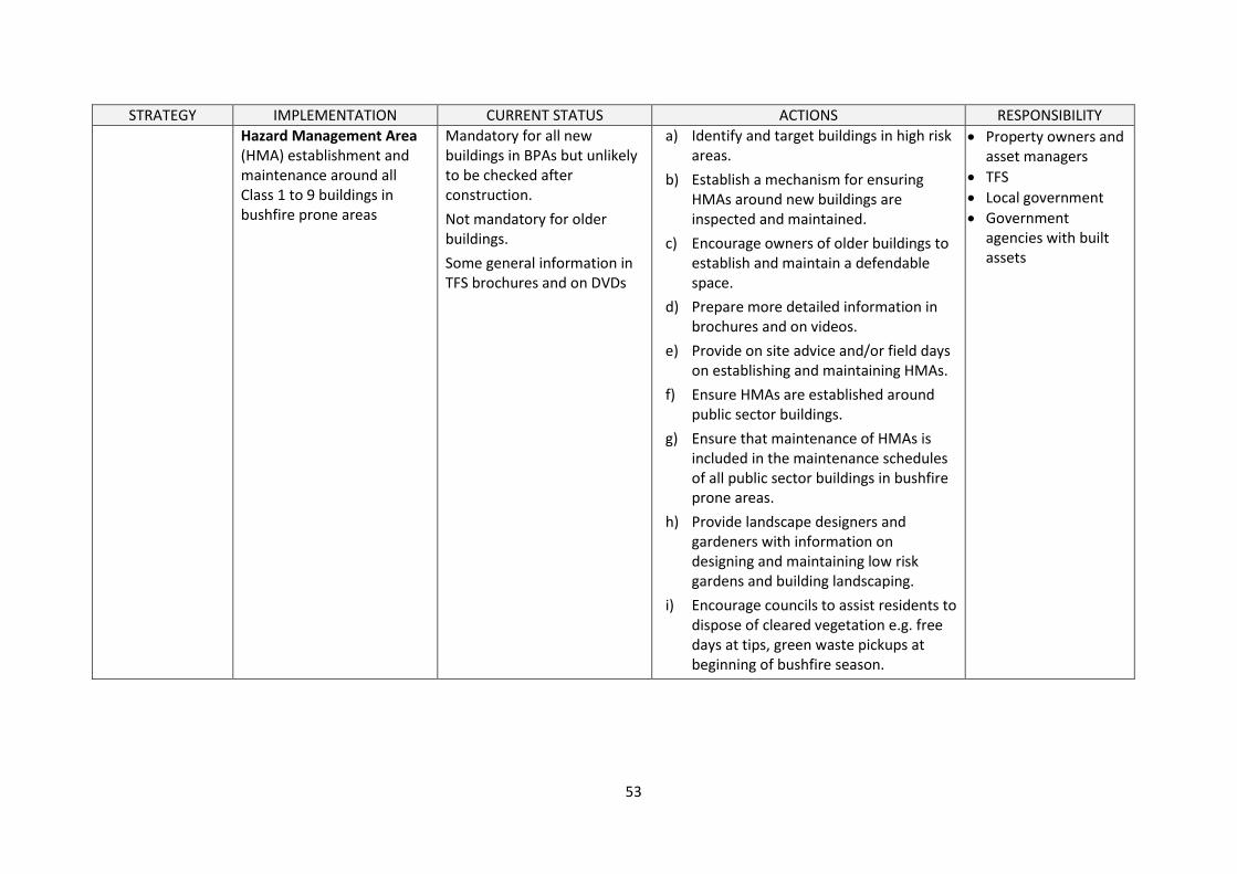
Hazard Management Area (HMA) establishment and maintenance around all Class 1 to 9 buildings in bushfire prone areas
Mandatory for all new buildings in BPAs but unlikely to be checked after construction.
Not mandatory for older buildings.
Some general information in TFS brochures and on DVDs
a) Identify and target buildings in high risk areas.
b) Establish a mechanism for ensuring HMAs around new buildings are inspected and maintained.
c) Encourage owners of older buildings to establish and maintain a defendable space.
d) Prepare more detailed information in brochures and on videos.
e) Provide on site advice and/or field days on establishing and maintaining HMAs.
f) Ensure HMAs are established around public sector buildings.
g) Ensure that maintenance of HMAs is included in the maintenance schedules of all public sector buildings in bushfire prone areas.
h) Provide landscape designers and gardeners with information on designing and maintaining low risk gardens and building landscaping.
i) Encourage councils to assist residents to dispose of cleared vegetation e.g. free days at tips, green waste pickups at beginning of bushfire season.
Property owners and asset managers
TFS
Local government
Government agencies with built assets

54
STRATEGY IMPLEMENTATION CURRENT STATUS ACTIONS RESPONSIBILITY
Establish and maintain fuel breaks in bushland bordering lots with buildings where there is insufficient space on the lot for an adequate Hazard Management Area.
TFS have draft guidelines for establishing and maintaining fuel breaks.
Has generally been assessed and implemented on most Hobart and Clarence Council reserves, also on UTAS and Defence property.
Situation in reserves managed by other councils and PWS needs to be determined
Some implementation on privately owned bush blocks either voluntarily or via hazard abatement notices.
a) Assess need for fuel breaks in Type 1 interface areas, particularly in high risk areas, and encourage landowners/managers to implement.
b) Issues permit infringement advice where landowners are not clearing and maintaining fuel breaks.
TFS
Property owners/land management agencies
Local government (planning)
Establish and maintain fire trails and vehicle accessible routes through fuel breaks on public land where terrain allows.
Has generally been assessed and implemented on most Hobart and Clarence Council reserves, also on UTAS and Defence property.
Situation in reserves managed by other councils and PWS needs to be determined
a) Set standard for emergency vehicle access through fuel breaks in Type 1 interface areas.
TFS/SFMC

55
STRATEGY IMPLEMENTATION CURRENT STATUS ACTIONS RESPONSIBILITY
4. Reduce bushfire risk to critical infrastructure
a) Reduce bushfire risk to electricity supply assets
Transmission lines
Transformers
Substations
Some areas known to be in good condition, but overall knowledge is patchy.
a) Maintain transmission line easements
b) Replace wooden poles with non combustible in high risk areas
c) Reduce bushfire hazard around critical points in the distribution network (substations, Goat Hills)
d) Develop contingencies for power outages due to bushfires
TasNetworks
b) Reduce bushfire risk to communication assets, particularly those used by the emergency services
Radio
Telephone
Mobile phone
Television
Hydro
Known sites: kunanyi / Mount Wellington Goat Hills Mount Faulkner Chimney Pot Hill Mt Nelson Mount Rumney Guy Fawkes Hill Sandford Radio monitoring station on northern Meehan Range
a) Identify critical infrastructure sites in high risk areas
b) Increase resistance of infrastructure
c) Reduce bushfire hazard around infrastructure (manual clearing, slashing, burning)
d) Secure power supply (underground, replace wooden with steel or concrete poles)
e) Develop contingencies
Emergency Response agencies
Communications service providers

56
STRATEGY IMPLEMENTATION CURRENT STATUS ACTIONS RESPONSIBILITY
c) Reduce bushfire risk to drinking water supply
Pumps (including power supply)
treatment works (note presence of hazardous chemicals)
To be determined a) identify critical infrastructure sites in high risk areas
b) Increase resistance of infrastructure
c) Reduce bushfire hazard around infrastructure (manual clearing, slashing, burning)
d) Secure power supply (underground, replace wooden with steel or concrete poles)
e) Develop contingencies in case critical infrastructure is damaged by bushfire
TasWater
d) Reduce bushfire risk to sewerage system and sewage treatment infrastructure
Pumps (including power supply)
treatment works (note presence of hazardous chemicals)
To be determined a) identify critical infrastructure sites in high risk areas
b) Increase resistance of infrastructure
c) Reduce bushfire hazard around infrastructure (manual clearing, slashing, burning)
d) Secure power supply (underground, replace wooden with steel or concrete poles)
e) Develop contingencies in case critical infrastructure is damaged by bushfire
TasWater

57
STRATEGY IMPLEMENTATION CURRENT STATUS ACTIONS RESPONSIBILITY
e) Reduce Bushfire risk to drinking water catchments and water storages
Protect catchment areas and open storage reservoirs from bushfires
Major catchment areas on the Wellington Range.
Open storages in Ridgeway Reserve, Wellington Park, Risdon Brook Reserve and Flagstaff Gully.
TasWater has an agreement with TFS on the use of fire retardants in drinking water catchements
a) Consider drinking water catchments as assets to be protected when planning hazard reduction programs
WPMT
FRU
HCC
CCC
f) Reduce bushfire risk to key transport infrastructure
Airport ??
To be determined Open discussions with the Airport HFMAC/SES?
Airport Authority
5. Reduce bushfire risk to cultural heritage values
Identification of cultural values, and assessment for exposure/susceptibility to damage or loss from fire
Heritage values considered in most Bushfire Management Plans prepared by land managers.
FRU consideres heritage in operational burn plans.
a) Open communication with heritage bodies, councils
b) Determine and implement the most effective measures for reducing the risk of damage to cultural heritage values by bushfires or bushfire control and management activities
HFMAC
?

58
STRATEGY IMPLEMENTATION CURRENT STATUS ACTIONS RESPONSIBILITY
6. Reduce bushfire risk to natural heritage values
a) Reduce bushfire risk to biodiversity, including threatened species and plant communities.
Fire dependant plant communities require burning in accordance with their optimal fire regimes. (note: lack of fire is also a risk to biodiversity)
Pre and post burn weed control required.
Some areas under active management, other areas poorly known
a) Compile known natural heritage values (NVA, Tasveg and other databases)
b) Identify areas of possible high value for future investigation
c) Ensure that burning programs primarily for hazard management do not adversely affect biodiversity values
d) Ensure ecosystems that require regular fire to maintain their viability are burnt is accordance with their optimal fire regimes.
e) Control weeds before and after burns.
HFMAC/SFMC
TFS
b) Reduce bushfire risk to other (non biological) values
Values that require protection include: geoheritage and scenic values.
a) Ensure agencies carrying out bushfire management and control activities are aware of the location of natural heritage assets so they can avoid inadvertent damage.
HFMAC/SFMC
TFS

59
STRATEGY IMPLEMENTATION CURRENT STATUS ACTIONS RESPONSIBILITY
7. Reduce bushfire risk to primary production
a) Raise awareness of bushfire risk mitigation programs within context of key primary industries, to better deliver burns and other risk management activities in areas where they operate
livestock
fencing
aquaculture
horticulture
viticulture
apiculture?
Engagement with specific peak bodies begun, to continue through 2017 and 2018
a) TFGA: Community forums during 2015-6, field days in early 2017 (in planning stages 2016)
b) Wine Tasmania: Smoke taint field days in planning for early 2017
c) Apiculture: Liaison with beekeepers during summer 2015-6
TFS Fuel Reduction Unit Community Engagement Section
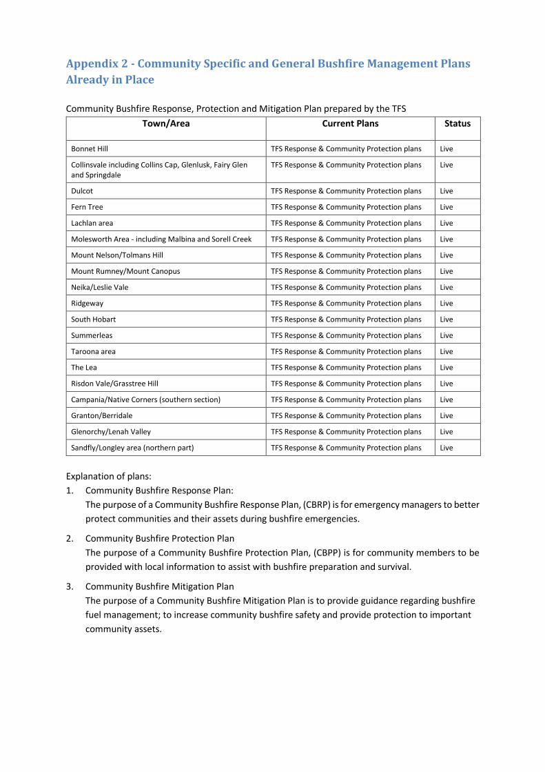
Appendix 2 - Community Specific and General Bushfire Management Plans
Already in Place
Community Bushfire Response, Protection and Mitigation Plan prepared by the TFS
Town/Area Current Plans Status
Bonnet Hill TFS Response & Community Protection plans Live
Collinsvale including Collins Cap, Glenlusk, Fairy Glen and Springdale
TFS Response & Community Protection plans Live
Dulcot TFS Response & Community Protection plans Live
Fern Tree TFS Response & Community Protection plans Live
Lachlan area TFS Response & Community Protection plans Live
Molesworth Area - including Malbina and Sorell Creek TFS Response & Community Protection plans Live
Mount Nelson/Tolmans Hill TFS Response & Community Protection plans Live
Mount Rumney/Mount Canopus TFS Response & Community Protection plans Live
Neika/Leslie Vale TFS Response & Community Protection plans Live
Ridgeway TFS Response & Community Protection plans Live
South Hobart TFS Response & Community Protection plans Live
Summerleas TFS Response & Community Protection plans Live
Taroona area TFS Response & Community Protection plans Live
The Lea TFS Response & Community Protection plans Live
Risdon Vale/Grasstree Hill TFS Response & Community Protection plans Live
Campania/Native Corners (southern section) TFS Response & Community Protection plans Live
Granton/Berridale TFS Response & Community Protection plans Live
Glenorchy/Lenah Valley TFS Response & Community Protection plans Live
Sandfly/Longley area (northern part) TFS Response & Community Protection plans Live
Explanation of plans:
1. Community Bushfire Response Plan:
The purpose of a Community Bushfire Response Plan, (CBRP) is for emergency managers to better
protect communities and their assets during bushfire emergencies.
2. Community Bushfire Protection Plan
The purpose of a Community Bushfire Protection Plan, (CBPP) is for community members to be
provided with local information to assist with bushfire preparation and survival.
3. Community Bushfire Mitigation Plan
The purpose of a Community Bushfire Mitigation Plan is to provide guidance regarding bushfire
fuel management; to increase community bushfire safety and provide protection to important
community assets.

General Bushfire Management Plans Already in Place
PLAN NAME TENURE DATE STATUS AREA NOTES
Wellington Park Fire Management Strategy
Wellington Park, Glenorchy City Council, Hobart City Council, private
2006 Implemented 16,090 ha Includes some private and Council land adjoining Wellington Park. Being revised.
PWS controlled land within the HFMA
PWS Southern Region Strategic Fire Management Plan
2011 Partly Implemented All PWS managed land in the Southern Region
Mount Faulkner Region Strategic Fire Management Plan
Mixed private and public 2005 Partly Implemented 5830 ha Some fire trail and waterhole upgrading, planned burn program started in 2016
Meehan Range Regional Fire Management Strategy
Mixed Private and public 2007 Partly implemented 5359 ha Some fire trail upgrading completed, planned burns near Risdon Vale ?? completed, others planned for 2017
Risdon Brook Dam Catchment and Adjoining Areas Fire Management Plan
Mixed private and public 2001 Partly implemented 3,400 ha Large burn on Mount Direction and some fire trail repairs
Goat Hills Fire Management Plan
Mixed private and Glenorchy City Council
2006 Partly implemented 490 ha Maintenance of fire trails - planned burns not implemented. Planning to be taken over by TFS.
Ridgeway Park/Waterworks Reserve Fire Management Plan
Hobart City Council 2003 Implemented 480 ha Being revised by HCC

62
PLAN NAME TENURE DATE STATUS AREA NOTES
Knocklofty Reserve/McRobies Gully Fire Management
Hobart City Council 2005 Implemented 403 ha Being revised by HCC
Bicentennial Park/Porter Hill Reserve Fire Management Plan
Hobart City Council 2014 Implementation commencing
230 ha Includes a number of nearby small reserves
Pilchers Hill Bushfire Management Plan
Clarence City Council 2016 Implemented 130ha Planned burns undertaken and on-going
Queens Domain Fire Management Plan
Hobart City Council 2008 Implemented 164 ha
Lauderdale Wetlands Reserve Bushfire Management Plan
Clarence City Council 2016 Implemented 122 ha
Rosscommon Bushfire Management Plan
Clarence City Council 2016 Implemented 117 ha Planned burns undertaken and on-going
Fort Direction Ammunition Storage Facility Bushfire Management Plan
Department of Defence 2013 Implemented 107 ha
University Reserve, Sandy Bay Campus Fire Management Plan (draft)
University of Tasmania 2010 Partly implemented 90 ha Fire breaks and some fire trails maintained, planned burns not implemented
Waverley Flora Park Bushfire Management Plan
Clarence City Council 2016 Implemented 82 ha Planned burns undertaken and on-going

63
PLAN NAME TENURE DATE STATUS AREA NOTES
Mortimer Bay Coastal Reserve Bushfire Management Plan
Clarence City Council 2016 Implemented 55 ha Planned burns undertaken and on-going
Gordons Hill State Recreation Area
Parks and Wildlife Service 2011 Partly Implemented 50 ha Clarence Council plan for northern section implemented before transfer to PWS
Natone Hill Bushfire Management Plan
Clarence City Council 2016 Implemented 43 ha Planned burns undertaken and on-going
Milford Bushfire Management Plan
Private 2008 Partly implemented 40 ha One planned burn completed
Roches Beach Coastal Reserve and Nowra Bushland Reserve Bushfire Management Plan
Clarence City Council 2016 Implemented 24 ha
Glebe Hill Reserve, Howrah, Bushfire Management Plan
Clarence City Council 2016 Implemented 22 ha Planned burns undertaken and on-going
Rosny Hill Bushfire Management Plan
Clarence City Council 2016 Implemented 21 ha Planned burns undertaken and on-going
7 Yamada Place Mornington (Knopwood Hill)
Private 2011 Unknown 21 ha
Bedlam Walls Bushfire Management Plan
Clarence City Council 2016 Implemented 15 ha
Rosny Foreshore Bushfire Management Plan
Clarence City Council 2016 Implemented 15 ha Planned burns undertaken and on-going

64
PLAN NAME TENURE DATE STATUS AREA NOTES
Seven Mile Beach Reserve Bushfire Management Plan
Clarence City Council 2016 Implemented 31 ha
Rokeby Hills Reserve Bushfire Management Plan
Clarence City Council 2016 Implemented 40 ha Planned burns undertaken and on-going
Canopus – Centaur Bushland Reserve, Mt Rumney, Bushfire Management Plan
Clarence City Council 2016 Implemented 7 ha
Wiena Bushland Reserve, Lindisfarne, Bushfire Management Plan
Clarence City Council 2016 Implemented 3 ha Fire Trail network and fuel breaks re-established in 2016
Barossa Catchment/Kalang Avenue land, Lenah Valley
Hobart City Council 2006 Partly implemented 33 ha Partly covered by the Wellington Park Fire Management Strategy
Glenorchy South TFS Bushfire Planning and Policy Unit 2016
Lenah Valley South Bushfire Mitigation Plan
TFS Bushfire Planning and Policy Unit 2015
Mt Nelson/The Lea Bushfire Mitigation Plan Stage 1
TFS Bushfire Planning and Policy Unit 2014
Mt Nelson/The Lea Bushfire Mitigation Plan Stage 2
TFS Bushfire Planning and Policy Unit 2016
Sandfly/Longley TFS Bushfire Planning and Policy Unit 2016

Appendix 3 – Existing and Proposed Strategic Fire Trails These fire trails provide important access routes for fire fighting, through or along the perimeter of bushland areas, and are potential control lines for major
bushfires. This table and incomplete and is awaiting further investigations by land owners.
Name Start Point End point Maintained by
Desired Classification1
Current Classification1
GIS layer Y/N
Notes
East West Trail Zig Zag Trail (Goat Hills)
Jefferys Track PWS 3 5 Yes Key access route running the length of Wellington Park.
Big Bend Trail Pinnacle Road at Big Bend
East West Trail PWS 3 substandard Yes Important link to East West Trail and potential control line.
Ringwood Trail End of Ringwood Road
East West Trail PWS 3 5 Yes Important link to East West Trail and potential control line. Property owner between Ringwood Road and the Wellington Park boundary does not allow non emergency access.
Collins Cap Trail End of Suhrs Road East West Trail PWS 3 3 Yes Important link to East West Trail and potential control line.
Jefferys Track End of Mitchells Road, Crabtree
Hydehurst Road, Lachlan
DVC Norske Skog PWS
3 variable- northern end Class 1, southern end Class 5, about 3 km substandard.
Yes Important north-south link across the Wellington Range. Provides access to the western end of the East-West Trail.
Zig Zag Trail Collinsvale Road Montrose Trail in Wellington Park
Tasnetworks 3 variable- northern end Class 3, southern end Class 5,
Yes Important east-west link across Goat Hills. Provides access to the East West Trail, Dooleys Fire Trail
Chapel Fire Trail Knights Creek Trail Montrose Trail GCC, Tasnetworks
3 Substandard Yes Important east-west link across Goat Hills. Provides access to the Zig Zag Trail
Dooleys Fire Trail Zig Zag Trail Dooleys Avenue, Berridale
GCC 3 5 Yes Important link to top of Goat Hills.

66
Name Start Point End point Maintained by
Desired Classification1
Current Classification1
GIS layer Y/N
Notes
Priest Fire Trail Priest Place Tolosa Fire Trail GCC 3 3 Yes Important entry to Wellington Park and control line for fires in the Limekiln Gully area
Main Fire Trail Lenah Valley Road Strickland Avenue HCC 3 3 Yes Important north-south link along the boundary of Wellington Park
Tolosa Fire Trail Tolosa Street Merton Weir GCC TasWater
3 3 Yes Provides access to a water supply and the western end of Priest Fire Trail
Bracken Lane Fire Trail
Curtis Avenue Pillinger Drive HCC 3 3 Yes Provides alternative emergency access between Pillinger Drive and Huon Road. Some steeper sections require repair
Unnamed Mt Nelson Signal Station
Enterprise Road HCC 3 3 yes In Bicentennial Park
New Town Trail (M1) and K13
Main Fire Trail (Wellington Park)
Fire Trail K9 in Knocklofty Reserve
HCC Private
3 ? yes Links Knocklofty Reserve to Wellington Park (Main Fire Trail), Important east-west control line and access
K3/K8 (Knocklofty Reserve)
Weerona Avenue (Mt Stuart)
Forest Road K3 – Private K8 - HCC
3 Variable Yes Separates Knocklofty Reserve from urban areas to the easet. K8 in Knocklofty Reserve well maintained. K3 on private property not maintained.
K1/K9 (Knocklofty Reserve)
Forest Road Giblin Street HCC 3 ? Yes Traverses Knocklofty reserve
R14 (Ridgeway Reserve)
Bramble Street, Ridgeway
Proctors Road HCC 3 ? Yes Links Ridgeway to Southern Outlet. Runs along northern perimeter of Ridgeway
R8 (Ridgeway Reserve)
Ridgeway Road Woodridge Place (Tolmans Hill)
HCC Private
3 ? Yes Important alternative access to Tolmans Hill
Granton Heights Fire Trail
Granton Heights Road
Dixons Fire Trail at Snake Mount
TFS 3 ? Yes Important link to Dixons fire Trail
Nassau Spur Fire Trail
Lyell Highway Dixons Fire Trail at Snake Mount
TFS 5 ? Yes

67
Name Start Point End point Maintained by
Desired Classification1
Current Classification1
GIS layer Y/N
Notes
Dixons Fire Trail Lyell Highway Granton Heights Fire Trail at snake Mount
TFS 3 ? Yes Important primary control line on Mount Faulkner.
Douglas Road Fire Trail
End of Douglas Road
Dixons Fire Trail TFS 3 ? Yes Important access and egress link to Dixons Fire Trail
Wagner Fire Trail End of Wagner Road
Sky Farm Fire Trail
TFS 3 ? Yes Access to the top of Mount Faulkner from Molesworth. Important control line.
Sky Farm Fire Trail End of Sky Farm Road
Wagner Fire Trail TFS 3 ? Yes Main access to the top of Mount Faulkner from Clarement.
Back Faulkner Fire Trail
Wagner Fire Trail Lowes Ridge Trail TFS 5 5 Yes Strategic link around southern side of Mount Faulkner
Lowes Ridge Fire Trail
Arunta Crescent, Chigwell
Back Faulkner Fire Trail
TFS 3 ? Yes Continuation of Back Faulkner Fire Trail
RB3 (Risdon Brook Dam)
Baskerville Road Risdon Brook Reservoir
Tasnetworks 3 ? Yes Follows Transmission line easement
RB4 (Risdon Brook Dam)
Direction Drive Risdon Brook Dam
PWS 5 5 Yes Important control line
unnamed Downhanstown Road
Downhams Road Private 3 5
Yes Important north-south link
MR5 (Meehan Range)
Downhams Road Flagstaff Gully Link
PWS Private
3 ? Yes Important north-south link
MR4 (Meehan Range)
Downhams Road Flagstaff Gully Road
Private 5 ? Yes Important north-south link
MR6 (Meehan Range)
MR5 MR7 Private 5 ? Yes Important east-west link
MR7 (Meehan Range)
Kings Road Hobdens Road Private 5 ? Yes Important north-south link
MR8 (Meehan Range)
Hobdens Road MR9 PWS Private
3 5
Yes Important east-west link
MR9 (Meehan Range)
Belbin Road MR5 PWS Private
3 5
Yes Important east-west link
MR12 (Meehan Range)
Houston Drive Mt Rumney Road Private 5 ? Yes Important north-south control line and link to Mt Rumney Road

68
Name Start Point End point Maintained by
Desired Classification1
Current Classification1
GIS layer Y/N
Notes
MR15 (Meehan Range)
Mt Rumney Road MR 11 Private 5 5 Yes North –south control line along western foothills of Meehan Range
MR11 (Meehan Range)
Mt Rumney Road Acton Court Private 3 5 Yes Important emergency access to eastern end of Mt Rumney Road
MR13 (Meehan Range)
Mt Rumney Road (MR11)
MR14 (Acton Drive)
Private 5 5 Yes Important access along top of Meehan Range
MR16 (Meehan Range
Rockingham Drive MR15 Private 5 ? Yes Important link between Mt Rumney Road and Clarendon Vale
MR14 (Meehan Range)
Rockingham Drive Acton Drive Private 3 ? Yes Important east-west link and control line across Meehan Range
MR17 (Meehan Range)
Tara Drive MR14 Private 5 variable Yes Important link and north-south control line. Most of the link is a private driveway maintained to Class 3 standard.
W2/W5 (Waverley Flora Park)
Aruma Street Waverley Street CCC 3 Variable Yes North-south link across Waverley Flora Park
W4 (Waverley Flora Park)
Vadura Place Quarry Road CCC 3 Variable Yes Important access around eastern portion of the Waverley Flora Park
W11 (Waverley Flora Park)
W4 W2 CCC 3 5 Yes Important east-west link in Waverley Flora Park
MB2/MB3/MB4 MB3 (Gellibrand Drive)
MB4 (Gellibrand Drive)
CCC 5 5 Yes Important boundary trail along eastern side of Mortimer Bay Reserve
NH2/NH3 (Natone Hill Reserve)
Tianna Road (northern end)
Tianna Road (southern end)
CCC 3 3 Yes Boundary trail around Natone Hill Reserve
PH2 (Pilchers Hill Reserve)
Flagstaff Gully Road Geilston Creek Road
CCC 3 5
Yes Important link between Flagstaff Gully Road and Geilston Creek Road.
PH3/PH4 (Pilchers Hill Reserve)
Flagstaff Gully Road Walana Street CCC
3 Variable Yes Important control line across Pilchers Hill
1 – Class 1, 3, 5 or substandard from the PWS fire trail classification

69
New Strategic Fire Trails
New Fire trails or links between existing trails that provide important access routes for fire fighting, through or along the perimeter of bushland areas and are potential control lines.
Location Start Point End point Links existing fire trails/roads Desired Classification1
Route GPSed Notes
1 – Class 1, 3, 5 or substandard from the PWS fire trail classification
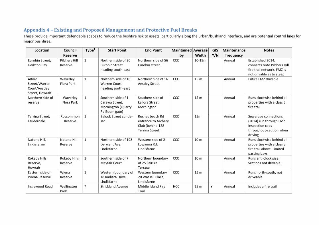
Appendix 4 – Existing and Proposed Management and Protective Fuel Breaks These provide important defendable spaces to reduce the bushfire risk to assets, particularly along the urban/bushland interface, and are potential control lines for major bushfires.
Location Council Reserve
Type1 Start Point End Point Maintained by
Average Width
GIS Y/N
Maintenance frequency
Notes
Eurobin Street, Geilston Bay
Pilchers Hill Reserve
1 Northern side of 30 Eurobin Street heading south-east
Northern side of 56 Eurobin street
CCC 10-15m Annual Established 2014, connects onto Pilchers Hill fire trail network. FMZ is not drivable as to steep
Alford Street/Warren Court/Anstley Street, Howrah
Waverley Flora Park
1 Northern side of 18 Warren Court heading south-east
Northern side of 16 Anstley Street
CCC 15 m Annual Entire FMZ drivable
Northern side of reserve
Waverley Flora Park
1 Southern side of 1 Carawa Street, Mornington (Quarry Rd Boom gate)
Southern side of kallora Street, Mornington
CCC 15 m Annual Runs clockwise behind all properties with a class 5 fire trail
Terrina Street, Lauderdale
Roscommon Reserve
1 Balook Street cul-de-sac
Roches beach Rd entrance to Archery Club (behind 128 Terrina Street)
CCC 15m Annual Sewerage connections (2014) run through FMZ. Inspection caps throughout-caution when driving
Natone Hill, Lindisfarne
Natone Hill Reserve
1 Northern side of 198 Derwent Ave, Lindisfarne
Western side of 2 Lowanna Rd, Lindisfarne
CCC 10 m Annual Runs clockwise behind all properties with a class 5 fire trail above. Limited passing bays.
Rokeby Hills Reserve, Howrah
Rokeby Hills Reserve
1 Southern side of 7 Mayfair Court
Northern boundary of 25 Fairisle Terrace
CCC 10 m Annual Runs anti-clockwise. Sections not drivable.
Eastern side of Wiena Reserve
Wiena Reserve
1 Western boundary of 18 Radiata Drive, Lindisfarne
Western boundary 20 Wassell Place, Lindisfarne
CCC 15 m Annual Runs north-south, not driveable
Inglewood Road Wellington Park
? Strickland Avenue Middle Island Fire Trail
HCC 25 m Y Annual Includes a fire trail

71
1 “M” Management or “P” Protective fuel break as defined in section 4.6.
New Strategic Fuel Breaks
Desired or planned fuel breaks, particularly around high value assets.
Location Reserve Type1 Start Point End point Proposed Width
Asset(s) Protected GIS Y/N
Notes
1 “M” Management or “P” Protective fuel break as defined in section 4.6.

Appendix 5 - The Bushfire Risk Assessment Model (BRAM)
The Bushfire Risk Assessment Model (BRAM) is a software product that was developed by the
Fire Management Section of the Parks and Wildlife Service (Department of Primary Industries,
Parks, Water and Environment). The aim of the model is to identify bush fire risk at a strategic
level as well as to identify the elements driving actual bush fire risk.
A stakeholder group was set up to oversee the process. Stakeholders involved in developing the
process included:
o Parks and Wildlife Service;
o Tasmania Fire Service;
o Forestry Tasmania;
o Tasmanian Farmers and Graziers Association;
o State Emergency Service:
o Forest Industries Association of Tasmania;
o Local Government Association of Tasmania;
o Resource management and conservation , DPIPWE;
o NRM ;
o Tasmanian Aboriginal land and Sea Council;
Additional working groups were set up to advise on specialist areas such as values at risk,
suppression capabilities, ignition potential, and fire behaviour.
The process is aligned to the Australian/New Zealand Standard AS/NZS 4360:2004 Australian
Standard Risk Management and the updated standard AS/NZS ISO 31000:2009 Risk management
– Principles and guidelines. Risk is defined as the” effect of uncertainty on objectives” with a
focus of the effect on the objectives
5.2.1.1 The process
The model is built in a geographic information system that utilizes various spatial orientated
data, fire behaviour and fuel accumulation models and climate records. The data and values
were developed by consensus of a range of stakeholders
The process applies the same set of assessment rules to the data contained in the model , thus
it can be applied across the state. The process is tenure blind
The BRAM identifies the likelihood and consequence of a fire at a particular point. The risk
is determined through the use of a qualitative risk matrix incorporating likelihood and values at
risk (consequences). The process identifies the actual risk at that point not the perceived risk.
The output is in the form of layers identifying the likelihood, values at risk and actual risk
The model uses 4 major areas to calculate risk likelihood of an area for:
o Fire behaviour potential - the manner in which fuel ignites, flame develops, and fire spreads and exhibits other related phenomena (likelihood).
o Ignition potential - the probability or chance of fire starting as determined by the
presence of causative agents (likelihood).
o Suppression capability - the factors and limitations that are related to the ability to detect, respond to, and contain a bushfire (likelihood).
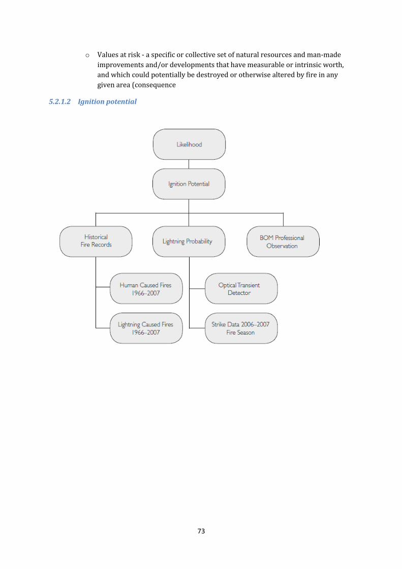
73
o Values at risk - a specific or collective set of natural resources and man-made
improvements and/or developments that have measurable or intrinsic worth,
and which could potentially be destroyed or otherwise altered by fire in any
given area (consequence
5.2.1.2 Ignition potential

74
5.2.1.3 Suppression capabilities

75
5.2.1.4 Fire Behaviour Potential
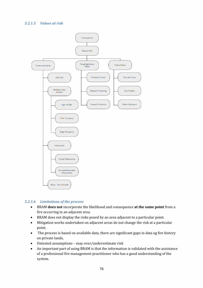
76
5.2.1.5 Values at risk
5.2.1.6 Limitations of the process
BRAM does not incorporate the likelihood and consequence at the same point from a
fire occurring in an adjacent area.
BRAM does not display the risks posed by an area adjacent to a particular point.
Mitigation works undertaken on adjacent areas do not change the risk at a particular
point.
The process is based on available data, there are significant gaps in data eg fire history
on private lands,
Untested assumptions – may over/underestimate risk
An important part of using BRAM is that the information is validated with the assistance
of a professional fire management practitioner who has a good understanding of the
system.

77
Figure 5.1: BRAM Likelihood

78
Figure 5.2: BRAM Consequence

79
Appendix 6 - NERAG Risk Assessment Approach (Derived from the National Emergency Management Committee (2010), National Emergency Risk Assessment Guidelines, Tasmanian State Emergency Service, Hobart)
The NERAG provide a methodology to assess risks from emergency events and are principally
concerned with risk assessment. The NERAG methodology was utilised in development of the BRAM
to develop the final risk profile
The guidelines are not intended to address the entire risk management framework or the risk
management process as outlined in AS/NZS ISO 31000:2009. However, because they focus on the
assessment of risks from emergency events, they ultimately direct the management of emergency
risks in line with the international standards for risk management.
The guidelines aim to provide a risk assessment methodology that:
enables focus on risks in small (e.g. municipal) or large (e.g. regional and/or state and/or
national) areas
is useable for both risk ‘from’ and risk ‘to’ (e.g. risk from bushfire, risk to infrastructure from
all or specific sources of risk)
uses a scenario-based approach
samples risk across a range of credible consequence levels
identifies current risk under existing controls and residual risk assuming implementation of
additional controls or control improvements
provides base-line qualitative risk assessments and triggers for more detailed analysis
allows risk evaluation at varying levels of confidence
Provides outputs that are comparable, which rate risk and suggests means to reduce risk.
Risk analysis is the element in the process through which the level of risk and its nature is
determined and understood. Information from risk analysis is critical to rank the seriousness of risks
and to help decide whether risks need to be treated or not. In this phase, control opportunities are
also identified. The analysis involves consideration of possible consequences, the likelihood that
those consequences may occur (including the factors that affect the consequences), and any existing
control that tends to reduce risks. During this phase the level of confidence in the analysis is
assessed by considering factors such as the divergence of opinion, level of expertise, uncertainty,
quality, quantity and relevance of data and information, and limitations on modelling. At the
conclusion of this step, all identified risks are categorised into risk levels and given a risk rating, and
statements concerning existing controls and their adequacy are made.
NERAG takes an all hazards approach and provides a method that is suitable for considering other
sources of risk beside fire

5.2.1.7 Consequence table Consequence
level
People Environment Economy Public
Administration
Social Setting Infrastructure
Catastrophic Widespread
multiple loss of
life( mortality > 1
in ten thousand),
Health systems
unable to cope,
Displacement of
people beyond a
ability to cope
Widespread
severe
impairment or
loss of ecosystem
functions across
species and
landscapes,
irrecoverable
environmental
damage
Unrecoverable
financial loss > 3%
of the government
sector’s revenues,
asset destruction
across industry
sectors leading to
widespread
failures and loss of
employment
Governing body
unable to manage
the event,
disordered public
administration
without effective
functioning, public
unrest, media
coverage beyond
region or
jurisdiction
Community unable
to support itself,
widespread loss of
obj3ects of cultural
significance,
impacts beyond
emotional and
psychological
capacity in all parts
of the community
Long term failure
of significant
infrastructure and
service delivery
affecting all parts
of the community,
ongoing external
support at large
scale required
Major Multiple loss of
life ( mortality > 1
in 0ne hundred
Thousand), Heath
system over
stressed, Large
numbers of
displaced people(
more than 24
hours)
Serious
impairment or
loss of ecosystem
functions affecting
many species or
landscapes,
progressive
environmental
damage
Financial loss 1-3%
of the
governments
sector’s revenues
requiring major
changes in business
strategy to (partly)
cover loss,
significant
disruptions across
industry sectors
leading to multiple
business failures
and loss of
employment
Governing Body
absorbed with
managing the
event, public
administration
struggles to
provide merely
critical services,
loss of public
confidence in
governance,
media coverage
beyond region
jurisdiction
Reduces quality of
life within the
community,
significant loss or
damage to objects
of cultural
significance,
impacts beyond
emotional and
psychological
capacity in large
parts of the
community
Mid- to long term
failure of
significant
infrastructure and
service delivery
affecting large
parts of the
community, initial
external support
required
Moderate Isolated cases of
loss of life (
mortality > 1 in
one million),
Health system
operating at
maximum
capacity, isolated
cases of
displacement of
people( less than
24 hours)
Isolated but
significant cases
of impairment or
loss of ecosystem
functions,
intensive efforts
for recovery
required
Financial loss 0.3 –
1% of the
governments
sector’s revenue
requiring
adjustments to
business strategy
to cover loss,
disruptions to
selected industry
sectors leading to
isolated cases of
business failures
and multiple loss
of employment
Governing body
manages the
event with
considerable
diversion from
policy, public
administration
functions limited
by focus on critical
services,
widespread public
protests, media
coverage within
region or
jurisdiction.
Ongoing reduced
services within
community,
permanent
damage to objects
of cultural
significance,
impacts beyond
emotional and
psychological
capacity in some
parts of the
community
Mid-term failure
of( significant)
infrastructure and
service delivery
affecting some
parts of the
community,
widespread
inconveniences
Minor Isolated cases of
serious injury,
heath system
operating within
Normal
parameters
Isolated cases of
environmental
damage, one off
recovery efforts
required
Financial loss 0.1-
0.3% of the
governments
sector’s revenues
requiring activation
of reserves to
cover loss,
disruptions at
business level
leading to isolated
cases of loss of
unemployment
Governing body
manages the
event under
emergency
regime, Public
administration
functions with
some
disturbances,
isolated
expressions of
public concern,
media coverage
within region or
jurisdiction
Isolated and
temporary cases of
reduced services
within the
community,
repairable damage
to objects of
cultural
significance,
impacts within
emotional and
psychological
capacity of the
community
Isolated cases of
short– to mid-term
failure of
infrastructure and
service delivery.
Localised
inconveniences
Insignificant Near misses or
minor injuries, no
reliance on
health system
Near misses or
incidents without
environmental
damage , no
recovery efforts
required
Financial loss ,
0.1% of the
governments
sector’s revenues
to be managed
within standard
financials
provisions,
inconsequential
Governing body
manages the
event within
normal
parameters, public
administration
functions without
disturbances,
public confidence
Inconsequential
short-term
reduction of
services, no
damages to objects
of cultural
significance, no
adverse emotional
Inconsequential
short-term failure
of infrastructure
and service
delivery, no
disruption to the
public services

81
disruptions at
business level
in governance, no
media attention
and psychological
impacts
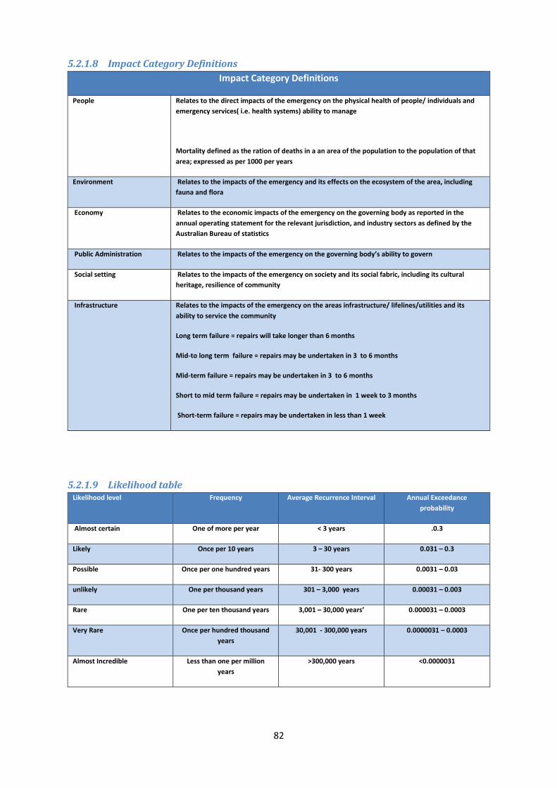
82
5.2.1.8 Impact Category Definitions
Impact Category Definitions
People Relates to the direct impacts of the emergency on the physical health of people/ individuals and
emergency services( i.e. health systems) ability to manage
Mortality defined as the ration of deaths in a an area of the population to the population of that
area; expressed as per 1000 per years
Environment Relates to the impacts of the emergency and its effects on the ecosystem of the area, including
fauna and flora
Economy Relates to the economic impacts of the emergency on the governing body as reported in the
annual operating statement for the relevant jurisdiction, and industry sectors as defined by the
Australian Bureau of statistics
Public Administration Relates to the impacts of the emergency on the governing body’s ability to govern
Social setting Relates to the impacts of the emergency on society and its social fabric, including its cultural
heritage, resilience of community
Infrastructure Relates to the impacts of the emergency on the areas infrastructure/ lifelines/utilities and its
ability to service the community
Long term failure = repairs will take longer than 6 months
Mid-to long term failure = repairs may be undertaken in 3 to 6 months
Mid-term failure = repairs may be undertaken in 3 to 6 months
Short to mid term failure = repairs may be undertaken in 1 week to 3 months
Short-term failure = repairs may be undertaken in less than 1 week
5.2.1.9 Likelihood table Likelihood level Frequency Average Recurrence Interval Annual Exceedance
probability
Almost certain One of more per year < 3 years .0.3
Likely Once per 10 years 3 – 30 years 0.031 – 0.3
Possible Once per one hundred years 31- 300 years 0.0031 – 0.03
unlikely One per thousand years 301 – 3,000 years 0.00031 – 0.003
Rare One per ten thousand years 3,001 – 30,000 years’ 0.000031 – 0.0003
Very Rare Once per hundred thousand
years
30,001 - 300,000 years 0.0000031 – 0.0003
Almost Incredible Less than one per million
years
>300,000 years <0.0000031
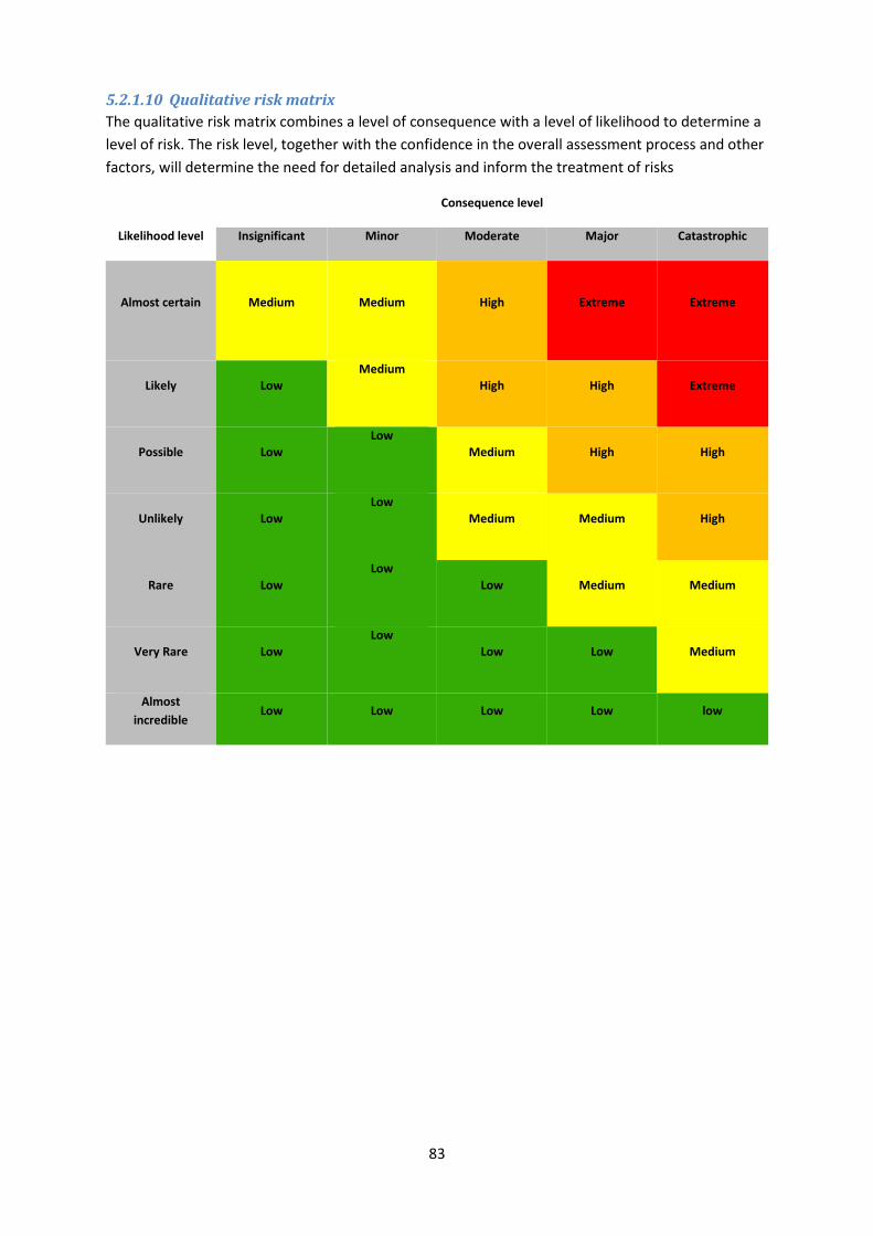
83
5.2.1.10 Qualitative risk matrix
The qualitative risk matrix combines a level of consequence with a level of likelihood to determine a
level of risk. The risk level, together with the confidence in the overall assessment process and other
factors, will determine the need for detailed analysis and inform the treatment of risks
Consequence level
Likelihood level Insignificant Minor Moderate Major Catastrophic
Almost certain Medium
Medium
High Extreme Extreme
Likely Low
Medium
High High Extreme
Possible Low
Low
Medium High High
Unlikely Low
Low
Medium Medium High
Rare Low
Low
Low Medium Medium
Very Rare Low
Low
Low Low Medium
Almost
incredible Low Low Low Low low

84
Appendix 7 - National Construction Code building classes
Classification Summary of Buildings and Structures as defined in the Building Code of Australia
CLASSES OF BUILDINGS
Class 1 Class 1a A single dwelling being a detached house, or one or more attached dwellings, each being separated by a fire resistant wall, including a row house, terrace house, town house or villa unit.
Class 1b A boarding house, guest house, hostel of the like with a total area of all floor not exceeding 300 m2 and where not more than 12 reside, and is not located above or below another dwelling or another Class of building other than a private garage
Class 2 A building containing 2 or more sole-occupancy units each being a separate dwelling.
Class 3 A residential building, other than a Class 1 or 2 Building, which is a common place of long-term or transient living for a number of unrelated persons.
Examples: boarding-house, hostel, backpackers accommodation or residential part of a hotel, motel, school or detention centre.
Class 4 A dwelling in a building that is Class 5, 6, 7, 8 or 9 if it is the only dwelling in the building.
Class 5 An office building used for professional or commercial purposes, excluding buildings of Class 6, 7, 8 or 9.
Class 6 A shop or other building for the sale of goods by retail or the supply of services direct to the public.
Examples: café, restaurant, kiosk, hairdressers, showroom or service station.
Class 7 Class 7a A building which is a car park
Class 7b A building which is used for storage or display of goods or produce for sale by wholesale.
Class 8 A laboratory, or a building in which a handicraft or process for the production, assembling, altering, repairing, packing, finishing or cleaning of goods or produce is carried on for trade, sale or gain.
Class 9 A building of a public nature:
Class 9a A health care building, including those parts of the building set aside as a laboratory.
Class 9b An assembly building, including a trade workshop, laboratory or the like, in a primary or secondary school, but excluding any other parts of the building that are of another class.
Class 9c An aged care building.
Class 10 A non habitable building or structure:
Class 10a A private garage, carport, shed or the like.
Class 10b A structure being a fence, mast, antenna, retaining or free standing wall, swimming pool or the like.

Appendix 8 – Treatment schedule - annual works program
Location Summary Tenure Previous Treatment including current
plans
Action required Project implementation Timeframe for
completion
Overall FMAC
Priority rating
Wellington Range
Eastern Slopes of
kunanyi/Mt
Wellington
55
Steep hills with
densely forested
areas close to the
urban interface.
Opportunity for
fuel reduction on
lower slopes.
Private Property,
Wellington Park, HCC
managed land.
Wellington Park Fire Management
Strategy. TFS Community Protection,
Response Plans and Lenah Valley
South community Bushfire Mitigation
Plan.
Prepare Community Bushfire
Mitigation Plans. Implement
planned burns. Greater
Wellington Park Fire Management
Strategy
BPP Unit to prepare Community Bushfire
Mitigation Plan for Lenah Valley North. FRU
and Councils to conduct fuel reduction burns.
FRU to provide advice on procedures to be
used when planning and undertaking burning
on Private Property.
High
Meehan Range
from Quoin Ridge
to Lauderdale
47
Strategically
important to
provide protection
to communities
surrounding this
area. There have
been a number of
illegal fire ignitions
in the past.
Combination of Private
Property, CCC and PWS
managed land.
Meehan Range Region Fire
Management Strategy, Risdon Brook
Dam Catchment and Adjoining Areas
Fire Management Plan, TFS
Community Protection and Response
Plans. PWS Southern Region Fire
Management Plan.
Prepare TFS Community
Protection and Response plans.
Review and update fire
management plans to allow FRB's
to occur.
BPP Unit to prepare Community Protection
Bushfire Mitigation Plans. FRU and Councils to
conduct fuel reduction burns. FRU to provide
advice on procedures to be used when
planning and undertaking burning on Private
Property.
High
Dulcot
40
Woodland and
grassland on the
margins of human
settlement area
Private Property Prepare operational burn plans
for priority Fuel Management
Units.
FRU to coordinate and implement burns High
Mt Falkner
50
Steep hills with
densely forested
areas close to the
urban interface.
Strategically
important to
provide protection
to communities
surrounding this
area.
Private Property, GCC and
PWS managed land.
Mount Faulkner Region Strategic Fire
Management Plan. TFS Community
Protection and Response Plans. PWS
Southern Region Fire Management
Plan.
Prepare operational burn plans
for priority Fuel Management
Units.
FRU and Councils to conduct fuel reduction
burns. FRU to provide advice on procedures to
be used when planning and undertaking
burning on Private Property.
High
Government Hills
43
Woodland and
grassland on the
margins of
Suburbs
Private Property, CCC and
PWS managed land.
Bedlam Walls Bushfire Management
Plan. PWS Southern Region Fire
Management Plan. TFS Community
Protection and Response Plans.
Prepare TFS Community
Protection and Response plans.
PWS and Clarence Council to
implement burn plans in this area
BPP Unit to prepare Community Protection
Bushfire Mitigation Plans. PWS and Councils to
conduct fuel reduction burns. FRU to provide
advice on procedures to be used when
planning and undertaking burning on Private
Property.
High
Goat Hills
42
Steep hills with
densely forested
areas close to the
urban interface.
Strategically
important to
provide protection
to communities
surrounding this
area.
Private Property,
Wellington Park, GCC
managed land.
Goat Hills Fire Management Plan,
Wellington Park Fire Management
Strategy, TFS Community Protection
and Response Plans.
Prepare operational burn plans
for priority Fuel Management
Units.
FRU to conduct fuel reduction burns. FRU to
provide advice on procedures to be used when
planning and undertaking burning on Private
Property.
High
Rokeby/Acton
54
Large areas of dry
forest mixed with
human settlement
areas. Numerous
dead end roads.
Private Property, CCC and
PWS managed land.
Mehan Range Region Fire
Management Strategy, TFS
Community Protection and Response
Plans. PWS Southern Region Fire
Management Plan.
Prepare operational burn plans
for priority Fuel Management
Units.
FRU to conduct fuel reduction burns. FRU to
provide advice on procedures to be used when
planning and undertaking burning on Private
Property.
High
Dromedary
(mostly covered
by Midlands FPP)
49
Strategically
important to
communities in
the lower Derwent
Valley. Fires from
this area have
spotted across the
Derwent River to
the northern
slopes of Mt
Faulkner in the
past with the
potential to
impact on Hobart
and suburbs.
Private Property, PWS
managed land, Permanent
Timber Production Zone
TFS Community Protection and
Response Plan for Broadmarsh.
Investigate mitigation options for
this area, including Black Hills,
Tanina Bluff Broadmarsh and
Upper Dromedary
FRU to develop Strategic Bushfire Mitigation
Plan.
High

86
Sandford
41
Large areas of dry
forest mixed with
human settlement
areas. Numerous
dead end roads.
Private Property, CCC and
PWS managed land.
TFS Community Protection and
Response Plans. PWS Southern Region
Fire Management Plan.
Investigate mitigation options for
this area.
FRU to develop Bushfire Mitigation Plan for
area south of Lauderdale Canal. Complete
operational burn plans.
High
Mt
Nelson/Tolmans
Hill/The Lea
51
Strategically
important to
provide protection
to communities
surrounding this
area. There have
been a number of
illegal fire ignitions
in the past.
Private Property, HCC and
PWS managed land.
PWS Southern Region Strategic Fire
Management Plan, Bicentennial
Park/Porter Hill Reserve Fire
Management Plan, Mt Nelson, The
Lea Community Bushfire Mitigation
Plan.
Prepare operational burn plans
for priority Fuel Management
Units. Prepare second Stage of
Community Bushfire Mitigation
Plan
BPP to prepare The Lea Stage 2 Community
Bushfire Mitigation Plan. Implement
operational burn plans. FRU to provide advice
on procedures to be used when planning and
undertaking mitigation works on Private
Property.
High
Ridgeway
Summerleas Rd
53
Steep hills with
densely forested
areas close to the
urban interface.
Strategically
important to
provide protection
to communities
surrounding this
area.
Private Property, HCC and
KC managed land.
Ridgeway Park/Waterworks Reserve
Fire Management Plan, TFS
Community Protection and Response
Plans.
Prepare operational burn plans
for priority Fuel Management
Units.
FRU and HCC to conduct fuel reduction burns.
FRU to provide advice on procedures to be
used when planning and undertaking burning
on Private Property.
High
Albion Heights
Bonnet Hill
38/39
Large areas of dry
forest mixed with
human settlement
areas.
Private Property, KC and
PWS managed land.
TFS Community Protection and
Response Plans. PWS Southern Region
Fire Management Plan.
Investigate mitigation options for
this area.
Multi Agency development of mitigation
strategy
High


