Columbia University in the City of New York | Graduate School of Architecture, Planning, and Preservation Independent Research Seminar, Spring 2012 Professor: Mojdeh Baratloo Graduate Research Associates: Ori Guy | Matthew Henry Mixed Use Water Infrastructure | Hoboken, New Jersey DRAFT Base Image: Google Earth HOBOKEN JERSEY CITY NEW YORK CITY W 14 ST WASHINGTON ST
Transcript
Columbia University in the City of New York | Graduate School of Architecture, Planning, and PreservationIndependent Research Seminar, Spring 2012 Professor: Mojdeh BaratlooGraduate Research Associates: Ori Guy | Matthew Henry
Mixed Use Water Infrastructure | Hoboken, New Jersey DRAFT
Base Image: Google Earth
HOBOKEN
JERSEY CITY
NEW YORK CITY
W 14 ST
WAS
HING
TON
ST
Columbia University in the City of New York | Graduate School of Architecture, Planning, and PreservationIndependent Research Seminar, Spring 2012 Professor: Mojdeh BaratlooGraduate Research Associates: Ori Guy | Matthew Henry
Mixed Use Water Infrastructure | Hoboken, New Jersey DRAFTTOPIC:For centuries, communities have relied on pipes and pumps infrastructure to manage storm water and prevent floods. In nearly all cases, this is not only expensive but it rarely contributes to the betterment of a community in social terms. Typically, the infrastructure is designed to function mechanically and never be seen – an invisible force at work. This report hypothesizes on alternative methods - both grey and green- of conceiving and implementing storm water solutions. Can combinations of grey and green storm water infrastructures not only manage large amounts of water, but have secondary uses and purposes that benefit the community and its public realm? BACKGROUND:The City of Hoboken, NJ, is defined by its proximity to water. The city relies on its location for economic and infrastructural advantage, but this location’s geography creates the city’s most pressing environmental and economic issue: frequent flooding of the combined sewer overflow system (CSO). Hoboken’s sewer outfalls (designed to release excess sewer flow during rain events) lie below Hudson River’s high tide mark; they are mechanically closed during high tide which creates a closed loop. When rain occurs during high tide, the system is incapable of discharge and back flow of storm water mixed with wastewater floods Hoboken’s low lying streets. This problem is projected to worsen because of rising water levels due to climate change. The integration of green and grey infrastructure as complimentary systems is a crucial strategy to containing the volume of stormwater before it enters the sewer system.
METHOD:Research will rely on three overlapping processes. First, develop an understanding of Hoboken’s specific situation through research and interviews of city officials and industry experts. Second, research contemporary green and grey storm water technologies and innovations. Lastly, investigate relevant case studies that utilize green and grey infrastructures to mitigate flooding as well as establish a relationship to their larger social realms (when applicable).
DELIVERABLE:The report will be a comprehensive design vision, consisting of three chapters. The first will present a matrix framework of potential green and grey design strategies developed for Hoboken’s specific situation. This tool will allow the CIty of Hoboken to determine the appropriate combinations of green and grey based upon cost, social impact, and magnitude of desired flood prevention. The second chapter will present a selected design vision based on a specific percentage of green and grey infrastructure. The last chapter will document the research and case studies that the design solutions are founded upon.
Columbia University in the City of New York | Graduate School of Architecture, Planning, and PreservationIndependent Research Seminar, Spring 2012 Professor: Mojdeh BaratlooGraduate Research Associates: Ori Guy | Matthew Henry
Mixed Use Water Infrastructure | Hoboken, New Jersey DRAFT
PART I - HOBOKEN’S EXISTING STORM WATER SYSTEM.
1-1. How does one know where the water causing the flooding problem is coming from? For example, is it coming from the Hudson River, rain, surface run-off, or a combination?
1-2. How does the existing system deal with excess water?
1-3. What are the factors involved in systematic flooding? For example, high tide, high wind?
PART II - HOBOKEN.
2-1. Given the geographical circumstances of Hoboken, has the city established a goal or baseline level of acceptable flood risk? For example, 1” of rain at high tide?
2-2. What solutions has Hoboken considered? For example, the $20 million pumps?
2-3. Beside the acquired site (parking lot between Paterson Avenue and Observer Highway), has Hoboken considered utilizing streets or other public spaces to assist in this problem?
PART III - TECHNOLOGY.
3-1. What are known and/or available technologies applicable or specific to Hoboken?
Columbia University in the City of New York | Graduate School of Architecture, Planning, and PreservationIndependent Research Seminar, Spring 2012 Professor: Mojdeh BaratlooGraduate Research Associates: Ori Guy | Matthew Henry
Mixed Use Water Infrastructure | Hoboken, New Jersey DRAFT
Hoboken’s TopographyTopography Lines
Lowest Area
Recurring Flooded StreetsWater Flow Direction
4’
200’
120’
10’
20’
30’
60’100’
Columbia University in the City of New York | Graduate School of Architecture, Planning, and PreservationIndependent Research Seminar, Spring 2012 Professor: Mojdeh BaratlooGraduate Research Associates: Ori Guy | Matthew Henry
Mixed Use Water Infrastructure | Hoboken, New Jersey DRAFT
Water runoff comparison (below): from natural to urban ground cover. A higher percentage of impervious ground cover means storwater runoff volume increases.
Hoboken’s water infrastructure is a combined sew-er outflow (CSO). At low tide (left) excess water (storm + sewer) evacuates into the Hudson river.
At high tide (left) a tidal gate closes and makes the system a closed loop. Excess water can not evacuate into the Hudson and instead flows verti-cally until equilibrium is reached, typically above the lowest levels of Hoboken. Hence, the frequent flooding.
Columbia University in the City of New York | Graduate School of Architecture, Planning, and PreservationIndependent Research Seminar, Spring 2012 Professor: Mojdeh BaratlooGraduate Research Associates: Ori Guy | Matthew Henry
Mixed Use Water Infrastructure | Hoboken, New Jersey DRAFT
Flooding In Hoboken During Rain and Hudson River High Tide - Failed CSO SystemImages: Top: Mayor Presentation, MICD Conference, December 2011 Top: MICD Meeting Report, December 2011
Columbia University in the City of New York | Graduate School of Architecture, Planning, and PreservationIndependent Research Seminar, Spring 2012 Professor: Mojdeh BaratlooGraduate Research Associates: Ori Guy | Matthew Henry
Mixed Use Water Infrastructure | Hoboken, New Jersey DRAFT
Watershed Line
45’
The volumetric scale of water is im-mense. One (1) inch of rain falling within Hoboken’s CSO shed* (+/- 33.7 million square feet) is equivalent to 2.8 million cubic feet). Is it estimated that 80% of this water will make it into Hoboken’s water infrastructure.; this equates to 2.2 million cubic feet (16.5 million gallons).
This volume of water applied to the 50,000 square foot property acquired by Hoboken would fill a tank 45 feet deep (bottom).
* CSO shed to be confirmed by City of Hoboken
22 sites will be needed to absorb a 1” rain fall assuming a designed flood capacity of 2ft
City Wide Municipal Policies2013 2033
rain
gar
dens
stor
age t
anks
gree
n st
reet
s
gree
n ro
ofs
gree
n wall
s
bios
wales
rain
water
har
vest
ing
blue
roof
waste
water
reus
eliv
ing
mac
hine
s
Columbia University in the City of New York | Graduate School of Architecture, Planning, and PreservationIndependent Research Seminar, Spring 2012 Professor: Mojdeh BaratlooGraduate Research Associates: Ori Guy | Matthew Henry
Mixed Use Water Infrastructure | Hoboken, New Jersey DRAFT
Street Network
Public Open SpaceUndeveloped Property / Parking LotCSO Outfall LocationPublic Institutions ?
Hoboken Urban Fabric
Columbia University in the City of New York | Graduate School of Architecture, Planning, and PreservationIndependent Research Seminar, Spring 2012 Professor: Mojdeh BaratlooGraduate Research Associates: Ori Guy | Matthew Henry
Mixed Use Water Infrastructure | Hoboken, New Jersey DRAFT
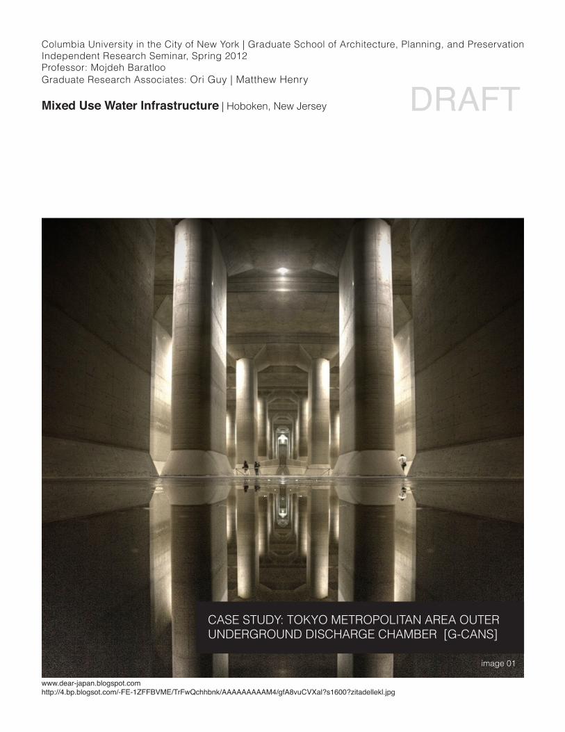
CASE STUDY: TOKYO METROPOLITAN AREA OUTER UNDERGROUND DISCHARGE CHAMBER [G-CANS]
Columbia University in the City of New York | Graduate School of Architecture, Planning, and PreservationIndependent Research Seminar, Spring 2012 Professor: Mojdeh BaratlooGraduate Research Associates: Ori Guy | Matthew Henry
Mixed Use Water Infrastructure | Hoboken, New Jersey DRAFT
project: Tokyo G-CANS location: Tokyo, Japandate: Open: 2006 (construction : 13 years)cost: $2,000,000,000 (estimated)type: Flood Prevention from River Overflowdischarge: 47,000 gallons (200 tons) per second
image 02 image 03
Columbia University in the City of New York | Graduate School of Architecture, Planning, and PreservationIndependent Research Seminar, Spring 2012 Professor: Mojdeh BaratlooGraduate Research Associates: Ori Guy | Matthew Henry
Mixed Use Water Infrastructure | Hoboken, New Jersey DRAFT
image 04
image 06image 05
The Tokyo Metropolitan Area Outer Underground Discharge Chamber (G-Cans) is a wonder of engineering and flood preven-tion. It captures flood/overflow water from four (4) waterways flowing towards Tokyo and diverts it, through a series of under-ground chambers and tunnels, towards the Edo river (images 04, 05). Final evacuation occurs via a series of huge engines capable of pumping 47,000 gallons of water per second into the Edo River. G-Cans implementation eliminated the flood risk to 30,000 resi-dences.
The main chamber (image 01, 06) is one of the largest under-ground chambers in the world. Unexpectedly, its scale and uniqueness has made it a tourist destination. Tours are now of-fered regularly, and Land Rover filmed a commercial there in 2006. Above the main chamber lays a football field (image 07). It is most ironic that the football field lacks appropriate drainage while sitting atop one of the globe’s most incredible pieces of water manage-ment infrastructure.
The G-Cans was not designed with a civic role (other then flood prevention) in mind. One can only imagine the potential if it had been conceived with a civic/public role in mind.
Columbia University in the City of New York | Graduate School of Architecture, Planning, and PreservationIndependent Research Seminar, Spring 2012 Professor: Mojdeh BaratlooGraduate Research Associates: Ori Guy | Matthew Henry
Mixed Use Water Infrastructure | Hoboken, New Jersey DRAFT
image 07
Columbia University in the City of New York | Graduate School of Architecture, Planning, and PreservationIndependent Research Seminar, Spring 2012 Professor: Mojdeh BaratlooGraduate Research Associates: Ori Guy | Matthew Henry
Mixed Use Water Infrastructure | Hoboken, New Jersey DRAFT
BIORETENTION / RAIN GARDEN• Pollution is removed from stormwater
thoughorganicfilters(soil,grass,plants• Clean water is collected.• Stormwater from impervious urban surfac-
es is absorbed by soil / vegetation.
BIOSWALE• Recessed,linearlandscapefilledwithveg-
etation or compost.• Filters out silt / pollution before surface
porarily in an open volume.• Water Drains slowly as additional room
becomes available.• Helps in pre-treatment as pollutants starts
to settle
LIVING MACHINE• Wastewater treatment system (trade-
marked)• Mimicking biological workings of wetlands• Further disinfection (using UV, ozone or
chlorine) is possible• Non-potable reuse
POROUS PAVEMENT• Prevent / reduce stormwater runoff• Water collects in a reservoir, slowly
seeping into surrounding rock or soil.
Source: Gang, Jeanne, Reverse Effect: Renewing Chicago’s Waterways, Studio Gang, 2011Some Green Infrastructure Strategies
Columbia University in the City of New York | Graduate School of Architecture, Planning, and PreservationIndependent Research Seminar, Spring 2012 Professor: Mojdeh BaratlooGraduate Research Associates: Ori Guy | Matthew Henry
Mixed Use Water Infrastructure | Hoboken, New Jersey DRAFT
Integrated Green Infrastructure: Design Matrix
StormwaterstrategiesbasedonspecificurbanconditionsSource: San Mateo County Sustainable Green Streets and Parking Lots Design Guidebookhttp://www.flowstobay.org/documents/municipalities/sustainable%20streets/Book%20Layout%20Guidebook/Green%v%20revised%20book%20layout%20Guidebook.pdf
Columbia University in the City of New York | Graduate School of Architecture, Planning, and PreservationIndependent Research Seminar, Spring 2012 Professor: Mojdeh BaratlooGraduate Research Associates: Ori Guy | Matthew Henry
Mixed Use Water Infrastructure | Hoboken, New Jersey DRAFTIntegrated Green Infrastructure: Water Re-Use
Integrated Green Infrastructure: Green Streets
Concept Diagram for a Net-Zero water project.(Net-Zero: All water demands are met with Harvested rainwater and reused water. Wastewater and stormwater are managed on site)
Stormwater Street Planters
Street Before Street After: Curb Extension Porous Pavement
Stormwater Curb Extension: Water Retention System Monitoring
Source: Portland Green Streets Program, http://www.portlandonline.com/BES/index.cfm?c=44407.
Columbia University in the City of New York | Graduate School of Architecture, Planning, and PreservationIndependent Research Seminar, Spring 2012 Professor: Mojdeh BaratlooGraduate Research Associates: Ori Guy | Matthew Henry
Mixed Use Water Infrastructure | Hoboken, New Jersey DRAFT
San Francisco Stormwater Design Guidelines, Cover
Stormwater Runoff Channelling, Malmo, SwedenIntegrated Urban Design To Convey and Treat Stormwater Malmo, SwedenSource: San Franciso Stormwater Design Guidelines, http://sfwater.org/index.aspx?page=446
Integrated Green Infrastructure: Municipal Policy and Initiatives
Columbia University in the City of New York | Graduate School of Architecture, Planning, and PreservationIndependent Research Seminar, Spring 2012 Professor: Mojdeh BaratlooGraduate Research Associates: Ori Guy | Matthew Henry
Mixed Use Water Infrastructure | Hoboken, New Jersey DRAFTIntegrated Green Infrastructure: Public SpaceOld Mint Plaza, San Francisco | CMG Landscape Architecture + Sherwood Design Engineers
Before: City Street
Green infrastructure integrated into the design of public space