2
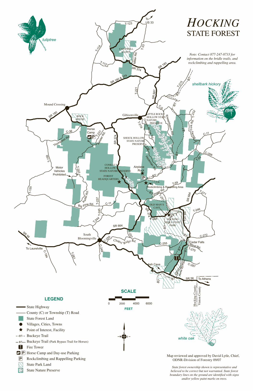
LANCASTER SUGAR GROVE ROCKBRIDGE LOGAN MOUND CROSSING GIBISONVILLE LAURELVILLE SOUTH BLOOMINGVILLE To Columbus To Athens HOCKING STATE FOREST US 33 SR 180 SR 180 SR 56 SR 374 SR 664 SR 374 SR 56 SR 93 HOCKING STATE FOREST OHIO Division of Forestry • 2045 Morse Rd., H-1 Columbus, Ohio 43229-6693 Equal Employment Opportunity Employer M/F/H Welcome to Hocking State Forest Forest Management Since 1924, Hocking State Forest has been managed through application of the multiple use concept. The forest continues to improve and sustain many products and benefits. Water, soil, habitat, and aesthetics are among the many variables considered during the land manage- ment process. Foresters are able to enhance areas for visitors to enjoy many outdoor activities including hiking, camping, wildlife watching, hunting, fishing and horseback riding. These benefits are in addition to growing highly desirable timber for wood products which are shipped throughout the U.S. and the world. During the spring and fall fire season months— March, April, May, October and November— the division works to prevent, detect and suppress wildfires that occur on state and private land within Hocking County and parts of Vinton and Fairfield counties. Prescribed Fire is a management tool used on Hocking State Forest to reduce fuel loads in the forest and promote oak regeneration. Trained forestry professionals conduct controlled fires, as dictated by a written plan and overseen by a certified Prescribed Fire Manager. The many gas wells and transmission lines that you see are a result of the development of a nat- ural gas storage field underlying the forest area. Trail and Boundary Marks Many different colors of paint are seen on trees throughout the area. Yellow spots indicate the boundary between state and private land. White and/or red spots are the boundaries around the three nature preserves. Blue spots designate the Buckeye Trail. The Bridle Trails are designated by various colors (see Bridle Trail map). General Rules for Forest Visitors The Hocking State Forest area receives hundreds of thousands of visitors each year. Please respect the forest community that you find. Your consideration of other visitors using the forest will help provide an enjoyable experience for all. 1. Visitors are free to walk on state forest property during daylight hours. However, because of the many cliffs located throughout the area, extreme caution is urged particularly when ice or snow is present. Because of these hazards, Hocking State Forest closes at dark. 2. Operation of motor vehicles is restricted to roads provided for such travel. The speed limit on state forest roads is 30 mph unless otherwise posted. Vehicles may not be parked where traffic or access to division service roads or trails will be obstructed. 3. Use of horses is permitted on designated bridle trails only. There is an official Bridle Trail Map available. 4. Camping and building of fires are prohibited. 5. Public display or consumption of any alcoholic beverage is prohibited. 6. Trash and litter should be handled with the back-country ethic, “Pack it in, pack it out.” 7. Disturbance or defacement of any property, materials, natural feature or vegetation is prohibited. This includes the digging of Ginseng and other roots or plants. Berries, nuts and mushrooms may be gathered and removed, except from seed orchards and nature preserves. Hocking Hills State Park Hocking Hills State Park, administered by the Division of Parks and Recreation, includes five areas which contain some of the most striking cliffs and land formations found anywhere in Ohio. Additional information regarding Ash Cave, Old Man’s Cave, Rock House, Cedar Falls and Cantwell Cliffs is available at the park office. State Nature Preserves Three state nature preserves have been established in Hocking State Forest. These preserves—Conkle’s Hollow, Sheick Hollow and Little Rocky Hollow—have unique ecological systems. Conkle’s Hollow has hiking trails for the general public. No hunting is permitted and all visitors must stay on the trails. Sheick and Little Rocky Hollows are designated as interpretive and scientific preserves respec- tively, and are not open to the general public. Admission is by permit only. Permits are issued by the Division of Natural Areas and Preserves who cooperatively administer the preserves. Rockclimbing and Rappelling Area The ninety-nine acre area is located on Big Pine Road, one mile east of Conkle’s Hollow. A parking area is within easy walking distance of the rock and cliff face. Be sure to use quality equipment and climb with experienced people. Climbers and rappellers must register prior to entering the Rock- climbing and Rappelling Area (see Rockclimbing and Rappelling Area map). Forest Vegetation One of the special attractions of Hocking State Forest is the natural vegetation. Plant species commonly found farther north mix with typically southern species to provide an unusual variety of native plant life and associated wildlife. Virginia and pitch pines, sassafras, and black, scarlet, white and chestnut oaks grow on the generally dry ridge areas. Hemlock, beech, black birch, red and sugar maples, yellow poplar, white ash, red oak, basswood and hickories grow in cool gorges, moist coves and on slopes. Flowers, shrubs and ferns commonly associated with these site conditions also abound. Plantations of red, white and shortleaf pines have developed from plantings of seedlings on abandoned farm fields. These stands of native and planted pines often indicate where corn and wheat once grew on subsistence farms in the 19th and early 20th centuries. Hunting and Fishing Hunting and fishing are permitted within Hocking State Forest as regulated by the Division of Wildlife. Shooting is prohibited within 400 feet of any building, facility, recreation area or within any designated nature preserve. It is unlawful to shoot from, on, across or along a public road or highway. Location Map Additional Information Hocking State Forest 19275 State Route 374 Rockbridge, Ohio 43149-9749 877-247-8733 Hocking Hills State Park 20160 State Route 664 Logan, Ohio 43138-9537 (740) 385-6841 Park Office Division of Natural Areas & Preserves 2045 Morse Rd., F-1 Columbus, Ohio 43229-6693 (614) 265-6453 ohiodnr.com/forestry EMERGENCIES Call 911 Our mission is to promote and apply management for the sustainable use and protection of Ohio’s private and public forest lands.