18
WELL HEAD DESERTED SETTLEMENT Holwick, Teesdale Excavation Project Design, 2017 ALTOGETHER ARCHAEOLOGY

WELL HEAD DESERTED SETTLEMENT
Holwick, Teesdale
Excavation Project Design, 2017
ALTOGETHER ARCHAEOLOGY

Altogether Archaeology 2017 Well Head excavation - Project Design Page 2 of 18
This Document © Altogether Archaeology 2017
It may be shared and used for non-commercial purposes with appropriate credits and indication of changes. For commercial use, please contact Altogether Archaeology.
Document compiled by Martin Green, with the assistance of Paul Frodsham, Stephen Eastmead and Tony Metcalfe
Version 1.1 (18 Aug 2017)
Site location: NY90812671
Google Earth images © Google 2017.
Ordnance Survey map and contour data © Crown copyright and database rights 2011, 2017.
Lidar information © Environment Agency copyright and/or database right 2017. All rights reserved.
Please note: The features described in this report lie on private farm-land with no public access.
Cover image: Google Earth image of core area of deserted settlement, looking south. The Strathmore Arms is the building at the lower edge of the image.
Altogether Archaeology 2017 Well Head excavation - Project Design Page 3 of 18
Contents 1 Summary ......................................................................................................................................... 4
2 Survey of Well Head settlement April 2017 .................................................................................... 6
3 Investigation of the site by magnetometry .................................................................................... 9
4 Project aims and objectives .......................................................................................................... 10
5 Methods ........................................................................................................................................ 12
5.1 Trench locations .................................................................................................................... 12
5.2 Excavation of trenches .......................................................................................................... 13
5.3 Finds, environmental sampling and human remains ............................................................ 14
5.4 Report ................................................................................................................................... 15
6 Project team & communication .................................................................................................... 15
7 Timetable ...................................................................................................................................... 16
8 Site access, health and safety, insurance, and welfare ................................................................ 16
9 Acknowledgements ....................................................................................................................... 17
10 References ................................................................................................................................ 17

Altogether Archaeology 2017 Well Head excavation - Project Design Page 4 of 18
1 SUMMARY
This document is a Project Design for the proposed excavation in September 2017 of the Well Head deserted settlement at Holwick (Upper Teesdale). It sets out the reasons, strategy and methodology for undertaking the excavation. In format and content it conforms to current best practice including the guidance outlined in Management of Research Projects in the Historic Environment (English Heritage 2006) and the Institute for Archaeologists’ Standards and Guidance for Archaeological Excavation (IfA 2008). It is also intended to function as an introduction to the site and the project for participants.
Excavation will be by volunteer members of Altogether Archaeology (AA), a community archaeology group for the North Pennines and surrounding area. Professional archaeological supervision will be by Paul Frodsham (Oracle Heritage Services: http://www.oracleheritageservices.com).
Information about Altogether Archaeology is given at https://altogetherarchaeology.org, where reports of all previous surveys and excavations are available (see the Reports page).
Well Head is one of a series of small deserted farmsteads and hamlets along the southern edge of the valley floor of upper Teesdale. They consist of the dwarf-wall foundations of rectangular long houses, with associated enclosures and fields. These settlements are thought to have been in use in the high medieval era (1066 AD to 1350 AD), but, as none of them have been excavated, it is uncertain over what period they were in use.
In 2011 a survey of the Holwick area of the floor of Teesdale was carried out by AA members under the supervision of Oxford Archaeology North. Three of the deserted settlements (and some other sites) were surveyed at level 3 (Ainsworth 2007); the survey results and the archaeology and history of the area are discussed in detail in the report of the 2011 survey (Schofield and Quartermaine 2011). The report recommended (paragraph 6.5.7) that the Well Head settlement should also be surveyed in detail, but this was not carried out during the 2011 survey.
In preparation for excavation, members of AA surveyed the Well Head settlement in May 2017. The report of the survey is available on the AA website (Green 2017). A nearby group of buildings on the side of the valley above Well Head was also surveyed (Eastmead 2017): this is probably a shieling associated with the settlement. The survey showed that the Well Head settlement is a complex group of rectangular buildings, ten of which could be identified, with associated yards, platforms, tracks, and field boundaries. It is one of the largest of the series of upper Teesdale abandoned “medieval” settlements and is located in a classic position for long-term settlement; on a small hillock by a spring, at the boundary of the good “in-bye” land and the rough grazing of the higher ground.
Partial excavation of the core area of the settlement is planned to last for 2 weeks in September 2017. The aims are to learn more about the structure and use of the settlement, to gain insight into the dates of establishment and abandonment of the settlement, to assess the quality of survival of archaeological remains on the site and the extent of damage by rabbits and other animals. The site is not a Scheduled Monument, nor is it in an SSSI or Nature Reserve.

Altogether Archaeology 2017 Well Head excavation - Project Design Page 5 of 18
Figure 1: Location map of Well Head. The 2011 survey area is shaded in pink. Map taken from Schofield and Quartermaine (2011): Oxford Archaeology North.
Map data © Crown copyright
Altogether Archaeology 2017 Well Head excavation - Project Design Page 6 of 18
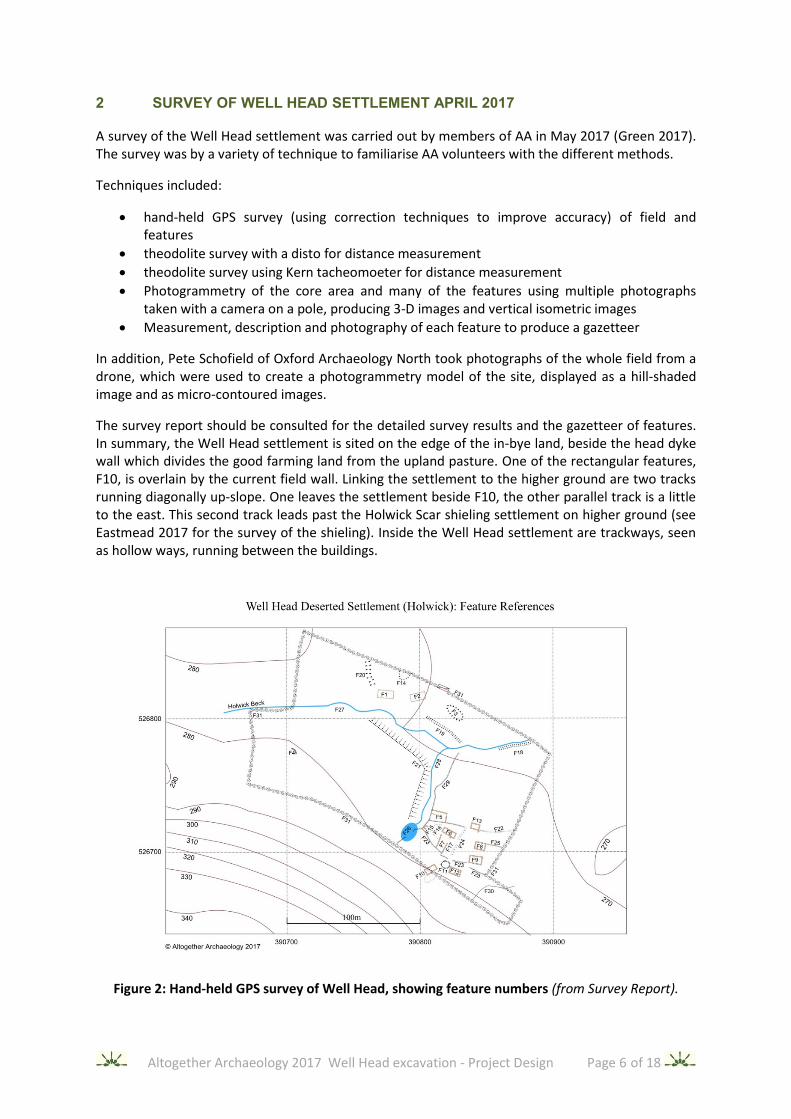
2 SURVEY OF WELL HEAD SETTLEMENT APRIL 2017
A survey of the Well Head settlement was carried out by members of AA in May 2017 (Green 2017). The survey was by a variety of technique to familiarise AA volunteers with the different methods.
Techniques included:
• hand-held GPS survey (using correction techniques to improve accuracy) of field and features
• theodolite survey with a disto for distance measurement
• theodolite survey using Kern tacheomoeter for distance measurement
• Photogrammetry of the core area and many of the features using multiple photographs taken with a camera on a pole, producing 3-D images and vertical isometric images
• Measurement, description and photography of each feature to produce a gazetteer
In addition, Pete Schofield of Oxford Archaeology North took photographs of the whole field from a drone, which were used to create a photogrammetry model of the site, displayed as a hill-shaded image and as micro-contoured images.
The survey report should be consulted for the detailed survey results and the gazetteer of features. In summary, the Well Head settlement is sited on the edge of the in-bye land, beside the head dyke wall which divides the good farming land from the upland pasture. One of the rectangular features, F10, is overlain by the current field wall. Linking the settlement to the higher ground are two tracks running diagonally up-slope. One leaves the settlement beside F10, the other parallel track is a little to the east. This second track leads past the Holwick Scar shieling settlement on higher ground (see Eastmead 2017 for the survey of the shieling). Inside the Well Head settlement are trackways, seen as hollow ways, running between the buildings.
Figure 2: Hand-held GPS survey of Well Head, showing feature numbers (from Survey Report).

Altogether Archaeology 2017 Well Head excavation - Project Design Page 7 of 18
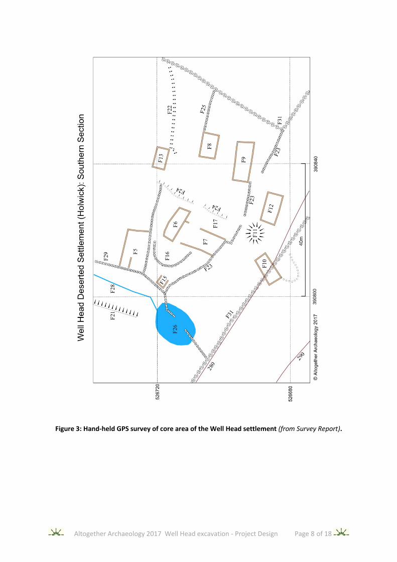
In the centre of the settlement, at the summit of a hillock beside a large spring, are two single-celled rectangular structures at right angles to each other (F6, F7), overlain by old tumbled field walls and rubble. To the NW of F7 are two platforms lower on the slope (F15, F16). To the SE of F7, is rectangular platform (F17), similar in size to F7. See Figures 3 and 4 for plans of this core area.
Around this central core are six rectangular buildings (F5, F8, F9, F10, F12, F13), all (except F10) roughly sharing the orientation of F6. Some are single-celled. However, F9 and F12 may be two-celled. The western end of F13 has been lost in debris from a steep earth slope. Only F6, F7, and F8 have clear entrances: these are in their long sides. However, care needs to be taken in identifying entrances as ongoing movement of cattle across the site may have created gaps in the ruined walls. F10 has an attached yard to its east. F5 has a flat platform attached to its north side, possibly a yard.
To the north of the beck, 100m north of the core area, are the foundations of two larger buildings (F1, F2), but interpretation is difficult as one side of F2 is absent and the feature lies in wet ground near the beck. A platform, F14, lies at the top of the slope to the north and there is an old track, F20, to their west which leads down to the watering place on the beck and provides access to these buildings; the modern road to the north of them is only two hundred years old.
Map evidence (see survey report) shows that by 1800 the settlement was largely deserted with stone field walls built across it (now mostly tumbled) and only two remaining buildings: a cow byre north of the beck (at F2) and rectangular structures in the core of the settlement (F6 and F7), possibly already ruined. By the mid-19th century there were no structures apart from field walls.
The only feature to the W of the main settlement is F4. The nature of this is unclear as there are only fragmentary remains. The lack of features in this area is probably due to the ridge between the beck and the crag having been ploughed, as evidenced by the “clean” appearance on lidar images.
The date of the tumbled field walls running across the settlement is unclear. They were clearly built after the settlement had gone out of use, but are older than the current field walls. The layout of the walls suggests that they were stock enclosures and intended to control access to water sources. The “stepped” gap in the tumbled wall beside F9 may have been to control stock descending from the moors. One of the walls, F22, is only seen as foundations and may be older: it appears to be the boundary between the settlement and agricultural land to the north. There is no clear straight route through the settlement for stock movement between in-bye land, byres in the settlement and the moorland. This may be because of the steepness of the slopes necessitating zig-zag tracks, and the location of the core of the settlement on a hillock discouraging through traffic.
Some of the E side of the settlement (including the lower end of the track down from the shielings) may have been obscured by debris from a chute through the crags, and by the ploughing of the field behind the pub. This field, to the E of the field in which the settlement lies, does not stretch as far as the head-dyke, suggesting that it is a later enclosure, carved out of the settlement field.
A small mound, F11, is located in the southern part of the settlement. There is a scoop quarried into one face. It is unclear if this is a natural feature, or is a constructed cairn.
The rectangular buildings of the settlement survive as dwarf-wall foundations of stone and earth about 0.2m high.
Altogether Archaeology 2017 Well Head excavation - Project Design Page 8 of 18
Figure 3: Hand-held GPS survey of core area of the Well Head settlement (from Survey Report).

Altogether Archaeology 2017 Well Head excavation - Project Design Page 9 of 18
Figure 4: Theodolite-with-disto survey of core area of the Well Head settlement (from Survey Report)
3 INVESTIGATION OF THE SITE BY MAGNETOMETRY
The Swaledale & Arkengarthdale Archaeology Group kindly allowed AA to use their Bartington dual sensor magnetometer to examine the site. This was carried out on 6 August 2017, with the machine operated by Stephen Eastmead.
The site is beside crags of the Whin Sill, composed of an igneous rock (intrusive dolerite), with much of the stones on the site being derived from the crag. This rock is usually magnetic, therefore it was
Altogether Archaeology 2017 Well Head excavation - Project Design Page 10 of 18
expected that a full grid survey would not give much useful information. This was confirmed on site as it became clear that nearly all the stone on site (walls, foundations, field stone, bedrock) gave a high reading on the magnetometer, drowning out subtle variations. The magnetometer was therefore used as a scanner to examine chosen locations such as the central area of buildings and to check if apparent entrances were truly gaps in the walls (as shown by low readings).
Significant results are as follows:
F1: The centre of this feature gave a consistently fairly high reading, suggesting it may have a stone floor (or be on igneous bedrock). There was no signal enhancement transversely across the centre of the building, making it unlikely it was divided by a stone wall into two cells.
F2: The south side of this rectangular structure cannot be identified on the ground and was not detected by the magnetometer.
F4: The visible short curved bank could be followed a few meters further to the west, as high signature on the magnetometer. Hence this structure is roughly a semicircle, approximately 6m in diameter, a candidate for a round house.
F5: The rectangular platform abutting the north side of this rectangular structure gave a fairly even signal. There was no increase in signal in the middle or at the edges of the platform (except where overlain by a later stone wall). Therefore, it probably is not revetted by stone walls nor are there stone foundations on it.
F7: The apparent entrances at the north end of its eastern wall and centre of its western wall both gave low readings, suggesting gaps in the stone foundations at these points.
F8, F9, and F13. The stone foundations of these buildings gave, as expected, high readings, but across the centre of the buildings the floors gave lower readings with no clear areas of enhancement.
F11: This mound/cairn gave low readings, making it unlikely that it is a cairn of stones from the Whin Sill or Whin Sill bedrock.
F15: The edges of this platform did not give a high reading, so probably do not contain stone (although interpretation was difficult due to interference from the nearby stone walls).
F16: The edge of this platform gave a high reading, suggesting it was revetted with stone (or had a wall foundation at its edge).
4 PROJECT AIMS AND OBJECTIVES
Both of the relevant Research Frameworks highlight the lack of knowledge of medieval rural settlement in the North Pennines. The North Pennines Archaeological Research Framework (Frodsham 2017) states that:
“Buildings of presumed medieval date survive as earthworks in many places, for example at Holwick (Upper Teesdale). [...] A selection of such sites, in different places throughout the North Pennines, should be subjected to detailed survey and excavation to find out more about them and establish their chronology.” (Paragraph 6c)
“Much work is required to understand medieval agriculture throughout the North Pennines.” (Paragraph 6h)

Altogether Archaeology 2017 Well Head excavation - Project Design Page 11 of 18
The North East Regional Research Framework (Petts and Gerrard 2006) also refers to the lack of understanding of medieval and early medieval rural domestic structures:
“Even basic questions, such as when the transition from the Romano-British tradition of circular buildings to the medieval rectangular tradition took place, are still unanswered. It is possible that many rectangular structures, ostensibly of later medieval date, may in fact be of pre-Conquest date.” (page 159)
“Despite the overwhelmingly rural nature of the medieval settlement pattern, there has been relatively little archaeological work on rural settlements, and virtually none in the North Pennines or in northern or upland Northumberland, with most excavated sites being found in South Durham and Cleveland” (page 165)
The HLF-sponsored Lidar Landscapes project, managed by the North Pennines AONB, is still in progress. However preliminary results for the Teesdale part of the lidar survey show that the valley is rich in enclosed round house settlements, normally dated to the late Iron Age / Romano-British era. There are associated “celtic” field systems (Paul Frodsham: report in preparation). These early settlements are found in all parts of the dale, both above and below Holwick. In areas of later medieval ploughing (most of the valley floor at Holwick and lower down the dale) they are, not surprisingly, absent. This suggests that much of the dale was in cultivation before the early medieval era. During the early medieval period (up to 1066 AD) the picture is less clear. Place names suggest Anglo-Saxon and Viking occupation. At Simy Folds (on higher ground west of Holwick) Coggins found evidence of long-term multi-period occupation, with two hearths dated to the 8th century (Coggins, Fairless and Batey 1983). Otherwise, evidence is lacking.
Several strands of evidence help to narrow down the date of the Well Head settlement.
• Pottery found during the survey in molehills has been dated to the 13th century and later
• All structures are rectangular, there are no round houses (except for the fragmentary remains of F4 which could be circular)
• Current field walls pass over the access tracks from settlement to fell and overlie F10, so clearly post-date the settlement
• The tumbled walls across the settlement also clearly post-date the active period of the settlement and were present in their current form on maps around 1800
• Map evidence (see the survey report) show that by 1800 all that remained of the settlement was a cow byre and rectangular structures on the hillock (possibly already ruined)
• Nearby parts of the valley floor are covered in lynchets and broad ridge-and-furrow (normally dated to the medieval period from the 9th century onwards)
• The settlement was connected to upland shielings by a track suggesting it was in use during an era of transhumance.
This suggests that the settlement was in use in the high medieval period between the Conquest and Black Death (1100 to 1350 AD). However, its date of foundation may well have been before this as Teesdale was clearly well-populated earlier, and such a good settlement site is likely to have been used. Unfortunately, as mentioned above, the nature and extent of early medieval settlement in the North Pennines is unclear. Hence, it is not possible to assess the chance that a site like Well Head could have been continuously occupied from Iron Age to High Medieval or if there would have been a period of disuse in the early medieval period.
Thus, a prime objective of the excavation is to discover the period and intensity of use of the settlement: with the lack of any previous excavations of similar sites in the North Pennines, nothing can be assumed about its nature: it may have been in use from prehistoric times, or it may have had only a comparatively short period of intense use during the high medieval era.

Altogether Archaeology 2017 Well Head excavation - Project Design Page 12 of 18
Other aims are:
• To evaluate the state of preservation of the settlement and risks to it from rabbits and other factors
• To establish the character of its original construction and any later modification
• To recover material useful for dating the construction and usage
• To recover material and other evidence to establish the types of activity in the settlement
• To recover suitable palaeo-environmental material (if present) to understand the site and landscape
• In general, to aid understanding of similar sites, particularly the other abandoned “medieval” settlements along the edge of the valley floor in upper Teesdale, none of which have been excavated
• To enhance the archaeological capability of AA members including greater involvement in project planning, delivery, and reporting
• For volunteers to have a good time and have both mental and physical exercise
• To feed back into the local community our findings and enhance appreciation of the local historic environment
5 METHODS
5.1 Trench locations
Trench locations are provisional, based on information available from the pre-excavation survey that has already been carried out and published on the AA website (Green 2017). Information has also been used from magnetometer data (see Section 4). As excavation proceeds and more information is available then location of new trenches may be updated. The intention is to excavate only a small fraction of the total area of the settlement, treating this as an exploratory excavation to establish the nature of the site, its state of preservation, and the risks to it.
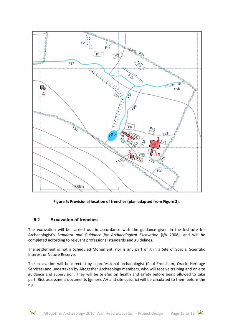
Provisional trench size, location, and order of excavation are as follows (refer to the gazetteer in the survey report for descriptions of features and Figure 5 below for a plan):-
Trench 1: 9m x 12m to expose all of rectangular building F8 and abutting end of wall F25, with deepening of excavation to the natural over part of the area. This may be extended by a 2m wide extension (Trench 1a) across the centre of neighbouring rectangular building F9.
Trench 2: 18m x 2m across platforms F15 and F16 and into rectangular structure F7, including the terminal of its eastern wall.
Trench 3: 4m x 4m to examine one quadrant of mound/cairn F11 and establish its nature. Depending on results, this may be extended by 2m to include the adjacent corner of rectangular structure F10.
Trench 4: 4m x 4m to examine one quadrant of possible roundhouse F4, this trench may need to be adapted depending on findings since the identification of the structure as a round house is uncertain.
Altogether Archaeology 2017 Well Head excavation - Project Design Page 13 of 18
Figure 5: Provisional location of trenches (plan adapted from Figure 2).
5.2 Excavation of trenches
The excavation will be carried out in accordance with the guidance given in the Institute for Archaeologist's Standard and Guidance for Archaeological Excavation (IfA 2008), and will be completed according to relevant professional standards and guidelines.
The settlement is not a Scheduled Monument, nor is any part of it in a Site of Special Scientific Interest or Nature Reserve.
The excavation will be directed by a professional archaeologist (Paul Frodsham, Oracle Heritage Services) and undertaken by Altogether Archaeology members, who will receive training and on-site guidance and supervision. They will be briefed on health and safety before being allowed to take part. Risk assessment documents (generic AA and site-specific) will be circulated to them before the dig.
Altogether Archaeology 2017 Well Head excavation - Project Design Page 14 of 18
The excavation areas will be defined by Netlon fencing if necessary to prevent animals from entering the area when the site is unattended. The farmer has agreed that the field will not contain cattle during the excavation. The depth of the excavations is not expected to exceed 1m. Advice will be taken from the professional archaeologist, if necessary, as to precautions needed for deep excavation.
Position of the trenches (OS National grid co-ordinates) will be established by relating them to the previous AA survey, cross-checked by corrected hand-held GPS readings.
All excavation will be by hand. Turf, stones, and soil will be stored separately on site
After the completion of the excavation, the original ground surface will be restored and the area re-turfed to restore its original state.
All excavated archaeological deposits will be recorded stratigraphically using a paper record forms recording system, as used in previous Altogether Archaeology excavations.
A drawn record of archaeological features and deposits will be made, including plans drawn at a scale of 1:20, and sections at 1:10. The trenches will be recorded by photogrammetry to give isometric views of plans and sections, as well as 3-D models of them.
The position of finds (apart from those in topsoil) and their archaeological context will be recorded. A dumpy level will be used to establish heights.
A photographic record will be maintained, using colour digital photography, of all significant features, finds, deposits and general site working. The photographic record will illustrate both the detail and the general context of the principal features and finds excavated and the site as a whole.
A site notebook and loose-leaf folder will be maintained for each trench to maintain a record of the volunteers present, work done, photography, plans, sections, levels, contexts and significant finds.
5.3 Finds, environmental sampling and human remains
All artefacts from excavated contexts will be retained, except those considered to be of no intrinsic interest from features or deposits of obviously modern date. However, in such circumstances, sufficient artefacts may still be retained in order to elucidate the date and/or function of the features or deposits.
All retained artefacts will, as a minimum, be washed, weighed, counted, marked (as necessary), identified, and bagged or boxed in suitable containers.
Any artefacts requiring conservation or specific storage conditions will be dealt with immediately in line with First Aid for Finds (Watkinson and Neal 2001) and after taking expert advice.
All artefacts recovered during the excavations on the site remain the property of the farmer/landowner. They will be suitably bagged by context and boxed after any necessary conservation (on expert advice and subject to agreement with the landowner). Finds will be kept in a secure location overnight. No finds will be discarded before post-excavation assessment.
If material is recovered that is considered to be covered by the Treasure Act of 1996 all the necessary information required by the Act (i.e. finder, location, material, date, associated items etc.) will be reported and the Finds Liaison Officer advised.

Altogether Archaeology 2017 Well Head excavation - Project Design Page 15 of 18
Sealed deposits suitable for palaeoenvironmental examination and dating may be found during this excavation. If a decision to take such samples is made, then they will be taken, stored, and processed according to accepted procedures.
It is extremely unlikely that human remains will be discovered during this excavation. If any are discovered then the advice of the professional archaeologist will be taken regarding recording, excavation and removal from the site, subject to compliance with the appropriate legislation and guidance. A licence for the removal of human remains will be required should it be considered necessary. All excavation and post-excavation treatment of remains will be in accordance with the standards set out by the Institute for Archaeologists (McKinley and Roberts 1993).
5.4 Report
Specialists will be called on as necessary from Durham University and elsewhere to assess finds, process samples taken, and advise on archaeological findings.
A comprehensive Project Archive will be prepared and a report issued, intelligible to the interested non-specialist, which will include:
• Introduction and background to the project, using updated and expanded extracts from this Project Design, the 2011 Holwick Survey Report and the 2017 Well Head Survey Report
• A site location plan, with trenches marked, notated with the OS grid
• A concise description of the dates of the project, methods used, and results obtained
• Drawn and photogrammetric plans and sections of the archaeological deposits
• A list of significant finds with any specialist reports on these
• A report on any environmental and dating work undertaken, giving results
• Recommendations for further archaeological work (although these would be undertaken as a separate project)
Copies of the report will be supplied to the landowners, farmer, AONB and County Archaeology Service. An electronic copy of the report will be, in keeping with previous practice, posted on the AA website for public access: http://www.altogetherarchaeology.org/reports.php
The report will be made available via the ADS/OASIS archive
6 PROJECT TEAM & COMMUNICATION
In accordance with standard Altogether Archaeology practice, this project will be overseen by a Project Team, as follows:
Professional Archaeologist/Director Paul Frodsham
AA Fieldwork Co-ordinator Martin Green [email protected]
AA excavation task group member Stephen Eastmead
AA Chairman and AA excavation task group member
Tony Metcalfe
Overall supervision of the excavation will be by Paul Frodsham. He has over twenty years’ experience of directing archaeology projects in North-East England, and has previously been employed as the senior archaeologist for the Northumberland National Park and for the North Pennines AONB. He directed the HLF-funded Altogether Archaeology community project from 2010
Altogether Archaeology 2017 Well Head excavation - Project Design Page 16 of 18
to 2015 and currently works for his own consultancy, Oracle Heritage Services, as well as managing (for the North Pennines AONB) the Lidar Landscapes project, which finishes on 31 August 2017. The team will be in daily contact during the two weeks of the excavations. Funding of the project is through Altogether Archaeology’s own resources, mainly membership fees and donations. Publicity about the project will be disseminated via email to all members of AA All volunteers taking part in the excavation will be required to be paid-up members of AA and to specifically register for the project, giving days of attendance. On registration for the project, their contact details and those of their emergency contact will be kept, and they will be given the contact details of the fieldwork co-ordinator and archaeological director. Volunteers should contact the fieldwork co-ordinator if concerned that excavation may not take place due to adverse weather or other factors, or if they are unable to attend as planned. The number of volunteers will be limited each day to less than 25; the number of days allocated to each volunteer may be reduced to avoid exceeding the limit.
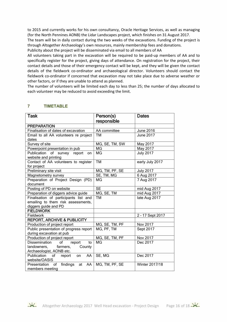
7 TIMETABLE
Task Person(s) responsible
Dates
PREPARATION
Finalisation of dates of excavation AA committee June 2016
Email to all AA volunteers re project dates
TM June 2017
Survey of site MG, SE, TM, SW May 2017
Powerpoint presentation in pub MG May 2017
Publication of survey report on website and printing
MG July 2017
Contact of AA volunteers to register for project
TM early July 2017
Preliminary site visit MG, TM, PF, SE July 2017
Magnetometry survey SE, TM, MG 6 Aug 2017
Preparation of Project Design (PD) document
MG 7 Aug 2017
Posting of PD on website SE mid Aug 2017
Preparation of diggers advice guide MG, SE, TM mid Aug 2017
Finalisation of participants list and emailing to them risk assessments, diggers guide and PD
TM late Aug 2017
FIELDWORK
Fieldwork 2 – 17 Sept 2017
REPORT, ARCHIVE & PUBLICITY
Production of project report MG, SE, TM, PF Nov 2017
Public presentation of progress report during excavation at pub
MG, PF, TM Sept 2017
Production of project report MG, SE, TM, PF Nov 2017
Dissemination of report to landowners, farmers, County Archaeologist, AONB etc.
MG Dec 2017
Publication of report on AA website/OASIS
SE, MG Dec 2017
Presentation of findings at AA members meeting
MG, TM, PF, SE Winter 2017/18

Altogether Archaeology 2017 Well Head excavation - Project Design Page 17 of 18
8 SITE ACCESS, HEALTH AND SAFETY, INSURANCE, AND WELFARE
Parking will be on the verge of the road by the field. If no spaces are left there, cars should be parked further along the road. The pub landlords have requested that the pub car park should not be used. Volunteers are encouraged to car share.
The pub will provide toilet facilities, available via the back door outside opening hours (i.e. before noon).
The farmers’ advice will be followed regarding restrictions in access. No dogs will be allowed on site.
Full consideration will be given to matters of health and safety throughout this project. All work will be undertaken in accordance with the 1974 Health and Safety Act and its subsequent amendments, the 2007 Construction Design and Management Regulations, and the Standing Conference of Archaeological Unit Managers (SCAUM) Health and Safety Manual (2007).
In accordance with standard Altogether Archaeology practice, all work will be subject to the standard AA Risk Assessment and also to a specific risk assessment, covering all real and potential hazards associated with this particular site. A comprehensive health and safety induction will be given to all volunteers at project start-up, and will be emailed to them to read before participation. They will be asked to sign a register, confirming that they understand the risk assessment, and will be asked to provide an emergency contact number of a friend or relative.
An appropriate first aid kit will be on site at all times while fieldwork is in progress. Antiseptic gel and wipes will be available on site. Paul Frodsham is a qualified First Aider.
The trench locations are normally in mobile phone coverage in case of emergencies, but if reception is difficult the pub telephone should be used.
Altogether Archaeology pays for insurance to cover volunteer activities, including excavation, from Export and General Insurance Services Limited.
9 ACKNOWLEDGEMENTS
Thanks to the farmers, the Robinson family of Middle Farm, for their interest. Thanks also for permissions to the Strathmore estate and for the hospitality of the landlords of the Strathmore Arms. The Swaledale and Arkengarthdale Group (SWAAG.org) lent us their magnetometer. Some survey equipment was borrowed from the Tynedale North of the Wall Archaeology Group. Stuart White donated the tacheometer and other equipment. Pete Schofield (Oxford Archaeology North) gave a morning of his time to fly the site with a drone.
10 REFERENCES
Ainsworth, S. 2007 Understanding the Archaeology of Landscape, English Heritage, available at https://historicengland.org.uk.
Coggins, D., Fairless, K. J. and Batey, C. E. 1983 Simy Folds: An Early Medieval Settlement Site in Upper Teesdale, County Durham, Medieval Archaeology, 27, pp. 1-26.
Eastmead, S. 2017 Holwick Scars Scheduled Monument 1019458 - GPS Survey 17 May 2017, Altogether Archaeology, available at https://altogetherarchaeology.org.

Altogether Archaeology 2017 Well Head excavation - Project Design Page 18 of 18
English Heritage 2006 Management of Research Projects in the Historic Environment.
Frodsham, P. 2017 North Pennines Archaeological Research Framework, Altogether Archaeology, available at https://altogetherarchaeology.org.
Green, M. 2017 Well Head Deserted Settlement, Holwick, Teesdale Survey Report 14th to 20th May 2017, Altogether Archaeology, available at https://altogetherarchaeology.org.
Institute for Archaeologists 2008 Standards and Guidance for Archaeological Excavation
McKinley J.I. & Roberts C. 1993 Technical Paper 13: Excavation and post-excavation treatment of cremated and inhumed remains, (Chartered Institute for Archaeologists)
Petts, D. and Gerrard, C. 2006 Shared Visions: The North-East Regional Framework for the Historic Environment, Durham County Council
Schofield, P. and Quartermaine, J. 2011 Holwick, Upper Teesdale, County Durham: Community Archaeology Survey, Report 2010-11/1195, Oxford Archaeology North, available at https://altogetherarchaeology.org.
Watkinson, K. & Neal, V. 2001 First Aid for Finds, UKIC


