Page 1
• CONGRESS OF THE PIIIUPPINES FIFTEENTH CONGRESS First Regular Session }
HOUSE OF REPRESENTATIVES
H. No. 3975
By REPRESENTATIVES SALIMBANGON, MATUGAS AND HERRERA-DY, PER COMMfITEE REpORT No. 489
AN ACT DECLARING CERTAIN LANDS OF THE PUBLIC DOMAIN LOCATED IN THE MUNICIPALITIES OF BANTAYAN, DAANBANTAYAN, MADRIDEJOS AND STA. FE, ALL IN THE PROVINCE OF CEBU, AS AGRICULTURAL LAND OPEN TO DISPOSITION FOR AGRICULTURAL, COMMERCIAL, RESIDENTIAL, TOURISM AND OTHER SIMILAR PRODUCTIVE PURPOSES, AMENDING FOR THE PURPOSE PRESIDENTIAL PROCLAMATION NO. 2151, "DECLARING CERTAIN ISLANDS AND/OR PARTS OF THE COUNTRY AS WILDERNESS ARPAS", DATED DECEMBER 29, 1981, AND FOR OTHER PURPOSES
Be it enacted by the Senale and fiouse 0/ Representatives a/the Philippines in Congress assembled: '.
SECTION l. Declaration of Agricultural Lands. - Certain lands ofthe
2 public domain located in the. municipalities of Bantayan, Daanbantayan,
3 Madridejos and Sta. Fe, all in the Province of Cebu, are hereby declared public
4 agricultural land open to disposition for agricultural, commercial, residential,
5 tourism and otller similar productive purposes. The fundamental principles
6 guiding this Act are the protection of t1).e island, the preservation and
Page 2
2
sustainable use of its waters, the prevention of unplanned and unr7gulated
2 development and the protection of its marine resources.
3 Said public agricultural lands, with a total area of thirteen thousand
4 three hundred thirteen and 8,10511 0,000 (13,313.8105) hectares, more or less,
5 are more particularly described in the following land classification (LC) maps:
6 (a) LC Map No. 2656, Project No. 23, Block I, five thousand four
7 hundred nineteen (5,419) hectares, more or less, alienable or disposable lands,
8 Bantayan Island, Municipality of Bantayan:
9 Corner Bearing Distance (m.)
10 Follow Bantayan and Madridejos ·11 municipal boundary line 8,740
12 2 Follow seashore line in a generally 13 northeasterly direction 2,450
14 3 Follow Bantayan and Sta. Fe municipal 15 boundary line in a generally
'" 16 southwesterly direction 5,220
17 4 Follow seashore line in a generally 18 westerly and southwesterly direction 1,160
19 5 Follow seashore line in a generally 20 southwesterly direction 1,160
21 6 N.70'W. 110
22 7 S. 56' W. 110
23 8 N. 46' W. 100
24 9 S. 74' W. 280
25 10 S. 33' E. 80
26 11 S. 33' E. 160
27 12 S. 56' W. 100
28 13 S. 36' W. 160
29 14 S. 19' W. 140
30 15 S. 42' E. 100
Page 3
3
I 16 Follow seashore line in a generally 2 southwesterly direction 380
3 17 Follow seashore line in a generally 4 westerly and northwesterly direction 1,320
5 18 Follow seashore line in a generally 6 northerly direction 440
7 19 S.6I'E. 50
8 20 N. 08' E. 170
9 , 21 N.43'E. 280
10 22 N. 89' E. 190
11 23 N. 06' E. 140
12 24 N. 57' W. 150
13 25 S. 43' W. 150
14 26 S. 79' W. 150
15 27 N. 78' W. 160
16 28 N. 32' W. 190
17 29 S. 80' W. 100
18 30 N.19'E. 110
19 31 N. 54' E. 330
20 32 N. 89' E. 260
21 33 N. 06' E. 110
22 34 N.45'W. 160
23 35 N. 52' E. 80
24 36 ' N. 78' E. 200
25 37 N. 87' E. 180
26 38 N. 08' E. 100
27 39 N. 60' E. 180
28 40 S. 28' E. 170
29 41 N. 74' E. 250
Page 4
4
42 N. 76° E. 180
2 43 N. 76° E. 150
3 44 N.21°E. 170
4 45 N. 08° E. 200
5 46 N. 64° W. 120
6 47 S. 35° W. 220
7 48 S. 22° E. 120
8 49 S. 41° W. 120
9 50 N.700W. 130
10 51 S. 84° W. 220
II 52 N.36°W. 280
12 53 N. 43° E. 260
13 54 S. 64° E. 100
14 55 N.48°E. 150
15 56 N.27°W. 260
16 57 N. 36° E. 330
17 58 N. 80° W. 160
18 59 S. 79° W. 230
19 60 S. 25° W. 170
20 61 S. 42° W. 120
21 62 N.64°W. 110
22 63 N.400W 240
23 64 N.07°W. 100
24 65 S.600 W. 120
25 66 N.09°E. 300
26 67 N. 22° W. 100
27 68 S. 29° W. 100
28 69 N.81°W. 130
Page 5
5
70 N. 73' W. 240
2 71 S. 57' W. 90
3 72 Follow seacoast line in a generally 4 southwesterly and northwesterly
'5 direction 8,880
6 73 S. 63' E. 90
7 74 N.31'E. 110
8 75 N. 50' E. 80
9 76 N.03'W. 150
10 77 N. 09' E. 240
I I 78 N. 48' W. 120
12 79 N. 70' E. 400
13 80 N. 08' W. 170
14 81 S.41'E. 250
15 82 S. 80' E. 230
16 83 N.26'W. 420
17 84 S. 88' W. 390
18 85 S. 29' W. 570
19 86 S. 32' W. 160
20 87 S. 30' E. 170
21 88 S.41'W. 120
22 89 S. 06' E. 160
23 90 Follow seacoast line in a generally 24 northwesterly and northeasterly direction 1,200
25 91 Follow seacoast line in a generally 26 northeasterly direction 1,050
27 92 Follow seacoast line in a generally 28 northeasterly direction 640
Page 6
6
(b) LC Map No. 2656, Project No. 23, Block II, forty-seven (47)
2 hectares, more or less, alienable or disposable lands, Panitugan Island,
3 Municipality of Bantayan:
4
5 6
7 8
9 10 11
12 13 14
15 16
17
18
19
20
21
22
23
24
2
3
4
5
6
7
8
9
10
II
12
13
Bearing
Follow seacoast line in a generally southeasterly direction
Follow seacoast line in a generally east-southeasterly direction
Follow seacoast line in a generally southeasterly ·and southwesterly direction
Follow seacoast line in a generally southwesterly and northwesterly direction
Follow seacoast line in a generally northeasterly direction
N. 59' E.
N. 70' E.
N. 20' E.
N.55'W.
N. 39' E.
N.19'W.
N. 64' W.
N. 35' W.
Distance (m.l
440
270
920
890
240
170
250
120
120
160
180
160
210
25 (c) LC Map No. 2656, Project No. 23, Block III, one hundred (100)
26 hectares, more or less, alienable or disposable lands, Botiguis Island,
27 Municipality of Bantayan:
28
29 30 31
Bearing
Follow seacoast line in a generally northeasterly and southeasterly direction
pistance (m.)
600
Page 7
7
I 2 Follow seacoast line in a generally 2 southwesterly direction 360
3 3 Follow seacoast line in a generally 4 southeasterly direction 290
5 4 Follow seacoast line in a generally 6 southwesterly direction 560
7 5 Follow seacoast line in a generally 8 southwesterly direction 370
9 6 Follow seacoast line in a generally 10 southwesterly and northerly direction 760
I I 7 Follow seacoast line in a generally 12 northeasterly direction 570
13 8 Follow seacoast line in a generally 14 northeasterly direction 320
15 9 . Follow seacoast line in a generally 16 northeasterly direction 720
17 JO S. 12' E. 150
18 II S.51'E. 160
19 12 N.82'E. 150
20 13 N. 04' E. 150
21 14 N.89'W. 140
22 15 N.46'W. 130
23 (d) LC Map No. 2656, Project No. 23, Block IV, two hundred
24 ninety-nine (299) hectares, more or less, alienable or disposable lands, Doong
25 Island, Municipality ofBantayan:
26 Comer Bearing Distance (m.l
27 I Follow seacoast line in a generall), 28 northeasterly direction 1,040
29 2 Follow seacoast line in a generally 30 southeasterly direction 410
31 3 Follow. seacoast line in a generally 32 southwesterly direction 450
Page 8
8
I 4 Follow seacoast line 'in a generally 2 southwesterly direction 1,000
3 5 Follow seacoast line in a generally 4 southwesterly direction 920
5 6 Follow seacoast line in a generally 6 southwesterly direction 800
7 7 Follow seacoast line in a generally 8 southwesterly direction 880
9 8 Follow seacoast line in a generally 10 southwesterly and northwesterly I I direction 730
12 9 Follow seacoast line in a generally 13 northwesterly direction 610
14 10 Follow seacoast line in a generally 15 northeasterly direction 490
16 11 Follow seacoast line in a generally 17 northeasterly direction 520
18 12 N. 80" E. 60
19 J3 N. 71" E. 120
20 14 N. 34" E. 100
21 15 N. 71' W. 160
22 16 N. 63" E. 220
23 17 N. 60" E. 220
24 18 N. 88" E. 120
25 19 S. 42" E. 110
26 20 N. 21' E. 240
27 21 N. 70' E. 190
28 22 N. 34' E. 340
29 23 N. 75" E. 240
30 24 N. 87" E. 320
31 25 N. 05" W. 180
Page 9
2
3
26
27
28
9
N. 84' W.
S.55'W.
N. 76' W.
150
160
290
4 (e) LC MapNo. 2656, Project No. 23, Block V, one hundred fifty-four
5 (154) hectares, more or less, alienable or disposable lands, Lipayran Island,
6 Municipality of Bantayan: The entire island of Lipayran.
7 (f) LC Map No. 2656, Project No. 23, Block VI, forty-six (46)
8 hectares, more or less, alienable or disposable lands, Hilotungan Island,
9 Municipality of Bantayan: The entire island of Hila tung an.
10 (g) LC Map No. 2656, Project No. 34, one thousand seven hundred
II twenty-three (1,723) hectares, more or less, alienable or disposable lands,
12 Bantayan Island; Municipality ofMadridejos:
13
14
IS
16
17
18
19
20
21 22
23 24 25
2
3
4
5
6
7
8
9
Bearing
S. 79' E.
N.67'E.
N. 46' E.
N. 78' E.
N. 79' E.
N. 70' E.
N. 66' E.
Follow seacoast line in a generally southeasterly direction
Follow BalJtayan and Madridejos municipal boundary in a gen~rally northwesterly direction
Distance (m.)
2,670
530
1,100
630
810
470
710
5,080
8,740
26 (h) LC Map No. 2967, Project 34-A, four hundred eight (408) hectares,
27 more or less, alienable or disposable lands, Bantayan Island, Municipality of
28 Madridejos:
Page 10
10
Corner Bearing Distance (m.)
2 N. 17' E. 430
3 2 N. 17' E. 400
4 3 N. 27' E. 440
5 4 N. 32' E. 340
6 5 N. 23' E. 240
7 6 N.05'E. 240
8 7 S. 64' E. 200
9 8 N. 40' E. 320
10 9 N. 27' E. 400
11 10 S. 68' E. 310
12 11 S. 62' E. 340
13 12 S. 62' E. 360
14 13 S. 62' E. 360
15 14 S. 42' E. 380
16 15 S. 42' E. 280
17 16 S.42'E. 260
18 '17 S. 42' E. 280
19 18 S.27'E. 400
20 19 N.55'W. 240
21 20 S. 81' W. 220
22 21 Due West 380
23 22 S. 83' W. 420
24 23 S. 73' W. 230
25 24 S. 73' W. 330
26 25 S. 73' W. 270
27 26 S. 58' W. 140
28 27 S. 75' W. 260
Page 11
11
28 S.7S'W. 270
2 29 S. 80' W. 340
3 30 S. 79' W. 42
4 (i) LC Map No. 3474, Project 34-B, one thousand eight hundred
5 thirty-nine (1,839) hectares, more or less, alienable or disposable lands,
6 Bantayan Island, Municipality of Madridejos:
7 Comer Bearing Distance (m.)
8 N. 30' E. 290
9 2 N. 16' E. 200
10 3 N. 43' E. 170
II 4 S. 20' E. 200
12 5 N. 65' E. 65
13 6 S.6I'E. 90
14 7 S. 10' W. 150
15 8 N. 60' E. 100
16 9 S. 61' E. 170
17 10 Due East 150
18 11 N. 47' E. 110
19 12 N. 25' W. 100
20 13 N.45'W. 190
21 14 N. 07' E. 120
22 15 N.30'W. 90
23 16 N.8I'W. 180
24 17 N. 67' W. 185
25 18 N. 60' E. 70
26 19 Due East 80
27 20 S. 63' E. 90
28 21 S. 80' E. 130
Page 12
12
22 N. 72° E. 150
2 23 S.ll°E. 240
3 24 S. 80° E. 170
4 25 N. 50° E. 250
5 26 N. 55° E. 130
6 27 N. 85° E. 140
7 28 N. 16° E. 320
8 29 N. 80° EOo 140
9 30 N. 04° E. 230
10 31 N. 55° E. 240
II 32 N. 04° E. 130
12 33 N. 18° W. 100
IJ 34 N. 25° E. 100
14 35 N. 68° W. 150
15 36 N. 55° W. 170
16 37 S.400W. 70
17 38 S. 57° E. 200
18 39 S. 10° W. 90
19 40 S. 18° E. 125
20 41 S. 80° W. 220
21 42 S. 11° E. 150
22 43 S. 17° W. 150
23 44 N. 49° W. 125
24 45 S.62°W. 200
25 46 S. 20° E. 110
26 47 S.68°W. 70
27 48 S.82°W. 50
28 49 S. 03° W. 80
Page 13
13
50 S. 50° W. 200
2 51 N. 68° W. 70
3 52 N. 32° E. 310
4 53 N. 09' E. 100
5 54 N.04°W. 120
6 55 N. 34' E. 220
7 56 N. 31° E. 255
8 57 N. 25° E. 230
9 58 N. 20° E. 250
10 59 N. 20' E. 200
11 60 N.31'E. 155
12 61 N. 07° E. 180
13 62 N. 23' E. 270
14 63 N.19°E. 350
15 64 N. II°E. 280
16 65 N. 23' E. 255
17 66 N. 74° E. 115
18 67 S. 28° W. 155
19 68 S. 19' W. 120
20 69 S. 22' E. 140
21 70 S. 25° W. 160
22 71 N. 72° E. 95
23 72 S. 50° E. 90
24 73 S.21°W. 250
25 74 S. 31° W. 175
26 75 S. 10° W. 140
27 76 S. 05° W. 150
28 77 S. 58° E. 100
Page 14
14
78 N. 45' E. 90
2 79 N.II'E. 215
3 80 N. 59' E. 190
4 81 N. 03' W. 195
5 82 N. 45' E. 210
6 83 N. II' E. 225
7 84 N.17'E. 225
8 85 S. 75' W. 140
9 86 N. 75' W. 115
10 87 N.24'W. 165
11 88 N.75'E. 215
12 89 N.80'E. 340
13 90 N. 75' E. 270
14 91 N.75'E. 260
15 92 N. 58' E. 140
16 93 N. 73' E. 270
17 94 N. 73' E. 330
18 95 N. 73' E. 230
19 96 N. 82' E. 420
20 97 Due East 380
21 98 N.8I'E. 220
22 99 S. 26' W. 190
23 100 S. 15' E. 320
24 101 S. 06' E. 280
25 102 N.77'E. 110
26 103 N.07'W. 220
27 104 N. 24' E. 120
28 105 Due East 110
Page 15
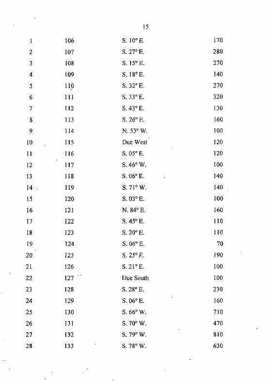
15
106 S. 10° E. 170
2 107 S. 27° E. 280
3 108 S. 15° E. 270
4 109 S. 18° E. 140
5 110 S.32°E. 270
6 11 1 S. 33° E. 320
7 112 S. 43° E. 130
8 113 S. 26° E. 160
9 114 N. 53° W. 100
10 115 Due West 120
II 116 S. 05° E. 120
12 117 S. 46° W. 100
13 . liS S. 06° E. 140
14 119 S.7I'W. 140
15 120 S. 03° E. 100
16 121 N.84°E. 160
17 122 S.45°E. 110
18 123 S. 20° E. 110
19 124 S. 06° E. 70
20 125 S. 25° E. 190
21 126 S.21°E. 100
22 127 .. Due South 100
23 128 S. 28° E. 230
24 129 S.06°E. 160
25 130 S. 66° W. 710
26 131 S. 70° W. 470
27 132 S. 79° W. 810
28 133 S.78°W. 630
Page 16
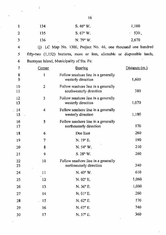
16
l34 S.46°W. 1,100
2 l35 S.67°W. 530,
3 136 N.79°W. 2,670
4 G) LC Map No. l300, Project No. 46, one thousand one hundred
5 fifty-two (l, 152) hectares, more or less, alienable or disposable lands,
6 Bantayan [sland, Municipality of Sta. Fe:
7 Corner Bearing Distance (m.)
8 Follow seashore line in a generally 9 westerly direction 1,600
10 2 Follow seashore line in a generally II southwesterly direction 380
12 3 Follow seashore line in a generally 13 westerly direction 1,070
14 4 Follow seashore line in a generally [5 westerly direction 1,180
16 5 Follow seashore line in a generally 17 northeasterly direction [70
18 6 Due East 260
19 7 N. 19° E. 190
20 8 N.54°W. 210
21 9 S. 28° W. 260
22 10 Follow seashore line in a generally 23 northwesterly direction 340
24 II N.400W. 610
25 12 N. 02° E. 1,060
26 13 N. 36° E. 1,000
27 14 N.OloE. 260
28 15 N. 62° E. [70
29 16 N. 67° E. 740
30 17 N. 57° E. 360
Page 17
17
18 N.58°W. 210
2 19 N. 48° E. 240
3 20 N.02°W. 115
4 21 N.69°W. 80
5 22 Follow seashore line in a generally 6 southeasterly direction 460
7 23 follow seashore line in a generally 8 southeasterly direction 190
9 24 Follow seashore line in a generally 10 southeasterly direction 1,120
11 25 Follow seashOre line in a generally 12 southeasterly direction 2,570
13 (k) LC Map No. 2656, Project No. 46-A, Block I, four hundred
14 ninety-six (496) hectares, more or less, alienable or disposable lands, Bantayan
15 Island, Municipality of Sta. Fe:
16 Corner Bearing Distance (m.)
17 Follow Bantayan and Sta. Fe 18 municipal boundary line in a 19 generally northwesterly direction 5,220
20 2 Follow seacoast line in a generally 21 southeasteriy direction 1,080
22 3 S. 61° W. 170
23 4 S. 40° E. 270
24 5 S.79°W. 180
25 - 6 N.38°W. 130
26 7 S. 65° W. 90
27 8 N.19°W. 180
28 9 N.53°W. 170
29 10 N.48°W. 330
30 I I S. 23° W. 60
Page 18
18
12 N. 46° W. 240
2 13 N.23°W. 130
3 14 N.24°W. 200
4 15 N.28°W. 140
5 16 N. 20° E. 140
6 17 N. 59° W. 130
7 18 S. 49° W. 220
8 19 S. 12° E. 160
9 20 N. 76° E. 80
10 21 S. 46° E. 160
II 22 S. 01' E. 350
12 23 S. 62° W. 130
13 24 S:22° E. 340
14 25 Due West 280
15 26 N. 34° E. 190
16 27 N.600W. 200
17 28 N.34°W. 120
18 29 N.54"W. 70
19 30 N. 12' E. 90
20 31 S. 45° E. 270
21 32 S. 50° E. 130
22 33 S. 44° E. 300
23 34 S. 36' E. 280
24 35 S. 60° W. 250
25 36 S. 60' W. 720
26 37 S. 60' W. 190
27 38 S. 02° W. 280
28 39 S. 34' W. 980
Page 19
2
3 4
40
41
42
19
S. 02' W. 1,140
S. 38' E. 700
Follow seacoast line in a generally northwesterly direction 1,200
5 (I) LC Map No. 2656, Project 46-A, Block II, four hundred forty-two
6 (442) hectares, more or less, alienable or disposable lands, Jilantaga-an Island,
7 Municipality ofSta. Fe: The entire island of Jilantaga-an.
8 (m) LC Map No. 3411, Project No. 46-B, eight hundred eighty-four
9 and 5011 00 (884.50) hectares, more or less, alienable or disposable lands,
10 Guintacan Island, Municipality ofSta. Fe:
II
12 13
14 15
16 17
18 19
2
3
4
Bearing
Follow shoreline in a generally southeasterly direction
Follow shoreline in a generally southwesterly direction
Follow shoreline in a generally northwesterly direction
Follow shoreline in a generally northeasterly cti'rection
Distance (m.)
3,350
4,600
4,050
3,860
20 (n) LC Map No. 3411, Project No.8-A, Block A, one hundred
21 sixty-seven and 7,505/10,000 (167.7505) hectares, more or less, alienable or
22 disposable lands, Camasa Island, Municipality of Daanbantayan: The entire
23 island of Camasa.
24 (0) LC Map No. 3411, Project No.8-A, Block B, one hundred
25 thirty-six and 561100 (136.56) hectares, more or less, alienable or disposable
26 lands, Malapascua Island, Barangay Logon, Municipality of Daanbantayan:
27 The entire island of l\1alapascua.
28 SEC. 2. Status of the Areas Outside the Agricultural Lands; Land
29 Classification. - The portions of the public domain within the territorial
30 jurisdiction of the municipalities of Bantayan, Daanbantayan, Madridejos and
Page 20
20
Sta. Fe which are located outside the agricultural lands declared in Section I
2 shall remain within the coverage of Proclamation No. 2151, "Declaring Certain
3 Islands and/or Parts of the Country as Wilderness Areas", dated December 29,
4 1981, and shall be managed in accordance with Republic Act No. 7586,
5 otherwise known as the "National Integrated Protected Areas System Act of
6 1992" or (he NIPAS Act. For the purpose of land classification, these lands
7 are hereby declared national parks as provided for in the Philippine
8 Constitution, the boundaries of which are defined in the following land
9 classification maps:
10 <a) LC Map No. 2656, Project No. 23, Block A, thirty (30) hectares,
II more or less, national park, Bantayan Island, Municipality ofBantayan:
12
13
14
15
16
17
18
19
20
21
22
23
24
25
26
27
28
Comer
2
3
4
5
6
7
8
9
10
II
12
13
14
15
16
Bearing Distance (m.)
N.06'W. 160
N.41"E. 120
N.300 W. 170
N. 32" E. 160
N. 29' E. 570
N. 88' E. 390
S. 26° E. 420
N. 80' W. 230
N. 41° W. 250
S. 08° E. 170
S. 70° W. 400
S. 48' E. 120
S.09'W. 240
S. 03' E. 150
S. 50' W. 80
S. 31' W. 110
Page 21
21
17 N.63'W. 90
2 (b) LC Map No. 2656, Project No. 23, Block B, six (6) hectares, more
3 or less, national park, Bantayan Island, Municipality of Bantayan:
4 Comer Bearing Distance (m.l
5 S. 82' &:. 130
6 2 S. 36' E. 200
7 3 N. 19' W. 80
8 4 Follow road in a generally 9 northeasterly direction 50
10 5 S. 18' E. 150
11 6 S. 61' E. 110
12 7 S. 58' W. 50
13 8 S. 81' W. 80
14 9 N.43' W. 240
15 10 S. 03' W. 140
16 11 N. 59' W. 60
17 12 N.13'W. 240
18 (c) LC Map No. 2656, Project No. 23, Block C, one hundred one (101)
19 hectares, more or less, national park, Bantayan Island, Municipality of
20· Bantayan: .. 21 Comer Bearing Distance l!:!hl
22 N. 57' E. 90
23 2 S. 73' E. ·240
24 3 S. 81' E. 130
25 4 N. 29' E. 100
26 5 S. 22' E. 100
27 6 S. 09' W. 300
28 7 N.60'E. 120
Page 22
22
8 S. 07' E. 100
2 9 S. 40' E. 240
3 10 S. 64' E. 110
4 II N. 42' E. 120
5 12 N. 25' E. 170
6 13 N. 79' E. 230
7 14 S. 80' E. 160
8 15 S. 36' W. 330
9 16 S. 27' E. 260
10 17 S. 48' W. 150
11 18 N. 64' W. 100
12 19 S.43'W. 260
13 20 S. 36' E. 280
14 21 N. 84' E. 220
15 22 S. 70' E. 130
16 23 N.4I'E., 120
17 24 N.22'W. 120
18 25 N. 35' E. 220
19 26 S. 64' E. 120
20 27 S. 08' W. 200
21 28 S.2I'W. 170
22 29 S. 76' W. 150
23 30 S.76'W. 180
24 31 S. 74' W. 250
25 32 N. 28' W. 170
26 33 S.60'W. 180
27 34 S.08°W. 100
28 35 S.8?OW. 180
Page 23
23
36 S. 78° W. 200
2 37 S. 52° W. 80
3 38 S. 45° E. 160
4 39 S.06°W. 110
5 40 S.89'W. 260
6 41 S. 54' W. 330
7 42 S. 19° W. 110
8 43 N. 80° E. 100
9 44 S. 32' E. 190
10 45 S. 78' E. 160
II 46 N. 79° E. 150
12 47 N. 43° E. 150
13 48 S. 57° E. 150
14 49 S.06'W. 140
15 50 S. 89° W. 190
16 51 S. 43° W. 280
17 52 S. 08' W. 170
18 53 N.61'W. 50
19 54 Follow seacoast line in a generally 20 northwesterly direction 570
21 55 Follow seacoast line in a generally 22 northwesterly and northeasterly 23 direction 1,040
24 56 Follow seacoast line in a generally 25 northeasterly and northwesterly 26 direction 1,880
27 57 Follow seacoast line in a generally 28 northwesterly direction 730
29 (d) LC Map No. 2656, Project No. 23, Block D, thirty (30) hectares,
30 more or less, national park, Bantayan Island, Municipality of Bantayan:
Page 24
24
Comer Bearing Distance (m.)
2 Follow seacoast line in a generally 3 southeasterly and southwesterly 4 direction 1,730
5 2 N. 42° W. 100
6 3 N. 19° E. 140
7 4 N. 36° E. 160
8 5 N. 56° E. 100
9 6 N. 33° W. 160
10 7 N. 33° W. 80
II 8 N. 74° E. 280
12 9 S. 46° E. 100
13 10 N. 56° E. llO
14 II S. 73° E, 110
15 (e) LC Map No. 2656, Project No. 23, Block E, five (5) hectares, more
16 or less, national park, Bantayan Island, Mnnicipality of Bantayan:
17 Corner Bearing Distance (m.)
18 S.28°W. 180
19 2 N.66°W. 240
20 3 N. 52° E. 180
21 4 N. 76° E. 110
22 5 S. 35' E. 100
23 (t) LC Map No. 2656, Project No. 23, Block F, twenty-nine (29)
24 < hectares, more or less, national park, Panitugan Island, Municipality of
25 Bantayan:
26 Comer Bearing Distance (m.)
27 S. 35° E. 210
28 2 S.64°E. 160
29 3 S. 19° E. 180
Page 25
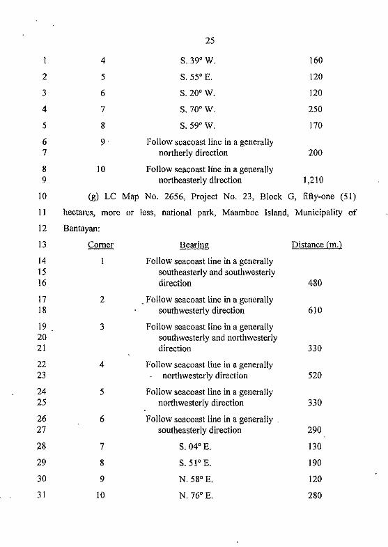
25
4 S. 39' W. 160
2 5 S. 55' E. 120
3 6 S. 20' W. 120
4 7 S. 70' W. 250
5 8 S. 59' W. 170
6 9 Follow seacoast line in a generally 7 northerly direction 200
8 10 Follow seacoast line in a generally 9 northeasterly direction 1,210
10 (g) LC Map No. 2656, Project No. 23, Block G, fifty-one (51)
11 hectares, more or less, national park, Maamboc Island, Municipality of
12 Bantayan:
13 Corner Bearing Distance (m.l
14 Follow seacoast line in a generally 15 southeasterly and southwesterly 16 direction 480
17 2 . Follow seacoast line in a generally 18 southwesterly direction 610
19 3 Follow seacoast line in a generally 20 southwesterly and northwesterly 21 direction 330
22 4 Follow seacoast line in a generally 23 northwesterly direction 520
24 5 Follow seacoast line in a generally 25 northwesterly direction 330
26 6 Follow seacoast line in a generally. 27 southeasterly direction 290
28 7 S. 04' E. 130
29 8 S.51'E. 190
30 9 N. 58' E. 120
31 10 N. 76' E. 280
Page 26
26
II N. 02' W. 190
2 12 N.46'W. 180
3 13 Follow seacoast line in a generally 4 northwesterly and northeasterly 5 direction 1,040
6 (h) LC Map No. 2656, Project No. 23, Block H, ten (l0) hectares,
7 more or less, national park, Maamboc Island, Municipality ofBantayan:
8 Comer Bearing Distance (m.l
9· Follow seacoast line in a generally 10 southeasterly direction 310
11 2 Follow seacoast line in a generally 12 northeasterly direction 400
13 3 S. 46' E. 180
14 4 S. 02' E. 190
15 5 S.76'W. 280
16 6 S. 58' W. 120
17 7 N.51'W. 190
18 8 N. 04' W. 130
19 (i) LC Map No. 2656, Project No. 23, Block 1, six (6) hectares, more
20 or less, national park, Botiguis Island, Municipality of Bantayan:
21 Comer Bearing Distance (m.l
22 Follow seacoast line in a generally 23 northeasterly direction 100
24 2 S. 46' E. 130
25 3 S. 89' E. 140
26 4 S.04'W. 150
27 5 S. 82' W. 150
28 6 N. 51' W. 160
29 7 N.12'W. 150
Page 27
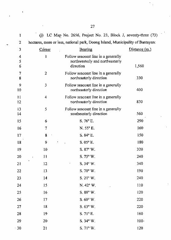
27
U) LC Mal' No. 2656, Project No. 23, Block J, seventy-three (73)
2 hectares, more or less, national park, Doong [slaod, Municipality ofBantayan:
3 ~drner Bearing Distance (m.)
4 Follow seacoast line in a generally 5 northwesterly aod northeasterly 6 direction 1,560
7 2 Follow seacoast line in a generally 8 northeasterly direction 330
9 3 Follow seacoast line in a generally 10 northeasterly direction 400
II 4 Follow seacoast line in a generally 12 northeasterly direction 830
13 5 Follow seacoast line in a generally 14 southeasterly direction 560
15 6 S. 76' E. 290
16 7 N. 55' E. 160
17 8 S. 84' E. 150
18 9 S. 05' E. 180
19 10 S. 87' W. 320
20 11 S. 75' W. 240
21 12 S. 34' W. 340
22 13 S. 70' W. 190
23 14 S.2I'W. 240
24 15 N.42'W. 110
25 16 S. 88' W. 120
26 17 S. 60' W. 220
27 18 S. 63' W. 220
28 19 S.7I'E. 160
29 20 S. 34' W. 100·
o 30 21 S.7l'W. 120
Page 28
28
22 S. 80" W. 60
2 (k) LC Map No. 3474, Project 34-B, Block A, sixteen and 60/100
3 (! 6.60) hectares, more or less, national park, Bantayan Island, Municipality of
4 Madridejos:
5 CO!1lIT Bearing Distance (m.l
6 S. 17" E. 290
7 2 Due West 110
8 3 S. 24" W. 120
9 4 S. 07" E. 220
10 5 S. 77" W. 110
II 6 N. 06" W. 280
12 7 N.15"W. 320
13 8 N. 26" E. 220
14 9 S. 55" E. 240
15 (I) LC Map No. 3474, Project 34-B, Block B, fourteen and 80/100
16 (14.80) hectares, more or less, national park, Bantayon Island, Municipality of
17 Madridejos:
18 Comer Bearing Distance (m.l
19 S. 22° W. 200
20 2 S.II"E. 130
21 3 S.31"W. 190
22 4 N.20"W. 110
23 5 N.45"W. 110
24 6 S. 84" W. 160
25 7 N.03"W. 100
26 8 N. 71" E. 140
27 9 N.06"W. 140
28 10 N. 46" E. 100
Page 29
29
II N.05°W. 120
2 12 Due East 120
3 13 S. 53° E. 100
4 14 S. 22° E. 130
5 (m) LC Map No. 3474, Project 34-B, Block C, twelve and 40/100
6 (12.40) hectares, more or less, national park, Bantayan Island, Municipality of
7 Madridejos:
8 Corner. Bearing Distance 1m,}
9 N. 45° E. 430
10 2 S. 30° E. 90
II 3 S. 70° W. 120
12 4 S. 45° E. 190
13 5 S. 25° E. 100
14 6 S. 47° W. 110
15 7 Due West 150
16 8 N.61°W. 170
17 9 S.600 W. 100
18 10 N. 10° E. 150
19 I I N.61°W. 90
20 (n) LC Map No. 3474, Project 34-B, Block D, forty and 201100 (40.20)
21 hectares, more or less, national park, Bantayan Island, Municipality of
22 Madridejos:
23 Corner Bearing Distance (m.)
24 N.ll°W. 240
25 2 N. 59° E. 200
26 3 S. 68° E. 70
27 4 N. 50° E. 200
28 5 N. 03° E. 80
Page 30
30
6 N. 82' E. 50
2 7 N. 68' E. 70
3 8 N.20'W, 110
4 9 N. 62' E, 200
5 10 S. 49' E. 125
6 II N, 17' E. 150
7 12 S.II'E, 150
8 13 N. 80' E, 220
9 14 N, 18' W, 125
10 15 N. 10' E. 90
II 16 N. 57' E, 200
12 17 N, 40' E. 70
13 18 S, 55' E, 70
14 19 S, 68' E, 150
15 20 S. 25' W. 100
16 21 S, 18' E, 100
17 22 S, 04' W, 130
18 23 S. 55' W, 240
19 24 S, 04' W. 230
20 25 S, 80' W, 140
21 26 S, 16' W, 320
22 27 S, 85' W. 140
23 28 S, 55' W, 130
24 29 S, 50' W, 250
25 30 N,80'W, 170
26 (0) LC Map No, 3474, Project 34-B, Block E, thirty-four and 40/100
27 (34.40) hectares, more or less, national park, Bantayan Island, Municipality of
28 Madridejos:
Page 31
31
1 . Comer Bearing Distance (m.)
2 S. 24' E. 165 ."."
3 2 S. 75° E. 115
4 3 N. 75' E. 140
5 4 S.17'W. 225
6 5 S.II'W. 225
7 6 S. 45° W. 210
8 7 S. 03' E. 195
9 8 S. 59' W. 190
10 9 S.II'W. 215
II 10 S. 45' W. 90
12 11 N. 58' W. 100
13 12 N.05'E. 150
14 13 N. 10' E. 140
15 14 N.3I'E. 175
16 15 N. 21' E. 250
17 16 N.50'W. 90
18 17 S. 72' W. 95
19 18 N.25'E. 160
20 19 N.22'W. 140
21 20 N.19'E. 120
22 21 N. 28' E. 150
23 22 N. 80' E. 100
24 (p) LC Map No. 2656, Project No. 46-A, forty-four (44)'hectares, more
25 or less, national park, Bantayan Island, Municipality of Sta. Fe:
26 Comer Bearing Distance (m.)
27 Follow seacoast line in a generally 28 southeasterly direction 140
Page 32
32
2 S. 55' E. 90
2 3 S.06'W. 110
3 4 S.45'W. 270
4 5 N. 63' W. 210
5 6 S. 60' W. 100
6 . 7 N. 36' W . 280
7 8 N. 44' W. 300
8 9 N. 50' W. 130
9 10 N.45'W. 270
10 II S.12'W. 90
II 12 S. 54' E. 70
12 13 S. 34' E. 120
13 14 S. 60' E. 200
14 15 S. 34' W. 190
15 16 Due East 280
16 17 N. 22' W. 340
17 18 N. 62' E. 130
18 19 N. 01' W. 350
19 20 N.46'W. 160
20 21 S.76'W. 80
21 22 N. 12' W. 160
22 23 N. 49' E. 220
23 24 S. 59' E. 130
24 25 S. 20' W. 140
25 26 S. 28' E. 140
26 27 S. 24' E. 200
27 28 S. 23' E. 130
28 29 S. 46' E. 240
Page 33
2
3
4
5
6
7
8
9
30
31
32
33
34
35
36
37
38
33
N. 23° E. 60
S. 48° E. 330
S. 53° E. 170
S. 19° E. 180
N. 65° E. 90
S. 38° E. 130
N. 79° E. 130
N. 40° E. 270
N. 61° E. 170
10 (q) LC Map No. 1300, Project No. 46, five (5) hectares, more or less,
II national park, Bantayan Island, Municipality of Sta. Fe: The' technical
12 description is identical to comers 6, 7, 8, 9 and 10 of Project No. 46, Sta. Fe,
13 LC Map No. 1300 found in Section I Ul of this Act.
14 SEC. 3. Additional Protected Areas. - Notwithstanding the technical
15 descriptions in Section I and Section 2, for ecological consideration and
16 environmental protection, the band of dry land within the shorelines covering
17 twenty (20) meters landward from the point where seawater reaches during the
18 highest high tide shall remain as protected areas, under the land classification
19 of national park as provided for in the Philippine Constitution.
20 The islands of Sillon, Pananganlan Gamay, Pananganlan Dako, Botong
21 Diot, Botong Dako, Saga.a, SUlagon Dako, Sulagon Gamay, Biyagayag Dako,
22 Biyagayag Gamay, Mambacayao Dako, Mambacayao Gamay and any other
23 unnamed islands or islets outside the coverage of Section I but located within
24 the territorial boundaries of the municipalities covered in this Act shall
25 likewise remain as protected areas, pursuant to the NIP AS Act, and shall fall
26 under the land classification of national park as provided for in the Philippine
27 Constitution.
Page 34
34
SEC. 4. Disposition of Agricultural Lands for Public and Quasi-Public
2 Purposes. - Prior to any disposition of the public agricultural lands declared in
3 the fIrst paragraph of Section I hereof and accordingly described in its second
4 paragraph, subparagraphs (a), (b), (c), (d), (e), (t), (g), (h), (i), (j), (k), (I), (m),
S (n) and (0), to individuals or private applicants qualifIed to own lands of the
6 public domain, the Department of Environment and Natural Resources
7 (DENR) shall segregate and alienate or reserve appropriate areas, consistent
8 with the relevant provisions of Commonwealth Act No. 141, as amended,
9 otherwise known as "The Public Land Act", and this Act, suitable areas for: (a)
10 commercial, residential, tourism or other siroilar productive purposes; (b)
II educational, charitable or other siroilar purposes; (c) town sites; and (d) public
12 and quasi-public purposes such as, but not limited to, municipal parks, roads
13 and highways, municipal and barangay dnmp sites, communal forests,
14 hospitals, wharves, airports and offices of the national government and local
IS government units: Provided, That the identifIcation of areas for public and
16 quasi-public purposes shall be undertaken jointly with the concerned
17 government agencies or local government units: PrOVided, moreover, That
18 titles over tracts of land for public and quasi-public purposes shall be in the
19 name of the Republic of the Philippines.
20 SEC, 5. Disposition of Public Agricultural Lands to the Private
21 Sector. - The disposition of the public agricultural lands to. individuals or
22 private applicants qualifIed to own lands of the public domain, regardless of
23 the actual use or identifIed purpose of said lands pursuant to this Act, shall be
24 through the issuance by the DENR of a free patent to any applicant who is a
25 citizen of the Philippines and who has continuously occupied and/or cultivated
26 either by hiroself or through his predecessor-in-interest or has paid the real
27 estate taxes for the tract or tracts of land being applied for while the same has
28 not been occupied by any other p'erson, for at least three (3) years prior to the
Page 35
35
approval of this Act, not to exceed twelve (12) hectares for each qualified
2 applicant.
3 SEC. 6. Penal Provision. - Any public offic.er or employee who
4 knowingly recommends or who causes the issuance of title over any portion of
5 the protected areas or national, parks identified in Section 2 and Section 3
6 hereof and in the rules anil regulations promulgated pursuant to this Act, after
7 an appropriate administrative proceeding, shall be dismissed from the service
8 with prejudice to reemployment and, upon conviction by a court of competent
9 jurisdiction, be punished with imprisonment of not less than two (2) years nor
10 more than four (4) years and a firie of not less than Five thousand pesos
II (P5,000.00). The land'title shall be null and void.
12 SEC. 7.' Implementing Rules and Regulations. - Within three (3)
13 months following the effectivity of this Act, the Secretary of the DENR shail
14 issue the necessary rules and regulations ,for the effective implementation of
15 this Act.
16 .. SEC. 8. Repealing Clause. - Proclamation No: 2151, dated December
17 29,1981, and all laws, decrees, orders, proclamations, rules and regulations or
18 parts, thereof which are inconsistent with this Act are hereby amended, repealed
19 andlormodified accQrdingly.
20 SEC. 9. EffectiVity. - This Act shall take effect fifteen (15) days after
21 its complete publication in the Official Gazette or in at least two (2) national
'22 newspapers of general circulation.
Approved,
o