10
INDUSTRY PERSPECTIVE How GIS Drives Innovation Across Outdoor Recreation Spaces
INDUSTRY PERSPECTIVE
How GIS Drives Innovation Across Outdoor Recreation Spaces

How GIS Drives Innovation Across Outdoor Recreation Spaces2
Outdoor recreation resources are essential elements of strong communities. They improve quality of life by supporting economies, promoting healthy living and fostering a stewardship ethic to sustain the environment. But maintaining these opportunities can be challenged by various factors, including tight budgets, limited space and, yes, even a pandemic.
To strengthen our nation’s outdoor recreation resources, communities need a multipronged strategy that elevates effective asset management, improved public information forums, data-driven budgeting and sustainable resource management practices.
For decades, communities have relied on geographic information systems (GIS) to aid this critical work of sustaining natural resources and managing outdoor facilities. But now they’re starting to use the technology on an enterprise level. They’re embracing GIS as an integral technology supporting the complex system of interwoven workflows that must work together to effectively manage and sustain outdoor spaces.
Modernization of the outdoor recreation industry’s data collection, analysis, resource planning and collaboration through mapping and location intelligence has led to a tremendous return on investment for government employees and the residents they serve. The coronavirus pandemic has brought the value of this approach to the forefront as people have flocked to outdoor recreation resources in unprecedented numbers. In turn, managing organizations have had to quickly respond to ensure safe outdoor experiences, promote a wide distribution of opportunities to visitors in easily consumable ways, and make real-time budget and resource allocation decisions.
Ultimately, location-based approaches bring about innovation and are fundamental to managing outdoor recreation resources. Communities can shorten their paths to success by learning from subject-matter experts in recreation, facility management and GIS. Your peers can share the benefits of applying GIS to their outdoor recreation challenges, and insights into their approaches. GovLoop teamed with Esri to create this report to share some of these best practices.
Introduction
How GIS Drives Innovation Across Outdoor Recreation Spaces

3Industry Perspective
State and local government professionals responsible for managing outdoor recreation spaces balance the needs of an active public, the conservation of land, and maintenance of the entire network of facilities and properties.
These land and water areas can support any range of activities such as running, biking, camping, boating, fishing, hiking, nature watching, sports and simple relaxation. To support a thriving experience, a complex system of many interwoven workflows must be in place.
Asset management, emergency planning and response, licensing, reservations, public information sharing, conservation, finance, and accounting are just some of the daily workflows conducted across multiple government agencies. GIS is one of the integral systems supporting those daily workflows.
Natural resources professionals are among the early adopters of mapping and spatial analysis technology, using it to establish trails and designated areas, monitor habitats and more. But combining GIS with other systems such as budgeting, emergency notifications, enterprise resource planning and scheduling improves the overall effectiveness.
The use of GIS has been increasing in the outdoor recreation industry as forward-thinking leaders understand the value of spatial thinking when asking the question, how can we improve? Combining GIS with the latest technology including the Internet of Things, cloud computing, sensors and civic engagement platforms, puts the power of maps and analysis into the hands of more staff and residents seeking outdoor refuge. New influences such as green infrastructure planning, climate change, the coronavirus pandemic and addressing social inequities have shed light on the evolving roles location plays in balancing the quality of life for people.
In light of these new influences, there has been a sudden uptick in the use of GIS to support the modernization of outdoor recreation. Here are a few of the innovative uses of GIS for outdoor recreation advancements:
Laying a Foundation for Innovation With GIS
In the following sections, we explore four key aspects of managing outdoor resources and recreation facilities: 1) Monitoring and planning 2) Asset management and field maintenance 3) Executive engagement and cross-agency collaboration 4) Civic engagement and public information sharing. For each, we explore current challenges, how GIS is being used to solve those issues and case studies that highlight the impact.
Improve information sharing and collaboration
with the public
Support continuity of operations during
moments of crisis
Protect public health by creating safe
environments for recreation
Establish new web-based self-help services in commonly requested
services
Improve coordination of highly mobile field
personnel
Leverage real-time data for improved decision-
making
Answer questions of accessibility and
equitable distribution of outdoor offerings
Shift budgeting and resource allocation from a static annual process to
a responsive, real-time environment
How GIS Drives Innovation Across Outdoor Recreation Spaces4
Creating opportunities for people to engage in outdoor activities and bond with nature is no small feat. Sure, you can designate a space for use, but how can you ensure that it equitably meets your residents’ needs?
That’s where location-based planning comes in. Communities must first decide whether or not they will allow a space to be open to the public for recreational purposes. For example, ensuring that the space is accessible and suitable for visitors might require building new roads to and from the outdoor facility. Conducting environmental and engineering studies and determining what building materials to use for the projects are also part of the planning process.
But planning is not a one-time event, and it’s only one part of the complex system of workflows needed to develop and maintain outdoor recreation facilities.
Once these facilities are designated and built, staff must rely on real-time monitoring to understand
what is happening in and around those spaces. These deep insights ultimately improve and enhance decision-making. Proper monitoring allows employees to remain agile when it comes to decisions about openings, closures, maintenance and other need-based changes.
Staff often rely on GIS to monitor wildlife, assets, buildings, budgets, mobile workforces and more. They can also make budget and resource allocation decisions about capital projects based on current facility capacities. But the key moving forward will be how state and local governments tap into the full power of GIS to unify these data points across departments and systems.
Communities don’t have to guess or make gut decisions about whether they’re meeting the public’s needs. Instead, they can rely on sound and holistic insights to get concrete answers and make data-driven decisions.
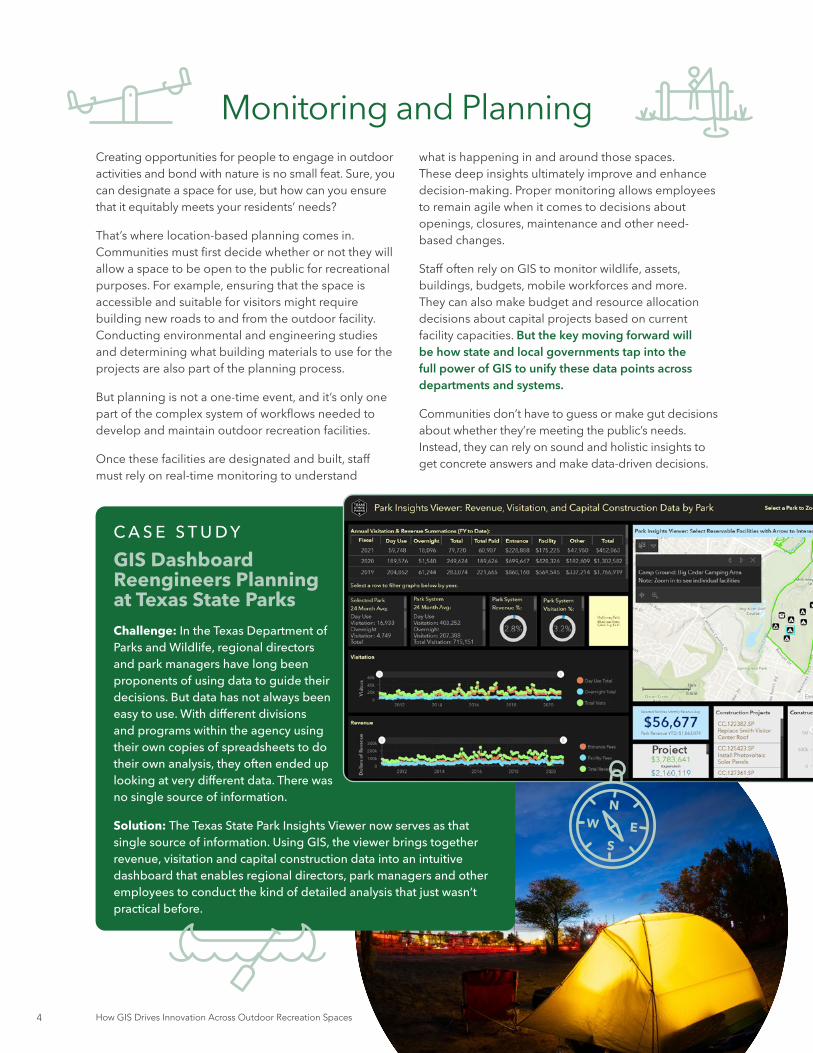
Monitoring and Planning
C A S E S T U D YGIS Dashboard Reengineers Planning at Texas State ParksChallenge: In the Texas Department of Parks and Wildlife, regional directors and park managers have long been proponents of using data to guide their decisions. But data has not always been easy to use. With different divisions and programs within the agency using their own copies of spreadsheets to do their own analysis, they often ended up looking at very different data. There was no single source of information.
Solution: The Texas State Park Insights Viewer now serves as that single source of information. Using GIS, the viewer brings together revenue, visitation and capital construction data into an intuitive dashboard that enables regional directors, park managers and other employees to conduct the kind of detailed analysis that just wasn’t practical before.

5Industry Perspective
In the previous section, we explored the importance of using location-based data to track what is happening in and around outdoor recreation spaces. Now let’s take that discussion a step further.
Not only must staff understand what is happening, but they must also be empowered to respond. That empowerment comes in the form of having the necessary tools to communicate and collaborate across teams and departments to solve problems.
Consider the various assets that outdoor recreation facilities have to manage and maintain — wildlife, animals, water bodies, rugged terrain, buildings, staff and visitors, to name a few. GIS enables outdoor recreation staff to connect people in the field with their offices to restore, sustain and protect the assets within their facilities, while optimizing workflows. This enables them to better serve visitors and their staff.
For example, say you have up-to-date usage statistics about campsites and reservations. Those metrics can help you determine if those sites are meeting visitors’ needs and what could potentially be improved.
Historically, it has been difficult and expensive to track these important metrics in real time. As a result, outdoor recreation facilities often make do with only partial data about how their facilities are being used. They may miss opportunities to boost customer satisfaction, improve situational awareness and proactively keep facilities in good working order.
To address these issues, many outdoor recreation facilities are upgrading their GIS and technology infrastructure. The goal is to develop capabilities for planning, monitoring and managing activities across facilities in real time on a single dashboard. The visualization element is important; it can make data more tangible and actionable than a static, spreadsheet-based approach.
Asset Management and Field Maintenance
C A S E S T U D YMissouri State Parks Implements a Central Asset Management ProgramChallenge: Missouri’s state park system contains 91 state parks and historic sites over 160,000 acres. With more than 2,000 structures, 3,500 campsites, 194 cabins, almost 2,000 picnic sites, and more than 1,000 miles of trail, Missouri State Parks was challenged to develop a way to effectively manage and maintain all of these various assets.
Solution: The organization established an enterprise GIS to inventory and manage more than 2,000 critical assets across the parks system. This central GIS was transformative for the park system as it previously had no electronic record of assets, nor an effective way to manage them at the park, region or statewide levels. This real-time information is displayed in a dashboard, empowering staff to make better resource management decisions.

How GIS Drives Innovation Across Outdoor Recreation Spaces6
Sharing information and analysis with executives and multiple agencies is key to the success of thriving outdoor recreation facilities. GIS enables agencies to display critical information in dashboards that are readily accessible and easy to comprehend.
Having actionable data at their fingertips allows executives to quickly gain a complete view of the status of the facilities and to make better decisions around budget and resource allocations at the local and state levels. Pre-COVID-19, one of the longstanding issues that leaders had to grapple with was the decline in the number of people visiting outdoor recreation facilities. This prompted a need to understand recreation license trends more deeply and maximize the use of recreation resources.
Understanding who has purchased recreation licenses or permits helps organizations target marketing activities and increase retention rates. But amid the pandemic, many outdoor recreation facilities faced a very different dilemma: quickly supporting an influx in site visitors.
Take Tennessee State Parks, for example. When the coronavirus pandemic emerged, the parks didn’t have models in place for closing and reopening facilities. They also lacked analysis that the governor needed to make decisions about access.
State leaders turned to GIS for help. The solution that emerged combines park data, COVID-19 tracking data and real-time information captured on GIS mobile apps that park managers and rangers use. Driven by GIS data and analysis, the park system developed a location strategy and safety initiatives and built a dashboard for disseminating data.
These types of success stories can’t flourish when teams operate in silos. Oftentimes, multiple agencies need to partner on critical projects. To facilitate this cross-collaboration, leaders must be informed and equipped with current and relevant information about all facets of outdoor facilities to make sound, data-driven decisions.
Executive Engagement and Cross-Agency Collaboration
C A S E S T U D YNew Jersey Better Informs Executives to Minimize ClosuresChallenge: In 2019, New Jersey’s Department of Environmental Protection saw a surge in harmful algal blooms (HABs) in lakes and reservoirs across the state. Because these blooms release toxins that can harm humans as well as aquatic life, the department issued advisories recommending against recreational activities like swimming and eating caught fish. Such advisories frustrated residents and visitors.
Solution: That changed in June 2020, when the department launched an interactive mapping tool. The web application presents data about water management to officials and the public in a clear and actionable manner. The state is laying the groundwork to collaborate with county health departments and neighborhood groups to potentially submit samples of HABs through the tool. This allows authorities to expand their footprint and better track changing conditions. Officials are also exploring how the use of trusted collaborators can help in other workflow areas, such as firefighter service and endangered species.
7Industry Perspective
The ability to regularly monitor and quickly respond to issues across recreation facilities isn’t just a win for the staff charged with those duties. Ultimately, the real winners are the visitors. Overall public safety and well-maintained grounds are critical to the longevity of outdoor spaces.
As vital as collaboration is between employees and outdoor recreation facility management, and between government agencies, it’s equally important to foster communication and collaboration with the public. For example, visitors and potential guests expect tangible information about what recreation and educational programs are taking place and what assets an outdoor recreation facility has available.
While many outdoor recreation facilities still provide this information via static descriptions and photos, more are providing it through a dynamic map, accessible either via the web or a mobile app. Behind the scenes, all of that information is flowing through
a GIS engine. With up-to-date information about resource availability, for example, outdoor recreation facilities can better manage public participation.
The message? Civic engagement and public information sharing are valuable in all forms. Taking the time to share with the public how their feedback impacts decision-making is also valuable to establishing strong and ongoing relationships with visitors.
Incorporating public input is especially valuable when making cross-agency decisions. That feedback can help to unify and create common ground across various goals that often differ by agency. For example, the outdoor recreation facility may be interested in planning a new trail, while the fish and wildlife department is focused on rare species or habitats that might affect where or how the trail is built. If both agencies use the same GIS tools and have access to the same data, they can visualize the data together on the same platform and make decisions that satisfy all stakeholders.
Civic Engagement and Public Information Sharing
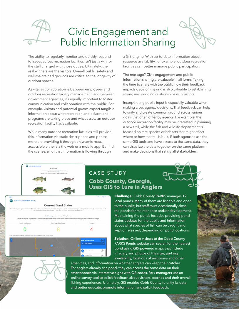
C A S E S T U D YCobb County, Georgia, Uses GIS to Lure in Anglers
Challenge: Cobb County PARKS manages 12 local ponds. Many of them are fishable and open to the public, but staff must occasionally close the ponds for maintenance and/or development. Maintaining the ponds includes providing pond status updates for the public and information about what species of fish can be caught and kept or released, depending on pond locations.
Solution: Online visitors to the Cobb County PARKS Ponds website can search for the nearest pond using GIS-powered maps that include imagery and photos of the sites, parking availability, locations of restrooms and other
amenities, and information on whether anglers can keep their catches. For anglers already at a pond, they can access the same data on their smartphones via interactive signs with QR codes. Park managers use an online survey tool to solicit feedback about visitors’ catches and their overall fishing experiences. Ultimately, GIS enables Cobb County to unify its data and better educate, promote information and solicit feedback.
7Industry Perspective

How GIS Drives Innovation Across Outdoor Recreation Spaces8
INFO
R M
PLAN MANAGE
C O L L A B ORA
TE
No one department or entity owns the entire workflow required to properly maintain outdoor recreation facilities. It’s a collective effort that spans entities, such as fish and wildlife agencies, parks, forestry, conservation, natural resources, and planning departments. Many of these agencies are using GIS to some extent today, but there’s untapped potential in this powerful technology that can drive new levels of modernization and innovation.
Esri has identified a core set of technology and business capabilities that, incorporated into GIS initiatives, deliver the best results. We’ve provided some examples of how these tools can be used throughout various parts of the overall workflow.
How GIS Supports Outdoor Recreation Workflows
ArcGIS Field Maps: An all-in-one app that uses data-driven
maps to help fieldworkers perform mobile data collection
and editing, find assets and information, and report their real-
time locations.
ArcGIS Pro: A desktop GIS
application that supports data visualization,
advanced analysis, integration of
data from multiple sources and map
development in 2D, 3D and 4D.
ArcGIS StoryMaps: A map-making tool for creating
custom maps, as well as for adding text, photos and vidoes
to existing ArcGIS web maps and web scenes.
ArcGIS Dashboards: Enables users to convey
information by presenting location-based analytics
using intuitive and interactive data visualization
on a single screen.
ArcGIS Hub: A community engagement
platform that fosters communication,
collaboration and data sharing.
ArcGIS Online: Foundational cloud-based mapping and
analysis solution. Use to make maps, analyze data and to share
and collaborate.
1 — Organize Existing Data
6 — Citizen Engagement
2 — Collect New Data
3 — Perform Analysis
4 — Cross Agency Collaboration
5 — Inform Decision Makers
ArcGIS Solutions for Recreation Outreach:
Ready-to-deploy apps used to understand key license
trends, promote recreation opportunities, and share outdoor amenities with
the public

9Industry Perspective
GIS has long been a foundational technology for maintaining one of the nation’s most precious assets: outdoor recreation spaces. For decades, the state and local government employees charged with this responsibility have relied on data to better understand and track what’s happening in and around those facilities.
But as the public’s needs change and new demands arise, employees and leaders must be equipped to make timely, well-informed decisions based on real-time updates. Using GIS, agencies can monitor the metrics that matter most to their communities, whether that’s visitor density, asset usage or natural resource health. With that information, agencies can see the big picture, which aids in customer response, maintenance, safety and other important issues.
A modern GIS system can also help agencies glean the most value from their data through predictive analytics and what-if analyses. This enables analysts to make more effective decisions on everything from budgeting and management to public safety.
The right tools can also foster collaboration and communication both among outdoor recreation facilities and with the public. With these capabilities, agencies can improve customer satisfaction and communication, save money, and focus on the most pressing priorities.
Conclusion
When Esri was founded in 1969, we realized even then that geographic information system (GIS) technology could make a difference in society. Working with others who shared this passion, we were encouraged by the vast possibilities of GIS.
Today our confidence in GIS is built on the belief that geography matters - it connects our many cultures and societies and influences our way of life. GIS leverage geographic insight to ensure better communication and collaboration.
Explore our website to discover how our customers have obtained the geographic advantage by using Esri software to address social, economic, business, and environmental concerns at local, regional, national, and global scales. We hope you will be inspired to join the Esri community in using GIS to create a better world.
go.esri.com/outdoorrecreation
GovLoop’s mission is to inspire public sector professionals by serving as the knowledge network for government. GovLoop connects more than 300,000 members, fostering cross-government collaboration, solving common problems and advancing government careers. GovLoop is headquartered in Washington, D.C., with a team of dedicated professionals who share a commitment to the public sector.
For more information about this report, please reach out to [email protected].
govloop.com | @govloop
9Industry Perspective

How GIS Drives Innovation Across Outdoor Recreation Spaces10
1152 15th St. NW Suite 800Washington, DC 20005
P (202) 407-7421F (202) 407-7501
www.govloop.com@GovLoop


