31
ppt How to Read and Use Grid Coordinates Federal Geographic Data Committee US National Grid (FGDC-STD-011-2001) - Tom Terry [email protected] , (703) 695-3118

ppt
How to Read and Use Grid CoordinatesFederal Geographic Data Committee
US National Grid (FGDC-STD-011-2001)
- Tom Terry
[email protected] , (703) 695-3118

Review and relevance: Map Accuracy
- National Map Accuracy Standard (NMAS)
- NMAS = >1:20,000 = 90% of well defined features will
be within 1/50 inch on map of true position.
- @ 1:24,000, 90% of well defined mapped features will
be within 12.19-m of true position on the ground.
- @ 1:24,000, 12-m = 0.5-mm...
...or dot from 0.5-mm pencil lead =
- USGS 1:24,000 series topo maps = NMAS.

0.002.004.006.008.00
10.0012.0014.0016.00
0 5 1015 20 25 30 3540 45 50 55 6065 70 75 80 8590 95 10
0 Figure 37. Samples listed by distance errors.
This chart depicts the 100 sample locations over a period of 100 minutes from a consumer
GPS receiver, listed by miss distance. Y values represent the error (miss distance)
between what the GPS receiver displayed and the true position of the receiver at
horizontal control station GPS112 on the GMU campus.
85%
Err
or
in M
ete
rsReview and relevance: GPS Accuracy
0.00
2.00
4.00
6.00
8.00
10.00
12.00
14.00
16.00
1 9 17 25 33 41 49 57 65 73 81 89 97
Mean
95%
Err
or
in M
ete
rs
16:36 18:1628 Feb 2004, 100 samples
Figure 38. Location samples in temporal sequence.
This chart depicts a temporal sequence of the 100 position samples taken at
1min intervals from a consumer GPS receiver. Y values represent the error
(miss distance) between what the GPS receiver displayed and the true position
of the receiver at horizontal control station GPS112 on the GMU campus. The
average error was only 3.5-m, and 95% were within 8.2-m, an amazing
capability given the cost and reliability of these consumer devices. Note the
outlyer excursion out to 15-m beginning at ~67 minutes.

In other words...
matches GPS...
…in accuracy.
It is worth noting, this accuracy was achieved at no
trivial cost to the US Treasury over the last century.
The lessons: 1) Do not point at position with your finger.
2) Attention to detail when working.
Attention to detail when working.

Orientation to the
US National Grid format:
UTM format: 16R, 210280mE, 2309760mN(Well suited for surveying / distance and direction calculations
and a component of the US National Grid.)
USNG format: 16R BU 1028 0976Grid Zone Designation (GZD)(6° lat x 8° longitude quad)
100,000-m Square ID
Easting Northing
Grid Coordinates
Water Tank at grid: 16R BU 1028 0976
Read right, and up.
08/27/98
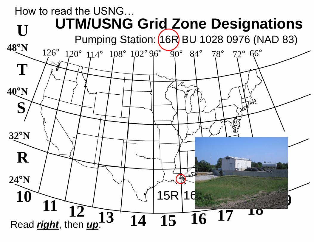
UTM/USNG Grid Zone Designations
126° 120° 114° 108° 102° 96° 90° 84° 78° 72° 66°
1011 12 13 14 15 16 17 18
19
24°N
32°N
40°N
48°N
15R
S
R
U
T
MGRS Grid Zone Designations
How to read the USNG…
16R
Read right, then up.
Pumping Station: 16R BU 1028 0976 (NAD 83)

90°W
Louisiana 100,000-m Square IDs
32°N32°N15S
15R
16S
16R35003500
36003600
34003400
33003300
20070060050040032003200
15R 16R
15S 16S
VN WN XN YN BT
VP WP XP YP BU
VQ WQ XQ YQ BV
VR WR XR
VS WS XS
15R 16R
15S 16S
Scale
~1:2,700,000
See:
www.fgdc.gov/usng
Pumping Station:
16R BU 1028 0976
Read right,
then up.

The Power of Truncated USNG Values
Pumping Station: 16R BU 1028 0976
Grid: BU 1028 0976
= repeat of
BU 1028 0976
Each 2 letter/8 digit USNG value
(10-m posting) in the outlined area is unique.

The Power of Truncated USNG Values
Jefferson Pier, Washington, DC
Grid: UJ23370651
= repeat of UJ23370651
Each 2 letter/8 digit USNG value
(10-m posting) in the outlined area is unique.

CHALMETTE, LA
Grid Zone Designation
16R
BU
100,000-m Square ID
U.S. National Grid
Reading USNG Grid Coordinates
(think 1249 / 1084 )
Read Right, Then Up.”
Read RIGHT to grid line 12
Then measure right another
480-meters.
Then, read UP to grid line 10,
and measure UP another 840-meters.
4-digit: 12 10 = 1,000m
6-digit: 124 108 = 100m
8-digit: 1249 1084 = 10m
10-digit: 12490 10840 = 1m precision
Water tank located at
grid: 16R BU 1249 1084
Water Tank at
grid: 12491084
Romer Scale
Principal Digits
213
3310

Orientation on the Romer Scale

ppt
Water Tank at grid:
1249 1084
Read right, and up.
3310
3311
Reading and Using
the Romer Scale

ppt
Building at grid:
145 100
Ex 1
Read right, and up.

ppt
Building at grid:
1282 1122
Ex 1

ppt
Building at grid:
1210 1109
Ex 2
Read right, and up.
ppt
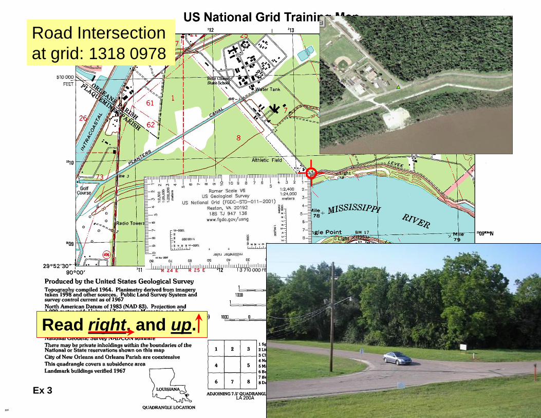
Road Intersection
at grid: 1318 0978
Ex 3
Read right, and up.

ppt
Building at grid:
1448 0992
Ex 4
Read right, and up.
ppt
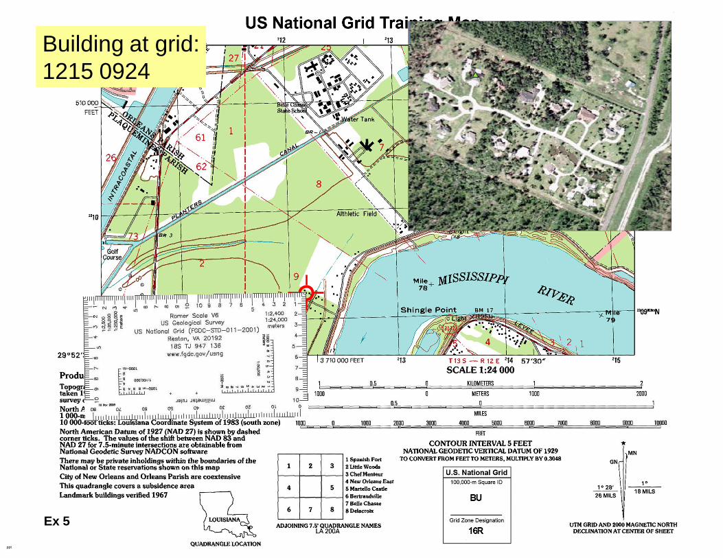
Building at grid:
1215 0924
Ex 5

ppt
Reconstructing
a grid
3308
Road Intersection
at grid: 1425 0875
Ex 6

ppt
Reconstructing
a grid
Building at grid: 107 102
Ex 7
210

ppt
Reconstructing
a grid
Building at grid: 1028 0976
Ex 8
210

How to handle the
UTM Grid Zone Junction
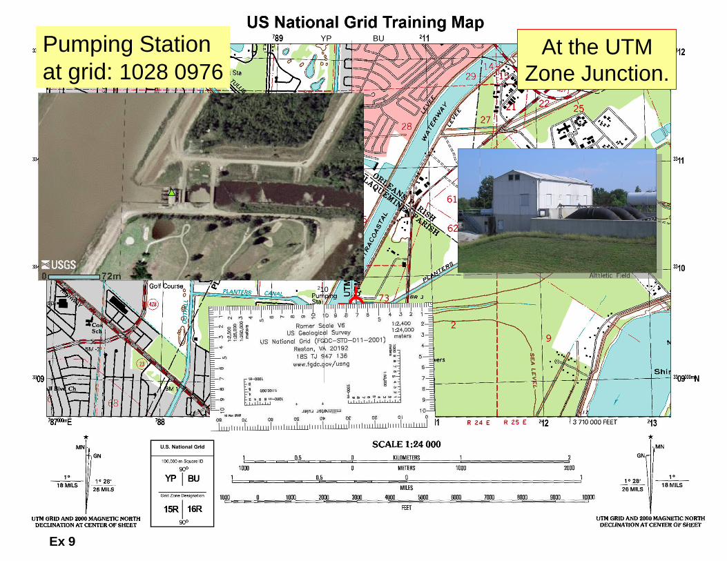
YP BU
YP BU
At the UTM
Zone Junction.
Pumping Station
at grid: 1028 0976
210
Ex 9

YP BU
YP BUBuilding (CM SW Wing)
at grid: 8967 1149At the UTM
Zone Junction.
Ex 10

YP BU
YP BUBuilding at grid: 117116
Ex 11

YP BU
YP BUBuilding at grid: 8906 0916
At the UTM
Zone Junction.
Ex 12

Back Up Slides

ppt
3308
Reconstructing
a grid
Light at grid:
1346 0897
Ex 10

ppt
Building at grid:
1441 0986

ppt
Road Intersection
at grid: 1456 1028
Ex 5
ppt
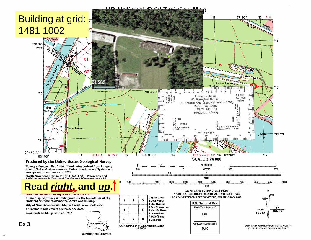
Building at grid:
1481 1002
Ex 3
Read right, and up.


