DISTRICT OF MISSION OFFICIAL COMMUNITY PLAN BYLAW 4052-2008 A Bylaw to provide policy statements on managing the District of Mission's current and future growth and development WHEREAS under the provisions of Section 876 of the Local Government Act the Council may adopt one or more community plans for one or more areas; AND WHEREAS, under the provisions of Section 882(1) of the Local Government Act, the Council must adopt a community plan by bylaw, and, following adoption of such bylaw, the community plan is an Official Community Plan; AND WHEREAS the Council has had prepared a community plan, such community plan being expressed in maps, plans and reports; NOW THEREFORE the Council of the District of Mission, in open meeting assembled, ENACTS AS FOLLOWS: This Bylaw may be cited for all purposes as "District of Mission Official Community Plan Bylaw 4052-2008". Schedule "A" attached hereto and forming part of this Bylaw is hereby adopted and is the Official Community Plan for the District of Mission with the exception of those portions not intended to be part of the bylaw. "District of Mission Official Community Plan Bylaw 3142-1998" and all amendments thereto are hereby repealed. Any bylaw commenced under "District of Mission Official Community Plan Bylaw 3142-1998" prior to the adoption of this bylaw, which has received at least two readings as of the date of adoption of this bylaw, is, when adopted, deemed to be conforming to, and adopted under, this bylaw. Any designation reference in any bylaw commenced under "District of Mission Official Community Plan Bylaw 3142-1998" but adopted under this bylaw is deemed to be a reference to the corresponding new designation as identified within each such designation. READ A FIRST TIME this 5 th day of May, 2008 COUNCIL CONSIDERATION OF SECTION 882 OF THE LOCAL GOVERNMENT ACT this 16 th day of June, 2008 PUBLIC HEARING held this 25 th day of June, 2008 READ A SECOND TIME this 7 th day of July, 2008 READ A THIRD TIME this 7 th day of July, 2008 ADOPTED this 28 th day of July, 2008 original signed by Mayor James Atebe original signed by Dennis Clark JAMES ATEBE, MAYOR DENNIS CLARK, DIRECTOR OF CORPORATE ADMINISTRATION
Transcript
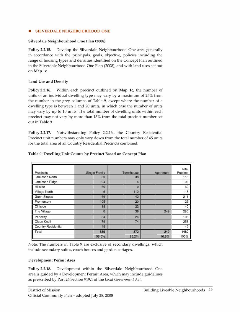
DISTRICT OF MISSION OFFICIAL COMMUNITY PLAN BYLAW 4052-2008
A Bylaw to provide policy statements on managing the District of Mission's current and future growth and development
WHEREAS under the provisions of Section 876 of the Local Government Act the Council may adopt one or more community plans for one or more areas;
AND WHEREAS, under the provisions of Section 882(1) of the Local Government Act, the Council must adopt a community plan by bylaw, and, following adoption of such bylaw, the community plan is an Official Community Plan;
AND WHEREAS the Council has had prepared a community plan, such community plan being expressed in maps, plans and reports;
NOW THEREFORE the Council of the District of Mission, in open meeting assembled, ENACTS AS FOLLOWS:
This Bylaw may be cited for all purposes as "District of Mission Official Community Plan Bylaw 4052-2008".
Schedule "A" attached hereto and forming part of this Bylaw is hereby adopted and is the Official Community Plan for the District of Mission with the exception of those portions not intended to be part of the bylaw.
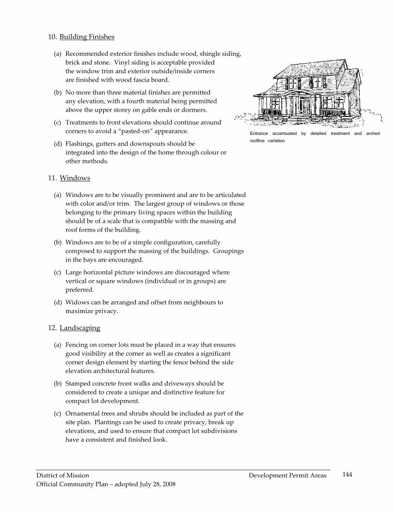
"District of Mission Official Community Plan Bylaw 3142-1998" and all amendments thereto are hereby repealed.
Any bylaw commenced under "District of Mission Official Community Plan Bylaw 3142-1998" prior to the adoption of this bylaw, which has received at least two readings as of the date of adoption of this bylaw, is, when adopted, deemed to be conforming to, and adopted under, this bylaw. Any designation reference in any bylaw commenced under "District of Mission Official Community Plan Bylaw 3142-1998" but adopted under this bylaw is deemed to be a reference to the corresponding new designation as identified within each such designation.
READ A FIRST TIME this 5th day of May, 2008 COUNCIL CONSIDERATION OF SECTION 882 OF THE LOCAL GOVERNMENT ACT this 16th day of June, 2008 PUBLIC HEARING held this 25th day of June, 2008 READ A SECOND TIME this 7th day of July, 2008 READ A THIRD TIME this 7th day of July, 2008 ADOPTED this 28th day of July, 2008 original signed by Mayor James Atebe original signed by Dennis Clark JAMES ATEBE, MAYOR DENNIS CLARK, DIRECTOR OF CORPORATE ADMINISTRATION
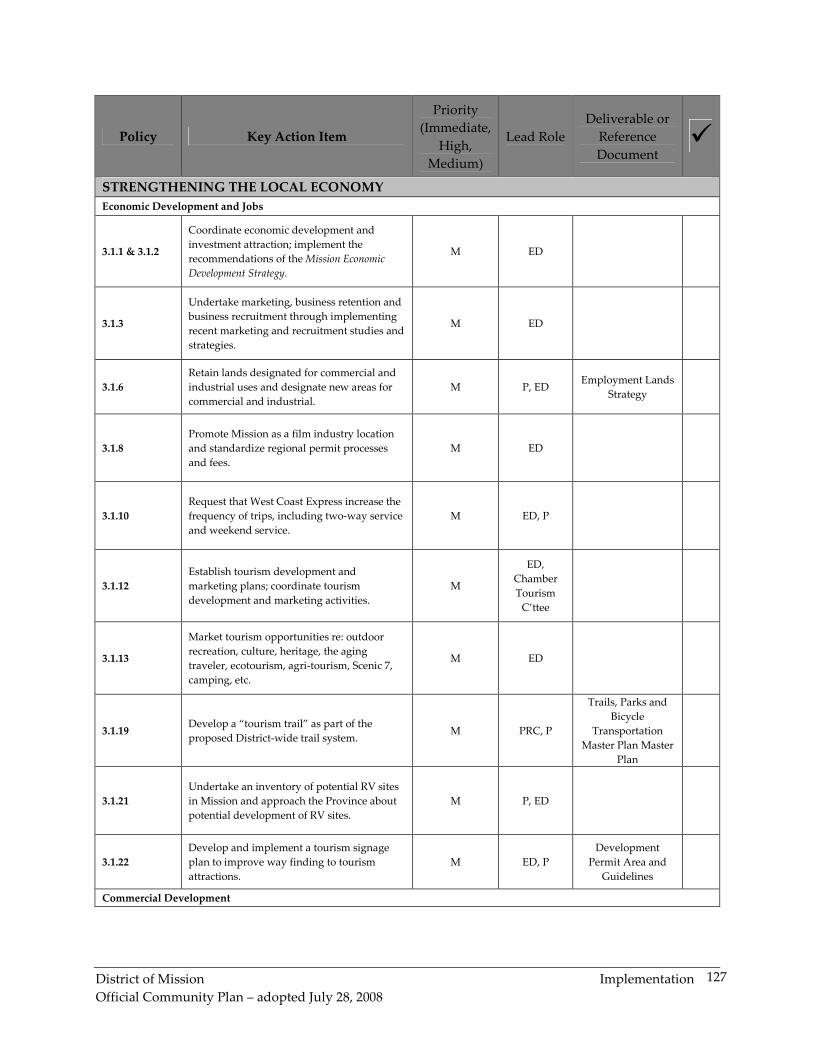
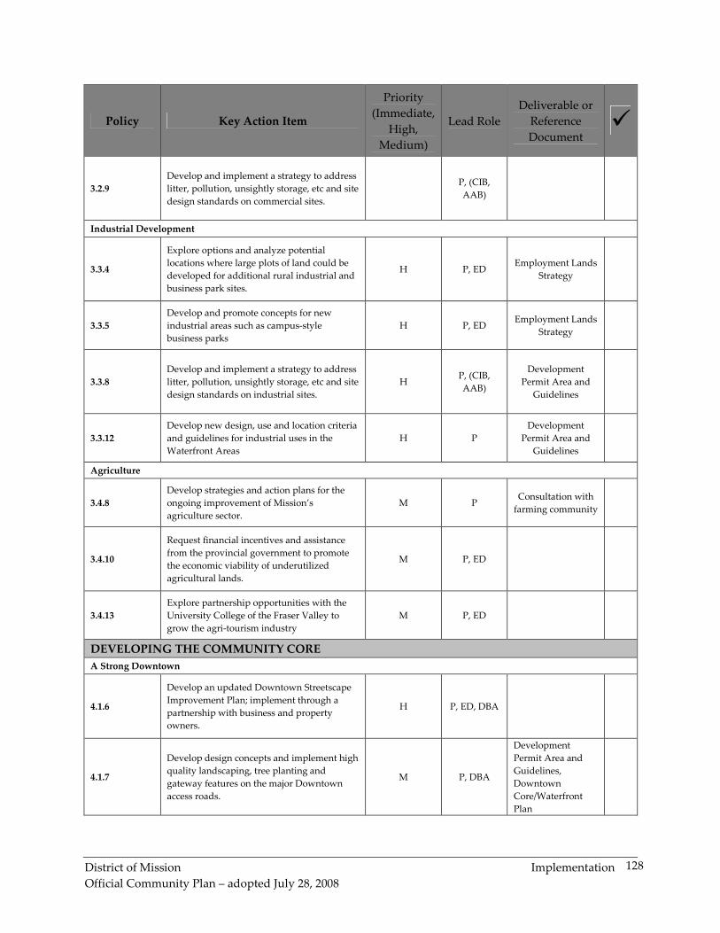
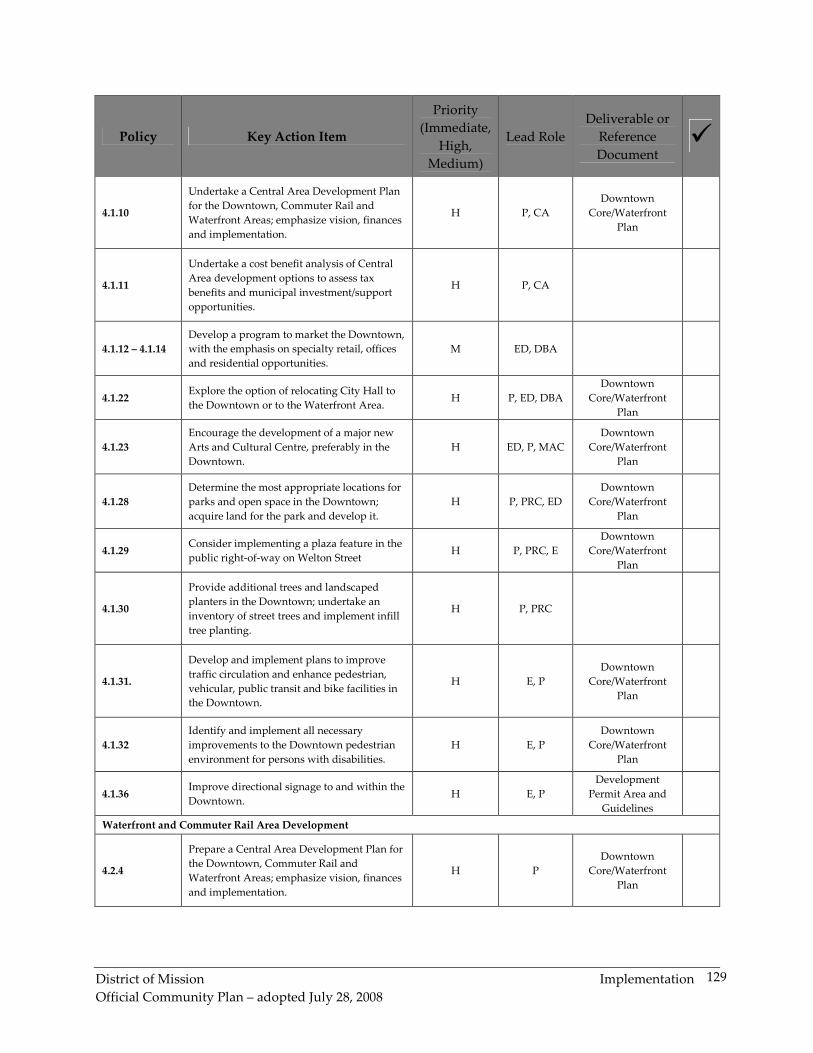
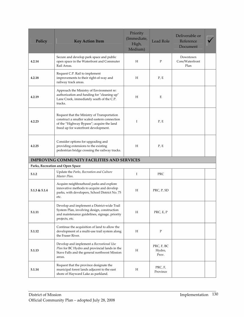
Figure 6: Occupied Owned and Rented Dwellings............................................................................. 11
Figure 7: Mode of Transportation to Work .......................................................................................... 12
Figure 8: Industry Sectors ....................................................................................................................... 13
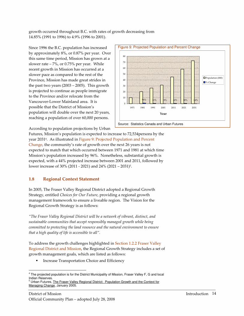
Figure 9: Projected Population and Percent Change........................................................................... 14
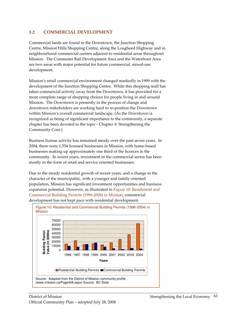
Figure 10: Residential and Commercial Building Permits (1996-2004) in Mission......................... 61
LIST OF MAPS
OCP Map 1 Land Use Designations and Neighbourhood Plan Areas
OCP Map 1a Mission Urban Infill Area
OCP Map 1b Cedar Valley
OCP Map 1c Silverdale Urban Neighbourhood Plan #1
OCP Map 2 Transportation and Gravel Resources
OCP Map 3 Municipal Services and Infrastructure
OCP Map 4 Trail Systems Map
OCP Map 5 Development Permit Areas
OCP Map 5a Fraser River Development Permit Areas
District of Mission Introduction
Official Community Plan – adopted July 28, 2008
1
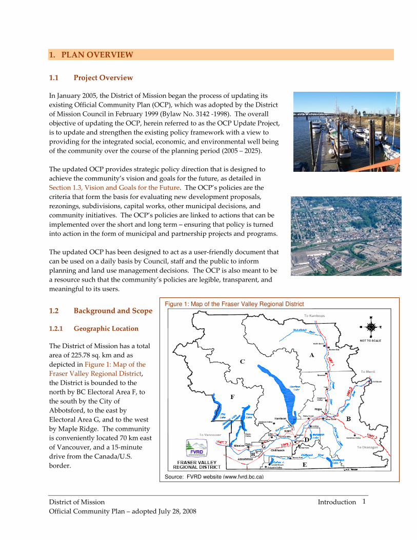
Figure 1: Map of the Fraser Valley Regional District
Source: FVRD website (www.fvrd.bc.ca)
1. PLAN OVERVIEW
1.1 Project Overview
In January 2005, the District of Mission began the process of updating its
existing Official Community Plan (OCP), which was adopted by the District
of Mission Council in February 1999 (Bylaw No. 3142 -1998). The overall
objective of updating the OCP, herein referred to as the OCP Update Project,
is to update and strengthen the existing policy framework with a view to
providing for the integrated social, economic, and environmental well being
of the community over the course of the planning period (2005 – 2025).
The updated OCP provides strategic policy direction that is designed to
achieve the community’s vision and goals for the future, as detailed in
Section 1.3, Vision and Goals for the Future. The OCP’s policies are the
criteria that form the basis for evaluating new development proposals,
rezonings, subdivisions, capital works, other municipal decisions, and
community initiatives. The OCP’s policies are linked to actions that can be
implemented over the short and long term – ensuring that policy is turned
into action in the form of municipal and partnership projects and programs.
The updated OCP has been designed to act as a user-friendly document that
can be used on a daily basis by Council, staff and the public to inform
planning and land use management decisions. The OCP is also meant to be
a resource such that the community’s policies are legible, transparent, and
meaningful to its users.
1.2 Background and Scope
1.2.1 Geographic Location
The District of Mission has a total
area of 225.78 sq. km and as
depicted in Figure 1: Map of the
Fraser Valley Regional District,
the District is bounded to the
north by BC Electoral Area F, to
the south by the City of
Abbotsford, to the east by
Electoral Area G, and to the west
by Maple Ridge. The community
is conveniently located 70 km east
of Vancouver, and a 15-minute
drive from the Canada/U.S.
border.
District of Mission Introduction
Official Community Plan – adopted July 28, 2008
2
1.2.2 Fraser Valley Regional District and Mission
The Fraser Valley Regional District was formed in 1995 by the amalgamation
of Central Fraser Valley, Dewdney-Allouette and Fraser Cheam Regional
Districts. The District is a partnership of local government members,
including the Cities of Chilliwack and Abbotsford, the Districts of Mission,
Kent and Hope, the Village of Harrison Hot Springs, and eight BC electoral
areas (A-H).
The Fraser Valley Regional District is the third most populous region in
British Columbia with an estimated 2004 population of 260,247 people. The
region has a history of growth, having increased in size by more than 100,000
people over the past 20 years1. According to Statistics Canada, the Fraser
Valley Regional District’s population increased 6.8% between census years
1996 and 2001 and continued growth is forecast for the Region.
While the Fraser Valley Regional District is approximately 14,000 sq. km. in
size, over 90% of the region’s population resides on less than 1% of the land
base. Only a small portion of the region is considered suitable for
development due largely to the local topography, Figure 2: Map of the Fraser
Valley Regional District’s Topography. As such, the region faces extreme
growth pressures that demand growth management and strategic land use
planning.
1 Choices for Our Future. Regional Growth Strategy for the Fraser Valley Regional District. 2004
Figure 2: Map of the Fraser Valley Regional District’s Topography
District of Mission Introduction
Official Community Plan – adopted July 28, 2008
3
The growth pressures experienced in the Fraser Valley Regional District are
spread across its member communities, including the District of Mission, as
evidenced by the community’s rate of population growth. According to
Statistics Canada, Mission experienced a 2.5% increase in population
between 1996 and 2001. Mission’s attractive quality of life, urban and rural
living experiences, and spectacular natural setting, continue to act as
attractions for newcomers to the community.
1.3 Vision and Goals for the Future
Looking ahead to the future, the vision for the District of Mission is as
follows:
Mission is a healthy community that has a balance of residential, commercial, and
industrial land uses, amongst an abundance of parkland and natural open space. It
is known as a community-oriented, affordable, and safe community. Mission has a
mix of housing types, offering choices to people of all incomes, lifestyles, and age
groups. Community neighbourhoods reflect principles of sustainable development.
The downtown is a vibrant place with a distinct identity that attracts residents and
visitors in search of unique shopping and living experiences. The number of local
industries and jobs has increased over the years to allow more residents to live and
work in Mission. Natural and cultural resources provide recreation and tourism
opportunities that have contributed to the attractive quality of life and the strong
local economy.
The overall purpose of the updated OCP is to provide a policy framework
that contributes to the sustainable growth and development of Mission,
while strengthening individual and collective well-being through balanced
and integrated actions that are mindful of social, cultural, economic, and
environmental attributes of the community.
The goals of the OCP are designed to reflect the diverse attributes of the
community, keeping in mind the principles of sustainability. The OCP’s
goals are summarized as follows:
� To achieve sustainable growth; balancing economic, environmental
and social principles
� To increase the number of local employment and shopping
opportunities through commercial and industrial development
� To manage the natural environment
� To develop housing alternatives which reflect the diverse needs of
the community’s current and future residents
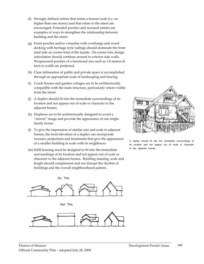
� To ensure that development provides public spaces, open spaces,
and parkland that contribute to the value of the public realm
� To enhance transportation choice through the development and
enhancement of an integrated, multi-modal transportation system
District of Mission Introduction
Official Community Plan – adopted July 28, 2008
4
� To enhance the community’s character and economic well-being
through waterfront development and downtown revitalization and
sustainable development
� To maintain and enhance the quality of life that will continue to
encourage people to live, work, and visit Mission
� To involve the public in all stages of the development and
implementation of the OCP
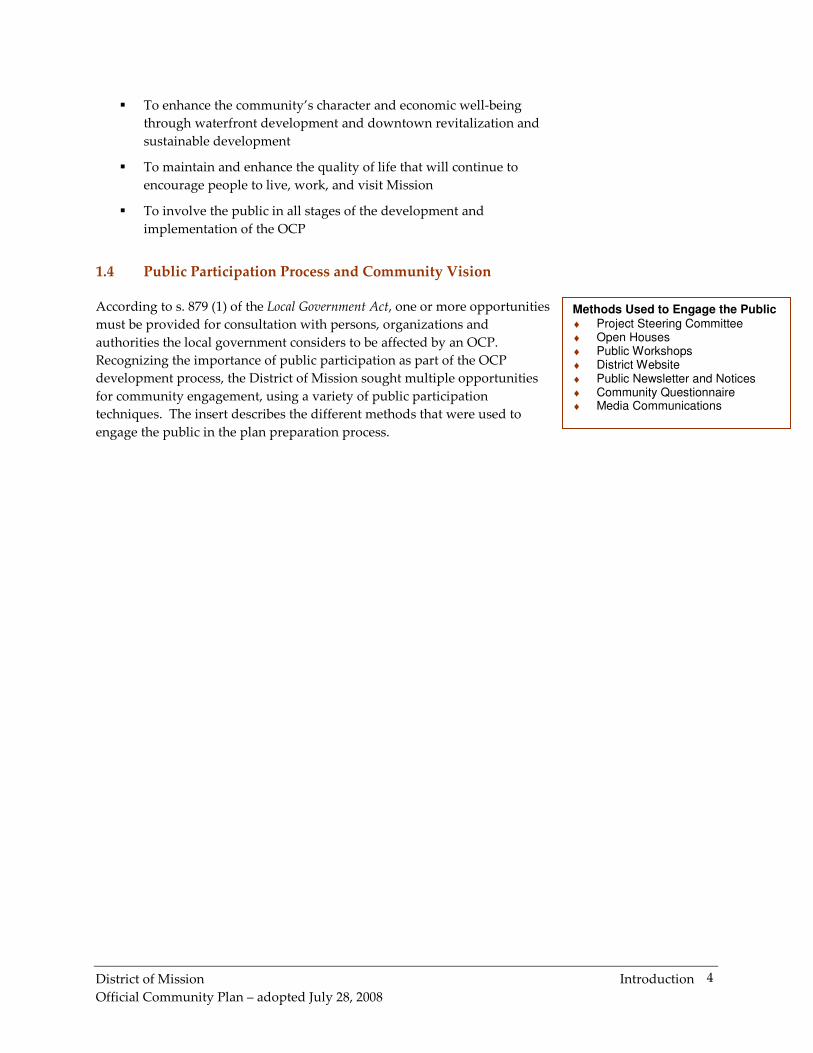
1.4 Public Participation Process and Community Vision
According to s. 879 (1) of the Local Government Act, one or more opportunities
must be provided for consultation with persons, organizations and
authorities the local government considers to be affected by an OCP.
Recognizing the importance of public participation as part of the OCP
development process, the District of Mission sought multiple opportunities
for community engagement, using a variety of public participation
techniques. The insert describes the different methods that were used to
engage the public in the plan preparation process.
Methods Used to Engage the Public ♦ Project Steering Committee ♦ Open Houses ♦ Public Workshops ♦ District Website ♦ Public Newsletter and Notices ♦ Community Questionnaire ♦ Media Communications
District of Mission Introduction
Official Community Plan – adopted July 28, 2008
5
� Project Steering Committee
The District of Mission Council appointed a Project Steering Committee in
January 2005. The Committee was comprised of 14 individuals representing
a diverse cross-section of the community including, representatives from
residential associations, environmental groups, key agencies, business
organizations, cultural groups and other stakeholder interest groups.
The diversity of the Committee allowed for valuable and objective input
toward the development of the updated OCP. Members of the Committee
provided direction to the planning exercise throughout the process and
provided valuable input into the initial drafts of OCP policy and the Final
Draft OCP. Committee members participated actively in Project Steering
Committee meetings, Open Houses and Public Workshops.
� District of Mission Website - OCP Update Project
The District website was populated with information concerning the OCP
Update Project throughout the process to ensure that citizens of Mission
were kept informed of the plan development process. Frequent updates to
the website ensured that the public was notified of upcoming events and that
input received at the Open Houses and Public Workshops were shared with
the public on a timely basis.
� Open Houses and Questionnaire – Issues and Opportunities
The OCP Project Team held Open Houses on the evening of May 12, 2005
and during the day on May 14, 2005 at the Stave Falls Elementary School and
Heritage Park Secondary School respectively. Members of the Stantec
Consulting team, Mission’s planning staff and representatives of the Project
Steering Committee hosted this first set of Open Houses with approximately
100 members of the general public attending.
The Open Houses represented an opportunity for local residents to learn
about the OCP Update Project’s planning process and share their ideas
regarding issues and opportunities for the future development of Mission.
The public was notified of the Open Houses by means of the following (as
was the case for all subsequent public participation events):
� newspaper advertisements in three local papers - two weeks in
advance and one week in advance
� an update on the Project Website
� interviews on the project by local newspaper reporters
� distribution of approximately 5,000 letters to school children to take
home to their parents
District of Mission Introduction
Official Community Plan – adopted July 28, 2008
6
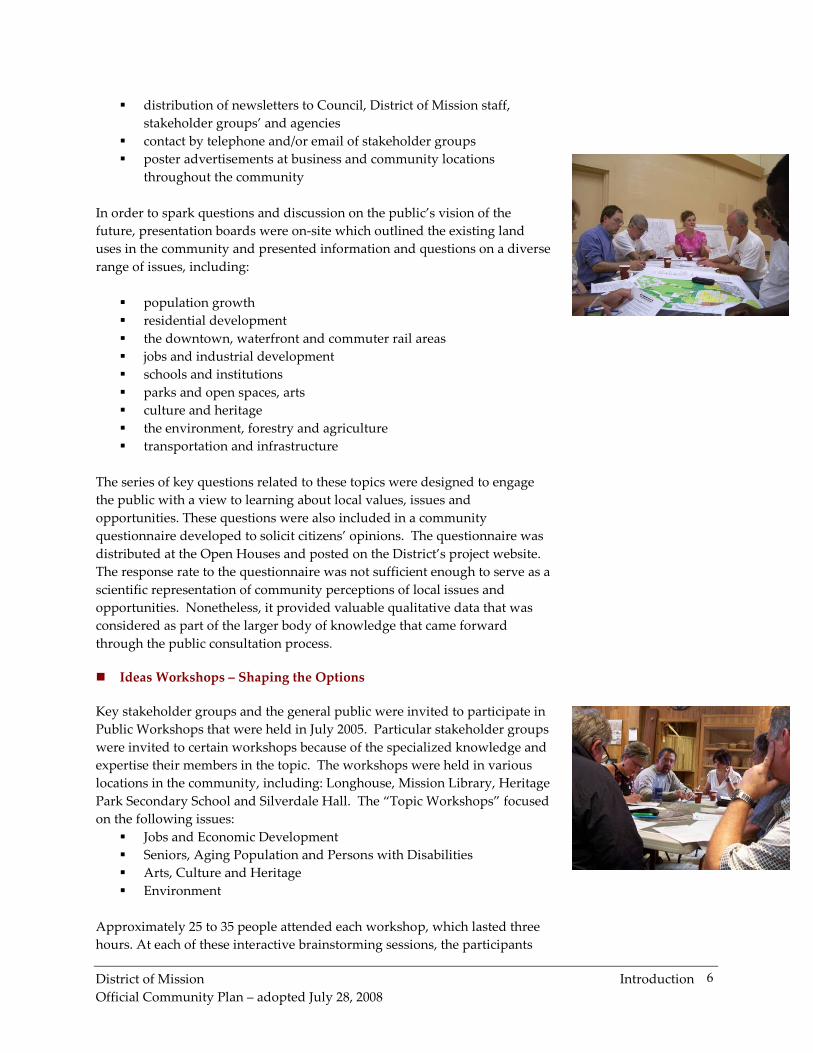
� distribution of newsletters to Council, District of Mission staff,
stakeholder groups’ and agencies
� contact by telephone and/or email of stakeholder groups
� poster advertisements at business and community locations
throughout the community
In order to spark questions and discussion on the public’s vision of the
future, presentation boards were on-site which outlined the existing land
uses in the community and presented information and questions on a diverse
range of issues, including:
� population growth
� residential development
� the downtown, waterfront and commuter rail areas
� jobs and industrial development
� schools and institutions
� parks and open spaces, arts
� culture and heritage
� the environment, forestry and agriculture
� transportation and infrastructure
The series of key questions related to these topics were designed to engage
the public with a view to learning about local values, issues and
opportunities. These questions were also included in a community
questionnaire developed to solicit citizens’ opinions. The questionnaire was
distributed at the Open Houses and posted on the District’s project website.
The response rate to the questionnaire was not sufficient enough to serve as a
scientific representation of community perceptions of local issues and
opportunities. Nonetheless, it provided valuable qualitative data that was
considered as part of the larger body of knowledge that came forward
through the public consultation process.
� Ideas Workshops – Shaping the Options
Key stakeholder groups and the general public were invited to participate in
Public Workshops that were held in July 2005. Particular stakeholder groups
were invited to certain workshops because of the specialized knowledge and
expertise their members in the topic. The workshops were held in various
locations in the community, including: Longhouse, Mission Library, Heritage
Park Secondary School and Silverdale Hall. The “Topic Workshops” focused
on the following issues:
� Jobs and Economic Development
� Seniors, Aging Population and Persons with Disabilities
� Arts, Culture and Heritage
� Environment
Approximately 25 to 35 people attended each workshop, which lasted three
hours. At each of these interactive brainstorming sessions, the participants
District of Mission Introduction
Official Community Plan – adopted July 28, 2008
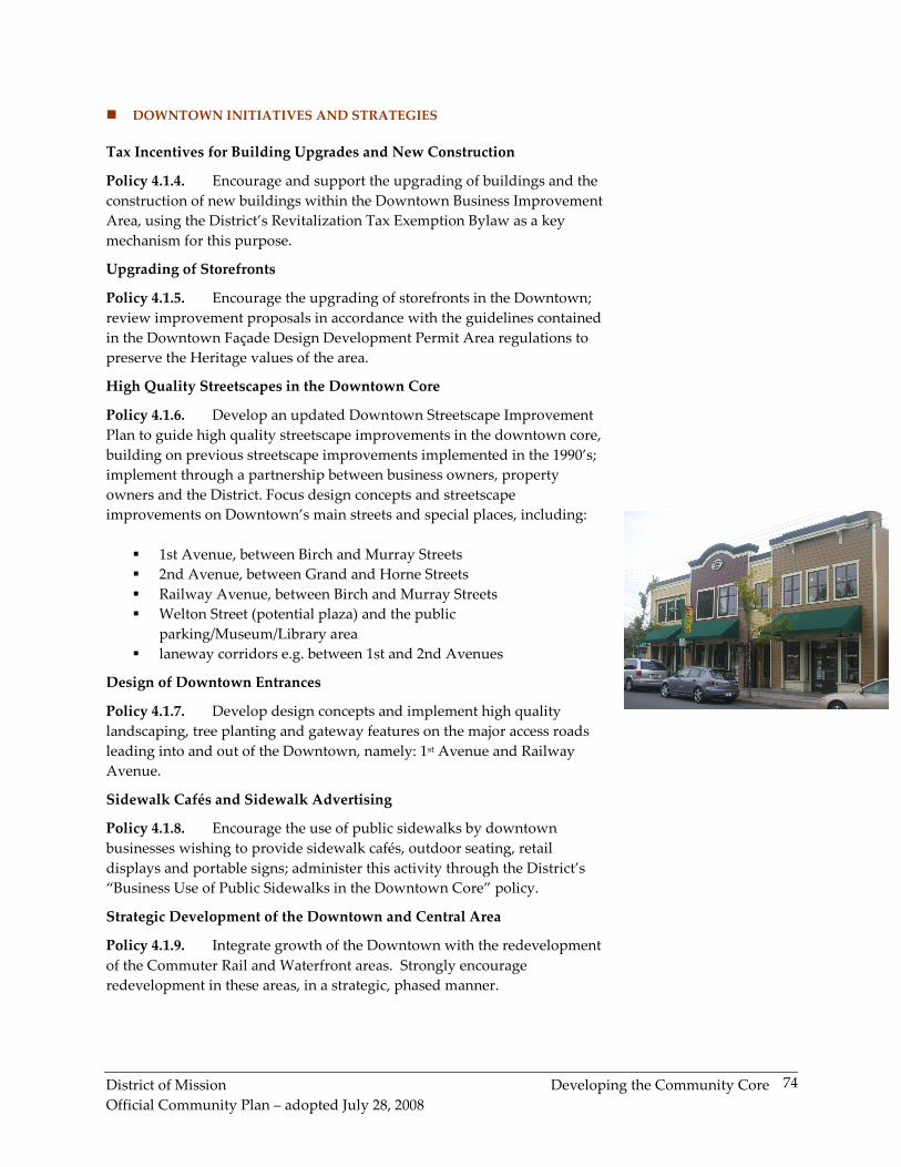
7
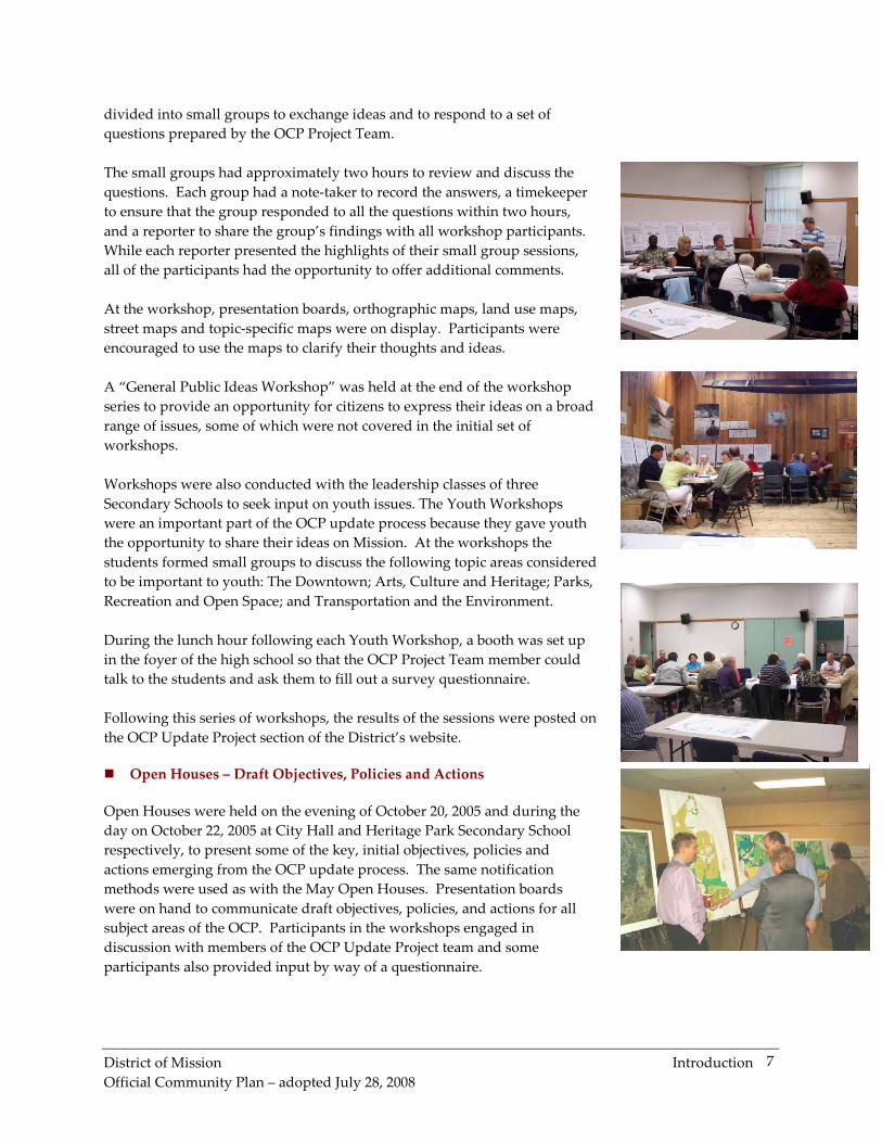
divided into small groups to exchange ideas and to respond to a set of
questions prepared by the OCP Project Team.
The small groups had approximately two hours to review and discuss the
questions. Each group had a note-taker to record the answers, a timekeeper
to ensure that the group responded to all the questions within two hours,
and a reporter to share the group’s findings with all workshop participants.
While each reporter presented the highlights of their small group sessions,
all of the participants had the opportunity to offer additional comments.
At the workshop, presentation boards, orthographic maps, land use maps,
street maps and topic-specific maps were on display. Participants were
encouraged to use the maps to clarify their thoughts and ideas.
A “General Public Ideas Workshop” was held at the end of the workshop
series to provide an opportunity for citizens to express their ideas on a broad
range of issues, some of which were not covered in the initial set of
workshops.
Workshops were also conducted with the leadership classes of three
Secondary Schools to seek input on youth issues. The Youth Workshops
were an important part of the OCP update process because they gave youth
the opportunity to share their ideas on Mission. At the workshops the
students formed small groups to discuss the following topic areas considered
to be important to youth: The Downtown; Arts, Culture and Heritage; Parks,
Recreation and Open Space; and Transportation and the Environment.
During the lunch hour following each Youth Workshop, a booth was set up
in the foyer of the high school so that the OCP Project Team member could
talk to the students and ask them to fill out a survey questionnaire.
Following this series of workshops, the results of the sessions were posted on
the OCP Update Project section of the District’s website.
� Open Houses – Draft Objectives, Policies and Actions
Open Houses were held on the evening of October 20, 2005 and during the
day on October 22, 2005 at City Hall and Heritage Park Secondary School
respectively, to present some of the key, initial objectives, policies and
actions emerging from the OCP update process. The same notification
methods were used as with the May Open Houses. Presentation boards
were on hand to communicate draft objectives, policies, and actions for all
subject areas of the OCP. Participants in the workshops engaged in
discussion with members of the OCP Update Project team and some
participants also provided input by way of a questionnaire.
District of Mission Introduction
Official Community Plan – adopted July 28, 2008
8
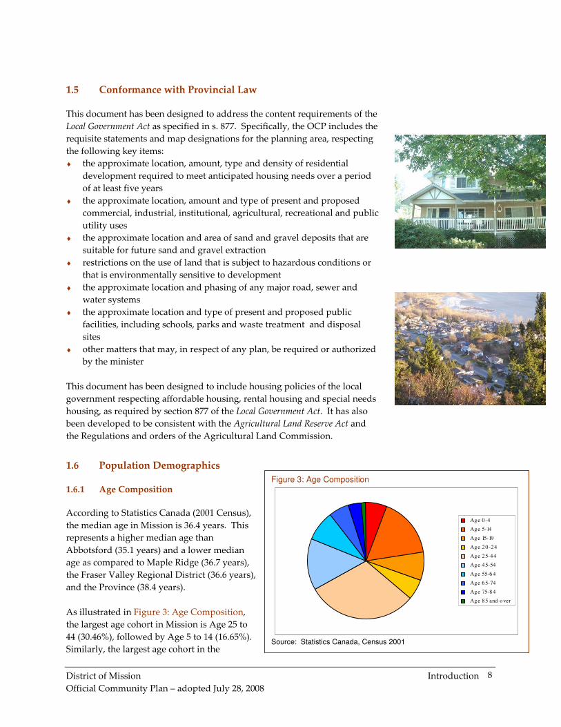
Figure 3: Age Composition
Age 0 -4
Age 5-14
Age 15-19
Age 20 -24
Age 25-44
Age 45-54
Age 55-6 4
Age 65-74
Age 75-8 4
Age 85 and o ver
Source: Statistics Canada, Census 2001
1.5 Conformance with Provincial Law
This document has been designed to address the content requirements of the
Local Government Act as specified in s. 877. Specifically, the OCP includes the
requisite statements and map designations for the planning area, respecting
the following key items:
♦ the approximate location, amount, type and density of residential
development required to meet anticipated housing needs over a period
of at least five years
♦ the approximate location, amount and type of present and proposed
commercial, industrial, institutional, agricultural, recreational and public
utility uses
♦ the approximate location and area of sand and gravel deposits that are
suitable for future sand and gravel extraction
♦ restrictions on the use of land that is subject to hazardous conditions or
that is environmentally sensitive to development
♦ the approximate location and phasing of any major road, sewer and
water systems
♦ the approximate location and type of present and proposed public
facilities, including schools, parks and waste treatment and disposal
sites
♦ other matters that may, in respect of any plan, be required or authorized
by the minister
This document has been designed to include housing policies of the local
government respecting affordable housing, rental housing and special needs
housing, as required by section 877 of the Local Government Act. It has also
been developed to be consistent with the Agricultural Land Reserve Act and
the Regulations and orders of the Agricultural Land Commission.
1.6 Population Demographics
1.6.1 Age Composition
According to Statistics Canada (2001 Census),
the median age in Mission is 36.4 years. This
represents a higher median age than
Abbotsford (35.1 years) and a lower median
age as compared to Maple Ridge (36.7 years),
the Fraser Valley Regional District (36.6 years),
and the Province (38.4 years).
As illustrated in Figure 3: Age Composition,
the largest age cohort in Mission is Age 25 to
44 (30.46%), followed by Age 5 to 14 (16.65%).
Similarly, the largest age cohort in the
District of Mission Introduction
Official Community Plan – adopted July 28, 2008
9
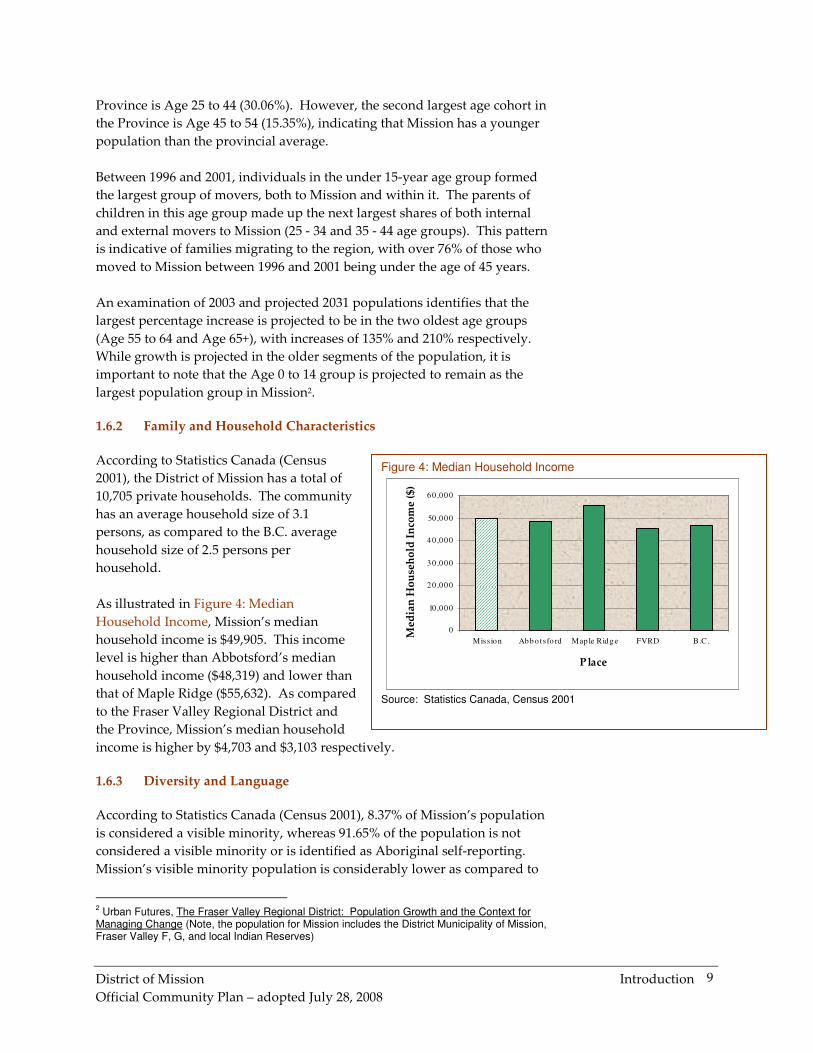
Figure 4: Median Household Income
0
10 ,000
20 ,000
30 ,000
40 ,000
50 ,000
60 ,000
Miss ion Abb o ts fo rd Map le Ridg e FVRD B.C.
Place
Med
ian
Ho
use
ho
ld I
nco
me
($)
Source: Statistics Canada, Census 2001
Province is Age 25 to 44 (30.06%). However, the second largest age cohort in
the Province is Age 45 to 54 (15.35%), indicating that Mission has a younger
population than the provincial average.
Between 1996 and 2001, individuals in the under 15-year age group formed
the largest group of movers, both to Mission and within it. The parents of
children in this age group made up the next largest shares of both internal
and external movers to Mission (25 - 34 and 35 - 44 age groups). This pattern
is indicative of families migrating to the region, with over 76% of those who
moved to Mission between 1996 and 2001 being under the age of 45 years.
An examination of 2003 and projected 2031 populations identifies that the
largest percentage increase is projected to be in the two oldest age groups
(Age 55 to 64 and Age 65+), with increases of 135% and 210% respectively.
While growth is projected in the older segments of the population, it is
important to note that the Age 0 to 14 group is projected to remain as the
largest population group in Mission2.
1.6.2 Family and Household Characteristics
According to Statistics Canada (Census
2001), the District of Mission has a total of
10,705 private households. The community
has an average household size of 3.1
persons, as compared to the B.C. average
household size of 2.5 persons per
household.
As illustrated in Figure 4: Median
Household Income, Mission’s median
household income is $49,905. This income
level is higher than Abbotsford’s median
household income ($48,319) and lower than
that of Maple Ridge ($55,632). As compared
to the Fraser Valley Regional District and
the Province, Mission’s median household
income is higher by $4,703 and $3,103 respectively.
1.6.3 Diversity and Language
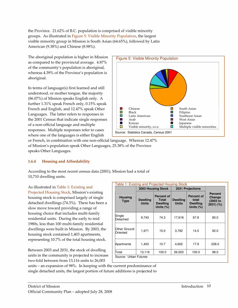
According to Statistics Canada (Census 2001), 8.37% of Mission’s population
is considered a visible minority, whereas 91.65% of the population is not
considered a visible minority or is identified as Aboriginal self-reporting.
Mission’s visible minority population is considerably lower as compared to
2 Urban Futures, The Fraser Valley Regional District: Population Growth and the Context for
Managing Change (Note, the population for Mission includes the District Municipality of Mission, Fraser Valley F, G, and local Indian Reserves)
District of Mission Introduction
Official Community Plan – adopted July 28, 2008
10
the Province. 21.62% of B.C. population is comprised of visible minority
groups. As illustrated in Figure 5: Visible Minority Population, the largest
visible minority group in Mission is South Asian (64.65%), followed by Latin
American (9.38%) and Chinese (8.98%).
The aboriginal population is higher in Mission
as compared to the provincial average. 4.87%
of the community’s population is aboriginal,
whereas 4.39% of the Province’s population is
aboriginal.
In terms of language(s) first learned and still
understood, or mother tongue, the majority
(86.07%) of Mission speaks English only. A
further 1.31% speak French only, 0.15% speak
French and English, and 12.47% speak Other
Languages. The latter refers to responses in
the 2001 Census that indicate single responses
of a non-official language and multiple
responses. Multiple responses refer to cases
where one of the languages is either English
or French, in combination with one non-official language. Whereas 12.47%
of Mission’s population speak Other Languages, 25.38% of the Province
speaks Other Languages.
1.6.4 Housing and Affordability
According to the most recent census data (2001), Mission had a total of
10,710 dwelling units.
As illustrated in Table 1: Existing and
Projected Housing Stock, Mission’s existing
housing stock is comprised largely of single
detached dwellings (74.3%). There has been a
slow move toward providing a range of
housing choice that includes multi-family
residential units. During the early to mid
1980s, less than 100 multi-family residential
dwellings were built in Mission. By 2003, the
housing stock contained 1,403 apartments,
representing 10.7% of the total housing stock.
Between 2003 and 2031, the stock of dwelling
units in the community is projected to increase
two-fold between from 13,116 units to 26,003
units – an expansion of 98%. In keeping with the current predominance of
single detached units, the largest portion of future additions is projected to
Figure 5: Visible Minority Population
Chinese South Asian Black Filipino Latin American Southeast Asian Arab West Asian Korean Japanese Visible minority, n.i.e Multiple visible minorities
Source: Statistics Canada, Census 2001
Table 1: Existing and Projected Housing Stock
2003 Housing Stock 2031 Projections
Housing Type Dwelling
Units
Percent of Total
Dwelling Units (%)
Dwelling Units
Percent of total
Dwelling Units (%)
Percent Change (2003 to
2031) (%)
Single Detached
9,743 74.3 17,618 67.8 80.0
Other Ground Oriented
1,971 15.0 3,782 14.5 92.0
Apartments 1,403 10.7 4,602 17.9 228.0
Total 13,116 100.0 26,003 100.0 98.0
Source: Urban Futures
District of Mission Introduction
Official Community Plan – adopted July 28, 2008
11
Table 2: Monthly Housing Payments and Affordability Average Monthly Payments ($)
Rented Dwellings Occupied Dwellings
Mission 705 1 011
Abbotsford 705 966
Maple Ridge 783 1 071
FVRD
688 902
B.C.
751 904
Source: Statistics Canada, Census 2001
Figure 6: Occupied Owned and Rented Dwellings
0
10
20
30
40
50
60
70
80
90
Mission Abbotsford Maple Ridge FVRD B.C.
Place
Per
cen
t o
f T
ota
l O
ccu
pie
d O
wn
ed
and
Ren
ted
Dw
elli
ng
s
Number of owned dwellings Number of rented dwellings
Source: Statistics Canada, Census 2001
be single detached units. Of the 2031 total housing stock, 67.8% is projected
to be comprised of single detached units3.
The average value of a dwelling in Mission in March 2006 was $304,182. This
figure is lower than the average price of a dwelling in all areas of the Fraser
Valley Regional District ($442,726). Mission’s average dwelling price was
also 17.6 per cent lower than that of Abbotsford ($369,167) in March 2006.
The source of this information was obtained from the MLS Summary, March
2006 – Fraser Valley Real Estate Board.
Three quarters of dwellings in Mission are owner-
occupied (74.88%), versus one quarter of which are
rented (25.12%). As illustrated in Figure 6: Occupied
Owned and Rented Dwellings, the percentage of
owned dwellings in Mission as compared to the
Fraser Valley Regional District and the Province is
3.38 and 8.57% higher respectively.
As noted in Section 1.62, Family and Household
Characteristics, the median household income in
Mission is $49,905. On monthly basis, this median
household income equates to $4,158.75. Housing is
generally considered affordable if 30% or less of one’s
income is spent on housing costs. Based on Mission’s
median household income, an affordable housing cost
is $1,247/month. As illustrated in Table 2: Monthly
Housing Payments and Affordability, Mission residents paid an average
monthly payment of $705 on rent. Conversely, an average monthly payment
of $1,011 was spent per month on occupied dwellings (e.g. mortgage
payments). Based on average monthly payments paid for both rented and
occupied dwellings, housing in Mission is considered to be affordable.
3 Urban Futures, The Fraser Valley Regional District: Population Growth and the Context for
Managing Change, Part II, 2005.
District of Mission Introduction
Official Community Plan – adopted July 28, 2008
12
Table 3: Education Level of Working Age Groups Mission B.C.
Education Level 20-34 years 35-64 years 20-34 years 35-64 years
Less than Grade 12 certificate
21.30% 25.50% 14.60% 21.10%
High School and some postsecondary
38.50% 26.40% 34.40% 23.40%
Trades certificate or diploma
11.60% 20.40% 10.50% 14.30%
College certificate or diploma
16.40% 19.10% 17.00% 18.60%
University certificate, diploma or degree
12.30% 8.70% 23.50% 22.60%
Adapted from Mission Manufacturing Opportunity Scan (2005). Source: Statistics Canada, Census 2001.
Figure 7: Mode of Transportation to Work
0
10
20
30
40
50
60
70
80
90
Car, t ruck,
van, as
d river
Car, t ruck,
van, as
passenger
Pub lic
t rans it
Walked o r
b icycled
Other
method
Transportation Mode
Per
cen
t (%
)
Miss ion
B.C.
Source: Statistics Canada, Census 2001
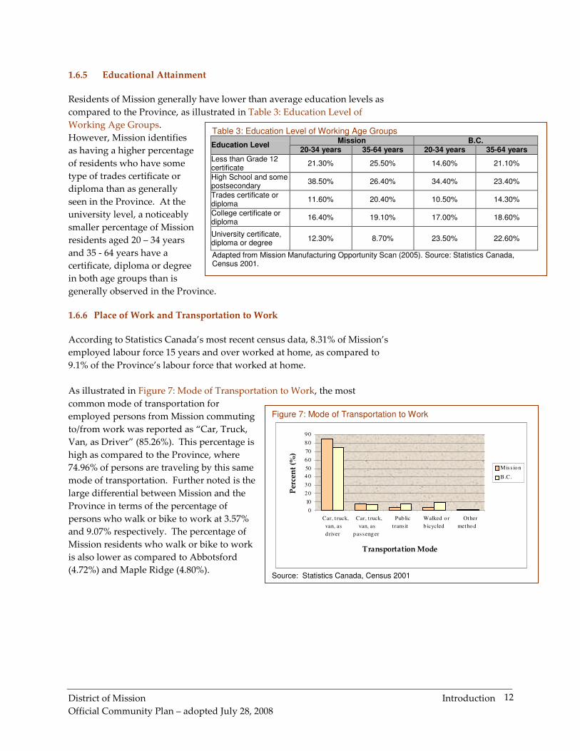
1.6.5 Educational Attainment
Residents of Mission generally have lower than average education levels as
compared to the Province, as illustrated in Table 3: Education Level of
Working Age Groups.
However, Mission identifies
as having a higher percentage
of residents who have some
type of trades certificate or
diploma than as generally
seen in the Province. At the
university level, a noticeably
smaller percentage of Mission
residents aged 20 – 34 years
and 35 - 64 years have a
certificate, diploma or degree
in both age groups than is
generally observed in the Province.
1.6.6 Place of Work and Transportation to Work
According to Statistics Canada’s most recent census data, 8.31% of Mission’s
employed labour force 15 years and over worked at home, as compared to
9.1% of the Province’s labour force that worked at home.
As illustrated in Figure 7: Mode of Transportation to Work, the most
common mode of transportation for
employed persons from Mission commuting
to/from work was reported as “Car, Truck,
Van, as Driver” (85.26%). This percentage is
high as compared to the Province, where
74.96% of persons are traveling by this same
mode of transportation. Further noted is the
large differential between Mission and the
Province in terms of the percentage of
persons who walk or bike to work at 3.57%
and 9.07% respectively. The percentage of
Mission residents who walk or bike to work
is also lower as compared to Abbotsford
(4.72%) and Maple Ridge (4.80%).
District of Mission Introduction
Official Community Plan – adopted July 28, 2008
13
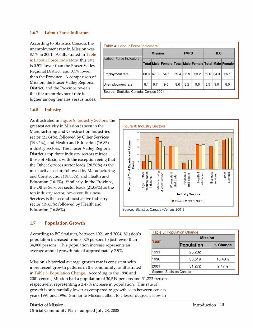
Table 4: Labour Force Indicators
Mission FVRD B.C.
Labour Force Indicators
Total Male Female Total Male Female Total Male Female
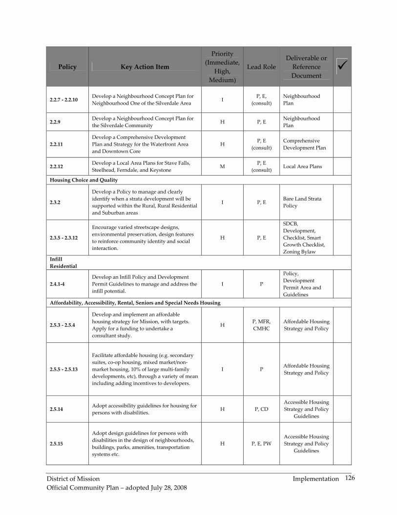
Neighbourhood Planning areas take the form of many different names and
have different intentions. Currently, there is one neighbourhood plan, Cedar
Valley Comprehensive Development Plan (Map 1b), in place; one
neighbourhood plan underway, Silverdale Neighbourhood #1
Neighbourhood Plan (Map 1c); and numerous other areas that will be
District of Mission Introduction
Official Community Plan – adopted July 28, 2008
21
planned within the context of a neighbourhood plan area. These areas may
include:
� Central Core including the Waterfront,
� Hatzic/North Hatzic,
� Ferndale,
� Stave Falls,
� Silverdale Urban and Urban Reserve,
� Silverdale Community
� Silverhill, and
� Keystone.
Generally, some of the Rural areas that have been identified as possible
neighbourhood planning areas can be planned using a Local Area Plan
process where the level of detail may not be as involved as a full
Neighbourhood Plan or a Comprehensive Development Plan given its
comparative lower density than Urban areas, where a more comprehensive
plan is required.
Other Land Use Designations
Other Land Use Designations found throughout the District of Mission,
whether Rural or Urban, also form part of the Official Community Plan.
These are as follows:
� Public/Institutional
� Historical Site
� Parks, Recreation and Open Space
� Recreation Commercial
� Agricultural Land Reserve
� Municipal Forest
District of Mission Introduction
Official Community Plan – adopted July 28, 2008
22
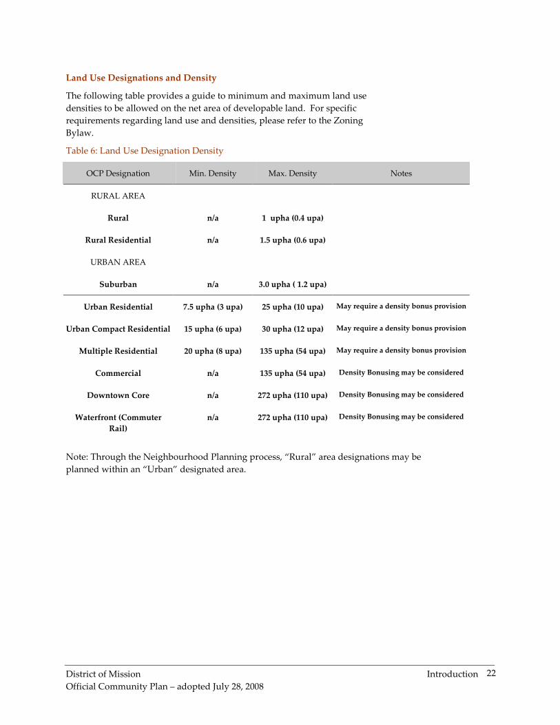
Land Use Designations and Density
The following table provides a guide to minimum and maximum land use
densities to be allowed on the net area of developable land. For specific
requirements regarding land use and densities, please refer to the Zoning
Bylaw.
Table 6: Land Use Designation Density
OCP Designation Min. Density Max. Density Notes
RURAL AREA
Rural n/a 1 upha (0.4 upa)
Rural Residential n/a 1.5 upha (0.6 upa)
URBAN AREA
Suburban n/a 3.0 upha ( 1.2 upa)
Urban Residential 7.5 upha (3 upa) 25 upha (10 upa) May require a density bonus provision
Urban Compact Residential 15 upha (6 upa) 30 upha (12 upa) May require a density bonus provision
Multiple Residential 20 upha (8 upa) 135 upha (54 upa) May require a density bonus provision
Commercial n/a 135 upha (54 upa) Density Bonusing may be considered
Downtown Core n/a 272 upha (110 upa) Density Bonusing may be considered
Waterfront (Commuter
Rail)
n/a 272 upha (110 upa) Density Bonusing may be considered
Note: Through the Neighbourhood Planning process, “Rural” area designations may be
planned within an “Urban” designated area.
District of Mission Protecting the Natural Environment
Official Community Plan – adopted July 28, 2008
23
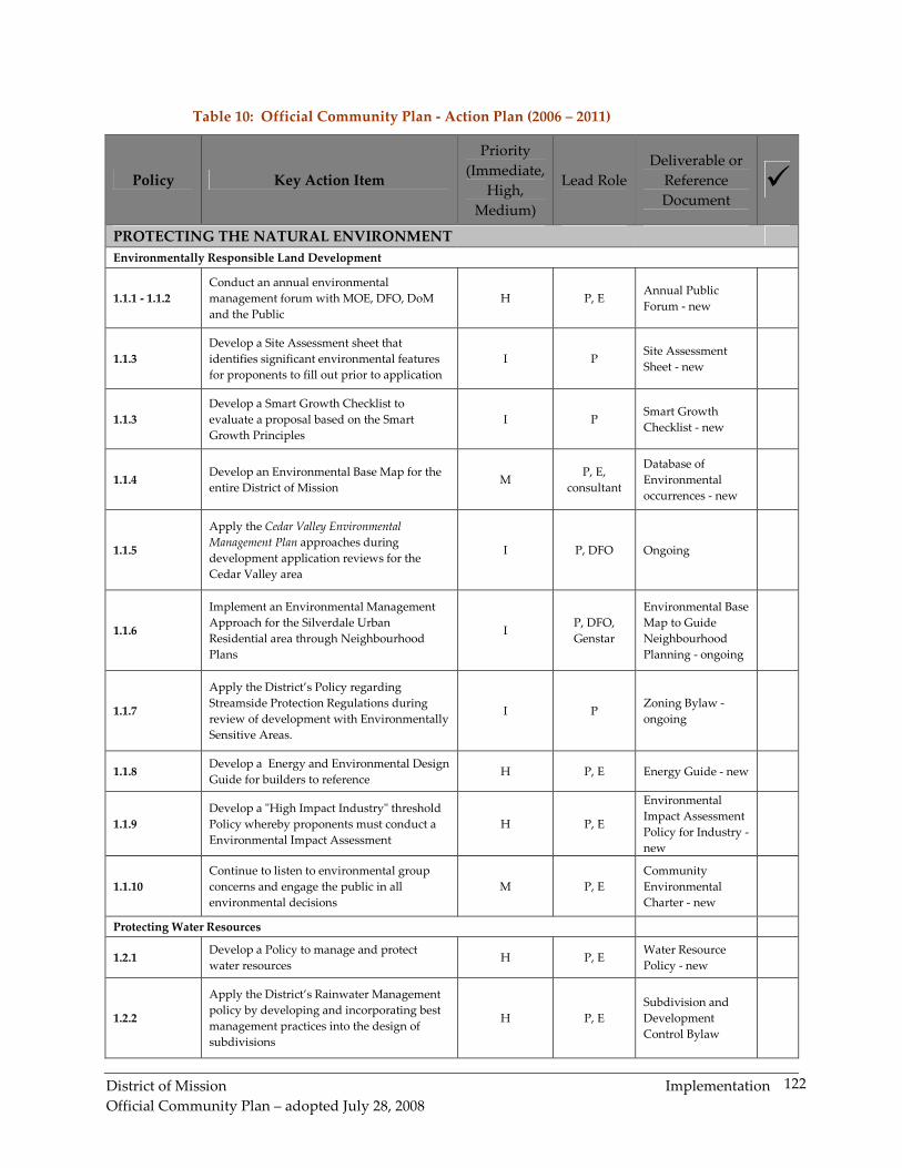
1. PROTECTING THE NATURAL ENVIRONMENT
1.1 Environmentally Responsible Land Development
The District of Mission, as a rapidly growing community is very aware of the
need to manage future land development in an environmentally sustainable
manner. The District of Mission works closely with several provincial and
federal agencies and departments to encourage environmentally sustainable
planning and management of land. Recent successes in effective
environmental management in Mission include:
� the Cedar Valley Environmental Management Plan and
accompanying Memorandum of Understanding with the
Department of Fisheries and Oceans
� the watercourse mapping inventory
� municipal property acquisition within the Silverdale Creek
Parkway Corridor, including innovative acquisition partnerships
with groups such as Ducks Unlimited Canada
� the environmental template to be used to guide neighbourhood
planning, over time, within the Silverdale Urban Residential Area
Beyond responsible environmental stewardship of its land base, and
retention of the community’s natural attributes, Mission seeks to maintain its
small town character as it evolves into a more ‘Complete Community’.
Collectively, these aspirations convey the desire of Mission residents to strive
for a high level of environmentally sustainable planning, otherwise known
as ‘smart growth’. To achieve these goals, the District will continue with the
environmental management approaches currently in place and will add an
evaluation tool, known as a smart growth checklist, to evaluate growth and
development proposals.
Smart Growth and the Environmental Development Checklist
The intent of Mission’s smart growth checklist is to review growth and
development proposals from the basis of whether or not they meet the high
environmental standards that Mission wishes to maintain as it continues to
grow and evolve. The checklist provides a guide for developers and
landowners towards achieving sustainable development projects. The
checklist is a practical tool for evaluating smart growth principles, as set out
by Smart Growth BC, that includes:
1. mix land uses
2. build well designed, compact neighbourhoods
3. provide a variety of transportation choices
4. create diverse, affordable housing options
5. encourage growth in existing communities
6. preserve open spaces and environmentally sensitive areas
7. protect and enhance agriculture lands
Sustainable Development "Sustainable development is development that meets the needs of the present without compromising the ability of future generations to meet their own needs." World Commission on Environment and Development (WCED). Our common future. Oxford: Oxford University Press, 1987 p. 43. Where the goals are to:
� Maintain environmental integrity to ensure the health and security of human communities and life-sustaining ecosystems.
� Ensure social equity to enable the complete fulfillment of all men and women, development of communities and respect for diversity.
� Aim for economic efficiency to create an innovative and prosperous economy that is ecologically and socially responsible
District of Mission Protecting the Natural Environment
Official Community Plan – adopted July 28, 2008
24
8. utilize smarter and cheaper infrastructure and green buildings
9. foster unique neighbourhood identity
10. nurture engaged citizenship
By using the checklist, the municipality can establish a consistent approach
to be followed in reviewing each project that is to be developed within the
community. The checklist will assist Council when considering applications.
Cedar Valley Environmental Management Plan
Through the adoption of the Cedar Valley Environmental Management Plan
in 1996, the District established its first comprehensive environmental
planning approach to land development. The intent of the Plan is to protect
and preserve environmentally sensitive area locations as urban development
occurs in Cedar Valley. The Plan includes the following objectives:
� protect environmentally sensitive areas
� enhance opportunities for urban development
� achieve agreement on an environmental management approach
� create development process efficiencies
� achieve commitment from the Department of Fisheries and Oceans
and the District of Mission to adopt and respect the Environmental
Management Plan
The document was updated in 2005 and a Memorandum of Understanding
between the District of Mission and the Department of Fisheries and Oceans
was signed to confirm the commitment to the process.
The sustainable development guidelines in the Cedar Valley Plan included
the following:
� identifying developable versus non-developable land and preserving
approximately 1/3 of the entire development area for open space,
environmental preservation and parks
� integrating pedestrian greenways between schools, residential areas
and other key community locales
� optimizing utility of land by using different forms of density for
single family lots as well as varied high density forms of residential
projects
� ensuring the integrity of the natural environment remains intact
In 2005 the District moved forward with its environmentally responsible
development approach in adopting a comprehensive set of sustainable
development policies and guidelines regarding the development of the
Silverdale Urban Residential Area. The policy requires development in the
3400-acre area to proceed on a phased basis, through the approval of
Neighbourhood Plans.
District of Mission Protecting the Natural Environment
Official Community Plan – adopted July 28, 2008
25
The Neighbourhood Plan preparation process requires ongoing public
consultation and the extensive, comprehensive environmental, social and
economic analysis of the area to ensure the highest possible environmental
standards are met. Council’s policy states that the intent of the process is to
“establish a planning framework that will result in the Silverdale Urban
Residential development representing the most advanced, innovative and
liveable planned community within the Lower Mainland area.”
The environmental analysis in the Silverdale area is based on a
comprehensive watershed approach and prior to commencing a
Neighbourhood Plan, the District requires an inventory be taken identifying
locations of watercourse areas, headwaters, wildlife corridors and tree
canopy cover. The primary objective of the environmental management
studies is to identify and protect Environmentally Sensitive Areas, including:
� watercourses and the streamside or riparian areas, and associated
ravines
� water bodies (lakes, wetlands and marshes) and the associated
foreshore or riparian areas
� aquifer recharge areas
� rare and endangered vertebrate and plant species
� wildlife trees and greenway linkages/wildlife corridors
Requirements of the Neighbourhood Plan process include an extensive list of
environmental mapping, environmental studies and protection plans,
background/update reports, land use studies, transportation studies and
municipal servicing studies. Additional requirements include such studies
as a public consultation communications plan, heritage, culture and
archaeological analyses, a renewable energy technology study, a landscape
design study, a community-wide feasibility study, a community facilities
study, financial impact studies as well as several other specific assessments
and studies.
The impact of growth pressures on the District’s natural setting is a serious
concern to residents. Environmental management efforts will be key to
finding a balance between growth and development activities and
preservation and protection of the natural environment such that Mission
can look toward a sustainable future. The following policies are designed to
support the proactive objective of adopting an Environmental Management
Approach to development in Mission.
OBJECTIVE
Adopt an overall management approach that values the environment when
developing in Mission.
District of Mission Protecting the Natural Environment
Official Community Plan – adopted July 28, 2008
26
POLICIES
Collaborative Approach to Environmental Protection and Management
Policy 1.1.1. Coordinate the District’s environmental protection and
management initiatives with regional, provincial, federal government
departments and agencies.
Annual Environmental Management Forum
Policy 1.1.2. Conduct an annual environmental management forum,
working with all local environmental stewardships groups, to provide for
the exchange of information and the further development of community
based environmental initiatives.
Smart Growth Principles and an Environmental Development Checklist
Policy 1.1.3. Employ smart growth principles and use an environmental
development checklist to identify strengths and weaknesses in new
developments. Through this approach, any new development would be
evaluated on a number of general criteria to determine if it:
� is located near existing infrastructure
� increases the range of housing options
� protects open space, farmland and environmentally sensitive areas
� contributes to a mix of land uses and/or a well designed, compact
neighbourhood
� enhances choices for getting around (e.g. walking, cycling, transit)
� fosters social interaction and unique neighbourhood identity
Identifying and Mapping Environmental Values
Policy 1.1.4. Identify environmental values and map environmental
features in the District of Mission so that this information can be used and
refined for planning processes and for evaluating development proposals. In
particular, the following environmental features should be mapped:
� watercourses including streams, creeks, rivers, wetlands, sloughs,
ditches, lakes and groundwater recharge areas, which may comprise
fish habitat
� known occurrences of endangered, threatened or vulnerable aquatic
species, particularly those listed under the Species at Risk Act
Cedar Valley Environmental Management Plan
Policy 1.1.5. In the review of development applications in the Cedar
Valley area, protect environmentally sensitive areas and manage rainwater
through the application of District Policies and the Cedar Valley
Environmental Management Plan, involving:
� acquiring and protecting environmentally sensitive areas
� acquiring and developing parkland
� integration of pedestrian greenways
� optimizing land use
� varying densities for single family and multi-family areas
� ensuring the integrity of the natural environment remains intact.
District of Mission Protecting the Natural Environment
Official Community Plan – adopted July 28, 2008
27
Silverdale Environmental Management Approach
Policy 1.1.6. Implement an Environmental Management Approach for
the Silverdale Urban Residential area, through Neighbourhood Plans that
involve:
� identification of environmentally sensitive areas
� a comprehensive watershed approach
� ongoing public participation
� extensive, comprehensive environmental, social and economic
analysis and monitoring.
Protection of Environmentally Sensitive Areas
Policy 1.1.7. In the review of development proposals in Environmentally
Sensitive Areas, apply the District’s policies and bylaws regarding:
� watercourses, streamside or riparian areas, ravines
� water bodies (lakes, wetlands and marshes)
� aquifer recharge areas
� rare and endangered vertebrate and plant species
� wildlife trees and greenway linkages/wildlife corridors
Energy Efficient Building Design
Policy 1.1.8. Encourage energy efficient building design.
Assessment of High Impact Industry
Policy 1.1.9. Continue to require Environmental Impact Assessments for
high impact industry.
Environmental Education and Partnerships
Policy 1.1.10. Support environmental education and partnerships
occurring within the community.
1.2 PROTECTING WATER RESOURCES
Mission is located along the Fraser River – a water resource that has been
central to the development of the community given its industrial legacy. The
river continues to have an industrial function, but increasingly, it is being
viewed in terms of the opportunities it presents for mixed-use residential
and commercial waterfront development. As uses intensify along the Fraser
River, it will become increasingly more important to protect the river and its
tributaries through practices such as rainwater management, buffer systems,
development control, etc. These resource management practices will protect
natural habitat and help to preserve one of the community’s greatest eco-
tourism and recreation amenities that supports activities such as sturgeon
and salmon fishing.
The following policies provide for the protection of Mission’s water
resources, including the Fraser River, but also other surface and ground
water resources in the watershed areas of Mission.
District of Mission Protecting the Natural Environment
Official Community Plan – adopted July 28, 2008
28
OBJECTIVE
Protect the District’s water resources and encourage reduction of water
consumption.
POLICIES
Water Resource Management
Policy 1.2.1. Ensure that water resource management initiatives are
explored prior to development so as to preserve watercourses, wetlands,
manage groundwater.
Rainwater Management
Policy 1.2.2. Apply the District’s Rainwater Management policy by
incorporating best management practice measures into the design of
subdivisions (e.g. groundwater recharge systems) with the objective to
maintain the mean annual flows in watercourses.
Low Impact Development
Policy 1.2.3. Require new developments to incorporate low impact
development elements to manage rainfall at the source.
Water Conservation
Policy 1.2.4. Promote water conservation and develop programs to
reduce water consumption.
1.3 IMPROVING AIR QUALITY
There are a number of factors that contribute to poor air quality including
automobile emissions, industrial emissions, outdoor burning, etc. Some
contributors to poor air quality are also linked to climate change. In fact,
82% of human-made greenhouse gas emissions come from energy-related
carbon dioxide emissions resulting from petroleum and natural gas. In brief,
these emissions are linked to both smog (poor air quality) and climate
change. Clearly, there is a link between local activities, regional air quality,
and global climate change. In order to mitigate these impacts a collaborative
approach is required among different levels of government and community
stakeholders across the entire Lower Mainland area, including Mission. The
following policies provide direction to improve air quality locally in Mission,
as well as regionally and globally.
OBJECTIVE
Work with other levels of government, neighbouring jurisdictions,
businesses and other stakeholders to improve local and regional air
quality through collaborative initiatives and the development of a local air
quality management program.
District of Mission Protecting the Natural Environment
Official Community Plan – adopted July 28, 2008
29
POLICIES
Regional Cooperation
Policy 1.3.1 Work in cooperation with the Fraser Valley Regional
District, the Greater Vancouver Regional District, neighbouring
municipalities, Whatcom County, businesses and other stakeholders to
support and implement the Fraser Valley Regional District Air Quality
Management Plan.
Best Practices in District Operations
Policy 1.3.2 Establish and follow ‘best management practices’ for air
quality management for District operations to reduce the negative air quality
impacts, and further, examine options to introduce energy efficient systems
in District buildings and infrastructure and examine options for using
alternative fuel vehicles for District operations.
Outdoor Burning
Policy 1.3.3 Continue to regulate and manage outdoor burning.
Dependence on the Automobile
Policy 1.3.4 Reduce dependence of the automobile by supporting public
transit, transit oriented development (TOD), and alternative transportation
modes.
Community Based Programs
Policy 1.3.5 Encourage and support community based programs to
prevent pollution.
New Technologies for Industry
Policy 1.3.6 Encourage local industry and businesses to investigate and
adopt new technologies to reduce air pollution.
Air Quality and Tree Retention
Policy 1.3.7 Recognize the District’s Tree Retention/Replanting Program
for its contribution to improving air quality within the municipality.
Energy Efficient Development
Policy 1.3.8 Develop and incorporate energy efficient site design
guidelines into the District’s development approval process.
District of Mission Protecting the Natural Environment
Official Community Plan – adopted July 28, 2008
30
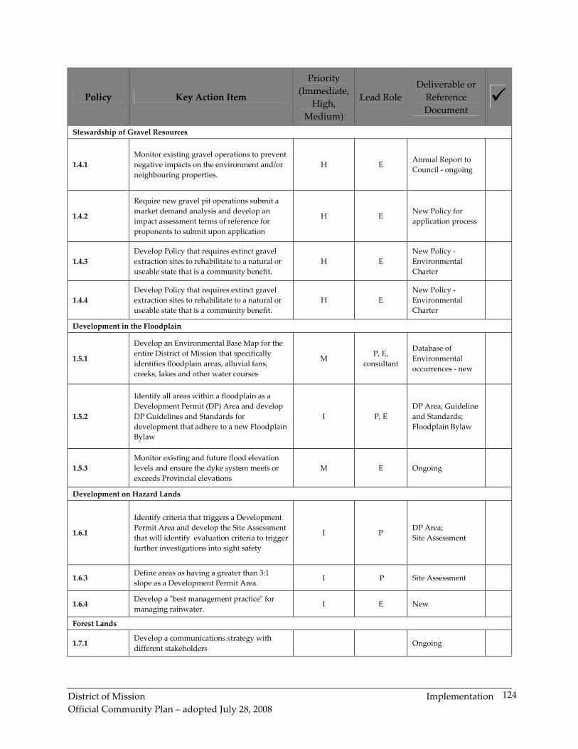
1.4 STEWARDSHIP OF GRAVEL RESOURCES
Aggregate (sand, gravel and crushed bedrock) is a non-renewable resource.
As such, the development and use of aggregate must be carefully planned to
ensure long-term availability of appropriate quality material at reasonable
cost and with minimal impacts.
There are active commercial gravel pit operations in Mission, as identified in
Map 2, Transportation System and Gravel Pits. The District owns two of
these operations, one is owned by the Crown, and four operations are
privately owned. In 1997, the estimated production volume was
approximately 697,866.9 tonnes, representing 5% of the Lower Mainland’s
demand for gravel.
Mission’s gravel production is mostly absorbed by the local market. While
there is no anticipated decrease in the demand for aggregate, gravel pits
have a limited lifespan that must be considered. The reclamation and end
use of gravel pits is important from a social, economic, and environmental
perspective, and integral to long-term community planning efforts.
The following policies provide direction in terms of managing gravel
operations within the District with a view to minimizing short- and long-
term impacts.
OBJECTIVE
Manage gravel operations to minimize their impacts.
POLICIES
Management of Existing Gravel Operations
Policy 1.4.1. Continue to manage the technical, safety and environmental
impacts of existing gravel pit operations as well as impacts on adjacent
properties.
New or Expanded Gravel Pits
Policy 1.4.2. Evaluate applications for new or expanded gravel pits based
on potential operating impacts upon adjacent residential neighbourhoods
and other land uses, noise levels and traffic impacts on municipal roads.
Continuous Rehabilitation of Gravel Sites
Policy 1.4.3. Support the continuous rehabilitation of gravel extraction
sites to reduce the visual impact of the operations on the community.
Reclamation of Gravel Sites
Policy 1.4.4. Support a variety of options for the reclamation of gravel
sites, including conversion to residential, institutional, parkland and/or rural
area industrial/business use.
District of Mission Protecting the Natural Environment
Official Community Plan – adopted July 28, 2008
31
Aggregate within Agricultural Land Reserve
Policy 1.4.5. Identify opportunities for improving the long-term potential
of land through the reclamation of land for agricultural use in cases where
some or all of the aggregate resources have been removed and the topsoil
layers in their original layers have been replaced.
Regional Planning
Policy 1.4.6. Continue to collaborate with the FVRD to work toward a
coordinated, region-wide plan for aggregates.
1.5 DEVELOPMENT IN THE FLOODPLAIN
Mission is at risk of experiencing the detrimental effects of natural hazards,
including flooding, particularly given its location in relation to the Fraser
River. The largest recorded flood event of the Fraser River happened in
1894. This flood resulted in residential areas moving “up the hill” and the
establishment of a 200-year floodplain boundary. The floodplain area,
approximately 400 ha, extends generally in a southerly direction from the
Lougheed Highway to the Fraser River, as seen on Map 1. Land use areas
within the floodplain include industrial, the Waterfront Area, the Commuter
Rail Area, and part of the Downtown.
After the flood of 1948, a major flood control project was established to
construct dykes elevated and broad enough to withstand the extremely high
water levels along the Fraser River. Despite the existing extensive system of
dykes and drainage facilities adjacent to the Fraser River, the risk of a flood
greater than the 200-year hazard still exists. There is also a risk of dyke
failure and local flooding behind the local dykes. These events could result
in property damage, including loss to valuable farmland, and loss of life.
Floodplain management policies, bylaws guidelines and regulations have
been developed for Mission to address the potential health and safety risks
from flooding. The following polices address floodplain management and
have been developed for Mission to address the potential health and safety
risks from flooding.
Efforts to provide for public safety and protection of property can be
achieved through flood hazard management programs that involve a
combination of strategic efforts to increase public awareness about flood
hazards, establishment of floodproofing standards for new development,
local government land use planning, and regulation of subdivision
approvals. The following policies address floodplain management.
District of Mission Protecting the Natural Environment
Official Community Plan – adopted July 28, 2008
32
OBJECTIVE
Protect people and property from the risk of flooding.
POLICIES
Floodproofing New Development
Policy 1.5.1. Continue to identify floodplain areas that are subject to
floodplain requirements, including the 200-year Fraser River floodplain,
alluvial fans, creeks, lakes and other watercourses and ensure all new
development within the floodplain is adequately flood proofed.
Floodplain Development Requirements
Policy 1.5.2 Development on a floodplain shall be in accordance with the
District of Mission Floodplain Management Bylaw.
Maintaining and Upgrading the Fraser River Dyke
Policy 1.5.3. Maintain the existing dyke at the Fraser River and determine
what modifications may be required to mitigate the effects of flooding on
existing and future development within the floodplain.
Fraser River Development Permit Area
Policy 1.5.4 Development located within the Fraser River Development
Permit Area, identified on OCP Map 5a, shall meet the requirements of the
Development Permit Area Guidelines and the District of Mission Floodplain
Management Bylaw.
1.6 DEVELOPMENT ON HAZARD LANDS
Mission’s steep, sloping terrain, heavy rainfall, and the ongoing alteration of
the natural environment through development activity and industrial
activity, may lead to soil erosion. The effects of soil erosion are multi-fold
including, rapid surface water runoff and in turn, flooding (with impacts on
agriculture, local economy, etc.), depletion of groundwater (with impacts on
drinking water) and landslides. Collectively, these natural hazards pose a
threat to health and safety. Planning and development decisions impact the
extent to which natural hazards serve as a threat. The following policies are
designed to manage the risk of development on hazardous lands,
particularly in steep slope areas.
OBJECTIVE
Manage the risk of development on hazardous lands, primarily lands with
steep slopes.
POLICIES
Evaluation of Development on Hazard Lands
District of Mission Protecting the Natural Environment
Official Community Plan – adopted July 28, 2008
33
Policy 1.6.1. Evaluate development on lands deemed to be dangerous
through site-specific considerations; where appropriate, require developers
to provide a site-specific geotechnical evaluation to ensure proposed
developments on hazard lands will not be detrimentally affected.
Lands Where Development is Prohibited
Policy 1.6.2. Development on potentially hazardous lands shall be
prohibited where a report from a qualified professional has not identified the
site as safe for the use intended.
Development on Hazard Lands
Policy 1.6.3. Development on hazardous lands shall meet the
requirements of the Geotechnical Hazard Lands Development Permit Area
Guidelines.
Policy 1.6.4. Prohibit development on lands subject to hazards where a
report submitted by a qualified professional has not identified the land as
being safe for the use intended.
Rainwater Management
Policy 1.6.5. Require all development to deal with rainwater
management on site as per the District’s “best management practice”
requirements to reduce peak flow-related erosion of the site or adjacent sites.
1.7 FOREST LANDS
Mission is unique in that it is home to a large Municipal Forest, an area of
approximately 10,400 ha which covers over 40% of the District. This natural
resource is an amenity that is unparalleled within Lower Mainland
communities.
The Municipal Forest is made up of municipal and provincial crown-owned
land. The District has had a Tree Farm Licence since 1958 and recently
renewed it to 2024. Through this licence, harvesting patterns are locally
controlled and managed. Surplus revenues from the forestry operation
accrue to the municipality and have been directed to various municipal
programs such as arts and culture and the construction of a Fire Hall and a
new library. The forest industry also creates both direct and indirect
employment opportunities, while supplying local wood manufacturers with
raw materials.
Further to the economic benefits associated with the Municipal Forest, one
cannot underestimate the environmental value of the area that provides
habitat to different species of flora and fauna. The sheer size and
prominence of the Municipal Forest provides the community its natural
character and also contributes to local sense of place. The Municipal Forest
also serves as a recreation amenity. There are over a dozen hiking and multi-
use trails, separate trail facilities for horses and mountain bikers, and several
District of Mission Protecting the Natural Environment
Official Community Plan – adopted July 28, 2008
34
lakes and various picnic spots. Other outdoor activities available to the
public include fishing, forest education and interpretation, and hunting in
designated areas. Recreation activity in the Municipal Forest has
consistently increased over the past 20 years.
The following policies are focused on the preservation and protection of the
Municipal Forest, as well as integrated management.
OBJECTIVE
Preserve and protect the Municipal Forest and manage the integration of
environmental and recreation uses.
POLICIES
Collaborative Approach to Forest Management
Policy 1.7.1. Coordinate forest management through ongoing
communication and planning involving the Forestry Department, Ministry
of Forests and Range, BC Hydro, local residents and the RCMP.
Importance of the Municipal Forest
Policy 1.7.2. Recognize the importance of the Municipal Forest to the
District; maintain and protect forestry use and logging operations as well as
other non-timber resources such as mushrooms.
Recreation Use Plans
Policy 1.7.3. Work with the appropriate local organizations as well as
provincial and federal departments to prepare Recreation Use Plans for areas
such as Rolley Lake, the Florence Lake Forestry Road area west of Stave Lake
etc.
Managing Uncontrolled Access to the Forest
Policy 1.7.4. Work with the appropriate provincial and federal
departments to reduce the detrimental effects of uncontrolled public access
of the Municipal Forest; develop a recreational management strategy to
achieve this objective.
Managing Interface Fire Hazard
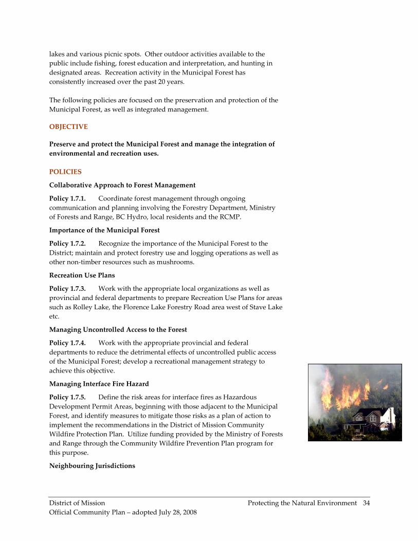
Policy 1.7.5. Define the risk areas for interface fires as Hazardous
Development Permit Areas, beginning with those adjacent to the Municipal
Forest, and identify measures to mitigate those risks as a plan of action to
implement the recommendations in the District of Mission Community
Wildfire Protection Plan. Utilize funding provided by the Ministry of Forests
and Range through the Community Wildfire Prevention Plan program for
this purpose.
Neighbouring Jurisdictions
District of Mission Protecting the Natural Environment
Official Community Plan – adopted July 28, 2008
35
Policy 1.7.6. Manage the Municipal Forest in a manner that does not
adversely impact neighbouring jurisdictions (i.e. Electoral Area ‘F’ of the
FVRD, Hatzic Valley), and in such a way that allows for ongoing
consultation and collaboration as required.
District of Mission Building Liveable Neighbourhoods
Official Community Plan – adopted July 28, 2008
36
2. BUILDING LIVEABLE NEIGHBOURHOODS
2.1 NEIGHBOURHOOD CHARACTER
The District of Mission is blessed with a very wide variety of rural, suburban
and urban lifestyle choices, with a broad range of housing forms and styles
being available to meet the diverse needs of the community. Residents have
expressed a strong appreciation of Mission’s small town atmosphere and the
variety of recreational opportunities available within close proximity.
Projected growth in Mission’s housing stock over the next three decades as
forecasted by The Fraser Valley Regional District: Population Growth and
the Context for Managing Change (2005), is based on projections of the
Mission resident population growing to 71,621 by 2031 (approximately a
doubling of population over this period). While Mission is expected to see
its 65 + population grow the most over this period, both absolutely and
relatively (by 210%), the under 15 age group is also expected to grow
substantially, adding 5,833 individuals between 2003 and 2031.
The housing projections (See Table 1: Existing and Projected Housing Stock
in Part I, Introduction) suggest Mission’s housing stock will also
approximately double over this period, from 13,116 dwelling units in 2003 to
26,003 units in 2031.
The projections indicate that single detached units, with an 80% increase, will
still be the dominant housing form, but would make up a slightly smaller
percentage of total units in 2031. Other ground oriented (‘young family
suitable’) housing would double in numbers, holding about steady at its
current proportionate level. Multi-family units, are forecasted to increase by
nearly 230% to become a significantly more important proportion of the
housing stock. This would be expected with an aging population.
The series of residential policies contained in this OCP are a critical
component of the effort to ensure that a range of housing options will
continue to be in place for future residents and that high quality housing and
neighbourhoods will be built and maintained. The District works with the
private sector in the many facets of providing housing for a variety of income
levels, family structures, age groups and lifestyles. This includes providing
for many different housing forms, tenures and densities in a wide array of
rural, suburban and urban settings.
The District strives to achieve neighbourhoods that are attractive, safe, have
lots of green space, good pedestrian and transportation networks and are
well connected to schools, shopping, community facilities, amenities and
services. The policies in this section of the Plan are primarily aimed at
achieving:
District of Mission Building Liveable Neighbourhoods
Official Community Plan – adopted July 28, 2008
37
• an application of the principles of sustainable development through
encouraging a wide variety of higher density development forms, infill
housing, cluster developments and other innovative housing types; and
• an emphasis on the quality of design of neighbourhoods, encouraging
varied streetscape designs, preservation of the natural environment,
convenient pedestrian access, design features which reinforce
community identity and social interaction and so forth.
OBJECTIVE
Develop liveable, complete, safe, sustainable neighbourhoods with a
strong sense of community and where the natural environment is highly
valued and where high quality neighbourhood design, building design
and landscape design promotes a wide variety of housing choice.
POLICIES
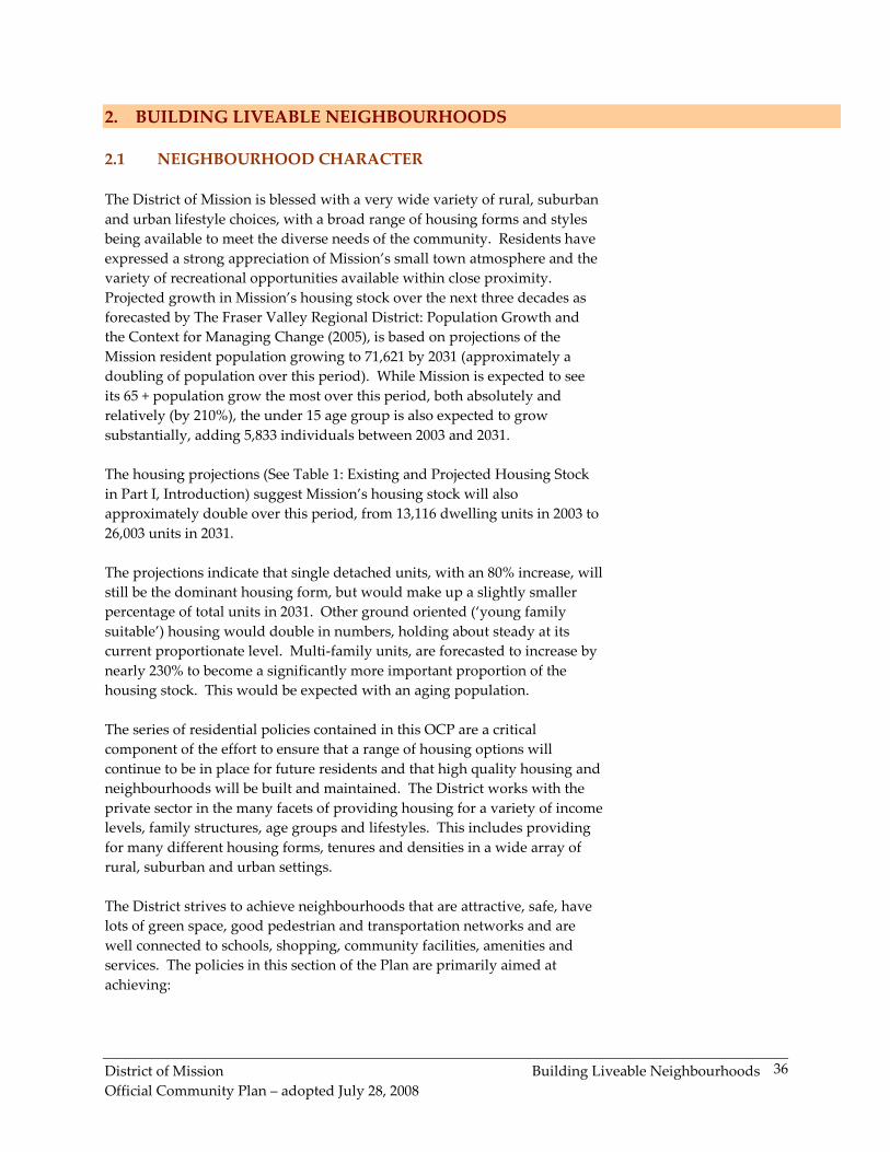
� DESIGNING WITH NATURE
Preserving Natural Features
Policy 2.1.1. Ensure residential developments are planned compatibly
with the natural attributes of each site, with the objective of preserving and
protecting natural features such as ravines, wetlands, watercourses, natural
topography of the site, views, vistas and mature vegetation.
Retaining and Replanting Trees
Policy 2.1.2. Ensure new developments provide for the retention of
significant trees and replanting of new trees in accordance with the District
of Mission’s Tree Retention and Replanting Policy. Where applicable,
boulevard street trees are to be provided in addition to the requirements of
the Tree Retention and Replanting Policy. Lot grading designs should
incorporate the trees being retained and/or replanted.
Energy Efficient Building Design
Policy 2.1.3. Require proponents of residential development projects to
consider energy efficient building design.
Permeable Surfaces and Natural Landscaping
Policy 2.1.4. Encourage the use of permeable surfaces wherever possible
(e.g. prohibit large paved yard areas) and encourage naturescaping (the
practice of natural landscaping, or gardening with native plants) on single
family and multi-family residential properties.
Sustainable Development "Sustainable development is development that meets the needs of the present without compromising the ability of future generations to meet their own needs." World Commission on Environment and Development (WCED). Our common future. Oxford: Oxford University Press, 1987 p. 43. Where the goal is to:
� Maintain environmental integrity to ensure the health and security of human communities and life-sustaining ecosystems.
� Ensure social equity to enable the complete fulfillment of all men and women, development of communities and respect for diversity.
� Aim for economic efficiency to create an innovative and prosperous economy that is ecologically and socially responsible
District of Mission Building Liveable Neighbourhoods
Official Community Plan – adopted July 28, 2008
38
Towards More Sustainable Residential Development
Policy 2.1.5. Pursue a multi-faceted residential strategy, involving efforts
to make more optimal use of the dwindling land base, through supporting
such development forms and initiatives as:
• higher density forms of development
• urban infill development
• smaller urban lot sizes
• appropriate massing of houses according to lot size
• cluster developments to avoid building on steeply sloping lands and to
protect environmentally sensitive lands
• innovative and proven package treatment systems for rural area septic
effluent disposal
• mixed use commercial-residential developments in commercial and
industrial areas
� NEIGHBOURHOOD DESIGN
Measures to Reinforce Community Identity
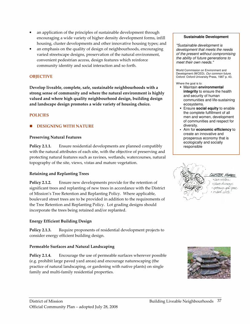
Policy 2.1.6. Reinforce community identity through a variety of means
such as:
• Developing and maintaining varied streetscape design
• Creating community gathering spaces (e.g. small parks, “village
squares”)
• Encouraging community use of community centres and local schools
• Highlighting heritage features through signage, preservation etc.
• Supporting a range of services close by for convenience
• Providing safe and convenient access within neighbourhoods
• Providing special signage, gateways and other unique urban design
features
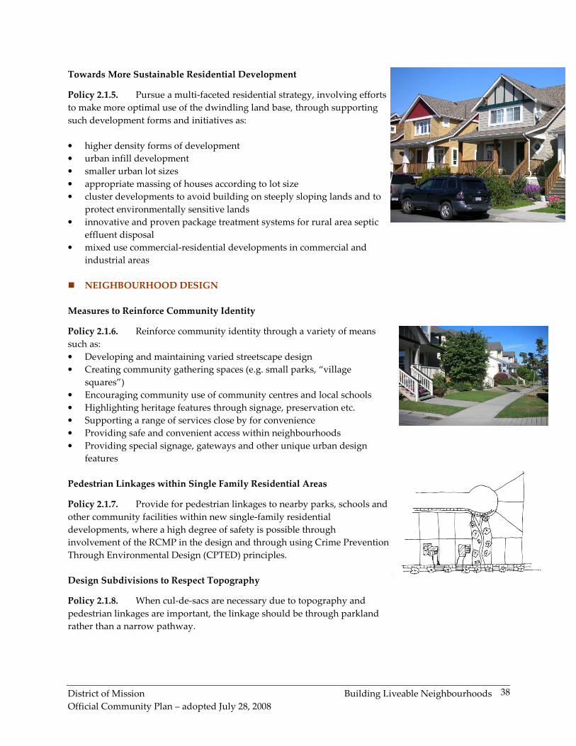
Pedestrian Linkages within Single Family Residential Areas
Policy 2.1.7. Provide for pedestrian linkages to nearby parks, schools and
other community facilities within new single-family residential
developments, where a high degree of safety is possible through
involvement of the RCMP in the design and through using Crime Prevention
Through Environmental Design (CPTED) principles.
Design Subdivisions to Respect Topography
Policy 2.1.8. When cul-de-sacs are necessary due to topography and
pedestrian linkages are important, the linkage should be through parkland
rather than a narrow pathway.
District of Mission Building Liveable Neighbourhoods
Official Community Plan – adopted July 28, 2008
39
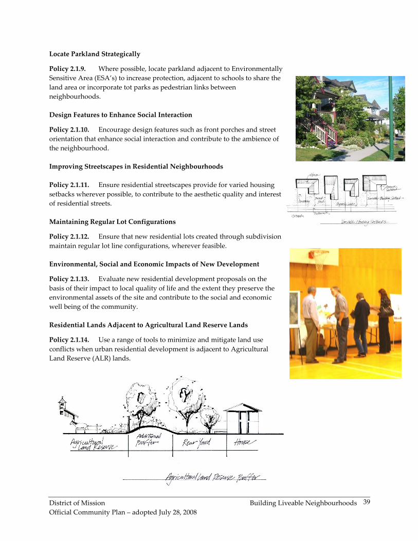
Locate Parkland Strategically
Policy 2.1.9. Where possible, locate parkland adjacent to Environmentally
Sensitive Area (ESA’s) to increase protection, adjacent to schools to share the
land area or incorporate tot parks as pedestrian links between
neighbourhoods.
Design Features to Enhance Social Interaction
Policy 2.1.10. Encourage design features such as front porches and street
orientation that enhance social interaction and contribute to the ambience of
the neighbourhood.
Improving Streetscapes in Residential Neighbourhoods
Policy 2.1.11. Ensure residential streetscapes provide for varied housing
setbacks wherever possible, to contribute to the aesthetic quality and interest
of residential streets.
Maintaining Regular Lot Configurations
Policy 2.1.12. Ensure that new residential lots created through subdivision
maintain regular lot line configurations, wherever feasible.
Environmental, Social and Economic Impacts of New Development
Policy 2.1.13. Evaluate new residential development proposals on the
basis of their impact to local quality of life and the extent they preserve the
environmental assets of the site and contribute to the social and economic
well being of the community.
Residential Lands Adjacent to Agricultural Land Reserve Lands
Policy 2.1.14. Use a range of tools to minimize and mitigate land use
conflicts when urban residential development is adjacent to Agricultural
Land Reserve (ALR) lands.
District of Mission Building Liveable Neighbourhoods
Official Community Plan – adopted July 28, 2008
40
2.2 PLANNING AREAS
Identified in the section are policies regarding Planning Areas. Area
planning is an important component in achieving orderly development in
any given area and can be defined in two broad terms, Neighbourhood
Planning and Local Area Planning. Neighbourhood Plans are
comprehensive plans where everything from servicing, road layouts, land
uses, densities and design guidelines are planned. Local Area Plans are
generally, less specific, but look at an area’s development potential and
identifies key planning issues, principles and objectives.
The Waterfront and Commuter Rail Area represent a significant opportunity
for Mission to achieve urban land intensification for over 50 ha (124 ac) of
land designated for high-density residential and mixed
commercial/residential uses and industrial uses.
Policies are included for the Hatzic/North Hatzic, Cedar Valley and
Silverdale areas in this section as these areas have been involved in, or will
be involved in comprehensive Neighbourhood Planning exercises with a
particular focus on environmental planning.
Local Area Plans will be considered for other areas such as Stave Falls,
Steelhead, Ferndale and Keystone.
OBJECTIVE
Develop comprehensive Neighbourhood Plans that place an emphasis on
sustainable development and develop Local Area Plans in areas where
comprehensive Neighbourhood Plans are not needed.
POLICIES
� HATZIC / NORTH HATZIC
Neighbourhood Plan for Hatzic and North Hatzic
Policy 2.2.1. Consider the preparation of a Neighbourhood Plan for the
Hatzic / North Hatzic areas, involving area residents in the planning process.
The Neighbourhood Plan process will address various issues including
residential land use options, provision for parkland, engineering servicing
requirements, public participation, provision of a neighbourhood
commercial centre, safety and environmental preservation issues. Prior to a
Neighbourhood Planning process occurring, the following policies apply to
development on an interim basis:
• New residential development must occur with complete municipal
services in accordance with the Subdivision Control Bylaw standards.
District of Mission Building Liveable Neighbourhoods
Official Community Plan – adopted July 28, 2008
41
• Consider subdivision applications that propose lots smaller than
traditional Hatzic lots on a site by site basis.
• Consider one-storey garden apartments, senior townhouse and
retirement village proposals on a site specific basis through the rezoning
process.
� CEDAR VALLEY
Cedar Valley Comprehensive Development Plan (1996)
Policy 2.2.2. Develop the Cedar Valley area generally in accordance with
the principals outlined in the Cedar Valley Comprehensive Development
Plan and the Cedar Valley Environmental Management Plan with land uses
as set out on Map 1b.
Progress Monitoring
Policy 2.2.3. Undertake a monitoring process for evaluating the
implementation of the Cedar Valley Environmental Management Plan.
Protection of Environmentally Sensitive Areas
Policy 2.2.4. Acquire all areas identified as Environmentally Sensitive
through purchase or dedication, or by protection by covenant; at the time of
development, the developer shall compensate for all Environmentally
Sensitive Areas identified for removal as determined by the Cedar Valley
Environmental Management Plan.
Development Phasing in Cedar Valley
Policy 2.2.5. Urban development of Cedar Valley must occur in a phased,
orderly sequence, in accordance with the four development phases identified
by the Cedar Valley Comprehensive Development Plan. In order for urban
development to move from one phase to the next, Council must approve the
commencement of the new phase of development, and either one or both of
the following conditions should be met:
• 75% build-out of the allocated dwelling unit density for the subject phase
has occurred
• 75% of the residential land use area for the subject phase has been
developed
Development Outside of the Phasing Sequence
Policy 2.2.6. Urban development outside an identified phase area may
occur if such development will remedy failing septic field systems or upon
Council consideration to adjust phasing boundaries based on a significant
community benefit.
District of Mission Building Liveable Neighbourhoods
Official Community Plan – adopted July 28, 2008
42
Urban Residential - Compact Cluster Development
Policy 2.2.7 The Compact Cluster designation within the Cedar Valley
Comprehensive Development Plan is designed to accommodate strata
developments that shall manage all rainwater on site. The built form may
take a variety shapes and forms including but not limited to:
� Multiple Family Townhouse
� Compact Single Family Strata (bare land or traditional)
� Compact Single Family Strata with carriage homes and/or granny
flats
� SILVERDALE
Silverdale and Silverdale Community Neighbourhood Plans
Policy 2.2.8. Development in the both the Silverdale and Silverdale
Community areas will be initiated through individual Neighbourhood Plans.
Applications to commence the Neighbourhood Plan process shall be
considered based on proposed neighbourhood areas determined as an
outcome of the Neighbourhood One process. Development prior to
completion of a Neighbourhood Plan is limited to the densities allowed
under existing zoning or in accordance with existing suburban and rural
designations within the OCP.
Secondary Planning Area
Policy 2.2.9. As an outcome of the Neighbourhood One process, the
following applies to the Secondary Planning Area;
� the principles, goals and objectives and many of the policies relating
to Silverdale Neighbourhood One;
� subject to a review of policies respecting neighbourhood planning,
property owners in the secondary area can commence the planning
process by providing or completing studies in accordance Table 7 for
their subject lands;
� property owners are encouraged to consider collaborative efforts
encompassing at least a single development precinct incorporating
watercourses and natural areas as part of an application;
� where existing studies have not provided sufficient information,
further study is required based on the terms of reference for the
initial studies, which must be met, except as agreed to by the District,
based on experience with the initial studies; and
� studies applicable to the Secondary Study Area are listed in Table 8,
and provide information which is available when considering
development in the Secondary Area.
District of Mission Building Liveable Neighbourhoods
Official Community Plan – adopted July 28, 2008
43
Table 7 – Studies – Secondary Study Area
Studies Completed for Neighbourhood
One planning area
Apply to
Secondary
Study Area
9.0 Environmental
9.01
9.02
9.03
9.05
9.06
Stream Surveys & Mapping
Fisheries Assessment
Fisheries Setback Zones
Climate Studies
Water Quality
No
9.04 Tree Management x Partially
9.07 Vegetation and Habitat No
9.08 Wildlife No
9.09 Special Species Status No
9.10 Wildlife Corridors x Partially
9.11 Natural Features Plan No
9.12
9.13
9.14
9.15
Special Status Species Plan
Environmental Protection Plan
Environmental Monitoring Plan
Stewardship
No
11.01 Geotechnical No
11.02A
Hydro-geological - Overview X Yes
11.02B Hydro-geological - Neighbourhood
Level No
11.03 Landslide Risk No
12.0 Area Wide Transportation X Yes
13.0 Transportation Demand Management X Yes
14.0 Neighbourhood Transportation x Partially
15.0 Bulk Water Supply Yes
16.0 Trunk Sewer System x Partially
17.0 Integrated Stormwater Management
Plan - Stage 1 X Yes
Integrated Stormwater Management Plan
- Stage 2 x Partially
Integrated Stormwater Management Plan -
Stage 3 x Partially
18.0 Slope Analysis & Map x Partially
19.0 Archaeological Study Part 2 & 3 X Yes
20.0 Park & ESA Acquisition X Yes
21.0 Energy Technology X Yes
22.0 Stream & Rainfall Monitoring (included
in Environmental Studies)
23.0 Water Metering (by District policy)
24.0 Alternate Standards X Yes
25.0 Community League Feasibility X Yes
26.0 Projected Retail Demand X Yes
27.0 Future Employment Needs X Yes
28.0 Leisure & Community Facilities X Yes
29.0 Finance/Cost Recovery Strategy X Yes
30.0 Landscape Design Strategy x Partially
31.0 Housing Market Study X Yes
32.0 Geotechnical and Environmental
Opportunities & Constraints & Map No
Table 8 – Additional Studies –
Secondary Study Area
Other Studies Relating to Secondary Study Area
DoM Maps
Contour Low resolution, On site
surveys required for slope,
top-of-bank, etc
Drainage General, info in N1p studies
requires supplementation
OCP Use guide, goals & Objectives
Environmental Base
Map
Low resolution
environmental assessment
Site specific studies required
N1 Primary area
Plan
Principles, Goals, Objectives,
Policies mostly transferable
District of Mission Building Liveable Neighbourhoods
Official Community Plan – adopted July 28, 2008
44
Chance Find Procedure
Policy 2.2.10. The District shall utilize and require the procedure set out in
Study 19.0 Guidelines for Archaeological Chance Find Management for
Development Activities at Neighbourhood One, Silverdale, British
Columbia. District Inspectors as well as applicants for any works involving
excavation shall be provided with and be required to comply with this
provision. The provision applies to public works and utilities as well as
development and construction
Silverdale Planning Area
Policy 2.2.11. The area of Silverdale designated as “Urban” within the
Neighbourhood Planning Area on Map 1c, indicates its potential for future
urban uses including: residential (i.e. single family residential and multi-
unit residential), suburban and/or rural residential, neighbourhood
commercial, employment, institutional, school, parks, recreation, and natural
open space uses.
Policy 2.2.12. Considerations for the next neighbourhood include:
� a logical extension of adjacent services with appropriate capacities,
� utilize drainage watersheds as a boundary where possible to
facilitate gravity flows of drainage and sanitary sewage, and
� incorporate a sufficient area of land to support neighbourhood
infrastructure such as a catchment for an elementary school”.
Neighbourhood Planning Triggers
Policy 2.2.13. Neighbourhood Planning in the Silverdale area, as defined
on Map 1c, shall not be commenced or considered until the following
principles are met:
� 75% of the property owners within a “planning area” have an
“urban” designation, or
� 75% of the land area within a “planning area” have an “urban”
designation, and
� Council has, by resolution, endorsed a “planning area” boundary
that considers watershed boundaries and
� Council has, by resolution, endorsed commencement of the
neighbourhood planning process.
Public Infrastructure, Parks and Open Space in Silverdale
Policy 2.2.14. All public infrastructure services for water, sanitary sewer,
rainwater, roads, parks, public recreation, and natural open space required
for urban density development within the Silverdale area shall be paid by
the developer, and located on public land or on property provided by the
developer.
District of Mission Building Liveable Neighbourhoods
Official Community Plan – adopted July 28, 2008
45
� SILVERDALE NEIGHBOURHOOD ONE
Silverdale Neighbourhood One Plan (2008)
Policy 2.2.15. Develop the Silverdale Neighbourhood One area generally
in accordance with the principals, goals, objective, policies including the
range of housing types and densities identified on the Concept Plan outlined
in the Silverdale Neighbourhood One Plan (2008), and with land uses set out
on Map 1c.
Land Use and Density
Policy 2.2.16. Within each precinct outlined on Map 1c, the number of
units of an individual dwelling type may vary by a maximum of 25% from
the number in the grey columns of Table 9, except where the number of a
dwelling type is between 1 and 20 units, in which case the number of units
may vary by up to 10 units. The total number of dwelling units within each
precinct may not vary by more than 15% from the total precinct number set
out in Table 9.
Policy 2.2.17. Notwithstanding Policy 2.2.16., the Country Residential
Precinct unit numbers may only vary down from the total number of 45 units
for the total area of all Country Residential Precincts combined.
Table 9: Dwelling Unit Counts by Precinct Based on Concept Plan
Note: The numbers in Table 9 are exclusive of secondary dwellings, which
include secondary suites, coach houses and garden cottages.
Development Permit Area
Policy 2.2.18. Development within the Silverdale Neighbourhood One
area is guided by a Development Permit Area, which may include guidelines
as prescribed by Part 26 Section 919.1 of the Local Government Act.
Precincts Single Family Townhouse Apartment Total
Precinct
Jamieson North 80 38 118
Jamieson Ridge 104 4 108
Hillside 69 0 69
Village North 6 112 118
Gunn Slopes 169 42 211
Promontory 105 20 125
Cliffside 18 22 40
The Village 0 36 249 285
Parkway 84 24 108
Olson Knoll 179 74 253
Country Residential 45 45
Total 859 372 249 1480
58.0% 25.2% 16.8% 100%
District of Mission Building Liveable Neighbourhoods
Official Community Plan – adopted July 28, 2008
46
Policy 2.2.19. The Development Permit requirement may be replaced for
Intensive Residential Development where there is a Statutory Building
Scheme registered on Title where the District of Mission determines that the
form and character elements outlined in the Development Permit Area
guidelines have been achieved.
� CENTRAL CORE DEVELOPMENT AREA
Overall Strategy and Plan for the Central Area
Policy 2.2.12. Facilitate high-density residential development in the
Downtown, Commuter Rail and Waterfront Areas in conjunction with an
overall comprehensive development strategy and plan (Neighbourhood
Plan) for the larger central area of Mission. (cross reference Policies 4.1.10
and 4.2.4)
� RURAL/RURAL RESIDENTIAL AREAS
Local Area Plans for Rural Areas
Policy 2.2.13. Consider the preparation of Local Area Plans for the rural
locations of Stave Falls, Steelhead, Ferndale and the Keystone areas. The
Local Area Plan process will address a variety of issues including residential
land use options, provision for parkland, engineering servicing
requirements, public participation, safety, interface fire hazards and
environmental preservation issues.
Managing Development Expectations
Policy 2.2.14. Servicing adjacent to a property does not automatically
trigger increased development potential above the current Land Use
designation.
2.3 HOUSING CHOICE AND QUALITY
Mission has a wide variety of Rural, Rural Residential and Suburban
communities, including the following areas: Hatzic/North Hatzic, Israel
District of Mission Building Liveable Neighbourhoods
Official Community Plan – adopted July 28, 2008
54
Housing Agreements
Policy 2.5.4. Encourage the provision of affordable, rental and special
needs housing within multi-family developments through the use of housing
agreements and the granting of density bonuses.
Increase Affordable Housing Inventory
Policy 2.5.5. Explore a Housing Legacy Fund approach as a mechanism
for acquiring single family, multiple family and secondary dwelling unit,
where development contributes to the Fund and is used to purchase units,
and research methods for sustaining a housing inventory that is managed,
monitored and maintained by a society or non-profit organization.
Mixed Market/Non-Market Affordable Housing
Policy 2.5.6. Encourage innovative forms of affordable housing including
mixed market/non-market housing developments.
Affordable Housing Provisions in Neighbourhood Plans
Policy 2.5.7. Incorporate provisions for the development of affordable,
rental and special needs housing within Neighbourhood Plans as they are
prepared for existing and future residential areas.
� HOUSING FOR SENIORS AND FOR PERSONS WITH
DISABILITIES
Locational Criteria for Seniors Housing
Policy 2.5.8. Provide for a broad range of housing types and tenures for
seniors, to encourage seniors to remain in the community. Encourage
seniors housing to be located close to shopping, health services, and transit
and community facilities.
Variety of Seniors Housing
Policy 2.5.9. Promote and encourage a wide variety of housing types and
price ranges for seniors housing, including:
• townhouse designs with master suites and laundry on the ground floor
• sponsored housing types in condominium and high rise developments
• assisted living facilities
• co-housing
• small lot single family developments
Universal Access
Policy 2.5.10. Develop Universal Access guidelines that list elements that
must be included in 10% of the units in all multiple family developments to
ensure Universal Access to housing for seniors and persons with disabilities.
Aging-In-Place for Seniors
Policy 2.5.11. Encourage seniors housing that provides for “aging-in-
place” (e.g. housing that provides a range of services, ‘universal’ housing
District of Mission Building Liveable Neighbourhoods
Official Community Plan – adopted July 28, 2008
55
design that can be readily modified in terms of door widths, safety features,
etc.).
Seniors Housing and Special Needs
Policy 2.5.12. Encourage seniors housing designed to accommodate
persons with special needs and persons with disabilities.
Non-Market Seniors Housing
Policy 2.5.13. Consider incentives for seniors housing rezoning
applications, on a case-specific basis, where community housing goals are
being met.
Designing for Persons with Disabilities
Policy 2.5.14. Adopt design guidelines that address issues of accessibility
for persons with disabilities in the design of neighbourhoods, buildings,
parks, services, amenities and transportation systems and facilities in the
community.
� SPECIAL NEEDS HOUSING
Special Needs Housing
Policy 2.5.15. Develop a strategy for special needs housing, integrating
smaller scale projects into the community, in conjunction with overall
community need; housing could include emergency shelters for homeless
persons, emergency transition housing, transition housing, and group homes
for persons with mental and physical disabilities or behavioural problems.
The review process for special needs housing proposals will include a public
consultation process involving local residents.
District of Mission Strengthening the Local Economy
Official Community Plan – adopted July 28, 2008
56
3. STRENGTHENING THE LOCAL ECONOMY
3.1 ECONOMIC DEVELOPMENT AND TOURISM
Mission’s commercial and industrial sectors have seen slow but steady
growth in recent years, supported by steady growth in the residential sector.
The commercial sector has expanded in recent years with the addition of the
Junction Shopping Centre in 1999, improvements to the Mission Hills
Shopping Centre and the more recent upsurge of new, small retail businesses
opening in the Downtown core. While Mission is constrained by a lack of
strategically located and serviced industrial land, the development of the
Silver Creek Business Park in 2005 opened up 15 ha of land for a wide range
of light industrial and business uses.
Mission has good transportation infrastructure to support the development
of its commercial and industrial sectors, with direct access to the Lougheed
Highway, Highway No. 11, and easy access to the Trans Canada Highway
and U.S. Interstate No. 5. It is also supported by the existence of the
Canadian Pacific Railway, the West Coast Express commuter rail and its
close proximity to the Abbotsford International Airport.
One of the most significant opportunities for the strengthening of the
commercial and industrial sectors is the potential that exists for development
of Mission’s Waterfront Area as a mixed use residential, commercial,
institutional and light industrial area.
The municipality has an abundance of natural beauty that is conducive to
sport fishing, hiking, camping and resort community development among
other tourism development opportunities.
Mission’s local economy faces a number of challenges, including a limited
supply of industrial and business park lands, a shortage of local employment
opportunities, issues relating to maintaining a strong downtown and
Mission’s close proximity to a major regional commercial centre, Abbotsford.
Despite these challenges, there is an atmosphere of optimism for the future
of Mission’s economy and a number of economic initiatives are currently
underway.
With a view to strengthening local economic development and tapping into
the community’s economic potential, Mission’s Economic Development
Select Committee commissioned a consulting group in 2002 to develop an
Economic Development Strategy. The Strategy identified the following
economic development goals and objectives:
� Expand the economy into new and growing sectors, as well as
developing new opportunities within existing sectors
District of Mission Strengthening the Local Economy
Official Community Plan – adopted July 28, 2008
57
� Create new, long-term quality jobs that provide opportunities for the
local labour force
� Recognize the value of the natural environment, heritage and
cultural resources in the continued sustainable development of the
community
� Enhance the sense of community while preserving the small town
lifestyle
� Continue efforts to enhance Downtown investment and
development
� Maintain and enhance the Quality of Life of the community
Linked to the aforementioned goals, was an economic development action
plan. This strategic document was developed to focus on economic
development, tourism, and film. In 2003, the Economic Development Select
Committee hired an Economic Development Officer to implement the
strategy. Central to moving forward with local economic development will
be the implementation of the Economic Development Strategy, supported
through the land use policies and actions contained herein.
One of the recommended actions of the economic development action plan
was to prepare a community marketing strategy. This action was
implemented in 2004 when an Economic Development Marketing Strategy
was developed to direct all future advertising and promotional efforts for the
Economic Development Select Committee. The strategy identified that based
on major activity measures, tourism is a growing industry in Mission. It was
further noted that the contribution tourism made to total community income
increased three-fold between 1991 and 2001. Despite this marked increase in
tourism-derived community income, the community has “very limited but
high-quality tourism product which creates the potential to increase tourism
interest in the area …” (Economic Development Marketing Strategy, 2004).
Local, nature-based tourist attractions include the Fraser River, Stave Lake,
Rolley Lake Provincial Park and the Municipal Forest. Other tourist
attractions include the Mission Raceway Park, Westminster Abbey, the
Clarke Foundation Theatre, Longhouse, the Mission Museum, the Mission
Music Festival and the Power House at Stave Falls. While these local
attractions possess significant tourism appeal, there is a need for more
effective joint marketing efforts to attract more destination type tourism
traffic to the area.
Mission has the potential to become the gateway for the “Mighty Fraser
Country”, and to become a staging area for a wide range of outdoor
recreational pursuits, including sport fishing, boating, camping, hiking,
horseback riding and so forth. A strong ecotourism sector could be
complimented by tourism that is directed toward arts, culture, and heritage
resources including sites such as the Longhouse.
District of Mission Strengthening the Local Economy
Official Community Plan – adopted July 28, 2008
58
OBJECTIVE
Achieve a strong, balanced, economy that supports a diversity of local jobs
and businesses in all economic sectors.
POLICIES
� ECONOMIC DEVELOPMENT AND JOBS
A Collaborative Approach to Attracting Investment
Policy 3.1.1. Coordinate the District’s economic development and
investment attraction initiatives with regional, provincial, federal
government departments and agencies, as well as other private sector or
interest based economic development and tourism organizations.
Implementing the Economic Development Strategy
Policy 3.1.2. The Economic Development Officer should work with
District staff, Council, the Economic Development Select Committee and
local stakeholders to implement the recommendations of the Mission
Economic Development Strategy (2002).
Marketing, Business Retention and Business Recruitment
Policy 3.1.3. Implement the recommendations of the Economic
Development Marketing Strategy (2004) and the District of Mission
Manufacturing Opportunity Scan (2005) and undertake further research on
economic development strategies as necessary. Actively pursue follow up
action on marketing and business retention and recruitment activities.
Downtown Economic Development
Policy 3.1.4. The Economic Development Office should maintain as one
of its primary mandates, the marketing, promotion and economic
development of the Downtown and work with all stakeholder groups to help
foster downtown revitalization.
Building on Mission’s Strengths
Policy 3.1.5. Recognize what is “unique” about Mission - the natural,
heritage, and cultural resources – and build on these assets to guide
economic development efforts in the community.
Retaining Land for Commercial and Industrial Use
Policy 3.1.6. Develop and expand the commercial and industrial tax base
in part, through the retention of lands designated for commercial and
industrial uses and the designation of new areas for commercial and
industrial uses.
Creating Local Jobs
Policy 3.1.7. Create, maintain, and diversify local, high-value, jobs to
achieve a greater balance in the number of persons living and working in
District of Mission Strengthening the Local Economy
Official Community Plan – adopted July 28, 2008
59
Mission as compared to those who are living in Mission and working in
other locales.
Film Industry Promotion
Policy 3.1.8. Promote Mission as a film industry location to grow this
sector of the local economy. Work with the Fraser Valley Regional District
and member communities to promote the Fraser Valley Region as a film
industry location and standardize regional permit processes and fees for the
film industry activity.
� INFRASTRUCTURE FOR ECONOMIC DEVELOPMENT
Infrastructure to Support Economic Growth
Policy 3.1.9. Maintain and enhance municipal water, sewer and
transportation infrastructure in relation to commercial and industrial lands
to support economic growth.
West Coast Express Commuter Rail Service
Policy 3.1.10. Actively pursue with West Coast Express a greater
frequency of trips between Mission and Vancouver, including weekend
service and two-way travel. (cross reference policy 6.3.3)
Residential, Commercial and Industrial in the Commuter Rail Area
Policy 3.1.11. Build on the presence of the West Coast Express by
providing a mix of residential, commercial, and light industrial uses in the
Commuter Rail Area so as to create a new live-work environment.
� TOURISM DEVELOPMENT
Tourism Development and Marketing
Policy 3.1.12. Work in cooperation with the Mission Regional Chamber of
Commerce Tourism Committee to establish tourism development and
marketing plans to identify, develop and promote tourism opportunities.
Coordinate tourism development and marketing activities with the
implementation of the Economic Development Strategy and the Economic
Development Marketing Strategy.
Local Tourism Features
Policy 3.1.13. Identify existing local tourism features and market them to
grow the tourism industry. Build the local tourism industry around
environmental, arts, culture, and heritage resources.
Marketing Tourism Opportunities for Seniors
Policy 3.1.14. Anticipate changing demographics and consider the aging
traveler in tourism development.
District of Mission Strengthening the Local Economy
Official Community Plan – adopted July 28, 2008
60
Ecotourism Opportunities
Policy 3.1.15. Create a market niche for Mission by developing ecotourism
opportunities through partnerships and marketing activities.
Regional Tourism Markets
Policy 3.1.16. Target the regional (Lower Mainland area) and short-haul
tourism markets, particularly in the area of ecotourism.
Agri-tourism
Policy 3.1.17. Develop the agri-tourism sector of the tourism industry
through partnerships and marketing activities.
Scenic 7 Route
Policy 3.1.18. Work in collaboration with the communities along Highway
No. 7 and other tourism organizations to actively promote the “Scenic 7”
route as an important tourism destination route.
Linking Tourism Attractions
Policy 3.1.19. Develop a “tourism trail”, as part of the proposed District-
wide trail system within Mission; provide a special focus on linking the
Downtown with a multi-use trail system along the Fraser River, the
Waterfront Area, Westminster Abbey, Fraser River Heritage Park,
Longhouse site and other places of interest.
Tourism Accommodation
Policy 3.1.20. Encourage an increase in the number and variety of tourism
accommodation businesses in the form of hotels, motels, bed and breakfasts,
country inns, tourist homes, fishing lodges and cabins, resorts, campgrounds
and recreation vehicle (RV) parks.
Camping Facilities and RV Sites
Policy 3.1.21. Encourage the development of recreation vehicle (RV) park
sites in Mission. Undertake an inventory of potential RV sites in Mission and
advertise the availability of potential sites to facilitate development. In
addition, approach the provincial government regarding the potential for
developing RV sites and campground facilities within Mission.
Signage for Tourism Attractions
Policy 3.1.22. Develop and implement a tourism signage plan to improve
wayfinding to tourism attractions.
Tourist Information Kiosk
Policy 3.1.23. Provide a tourist information kiosk in the Downtown to
improve the level of visitor service that can be provided.
District of Mission Strengthening the Local Economy
Official Community Plan – adopted July 28, 2008
61
3.2 COMMERCIAL DEVELOPMENT
Commercial lands are found in the Downtown, the Junction Shopping
Centre, Mission Hills Shopping Centre, along the Lougheed Highway and in
neighbourhood commercial centres adjacent to residential areas throughout
Mission. The Commuter Rail Development Area and the Waterfront Area
are two areas with major potential for future commercial, mixed-use
development.
Mission’s retail commercial environment changed markedly in 1999 with the
development of the Junction Shopping Centre. While this shopping mall has
taken commercial activity away from the Downtown, it has provided for a
more complete range of shopping choices for people living in and around
Mission. The Downtown is presently in the process of change and
downtown stakeholders are working hard to re-position the Downtown
within Mission’s overall commercial landscape. (As the Downtown is
recognized as being of significant importance to the community, a separate
chapter has been devoted to the topic - Chapter 4: Strengthening the
Community Core.)
Business license activity has remained steady over the past seven years. In
2004, there were 1,554 licensed businesses in Mission, with home-based
businesses making up approximately one third of the licences in the
community. In recent years, investment in the commercial sector has been
mostly in the form of retail and service oriented businesses.
Due to the steady residential growth of recent years, and a change in the
character of the municipality, with a younger and family oriented
population, Mission has significant investment opportunities and business
expansion potential. However, as illustrated in Figure 10: Residential and
Commercial Building Permits (1996-2004) in Mission, commercial
development has not kept pace with residential development.
Figure 10: Residential and Commercial Building Permits (1996-2004) in Mission
0
10000
20000
30000
40000
50000
60000
70000
1996 1997 1998 1999 2000 2001 2002 2003 2004
Years
Bu
ild
ing
Perm
it
Va
lue
(in
$0
00
s)
Residential Building Permits Commercial Building Permits
Source: Adapted from the District of Mission community profile (www.mission.ca/Page408.aspx) Source: BC Stats
District of Mission Strengthening the Local Economy
Official Community Plan – adopted July 28, 2008
62
Commercial building permits reached a peak in 1999 primarily due to the
development of the Junction Shopping Centre. Since its peak in 1999, the
value of commercial building permits has steadily decreased – a decrease of
approximately 50% over seven years. The gap between residential and
commercial building permits has increased as the value of residential
building permits has increased 145% over the same time period. The
community faces the challenge of balancing residential growth with that of
commercial and industrial growth to ensure a more complete community.
OBJECTIVE
Encourage a wide range of commercial businesses and maintain a diversity
of commercial retail, office and service sector locations in Mission to
provide for local, neighbourhood, community-wide and regional needs.
POLICIES
� A DIVERSITY OF COMMERCIAL OPPORTUNITIES
Neighbourhood Commercial Areas
Policy 3.2.1. Encourage the development of neighbourhood commercial
centres that provide for the personal service and daily shopping needs of
residents in the surrounding neighbourhoods. Discourage service stations
and gas pumps being located in these areas.
The Downtown Core
Policy 3.2.2. Encourage the development of specialty retail, personal
service commercial, office, institutional and arts, cultural and tourism uses in
the Downtown that contribute to the rich character and small town
atmosphere existing in the area. Encourage commercial uses that cater to
regional and community-wide markets and those that serve the needs of the
neighbouring area residents and the Downtown’s worker population.
Highway Commercial and Regional Shopping Centres
Policy 3.2.3. Provide for commercial uses that serve the local and regional
population to locate in regional shopping centre locations and in highway
commercial areas on a site-by-site basis. Limit strip retail and large
warehouse retail businesses to existing commercial use areas.
Office Use Locations
Policy 3.2.4. Encourage office uses to locate in the Downtown (preference
for above street level), Waterfront and Commuter Rail areas while allowing
small scale office use in neighbourhood commercial and auto-oriented
commercial areas.
Site Coverage of Commercial Buildings
Policy 3.2.5. Require commercial developments to provide as much
significant site building coverage as feasible. Encourage commercial
District of Mission Strengthening the Local Economy
Official Community Plan – adopted July 28, 2008
63
developments to provide a minimum building site coverage of 30% of the
site area, so as to generate enhanced assessed values of commercial sites and
positively contribute to municipal tax revenue.
Review of Mixed Use Commercial / Residential Development
Policy 3.2.6. Consider mixed commercial/residential use development
proposals on a site-specific basis through a Comprehensive Development
Zone review process.
Site Design for Mixed Use Development
Policy 3.2.7. Require that site design considerations for mixed
commercial/residential use developments address the ‘fit’ of the project
within its surrounding environment. Site design considerations must
include provision for a more liveable community, elements of green useable
open space, natural features, pedestrian orientation and other site design
factors.
� QUALITY OF DESIGN
Design Review for Achieving a High Standard of Commercial
Development
Policy 3.2.8. Require all commercial development proposals within
Mission to be subject to a Development Permit process for design to achieve
a high standard of site and structure design. Landscaping, signage, parking,
amenity features and outside storage plans shall be in accordance with
guidelines established for specific development permit areas.
Design of Commercial Uses in Residential Areas
Policy 3.2.9. Commercial uses in residential areas must incorporate
design elements of building form, character and scale that are compatible
with the existing neighbourhood, quality site landscaping, vegetative
buffers, limited and aesthetically designed signage, crime prevention design
principles, and design that is sensitive to the issue of light pollution and
noise.
Maintain an Attractive and Clean Commercial Area
Policy 3.2.10. Work with the Communities in Bloom Association, mall
owners, the Downtown Business Association, the Chamber of Commerce
and Adopt-A-Block to develop and implement an overall strategy to address
visible site litter and pollution, unsightly storage, and inadequate
landscaping.
Limits to Commercial Signs
Policy 3.2.11. Encourage commercial signs that are integrated into the
architectural design of the building via the Development Permit process and
discourage freestanding signs except in the case where multiple tenants exist
and share one freestanding sign. Limit freestanding signs to one
freestanding sign.
District of Mission Strengthening the Local Economy
Official Community Plan – adopted July 28, 2008
64
Coordination and Design of Commercial Signage
Policy 3.2.12. Commercial signage should reflect a coordinated, visually
aesthetic appearance that does not detract from the use and enjoyment of
existing and proposed buildings and sites in the surrounding area.
� NEIGHBOURHOOD COMMERCIAL AREAS
Intent of Neighbourhood Commercial Areas
Policy 3.2.13. Require Neighbourhood Commercial sites to serve a specific
adjacent residential market and to be a land use that is compatible with the
residential character of the neighbourhood.
Minimum Site Size of Neighbourhood Commercial Areas
Policy 3.2.14. Require Neighbourhood Commercial proposals to consist of
a suitable area to accommodate adequate on-site parking, landscape and
amenity areas, safe access and egress, and buffering for adjacent land uses.
Design Requirements for Neighbourhood Commercial Areas
Policy 3.2.15. Require Neighbourhood Commercial development to
incorporate design elements of building form and character that are in
keeping with its neighbourhood, to provide superior site landscaping,
screening and buffers for adjacent land uses and to utilize limited and
attractive signage. Require these developments to incorporate crime
prevention design considerations and to address associated issues of light
nuisance, noise, litter and appropriate operating hours.
� HIGHWAY COMMERCIAL AND REGIONAL SHOPPING CENTRES
Quality of Design in Commercial Areas
Policy 3.2.16. Require developments within the commercial areas to
comply with high standard site, building, landscape and signage design, in
accordance with the Development Permit Guidelines contained in the OCP.
Mixed Use in Highway Commercial and Regional Shopping Centre Areas
Policy 3.2.17. While highway commercial and regional shopping centre
areas shall be primarily oriented to service commercial uses, proposals for
mixed-use commercial/residential use will be considered as part of a
Comprehensive Development Zone review process and will be evaluated on
a site-specific basis.
District of Mission Strengthening the Local Economy
Official Community Plan – adopted July 28, 2008
65
3.3 INDUSTRIAL DEVELOPMENT
Approximately 1.2% (305 ha) of Mission’s land area is comprised of
industrial land. These industrial lands are primarily concentrated in the
southern portion of the urban area, along the Lougheed Highway / Canadian
Pacific Railway corridor and the Keystone and Steelhead areas.
Manufacturing is a major industry in Mission, generating a significant
number of jobs and contributing to the community’s tax base. There is a
diversity of products being manufactured in Mission, with concentrations in
wood and housing products. (See Figure 8: Industry Sectors in Part I,
Introduction). Over 41% of the manufacturing labour force is employed by
the wood processing industry.
Similar to trends seen nationally and across North America, Mission is seeing
faster job creation in service sectors rather than in goods-producing
industries like manufacturing. A recent report indicated that the top five
manufacturers in Mission produced over 650 jobs and make up 35% of the
total manufacturing labour force. Given the decline in the manufacturing
sector, coupled with the dominance of five key manufacturing companies,
there is both an opportunity to grow and diversify the manufacturing sector
in Mission.
A recent report on population growth, the Fraser Valley Regional District:
Population Growth and the Context for Managing Change, Urban Futures (2005),
predicted that Mission would see a substantial increase in employment
between now and 2031. The report projected that the number of jobs would
increase by 127%, from the existing 14,454 jobs to 32,754 jobs. In order to
fulfill the projected increase in industrial-based jobs over this period, there
will need to be a substantial increase in the amount of land designated for
industrial use over the next 25 years.
The benefits of pursuing industrial development include, but are not limited
to, tax revenue generation, employment creation, and more efficient use of
land and existing infrastructure through land intensification as opposed to
urban sprawl.
The District of Mission recently commissioned two studies that focussed on
strategies and actions to attract new industry to Mission. Key to moving
forward with industrial growth and diversification will be the efforts
devoted to implementing the recommendations from these reports.
The District of Mission Economic Development Marketing Strategy report (2004)
outlined a five-year marketing strategy and two year promotional plan. It
emphasized the importance of creating a community ‘brand’ or unique
identity to market the community, identified key markets for promotional
activity (including tourism, film and non-tourism opportunities) and
District of Mission Strengthening the Local Economy
Official Community Plan – adopted July 28, 2008
66
provided innovative marketing ideas. The report contained a number of
very specific recommendations on initiatives to undertake within the overall
strategic program.
The District of Mission Manufacturing Opportunity Scan (2005) report included
a brief socio-economic overview of Mission, analyzed the current local
manufacturing profile and identified those manufacturing sectors that will
best fit the area and best utilize the community’s strategic assets. The
District’s Economic Development Office and the Economic Development
Select Committee of Council are currently active in implementing the
findings of this report.
OBJECTIVE
Provide a diverse supply of industrial and business park sites in Mission
to support a wide range of industrial activities in order to strengthen the
local economy and increase employment opportunities for Mission
residents.
POLICIES
Land Supply for Industry
Policy 3.3.1. Encourage a wide range of industrial uses and maintain a
diversity of designated, zoned and serviced industrial and business areas to
ensure adequate land is available to meet present needs and future demand
for industrial development.
Support for Local Industries
Policy 3.3.2. Support the retention and expansion of local industrial
businesses as an important component of the community's future industrial
base.
Promotion of Job Intensive Industries
Policy 3.3.3. In implementing the recommendations of the Economic
Development Marketing Strategy, emphasize promotional efforts on
attracting those industries to Mission that are job intensive and provide for
higher land use densities. Encourage new types of knowledge-based, high
technology and non-polluting industries to locate in Mission.
Alternative Locations for New Industrial Sites
Policy 3.3.4. Explore options for developing additional rural industrial
and business park sites, giving consideration to alternative methods of
providing for municipal services including sanitary sewer and water.
Undertake an analysis of potential alternative locations where large plots of
land could be developed for this purpose, based on a range of locational
criteria including accessibility and proximity to already built up areas.
District of Mission Strengthening the Local Economy
Official Community Plan – adopted July 28, 2008
67
Campus-style Business Parks
Policy 3.3.5. Develop and promote concepts for new industrial areas such
as high quality, planned campus-style business parks with an emphasis on
environmental features and attractive amenities.
Intensify Underutilized or Vacant Industrial Areas
Policy 3.3.6. Consider incentives for encouraging owners of vacant or
underutilized, designated industrial areas in circumstances where
development of the land through the extension of services would result in
intensified use and substantial economic and employment benefits to the
municipality.
Private Sector and Partnership Initiatives
Policy 3.3.7. Encourage industrial development initiatives by the private
sector, initiatives which are innovative and could result in an expanded
range of rural, suburban and urban industrial and business park sites.
Consider developing partnership arrangements with the private sector to
expedite the provision of new industrial sites.
Improving the Visual Appearance of Industrial Areas
Policy 3.3.8. Develop and implement an overall strategy to address
visible site litter and pollution, unsightly storage, inadequate landscaping
and higher standard site design requirements on industrial sites.
Compatibility of Industrial Uses
Policy 3.3.9. Ensure the compatibility of new industrial development
with surrounding land uses in terms of such factors as site design, building
design, landscaping, noise, odour and transportation / traffic circulation.
Design Review for Industrial Development
Policy 3.3.10. Ensure all future and expanded industrial developments
comply with Development Permit Area guidelines for building appearance,
site landscaping, signage, outside storage and parking provisions through
the Development Permit review process.
Industrial Development in the Waterfront and Commuter Rail Areas
Policy 3.3.11. Encourage the development of a mix of medium and high-
density residential, institutional, retail commercial, office, mixed
residential/commercial uses as the primary uses in the Waterfront and
Commuter Rail Development Areas. Also provide for the development of
light industrial/business uses in the area, while ensuring compatibility with
surrounding land uses.
Guidelines for Industry in the Waterfront and Commuter Rail Areas
Policy 3.3.12. Develop new design, use and location criteria and guidelines
for industrial uses in the Waterfront and Commuter Rail Areas as part of
undertaking a Comprehensive Central Area Development Plan for the
Downtown, Waterfront and Commuter Rail areas. Encourage mixed-use
District of Mission Strengthening the Local Economy
Official Community Plan – adopted July 28, 2008
68
developments and an intensification of site building coverage in these areas
(cross reference Policies 2.3.10 and 2.3.11).
3.4 AGRICULTURE
Agriculture in Mission is an important component of the community’s
character and is an important contributor to the local economy. Even though
only 3% of the local labour force is employed in the agricultural industry,
there continues to be a well-grounded understanding of the “value of natural
capital” that comes from the working landscape.
Today, there are only one or two large working farms in the community,
with the rest being smaller farming operations, hobby farms or nurseries
producing fruits, berries, vegetables or forage crops for beef operations both
within and outside of the community.
Agriculture is protected by several significant pieces of provincial legislation
including the Agricultural Land Commission Act and the Farm Practices
Protection (Right to Farm) Act. The former sets the legislative framework for
the establishment and administration of the Agricultural Land Reserve. The
District of Mission has been working cooperatively with the Agricultural
Land Commission for a number of years to maintain the farming integrity of
the Agricultural Land Reserve lands in Mission.
Mission has just over 200 parcels of land in the Agricultural Land Reserve,
totalling approximately 1,018 ha, or 9% of the community’s land base. This
amount of Agricultural Land Reserve land is relatively low as compared to
other municipalities such as Abbotsford, which has 74% of its land area in
the Agricultural Land Reserve.
Agriculture lands in Mission are primarily in small, isolated pockets, with
the largest land holding being located on the flats on the western edge of the
urban area (approximately 285 ha). Of the 1,018 ha of Agricultural Land
Reserve land in Mission, 209 parcels (57%) are not farmed and have no
improvement, while 43% have building improvements assessed at a value
greater than $25,000 on the property.
While Mission may have a comparatively low supply of Agricultural Land
Reserve land, it is still an important component of the Mission land base, as
well as an important contributor to the total area of agricultural land in the
province. This is particularly true given the dwindling supply of productive
agricultural land and the considerable population growth pressures that
exist, particularly in the Lower Mainland. Most other jurisdictions in North
America are struggling to have what Mission already has – protected
agricultural land. Food security is an important issue that cannot be
underestimated.
Background on the Agricultural Land Reserve
The Agricultural Land Reserve was established in 1973 to control, manage and preserve lands with agricultural capability. Since 1973, approximately 5% of B.C.'s total land area has been placed in the Agricultural Land Reserve. The Agricultural Land Reserve can be thought of as a provincial land use zone in which agriculture is recognized as the priority use. Farming is encouraged and non-agricultural uses are regulated. The Agricultural Land Commission must approve subdivision and non-farm use authority prior to municipal review.
♦ The Lower Mainland represents 2.7% of the total land area of British Columbia.
♦ The Lower Mainland is responsible for over 75% of the province’s gross farm receipts.
District of Mission Strengthening the Local Economy
Official Community Plan – adopted July 28, 2008
69
Economic opportunities for agricultural products should increase in the
future, along with the increased market that comes from steady population
growth in the area. In addition, growth in areas like agri-tourism and agri-
recreation are seen as potential opportunities. Lower Mainland communities
including Pitt Meadows and Surrey, as well as the District of Kent and some
Vancouver Island communities have recently begun to develop their agri-
tourism sectors.
The District of Mission supports the growth and enhancement of the
agriculture industry. The significance of agriculture to a community like
Mission goes beyond economics and has broader implications for the
community’s wildlife habitat, lifestyle, community character, local food
security, and the environment.
OBJECTIVE
Protect and enhance land with agricultural capability and potential in the
District of Mission.
POLICIES
Agricultural Land Commission Regulation
Policy 3.4.1. All uses and subdivision of Agriculture Land Reserve land
must be in accordance with the Agricultural Land Commission Act, regulations
thereto, and orders of the Agricultural Land Commission.
Support for the Agricultural Land Commission
Policy 3.4.2. Although not precluding changes, support the Agricultural
Land Commission mandate to maintain the farming integrity of lands
designated as Agriculture Land Reserve land by exploring alternatives
before supporting changes to the ALR.
Collaboration on Regional Agricultural Issues
Policy 3.4.3. Work with the Agricultural Land Commission to address
agricultural related issues identified in the Fraser Valley regional Growth
Strategy.
Uses in the Agricultural Land Reserve
Policy 3.4.4. Encourage the provision of a full range of agricultural and
complementary uses in the ALR and encourage value-added activities that
can improve farm viability such as cottage industry businesses.
Policy 3.4.5. Preserve contiguous areas of agricultural land and avoid
severance by recreation, parks, transportation and utility corridors.
Policy 3.4.6. Minimum lot size in the Agricultural Land Reserve for
subdivision shall be 3.6 ha (8.9 ac). Neither the approving officer nor
Agricultural Land Commission is obliged to approve a subdivision that
meets this minimum lot size.
District of Mission Strengthening the Local Economy
Official Community Plan – adopted July 28, 2008
70
Land Use Adjacent to Agricultural Lands
Policy 3.4.7. Recognize and protect the needs and activities of farm
operations when considering adjacent and nearby land uses.
Policy 3.4.8. Encourage adjacent land uses that are compatible with
agricultural uses and that promote the principles of Smart Growth. Consider
the use of disclosure statements (via a restrictive covenant) on titles of new
developments adjacent to agricultural areas, informing landowners of the
possibility of noise, dust and odours arising from normal farm practices. At
the same time, ensure that the impact of adjacent development on agriculture
lands, such as water runoff from uplands, is minimized.
Managing Urban / Agricultural Land Use Interfaces
Policy 3.4.9. Discourage urban development abutting Agricultural Land
Reserve lands, and where necessary, require separation of the land uses with
setbacks and landscaped and bermed buffers. Landscaped buffer
specifications are provided through the Agricultural Land Commission.
Density Transition Adjacent to Agricultural Land Reserve
Policy 3.4.10. Consideration should be given to a density transition where
urban development is proposed adjacent to Agricultural Land Reserve
property.
Recreation Trails and Farmland
Policy 3.4.11. Where recreation trails pass through agricultural lands,
ensure they are designed so as to minimize disruption and other impacts on
agricultural activity.
Coordinated Action on Agriculture Issues
Policy 3.4.12. Support public education, awareness, dialogue and input on
agricultural issues in Mission and work with an agricultural group, the
Agricultural Land Commission, the Ministry of Agriculture and Lands and
District of Mission Strengthening the Local Economy
Official Community Plan – adopted July 28, 2008
71
the Fraser Valley Regional District to develop strategies and action plans for
the ongoing improvement of Mission’s agriculture sector.
Financial Incentives to Use Underutilized Agricultural Land
Policy 3.4.13. Request that the Ministry of Agriculture and Lands take a
stronger role in providing financial incentives and assistance programs to
promote the economic viability of farming underutilized agricultural lands.
Environmentally Friendly Farming Practices
Policy 3.4.14. Encourage eco-friendly farming practices through the
coordination of farming and environmental protection efforts (e.g. habitat
protection, water use management, drainage management).
Policy 3.4.15. Promote participation in the Environmental Farm Planning
Program.
Agricultural Heritage and Tourism Initiatives
Policy 3.4.16. Pursue better use of vacant and underutilized Agricultural
Land Reserve lands by promoting the integration of farming with other
environmental, heritage and economic community goals. Promote initiatives
related to agri-tourism, agriculture heritage preservation and the local
processing of agricultural products.
Partnership Opportunities with the University College of the Fraser Valley
Policy 3.4.17. Encourage partnerships with the agricultural community,
senior governments and private enterprise to promote the agricultural sector.
Policy 3.4.18. Explore partnership opportunities with the University
College of the Fraser Valley to grow the agri-tourism industry.
Agri-tourism is “travel that combines agricultural or rural settings and products within a tourism experience”.
Agri-tourism provides visitors with a range of agriculturally-based experiences such as fruit and vegetable stand shopping (direct farm marketing), winery, orchard, garden and alpaca tours, farm-based harvest festivals, farmer's markets and cattle drives.
For more information visit the BC AgriTourism Association website at: http://www.agritourismbc.org/
District of Mission Developing the Community Core
Official Community Plan – adopted July 28, 2008
72
4. DEVELOPING THE COMMUNITY CORE
4.1 A STRONG DOWNTOWN
Downtown Mission has a small town, historic character that draws clientele
from both within the community and, for certain specialty stores, beyond
Mission’s boundaries. Approximately 100 businesses are located within the
Downtown.
The Downtown’s main street, 1st Avenue, is characterized by one and two
storey older buildings of varying ages and styles and has a mix of retail
stores, restaurants, offices, financial services and specialty stores. Railway
Avenue’s primary function is to move traffic, but it has service retail, small
specialty retail and second storey office space in older buildings, some in
need of upgrading.
Further to the above uses, there are several institutional uses in the
Downtown such as the public library, community archives and museum, as
well as a number of social service providers. The Downtown is Mission’s
financial centre, with chartered banks located along 1st Avenue. The post
office and banks have a strong presence and provide a significant draw to
the Downtown.
The Downtown, especially 1st Avenue, is a very pedestrian-oriented area
with a high potential for improvement given the human scale of its
buildings, its compact form, its hillside setting and its situation between
older residential areas to the north, west and east, and areas with a high
potential for redevelopment to the south.
At the present time, the Downtown’s physical environment is generally in
need of upgrading. A recent review of the Downtown indicated there is no
dominant retail theme, anchor tenants, or agglomeration of quality
businesses to attract shoppers on a regular basis.
There has been a relatively high vacancy rate in the Downtown over the last
several years. This can be attributed to a combination of factors, one of the
most significant being the competition from large format commercial centres
such as the Junction Shopping Centre and the Mission Hills Shopping
Centre. Despite the Downtown’s high vacancy rates in recent years, there
have been a number of acquisitions of vacant properties in the Downtown
within the last year and a number of new specialty stores opening up,
creating a general atmosphere of optimism amongst those involved in
improving the Downtown.
There are a number of groups in Mission enthusiastically committed to
improving the Downtown, including the Downtown Business Association,
the Chamber of Commerce, the District of Mission Downtown Coalition and
the District of Mission Economic Development Office.
Downtown revitalization is a key component of Mission’s overall economic
development efforts. In 2001 the Mission Downtown Retail Market Study
District of Mission Developing the Community Core
Official Community Plan – adopted July 28, 2008
73
was commissioned to provide recommendations for the Downtown
commercial core area. The study identified that there should be a focus on
“creating a merchandising mix that provides either a unique or
complementary shopping experience compared to major shopping centre
competition in the Lower Mainland” (Hume Consulting Corporation and
Commercial Marketing Inc., 2001, 35).
The 2002 Mission Economic Development Strategy also made
recommendations for economic development in the Downtown.
The implementation of the strategies outlined in both of the above studies, as
well as the recommendations contained in the OCP, will be key to the long-
term vitality of the Downtown.
OBJECTIVE
Recognize the Downtown as the heart of the community and support an
ongoing process of improvement to ensure the continued vitality and
historic character of the Downtown and its integration with the waterfront
and commuter rail areas.
POLICIES
� DOWNTOWN ORGANIZATIONS AND STAKEHOLDERS
Collaborative Initiatives for Downtown Revitalization
Policy 4.1.1. The Economic Development Office will work with the
Downtown Business Association, the Chamber of Commerce, and
Downtown stakeholders to develop collaborative initiatives to create a vital
downtown. Support public and private reinvestment in the Downtown in
recognition of its importance to the community.
Partnerships with Key Downtown Stakeholders
Policy 4.1.2. Promote partnership arrangements between the District and
key stakeholders to revitalize the Downtown; involve downtown area
employees in discussions regarding the improvement of downtown services
and facilities.
Maintaining the Downtown as a Business Improvement Area
Policy 4.1.3. Support the Mission Downtown Business Association and its
commitment to maintain the Downtown as a Business Improvement Area
(BIA). Cooperate with Business Improvement Area British Columbia
(BIABC) in its networking, outreach and lobbying efforts on behalf of
downtown improvement.
District of Mission Developing the Community Core
Official Community Plan – adopted July 28, 2008
74
� DOWNTOWN INITIATIVES AND STRATEGIES
Tax Incentives for Building Upgrades and New Construction
Policy 4.1.4. Encourage and support the upgrading of buildings and the
construction of new buildings within the Downtown Business Improvement
Area, using the District’s Revitalization Tax Exemption Bylaw as a key
mechanism for this purpose.
Upgrading of Storefronts
Policy 4.1.5. Encourage the upgrading of storefronts in the Downtown;
review improvement proposals in accordance with the guidelines contained
in the Downtown Façade Design Development Permit Area regulations to
preserve the Heritage values of the area.
High Quality Streetscapes in the Downtown Core
Policy 4.1.6. Develop an updated Downtown Streetscape Improvement
Plan to guide high quality streetscape improvements in the downtown core,
building on previous streetscape improvements implemented in the 1990’s;
implement through a partnership between business owners, property
owners and the District. Focus design concepts and streetscape
improvements on Downtown’s main streets and special places, including:
� 1st Avenue, between Birch and Murray Streets
� 2nd Avenue, between Grand and Horne Streets
� Railway Avenue, between Birch and Murray Streets
� Welton Street (potential plaza) and the public
parking/Museum/Library area
� laneway corridors e.g. between 1st and 2nd Avenues
Design of Downtown Entrances
Policy 4.1.7. Develop design concepts and implement high quality
landscaping, tree planting and gateway features on the major access roads
leading into and out of the Downtown, namely: 1st Avenue and Railway
Avenue.
Sidewalk Cafés and Sidewalk Advertising
Policy 4.1.8. Encourage the use of public sidewalks by downtown
businesses wishing to provide sidewalk cafés, outdoor seating, retail
displays and portable signs; administer this activity through the District’s
“Business Use of Public Sidewalks in the Downtown Core” policy.
Strategic Development of the Downtown and Central Area
Policy 4.1.9. Integrate growth of the Downtown with the redevelopment
of the Commuter Rail and Waterfront areas. Strongly encourage
redevelopment in these areas, in a strategic, phased manner.
District of Mission Developing the Community Core
Official Community Plan – adopted July 28, 2008
75
Central Area Comprehensive Development Plan
Policy 4.1.10. Undertake a Central Area Development Plan for the
Downtown, Commuter Rail and Waterfront areas. Adopt a new bold vision
and future land use concept and design guidelines for the entire central area.
Use the OCP policies and the Plans prepared in the 1990s for these areas and
the Mission Landing Waterfront Concept Plan prepared in 2006 as a
foundation for the new planning process. The emphasis of the new Plan is to
be on establishing a new vision for the area, determining financial feasibility
and developing implementation strategies.
Cost Benefit of Central Area Redevelopment
Policy 4.1.11. Undertake a cost benefit analysis of development options as
part of the Central Area Development Plan study process to assess the tax
benefits to be achieved from the redevelopment and to determine how the
municipality could become involved in investing in and supporting the
redevelopment initiative.
� MARKETING AND PROMOTION
Downtown Marketing
Policy 4.1.12. Develop a program to market the Downtown as the heart of
Mission, with the emphasis on the diversity of its specialty retail,
professional office and residential opportunities.
Developing a Niche Market for the Downtown
Policy 4.1.13. Encourage the development of a niche retail market in the
Downtown that is distinct from competing large format retail located west of
the Downtown. Involve a number of stakeholder groups in this process to
re-position the Downtown as a focus of specialty shops and services.
Marketing and Business Retention and Recruitment Actions
Policy 4.1.14. Implement the recommendations of the Mission Downtown
Retail Market Study (2001) and the Economic Development Marketing Strategy
(2004) and undertake further research on downtown revitalization strategies
as necessary. Actively pursue follow up action on marketing, promotional
and business retention and recruitment activities.
Owner Occupied Businesses
Policy 4.1.15. Encourage the retention and recruitment of owner occupied
businesses in the Downtown.
Absentee Landlords
Policy 4.1.16. Maintain strong communication ties with absentee landlords
and involve them in improvement plans and initiatives.
Special Events and Attractions
Policy 4.1.17. Support special events, ongoing programs and attractions
that help sustain the downtown business environment.
District of Mission Developing the Community Core
Official Community Plan – adopted July 28, 2008
76
� DOWNTOWN CHARACTER, USES AND FACILITIES
Continuous Street Front Retail
Policy 4.1.18. Provide for continuous street front retail shopping in a
compact pedestrian environment in the Downtown, especially in the
commercial core, the three-block stretch between Horne Street and Grand
Street. Encourage the infill of vacant sites in the Downtown.
Major Offices, Public Administration and Institutional Uses
Policy 4.1.19. Actively encourage the development of major office, public
administration and institutional uses within or adjacent to the Downtown as
the first location for consideration in the community, provided adequately
sized parcels are available.
Offices, Support Services and Educational Facilities
Policy 4.1.20. Encourage the location of support services in the Downtown
in sectors such as education and training, community-based health, social
services organizations, information based businesses and professional
services.
Retail at Ground Level
Policy 4.1.21. Encourage residential, office and institutional uses to locate
on the upper floors of downtown buildings to maintain prime ground level
space for retail uses.
Relocating City Hall to the Downtown
Policy 4.1.22. Explore the option of relocating City Hall and other civic
facilities to the Downtown or to the Waterfront Area; consider these options
as part of the process of preparing the Central Area Comprehensive
Development Plan.
An Arts and Cultural Centre in the Downtown
Policy 4.1.23. Encourage the development of a major new Arts and
Cultural Centre, (which could include a Museum and Art Centre), with the
preferred location being in the Downtown area. On an interim and pilot
basis, explore a temporary art centre in the Downtown for local artists and
for use by Mission arts groups.
High Density Residential in the Downtown
Policy 4.1.24. Encourage higher density residential development and
mixed-use commercial/residential development in appropriate locations
within the Downtown area. The approval of these development proposals
would be subject to a development permit process review of design,
massing, public view corridors, public spaces, and other considerations.
(Cross reference to Policy 2.3.10)
District of Mission Developing the Community Core
Official Community Plan – adopted July 28, 2008
77
� DOWNTOWN IMAGE AND QUALITY OF DESIGN
Pedestrian Oriented Development
Policy 4.1.25. Ensure development in the Downtown is pedestrian-
oriented, compact, and intensively developed.
Distinctive Streetscape Elements
Policy 4.1.26. Encourage the use of special street furniture, street paving,
street markings, street name signs, light standards, banners, colours and
landscaping to create a distinctive environment and sense of place.
Historical and Contemporary Themes for Downtown Development
Policy 4.1.27. Promote historical and contemporary themes to guide the
Downtown’s image enhancement program.
Acquisition of Land for Downtown Open Space
Policy 4.1.28. Undertake an analysis as to the most appropriate locations
for a high quality open space, small park or urban plaza in the Downtown
area, in order to provide for a natural public gathering place for Downtown
visitors, tourists and area residents and employees. Acquire land for the
park and develop it, either through District funding or through a partnership
with Downtown stakeholder groups.
The Downtown Park Concept
Policy 4.1.29. Consider a plaza feature in the public right-of-way on
Welton Street between 1st and 2nd Avenues, (a concept recommended in the
1990 Downtown Mission Concept – A Study of Improvement Potential report), as
one of the open space areas in the Downtown. Consult with the Mission Arts
Council and other stakeholders.
Greening the Downtown
Policy 4.1.30. Improve the aesthetic quality of the Downtown through the
provision of additional trees and landscaped planters in appropriate
locations. Undertake an inventory of street trees and implement infill tree
planting on a staged basis, being careful to coordinate the location of trees
with the needs of businesses on the street. Consult with stakeholders,
including but not limited to, business owners and Communities in Bloom.
Transportation Improvements in the Downtown
Policy 4.1.31. In conjunction with the Transportation Master Plan process
for Mission, examine the need to improve downtown traffic circulation and
to provide for enhanced pedestrian, vehicular, public transit and bike
facilities in the Downtown area; implement any necessary improvements on
a systematic, phased basis.
Barrier Free Pedestrian Access
Policy 4.1.32. Identify all necessary improvements to the Downtown
pedestrian environment in terms of the needs of persons with physical, sight
District of Mission Developing the Community Core
Official Community Plan – adopted July 28, 2008
78
or hearing disabilities; implement improvements including curb cuts for
barrier free wheelchair access, auditory and Braille pedestrian signals and
other improvements on a systematic, phased basis.
Downtown Parking
Policy 4.1.33. Maintain a public parking system in the Downtown that
offers ample on-street parking and affordable off-street parking in safe and
visible locations, with appropriate directional signage to it.
A Downtown Public Art Program
Policy 4.1.34. Facilitate the display of a wide variety of public art in the
Downtown, with possibilities including the installation of displays to exhibit
art on a revolving basis, developing a program for private businesses to
display art, creating a special “artwalk” event, and encouraging artwork,
murals, flowers and sculpture on storefronts, sidewalks and in building
foyers. Collaborate with the Mission Arts Council to develop and implement
a Downtown Public Art Program.
Design Guidelines for Crime Prevention
Policy 4.1.35. Explore opportunities to improve the safety of downtown
area pedestrian routes and open spaces; encourage design that enhances
security by applying Crime Prevention Through Environmental Design
principles.
Improved Directional Signage
Policy 4.1.36. Improve directional signage to and within the Downtown to
facilitate wayfinding to parking, amenities, and points of interest.
Special Events and Attractions
Policy 4.1.37. Actively encourage a variety of events and activities to be
held in the Downtown to increase the vibrancy of the Downtown; encourage
activities such as the Farmers Market, parades, programmed festivities and
the seasonal use of street vendors, buskers and other entertainers. Work in
collaboration with local stakeholders to garner community support.
� AREAS ADJACENT TO THE DOWNTOWN
Diversity in Downtown “Transition Areas”
Policy 4.1.38. Encourage the residential and commercial transition areas
immediately adjacent to the Downtown to develop as diverse, high quality
residential, commercial and mixed-use neighbourhoods with strong
physical, social and cultural links to the Downtown.
Business Uses in Homes Adjacent to the Downtown
Policy 4.1.39. Provide for business uses such as retail, offices and restaurants
in existing homes located within one block, or approximately 80 m, of the
northern and western boundaries of the Downtown commercial core. Require
that proposals address site design issues such as signage, parking, façade
District of Mission Developing the Community Core
Official Community Plan – adopted July 28, 2008
79
alterations and function to ensure compatibility with the residential character
of the neighbourhood.
Downtown East Commercial Expansion Area
Policy 4.1.40. Encourage the Downtown East Expansion Area to develop
as a primarily commercial area while providing for mixed use commercial /
residential development. Developments that provide zero lot line building
setbacks, small landscaped and public open space areas and on site parking
are encouraged. The approval of development proposals in this area,
identified as Area J on Map 5 would be subject to a development permit
process review of design, massing, siting, pedestrian circulation,
landscaping, signage and other considerations.
Compatibility and High Quality Design in Downtown East
Policy 4.1.41. Encourage development proposals in the Downtown East
Expansion Area to emphasize high quality design and to respect 1920s and
1930s Edwardian design characteristics and mixed-use forms similar to
existing development in the Downtown. Architectural features such as bay
windows, pitched roofs, facades with a historic appearance, canopies,
awnings, attention to window and storefront design and patio areas in front
of buildings are encouraged.
4.2 THE WATERFRONT AND COMMUTER RAIL AREAS
The Downtown is located adjacent to two areas, the Commuter Rail Area
and the Waterfront Area, which have outstanding potential for development
as high density, mixed use urban neighbourhoods. Recently there has been
considerable public interest in capitalizing on the potential of these two
areas. At the same time, there has been an atmosphere of renewed hope for
the revitalization of the Downtown.
Given the geographic proximity and interrelatedness of the three central city
areas, it will be necessary to coordinate planning and development efforts in
these areas in a comprehensive, phased approach.
The Waterfront Area
The Waterfront Area is a 44.1 ha (109 ac) area extending along the Fraser
River, south of the Downtown, Commuter Rail and central industrial areas.
The boundaries of the area are: the Mission Raceway Park on the west, the
CP railway tracks on the east, Highway 11 on the north and the Fraser River
on the south.
The area is comprised of two general areas, with the CPR north-south rail
line being the dividing line between a developed, primarily
industrial/commercial (13.4 ha) area on the east and an undeveloped (30.7
ha) area to the west.
The potential redevelopment of the waterfront has been a longstanding topic
of interest to Mission residents. In 1992, the Waterfront Development Concept
District of Mission Developing the Community Core
Official Community Plan – adopted July 28, 2008
80
Plan, was completed, focussing on the area between the CPR rail line and
Horne Street. The Plan called for the development of a mixed-waterfront
environment focused around an improved Harbour Avenue Park.
The Concept Plan identified potential for multifamily residential uses,
waterfront retail and services, specialty office, waterfront oriented industries,
marina expansion, waterfront tourist-related uses and possibly small hotel,
civic uses and public recreation uses and activities.
Despite the significant potential for the Waterfront area to become a
landmark area for the District of Mission, there are a number of obstacles
that have to be overcome in this developed area of the waterfront before
development can occur. The area is divided up and encumbered by
embankments required for highway, railway and dike purposes and there
are issues around servicing costs, roadway access, floodplain requirements
and fragmented land ownership.
Furthermore, a new development vision and implementation strategy is
required for the waterfront area, which now includes the large 30.7 ha site
west of the CPR tracks.
The Commuter Rail Area
The Commuter Rail Area is a 16.7 ha (41.3 ac) area located in the Fraser River
floodplain, bounded on two sides by rail tracks, and on the south side by
Highway 11 right-of-way. Currently, it is a low intensity, light industrial /
commercial area.
The Mission City Concept Plan and Strategy Plan: Commuter Rail
Development Area report, which was completed in 1996, recognized the
redevelopment opportunities resulting from the potential integration of the
area with the Downtown and Waterfront areas. The Plan called for the area
to be redeveloped as a high-density residential, mixed-use area, to maximize
on the redevelopment opportunities resulting from the presence of the West
Coast Express Commuter train station and the area’s proximity to the
Downtown core, the Waterfront Area and the Fraser River.
While the concept plan, Development Permit Area guidelines and OCP
policies continue to provide the direction for residential and mixed-use
development to occur in the area, no such redevelopment has taken place.
OBJECTIVE
Actively encourage the redevelopment of the Waterfront and Commuter
Rail Areas as high-density residential and mixed-use urban
neighbourhoods, with a high quality, heritage sensitive, pedestrian
oriented environment and strong connections to the Downtown.
District of Mission Developing the Community Core
Official Community Plan – adopted July 28, 2008
81
POLICIES
� WATERFRONT AND COMMUTER RAIL AREA DEVELOPMENT
An Exceptional Waterfront Community
Policy 4.2.1. Encourage the development of the Waterfront Area as an
exceptional, high quality waterfront residential neighbourhood that is
connected with the Commuter Rail and Downtown areas and well integrated
with the overall central urban area of Mission. The expanded boundaries of
the Waterfront Area are as follows: the Mission Raceway Park on the west,
the CP railway tracks on the east, Highway 11 on the north and the Fraser
River on the south.
Commuter Rail Area - An Urban Residential Neighbourhood
Policy 4.2.2. Encourage the development of the Commuter Rail Area as a
transit oriented urban residential neighbourhood that is connected with the
Downtown and the Waterfront areas and well integrated with the overall
central urban area of Mission.
Land Uses in the Waterfront and Commuter Rail Areas
Policy 4.2.3. Encourage multi-family residential as the preferred type of
development in the Waterfront and Commuter Rail Areas. Provide for other
uses in the area, including:
� commercial uses that cater to area residents, the community at large
and the regional market
� mixed residential/commercial
� offices
� institutional uses,
� parks and open space,
� light industrial/business uses that are compatible with an urban
residential neighbourhood
� expanded marina uses and possibly a houseboat community
Central Area Development Plan
Policy 4.2.4. In preparing a Central Area Development Plan for the
Downtown, Waterfront and Commuter Rail Areas, use the policies contained
in this OCP to inform the Plan as well as the following key reports
previously prepared for the areas:
� the Downtown Mission Concept – A Study of Improvement Potential
(1990) report
� the Waterfront Development Concept Plan, Mission, B.C. (1992)
� the Downtown Mission Façade Guidelines (1994) report
� the Mission City Concept Plan and Strategy Plan: Commuter Rail
Development Area (1996)
� Mission Landing Waterfront Concept Plan (2006)
District of Mission Developing the Community Core
Official Community Plan – adopted July 28, 2008
82
Through the new planning process, undertake a major review and update of
the goals and objectives, development concepts, design guidelines and
implementation strategies as contained in the abovementioned reports.
The emphasis of the new Plan is to be on implementation strategies, financial
feasibility and the establishment of a new bold vision for the area.
Variety of Multi-Family Residential
Policy 4.2.5. Facilitate the provision of a variety of multi-family
residential development forms in the Waterfront and Commuter Rail Areas,
in terms of unit size, price and forms of tenure, including social housing.
Compatibility of Light Industrial Uses
Policy 4.2.6. Permit light industrial uses in the Waterfront and Commuter
Rail Areas where they are compatible with adjacent existing land uses. The
approval of these proposals would be subject to a development permit
process review of design, massing, siting, parking, pedestrian circulation,
landscaping, screening and other considerations.
� BUILT FORM AND DESIGN QUALITY
High Rise Building Forms in the Waterfront and Commuter Rail Areas
Policy 4.2.7. Provide for the intensification of land use in the Waterfront
and Commuter Rail Areas in line with Smart Growth principles. Allow
building heights to be greater than buildings elsewhere in the municipality,
so that these areas will be visually distinctive from the rest of the
municipality and provide an urban “skyline” for Mission’s waterfront.
Siting of Buildings to Maintain Viewscapes
Policy 4.2.8. Require high-rise residential buildings in the Waterfront and
Commuter Rail Areas to be carefully planned and sited so that the
obstruction of public views from the Downtown and from public view points
in residential areas are minimized. To maintain viewscapes to the Fraser
River, staggered building heights from the south to the north are
encouraged.
Floodproofing of Development
Policy 4.2.9. As the Waterfront and Commuter Rail Areas fall within the
floodplain, apply all existing municipal floodproofing requirements on new
development.
Pedestrian Oriented Design of Buildings
Policy 4.2.10. Building design in the Waterfront and Commuter Rail Areas
should contribute to the pedestrian orientation of the areas through
establishing a pedestrian scale, through articulated building design at
ground level and through building façade design that promotes pedestrian
interest.
District of Mission Developing the Community Core
Official Community Plan – adopted July 28, 2008
83
Screening Parking from the Street
Policy 4.2.11. Where residential structures have at grade parking, require
landscape buffers on site to screen parking from the street. Screening of
parking may be achieved by the installation of berms and planting or by use
of a combination of screen walls and planting. Extensive landscaping on the
remainder of residential sites is also encouraged.
� THE PUBLIC ENVIRONMENT
Creating An Urban Street Environment
Policy 4.2.12. Develop a street environment throughout the Waterfront
and Commuter Rail Areas that is appropriate to an urban residential
neighbourhood, recognizing the streets' role as open space and as vehicle
and pedestrian corridors.
Maintaining the Original Townsite Street Grid
Policy 4.2.13. Take advantage of the urban residential scale of the original
Mission townsite street grid in the Waterfront and Commuter Rail Areas, as
appropriate redevelopment of the areas’ streets is a vital step in creating a
new role for these areas.
Acquiring and Developing Parks and Public Open Space
Policy 4.2.14. Secure and develop as much park space and public open
space in the Waterfront and Commuter Rail Areas as can be done in a cost
effective manner, as this is needed to complement and support the
residential development of these areas.
Special Street Elements to Create a Sense of Place
Policy 4.2.15. Encourage the use of special paving, street markings, street
furniture, light standards, street name signs, banners, gateway monuments
and landscaping to create a sense of place in the Waterfront and Commuter
Rail Areas.
A Safe Public Environment
Policy 4.2.16. Apply Crime Prevention Through Environmental Design
(CPTED) principles to the design of the public environment to enhance
security for people living, working, and shopping in the Waterfront and
Commuter Rail Areas.
Landscaping Rail Lines and Major Roadways
Policy 4.2.17. Require that transportation corridors be designed and
existing corridors enhances with vegetative buffers and significant
landscaping to minimize or eliminate the visual effects the rail lines and the
Highway Bypass that run through the Waterfront and Commuter Rail Areas
and incorporate them into the fabric of the area.
District of Mission Developing the Community Core
Official Community Plan – adopted July 28, 2008
84
Public Safety and Beautification of Railway Rights-of-way
Policy 4.2.18. Request C.P. Rail to implement improvements to their right-
of-way and railway track areas in the central area of Mission, including the
following projects:
� landscaping and beautification of the railway land located opposite
and to the south of James and Grand Street.
� provision of a continuous, linear landscaping and fencing corridor
on both sides of the C.P. Rail tracks to ensure public safety.
Clean Up of Lane Creek
Policy 4.2.19. Approach the Ministry of Environment with regard to
authorization and financial assistance in "cleaning up" Lane Creek, which is
located to the immediate south of the C.P. Rail tracks. In addition, approach
environmental groups to help undertake the clean up.
� PEDESTRIANS, VEHICULAR TRAFFIC AND PARKING
Pedestrian Links to the Downtown and Waterfront Areas
Policy 4.2.20. Develop specific pedestrian routes through the Commuter
Rail Area between the Downtown and the Waterfront areas.
Commuter Rail – Waterfront Links that Involve Highway 11
Policy 4.2.21. Where opportunity exists to link the Commuter Rail Area to
the Waterfront Area under or at the grade of the Highway Bypass, make the
pedestrian or road passageway safe and functional for vehicles and
pedestrians.
Vehicle Access to and from the Downtown and Waterfront
Policy 4.2.22. Maximize access points and choices for local vehicle
circulation between and within the Commuter Rail Area, the Waterfront
Area and the Downtown.
Scaled Down Bypass Through the Waterfront and Commuter Rail Areas
Policy 4.2.23. Request that the Ministry of Highways examine the
feasibility of alternative routes and scale of the “Mission Highway Bypass”
through the Waterfront and Commuter Rail Areas (cross reference Policy
6.2.7), with appropriate connections to the Downtown area and consider a
level crossing of the railway. When and if this new bypass option is deemed
feasible, the District should acquire the land freed up by the new concept
and use the land as a catalyst to help initiate redevelopment in the area.
Full Pedestrian and Vehicle Access
Policy 4.2.24. When and if the redesigned Highway Bypass route is
constructed, design the project so that full pedestrian and vehicle access to
and from the Waterfront and Commuter Rail Areas is incorporated into the
design.
District of Mission Developing the Community Core
Official Community Plan – adopted July 28, 2008
85
� SPECIFIC COMMUTER RAIL AREA DESIGN CONSIDERATIONS
Options for Upgrading the Pedestrian Bridge
Policy 4.2.25. Consider options for upgrading and providing extensions to
the existing pedestrian bridge crossing the railway tracks at the West Coast
Express station that improves the accessibility.
Integration of the Commuter Rail Station into Multi-Use Development
Policy 4.2.26. Ensure any comprehensive, multi-use development in the
immediate vicinity of the commuter rail station integrates the rail station,
including patron parking, into the development.
Area Parking Requirements
Policy 4.2.27. Ensure an ample supply of public parking is provided for
commuters within a 5-minute walk of the train station and sufficient off-
street parking is provided for all other developments in accordance with the
needs of area residents and the requirements of the Zoning Bylaw.
Reduced Parking Requirements for Transit-Oriented Development
Policy 4.2.28. Consider a reduced parking requirement for residential
development in this transit-oriented development area to respond to the
anticipated number of area residents who will be using the commuter train,
and given the proximity to many day to day services, and may own fewer
vehicles per household on average.
� SPECIFIC WATERFRONT AREA DESIGN CONSIDERATIONS
The Waterfront as a Defining Design Element
Policy 4.2.29. Give special consideration to the waterfront as the defining
design element of the public realm throughout the Waterfront Area. Increase
the community's awareness of Mission's historical and current relationship
with the river through such elements as public art and street furniture
design, and the design of streetscapes and public spaces.
Architecture in the Waterfront Area
Policy 4.2.30. The character of built space in the overall development in
the Waterfront Area should reflect a traditional waterfront architectural form
to the greatest degree possible. Encourage the use of the following design
and built form elements:
� stained or painted wood for exteriors
� cedar shakes and/or shingles as a standard material requirement
� timber, painted wood cladding and shed roofs
� a mix of materials that reflect historic character, and create a sense of
presence and permanency of significant structures used brick and
stone
� openings punched with strong coloured mullions and window trim
District of Mission Developing the Community Core
Official Community Plan – adopted July 28, 2008
86
� terraced or stepped forms (large terraces and decks) with residential
development
Weather Protection Design
Policy 4.2.31. Encourage projecting elements (such as eaves, porches, etc.)
on commercial structures in the Waterfront Area. Weather protection
through the use of projecting canopies and arcades should be provided along
the north side of Harbour Avenue.
Public Access to the River
Policy 4.2.32. Ensure that public access points, trails and boardwalk areas
are provided along the waterfront to allow for the community-wide
enjoyment of the river and its scenic views.
� CURRENT DEVELOPMENT APPROVAL PROCESSES
Current Design Guidelines for the Waterfront and Commuter Rail Areas
Policy 4.2.33. The approval of development proposals in the Waterfront
and Commuter Rail Areas, identified as Areas K and L respectively, on Map
5a, will be reviewed in accordance with Development Permit Area
guidelines as to design, massing, siting, pedestrian circulation, landscaping,
signage and other considerations.
The current design guidelines for these Development Permit Areas are
consistent with and enhanced by guidelines contained in the “Waterfront
Development Concept Plan, Mission, B.C. (1992)” and the “Mission City
Concept Plan and Strategy Plan: including Commuter Rail Development
Area (1996)” respectively.
District of Mission Improving Community Facilities and Services
Official Community Plan – adopted July 28, 2008
87
5. IMPROVING COMMUNITY FACILITIES AND SERVICES
5.1 PARKS, RECREATION AND OPEN SPACE
The District of Mission is fortunate in that it has an abundant supply of high
quality parks and recreation facilities, natural open spaces, lakes, rivers,
streams, trails and forested areas. These recreation facilities and outdoor
recreation areas provide a full array of opportunities for both active (e.g.
organized sports activities, hiking, sport fishing) and passive (e.g. nature
viewing, walking, resting) recreation pursuits. Overall, the District’s parks
and recreation resources respond very well to the diverse recreation and
leisure needs of local residents and visitors to the community.
The District is supported in providing parks and open spaces by School
District No. 75, the provincial government, the Fraser Valley Regional
District and by private interests such as the Mission Rod and Gun Club and
the Mission Golf and Country Club. Its major community wide parks and
recreation facilities include Centennial Park, Mission Rotary Sports Park and
the Mission Leisure Centre. District level parks and open spaces include the
Municipal Forest, Cascade Falls Regional Park, Matsqui Trail, Neilson
Regional Park, Dewdney Regional Park and Fraser River Regional Park.
Mission has approximately 1,700 ha of municipal and non-municipal
parkland, made up of:
� neighborhood parks, which are designed to accommodate the needs
of a neighbourhood, typically within a distance of four to six blocks
or within a 10 minute (480 m) walking radius for all residents
� community parks, which provide for the active and passive needs of
the community at large
� sport parks, which serve active recreation needs within the broader
community/region and typically include natural resource areas
� recreational greenways, which provide non-motorized commuter
and recreational needs of the community at large
� ecological greenbelts, which provide limited public access to areas
with ecological value
The value that is assigned to parks, recreation facilities, and open space
cannot be underestimated. Much like streets and sidewalks, water and
wastewater lines, drainage facilities, police and fire equipment, and other
municipal facilities and services, parks, recreation facilities, and open space
are an integral part of the municipal infrastructure. As such, an equal level
of consideration and commitment of resources is warranted to ensure
acquisition, construction, operation and maintenance, and program
management.
District of Mission Improving Community Facilities and Services
Official Community Plan – adopted July 28, 2008
88
It is important to maintain and increase the amount of parks and open spaces
in Mission given the many functions that they provide, including:
� aesthetic value
� health benefits
� natural habitat
� respite from the built environment
� community gathering places (e.g. for festivals, picnics)
Land Commission (ALC), Agricultural Select Committee (ASC), Mission Arts Council (MAC), Canadian Mortgage and
Housing Corporation (CMHC), Communities in Bloom Association (CIB), Department of Fisheries and Oceans (DFO),
Downtown Business Association (DBA), Fraser Valley Regional District (FVRD), Greater Vancouver Regional District
(GVRD), Ministry of Agriculture and Lands (MAL), Ministry of the Environment (MOE), Ministry of Forests and Range
(MFR), School District No. 75 (SD), District of Mission Historical Society (DMHS)
1.3 MONITORING, EVALUATION AND REPORTING
The Action Plan has been developed such that it is possible to monitor the
progress of the OCP’s implementation according to predetermined
timeframes. Key to successful implementation is ongoing monitoring which
must be evaluated and formally reported, on an annual basis. The
recommended tool for evaluation and reporting is an Annual Progress
Report.
The OCP Staff Committee, in consultation with all District departments,
would be responsible for preparing an Annual Progress Report for submittal
and presentation to Council. Requiring that reporting occurs on a regular
basis ensures that the OCP would be consistently monitored and evaluated,
while providing a mechanism for identifying minor plan amendments that
may be required.
It is recommended that the presentation of the Annual Progress Report
should be coordinated with the District’s annual budgeting process so that
recommendations can be made available early in the budgeting cycle, and
requests for operating funds, capital improvements and major programs can
be reviewed in light of the OCP’s progress.
The Annual Progress Report should include proposed amendments that
have come forward during the course of the year. In other words, Council,
for the most part, should consider proposed amendments to the OCP no
more frequently than once per year. This approach allows proposed
amendments to be considered concurrently so that the cumulative effect of
all amendments on the vision, objectives and policies of the OCP may be
understood. The exception to this approach would apply in the following
circumstances:
� Council’s consideration of a rezoning or development application
� Council’s enacting another bylaw which would be in conflict with
the OCP
� changes being made to other Plans, bylaws and legislation having an
impact on the OCP
� Council initiating a major update of the OCP after a five year period
Since proposed amendments would not be considered by Council more
frequently than once per year, it would be critical for the Plan Administrator
to maintain a publicly accessible list of proposed amendments that have been
District of Mission Implementation
Official Community Plan – adopted July 28, 2008
135
suggested by District staff, the OCP Staff Committee, and local citizens over
the course of a one-year period.
Council would review and consider the OCP Staff Committee’s Annual
Progress Report at a pre-determined time each year. The Report, as adopted
by Council, would include all applications for proposed amendments, and
any proposals for amendments that Council elects to consider during the
annual amendment process.
A five-year review must be initiated by a pre-determined date on every fifth
year of the OCP’s planning period. As part of the process to initiate the OCP
update, the Plan Administrator, with the OCP Staff Committee, would
undertake an Evaluation Report. The objective of the Evaluation Report
would be to provide perspective on the preceding 5-year period and assess
growth indicators, evaluate implementation progress, and identify proposed
and recommended amendments to the OCP.
The following policies are relevant to the Annual Progress Report and to the
five-year review and associated Evaluation Report:
OBJECTIVE
Keep the OCP current and responsive to change through a five-year review
process, so that the Plan will continue to be a useful decision-making tool
for the benefit of Council and staff during the course of the planning
period.
POLICIES
Five-Year Update of the OCP
Policy 9.1.1. Update the OCP every five years in order to be responsive to
the local and regional trends, as well as issues that are highlighted during
ongoing monitoring and evaluation.
Amending the OCP
Policy 9.1.2. The procedure to amend the OCP shall, in general, only be
initiated by Council, as a result of:
� amendments resulting from the Annual Progress Report
� Council’s consideration of a rezoning or development application
� Council’s enacting another bylaw which would be in conflict with
the OCP
� changes being made to other Plans, bylaws and legislation having an
impact on the OCP
� Council initiating a major update of the OCP after a five year period
Reconsideration of Applications for OCP Amendments
Policy 9.1.4. Applications for OCP amendments that are refused shall not
be reconsidered within 12 months of the previous application.
Review of the Regional Context Statement
District of Mission Implementation
Official Community Plan – adopted July 28, 2008
136
Policy 9.1.5. According to s. 866(4)(c) of the Local Government Act, Council
must review the regional context statement at least once every five years
after its latest acceptance by the Fraser Valley Regional District board.
Process for Proposed Amendments to the Regional Context Statement
Policy 9.1.6. As per the Local Government Act, a proposed amendment to
the regional context statement must be submitted to the Fraser Valley
Regional District board. If no amendment to the regional context statement
is proposed, the statement must be submitted to the Fraser Valley Regional
District board for its continued acceptance.
District of Mission Development Permit Areas
Official Community Plan – adopted July 28, 2008
137
DEVELOPMENT PERMIT AREAS
DEVELOPMENT PERMIT AREA GUIDELINES OVERVIEW
The Local Government Act Section 919.1 (1) states that an official community plan
may designate development permit areas for one or more of the following purposes:
(a) protection of the natural environment, its ecosystems and biological
diversity;
(b) protection of development from hazardous conditions;
(c) protection of farming;
(d) revitalization of an area in which a commercial use is permitted;
(e) establishment of objectives for the form and character of intensive
residential development;
(f) establishment of objectives for the form and character of commercial,
industrial or multi-family residential development.
Section 919.1(2) states that with respect to areas designated under subsection (1), the
official community plan must:
(a) describe the special conditions or objectives that justify the designation,
and
(b) specify guidelines respecting the manner by which the special conditions
or objectives will be addressed.
District of Mission Development Permit Areas
Official Community Plan – adopted July 28, 2008
138
INTENSIVE RESIDENTIAL DEVELOPMENT PERMIT AREA
GUIDELINES
1. Category
Section 919.1(1) (e) of the Local Government Act (form and character of
intensive residential development)
2. Intent
The Intensive Residential Development Permit Area is designated to
establish guidelines for the form and character of intensive residential
development by facilitating a higher standard of building design,
housing alternatives, site compatibility and site aesthetics that
promote the important qualities of a vibrant residential
neighbourhood. The guidelines are intended to reinforce community
identity of single-family residential neighbourhoods.
3. Objectives
• To facilitate a high standard of building design, site compatibility
and site aesthetics;
• To integrate higher density single-family residential development
into neighbourhoods in the urban area through the establishment
of general provisions for building form and character;
• To minimize the impact of new single-family infill residential
development on existing neighbourhoods;
• To provide a mix of housing forms, choices and affordability
opportunities for residents in the urban area and at the same time
provide for more interesting and varied urban neighbourhoods;
• To provide for a form of sustainable development in Mission
through the economic efficiencies gained by capitalizing on
existing infrastructure and services in the urban area by
increasing single-family residential densities;
• To provide a neighbourhood environment that focuses on
pedestrians and away from an automobile dominated streetscape;
and
• To incorporate Crime Prevention through Environmental Design
(CPTED) principles to provide a safe residential environment.
4. Applicability
An Intensive Residential Development Permit is required for all
residential development proposing urban compact, urban cluster
compact and urban infill, including all coach house, garden cottage and
duplex buildings, within the urban area. Intensive Residential
Development Permits are applicable to:
• Compact residential development on lands designated Urban
Compact / Multiple Family on OCP Map 1a and Urban
Residential – Compact on OCP Maps 1b;
District of Mission Development Permit Areas
Official Community Plan – adopted July 28, 2008
139
• Cluster residential development on lands designated Urban
Compact - Cluster on OCP Maps 1b;
• Infill residential development on lands designated Urban
Compact / Multiple Family on OCP Map 1a;
• Coach house and garden cottage residential buildings on lands
designated Urban Residential and Urban Compact / Multiple
Family on OCP Map 1a; and
• Duplex residential buildings on lands designated Urban
Residential and Urban Compact / Multiple Family on OCP Map
1a.
5. Guidelines
Intensive residential development is expected to maintain a strong single-
family neighbourhood character in which individual dwelling units
are distinguishable from one another. Intensive residential
development achieves higher density of single-family as is seen with
the traditional neighbourhoods north of the downtown core.
Increased residential density is accomplished through the
development of smaller lots with or without coach houses, garden
cottages, and through the development of duplex housing. This type
of neighbourhood character offers a range of housing types while
reinforcing the relationship of the homes to the street.
During the review of the development permit application, alternative
solutions and designs that meet the general intent of the guidelines
can be considered and applied to the intensive residential
development.
1. General Form and Character
(a) Buildings should utilize variations in the character of rooflines,
steep sloping rooflines, gables, hips and dormers. Massing
based on simple, regular shapes with strong, gable roof forms.
(b) Garages are to be detached that have access from rear lanes.
Where rear lane access is not possible, garages should be
recessed behind the front façade of the principal dwelling.
(c) Dwellings should be ground entry. Basement entry designs
may be considered for dwellings when lane access is not
possible or where topographical constraints exist.
(d) To allow for an interesting streetscape, buildings are to have
small or staggered front yard setbacks.
(e) A higher level of architectural detail and, where appropriate,
landscape treatment should be used to emphasize the primary
entrances. High quality materials and finishes, such as wood
and masonry, are encouraged.
Veranda, elevated entrance and landscape features provide for strong delineation between public and private space
District of Mission Development Permit Areas
Official Community Plan – adopted July 28, 2008
140
(f) Strongly defined entries that retain a human scale (i.e. no
higher than one storey) and that relate to the street are
encouraged. Extended porches and recessed entries are
examples of ways to strengthen the relationship between
building and the street.
(g) Front porches and/or verandas with overhangs and wood
decking with heritage style railings should dominate the front
(and side on corner lots) of the façade. On corner lots, design
articulation should continue around to exterior side walls.
Wraparound porches of a functional size such as 1.8 metres (6
feet) in width are preferred.
(h) Clear delineation of public and private space is accomplished
through an appropriate scale of landscaping and fencing.
(i) Coach houses and garden cottages are to be architecturally
compatible with the main structure, particularly where visible
from the street.
(j) A duplex should fit into the immediate surroundings of its
location and not appear out of scale or character to the
adjacent homes.
(k) Duplexes are to be architecturally designed to avoid a
“mirror” image and provide the appearance of one single-
family house.
(l) To give the impression of similar size and scale to adjacent
homes, the front elevation of a duplex can incorporate
recesses, projections and treatments that give the appearance
of a smaller building in scale with its neighbours.
(m) Infill housing must be designed to fit into the immediate
surroundings of its location and not appear out of scale or
character to the adjacent homes. Building massing, scale and
height should complement and not disrupt the rhythm of
buildings and the overall neighbourhood pattern.
A duplex should fit into the immediate surroundings of its location and not appear out of scale or character to the adjacent homes
Do This
Not This
District of Mission Development Permit Areas
Official Community Plan – adopted July 28, 2008
141
2. Pervious Surface Retention
(a) A variety of materials for driveways, walkways and patio areas
should be used to maximize pervious surface area and be
designed to maximize rainwater infiltration on-site.
3. Building Height
(a) The height of principal single-family dwellings shall not exceed
two storeys as viewed from the front, unless the third storey is
incorporated entirely into the roof form. For secondary
dwellings in the form of a coach house or garden cottage, the
massing shall be secondary to the principal dwelling.
(b) The height of infill houses shall not exceed the average height
of the houses immediately adjacent to ensure complementary
form and character. The incorporation of living spaces within
the roof form is encouraged.
4. Parking and Garages
(a) Where a lane is provided, access to off-street parking is to be
provided from the lane. Where lanes are not possible, access
from the street will be encouraged to combine two driveways of
adjacent compact lots minimize entry driveways, curb cuts, and
to enhance the streetscape of the neighbourhood.
(b) Garages should not be the dominant housing feature along the
street. Garage doors should appear to be set into the walls
rather than flush with the exterior wall. A variety of compatible
designs that relate to the particular architectural design selected
should be used throughout a development project to reduce
visual repetition along the street.
(c) Two single doors are preferred over one double door.
(d) Where lane access is not possible, garages facing the street
should be distinctly set back from the façade of the house.
(e) The massing of garages should be secondary to the primary
form of the home. The design and detailing of the garage must
be consistent with the architectural style of the home especially
where doors are visible from the street.
5. Building Orientation
(a) All residential buildings are to have their primary façade facing
public streets, parks, and greenways. Houses on corner lots
require special design attention, and as such flanking and
corner side elevations should incorporate variations on wall
Garage door design and location away from the road accentuates the residence rather than the garage
Garages facing the street should be set back from the façade of the house
Plan View
Front elevation
District of Mission Development Permit Areas
Official Community Plan – adopted July 28, 2008
142
Effective use of separate entrances in a duplex provides for the appearance of a single family dwelling
planes, substantial roofline between floors, appropriate wall
heights, window placement and detailing.
(b) Wherever possible, garages are to be located in the rear yard,
with front entrances and porches featured as the dominant
features seen from the street.
(c) For duplex housing, buildings are to be oriented in such a way
to allow for maximum delineation of rear yard amenity for each
unit.
(d) A duplex building that is located on corner lot must have the
two dwelling units within the duplex orientated and designed
in a way that each front entrance faces a different street.
(e) For infill housing, front yard setbacks shall be, on average,
similar to those of the dwellings immediately adjacent.
6. Entries, Porches, and Front Yards
(a) Entranceways are to be covered at the first level. Front doors or
individual entries are to be emphasized through the use of
entry porches or recessed front doors.
(b) The additions of porches/verandas promote neighbourhood
interaction and provide semi-private outdoor space. They
should have a functional depth with some flexibility to project
into the front-yard setback. Porches and/or verandas are to be
raised above the ground and preferably extend across the entire
front of the dwelling.
(c) Fencing and hedging in the front yard can be used to delineate
public and semi-private space. Hedging or fences should be
kept low, and the latter should be designed to be in keeping
with the architectural character of the dwelling.
(d) Wood or stone fencing, or a combination of the two, is
acceptable for front yards while chain link metal fencing is not.
Picket, lattice or other similar wood fencing is acceptable, while
solid fence panels are not.
(e) Gates and/or arbours should be consistent with the style of the
fence.
7. Built Form Diversity
(a) Diversity of building form is encouraged within the same area
on the same street.
(b) No street block should have more than two homes with the
same architectural design. Variation can be accomplished
through the location of porches, roof form, façade articulation,
and front elevation design details (i.e. variety in window
proportions, trim, materials, and colour).
District of Mission Development Permit Areas
Official Community Plan – adopted July 28, 2008
143
8. Building Massing
(a) The massing of individual houses or buildings should express a
strong clear hierarchy of forms. Upper floors that are
proportionally smaller than the lower main floors reduce the
appearance of box-on-box housing forms while allowing for
varied roof forms.
(b) Setbacks in the second-storey break-up the appearance of
longer walls and allow for larger skirt roofs along the side of a
building.
(c) Building massing should reflect the character of historic homes
found in traditional District of Mission urban neighbourhoods.
The massing should incorporate strong pitched roof forms,
porches, and/or recessed entries.
(d) The scale of adjacent buildings should minimize overlooking
and shadowing between buildings.
9. Roof Forms
(a) Buildings should have strong primary roof forms. Secondary
roofs, gables, shed or integrated skirt roofs should be
incorporated into the building form to express a clear formal
hierarchy and to visually support the primary roof form.
(b) Incorporation of living spaces within the roof form is
encouraged for principal buildings and is required for the
design of coach house buildings.
(c) Roof slopes of a minimum of 7 in 12 are encouraged, with
steeper roofs preferred on dominant and primary roofs.
(d) Garage roofs are to complement the roof form of the principal
dwelling
(e) Consideration should be given to roofing materials that achieve
an appropriate fit with the building’s structural massing,
articulation, and roof forms.
Varied rooflines create diverse and interesting streetscapes
District of Mission Development Permit Areas
Official Community Plan – adopted July 28, 2008
144
10. Building Finishes
(a) Recommended exterior finishes include wood, shingle siding,
brick and stone. Vinyl siding is acceptable provided
the window trim and exterior outside/inside corners
are finished with wood fascia board.
(b) No more than three material finishes are permitted
any elevation, with a fourth material being permitted
above the upper storey on gable ends or dormers.
(c) Treatments to front elevations should continue around
corners to avoid a “pasted-on” appearance.
(d) Flashings, gutters and downspouts should be
integrated into the design of the home through colour or
other methods.
11. Windows
(a) Windows are to be visually prominent and are to be articulated
with color and/or trim. The largest group of windows or those
belonging to the primary living spaces within the building
should be of a scale that is compatible with the massing and
roof forms of the building.
(b) Windows are to be of a simple configuration, carefully
composed to support the massing of the buildings. Groupings
in the bays are encouraged.
(c) Large horizontal picture windows are discouraged where
vertical or square windows (individual or in groups) are
preferred.
(d) Widows can be arranged and offset from neighbours to
maximize privacy.
12. Landscaping
(a) Fencing on corner lots must be placed in a way that ensures
good visibility at the corner as well as creates a significant
corner design element by starting the fence behind the side
elevation architectural features.
(b) Stamped concrete front walks and driveways should be
considered to create a unique and distinctive feature for
compact lot development.
(c) Ornamental trees and shrubs should be included as part of the
site plan. Plantings can be used to create privacy, break up
elevations, and used to ensure that compact lot subdivisions
have a consistent and finished look.
Entrance accentuated by detailed treatment and arched roofline variation
District of Mission Development Permit Areas
Official Community Plan – adopted July 28, 2008
145
13. Crime Prevention Through Environmental Design (CPTED)
(a) Developers and designers are to consider appropriate safety
and natural surveillance measures (such as lighting design,
visual access/surveillance) as per CPTED principles.
(b) Homes are to be designed so that primary living areas have a
clear view of the street, park, and/or greenway.
(c) Garages are to be oriented so that they do not completely block
the view of the street or lane.
(d) Raised functional porches are to be provided on the street-
facing elevation of residences.
(e) The first-floor elevation should be set high enough to provide
a commanding view of the street.
6. Exemption
The following will be exempt from requiring an Intensive Residential
Development Permit:
• Excluding coach house and garden cottage, a development
proposing to construct a new building(s) or an addition to an
existing building(s) less than 111.5 sq. m. will be evaluated by
staff ‘in-house’ to ensure consistence with the intent of
Development Permit Area Guidelines;
• Internal renovations not resulting in any change to the external
appearance of the building;
• Site improvements such as landscaping and paving;
• Subdivision for the purposes of lot consolidation, lot line
adjustment, or road widening to District of Mission standards;
• Exterior building envelope repairs covered under the Homeowner
Protection Act, SBC 1998 not resulting in any significant change to
the external appearance of the building; and
• Any servicing work undertaken by or on behalf of the District of
Mission.
Clear view of streets while maintaining privacy for residents
District of Mission Development Permit Areas
Official Community Plan – adopted July 28, 2008
146
Area B - WINDEBANK CREEK DEVELOPMENT PERMIT
AREA
1. Category
• 919.1(1)(a) of the Local Government Act (protection of the natural
environmental, its ecosystems and biodiversity)
2. Intent
Windebank Creek is a spawning ground for salmon and trout. The
associated adjacent environment, its ecosystems and biological
diversity may be at risk of damage from uncontrolled development.
Consequently, the objective of the development permit area
designation is to regulate the location of adjacent development in
order to minimize risk.
3. Objective
• To protect the spawning area for salmon and trout.
4. Guidelines
Development permits issued in the Windebank Creek area, as
identified as Area B on OCP Map 5.
1. Alteration of the natural drainage of the area should be
minimized.
2. An area 30 m from the top of bank adjacent to both sides of
Windebank Creek will be protected through use of tools such as a
restrictive covenant at the time of development to maintain the
natural environment, its ecosystems and biological diversity.
3. Vegetation or trees should be planted or retained in order to
control erosion and protect the creek’s water quality.
4. Conditions respecting the sequence and timing of any
construction on subject lands may be specified by provincial and
federal agencies.
5. Clustering of development on appropriate site locations may be
considered, provided that the permitted density is maintained
and environmental integrity is preserved.
5. Exemption
A development proposing to construct a new building(s) or an
addition to an existing building(s) less than 111.5 sq. m. will be
evaluated by staff ‘in-house’ to ensure consistence with the intent of
Development Permit Area Guidelines and will be exempt from
requiring a Development Permit.
District of Mission Development Permit Areas
Official Community Plan – adopted July 28, 2008
147
Area C - DOWNTOWN COMMERCIAL EXPANSION
DEVELOPMENT PERMIT AREA
1. Category
• 919.1(1)(f) of the Local Government Act (form and character)
2. Intent
As this area re-develops with a mix of commercial and residential
land uses, both in existing structures and new construction, the
objective is to ensure that there is an attractive and seamless link
between the existing downtown area and the service commercial area,
in a way that incorporates the Edwardian elements from the
downtown and is sympathetic to the scale and character of the
existing area. The intent of Development Permit Area C is to respond
to this stated objective.
3. Objectives
• To ensure that the area develops in an attractive manner; and
• To provide an aesthetically pleasing and functional transition
zone between the established downtown commercial core and the
service commercial area to the west.
4. Guidelines
The downtown commercial expansion development permit area
represents the area to the west of the downtown commercial core, as
identified on Area C on OCP Map 5 and is discussed under the
following three categories:
• Commercial policies
• Multi-family residential
• Renovation or removal of existing structure(s)
1. Commercial Development Permit Guidelines
a. Development should be professionally designed with respect to
siting of buildings, facades, exterior finish and design to ensure a
high quality and attractive development that will be compatible
with, and enhance, the established downtown commercial core
and the service commercial area.
b. Building will incorporate 1920’s to 1930’s architectural features
such as bayed windows, pitched roofs, historic appearance
facades, canopies, awnings, attention to window and store front
design, and patio areas in front of buildings.
c. Incorporated into architectural design elements will be Crime
Prevention through Environmental Design principles.
d. Walkways should incorporate weather protection whenever
possible to ensure convenient pubic pedestrian access to and from
District of Mission Development Permit Areas
Official Community Plan – adopted July 28, 2008
148
adjacent commercial uses. Provision of private park benches and
rest areas will be encouraged. For security, private walkways
must be lighted and allow overview from adjacent buildings.
e. A landscaping plan drawn by a professional landscape architect
will be submitted as part of the development permit application:
• to enhance and accentuate the appearance of the
development;
• to retaining as many of the existing trees as possible;
• to create interesting views and focal points into and out of a
site for pedestrians, passing drivers and tenants within
buildings on the site or adjacent to it through landscape
planting and screening;
• to minimize the use of asphalt paving on the site through the
use of brick and stone pavers and other design elements that
are more aesthetically effective; and
• to incorporate the use of decorative fencing or brick walls in
conjunction with landscaping treatment.
f. All garbage receptacles, parking, loading and storage areas for
commercial uses are encouraged to be located to the rear of the
proposed building, or underground, and are to be screened out of
public view from adjacent roads. The use of extensive surface
parking areas on site is discouraged.
g. To achieve integrated character on the development site, signs are
encouraged to be designed so that they are compatible with
buildings and the aesthetics of the area. Use of storefront façade
signs and low level signs with brick columns are preferred. It is
recognized that effective signage and well-done window displays
will greatly contribute to the interest of pedestrian movement and
aesthetic appeal of the area.
2. Multi-family Residential Development Permit Guidelines
a. Multi-family housing quality and building design, buildings size,
mass and siting must relate to adjacent development and achieve
a high quality and attractive transition location between the
downtown and service commercial areas.
b. The 1920’s to 1930’s Edwardian historic period and architectural
style for buildings are encouraged, although planning design
concepts from another period or style may be considered, if
properly and harmoniously used.
c. Attention to the following elements is required:
• peaked roofs rather than a flat roof design are encouraged;
• air conditioning units and other utility features on roofs
should be screened from view;
District of Mission Development Permit Areas
Official Community Plan – adopted July 28, 2008
149
• multi-family dwelling unit configuration is encouraged to
take advantage of scenic views, topography, natural
vegetation, and other features;
• extensive use of exterior decks and sun rooms shall be
encouraged with all developments;
• buildings must be designed and screened to minimize noise
and negative visual impact; and
• design and siting attention should also ensure that sun
penetration to pedestrian walkways and adjacent properties
is maximized.
d. Crime Prevention through Environmental Design principles must
be utilized.
e. The use of “untreated” concrete as a final building finish will not
be encouraged.
f. All buildings should be complementary in form and exterior
finish color in order for the entire development permit area to be
homogeneous:
• to avoid competing building shapes, or buildings which are
obviously out of scale and character with their neighbours;
• to treat each building not as an individual creation, but rather
as a carefully planned addition to the natural setting which
embraces it, taking into consideration the natural character of
the site and the design of adjacent buildings.
g. A streetscape must be created by each building integrating with
adjacent structures in a way that enhances the natural
surrounding, while creating interest through complementary
design.
h. All parking for multi-family residential uses will be encouraged
to be provided either in the rear of the site or underground, and
shall be screened out of pubic view as much as feasible.
3. Renovation or Removal of Existing Structure(s)
a. If there is an existing structure on the site, a historic value
assessment is required to accompany an application to re-develop
the site.
b. If historic value is determined by the assessment, the assessment
report must be forwarded to the Mission Community Heritage
Commission for a recommendation regarding the best approach
for preserving the heritage value on the site (pictorial record and
demolition, restoration, density bonus and restoration, or other
options). The commission’s recommendation are to be forwarded
to Council at the time the application is being considered.
c. Where possible and in conjunction with section 4.1 and 4.2 of the
Development Permit Area C Guidleines, existing structures with
District of Mission Development Permit Areas
Official Community Plan – adopted July 28, 2008
150
a recognized historic value should be incorporated into new
development in a way that maintains the historic integrity and
enhances the historic value of the site.
5. Exemptions
A development proposing to construct a new building(s) or an
addition to an existing building(s) less than 111.5 sq. m. will be
evaluated by staff ‘in-house’ to ensure consistence with the intent of
Development Permit Area Guidelines and will be exempt from
requiring a Development Permit.
District of Mission Development Permit Areas
Official Community Plan – adopted July 28, 2008
151
Area D - LOUGHEED HIGHWAY CORRIDOR AREA
DEVELOPMENT PERMIT AREA
1. Category
• 919.1(1)(f) of the Local Government Act (form and character)
2. Intent
This area is an auto dependent commercial development precinct
located on the north and south sides of the Lougheed Highway. The
objective for the Lougheed Highway Corridor Area is to ensure a high
quality and attractive form of commercial development, with
attention given to streetscape views from the Lougheed Highway.
Development Permit Area D has been designated in the OCP to
respond to this objective, noting that by encouraging adherence to
professionally designed developments, individual site aesthetics and
continuity along the highway corridor can be enhanced.
3. Objectives
• To provide for an attractive and continuous development area for
commercial land uses;
• To encourage a high standard of site and building design; and
• To coordinate the siting, form and volume of commercial
developments, and their areas for parking and loading uses,
through the efficient use of land.
4. Guidelines
The Lougheed Highway Corridor Area is identified as Area D on
Map 5.
1. Building Form and Character
(a) Building form and character must include:
• a high quality and attractive form of commercial
development through professional designed developments
that enhance individual site aesthetics and continuity along
the highway corridor
• attention given to the streetscape viewed from the Lougheed
Highway.
(b) Architectural attention with respect to the siting of buildings,
facades, exterior finish and roof lines is encouraged.
(c) New commercial developments should be designed in harmony
with newly constructed buildings on adjacent sites.
(d) The streetscape created from building forms should complement
each other, thereby avoiding monotony, and enhancing the
natural surroundings.
District of Mission Development Permit Areas
Official Community Plan – adopted July 28, 2008
152
(e) Pedestrian linkages between adjacent buildings and
developments are encouraged.
(f) The use of “untreated” concrete as a final building finish shall not
be encouraged, instead exterior finishes that cover such materials
shall be encouraged, together with façade treatment of designed
building entrances, windows and awnings.
(g) Crime Prevention through Environmental Design principles are
to be utilized.
2. Landscaping
(a) To complement high quality building design, attractive outside
visual appearance of commercial developments is to be achieved
through effective use of site landscaping, fencing and screening.
(b) Substantial landscaping to new development sites is required.
(c) Surface parking lots are encouraged:
• to be screened as much as possible from streetscape view by
good-quality fencing or landscaping, or a combination of
both;
• to have provisions for breaking up large parking areas by
separating parking sites and incorporating internal site
landscaping attention, raised pedestrian walkways and
strategic siting of buildings;
• to use of different forms of parking area surface materials
such as brick and decorative rock work instead of solely
relying upon asphalt; and
• to interplant the parking area with trees to integrate into the
overall landscaping scheme.
(d) At the front property line of all commercial sites, provision for a
landscaped boulevard is a crucial aspect to include as part of a
site design plan and should include:
• deciduous trees of a minimum two-inch trunk diameter to be
planted a maximum of 15.0 ft apart;
• tree foliage that will act as a visual buffer to paved areas on
site and
• efforts to retain of existing trees on site.
(e) Use of hedges, floral displays, lawns with park benches,
brickwork fences and screens and ornamental lights is
encouraged to be also included in site landscape design.
(f) Signage plays another highly visible role in streetscape views.
Signage should be architecturally designed, coordinated for site
location and placement and complementary to the site building
design.
5. Exemption
District of Mission Development Permit Areas
Official Community Plan – adopted July 28, 2008
153
A development proposing to construct a new building(s) or an
addition to an existing building(s) less than 111.5 sq. m. will be
evaluated by staff ‘in-house’ to ensure consistence with the intent of
Development Permit Area Guidelines and will be exempt from
requiring a Development Permit.
District of Mission Development Permit Areas
Official Community Plan – adopted July 28, 2008
154
Area E - LOUGHEED SERVICE COMMERCIAL CORE
DEVELOPMENT PERMIT AREA
1. Category
• 919.1(1)(f) of the Local Government Act (form and character)
2. Intent
The subject area is characterized by service commercial uses located
in the Lougheed Highway area to the west of the downtown. The
objective for this area is to ensure a high quality and attractive form of
commercial development, with attention to streetscape views from
the Lougheed Highway, Logan Avenue, Fraser Crescent and adjacent
streets. The guidelines are intended to respond to this objective,
noting that by encouraging adherence to professionally designed
developments, individual site aesthetics and continuity from the
adjacent streets can be enhanced.
3. Objectives
• To provide for an aesthetically attractive and continuous
development area for commercial land uses;
• To encourage a high standard of site and building design; and
• To coordinate the siting, form and character of commercial
developments, and their site uses for parking and landscaping
uses, through the efficient use of the land.
4. Guidelines
The Lougheed Service Commercial Core Area is identified as Area E
on OCP Map 5.
1. Building Form and Character
(a) While it is recognized that existing commercial developments in
the subject area have already assumed a certain physical
character, new developments have the potential to dictate and
assume a new appearance for the area.
(b) Building form and character must include designing buildings
that are pleasant to look at, where architectural design attention
with respect to the siting of buildings, facades, massing, exterior
finish and roof lines is encouraged and where flat roof lines and
blank exterior walls are not encouraged.
(c) New commercial developments should be designed in harmony
with existing buildings on adjacent sites.
(d) The streetscape created by the building forms should complement
each other, thereby avoiding monotony, but creating a positive
visual impact.
District of Mission Development Permit Areas
Official Community Plan – adopted July 28, 2008
155
(e) Pedestrian linkages between adjacent buildings and
developments are encouraged and could include continuous
weather protection over pedestrian walkways.
(f) In order to promote active pedestrian interest and activity in this
area, small retail units that are located at grade level are
encouraged where visual variety, high quality design, effective
storefront signage and window displays, and overall attention to
building scale in relation to the walking speed of pedestrians at
street level is emphasized.
(g) To promote the office component use of this area, buildings of
two storeys are encouraged and should be architecturally
designed with attention to varied and articulated facades.
(h) The use of ‘untreated’ concrete as a final building finish will not
be encouraged; instead, exterior finishes that cover such materials
should be used together with façade treatment of designed
building entrances, windows and awnings.
(i) Crime Prevention through Environmental Design elements will
be utilized.
2. Landscaping
(a) To complement high quality building design, attractive visual
appearance of commercial developments is achieved through
effective use of site landscaping, fencing and screening of parking
areas.
(b) Substantial landscaping is encouraged for each commercial site:
• to screen parking and paved areas of each site from the
Lougheed Highway and adjacent streets;
• to increase the amount of natural vegetation and shaded
areas on each development site; and
• to finish all properties in a manner that is aesthetically
attractive and reflects the natural “green” character of
Mission.
(c) At the property lines that abut adjacent streets, provision for a
minimum ten foot wide landscaped boulevard is a crucial aspect
to include as part of the site design plan to serve as a buffer area
between the adjacent street and the paved area of the site.
(d) Within the landscaped boulevard, the planting of mature
deciduous trees is encouraged at an approximate ratio of one tree
to every three parking spaces.
(e) Use of hedges, floral displays, lawns with park benches,
brickwork fences, shade areas and ornamental lights is
encouraged to be also included in site landscape design.
District of Mission Development Permit Areas
Official Community Plan – adopted July 28, 2008
156
(f) Use of focal points such as public art or features such as water
fountains will be considered.
(g) Since parking areas will be highly visible from adjacent streets,
the design of parking areas is encouraged to be attractive and
efficient with surface parking lots screened as much as possible
from streetscape view by use of landscape berms or good-quality
fencing or a combination of both.
(h) Provision for breaking up large parking areas by having separate
parking sites shall be encouraged through the use of internal site
landscaping attention, raised pedestrian walkways and strategic
siting of buildings and the integration of the overall landscaping
scheme on the site, interplanting of the parking area with trees.
(i) Use of different forms of parking area and pedestrian walkway
surface materials such as brick and decorative rock work is an
option for site developments, instead of solely relying upon
asphalt.
5. Exemption
A development proposing to construct a new building(s) or an
addition to an existing building(s) less than 111.5 sq. m. will be
evaluated by staff ‘in-house’ to ensure consistence with the intent of
Development Permit Area Guidelines and will be exempt from
requiring a Development Permit.
District of Mission Development Permit Areas
Official Community Plan – adopted July 28, 2008
157
Area F - DOWNTOWN FAÇADE DESIGN DEVELOPMENT
PERMIT AREA
1. Category
• 919.1(1)(d and f) of the Local Government Act (downtown
revitalization, and form and character)
2. Intent
This area has existing structures, streetscapes and vistas that have
significant historic importance. It is the historic value of elements
from the past that gives a community its sense of time and place. The
guidelines are intended to ensure that careful regard is given to
remaining examples in an effort to protect, restore or at the very least
record those authentic elements that are part of Mission’s heritage.
3. Objectives
• To protect existing historic elements and character through the
adoption and implementation of the Downtown Mission Façade
Design Guidelines;
• To ensure that renovations to existing structures respects the
heritage value, character and authentic elements of the structure;
and
• To facilitate the revitalization of the downtown core commercial
area through the establishment of guidelines for the form and
character of commercial and residential apartment development.
4. Guidelines
The Downtown Façade Design Area is identified as Area F on OCP
Map 5.
1. Protect existing examples of 1920 and 1930 architecture by
retaining those features and existing elements and restoring them,
while:
• providing for an attractive and coordinated development area
for commercial residential apartment land uses;
• revitalizing the downtown as a commercial area; and,
• creating a high standard of building exterior design reflecting
the 1920’s to 1930’s Edwardian architecture style indigenous
to the downtown area.
2. Development permit area façade design guidelines (as detailed in
The Downtown Mission Façade Design Guidelines are herein
adopted. The guidelines are focused on the elements
summarized below:
� façade location;
� façade width;
� façade height;
District of Mission Development Permit Areas
Official Community Plan – adopted July 28, 2008
158
� ground floor façade elements such as tiling, window patterns and
retail entrances;
� pedestrian weather protection;
� second storey design treatment;
� roofs and parapets;
� façade materials;
� façade colours;
� signage;
� lighting; and
� surface parking lots.
3. When an application involves the renovation or removal of an
existing structure:
(a) If there is an existing structure on the site, a historic value
assessment is required to accompany an application to re-develop
the site.
(b) If historic value is determined by the assessment, the assessment
report must be forwarded to the Mission Community Heritage
Commission for a recommendation regarding the best approach
for preserving the heritage value on the site (pictorial record and
demolition, restoration, density bonus and restoration, or other
options). The commission’s recommendations are forwarded to
Council at the time the application is being considered.
(c) Where possible and in conjunction with section 4.1 and 4.2 of the
Development Permit F, existing structures with a recognized
historic value should be incorporated into new development in a
way that maintains the historic integrity and enhances the historic
value of the site.
5. Exemption
1. A development proposing to construct a new building(s) or an
addition to an existing building(s) less than 111.5 sq. m. will be
evaluated by staff ‘in-house’ to ensure consistence with the intent
of Development Permit Area Guidelines and will be exempt from
requiring a Development Permit.
2. A Development Permit is not required for minor alterations
including and limited to:
• changes of use that conform to the Zoning Bylaw;
• interior renovations;
• exterior maintenance requiring only the repair or replacement
of existing surface materials and colours, provided that the
structures/site does not have identified heritage value as
determined by the Director of Planning;
• changes to plant material in established landscape areas; and
District of Mission Development Permit Areas
Official Community Plan – adopted July 28, 2008
159
• changes to signage, other than free standing signs.
District of Mission Development Permit Areas
Official Community Plan – adopted July 28, 2008
160
Area G - DOWNTOWN EAST END DEVELOPMENT PERMIT
AREA
1. Category
• 919.1(1)(d and f) of the Local Government Act (downtown
revitalization, and form and character)
2. Intent
The objective is to ensure that as the Downtown East End redevelops
with a mix of commercial and residential land uses, both in existing
structures and new construction, with a view to creating an attractive
and seamless link with the existing downtown area by incorporating
Edwardian elements into newly built and renovated commercial and
multi-family residential projects, or restoration of existing structures
with recognized heritage value. The Development Permit Area G
guidelines have been developed to respond to this objective.
3. Objectives
• To ensure that renovations to existing structures respects the
heritage value, character and authentic elements of the structure;
• To provide for eastward expansion of the downtown business
area;
• To encourage development to occur in a similar Edwardian
design and mixed use fashion as the downtown commercial core;
• To facilitate a high standard of site aesthetics and building design;
and
• To co-ordinate the elements of building form and character, and
landscaping within each new development site, and have these
design elements integrate with overall development in the area.
4. Guidelines
The Downtown East End Development Permit Area is identified as
Area G on OCP Map 5.
1. Commercial Development Permit Guidelines
(a) Commercial office, retail, personal service, restaurant and other
uses as defined by Council will predominantly occupy the first
storey area of all development proposals.
(b) Development design will apply to proposed new and retrofitted
buildings.
(c) Building form and character design elements will extend to siting
of buildings, facades, roof lines and streetscape orientation,
distinctive to the 1920’s and 1930’s architectural features as
defined by the Downtown Mission Façade Design Guidelines (i.e.
The Study) dated May 1994, prepared by Jon Ellis and Associates.
District of Mission Development Permit Areas
Official Community Plan – adopted July 28, 2008
161
(d) Historic façade appearance, canopy and awning weather
protection for pedestrians, attention to storefront and window
display, and patio areas in front of buildings will be encouraged.
(e) Convenient public pedestrian access to and from adjacent
commercial properties is encouraged. Provision of public park
benches, rest and shade areas, weather protection and secure
lighted walkways for pedestrians is further encouraged.
(f) The intent of landscaping the downtown east expansion area is to
‘green’ and provide a more natural environment feature to new
developments:
• by including trees, and screening to complement the building
design and enhance interesting site viewscapes and focal
points; and
• by incorporating the use of decorative fencing or brick walls
in conjunction with landscaping treatment.
(g) Design of parking areas should incorporate landscaping detail to
minimize obtrusive streetscape views by buffering asphalt
parking areas through creative use of landscape flower areas,
landscape buffers and berms, trees and decorative fencing.
(h) Innovative façade designed signs and architecturally featured low
level composite signs that complement the form and character of
buildings is encouraged.
(i) Garbage receptacles, loading and storage areas are encouraged to
be located in screened areas, away from public view as much as
possible.
(j) Crime Prevention through Environmental Design elements are to
be used.
2. Residential Apartment Development Permit Guidelines
(a) Apartment residential use within the Downtown East End
Expansion Area must be located on the second storey and above.
The mixed use of commercial and residential is intended to make
new developments more financially viable.
(b) Residential Apartment design will utilize the architectural
features identified in the Downtown Mission Façade Design
Guidelines (i.e. The Study) dated May 1994, prepared by Jon Ellis
and Associates.
(c) Landscaping features are to enhance building design and to
screen parking areas.
(d) Use of focal elements such as water fountains and public art is
encouraged.
3. Renovation or Removal of Existing Structure(s)
District of Mission Development Permit Areas
Official Community Plan – adopted July 28, 2008
162
(a) If there is an existing structure on the site, a historic value
assessment is required to accompany an application to re-develop
the site.
(b) If historic value is determined by the assessment, the assessment
report must be forwarded to the Mission Community Heritage
Commission for a recommendation regarding the best approach
for preserving the heritage value on the site (pictorial record and
demolition, restoration, density bonus and restoration, or other
options). The commission’s recommendations are forwarded to
Council at the time the application is being considered.
(c) Where possible and in conjunction with section 4.1 and 4.2 of the
Development Permit Area C Guidlines, existing structures with a
recognized historic value should be incorporated into new
development in a way that maintains the historic integrity and
enhances the historic value of the site.
5. Exemption
1. A development proposing to construct a new building(s) or an
addition to an existing building(s) less than 111.5 sq. m. will be
evaluated by staff ‘in-house’ to ensure consistence with the intent
of Development Permit Area Guidelines and will be exempt from
requiring a Development Permit.
2. A Development Permit is not required for minor alterations
including and limited to:
• changes of use that conform to the Zoning Bylaw;
• interior renovations;
• exterior maintenance requiring only the repair or replacement
of existing surface materials and colours, provided that the
structures/site does not have identified heritage value as
determined by the Director of Planning;
• changes to plant material in established landscape areas; and
• changes to signage, other than freestanding signs.
District of Mission Development Permit Areas
Official Community Plan – adopted July 28, 2008
163
Area H - MULTI-FAMILY RESIDENTIAL DEVELOPMENT
PERMIT AREA
1. Category
• 919.1(1)(f) of the Local Government Act (form and character)
2. Intent
The subject area is so designated to provide guidelines for the general
form and character of multi-family residential development in the
Urban Area.
Due to the predominant single-family character of the urban area
located south of 7th Avenue, effective site selection of new
multifamily projects represents the preliminary criteria to evaluate.
This Development Permit Area seeks to provide objectives that can be
utilized to develop multi-family residential projects in an orderly
manner, and in a fashion that will have as minimal impact upon
single family uses as possible.
The success in developing more multi-family residential uses in the
community will be critically dependent upon the sensitivity and
creativity provided to integrate the design, appearance and function
of projects into the existing single-family neighbourhood. The
massing of buildings, exterior design and appearance, orientation to
street, maintenance of views and attention to the physical attributes of
the adjacent area are essential features to evaluate.
The quality of landscaping and standards of maintenance are very
important characteristics in the development of new multi-family
residential projects. The goal is to achieve a superior level of site
aesthetics and appearance through high quality landscaping design in
the frontage and perimeter areas of the development, in creation of
open space areas, specific treatment for parking areas and retention of
existing trees and vegetation.
3. Objectives
• To provide for a large, identifiable area for multi-family
developments to locate;
• To encourage development to occur in a phased siting fashion;
• To facilitate a high standard of site aesthetics and building design;
and
• To coordinate the integration of multifamily developments into
existing neighbourhood areas through the establishment of
general provisions for building form and character and
landscaping.
4. Guidelines
District of Mission Development Permit Areas
Official Community Plan – adopted July 28, 2008
164
The Multi-family Residential Development Permit Area is identified
as Area H on OCP Map 5. The area designated for Multi-family Infill
Residential Development, within the Development Permit Area
which distinguishes three sub-areas where these guidelines apply.
1. Siting
(a) Higher density multi-family projects are especially encouraged in
the areas adjacent to the downtown commercial core and to the
east of the commercial area primarily on 2nd and 3rd Avenues.
Orientating higher density residential uses on the periphery of
the commercial core provides views and proximity to downtown
uses and transportation amenities for the residents, and a nearby
market for commercial businesses.
(b) The three sub-areas where Multi-family Infill Residential is
provided for are defined as follows:
(i) 1st Avenue to 4th Avenue between Murray Street and the
Cedar Valley Connector (not to exceed 82 dwelling units/ha
(33 units/ac));
(ii) the area south of 7th Avenue between Stave Lake Street and
the western edge of the “Urban” boundary (not to exceed 52
dwelling units/ha (21 units/ac)); and
(iii) on the following main corridor routes in the general area
between 7th and 14th Avenues – Horne Street, Taulbut Street,
Grand Street, Cedar Street, Hurd Street, 7th Avenue, and
portions of 14th Avenue (up to 40 units/ha (16 units/ac)).
(c) Attention to adjacent land uses should be considered in the
planning phase:
• to minimize the impact upon established single family
residences; and
• when the adjacent land uses are not residential, to provide for
both physical separation and security for multi-units, as well
as for visual and acoustic privacy.
(d) Low density multi-family cluster development proposals will be
considered on a case-by-case basis on sites throughout the urban
area that are topographically constrained or contain significant
environmental features, based upon their compliance with the
following provisions:
(i) a net density of approximately 30 to 40 units/ha (12 to 16
units/ac);
(ii) retention of a minimum of 15% of the site as natural,
undeveloped open space; retention of all areas of the site with
a grade exceeding 30% as natural, undeveloped open space;
District of Mission Development Permit Areas
Official Community Plan – adopted July 28, 2008
165
(iii) sites that are adjacent to, or a component of, future
neighbourhood commercial nodes will be encouraged.
2. Building Form and Character
(a) Design attention and architectural style will be encouraged to
provide attractive roof lines, unobtrusive building height, bay
windows, unique building entrance points and limited massing of
building exteriors in order to ensure that new multi-family
developments add to and enhance the existing visual appearance
of the neighbourhood and to not create excessive disruption of
the visual character of the neighbourhood.
(b) Strong individual residential unit identity through smaller design
components is encouraged.
(c) Multi-family buildings are encouraged to provide a transition to
the character and height of adjacent buildings.
(d) All flat roofs should have a prominent articulated cornice
treatment.
(e) Exterior design should include considerable attention to the type
and quality of finishing materials by using brick and stone, and
bay windows to create focal points in exterior facades, and by
avoiding the use of stucco on large extended surfaces that appear
flat and uninteresting. Massing and long, uninterrupted blank
walls are not preferred.
(f) All multifamily residential developments are encouraged to face
or give the appearance of facing the street where:
• townhouse residential units have their “front door” (i.e.
principal public entry) facing the public street; and
• apartments face their main lobby and entrance, to the public
street; and
• where multi-family developments do not directly face the
street, design appearance to the street may be accomplished
by façade attention to the individual units, by providing
pedestrian access to the street and where appropriate, by
providing fences designed with individual unit gates and
entrances.
(g) Townhouse developments that contain more than four units per
structure and similarly, large apartment projects, should provide
building façade interruptions, distinctive neighbourhood roofing
characteristics and open space landscape treatment breaks to
provide for an aesthetically pleasing and varying streetscape
appearance.
(h) Multi-family residential developments should carefully consider
the view impacts of the new structures on the existing
neighbourhood and the possibility to create additional public and
private views through the new construction, by limiting building
District of Mission Development Permit Areas
Official Community Plan – adopted July 28, 2008
166
mass and height where it will block significant views from
adjacent buildings, and by linking up new open space to existing
open space on adjacent sites to extend view depth.
(i) The livability of the new dwelling units with regard to access to
views and sunlight should also be considered in the building
design through utilization of staggered building elevations,
having all units above grade, and locating landscaped open space
next to windows and adjacent buildings with limited
opportunities for distant views.
(j) Balconies and patios should be designed with attention initially to
the usability of the space by the resident and secondly to the
overall design of the building to ensure a cohesive, attractive
image and not a ‘tacked on’ look, by:
• using recessed or semi-recessed balconies rather than
projecting balconies;
• providing adequate storage space within each unit so as not
to promote ‘clutter’ on the balcony;
• finishing the balconies in materials compatible with those
used for the overall building; and
• developing a balance between the balcony and building
frontage.
(k) Integration of Crime Prevention through Environmental Design
elements into building form and character considerations is
necessary.
3. Landscaping
(a) Multi-family residential developments will be encouraged to
provide landscaping that creates visual interest and identity.
(b) The frontage area of new developments should be entirely
landscaped with specific attention to providing a variety of plant
materials and treatments, some of which should achieve
substantial size at maturity.
(c) The use of landscaping pockets of vegetation such as flowering
shrubs within a well maintained and cut grassed area is
encouraged.
(d) In side yards, the use of decorative brick walkways to design
elements such as park benches and formal courtyards are
encouraged.
(e) Developments should maximize useable open space by creating
large contiguous open spaces rather than a series of isolated
spaces and open space should also be used as a buffer between
adjacent buildings when privacy for the residents and access to
sunlight are issues.
District of Mission Development Permit Areas
Official Community Plan – adopted July 28, 2008
167
(f) Developments will be encouraged to provide landscaping which
reinforces the neighbourhood character by retaining large healthy
and/or significant stands of trees on site, to protect or stockpile for
replanting existing shrubs or other landscape features which
would lend visual continuity to the neighbourhood.
(g) Successful site design also extends to blending in parking areas of
multi-family residential projects into the attractive form and
character goals of the development.
(h) Underground parking for apartment buildings is encouraged,
especially near the downtown area, while townhouse
developments are to provide an enclosed parking space adjacent
to each dwelling unit in addition to one other space. Emphasis on
visually screening the parking area from streetscape views and
from adjacent lots is further encouraged.
(i) Parking areas should be screened as much as is feasible from
frontage and streetscape views through use of landscaped
hedges, landscape berms, sloped grassed or flower bed areas or
by design elements such as brick fences.
(j) ‘Viewing’ aisles into the development to maintain site safety
should be integrated into site screening considerations.
(k) Parking areas will also be encouraged to be broken up through
the interplanting of landscaping and decorative brickwork,
especially between parking areas of adjacent dwelling units.
(l) The use of alternative construction materials to asphalt such as
paving stones, brick or aggregate concrete is encouraged to
complement the overall landscape treatment of the site.
(m) A clear, direct and pleasing pathway system, preferably with
decorative paving materials and landscaping treatment is
encouraged to be provided to connect the buildings with parking
lots and the sidewalks in the abutting streets.
(n) Fencing for screening purposes should complement the site and
building design by being in short lengths and constructed of
materials similar to the building design or of decorative
brickwork. Long, monotonous fencing is not encouraged.
(o) The size, height, location and design of multifamily project name
signs should be architecturally integrated into the overall design
of the buildings and landscaping. Similarly refuse containers and
areas should be attractively and completely screened with
materials complementing the project’s fence design, with
consideration given for providing access for collection vehicles.
5. Exemption
A development proposing to construct a new building(s) or an
addition to an existing building(s) less than 111.5 sq. m. will be
evaluated by staff ‘in-house’ to ensure consistence with the intent of
District of Mission Development Permit Areas
Official Community Plan – adopted July 28, 2008
168
Development Permit Area Guidelines and will be exempt from
requiring a Development Permit.
District of Mission Development Permit Areas
Official Community Plan – adopted July 28, 2008
169
Area I - WATERFRONT DISTRICT DEVELOPMENT PERMIT
AREA
1. Category
• 919.1(1)(f) of the Local Government Act (form and character)
2. Intent
Mission’s waterfront has the potential to become a significant landmark
area for the community. The objective is to develop the waterfront
district as a high-density residential and mixed-use urban
neighbourhood, with a high quality, pedestrian oriented environment and
strong connections to the Downtown. To achieve this objective, the
subject area is designated for the establishment of guidelines for the
general form and character of multi-family residential and commercial
development of new development in a waterfront character and setting.
The character of the waterfront area will evolve as re-development occurs
as determined by the Waterfront Development Concept Plan dated April
1992, prepared by Hotson Bakker Architects, Coriolis Consulting Corp.
and Hay and Co. (i.e. The Concept Plan).
3. Objectives
• To guide the development and re-development of the waterfront
area through the adoption and implementation of by the
Waterfront Development Concept Plan dated April 1992,
prepared by Hotson Bakker Architects, Coriolis Consulting Corp.
and Hay and Co. (i.e. The Concept Plan);
• To develop the waterfront area with strong linkages to the
downtown, computer rail area and other key destinations; and
• To achieve the following objectives from the Concept Plan:
- Recognize that this area is Mission’s best opportunity for
increased community access to, and enjoyment of, the river
and for residential and commercial development in a
waterfront setting.
- Protect the opportunity for waterfront-oriented public and
private development in the long term, even if short-term
prospects are limited by market, budget and other
constraints.
- Encourage private development, as a means of generating
investment, employment and tax base in the community.
- Increase Mission’s ability to attract visitors.
- Increase the community’s enjoyment of the river and increase
the community’s awareness of Mission’s historical and
current relationship with the river.
District of Mission Development Permit Areas
Official Community Plan – adopted July 28, 2008
170
- Reinforce the efforts to strengthen Mission’s downtown and
to strengthen Mission’s tourism sector.
4. Guidelines
The Waterfront District Development Permit Area is identified as
Area I on OCP Map 5.
1. The character of built space in the overall development should
reflect a traditional waterfront architectural form to the greatest
degree possible. The use of timber, painted wood cladding and
shed roofs is encouraged.
2. To maintain viewscapes to the Fraser River, staggered building
heights from the south to the north are encouraged.
3. Projecting elements (such as eaves, porches, etc.) are encouraged
on commercial structures.
4. Weather protection through the use of projecting canopies and
arcades should be provided along the north side of Harbour
Avenue.
5. The use of stained or painted wood for exteriors is encouraged.
Openings should be punched with strong coloured mullions and
window trim.
6. Terraced or stepped forms of residential development are
encouraged with large terraces and decks.
7. Where residential structures have at grade parking, landscape
buffers should be provided on site to screen parking from the
street. Screening of parking may be achieved by the installation
of berms and planting or by use of a combination of screen walls
and planting. Extensive landscaping on the remainder of
residential sites is also encouraged.
5. Exemption
A development proposing to construct a new building(s) or an
addition to an existing building(s) less than 111.5 sq. m. will be
evaluated by staff ‘in-house’ to ensure consistence with the intent of
Development Permit Area Guidelines and will be exempt from
requiring a Development Permit.
District of Mission Development Permit Areas
Official Community Plan – adopted July 28, 2008
171
Area J - COMMUTER RAIL REDEVELOPMENT PERMIT AREA
1. Category
• 919.1(1)(f) of the Local Government Act (form and character)
2. Intent
The Commuter Rail Redevelopment Area is planned for redevelopment
from a low intensity, light industrial/commercial area to a high-density
residential, mixed-use area. The presence of the West Coast Express
Commuter train station will largely contribute to this transition. The
subject area is designated as a Development Permit Area to establish
guidelines for the general form and character of future residential and
commercial developments within the redevelopment area. The primary
objective of the designation is to encourage a professionally designed
mixed use form of residential and commercial development so as to
‘bridge’ and ‘connect’ the downtown area with proposed new
developments within the Harbour Avenue waterfront.
3. Objectives
• To encourage a professionally designed mixed use area through
the adoption and implementation of the Mission City Commuter
Rail Development Area Concept and Strategy Plan dated
February 1996, prepared by Jon Ellis and Associates (i.e.
Commuter Rail Development Area Plan).
4. Guidelines
The Commuter Rail Redevelopment Development Permit Area is
identified as Area J on OCP Map 5.
1. Create a development plan that is integrated with the Mission
downtown commercial core and the Mission waterfront area in
order to maximize redevelopment opportunities resulting from
the establishment of West Coast Express commuter rail service.
2. Maximizing the area’s residential development potential, as well
as its residential livability.
3. Encouragement of commercial investment opportunities.
4. Identifying design considerations for building form and character
of new developments.
5. Exemption
A development proposing to construct a new building(s) or an
addition to an existing building(s) less than 111.5 sq. m. will be
evaluated by staff ‘in-house’ to ensure consistence with the intent of
Development Permit Area Guidelines and will be exempt from
requiring a Development Permit.
District of Mission Development Permit Areas
Official Community Plan – adopted July 28, 2008
172
Area K - INDUSTRIAL BUSINESS PARK DEVELOPMENT
PERMIT AREA
1. Category
• 919.1(1)(f) of the Local Government Act (form and character)
2. Intent
To achieve an improved built form for the Industrial Business Park,
the subject area is designated as a Development Permit Area for the
establishment of guidelines for the general form and character of
future industrial and commercial developments, and expansion of
existing developments, within the subject area.
3. Objectives
• To ensure a superior designed and aesthetic form of development
than what has previously been achieved within the Industrial
Park.
4. Guidelines
The Industrial Business Park Development Permit Area is identified
as Area K on OCP Map 5.
1. Site Design
(a) Lighting of parking and site areas are not to illuminate adjacent
or nearby properties to an intensity greater than existing street
lights adjacent to nearby impacted sites.
(b) Exterior site storage is encouraged to be minimized, and where
present, be enclosed by an architecturally integrated opaque or
translucent screen. Landscaped berms, trees and substantial site
landscaping may also be proposed as screening alternatives.
(c) Refuse collection areas are to be completely screened by
landscaping vegetation or by materials such as brick that are
similar to the wall material of the building, with consideration
given to providing access for collection vehicles.
(d) Loading areas are encouraged to be located at the rear or side of
the building, and designed in an unobtrusive manner.
(e) Signage is to be architecturally co-ordinated with the overall
design of the site building and landscaping.
2. Building Form and Character
(a) All buildings, structures, and expansions or additions thereto will
be designed to account for the high visibility of this industrial and
future commercial business area within the core of the
community by providing an appealing public appearance.
(b) Design consideration must extend to creating an appealing visual
relationship between buildings and streetscape, and the Mission
District of Mission Development Permit Areas
Official Community Plan – adopted July 28, 2008
173
Bridge and Highway 11 traffic, and the commuter rail viewscape
corridor.
(c) Design detail will also be encouraged to consider the relation
between building height and massing, building materials, office
area accentuation, site coverage, setback areas and adjacent
developments, by:
(i) Orientating the building to the street.
(ii) Locating the office component to the front of the building.
(iii) Differentiating one face of the building from another by
utilizing different architectural components.
(iv) Ensuring individual identity to units in multi-tenant
buildings.
(v) Providing for finished treatment of open space through
attractive landscaping.
(d) Developments should address the impact and visual exposure of
building roofscapes by:
(i) Varying roof top architectural design.
(ii) Considering all roof top equipment as part of the building’s
architectural vocabulary and screening or incorporating same
into the design in a manner consistent with the overall
architecture of the building.
(iii) Wherever possible, roof vents and stacks and other
equipment should be grouped.
(e) No exposed surfaces of buildings are encouraged to be finished
with unpainted concrete block or result in extensive blank wall
surfaces.
(f) Manufactured mobile structures are not deemed as an
appropriate building form.
3. Landscaping
(a) Attractive site landscaping to the perimeter of the site, especially
to the front and any adjacent streets, and to the commuter rail
corridor, will form part of the site development design.
(b) Frontage of lots will be encouraged to maintain a minimum 6.0 m
landscape area that utilizes street trees, flowering shrubs and
landscaped berms.
(c) All vegetation used for landscaping is to be mature and ground
cover landscaping is encouraged to be low growing spreading
plants. The use of bark mulch is not preferred.
(d) Parking areas are to be screened with site landscaping or
landscaping berms as much as feasible.
5. Exemption
District of Mission Development Permit Areas
Official Community Plan – adopted July 28, 2008
174
A development proposing to construct a new building(s) or an
addition to an existing building(s) less than 111.5 sq. m. will be
evaluated by staff ‘in-house’ to ensure consistence with the intent of
Development Permit Area Guidelines and will be exempt from
requiring a Development Permit.
District of Mission Development Permit Areas
Official Community Plan – adopted July 28, 2008
175
Area L - CEDAR VALLEY MULTI-FAMILY RESIDENTIAL
DEVELOPMENT PERMIT AREA
1. Category
• 919.1(1)(f) of the Local Government Act (form and character)
2. Intent
Cedar Valley is planned as a residential area with extensive parkland
and natural areas. To achieve this mix of residential and
parkland/open spaces, higher densities must be developed. To
achieve the desired built form (e.g. compatible with existing
development, reflective of neighbourhood character) the properties
are designated as a Development Permit Area so that guidelines may
be established. .
3. Objectives
• To encourage a high visual design and functional standard of
development for higher density residential uses.
• To maintain a development density that can support adjacent
commercial land uses and the viability of infrastructure such as
public transit.
• To provide a mix of housing forms, choices and affordability
opportunities for new residents to Cedar Valley.
• To incorporate Crime Prevention through Environmental Design
principles to provide a safe residential environment.
• To minimize the impact of new multiple-family residential
developments on existing and proposed other lower-density
housing forms.
• To minimize effects on existing natural features and
environmentally sensitive areas.
• To create new residential developments that are orientated to
pedestrians rather than automobile vehicles.
4. Guidelines
The Cedar Valley Multi-Family Development Permit Area is
identified by the following designations as listed on OCP Map 1b –
Cedar Valley:
• Townhouse
• Apartments
• Seniors Congregate
1. Siting
(a) Buildings are to be sited to preserve and maximize views, to
utilize natural light, and to complement the natural landscape.
District of Mission Development Permit Areas
Official Community Plan – adopted July 28, 2008
176
(b) Siting of buildings should suit the neighbourhood character and
complement adjacent developments.
(c) Clustering of buildings on sites with environmentally sensitive or
significant natural areas is encouraged.
(d) Buildings should be sited to create courtyards, green space areas,
child play areas, and other common areas that would not be
visible outside the multi-family complex.
(e) Buildings that are more than two storeys in height should be set
back further than one and two storey buildings so that the
buildings seem smaller from the street.
2. Building Form and Character
(a) Building materials, colour and architectural design should
complement the neighbourhood character and existing landscape.
(b) A common architectural design theme of building form and
character is encouraged to be used throughout the residential
project while emphasizing strong individual unit identity
through smaller design components.
(c) The liveability of the new dwelling units with regard to views
and sunlight should also be considered in the building design
through utilization of staggered building elevations, having all
units above grade, and locating landscaped open space next to
windows and adjacent buildings.
(d) Small clusters of townhouse units are a preferred design for
townhouse development.
(e) All multi-family residential developments are encouraged to face
or give the appearance of facing the street. This orientation
should contribute to an attractive streetscape view and includes
the building façade, landscaping and fence treatment along the
subject street.
(f) Larger apartment buildings and long rows of buildings should be
broken up by utilizing design considerations such as varying
building separation, building articulation, breezeways and
courtyards to provide variety, create landscape pockets and to
reduce bulk and building massing.
(g) Townhouse developments that contain more than four units per
structure should provide building façade interruptions,
distinctive neighbourhood roofing characteristics and open space
landscape treatment breaks to provide for an aesthetically
pleasing and varying streetscape appearance.
(h) Building lines and rooflines should be created in a design manner
so as to provide relief of monotony.
District of Mission Development Permit Areas
Official Community Plan – adopted July 28, 2008
177
(i) All walls of buildings should have detail such as texture,
modulating and articulation of wall lines, design articulation and
use of bay windows.
(j) Screening of mechanical equipment, especially equipment sited
on rooftops, is encouraged and, wherever possible, integrated
into the architecture of the development.
(k) Balconies and patios of multi-family buildings should be
designed with attention initially to the usability of the space by
the resident and secondly to the overall design of the building to
ensure a cohesive attractive image.
(l) Ground entry access (i.e. Front porch and door) is encouraged for
all main floor suites. Such entries should have strong individual
identity.
(m) Pedestrian linkages are encouraged throughout multi-family
developments and to link these developments with each other
and to parks, schools, commercial centres, etc.
(n) A clear and direct pathway system, preferably with decorative
paving materials, adequate lighting and landscaping treatment
should be provided to connect the buildings with parking areas.
(o) Design elements such as park benches and formal courtyards are
encouraged.
(p) Fencing for screening purposes should complement the site and
building design by being in short lengths and constructed of
materials similar to the building design or of decorative
brickwork.
(q) The size, height, location and design of multi-family project name
signs should be architecturally integrated into the overall design
of the form and character of buildings.
3. Landscaping
(a) Attractive site landscaping must be incorporated into the design
of all multi-family residential projects.
(b) Planning schemes are encouraged to appear as natural as possible
and, wherever feasible, to utilize plant types that maintain
existing wildlife habitat and create new habitat.
(c) Natural landscape features between or near unit clusters should
be preserved wherever feasible by incorporating open space
buffers.
(d) New development should provide landscaping which reinforces
the neighbourhood character by retaining large healthy and/or
significant stands of trees on site, to protect or stockpile for
replanting important shrubs or other landscape features which
would lend visual continuity to the neighbourhood, to duplicate
any strong existing area landscape features such as hedges or
District of Mission Development Permit Areas
Official Community Plan – adopted July 28, 2008
178
floral display in the front landscaped area, and to work with the
topography of the site and neighbourhood.
(e) Retaining walls are encouraged to be terraced as much as
possible.
(f) Parking areas should be screened as much as is feasible from
frontage and streetscape views by landscaped hedges, sloped
grassed or flower bed areas or by design elements such as brick
fences. ‘Viewing’ aisles into the development to maintain site
safety should be integrated into site screening considerations.
(g) Parking areas should also be broken up through the interplanting
of landscaping and decorative brickwork, especially between
parking areas of adjacent dwelling units.
(h) Green buffer areas are to be located on each side of Cedar Street
and on other arterial roads to provide a green gateway to the
community. These buffer areas are encouraged to be at least 6 m.
wide, would fall within the frontage of private property, and are
to have an abundance of landscaping primarily comprising of
street trees and shrubs. The buffer strip area is intended to
enhance pedestrian movement within Cedar Valley.
(i) Large site parking areas are discouraged; clusters of parking
spaces or individual parking spaces with shared driveways are
encouraged.
(j) Refuse collection, utilities and service areas are encouraged to be
sited within buildings, underground or provided with an
attractive landscape screen or a screen designed to match with the
site’s buildings, with consideration given to providing access for
collection vehicles.
5. Exemption
A development proposing to construct a new building(s) or an
addition to an existing building(s) less than 111.5 sq. m. will be
evaluated by staff ‘in-house’ to ensure consistence with the intent of
Development Permit Area Guidelines and will be exempt from
requiring a Development Permit.
District of Mission Development Permit Areas
Official Community Plan – adopted July 28, 2008
179
Area M - CEDAR VALLEY COMMERCIAL DEVELOPMENT
PERMIT AREA
1. Category
• 919.1(1)(f) of the Local Government Act (form and character)
2. Intent
The subject sites are designated as a Development Permit Area for the
establishment of design guidelines for the general form and character
of commercial developments within an urbanized Cedar Valley.
Development permit guidelines for siting, building form and
character, and landscaping are outlined under the categories of local
commercial and village neighbourhood centre commercial.
Local Commercial is intended to provide limited grocery services and
could include small retail units such as a video store or coffee shop,
and an accessory unit on the second storey.
A design concept of the Village Neighbourhood Commercial Centre is
envisioned with a mix of uses that provides frequently needed
services within an easy walking and driving distance from residential
neighbourhoods and includes multi-family units above the ground
floor commercial. In addition, the Village Neighbourhood
Commercial Centre will create a focal point and meeting place for the
neighbourhood it services.
3. Objectives
• To encourage a high standard of site and building design;
• To provide a safe commercial environment by utilizing Crime
Prevention through Environmental Design principles;
• To minimize commercial building site impacts on adjacent land
uses, view vistas and natural areas;
• To maintain the character of adjacent residential uses;
• To prohibit strip mall development;
• To provide safe and convenient access to commercial buildings
for motorists, pedestrians and cyclists; and
• To establish gathering places and focal points as an integral part
of the commercial development.
4. Guidelines
The Cedar Valley Commercial Development Permit Area is identified
by the following designations as listed on OCP Map 1b – Cedar
Valley:
• Mixed Use Commercial Residential
District of Mission Development Permit Areas
Official Community Plan – adopted July 28, 2008
180
Mixed Use Commercial
(a) Siting
(i) Buildings are to be sited to preserve and maximize views, to
utilize natural light, and to complement the natural
landscape.
(ii) Siting of buildings should suit the neighbourhood character
and complement adjacent developments.
(iii) Site design considerations of pedestrian safety and efficient
vehicular movement is required.
(iv) Buildings should also be sited in a manner that provides safe
and attractive pedestrian linkages to other buildings, various
amenities and parks.
(v) Buildings should be sited as close to the front and exterior
side property boundaries along roads, to create a community
landmark and gateway feature, and in such a manner that a
street wall of commercial and residential activity frames the
four corners of the intersection.
(vi) Building form, plazas, or landscaping should be used to
announce major entry points to the commercial development.
(vii)Modulation of building facades at ground level is encouraged
to be provided to enable various street activities such as
outdoor cafes, street entertainment, sidewalk sales and other
public amenities.
(viii)Corner buildings should be sited in a manner that will
encourage pedestrian movement and be oriented to the entire
corner and not to emphasize only one streetscape.
(b) Building Form and Character
(i) Building form and character, architectural design, materials
and colour should create a unique Cedar Valley
neighbourhood character, complement the existing landscape
and should be sensitive to the rural roots and traditional
images of the community.
(ii) Buildings should provide sensitive transitions to adjacent
developments and retain unifying elements such as roof lines,
style, window patterns and building articulation.
(iii) Buildings should provide external visual cues which relate to
interior functions and use. Typically, ground level design
detail should relate to retail and commercial activities, and
District of Mission Development Permit Areas
Official Community Plan – adopted July 28, 2008
181
upper floor design should relate to office or residential
activities.
(iv) Ground level design treatment should include materials such
as brickwork and generous amounts of clear glass to provide
visual transitions and connections between indoor and
outdoor activities.
(v) Public art is encouraged as a means of providing interest,
civic identity and community pride.
(vi) Overhead protection should be provided over portions of
sidewalk for weather protections to enhance and encourage
pedestrian mobility and they should be individualized by
building.
(vii) Vertical emphasis on building detail is encouraged to
diminish building massing.
(viii)Variety in rooflines and cornice treatments is encouraged to
add building form and character design emphasis and
contrast.
(ix) Other elements of the building form and character pertain to
associated amenities on the site and the manner that they
integrate into the overall appearance of the development.
These include attention to:
• Safe and attractive pedestrian linkages to be provided to
connect the commercial buildings together as well as
connecting the commercial buildings to parking areas,
amenities, parks and other activities. These pedestrian
linkages are to also connect the commercial areas to the
nearby residential areas.
• Driveway access should be provided for servicing
commercial buildings. Driveway access off of side streets
may allow all turning movements, while access off of
Cedar Street shall be restricted to right-in and right-out
(no left turns).
• Parking areas should be sited to the rear or side of the
commercial developments whenever possible.
• Parking area surfaces should be broken-up with
landscaping and use of surface materials such as brick
and decorative rockwork.
• Refuse collection, utilities and service areas should be
within buildings or be provided with a landscape screen
or screening which is architecturally compatible to
adjacent buildings, with consideration given to providing
access for collection vehicles.
• The use of commercial signs within Cedar Valley will be
of superior design, low profile and integrated into the
District of Mission Development Permit Areas
Official Community Plan – adopted July 28, 2008
182
residential character of the area. Signs should be
incorporated into the building architecture of buildings
without dominating the façade.
• The commercial building name and date is encouraged to
be integrated within the architecture of the building as a
means of identity and heritage.
(c) Landscaping
(i) A professionally designed landscape plan shall be submitted
as part of the development permit application.
(ii) The Municipality shall require security to ensure that
landscaping is installed and maintained for a minimum one-
year period to a standard documented in an approved
landscape plan.
(iii) Landscaping should provide shade and enhance visual
interest. Use of trees, floral displays, planters, hanging
baskets, benches and ornamental lights are encouraged.
(iv) Parking areas should be broken-up through the interplanting
of landscaping and with use of decorative brickwork or
rockwork as a surface material.
(v) Green buffer areas are to be located on each side of Cedar
Street and on other arterial roads to provide a green gateway
to the community. These buffer areas are to be at least 6 m.
wide, fall within the frontage of private property and are to
have an abundance of landscaping primarily comprising of
street trees and shrubs. The buffer area is to enhance
pedestrian circulation and movement.
5. Exemption
A development proposing to construct a new building(s) or an addition to
an existing building(s) less than 111.5 sq. m. will be evaluated by staff ‘in-
house’ to ensure consistence with the intent of Development Permit Area
Guidelines and will be exempt from requiring a Development Permit.
District of Mission Development Permit Areas
Official Community Plan – adopted July 28, 2008
183
Village Neighbourhood Commercial Centre Concept
District of Mission Development Permit Areas
Official Community Plan – adopted July 28, 2008
184
Area O – SILVERDALE NEIGHBOURHOOD ONE
DEVELOPMENT PERMIT AREA
PART V: DEVELOPMENT PERMIT AREA GUIDELINES
17.0 Silverdale Neighbourhood One Development Permit
Area
Principle: Create a well-designed neighbourhood that promotes a high
quality of life.
17.1 Introduction
The Local Government Act Section 919.1(1) states that an official
community plan may designate development permit areas for:
� the establishment of objectives for the form and character of
Intensive Residential Development (section 919.1(1) e; and
� the establishment of objectives for the form and character of
commercial, industrial or multi-family residential development
(section 919.1(1) f ).
Section 919.1(2) states that with respect to areas designated under
subsection (1), the official community plan must:
(a) describe special conditions or objectives that justify the
designation, and
(b) specify guidelines respecting the manner by which the special
conditions or objectives will be addressed.
The plan for Neighbourhood One describes a sustainable community that
fits within the local landscape. The quality of the design of buildings and
landscapes in Silverdale has been highlighted as a very important
concern. The hillside is visible from Lougheed Highway and other parts
of Mission and beyond. Design that fits with the spectacular natural
setting and acknowledges the local vernacular is desired. The following
objectives and design guidelines are intended to guide the work of
designers in developing submissions for re-zoning and development
permits as well as the work of District Council and Staff when reviewing
these submissions.
17.2 Designation as Development Permit Area
District of Mission Development Permit Areas
Official Community Plan – adopted July 28, 2008
185
All of Neighbourhood One as shown on Map 1 is designated as a
development permit area under section 919.1(1)e of the Local Government
Act to guide the form and character of Intensive Residential development
and under section 919.1(1) f of the Local Government Act to guide the form
and character of multi-family, and commercial development.
Where a development permit is required, it would be a pre-requisite to a
Building Permit.
“Intensive residential” is defined as residential development where:
� the building coverage is proposed to be greater than 40% of the lot
area6; or
� a development is either a Clustered Cottage Residential Use or a
Clustered Residential Use; or
� the area of the lot is less than 5,000 square feet; or
� a secondary dwelling in an accessory building is proposed; or
� a business use in an accessory building is proposed.
“Commercial” development is as defined in the District of Mission zoning
bylaw.
“Multi-family” is defined as development of more than one dwelling unit
per fee simple or parent lot in townhouse and apartment housing forms.
17.2.1 Statutory Building Scheme
Further to section 919(4) of the Local Government Act, if the owner enters
into a Section 219 (of the Land Title Act) covenant that is acceptable to the
District of Mission that establishes an alternative mechanism for meeting
the Development Permit Objectives, then a Development Permit will not
be required for the categories of development that the Section 219
Covenant provides for.
The use of a Statutory Building Scheme that harmonizes with the
following Development Guidelines is also encouraged for development
that does not require a Development Permit.
17.2.2 Intent
Neighbourhood One is located on a steep hillside which is highly visible
from various parts of Mission. As outlined in the Neighbourhood Plan
Goals and Objectives, the District of Mission is interested in ensuring that
development form and character respects the hillside topography and
views of the site while ensuring that buildings and landscapes are
visually attractive and contribute to a highly liveable community.
6 This is not intended to imply that coverage of 40% of greater will necessarily be allowed in the zoning bylaw.
District of Mission Development Permit Areas
Official Community Plan – adopted July 28, 2008
186
17.2.3 Objectives
� To ensure that development is compatible with the natural
surroundings and hillside form;
� To facilitate a high standard of building design, site compatibility
and site aesthetics;
� To provide a mix of housing opportunities and building forms;
� To ensure a safe urban environment;
� To create a neighbourhood that is comfortable and welcoming
� for pedestrians.
17.3 General Development Guidelines
17.3.1 Site Assessment
17.3.1.1 Identify significant natural and cultural features on the
parcel/lot such as rock outcrops, ridgelines, significant trees
and archaeological finds prior to undertaking a site plan in
order to conserve, enhance and memorialize these features of
the parcel/lot where possible.
17.3.2 Building Siting & Orientation
17.3.2.1 The primary façade of buildings should generally be oriented
towards streets and open spaces to create a sense of
enclosure, encourage street vitality and provide “eyes on the
street”.
17.3.2.2 Development located at a street terminus should
acknowledge that position with distinctive architectural
features and orientation of entranceways.
17.3.3 On-lot Retaining Walls
17.3.3.1 Retaining walls should respect the natural character of the
site and be designed and constructed in a manner that does
not dominate the site or surrounding area.
17.3.3.2 Retaining walls should be constructed from natural materials
such as rock and stone as much as possible. Unpatterned
concrete and “Allen” block should be used in moderation and
should be well landscaped if used. Wooden retaining walls
should be avoided.
17.3.3.3 Uninterrupted (non-terraced) stretches of retaining walls
should generally not be greater than 1.5m in height. Planted
terraces should be incorporated wherever possible.
District of Mission Development Permit Areas
Official Community Plan – adopted July 28, 2008
187
17.3.4 Views to the Site
17.3.4.1 All development should consider the view of the site from
Lougheed Highway and ensure that the Neighbourhood
presents an attractive face from all directions. The appearance
of solid “walls” of buildings on the hillside are to be avoided
outside the Village Centre.
17.3.4.2 Development should take the form of distinct “pockets of
building” that are “woven” into the landscape.
17.3.5 Sense of Arrival
17.3.5.1 Distinctive architectural elements and landscape elements as
well as signage should be used at the entry point of the
neighbourhood and each precinct to signal a sense of arrival
or gateway.
17.3.6 Fire Hazard
17.3.6.1 Design should consider the risk of interface fire hazard as set
out in the OCP and other appropriate policies.
17.3.7 Shadowing, Sunlight and Views
17.3.7.1 New development should take reasonable steps to minimize
shadowing on neighbouring or adjacent development.
17.3.7.2 Buildings should be sited and oriented to maximize views
and solar access.
17.3.7.3 New projects should take appropriate steps to not block
existing or anticipated views from other buildings where
practical.
Avoid This
District of Mission Development Permit Areas
Official Community Plan – adopted July 28, 2008
188
17.3.8 Safety & Security
17.3.8.1 Developers and designers are to consider appropriate safety
and natural surveillance measures (such as lighting design,
visual access/surveillance) as per CPTED principles.7
17.3.8.2 Parking areas and entrances to parking structures should be
designed to allow natural surveillance.
17.3.8.3 Development should encourage casual surveillance and “eyes
on the street” through placement of windows, balconies and
street-level uses. Avoid blank, windowless walls that do not
permit building occupants to observe the street.
17.3.8.4 New development should incorporate landscaping that
maintains good visibility of public areas.
17.4 Building Form & Character Guidelines
17.4.1 Overall form of development
17.4.1.1 Buildings and landscapes should contribute to an overall
“family” of development styles by using similar architectural
elements, styles and materials. This is not intended to result
in “uniformity” but rather in “complementary” development.
17.4.1.2 Building forms should respect the topography of the
landscape. For example, roof forms should step down the
hillside.
17.4.1.3 Diversity of building form is encouraged within the same
area on the same street. Houses should have variations on
their expression towards the street, through the location of
porches, roof form, façade articulation, and front elevation
design details (i.e. window proportions, trim, material and
colour) are encouraged.
17.4.1.4 The incorporation of living spaces within the roof form is
encouraged.
7 Crime Prevention Through Environmental Design (CPTED) is a set of design strategies aimed at improving the safety and feeling of safety in built environments.
District of Mission Development Permit Areas
Official Community Plan – adopted July 28, 2008
189
17.4.2 Scale & Massing
17.4.2.1 New buildings should provide a sensitive transition to other
buildings in nearby areas. Abrupt changes to height and scale
should generally be avoided.
17.4.2.2 The visual mass of large buildings (such as apartments or
commercial buildings) should be articulated (broken up) to
reduce their visual impact.
17.4.2.3 Taller buildings should consider the following to reduce
visual impact from streets, open spaces, and neighbouring
property especially on the downhill side:
� Upper floors should step back from the base of the
building to reduce their visual impact and
� Ensure basement living spaces have good natural light;
� Main storey should be punctuated with porches; and
� Upper storey should be contained within the roof
structure.
17.4.3 Exterior Finish & Architecture Features
17.4.3.1 The form, exterior design, and finish of buildings and
structures should complement the natural landscape,
preferably through the use of rich earth tones and natural
materials (refer to Section 17.6 – Recommended Colour
Palette). Neutral tones including white, light grey or beige are
to be avoided as the dominant building colours.
17.4.3.2 Articulations that create interesting shadows are encouraged,
especially in high visibility locations.
17.4.3.3 Roof structures such as chimneys, vents, skylights, HVAC
equipment, satellite dishes, etc. should be placed with visual
considerations in mind, particularly views from other
buildings and public open spaces.
17.4.3.4 The use of untreated or unfinished concrete, metal, or
aluminum as a final building finish is not encouraged.
17.4.3.5 Large expanses of any one material are not acceptable unless
effective architectural details are used to break up the visual
monotony.
District of Mission Development Permit Areas
Official Community Plan – adopted July 28, 2008
190
17.4.3.6 All new developments are encouraged to incorporate natural
rock and stone (especially locally sourced rock) as a façade
treatment and as an element in freestanding signage. The
exterior finish of buildings, excluding roof treatments, is
encouraged to be brick, finished concrete, Hardi board,
architecturally faced block, cultured stone, wood or modest
amounts of stucco.
17.4.3.7 New buildings should incorporate into the facades, materials
that give the appearance of being substantial to avoid a ‘thin
veneer’ look and feel.
17.4.3.8 New projects should respond positively to the desirable
architectural characteristics of surrounding buildings to help
new buildings be more compatible with their neighbours and
ensure a good fit with existing development using some or all
of the following strategies:
� Similar building articulation, scale and proportions;
� Similar or complementary architectural style;
� Similar or complementary roof forms and roof lines;
� Similar building details including patterning and
placement of doors and windows; and
� Similar or complementary materials and colour.
17.4.3.9 Where building elevations are visible from adjacent roads,
ensure these elevations are finished and treated similarly to
the front elevation.
17.4.3.10 For corner buildings, articulate the front and exterior side
walls. Wrap around porches of a functional size (i.e. depth
greater than 6 feet) especially when oriented towards a good
view are encouraged for single-detached dwellings.
17.4.3.11 Buildings should utilize variations in the character of
rooflines, sloping roof lines, gables and dormers. However,
other interesting roof treatments will be considered.
17.4.3.12 A higher level of architectural detail and, where appropriate,
landscape treatment, should be used to emphasize primary
entrances.
17.4.3.13 Flashings and gutters should be integrated into the design
through colour and material selection.
District of Mission Development Permit Areas
Official Community Plan – adopted July 28, 2008
191
17.4.4 Secondary Dwellings
17.4.4.1 Accessory buildings housing secondary dwellings should be
similar in architectural style and secondary in scale to the
primary dwelling.
17.4.4.2 Outside private space and parking must be provided that is
dedicated to the secondary dwelling.
17.4.4.3 Where coach houses are proposed, the dwelling unit must be
incorporated within the roofline of the building.
17.4.4.4 Circulation, Access & Parking Guidelines
17.4.5 Parking
17.4.5.1 Surface parking areas for commercial and multi-family
developments should generally be located at the rear or side
of buildings.
17.4.5.2 Large parking lots should be avoided or broken up with
landscaped islands that incorporate rainwater infiltration
measures where appropriate.
17.4.5.3 For multi-family and commercial buildings, consider putting
parking under the building. For parking not covered by a
building or structure, use arbours, trellises and landscaping
to help screen views of parking lots from the street, public
open spaces, and significant viewpoints in the community.
17.4.5.4 Structured or covered parkades should be integrated within a
building structure when used. The exterior façade and site
development of these structures should resemble non-
parkade buildings.
17.4.5.5 On steeper slopes sites, consider common parking areas close
to the street.
17.4.6 Garages
17.4.6.1 Detached garages or remote parking areas that reduce
grading impacts on the slope and provide easier, safer vehicle
access are strongly encouraged.
17.4.6.2 In the case of single-detached dwellings, for garage structures
attached to the main dwelling, it is preferable that garages be
District of Mission Development Permit Areas
Official Community Plan – adopted July 28, 2008
192
setback from the façade of the house a minimum of 1 metre
and given less prominence in the streetscape.
17.4.6.3 The massing of garages should be secondary to the primary
form of the home. The design and detailing of the garage
should be consistent with the architectural style of the home.
17.4.6.4 Garage doors visible from the street are to have the same
quality of detail, as does the primary building. The use of
windows and wood in the garage door is encouraged.
17.4.6.5 Entry driveways are to be a maximum of 5.5 metres in width.
17.4.7 Unenclosed Storage
17.4.7.1 Where possible, site elements such as storage, shipping and
loading areas, transformers and meters, bay doors and
garbage receptacles should be screened from adjacent roads
and developments.
17.4.7.2 Unenclosed storage is not permitted in any required front or
exterior side yard setback.
17.5 Landscape Character Guidelines
17.5.1 Landscaping
17.5.1.1 All Development Permit applications must provide an
acceptable landscape plan created by a design professional.
17.5.1.2 The external appearance of buildings should be softened
using plants, shrubs, trees, and where necessary, hard
landscaping treatments such as terraced retaining walls and
planters.
17.5.1.3 Plant shrubs and trees in masses and patterns characteristic of
a natural setting and with the intent of encouraging
biodiversity.
17.5.1.4 Emphasize building entries with special planting in
conjunction with decorative paving and/or lighting.
17.5.2 Fences
17.5.2.1 No fencing is permitted in the front yards of “Intensive
Residential” units.
District of Mission Development Permit Areas
Official Community Plan – adopted July 28, 2008
193
17.5.2.2 Fences in the front yards of other building types should be
kept low (4 feet in height or less) and should be designed to
be in keeping with the architectural character of the dwelling.
17.5.2.3 Fences that are open to some light penetration are preferred
in all locations.
17.5.2.4 Wood or stone fencing or a combination of the two is
encouraged.
17.5.3 Landscape Restoration
17.5.3.1 Restore disturbed areas of the site intended to become natural
open space as soon as possible after disturbance.
17.5.3.2 Utilize plant material for site restoration and residential
landscaping that is native to the region and drought resistant.
17.5.4 Outdoor Water Conservation
17.5.4.1 Employ water-conserving principles and practices in the
choice of plant material (“xeriscaping8”)
17.5.4.2 Automated, permanent irrigation systems are not encouraged
unless it can be demonstrated that they conserve water
compared to hand watering.
17.5.4.3 If irrigation systems are used, provide automatic shut-off
valves for irrigation systems to reduce the risk of accidental
erosion in the event that a head or pipe breaks.
17.6 Recommended Colour Palette
17.6.1.1 The following colour palette is recommended as appropriate
for the Silverdale Neighbourhood One area. Reference to
specific manufacturers is for convenience only and does not
suggest that products from other manufacturers cannot be
used if similar colours can be achieved.
8 “Xeriscaping” refers to plant selection and landscaping that requires little or no artificial irrigation to maintain plants in good health.
District of Mission Development Permit Areas
Official Community Plan – July 28, 2008
194
Silverdale Neighbourhood One – Colour Palette
District of Mission Development Permit Areas
Official Community Plan – July 28, 2008
195
District of Mission Development Permit Areas
Official Community Plan – July 28, 2008
196
District of Mission Development Permit Areas
Official Community Plan – July 28, 2008
197
District of Mission Development Permit Areas
Official Community Plan – July 28, 2008
198
District of Mission Development Permit Areas
Official Community Plan – July 28, 2008
199
Area P – FRASER RIVER DEVELOPMENT PERMIT AREA
1. Category
The Fraser River Development Permit Guidelines are established pursuant to
Section 919(1)(a) and 919.1(b) and are applicable to the Fraser River
Development Permit Area shown on Official Community Plan Map 5a.
2. Intent
Establish a Fraser River Development Permit Area to ensure that the
requirements of the Floodplain Management Bylaw are being met and that
any geotechnical reports undertaken as part of development will adequately
address the potential hazards of the Fraser River.
3. Objectives
• To minimize damage to structures and properties from flooding;
• To direct development away from land subject to potential river avulsion
hazards;
• To ensure adequate assessment and mitigation of river hazards;
• To allow for suitable land use under hazardous conditions in accordance
with engineering studies; and
• To minimize impact of development and land alteration on the natural
environment, ecosystems and biological diversity.
4. Applicability
To achieve the objectives of Development Permit Area, the following shall
apply to the issuance of development permits:
a) Activities requiring a Development Permit
A Development Permit must be obtained prior to:
i) subdivision of land;
ii) alteration of land;
iii) construction of, addition to, or alteration of, a building or structure
within the development permit area.
b) Pursuant to Section 920(11) of the Local Government Act, an engineering
study prepared by a professional engineer with experience in river
engineering may be required. The report shall be certified and state
that the development is safe for the use intended.
c) Guidelines for Engineers Reports to meet the Development Permit
Guidelines
Where a geotechnical report is required, each report must:
• meet the levels deemed acceptable in the District of Mission’s
Hazard Acceptability Thresholds for Development Permit Approvals by
District of Mission Development Permit Areas
Official Community Plan – July 28, 2008
200
Local Governments;
• address the requirements in the Assistance to Developers and
Building Permit Applicants Undertaking Geotechnical Studies hand
out; and
• meet the requirements of District of Mission Floodplain
Management Bylaw.
5. Exemptions
a) A development permit may not be required for construction of,
addition to or alteration of, a building or structure where:
i) the property is protected by a dike, as defined by the District of
Mission Floodplain Management Bylaw, and the requirements of
the District of Mission Floodplain Management Bylaw are being
met;
ii) the property is located within the London Avenue Local
Exemption Area identified on Official Community Plan Map 5a; or
iii) the type of construction, addition, or alteration, does not affect, or
relate to, matters of health, safety or the protection of property
from damage."
District of Mission Development Permit Areas
Official Community Plan – July 28, 2008
201
AREA Q - GEOTECHNICAL HAZARD LANDS DEVELOPMENT
PERMIT AREA GUIDELINES
1. Category
The Geotechnical Hazards Development Permit Area Guidelines are
established pursuant to Section 919(1)(a) and 919.1(b) of the Local Government
Act and are applicable to all lands within the District of Mission.
2. Intent
Lands within the District of Mission include a variety of land forms, which
have the potential to create a range of different types of hazards that may
affect development. These hazards include but are not limited to: steep
slopes, flooding, debris flows, rock fall, liquefactions and debris floods.
Pursuant to Section 919 of the Local Government Act a municipality may
designate development permit areas for the purposes of protecting
development from hazardous conditions.
As this Development Permit Area is established to protect areas from
hazardous conditions, pursuant to Section 920(11) any requirement for a site
specific geotechnical report must be prepared by an engineer with
experience or training in geotechnical study and geohazard assessments.
3. Objectives
• To minimize damage to people, structures and properties from
geotechnical hazards, debris floods, debris flows and alluvial fans;
• To direct development away from land subject to potential hazards;
• To ensure adequate assessment and mitigation of hazards from steep
slopes;
• To allow for land use suitable under hazardous conditions in accordance
with engineering studies; and
• To minimize impact of development and land alteration on the natural
environment, ecosystems and biological diversity.
4. Applicability
To achieve the objectives of Geotechnical Hazard Land Development Permit
Area the following shall apply to the issuance of development permits:
a) Activities requiring a Development Permit
A Development Permit must be obtained prior to:
i) subdivision of land;
ii) alteration of land; and
iii) construction of addition to or alteration of a building or structure
within the development permit area.
District of Mission Development Permit Areas
Official Community Plan – July 28, 2008
202
b) Pursuant to Section 920(11) of the Local Government Act, a geotechnical
report prepared by a Professional Engineer with experience in
geotechnical study and geohazard assessments may be required
where:
i) There is a slope greater than 30% within a distance considered to
be influential on the site’s hazard rating, or
ii) Signs of slope instability exist on the property, above or below the
proposed development, or
iii) Development may be affected by a watercourse and/or an alluvial
fan hazard, or
iv) The Approving Officer or Building Inspector deem the report is
necessary.
5. Guidelines
a) Where possible development should be sited to avoid hazards. Where
it is impossible or impractical to avoid a hazard, mitigative measures
may be considered.
b) Development permit may vary or supplement a bylaw under Part 26,
Division 7 or 11 of the Local Government Act provided the variance or
supplement is minor and directly related to, and in accordance with,
the objectives of the Geotechnical Hazard Lands Development Permit
Area.
c) Conditions or restrictions may be imposed respecting the uses and
densities permitted in the zoning bylaw, the sequence and timing of
construction, areas to remain free of development, vegetation or trees
to be planted or retained, natural drainage to be maintained or
enhanced.
d) Where the zoning bylaw permits residential use and where the
geotechnical study identifies an acceptable level of risk for new
construction, all new lots created should include suitable building
sites. Clustering lots away from the hazard area may be approved and
the minimum size of parcels of land that may be created by
subdivision may be varied by development permit to facilitate the
optimum and safe use of the land, provided that the average parcel
size of the clustered lots shall not be less than the minimum parcel size
specified in the zoning bylaw, and provided that each lot is suitable for
its intended use.
e) Where a geotechnical report is required, each report must:
• meet the levels of safety deemed acceptable in the District of
Mission Hazard Acceptability Thresholds for Development Permit
Approvals by Local Governments;
• address the requirements in the Assistance to Developers and
Building Permit Applicants Undertaking Geotechnical Studies hand
out; and
District of Mission Development Permit Areas
Official Community Plan – July 28, 2008
203
• complete as part of the assessment and submit “Appendix D” from
Guidelines for Legislated Landslide Assessments for Proposed Residential
Development in BC (p. 54 & 55).
6. Exemptions
a) A development permit may not be required for construction of,
addition to or alteration of, a building or structure where:
i) the potential risk of any geotechnical hazard which may affect the
site as determined by a professional engineer, with experience or
training in geotechnical study and geohazard assessments, states
in a site specific report that the land is safe for the use intended
and where Acceptability Thresholds for Development Permit Approvals
by Local Governments the Guidelines under Development Permit
Area 5(b)(1) have been met, with no conditions.
ii) the type of construction, addition, or alteration, does not affect, or
relate to, matters of health, safety, or the protection of property
from damage.
District of Mission Development Permit Areas
Official Community Plan – July 28, 2008
204
OTHER DEVELOPMENT PERMIT AREAS
1. Category
• 919.1(1)(f) of the Local Government Act (form and character)
2. Intent
Commercial, industrial, multi-family residential, and mixed use areas are
designated at key locations as development permit areas given their high
visibility in the community and the need to provide design guidelines for the
form and character of development. These development areas will maintain
a desired level of design character for such developments.
3. Objectives
• To encourage a high standard and consistent level of site and building
design;
• To coordinate the siting, form and character of developments and
landscaping of new developments; and
• To minimize effects on existing neighbourhood land uses.
4. Guidelines
Other Development Permit Area sites are designated as Development Permit
Areas in Schedule 1, “Other Development Permit Areas”. Development
Permit Guidelines accompany each designation in Schedule 1, “Other
Development Permit Areas”.
5. Exemption
A development proposing to construct a new building(s) or an addition to an
existing building(s) less than 111.5 sq. m. will be evaluated by staff ‘in-house’
to ensure consistence with the intent of Development Permit Area Guidelines
and will be exempt from requiring a Development Permit.
District of Mission Development Permit Areas
Official Community Plan – adopted July 28, 2008
205
SCHEDULE 1, "OTHER DEVELOPMENT PERMIT AREAS" GUIDELINES
DEVELOPMENT PERMIT AREA GUIDELINES
MAP DESCRIPTION OF D.P. AREA
PERMIT AREA NAME AND/OR
LOCATION
BUILDING SITING
OBJECTIVES
BUILDING FORM AND
CHARACTER OBJECTIVES
SITE LANDSCAPING OBJECTIVES
O. (i) Mission Industrial Park (OCP Map 5)
1. Overall site planning and development should address the entire property.
2. Buildings encouraged to have streetscape design appearance.
3. Visual detail to West Coast Express corridor is encouraged.
4. Wherever possible, employee parking and truck loading areas should not be located between the front of the building and the street.
1. The following building form and character objectives are encouraged:
� orientating building to the street;
� locating office component to front of building;
� limiting massing of building sides through building articulation and use of varying building materials;
� building design articulation is encouraged to utilize architectural methods to present an attractive public "face".
2. Roof line treatment of buildings is encouraged to utilize design consideration including grouping and screening of rooftop equipment wherever feasible.
1. The streetscape portion of the property is to be landscaped with plantings such as trees, shrubbery and flowering plants.
2. Wherever possible, use of
landscaped berms to screen parking and storage is encouraged.
3. Overall development is encouraged to maximize the positive impact of finished open space.
4. Wherever feasible, all side yards between the face of the building and the street are encouraged to be treated as open space and landscape.
O. (ii) Southwest corner of 7th Avenue and Hurd Street - Mixed Use Site
1. The public visibility of the site is encouraged to be addressed through overall site planning and building design to commercial and multi-unit residential developments.
2. Building siting objectives should consider the following elements:
� the need to fit into the neighbourhood;
� to display an attractive streetscape image;
� to convey a pedestrian friendly character;
� to cluster buildings rather than massing buildings together.
1. The use of architectural design features of sloping and gable roofs, recessed doors, increased overhangs for pedestrian weather protection, residential style windows (mullions, trims) and a building character that respects the surrounding context of the site is encouraged.
2. Design coordination of all buildings on site is encouraged.
1. Utilization of street trees, landscaped berms, and increased front, side and rear setbacks in finished open space is encouraged.
2. Central green and/or public area is encouraged to be considered for the site.
3. Internal pedestrian walkways, park benches and shade areas are encouraged to be integrated within the landscape design for the site.
4. Landscaping is encouraged to screen parking and auto circulation of the site as much as possible.
O. (iii) Fraser River Industrial - Business Park (Duncan et al)
1. Overall area site planning and building design will be encouraged to pursue the following:
� a clean, modern progressive image;
� coordinated siting of buildings, landscaped areas including parking lots and open spaces;
1. Front facades of buildings should be articulated to establish a business park identity through office window and entry location detailing.
2. The design of building roofscapes should present a complimentary visual image to building design.
2. Wherever feasible, massing of building sides should be limited through articulation and varied building materials.
1. Overall area tree planting is encouraged.
2. Gateway landscape design to visitors is encouraged.
3. Use of shrubbery, decorative planting and landscaped berms is encouraged on each property.
District of Mission Development Permit Areas
Official Community Plan – adopted July 28, 2008
206
DEVELOPMENT PERMIT AREA GUIDELINES
MAP DESCRIPTION OF D.P. AREA
PERMIT AREA NAME AND/OR LOCATION
BUILDING SITING OBJECTIVES
BUILDING FORM AND
CHARACTER OBJECTIVES
SITE LANDSCAPING OBJECTIVES
� use of varying architectural designs.
2. Front image of
buildings to streetscape is important. Visual presentation of rear of buildings to West Coast Express corridor should be addressed.
O (iv) Heritage Park Neighbourhood Commercial - 11th Avenue and Stave Lake Street
1. An appropriate scale of site development is encouraged so as to integrate successfully into the high visibility location of the property opposite from the Heritage Park Centre site and the adjacent residential area.
2. The orientation of commercial buildings should respect adjacent neighbourhood views and streetscape visual presentation.
3. Buildings are encouraged to incorporate neighbourhood friendliness in their character and siting.
1. Building form and character is encouraged to be achieved through superior architectural attention to the following:
and store entry locations; � pedestrian elements such
as widened walkways and benches;
� non-glare lighting; � overall building
coordination.
2. Blank facade segments on buildings should be avoided.
3. An interesting, attractive neighbourhood storefront character for all buildings should be pursued.
4. Rear design treatment of buildings to adjacent residential homes should be addressed.
1. To promote pedestrian friendliness of the site, attention to the following considerations is encouraged:
� easy, safe and designated walkway corridors from adjacent streets to storefronts;
� integration of landscaped public spaces.
2. Comprehensive site
landscaping should consider use of varied street tree types, landscaped berms to screen parking areas, integration of decorative flower areas in open space pockets, site landscaping, focal location to adjacent street intersection, use of shade areas and pedestrian benches and overall landscaping emphasis to lend interesting colour, foliage and image to the site.
O (v), O (vii),
O (viii), O (ix)
Stave Lake Street and Dewdney Trunk Road Corner - Commercial, Nelson Street Golf Course - Neighbourhood Commercial, Dewdney Trunk Road and Richards Avenue - Commercial, Steelhead - Neighbourhood Commercial
1. To achieve successful development of a commercial identity in established rural and suburban residential neighbourhoods, buildings are encouraged to be sited in scale with local context, to display an attractive streetscape image and be reflective of the design theme accomplished with existing rural neighbourhood commercial sites in the Steelhead area and at Clark's General Store in Stave Falls.
1. Neighbourhood form and character of buildings should be considered.
2. Urban commercial character of modern design and substantial site lighting should be avoided.
3. Rustic, country-style and Victorian heritage architectural forms of buildings are encouraged.
1. Site landscaping should reflect the rural or suburban natural environment of the property.
2. Planting of trees, use of flowering shrubs and decorative buffer area to adjacent street is encouraged.
3. Wherever feasible, provision of public landscaped areas for rest stops should be considered.
4. Use of historical information kiosks or signboards telling of the neighbourhood area is encouraged within public areas.
District of Mission Development Permit Areas
Official Community Plan – adopted July 28, 2008
207
DEVELOPMENT PERMIT AREA GUIDELINES
MAP DESCRIPTION OF D.P. AREA
PERMIT AREA NAME AND/OR LOCATION
BUILDING SITING OBJECTIVES
BUILDING FORM AND
CHARACTER OBJECTIVES
SITE LANDSCAPING OBJECTIVES
2. Building siting should incorporate both convenient automobile access and pedestrian access opportunities.
O (vi) Hatzic - Lougheed Highway Commercial
1. Redevelopment of this existing commercial area should focus on successful integration with adjacent neighbourhood residential area building character and Lougheed Highway streetscape exposure by providing comprehensive building site design review.
2. Buildings should be sited in scale with the neighbourhood and provide convenient automobile access.
1. Coordinated building form and character is desired.
2. Clustering of buildings with interconnections of public open spaces is encouraged.
3. Design attention to compatible building facades, rooflines, pedestrian weather protection, fenestration, parapet shapes, store entry locations and colours is encouraged.
4. Use of blank walls should be avoided.
5. Maintenance of existing residential views is encouraged.
1. Retention of existing landscaping and trees is encouraged.
2. Landscaping adjacent to the Lougheed Highway and Manson Street should be continuous and varied.
3. Use of landscape berms to screen parking or utilization of low dense plantings should be considered.
4. Significant colour and year round foliage from landscaping is encouraged.
O (x)
Clay Street – Keystone Avenue Golf Course
1. Buildings are encouraged to be sited in scale with the Local Rural Neighbourhood Character.
2. Buildings are to display an attractive streetscape image.
1. Design coordination of buildings on-site is encouraged.
2. To limit massing of sides of buildings, varied design articulation is encouraged through use of varying building materials, windows, recessed doors and varied roof lines.
3. Wherever feasible, buildings should be orientated to the street.
1. The Clay Street portion of the site adjacent to the parking area is encouraged to be landscaped with plantings such as trees, shrubbery and flowering plants.
2. Significant colour and year round foliage from landscaping is encouraged.
3. Retention of existing natural landscaping and trees is encouraged at other streetscape portions of the property.
4. Internal pedestrian pathways from parking area to clubhouse are encouraged, to incorporate park benches with shade areas.
5. Site signage adjacent to Clay Street entrance should be low level, ground based, non-lit and complemented with flowering plants.
O (xi)
Lougheed Highway and McLean Street
1. To achieve successful development of a commercial identity in an established suburban residential neighbourhood adjacent to the Lougheed Highway.
1. Building form and character is encouraged to be achieved through design attention to:
� varied building materials; � varied roof lines; � limiting building massing; � emphasis to building entry
locations; � non-glare lighting; � neighbourhood form and
character of adjacent buildings.
1. Site landscaping should reflect the suburban natural environment of the property.
2. Planting of trees, use of flowering shrubs, and decorative buffer area to adjacent street is encouraged.
District of Mission Development Permit Areas
Official Community Plan – adopted July 28, 2008
208
DEVELOPMENT PERMIT AREA GUIDELINES
MAP DESCRIPTION OF D.P. AREA
PERMIT AREA NAME AND/OR LOCATION
BUILDING SITING OBJECTIVES
BUILDING FORM AND
CHARACTER OBJECTIVES
SITE LANDSCAPING OBJECTIVES
O (xii)
Lougheed Highway and Dewdney Trunk Road
1. Commercial redevelopment and expansion within this area should focus on successful integration with adjacent residential neighbourhood building character and Lougheed Highway streetscape exposure by providing comprehensive building site design review.
2. Buildings should be sited in scale with the neighbourhood and provide convenient automobile access.
1. Coordinated building form and character is desired.
2. Building form and character is encouraged to be achieved through design attention to:
� Varied building materials; � Varied roof lines; � Limiting building massing; � Emphasis to building entry
locations; � Non-glare lighting; � Neighbourhood form and
character of adjacent buildings.
1. Site landscaping should reflect the suburban natural environment of the property.
2. Planting of trees, use of flowering shrubs, and decorative buffer area to adjacent street is encouraged.