53
Human and Biophysical Dimensions of Land Use/Cover Change in Amazonia: Towards a Multi-scale Synthesis LC-09 Emilio F. Moran, PI
Human and Biophysical Dimensions of Land Use/Cover
Change in Amazonia:
Towards a Multi-scale SynthesisLC-09
Emilio F. Moran, PI

Co-PIs and collaborators
• Eduardo Brondizio, Indiana U.• Mateus Batistella, Embrapa Satellite Monitoring• Dalton Valeriano, INPE • Jose Simeao de Medeiros, INPE• Paul Mausel, Indiana State• Ryan Jensen, Indiana State • Lars Hedin, Princeton U.
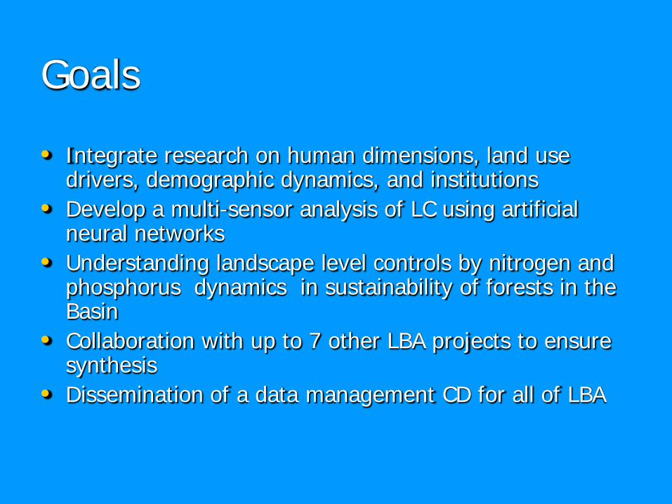
Goals
• Integrate research on human dimensions, land use drivers, demographic dynamics, and institutions
• Develop a multi-sensor analysis of LC using artificial neural networks
• Understanding landscape level controls by nitrogen and phosphorus dynamics in sustainability of forests in the Basin
• Collaboration with up to 7 other LBA projects to ensure synthesis
• Dissemination of a data management CD for all of LBA

The study areas
1. Altamira
2. Marajo
3. Tome-Acu
4. Igarape-Acu
5. Yapu
6. Rondonia
7. Santarem

It is important to consider the history of regional occupation underlying contemporary dynamics of land use and cover change. Esp. account for the different stages and phases of regional occupation and the dynamics of land cover change associated with each stage. We have found high level of heterogeneity in spatial and temporal patterns as a result of these process:
Locally, heterogeneity evolves from factors underlying the decision-making of land users, including variation in types of owners and users, length of occupation, land tenure condition, availability of resources, experience, knowledge, available technology and labor, and access to capital.
Regionally, heterogeneity evolves from the arrival of different groups, creation of access routes, and economic policies promoting particular forms of institutional arrangements and economic systems.
History of regional occupation and colonization phases

Intra-regional variability in land use trajectories (1970-2000), Amazon estuary

Intra-regional variability in Deforestation trajectories (1970-2000), Amazon estuary

Population and Environment Findings
• Dramatic decline in female fertility in the frontier• Different arriving cohorts of settlers follow
similar deforestation trajectory, but magnitude shows response to period effects (e.g. macroeconomic factors)
• Farmer persistence is affected by soil quality on the property
• Crop choice is affected by proportion of good soils

Integrating Social Survey Data with Parcel Boundaries

The colonist footprint: Average deforestation trajectories across cohorts
02468
101214161820
def70
def73
def75
def78
def79
def85
def88
def91
def96
deforestation periods
Ave
rage
per
cent
age
defo
rest
ed o
n fa
rm lo
ts
cohort 1, < 1973(n=121)cohort 2, 1973-76(n=1033)cohort 3, 1976-79(n=791)cohort 4, 1979-85(n=443)cohort 5, 1985-88(n=176)cohort 6, 1988-91(n=90)cohort 7, 1991-96(n=531)cohort 8, new(n=533)
Average Deforestation of Farm Lot/Cohort: Trajectories

LUCITA II Agent Based Simulation Modelling
of Farmer Household Decision Making on Land Use/Land CoverChange in the Brazilian AmazonPeter J. Deadman, Derek RobinsonDepartment of Geography, University of Waterloo, Waterloo, Ontario, Canada
Emilio Moran, Eduardo BrondizioCenter for the Study of Institutions, Population, and Environmental Change and Anthropological Center for Training and Research on Global Environmental Change, Indiana University
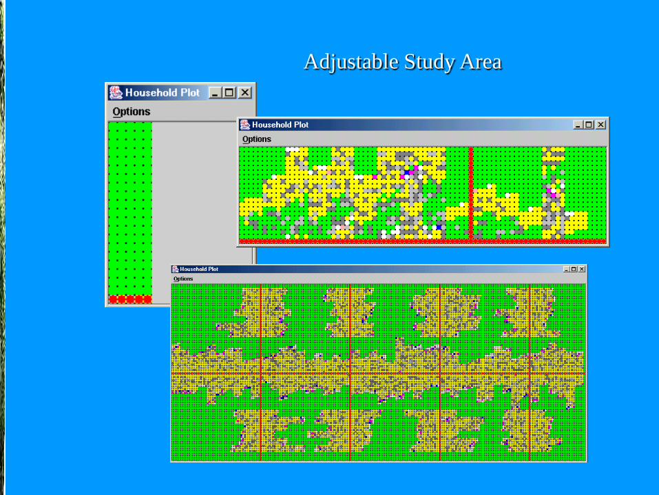
Adjustable Study Area

Land Cover and Soil GridsDisplayable & Probe-able

Object Oriented
And Much More…
• Ability to alter cell selection• Ability to alter plot selection• Farmers leave or are removed if they can not provide forthemselves. Plots are then opened up for new farmers
• Households have a number of children who donate variable amounts of labour.
• Automatic road and plot creation with identification IDs

Markets and land use changeThere is a coupling between market signals (e.g., commodity price) and farmers’ decision-making on land allocation influencing land cover change in the Amazon.
We have found that small-scale land use systems in the Amazon are closely related to and adapting to change in market dynamics, though presenting variability in the level of responses according to household conditions (e.g., labor, knowledge of resources), available resources (e.g., soil, forest), and access to capital (e.g., credit), and land tenure condition.
Changes prompted by national and regional commodity markets, such as inter-annual and decadal price of agricultural and forest products have considerable and measurable consequences to land cover.

Municipalities producing Soybeans 1990 – 1995 - 2000
(Map derived from IBGE – SIDRA)*

2000
1990~1985*
1995
*Three shades of color indicate ranks of fruit production: low (lighter) to high (darker)** 1985 data not available at IBGE-SIDRA; map approximated from areas of heart of palm production
External markets and expansion of acai fruit production areas, 1985 - 2000

Producer – Intermediaries – Processor - Consumers
The Acai fruit commodity chain: Producer – Consumer interactions
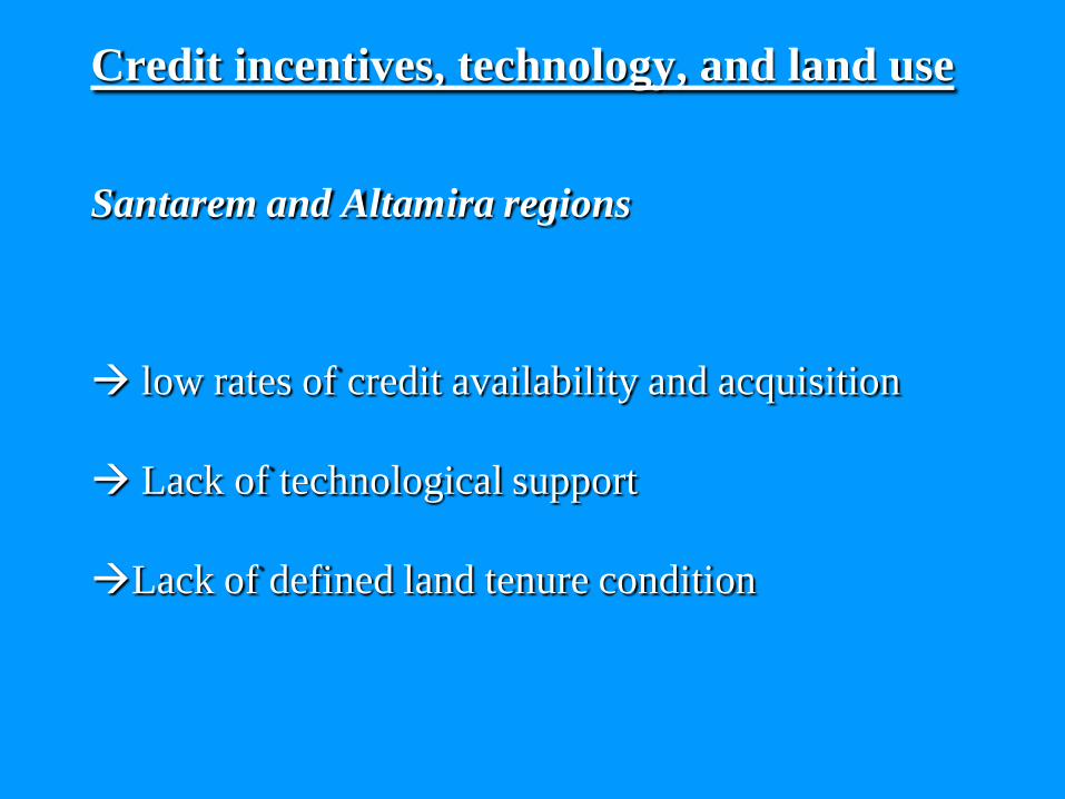
Credit incentives, technology, and land use
Santarem and Altamira regions
low rates of credit availability and acquisition
Lack of technological support
Lack of defined land tenure condition
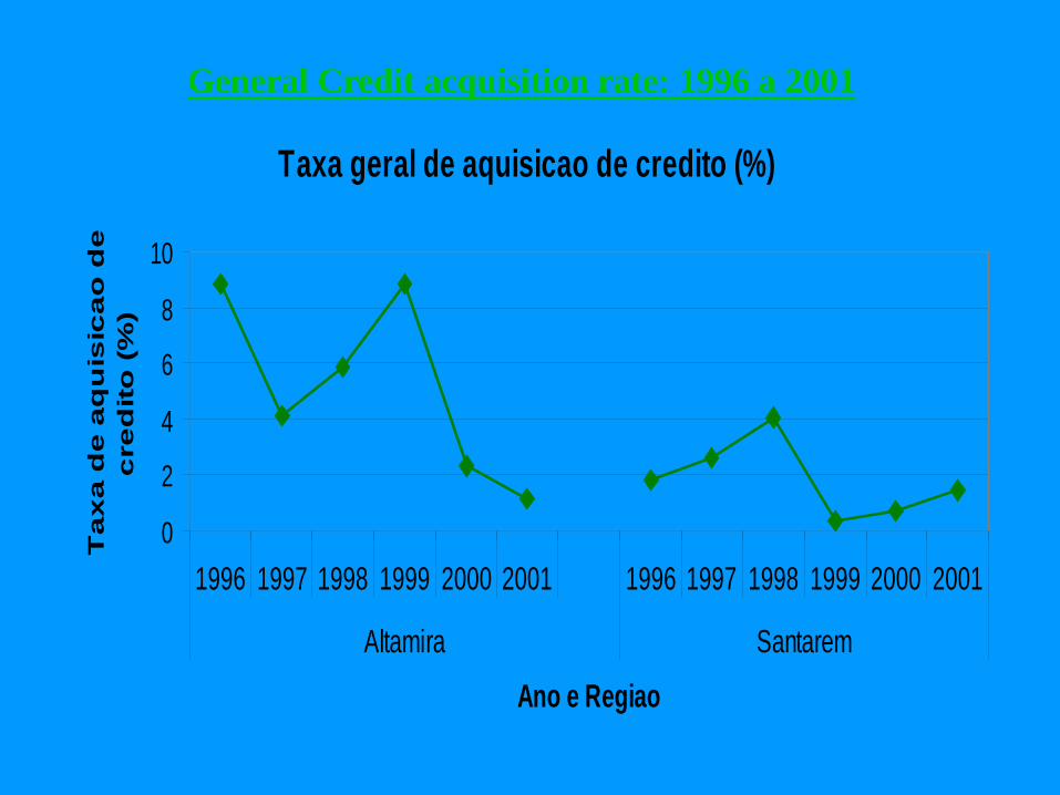
General Credit acquisition rate: 1996 a 2001
Taxa geral de aquisicao de credito (%)
0
2
4
6
8
10
1996 1997 1998 1999 2000 2001 1996 1997 1998 1999 2000 2001
Altamira Santarem
Ano e Regiao
Ta
xa
de
aq
uis
ica
o d
e
cre
dit
o (
%)
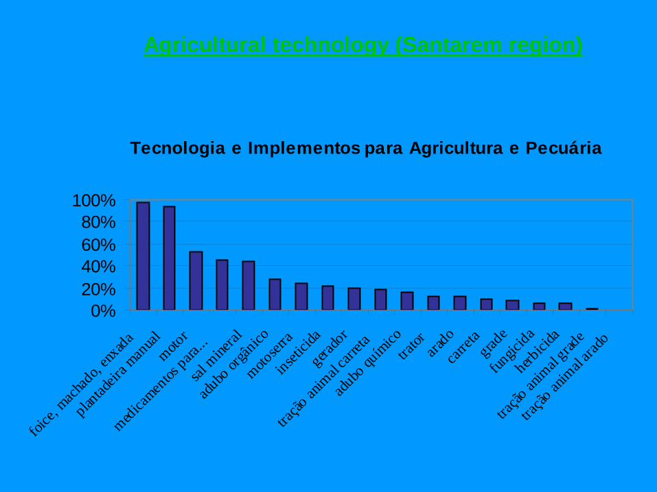
Tecnologia e Implementos para Agricultura e Pecuária
0%20%40%60%80%
100%
foice,
mach
ado,
enxada
plantad
eira m
anual
motor
medicamen
tos para
...
sal m
ineral
adubo
orgân
ico
motoser
ra
insetici
da
gerado
r
tração
anim
al carr
eta
adubo
quím
icotra
tor arado
carret
agrad
e
fungic
ida
herbici
da
tração
anim
al grad
e
tração
anim
al arad
o
Agricultural technology (Santarem region)

Situação FundariaAnos 2001 e 2002
0%
10%
20%
30%
40%
50%
60%
70%
80%
90%
100%
Título definitivo no seunome
Outro/Nada Recibo do donoanterior pela compra
Carta de posse Escritura pública
Land tenure condition (Santarem region)

Institutions and land use change
• The role of local people organizing protect the forest reserves in Machadinho was crucial
• Deforestation rates were the same in fishbone and in topographically adjusted settlement pattern
• Only difference was the creation of reserves, and local self-organization to protect the reserves from neighbors

The State of Rondônia seen through a mosaic of Landsat TM images from year 2000 (Embrapa 2001)
Machadinho d’Oeste
Vale do Anari
Porto Velho
Madeira River Ji-Paraná River
Colonization Projects
Samuel Dam
BR-364
24.97% deforested - Forest
21.92% deforested - State
1.2% deforested/year

Landscape Structure and Change
• Mean patch size of forest decreases at a higher rate in fishbone. In 1994, MPS is similar in both settlements• Mean patch size of farmland is greater in fishbone
Machadinho
Anari

Change detection techniques• Many change detection techniques have
been developed, but selection of a best suitable approach for a specific study area is not straightforward task (Lu et al. in press, IJRS).
• A comparative study of different methods is often used to identify a suitable approach and result (Lu et al. in revising and resubmission, IJRS).

Change detection techniques (cont.)
• The change detection based on spectral mixture analysis of multi-temporal images provides the flexibility of some specific change purposes, such as forest degradation (Lu et al., 2004 (forthcoming), CJRS).
• Change detection based on biophysical parameters are especially useful for detection of vegetation changes (Lu et al. 2002, ASPRS conference)

Biomass Estimation
• TM/ETM+ data are more suitable for SS biomass estimation, instead of mature forest biomass estimation (Lu et al., in press, CJRS).
• Incorporation of spectral responses and texture improves biomass estimation performance (Lu et al. 2002, In: Advances in Spatial Data Handling)

Biomass Estimation (cont.)
• Different biophysical conditions affect biomass estimation, leading to the difficulty to transfer the models for different study areas (Lu et al. 2004 (forthcoming), In: Seeing the Forest and the Trees: Human-Environment Interactions in Forest Ecosystems).
• Textures are less important for SS biomass estimation, but important for advance SS or mature forest biomass estimation, or those forest sites with complex stand structures (Lu and Batistella, in press, Acta Amazonica).

Soil fertility (Lu et al. 2002, LD&D)• Vegetation biomass has significant relationships
with soil fertility and certain nutrients.• Different soil types, such as alfisols, ultisols, and
oxisols, affect these relationships. For example, the nutrients in surface layer soils in alfisols are more important for vegetation biomass accumulations, but ultisols and oxisols deeper horizons significantly influence vegetation growth rates.
• The biomass accumulation is more significantly related to soil fertility in alfisols than in ultisols and oxisols.

Evaluation of Soil Erosion Risk(Lu et al., in press, LD&D)• Soil erosion is a common phenomenon resulting in land
degradation and environmental deterioration. • Many factors, such as precipitation, soil conditions,
terrain factors, and vegetation covers, interplay in soil erosion, leading to the difficulty in estimating soil erosion or mapping erosion risk.
• Remote sensing and GIS provide an effective method for evaluation of soil erosion risks in the Amazon basin.
• Majority of advanced successional and mature forests are in very low and low risk, but some areas that fall in initial succession, agroforestry, and pasture are in medium and high risk.

Amazon Information System
• We have developed a comprehensive information management system to store, display, integrate, manage, analyze, and model both regular data and image data
• Integrates ERDAS, Oracle, SQL, arcinfo, arcview, visual basic and spss
• Uses artificial neural networks to enhance modeling capabilities
• Currently being tested by other LBA collaborating projects
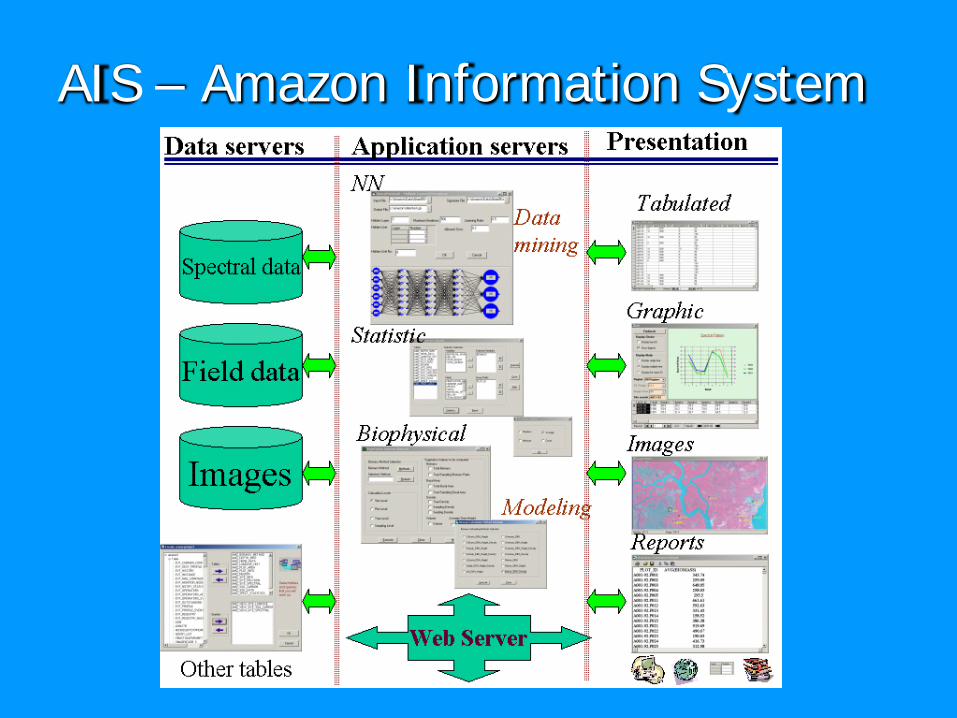
AIS – Amazon Information System

Education and Training

• Educational CD:• Dias, N.W., P. Mausel, G. T. Batista, E. M. L.
Novo, and T. Krug, Indiana State Unversity Geo-Technology Center successfully completed the development of a two CD-ROM set entitled “Sensoriamento Remoto: Aplicações para a Preservação, Conservação e Desenvolvimento Sustentável da Amazônia” [Remote Sensing: Applications for Preservation, Conservation and Sustainable Development of the Amazon].
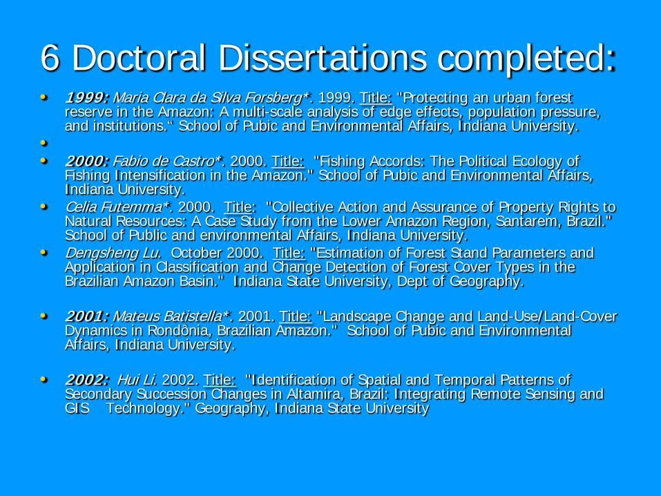
6 Doctoral Dissertations completed:• 1999: Maria Clara da Silva Forsberg*. 1999. Title: "Protecting an urban forest
reserve in the Amazon: A multi-scale analysis of edge effects, population pressure, and institutions.“ School of Pubic and Environmental Affairs, Indiana University.
•• 2000: Fabio de Castro*. 2000. Title: "Fishing Accords: The Political Ecology of
Fishing Intensification in the Amazon." School of Pubic and Environmental Affairs, Indiana University.
• Celia Futemma*. 2000. Title: "Collective Action and Assurance of Property Rights to Natural Resources: A Case Study from the Lower Amazon Region, Santarem, Brazil." School of Public and environmental Affairs, Indiana University.
• Dengsheng Lu. October 2000. Title: "Estimation of Forest Stand Parameters and Application in Classification and Change Detection of Forest Cover Types in the Brazilian Amazon Basin." Indiana State University, Dept of Geography.
• 2001: Mateus Batistella*. 2001. Title: "Landscape Change and Land-Use/Land-Cover Dynamics in Rondônia, Brazilian Amazon." School of Pubic and Environmental Affairs, Indiana University.
• 2002: Hui Li. 2002. Title: "Identification of Spatial and Temporal Patterns of Secondary Succession Changes in Altamira, Brazil: Integrating Remote Sensing and GIS Technology." Geography, Indiana State University

• Courses and training in Brazil:
• UFAC, Acre: Human dimensions of LCLUC
• GISBrasil 2002 and 2003: Course in Geotechnologies and the Environment
• GEOBrasil 2002: Course in Geotechnologies and the Environment
• SENAC: Course in Human Dimensions of Land-Use/Land-Cover Change in 2002
• PUC-Campinas: Courses in GIS and Land-Use Planning
• INPE: Seminar in Human Dimensions of Land-Use/Land-Cover Change in 2002
• EMBRAPA: Seminar in Human Dimensions of Land-Use/Land-Cover Change in 2002

Image with property grid and major roads in red.Sampling approaches in Santarem
55°0'0"W
55°0'0"W
54°45'0"W
54°45'0"W
54°30'0"W
54°30'0"W
54°15'0"W
54°15'0"W
3°15
'0"S
3°15
'0"S
3°0'
0"S
3°0'
0"S
2°45
'0"S
2°45
'0"S
2°30
'0"S
2°30
'0"S
10 0 105 Kilometers
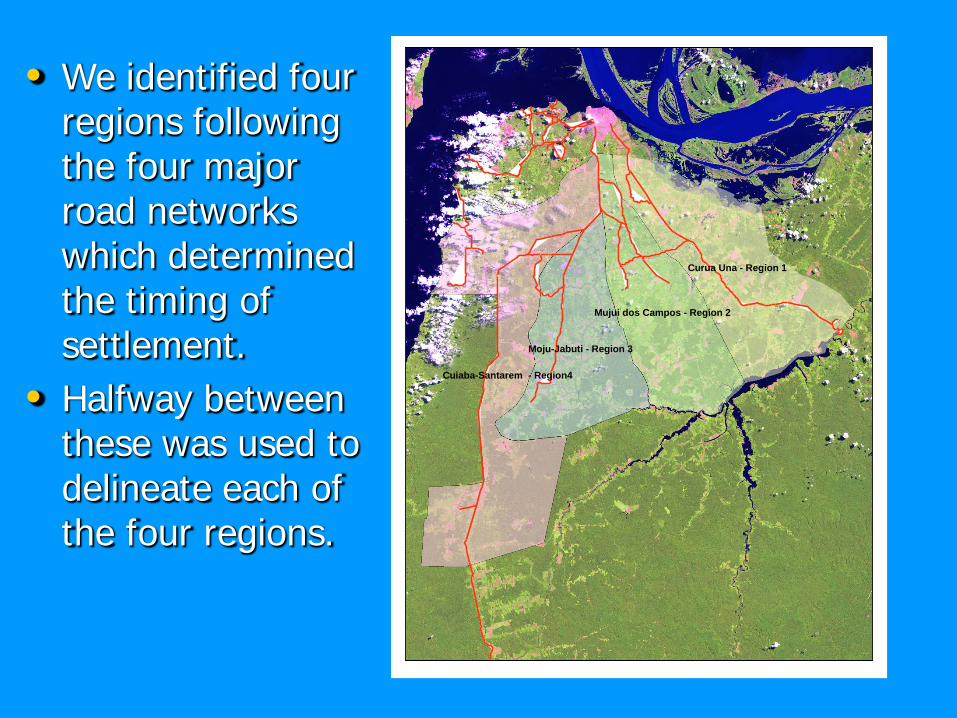
• We identified four regions following the four major road networks which determined the timing of settlement.
• Halfway between these was used to delineate each of the four regions.
Curua Una - Region 1
Mujui dos Campos - Region 2
Moju-Jabuti - Region 3
Cuiaba-Santarem - Region4

• Each region was divided into 3km X 3km cells

• A random sample of 20 target grid cells were then selected for each region.
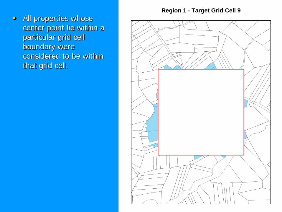
• All properties whose center point lie within a particular grid cell boundary were considered to be within that grid cell.
Region 1 - Target Grid Cell 9
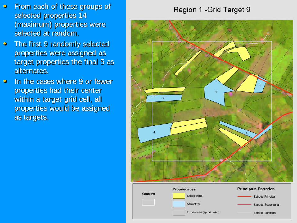
• From each of these groups of selected properties 14 (maximum) properties were selected at random.
• The first 9 randomly selected properties were assigned as target properties the final 5 as alternates.
• In the cases where 9 or fewer properties had their center within a target grid cell, all properties would be assigned as targets.

Thanks!

Relevant modeling issues 1 :
We have found that simple, dichotomous land cover classifications hinder the understanding of intra-regional variability and limit the linkages between land use systems and spatial land cover patterns.
We found that some of the most relevant land use systems (e.g., agroforestry and agricultural sites) may disappear from regional analysis, thus posing enormous implication to understanding and projecting land cover change. These findings should caution against the use of generalized variables to predict future land use and cover change.

Relevant modeling issues 2 :
Data limitations, for instance, regarding soil patchiness as well as poor understanding of the role of different types of access (e.g., roads versus waterways) needs to be considered in any attempt to model factors influencing regional land use change.
We have found that capturing 'process-pattern' linkages in land use and cover analysis is scale dependent. While spatial land cover patterns resulting from land use activities may be somewhat clear at the community level, these tend to disappear at the regional level due to variations in land use systems and environmental characteristics across short distances.

Relevant modeling issues 3:
We have found that inter-regional differences in rates of regrowth are best explained by the differences between soil fertility, whereas intra-regional differences are best explained by the differential impact of land use history on forest recovery. This difference in results, stemming from differences in aggregation and scale of analysis serves as a warning to facile generalization, but also raises the question whether this difference may be due to limits on the quantity and quality of data at the right scale for the analysis at each scale.
We have found that biomass estimation is region specific, and that allometric equations are still limited in their accuracy beyond the forest type from which they were derived. There is a clear need for further developments of more accurate estimation approaches combining advanced remotes sensing techniques and a greater range of allometric equations. We found that a combination of spectral and texture components in the analysis of remote sensing data improves AGB estimation performance.

Publications 1:
• Integration of units of analysis in the study of LCLUC (farm, settlement, regional levels)
• -Related publications: McCracken et al 1999 (PERS), , Futemma and Brondizio 2003 (Human Ecology); Brondizio et al 2002, Moran et al 2002, McCracken et al 2002 (all Wood and Porro book), Siqueira et al 2003 (Gender book), Evans et al 2001 (Ecological mModeling), Lim et al 2002 (ABM book), Brondizio book under review (book manuscript Columbia U.P.), Batistela et al 2003 (PE&RS); Castro et al 2002 (Field methods); Batistela and Brondizio 2001 (paper1st. prize GIS-BRASIL); Moran and Brondizio 2001 (Rappaport ort book); Brondizio, Castro, and Batistela et al 2000 (LBA science poster)

Publications 2:
• Study of Land-Use Driving Forces.
• -Related publications: McCracken et al 1999 (PERS), Brondizio 1999 (book chapter), Futemma and Brondizio 2003 (Human Ecology) Batistela e Moran in press (Acta Amazonica); Brondizio et al 2002, Moran et al 2002, McCracken et al 2002 (Wood and Porro book), Siqueira et al 2003 (Gender book), Evans et al 2001 (Ecological Modeling), Lim et al 2002 (ABM book), Brondizio in press (Culture and Agriculture), Brondizio book under review (Columbia U.P.), Brondizio in press (Working Forests book), Brondizio et al 2003 (Urban Ecosystems).

Publications 3:
• Comparative remote sensing methodologies and biomass estimation methods (image calibration and spectral modeling
•• -Related publications: Tucker, Brondizio, Moran et al
1998 (Interciencia), Moran et al 2000 (FE&M), Lu et al in press (Canadian Journal of RS); Lu et al 2003 (FE&M), Lu et al (RSE), Lu et al (IJRS), Lu et al submitted (cipec book chapter), Lu et al 2002 (Land degradation and development), Moran et al 2000 (A. Hall’s book chapter); Lu et al 2002 (Advances in Spatial data handling book); Ponzoni and Rezende in press (Arvovre)

Publications 4:
• Study of Comparative Forest Regrow th Rates.
• -Related publications: Tucker, Brondizio, Moran 1998 (Interciencia), Moran et al 2000 (FE&M), Lu et al in press (Canadian Journal of RS); Lu et al 2003 (FE&M), Lu et al submitted (book chapter), Lu et al 2002 (Land degradation and development), Moran et al 2000 (book chapter); Lu et al 2002 (Advances in Spatial data); Ponzoni and Rezende in press (Arvovre)
Publications 5:
• Study of Land-use Footprints.
• -List of publications: Batistela et al 2003 (PE&RS); Castro et al 2002 (Field methods); Batistela and Brondizio 2001 (1st. prize GIS-BRASIL); Moran and Brondizio 2001 (Rappaport ook); Batistela et al 2000 (Int’l archives of the ISPRS); Brondizio, Castro, and Batistela 2000 (LBA science poster)


