HUMPTY DOO BARRAMUNDI FARM - DEVELOPMENT APPLICATION Statement of Effect ENTURA-B6760 19 April 2016 Prepared by Hydro-Electric Corporation ABN48 072 377 158 t/a Entura 89 Cambridge Park Drive, Cambridge TAS 7170 Australia
Transcript
HUMPTY DOO BARRAMUNDI FARM - DEVELOPMENT APPLICATION Statement of Effect
ENTURA-B6760 19 April 2016
Prepared by Hydro-Electric Corporation ABN48 072 377 158
t/a Entura 89 Cambridge Park Drive, Cambridge TAS 7170 Australia
Entura in Australia is certified to the latest version of ISO9001, ISO14001, and OHSAS18001.
Entura hold electrical contractors license number 1052448
Entura has prepared this document for the sole use of the client and for a specific purpose, as expressly stated in the document. Entura
undertakes no duty nor accepts any responsibility to any third party not being the intended recipient of this document. The information
contained in this document has been carefully compiled based on the client’s requirements and Entura’s experience, having regard to the
assumptions that Entura can reasonably be expected to make in accordance with sound professional principles. Entura may also have
relied on information provided by the client and/or other parties to prepare this document, some of which may not have been verified.
Subject to the above conditions, Entura recommends this document should only be transmitted, reproduced or disseminated in its
entirety.
Humpty Doo Barramundi Farm - Development Application - Statement of Effect Revision No: 1.0 ENTURA-B6760 19 April 2016
Document information
Title Humpty Doo Barramundi Farm - Development Application
Statement of Effect
Client organisation Humpty Doo Barramundi Pty Ltd
Client contact Bob Richards
Document number ENTURA-B6760
Project manager Alan Barrett
Project reference E305567 - P510894
Revision history
Revision 1.0
Revision description Final for submission
Prepared by Dan Marr
18 April 2016
Reviewed by Scott Lobdale
18 April 2016
Approved by David Procter
18 April 2016
(name) (signature) (date)
Distributed to Bob Richards Humpty Doo Barramundi Pty Ltd
19 April 2016
(name) (organisation) (date)
Humpty Doo Barramundi Farm - Development Application - Statement of Effect Revision No: 1.0 ENTURA-B6760 19 April 2016
i
Contents
1. Introduction 1
2. Applicant details 2
2.1 Humpty Doo Barramundi 2
2.2 Contact person 3
3. Regulation 3
4. Statement of effect of use or development proposal 5
4.1 Section 46(3)(a) – Compliance with the planning scheme 5
4.2 Section 46(3)(b) – Compliance with interim development control order 5
4.3 Section 46(3)(c) – Environmental assessment 5
4.4 Section 46(3)(d) – Merits of proposal 5
4.5 Section 46(3)(e) – Suitability of land 5
4.6 Section 46(3)(f) – Public facilities or public open space 6
4.7 Section 46(3)(g) – Public utilities and infrastructure 6
4.8 Section 46(3)(h) – Amenity of area 6
4.9 Section 46(3)(j) – Public interest 6
5. Site description 6
5.1 Location 6
5.2 Existing HDB Farm 9
5.3 Climate 10
5.4 Geology and soils 11
5.5 Hydrology and water resources 11
5.6 Flora and fauna 12
5.7 Invasive species 13
5.8 Historic and cultural heritage 13
5.9 Social and economic 14
6. Proposed development 15
6.1 Production ponds 15
6.2 Water treatment 17
6.3 Header ponds 17
6.4 Stage three nursery 17
6.5 Feed storage 18
6.6 Emergency power supply 18
6.7 Service corridor 18
7. Proposed operation 19
7.1 Harvesting and packing 19
7.2 Water requirement and treatment 19
7.4 Decommissioning 21
7.6 Merits of the proposal 21
Humpty Doo Barramundi Farm - Development Application - Statement of Effect Revision No: 1.0 ENTURA-B6760 19 April 2016
ii
8. Development impacts 23
8.1 Waste and pollution 23
8.2 Geology and soils 28
8.3 Water resources 28
8.4 Flora and fauna 29
8.5 Invasive species 30
8.6 Vegetation clearance 30
8.7 Aboriginal and European heritage 31
8.8 Environmental management 31
8.9 Biosecurity 31
8.10 Amenity of area 32
8.11 Matters of National Environmental Significance 32
8.12 Summary of impacts 32
9. Compliance with the planning scheme 33
9.1 Primary purpose 34
9.2 Reference to Policy (Clause 2.7) 34
9.3 Reference to Guidelines (Clause 2.8) 37
9.4 General Height Control (Clause 6.1) 37
9.5 Animal Related Use and Development (Clause 10.1) 38
9.6 Clearing of Native Vegetation (Clauses 10.2 & 10.3) 39
Appendices
A NTLC - letter of consent
B HDB Farm - Environmental management report
C Site layout plan
D Threatened species potentially occurring on site
E Heritage gazettal
List of figures
Figure 1.1: Looking east across the current Humpty Doo Barramundi Farm to the Adelaide River 1
Figure 5.1: Location of the Humpty Doo Barramundi Farm (Google earth) 7
Figure 5.2: The existing Humpty Doo Barramundi Farm and expansion site to the south (Google earth) 8
Figure 5.3: View of the packing facility and loading bay 9
Humpty Doo Barramundi Farm - Development Application - Statement of Effect Revision No: 1.0 ENTURA-B6760 19 April 2016
iii
Figure 5.4: Sluice Gate 14
Figure 6.1: Layout of Proposed Development 16
Figure 6.2: Construction of production ponds in 2012 17
Figure 6.3: Existing water treatment channels 18
Figure 7.1: A mature barramundi ready from the production ponds 22
Figure 9.1: Zoning of site and surrounds 34
Figure 9.2: Extract from Land Use Concept Map (Figure 3 in LLUO) 36
Figure 9.3: Extract from Existing and Potential Aquaculture Sites (Figure 10 in LLUO) 36
List of tables
Table 5.1: Long term climate data Middle Point Rangers 1957 – 2016 10
Table 8.1: 2015 Mean Water Quality Monitoring Results 25
Table 8.2: Net gain (water discharge) at proposed HDB expanded farm 26
Humpty Doo Barramundi Farm - Development Application - Statement of Effect Revision No: 1.0 ENTURA-B6760 19 April 2016
1
1. Introduction
Humpty Doo Barramundi (HDB) currently own and operate the Humpty Doo Barramundi Farm (Figure 1.1) located to the east of Humpty Doo on the banks of the Adelaide River in Middle Point. HDB are a local, family owned business that has been in operation since 1993. In 2015 HDB produced over 1000 tonnes of high quality barramundi worth approximately $12 Million which was distributed to markets throughout every major city in Australia.
In 2012, a change in business model underpinned a $5 million three year development program that has transformed HDB in to a modern corporate business that controls the distribution of its product. Growth is seen as essential to survival in the rapidly consolidating Australian and global aquaculture industry and HDB is now well placed to utilise its industry leading production and distribution systems to expand. This system utilising a constructed wetland filtration system provides for efficient production of premium quality fish with minimal to zero discharge of nutrients to receiving waters.
HBD propose to expand the existing farm by developing an additional 50 production ponds to the current 26 currently existing on site. This will enable an estimated increase in production to a total of 90 tonnes per week, up to 60 tonnes from the existing 30 tonnes per week.
Figure 1.1: Looking east across the current Humpty Doo Barramundi Farm to the Adelaide River
Humpty Doo Barramundi Farm - Development Application - Statement of Effect Revision No: 1.0 ENTURA-B6760 19 April 2016
2
The proposed expansion that is the subject of this application is part of HDBs continued growth. Expansion will allow HDB to achieve greater economies of scale in a competitive market enabling it to increase employment of local staff, and make value adding and further associated business enterprises viable.
This document has been prepared to support a development application to the Development consent authority seeking approval for this expansion.
In conjunction with this application a Notice of Intent (NOI) is being prepared following consultation with the Northern Territory Environmental Protection Authority (NTEPA) and Department of Primary Industries and Fisheries (DPIF). The NOI will serve as a NOI for assessment by the NT NTEPA under the Environmental Assessment Act 1994 and for application to the Fisheries Licensing section of the DPIF to seek an amendment to HDB’s current Aquaculture Licence.
2. Applicant details
2.1 Humpty Doo Barramundi
Humpty Doo Barramundi is a privately owned and operated family business and has been producing premium barramundi since 1993. The business has grown to become the largest producer of barramundi in Australia, distributing over 1000 tonnes to all major Australian cities in 2015. Since 2011 HDB have packed, sold and distributed its fish from the farm directly to major wholesalers across Australia.
HDBs growth has been underpinned since its inception by its strategic goal to “Survive, Learn, Grow and Diversify”. Key to this goal is HDB’s investment in knowledge and drive toward continuous learning and improvement.
HDB is currently an industry leader in the following areas:
Production modelling and planning;
Salt water recirculation pond systems;
Automated pond feeding systems;
Live fish transfer (Fish pumping);
Advanced (mechanised) nursery operations;
Product grading and packing system;
Product tracking data base and invoicing;
Advanced system monitoring and alarm systems.
HDB has worked individually and in cooperative partnerships with both government and non - government organisations to drive innovation and technology development in the aquaculture industry, build a knowledge base unequalled by any others in the Australian aquaculture industry.
HDB is accredited under the Australian Barramundi Farming Association (ABFA) Sustainability Certification Program. The program has a number of key components that include, annual eco
Humpty Doo Barramundi Farm - Development Application - Statement of Effect Revision No: 1.0 ENTURA-B6760 19 April 2016
3
efficiency benchmarking, sustainability checklists, risk assessments and annual audits. HDBs sustainability policy includes a commitment to achieve:
The highest standards of environmental performance
Minimal impacts to wildlife and to the environment
Pollution prevention
Best practice waste management
Efficient use of all resources
Purchasing products and engaging service providers locally where possible
Compliance with our legal and proprietary obligations
Continual review and improvement of our systems and processes.
2.2 Contact person
The contact person for this application is:
Bob Richards Managing Director Humpty Doo Barramundi Pty Ltd
Humpty Doo Barramundi Farm - Development Application - Statement of Effect Revision No: 1.0 ENTURA-B6760 19 April 2016
4
Environment Protection and Biodiversity Conservation Act 1999 (Commonwealth)
The Commonwealth Environment Protection and Biodiversity Conservation Act 1999 (EPBC Act) provides for the protection of Matters of National Environmental Significance (MNES) and the conservation of Australia's biodiversity. Approval is required for actions that will have, or are likely to have a significant impact on a MNES. The Project will not be referred as it is considered not to have a significant impact on any MNES.
Environmental Assessment Act
The Environment Assessment Act 1982 (EA Act) establishes the framework for environmental assessment in the Northern Territory. As identified above, a NOI will be submitted to the NTEPA for assessment.
Waste Management and Pollution Control Act
The Waste Management and Pollution Control Act (WMPC Act) provides for the protection of the environment through encouragement of effective waste management, pollution prevention and control practices. The use will not generate a listed waste, as defined under within Schedule 2 of the Waste Management and Pollution Control (Administration) Regulations as the fish will not be processed on site, but exported whole.
Fisheries Act
The Fisheries Act provides for the regulation and management of fisheries and fishery resources in the Northern Territory. The existing HDB farm operates under Aquaculture Licence Number C502. As identified above, an amendment to the licence will be sought for the operation of the Project.
Water Act
The Water Act controls and regulates the extraction of surface and ground water and the disposal of waste to surface or ground water. The existing HDB farm operates under a Water Extraction Licence and Waste Discharge Licence WDL 189-01. Amendments to the licences will be sought for the operation of the project.
Northern Territory Aboriginal Sacred Sites Act
This Northern Territory Aboriginal Sacred Sites Act establishes the protection and registration of sacred sites including procedures for the avoidance of sacred sites in the development and use of land. A request to the Aboriginal Areas Protection Authority (AAPA) did not find any records of registered sacred sites on the site. Given the heavily disturbed nature of the Site it is considered unlikely that unregistered sacred sites exist and HDB do not intend to obtain an Aboriginal Areas Protection Authority Certificate under the Act.
Heritage Act
The Heritage Act provides for the protection of archaeological places and objects. There are no heritage values recorded on the NT Heritage Register found on the expansion site. The development will not impact on the Heritage Object listed on the existing HDB Farm.
Humpty Doo Barramundi Farm - Development Application - Statement of Effect Revision No: 1.0 ENTURA-B6760 19 April 2016
5
4. Statement of effect of use or development proposal
This section identifies how the particular requirements of Section 46(3) of the Planning Act are met. Where a detailed response is required, subsequent sections of this report are referenced.
4.1 Section 46(3)(a) – Compliance with the planning scheme
Refer to Section 1 for a detailed assessment against the relevant provisions of the planning scheme.
4.2 Section 46(3)(b) – Compliance with interim development control order
No interim development control orders applying to the land have been identified.
4.3 Section 46(3)(c) – Environmental assessment
Projects in the Northern Territory which may ‘significantly affect the environment’ are required to go through a formal environmental assessment framework governed by the EA Act which is administered by NTEPA.
The primary purpose of the assessment process under the EA Act is to provide for appropriate examination of proposed projects which may cause significant environmental impact.
An activity may be referred to the NTEPA by the Minister Responsible for the Activity (ie: fisheries), through the assessment process administered by DAS or directly by the proponent. Normal referral is via the submission of a Notice of Intent.
In this case, the proponent is directly engaging the NTEPA in order to determine the level of assessment required. If a Public Environmental Report or Environmental Impact Statement is required then the proponent will undertake this work in accordance with any guidelines issued by the NTEPA.
4.4 Section 46(3)(d) – Merits of proposal
Refer to Section 0 for description of the merits of the proposed development.
4.5 Section 46(3)(e) – Suitability of land
Refer to Section 1 for a detailed description of the site.
Refer to Section 1 for a detailed description of the proposed development.
Refer to Section 1 for a detailed description of the proposed operation of the activity.
Refer to Section 8 for a detailed consideration of the impacts of the proposal development.
Humpty Doo Barramundi Farm - Development Application - Statement of Effect Revision No: 1.0 ENTURA-B6760 19 April 2016
6
4.6 Section 46(3)(f) – Public facilities or public open space
Refer to Section 5.1 for the identification of the nearby open space. No additional facilities are being provided as part of the development.
4.7 Section 46(3)(g) – Public utilities and infrastructure
Refer to Section 0 for a consideration of the need for upgrade of the public infrastructure as a result of the proposed development.
It is understood that the matter will be referred to the following service agencies for comment:
Litchfield council
Power and Water Corporation
Department of Transport
Telstra/NBN
Department of Primary Industries and Fisheries (separate NOI being submitted)
Department of Land Resource Management
Northern Territory Environmental Protection Authority (separate NOI being submitted by applicant).
4.8 Section 46(3)(h) – Amenity of area
Refer to Section 8.10 for a consideration of the impact of the development upon the amenity of the site and surrounds.
4.9 Section 46(3)(j) – Public interest
The development is for the expansion of a private development on the banks of the Adelaide River. Public access to the river via the existing public road is maintained. There is no discernible level of benefit or detriment to the public interest resulting from this development.
5. Site description
5.1 Location
The existing HDB farm is located at Section 1703 (1105 Anzac Parade) at Middle Point, Hundred of Guy, approximately 58km to the east of Darwin on the flood plain of the Adelaide River (Figure 5.1).
The site for expansion (the site) is located immediately to the south of the existing HDB farm at Section 1624 which forms part of Crown Lease Perpetual (CLP) 1672 (Figure 5.2). Section 1624 comprises 355ha in its entirety, however, the area of the proposed expansion is approximately 160ha.
Humpty Doo Barramundi Farm - Development Application - Statement of Effect Revision No: 1.0 ENTURA-B6760 19 April 2016
7
Figure 5.1: Location of the Humpty Doo Barramundi Farm (Google earth)
The site is currently unused and owned by the Northern Territory Land Corporation (NTLC). HDB is currently negotiating the purchase of Section 1624 from the NTLC. The NTLC has provided written consent for Humpty Doo Barramundi to lodge this application prior to the completion of the proposed sale of the land. The letter of consent is provided in Appendix A.
The site is bordered by a vacant parcel of Crown land, the Adelaide River and the Djukbinj National Park (across the river) to the east, while the Harrison Dam Conservation Reserve forms the southern and western boundary. The Fogg Dam Conservation Reserve is located approximately 1km to the west. A public road runs along the southern boundary of Section 1624 and provides access from Anzac Parade to the Adelaide River. This road is used by Adelaide River Cruises as the access point to conduct jumping crocodile and wildlife tours.
On the survey plans for the site, there appears to be an old redundant drainage easement across Section 1624 that has been cut off by the public road to the south. HDB will further investigate this and seek its removal if necessary.
The site is currently vacant except for a small area in the south-eastern corner, which contains some infrastructure used by Adelaide River Cruises. The continuation of this use, including formalising an arrangement if necessary, is being dealt with as part of the negotiation to purchase from NTLC.
The site has been previously disturbed as it, together which much of the surrounding land, including the existing HDB farm, was historically used for cattle grazing. In the early 1950s the area was developed as part of the failed Territory Rice Ltd project. Development included the establishment of
Humpty Doo Barramundi Farm - Development Application - Statement of Effect Revision No: 1.0 ENTURA-B6760 19 April 2016
8
rice fields, irrigation channels, pump stations and both Harrison and Fogg Dams1. The site was used as a rice field. Rice growing ceased in 1964 and the site has remained unused from this time until the present day. The site is thought to have been heavily grazed by feral buffalo prior to their removal under the National Brucellosis and Tuberculosis Eradication Campaign (BTEC) in the early 1970s2.
Current land uses in the vicinity of the site include:
grazing of predominately native vegetation to the north of the existing HDB farm
rural residential lots
irrigated horticulture, including melon and turf farming. Note, horticultural is not possible on the proposed site due to the heavy black clay soils, seasonal inundation and lack of underlying fresh water resource
fruit trees, predominately mangoes, along Anzac Parade3
University of Sydney’s Tropical Ecology Research Facility on Anzac Parade.
Figure 5.2: The existing Humpty Doo Barramundi Farm and expansion site to the south (Google earth)
1 http://www.ricetrail.com.au/
2 http://www.nt.gov.au/d/Primary_Industry/?Header=Portrait%20of%20the%20NT 3 NR Maps accessed 04/03/2016
Humpty Doo Barramundi Farm - Development Application - Statement of Effect Revision No: 1.0 ENTURA-B6760 19 April 2016
9
5.2 Existing HDB Farm
The existing HDB farm includes a nursery, production and harvesting ponds and packing facilities across 60ha of land. The operation does not contain a hatchery, instead it purchases barramundi fry from external Australian suppliers. All stock has Australian hatchery veterinary approval and is transported with a Translocation Certificate issued by the Northern Territory Government.
The nursery at HDB farm operates in two stages. The first stage nursery has ten tanks (6x 10,000l, 2x 5000l & 2x 2000l) for small fish up to 1.0g. The second stage nursery has eleven tanks (5x 45,000l tanks & 6x 10,000l) which are used to rear fish from 1g to around 30g prior to being moved to production ponds for grow out. Each of the nurseries has a constructed wetland water treatment system which allows the constant treatment and recirculation of waste water. When required, additional water is drawn from the Adelaide River, to increase the salinity of water in the nursery to meet the optimum culture conditions for small fish. The numbers of fish reared through the nursery is currently constrained by the capacity of the production ponds.
The HDB farm contains 26 production ponds. The ponds are earthen with HDPE lining on the banks. The production ponds operate in conjunction with a constructed wetland water treatment system which treats waste water discharged from the ponds and supplies clean water. Water is able to be recirculated indefinitely through the treatment system. Water is drawn from the Adelaide River, generally from June to December to replace water lost through evaporation and to manage the salinity of water in the system. When this exchange is underway HDB may release some water back to the river via the authorised discharge point approximately 1 km downstream from the intake point.
Figure 5.3: View of the packing facility and loading bay
Humpty Doo Barramundi Farm - Development Application - Statement of Effect Revision No: 1.0 ENTURA-B6760 19 April 2016
10
A Water Extraction Licence is currently in place and is managed by the NT DLRM. The NTEPA administer the existing Waste Discharge Licence (WDL189-01). Water quality parameters are monitored at weekly intervals in the HDB ponds and regular maintenance of pipes, pumps and aerators is carried out to ensure optimum fish health conditions are maintained.
The existing HDB farm operates under an Environmental Management Plan (EMP) associated with Aquaculture Licence C502. The EMP facilitates environmental monitoring requirements as well as risk and emergency management.
5.3 Climate
The site is located in a region that experiences a tropical monsoonal climate with distinct wet and dry seasons and little variation in temperature. The wet season is characterised by higher humidity and rainfall and extends between September and May. Most significant rainfall events occur between November and April. The dry season extends from June to August and is characterised by lower humidity and very little rainfall.
Climate observations are made by the Bureau of Meteorology (BoM). The closest BoM weather monitoring station to the site is Middle Point Rangers (Site 014090) located approximately 7km to the west. Long term temperature, rainfall and daily evaporation averages from the Middle Point Rangers station for the years 1957 to 2016 are presented in Table 5.14 together with long term regional monthly evaporation averages5.
Table 5.1: Long term climate data Middle Point Rangers 1957 – 2016
Statistics Jan Feb Mar Apr May Jun Jul Aug Sep Oct Nov Dec Annual Years
Humpty Doo Barramundi Farm - Development Application - Statement of Effect Revision No: 1.0 ENTURA-B6760 19 April 2016
11
Average annual rainfall is 1421mm with the highest rainfall occurring in January and the lowest in July. Over 86% of annual average rainfall falls between November and March. The average annual regional evaporation is 2400mm and exceeds the average annual rainfall. Evaporation is highest in October and lowest in February.
5.4 Geology and soils
The underlying geology at the Site is mapped as ‘sand, silt and clay in coastal estuaries’ on the Geological Map of the Northern Territory6. The soils underlying the Site have been investigated as part of an assessment of potential environmental constraints associated the planned expansion of HDB farm7. The report is provided in Appendix B and a brief summary provided below.
The dominant soils on the site are Vertosols which are Hydrosolic in nature being saturated during the wet season. Clay content is generally very high (up to 40% of the soil profile) with silt and sand comprising the remainder. Soils are dominated by the clay mineral montmorillonite and have a high shrink-swell potential. Some areas of the Site are saturated for most of the year and Vertosols at these locations typically have elevated levels of organic matter. The depth to the Vertosols decreases toward the western side of the Site but is likely to exceed 1.5m at the proposed location of the Project. The underlying material contains gravels and sands.
The soils underlying the Site contain sulphides that have the potential to oxidise on exposure to air and produce acidic compounds. It is noted that there is also free calcium carbonate present in overlying soils in the form of free nodules and marine shells that provide a buffer against acid potential.
The Northern Territory Land System mapping supports the findings of the report, indicating that the soils on the Site are Aquic Vertosols over mainly calcic estuarine muds8. Mapping of Acid Sulphate Soils on the Adelaide River floodplain indicates that the site is susceptible to acid sulphate soil risk with sulphuric material potentially present at varying depths in the soil profile9
5.5 Hydrology and water resources
The site is located on the Adelaide River floodplain and is subject to periodic flooding during the wet season (October to April). Flooding generally occurs when severe rainfall or cyclones occur in the upper catchment. The Adelaide River is tidal at the site and floods can also be influenced by tidal conditions. No floodplain study reports or mapping are currently available for the Adelaide River floodplain. A detailed flood study is reported to have been completed for the Comalie/Litchfield area of the Adelaide River however, floodplain mapping has not yet been made available10. Maximum flood levels at the HDB farm have been recorded for recent large flood events including 2007 and 2011 floods and these have been provided as reference points to the Northern Territory Government flood modelling team.
Humpty Doo Barramundi Farm - Development Application - Statement of Effect Revision No: 1.0 ENTURA-B6760 19 April 2016
12
The closest functional river height and rainfall gauging station is located approximately 20 km to the south of the site where the Arnhem Highway crosses the Adelaide River (Station Number g8170021). AHD flood levels measured at this site in ~ 1:5, 1:10, 1:50 and 1:100 AEP flood events are 3.08 m, 3.43 m, 4.06 m and 4.30 m respectively.
Tidal water is drawn from the Adelaide River for the operation of the current HDB farm (refer Section 5.2). There are no other users of water from the Adelaide River in the vicinity of the Project as the water is naturally saline and generally highly turbidity.
Groundwater is drawn by other users from a number of bores to the west of the Project to support mango farming and other horticultural businesses. Groundwater underlying the Project is saline, however, its use for horticulture to the west of the Project suggests the underlying aquifer grades to fresh in a westerly direction. This is supported by data from bores located on the eastern and western edges of the Project which suggest salinity decreases in a westerly direction away from the Adelaide River11.
5.6 Flora and fauna
This site is located on the Adelaide River Coastal Floodplain which is recorded by the Department of Land Resource Management (DLRM) as a Site of Conservation Significance (SOCS) (SOCS Number 12)12. Listing as a SOCS does not impose additional legislative or regulatory requirements or control on management and use of the land13. The site does not form part of the Adelaide River Floodplain System which is listed on the Directory of Nationally Important Wetlands14.
In common with a significant proportion of the Adelaide River coastal floodplain SOCS the historical use of the site for rice cultivation and subsequent grazing by feral buffalo has left it in poor condition. The vegetation on site is mapped as Oryza tall closed tussock grassland consisting of Oryza species, Eleocharis spp, tussock grass and sedge under the National Vegetation Management System (NVIS)15. NT Land System mapping records the site as Cyperus which is associated with vegetation communities of Mid-high closed grassland of Dichanthium sericeum, Germania grandiflora, Eleocharis spiralis16. It should be noted that both the NVIS and the NT Land Systems mapping is at a broad scale and may not be representative of the vegetation on the site. There are Mangroves mapped immediately on the eastern boundary of the site adjacent to the Adelaide River and for a small area on the north eastern corner of the site17. The entrance to the Adelaide River is not located in the vicinity of a Commonwealth Marine Reserve.
No species listed under the Territory Parks and Wildlife Conservation Act 2000 (TPWC Act) or the Environmental and Biodiversity Conservation Act 1999 (EPBC Act) have been recorded from the site18. However, there are records of flora and fauna species listed under the TPWC Act from adjacent sites
Humpty Doo Barramundi Farm - Development Application - Statement of Effect Revision No: 1.0 ENTURA-B6760 19 April 2016
13
and a search of the Protected Matters Search Tool (PMST) identified a further 14 threatened species which are considered to potentially occur on or utilise the site.
A search of the NRM Infonet Database identifies a further 20 threatened species that may occur within 5km of the site. Fourteen threatened species have been recorded from the Adelaide River coastal floodplain SOCS19.
A list of species previously recorded from within approximately 5km of the site or identified by the PMST is provided in Appendix C.
5.7 Invasive species
There is one invasive species record on the site for Mimosa pigra which is listed as a Weed of National Significance (WONS)20. Mimosa pigra is a serious threat to the Adelaide River Coastal Floodplain and has already impacted large areas of the floodplain21. Feral animals including pigs, feral cats and dogs are common on the Adelaide River Coastal Floodplain and all are regularly seen on the HDB farm. Pigs are actively controlled when required.
5.8 Historic and cultural heritage
A search of the NT Heritage Register22 has identified:
There are no heritage listed places or objects found on Section 1624
A listed site named ‘Fogg Dam and associated areas’ is located on nearby land including portions of the existing HDB Farm
The listing of Fogg Dam is associated with the Territory Rice Ltd project which failed in the early 1960s. The background heritage report23 provides a basis for the listing which is defined within the Gazettal Instrument which is included in Appendix E. Fogg Dam is located within section 1554 and is managed by the NT Parks and Wildlife Commission as a conservation area. Associated listings include a sluice gate within Section 1703 (the existing HDB Farm), a pump system on parts of Sections 1530 & 1703 and a rice paddy on Section 1530.
The Sluice Gate (Figure 5.4) is a heritage object. The gazettal for the Heritage Object includes the land within a circle with a 10m radius around the item. This gate is located at the eastern end of the existing draining channel that runs along the southern edge of the existing HDB Farm. No work is proposed on this object or within its 10m radius. Accordingly an approval under the heritage Act is not required for the expansion of activities.
Humpty Doo Barramundi Farm - Development Application - Statement of Effect Revision No: 1.0 ENTURA-B6760 19 April 2016
14
Figure 5.4: Sluice Gate
No commonwealth heritage places, national heritage places or world heritage properties occur in the vicinity of the site.
The Aboriginal Areas Protection Authority (AAPA) were contacted as part of the environmental management report in Appendix B. No sacred sites are recorded as existing on the subject properties. An Authority Certificate in this regard is being separately pursued in order to provide certainty.
5.9 Social and economic
The existing HDB farm and proposed expansion site are located in Middle Point in the Litchfield Municipality. Key industries in Litchfield include; horticulture (mangoes, Asian vegetables, melons and nurseries), agriculture (abattoir, crocodile farm) aquaculture, tourism (jumping crocodile cruises) and a range of small supporting businesses24. Several new developments are proposed in Litchfield Municipality notably including the Ichthys LNG Project accommodation village and gas processing plant at Bladin Point and a new prison and hospital in Holtze25. The most recent Australian Census in 2011 recorded a population in Lichfield Municipality of 18,620 people. Of people who reported being in the labour force (9,972 people) 88.3% were employed either full or part time and 3.4% reported being unemployed26. 24http://www.litchfield.nt.gov.au/sites/default/files/images/Messages%20from%20the%20Mayor/Ministers%20Report%20March%202014.pdf 25 http://www.litchfield.nt.gov.au/living-litchfield/about-area/population 26http://www.censusdata.abs.gov.au/census_services/getproduct/census/2011/quickstat/70103?opendocument&navpos=220
Humpty Doo Barramundi Farm - Development Application - Statement of Effect Revision No: 1.0 ENTURA-B6760 19 April 2016
15
The existing HDB farming operation provides employment for approximately 30 full and part time staff and purchases goods and services from ~60 local businesses.
The site is not located near any residential properties and has little potential to affect the amenity of nearby residents. The farm ponds and infrastructure will be visible from the access road to the south of the site, however, this road does not provide well utilised access to the Adelaide River and disturbance to visual amenity from the track is not considered a significant impact. One business, Adelaide River Cruises, operates from the public access road to the south of the site. The Adelaide River is used for recreational activities but it is not considered to be a significant recreational fishing area.
6. Proposed development
The project involves the expansion of the existing HDB farm incorporating two new ‘modules’ of production ponds and associated infrastructure. The proposed expansion does not include any changes to the livestock acquisition process.
The project involves the expansion of the existing HDB farm incorporating two new ‘modules’ of production ponds and associated infrastructure. It includes:
up to 48 new production ponds
two constructed wetland water treatment systems to support the production ponds
header ponds
sediment pond
stage three nursery and treatment pond
feed storage
emergency power supply
service corridor.
A description of each component is provided below. A layout of the proposed development is provided Appendix C and shown in Figure 6.1. It should be noted that this layout is conceptual in nature and is likely to be further refined.
6.1 Production ponds
The project will involve the construction of up to 48 new production (grow out ponds). Each pond will be 80m x 80m and 1.5m deep. The new ponds will be constructed by pushing up an earthen berm composed of onsite soils to from each pond. The height of the berm will allow sufficient freeboard to accommodate a greater than 1:100 AEP flood event (refer Section 0). The berm will be capable of accommodating vehicle traffic. The outer banks of the berm will be revegetated with non-invasive grasses as soon as construction is completed to prevent erosion and maintain bank stability. The inner bank of the ponds will be lined with HDPE.
Humpty Doo Barramundi Farm - Development Application - Statement of Effect Revision No: 1.0 ENTURA-B6760 19 April 2016
16
Figure 6.1: Layout of Proposed Development
Fish will be grown out in the production ponds to between 300g and 5kg depending on customer requirements. During grow out fish will be fed an Australian made pelletised diet twice daily. Feed is sourced from a Global Gap certified Australian supplier (Ridley Aquafeed) and every effort is being made over time to reduce the need for input of wild fish to the diet. The ratio of wild fish into the diet for each kilogram of premium barramundi produced is currently 0.5 kg of wild fish to 1 kg of Barramundi produced. This is expected to improve over time with continued innovation in feed sourcing and ingredients. Fish will be fed using a range of demand feeding systems co-developed by HDB.
Production ponds will require periodic maintenance approximately every five to ten years. During maintenance water will be drained from the pond into the water treatment system (if required). Aquatic plants will be removed and accumulated benthic sediment pushed up on to the berm walls and allowed to dry and decompose. Maintenance (if required) to the berms will also be undertaken at this time.
Humpty Doo Barramundi Farm - Development Application - Statement of Effect Revision No: 1.0 ENTURA-B6760 19 April 2016
17
Figure 6.2: Construction of production ponds in 2012
6.2 Water treatment
Two new constructed wetland water treatment systems will be built to treat water from the proposed new production ponds. The water treatment system will comprise approximately 65% of the proposed development area. HDB has found that this ratio of production ponds to water treatment system is optimal for producing clean water suitable for recirculation while minimising the release of nutrients to receiving waters. Each system consists of approximately 9km of 1.5m deep (unlined) channel constructed by pushing up an earthen berm composed of onsite soils to from each pond. The height of the berm will allow sufficient freeboard to accommodate a greater than 1:100 AEP flood event. Vegetation is planted to grow within the water treatment system to aid the absorption of nutrients from production pond water and minimise erosion.
6.3 Header ponds
Header ponds will be located between rows of production ponds and function to provide a source of clean water to gravity feed to the production ponds. The header ponds will be constructed by pushing up an earthen berm composed of onsite soils. Each header pond will be 30m wide and filled with water and vegetated.
6.4 Stage three nursery
The project includes the construction of a stage three nursery to rear fish from approximately 30g to 200g prior to stock out to the farming ponds. This facility will be developed progressively as the adjacent ponds are commissioned. The nursery will include up to eight 12m diameter tanks each with a volume of up to 450,000L. The nursery will be housed in an open walled shed approximately 50m x 30m. The floor will be either concrete slab or compacted gravel. Water will be circulated through the nursery using the module one water treatment system.
Humpty Doo Barramundi Farm - Development Application - Statement of Effect Revision No: 1.0 ENTURA-B6760 19 April 2016
18
Figure 6.3: Existing water treatment channels
6.5 Feed storage
A new shed up to 20m x 30m will be constructed to store feed. The shed will be open on one side and include either a concrete slab or compacted gravel floor.
6.6 Emergency power supply
A new ‘power shed’ will be constructed to house an emergency generator system, switch gear, transformer and fuel supply. The fuel supply will either be self bunded or bunded storage in accordance AS1940-2004 (The storage and handling of flammable and combustible liquids) will be provided. A generator is required to provide backup power to critical infrastructure such as pumps and aerators in the event of a mains power failure.
6.7 Service corridor
A service corridor / access track will be constructed connecting the existing HDB with the proposed expansion. The service corridor will be approximately 15m wide and 190m long. It will be capable of carrying year round light vehicular traffic and will be the corridor via which power, water and communication lines are connected to the proposed expansion. The service corridor will be constructed with soil sourced onsite during pond construction.
Humpty Doo Barramundi Farm - Development Application - Statement of Effect Revision No: 1.0 ENTURA-B6760 19 April 2016
19
7. Proposed operation
This section describes the farming processes that will be used on the expanded farm which will generally the same as are currently used on the existing HDB farm. Over a 23 year period HDB has developed a best practice production system that has proven to consistently produce high quality Barramundi with minimal impacts on the surrounding environment and little to no release of nutrients to the receiving waters. This history is seen as a ‘proof of concept’, that a development of this type can be carried out with little or no offsite impacts to the surrounding environment.
7.1 Harvesting and packing
No change to harvesting or packing processes or facilities is planned for the proposed expansion.
Harvesting is currently carried out in accordance with recognised industry best practice for both animal welfare and product quality. A seine net is used to crowd fish against a bank in the production pond whilst supplemental oxygen is provided. A fish pump is used to quickly and gently harvest fish from the pond from where the fish are run over a dewaterer and into saline ice slurry bins where they are left iced down and chilled for between 12 and 24 hours. Fish are rapidly anaesthetised by chilled water.
The slurry bins are drained and fish transported into the packing facility. Fish from each bin are temperature checked and quality controlled prior to being passed over a grading machine which sorts the fish by weight. Fish are packed by hand to order for customers. Packed boxes are assembled into consignments, held in a chiller and then loaded into refrigerated trucks for dispatch.
Whilst no change in harvesting or packing processes or facilities is required, the proposed expansion will increase the frequency of harvesting and packing from approximately 1.5 days per week to up to 5 days per week. Thus increasing employment opportunities provided by the business and improving infrastructure utilisation.
7.2 Water requirement and treatment
The production ponds will operate in conjunction with a water treatment system which treats waste water discharged from the ponds and supplies clean water. Water will be able to be recirculated indefinitely through the treatment system. Clean treated water will be drawn from the treatment ponds and pumped up to the header pond where it gravity feeds through the production ponds back into the treatment system. Connecting pipes to and from the production ponds allow the control water within the ponds. Water will be drawn from the Adelaide River, generally from June to December, to replace water lost through evaporation and to manage the salinity of water in the system. Water drawn from the Adelaide River will be pumped to the settlement pond before being pumped to the header pond and allowed to circulate through the system.
The proposed expansion will require additional water to be drawn from the adjacent tidal reaches of the Adelaide River to initially fill the system and subsequently to top up ponds and control salinity. The production system at HDB requires the addition of salt water, drawn from the adjacent tidal reaches of the Adelaide River during the dry season when river salinities are optimal for high quality barramundi farming. The volume of water required to fill the new system will be approximately 1800ML and it is estimated, based on maximum pumping rates, that up to approximately 2800ML
Humpty Doo Barramundi Farm - Development Application - Statement of Effect Revision No: 1.0 ENTURA-B6760 19 April 2016
20
would be added to the total system (existing and new farm) annually (refer Section 8.1). Water will be extracted in accordance with a new or amended Water Extraction Licence. Pumping capacity at the existing extraction point on the Adelaide River will be upgraded to provide sufficient water supply for the Project.
Water will be extracted in accordance with a new or amended Water Extraction Licence. Pumping capacity at the existing extraction point on the Adelaide River will be upgraded to provide sufficient water supply for the farm expansion.
The berms of the channels in the treated end of the water treatment system will contain pipes that allow water to be released into a channel surrounding the site where it will flow back into the Adelaide River via the existing authorised discharge points. The location of the pipes ensures that any water discharged has already been fully treated and is released at the point that it will otherwise be pumped and reused for fish culture. This ensures the highest quality of discharge water possible. Water quality monitoring undertaken at the existing HDB farm shows that, while the water released from the treatment system has generally elevated concentrations of nutrients and reduced concentration of dissolved oxygen when compared to background levels, it is rapidly diluted to background levels in the Adelaide River.
When water is added to the system either during replacement of evaporated water or during periods of heavy rain some water may be released from the treatment system and flow back to the Adelaide River. The release pipes on the treatment system will be fitted with a flow monitoring system that will be capable of recording the instantaneous volume of waste water discharged from the treatment system. Waste water will be released in accordance with the conditions contained in a new or amended Waste Discharge Licence.
Water quality parameters in the system will be monitored at weekly intervals and regular maintenance of pipes, pumps and aerators will be carried out to ensure optimum fish health conditions are maintained. The water treatment system will require periodic maintenance to manage aquatic growth. Excess aquatic vegetation will be removed and place on the berm walls and allowed to dry and decompose. Approximately every five to ten years the water treatment system will be drained and accumulated benthic sediment pushed up onto the berms walls and allowed to decompose.
7.3 Development stages
The earthworks construction phase of the Project is scheduled to commence in July 2016. This phase of the Project is designed to be constructed in one operation such that upon completion all ponds and channels can be flooded and fully revegetated to prevent the possibility of erosion.
This timeframe is necessary to enable the successful completion of the Project earthworks within the narrow window for access on the cracking black soil floodplain of the Adelaide River. If the Project does not commenced in July 2016 the earthworks construction phase may be delayed by 12 months.
Once pond earthworks have been completed, support infrastructure i.e. power supply, generator shed, access roads will be developed in order to enable initial stocking of the first batch of fish to the Project by December 2016.Full commissioning and stocking of the farm will be staged between 2016 and 2018 in line with operational and market requirements.
This approach is consistent with the development strategy successfully deployed during HDB’s last expansion project over 2012 and 2013.
Humpty Doo Barramundi Farm - Development Application - Statement of Effect Revision No: 1.0 ENTURA-B6760 19 April 2016
21
7.4 Decommissioning
The proposed expansion to the HDB farm has no defined life time and is expected to operate as part of a sustainable business for the foreseeable future. Should the expansion site be decommissioned the site will be rehabilitated. Rehabilitation would generally be the reverse of construction:
All associated infrastructure (pumps, aeration units etc) would be removed
HDPE lining would be removed
The banks of the ponds pushed back into the pond voids to recreate the original flat topography.
The disturbed areas would then be revegetated with appropriate native species.
7.5 Public infrastructure
Preliminary discussions with Power and Water Corporation (PWC) indicate that there is adequate capacity to accommodate the increased electricity consumption of the proposed expansion (aerators, pumps etc) in the distribution line that services the existing HDB farm. HDB is further investigating the opportunity for the use of solar power to provide electricity supplement power supply in the future.
The proposed expansion will result in an increase in truck movements on Anzac Parade on to major highways from two to up to five per week.
In 2015, HDB partnered with the Litchfield Shire Council to apply for funding from Federal Government as part of the Regional Economic Infrastructure Fund. This application was successful and will result in the upgrade of Anzac Parade for the purpose of facilitating the planned increase in road traffic resulting from the expansion of the HDB farm. The road project will be designed and managed by the Litchfield Shire Council and is due for commencement in August 2016.
7.6 Merits of the proposal
The existing HDB farm provides an important contribution to the economy of Litchfield Municipality and wider Northern Territory. HDB currently employ 30 people, a number that has grown by 300% in the last five years. Employees are provided with nationally accredited training under the National Work Force Development program to build capacity in areas relevant to the aquaculture industry. Over 60 local businesses regularly provide services to HDB. In 2015 HDB produced over 1000 tonnes of produce worth approximately $12 Million which was distributed to markets throughout every major city in Australia. Profits from HDB have been entirely reinvested in the growth of the business. From 2012 to 2015 HDB completed a five million dollar development program that included an expanded production and water treatment system, upgraded packing facility and employee accommodation.
The proposed expansion is expected to increase production to up to 90 tonnes per week and HDB plans to continue reinvesting profits into the growth of the business. It is expected that the proposed farm expansion will provide a further 20 direct employment opportunities and an increase in economic opportunities for local goods and service providers. It will also provide the opportunity for new business operations to capitalise on the availability of volumes of local fish for processing and distribution. The expanded farm may provide opportunities for people who may otherwise leave the region for employment and also promote in-migration to the region.
Humpty Doo Barramundi Farm - Development Application - Statement of Effect Revision No: 1.0 ENTURA-B6760 19 April 2016
22
Figure 7.1: A mature barramundi ready from the production ponds
HDB play an active role in the local community working with local indigenous training and employment groups to provide opportunities for local indigenous people. HDB host the Giraween Primary School and supports their school aquaponics project with supply of fingerlings and technical support. HDB also host the Palmerston Game Fishing Club annual junior anglers clinic. This event brings 100 local children to the farm to learn about recreational fishing, skills development, conservation practices and water safety.
HDB has worked individually and in cooperative partnerships with both government and non - government organisations to drive innovation and technology development in the aquaculture industry, build a knowledge base unequalled by any others in the Australian aquaculture industry. Examples include:
In 2002, Managing Director and business owner, Bob Richards was awarded a Churchill Fellowship to study pond farming systems that minimised effluent releases to the environment. HDB is now leading the industry with a biological filtration and recirculated water treatment system.
In 2004, Humpty Doo Barramundi initiated a program to further develop nursery grading technologies in order to reliably supply accurately sized barramundi for the plate size barramundi market. This initiative received a grant from the Food Processing in Regional Australia Program and HDB is now the leading supplier of plate sized fish in Australia.
In 2006, Humpty Doo Barramundi, in partnership with AQ1, an Australian technology company and Ridely Seafoods, a fish food supplier, commenced a project to develop the world’s first automated barramundi feeding system, in order to improve efficiency and sustainability. This initiative received a grant from the Industry Cooperative Innovation Program. AQ1 is now successfully marketing the automated feeder globally.
In 2015 HDB invested in advanced pond harvesting technology, including “state of art” fish pumping and net technology. Benefits are expected to include: better animal welfare, better quality product, improved safety for staff and improved efficiency.
Humpty Doo Barramundi Farm - Development Application - Statement of Effect Revision No: 1.0 ENTURA-B6760 19 April 2016
23
In 2016 Dan Richards has been awarded a Nuffield Farming Scholarship to enable him to travel to aquaculture operations in Europe, America and Asia over a 16 week period to learn from leading global aquaculture operations and to bring this knowledge back into the Australian aquaculture industry.
The success of HDB as a company has been recognised nationally through the following recent awards:
Barramundi Farmers Sustainability Program 2015 – Inaugural winner of the Integrated Sustainable Aquaculture Production. National Award.
NT Winner and National finalist (1 of 3) Large Seafood Business Award – 2015
NT Winner and National finalist (1 of 3) Primary Producers Award - 2013
8. Development impacts
8.1 Waste and pollution
The following wastes are generated by the existing HDB farm:
Waste water from ponds
Waste water from cleaning packing facilities
Solid wastes (predominantly feed bags)
Waste from onsite ablution facilities
The proposed expansion of the HDB farm will not introduce any new waste sources but will increase the volume of all wastes produced.
Beneficial Uses have been declared for all natural waterways in the Elizabeth and Howard River Region (which incorporates the site) and include the protection of environment, agriculture, public water supply and rural stock and domestic water supply. It is considered that the waste treatment regime described below will ensure that the operation of the HDB Farm will not impact on the declared Beneficial Uses.
8.1.1 Waste water from ponds
As described in Section 0, HDB operate a constructed wetland water treatment system whereby water is able to recycled and no regular large scale discharge of waste water is required. HDB intends to install two new constructed wetland water treatment systems similar in design to the systems currently in operation on the existing farm. Water in the system will be able to be circulated indefinitely and no regular large scale discharge of waste water will be required. However, the treatment system will be able to discharge water that will flow via a collection channel into the Adelaide River. Waste water may be discharged from the treatment system under the following circumstances:
Humpty Doo Barramundi Farm - Development Application - Statement of Effect Revision No: 1.0 ENTURA-B6760 19 April 2016
24
Addition of water to the production ponds
Climatic conditions on site are such that average yearly evaporation exceeds precipitation and the water must be added to the production ponds to maintain an operational level. HDB extract water from the Adelaide River generally between June and December when salinity levels are optimal. Dependent on the water level in the ponds at the time of extraction the input of additional water may occasionally cause water to be discharged from the treatment system via the approved discharge points.
Maintenance of production or nursery ponds
Both production and nursery ponds are emptied approximately once every five to ten years for cleaning and maintenance. Water from the ponds is pumped into the water treatment system which, depending on the water level in the treatment system at the time, may cause water to be discharged from the treatment system via the approved discharge points.
Periods of heavy rainfall or flooding
If inflow into the entire system (ponds and treatment system) from rainfall exceeds the capacity of the system water will be discharged from the treatments system via the approved discharge points. Flooding also has the potential to cause the discharge of water from across the proposed farm if the level of flood water exceeds the level of the ponds of the treatment system.
The potential impact of waste water discharged from the water treatment system will determined by the quality and volume of water discharged and its dilution at the release point into the Adelaide River.
Water quality monitoring is undertaken at the discharge point on the Adelaide River and at a site upstream (background) and downstream of the discharge point as part of conditions associated with WDL 189-01. Table 8.1 shows the mean concentrations parameters contained in WDL 189-01 recorded from the water treatment discharge point and upstream and downstream monitoring sites in 2015. It should be noted that the mean results presented are based on three monitoring events (two for upstream sites). Given the production process (e.g. feed composition and ratio) and water treatment systems installed as part of the proposed expansion will be the same as those used on the existing farm the quality of water discharged is also expected to be the similar.
The results of the 2015 water quality monitoring indicate that the concentrations of six out of ten of the parameters monitored were of similar (pH, temperature, nitrite, filterable reactive phosphorous) or slightly better (nitrate, total phosphorous) quality than background concentrations. Of the four parameters that showed worse concentrations (Chlorophyll –a, ammonia, total nitrogen dissolved oxygen) all were diluted to similar of better concentrations than background by the downstream discharge point. These results indicate that the quantity of waste water discharged from the existing farm does not have a significant impact on water quality downstream of the discharge point.
Humpty Doo Barramundi Farm - Development Application - Statement of Effect Revision No: 1.0 ENTURA-B6760 19 April 2016
25
Table 8.1: 2015 Mean Water Quality Monitoring Results
Parameter Unit Mean treatment system discharge
point 2015
Mean downstream monitoring 2015
Mean upstream monitoring site
2015
pH pH 6.61 6.78 6.24
Electrical Conductivity µS/cm Not recorded Not recorded Not recorded
Turbidity NTU Not recorded Not recorded Not recorded
Dissolved Oxygen % sat 40.5 57.3 58.3
Temperature 0C 29.0 29.7 31.1
Filterable Reactive Phosphorous
µg/L 13 10 15
Total Phosphorous µg/L 73 106 110
Ammonia µg/L 27 13 15
Total Nitrogen µg/L 1067 660 750
Nitrate µg/L 26 123 125
Nitrite µg/L <10 <10 15
Chlorophyll -a µg/L 8333 1000 6000
There is no data on the volume of waste water discharged from the existing farm. The volume of waste water discharged during the top up of production ponds and during rainfall / flooding events is dependent on prevailing climatic conditions (evaporation and precipitation). For example, on the existing farm there were three short term releases of less than one week each during 2015 and there have been none during 2016. To estimate the maximum volume of waste water expected to be discharged from the expanded farm (existing farm plus proposed expansion) the expected average monthly net gain / loss, based on average evaporation and precipitation data, together with the expected quantity of water to be added to top up production ponds based on pumping rates of the existing farm has been calculated (Table 8.2). If it’s assumed that the header ponds, all production ponds and the water treatment system start each month full, which is a highly unlikely scenario, then volume of water expected to be discharged via the treatment system can be taken as the net gain. Using these assumptions the maximum annual waste water discharge would be 1695ML. In practice, since its last expansion in 2012, HDB has struggled to maintain water levels across the farm in the face of high evaporation. The actual pumping regime will be determined by both river salinities and the need for additional pond waters. As such, the pumping and discharge volumes presented in Table 8.2 are considered to be extremely high.
There is no water course discharge data available from any monitoring stations in the vicinity of the HDB site. As part of a separate study, Entura have modelled discharge rates at a site on the Adelaide River approximately 45km upstream of the site. Table 8.2 also shows the modelled monthly flow at the upstream location. The volume of water flowing past the HDB site will be vastly greater as flow past the site is tidal, whereas the modelled site was not, and the modelled flow from the upstream will increase as inflows from tributaries are included.
Humpty Doo Barramundi Farm - Development Application - Statement of Effect Revision No: 1.0 ENTURA-B6760 19 April 2016
26
Table 8.2: Net gain (water discharge) at proposed HDB expanded farm
Comparing the expected monthly discharge volume from the farm with the discharge volume from the expanded HDB farm to the modelled monthly flow it can be seen that for the months that the highest volume of discharge is expected (i.e. the wet season November to February) there is adequate dilution just in the modelled upstream flow to reduce expected concentration of parameters in the discharge water to within background levels. The upstream site used for modelling did not flow during the dry season and becomes redundant for the purposes of assessing dilution at the HBD site which does flow year round and is also tidal. The small volumes of water released during these months are expected to be rapidly diluted with tidal flow as is evidenced by the results of monitoring in 2015. It should also be reiterated that the discharge volumes presented in Table 8.2 are considered to be extremely high and very unlikely to eventuate. Similarly the flow volumes are considered to be extremely low and are likely to be far higher with additional inflow and tidal influence.
HDB will apply for a new (or amended) waste discharge licence to include the increase in waste water expected to be discharged from the treatment system on the expanded farm. Waste water will be discharged from the expanded farm via the two existing discharge points permitted under WDL 189-01. HDB acknowledge that monitoring and reporting of water releases under WDL 189-01 has not been to the standard expected by the EPA or by HDB. HDB are committed to implementing better practice. Key to this will be the installation of a flow monitoring system that will be capable of recording the instantaneous volume of waste water discharged from the system. HDB have also engaged external water quality experts to undertake monitoring and reporting of results to ensure monitoring and reporting are carried out in accordance with licence requirements.
In addition, to the planned discharge of waste water there is potential for unplanned discharges in the event of a flood or catastrophic failure of a treatment pond (largest pond). The total volume of water in the expanded farm is approximately 2700ML and it is possible, though highly unlikely, that a
Humpty Doo Barramundi Farm - Development Application - Statement of Effect Revision No: 1.0 ENTURA-B6760 19 April 2016
27
major flood event could cause overtopping of all ponds and the release of all water. The pond system will be designed to withstand a greater than 1:100 AEP flood event without any over topping. The release of water during a greater the 1:100 AEP flood event is unlikely to cause any significant impacts to downstream water quality or ecological values, even allowing for significantly worse water quality from untreated water, as it is expected that the volume of water flowing past the site would be sufficiently large to rapidly dilute up to 2700 ML of waste water.
The volume of water in each treatment system is approximately 400 ML. In the event of a catastrophic failure it is possible that up to 270 ML of waste water would be released (approximately 0.5m of the treatment system will be below ground level and water in this would not be released in the event of a failure). Waste water is expected to follow an existing drainage line immediately to the north of the site before entering the Adelaide River approximately 6km to the north. Under this scenario there is potential for temporary and localised impacts to ecological values in the drainage line and potentially close to the discharge point in the Adelaide River if mixing is inhibited by thermal or saline stratification. Potential impacts are likely to be restricted to localised adverse response to reduced levels of dissolved oxygen in immobile/benthic organisms. Longer term impacts, such as algal blooms in the Adelaide River, are considered unlikely due to the dilution of the discharge water and suppression due to naturally high turbidity of tidal water in the Adelaide River.
8.1.2 Waste water from packing facilities
The packaging facilities are currently used twice per week and are washed after every use. Washing the packing facility produces approximately 40m3 of waste water that contains a small amount of fish slurry (slime / scales), food grade detergents and sterilisers and salty water from ice bins. Waste water is currently discharged directly into Mangroves adjacent to Adelaide River. The proposed expansion of the farm will result in the packing facility being used five days per week with commensurate increase in washing and generation of waste water. Whilst no environmental harm has been observed from present discharge practices HDB acknowledge that an effective treatment system will be required and are committed to installing such a system.
8.1.3 Solid waste
Solid waste produced is primarily composed of used feed bags and mortality waste. Used feed bags are currently, and will continue to be, taken to an approved landfill for disposal. Opportunities for recycling feedbags are being pursued. Minor amounts of general rubbish collected at the site are also disposed of to an approved landfill site.
Fish mortality waste is currently buried on site at a level of approximately 100kg/week. With the expanded farm the expected volumes of this waste would increase to around 300kg/week. Investigations are underway to assess the feasibility of a compost style reuse of this waste steam to produce a usable by-product.
8.1.4 Waste from ablution facilities
There are domestic scale toilets, showers and sinks located in accommodation facilities and the administration area on the site that are treated through standard septic tank systems. The expansion of the production farm does not include the construction of any new ablution facilities but may lead to some increase in their use. Waste water from ablution facilities is directed to a septic system which is expected to have capacity to deal with the increased volume associated with the planned expansion.
Humpty Doo Barramundi Farm - Development Application - Statement of Effect Revision No: 1.0 ENTURA-B6760 19 April 2016
28
Hydrocarbons and small volumes of chemicals are stored on site and there is a potential pollution risk if they are stored or used inappropriately. The proposed expansion will include a new back-up generator power supply shed in the service hub. The installation of this facility will include a new diesel tank to support the new generator and will be constructed with adequate bunding capacity in accordance with AS1940-2004 (The storage and handling of flammable and combustible liquids) to prevent spillage of fuels and oils.
8.2 Geology and soils
Mapping and assessment of the site have indicated the potential risk of acid sulphate soils. Identification and management of acid sulphate soils is also critical for ensuring that production ponds are suitable for the survival and growth of fish.
8.2.1 Acid sulphate soil management
The proposed expansion will be constructed and operated to ensure that, where ever possible, potentially acid producing soils are not exposed. This will be achieved by ensuring the depth of excavation during pond construction remains shallow to prevent exposure of underlying acid forming soils and timing construction such that ponds can be immediately flooded once construction is complete. To further control the risk of acid sulphate soils a contractor (nominally Dave Howe) will be engaged for the duration of earthworks to test soil as it is disturbed for the presence of acid sulphate soils. Should acid sulphate soils be encountered during excavation they will be treated with lime at a rate determined by the contractor. The construction and operational management methods described above were used successfully to construct the existing farm. In fact during the 2012/2013 farm expansion lime was purchased as a precautionary measure for use in acid sulphate soil treatment and none was required.
8.2.2 Erosion and sediment control
Erosion is not considered to be a significant risk as the site is flat and the soils present are not prone to erosion. Nonetheless, the risk of erosion will be controlled by minimising the time soils are exposed by ensuring construction is completed as fast as possible and revegetating the pond banks with fast growing non-invasive grass species immediately on completion of construction. Further to this approximately 90% of berm wall batters drain inwards within the water treatment system and production ponds so sediment is not able to flow offsite. The internal banks of the production ponds will be lined with HDPE to prevent wind and wave erosion.
8.3 Water resources
Approximately 1800ML of water is proposed to be drawn from the existing intake on the Adelaide over the construction period to initially fill the expanded farm (sediment, header, production and treatment ponds). The existing farm pumps approximately 900ML from the Adelaide River to replace water lost through evaporation and control salinity in the production ponds.
Water is also drawn from Northern Territory Government bore (RN031329) on site for use in ice slurries. Approximately 8m3 per week is extracted for current production and it is expected that this will rise to approximately 20m3 per week during operation of the expanded farm. The bore is located on the banks of the Adelaide River and is saline. It is highly unlikely that the extraction of 20m3 from the bore will have any adverse impacts to the environment or increase the salinity of the water table to the west of the site.
Humpty Doo Barramundi Farm - Development Application - Statement of Effect Revision No: 1.0 ENTURA-B6760 19 April 2016
29
Freshwater is sourced from an adjacent farm by agreement with the owner and used for the production of ice. It is expected that up to 150m3 of fresh water will be required for the expanded farm and the supply of this water will be negotiated with the landowner.
HDB will apply for a new (or amended) Water Extraction Licence to include the necessary quantities to cover construction and operational requirements.
8.4 Flora and fauna
No flora of fauna species listed under TPWA Act or EPBC Act have been recorded from the site. Species previously recorded from within approximately 5km of the site or identified by the PMST as potentially occurring on the site are described in Appendix D.
There is one flora species, Pentapetes phoenicea, which is listed as Near Threatened under the TPWA Act which has been recorded from the current HDB farm site and has the potential to occur on the proposed expansion site. It is understood that the site was surveyed for Pentapetes phoenicea by DLRM staff in February 2016 and was not found.
There are 14 listed fauna species which are considered to potentially impacted by the project (either potentially occur on the site, use the site intermittently for foraging or occur in the Adelaide River). Of these five are birds, three are mammals, two are reptiles and four are sharks. The five bird species include three listed as near threatened under the TPWC Act Act and not listed under the EPBC Act one, Epthianura crocea tunneyi (Yellow chat (Alligator Rivers subspecies)) listed as Endangered under both the TPWC Act and EPBC Act and one Rostratula australis (Australian Painted Snipe) listed as Vulnerable under the TWPC Act and Endangered under the EPBC Act . The Yellow chat (Alligator Rivers) is restricted to a small geographic range which includes the Adelaide River flood plain. The mammal species include Saccolaimus saccolaimus nudicluniatus (Bare-rumped Sheathtail Bat) and Xeromys myoides (Water Mouse) which are listed under the EPBC Act as Critically Endangered and Vulnerable respectively. Neither are listed under the TPWC Act. There is no suitable roosting habitat for the Bare-rumped Sheathtail Bat however, the site does provide potential foraging habitat. The Water Mouse is known from only ten records in the Northern Territory and, although the site does provide potential habitat, it is considered unlikely to occur. The reptiles include Varanus panoptes (Floodplain Monitor) and Acanthophis hawkei (Plains Death Adder) both listed as Vulnerable under the TPWC Act. The Plains Death Adder is also listed as Vulnerable under the EPBC Act. There are no records of the Plains Death Adder from within 5km of the site but the site is considered to provide potential habitat.
Development of the site will include the clearing of approximately 1.27km2 of vegetation. This represents approximately 0.07% of the Adelaide River flood plain SOCS. Although the site provides potential habitat for a number of listed threatened species the loss of a small area already degraded habitat is unlikely to have a significant impact on any of the species.
Four shark species including Glyphis garricki (Northern River Shark), Glyphis glyphis (Speartooth Shark), Pristis pristis (Freshwater Sawfish) and Pristis clavata (Dwarf Sawfish) have the potential to occur in the Adelaide River. The Speartooth Shark is listed as Vulnerable under the TPWC Act and Critically Endangered under the EPBC Act whilst the Dwarf Sawfish and Freshwater Sawfish are both listed as Vulnerable under the TPWC Act and EPBC Act. The Northern River Shark is listed as endangered under both the TPWC Act and EPBC Act. The Speartooth Shark and Freshwater Sawfish are known to occur in the Adelaide River whilst the Northern River Shark is known to occur in the lower reaches of the Adelaide River. There are no records of the Dwarf Sawfish but the Adelaide River does provide potential habitat. Treated waste water will be discharged into the Adelaide River
Humpty Doo Barramundi Farm - Development Application - Statement of Effect Revision No: 1.0 ENTURA-B6760 19 April 2016
30
from the proposed expanded farm however, it is expected to be rapidly diluted to within background concentrations (Section 8.1). It is unlikely that the discharge of waste water will have a significant impact on any of the shark species.
A further 11 species listed as migratory under the EPBC Act are considered to be potentially impacted by the project. The migratory species include eight migratory bird species and three migratory marine species. Of the migratory bird species only two Merops ornatus (Rainbow Bee-eater) and Ardea ibis (Cattle Egret) breed in Australia. The breeding habitat of the Rainbow bee-eater can include flat ground29 and it is possible that the site is used for breeding though unlikely as it is located on a flood plain. Construction will not occur in the breeding season (August to January). The loss of a small area of breeding / foraging habitat is unlikely to have a significant impact on the Rainbow bee-eater. Breeding habitat for the Cattle Egret in the Northern Territory includes mangroves. With the exception of a small area of poor condition mangroves no mangroves on site will be cleared and it is unlikely any breeding habitat will be disturbed. The loss of a small area of foraging habitat is unlikely to have a significant impact on any of the migratory bird species. There are also three migratory marine species that occur in the Adelaide River. The Sousa chinensis (Indo-Pacific Humpback Dolphin), and Anoxypristis cuspidate (Narrow Sawfish) are unlikely to significantly impacted by treated waste water as it will be rapidly diluted. The Crocodylus porosus (Crocodile) is regularly sighted on the existing farm and is actively managed (refer below).
HDB actively manage predators include crocodiles and birds on the existing farm and will also manage predators on the expanded farm. HDB hold permits from NT Parks and Wildlife to interfere with Crocodiles, Cormorants and Pied Herrons and reports these interactions in accordance with its permit requirements. Scare guns are used to discourage birds. HDB maintains a Crocodile exclusion fence along the river frontage along with a monitoring and trapping program within its production system. Any crocodiles removed are relocated to Crocodylus Park in accordance with the permit requirements. The crocodile exclusion fence will be extended to include the river frontage on the site and the monitoring and trapping program similarly expanded.
8.5 Invasive species
Weeds and feral animals are actively controlled on the existing HDB farm and will also be controlled on the expanded site. In particular, the used of the expanded site will result in the control of mimosa and help prevent its potential spread into adjacent conservation areas.
8.6 Vegetation clearance
Development of the site will include the clearing of approximately 1.6km2 of vegetation. This represents approximately 0.09% of the Adelaide River flood plain SOCS. Although the site provides potential habitat for a number of listed threatened species the loss of a small area of already degraded habitat is unlikely to have a significant impact on any of the species.
A small area of mangroves (0.08Ha) will be cleared to construct the service corridor. The mangroves are located on a drainage line away from the banks of the Adelaide River and are in poor condition. The loss of this small area of mangroves is not considered to be significant. No other infrastructure will be located within 10m of other mangroves.
Humpty Doo Barramundi Farm - Development Application - Statement of Effect Revision No: 1.0 ENTURA-B6760 19 April 2016
31
8.7 Aboriginal and European heritage
The AAPA do not have any records of sacred sites occurring on the site. The site has historically been heavily disturbed by the Territory Rice Ltd project and it is unlikely that there are any Aboriginal heritage values associated with the site. Nonetheless, if any Aboriginal artefacts are discovered during earth works work will cease immediately and the AAPA will be notified. Work will not recommence without approval from the AAPA.
The proposed expansion will not impact on the heritage-listed sluice gate nor encroach within the nominated surrounding 10m radius circle.
8.8 Environmental management
The existing EMP will be adapted for the expanded farm in compliance with any new (or amended) licence. The EMP will also reflect any new monitoring or management requirements arising out of compliance with the Water Extraction Licence or Waste Discharge Licence.
HDB environmental policies and procedures have been developed in compliance with Barramundi Farmers Sustainability Program 2015 - Integrated Sustainable Aquaculture Production. HDB is currently undertaking works towards achieving International Best Aquaculture Practice (BAP) certification.
8.9 Biosecurity
Biosecurity at HDB is managed using several strategies which will be extended to the proposed expansion:
Disease
Health management of fish at HDB is conducted in close consultation with NT Government veterinary staff. The HDB production system is designed such to minimise the potential for exchange with the outside environment. In 23 years of operation there has been no known disease outbreaks to wild stocks associated with HDB or its operations.
Quarantine
Incoming fish that are grown on in HDBs system are only received from known hatcheries within Australia. All fry imports to HDB are conducted with the cooperation and approval of NT Government veterinary staff. When required, HDB can and has established quarantine conditions to meet Government requirements following barramundi fry imports. In the event of a disease outbreak HDB can largely quarantine it’s on farm waters except during extreme rain events. All water released to the environment from HDB production ponds passes through the water treatment system prior to release.
Control of Genetic material
The HDB production system is designed such that production fish are contained within ponds and under normal operating conditions there is minimal potential for the release of genetic material.
Humpty Doo Barramundi Farm - Development Application - Statement of Effect Revision No: 1.0 ENTURA-B6760 19 April 2016
32
8.10 Amenity of area
There will be minimal impact on the amenity of the area. The expansion of the activity will increase traffic usage, but this will be catered for with the upgrading of Anzac Parade. The use is relatively passive with large areas of ponds and vegetated banks which will not cause a visual intrusion to the recreation use of the Adelaide River. Access to the river via the public road to the south will be uninterrupted.
8.11 Matters of National Environmental Significance
The proposal will not have a significant impact on a MNES.
There are nine listed threatened species and a further 11 migratory species under the EPBC Act that are considered to be potentially impacted by the project. Of the listed species two are birds (Yellow Chat (Alligator Rivers) and Australian Painted Snipe) two are mammals (Bare-rumped, Sheathtail Bat and Water Mouse) and one is a reptile (Plains Death Adder). The loss of a small area (0.09% of the Adelaide River SOCS) of potential habitat is unlikely to have a significant impact on any of these species. The other four species are sharks (Northern River Shark, Speartooth Shark, Dwarf Sawfish and Freshwater Sawfish) which may be potentially impacted by treated waste water discharge into the Adelaide River from the expanded farm. Waste water is expected to be rapidly diluted upon release (Section 8.1) and is unlikely to have a significant impact on any of the shark species.
The migratory species include eight species of birds of which two (Rainbow Bee-eater and Cattle Egret) potentially breed on the site. The breeding habitat for the Rainbow Bee-eater can include flat ground whilst the breeding habitat for the Cattle Egret includes mangroves. Construction will not occur during the breeding season of the Rainbow Bee-eater and, with the exception of a small area of poor condition mangroves, no breeding habitat for the Cattle Egret will be disturbed. The loss of a small area of breeding habitat for these species and a small area of foraging habitat for all the migratory bird species is unlikely to have a significant impact.
The remaining three migratory species are marine and include Indo-Pacific Humpback Dolphin, Narrow Sawfish and Crocodile. The Indo-Pacific Humpback Dolphin and Narrow Sawfish are both know to occur in the Adelaide River however, neither is likely to be significantly impacted by waste water discharge from the project. Crocodiles are regularly seen on the existing HDB farm and are actively managed through exclusion fencing and trapping and relocation (under permit from NT Parks and Wildlife).
8.12 Summary of impacts
The proposed expansion of the HDB farm will have few impacts during construction or operation. The geology and soils underlying the site are suitable for the intended use and potentially acid sulphate soils will be actively managed during construction. The loss of a small area (1.27km2 or approximately 0.07% of the Adelaide River flood plain SOCS) of potential habitat for threatened species that potentially utilise the site is unlikely to have a significant impact on any species. Treated waste water will be discharged into the Adelaide River but will be rapidly diluted and is unlikely to have a significant impact on any threatened species that occur in the river.
The new ponds will be designed to withstand a greater than 1:100 AEP flood event without over topping and in the event of a major flood the volume of water flowing over the flood plain would rapidly dilute water released from the farm. A catastrophic failure of a treatment pond wall has the
Humpty Doo Barramundi Farm - Development Application - Statement of Effect Revision No: 1.0 ENTURA-B6760 19 April 2016
33
potential to result in short term localised impacts as it is discharged into the Adelaide River. HDB currently operate under a Water Extraction Licence and Waste Discharge Licence and will apply for new or amended licences to include increased volumes associated with the expansion. HDB are committed to compliance with the conditions of licences.
The site has been historically heavily disturbed by the Territory Rice Project and is considered unlikely to contain any Aboriginal artefacts. The AAPA do not have any records of sacred sites occurring on the site. There are no European heritage values will be disturbed by the project.
The project will allow HDB to continue to grow and remain viable in the rapidly consolidating Australian and global aquaculture industry. Increased production is expected to provide employment and training opportunities for a further 20 people and increase the requirement for services supplied by local businesses.
9. Compliance with the planning scheme
Development and use within the Northern Territory is generally regulated by the Planning Act through the operation of the Northern Territory Planning Scheme (NTPS). Administration of the NTPS for the proposal is through Development Assessment Services (DAS).
The site is located wholly within the Litchfield Council Local Government Area and is subject to land use controls under the Northern Territory Planning Scheme (NTPS).
The use of the land for aquaculture is encompassed within the land use of Intensive Animal Husbandry. Both Sections 1604 and 1703 is zoned Horticulture30 within which Intensive Animal Husbandry is a discretionary use (Figure 9.1).
The use is subject to the following provisions of the planning scheme:
Reference to Policy (Clause 2.7)
Reference to Guidelines (Clause 2.8)
General Height Control (Clause 6.1)
Clause 10.1 (Animal Related Use and Development (Clause 10.1)
Clearing of Native Vegetation (Clauses 10.2 & 10.3)
Relevant clauses of the planning scheme are identified and discussed in detail below.
Humpty Doo Barramundi Farm - Development Application - Statement of Effect Revision No: 1.0 ENTURA-B6760 19 April 2016
34
Figure 9.1: Zoning of site and surrounds
9.1 Primary purpose
1. The primary purpose of Zone H is to provide suitable land for horticulture.
Horticulture is defined as “the commercial cultivation of fruit, vegetables, flowers and the like”. Mango farming and other horticultural businesses are supported in similar zoned land to the west and southwest where the extracted groundwater is generally fresh. Groundwater on the site, adjacent to the Adelaide River is saline.
Accordingly the site is unsuitable for horticulture. The existing use has proven to be compatible with the surrounding uses and does not detrimentally impact on the capability of nearby properties to undertake horticulture uses.
9.2 Reference to Policy (Clause 2.7)
1. The interpretation of the Planning Scheme and the determinations of a consent authority must have regard to the policies and planning concepts expressed in those documents appearing in Schedule 2 and ensure that a use or development or proposed use or development is consistent with them.
2. Where there is an inconsistency between any applicable policy and the Planning Scheme, the provisions of the Planning Scheme will prevail.
The following documents are referenced under Schedule 2 of the NTPS.
9.2.1 Darwin Regional Land Use Plan 2015
The key purpose of this Darwin Regional Land Use Plan 2015 (DRLUP) is to identify the essential characteristics and needs that will shape future development in the region and establish an overarching framework for that development. The plan identifies the land use for the existing HDB
Humpty Doo Barramundi Farm - Development Application - Statement of Effect Revision No: 1.0 ENTURA-B6760 19 April 2016
35
Farm and the proposed expansion site as part Horticulture and part Open Space / Natural Area. The land south of the expansion site is Mangrove / Conservation.
The DRLUP identifies the following key objectives for development in Primary Industry areas:
Protect land resources of potential importance to future economic development and self-sufficiency in the region by:
o identifying and protecting areas with potential for horticulture and agriculture
o identifying areas with potential for extracting construction material while considering limitations that future land uses may impose on access to these resources.
The DRLUP considers alternative use of this land should have regard to the self-sufficiency in primary produce and expand and diversify the regional and territory economies.
It is clear that undertaking an aquaculture use on this land, particularly the expansion of an extremely successfully established business, is making the most effective use of marginally viable horticulture land through a complementary activity.
The use is considered compatible with anticipated and established uses of adjoining land with little opportunity for conflict.
9.2.2 Litchfield Planning Concepts and Land Use Objectives 2002
The Litchfield Planning Concepts and Land Use Objectives 2002 (LLUO) specifies acceptable types, intensity and locations of future land use and development in the Litchfield Shire.
The existing HDB Farm lies within Locality 12 (Lanbells Lagoon / Middle Point) while the expansion site lies within Locality 11 (Black Jungle / Fogg Dam) where the intent is for “Protection of flora and fauna for the maintenance of biodiversity in recognition of the species diversity and abundance of the area”.
Some mapping errors appear when focussed at the site level, mainly due to the original coarseness of scale. As an example, the existing farm (shown in brown) is shown some distance from the Adelaide River in the Land Use Concepts Map (extract shown in Figure 9.2). The areas along the Adelaide River (shown as green) coincide with the areas of Priority Environmental Management which have been recognised as where development should give priority to consideration of potential environmental impacts.
However, this map clearly shows the proposed expansion site as “Possible Aquaculture” (indicated by thick black hatched line). This is reinforced with the sites specifically identified in the Existing and Potential Aquaculture Sites map (Figure 9.3).
Humpty Doo Barramundi Farm - Development Application - Statement of Effect Revision No: 1.0 ENTURA-B6760 19 April 2016
36
Figure 9.2: Extract from Land Use Concept Map (Figure 3 in LLUO)
The Land Use Concepts map identifies the possible future distribution of land uses within the shire. The LLUO identifies that:
“The plan has been prepared taking into account the known resources and constraints of the area and the opportunities for development within the context of protection of horticulture, aquaculture and extractive industries, continuing rural residential development, major industrial development of significance to the region and protection of regionally significant resources. … The land use concepts and the descriptive planning concepts will assist in the interpretation of the land use objectives and illustrate factors which will contribute to the achievement of the objectives.”
Figure 9.3: Extract from Existing and Potential Aquaculture Sites (Figure 10 in LLUO)
Humpty Doo Barramundi Farm - Development Application - Statement of Effect Revision No: 1.0 ENTURA-B6760 19 April 2016
37
The LLUO recognises the sites as regionally significant in terms of land use and outlines the importance of the contribution of the agriculture industry (including horticulture and aquaculture) to the economy of the Territory and the need to protect opportunities for growth.
The aquaculture industry is specifically identified as a growth area, however recognises the “future development will be subject to more detailed assessment of water and land resources, available and required infrastructure and potential environmental impacts associated with individual proposals”.
It is therefore considered that the proposal is consistent with the outcomes and principles of the LLUO.
Notwithstanding this, the LLUO is likely to be superseded in the future. The Draft Litchfield Sub-Regional Land Use Plan (its intended successor) is not yet a formal policy document under the NTPS and therefore does not have determining weight. However it has been released for public comment so it is worth considering the proposal against the draft plan.
9.2.3 Draft Litchfield Sub-Regional land Use Plan
The draft plan provides a more detailed level of planning including planning principles specific to the Litchfield subregion and the Land Use Concept Plans to guide the future development of area plans for the Rural Activity Centres.
The draft plan is very urban focussed with very few provisions relating to Horticulture, merely identifying the area as of “low horticulture potential”. Aquaculture is not mentioned at all. The most relevant statement in relation to the proposal is that “intensive animal industries require locations that are both suitable for purpose and not in conflict with adjacent land uses”. On this basis the proposal is consistent with the draft plan.
9.3 Reference to Guidelines (Clause 2.8)
1. Applications for a use or development must demonstrate consideration of and the consent authority must have regard to any guidelines applicable to the use or development appearing in Schedule 3 and ensure that a use or development or proposed use or development is consistent with them.
2. Where there is an inconsistency between any applicable guideline and this Planning Scheme, the provisions of the Planning Scheme will prevail.
The Priority Environmental Management Areas – Litchfield Shire (Litchfield Planning Concepts and Land Use Objectives 2002) are referenced in Schedule 3 of the NTPS but have been discussed in 9.2.2.
9.4 General Height Control (Clause 6.1)
1. The purpose of this clause is to ensure that the height of buildings in a zone is consistent with development provided for by that zone. …
4. Unless expressly provided by this Planning Scheme, the height of any part of a building is not to exceed 8.5m above the ground level, unless it is: (a) A flag pole, aerial or antenna; or (b) For the housing of equipment relating to the operation of a lift.
Humpty Doo Barramundi Farm - Development Application - Statement of Effect Revision No: 1.0 ENTURA-B6760 19 April 2016
38
It is intended to construct three new sheds as part of the expanded development:
A large open-walled shed (approx. 50m x 30m) housing the Stage 3 Nursery
A second shed (approximately 30m x 20m) which will be open on one side and used to store feed
A small shed to contain the back-up power supply generator and plant.
These sheds will match the existing development on site and none will exceed 8.5m in height.
9.5 Animal Related Use and Development (Clause 10.1)
1. The purpose of this clause is to minimise the adverse effect of animal related activities on the environment and to ensure that those activities do not detract from the amenity of the locality.
2. Subject to sub-clause 3, premises for the keeping of animals for the purposes of agriculture, animal boarding, domestic livestock, intensive animal husbandry or stables are to be designed and operated so as not to cause any of the following: (a) create risk of pollution of ground and surface waters;
The risk of pollution is considered in Section 8.1 above. The water discharge from the site will be via the two discharge points currently regulated under Waste Discharge Licence WDL189-01. It is expected that this licence will be modified to incorporate the expanded facility. Updated monitoring and sampling will ensure that the required concentration levels or the measured parameters will be met.
During peak flooding events there is potential for temporary and localised impacts to ecological values in the drainage line and potentially close to the discharge point in the Adelaide River. Potential impacts are likely to be restricted to localised adverse response to reduced levels of dissolved oxygen in immobile/benthic organisms.
Longer term impacts, such as algal blooms in the Adelaide River, are considered unlikely due to the dilution of the discharge water and suppression due to naturally high turbidity of tidal water in the Adelaide River.
(b) contribute to the erosion of the site or other land;
Erosion will be controlled by minimising the time soils are exposed by ensuring construction is completed as fast as possible and revegetating the pond banks with non-invasive grasses immediately on completion of construction. The internal banks of the ponds will be lined with HDPE to prevent wind and wave erosion.
(c) cause detriment to the amenity of the locality by reason of excessive noise, offensive odours, excessive dust or the attraction of flies, vermin or otherwise; or
The will be little to no impact on the amenity of the area due to:
There are no sensitive receptors (dwellings or businesses)near the site
There is minimal waste generation
The use does not generate odour or other air emissions.
Humpty Doo Barramundi Farm - Development Application - Statement of Effect Revision No: 1.0 ENTURA-B6760 19 April 2016
39
(d) constitute a risk of the spread of infectious disease or other health risk.
Biosecurity risk is discussed in Section 8.9 above.
Given the control measures in place, the likelihood of the spread of disease is extremely rare. Given there are multiple production ponds, any outbreak can be swiftly contained through isolation if necessary.
9.6 Clearing of Native Vegetation (Clauses 10.2 & 10.3)
10.2 Clearing of Native Vegetation in Zones H, A, RR, RL, R, CP, CN, RD and WM and on Unzoned Land
1. The purpose of this clause is to ensure that the clearing of native vegetation does not unreasonably contribute to environmental degradation of the locality.
2. This clause does not apply if the clearing of native vegetation is required or controlled under any Act in force in the Territory, or is for the purpose of: (a) a firebreak up to 5m wide along the boundary of a lot having an area of 8ha or less,
unless otherwise specified by a Regional Fire Control Committee; or (b) a firebreak up to 10m wide along the boundary of a lot having an area greater than 8ha,
unless otherwise specified by a Regional Fire Control Committee; or (c) an internal fence line up to 10m wide on a lot having an area greater than 8ha.
3. The clearing of native vegetation is to: (a) avoid impacts on environmentally significant or sensitive vegetation; (b) be based on land capability and suitability for the intended use; (c) avoid impacts on drainage areas, wetlands and waterways; (d) avoid habitat fragmentation and impacts on native wildlife corridors; and (e) avoid impacts on highly erodible soils.
4. All clearing of native vegetation in Zone CN requires consent. 5. Subject to sub-clause 6, the clearing of native vegetation of more than one hectare in
aggregate of land (including any area already cleared of native vegetation) on unzoned land or in Zones H, A, RR, RL, R, CP, CN, RD or WM requires consent.
… 10.3 Clearing of Native Vegetation – Performance Criteria 1. The purpose of this clause is to specify the matters to be taken into account in assessing an
application for the clearing of native vegetation. 2. An application for the clearing of native vegetation is to demonstrate consideration of the
following: (a) the Land Clearing Guidelines (as amended from time to time) by the Department of
Natural Resources, Environment and the Arts;
The proposed development requires the clearance of approximately 1.27km2 of vegetation. The habitat is significantly degraded through historical uses of cattle grazing and rice paddocks.
The application has addressed staging of works, erosion management and the ongoing management of the land. Buffers are not proposed along the southern boundary which adjoins a public road. The berms of the production ponds and waterways will be vegetated.
Humpty Doo Barramundi Farm - Development Application - Statement of Effect Revision No: 1.0 ENTURA-B6760 19 April 2016
40
(b) the presence of threatened wildlife as declared under the Territory Parks and Wildlife Conservation Act;
No flora of fauna species listed under TPWA Act or EPBC Act have been recorded on the site subject to the expanded operation. However, there are 12 listed fauna species which are considered to potentially occur on or to utilise the site. While the proposed expansion site provides potential habitat for a number of listed threatened species the loss of a small area already degraded habitat is unlikely to have a significant impact on any of the species.
(c) the presence of sensitive or significant vegetation communities such as rainforest, vine thicket, closed forest or riparian vegetation;
The site does not contain any sensitive or significant vegetation communities within the clearing area proposed.
(d) the presence of essential habitats, within the meaning of the Territory Parks and Wildlife Conservation Act;
The site does not contain any essential habitats within the meaning of the Territory Parks and Wildlife Conservation Act.
(e) the impact of the clearing on regional biodiversity;
The impact of the proposed clearing on regional biodiversity is negligible
(f) whether the clearing is necessary for the intended use;
The cleared area will be developed for landscaped ponds and waterways consistent with the adjacent land. Less than half of Section 1624 is proposed to be developed as part of this application.
(g) whether there is sufficient water for the intended use;
The water resources are sufficient for the intended use. See Section 8.2.1.
(h) whether the soils are suitable for the intended use;
The soils are suitable for the intended use as demonstrated by the existing HDB Farm adjacent. See Section 8.2
(i) whether the slope is suitable for the intended use;
The slope of the land is negligible and suitable for the intended use.
(j) the presence of permanent and seasonal water features such as billabongs and swamps;
There are no natural permanent or seasonal water features on site. The ponds and waterways will be constructed for the use.
(k) the retention of native vegetation adjacent to waterways, wetlands and rainforests;
The native vegetation adjacent to the Adelaide River is outside the site and will not be impacted by this development.
Humpty Doo Barramundi Farm - Development Application - Statement of Effect Revision No: 1.0 ENTURA-B6760 19 April 2016
41
(l) the retention of native vegetation buffers along boundaries;
The native vegetation on site is predominately degraded. However, the area adjacent to the Adelaide River and the western half of Section 1624 is not proposed to be cleared as part of this application.
(m) the retention of native vegetation corridors between remnant native vegetation;
There is connectivity between the native vegetation to be retained on this land and adjoining properties.
(n) the presence of declared heritage places or archaeological sites within the meaning of the Heritage Conservation Act; and
The Heritage Object on site will not be impacted by the development. See Section 0.
(o) the presence of any sacred sites within the meaning of the NT Aboriginal Sacred Sites Act.
No sacred sites have been recorded or identified on site.
Humpty Doo Barramundi Farm - Development Application - Statement of Effect Revision No: 1.0 ENTURA-B6760 19 April 2016
43
Appendices
Humpty Doo Barramundi Farm - Development Application - Statement of Effect Revision No: 1.0 ENTURA-B6760 19 April 2016
A NTLC - letter of consent
Humpty Doo Barramundi Farm - Development Application - Statement of Effect Revision No: 1.0 ENTURA-B6760 19 April 2016
B HDB Farm - Environmental management report
HUMPTY DOO BARRAMUNDI FARM
Environmental Management Report
December 2015
David F Howe, B. Agr. Sci. (Melb.), Soil Specialist
9 Phoenix Street, Nightcliff
1. Humpty Doo Barramundi Farm
Site is located on the flood plain of the Adelaide River, approximately 60 kilometres from the
mouth. The flood plain varies in width from 4 to 10 km.
Access to the site is via a gravel road extending from the end of Anzac Parade.
Google image of site 2015
RECOMMENDATIONS
1. Acid Sulfate Soils
That the deeper, clay soils are monitored during excavations to detect sulfidic materials so
that appropriate, immediate, remedial action can be taken.
2. Soil Erosion
That bare, disturbed soil surfaces are protected by capping or re-vegetation as appropriate.
3. Flooding
That flood flows are minimally impeded by new infrastructure. Detailed level survey to be
undertaken.
4. Heritage Sites
That identified significant heritage sites or sacred sites are afforded appropriate protection.
Contents
1. Humpty Doo Barramundi Farm - Location
2. Soil Types
2.1 Dominant soil
2.2 Other soils
3. Physical characteristics relevant to management
3.1 Clay content
3.2 Shrink/swell properties
3.3 Engineering properties
3.4 Compaction
3.5 Depth to underlying material
4. Chemical characteristics relevant to management
4.1 Acid Sulphates
4.2 Nutrients
4.3 Organic matters
4.4 Soil carbonates
5. Soil Hydrology
5.1 Soil-water holding capacity
5.2 Flooding/inundation
6. Land Use on the Site
6.1 Irrigation for rice and other crops
6.2 Water control and distribution headworks
6.3 Heritage values
7. References
8. Appendices
2. Soils Types
2.1 Dominant soil type
Vertosols are the dominant soil type across the site. These soils are predominantly
Hydrosolic in nature being saturated or inundated during the wet season. The soils are high
in clay content and exhibit strong cracking when dry. Soil surface colour is generally black to
grey, often becoming paler with depth. Soil structure at the surface is often finely granular
and soil aggregates become much coarser at depth. Some profiles include high
concentrations of carbonates. (Refer Map 1)
2.2 Other soils
2.2.1 Marine and swamp deposits
Marine soils occur in a narrow band along the Adelaide River and its tributaries. They have
high levels of organic matter and are obviously very saline. Silt-sized particles and clay
dominate the soil profile along with fragments of vegetation. These soils have the highest
risk of acid production as a result of sulphidic material being exposed during excavation.
Freshwater swamps on the flood plain are Vertosols that are saturated for most of the year
and have very high levels of organic matter – up to 30%. They generally support dense
stands of grasses, sedges and fringing vegetation.
2.2.2 Soil intergrades
Transitions from flood plain to uplands occur as a result of a combination of alluvial
deposition from the flood plain and colluvial deposition from surrounding higher land. Soil
material is usually deposited in layers reflecting the mixed soil development processes.
Surface layers generally have a higher concentration of organic matter as a result of higher
moisture from runoff and seepage. These soils are typically classified as Hydrosols.
Typically these soils have a more or less clay-dominated upper layer overlying gravel and
sand material.
Map 1: Dominant soil types on the site
3. Physical characteristics relevant to management
3.1 Clay content
Clay content is generally up to 40% of the profile. Silt-sized particles and sand grains make
up the balance of the profile and occasionally nodular or diffused carbonates occur.
3.2 Shrink-swell properties
Soils profiles are dominated by the clay mineral montmorillonite and shrink when dry and
expand when wet. These soils are considered to be highly active. The change in volume
between wet and dry can be as high as 30% - this characteristic has major implications for
engineering uses of these soils causing instability in foundations and earthworks.
3.3 Engineering properties
In addition to soil volume instability as a consequence of high shrink-swell potential, soils
with high clay content are not generally suited to a range of engineering uses unless steps
are taken to stabilise them. USG classification is HC (clay soils with high plasticity). Also,
some of the soil material is susceptible to dispersion, a problem made worse by saline water
or high proportions of carbonates.
3.4 Compaction
High clay content soils are notoriously difficult to compact as a result of the narrow range of
water content during which the soil can be worked – the difference between Plastic limit
and Liquid limit. When the soils dry, cracks appear that compromise the effectiveness of
water storage embankments.
3.5 Depth to underlying materials
The heavy clay soils on the flood plain become thinner where they butt up to the
surrounding terrain. Soil profiles become a mixture of colluvial wash from higher slopes and
also from material that underlies the alluvial flood plain deposits. Much of the underlying
material contains gravels and sand, often displaying strong mottled colouring. The
underlying material, while not optimal for engineering purposes is considerably superior to
the Vertosols on the flood plain for engineering purposes. Refer Map 2.
Map 2: Depth to underlying soil material.
4. Chemical characteristics of soils
4.1 Acid sulfates
Some of the flood plain soils and underlying lenses of deposited material contain sulfides.
This soil material has the potential to oxidise on exposure to air and can produce strongly
acidic compounds. High acid production material is usually, but not always, associated with
buried marine deposits and marine vegetation in close proximity to river channels and
tributaries.
4.2 Nutrients
The flood plain soils have moderate to high levels of plant nutrients.
4.3 Organic matter
Organic matter content in the flood plain soils can be quite high, typically approaching 25%.
As organic matter oxidises, volume reduction will occur, further exaggerating the effects of
high shrink-swell potential.
4.4 Soil carbonates
The Vertosols typically have high concentrations of Calcium Carbonate, either dispersed
through the profile or occurring as discrete nodules. Soil pH ranges from slightly alkaline to
very strongly alkaline. The soil pH does offer limited buffering to the highly acidic conditions
that can occur when sulfidic soil material is exposed during excavation. High surface soil pH
is limiting to establishing and maintaining vegetative cover on some of the soils
5. Soil hydrology
5.1 Water-holding capacity
Vertosols have a high water-holding capacity. By holding water content at a consistent level,
soil volume changes can be minimised.
5. 2 Flooding/inundation
The flood plain by its very nature is subjected to periodic flooding, generally as a result of
heavy rainfall in the catchment during severe rainfall depressions and cyclones. Flooding will
also be affected by the incidence of high tides. In addition, heavy rainfall tends to pond as a
result of the flat terrain and impermeable nature of the soils. Frequency of flooding and
depth of flood waters are beyond the scope of this report, however, a body of local
experience has been established that is aware of the extent and behaviour of flood events.
Every effort should be made to minimise impeding natural flow paths with earthworks,
Detailed level survey will be needed to determine direction of water flow and water depth.
6. Land use on the site
6.1 Irrigation for rice and other crops – commercial and experimental
Territory Rice Project saw an extensive area of the Adelaide River flood plain laid out for
irrigated rice production. The venture faltered largely due to water-related issues.
CSIRO irrigation research was undertaken on a far less extensive block on the flood plain at
the end of Anzac Parade. Most of the earthworks are visible today but are not functional.
6.2 Water control and distribution head-works
The network of embankments provides limited vehicle access to the area into the wet
season but the water distribution works are in very poor state of repair. Most channels are
full of sediment and many of the embankments are breached. Any metal structures have
rusted, aggravated by time and the chemical properties of the soil. There are some concrete
and masonry structures that are also in a state of ruin.
6.3 Heritage values
There are no Heritage Sites or Sacred Sites registered on Blocks 1530, 1703 or 1624,
Hundred of Guy.
Conceptual Layout – Humpty Doo Barramundi Farm
7. REFERENCES
Isbell R.F. (2002) The Australian Soil Classification, Revised Edition, CSIRO Publishing, Melbourne.
Hill J.V. and Edmeades B.F.J. (2008) Acid Sulfate Soils of the Darwin Region, DeptNREAS, NT.
Base map created by J. Dong, NT Government.
8. APPENDICES
Soil descriptions, classification, physical and chemical properties of four soils on the site and
adjacent to the site on Woolner Station. From Hill, J.V. and Edmeades, B.F.J (2008)
Location of sites used to generate depth to underlying material.
Humpty Doo Barramundi Farm - Development Application - Statement of Effect Revision No: 1.0 ENTURA-B6760 19 April 2016
Title Humpty Doo Barramundi FarmConceptual layoutHumpty Doo Barramundi
E305567-P510894-GIS001-019/04/2016
Steve ThomasDavid Procter
Map:
"\\HYD
ROTA
SMAN
IA\C
onsu
lt$\P
rojec
t\GIS\
Lega
cy\N
ew_P
rojec
ts_Aw
aiting
_Tas
k\SW
T_Ba
rramu
ndi_F
arm\P
5108
94_G
IS01
- Hum
pty D
oo B
arram
undi
Farm
- Con
ceptu
al La
yout.
mxd"
expo
rted o
n 4/19
/2016
9:40
:56 AM
by th
omas
sDa
ta so
urce(s
): Sou
rce: E
sri, D
igital
Glob
e, Ge
oEye
, Eart
hstar
Geo
graph
ics, C
NES/
Airbu
s DS,
USDA
, USG
S, AE
X, G
etmap
ping,
Aerog
rid, IG
N, IG
P, sw
isstop
o, an
d the
GIS
Use
r Com
munit
y
GDA 1994 MGA Zone 52
Approved Dan Marr
@ A31:7,500
Header PondProduction PondWater TreatmentEmergency Power SupplyFeed StorageNursery Water Treatment SupportSediment PondService CorridorStage 3 NurseryWaste water to DP1 & DP2New water from Adelaide RiverCadastral BoundaryAdelaide River
Humpty Doo Barramundi Farm - Development Application - Statement of Effect Revision No: 1.0 ENTURA-B6760 19 April 2016
D Threatened species potentially occurring on site
D.1 Threatened flora and fauna species previously recorded from within 5 kilometres of the site or identified on the Protected Matters Search Tool
Species Common Name Conservation Category Habitat/Comments
TPWC Act EPBC Act
Flora
Pentapetes phoenicea Pentapetes Near Threatened
Not listed
Potentially suitable habitat on site. It is understood that DLRM conducted a survey of the site and did not find any records.
Acrostichum aureum Near Threatened
Not listed Occurs in wet habitats. Unlikely to be any suitable habitat.
Cycas armstrongii Armstrong`s Cycad
Vulnerable Not listed No suitable habitat on site.
Ptychosperma macarthurii
Darwin Palm Endangered Endangered No suitable rainforest habitat on site.
Fauna
Birds
Ardeotis australis Australian Bustard
NT Not listed
Potential habitat exists on the site. Generally opportunistic species. Unlikely to be significantly impacted.
Acrocephalus australis Australian Reed-Warbler
NT Not listed
Prefers dense vegetation alongside water. No suitable habitat on site, unlikely to be impacted.
Limosa limosa Black-tailed Godwit
NT Not listed
Potential habitat exists on the site however, generally prefers coastal habitats. Although records occur from close to the site it is unlikely to regularly utilise the site. Unlikely to be significantly impacted.
Phaps histrionica Flock Bronzewing NT Not listed Potential habitat exists on the site. Unlikely to be significantly impacted.
Epthianura crocea tunneyi
Yellow Chat (Alligator Rivers)
EN EN
Potential habitat exists on the site. Limited to a small geographic range which includes the Adelaide River Flood Plain. Loss of a small area of already degraded habitat is unlikely to significantly impact the species.
Elanus scriptus Letter-winged Kite
NT Not listed Potential foraging habitat exists on site. Unlikely to be significantly impacted.
Humpty Doo Barramundi Farm - Development Application - Statement of Effect Revision No: 1.0 ENTURA-B6760 19 April 2016
Species Common Name Conservation Category Habitat/Comments
TPWC Act EPBC Act
Burhinus grallarius Bush Stone-curlew
NT Not listed Prefers open woodland an forest. No suitable habitat on site, unlikely to occur.
Calidris canutus Red Knot Vulnerable Migratory Unlikely to be any suitable habitat on site.
Vulnerable Migratory Unlikely to be any suitable habitat on site.
Erythrotriorchis radiatus
Red Goshawk VU Vulnerable
No records from within 5km of site. Prefers wooded and forested habitat. No suitable habitat on site, unlikely to occur.
Erythrura gouldiae Gouldian Finch VU Endangered
No records from within 5km of site. Prefers woodland habitat. No suitable habitat on site, unlikely to occur.
Falco hypoleucos Grey Falcon Vulnerable Not listed Unlikely to be any suitable habitat on site.
Geophaps smithii smithii
Partridge Pigeon VU VU
No records from within 5km of site. Prefers open forest and woodland. No suitable habitat on site, unlikely to occur.
Limosa lapponica Bar-tailed Godwit Vulnerable Migratory Unlikely to be any suitable habitat on site.
Numenius madagascariensis
Eastern Curlew Vulnerable Critically Endangered
No suitable habitat on site.
Rostratula australis Australian Painted Snipe
VU Endangered
No records from within 5km of site. Potential habitat occurs on site. Loss of a small area of already degraded habitat is unlikely to significantly impact the species.
Tyto novaehollandiae kimberli
Masked Owl (northern)
VU Vulnerable
No records from within 5km of site. Unlikely to be any potentially suitable habitat, has been recorded from edge of mangroves. Unlikely to be significantly impacted.
Mammals
Isoodon macrourus Northern Brown Bandicoot
Near Threatened
Not Listed Potential habitat exists on the site. Unlikely to be significantly impacted.
Antechinus bellus Fawn Antechinus Endangered Vulnerable No records from within 5km of site. Prefers forest and woodland habitats. No suitable
Humpty Doo Barramundi Farm - Development Application - Statement of Effect Revision No: 1.0 ENTURA-B6760 19 April 2016
Species Common Name Conservation Category Habitat/Comments
No records from within 5km of site. Generally requires rocky areas or tree hollows for denning purposes. No suitable denning habitat on site. Unlikely to occur on site.
Megaptera novaeangliae
Humpback Whale Not listed Vulnerable No suitable habitat
Mesembriomys gouldii gouldii
Black-footed Tree-rat (Kimberley and mainland Northern Territory),
Not Listed Endangered
No records from within 5km of site. Restricted to forests and woodlands. No suitable habitat on site, unlikely to occur.
Petrogale concinna canescens
Nabarlek (Top End)
Not Listed Endangered
No records from within 5km of site. Restricted to rocky areas. No suitable habitat on site, unlikely to occur.
No records from within 5km of site. Restricted to tall open forests where it is arboreal. No suitable habitat on site, unlikely to occur.
Rattus tunneyi Pale Field-rat Vulnerable Not listed
Potential habitat on site associated with vegetated areas on banks of Adelaide River which will not be distrubed by the project. Unlikely to be significantly impacted.
Saccolaimus saccolaimus nudicluniatus
Bare-rumped Sheathtail Bat
Not Listed Critically Endangered
No records from within 5km of site. Roosts in tree hollows and caves. No suitable roosting habitat onsite. Potential foraging habitat. Unlikely to be significantly impacted.
Xeromys myoides Water Mouse Not Listed Vulnerable
No records from within 5km of site. Known from only 10 records in NT. Potential habitat on site but unlikely to occur. Unlikely to be significantly impacted.
Reptiles
Acanthophis hawkei Plains Death Adder
Vulnerable Vulnerable
No records from within 5km of site. Known to occur on Adelaide River Floodplain and potentially suitable habitat exists on site. Unlikely to be
Humpty Doo Barramundi Farm - Development Application - Statement of Effect Revision No: 1.0 ENTURA-B6760 19 April 2016
Species Common Name Conservation Category Habitat/Comments
TPWC Act EPBC Act
significantly impacted.
Caretta caretta Loggerhead Turtle
Vulnerable Endangered No suitable habitat
Chelonia mydas Green Turtle Not listed Vulnerable No suitable habitat
Dermochelys coriacea Leatherback Turtle
Critically Endangered
Endangered No suitable habitat
Eretmochelys imbricata
Hawksbill Turtle Vulnerable Vulnerable No suitable habitat
Lepidochelys olivacea Olive Ridley Turtle
Vulnerable Endangered No suitable habitat
Natator depressus Flatback Turtle Not listed Vulnerable No suitable habitat
Varanus mertensi Mertens` Water Monitor
Vulnerable Not listed
Limited potential habitat occurs on site close to the Adelaide River. Unlikely to be significantly impacted.
Varanus panoptes Floodplain Monitor
Vulnerable Not Listed Potential habitat exists at the site. Unlikely to be significantly impacted.
Sharks
Glyphis garricki Northern River Shark
Endangered Endangered Known to occur in the lower reaches of the Adelaide River. Unlikely to be impacted.
No records from the Adelaide River though potential habitat in the lower reaches may occur. Unlikely to be impacted.
Pristis pristis Freshwater Sawfish
Vulnerable Vulnerable Known to occur in Adelaide River. Unlikely to be significantly impacted.
Pristis zijsron Green Sawfish Vulnerable Vulnerable
Not known to occur in the Adelaide River and unlikely to occur close to the site. Unlikely to be impacted.
Migratory Species
Marine birds
Apus pacificus Fork-tailed Swift - Migratory Potential foraging habitat. Widely distributed, unlikely to be impacted.
Marine species
Anoxypristis cuspidata Narrow Sawfish - Migratory
Potential habitat exists in Adelaide River. Species widely distributed and unlikely to be significantly impacted.
Humpty Doo Barramundi Farm - Development Application - Statement of Effect Revision No: 1.0 ENTURA-B6760 19 April 2016
Species Common Name Conservation Category Habitat/Comments
TPWC Act EPBC Act
Crocodylus porosus Crocodile - Migratory Known to occur regularly on site.
Manta alfredi Reef Manta Ray Migratory No suitable habitat.
Manta birostris Giant Manta Ray Migratory No suitable habitat.
Sousa chinensis Indo-Pacific Humpback Dolphin
Migratory Potentially suitable habitat exists in the Adelaide River. Unlikely to be impacted.
Terrestrial species
Cecropis daurica Red-rumped Swallow
Migratory
Likely to occur as a vagrant in Australia. Potential habitat occurs at site but unlikely to be significantly impacted.
Cuculus optatus Oriental Cuckoo Migratory
Unlikely to be any suitable foraging habitat (prefers forests). Does not breed in Australia. Unlikely to be significantly impacted.
Hirundo rustica Barn Swallow Migratory
Potential foraging habitat present. Does not breed in Australia. Unlikely to be significantly impacted.
Merops ornatus Rainbow Bee-eater
Migratory Potential foraging and breeding habitat exists. Unlikely to be significantly impacted.
Motacilla cinerea Grey Wagtail Migratory
Potential foraging habitat present. Does not breed in Australia. Unlikely to be significantly impacted.
Motacilla flava Yellow Wagtail Migratory Potential foraging habitat present. Unlikely to be significantly impacted.
Rhipidura rufifrons Rufous Fantail Migratory Prefers rainforests and thickets. No suitable habitat exists.
Wetland species
Acrocephalus orientalis
Oriental Reed-Warbler
Migratory
Potential foraging habitat exists but rarely seen in Australia. Does not breed in Australia. Unlikely to be significantly impacted.
Ardea alba Great Egret Migratory
Prefers shallow water but may occur on site if in flood or in damp areas. Unlikely in be significantly impacted.
Ardea ibis Cattle Egret Migratory Potential foraging and breeding habitat (mangroves) occur on site. Very small area of poor
Humpty Doo Barramundi Farm - Development Application - Statement of Effect Revision No: 1.0 ENTURA-B6760 19 April 2016
Species Common Name Conservation Category Habitat/Comments
TPWC Act EPBC Act
condition mangroves will be cleared and loss of foraging habitat unlikely to be significant. Species widely distributed and unlikely to be significantly impacted.
Charadrius veredus Oriental Plover Migratory
The site is unlikely to provide suitable habitat. Does not breed in Australia. Unlikely to be significantly impacted.
Glareola maldivarum Oriental Pratincole
Migratory
Potential foraging habitat present. Does not breed in Australia. Unlikely to be significantly impacted.
Pandion haliaetus Osprey Prefers broad areas of water. No suitable habitat on site.
Tringa nebularia Common Greenshank
Migratory
Potential foraging habitat present in mangroves on site. Unlikely to be significantly impacted.
Humpty Doo Barramundi Farm - Development Application - Statement of Effect Revision No: 1.0 ENTURA-B6760 19 April 2016
E Heritage gazettal
NORTHERN TERRITORY OFAUSTRALIA
Heritage Conservation ActDECLARATION OF HERITAGE PLACES AND HERITAGE OBJECT
HUMPTY DoO LOCALITY
I, Allson Anderson, Minister for Natural Resources, Environment and Heritage,
under section 26(I)(a) of the Heritage Conservation Act, declare:
the place described in Schedule I, Part I, and shown on the map in(a)
Part 2, known as Fogg Dam, to be a heritage place; and
(b) the place described in Schedule 2, Part I, and shown on the map in
Part 2.1<nown as the Pump System, to be a heritage place; and
(0) the place described in Schedule 3, Part i, and shown on the map in
Part 2, known as the Rice Paddy, to be a heritage place; and
(d) the object described in Schedule 4, Part I, and shown on the map in
Part 2, known as the Sluice Gate, to be a heritage object.
,.
Dated ,I^I, ,*
Minister for Natural Resources,Envii'oninent and Heritage
PART I
Allthat parcel of land near Middle Point in the Hundred of Guy, Northern
Territory of Australia containing an area of 1569 hectares more or less being
the whole of Section 1554 more particularly delineated on survey plan S80/96
lodged with the Surveyor-General, Darwin.
SCHEDULE I
FOGG DAM
"'^ 11:1"^,,,, ,ITFor, a NTPcr4,76,';'~~j'1'" "'-, Sec, 554 ,""~,,,,,,,"~"" ''""
I, ALISON ANDERSON, Ministei for Natru^al Resoirrces,Enviromnent and Lleritage, under section 26(I)(a) of theHe'lldoe CoilseJi, nito, I ACi, declare the place described inSchedule I and shown on the map in Schedule 2, known asthe WWII Mitsubishi G4MI Betly Bomber crash site, to bea helitage placeDated 5th May, 2009
.
A. ANDERSON
Ministei for Nailrral
Resoui. ces, Enviromnentand Heritage
SCHEDULE I
Alithai parcel of land near Charles Point in the Hundred ofBray. NoitheiTiTen'nory of Australia containing a total areaof 1.4 Ileciares Inore o1'1ess, being those Ihiee palts of Section36 desigiiated Section 237(A) defined as follows(a) that area contained within a circle of radius 40 metres
centred at Zone 52 Map Grid of A1rsii'alla co-ordinate682 719 meties East. 8 625 750 meti'ts Nomi;
(b) that area contained within a circle of radius 50 metrescentred at Zone 52 Map Grid of Australia co-ordinate682 985 males East, 8 625 864 metrts Noi^I;
(c) that area contained within a cii'cle of radius 20 metrescentred at Zone 52 Map Grid of Australia co-ordinate682 965 metres East, 8 625 973 menus Noi. th
SCHEDULE2
Tile No, tile, Ti Teiji!o1y Gol, ei", lien! Gazelle No. G20. 20 May 2009
(d) tile object described ill Sclledule 4, Part I, and snowiio11 the map in Palt 2, known as the Sluice Gate. to be alientage object
Dated 5th May, 2009A. ANDERSON
Minister for Natiu'al
Resources. Enviroiunentand Heritage
SCHEDULE I
FOGGDAM
PART I
All that parcel of land near Middle Point in 111e Hundred ofGuy, Noiftiein Teti'ito1y of AUSti'alla contaihing all area of1569 nectares In ore or less being the whole of Section 1554more particularly delineated on survey plan S80/96 lodgedwith the Surveyor-General, Daiwin
I, ALISON ANDERSON. Minister foi' Natural Resoirrces,Envii'Dinneni and Heritage, undei' section 26(I)(a) of theHe'll"ge Collse, lull'o11"c!, declare
(a) tile place desci'ibed in Schedule I, Palt I, and shown onthe map in Palt 2, known as Fogg Dam, to be a lientageplace; and
(b) the place descTibed in Schedule 2, Palt I, and SIIown onthe map in Palt 2. known as the Puinp System, to be aIleritage place; and
(c) the placedescribedin Schedule 3, Palt I. and snownonthemap in Palt 2, known as the Rice Paddy, to be a heritagePIacc; and
N
SCHEDULE2
PUMPSYSTLM
PART I
All that parcel of land near Middle Point in the Hundred ofGuy, Noitheni Terntoiy of Australia containing an area of3 180 square Instresinore Driess being thosepaits of Sections1530 and 1703 designated Section 1753(A) and bounded bystraight lines connecting in succession the following MapGrid of AUSti'alia (Zone 52) co-ordinates
The Noit/lei'" Tel'I'i!OJT Gol, e, "we'll Greene No. G20. 20 May 2009
SCHEDULE 3
RICE PADDY
PART I
All that parcel of land neai' Middle Point in 111e Hundred ofGuy, Noithei, I Terntoiy of AUSn'alia containing an area of4630 squai'e men'es more or less being that palt of Section1530 designated Section 1754(A) and bounded by straigliilines connectinu in succession the following Map Grid ofAUSbalia (Zone 52) co- oldinates
Easting (Ineti^es)POlnt
755 100I)755 1322)755 0703)
4) 755 035
755 100I)
INTP, '""~' ~~~~~~
^---\ ham, I '~\ EECi, ,,"""' \ Sect754(A) ,..,,.,
__\v^1< I"ANZAc_...___ ,,__ I I
~~ ' ~~-!_ru'"^ ..
SEC 15/4
H
I, DELIA pHOEBE LAWl{. IE. the Minister for Planning andLands, purrsuant 10 section 28(I) of the PIniiiii, Ig Her, givenotice Inat -
(a) I have, under section 25 of the AC!, amended theNT Planninu Scheme by rezoning NT Portion 6796(200) Quaity Road. Kaiherine Locality from Zone A(Agricultru'e) to Zone R (Rui'al); and
(b) copies of the amendingin, (Amendment No. 81) aleavailable froiiitlie Offices of 111e Department of Plinthingand infrastructure. choujid floor, Cavenagli House. 38Cavenagh Sri'eet, Daiwm
Dated 2911t April, 2009
Noithing (metres)86/1306
86/1252
86/12/4
8 611 264
8611306
HUNDRED OF GUY
PART2
^..
it \I. E. ,
;.
SCHEDULE4
SLUICEGATE
PART I
All that parcel of land near Middle Point in the HUIlthed ofGuy, Noithein Terntoiy of Australia contaiiung an area of3 14 square metres more o11essbentgthatpaitof Section 1703designated Section 1755(A) and contained within a cii'cle ofradius 10 Inerres centred at Map Grid of Australia (Zone 52)co-ordinate 757 940.5 Ineti'es East, 8 610 974 111etres 1101tii
PART2
in ,...^
",,,..
Page 3
,J,,
' REEDYI LAGOON
S. e 1624
D. P. LAWRIE
Minister for' Planningand Lands
oC
^;g
"HUNDREDOFGUY NTP",,,,,
, DJ"HBINJ
' 1''0 '\.NATIONAL
'\ 't, , '\Sect755(A)-->'6\ '~ 'ly'
~\ \..
.. ~\ \
Track ,,.
wiper
4924
R
NT Por6796a
^
MPCr 4391
--------
NTPor
8608
2/20
3/20
SMPeiannuatioiiActSUPERANNUATION INVESTMENTBOARD
APPOU*INERTOFMEMBERANDALTERNATEMElvmER
I, DELIA PHDEBE LAWRIE. the Treasurei
(a) under section 11(2)(b) of the Slipe, 'annual10/1 ACi.appoint Michae1 101m Martin to be a meInher of theSuperannuation hivestinent Board from 11 May 2009;and
(b) under section 15(I) of the ACi, appoint Michelle kilnKernpsta to be the alteinate In ember for Micliael JoiniMaltin
Real Plopei'Iy runtt Titles) ActCANCELLATIONNOTICE
Tile Registrar-General has received an Application No699734 for. the callcellation of Units FlailNo. Up 9,122 0vejLot 1382 Town of A1ice Springs at 24 Ballingall Street, AjiceSprings NT 0870Persons claiming to nave a legal or equitable Interest intile parcel or 111 a 1/1/11 WIT6 \\, ISIi to object to tile proposed
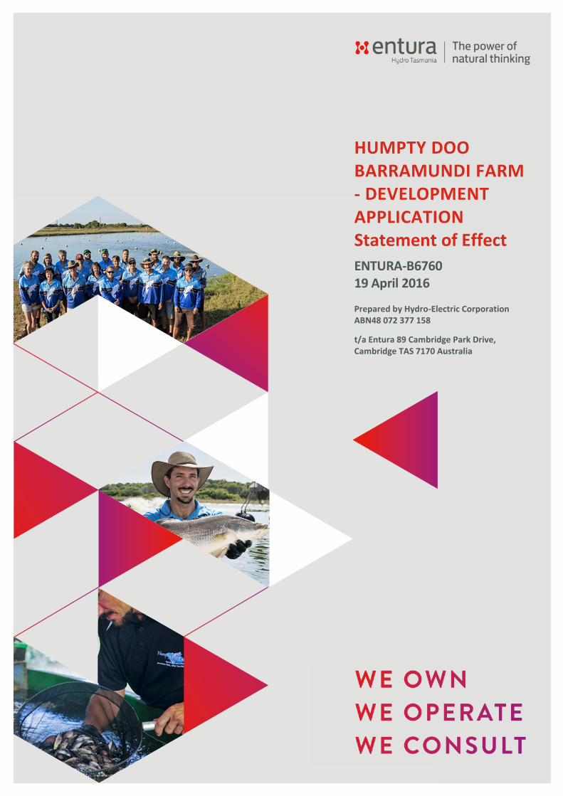


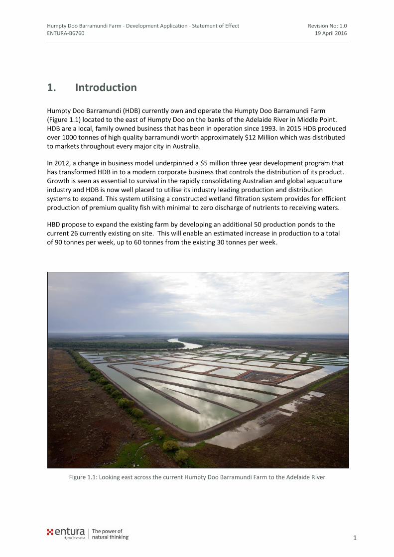
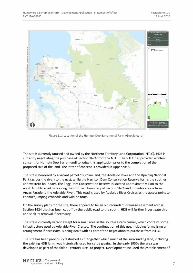
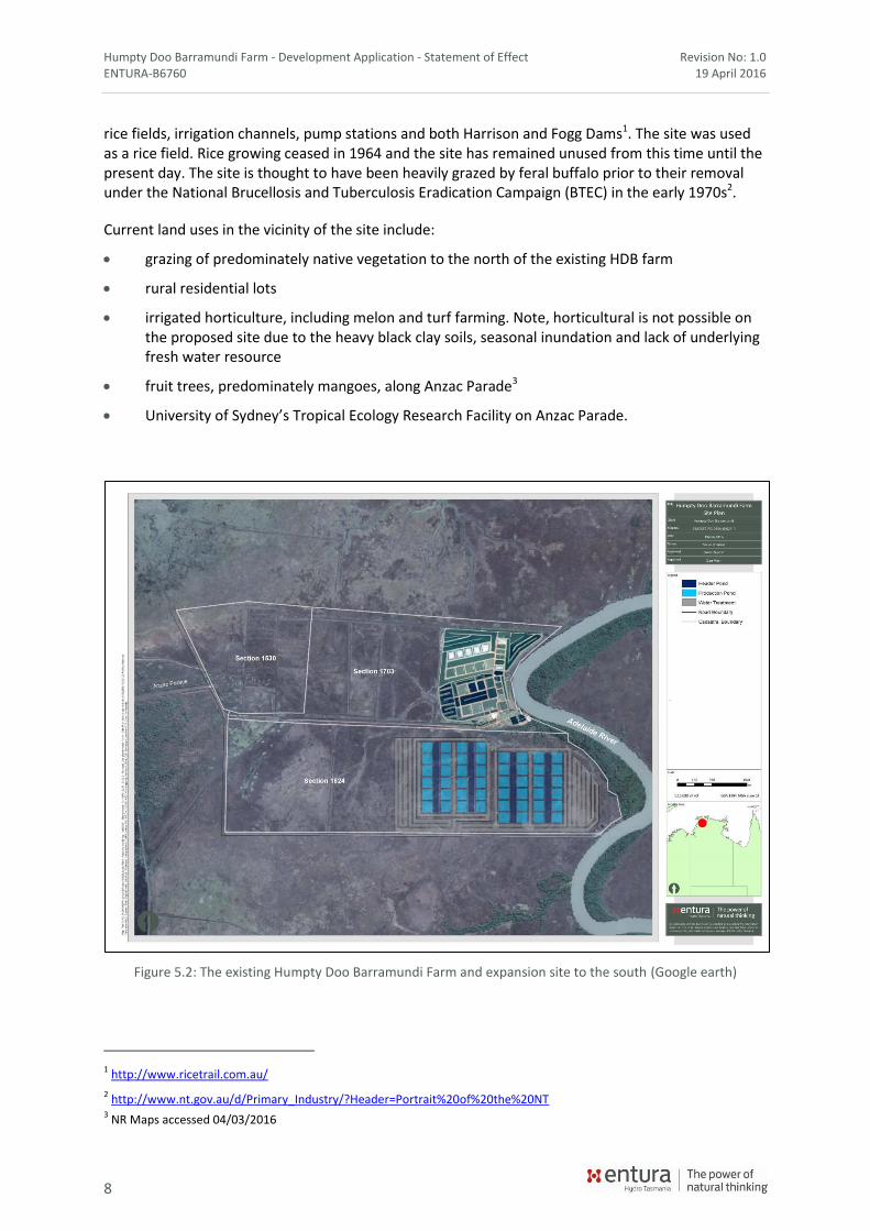
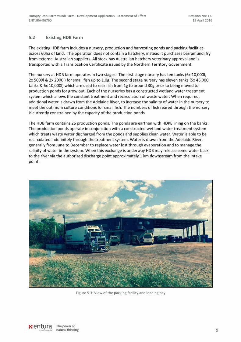
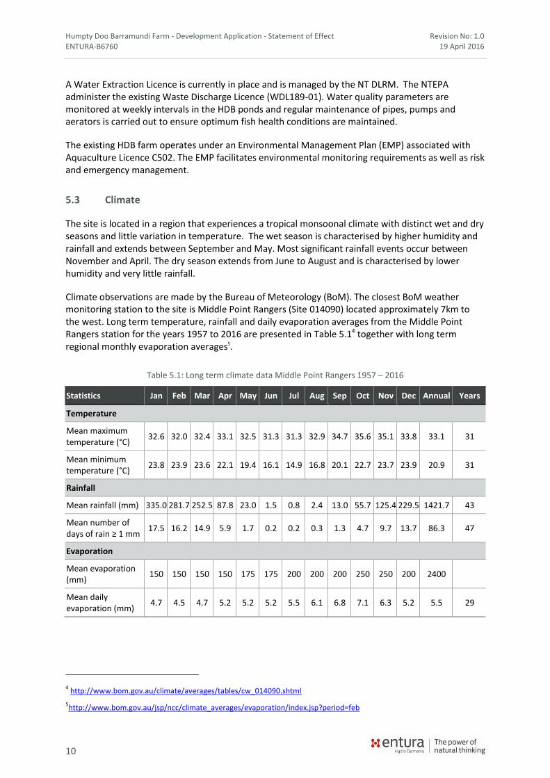
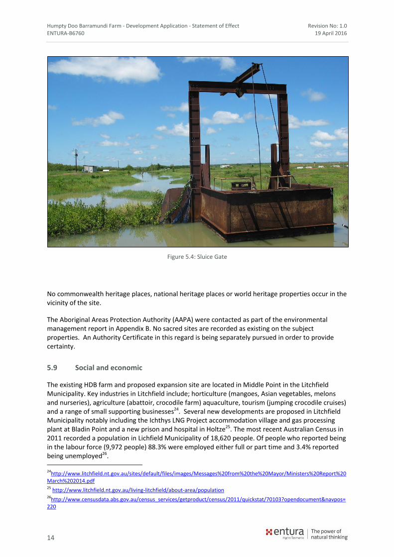
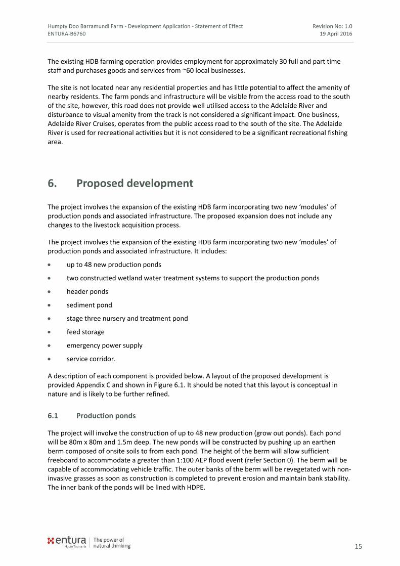
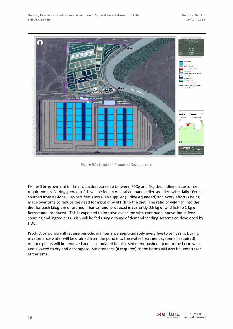
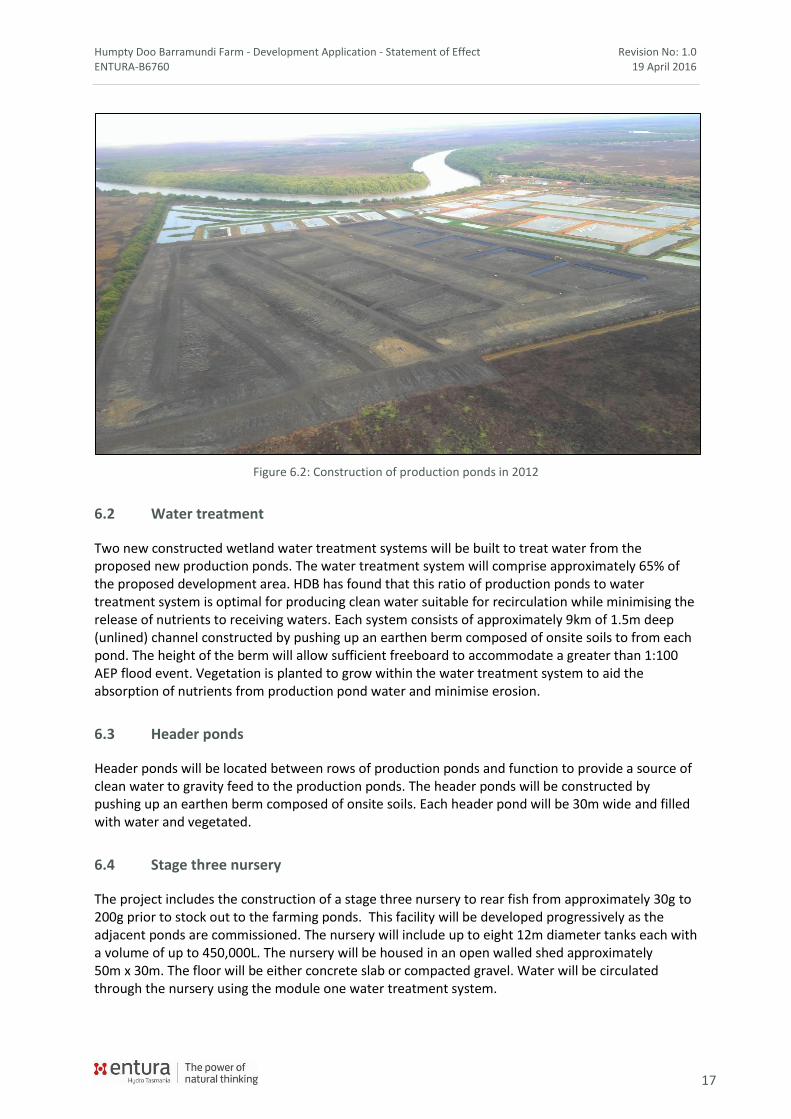

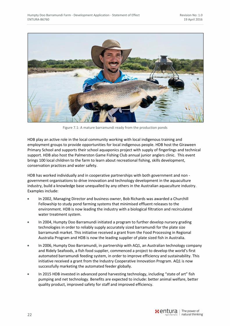
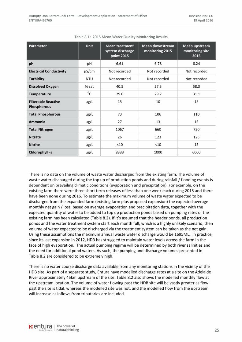
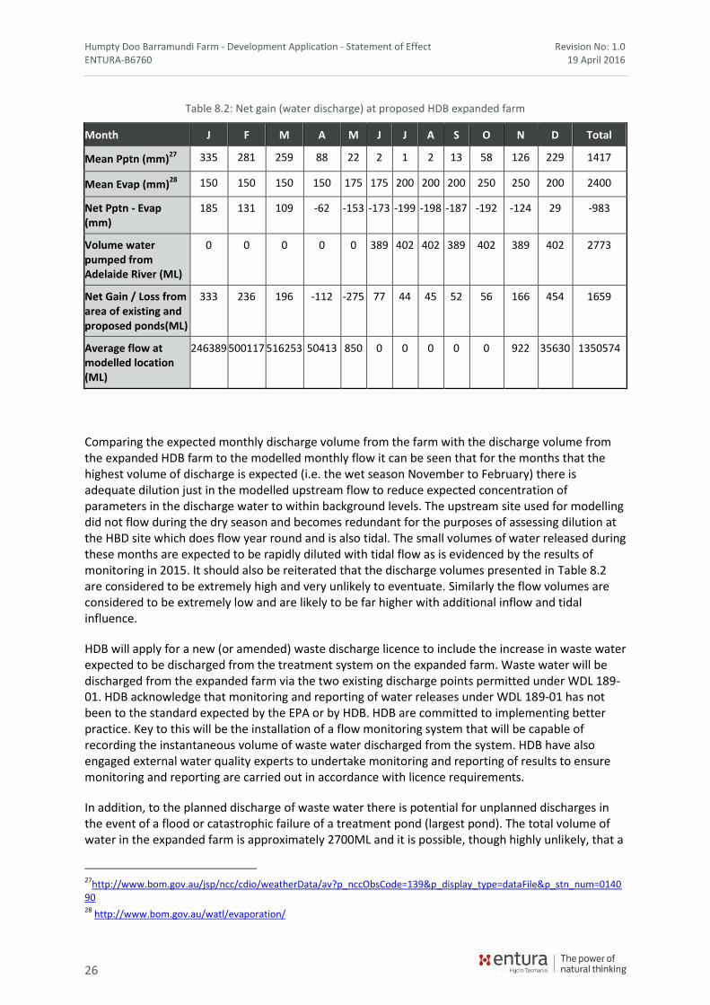
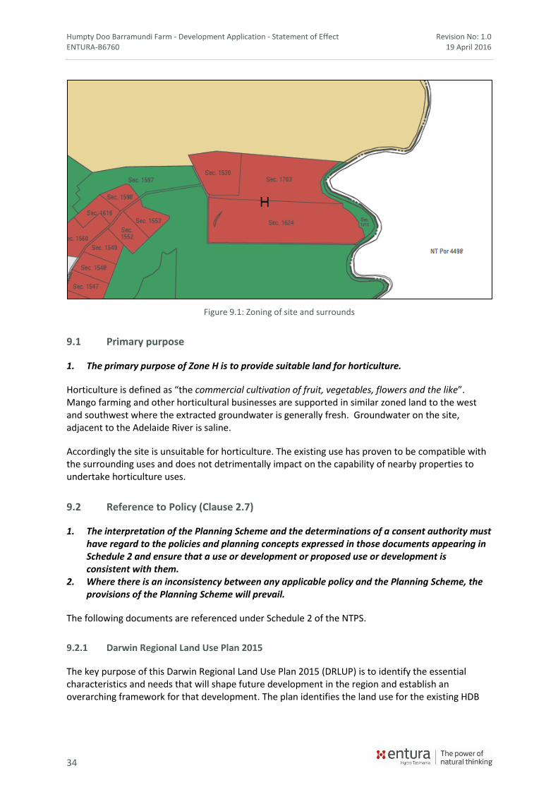
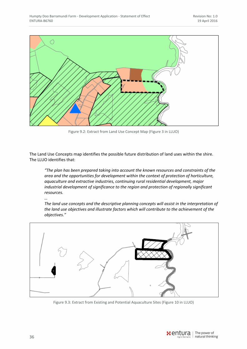
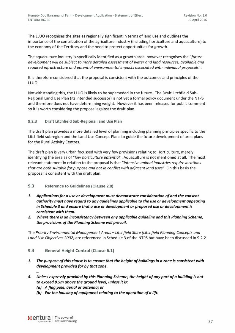

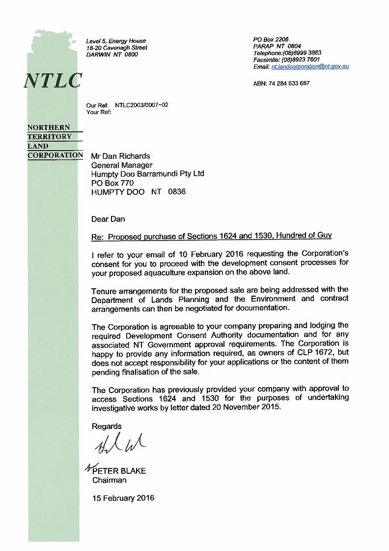
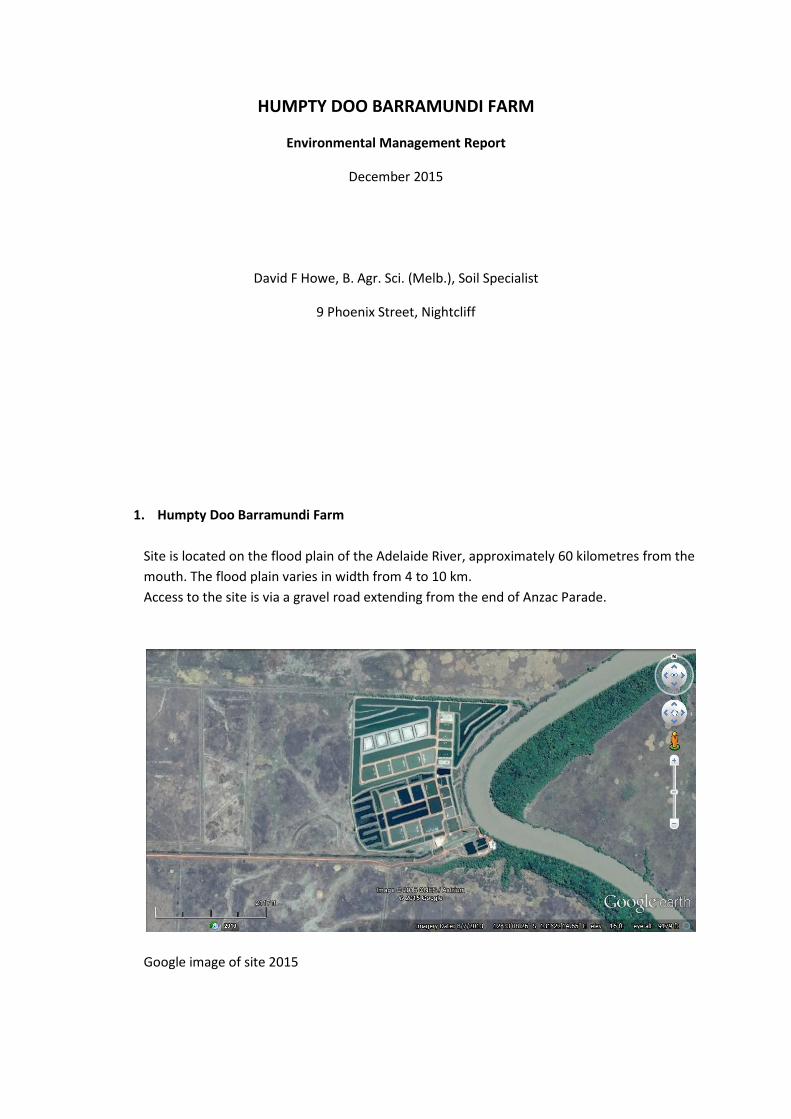
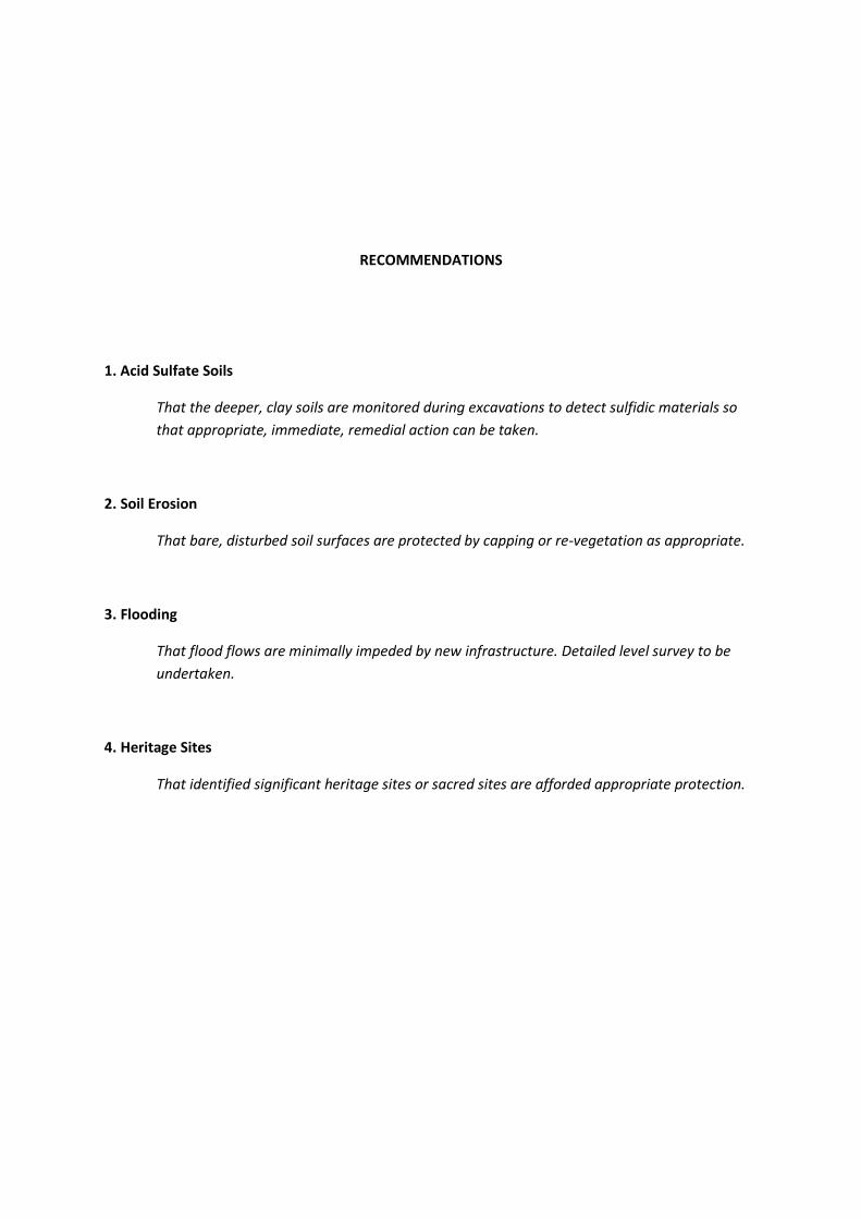
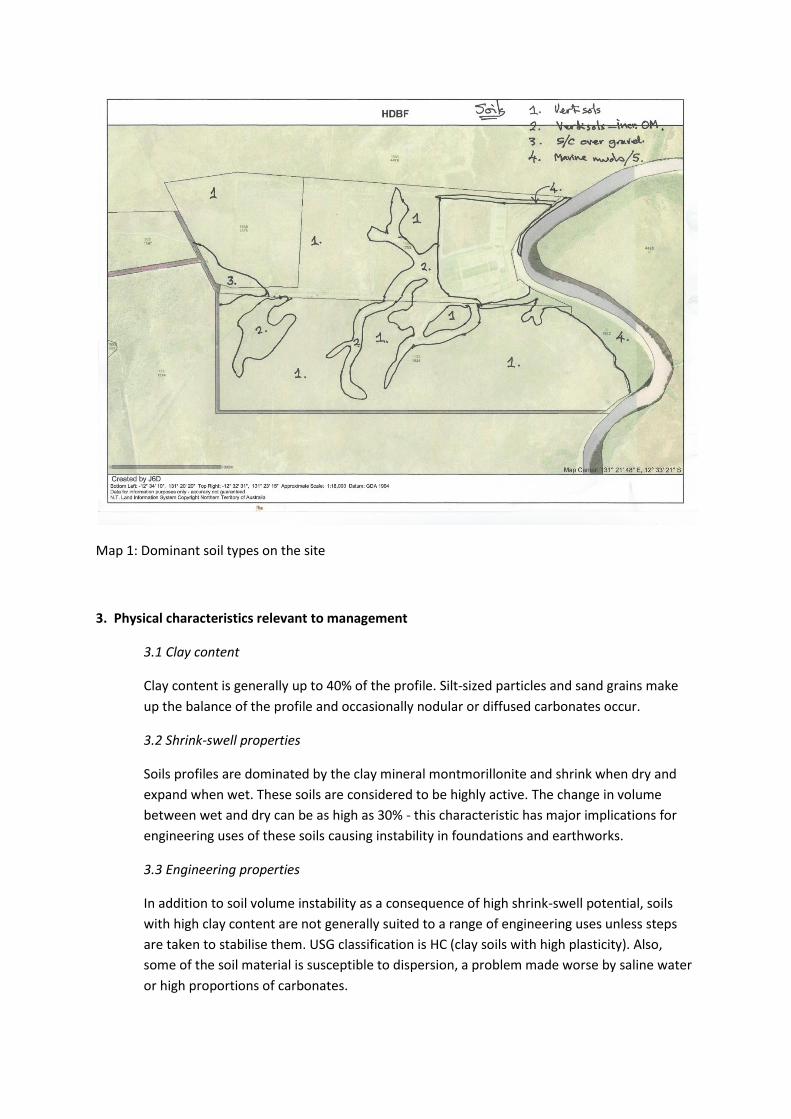
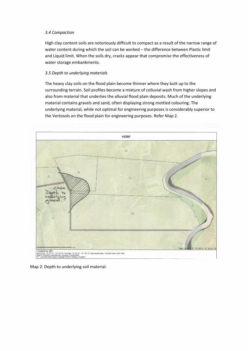
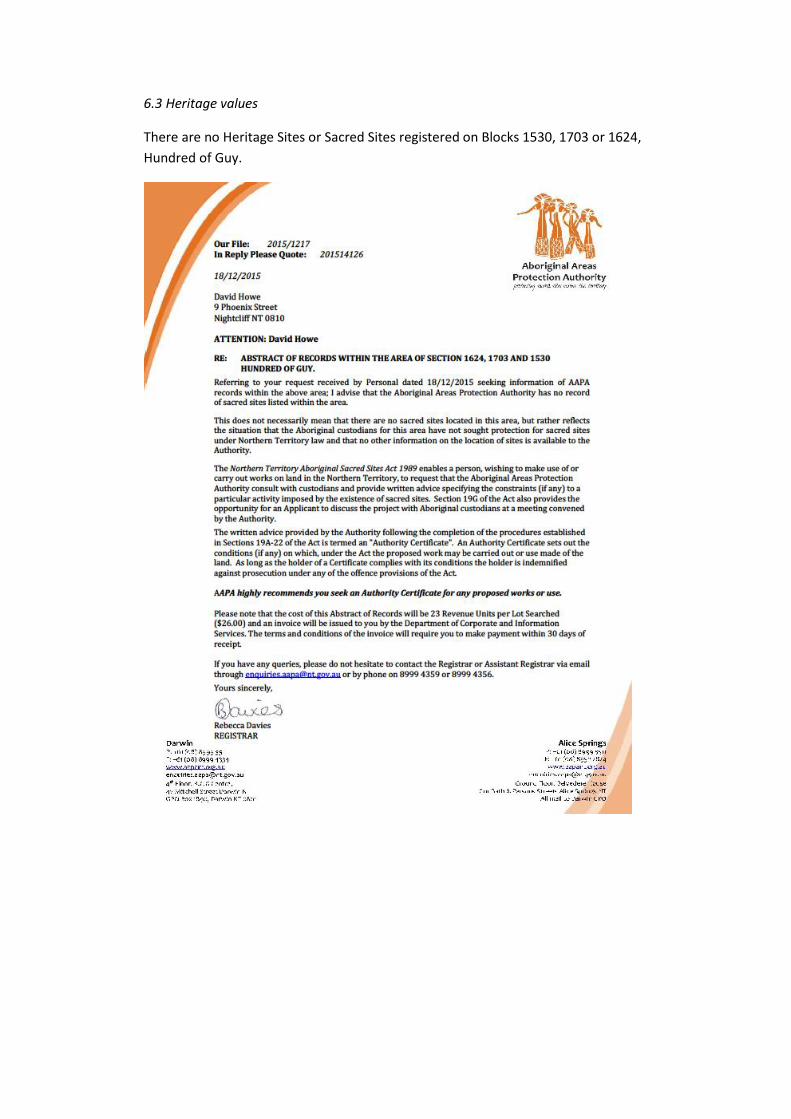
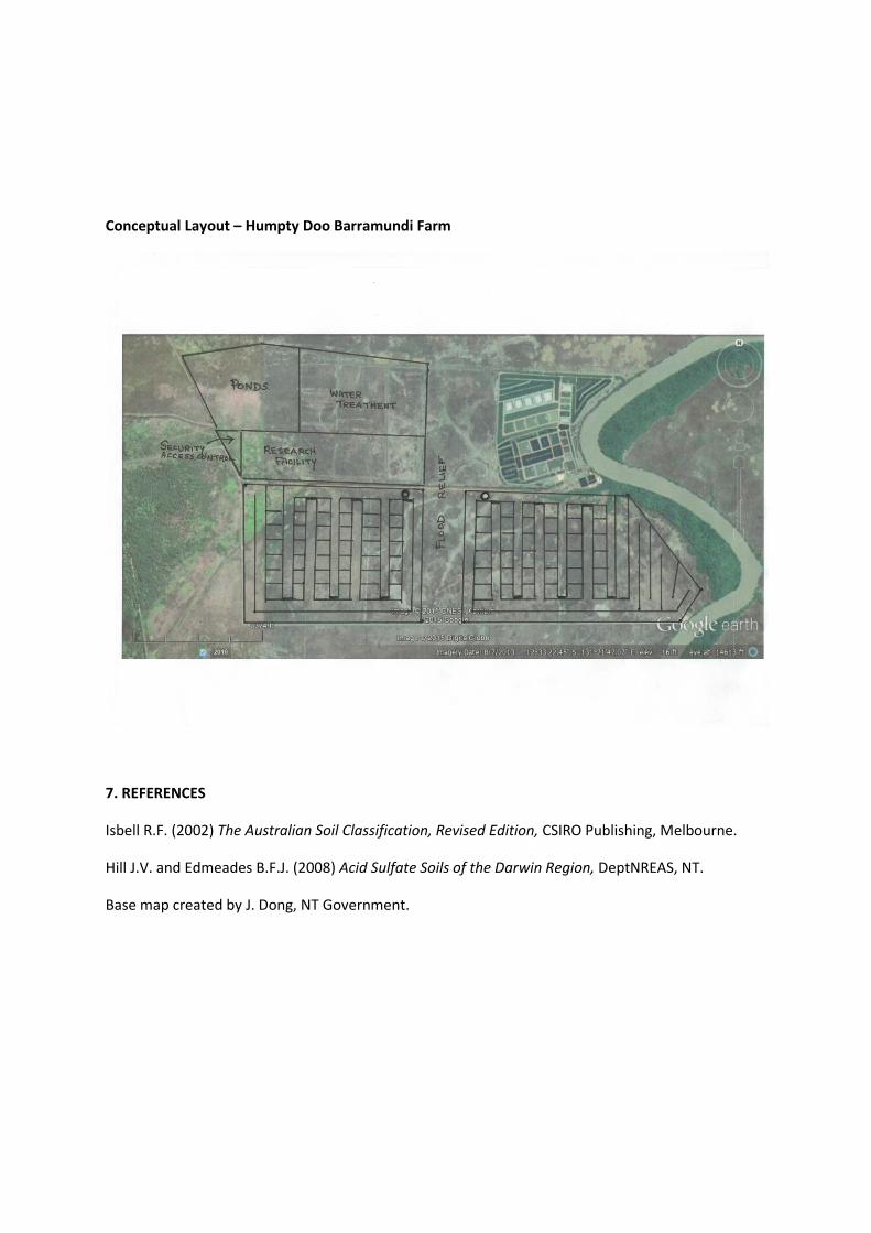
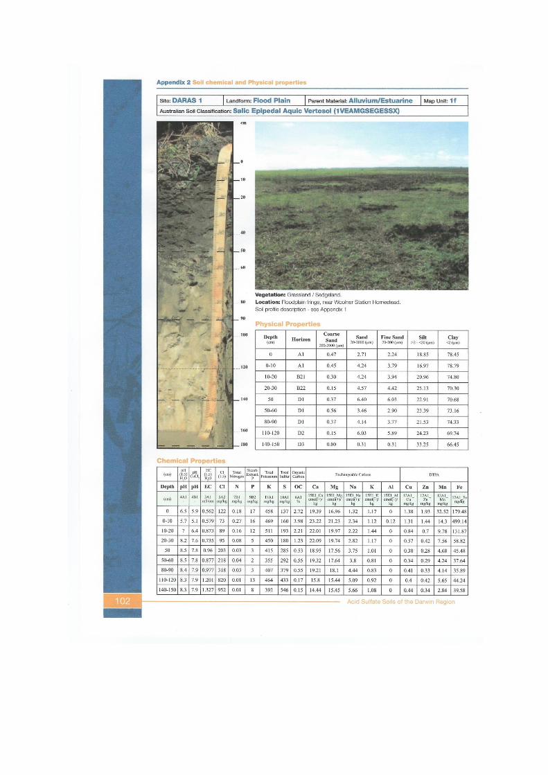
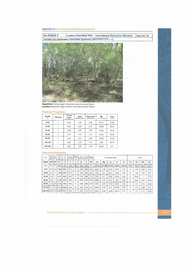
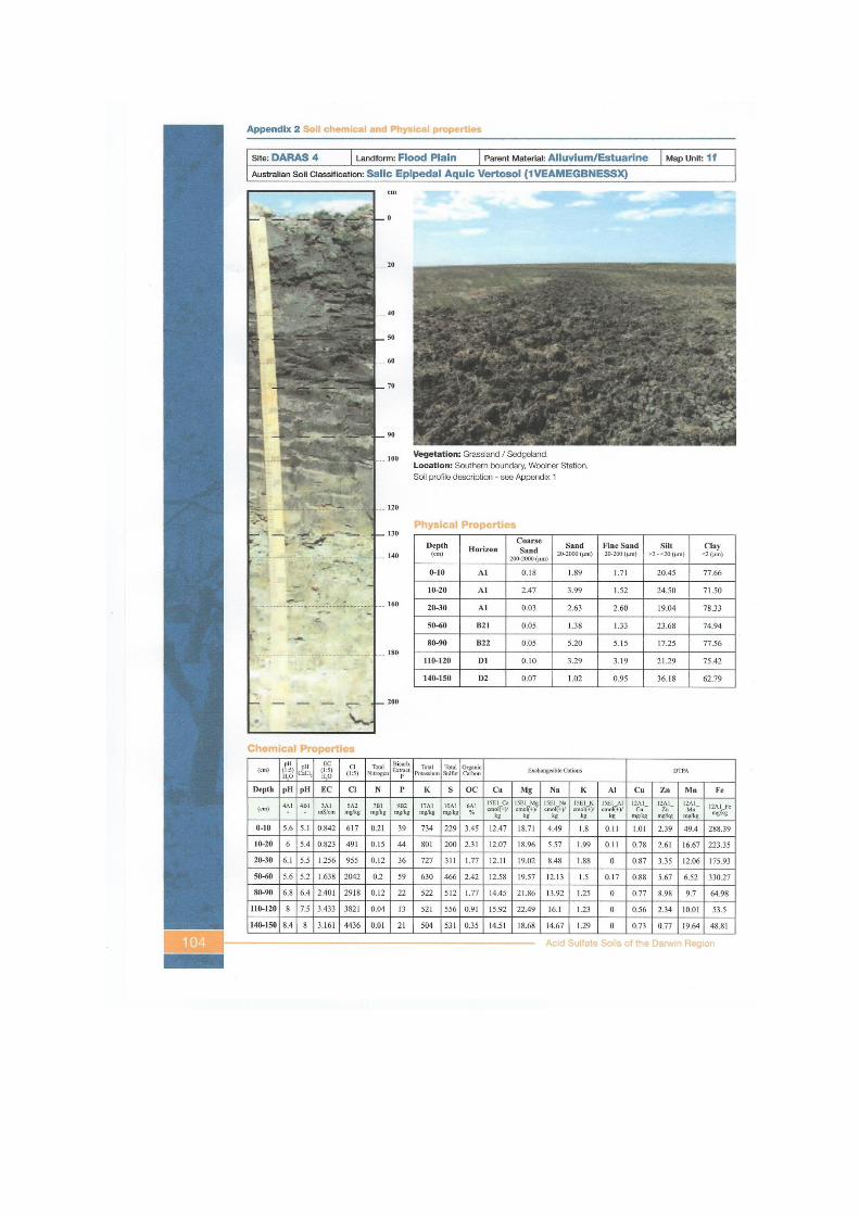
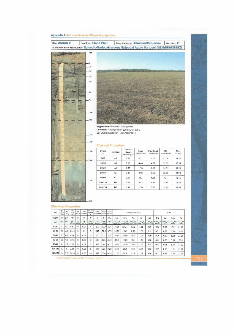
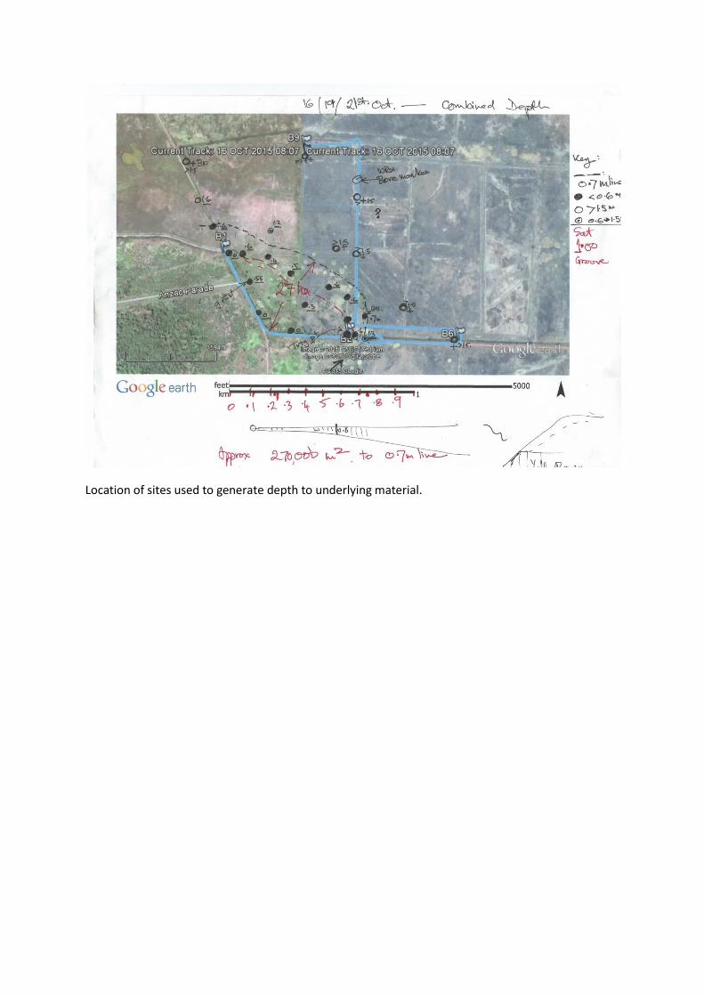
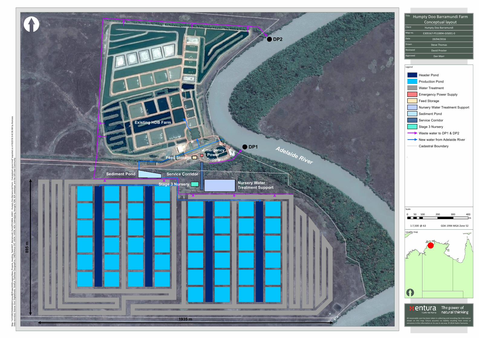
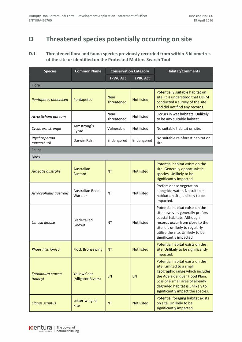
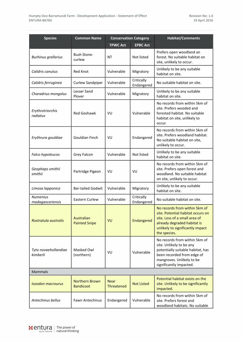
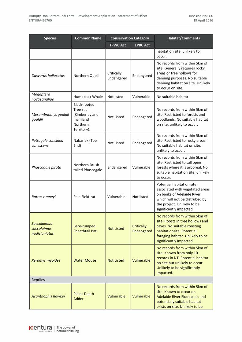
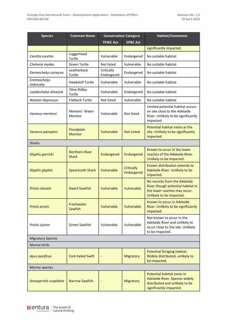
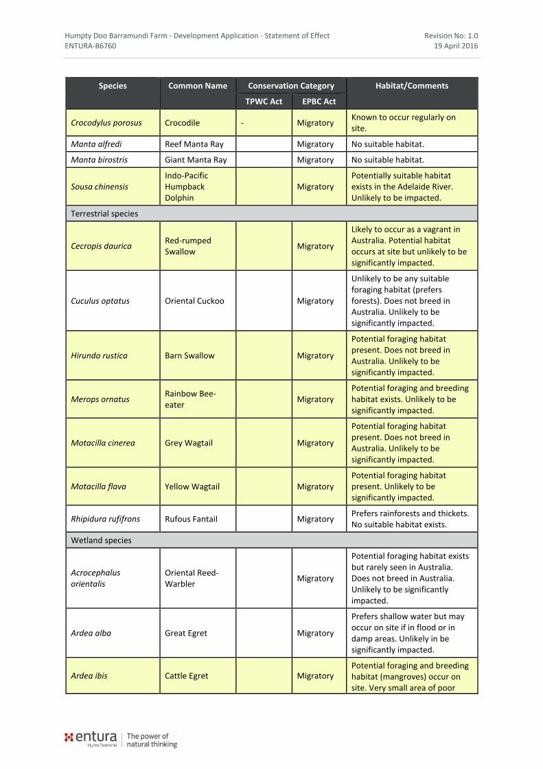
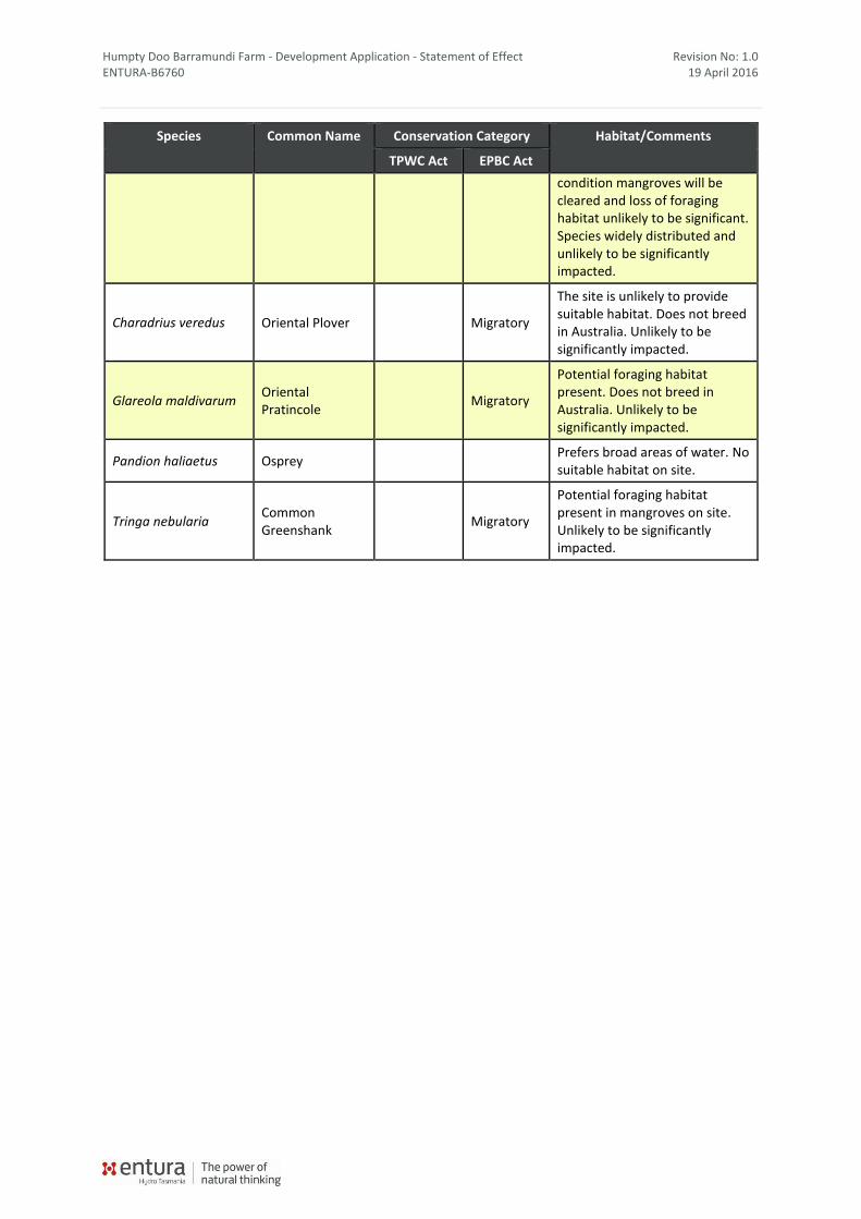
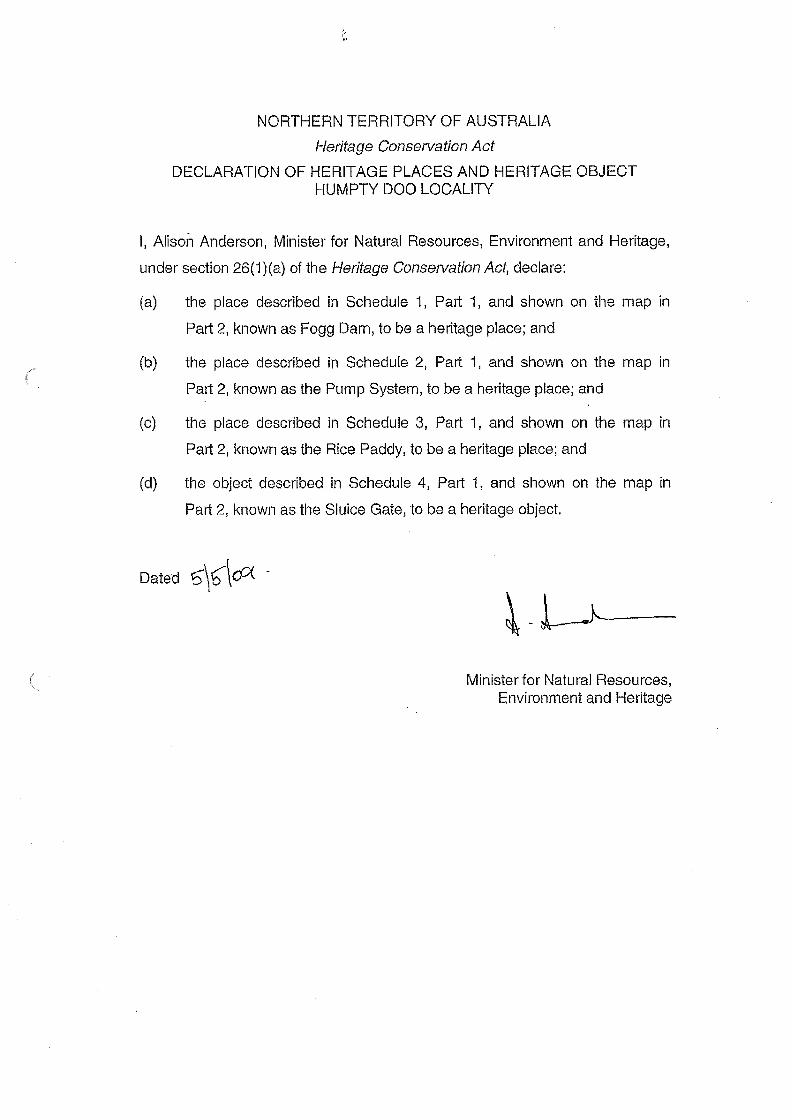
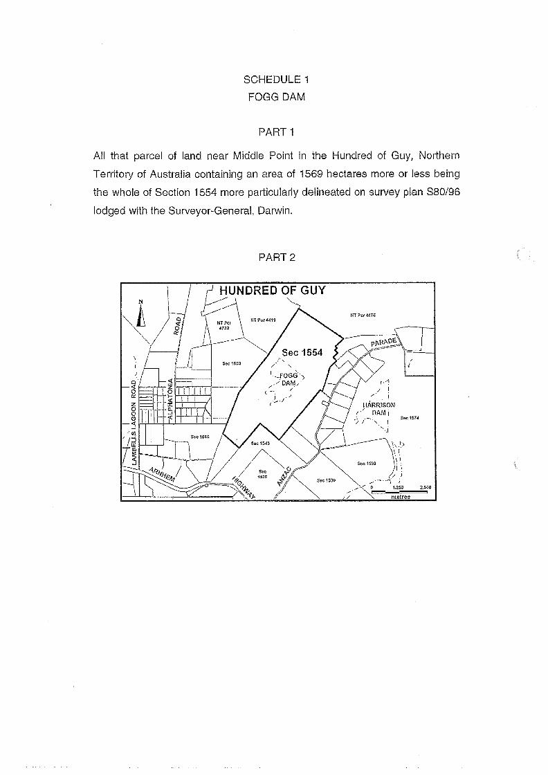
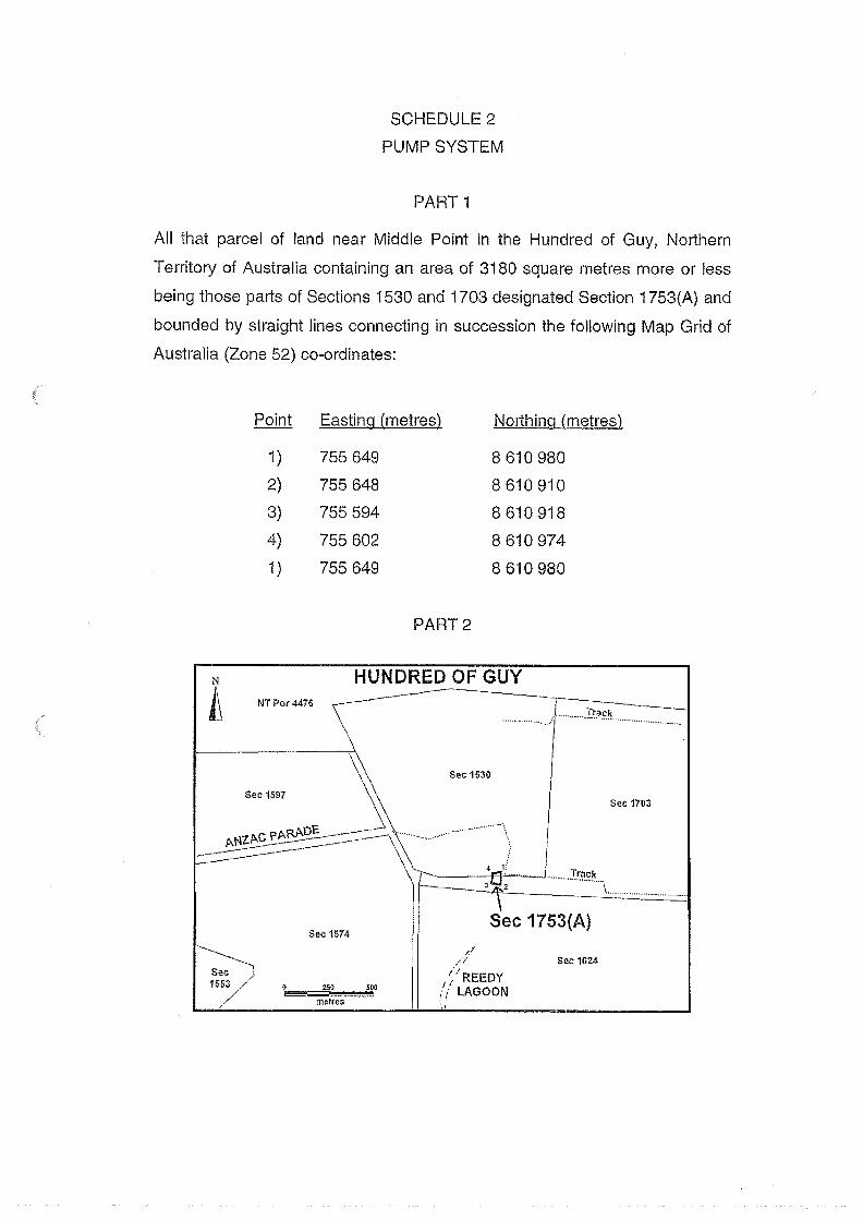
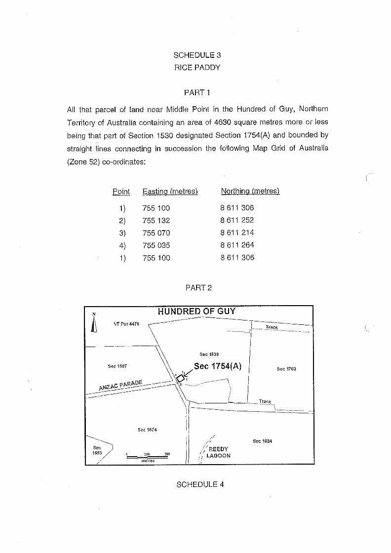
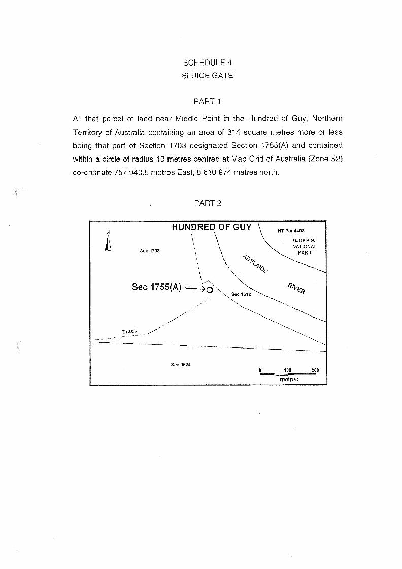
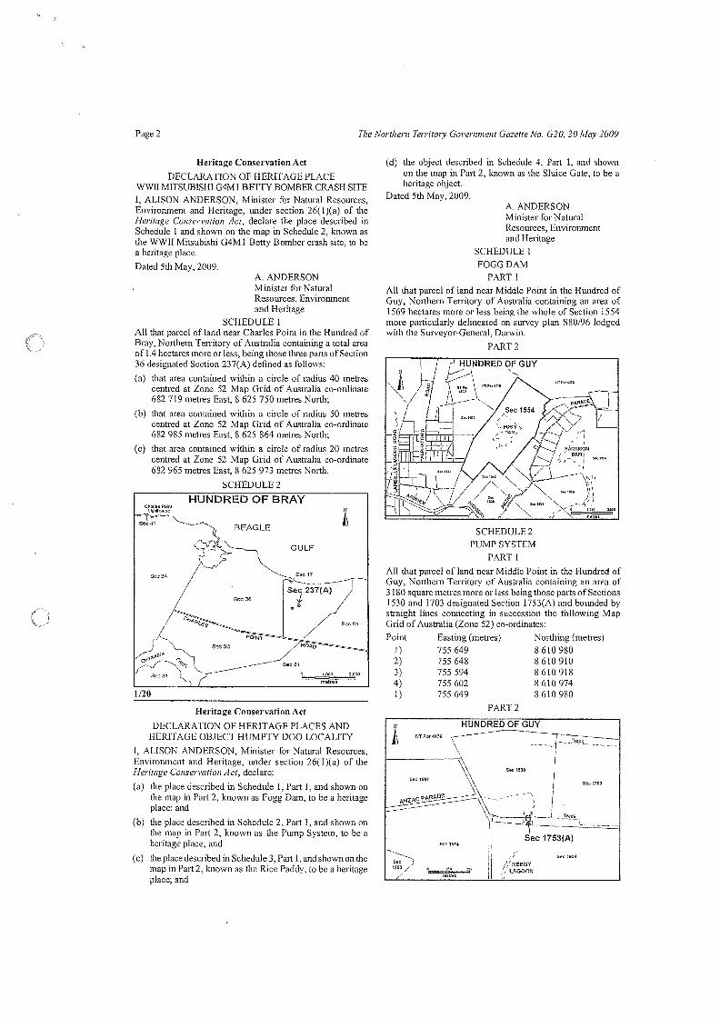


![[insert school name] Reports/2013_ar... · teaching and learning strategies such as Tribes and Real Justice. Humpty Doo Primary ... Our Aunty Patty Raymond received the prestigious](https://static.documents.pub/doc/80x56/5ad10fc47f8b9abd6c8b4b0f/insert-school-name-reports2013arteaching-and-learning-strategies-such-as.jpg)


