IP 129 Hydrocarbon accumulation in a paleovalley at Mississippian-Pennsylvanian unconformity near Hardinville, Crawford County, Illinois: a model paleogeomorphic trap R. H. Howard and S. T. Whitaker R. L. LANGENHEIM, JP DEPT. GEOL. UNIV. ILLINOIS 254 N.H.B., 1301 W. GIUEN ST. URBANA, ILLINOIS 61801 B ft 400 -500 600- 700 -800- -900 1000- > B' ILLINOIS PETROLEUM 129 1988 Department of Energy and Natural Resources ILLINOIS STATE GEOLOGICAL SURVEY
Transcript
IP 129
Hydrocarbon accumulation in a paleovalley
at Mississippian-Pennsylvanian unconformity
near Hardinville, Crawford County, Illinois:
a model paleogeomorphic trap
R. H. Howard and S. T. Whitaker
R. L. LANGENHEIM, JPDEPT. GEOL. UNIV. ILLINOIS
254 N.H.B., 1301 W. GIUEN ST.
URBANA, ILLINOIS 61801
B
ft
400
-500
600-
700
-800-
-900
1000-
>B'
ILLINOIS PETROLEUM 129 1988
Department of Energy and Natural Resources
ILLINOIS STATE GEOLOGICAL SURVEY
Howard, R. H.
Hydrocarbon accumulation in a paleovalley at Mississip-
pian-Pennsylvanian unconformity near Hardinville, Craw-
ford County, Illinois: a model paleogeomorphic trap
R, H. Howard and S. T. Whitaker— Champaign, IL: Illinois
State Geological Survey, 1988.
26 p.; 28 cm. — (Illinois Petroleum; 129)
I.Petroleum—Geology— Illinois. I. Title. II. Whitaker. S.T.
III. Series.
Printed by authority of the State of Illinois11988/1 500
Hydrocarbon accumulation in a paleovalley
at Mississippian-Pennsylvanian unconformity
near Hardinville, Crawford County, Illinois:
a model paleogeomorphic trap
R. H. Howard and S. T. Whitaker
ILLINOIS STATE GEOLOGICAL SURVEYMorris W. Leighton, Chief
Mapping coals to indicate unconformity paleovalleys 22
Seismic mapping 22
CONCLUSION 22
APPENDIX 24
1. Core slabs from basal Pennsylvanian reservoir 24
2. Core slabs from Chesterian strata 25
REFERENCES 26
FIGURES
1 Generalized geologic column of southern Illinois iv
2 Map showing hydrocarbon productive area of Pennsylvanian strata in the Illinois Basin, related major structural features,
and location of study area 2
3 Paleogeologic map of the sub-Pennsylvanian Chesterian surface in the Illinois Basin 3
4 Oil productive basal Pennsylvanian sandstone reservoir on northeast flank of the Hardinville Anticline 5
5 Basal Pennsylvanian sandstone deposits across the Hardinville Anticline 6
6 Two-well electric log cross section showing paleotopographic relief at the sub-Pennsylvanian unconformity 7
7 Induction log of bottom portion of E.R.I. #1 -A Richart Heirs 8
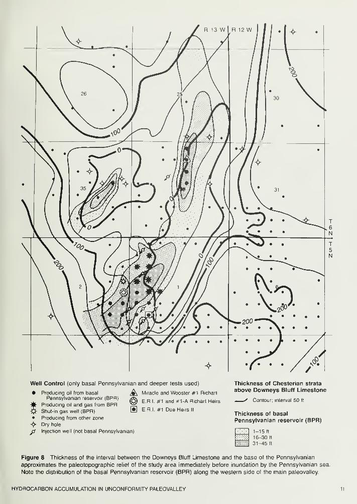
8 Thickness of the interval between the Downeys Bluff Limestone and the base of the Pennsylvanian 11
9 Thickness of Pennsylvanian strata below the Colchester (No. 2) Coal 12
10 Structure map of the Colchester (No. 2) Coal Member 13
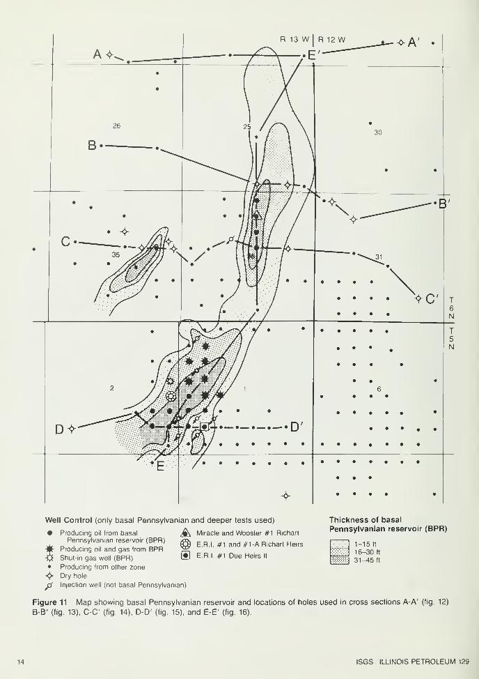
11 Map showing basal Pennsylvanian reservoir and locations of holes used in cross sections 14
12 Cross section A-A', showing structural and stratigraphic relations of strata along an east-west transect north of
clean sandstone development in the basal Pennsylvanian reservoir 15
13 Cross section B-B', showing basal Pennsylvanian sandstone along the western side of the paleovalley 16
14 Cross section C-C, showing structural and stratigraphic relations of Chesterian and basal Pennsylvanian strata along
the crest of the anticline 17
15 Cross section D-D', showing a relatively thick basal Pennsylvanian reservoir preserved along the western side of the
paleovalley 18
16 Cross section E-E', a longitudinal section along the paleovalley showing the changing thickness of the basal
Pennsylvanian reservoir across the Hardinville Anticline 19
17 Evolution of paleovalleys at the Mississippian-Pennsylvanian unconformity and subsequent sand bar deposition
across the Hardinville Anticline 21
18 Diagrammatic portrayal of kinds of stratigraphic traps associated with paleovalleys at the Mississippian-
Pennsylvanian unconformity 23
TABLE
1 Initial production of wells completed in the basal Pennsylvanian reservoir at Hardinville 10
THICKNESS ABOUT 2000 FT THICKNESS ABOUT 1300 FT THICKNESS: ABOUT 4000 FT
I 1 I
MATTOON
ZO
— 1— l-l-znj
m
IF
XXXX
BOND
MODESTO
CARBONDALEincludes Anvil
Rock, Cube,
U. Dudley,
Dykstro, Jake C,
Jomestown,
Pleasantview,
Colchester (No 2) Coal
SPOONIncl Belioir 500,
Bridgeport,
Browning, Cloy-
pool, L. Dudley,
Isobei , Kickopoo,
Petro, Robinson
,
2nd or L.Siggms,
Wilson
ABBOTTIncl Belldir 800,
Burtschi, Cosey,
Monsfield, Dogley
Portlow,
3rd, 4th Siggms
CASEYVILLEIncludes Biehl,
Buchanan,
Jordan,
Pottsville,
Ridqley
GROVE CHURCH
KINKAID
DEGONIA
._,'
.!_'
._.'*
JL i-
I ? 1 I
*
T-J-
CLORE
PALESTINE
MENARD
WALTERSBURG
VIENNA
TAR SPRINGS
GLEN DEAN
HARDINSBURG
HANEY(Golconda lime)
FRAILEYSIGol sh )
Big Cliffy, Jackson
BEECH CREEK(Barlow, basal Gol )
CYPRESSWeiler, Kirkwood,
Coriyle,Bellair 900,
Lmdley
RIDENHOWERtU P C )
Sample (P Cr. Sd ., E III )
BETHEL(Point CrSd ,W 111 )
DOWNEYS BLUFF(L.PC ,U Ren.)
YANKEETOWNBenoist
RENAULT ( L.Ren )
AUX VASESSTE GENEVIEVE
Aux Vases lime
Ohara
Spor Mountain
I Rosiclarelo
McClosky co
(Oblong) *>
L McClosky £
ULLIN
FT PAYNE
BORDEN (Osage)
Cole, Sonora
Corper
CHOUTEAU
NEW ALBANY
• Hordin
T L INGLE• Hibbard
• Homg• GRAND TOWER• Geneva
•_ Dutch Creek
CLEAR CREEK
BACKBONEGRASSY KNOB
BAILEY
MOCCASIN SPRINGSSilunon, Niagoran
( reef and nonreef
)
ST CLAIR
KANKAKEEEDGEWOOD
MAQUOKETA
GALENA
PLATTEVILLE
JOACHIM
DUTCHTOWN
ST PETER
Figure 1 Generalized geologic column of southern Illinois (modified from Huff, 1987). Solid dots indicate oil and gas pay
zones. Formation names are in capitals; other pay zones are not. About 4,000 feet of lower Ordovician and upper Cambrian
rocks under the St. Peter Sandstone are not shown. The Kinderhookian, Niagaran, Alexandrian, and Cincinnatian Series are
abbreviated as K., Niag., A., and Cine. Variable vertical scale. (Originally prepared by David H. Swann)
ABSTRACT INTRODUCTION
The surface of the Mississippian-Pennsylvanian unconformity
in the Illinois Basin is characterized by an anastomosing
pattern of paleovalleys eroded by the ancient Michigan River
System. Fluvial sandstones deposited within these valleys
commonly were buried by transgressive Pennsylvanian
marine shales, creating the potential for stratigraphic
entrapment of hydrocarbons.
One such trap was discovered accidentally on the northeast
flank of the Hardinville Anticline in 1955. The exploration
significance of a linear sandstone body within a paleovalley
was not recognized at that time, and only four producing wells
resulted.
Not until 1974 was this reservoir again fortuitously
encountered IV2 miles to the southwest on the anticline's
southwest flank. Correct log correlations led to its identification
in 1976 as a 3-mile long, 5- to 45-ft thick conglomeratic
sandstone body along one side of the paleovalley floor. Twenty
wells will recover an estimated 1.5 million barrels of 36° API
oil from the reservoir.
The experience with this reservoir illustrates the difficulties
and rewards involved in developing exploration models for
stratigraphic traps. Traps associated with paleovalleys at the
Mississippian-Pennsylvanian unconformity could prove to be
important targets for future exploration. Maps showing the
paleogeology and paleotopography of the sub-Pennsylvanian
surface and the structure of overlying Pennsylvanian coals
can be used to delineate paleovalleys on the unconformity
surface and potential hydrocarbon reservoir strata associated
with sedimentary fill. Seismic data may also be useful, but
careful computer modeling of seismic responses to lithologies
expected to be encountered in and along the paleovalleys,
as well as field testing, would be required to maximize the
effectiveness of a seismic program.
Hydrocarbon reservoirs that have been discovered in
relatively shallow Pennsylvanian sedimentary rocks within the
Illinois Basin (fig. 1 ) account for more than 13 percent of the
nearly 4 billion barrels of oil that has been produced in the
basin. Most Pennsylvanian production has come from
reservoirs along the La Salle Anticlinal Belt (fig. 2), in basal
sandstones at the Mississippian-Pennsylvanian unconformity
or from sandstones higher in the sequence of the lower
Pennsylvanian System (Swann and Bell, 1958). Away from
the La Salle belt about half of the Pennsylvanian oil is found
along fault lines and half in basal sandstones.
The nature and evolution of the anastomosing erosional
pattern inscribed on the Mississippian-Pennsylvanian
unconformity surface (fig. 3) has been widely studied and
discussed in the literature (Siever, 1951 ; Bristol and Howard,
1971; Howard, 1979a). The character, distribution, and
depositional environments of the sediments that buried this
surface, however, have received only relatively local
documentation (Davis, Plebuch, and Whitman, 1974; Pryor
and Potter, 1979). With the exception of Shiarella's (1933)
report on the Buford area in Ohio County, Kentucky, published
studies of hydrocarbon traps in basal Pennsylvanian
sandstones in the Illinois Basin are virtually nonexistent. Arecently completed but unpublished master's thesis by
Stephen F. Greb, University of Kentucky, is devoted to the
study of the Madisonville Paleovalley (fig. 3) and the basal
Pennsylvanian oil pools it contains, including those in the
Buford area.
This report is the first to describe the relationship of a
sub-Pennsylvanian unconformity paleovalley to a specific
hydrocarbon reservoirin Illinois. The description of the basal
Pennsylvanian reservoir (BPR) at Hardinville is a step toward
according basal Pennsylvanian hydrocarbon entrapment the
local and regional analyses its economic significance
deserves. From these analyses will emerge hydrocarbon play
models that can be used to indicate additional prospective
areas for similar paleogeomorphic traps.
HYDROCARBON ACCUMULATION IN UNCONFORMITY PALEOVALLEY
\i—^Jr
71. V
i."•
• v- .*.-. • v » •;
i . *%' / •.
' \>Al 7«V
«*».'. -,.
••
,
Figure 2 Map showing hydrocarbon productive area of Pennsylvanian strata
in the Illinois Basin, related major structural features, and location of study area.
ISGS ILLINOIS PETROLEUM 129
I Grove Church-Kinkaid
Degonia-Menard
Waltersburg-Glen Dean
Hardinsburg-Renault
60 mi
100 km
Figure 3 Paleogeologic map of the sub-Pennsylvanian Chesterian surface in the Illinois Basin (modified from Bristol and
Howard, 1971, plate 1; Howard, 1979a, fig. 2). The study area and location of studies of basal Pennsylvanian hydrocarbon
accumulation along the Madisonville Paleovalley in Daviess, McLean, and Ohio Counties, Kentucky, are shown.
HYDROCARBON ACCUMULATION IN UNCONFORMITY PALEOVALLEY
BASAL PENNSYLVANIAN RESERVOIR AT HARDINVILLE
History of oil discovery
The occurrence of a relatively shallow, oil-filled conglomeratic
sandstone lens draped across the crest of a major anticline
in the heart of the oldest oil-producing area in Illinois should
have guaranteed its early discovery. In the study area,
however, the discovery and exploitation of hydrocarbon
accumulations in shallower Pennsylvanian Robinson sands
and in the deeper Mississippian Chesterian and Valmeyeran
strata (fig. 1) effectively concealed the existence of a basal
Pennsylvanian oil accumulation there during the first seven
decades of oil exploration in Crawford County.
Oil production from the basal Pennsylvanian reservoir
(BPR) was finally established two miles east of Hardinville in
December 1955, when Miracle and Wooster plugged back
their #1 Richart well (SW NW NE Sec. 36, 6N-13W), a
McClosky (Ste. Genevieve) test on the northeast flank of a
structural closure herein named the Hardinville Anticline (fig.
4). This well was completed in the BPR for 120 barrels of oil
per day, but only three successful north and south offsets
followed. Apparently the exploration significance of an
oil-bearing basal Pennsylvanian sandstone body situated
along the floor of a deeply incised paleovalley was not
recognized. Consequently no further attempts were made to
develop the lenticular reservoir at that time.
It was not until 1974 that the basal Pennsylvanian reservoir
was again fortuitously encountered, this time on the anticline's
southwest flank, during drilling of the Energy Resources of
Indiana (E.R.I.) #1 Richart Heirs (NE NE SE Sec. 2, 5N-13W),
which was drilled to the McClosky (fig. 5). Unfortunately the
BPR was mistaken for Chesterian sandstones that were
expected at about the same depth, thereby preventing
recognition of the paleovalley.
Finally, in 1976, the E.R.I. #1 Due Heirs II (NE SW SWSec. 1, 5N-13W) encountered the BPR at about the expected
depth of the Yankeetown Sandstone. Its correct identification
as a Pennsylvanian fluvial sandbar deposited along the floor
of an unconformity paleovalley (probably extending NNEacross Sec. 36, 6N-13W) led to the completion of 16 oil wells
in the southwestern portion of the reservoir (fig. 5). Thepotential for miscorrelation of the BPR with Chesterian
sandstones is shown in figure 6 along with the paleotopog-
raphic relief of the unconformity surface.
E.R.I, estimates that primary and secondary production
methods will recover approximately 1.4 million barrels of oil
from its 16 producing wells (J. G. Peters andE. L.Whitmer,
Jr., personal communication). Another estimated 100,000
barrels will be recovered from the four wells in Section 36, in
the northeastern portion of the reservoir. Two additional wells,
the #1 -A Richart Heirs (NE NE SE Sec. 2, 5N-13W) and the
#1 -A Coulter Heirs (SE SE NE Sec. 2, 5N-13W), are shut-in
gas wells. High gas-oil ratios in wells updip from the
#1-A Richart Heirs, particularly where the BPR is less than
15 feet thick, suggest that a gas cap existed. Although E.R.I,
estimates that the southwestern portion of the reservoir
originally contained 277 million cubic feet of gas, produced
gas has been flared due to lack of market. Initial production
figures of all wells completed in the BPR are shown in table 1.
Reservoir lithology
In February 1977, E.R.I, drilled the #1-A Richart Heirs 50
feet south of its #1 Richart Heirs (NE NE SE Sec. 2, 5N-13W),
in which the BPR had been penetrated but not recognized in
1974. Although the BPR was encountered and cored in the
#1-A Richart Heirs, a poor cement job prevented its
completion as an oil producer. R. M. Guff and R. H. Howard
described this core, consisting of 20 feet of the BPR and 40
feet of underlying Chesterian strata (fig. 7). The BPR core is
oil stained throughout. Photographs of selected core slabs
are shown in appendixes 1 and 2.
ISGS ILLINOIS PETROLEUM 129
Well Control (only basal Pennsylvanian and deeper tests used)
• Producing oil from basalPennsylvanian reservoir (BPR)
• Producing from other zone
-<{v Dry hole
p Injection well (not basal Pennsylvanian)
fc\ Miracle and Wooster #1 Richart
Structure contourson Downeys Bluff Limestone
__/ Contour; interval 20 ft
Thickness of basal
Pennsylvanian reservoir (BPR)
1-15 ft
16-30 ft
31-^5 ft
Figure 4 Oil productive basal Pennsylvanian sandstone reservoir on the northeast flank of the Hardinville Anticline,
discovered in Miracle and Wooster's #1 Richart in 1955. Chesterian Downeys Bluff Limestone structure is shown with
respect to mean sea level. No wells producing from the basal Pennsylvanian reservoir that were drilled after 1956are shown.
HYDROCARBON ACCUMULATION IN UNCONFORMITY PALEOVALLEY
Well Control (only basal Pennsylvanian and deeper tests used)
Producing oil from basal ^ Miracle and Wooster #1 Richart
63) E.R.I. #1 and #1-A Richart Heirs
>fi
Pennsylvanian reservoir (BPR)
Producing oil and gas from BPRShut-in gas well (BPR) W E.R.I. #1 Due Heirs II
Producing from other zone
Dry hole
Injection well (not basal Pennsylvanian)
Structure contourson Downeys Bluff Limestone
__• Contour; interval 20 ft
Thickness of basal
Pennsylvanian reservoir (BPR)
1-15 ft
16-30 ft
31-45 ft
Figure 5 Basal Pennsylvanian sandstone deposits across the Hardinville Anticline. The oil-bearing BPR on the
southwest flank of the anticline was transected but unrecognized and unexploited in 1974 by E. R. I. # 1 Richart Heirs.
In 1976 E.R.I, completed # 1 Due Heirs II, the first of 16 producers in the sand bar, whose relation to the BPR in Section
36 was then recognized. A thick basal Pennsylvanian sandstone accumulation in Section 35 is barren because of its
communication with overlying porous strata. Downeys Bluff Limestone structure is shown with respect to mean sea
level. Location of cross section X-Y (fig. 6) is shown.
ISGS ILLINOIS PETROLEUM 129
Energy Resources of Indiana
#9 Price-Valdez CommunityThe Ohio Oil Company#1 Eagleton Community
600 i
Figure 6 Two-well electric log cross section X-Y (location shown in fig. 5) shows paleotopographic relief at the
sub-Pennsylvanian unconformity. Note the potential for correlation difficulties due to the spatial relation of the basal
Pennsylvanian reservoir (BPR) on the paleovalley floor to Chesterian sandstones. Exploitation of extensive
Pennsylvanian Robinson sand reservoirs and reservoirs in Chesterian and Valmeyeran strata inhibited recognition
and identification of the BPR.
HYDROCARBON ACCUMULATION IN UNCONFORMITY PALEOVALLEY
Energy Resources of Indiana
Richart Heirs #1-A NE NE SE Sec. 2, T5N-R13WIP-SIGW
1200 ft
Core Analysis
1300 ft
I
.*!*••
=«=jr
'•
:>erm<iabil ty'"'
oros
IT*••"•*
v
ty <
core depths adjusted up2 ft to correspond to log
Figure 7 Induction log of bottom portion of E.R.I. #1-A Richart Heirs (see fig. 5).
Lithology, porosity, and permeability of a 60-foot core, including 20 feet of the BPR and
40 feet of subjacent Chesterian strata, are graphically depicted. Letters A, B, C, and D,
indicate positions of core slabs shown in appendixes 1 and 2.
I
]• .*
|
conglomeratic sandstone
| shale
[ I
sandstone
| shaly siltstone
J silty sandstone
3 limestone
ISGS ILLINOIS PETROLEUM 129
UNIT
Richart Heirs #1-A
CORE DESCRIPTION
PENNSYLVANIAN SYSTEM
DEPTH (FT)
Sandstone
Shale
Sandstone
Sandstone
interbedded medium gray and light olive gray quartz sand with minor feldspar,
chert, and rock fragments; angular to subrounded; mostly poorly sorted; mostly
siliceous cement with some calcite cementation. Porosity is variable. Interval
consists of seven fining-upward cycles ranging from 0.2 to 1.5 ft thick. Grain
size at base ranges from coarse sand to granule or pebble; at top, fine to coarse
sand. Basal contact of each cycle is sharp, may be pyritic, and is commonlyinclined (giving some impression of crossbedding). Several shale chips up to
5 cm across occur at 1237 ft
medium dark gray, soft, fissile; thin, discontinuous, parallel silt laminae 1 to 2
mm thick, pyritic; irregular bottom contact and sharp upper contact
light olive gray; quartz sand with minor fragments of chert, subrounded to
rounded, very poorly sorted; irregular grain size variation from fine sand to
pebble; mostly medium to coarse matrix with coarse to very coarse floating
grains; numerous shale chips scattered throughout; siliceous and calcareous
cement; variable intergranular porosity
dark yellowish brown, medium- to fine-grained, well-sorted, siliceous cement
with some calcareous cement near top, 20° planar crossbedding throughout;
bottom contact sharp, pyritic
1231-1237.2
1237.2-1237.35
1237.35-1247.8
1247.8-1250.0
MISSISSIPPIAN SYSTEMChesterian Series
Ridenhower Formation
Sample Sandstone Member
Siltstone
Sandstone
Sandstone
Limestone
Sandstone
very light gray; numerous wavy shale partings, very fine sandstone streaks,
wavy bedding; scattered 2- to 5-mm pyrite nodules
very light gray, very fine, very silty, well cemented with silica and calcite, oil
stained in part; many wavy, hairline, pyritized shale partings
light gray, very fine, silty; up to 50% white to brown, coarse, limestone fragments
white speckled brown, fine to very coarse, few granules, very fossiliferous,
oolitic, silty, dense
light gray, very fine, very silty, many wavy hairline streaks of pyrite and gray
shale, slightly calcareous, dense, with scattered brown, white, medium to coarse
and stratigraphic relations of strata along an east-west transect north of clean
sandstone development in the BPR. Datum is mean sea level.
HYDROCARBON ACCUMULATION IN UNCONFORMITY PALEOVALLEY 15
ft
400
-500^
-600h
700
-800
-900
-1000
shale
sandstonesiltstone
limestone
dolomite 1 mile
Figure 13 Cross section B-B' (location shown in fig. 11) shows BPR situated along
the western, updip, side of the paleovalley. Post-depositional uplift has skewed the
structural position of the BPR. Note draping of Robinson sands into the paleovalley.
Datum is mean sea level.
16 ISGS ILLINOIS PETROLEUM 129
ft
500
-600
-700
800
900
1000-
Figure 14 Cross section C-C (location shown in fig. 11) shows structural and
stratigraphic relations of Chesterian and basal Pennsylvanian strata along the crest of
the anticline. Note that Pennsylvanian shales cover the thin basal Pennsylvanian
sandstone in the main valley and form a stratigraphic seal there. In the valley to the west
of the main valley, communication between a basal Pennsylvanian sandstone (Z) and
younger Pennsylvanian sandstones precludes a stratigraphic seal. Datum is mean sea
level.
HYDROCARBON ACCUMULATION IN UNCONFORMITY PALEOVALLEY 17
ft
400 -,
-500
-600
700
-800
-900
1000
-1100
1200
-1300
shalesandstonesiltstone
limestone
dolomite
1 mile
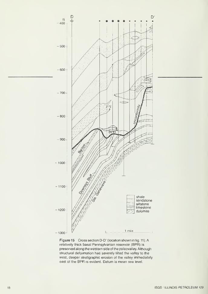
Figure 15 Cross section D-D' (location shown in fig. 11 ). Arelatively thick basal Pennsylvanian reservoir (BPR) is
preserved along the western side of the paleovalley. Although
structural deformation has severely tilted the valley to the
west, deeper stratigraphic erosion of the valley immediately
east of the BPR is evident. Datum is mean sea level.
18 ISGS ILLINOIS PETROLEUM 129
-500
600 1
700
-800
-900
1000
Figure 16 Cross section E-E' (location shown in fig. 11) is a longitudinal section along the paleovalley showing the
changing thickness of the basal Pennsylvanian reservoir (BPR) across the Hardinville Anticline. Note that the BPRinterfingers with shales on the extreme southwestern flank of the structure. Datum is mean sea level.
HYDROCARBON ACCUMULATION IN UNCONFORMITY PALEOVALLEY 19
EVOLUTION OF THE BASALPENNSYLVANIAN RESERVOIR
Development and infilling of paleovalleys
During late Chesterian (latest Mississippian) time the sea that
had covered most of Illinois, southwestern Indiana, and
western Kentucky began to recede to the south and
southwest. The ancient Michigan River System (Swann,
1963) advanced southwestward across the expanding
flatlands (Pryor and Sable, 1974). As base level continued to
drop, high flow rates and episodic catastrophic flooding
incised an anastomosing drainage pattern on the emergent
coastal plain (Howard, 1979a, b). .n the study area, incision
of the bifurcating valley (fig. 17a, b) was enhanced by slow
uplift of the La Salle Anticlinal Belt, which had already begun
by early Mississippian time (Atherton and Palmer, 1979;
Clegg, 1965; Craig and Varnes, 1979). The prevalence of
Mississippian slump blocks along steep-walled valleys
(Bristol and Howard, 1974) suggests that the Mississippian
strata were already at least partly lithified when incision
occurred.
During early Pennsylvanian time the returning sea
inundated the valleys progressively from south to north. As
the encroaching Pennsylvanian sea entered the valley at
Hardinville, gravelly sand bars were deposited along the
valley floor. Final scouring occurred along the eastern,
downdip portion of the valley floor (fig. 17c), leaving a
3-mile-long conglomeratic sandstone body 1/4- to 1/2-mile
wide, ranging up to 45 feet thick along the western part of
the valley (figs. 8 and 9) . Where marine shale was deposited
over the bar, a potential stratigraphic trap was created. Whereshale did not adequately seal a bar, as in the western valley
of the study area (figs. 8, 9, and 14), no trap existed.
This interpretation is consistent with the results of an
excellent sedimentological study by Pryor and Potter (1979),
which contains abundant outcrop and subsurface data to
substantiate the erosional and depositional history of a similar
sub-Pennsylvanian paleovalley at the southeastern end of
the Illinois Basin— the Brownsville Paleovalley in Edmonsonand Hart Counties, Kentucky. Modern anastomosing river
valleys in Alberta that were filled with coarse sediment during
post-Pleistocene alluviation (Smith and Smith, 1980) also
appear in some respects to be genetically analogous to the
one that deposited the BPR.
The lack of adequate core data in the study area precludes
a thorough understanding of the geometry of these basal
Pennsylvanian sandstone lenses, but in the preceding core
study of the #1 -A Richart Heirs several fining-upward cycles
were noted. Apparent clay drape separates some of these
cycles locally, and can be observed in several wireline logs
(e.g., fig. 7) and in the #1 -A Richart Heirs core at about 1,237
feet. When the clay layers are thick enough to deter
communication between otherwise vertically contiguous sand
lenses, a compartmentalization of the reservoir may result
that could influence oil recovery.
An important change in reservoir character is apparent in
Section 36, where the upper portion of the BPR contains a
sizable component of siltstone and shale along its eastern
side (figs. 8, 9, and 16). Resultant reduction in reservoir quality
there could have significantly limited hydrocarbon production.
A detailed investigation of numerous cores and logs,
however, would be required to predict reservoir heterogeneity
in the BPR and in similar reservoirs within the Illinois Basin.
Ideal well spacing and development practices could be
developed from such an investigation, which would ensure
that all the isolated sand lenses, or compartments, were
subject to drainage by producing wells.
Oil migration into Pennsylvanian reservoirs
Studies in progress at the Illinois State Geological Survey
suggest that Pennsylvanian shales and probably Mississip-
pian shales as well were too immature to have generated
hydrocarbons. It is apparent that most, if not all, hydrocarbons
in Pennsylvanian reservoirs were generated from the
Devonian-Mississippian New Albany Shale and migrated into
the Pennsylvanian rocks after passing through Mississippian
strata (Barrows and Guff, 1984). Paleovalleys that have
transected known hydrocarbon-bearing Mississippian units
would facilitate such migration.
Hydrocarbon migration into the basal Pennsylvanian
reservoir in the study area was probably not greatly affected
by reservoir heterogeneity. As oil and gas migrated into the
BPR, a gas cap began to form in the highest structural
positions. The fact that the gas was unable to escape is a
testament to the effectiveness of the overlying Pennsylvanian
shales as a seal. The gas cap continued to grow until it
encompassed enough of the highest portions of the BPR to
act as a barrier to further oil migration between the southern
20 ISGS ILLINOIS PETROLEUM 129
LATE MISSISSIPPIANRivers flow across low-relief plains. Anastomosing pattern develops because of high flow rates and
periodic flooding.
LATEST MISSISSIPPIANSlow uplift of the anticline enhances incision of rivers.
EARLY PENNSYLVANIANContinued incision of valleys across uplifting dome. Gravelly sand bars are deposited along paleovalleys
at end of each period of high flow. Gravel and sand are carried away by continuing stream flow along
lower side of valley.
Figure 17 Evolution of paleovalleys at the Mississippian-Pennsylvanian unconformity and subsequent sand bar
deposition across Hardinville Anticline during early Pennsylvanian time.
HYDROCARBON ACCUMULATION IN UNCONFORMITY PALEOVALLEY 21
and northern portions (fig. 16). Since the oil-water contact is
lower in the southern portion of the BPR than in the northern
portion, it is likely that the pathway for hydrocarbon migration
into basal Pennsylvanian rocks was from the south. As
migration continued, the southern part of the BPR filled with
oil, but the gas cap prevented oil from spilling over into the
northern part.
POTENTIAL EXPLORATION METHODS
The primary consideration in most hydrocarbon exploration
and development within the Illinois Basin has been relative
structural position of the presumed reservoir. There is high
potential, however, for discovering stratigraphic traps
associated with paleovalleys at the Mississippian-Pennsyl-
vanian unconformity that are not dependent upon structural
closure.
Basal Pennsylvanian fluvial sand bars deposited along the
floors of unconformity paleovalleys that were subsequently
filled with marine shales offer excellent potential for the
development of stratigraphic traps. These traps would not be
limited to locations on the crests of anticlinal structures, but
rather should be scattered along the courses of paleovalleys.
This is not to say, however, that the structural history of a
potential reservoir may not have significance. In fact, the
geology of the hydrocarbon reservoir within the paleovalley
at Hardinville reveals that contemporaneous structural
movement may have had an effect on depositional patterns
of sand bars along the valley. For example, the rising apex
of the Hardinville Anticline (figs. 4 and 5) apparently deflected
final stream flow in the paleovalley downdip against the
southeast bank, where it scoured any pre-existing sand
accumulation prior to marine shale deposition (figs. 8, 9, and
17c). This distribution of clastic units further reveals that
exploration for basal sand bars should not be limited to the
thalwegs of these paleovalleys.
In addition to basal Pennsylvanian fluvial sandstones, other
potential reservoirs and traps are associated with paleovalley
systems (fig. 18). If filled with shale, a paleovalley itself could
seal transected Mississippian reservoir rock. Additionally,
compaction over a relatively deep paleovalley may have
influenced the geometry of later drainage and depositional
patterns, locally resulting in "stacked sandstones" that caused
compaction anticlines in younger Pennsylvanian strata.
Mapping of unconformity from subsurface data
A regional paleogeologic map of the sub-Pennsylvanian
Chesterian surface in the Illinois Basin has revealed a network
of anastomosing valleys (Bristol and Howard, 1971 ). This kind
of map makes it possible to predict areas within the basin
that are most likely to contain paleovalleys and associated
sandstone reservoirs.
The most common method of defining and mapping a
paleovalley is to interpret logs from boreholes that penetrate
the Mississippian-Pennsylvanian unconformity. The absenceof significant limestone within the lower part of the Pennsyl-
vanian helps to differentiate those strata from adjacent
Mississippian rocks. Since Pennsylvanian valley-fill
sediments bear only an erosional relationship to adjacent
Mississippian strata (fig. 6), stratigraphic positions of
sandstones and shales, when compared to that of adjacent
strata, may reveal a paleovalley.
It is commonly difficult to determine the exact position of
the Mississippian-Pennsylvanian unconformity from log
analysis alone, and is therefore advisable and sometimes
necessary to examine well cuttings or cores. For example,
basal Pennsylvanian sandstones, particularly in paleovalleys,
tend to be much coarser than Mississippian sandstones, and
commonly contain clasts of Mississippian strata.
Mapping coals to indicate unconformity paleovalleys
Compaction of Pennsylvanian shales in an unconformity
paleovalley may cause subsidence of overlying strata. In the
study area this subsidence is reflected in the structure mapof the Colchester (No. 2) Coal Member (fig. 10), which showsa subtle syncline above the buried paleovalley.
Elsewhere in the basin, however, narrow, linear compaction
anticlines rather than synclines mirror the courses of
paleovalleys in strata high above the unconformity. These
anticlines, which themselves commonly contain hydrocarbon
traps (J. D. Turner, personal communication), have resulted
from shale compaction around "stacked sandstones" deposited
in low-relief valleys that had persisted through time directly
above paleovalleys at the unconformity surface (fig. 18).
Seismic mapping
Seismic data have been used with varying degrees of success
to identify and map paleovalleys in other basins. The accuracy
of these data depends largely on their quality and the amount
of contrast between the sedimentary rocks in the paleovalley
and the strata surrounding them. For example, a valley filled
with shale surrounded by dense, relatively tight limestone or
sandstone may show a characteristic anomaly on good
quality seismic data. Seismic studies could probably not
delineate the entire course of paleovalley, however, because
some lithologies occurring in and along the paleovalley maynot provide adequate impedance contrast to produce good
seismic reflection. Trends can be mapped, however, which
should enhance exploration.
Relatively inexpensive computer modeling of seismic
responses to anticipated paleovalley and surrounding
lithologies is advisable for improving seismic exploration. The
most accurate parameters for shooting and processing
seismic data in a given area can be determined from these
models and, when combined with field testing, can enhance
the effectiveness of seismic program.
CONCLUSION
The play concept that has guided most hydrocarbon
exploration and development in the Illinois Basin has been
the anticlinal theory of petroleum accumulation. Significant
reserves, however, remain to be discovered in a variety of
subtle traps within the Illinois Basin. Those traps associated
with paleovalleys at the Mississippian-Pennsylvanian
unconformity could prove to be important targets for future
oil and gas exploration.
Development of play models based on studies of paleo-
geomorphic stratigraphic traps such as the one at Hardinville
and the use of state-of-the-art exploration methods will aid
future hydrocarbon exploration in the Illinois Basin.
22 ISGS ILLINOIS PETROLEUM 129
1 Basal Pennsylvanian fluvial sandbar deposited on floor of paleovalley. Note compactionsyncline in overlying coal bed.
2 Pre-Pennsylvanian reservoir truncated by impermeable shale infilling paleovalley.
3 Anticline resulting from compaction of shales around stacked sandstones depositedwithin and above the paleovalley.
Figure 18 Diagrammatic portrayal of the kinds of stratigraphic traps associated with paleovalleys and their sedimentary fill.
HYDROCARBON ACCUMULATION IN UNCONFORMITY PALEOVALLEY 23
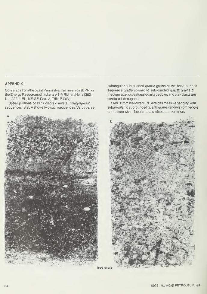
APPENDIX 1
Core slabs from the basal Pennsylvanian reservoir (BPR) in
the Energy Resources of Indiana #1 -A Richart Heirs (380 ft
NL, 330 ft EL, NE SE Sec. 2, T5N-R13W).
Upper portions of BPR display several fining-upward
sequences. SlabA shows two such sequences. Very coarse,
'. «M
subangular-subrounded quartz grains at the base of each
sequence grade upward to subrounded quartz grains of
medium size, occasional quartz pebbles and clay clasts are
scattered throughout.
Slab B from the lower BPR exhibits massive bedding with
subangular to subrounded quartz grains ranging from pebble
to medium size. Tabular shale chips are common.
"
true scale
7. M
24 ISGS ILLINOIS PETROLEUM 129
APPENDIX 2
Core slabs from Chesterian strata just below the
Mississippian-Pennsylvanian unconformity in the Energy
Resources of Indiana #1-A Richart Heirs (380 ft NL,
330 ft EL, NE SE Sec. 2.T5N-R13W). Wavy bedding appears
throughout the shaly siltstone in slab C; black areas are pyrite
nodules. Crossbedded, very fine-grained sandstone in slab
D characterizes the Sample Sandstone Member.
>*-
true scale • .->
HYDROCARBON ACCUMULATION IN UNCONFORMITY PALEOVALLEY 25
REFERENCES
Atherton, E.,and J. E. Palmer, 1979,TheMississippianand
Pennsylvanian (Carboniferous) Systems in the United
States— Illinois, in the Mississippian and Pennsylvanian
(Carboniferous) Systems in the United States, U.S.
Geological Survey Professional Paper 1110, p. L19.
Barrows, M. H., and R. M. Cluff, 1984, New Albany Shale
Group (Devonian-Mississippian) source rocks and
hydrocarbon generation in the Illinois Basin, in G. R.
Demaison and R. J. Murris [eds.] Petroleum
Geochemistry and Basin Evaluation: American
Association of Petroleum Geologists Memoir 35, p.
111-138.
Bristol, H. M., and R. H. Howard, 1971, Paleogeologic map of
the sub-Pennsylvanian Chesterian (Upper
Mississippian) surface in the Illinois Basin: Illinois State
Geological Survey Circular 458, in cooperation with
Indiana Geological Survey and Kentucky Geological
Survey, 14 p.
Bristol, H. M., and R. H. Howard, 1974, Sub-Pennsylvanian
valleys in the Chesterian surface of the Illinois Basin and
related Chesterian slump blocks, in G. Briggs [ed.],
Carboniferous of the southeastern United States:
Geological Society of America Special Paper 148, p,
315-335.
Clegg, K. E., 1965, The La Salle Anticlinal Belt and adjacent
structures in east-central Illinois: Illinois State Academyof Science, v. 58, no. 2, p. 82-94.
Craig, L. C, and K. L. Varnes, 1979, History of the
Mississippian System — an interpretive summary, in
L. C. Craig, C. W. Connor, et al. [eds.], Paleotectonic
investigations of the Mississippian System in the United
States: U.S. Geological Survey Professional Paper 1010,
p. 377.
Davis, R. W., R. O. Plebuch, and H. M. Whitman, 1974,
Hydrology and geology of deep sandstone aquifers of
Pennsylvanian age in part of the western coal field
region, Kentucky: Kentucky Geological Survey Series X,
Report of Investigations 15, 26 p.
Howard, R. H., 1979a, The Mississippian-Pennsylvanian
unconformity in the Illinois Basin— old and new thinking,
in J. E. Palmer and R. R. Dutcher [eds.], Depositional
and structural history of the Pennsylvanian System of
the Illinois Basin, Guidebook for field trip 9, Part 2, Ninth
International Congress on Carboniferous Stratigraphy
and Geology: Illinois State Geological Survey, p. 34-43.
Howard, R. H., 1979b, Carboniferous cyclicity related to the
development of the Mississippian-Pennsylvanian
unconformity in the Illinois Basin, in Eighth International
Congress on Carboniferous Stratigraphy and Geology,
v. 5, p. 32-41.
Howard, R. H., 1980, Sub-Pennsylvanian valleys in the
Chesterian surface of the Illinois Basin and related
Kentucky oil production, in Proceedings of Kentucky Oil
and Gas Association, annual meetings, 1972 and 1973:
Kentucky Geological Survey Series XI, Special
Publication 2, p. 55-71.
Huff, B. G., 1987, Petroleum industry in Illinois, 1985:
Illinois State Geological Survey, Illinois Petroleum 128,
140 p.
Pryor, W. A., and P. E. Potter, 1979, Sedimentology of a
paleovalley fill: Pennsylvanian Kyrock Sandstone in
Edmonson and Hart Counties, Kentucky : in J. E. Palmer
and R. R. Dutcher [eds.], Depositional and structural
history of the Pennsylvanian System of the Illinois Basin,
Guidebook for field trip no. 9, Part 2, Ninth International
Congress on Carboniferous Stratigraphy and Geology:
Illinois State Geological Survey, p. 49-62.
Pryor, W. A., and E. G. Sable, 1974, Carboniferous of the
Eastern Interior Region, in G. Briggs [ed.], Carboniferous
of the southeastern United States: Geological Society of
America Special Paper 148, p. 281-313.
Shiarella, N. W., 1933, Typical oil producing structures in the
Owensboro field of western Kentucky: Kentucky Bureau
of Mineral and Topographic Survey, Series 7, Bulletin 3,
14 p.
Siever, R., 1951, The Mississippian-Pennsylvanian unconfor-
mity in southern Illinois: American Association of
Petroleum Geologists Bulletin, v. 35, no. 3, p. 542-581
:
Illinois State Geological Survey Report of Investigations
152, 40 p.
Smith, D. G., and N. D. Smith, 1980, Sedimentation in anas-
tomosed river systems: examples from alluvial valleys
near Banff, Alberta: Journal of Sedimentary Petrology,
v. 50, no. 1, p. 157-164.
Swann, D. H., 1963, Classification of Genevievian and
Chesterian (late Mississippian) rocks of Illinois: Illinois
State Geological Survey Report of Investigations 216,
91 p.
Swann, D. H., and A. H. Bell, 1958, Habitat of oil in the Illinois