Hydrofracturing in response to the development of an overpressurised subglacial meltwater system during drumlin formation: an example from Anglesey, NW Wales Emrys Phillips a, *, Leanne Hughes b a British Geological Survey, Murchison House, West Mains Road, Edinburgh EH9 3LA, UK b British Geological Survey, Keyworth, Nottingham NG12 5GG, UK 1. Introduction During the Late Devensian (Weichselian), Anglesey (Fig. 1a) was located close to the eastern margin of the Irish Sea Ice Stream (Thomas and Chiverrell, 2007; Phillips et al., 2010b). This corridor of relatively faster moving ice, sourced in central and southwest Scotland, flowed southwest through the Irish Sea Basin (Merritt and Auton, 2000; Evans and O ´ Cofaigh, 2003; Roberts et al., 2007) where it met, coalesced with and ultimately decoupled from ice emanating from several ice caps surrounding the Irish Sea, including the Welsh Ice Sheet centred on Snowdonia (McCarroll, 2005; Thomas and Chiverrell, 2007). The Irish Sea Ice Stream is one of a number of ice streams that helped regulate the size and shape of the British and Irish Ice Sheet, and at its maximum extent, reached the Isles of Scilly (Scourse, 1991a,b; Hiemstra et al., 2006; Thomas and Chiverrell, 2007; Phillips et al., 2010b; Clark et al., 2012) (Fig. 1). The relatively faster flow of ice within ice streams, such as the Irish Sea Ice Stream, is thought to be largely controlled by conditions at the bed of these ice masses (e.g. Clark and Stokes, 2001; Bennett, 2003; Bamber et al., 2003; Benn and Evans, 2010). The introduction of pressurised meltwater into the bed of a glacier or ice sheet is widely regarded as leading to either enhanced sliding of the ice over areas of bedrock (hard bed), or the weakening and enhanced deformation of the unconsolidated sediments (soft bed) which may underlie the ice stream (Benn and Evans, 2010 and references therein). Hydrofractures, also referred to as water- escape features or clastic dykes, provide clear evidence for the movement of pressurised meltwater through subglacial to ice- marginal environments (Dionne and Shilts, 1974; Christiansen et al., 1982; von Brunn and Talbot, 1986; Burbridge et al., 1988; Dreimanis, 1992; Larsen and Mangerud, 1992; McCabe and Dardis, Proceedings of the Geologists’ Association 125 (2014) 296–311 A R T I C L E I N F O Article history: Received 6 September 2013 Received in revised form 25 March 2014 Accepted 26 March 2014 Available online 25 June 2014 Keywords: Hydrofractures Overpressurised meltwater Drumlin formation Micromorphology Irish Sea Ice Stream A B S T R A C T This paper presents the results of a detailed study of a complex hydrofracture system and host diamictons exposed within a longitudinal section through an elongate drumlin located to the west of Cemlyn Bay, Anglesey, NW Wales. This complex, laterally extensive sand, silt and clay filled hydrofracture system was active over a prolonged period and is thought to have developed beneath the Late Devensian (Weichselian) Irish Sea Ice Stream as it overrode this part of NW Anglesey. The sediment-fill to the hydrofracture system is deformed with kinematic indicators (folds, thrusts, augen) recording a SW-directed sense of shear, consistent with the regional ice flow direction across this part of the island. The lack of any geomorphological evidence for active retreat of the Irish Sea ice across Anglesey has led to the conclusion that hydrofracturing at the Cemlyn Bay site occurred within the bed of the Irish Sea Ice Stream whilst this relatively faster flowing corridor of ice was actively overriding the island. Shear imposed by the overriding ice led to the development of a subglacial shear zone which facilitated the propagation of the hydrofracture system with the laterally extensive feeder sills occurring parallel to Y-type Riedel shears. Although a subglacial setting beneath the active Irish Sea Ice Stream can be argued for the Cemlyn Bay hydrofracture system, its relationship to the formation of the ‘host’ drumlin remains uncertain. However, evidence presented here suggests that hydrofracturing may have occurred during the later stages or post landform development in response to the migration of overpressurised meltwater within the bed of the Irish Sea ice; possibly accompanying the local thinning and shutdown of the Irish Sea Ice Stream on Anglesey. ß 2014 Natural Environment Research Council. Published by Elsevier Ltd on behalf of The Geologists’ Association. All rights reserved. * Corresponding author. Tel.: +44 131 667 1000; fax: +44 131 668 2683. E-mail address: [email protected](E. Phillips). Contents lists available at ScienceDirect Proceedings of the Geologists’ Association jo ur n al ho m ep ag e: www .els evier .c om /lo cat e/p g eo la http://dx.doi.org/10.1016/j.pgeola.2014.03.004 0016-7878/ß 2014 Natural Environment Research Council. Published by Elsevier Ltd on behalf of The Geologists’ Association. All rights reserved.
Transcript
Proceedings of the Geologists’ Association 125 (2014) 296–311
Hydrofracturing in response to the development of an overpressurisedsubglacial meltwater system during drumlin formation: an examplefrom Anglesey, NW Wales
Emrys Phillips a,*, Leanne Hughes b
a British Geological Survey, Murchison House, West Mains Road, Edinburgh EH9 3LA, UKb British Geological Survey, Keyworth, Nottingham NG12 5GG, UK
A R T I C L E I N F O
Article history:
Received 6 September 2013
Received in revised form 25 March 2014
Accepted 26 March 2014
Available online 25 June 2014
Keywords:
Hydrofractures
Overpressurised meltwater
Drumlin formation
Micromorphology
Irish Sea Ice Stream
A B S T R A C T
This paper presents the results of a detailed study of a complex hydrofracture system and host
diamictons exposed within a longitudinal section through an elongate drumlin located to the west of
Cemlyn Bay, Anglesey, NW Wales. This complex, laterally extensive sand, silt and clay filled
hydrofracture system was active over a prolonged period and is thought to have developed beneath
the Late Devensian (Weichselian) Irish Sea Ice Stream as it overrode this part of NW Anglesey. The
sediment-fill to the hydrofracture system is deformed with kinematic indicators (folds, thrusts, augen)
recording a SW-directed sense of shear, consistent with the regional ice flow direction across this part of
the island. The lack of any geomorphological evidence for active retreat of the Irish Sea ice across
Anglesey has led to the conclusion that hydrofracturing at the Cemlyn Bay site occurred within the bed of
the Irish Sea Ice Stream whilst this relatively faster flowing corridor of ice was actively overriding the
island. Shear imposed by the overriding ice led to the development of a subglacial shear zone which
facilitated the propagation of the hydrofracture system with the laterally extensive feeder sills occurring
parallel to Y-type Riedel shears. Although a subglacial setting beneath the active Irish Sea Ice Stream can
be argued for the Cemlyn Bay hydrofracture system, its relationship to the formation of the ‘host’
drumlin remains uncertain. However, evidence presented here suggests that hydrofracturing may have
occurred during the later stages or post landform development in response to the migration of
overpressurised meltwater within the bed of the Irish Sea ice; possibly accompanying the local thinning
and shutdown of the Irish Sea Ice Stream on Anglesey.
� 2014 Natural Environment Research Council. Published by Elsevier Ltd on behalf of The Geologists’
Association. All rights reserved.
Contents lists available at ScienceDirect
Proceedings of the Geologists’ Association
jo ur n al ho m ep ag e: www .e ls evier . c om / lo cat e/p g eo la
1. Introduction
During the Late Devensian (Weichselian), Anglesey (Fig. 1a) waslocated close to the eastern margin of the Irish Sea Ice Stream(Thomas and Chiverrell, 2007; Phillips et al., 2010b). This corridorof relatively faster moving ice, sourced in central and southwestScotland, flowed southwest through the Irish Sea Basin (Merrittand Auton, 2000; Evans and O Cofaigh, 2003; Roberts et al., 2007)where it met, coalesced with and ultimately decoupled from iceemanating from several ice caps surrounding the Irish Sea,including the Welsh Ice Sheet centred on Snowdonia (McCarroll,2005; Thomas and Chiverrell, 2007). The Irish Sea Ice Stream is oneof a number of ice streams that helped regulate the size and shapeof the British and Irish Ice Sheet, and at its maximum extent,
0016-7878/� 2014 Natural Environment Research Council. Published by Elsevier Ltd o
reached the Isles of Scilly (Scourse, 1991a,b; Hiemstra et al., 2006;Thomas and Chiverrell, 2007; Phillips et al., 2010b; Clark et al.,2012) (Fig. 1).
The relatively faster flow of ice within ice streams, such as theIrish Sea Ice Stream, is thought to be largely controlled byconditions at the bed of these ice masses (e.g. Clark and Stokes,2001; Bennett, 2003; Bamber et al., 2003; Benn and Evans, 2010).The introduction of pressurised meltwater into the bed of a glacieror ice sheet is widely regarded as leading to either enhanced slidingof the ice over areas of bedrock (hard bed), or the weakening andenhanced deformation of the unconsolidated sediments (soft bed)which may underlie the ice stream (Benn and Evans, 2010 andreferences therein). Hydrofractures, also referred to as water-escape features or clastic dykes, provide clear evidence for themovement of pressurised meltwater through subglacial to ice-marginal environments (Dionne and Shilts, 1974; Christiansenet al., 1982; von Brunn and Talbot, 1986; Burbridge et al., 1988;Dreimanis, 1992; Larsen and Mangerud, 1992; McCabe and Dardis,
n behalf of The Geologists’ Association. All rights reserved.
Fig. 1. (a) Map of the British Iles showing location of Anglesey, NW Wales and the approximate limit of the British and Irish Ice Sheet. Also shown is the proposed maximum
extend of Irish Sea Ice Stream; (b) map of Anglesey showing the location of the study area and extend of the three landform assemblage zones (Thomas and Chiverrell, 2007;
Phillips et al., 2010a,b); (c) simplified superficial map of the Cemlyn Bay area of NW Anglesey showing the distribution of the main glacigenic sedimentary units and
landforms; (d) elongate drumlin developed on the southern side of the Cemlyn Nature Reserve (note presence of an undulating crest line to the drumlin); and (e)
photomontage of the exposed section through an elongate, NE–SW-trending drumlin located to the west of Cemlyn Bay (see (c)).
E. Phillips, L. Hughes / Proceedings of the Geologists’ Association 125 (2014) 296–311 297
1994; Dreimanis and Rappol, 1997; van der Meer et al., 1999, 2008;Rijsdijk et al., 1999; Le Heron and Etienne, 2005; Boulton, 2006;Gozdzik and van Loon, 2007; Phillips and Merritt, 2008; Phillipset al., 2012a). They record marked changes in hydrostatic pressurewithin the subglacial hydrogeological system which led to brittlefracturing of the pre-existing sediment and/or bedrock, andpenecontemporaneous liquefaction and introduction of a sedi-ment-fill (see van der Meer et al., 2008; Phillips et al., 2013 andreferences therein). Due to the pressurised nature of themeltwater, the sediment infill can be introduced from structurallyabove (downward injection) or below (upward injection) thedeveloping hydrofracture system (Dreimanis, 1992; Rijsdijk et al.,1999; Le Heron and Etienne, 2005; Gozdzik and van Loon, 2007;van der Meer et al., 2008). The introduction of pressurisedmeltwater beneath glaciers and ice sheets can have a profoundeffect on deformation beneath the ice not only leading to increasedforward motion, but also the development of water-lubricateddetachments within the sediment pile (e.g. Phillips et al., 2002;Kjær et al., 2006; Benediktsson et al., 2008), or the detachment andtransport of sediment and/or bedrock rafts (e.g. Moran et al., 1980;Broster, 1991; Broster and Seaman, 1991; Benn and Evans, 2010;Phillips and Merritt, 2008; Burke et al., 2009; Vaughan-Hirschet al., 2013).
This paper presents the results of a detailed study of alaterally extensive sediment-filled fracture system, interpreted
as a hydrofracture system, cutting the glacigenic sedimentsexposed in within a drumlin located to the west of Cemlyn Bayin northern Anglesey, NW Wales (Fig. 1). The glacigenic sedimentsand landforms preserved within this part of NW Anglesey weredeveloped when the island was overridden by the Irish Sea IceStream and, therefore, provide valuable insights into the condi-tions encountered beneath this ice stream. Field sedimentologicaland structural evidence are combined with micromorphologicalanalysis to demonstrate that hydrofracturing probably occurredduring the later stages of drumlin formation in response to therepeated introduction of overpressurised meltwater into the bedof the Irish Sea ice. Kinematic evidence (folds, shears, faults)preserved within deformed sediments filling the hydrofracture isused to demonstrate that fracture propagation was facilitated byshear imposed by the overriding ice. The results of this study areused to place the development of this hydrofracture system withinthe broader context of the overall evolution of the Irish Sea IceStream as it overrode Anglesey.
2. Quaternary geology of the study area
The glacial geomorphology and sedimentary succession pre-served on Anglesey has largely been interpreted as providing arecord of the processes that occurred beneath the Irish Sea IceStream. Thomas and Chiverrell (2007) and Phillips et al. (2010b)
E. Phillips, L. Hughes / Proceedings of the Geologists’ Association 125 (2014) 296–311298
divided this sequence into three sediment-landform assemblagezones (Fig. 1b):
� Zone 1 – an extensive subglacial depositional assemblagecovering much of northern and western Anglesey, and dominat-ed by an extensive drumlin field (Greenly, 1919). The drumlinsvary from being mainly composed of diamicton, through tobedrock dominated features encased in a relatively thin carapaceof this diamicton;� Zone 2 – a subglacial erosional assemblage of NE–SW-trending
ice-moulded bedrock ridges forming an elongate tract across thecentral part of the island;� Zone 3 – an undifferentiated subglacial erosional and deposi-
tional assemblage of elongate bedrock ridges, solitary drumli-noid landforms, bedrock channels and proglacial outwash (Helmand Roberts, 1984) and subglacial (esker) deposits that cover theremainder of the island.
Geomorphological mapping of part of the offshore area to thenorth of Anglesey (van Landeghem et al., 2009) has shown that acomparable suite of glacigenic landforms occurs beneath this partof the Irish Sea. Phillips et al. (2010b) demonstrated that changes inthe morphology, orientation and distribution of the subglaciallandforms on Anglesey closely match the underlying bedrock,concluding that bedrock geology potentially played an importantrole in controlling the relative velocity of the overriding IrishSea ice.
The present study focuses on a laterally extensive sediment-filled fracture system cutting a sequence of weakly stratifieddiamictons exposed in a longitudinal section through an elongatedrumlin located immediately to the west of Cemlyn Bay on the NWcoast of Anglesey (National Grid Reference SH 327 936) (Fig. 1). Thestudy area occurs well within sediment-landform assemblage zone1 (Fig. 1b) with the drumlins in this area forming part of thewestern Anglesey drumlin field first identified by Greenly (1919).The geology of this part of NW Anglesey (Fig. 1c) is dominated by alocally developed layer of diamicton (up to c 10–15 m thick)overlying the highly deformed and metamorphosed bedrock of theCambrian in age Monian Supergroup (Greenly, 1919; Shackleton,1975; Phillips, 1989, 1991a,b; Collins and Buchan, 2004; Howells,2007). Small areas of glacial sands and gravels have been identifiedwithin the larger, subglacial meltwater channels which are cut intothe bedrock exposed between Hen-dy (SH 304 914) and CarmelHead (SH 298 930), and locally within the lower ground betweenthe drumlins (Fig. 1c). The drumlins range in size and typicallyform low-lying elongate features with a prominent crest line. Theyare often single isolated landforms with a long profile of up to akilometre, but more complex features with marked, undulatingcrest lines have also been identified (Fig. 1d). The NE–SW-trendinglong axes of these subglacial landforms and glacial striae identifiedon glacially smoothed bedrock surfaces in the western part of thestudy area (Fig. 1c) record an overall SW-directed ice movementacross this part of NW Anglesey, consistent with their formationbeneath the Irish Sea Ice Stream as it overrode the island.
3. Methodology
The study focuses on a NE–SW-trending cliff section (15–20 mhigh, 300 m long) at the Cemlyn Bay site (SH 327 936) is orientatedparallel to the principal ice flow direction across the island (Fig. 1cand e). Prior to sampling the sediment-filled fracture system, theglacial sediments exposed within the core of the drumlin werelogged and described based on their sedimentological, lithologicaland structural characteristics using the standard methodologiesoutlined in Evans and Benn (2004). A sequence of photographswere taken of key parts of the cliff section enabling the detailed
analysis of the small- and meso-scale structures developed withinthe fracture system and host diamictons and underlying schistosemetasedimentary bedrock (Figs. 1e and 2–4). The orientations ofthe fracture system, lamination within the sediment-fill anddeformation structures (folds, foliations, joints) were measuredusing a compass clinometer. A total of five intact block samples(E75038 to E75042; Fig. 2) of the sediment-fill and adjacentdiamicton were taken using 10 cm cubed, aluminium Kubiena tins.The tins were gently cut into the face in order to limit sampledisturbance. The geographical position, orientation relative tomagnetic north, depth and way-up of the sample were marked onthe outside of the tin during collection. The samples were collectedat different locations along the lowest, and laterally most extensivesediment-filled fracture (Fig. 2) to provide detailed information onits internal architecture and the range of structures developed atvarious points within this sand- and silt-filled feature. A sequenceof photographs were then taken of the Kubiena tins embedded inthe face to provide a visual record of the location and context of theindividual samples within the fracture system. Each sample wasthen removed from the face, sealed in two plastic bags, and storedin a cold store to prevent the material from drying out prior tosample preparation.
Sample preparation (total time c. 10 months) involved theinitial replacement of pore-water by acetone, which was thenprogressively replaced by a resin and allowed to cure. Large formatorientated thin sections were taken from the centre of each of theprepared samples, thus avoiding artefacts associated with samplecollection. Each thin section was cut orthogonal to the hydro-fracture/vein margin evident from the field investigation. The thinsections were examined using a standard Zeiss petrologicalmicroscope and Zeiss projector, the latter allowing detailed studyof the range of microstructures at very low magnification. Themicrostructural mapping technique used to analyses the thinsections is described by Phillips et al. (2010a). The terminologyused to describe the various microtextures developed within thesesediments in general follows that proposed by van der Meer (1987,1993, 1996) and Menzies (2000).
4. Macro-scale description and interpretation
The longitudinal section through an elongate drumlin to thewest of Cemlyn Bay shows that it is composed of a 10–15 m thicksequence of weakly stratified diamictons which are cut by anumber of sediment-filled fractures (Figs. 1e and 2). The sequenceof stratified diamictons is underlain by polydeformed metasedi-mentary (greenschist to sub-greenschist facies) rocks belonging tothe New Harbour Group (Greenly, 1919; Maltman, 1977; Phillips,1989, 1991a,b), which are exposed on the foreshore. The boundarybetween the bedrock and the glacial sediments was not exposed,but can be located to within 50 cm of the top of the beach at thenorthern end of the section. The pale to dark green, chlorite–quartz–schists possess a well-developed schistosity which dips ata low to moderate angle towards the N/NW. This bedrock fabricoverprints bedding within these metamudstones and metasand-stones and is itself deformed by several phases of asymmetrical,SE-verging folds and associated axial planar cleavages (Maltman,1977; Phillips, 1991b).
The glacial sequence can be subdivided into two main units(Fig. 2); a lower bedrock-rich, clast- to matrix-supported, darkblue-grey to green-grey diamicton (1–2.5 m thick) composed ofangular to subrounded pebble to occasionally boulder-sized clastsof locally derived schistose metasedimentary rocks derived fromthe New Harbour Group, overlain by a brown to orange-brown,typically matrix-supported, stratified sandy diamicton. Thestratification within this diamicton is highlighted by the presenceof cobble- to boulder-sized, clast-rich bands. The upper sandy
Fig. 2. Photomontage of the laterally extensive hydrofracture system exposed towards the base of the Cemlyn Bay drumlin section. Also shown are the locations of the five
samples taken for thin sectioning and micromorphological analysis, and lower hemisphere stereographic projections of dip and dip azimuth data obtained for the margin of
the hydrofracture and bedding/lamination developed within this complex system.
E. Phillips, L. Hughes / Proceedings of the Geologists’ Association 125 (2014) 296–311 299
diamicton comprises a mix of angular locally derived bedrockfragments and more rounded, far travelled clasts including granite,volcanic rocks, Carboniferous limestone and sandstone. This isconsistent with this diamicton having been deposited by the IrishSea ice, the so called Irish Sea Till (see Fig. 2). Both diamictons arehard and compact (overconsolidated) consistent with them havingbeen overridden by ice. A number of the larger clasts within thediamictons are faceted and striated (Fig. 3a) with the striaetrending towards 2208, consistent with the SW-directed flow of iceacross the area. Phillips et al. (2013) describe a bedrock-richdiamicton directly overlying brecciated New Harbour Groupbedrock in the area between Porth Penrhyn-mawr (SH 287 852)and Porth Tywyn-mawr (SH 286 837), to the south of the presentstudy area. These authors interpreted this diamicton as aperiglacial head deposit which was reworked by the overriding
Irish Sea Ice. It is possible that the lower bedrock-rich diamictonexposed in the Cemlyn Bay section is similarly a glacially reworked,pre-existing periglacial (head) deposit. Palynological data fromboth diamictons published by Phillips et al. (2013) demonstratethat the palynomorph assemblage is dominated by CarboniferousDensosporites spp. and Lycospora pusilla, as well as undifferentiatedQuaternary pollen grains, with the lower grey diamicton contain-ing Mesozoic (Classopollis) fauna (see Table 1 of Phillips et al.,2013). The presence of Carboniferous palynomorphs within thevery locally derived New Harbour Group-rich lower diamicton isconsistent with the incorporation of more ‘far travelled’ materialinto this reworked head deposit by the overriding Irish Sea ice.
In the lower part of the section through the Cemlyn Bay drumlinthe diamictons are cut by two essentially subhorizontal to gentlysouth-westerly dipping fractures which thin towards the SW and
Fig. 3. (a) Striated boulder within the lower grey diamicton which is rich in very locally derived schistose metasedimentary New Harbour Group rock fragments; (b) thinly
bedded sand, silt and clay filling a 15–20 cm wide hydrofracture; (c) sediment-filled hydrofracture cross-cutting a locally developed fine-scale stratification developed within
the lower grey diamicton; (d) diffuse clay-rich layers and stringers within sediment-filled hydrofracture; (e) veins of coarse sand to very fine gravel cross-cutting earlier
developed sand-rich fill within the hydrofracture system; and (f) striated cobble included within massive, to weakly laminated sediment-fill to hydrofracture.
E. Phillips, L. Hughes / Proceedings of the Geologists’ Association 125 (2014) 296–311300
are infilled by relatively hard, laminated, red-brown sand, silt andclay (Fig. 2). The margins of these sill-like features are typicallysharp and range from irregular to planar in form. These sediment-filled fractures are coplanar with the stratification in the hostdiamictons suggesting that they were emplaced along thislayering. The laterally more extensive of these fractures can betraced south-westwards for some 60–70 m and occurs entirelywithin the basal grey diamicton, approximately 20–30 cm belowthe contact with the overlying sandy Irish Sea Till (Fig. 2). At thenorthern end of the section (locations A and B in Fig. 2) this sill-likefracture is much wider (60–70 cm thick) and is composed ofmassive to thinly bedded, hard (compact), yellow-brown fine- tomedium-sand, silt and clay (Fig. 3b–e). This fracture thins towardsthe SW (i.e. in a down ice direction) where it is only 10–20 cmthick, eventually appearing to pinch out or terminate in the morepoorly exposed central part of the drumlin. The margins ofthe fracture clearly cross-cut a thin stratification present withinthe host grey diamicton (Fig. 3c) and locally dip at between 108 and258 towards the NE (i.e. up-ice; see rose diagram in Fig. 2). The
lamination within the sediment-fill is locally cross-cut by irregularveins of darker red-brown coarse sand to very fine gravel (Fig. 3e).A number of the sand and silt laminae possess a fine-grainedcarbonate cement. Thin, lenticular to irregular stringers of clayeydiamicton locally occur within the sediments filling the hydro-fracture. Striated cobbles have also been observed included withinthis sediment-fill (Fig. 3f).
In the central part of the section (see Fig. 2) the dip of beddingwithin the laminated sediment-fill is more variable ranging from28 to 208, towards the ENE, SE and SW (see rose diagrams in Fig. 2).This laminated sediment-fill is up to 30 cm thick and crudely zonedfrom silt-rich at the margins, becoming progressively sandier andmore thickly laminated with clay stringers towards the centre ofthe fracture. The margins of the fractures are typically sharp withthe lamination occurring parallel to the vein margins. Thislamination is variably deformed (folded, faulted) and is locallycross-cut by thin veinlets of sand. In the least deformed parts of thefracture system the lamination can be traced laterally for up to2–3 m. Although the sediments filling the fracture are deformed
‘dyke’ cutting lower, grey diamicton; and (d) sediment-filled hydrofracture ‘deflected’ around a large boulder of New Harbour Group schist included within the lower grey
diamicton.
E. Phillips, L. Hughes / Proceedings of the Geologists’ Association 125 (2014) 296–311 301
there is very little evidence of large scale deformation of thissystem. In the central part of the section the upper and lower sill-like fractures are linked by a number of irregular subvertical dyke-like sections composed of apparently massive sand to silty sand(Fig. 4a–c). Locally the lower of the two fractures appears to havebeen deflected around the larger boulders (Fig. 4d).
The sandy Irish Sea Till at the northern end of the section is cutby a number of more steeply inclined, southerly dipping sand andgravel-filled fractures which link into the main sill-like hydro-fractures. These steeply inclined structures cut across thelithological boundary between the grey and overlying sandydiamictons indicating that their formation post-dated the deposi-tion of at least the lower part of the of the sequence within thedrumlin. The overall geometry and style of sediment-fill within thefractures cutting the diamictons at Cemlyn Bay are comparable tosediment-filled hydrofracture systems described from otherformer and contemporary glacial environments (e.g. Larsen andMangerud, 1992; van der Meer et al., 1999, 2008; Rijsdijk et al.,1999; Le Heron and Etienne, 2005; Phillips et al., 2012a).Consequently the sill- and dyke-like sediment-filled fracturesexposed at Cemlyn Bay are interpreted as forming part of a laterallyextensive hydrofracture system injected into the lower part of thedrumlin.
5. Micromorphology
The five thin sections (E75038 to E75042; Figs. 5–9, respec-tively) obtained from different parts of the lower sill-likehydrofracture (see Fig. 2) were examined in detail allowing thepattern of sediment-fill and deformation associated with thedevelopment of this complex system to be established. For ease ofdescription the micromorphology of the host diamicton and sand-dominated sediment-fill are to be described separately.
5.1. Micromorphology of the host diamicton
Sample E75038 was taken across the lower boundary betweenthe hydrofracture and the underlying grey, bedrock-rich diamic-ton. In thin section the diamicton is a poorly-sorted, thinlystratified, matrix-rich pebbly silty sand which possesses an open-packed, matrix-supported texture (Fig. 5). Traces of a hematiticand/or clay coating were noted on some clasts (skeleton grains).
Fine- to coarse sand and small pebble-sized clasts are typicallyangular to subangular with a low-sphericity (see Fig. 5), indicativeof a relatively short period of transport. However, rare, subroundedto well-rounded sand grains were also noted and are possiblypolycyclic in origin indicating that these grains may have a longer
Fig. 5. Microstructural map and high resolution scan of thin section of Cemlyn sample 1 (BGS registration number E75038) (see text for details). The orientation of the long
axes of the fine sand to pebble sized clasts included within the diamicton are shown in the attached rose diagram. The sedimentary sequence present within the hydrofracture
is divided into a series ((a)–(f)) of massive to laminated, upward fining sequences showing that this hydrofracture system accommodated several phases of fluid flow.
E. Phillips, L. Hughes / Proceedings of the Geologists’ Association 125 (2014) 296–311302
and more complex sedimentary history. The larger clasts are mainlycomposed of rock fragments, including indurated feldspathic andquartzose sandstones (Siluro-Devonian and/or Carboniferous),micritic to microcrystalline limestone (Carboniferous), phylloniticto schistose metamudstone (New Harbour Group), wacke sand-stone, quartz-sericite rock, polycrystalline vein quartz, siltstone,very fine-grained sandstone, altered siliceous volcanic rock,calcareous sandstone and chert/siliceous cryptocrystalline rock.The finer sand and silt in the matrix is largely composed of mono-and polycrystalline quartz with minor carbonate, muscovite, opaqueminerals, chlorite, epidote and plagioclase. The heterolithic nature ofthe clast assemblage demonstrates that although macroscopicallythe diamicton is dominated by very locally derived angular tosubangular fragments of New Harbour Group rocks, it also contains asignificant proportion of more far travelled material.
The fine stratification within the diamicton is defined byelongate, irregular ribbons and patches of clay and silt, and occursparallel to the lower margin of the hydrofracture (Fig. 5). Internallythe clay-rich layers possess a moderately to well-developedplasmic fabric which is locally deformed by a very fine-scalecrenulation and narrow shears, the latter defined by thin zoneswhich possessing a well-developed unistrial plasmic fabric.Variably developed pressure shadows are developed immediatelyadjacent to sand grains included within these clay-rich bands. Incontrast to the clay layers, the brown, medium- to coarse-siltmatrix of the diamicton lacks any obvious plasmic fabric,suggesting that it contains only minor amounts of clay minerals.However, traces of very fine, highly birefringent carbonate dooccur within the matrix and these may obscure any plasmic fabric(if present).
At very low magnifications (1� objective) the diamictonappears to be massive. However at higher magnifications (2.5�and 10� objectives) arcuate and circular grain alignments of silt tofine sand grade clasts were noted enclosing larger rock fragments.Two main clast microfabrics have been recognised within the
diamicton. The most pronounced of these is a spaced, discontinu-ous foliation (S2; pale purple of Fig. 5) which dips at between 308and 408 (in this plane of section) towards the northwest (up-icedirection). S2 is defined by relatively short domains which define amoderately well-developed planar to weakly anastomosingfoliation (Fig. 5). The earlier S1 fabric (dark purple in Fig. 5)preserved within the S2 microlithons dips at approximately 508towards the southeast (down-ice). This early foliation is defined byshort, irregular domains which have been variably crenulated(folded) during the imposition of S2. The spacing of the S2 domainsis locally controlled by the presence of larger pebble-sized clasts,indicating that large skeleton grains were controlling thepartitioning of deformation within the matrix of the diamicton.Both S1 and S2 are truncated at the boundary of the hydrofracture,clearly demonstrating that deformation resulting in the impositionof these clast microfabrics predated the brittle fracturing andformation of this sediment-filled feature.
5.2. Micromorphology of the sediment-fill within the hydrofracture
Samples E75038 to E75042 were collected from different partsof the hydrofracture system. In thin section they are all composedof a variably deformed, massive to finely laminated, moderately topoorly-sorted fine-sand, silty sand, silt and clay (Figs. 5–9). Thetexturally and compositionally immature sands possess an open-packed matrix- to grain-supported texture with a high intergran-ular porosity (up to 10% of the sediment). Angular to subangular,low sphericity silt to sand grains are mainly composed ofmonocrystalline quartz and variably sericitised plagioclase, aswell as traces of opaque minerals, polycrystalline quartz, biotite,chlorite, muscovite, epidote/clinozoisite, microcline and altered/degraded rock fragments. Carbonate is a common minor detritalcomponent with some of the laminae possessing trace amounts ofa micritic carbonate cement and/or hematitic or oxidised clay rimcement.
Fig. 6. Microstructural map and high resolution scan of thin section of Cemlyn sample 2 (BGS registration number E75039) (see text for details). The orientation of the
microscale faults and shears which offset bedding within this massive to weakly laminated, fine sand dominated hydrofracture fill are shown in the attached rose diagram.
These faults and shears record a sense of displacement towards the SW, consistent with the overall ice movement direction in the Cemlyn Bay area. Deformation of the finely
laminated silt and clay layer (centre left) resulted in the development of fine-scale, open, crenulation style folds. The axial planes of these microscale folds are coplanar with
the thrusts and shears indicating that they probably formed in response to the same overall stress regime.
E. Phillips, L. Hughes / Proceedings of the Geologists’ Association 125 (2014) 296–311 303
In the least deformed sample, E75038 (Fig. 5), the outer part ofthe fill is composed of 2–10 mm thick, laminated clay and siltylayer which appears to line the wall of the hydrofracture. The siltylaminae show evidence of both normal and reverse grading. Theclay-rich laminae possess a well-developed, bedding-parallelplasmic fabric which is coplanar with the margins ofthe hydrofracture. This fabric is variably deformed by at least
Fig. 7. Microstructural map, false colour image and high resolution scan of thin section
originally laminated silt and clay and massive sand fill to the hydrofracture has been sh
gently NE-dipping (in this plane of section) thrusts and shears. These deformation st
movement direction in the Cemlyn Bay area. The sedimentary layering and deformatio
interpretation of the references to colour in this figure legend, the reader is referred to
one set of angular kinks developed orthogonal to the margin of thehydrofracture. The kinks are locally offset by a number of low-angle shears which record a sense of shear towards the SW. Theremainder of the sediment-fill in E75038 is composed of laminatedfine sand, silty sand and silt, and can be divided into six, normalgraded sequences (labelled a–f in Fig. 5) which possess a coarser,typically more massive, sandy base passing upwards into a finer,
of Cemlyn sample 3 (BGS registration number E75040) (see text for details). The
eared resulting in the development of a asymmetrical ‘augen’ and subhorizontal to
ructures record a sense of shear towards the SW, consistent with the overall ice
n structures were later cross cut by a complex network of sand-filled veins. (For
the web version of the article.)
Fig. 8. Microstructural map, false colour image and high resolution scan of thin section of Cemlyn sample 4 (BGS registration number E75041) (see text for details). Bedding/
layering within this sample is deformed by a set of low-angle SW-dipping (in this plane of section) extensional faults (R shears) and more steeply SW-dipping normal faults (R0
shears). The low-angle extensional faults (lags) record a sense of shear towards the SW, consistent with the overall ice movement direction in the Cemlyn Bay area. (For
interpretation of the references to colour in this figure legend, the reader is referred to the web version of the article.)
E. Phillips, L. Hughes / Proceedings of the Geologists’ Association 125 (2014) 296–311304
laminated silty top. The lamination is gently inclined towards theNE (up-ice) and is cross-cut by a number of irregular sand-filledveins (Fig. 5). These sand-filled veins also occur parallel to beddingto form a branching network which post-dates at least the earlyhistory of sediment fill within the hydrofracture. These sand veinsalso appear to intrude the adjacent diamicton (see Fig. 5).
Samples E75039, E75040, E75041 and E75042 show aprogressive increase in the intensity of deformation (E75039 leastdeformed and E75042 relatively most intensively deformed) withthe thinly laminated sand, silt and clay filling the hydrofracturehaving undergone varying degrees of tilting, folding, thrusting andductile shearing (see Figs. 6–9). In sample E75039 the diffuselamination is steeply inclined (tilted) towards the NW (up-ice) and
Fig. 9. Microstructural map, false colour image and high resolution scan of thin section of
layering within this sample is deformed by a set of low-angle NW-dipping (in this pla
directed sense of movement on the thrusts is consistent with the overall ice movement di
section is moderately inclined (tilted) towards the SW. The central and lower parts of
interpretation of the references to colour in this figure legend, the reader is referred to
deformed by a set of small-scale, low-angle (c. 15–208 in this planeof section), NW-dipping thrusts (Fig. 6) with a sense of displace-ment towards the SW; i.e. coincident with the main ice movementdirection across the area. In detail a fine-scale lamination withinthe silt to clay-rich layers is deformed by a set of gently inclined,open folds and crenulations which are cut through by the laterthrusts. The thrust planes are diffuse structures, lacking anydiscrete fault plane or associated plasmic fabric. In the lower SWcorner of the thin section, the thrusts are cross-cut by an irregularvein composed of massive sand (Fig. 6).
In sample E75040 the lamination is folded by a number ofrecumbent to gently inclined structures, with both beddingand the folds being offset by as set of low-angle to subhorizontal,
Cemlyn sample 5 (BGS registration number E75042) (see text for details). Bedding/
ne of section) thrust faults and more steeply NW-dipping normal faults. The SW-
rection in the Cemlyn Bay area. The bedding/lamination in the upper part of the thin
the thin section are intruded by a number of veins/layers of massive sand. (For
the web version of the article.)
E. Phillips, L. Hughes / Proceedings of the Geologists’ Association 125 (2014) 296–311 305
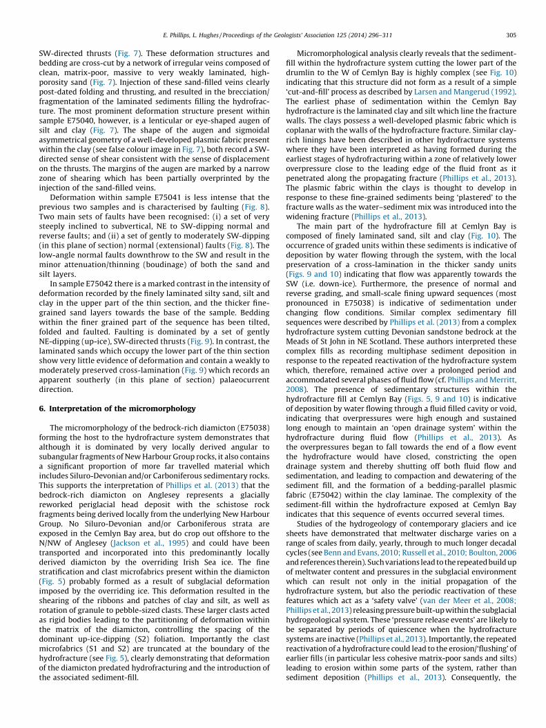
SW-directed thrusts (Fig. 7). These deformation structures andbedding are cross-cut by a network of irregular veins composed ofclean, matrix-poor, massive to very weakly laminated, high-porosity sand (Fig. 7). Injection of these sand-filled veins clearlypost-dated folding and thrusting, and resulted in the brecciation/fragmentation of the laminated sediments filling the hydrofrac-ture. The most prominent deformation structure present withinsample E75040, however, is a lenticular or eye-shaped augen ofsilt and clay (Fig. 7). The shape of the augen and sigmoidalasymmetrical geometry of a well-developed plasmic fabric presentwithin the clay (see false colour image in Fig. 7), both record a SW-directed sense of shear consistent with the sense of displacementon the thrusts. The margins of the augen are marked by a narrowzone of shearing which has been partially overprinted by theinjection of the sand-filled veins.
Deformation within sample E75041 is less intense that theprevious two samples and is characterised by faulting (Fig. 8).Two main sets of faults have been recognised: (i) a set of verysteeply inclined to subvertical, NE to SW-dipping normal andreverse faults; and (ii) a set of gently to moderately SW-dipping(in this plane of section) normal (extensional) faults (Fig. 8). Thelow-angle normal faults downthrow to the SW and result in theminor attenuation/thinning (boudinage) of both the sand andsilt layers.
In sample E75042 there is a marked contrast in the intensity ofdeformation recorded by the finely laminated silty sand, silt andclay in the upper part of the thin section, and the thicker fine-grained sand layers towards the base of the sample. Beddingwithin the finer grained part of the sequence has been tilted,folded and faulted. Faulting is dominated by a set of gentlyNE-dipping (up-ice), SW-directed thrusts (Fig. 9). In contrast, thelaminated sands which occupy the lower part of the thin sectionshow very little evidence of deformation and contain a weakly tomoderately preserved cross-lamination (Fig. 9) which records anapparent southerly (in this plane of section) palaeocurrentdirection.
6. Interpretation of the micromorphology
The micromorphology of the bedrock-rich diamicton (E75038)forming the host to the hydrofracture system demonstrates thatalthough it is dominated by very locally derived angular tosubangular fragments of New Harbour Group rocks, it also containsa significant proportion of more far travelled material whichincludes Siluro-Devonian and/or Carboniferous sedimentary rocks.This supports the interpretation of Phillips et al. (2013) that thebedrock-rich diamicton on Anglesey represents a glaciallyreworked periglacial head deposit with the schistose rockfragments being derived locally from the underlying New HarbourGroup. No Siluro-Devonian and/or Carboniferous strata areexposed in the Cemlyn Bay area, but do crop out offshore to theN/NW of Anglesey (Jackson et al., 1995) and could have beentransported and incorporated into this predominantly locallyderived diamicton by the overriding Irish Sea ice. The finestratification and clast microfabrics present within the diamicton(Fig. 5) probably formed as a result of subglacial deformationimposed by the overriding ice. This deformation resulted in theshearing of the ribbons and patches of clay and silt, as well asrotation of granule to pebble-sized clasts. These larger clasts actedas rigid bodies leading to the partitioning of deformation withinthe matrix of the diamicton, controlling the spacing of thedominant up-ice-dipping (S2) foliation. Importantly the clastmicrofabrics (S1 and S2) are truncated at the boundary of thehydrofracture (see Fig. 5), clearly demonstrating that deformationof the diamicton predated hydrofracturing and the introduction ofthe associated sediment-fill.
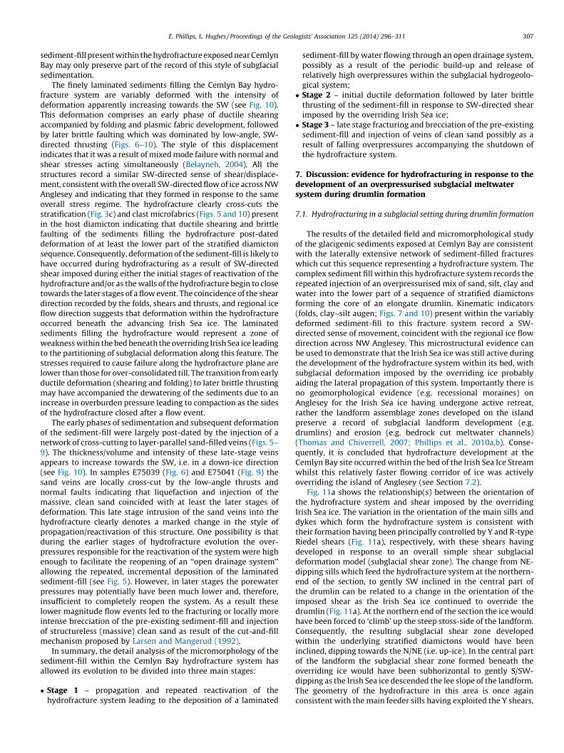
Micromorphological analysis clearly reveals that the sediment-fill within the hydrofracture system cutting the lower part of thedrumlin to the W of Cemlyn Bay is highly complex (see Fig. 10)indicating that this structure did not form as a result of a simple‘cut-and-fill’ process as described by Larsen and Mangerud (1992).The earliest phase of sedimentation within the Cemlyn Bayhydrofracture is the laminated clay and silt which line the fracturewalls. The clays possess a well-developed plasmic fabric which iscoplanar with the walls of the hydrofracture fracture. Similar clay-rich linings have been described in other hydrofracture systemswhere they have been interpreted as having formed during theearliest stages of hydrofracturing within a zone of relatively loweroverpressure close to the leading edge of the fluid front as itpenetrated along the propagating fracture (Phillips et al., 2013).The plasmic fabric within the clays is thought to develop inresponse to these fine-grained sediments being ‘plastered’ to thefracture walls as the water–sediment mix was introduced into thewidening fracture (Phillips et al., 2013).
The main part of the hydrofracture fill at Cemlyn Bay iscomposed of finely laminated sand, silt and clay (Fig. 10). Theoccurrence of graded units within these sediments is indicative ofdeposition by water flowing through the system, with the localpreservation of a cross-lamination in the thicker sandy units(Figs. 9 and 10) indicating that flow was apparently towards theSW (i.e. down-ice). Furthermore, the presence of normal andreverse grading, and small-scale fining upward sequences (mostpronounced in E75038) is indicative of sedimentation underchanging flow conditions. Similar complex sedimentary fillsequences were described by Phillips et al. (2013) from a complexhydrofracture system cutting Devonian sandstone bedrock at theMeads of St John in NE Scotland. These authors interpreted thesecomplex fills as recording multiphase sediment deposition inresponse to the repeated reactivation of the hydrofracture systemwhich, therefore, remained active over a prolonged period andaccommodated several phases of fluid flow (cf. Phillips and Merritt,2008). The presence of sedimentary structures within thehydrofracture fill at Cemlyn Bay (Figs. 5, 9 and 10) is indicativeof deposition by water flowing through a fluid filled cavity or void,indicating that overpressures were high enough and sustainedlong enough to maintain an ‘open drainage system’ within thehydrofracture during fluid flow (Phillips et al., 2013). Asthe overpressures began to fall towards the end of a flow eventthe hydrofracture would have closed, constricting the opendrainage system and thereby shutting off both fluid flow andsedimentation, and leading to compaction and dewatering of thesediment fill, and the formation of a bedding-parallel plasmicfabric (E75042) within the clay laminae. The complexity of thesediment-fill within the hydrofracture exposed at Cemlyn Bayindicates that this sequence of events occurred several times.
Studies of the hydrogeology of contemporary glaciers and icesheets have demonstrated that meltwater discharge varies on arange of scales from daily, yearly, through to much longer decadalcycles (see Benn and Evans, 2010; Russell et al., 2010; Boulton, 2006and references therein). Such variations lead to the repeated build upof meltwater content and pressures in the subglacial environmentwhich can result not only in the initial propagation of thehydrofracture system, but also the periodic reactivation of thesefeatures which act as a ‘safety valve’ (van der Meer et al., 2008;Phillips et al., 2013) releasing pressure built-up within the subglacialhydrogeological system. These ‘pressure release events’ are likely tobe separated by periods of quiescence when the hydrofracturesystems are inactive (Phillips et al., 2013). Importantly, the repeatedreactivation of a hydrofracture could lead to the erosion/‘flushing’ ofearlier fills (in particular less cohesive matrix-poor sands and silts)leading to erosion within some parts of the system, rather thansediment deposition (Phillips et al., 2013). Consequently, the
Fig. 10. Diagram showing the relative positions and overall interpretation of the thin sections within the hydrofracture system exposed to the west of Cemlyn Bay. Micromorphological analysis reveals the following: (i) the
hydrofracture fill is complex, comprising bedded/laminated sand, silt and clay; (ii) there is an overall increase in the intensity of the deformation towards the SW, i.e. in a down ice direction; (iii) early ductile shearing of the laminated
sediment-fill was followed by later brittle faulting; (iv) deformation structures record a consistent SW-directed sense of shear/displacement consistent with the main ice movement direction across the Cemlyn Bay area; and (v)
earlier ductile folding and brittle thrusting was followed by the injection of a complex network of sand-filled veins (see text for details).
E.
Ph
illips,
L. H
ug
hes
/ P
roceed
ing
s o
f th
e G
eolo
gists’
Asso
ciatio
n 1
25
(20
14
) 2
96
–3
11
30
6
E. Phillips, L. Hughes / Proceedings of the Geologists’ Association 125 (2014) 296–311 307
sediment-fill present within the hydrofracture exposed near CemlynBay may only preserve part of the record of this style of subglacialsedimentation.
The finely laminated sediments filling the Cemlyn Bay hydro-fracture system are variably deformed with the intensity ofdeformation apparently increasing towards the SW (see Fig. 10).This deformation comprises an early phase of ductile shearingaccompanied by folding and plasmic fabric development, followedby later brittle faulting which was dominated by low-angle, SW-directed thrusting (Figs. 6–10). The style of this displacementindicates that it was a result of mixed mode failure with normal andshear stresses acting simultaneously (Belayneh, 2004). All thestructures record a similar SW-directed sense of shear/displace-ment, consistent with the overall SW-directed flow of ice across NWAnglesey and indicating that they formed in response to the sameoverall stress regime. The hydrofracture clearly cross-cuts thestratification (Fig. 3c) and clast microfabrics (Figs. 5 and 10) presentin the host diamicton indicating that ductile shearing and brittlefaulting of the sediments filling the hydrofracture post-dateddeformation of at least the lower part of the stratified diamictonsequence. Consequently, deformation of the sediment-fill is likely tohave occurred during hydrofracturing as a result of SW-directedshear imposed during either the initial stages of reactivation of thehydrofracture and/or as the walls of the hydrofracture begin to closetowards the later stages of a flow event. The coincidence of the sheardirection recorded by the folds, shears and thrusts, and regional iceflow direction suggests that deformation within the hydrofractureoccurred beneath the advancing Irish Sea ice. The laminatedsediments filling the hydrofracture would represent a zone ofweakness within the bed beneath the overriding Irish Sea ice leadingto the partitioning of subglacial deformation along this feature. Thestresses required to cause failure along the hydrofracture plane arelower than those for over-consolidated till. The transition from earlyductile deformation (shearing and folding) to later brittle thrustingmay have accompanied the dewatering of the sediments due to anincrease in overburden pressure leading to compaction as the sidesof the hydrofracture closed after a flow event.
The early phases of sedimentation and subsequent deformationof the sediment-fill were largely post-dated by the injection of anetwork of cross-cutting to layer-parallel sand-filled veins (Figs. 5–9). The thickness/volume and intensity of these late-stage veinsappears to increase towards the SW, i.e. in a down-ice direction(see Fig. 10). In samples E75039 (Fig. 6) and E75041 (Fig. 9) thesand veins are locally cross-cut by the low-angle thrusts andnormal faults indicating that liquefaction and injection of themassive, clean sand coincided with at least the later stages ofdeformation. This late stage intrusion of the sand veins into thehydrofracture clearly denotes a marked change in the style ofpropagation/reactivation of this structure. One possibility is thatduring the earlier stages of hydrofracture evolution the over-pressures responsible for the reactivation of the system were highenough to facilitate the reopening of an ‘‘open drainage system’’allowing the repeated, incremental deposition of the laminatedsediment-fill (see Fig. 5). However, in later stages the porewaterpressures may potentially have been much lower and, therefore,insufficient to completely reopen the system. As a result theselower magnitude flow events led to the fracturing or locally moreintense brecciation of the pre-existing sediment-fill and injectionof structureless (massive) clean sand as result of the cut-and-fillmechanism proposed by Larsen and Mangerud (1992).
In summary, the detail analysis of the micromorphology of thesediment-fill within the Cemlyn Bay hydrofracture system hasallowed its evolution to be divided into three main stages:
� Stage 1 – propagation and repeated reactivation of thehydrofracture system leading to the deposition of a laminated
sediment-fill by water flowing through an open drainage system,possibly as a result of the periodic build-up and release ofrelatively high overpressures within the subglacial hydrogeolo-gical system;� Stage 2 – initial ductile deformation followed by later brittle
thrusting of the sediment-fill in response to SW-directed shearimposed by the overriding Irish Sea ice;� Stage 3 – late stage fracturing and brecciation of the pre-existing
sediment-fill and injection of veins of clean sand possibly as aresult of falling overpressures accompanying the shutdown ofthe hydrofracture system.
7. Discussion: evidence for hydrofracturing in response to thedevelopment of an overpressurised subglacial meltwatersystem during drumlin formation
7.1. Hydrofracturing in a subglacial setting during drumlin formation
The results of the detailed field and micromorphological studyof the glacigenic sediments exposed at Cemlyn Bay are consistentwith the laterally extensive network of sediment-filled fractureswhich cut this sequence representing a hydrofracture system. Thecomplex sediment fill within this hydrofracture system records therepeated injection of an overpressurised mix of sand, silt, clay andwater into the lower part of a sequence of stratified diamictonsforming the core of an elongate drumlin. Kinematic indicators(folds, clay–silt augen; Figs. 7 and 10) present within the variablydeformed sediment-fill to this fracture system record a SW-directed sense of movement, coincident with the regional ice flowdirection across NW Anglesey. This microstructural evidence canbe used to demonstrate that the Irish Sea ice was still active duringthe development of the hydrofracture system within its bed, withsubglacial deformation imposed by the overriding ice probablyaiding the lateral propagation of this system. Importantly there isno geomorphological evidence (e.g. recessional moraines) onAnglesey for the Irish Sea ice having undergone active retreat,rather the landform assemblage zones developed on the islandpreserve a record of subglacial landform development (e.g.drumlins) and erosion (e.g. bedrock cut meltwater channels)(Thomas and Chiverrell, 2007; Phillips et al., 2010a,b). Conse-quently, it is concluded that hydrofracture development at theCemlyn Bay site occurred within the bed of the Irish Sea Ice Streamwhilst this relatively faster flowing corridor of ice was activelyoverriding the island of Anglesey (see Section 7.2).
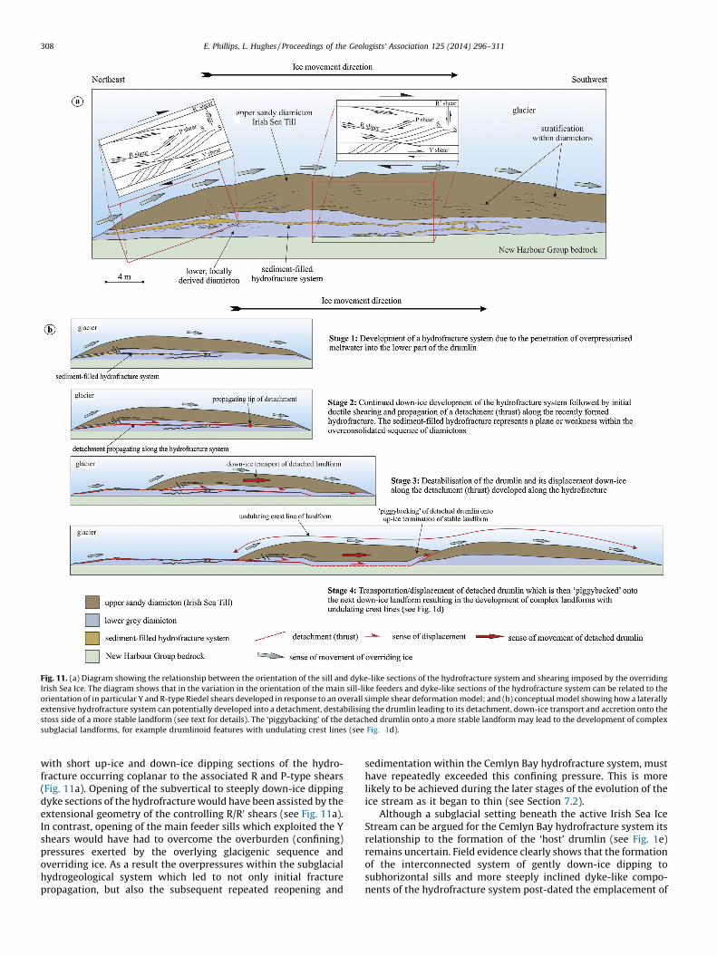
Fig. 11a shows the relationship(s) between the orientation ofthe hydrofracture system and shear imposed by the overridingIrish Sea ice. The variation in the orientation of the main sills anddykes which form the hydrofracture system is consistent withtheir formation having been principally controlled by Y and R-typeRiedel shears (Fig. 11a), respectively, with these shears havingdeveloped in response to an overall simple shear subglacialdeformation model (subglacial shear zone). The change from NE-dipping sills which feed the hydrofracture system at the northern-end of the section, to gently SW inclined in the central part ofthe drumlin can be related to a change in the orientation of theimposed shear as the Irish Sea ice continued to override thedrumlin (Fig. 11a). At the northern end of the section the ice wouldhave been forced to ‘climb’ up the steep stoss-side of the landform.Consequently, the resulting subglacial shear zone developedwithin the underlying stratified diamictons would have beeninclined, dipping towards the N/NE (i.e. up-ice). In the central partof the landform the subglacial shear zone formed beneath theoverriding ice would have been subhorizontal to gently S/SW-dipping as the Irish Sea ice descended the lee slope of the landform.The geometry of the hydrofracture in this area is once againconsistent with the main feeder sills having exploited the Y shears,
Fig. 11. (a) Diagram showing the relationship between the orientation of the sill and dyke-like sections of the hydrofracture system and shearing imposed by the overriding
Irish Sea Ice. The diagram shows that in the variation in the orientation of the main sill-like feeders and dyke-like sections of the hydrofracture system can be related to the
orientation of in particular Y and R-type Riedel shears developed in response to an overall simple shear deformation model; and (b) conceptual model showing how a laterally
extensive hydrofracture system can potentially developed into a detachment, destabilising the drumlin leading to its detachment, down-ice transport and accretion onto the
stoss side of a more stable landform (see text for details). The ‘piggybacking’ of the detached drumlin onto a more stable landform may lead to the development of complex
subglacial landforms, for example drumlinoid features with undulating crest lines (see Fig. 1d).
E. Phillips, L. Hughes / Proceedings of the Geologists’ Association 125 (2014) 296–311308
with short up-ice and down-ice dipping sections of the hydro-fracture occurring coplanar to the associated R and P-type shears(Fig. 11a). Opening of the subvertical to steeply down-ice dippingdyke sections of the hydrofracture would have been assisted by theextensional geometry of the controlling R/R0 shears (see Fig. 11a).In contrast, opening of the main feeder sills which exploited the Yshears would have had to overcome the overburden (confining)pressures exerted by the overlying glacigenic sequence andoverriding ice. As a result the overpressures within the subglacialhydrogeological system which led to not only initial fracturepropagation, but also the subsequent repeated reopening and
sedimentation within the Cemlyn Bay hydrofracture system, musthave repeatedly exceeded this confining pressure. This is morelikely to be achieved during the later stages of the evolution of theice stream as it began to thin (see Section 7.2).
Although a subglacial setting beneath the active Irish Sea IceStream can be argued for the Cemlyn Bay hydrofracture system itsrelationship to the formation of the ‘host’ drumlin (see Fig. 1e)remains uncertain. Field evidence clearly shows that the formationof the interconnected system of gently down-ice dipping tosubhorizontal sills and more steeply inclined dyke-like compo-nents of the hydrofracture system post-dated the emplacement of
E. Phillips, L. Hughes / Proceedings of the Geologists’ Association 125 (2014) 296–311 309
at least the lower part of the glacial sequence (Fig. 2); this includesthe sandy Irish Sea Till which was deposited by the Irish Sea ice as itoverrode Anglesey. If the hydrofracture system predated drumlinformation, or had formed early during the development of theselandforms, these sediment-filled features would have representedmajor planes of weakness within the deforming bed of the icesheet. As a result, deformation would have been focused alongthese planes leading to thrusting and the potential detachment ofthe developing landform from the underlying bed and its transportdown-ice (Stages 1–3 in Fig. 11b). Thrust-related detachment/decoupling would have had a profound effect on the stability,morphology and distribution of the landforms, and couldpotentially result in the ‘piggy backing’ or ‘stacking’ of severaldrumlins (Stage 4 in Fig. 11b). Although complex ‘double’landforms with undulating crest lines do occur in the study area(see Fig. 1d), recent detailed geomorphological mapping ofAnglesey carried out by the British Geological Survey has revealedthat these complex landforms are relatively uncommon. Althoughthere is microscale evidence of SW-directed shearing having beenaccommodated by the sediment fill within the hydrofracturesystem, there is no evidence of significant translation across thehydrofractures exposed in the Cemlyn Bay section, indicating thatthey do not represent significant detachments (thrusts). Conse-quently, the hydrofracturing of the stratified diamicton sequencewithin the Cemlyn Bay drumlin is thought to have occurred duringeither the later stages of, or post landform development.
7.2. Relative timing of hydrofracturing to the shutdown of the Irish
Sea Ice Stream
Hydrofracture systems from glacial environments described inthe literature (e.g. van der Meer et al., 1999, 2008; Phillips et al.,2013) are typically developed with an ice-marginal to sub-marginal setting providing an ‘escape route’ for the over-pressurised meltwater from beneath the ice forming the ‘burstout’ structures of Benediktsson et al. (2008). However, field andmicromorphological evidence presented here indicates thathydrofracturing at the Cemlyn Bay site occurred whilst the IrishSea ice was still actively overriding the area and coupled to its bedallowing shear to be transmitted into this substrate; i.e.hydrofracturing occurred under full subglacial conditions. Asubglacial setting is also indicated by the geomorphologicalrecord on Anglesey which lacks any evidence of active ice-marginretreat (Thomas and Chiverrell, 2007; Phillips et al., 2010a,b).Consequently, it is concluded that hydrofracture development atthe Cemlyn Bay site occurred within the bed of the Irish Sea IceStream whilst this relatively faster flowing corridor of ice wasactively overriding the island of Anglesey. Any overpressurisedmeltwater system developed at this stage would have beeneffectively constrained beneath the ice and would have led tohydrofracturing of the underlying bed.
Hydrofracturing of both the glacigenic sedimentary sequenceand underlying Monian Supergroup bedrock have been describedelsewhere on Anglesey (e.g. Harris, 1991; Phillips et al., 2013).Harris (1991) recorded open and sand-filled joints (hydrofrac-tures) within the bedrock cores from boreholes in the Wylfa Headarea to a depth of 20 m. Phillips et al. (2012a) argued that thesehydrofractures plus other examples cutting the New HarbourGroup bedrock between Porth Penrhyn-mawr (SH 287 852) andPorth Tywyn-mawr (SH 286 837) in western Anglesey providedclear evidence for the existence of an overpressurised hydro-geological system beneath the Irish Sea Ice Stream. Thedevelopment of such a system beneath this ice stream issupported by the presence of a network of subglacial meltwaterchannels cut into the bedrock in the western part of the studyarea (see Fig. 1c) and elsewhere across Anglesey (Thomas and
Chiverrell, 2007; Phillips et al., 2010a,b, 2012b). Pressurisedmeltwater systems beneath former and contemporary icestreams are thought to represent one of the main factorscontrolling fast ice flow (Clark and Stokes, 2001; Bennett, 2003;Bamber et al., 2003). The development of such a system beneaththe Irish Sea Ice Stream would have facilitated its overriding ofAnglesey as this ice stream continued to expand and extendfurther southward to its maximum extent at the Isles of Scilly(Hiemstra et al., 2006). However, the relative timing ofhydrofracturing with respect to the evolution of the Irish SeaIce Stream remains uncertain.
It is likely that pressurised meltwater flow within the proposedsubglacial hydrogeological system would have been eitherpreferentially concentrated along the ice-bed interface flowingaround or over the drumlins, thereby facilitating basal sliding, orconcentrated within the network of subglacial meltwater chan-nels. The volume of meltwater moving through the bed wasprobably much lower than that along the ice-bed interface orsubglacial channels, and would have been strongly controlled bythe porosity and permeability of the Irish Sea Till. The presence ofhydrofractures injected into the bed of the Irish Sea ice clearlyindicates that the hydrostatic pressures within the subglacialmeltwater system periodically exceeded the cohesive strength ofthe Irish Sea Till and underlying Monian Supergroup bedrock;effectively acting as a ‘pressure release’ or ‘safety valve’ to thesystem (cf. van der Meer et al., 2008; Phillips et al., 2013). Evidencepresented above (Section 7.1) suggests that hydrofracturing of theglacigenic sequence at Cemlyn Bay may have occurred either after(post) or during (syn) the later stages of drumlin formation. Thishydrofracture propagated SW-wards (down-ice) and was initiatedon the steep, up-ice side of the drumlin (see Figs. 1d and 11) withshear imposed by the overriding ice facilitating the opening of thissystem. As they developed the drumlins beneath the Irish Sea IceStream would have strongly influence or even impeded meltwaterflow along the ice-bed interface. As a result hydrostatic pressurewould have probably built up on the up-ice side of these subglaciallandforms, leading to the localised over-pressurisation of thehydrogeological system and hydrofracturing of the bed. Thecomplex nature of the sediment-fill within the Cemlyn Bayhydrofracture suggests that over-pressurisation and reactivationof these structures occurred repeatedly, possibly reflectingperiodic fluctuations in the volumes of meltwater flowing throughthe subglacial hydrogeological system. This increased variability inthe hydrostatic pressure and potentially the volume of meltwaterflowing through the subglacial hydrogeological system maypossibly suggest that it was becoming progressively unstable.The reopening of the subhorizontal to gently dipping sills whichfed the hydrofracture system requires that overpressures repeat-edly exceeded the confining pressure exerted by the overridingIrish Sea ice. As noted above this is more easily achieved during thelater stages of the evolution of the ice stream as it began to thinleading to a reduction in the confining pressure exerted upon thesediments within its bed. Consequently, it is possible thathydrofracturing observed at the Cemlyn Bay site occurred inresponse to the release/migration of overpressurised meltwaterwithin the bed of the Irish Sea ice, potentially recording thedestabilisation of the subglacial hydrogeological system, cessationof subglacial landform development and local shutdown of theIrish Sea Ice Stream on Anglesey.
8. Conclusions
A detailed macro- and microscale sedimentological andstructural studies of a complex hydrofracture system and hostdiamictons exposed to the west of Cemlyn Bay (NW Anglesey, NWales) clearly demonstrates that this laterally extensive network
E. Phillips, L. Hughes / Proceedings of the Geologists’ Association 125 (2014) 296–311310
of sand, silt and clay filled system was active over a prolongedperiod, and developed beneath the overriding Irish Sea ice. Thehydrofracture system is developed within the lower part of astratified sequence of diamictons forming the core to an elongateNE–SW-trending drumlin. The sedimentary fill to this hydro-fracture system is variably deformed with the resultant folds,thrusts and augen recording a SW-directed sense of shear,consistent with the regional ice flow direction across this part ofNW Anglesey. Importantly there is no geomorphological evidenceon Anglesey for the Irish Sea ice having undergone active retreat,rather the landform assemblage zones developed on the islandpreserve a record of subglacial erosion and landform development.Consequently, it is concluded that hydrofracturing at the CemlynBay site occurred within the bed of the Irish Sea Ice Stream whilstthis relatively faster flowing corridor of ice was active. Deforma-tion imposed by the overriding ice led to the development of asubglacial shear zone which facilitated the propagation of thehydrofracture system with the laterally extensive feeder sillsoccurring parallel to Y-type Riedel shears and subsequentdeformation of the sediment-fill. Although a subglacial settingbeneath the active Irish Sea Ice Stream can be argued for theCemlyn Bay hydrofracture system its relationship to the formationof the ‘host’ drumlin remains uncertain. Hydrofracturing clearlypost-dated the deposition of at least the lower part of theglacigenic sequence, including the Irish Sea Till which was laiddown by the Irish Sea ice as it overrode Anglesey. Consequently,the initial propagation and subsequent evolution of this hydro-fracture system is thought to have occurred during either the laterstages of, or post-drumlin development. Evidence from the CemlynBay site can be used to suggest that hydrofracturing occurred inresponse to the migration of overpressurised meltwater within thebed of the Irish Sea ice possibly accompanying the local thinningand shutdown of the Irish Sea Ice Stream on Anglesey and cessationof subglacial landform development.
Acknowledgements
This work forms part of ERP’s IMP research project and theGeology and Landscape of Wales programme of the BritishGeological Survey. Jonathan Lee, Rhian Kendall and Jez Everest arethanked for discussions in the field and comments on an earlierversion of this manuscript. John Fletcher (BGS thin sectioninglaboratory, Keyworth) is acknowledged for his expertise inmaking the thin sections. Simon Carr and Jaap van der Meer arethanked for their constructive reviews of this paper. ERP is anassociate member of the Centre for Micromorphology, QueenMary, University London. This paper is published with thepermission of the Executive Director of the British GeologicalSurvey (NERC).
References
Bamber, J.L., Baldwin, D.J., Gogineni, S.P., 2003. A new bed elevation data set formodelling the Greenland ice sheet. Annals of Glaciology 37, 351–356.
Belayneh, M., 2004. Palaeostress orientation inferred from surface morphology ofjoints on the southern margin of the Bristol Channel Basin, UK. In: Cosgrove, J.W.,Engelder, T. (Eds.), The Initiation, Propagation and Arrest of Joints and OtherFractures. Geological Society of London Special Publication 231, pp. 117–128.
Benediktsson, I.O., Moller, P., Ingolfsson, O., van der Meer, J.J.M., Kjær, K.H., Kruger, J.,2008. Instantaneous end moraine and sediment wedge formation during the1890 glacier surge of Bruarjokull, Iceland. Quaternary Science Reviews 27,209–234.
Benn, D.I., Evans, D.J.A., 2010. Glaciers and Glaciation, second ed. Hodder Education,London 802 pp.
Bennett, M.R., 2003. Ice streams as the arteries of an ice sheet: their mechanics,stability and significance. Earth-Science Reviews 61, 309–339.
Boulton, G.S., 2006. Glaciers and their coupling with hydraulic and sedimentaryprocesses. In: Knight, P.G. (Ed.), Glacier Science and Environmental Change.Blackwell, Oxford, pp. 3–22.
Broster, B.E., 1991. Glacitectonic deformation in sediment and bedrock, Hat Creek,British Columbia. Geographie physique et Quaternaire 45, 5–20.
Broster, B.E., Seaman, A.A., 1991. Glacigenic rafting of weathered granite: CharlieLake, New Brunswick. Canadian Journal of Earth Sciences 28, 649–654.
von Brunn, V., Talbot, C.J., 1986. Formation and deformation of subglacial intrusiveclastic sheets in the Dwyka formation of northern Natal, South Africa. Journal ofSedimentary Petrology 56, 35–44.
Burbridge, G.H., French, H.M., Rust, B.R., 1988. Water escape fissures resembling icewedge casts in late Quaternary subaqueous outwash near St. Lazare, Quebec,Canada. Boreas 17, 33–40.
Burke, E.R., Phillips, E.R., Lee, J.R., Wilkinson, I.P., 2009. Imbricate thrust stack modelfor the formation of glaciotectonic rafts: an example from the Middle Pleisto-cene of north Norfolk, UK. Boreas 38, 620–637.
Christiansen, E.A., Gendzwill, D.J., Meenely, W.A., 1982. Howe Lake: a hydrodynam-ic blowout structure. Canadian Journal of Earth Sciences 19, 1122–1139.
Clark, C.D., Stokes, C.R., 2001. Extent and basal characteristics of the M’ClintockChannel Ice Stream. Quaternary International 86, 81–101.
Clark, C.D., Anna, L.C., Hughes, A.C.L., Greenwood, S.L., Jordan, C., Sejrup, H.P., 2012.Pattern and timing of retreat of the last British-Irish Ice Sheet. QuaternaryScience Reviews 44, 112–146.
Collins, A., Buchan, C., 2004. Provenance and age constraints of the South StackGroup, Anglesey, UK: U–Pb SIMS detrital zircon data. Journal of the GeologicalSociety of London 161, 743–746.
Dionne, J.-C., Shilts, W.W., 1974. A Pleistocene clastic dike, Upper Chaudie re Valley,Quebec. Canadian Journal of Earth Sciences 11, 1594–1605.
Dreimanis, A., 1992. Downward injected till wedges and upward injected till dykes.Sveriges Geologiska Undersøgelse, Serie Ca 81, 91–96.
Dreimanis, A., Rappol, M., 1997. Late Wisconsinan sub-glacial clastic intrusivesheets along Lake Erie bluffs, at Bradtville, Ontario, Canada. SedimentaryGeology 111, 225–248.
Evans, D.J.A., O Cofaigh, C., 2003. Depositional evidence for marginal oscillations ofthe Irish Sea ice stream in southeast Ireland during the last glaciation. Boreas 32,76–101.
Evans, D.J.A., Benn, D.I., 2004. A Practical Guide to the Study of Glacial Sediments.Arnold, London, pp. 266–269.
Gozdzik, J., van Loon, A.J., 2007. The origin of a giant downward directed clastic dykein a kame (Bełchatow mine, central Poland). Sedimentary Geology 193, 71–79.
Greenly, E., 1919. The Geology of Anglesey. Memoir (District) Geological Survey ofGreat Britain HMSO, London, pp. 980.
Harris, C., 1991. Glacial deposits at Wylfa Head, Anglesey, North Wales: evidence forLate Devensian deposition in a non-marine environment. Journal of QuaternaryScience 6, 67–77.
Helm, D.G., Roberts, B., 1984. The origin of late Devensian sands and gravels,southeast Anglesey, N. Wales. Geological Journal 19, 33–55.
Hiemstra, J.F., Evans, D.J.A., Scourse, J.D., McCarroll, D., Furze, M.F.A., Rhodes, E.,2006. New evidence for a grounded Irish Sea glaciation of the Isles of Scilly, UK.Quaternary Science Reviews 25, 299–309.
Howells, M.F., 2007. British Regional Geology: Wales. British Geological Survey,Keyworth, Nottingham.
Jackson, D.I., Jackson, A.A., Evans, D., Wingfield, R.T.R., Barnes, R.P., Arthur, M.J.,1995. The Geology of the Irish Sea. United Kingdom Offshore Regional Report20–24 British Geological Survey, HMSO, London.
Kjær, K.H., Larsen, E., van der Meer, J.J.M., Ingolfsson, O., Kruger, J., Benediktsson, I.O.,Knudsen, C.G., Schomacker, A., 2006. Subglacial decoupling at the sediment/bedrock interface: a new mechanism for rapid flowing ice. Quaternary ScienceReviews 25, 2704–2712.
Larsen, E., Mangerud, J., 1992. Subglacially formed clastic dykes. Sveriges Geolo-giska Undersokning Series Ca 81, 163–170.
Le Heron, D.P., Etienne, J.L., 2005. A complex subglacial clastic dyke swarm,Solheimajokull, southern Iceland. Sedimentary Geology 181, 25–37.
Maltman, A.J., 1977. The Serpentinites and related rocks of Anglesey. GeologicalJournal 12, 113–128.
McCabe, A.M., Dardis, G.F., 1994. Glaciotectonically induced water-through flowstructures in a Late Pleistocene drumlin, Kanrawer, County Galway, westernIreland. Sedimentary Geology 91, 173–190.
McCarroll, D., 2005. North-west Wales. In: Lewis, C.A., Richards, A.E. (Eds.), TheGlaciations of Wales and Adjacent Areas. Logaston Press, Logaston,Herefordshire, pp. 27–40.
Menzies, J., 2000. Micromorphological analyses of microfabrics and microstructuresindicative of deformation processes in glacial sediments. In: Maltman, A.J.,Hubbard, B., Hambrey, M.J. (Eds.), Deformation of Glacial Materials. GeologicalSociety of London Special Publication 176, pp. 245–257.
Merritt, J.W., Auton, C.A., 2000. An outline of the lithostratigraphy and depositionalhistory of Quaternary deposits in the Sellafield district, west Cumbria. Proceed-ings of the Yorkshire Geological Society 53, 129–154.
Moran, S.R., Clayton, L., Hooke, R.L., Fenton, M.M., Andriashek, L.D., 1980. Glacier-bed landforms of the prairie region of North America. Journal of Glaciology 25,457–476.
Phillips, E.R., 1989. The Geology of the Monian Supergroup, Western Anglesey,North Wales. Unpublished PhD thesis, University of Wales, Cardiff, pp. 470.
Phillips, E.R., 1991a. The lithostratigraphy, sedimentology and tectonic setting ofthe Monian Supergroup, western Anglesey, North Wales. Journal of the Geo-logical Society of London 148, 1079–1090.
Phillips, E.R., 1991b. Progressive deformation of the South Stack and New HarbourGroups, Holy Island, western Anglesey, North Wales. Journal of the GeologicalSociety of London 148, 1091–1100.
E. Phillips, L. Hughes / Proceedings of the Geologists’ Association 125 (2014) 296–311 311
Phillips, E.R., Evans, D.J.A., Auton, C.A., 2002. Polyphase deformation at an oscillatingice margin following the Loch Lomond Readvance, central Scotland, UK. Sedi-mentary Geology 149, 157–182.
Phillips, E., Merritt, J., 2008. Evidence for multiphase water-escape during rafting ofshelly marine sediments at Clava, Inverness-shire, NE Scotland. QuaternaryScience Reviews 27, 988–1011.
Phillips, E.R., van der Meer, J.J.M., Ferguson, A., 2010a. A new ‘microstructuralmapping’ methodology for the identification and analysis of microfabricswithin glacial sediments. Quaternary Science Reviews 30, 2570–2596.
Phillips, E.R., Everest, J., Diego Diaz-Doce, D., 2010b. Bedrock controls on subglaciallandform distribution and geomorphological processes: evidence from the LateDevensian Irish Sea Ice Stream. Sedimentary Geology 232, 98–118.
Phillips, E., Lee, J.R., Riding, J.B., Kendall, R., Hughes, L., 2012a. Periglacial disruptionand subsequent glacitectonic deformation of bedrock: an example from Angle-sey, North Wales, UK. Proceedings of the Geologists’ Association, http://dx.doi.org/10.1016/j.pgeola.2012.08.006 (in press).
Phillips, E.R., Ritchie, C., Oliver, L., Mann, E., Everest, J., Diaz Doce, D., 2012b.Anglesey (Ynys Mon): a landscape carved by ice. Web delivery i-map BritishGeological Survey. Available online at http://www.bgs.ac.uk/discoveringGeol-ogy/geologyOfBritain/anglesey/home.html.
Phillips, E., Everest, J., Reeves, H., 2013. Micromorphological evidence for subglacialmultiphase sedimentation and deformation during overpressurized fluid flowassociated with hydrofracturing. Boreas 42, 395–427.
Roberts, D.H., Dackombe, R.V., Thomas, G.S.P., 2007. Palaeo-ice streaming in thecentral sector of the British-Irish Ice Sheet during the Last Glacial Maximum:evidence from the northern Irish Sea Basin. Boreas 36, 115–129.
Rijsdijk, K.F., Owen, G., Warren, W.P., McCarroll, D., van der Meer, J.J.M., 1999.Clastic dykes in over-consolidated tills: evidence for subglacial hydrofracturingat Killiney Bay, eastern Ireland. Sedimentary Geology 129, 111–126.
Scourse, J.D., 1991a. Late Pleistocene stratigraphy and palaeobotany of the Isles ofScilly. Philosophical Transactions of the Royal Society of London B334, 405–448.
Scourse, J.D., 1991b. Glacial deposits of the Isles of Scilly. In: Ehlers, J., Gibbard, P.L.,Rose, J. (Eds.), Glacial Deposits in Great Britain and Ireland. A.A. Balkema,Rotterdam, pp. 291–300.
Shackleton, R.M., 1975. Precambrian rocks of Wales. In: Harris, A.L., et al. (Eds.), ACorrelation of the Precambrian Rocks in the British Isles. Geological Society ofLondon, Special Report 6, pp. 76–82.
Thomas, G.S.P., Chiverrell, R.C., 2007. Structural and depositional evidence forrepeated ice-marginal oscillation along the eastern margin of the Late Deven-sian Irish Sea Ice Stream. Quaternary Science Reviews 26, 2375–2405.
van Landeghem, K.J.J., Wheeler, A.J., Mitchell, N.C., 2009. Seafloor evidence forpalaeo-ice streaming and calving of the grounded Irish Sea Ice Stream: implica-tions for the interpretation of its final deglaciation phase. Boreas 38, 119–131.
van der Meer, J.J.M., 1987. Micromorphology of glacial sediments as a tool indistinguishing genetic varieties of till. In: Kujansuu, R., Saarnisto, M. (Eds.),INQUA Till Symposium, Finland, 1985. Geological Survey of Finland, SpecialPaper 3, pp. 77–89.
van der Meer, J.J.M., 1993. Microscopic evidence of subglacial deformation. Qua-ternary Science Reviews 12, 553–587.
van der Meer, J.J.M., 1996. Micromorphology. In: Menzies, J. (Ed.), Glacial Environ-ments: vol. 2: Past Glacial Environments – Processes, Sediments and Landforms.Butterworth and Heinemann, Oxford, pp. 335–355.
van der Meer, J.J.M., Kjær, K., Kruger, J., 1999. Subglacial water-escape structures,Slettjokull, Iceland. Journal of Quaternary Science 14, 191–205.
van der Meer, J.J.M., Kjær, K.H., Kruger, J., Rabassa, J., Kilfeather, A.A., 2008. Underpressure: clastic dykes in glacial settings. Quaternary Science Reviews 28,708–720.
Vaughan-Hirsch, D.P., Phillips, E., Lee, J.R., Hart, J.K., 2013. Micromorphologicalanalysis of poly-phase deformation associated with the transport and emplace-ment of glaciotectonic rafts at West Runton, north Norfolk, UK. Boreas 42,376–394.