REPORT Hydrogeological review of Alexandra water supply Prepared for Central Otago District Council William Fraser Building 1 Dunorling Street PO Box 122 Alexandra 16 April 2008 42166867 J:\Jobs\42166867\6 Deliv\Hydrogeological review of Alexandra water supply (Report)_Final.doc Hydrogeological review of Alexandra water supply
Transcript
R E P O R T
Hydrogeological review of Alexandra water supply
Prepared for
Central Otago District Council
William Fraser Building 1 Dunorling Street PO Box 122 Alexandra
16 April 2008
42166867
J:\Jobs\42166867\6 Deliv\Hydrogeological review of Alexandra water supply (Report)_Final.doc Hydrogeological review of Alexandra water supply
H Y D R O G E O L O G I C A L R E V I E W O F A L E X A N D R A W A T E R S U P P L Y
Contents
Prepared for Central Otago District Council, 16 April 2008 J:\Jobs\42166867\6 Deliv\Hydrogeological review of Alexandra water supply (Report)_Final.doc
1.1 Purpose of this report ................................................................................................. 1-1 1.2 Background .................................................................................................................. 1-1 1.3 Scope of works ............................................................................................................ 1-1
2 Current supply issues .................................................................................. 2-1
3 Review of previous supply options studies................................................ 3-1
3.1 MWH review 2002......................................................................................................... 3-1 3.2 Opus review 2007......................................................................................................... 3-1
4 Geology and hydrogeology.......................................................................... 4-1
5.1 Source of hardness ..................................................................................................... 5-1 5.2 Hardness distribution in Alexandra Basin groundwaters ....................................... 5-1
5.2.1 Spatial hardness distribution ......................................................................... 5-1 5.2.2 Vertical hardness distribution ........................................................................ 5-2
5.3 Hardness trends........................................................................................................... 5-3 5.4 Surface water hardness and relationship with adjacent groundwater .................. 5-3 5.5 Summary....................................................................................................................... 5-5
H Y D R O G E O L O G I C A L R E V I E W O F A L E X A N D R A W A T E R S U P P L Y
Executive Summary
Prepared for Central Otago District Council, 16 April 2008 J:\Jobs\42166867\6 Deliv\Hydrogeological review of Alexandra water supply (Report)_Final.doc
ES-1
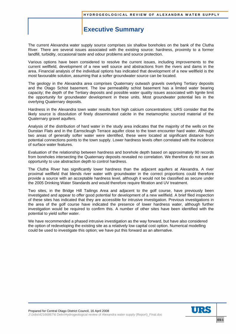
Executive Summary
The current Alexandra water supply source comprises six shallow boreholes on the bank of the Clutha River. There are several issues associated with the existing source: hardness, proximity to a former landfill, turbidity, occasional taste and odour problems and source protection.
Various options have been considered to resolve the current issues, including improvements to the current wellfield, development of a new well source and abstractions from the rivers and dams in the area. Financial analysis of the individual options has indicated that development of a new wellfield is the most favourable solution, assuming that a softer groundwater source can be located.
The geology in the Alexandra area comprises Quaternary outwash gravels overlying Tertiary deposits and the Otago Schist basement. The low permeability schist basement has a limited water bearing capacity; the depth of the Tertiary deposits and possible water quality issues associated with lignite limit the opportunity for groundwater development in these units. Most groundwater potential lies in the overlying Quaternary deposits.
Hardness in the Alexandra town water results from high calcium concentrations; URS consider that the likely source is dissolution of finely disseminated calcite in the metamorphic sourced material of the Quaternary gravel aquifers.
Analysis of the distribution of hard water in the study area indicates that the majority of the wells on the Dunstan Flats and in the Earnscleugh Terrace aquifer close to the town encounter hard water. Although two areas of generally softer water were identified, these were located at significant distance from potential connections points to the town supply. Lower hardness levels often correlated with the incidence of surface water features.
Evaluation of the relationship between hardness and borehole depth based on approximately 90 records from boreholes intersecting the Quaternary deposits revealed no correlation. We therefore do not see an opportunity to use abstraction depth to control hardness.
The Clutha River has significantly lower hardness than the adjacent aquifers at Alexandra. A river proximal wellfield that blends river water with groundwater in the correct proportions could therefore provide a source with an acceptable hardness level, although it would not be classified as secure under the 2005 Drinking Water Standards and would therefore require filtration and UV treatment.
Two sites, in the Bridge Hill Tailings Area and adjacent to the golf course, have previously been investigated and appear to offer good potential for development of a new wellfield. A brief filed inspection of these sites has indicated that they are accessible for intrusive investigation. Previous investigations in the area of the golf course have indicated the presence of lower hardness water, although further investigation would be required to confirm this. A number of other sites have been identified with the potential to yield softer water.
We have recommended a phased intrusive investigation as the way forward, but have also considered the option of redeveloping the existing site as a relatively low capital cost option. Numerical modelling could be used to investigate this option; we have put this forward as an alternative.
H Y D R O G E O L O G I C A L R E V I E W O F A L E X A N D R A W A T E R S U P P L Y
Section 1 Introduction
Prepared for Central Otago District Council, 16 April 2008 J:\Jobs\42166867\6 Deliv\Hydrogeological review of Alexandra water supply (Report)_Final.doc
1-1
1 Introduction
1.1 Purpose of this report Central Otago District Council (CODC) commissioned URS New Zealand to undertake a desktop investigation of the availability of groundwater in the Alexandra Basin, for the purpose of replacing the existing water supply wells. The scope of work was set out in the URS proposal dated 30 November 2007 and commissioned by CODC on 1 February 2008.
1.2 Background The water supply for Alexandra is currently sourced from six shallow boreholes on the bank of the Clutha River. There are several issues associated with the current supply: including hardness, proximity to a former landfill, turbidity, occasional taste and odour problems and source protection. Hardness in particular is a source of dissatisfaction with the local population. The supply issues have prompted two reviews of alternative supply options, the latest of which was concluded in October 2007 (Opus). Various source options have been considered, including improvements to the current wellfield, development of a new shallow well source, abstractions from the rivers and dams in the area and exploitation of deep groundwater. Financial analysis of the individual options has indicated that development of a new well field is the most favourable option, assuming that a softer groundwater source can be located.
1.3 Scope of works The scope of works for this study includes:
• Review of issues with Alexandra’s current supply
• Review of previous supply options analyses
• Collate data on geology, aquifer properties, groundwater flow and water quality
• Review of hydrochemistry in the study area
• Summary of supply options in context of findings in this report
• Conclusions and recommendations for a way forward
H Y D R O G E O L O G I C A L R E V I E W O F A L E X A N D R A W A T E R S U P P L Y
Section 2 Current supply issues
Prepared for Central Otago District Council, 16 April 2008 J:\Jobs\42166867\6 Deliv\Hydrogeological review of Alexandra water supply (Report)_Final.doc
2-1
2 Current supply issues
The issues associated with the current supply are: hardness, occasional taste and odour problems, proximity to a former landfill and turbidity and source protection issues.
Alexandra’s hardness is typically 120-165 mg/l CaCO3 (Opus 2007) and is therefore classified as Hard water. This leads to scaling problems, reduced effectiveness of detergents and staining problems. Hardness is the primary source of dissatisfaction with the current supply.
Taste and odour problems have been reported periodically by local residents, most recently over a four week period in September 2007. The recent odour issue was described as an earthy or musky smell, and was found to be arising from the inland boreholes. Lab analysis did not identify the odour source.
The current wellfield is located approximately 300m from a former landfill site. Investigations have indicated that it is very unlikely that the landfill will affect the town’s water supply, although the risk remains (Opus 2007). Monitoring of groundwater quality has been recommended if the existing source continues to be used. Opus (2007) note that, although technical assessments have indicated that the landfill represents a low risk to the town supply, this has not reassured the local population completely. The perception of risk from the landfill may be a cause of continued dissatisfaction with the current supply.
Turbidity monitoring of the Alexandra water supply currently comprises manual sampling approximately two to three times per week. Records indicate that there has been one sustained turbidity event above 1.7 NTU and 12 smaller events (Opus 2007). A turbidity problem was also experienced recently in borehole 6 (closest to the Clutha River) when the water level in the Clutha River was unusually low due to maintenance work at the Roxburgh dam.
The existing boreholes are shallow and hydraulically connected to the Clutha River and are therefore potentially at risk from microbial contamination. The occasional turbidity results are testament to this risk. Chlorination is employed to control bacterial contamination, but there is no current protection from protozoa. A combined filtration and UV treatment system would be required to resolve this issue.
H Y D R O G E O L O G I C A L R E V I E W O F A L E X A N D R A W A T E R S U P P L Y
Section 3 Review of previous supply options studies
Prepared for Central Otago District Council, 16 April 2008 J:\Jobs\42166867\6 Deliv\Hydrogeological review of Alexandra water supply (Report)_Final.doc
3-1
3 Review of previous supply options studies
3.1 MWH review 2002 Alternative water supply options for the town of Alexandra were first reviewed as part of the assessment of environmental effects of the borefield by MWH in 2002. The study was limited to water sources within the Alexandra basin, and considered the Clutha River/Matu Au, the Earnscleugh Aquifer, alternative sites on the Dunstan Flats, the Manuherikia Alluvium and a gallery borefield adjacent to the River Clutha or the mouth of the Fraser River. Hardness issues were not included in the assessment criteria for this study. A summary of the findings is presented below:
The Clutha river has a mean annual flow of 520 m3/s; the Otago Regional Plan (Water) considers the abstraction of 1000 m3/d to be sufficiently minor to classify it as a permitted activity. The MWH study concluded that the Clutha was not attractive as a supply option due to water quality issues and the associated treatment costs.
The Earnsleugh Flat aquifer could potentially yield sufficient water to meet the requirements of the town supply. This aquifer was not considered a favourable option, however, due to vulnerability of the aquifer to contamination from current land use activities and potential water resource impacts from proposed alluvial gold mining activity in the area.
The Dunstan Flats aquifer has similar groundwater availability to the Earnscleugh aquifer, with the highest yielding boreholes located on the margins of the Clutha River/Mata Au. MWH concluded that the downside of this resource was: greater allocation than the Earnscleugh Flat, the potential for impacts on existing water users, vulnerability to contamination from surface activities (e.g. on-site sewage disposal and horticultural chemical application) and the reliance on recharge from the Manuherikia irrigation scheme (which could reduce in the future).
Installation of a borefield in the Galloway area on the true right bank of the Manuherikia River, drawing from the Manuherikia Alluvium and indirectly from the river was considered. Issues with this option include unproven yields, the reduced discharge capacity of the Manuherikia River in comparison to the Clutha, potential impacts on other water users and again aquifer vulnerability.
Three areas were identified as potentially suitable for a gallery borefield: the Bridge Hill Tailings Area, the mouth of the Fraser River and the golf course reach of the Clutha. All of these areas had a sufficient saturated thickness of aquifer to be worthy of further consideration if a gallery wellfield was found to be the preferred option.
3.2 Opus review 2007 A water options study was undertaken by Opus in late 2007 with the remit of assessing the issues with the existing supply and the potential for extending the network to service the rural districts around Alexandra. The issues identified with the current supply source were: hardness, periodic taste and odour problems, potential for contamination by the nearby landfill site and non compliance with the Drinking Water Standards for New Zealand 2005 (NZDWS2005).
A summary of the water supply options and associated cost estimates from the Opus 2007 report is presented below.
H Y D R O G E O L O G I C A L R E V I E W O F A L E X A N D R A W A T E R S U P P L Y
Section 3 Review of previous supply options studies
Prepared for Central Otago District Council, 16 April 2008 J:\Jobs\42166867\6 Deliv\Hydrogeological review of Alexandra water supply (Report)_Final.doc
3-2
Table 3-1 Opus supply option and cost review summary
Option no. Option NPV cost ($M)
1 Existing supply with DWSNZ2005 upgrade 5.3
2 Existing supply with upgrade plus softening 13.3
3 New wellfield 7.3
4 Clutha River 14.4
5 Fraser River 14.5
6 Lake Dunstan 18.2
Two demand scenarios have been considered for the supply options in the Opus review: a 15ML/d capacity, which assumes that a significant reduction in demand is achieved by water meter installation, and a 20ML/d capacity to cover the eventuality that per capita demand remains high. The costs in Table 3-1 are based on the 20ML/d capacity.
Option 1 comprises upgrading the existing supply system to meet the values defined in the revised drinking water standards (DWSNZ2005). This would involve installation of filtration and UV treatment to mitigate the risk from protozoa and bacteria. This represents the cost baseline in that it meets the regulatory requirements, but does not address the hardness issue. The cost estimate for Option 1 assumes that cartridge filtration could be used to resolve the turbidity and protozoa risk issues. If a two stage filtration process is required, the costs would be significantly higher ($1.2M according to figures extracted from the Opus report).
Option 2 comprises upgrading the existing supply to meet DWSNZ2005 and installation of water softening plant. Softening adds $8M to the NPV cost of upgrading the existing supply source.
Option 3 involves development of a new wellfield in an area where groundwater quality is better and does not require softening plant.
Option 4 comprises direct abstraction from the Clutha River in Alexandra
Option 5 involves abstraction of water from the Fraser River, either directly or via an infiltration gallery.
Option 6 involves abstraction from Lake Dunstan at the Clyde Dam, 10km from the town.
Options 4, 5 and 6 are not considered further within this report on the basis of the Opus cost analysis findings, although they may be revisited further down the line if the lower cost alternatives are not possible.
Two further options were considered by Opus: development of a deep groundwater source and utilisation of the Lower Manorburn Dam. The latter was discounted due to quality, allocation and minimum flow issues and insufficient capacity. Development of deep groundwater would involve installation of a borefield to a depth of at least 30m below ground level in order to meet the definition of a secure source within DWSNZ2005. The Opus review considered the potential for groundwater resources at 150m depth (although the rationale for this particular depth is not clear from the report) and concluded that the probability of obtaining sufficient yields in combination with acceptable quality and impact on existing water users was very low.
The Opus review made the following recommendations with regard to development of a new source:
H Y D R O G E O L O G I C A L R E V I E W O F A L E X A N D R A W A T E R S U P P L Y
Section 3 Review of previous supply options studies
Prepared for Central Otago District Council, 16 April 2008 J:\Jobs\42166867\6 Deliv\Hydrogeological review of Alexandra water supply (Report)_Final.doc
3-3
• Water meters should be introduced to manage the excessively high current peak demand
• Irrigation for parks and reserves should continue to be switched to supplies from standalone water sources
• The Public Health Risk Management Plan for Alexandra should be reviewed and updated and submitted to MOH for approval
• Any water treatment system should be designed for a minimum of 15 ML/d, assuming that metering is introduced.
• Various minor works should be undertaking to improve the existing source treatment and security.
• Monitoring should be improved and further water quality data collected from the existing boreholes and other boreholes in the area. The existing boreholes should be monitored individually to determine whether there are water quality differences between the individual boreholes and an opportunity to manage the supply to improve water quality.
• Further investigation should be undertaken on some or all of the three potential alternative borefield sites identified to assess quality and yield
• A new supply from the Clutha River/Lake Dunstan or water softening plant should be considered if results from investigations into a new borefield are discouraging
• The implications for Clyde’s future water supply should be considered if a new source is developed.
• Supply of water to Alexandra Environs should be investigated further in conjunction with solutions to the Alexandra water supply issues, particularly with regard to the effect on Alexandra’s storage and reticulation system, and the potential for sharing with other developments.
The following sections of this report collate and evaluate the data available for assessment of the potential to develop a new groundwater source for Alexandra that would meet the following criteria:
• Low hardness
• Located within reasonably close proximity to the existing network
• Preferably require only cartridge filtration or no filtration
• Yield 20 ML/d
The following source options are considered: a shallow wellfield located away from the river, a wellfield adjacent to the river and a deep wellfield.
H Y D R O G E O L O G I C A L R E V I E W O F A L E X A N D R A W A T E R S U P P L Y
Section 4 Geology and hydrogeology
Prepared for Central Otago District Council, 16 April 2008 J:\Jobs\42166867\6 Deliv\Hydrogeological review of Alexandra water supply (Report)_Final.doc
4-1
4 Geology and hydrogeology
4.1 Regional Geology Regional geology for the Alexandra area is summarised from the information presented in the Alexandra Groundwater Survey report (Irricon 1998):
The Alexandra basin basement comprises Otago schist, a complex metamorphic unit derived from quortzofeldspathic and volcanogenic greywackes and primary volcanics. The basin structure was formed during Late Miocene-early Pleistocene and Pleistocene tectonism, with subsequent infilling during the Tertiary and Quaternary periods. The Tertiary deposits in this area comprise the Manuherikia Group and Pliocene Immature Conglomerate. The Manuherikia Group can include fluvial and lacustrine quartz conglomerate, lignite, carbonaceous shale, oil shale, siltstone and sandstone and is subdivided into the Dunstan and Wedderburn formations. Lignite seams up to 9m thickness have been worked in the Alexandra area, and are inferred to remain beneath the town at a depth of 20-30m.
Quaternary deposits in the Alexandra area comprise outwash gravels associated with glacial advances, subdivided into the Muttontown Gravel, Undifferentiated Northburn Advance Gravels, the Lowburn Advance, the Lindis Advance, the Luggate Advance and the Albert Town Advance deposits. The Quaternary units make up distinctive flights of terraces and predominantly consist of greywacke and schist gravels.
4.2 Local geology The current well field and landfill are situated in an area of gold dredge tailings on river derived sediments adjacent to the Clutha River (PDP 1995). The gravely strata is underlain by a coal bearing conglomerate of relatively low permeability. The bore logs indicate that the aquifer strata is composed of predominantly coarse quartzose gravels and sand with distinct lenses of coarse sand up to 3 m thick (PDP 1995). The thickness of the gravel aquifer is approximately 10 m on the river flat (where the well field is situated) and up to 25 m on the tailings adjacent to the landfill, to the north of the wellfield.
The geology of the Alexandra area has not been published at less than 1:250,000 scale (although the Cromwell area, extending just south of Clyde, has been mapped at 1:63,360 scale). Details of the geology and hydrogeology of the study area have therefore been collated from the various reference sources listed at the end of this report.
4.3 Aquifer properties The low permeability schist basement offers limited potential as a groundwater resource in all but highly fractured zones (Irricon 1998). Irricon concluded that the Dunstan and possibly the Wedderburn formations of the Tertiary may have sufficient permeability to yield groundwater, but any association with lignite would degrade water quality. The inferred depth of these Tertiary deposits atop the schist makes exploration uneconomic away from the basin margins.
Well records from the Alexandra area have been reviewed as part of this study: only one deep well (beyond 100m) is recorded in Otago Regional Council’s well database. This comprises a return borehole for the Molyneux Swimming Complex, and extends to 150m depth. We have been unable to obtain any additional information on this borehole.
Most groundwater potential therefore lies in the Quaternary deposits.
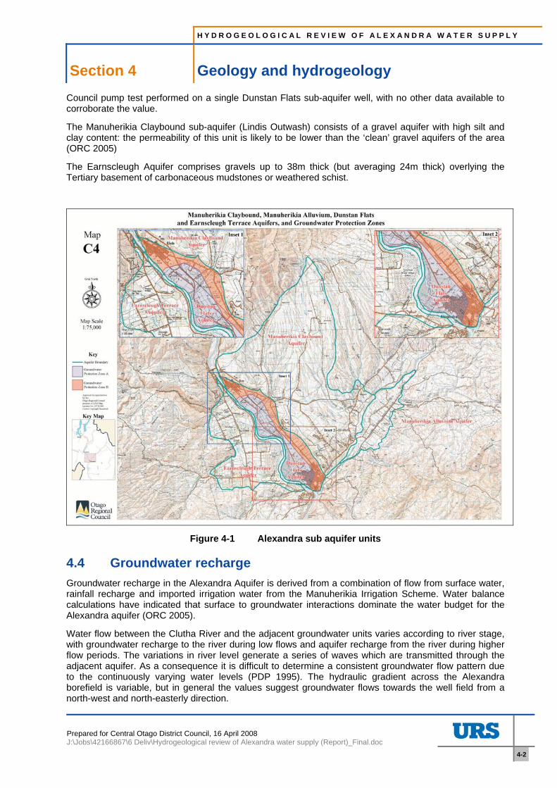
Otago Regional Council’s (ORC) Groundwater Allocation of the Alexandra Basin (2005) groups the Manuherikia Claybound, Dunstan Flats and Manuherikia Alluvium as sub aquifers of the Alexandra Aquifer, since the units appear to form a continuous multi lithology aquifer. Figure 4-1 (from ORC 2005) delineates the boundaries of the sub aquifer units.
The hydraulic conductivity is assumed to be in the order of 100 m/day for the Dunstan Flats sub-aquifer. This represents an aquifer with a very large capacity to transmit water, but is based on an Otago Regional
H Y D R O G E O L O G I C A L R E V I E W O F A L E X A N D R A W A T E R S U P P L Y
Section 4 Geology and hydrogeology
Prepared for Central Otago District Council, 16 April 2008 J:\Jobs\42166867\6 Deliv\Hydrogeological review of Alexandra water supply (Report)_Final.doc
4-2
Council pump test performed on a single Dunstan Flats sub-aquifer well, with no other data available to corroborate the value.
The Manuherikia Claybound sub-aquifer (Lindis Outwash) consists of a gravel aquifer with high silt and clay content: the permeability of this unit is likely to be lower than the ‘clean’ gravel aquifers of the area (ORC 2005)
The Earnscleugh Aquifer comprises gravels up to 38m thick (but averaging 24m thick) overlying the Tertiary basement of carbonaceous mudstones or weathered schist.
Figure 4-1 Alexandra sub aquifer units
4.4 Groundwater recharge Groundwater recharge in the Alexandra Aquifer is derived from a combination of flow from surface water, rainfall recharge and imported irrigation water from the Manuherikia Irrigation Scheme. Water balance calculations have indicated that surface to groundwater interactions dominate the water budget for the Alexandra aquifer (ORC 2005).
Water flow between the Clutha River and the adjacent groundwater units varies according to river stage, with groundwater recharge to the river during low flows and aquifer recharge from the river during higher flow periods. The variations in river level generate a series of waves which are transmitted through the adjacent aquifer. As a consequence it is difficult to determine a consistent groundwater flow pattern due to the continuously varying water levels (PDP 1995). The hydraulic gradient across the Alexandra borefield is variable, but in general the values suggest groundwater flows towards the well field from a north-west and north-easterly direction.
H Y D R O G E O L O G I C A L R E V I E W O F A L E X A N D R A W A T E R S U P P L Y
Section 4 Geology and hydrogeology
Prepared for Central Otago District Council, 16 April 2008 J:\Jobs\42166867\6 Deliv\Hydrogeological review of Alexandra water supply (Report)_Final.doc
4-3
The relationship between the hydrochemistry of the Clutha River and Alexandra borefield, which provides further insight into groundwater-surface water interaction, is discussed in Section 5.
H Y D R O G E O L O G I C A L R E V I E W O F A L E X A N D R A W A T E R S U P P L Y
Section 5 Hydrochemical assessment
Prepared for Central Otago District Council, 16 April 2008 J:\Jobs\42166867\6 Deliv\Hydrogeological review of Alexandra water supply (Report)_Final.doc
5-1
5 Hydrochemical assessment
5.1 Source of hardness Water hardness is a traditional measure of the capacity of water to react with soap and is caused by dissolved polyvalent metallic ions. In fresh waters, the principal hardness-causing ions are calcium and magnesium; strontium, iron, barium and manganese ions also contribute (Health Canada 1979). Calcium is the principal source of hardness in the Alexandra supply wells.
A previous study of the spatial distribution of hardness in the Alexandra basin (Irricon 1998) suggested that the higher hardness values were likely to be associated with water sourced from the schist basement or tertiary units. However, given that the quaternary deposits in the area comprise glacial outwash deposits predominantly of greywacke and schist gravels, dissolution of finely disseminated calcite within these metamorphic materials (particularly the schists) could readily dominate the chemistry of groundwater within these aquifers. On this basis the source of hardness could be intrinsic to the aquifer units.
5.2 Hardness distribution in Alexandra Basin groundwaters The preliminary survey of Groundwater of the Alexandra basin (Irricon 1998) includes water quality analyses from 43 sites across the basin, six of which were surface waters. These data were plotted spatially as part of the Irricon study. The Irricon field survey included visits to the 340 wells in the area to gather information; this included the well depth and general indications of the water quality characteristics from the owner (qualitative data). Many of the comments made about water quality focus on the issue of hardness; we have extracted all records from the dataset which have specific comments on the hardness, for further analysis. We recognise that this dataset is subjective, but consider that it still provides an insight into the question of hardness in terms of distribution across the basin and in relation to well depth.
In addition to the above datasets, we obtained an extract of Otago Regional Council’s water quality database for the study area. The database includes analytical results from groundwater samples collected from approximately 40 wells between September 1996 and April 2007. Hardness concentrations were calculated from calcium and magnesium results and grouped with the analytical results from the 1998 Irricon study to form a quantitative water quality dataset for the area.
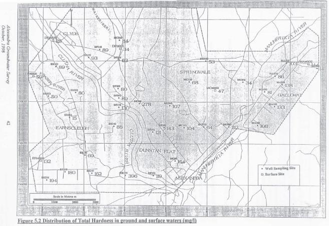
5.2.1 Spatial hardness distribution A copy of the hardness distribution plot from the Irricon report is presented in Appendix A. Irricon (1998) concluded that:
• Higher hardness levels were encountered at the southern end of the Earnscleugh flats, beneath the Terrace in the Dunstan Road area and along the eastern boundary of the Galloway Flats.
• The hardness pattern reflects the strong influence of calcium as the dominant cation and bicarbonate as the dominant anion
• The results suggest that these wells are drawing on a significant component of lateral seepage from the adjacent schist basement or contact with the Tertiary units.
• Further out on the flats, infiltration rainwater or irrigation seepage excerpts more influence on the groundwater chemistry
• Higher hardness levels are evident in the surface water draining from Omeo and Dip Creek
• Few of the hardness results from wells on the Springvale Terrace, in the Waikerikeri Valley and Upper Earnscleugh are above 100 mg/l
Whilst this is generally a reasonable interpretation of the data presented, we note in particular that the data points are sparsely distributed across the study area. Also, some hardness could be derived from
H Y D R O G E O L O G I C A L R E V I E W O F A L E X A N D R A W A T E R S U P P L Y
Section 5 Hydrochemical assessment
Prepared for Central Otago District Council, 16 April 2008 J:\Jobs\42166867\6 Deliv\Hydrogeological review of Alexandra water supply (Report)_Final.doc
5-2
metamorphic clasts within Quaternary gravels as well as from the schist basement and Tertiary units. Further analysis of all available hardness data has therefore been undertaken.
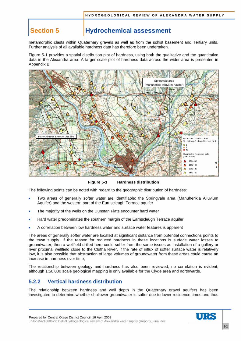
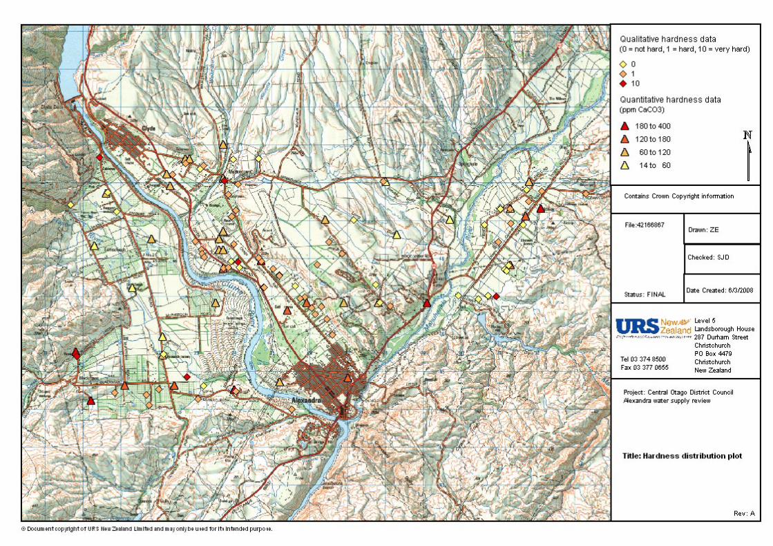
Figure 5-1 provides a spatial distribution plot of hardness, using both the qualitative and the quantitative data in the Alexandra area. A larger scale plot of hardness data across the wider area is presented in Appendix B.
Figure 5-1 Hardness distribution
The following points can be noted with regard to the geographic distribution of hardness:
• Two areas of generally softer water are identifiable: the Springvale area (Manuherikia Alluvium Aquifer) and the western part of the Eurnscleugh Terrace aquifer
• The majority of the wells on the Dunstan Flats encounter hard water
• Hard water predominates the southern margin of the Earnscleugh Terrace aquifer
• A correlation between low hardness water and surface water features is apparent
The areas of generally softer water are located at significant distance from potential connections points to the town supply. If the reason for reduced hardness in these locations is surface water losses to groundwater, then a wellfield drilled here could suffer from the same issues as installation of a gallery or river proximal wellfield close to the Clutha River. If the rate of influx of softer surface water is relatively low, it is also possible that abstraction of large volumes of groundwater from these areas could cause an increase in hardness over time,
The relationship between geology and hardness has also been reviewed; no correlation is evident, although 1:50,000 scale geological mapping is only available for the Clyde area and northwards.
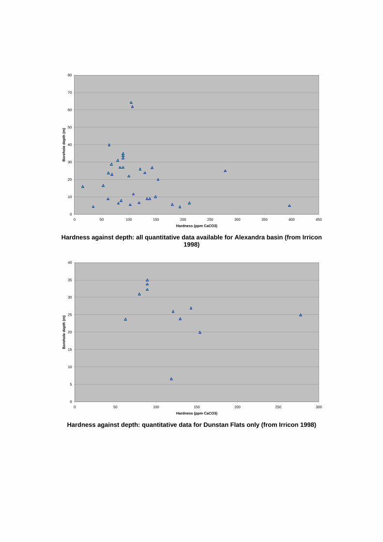
5.2.2 Vertical hardness distribution The relationship between hardness and well depth in the Quaternary gravel aquifers has been investigated to determine whether shallower groundwater is softer due to lower residence times and thus
Springvale area (Manuherikia Alluvium Aquifer)
Earnscleugh Terrace Aquifer
H Y D R O G E O L O G I C A L R E V I E W O F A L E X A N D R A W A T E R S U P P L Y
Section 5 Hydrochemical assessment
Prepared for Central Otago District Council, 16 April 2008 J:\Jobs\42166867\6 Deliv\Hydrogeological review of Alexandra water supply (Report)_Final.doc
5-3
reduced calcite dissolution. Plots of quantitative and qualitative hardness against well depth are presented in Appendix C. The following points can be noted from these data:
• Overall, there is no linear correlation between hardness and depth in either the Dunstan Flats data or the complete dataset
• From the quantitative dataset:
o all wells extending to greater than 30m depth have a hardness of less than 110 ppm (7/36 wells are >30m deep)
o Hardness in wells <30m deep varies between 15 and 396 ppm
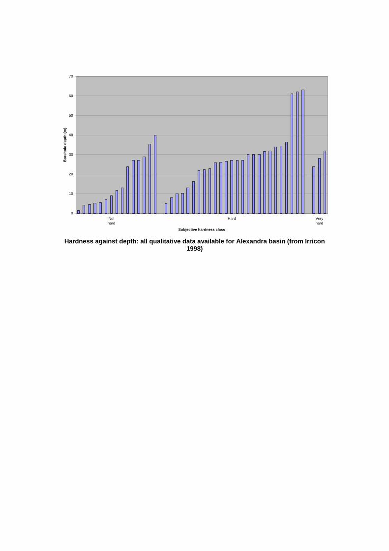
• From the qualitative dataset:
o Wells considered by their owners to have low hardness are distributed fairly evenly between depths ranging from 1.5 to 40m
o Those wells considered to be hard ranged between 5 and 63m deep.
o The wells considered by their owners to have very hard water were between 24 and 32m deep
o Of the 11 wells sunk to greater than 30m depth, two were considered not hard, eight were considered hard and one was considered to be very hard
We therefore consider that there is no discernable relationship between hardness and depth from the information available for this study.
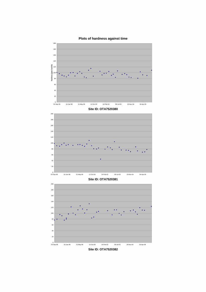
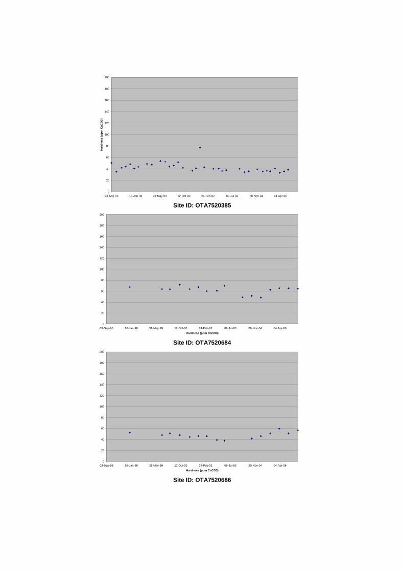
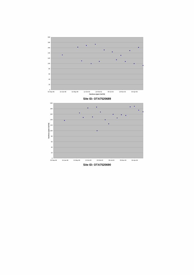
5.3 Hardness trends Long term water quality data are available from eight monitoring wells in the Alexandra area. Plots of hardness against time are presented in Appendix C. The following observations can be made from these data:
• Seasonal hardness fluctuations are apparent in most wells. Two patterns are observed: lower hardness levels at the end of the irrigation season and lower hardness levels at the end of winter. The magnitude of the fluctuations in those wells with the latter pattern is smaller, indicating that the diluting effect of rainfall recharge is relatively minor.
• Hardness levels generally reduce over time in two wells. Both wells follow the irrigation season pattern, with lowest hardness concentrations generally coinciding with the end of the irrigation season. This suggests that hardness concentrations in the aquifer here are reducing over time as a result of the import of softer surface water.
• The pattern switches in two wells, indicating the onset and cessation of irrigation in these areas (opposite reversals are observed).
There is therefore no indication of natural changes in hardness through time, although irrigation losses to groundwater appear to be causing a reduction in hardness in some areas.
We were unable to obtain sufficient water quality data from the Alexandra wellfield to assess water quality trends over time for the source water.
5.4 Surface water hardness and relationship with adjacent groundwater
The hardness of the Clutha River (at Clyde) was analysed as part of the 1998 Irricon study: 27.8 ppm hardness as CaCO3 was recorded in a sample collected on 30/4/1998. The hardness of the Clutha is
H Y D R O G E O L O G I C A L R E V I E W O F A L E X A N D R A W A T E R S U P P L Y
Section 5 Hydrochemical assessment
Prepared for Central Otago District Council, 16 April 2008 J:\Jobs\42166867\6 Deliv\Hydrogeological review of Alexandra water supply (Report)_Final.doc
5-4
likely to vary with river stage: water is likely to be harder during times of lower flows when the proportion of flow derived from groundwater increases.
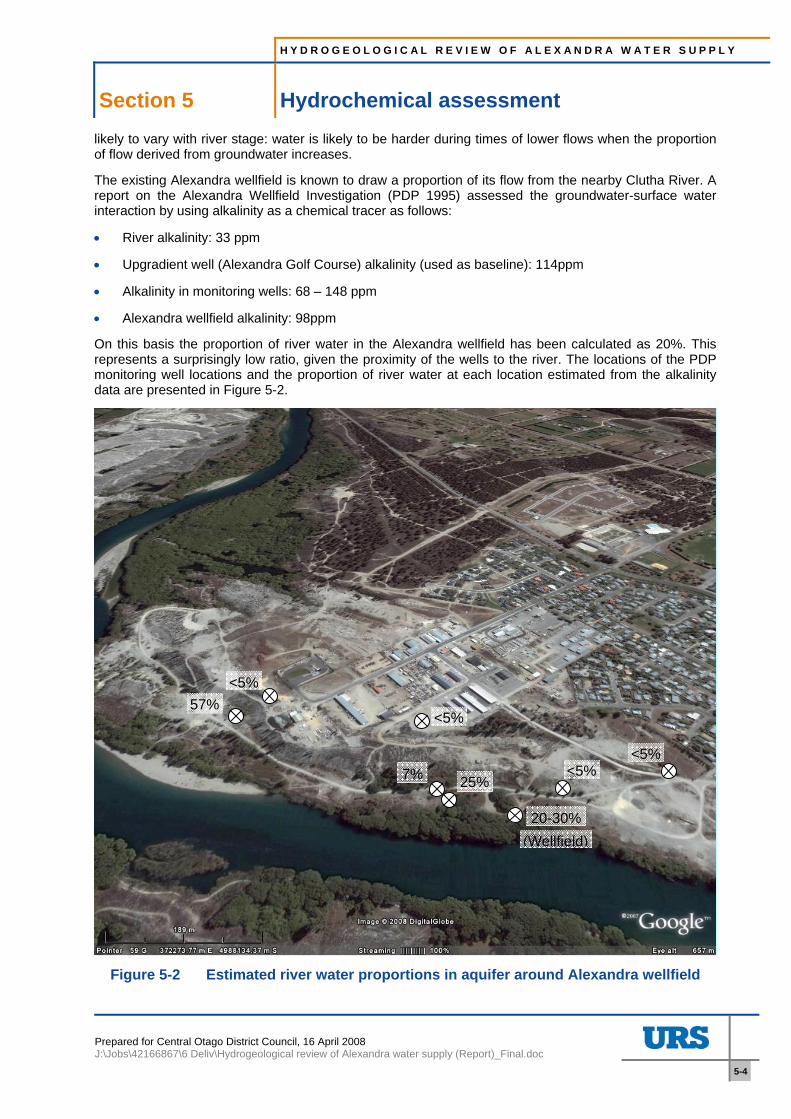
The existing Alexandra wellfield is known to draw a proportion of its flow from the nearby Clutha River. A report on the Alexandra Wellfield Investigation (PDP 1995) assessed the groundwater-surface water interaction by using alkalinity as a chemical tracer as follows:
• River alkalinity: 33 ppm
• Upgradient well (Alexandra Golf Course) alkalinity (used as baseline): 114ppm
• Alkalinity in monitoring wells: 68 – 148 ppm
• Alexandra wellfield alkalinity: 98ppm
On this basis the proportion of river water in the Alexandra wellfield has been calculated as 20%. This represents a surprisingly low ratio, given the proximity of the wells to the river. The locations of the PDP monitoring well locations and the proportion of river water at each location estimated from the alkalinity data are presented in Figure 5-2.
Figure 5-2 Estimated river water proportions in aquifer around Alexandra wellfield
57%
20-30%
25%7%
<5%
<5%
<5%<5%
(Wellfield)
H Y D R O G E O L O G I C A L R E V I E W O F A L E X A N D R A W A T E R S U P P L Y
Section 5 Hydrochemical assessment
Prepared for Central Otago District Council, 16 April 2008 J:\Jobs\42166867\6 Deliv\Hydrogeological review of Alexandra water supply (Report)_Final.doc
5-5
The following conclusions can be drawn from these data:
• The Alexandra wellfield and borehole 4 are located at a similar distance from the river (approximately 50m) and appear to encounter similar proportions of river water in the aquifer (20-30%).
• Borehole 3 is located slightly further from the river (approximately 60m) but draws only a very small proportion of river water (7%) according to the alkalinity data.
• Boreholes 1,2,6 and 7 encounter less than 5% river water and are located between 70 and 200m from the river.
• Borehole 5 is located approximately 130m from the river, but encounters 57% river water according to the alkalinity data.
Borehole 5 is located on the inside bend of the Clutha on a point bar. The point bar materials will comprise recent deposits with a relatively low level of compaction and cementation. The materials encountered in BH5 may therefore have a higher hydraulic conductivity than the quaternary deposits encountered in the other boreholes. A review of groundwater contour data in the PDP report indicates that groundwater flow in the area of BH5 under non-pumping conditions was approximately parallel to the river. Contours drawn from pumping water level data indicate a flow from the river towards BH5. Non-pumping data indicates that natural groundwater flow in the area of the wellfield, at the time of the PDP study, was towards the river. The higher proportion of river water encountered in BH5 is therefore likely to be due to factors associated with its location on the inside of the river bend.
By drawing a greater proportion of the supply from the Clutha indirectly (e.g. through use of an optimised river proximal wellfield), hardness could be reduced to an acceptable level. However, the relationship between groundwater hardness and distance from the river is not straightforward, and the analysis of river water proportions undertaken by PDP is based on a limited dataset and is therefore subject to some uncertainty. It may therefore be necessary to investigate water quality at a number of locations before the best site for a new wellfield can be defined.
5.5 Summary The likely source of water hardness (calcite in the metamorphic sourced gravels) appears to be widespread in the Quaternary deposits, which form the primary aquifers in the Alexandra area. Although we have not considered the majority of the low hardness boreholes in detail (with the exception of the Alexandra wellfield area) to ascertain why these encounter softer water, we note that many of these are located close to surface water courses and irrigated areas. Surface water losses to groundwater may therefore be the reason for the improved water quality at these locations. This is backed up by analysis of hardness trends over time in a number of boreholes.
Our analysis of the hardness data available from the Alexandra area therefore indicates that there is a limited potential for development of a ‘secure’ (i.e. without direct hydraulic links to surface waters), low hardness groundwater source. Evaluation of hydrochemical and hydrogeological data from the Alexandra wellfield indicates that the relationship between river proximity and river water: groundwater ratios is not straightforward; consideration must be given to variations in local geology and associated effects on groundwater flow patterns.
H Y D R O G E O L O G I C A L R E V I E W O F A L E X A N D R A W A T E R S U P P L Y
Section 6 Supply option evaluation
Prepared for Central Otago District Council, 16 April 2008 J:\Jobs\42166867\6 Deliv\Hydrogeological review of Alexandra water supply (Report)_Final.doc
6-1
6 Supply option evaluation
6.1 Options evaluation The information presented in the preceding sections of this report indicates that of the three groundwater supply options considered, one has been ruled out as unlikely to succeed: a deep borefield is unlikely to achieve sufficient yields and could potentially suffer from water quality issues. Analysis of the hydrochemistry information available has not revealed any areas of the Quaternary deposits within the proximity of the town and away from the river margins that are likely to yield low hardness water. Development of an infiltration gallery or river proximal wellfield, which draws a greater proportion of the supply indirectly from the Clutha River than the existing supply is also a potential solution. It should be noted that a source of this nature would require filtration and UV treatment in order to meet DWSNZ2005.
The success of a river proximal wellfield in achieving a satisfactory hardness level will depend on the proportion of water drawn from the Clutha River. The factors that will control the proportion of river water drawn from the boreholes include the relative hydraulic conductivities of the aquifer and the river bed and bank material (the skin effect), the natural groundwater flow rate and direction and the configuration of the wellfield. The existing wellfield is located within 50m of the river but only draws around 20% of its supply from this source (PDP 1995). The potential for a wellfield located closer to the river (proximity will be limited by bank slopes and stability and flood risk issues) to draw a greater proportion of river water and hence achieve a satisfactory hardness level is therefore unknown at this stage, although the lower reported hardness in ECNZ borehole P-93 (see below), adjacent to the Golf Course, is encouraging. The lower alkalinity encountered in monitoring borehole BH5 also indicates that it should be possible to achieve the hardness objectives, if a site with similar hydrogeological conditions to BH5 is available. The first option (Option 1) is therefore to undertake a hydrogeological investigation of potential sites on the banks of the Clutha River to determine whether an area with lower hardness is available.
The second option we have considered is investigation and modification of the existing wellfield in order to determine whether the hardness issues can be resolved through borehole engineering. This might involve drilling one or more strategically placed boreholes and optimisation of the operating regime. The attraction of this option would be relatively low capital costs, although the wellfield would still suffer from the other problems associated with the current supply.
The potential for Option 2 to be successful is dependent on the relationship between aquifer and river bed hydraulic conductivity, wellfield configuration and the natural groundwater flow regime. Numerical groundwater models can be used to evaluate the interaction between the relevant parameters in order to predict groundwater flow and solute transport in such circumstances, and hence the water quality that would be achieved under a given wellfield configuration and pumping regime.
Successful groundwater models are founded on good characterisation of the hydrogeological system and a comprehensive set of calibration and model verification data. We have undertaken a review of the available data for the Alexandra area to determine whether a groundwater model could be used to predict the likelihood of developing a successful river proximal wellfield using existing information. The Alexandra wellfield has been investigated in a number of previous studies. In particular, the PDP study in 1995 involved a nine day constant rate pumping test with water level monitoring in a number of observation boreholes and in the Clutha River. A review of the PDP report has revealed that sufficient data are available to develop a groundwater model of the existing wellfield. It should therefore be possible to make predictions of abstracted water quality under various alternative wellfield configuration scenarios with a tolerable level of uncertainty.
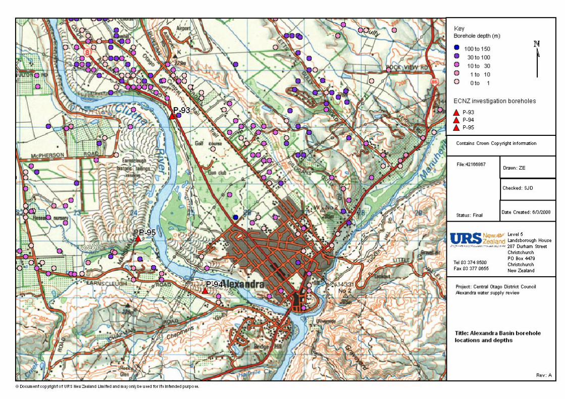
6.2 Gallery wellfield options The MWH (2002) study identified three areas as potentially suitable for a gallery borefield: the Bridge Hill Tailings Area, the mouth of the Fraser River and the golf course reach of the Clutha. These sites were investigated by the Electricity Corporation of New Zealand (ECNZ) in 1993; the locations of the investigation boreholes are indicated in Appendix D.
The Bridge Hill Tailings Area is located slightly downstream of the existing borefield and offers the chief advantage over the existing site of reducing the risk associated with the former landfill. Since the tailings
H Y D R O G E O L O G I C A L R E V I E W O F A L E X A N D R A W A T E R S U P P L Y
Section 6 Supply option evaluation
Prepared for Central Otago District Council, 16 April 2008 J:\Jobs\42166867\6 Deliv\Hydrogeological review of Alexandra water supply (Report)_Final.doc
6-2
are bounded by schist rock margins, the relocated borefield should draw a greater proportion of river water (which would therefore reduce hardness levels). The ECNZ drilling has indicated that a saturated thickness of approximately 7m of gravel is available in this area. Opus (2007) note that the Bridge Hill Tailings Area is relatively close to the Bridge Hill reservoir and hence a comparatively short pipeline would be required to connect into the existing system.
A restricted area of in situ gravel deposits is located near the mouth of the Fraser River; the investigation borehole in this area penetrated 14m of high permeability dredge tailings overlying schistose silty/clay. The saturated thickness of the dredge tailings was approximately 8m, indicating a high transmissivity.
The east bank of the Clutha River near the northern limit of the Alexandra Golf Course has also been characterised by an ECNZ investigation borehole: 23.5m of sandy gravel was encountered before schistose silt/clay was penetrated, inferred to be mantling the basement. Approximately 10m of saturated high permeability deposits are available in this area. From discussions with McNeil Drilling immediately prior to the issue of this report, we understand that of this borehole (P-93) has recorded 88 mg/l hardness. However, the borehole installation consists of a 50mm piezometer, which restricts the pump capacity significantly. It is therefore likely that the borehole was not purged adequately (this is supported up by the elevated turbidity and iron concentrations recorded) and hence the hardness results may not be representative of the true groundwater quality.
Initial indications of water quality in the golf course area are therefore promising.
Opus (1997) suggested that the latter two sites could be used to augment or supply Clyde and the adjacent rural areas.
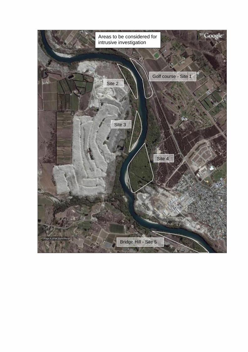
In addition to the above sites, there are a number of areas along the banks of the Clutha north of Alexandra town (see Appendix E) with potential point bar and other deposits where hydrogeological conditions may be similar to those encountered in investigation borehole BH5. These could also be considered for intrusive investigation.
CODC have indicated that the golf course and to a lesser extend the Bridge Hills Tailings area are their preferred options, based on proximity to potential connection points. A brief inspection of the golf course and Bridge Hills Tailings sites on 20/3/2008 has indicated that both sites are elevated above the river level to an extent that is likely to preclude the economic development of an infiltration gallery. A river proximal wellfield is therefore considered to be the best option at this stage.
The Bridge Hill Tailings area falls within the Earnscleugh sub aquifer unit, which is subject to the same take conditions as the Dunstan Flats aquifer (in which the existing abstraction is located). The transfer of the current consent to a new site on the other side of the river should be straightforward, assuming that abstraction from this location has no significant impact on nearby water takes. There are two takes in the Bridge Hill Tailings Area are as indicated in Appendix D. These comprise well no G42/0471, owned by a W Moffatt, drilled to 13m depth and used for domestic supply and irrigation, and well No. G42/0472 owned by a J Spriggs, drilled to an unknown depth and used for domestic supply. We have yet not confirmed with ORC that these takes are still in active use. The wells are located 260m and 340m from the Clutha River respectively. Potential impacts on these abstractions would need to be considered if development of a new water source in this area is the preferred option. However, given that the existing wellfield induces only a very limited drawdown even within very close proximity to the wellfield, we do not consider that this is likely to be an issue.
A similar situation exists in the area of the golf course – two wells are located within 150-200m of a possible site for the new wellfield (see Appendix D). The proposed wellfield could potentially be located further away from these wells if necessary, however, and the risk of a significant impact would be low in any case, assuming hydrogeological conditions are similar to the existing wellfield. The golf course site overlies the Dunstan Flats Aquifer – the same unit that the existing wellfield draws from. On this basis we do not foresee any major issues with consenting a new take on this site. The consenting situation for any other sites should be reviewed once the way forward has been agreed.
H Y D R O G E O L O G I C A L R E V I E W O F A L E X A N D R A W A T E R S U P P L Y
Section 7 Conclusions and recommendations
Prepared for Central Otago District Council, 16 April 2008 J:\Jobs\42166867\6 Deliv\Hydrogeological review of Alexandra water supply (Report)_Final.doc
7-1
7 Conclusions and recommendations
7.1 Conclusions We conclude:
• There are several issues associated with the current Alexandra town supply: hardness, proximity to a former landfill, turbidity, occasional taste and odour problems and source protection.
• Of the various solutions considered in previous studies, development of a new wellfield is the most financially favourable option, assuming that a softer groundwater source can be located.
• A review of the hydrogeology of the area indicates that most groundwater potential lies in the Quaternary deposits.
• Hardness in the Alexandra town water is due to high calcium concentrations; the likely source is dissolution of finely disseminated calcite within the schist basement, tertiary deposits and metamorphic sourced gravel material of the Quaternary aquifers.
• Analysis of the spatial distribution of hard groundwater did not identify any areas sufficiently close to the existing reticulation system where softer groundwater is likely to be encountered.
• Evaluation of the relationship between hardness and borehole depth using approximately 90 records from boreholes intersecting the Quaternary deposits revealed no correlation. We therefore do not see an opportunity to use abstraction depth to control hardness.
• The Clutha River has significantly lower hardness than the adjacent aquifers at Alexandra. A river proximal wellfield that blends river water (filtered through the bed and bank material) with groundwater, in the correct proportions, could therefore provide a source with an acceptable hardness level.
• Based on the natural chemical tracer analysis undertaken previously, and on the persistently elevated hardness levels, the existing wellfield draws a surprisingly low proportion of river water, given its proximity to the Clutha. This may be due to the wellfield configuration, the hydrogeological setting, or a combination of the two.
• Two options have been considered as a way forward: intrusive hydrogeological investigation of potential new wellfield sites and a numerical modelling study to determine whether the existing wellfield could be developed and operated to reduce hardness to an acceptable level.
• The river bank areas comprising relatively recently deposited bar materials may yield lower hardness water, although this is by no means certain. A number of sites with point bar deposits have been identified as options for further investigation.
• Sites in the Bridge Hill Tailings Area and adjacent to the golf course have previously been investigated and appear to offer good potential for development of a river proximal wellfield. We understand that the Golf Course site encountered a hardness concentration of 88 mg/l.
• We do not foresee any major issues with consenting a replacement wellfield in either of these areas. However, further consideration should be given to potential consenting issues at specific locations if Option 1 (intrusive investigation) is chosen as the way forward.
• There is no guarantee that, even if hardness can be reduced, a new river proximal wellfield would not suffer from the turbidity and occasional taste and odour issues encountered at the existing wellfield.
• Option 2 would involve some limited additional data collection followed by development and calibration of a numerical groundwater model of the existing wellfield.
H Y D R O G E O L O G I C A L R E V I E W O F A L E X A N D R A W A T E R S U P P L Y
Section 7 Conclusions and recommendations
Prepared for Central Otago District Council, 16 April 2008 J:\Jobs\42166867\6 Deliv\Hydrogeological review of Alexandra water supply (Report)_Final.doc
7-2
7.2 Recommendations We recommend:
• Consideration should be given to two options: intrusive investigation of one or more sites for a new river proximal wellfield and development of a numerical groundwater model of the existing wellfield to evaluate whether the system can be reconfigured to resolve the hardness issue.
• For Option 1, the potential sites identified in this report should be considered and a number chosen for further investigation in order of priority. The intrusive investigation should be phased such that an initial assessment of water quality is undertaken as the first priority before progressing onto the other (more costly) items, such as test pumping. It may be necessary to investigate a number of sites before a suitable location can be found.
• For Option 2, a short period of additional data collection would be required before the model development could be progressed.
• The following factors should be considered when weighing up these two options: the importance of relocating the wellfield away from the landfill, the cost total of a new wellfield if a two stage filtration system is required to control turbidity at the new location, the cost savings associated with redevelopment of the existing wellfield relative to the other options and the risk that a wellfield with sufficiently low hardness might not be achievable at any of the available sites.
• Our recommendation is that an intrusive investigation would be the best way forward, followed by a review of the data and re-evaluation of the options once the preliminary drilling works have been completed.
H Y D R O G E O L O G I C A L R E V I E W O F A L E X A N D R A W A T E R S U P P L Y
Section 8 References
Prepared for Central Otago District Council, 16 April 2008 J:\Jobs\42166867\6 Deliv\Hydrogeological review of Alexandra water supply (Report)_Final.doc
8-1
8 References
Alexandra and Environ Water Options Study; Opus, 2007
Groundwater Allocation of the Alexandra Basin; Otago Regional Council 2005.
Alexandra Borefield - Assessment of Environmental Effects MWH 2002
Groundwaters of New Zealand: Rosen M. R. and White P. A. 2001
Groundwater of the Alexandra Basin; Irricon 1998
Report on Alexandra Well Field; Pattle Delamore Partners Ltd 1995.
Geological Map of New Zealand Sheet S133; Cromwell. New Zealand Geological Survey 1987.
Guidelines for Canadian Drinking Water Quality - Supporting Documents – Hardness; Health Canada, 1979
H Y D R O G E O L O G I C A L R E V I E W O F A L E X A N D R A W A T E R S U P P L Y
Section 9 Limitations
Prepared for Central Otago District Council, 16 April 2008 J:\Jobs\42166867\6 Deliv\Hydrogeological review of Alexandra water supply (Report)_Final.doc
9-1
9 Limitations
URS New Zealand Ltd (URS) has prepared this report in accordance with the usual care and thoroughness of the consulting profession for the use of Central Otago District Council and only those third parties who have been authorised in writing by URS to rely on the report. It is based on generally accepted practices and standards at the time it was prepared. No other warranty, expressed or implied, is made as to the professional advice included in this report. It is prepared in accordance with the scope of work and for the purpose outlined in the Proposal dated 30/11/2007.
The methodology adopted and sources of information used by URS are outlined in this report. URS has made no independent verification of this information beyond the agreed scope of works and URS assumes no responsibility for any inaccuracies or omissions. No indications were found during our investigations that information contained in this report as provided to URS was false.
This report was prepared between 3-17/3/2008 and is based on the information available at the time of preparation. URS disclaims responsibility for any changes that may have occurred after this time.
This report should be read in full. No responsibility is accepted for use of any part of this report in any other context or for any other purpose or by third parties. This report does not purport to give legal advice. Legal advice can only be given by qualified legal practitioners.
This report contains information obtained by inspection, sampling, testing or other means of investigation. This information is directly relevant only to the points in the ground where they were obtained at the time of the assessment. The borehole logs indicate the inferred ground conditions only at the specific locations tested. The precision with which conditions are indicated depends largely on the frequency and method of sampling, and the uniformity of conditions as constrained by the project budget limitations. The behaviour of groundwater and some aspects of contaminants in soil and groundwater are complex. Our conclusions are based upon the analytical data presented in this report and our experience. Future advances in regard to the understanding of chemicals and their behaviour, and changes in regulations affecting their management, could impact on our conclusions and recommendations regarding their potential presence on this site.
Where conditions encountered at the site are subsequently found to differ significantly from those anticipated in this report, URS must be notified of any such findings and be provided with an opportunity to review the recommendations of this report.
Whilst to the best of our knowledge information contained in this report is accurate at the date of issue, subsurface conditions, including groundwater levels can change in a limited time. Therefore this document and the information contained herein should only be regarded as valid at the time of the investigation unless otherwise explicitly stated in this report.
Hydrogeological review of Alexandra water supply
Appendix A Hardness distribution in Alexandra area groundwaters (from Irricon 1998)
Prepared for Central Otago District Council, 16 April 2008 J:\Jobs\42166867\6 Deliv\Hydrogeological review of Alexandra water supply (Report)_Final.doc
A. Hardness distribution in Alexandra area groundwaters (from Irricon 1998)
Hydrogeological review of Alexandra water supply
Appendix B Hardness distribution plot (all available data)
Prepared for Central Otago District Council, 16 April 2008 J:\Jobs\42166867\6 Deliv\Hydrogeological review of Alexandra water supply (Report)_Final.doc
B. Hardness distribution plot (all available data)
Hydrogeological review of Alexandra water supply
Appendix C Hardness data analysis
Prepared for Central Otago District Council, 16 April 2008 J:\Jobs\42166867\6 Deliv\Hydrogeological review of Alexandra water supply (Report)_Final.doc
C. Hardness data analysis
0
10
20
30
40
50
60
70
80
0 50 100 150 200 250 300 350 400 450
Hardness (ppm CaCO3)
Bor
ehol
e de
pth
(m)
Hardness against depth: all quantitative data available for Alexandra basin (from Irricon
1998)
0
5
10
15
20
25
30
35
40
0 50 100 150 200 250 300
Hardness (ppm CaCO3)
Bor
ehol
e de
pth
(m)
Hardness against depth: quantitative data for Dunstan Flats only (from Irricon 1998)
0
10
20
30
40
50
60
70
Nothard
Hard Veryhard
Subjective hardness class
Bor
ehol
e de
pth
(m)
Hardness against depth: all qualitative data available for Alexandra basin (from Irricon
Appendix D ECNZ investigation borehole locations and existing groundwater takes
Prepared for Central Otago District Council, 16 April 2008 J:\Jobs\42166867\6 Deliv\Hydrogeological review of Alexandra water supply (Report)_Final.doc
D. ECNZ investigation borehole locations and existing groundwater takes
Hydrogeological review of Alexandra water supply
Appendix E Areas to be considered for intrusive investigation
Prepared for Central Otago District Council, 16 April 2008 J:\Jobs\42166867\6 Deliv\Hydrogeological review of Alexandra water supply (Report)_Final.doc
E. Areas to be considered for intrusive investigation
Areas to be considered for intrusive investigation