58
Hydrology related information subsystem within NEESPI Alexander Georgiadi, RAS-NEESPI Project Manager joint IGWCO/ CEOP workshop, Tokyo, February 28-March 4, 2005

Hydrology related information subsystem within NEESPI
Alexander Georgiadi, RAS-NEESPI Project Managerjoint IGWCO/ CEOP workshop, Tokyo, February 28-March 4, 2005
Hydrology related information subsystem within NEESPI
Alexander Georgiadi, RAS-NEESPI Project Managerjoint IGWCO/ CEOP workshop, Tokyo, February 28-March 4, 2005

1. General information about recent NEESPI activities
2. Objectives and priorities of Northern Eurasia Regional Information Network
3. Hydrology related information
3.1. State network stations of standard observations
3.2. Research stations
3.3. Field experiments

3
• The Northern Eurasia Earth Science Partnership Initiative, or NEESPI is
• An active multidisciplinary program of research focused on critical Earth system science issues in Northern Eurasia
– Current active partners are principally NASA and RAS – inishiators of NEESPI
and
• it is a strategically evolving program of internationally-supported Earth systems science research,
• which has as its foci scientific issues in northern Eurasia that are currently relevant to regional and Global scientific and decision-making communities.
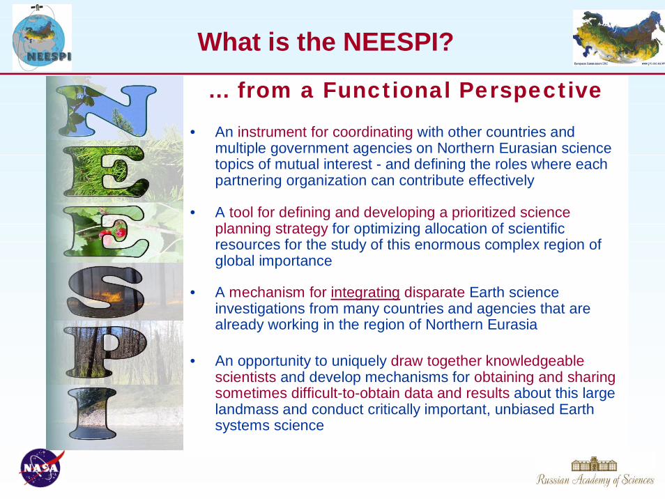
What is the NEESPI?
4
… from a Functional Perspective
• An instrument for coordinating with other countries and multiple government agencies on Northern Eurasian science topics of mutual interest - and defining the roles where each partnering organization can contribute effectively
What is the NEESPI?
• A tool for defining and developing a prioritized science planning strategy for optimizing allocation of scientific resources for the study of this enormous complex region of global importance
• A mechanism for integrating disparate Earth science investigations from many countries and agencies that are already working in the region of Northern Eurasia
• An opportunity to uniquely draw together knowledgeable scientists and develop mechanisms for obtaining and sharing sometimes difficult-to-obtain data and results about this large landmass and conduct critically important, unbiased Earth systems science

The overarching NEESPI science question is:
How do Northern Eurasia’s terrestrial ecosystems and their components dynamics interact with and alter the biosphere, atmosphere, and hydrosphere of the Earth?
This question can be reformulated in a pragmatic way as:
How do we develop our predictive capability of terrestrialecosystems dynamics over Northern Eurasia for the 21st century to support global projections as well as informed decision making and numerous practical applications in the region?

5
What is the NEESPI Study Area ?
NEESPI StudyArea includes:
Former SovietUnion,NorthernChina andMongolia,Scandinavia& EasternEurope
MapCourtesy ofEuropean Commission,JRC
6Deering – Feb 2004
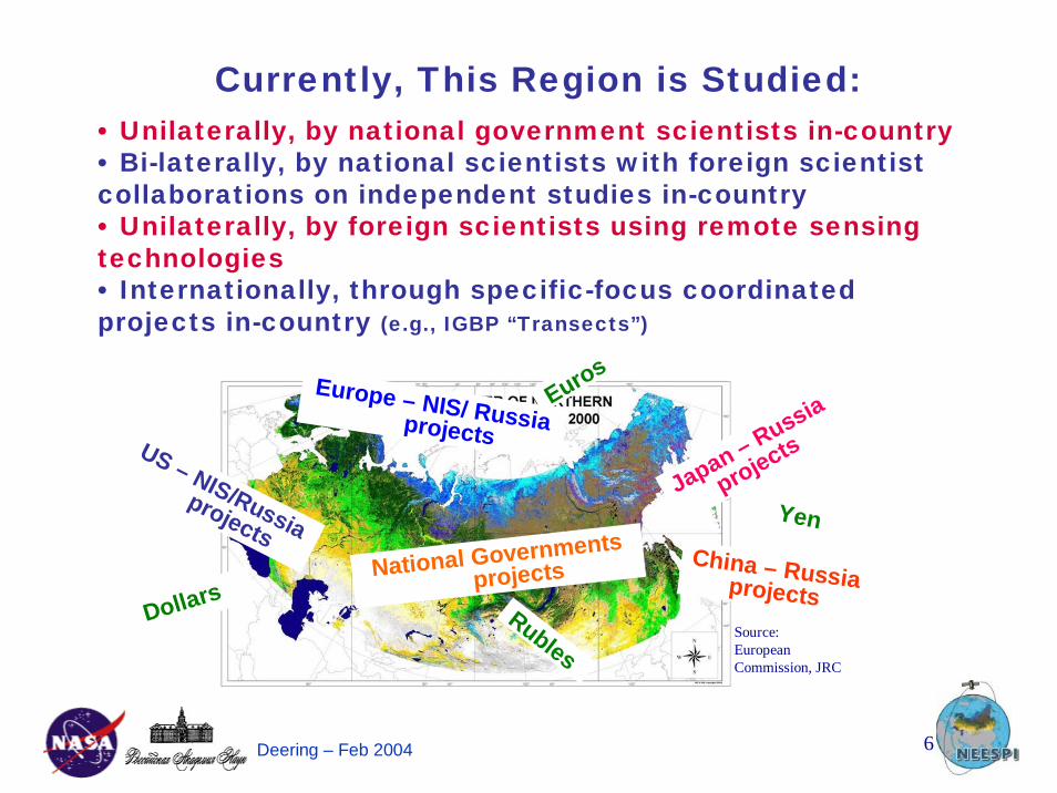
Currently, This Region is Studied:• Unilaterally, by national government scientists in-country• Bi-laterally, by national scientists with foreign scientist collaborations on independent studies in-country• Unilaterally, by foreign scientists using remote sensing technologies• Internationally, through specific-focus coordinated projects in-country (e.g., IGBP “Transects”)
Source:EuropeanCommission, JRC
Japan – Russia
projects
China – Russia projects
US – NIS/Russia projects
Europe – NIS/ Russia projects
National Governments projects
Yen
Euros
DollarsRubles
6Deering – Feb 2004
Currently, This Region is Studied:• Unilaterally, by national government scientists in-country• Bi-laterally, by national scientists with foreign scientist collaborations on independent studies in-country• Unilaterally, by foreign scientists using remote sensing technologies• Internationally, through specific-focus coordinated projects in-country (e.g., IGBP “Transects”)
Source:EuropeanCommission, JRC
Japan – Russia
projects
China – Russia projects
US – NIS/Russia projects
Europe – NIS/ Russia projects
National Governments projects
Yen
Euros
DollarsRubles
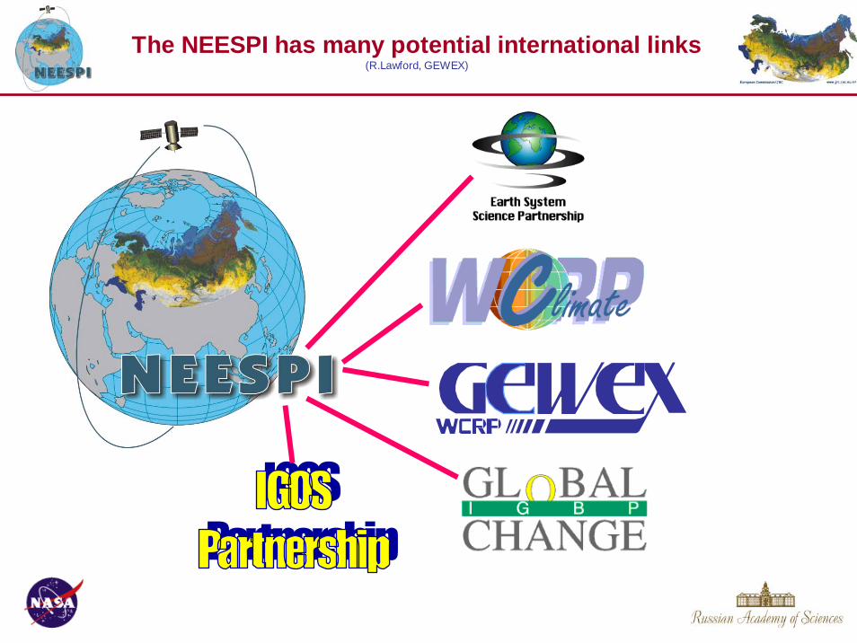
The NEESPI has many potential international links(R.Lawford, GEWEX)
‘12
Bi-lateral SPDraft Version 1 SP Ver. 2NEESPI Concept Development
NEESPI Phase I Implementation SP Development + 1st Funded Projects
Phase I Science Plan
International SP
ESJWG–“Agreement “SP Workshop
SP Review“Inter-Agency” Meeting
1st US/RU Planning W/S
Implementation Plan Early Planning
2005 2006 2007
Implementation Plan
NEESPI Implementation
‘08
International SP (cont’d)
Contacts w/ Int’l Agencies and Int’l SP Contributions
Sponsor Contributions
And International Sponsorship
Int’l Partner
Final SP Published
Internat’l
Multiple Projects
Full International Sponsorship - Implementation
Final IP Published
Workshops & Review Meetings
Activity ¥ Year (CY)
NEESPI Progress& Development Timeline
Review Revision
2002 2003 2004 ‘05
•• • • •
Phase I Science Plan Development
Formation of Science TeamPreparation of Implementation Plan

US NSF, NIH, EPA, USGS
DOE, USDA, NOAA . . .
Other NIS(Ukraine, Kazakhstan . . .)
GLORIADSTART,
GLOBE . . . GOFC / GOLD, GCOS, GTOS,
IGOS-P . . .IGBP, WCRP,IHDP, GCP. . .
ChinaCAS, CSA . . .
GEWEX, ILEAPS, LAND, GCTE,
GWSP, CLIVAR,GCP,CLIC, ESSP
RURILEM, MST. . .
JapanNASDA (JAXA) . . .
Sponsoring Organizations• NEESPI Program Development• Research Funding Support• Organization & Implementation Committee
International Projects• Scientist Networks• Data Sharing• Data Analysis/ Synthesis
US-NASA2National Aeronautics & Space Administration
RU-RAS2Russian Academy
of Sciences
____________________________1 anticipated participation with project maturation2 founding sponsoring organizations
EUEC-RTD, ESA, DLR
NEESPI IS SEEKING ADDITIONALSPONSORSHIP AND LINKAGES

The major scientific areas, or science themes, to be addressed in the NEESPI include terrestrial ecosystem dynamics, biogeochemical cycles, surface energy and water cycles, land useinteractions: societal-ecosystem relationships, ecosystems and climate interactions, and topics of special interest, which include cold land region processes, coastal zone processes, and atmospheric aerosol and pollution.NEESPI seeks to address interactions between Northern Eurasian ecosystems, water, climate, and human activity, using a combined framework of predictive models, long-term in situand spatially complete modern remote-sensing observations, and process studies.
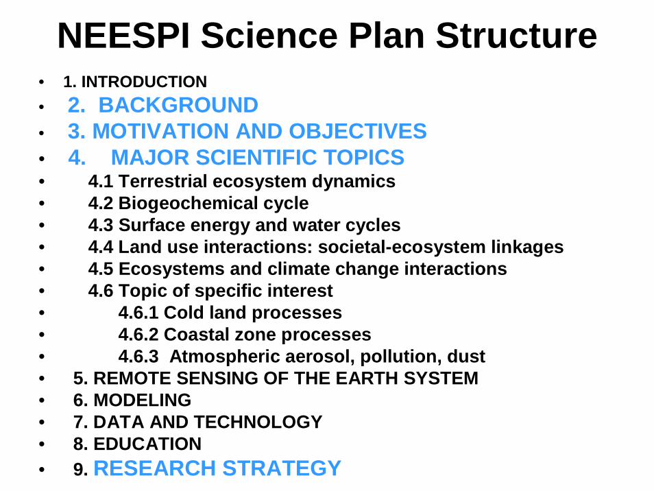
NEESPI Science Plan Structure• 1. INTRODUCTION• 2. BACKGROUND• 3. MOTIVATION AND OBJECTIVES• 4. MAJOR SCIENTIFIC TOPICS• 4.1 Terrestrial ecosystem dynamics • 4.2 Biogeochemical cycle • 4.3 Surface energy and water cycles • 4.4 Land use interactions: societal-ecosystem linkages • 4.5 Ecosystems and climate change interactions• 4.6 Topic of specific interest • 4.6.1 Cold land processes• 4.6.2 Coastal zone processes• 4.6.3 Atmospheric aerosol, pollution, dust • 5. REMOTE SENSING OF THE EARTH SYSTEM • 6. MODELING• 7. DATA AND TECHNOLOGY• 8. EDUCATION• 9. RESEARCH STRATEGY
Through conducting the scientific research during the next decade as addressed in the NEESPI Science Plan the following products are expected:• An integrated observational knowledge data base forenvironmental studies in Northern Eurasia that includes validatedremote sensing products• A suite of process-oriented models for major terrestrialprocesses in their major interactions (including those with the society)• Prototypes for a suite of global and regional models thatseamlessly incorporate major regionally specific feedbacksassociated with terrestrial processes in Northern Eurasia andwhich could serve to improve scientific understanding that wouldenable future environmental change projections and provide inputto informed decision-making for land use and environmentalprotection policies.• Systems demonstrated in the research domain in collaborationwith operational partners that can serve the emergency needs ofthe society (early warning / management / mitigation of floods,fire, droughts, and other natural disasters)

Overarching Scientific Questions for Water Cycle investigations
First: How will global climate change affect WC within Northern Eurasia?
Second: How will WC changes in Northern Eurasia affectsurrounding and global climate, biosphere and human society?
Third: What are main mechanisms of functioning, dynamics and long-term changes of water cycle components of terrestrial ecosystems and water systems of different scales in very diverse conditions of the Northern Eurasia?

Attention will be paid to the processes that directly feed back to the Global Earth System.From hydrological point of view
• The fresh water transport through the Arctic Ocean (increasing of fresh water inflow)
Thermohaline circulation is a global-scale overturning in the ocean that transports significant heat via a poleward flow of warm surface water and an equator-ward return of cold, less saline water at depth. The overturning, crucial to this transport in the Northern Hemisphere, occurs in the Greenland, Irminger and Labrador Seas. The overturning also moderates anthropogenic impact on climate because it removes atmospheric CO2 to the deep ocean. The occurrence and intensity of overturning is sensitive to the density of water at the surface in these convective gyres, which, in turn, is sensitive to the outflow of low-salinity water from the Arctic Ocean. In the Arctic Ocean, freshwater accumulates due to precipitation and inflow from rivers and the relatively fresh Pacific waters (compared to the North Atlantic Ocean) through the Bering Strait. This freshwater and sea ice outflow from the Arctic basin is subject to significant interannual oscillations that influence the salinity balance and winter convection processes of the Greenland Sea and the North Atlantic. About 10% of the global river runoff is discharged to the Arctic Ocean, which is only 5% of the global ocean area and 1.5% of its volume. About three-quarters of the inflow come from the six largest rivers, the Yenisey, the Lena, the Ob, the Mackenzie, the Pechora and the Kolyma. Five of them are in Northern Eurasia.

21.02.2004 8
Global Climate warming (current-future)
Regional Climate changes
Degradation of permafrost: significant change the permafrost spatial extent, active layer thickness,ground temperature,
Extreme fenomenon(floods, droughts)
River Runoff changes (volume, intraannualdistribution, part of underground flow)
Changes of CO2 fluxes:- riverine export ;- land-atmosphere fluxes(swamped areas, permafrost, etc.)
Changes of bogs
• Thawing of permafrost and connected hydrological changes(It is connected closely with previous objective)
Attention must be addressed to the processes of major societal importance.
They may or may not affect the Global Earth System but for the region’s population they are of pivotal importance.
•Extremes•Terrestrial hydrology and water supply•Soil moisture changes, impact on agriculture•Soil / freeze/ refreeze/ thaw of permafrost interaction with hydrological processes•Snow cover impact on flooding•Glaciers changes, impact on hydrology•Water pollution

Hydrological consequences of social-economic changesImpact on water resources of a decrease (at least twofold) of industrial
and agricultural production in Russia in the 1990s
A general weakeningof anthropogenic loading
Opposite (to weakening) effects due to changes in spatialdistribution and types of impacts as well as due to the degradation of the environment protection system
•Reduction of water withdrawalby most of users
•Decrease of arable land area•Decrease of irrigated land area•Decrease of amount of fertilizers •Decrease of forest cutting area•Decrease of melioration area
•Increasing of intensity of selected anthropogenic impacts
•Decrease of technology level in agriculture, forest cutting, etc.
•Increase of specific water consumption•Degradation of water quality protection
system
All hydroecological consequences of these changes are not yet fully investigated

Success of the NEESPI project requires open exchange of data andinformation among the project participants, to the greatest extent allowable by institutional, national, and international regulations.
NERIN has emerged as an informal network of:
a. scientists and other professionals, b. institutions and observational networks, c. projects within the thematic scope of NEESPI,d. network of points of contact for data users (under development). NERIN is currently assembling information about the content, quality, condition, and other characteristics of number of data sets available to support new research in Northern Eurasia. Searchable METADATA are available and new contributions to the METADATA are welcome.
The development and implementation of NERIN defined the thematic foci of the recent Workshop "OBSERVATIONAL DATA in Support of NEESPI" was held February 23-26, 2004 in Repino, near St. Petersburg, Russia.

NEESPI Information System
Observed State of Earth System
Projected State of Earth System
(based on scenarios of climateand socio-economic changes)

Hydrology related information subsystem will be an important part of NERIN having a wide range of data on main fresh water components and their factors including human activities on different temporal and spatial scales from different observational systems developed on national, bilateral and international levels. Data of state network, research stations, and field experiments as well as land cover land use data will be included in hydrological subsystem.

Base line data (in-situ and remote sensing)stations and gridded data
Historic andOperational Hydrometeo
Data of standard obs.Data on Land Surface Social-economic
Data
Data of NEESPI Projects
Data of National, Bilateral and International Programs (Data Centers)
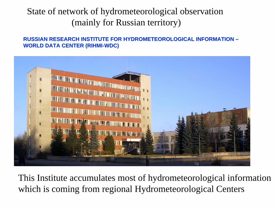
RUSSIAN RESEARCH INSTITUTE FOR HYDROMETEOROLOGICAL INFORMATION RUSSIAN RESEARCH INSTITUTE FOR HYDROMETEOROLOGICAL INFORMATION ––WORLD DATA CENTER (RIHMIWORLD DATA CENTER (RIHMI--WDC)WDC)
State of network of hydrometeorological observation (mainly for Russian territory)
This Institute accumulates most of hydrometeorological informationwhich is coming from regional Hydrometeorological Centers

Оперативное метеорологическое обеспечение
Operational meteorological data
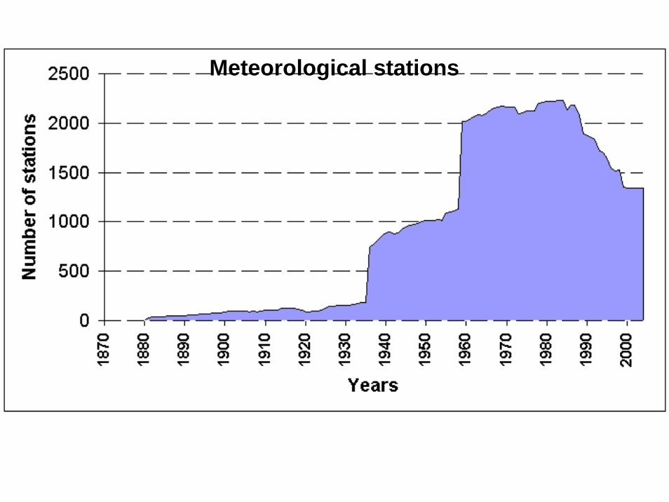
Meteorological stations

3-HOURLY DATA SET
Air temperatureWater vapour pressure Dew-point temperatureRelative humiditySea level pressure Station level pressure Air pressure tendency VisibilityTotal cloud amount Lower cloud amount Cloud generalHeight of cloud base Wind speed Wind directionPrecipitationPresent weatherPast weatherSurface temperatureGround stateAtmospheric phenomena
DAILY DATA SET
Mean daily air temperatureMaximum air temperatureMinimum air temperatureDaily precipitationSnow depthSnow coverageCharacteristics of siteMinimum of relative humidityMinimum of surface temperatureWind speed maximumAtmospheric phenomenaAtmospheric phenomena durationDaily total and low cloud amountSunshine duration
List of meteorological elements
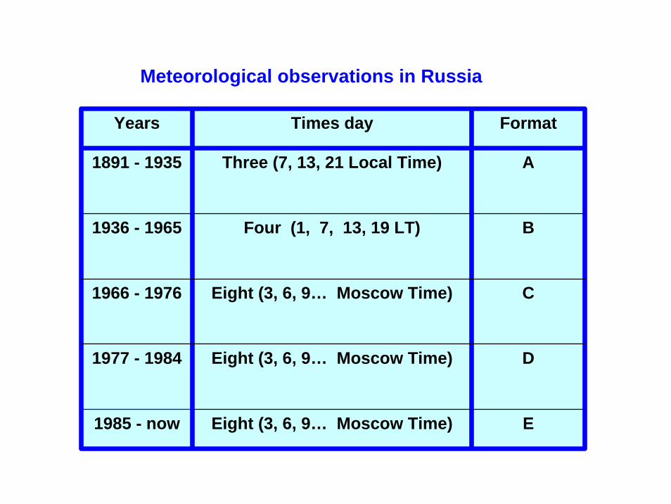
Years Times day Format
1891 - 1935 Three (7, 13, 21 Local Time) A
1936 - 1965 Four (1, 7, 13, 19 LT) B
1966 - 1976 Eight (3, 6, 9… Moscow Time) C
1977 - 1984 Eight (3, 6, 9… Moscow Time) D
1985 - now Eight (3, 6, 9… Moscow Time) E
Meteorological observations in Russia

Agrometeorological stations
0200400600800
10001200140016001800
1960
1965
1970
1975
1980
1985
1990
1995
2000
2004
Stat
ion

Observation
Tables
State Data FundPC
Agrometeorologicalannual
Up to 1960
From 1961to 1997
Observation
TablesAgrometeorological
annual PC1
From 1997to now Observation PC
Tables
Agrometeorologicalannual
PC1State
Data Fund
Soil moisture data

Meteorological stations(Snow cover characteristics. Daily data )


Meteorological stations (snow cover state characteristics for fixed routes observations)

THE SYSTEM OF HYDROLOGICAL
OBSERVATIONS IN RUSSIA
The system of hydrological observations is the main source of information on the surface water.
The state system of water resources
inventory
The system of hydrological observations
Water use inventory
Roshydromet
The system of groundwater
observations
Ministry of NaturalResources

THE SYSTEM OF HYDROLOGICAL
OBSERVATIONS IN RUSSIA
Hydrological network is the main part of surface water inventory. Hydrological observation data are required for many branches of the national economy, scientific purposes, environmental requests and others. Therefore, the requirements for this information are diverse with time.
Main components of hydrological network
Network on lakes and
reservoirs
Waterevaporimeter
network
Waterbalancenetwork
Networkon swamps
Network on rivers
and channels
Hydrolo-gical
network

THE SYSTEM OF HYDROLOGICAL
OBSERVATIONS IN RUSSIA
Dynamic of hydrological network
Number of stations
Rivers Swamps
Total Discharge
Total Posts
2844 2188 350 3 8 203
19864161 2664 514 6 15 302 10
20036
Evaporation Water balance
Lakes

Hydrometric operational stations

THE SYSTEM OF HYDROLOGICAL
OBSERVATIONS IN RUSSIA
Main types of observations on rivers:
• Water discharge• Water level• Sediment discharge• Sediment composition• Water temperature• Water quality• Ice regime
characteristics• Ice thickness
Main types of observations on lakes:
• Meteorological observations
• Water level
• Water temperature
• Water quality
• Waves
• Currents
• Ice regime characteristics
• Ice thickness
Main types of observations on swamps:
• Heat balance
• Meteorological observations
• Water discharge
• Water level
• Water quality
• Ice regime
• Peat and soil properties

THE SYSTEM OF HYDROLOGICAL
OBSERVATIONS IN RUSSIA
Water resources, their quality and use Integrated, selected and generalized information
Annual and long-term generalizations
Subsurface water
Catalogues of subsurface water
objects and points for
observations; results of
observations of subsurface water
regime and quality;
annual and long-term
generalizations;subsurface water
storage
Water use
Catalogues of water use; results of annual
statistical reports of
water users; annual
generalizations
Surface Water
Distributed according to the kind of informationCatalogues of water bodies and observation sites , results of observations of
water regime and quality; annual and long-term generalizations within the water bodies
Lakes and
reservoirs
Rivers and
canals
Seas and sea mouths
of rivers
Water quality on
land
Glaciers Mudflows
The National Water Cadastre structure

THE SYSTEM OF HYDROLOGICAL
OBSERVATIONS IN RUSSIA
The structure of the published part of the NWC
Three series of reference books in each section and subsection:
“Catalogue Data”, “Annual Data” ( yearbooks )“Long-term Data”. ( long-term issues )
Two combined reference books :
“Surface and Subsurface water resources, their use and quality”( yearbooks )“Water Resources and their Development” ( long-term issues ) (one-volumed reviews of the appropriate multi-purpose generalized data on large river basins and their parts, large lakes or reservoirs, units of administrative and territorial division, economic regions and country as a whole) .


# Water Balance Station Geographical zone Total area Basins number Operating period
1 Pribaltijskaya Coniferous Forest 40 6 1946 - operating
2 Valdai Branch of the SHI Coniferous Forest Up to 10000 15 1933 - operating
3 Podmoskovnaya Mixed Forest 25.6 9 1945 - operating
4 Nizhnedevitsk Forest-Steppe 103 10 1947 - operating
5 Kamennaya Steppe Steppe 4.9 6 1949 - operating
6 Pridesnianskaya Mixed Forest 29.7 8 1929 - operating
7 Veliko-Anadol Steppe 44.2 5 1950 - 1986
8 Bolkhov Mixed Forest 1930 16 1972 - 1986
9 Zakarpatskaya Mountain, Forest 550 23 1956 - operating
10 Dubovskaya Steppe 206 12 1948 - 1986
11 Leninogorskaya Mountain 400 2 1982 -
12 Bomnak Forest, Permafrost 22 4 1935 - 1968
13 Primorskaya Forest 1370 20 1946 - operating
14 Kolymskaya Mountain, Permafrost 21.2 7 1948 - operating
15 Alma-Atinskaya Mountain 118 21 1939 - 1972
16 Zapadno-Turkmenskaya Desert 13.6 6 1950 -
17 Kustanaiskaya Steppe 181 9 1960 - 1971
18 Zap. Kazakhstanskaya Semi-desert 248 5 1951 - 1973
19 Moldavskaya Steppe 62.4 9 1953 - operating
20 Aksusskaya (irrigation) Steppe 600 1 1974 - 1984
21 Semikarakorskaya (irrigation) Steppe 20 3 1965 - 1996
22 Mogot Experim. Plot Mountain, Permafrost 31.8 6 1976 - 1985, 2000 - 2002

Peatlands cover from 2 to 6 % of the land surface, contribution from Russia - up to 50 %
Ecosystems of the World. 4A. Mires: Swamp, Bog, Fen and Moor (Ed. Gore A.J.P.), 1983

• Peatlands – main terrestrial sink of atmospheric carbon
• Peatlands – GHG (CO2, CH4 , N2O) source • Peatlands could have a mitigation effect for the
climate change consequences• Peatlands strongly urge the climate change
adaptation strategy
Peatlands could be considered in the climate change problem regarding following aspects:
© A.Sirin (ILAN&WI RP)

0
10
20
30
1991 1992 1993 1994 1995 1996 1997 1998 1999
Reconstruction of forest drainage network in
Russia, th. ha
Only in European Russia secondary paludification
occurs on the territory over 750 th hectares
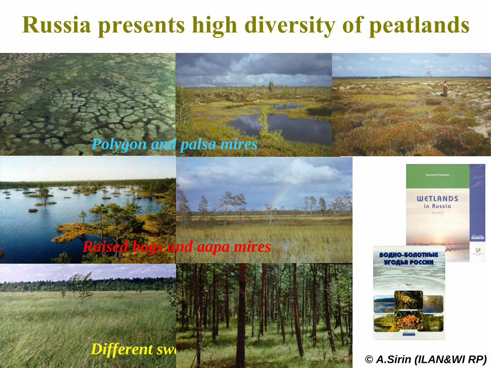
Russia presents high diversity of peatlands
© A.Sirin (ILAN&WI RP)
Raised bogs and aapa mires
Different swamps and fens
Polygon and palsa mires
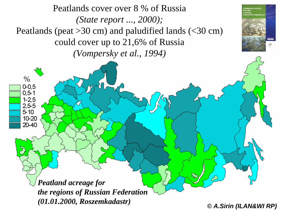
Peatlands cover over 8 % of Russia(State report ..., 2000);
Peatlands (peat >30 cm) and paludified lands (<30 cm)could cover up to 21,6% of Russia
(Vompersky et al., 1994)
%
© A.Sirin (ILAN&WI RP)
Peatland acreage forthe regions of Russian Federation(01.01.2000, Roszemkadastr)

Mire zones: I – polygon mires; II – palsa mires; III – raised (sphagnum) bogs; IV – flat eutrophic and mesotrophic mires; V – concave eutrophic and saline mires. Mountain regions of the Asian part of Russia according to N.Ja. Katz (1971): А – East Jakutiya; Б –Jakutia; В – Dauric-Amur.
Location of peatland observation stations andpoints of State Committee of Hydrometeorologyand Environmental Monitoring

Location of field peatland stations andobservation points of the West-Siberian Expedition of the State Hydrological Institute of the State Committee of Hydrometeorologyand Environmental Monitoring

Data of research stations

Complex Research Stations of RAS Research Institutes
Kursk Biosphere Station (1965)Stations of Institute of Forest, SB (Krasnoyarsk)Stations of Institute of Geography, SB (Irkutsk)Station of Institute of Biological Problems of Cryolithozone, SB (Yakutsk)

Field Research Stations

Data of international field experiments
KUREX- 88, KUREX- 91GAME/SiberiaIGBP (Enisey meridian)


Tundra
Plain taiga
Mountain taiga
GAME/Siberia, 1996-2003

Conclusions
1.There is rather dense hydrometeorological station network over Russia which includes stations of standard observations, monitoring stations as well as research stations and network of field experiments. Number of stations was decreased during 1990th.
2. This network combined with network of water quality monitoring, land data as well as socio-economic and satellite information form reliable basis for solving of major tasks of NEESPI Sci. Plan.
3. Availability of state network data was deteriorated due to stoppage of their open Publication during last 10-15 years.

4. The main objective of NERIN is to create better conditions for getting of necessary information based on:
4.1. Creation of detail Metadata archive which should combine main data bases on national, bi-lateral and international levels as well as on level of institutes and scientists.
4.2. Creation of effective relationships between owners of data and NEESPI Projects.
5. The attention should be paid on main problems of observational data assimilation (quality control, homogeneous of data sets, accuracy of measurements of some elements (solid precipitation), re-analysis of hydrometeoelements for mountain area and north-eastern part of Eurasia, etc.

Northern Eurasia Earth Science
Partnership Initiative
FOR MORE INFORMATION SEE THE NEESPI WEB SITE:http://neespi.gsfc.nasa.gov
Side Note: “NEESPI” is pronounced
approximately like theRussian phrase for
“Don’t sleep “

Materials of V. Razuvaev, V.Vuglinsky, S. Zhuravin, S.Sirin, O.Krankina, A.Shiklomanov, A.Georgiadi presented at NEESPI WS, February 2004, Sankt-Petersburg; D.Deering, A.Georgiadi presented at AGU Meeting, December 2004; NEESPI Science Plan were used in preparation of this talk.


