I-69 EVANSVILLE TO INDIANAPOLIS TIER 2 STUDIES Section 6—Final Environmental Impact Statement Summary S-i TABLE OF CONTENTS SUMMARY ................................................................................................................................... 1 S.1 INTRODUCTION .................................................................................................................... 4 S.2 TIER 1 NEPA STUDY ............................................................................................................ 5 S.3 PROJECT PURPOSE AND NEED ........................................................................................ 7 S.3.1 Tier 1 Purpose and Need for I-69 from Evansville to Indianapolis .................................... 7 S.3.2 Statement of I-69 Section 6 Tier 2 Purpose and Need ..................................................... 8 S.4 ALTERNATIVES DEFINITION ............................................................................................... 9 S.4.1 Project Scoping ................................................................................................................. 9 S.4.2 Conceptual Alternatives .................................................................................................. 11 S.4.3 Preliminary Alternatives .................................................................................................. 12 S.4.4 Alternatives Considered in the DEIS ............................................................................... 14 S.4.4.1 I-69 Mainline...................................................................................................................... 15 S.4.4.2 Interchanges and Local Service Roads ............................................................................ 18 S.4.4.3 Components of Alternatives C1, C2, C3, and C4 ............................................................. 18 S.4.5 Evaluation of Alternatives C1 through C4 ....................................................................... 23 S.4.5.1 Evaluation of Mainline Options M1 through M3 ................................................................ 23 S.4.5.2 Interchanges and Local Service Roads, Alternatives C1 – C4 ......................................... 25 S.4.5.3 Section 4(f) Evaluation ...................................................................................................... 44 S.4.5.4 Overall Impacts and Costs of Alternatives C1 through C4 (DEIS) ................................... 45 S.4.5.5 DEIS Preferred Alternative................................................................................................ 48 S.5 REFINED PREFERRED ALTERNATIVE (RPA) DEFINITION AND EVALUATION ........... 49 S.5.1 Definition and Impacts of the RPA .................................................................................. 49 S.5.1.1 Subsection 1: Indian Creek to SR 39 ................................................................................ 50 S.5.1.2 Subsection 2: SR 39 to Morgan Street ............................................................................ 51 S.5.1.3 Subsection 3: Morgan Street to Henderson Ford Road.................................................... 53 S.5.1.4 Subsection 4: Henderson Ford Road to Banta Road ....................................................... 54
Transcript
I-69 EVANSVILLE TO INDIANAPOLIS TIER 2 STUDIESSection 6—Final Environmental Impact Statement
Table S-25: Estimated Cost by Cost Item ($ Millions) for Alternative C4 and the RPA .............................. 62
Table S-26: Estimated Cost by Subsection ($ Millions) for Alternative C4 and the RPA ........................... 62
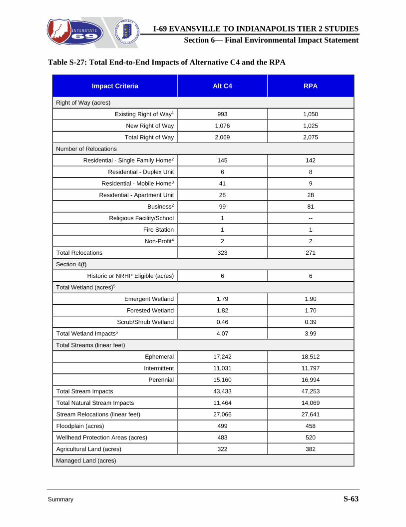
Table S-27: Total End-to-End Impacts of Alternative C4 and the RPA ...................................................... 63
Table S-28: Comparison of I-69 Section 6 Tier 1 and RPA Impacts .......................................................... 67
Table S-29: Major Mitigation Initiatives ....................................................................................................... 72
LIST OF FIGURES Figure S-1: I-69 Section 6 Four-County Study Area ..................................................................................... 2
Figure S-2: Preferred Alternative 3C and Tier 2 Sections ............................................................................ 6
Figure S-11: Decision Area 3-1 at Myra Lane ............................................................................................. 31
Figure S-12: Decision Area 3-2 ................................................................................................................... 32
I-69 EVANSVILLE TO INDIANAPOLIS TIER 2 STUDIESSection 6—Final Environmental Impact Statement
S-iv Summary
Figure S-13: Decision Area 4-2 Configuration ............................................................................................ 33
Figure S-14: Decision Area 5-2 at Stones Crossing Road ......................................................................... 35
Figure S-15: Decision Area 5-2 Configuration ............................................................................................ 35
Figure S-16: Decision Area 5-4 Configuration ............................................................................................ 36
Figure S-17: Decision Area 6-1 Configuration ............................................................................................ 38
Figure S-18: Decision Area 6-2 Configuration ............................................................................................ 39
Figure S-19: Decision Area 7-1, Options C4A and C4B at Southport Road ............................................... 41
Figure S-20: Decision Area 8-1, I-69/I-465 Interchange ............................................................................. 43
Figure S-21: The RPA in Martinsville .......................................................................................................... 51
Figure S-22: The RPA from SR 144 to Stones Crossing Road .................................................................. 56
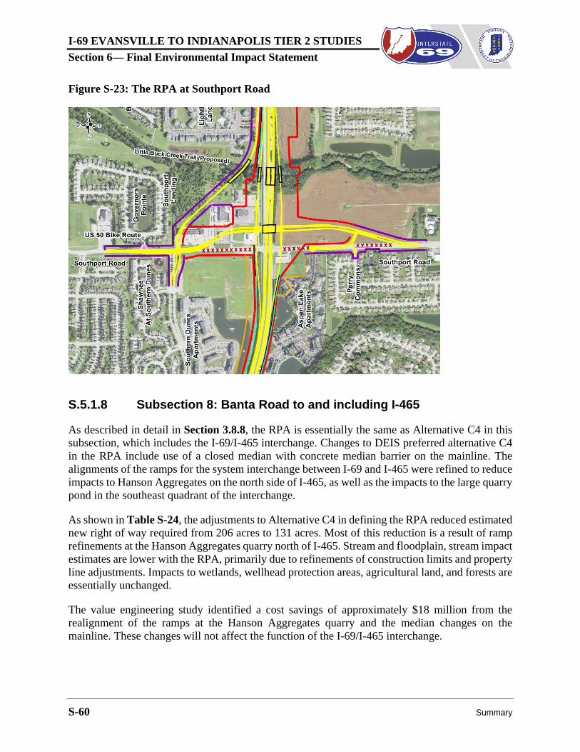
Figure S-23: The RPA at Southport Road .................................................................................................. 60
I-69 EVANSVILLE TO INDIANAPOLIS TIER 2 STUDIESSection 6— Final Environmental Impact Statement
Summary S-1
SUMMARY Since the publication of the DEIS, the following substantive changes have been made to this chapter:
• The Summary, prior to Section S.1, has been revised to note the publishing of the DEISand the development of the Refined Preferred Alternative (RPA), and Summary of theFEIS Process has been added.
• Section S.4.4 has been revised to indicate that the mainline, interchange, and local serviceroad options were developed during the DEIS.
• Typical cross section figures have been replaced by a table of DEIS mainline designdimensions in Section S.4.4.1.
• Section S.4.5 has been revised to indicate that it documents the process for identifying apreferred alternative in the DEIS. No new data or information is provided. Descriptionsand recommendations in the 23 decision areas in Section S.4.5.2 have been condensed.
• Section S.5 has been added to summarize interchange and local service road options ineight subsections for the RPA.
• Changes to the DEIS preferred alternative (Alternative C4) to define the RPA have beendescribed and the impacts of the RPA have been compared to those of Alternative C4 ineight subsections of the I-69 Section 6 corridor in Section S.5.1.1 through S.5.1.8.
• The overall end-to-end impacts of the RPA and Alternative C4 have been compared inSection S.5.2.
• Estimated wetland impacts have been described for the RPA in Section S.5.4 based onmore precise wetland delineations conducted after the DEIS was published. Information inthe DEIS was based on estimates of wetland areas.
• Adjustments have been made to the estimates of residential and business relocations forAlternative C4 in Section S.4.5.2 using updated information on use of existing structuresthat was not yet developed at the time the DEIS was prepared.
• The overall cost of the RPA and Alternative C4 has been compared by development phaseand subsection in Section S.5.5.1.
• The overview of Section 106 consultation has been updated in Section S.9.1.
• The description of Section 7 consultation in Section S.9.2 has been updated for the RPA.
• Section S.10, included in the DEIS to describe remaining Tier 2 steps has been removed.
I-69 EVANSVILLE TO INDIANAPOLIS TIER 2 STUDIESSection 6—Final Environmental Impact Statement
S-2 Summary
Summary of the DEIS Process
Regulations of the Council on Environmental Quality (CEQ) and Federal Highway Administration (FHWA) allow National Environmental Policy Act (NEPA) studies for large, complex projects to use a two-stage, tiered process. In Tier 1, an overall study area or general route is identified. In Tier 2, project level environmental studies are conducted to identify a preferred alignment and configuration of the facility. A tiered process is being used for I-69 from Evansville to Indianapolis, Indiana. NEPA studies have been completed for Tier 1 and for five of the Tier 2 sections. This NEPA study is for the last section, I-69 Section 6 between Martinsville and Indianapolis. The corridor is shown in the context of a four-county study area in Figure S-1.
Figure S-1: I-69 Section 6 Four-County Study Area
The 2004 Tier 1 Record of Decision (ROD) selected Alternative 3C as the I-69 corridor between Evansville and Indianapolis, with the SR 37 corridor to be used for Section 6 between Martinsville and Indianapolis. I-69 Section 6 termini are SR 37 at Indian Creek south of SR 39 in Morgan County and I-465 in Marion County. The Tier 1 ROD permitted consideration of alternative routes outside the selected corridor to avoid significant impacts. Due to the potential for increased impacts and/or changed conditions along SR 37, a scoping process was initiated in October 2014 to select the potential route for I-69 in Section 6.
I-69 EVANSVILLE TO INDIANAPOLIS TIER 2 STUDIESSection 6— Final Environmental Impact Statement
Summary S-3
The screening process for I-69 Section 6 began in early 2015 with 27 conceptual alternatives. The alternative selected in the Tier 1 ROD was included among these 27 conceptual alternatives, and was designated as Alternative C. With agency and stakeholder input, these were narrowed to five preliminary alternatives in June 2015. The relative performance, cost, and impact was reviewed; and with further agency and stakeholder input, the SR 37 corridor (Alternative 3C of the Tier 1 ROD) was confirmed as the preferred route for I-69 Section 6 in March 2016.
With the route confirmed, alternatives for the DEIS were defined by three components: I-69 mainline, I-69 interchanges, and local service roads. Each component could vary independently from the others and have its own set of options. To support the evaluation and facilitate input, three alternatives were developed to illustrate a range of options for the mainline, interchanges, and local service roads. The three alternatives were referred to as Alternatives C1, C2, and C3.
Alternatives C1, C2, and C3 were presented for discussion to agencies, community advisory committees, local government officials, emergency responders, and the public. Based on input from these stakeholders and additional technical studies, a fourth alternative, referred to as Alternative C4, was created as a hybrid of the other three. Alternatives C1, C2, C3, and C4 were identified as reasonable alternatives for evaluation in the DEIS.
Alternatives C1, C2, C3, and C4 are evaluated in Chapter 6, Comparison of Alternatives based on performance, cost, and impacts within a series of 23 small decision areas. Using this approach, the relative effectiveness of alternatives in meeting project purpose and need (see Chapter 2, Purpose and Need) is weighed with cost and impact in defining the components of the preferred alternative. Based on this approach and with extensive public input, Alternative C4 was selected as the preferred alternative in the DEIS.
The DEIS was published on March 24, 2017, with an invitation for comment from agencies and the public. Public hearings were held on April 6, 2017, and April 10, 2017, to present the findings of the DEIS and encourage public comment. It was announced that the comment period for the findings and recommendations of the DEIS would extend through May 8, 2017.
Summary of the FEIS Process
FHWA has prepared this FEIS in combination with the I-69 Section 6 ROD, in accordance with Public Law 112-141, the Moving Ahead for Progress in the 21st Century Act (MAP-21), which provides that the FEIS and ROD should be combined unless “(1) the FEIS makes substantial changes to the proposed action that are relevant to environmental or safety concerns; or, (2) there are significant new circumstances or information relevant to environmental concerns that bear on the proposed action or the impacts of the proposed action.”1 Several changes were made to the DEIS Preferred Alternative as the FEIS was being prepared, but these were not deemed “substantial” to a degree requiring a separate ROD, as discussed below.
1Refer to Section 1319(b) of MAP-21; and USDOT-FHWA, Final Guidance on MAP-21 Section 1319: Accelerated Decisionmaking in Environmental Reviews, November 13, 2014.
I-69 EVANSVILLE TO INDIANAPOLIS TIER 2 STUDIESSection 6—Final Environmental Impact Statement
S-4 Summary
Changes were made in the FEIS to refine the DEIS preferred alternative based on public and agency input, additional technical analysis, and value engineering studies. The result, referred to as the Refined Preferred Alternative (RPA), is the preferred alternative in the I-69 Section 6 FEIS. Changes to define the RPA are described in detail in Section S.5 and Section 6.4 of this FEIS. They include elimination of overpasses at Burton Lane, Big Bend Road, and Stones Crossing Road; modification of interchange layouts at Ohio Street, Henderson Ford Road, Smith Valley Road, and Southport Road; addition of a new local service road (Artesian Avenue) in Martinsville, and minor roadway realignments at various locations in the corridor.
Changes to define the RPA were made to avoid or minimize the impacts of the DEIS preferred alternative. Right of way and relocations were reduced, and impacts to core forest, floodplain, and wetlands are less with the RPA. Termini, general alignment, and function remain the same as the DEIS preferred alternative. The changes are not substantial in the context of combining the FEIS and the ROD. No significant new circumstances or information have become known since the DEIS was published. Thus, a combined FEIS/ROD is appropriate for this project.
Resource agencies were briefed on the changes in the RPA and provided an opportunity to comment in a coordination meeting on August 14, 2017. Public meetings were held to present the RPA and solicit comments on September 12, 13, and 14, 2017. Public and agency comments and minutes of the resource agency meetings are provided in Volume III of this FEIS.
Based on the input from agencies and the public regarding the RPA (documented in Volume III of this FEIS), FHWA and INDOT determined that combining the FEIS and ROD was still appropriate. With the release of this FEIS/ROD, the public and agencies will not have additional opportunities to comment on the RPA prior to FHWA implementing its ROD for this project.
S.1 INTRODUCTIONThe environmental documents for this project are prepared pursuant to NEPA and NEPA implementing regulations issued by the CEQ (40 CFR Parts 1500-1508), and by FHWA (23 CFR Part 771). This evaluation takes into account applicable laws, including Section 106 of the National Historic Preservation Act, Section 7 of the Endangered Species Act, Section 404 of the Clean Water Act (CWA), the Clean Air Act (CAA) and its amendments, and Section 4(f) of the Department of Transportation Act.
FHWA has combined the FEIS and the ROD into a single document to comply with the statute 23 U.S.C. 139(n)(2). This FEIS consists of three volumes:
Volume I contains the report narrative (this volume), available in hard copy and digital form. Volume II contains supporting documentation as appendices. The appendices are provided electronically on media accompanying Volume I, and are only available digitally. Volume III contains comments and responses. Section 1 includes comments on the DEIS, including oral statements at public hearing. Section 2 includes written and oral comments on the RPA, provided prior to completion of the FEIS. Comments, INDOT responses, and transcripts are provided in each section of Volume III. Volume III is only available digitally.
I-69 EVANSVILLE TO INDIANAPOLIS TIER 2 STUDIESSection 6— Final Environmental Impact Statement
Summary S-5
S.2 TIER 1 NEPA STUDYFHWA and INDOT determined that a tiered process would be used for I-69 between Evansville and Indianapolis based on consultations beginning with a meeting on May 18, 1999, with the following resource agencies: U.S. Environmental Protection Agency (USEPA), U.S. Fish and Wildlife Service (USFWS), U.S. Army Corps of Engineers (USACE), Indiana Department of Environmental Management (IDEM), and Indiana Department of Natural Resources (IDNR).
A Notice of Intent (NOI) published in the January 5, 2000, Federal Register announced preparation of a Tier 1 EIS for “the proposed extension of I-69 from Indianapolis to Evansville in Southwest Indiana (Corridor 18)” (65 FR 551, January 5, 2000), with termini of I-64 north of Evansville and I-465 in Indianapolis. It stated that “[t]he Tier 1 document will involve extensive environmental studies, as well as transportation studies, economic impact studies, and cost analysis, to provide the basis for FHWA to approve a specific corridor.”
The Tier 1 DEIS identified five basic alternatives for detailed analysis. Four of these alternatives included potential options to connect with Indianapolis. Including these options, a total of 12 distinct alternatives were considered in the Tier 1 DEIS. The westernmost alternative followed U.S. 41 and I-70 to Indianapolis. The easternmost alternatives followed various alignments to Bloomington, then followed the SR 37 corridor to Indianapolis.
Each Tier 1 alternative was defined as a corridor, generally 2,000 feet in width. Impacts and costs were estimated for a working alignment within each corridor. Working alignments varied from 240 to 470 feet in width, based on topography, need for local access roads,2 and number of lanes. Preliminary interchanges and grade separation locations were assumed to compare the costs, impacts, and performance of the Tier 1 alternatives. The final determination of interchanges, grade separations, and access treatments was deferred to Tier 2 studies.
The Tier 1 DEIS was published on July 31, 2002, and public hearings were held August 19 to August 21, 2002, in Terre Haute, Bloomington and Evansville. After considering all comments, INDOT recommended Alterative 3C, following SR 37 between Bloomington and Indianapolis, as the preferred alternative. This recommendation was accepted by then Governor Frank O’Bannon in January 2003 and work proceeded on the Tier 1 FEIS.
The Tier 1 FEIS was published December 5, 2003. It selected Alternative 3C as the preferred alternative and specified that the preferred corridor would be divided into six sections for Tier 2 NEPA studies (See Figure S-2). Section 6 begins on SR 37 at Indian Creek near SR 39 in Martinsville. It follows existing SR 37 to I-465 in Indianapolis. It is approximately 26 miles long.
2 In Tier 1, any local access roads were assumed to be located alongside I-69, and part of the typical section for the highway. See Tier 1 FEIS, Appendix E. No access roads other than these were assumed in the Tier 1 analysis.
I-69 EVANSVILLE TO INDIANAPOLIS TIER 2 STUDIESSection 6—Final Environmental Impact Statement
S-6 Summary
Figure S-2: Preferred Alternative 3C and Tier 2 Sections
I-69 EVANSVILLE TO INDIANAPOLIS TIER 2 STUDIESSection 6— Final Environmental Impact Statement
Summary S-7
The Tier 1 ROD issued by FHWA on March 24, 2004, included the following key decisions:
• FHWA selected a build alternative for I-69 between Evansville and Indianapolis.
• FHWA approved the location of the selected corridor as Alternative 3C, which followedSR 37 between Bloomington and Indianapolis.
• FHWA approved the selection of the SR 37 variation3 of the selected corridor nearIndianapolis and eliminated the variation along Mann Road shown in the Tier 1 DEIS.
• FHWA stated that though Alternative 3C corridor was selected, “…the flexibility will existto consider alternatives outside the selected corridor to avoid significant impacts within theselected corridor. The issue of whether to consider alternatives outside the selected corridorwill be determined in consultation with resource agencies in Tier 2.”
• FHWA noted that decisions regarding the number and location of interchanges and gradeseparations would be made in Tier 2 studies and were not being made in the Tier 1 ROD.
The Tier 1 ROD documented that coordination had occurred with all appropriate federal and state agencies regarding regulatory requirements (see Section 6, Regulatory Requirements, of the Tier 1 ROD).
S.3 PROJECT PURPOSE AND NEEDThe Tier 1 purpose and need for the I-69 Evansville to Indianapolis project (See Section S.3.1) is further refined in the identification of goals specific to each Tier 2 section as part of the scoping process. Thus, the I-69 Section 6 purpose and need consists of two parts: (1) the overall project purpose defined in Tier 1; and (2) local needs identified as part of the Tier 2 process. The Tier 2 purpose and need for I-69 Section 6 recognizes the completion of Sections 1 through 5 of I-69. Traffic forecasts assume that Sections 1 through 5 are completed in the no-build scenario.
S.3.1 Tier 1 Purpose and Need for I-69 from Evansville toIndianapolis
As defined in the Tier 1 FEIS, the purpose of I-69 is to provide an improved transportation link between Evansville and Indianapolis that:
• Strengthens the transportation network in Southwest Indiana.
• Supports economic development in Southwest Indiana.
• Completes the portion of the national I-69 project between Evansville and Indianapolis.
3 With the SR 37 variation, the last mile of I-69 (just south of I-465) would be realigned outside the SR 37 alignment to link with a new I-465 interchange approximately one mile west of the existing SR 37/I-465 interchange.
I-69 EVANSVILLE TO INDIANAPOLIS TIER 2 STUDIESSection 6—Final Environmental Impact Statement
S-8 Summary
Specific goals were identified in Tier 1 that support this overall purpose. They are listed below, with core goals shown in italics. Tier 1 established goals related to economic development in addition to the core goals.
Tier 1 Transportation Goals Goal 1: Improve the transportation linkage between Evansville and Indianapolis Goal 2: Improve personal accessibility for Southwest Indiana residents Goal 3: Reduce existing and forecasted traffic congestion on the highway network in
Tier 1 Economic Development Goals Goal 5: Increase accessibility for Southwest Indiana businesses to labor, suppliers, and
consumer markets Goal 6: Support sustainable, long-term economic growth (diversity of employer types) Goal 7: Support economic development to benefit a wide spectrum of area residents
(distribution of economic benefits)
Tier 1 National I-69 Goals Goal 8: Facilitate interstate and international movement of freight through the I-69
corridor, in a manner consistent with the national I-69 policies Goal 9: Connect I-69 to major intermodal facilities in Southwest Indiana
The Tier 1 goals are expressed as goals for the entire Southwest Indiana region, which includes 26 counties and encompasses a quarter of the State of Indiana. These broad, regional goals were used as the basis for evaluating alternatives in Tier 1, when the alternatives analysis involved comparing different corridors, 140 to 160 miles in length, spread across a broad geographic area.
S.3.2 Statement of I-69 Section 6 Tier 2 Purpose and Need
The purpose of the I-69 Section 6 project is to advance the overall goals of the I-69 Evansville to Indianapolis project consistent with commitments in the Tier 1 ROD, while also addressing local needs identified in Tier 2. The local needs identified in Tier 2 for I-69 Section 6 are listed below.
• Complete Section 6 of I-69, as determined in the Tier 1 ROD.• Reduce existing and forecasted traffic congestion.• Improve traffic safety.• Support local economic development initiatives.
Preliminary alternative alignments for I-69 Section 6 were developed to be consistent with the overall goals of Tier 1 and the local needs identified above for Tier 2. The nine I-69 Tier 2 Section
I-69 EVANSVILLE TO INDIANAPOLIS TIER 2 STUDIESSection 6— Final Environmental Impact Statement
Summary S-9
6 goals associated with the local needs, their relationship to Tier 1 goals, and their performance measures are summarized in Table S-1. Additional detail is provided in Chapter 2, Purpose and Need. These performance measures are considered part of the overall evaluation of alternatives, along with impacts and costs. The ability of alternatives to satisfy these performance measures and meet this Tier 2 purpose and need is evaluated in the development of alternatives in Chapter 3, Alternatives, and in Chapter 6, Comparison of Alternatives.
S.4 ALTERNATIVES DEFINITIONA screening process was used to define a broad range of potential alternatives and to narrow them to a relative few for detailed evaluation as reasonable alternatives. In this stepped approach, alternatives were defined, evaluated, and screened using successively more detailed methods. In this way, greater detail was provided, and opportunities were provided for public and agency input at each step. The steps used in the screening process are listed below:
1. Conduct project scoping activities to define conceptual alternatives.2. Refine conceptual alternatives and screen to preliminary alternatives.3. Refine preliminary alternatives and screen to reasonable alternatives.4. Refine reasonable alternatives for evaluation in the DEIS.5. Identify a preferred alternative based on evaluation in the DEIS.6. Identify a selected alternative in the Tier 2 FEIS/ROD.
S.4.1 Project Scoping
The original NOI for I-69 Section 6 published on April 29, 2004, stated that a scoping process would be initiated, and that resource agencies and the public would have opportunities for input during the scoping process and throughout the development of the project. The second NOI published on October 15, 2014, established a scoping process to determine whether to consider alternatives outside the selected Tier 1 corridor.4 See Section 1.3.1 for additional detail.
The scoping process was designed to involve agencies and the public in the review of current local needs for the I-69 Section 6 project area and to solicit input regarding potential routes to be considered. Two Community Advisory Committees (CACs) and a Stakeholder Working Group (SWG) were established specifically for I-69 Section 6. The scoping process included resource agency and public meetings, as well as meetings with the CAC and SWG.
4 The Notice of Intent published in the Oct. 15, 2014, Federal Register, which announced the resumption of studies in I-69 Section 6, provides that alternatives already considered within the Tier 1 approved corridor (SR 37) will remain under consideration.
GOAL 7 —Support economic development to benefit a wide spectrum of area residents (distribution of economic benefits).
GOAL 5— Support growth in economic activity in the I-69 Section 6 study area
Increases in personal income, total employment, and employment in key employment categories in the I-69 Section 6 study area.
GOAL 8— Facilitate interstate and international movement of freight through the I-69 corridor, in a manner consistent with the national I-69 policies
GOAL 6— Facilitate freight movements in the I-69 Section 6 study area
Reduction in daily truck vehicle hours of travel (VHT) in the I-69 Section 6 study area.
GOAL 9— Connect I-69 to major intermodal facilities in Southwest Indiana
GOAL 7 —Support intermodal connectivity to locations in the I-69 Section 6 study area
Travel time between key entry points into the study area and major intermodal centers.
I-69 EVANSVILLE TO INDIANAPOLIS TIER 2 STUDIES Section 6— Final Environmental Impact Statement
Summary S-11
Public information meetings were held to present the project scoping process and seek public input on February 23, 2015, at Center Grove High School, and on February 25, 2015, at Martinsville High School. INDOT sought public comment on the project study area, alternatives outside the SR 37 corridor, and other topics to be considered during the study. Members of the public were invited to draw alternative alignments for I-69 Section 6 which might warrant investigation. A comment period for written input was from February 23 to March 12, 2015.
S.4.2 Conceptual Alternatives
During the scoping process, FHWA affirmed that alternatives outside the SR 37 corridor would be reviewed along with the Tier 1 Alternative 3C (Alternative C in this FEIS) to determine whether they should be considered as reasonable alternatives. Twenty-six initial conceptual alternatives in addition to Alternative C were identified at the beginning of the alternatives development process. These initial 27 conceptual alternatives (including Alternative C) are shown in Figure S-3.
Figure S-3: Initial Conceptual Alternatives
I-69 EVANSVILLE TO INDIANAPOLIS TIER 2 STUDIES Section 6— Final Environmental Impact Statement
S-12 Summary
Maps showing the location of environmental resources and a preliminary listing of qualitative advantages and disadvantages were developed for each initial conceptual alternative. This list of advantages and disadvantages is included in the Conceptual Alternatives Evaluation Report, located in Appendix CC.
The study team5 eliminated half the 26 initial conceptual alternatives based on engineering or environmental flaws. The SR 37 alternative (Alternative C) and the remaining 13 conceptual alternatives were evaluated based on satisfaction of purpose and need, relative cost, environmental impacts (based on GIS data), and comments received from agencies and the public. The process and results are described in the Preliminary Alternatives Selection Report, located in Appendix DD.
The result of the conceptual alternatives screening process was the identification of five preliminary alternatives for further refinement and continued screening, as shown in Figure S-4. Two alternatives (B and D) would link the SR 37 corridor to I-70 west of Indianapolis International Airport. Two alternatives (K3 and K4) would link the SR 37 corridor to I-465 near Mann Road. One alternative (C) would follow the SR 37 corridor from Martinsville to I-465.
S.4.3 Preliminary Alternatives
The five preliminary alternatives all originate just south of SR 39 in Martinsville and follow the SR 37 corridor for at least 9 miles. From this point, they vary in alignment and interchange connection points with I-465. The preliminary alternatives evaluated are listed below.
• Alternative C: Follows SR 37 from south of SR 39 to I-465.
• Alternative B: Follows SR 37 for about 9 miles then leaves SR 37 on new alignment near Henderson Ford Road, crossing SR 67 between Bethany and Brooklyn, to a point on I-70 west of Plainfield, then along I-70 to I-465.
• Alternative D: Follows a route similar to Alternative B, with a variation in the route to cross SR 67 just south of Mooresville.
• Alternative K3: Follows SR 37 for about 17 miles, then extends westerly from a point just south of SR 144 on new terrain to cross the White River, then parallel to SR 37 on the west side of the river to interchange with I-465 at Mann Road.
• Alternative K4: Follows a route similar to K3, except that it leaves SR 37 about 6 miles closer to Martinsville (just north of Cragen Road) before crossing the White River and proceeding north to interchange with I-465 at Mann Road.
5 The study team consists of INDOT project management and engineering/environmental professionals from INDOT, FHWA,
HNTB Corporation and Lochmueller Group.
I-69 EVANSVILLE TO INDIANAPOLIS TIER 2 STUDIES Section 6— Final Environmental Impact Statement
Summary S-13
Figure S-4: Preliminary Alternatives
Each preliminary alternative was evaluated based on its ability to meet purpose and need performance measures identified for the project. Alternatives were also evaluated based on relative cost, with Alternative C used as a baseline for comparison. Additionally, impacts to the natural and human environment were compared. The natural environment includes resources such as streams, wetlands, and forests. The human environment includes, but is not limited to, historic properties, archeological sites, and land parcel impacts.
The quantitative information developed to describe the performance, relative cost, and impacts of the five preliminary alternatives was presented at public meetings held November 30, 2015; December 2, 2015; and December 3, 2015. Collectively, more than 1,600 people attended these meetings and over 900 comments were received during the subsequent public comment period. See Chapter 11, Comments, Coordination, And Public Involvement.
I-69 EVANSVILLE TO INDIANAPOLIS TIER 2 STUDIES Section 6— Final Environmental Impact Statement
S-14 Summary
The technical review indicated that Alternatives B and D would be similar to Alternative C with respect to cost and human and natural environmental impacts, but their performance would be much lower, especially with respect to travel time and safety. Alternatives K3 and K4 would perform as well as Alternative C, but they would be costlier and would provide no notable advantage in human and natural environmental impact. Part 1 of the Preliminary Alternatives Screening Report provided in Appendix EE describes the preliminary alternatives screening process and results in detail.
Public comments strongly favored the elimination of Alternatives K3, K4, B, and D. Over 85 percent of comments supporting one of the five preliminary alternative routes supported Alternative C, using the existing SR 37 corridor. Additional detail is provided in Appendix E of the Preliminary Alternatives Screening Report provided in Appendix EE.
The review of performance measures, relative cost, and environmental impact, along with public and agency input, was used to determine that Alternatives B, D, K3, and K4 should be eliminated from further consideration. All reasonable alternatives advanced for evaluation in the Tier 2 EIS would follow the Alternative C route (SR 37). This corresponds to the alternative selected in the I-69 Tier 1 ROD, referred to in that document as Alternative 3C.
S.4.4 Alternatives Considered in the DEIS
With the route identified as the SR 37 corridor, the final step in identifying alternatives for consideration in the DEIS (referred to as “reasonable alternatives” in the screening process) was to define individual components. These components are the I-69 mainline, defined by typical cross section; interchanges, defined by location and configuration; and local service roads, defined by location and position, including proposed overpasses or underpasses across I-69.
The I-69 mainline, interchange, and local service road components were assembled in various combinations to form complete alternatives. Three alternatives were defined for initial analysis and public review, designated as Alternatives C1, C2, and C3. They were structured to include the full range of project components that might be included in the preferred alternative.
Potential impacts were considered in the layout of the three alternatives using GIS data and preliminary right of way footprints. Efforts were made to minimize impacts to wetlands, floodplains, potential Section 4(f) resources, and relocations. These three alternatives were described as “alternative alignments” in the Preliminary Alternatives Screening Report (Appendix GG), and were presented at public meetings on April 4, 2016, and April 5, 2016.
Following the public presentation of Alternatives C1, C2, and C3, an opportunity for comment was provided to local units of government as well as public and agency stakeholders. Alternatives C1, C2, and C3 were presented to city and county engineers and planners, emergency service providers, government officials, resource agencies, the CACs and SWG, utility providers, and various local stakeholder groups for discussion and input. The alternatives were displayed at the I-69 Section 6 project office and on the project website.
I-69 EVANSVILLE TO INDIANAPOLIS TIER 2 STUDIES Section 6— Final Environmental Impact Statement
Summary S-15
Alternatives C1, C2, and C3 were developed with the express purpose of presenting a range of options for each component so that the public, agencies, and stakeholders would have the opportunity to provide input. Responding to this input, and based on more detailed evaluation of project components, Alternative C4 was developed as a hybrid of the other alternatives to more effectively serve the project purpose and need.
The four alternatives (C1, C2, C3, and C4) evaluated in the DEIS are described in detail in Chapter 3, Alternatives. Each alternative is illustrated in a series of maps at a scale of 1 inch = 500 feet provided at the end of that chapter.
S.4.4.1 I-69 Mainline
The mainline is the portion of I-69 including the highway lanes, median, shoulders, and side slopes. As a matter of good design practice, it will be important to maintain consistent mainline features through long segments of the corridor. Since these features are generally not determined or affected by differences in interchange designs and local service road configurations, mainline options are evaluated separately from the other components in Chapter 6, Comparison of Alternatives.
All mainline options have the same termini (Indian Creek near SR 39 in Martinsville and I-465 in Indianapolis). All would use the right of way of SR 37 until they approach and connect with I-465, and all would have the same number of lanes (see Table S-2). As defined in the DEIS, Alternatives C1 through C4 provide four lanes from Indian Creek to SR 144, six lanes from SR 144 to Southport Road, and eight lanes from Southport Road to I-465.
Table S-2: I-69 Mainline Lanes assumed in the DEIS
SR 252/SR 44 to Henderson Ford Rd Rural 46,000 – 47,000 4
Henderson Ford Rd to SR 144 Rural 47,000 – 48,000 4
SR 144 to Smith Valley Rd Urban 51,000 – 54,000 6
Smith Valley Rd to County Line Rd Urban 65,000 – 68,000 6
County Line Rd to Southport Rd Urban 77,000 – 81,000 6
Southport Rd to I-465 Urban 91,000 – 96,000 8
1. Segments shown are based on the locations of potential interchanges identified for Preliminary Alternative C in November 2015 mapping. http://www.in.gov/indot/projects/i69/files/Alt_C_Map_reduced.pdf or www.i69indyevn.org
I-69 EVANSVILLE TO INDIANAPOLIS TIER 2 STUDIES Section 6— Final Environmental Impact Statement
S-16 Summary
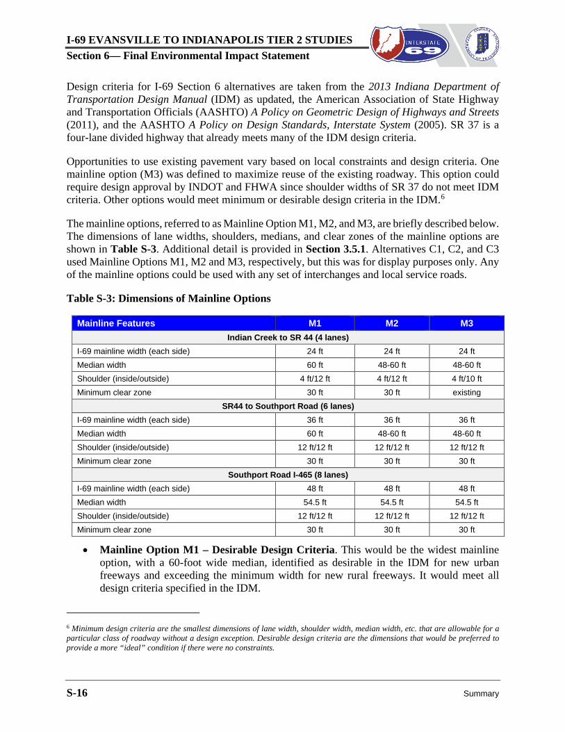
Design criteria for I-69 Section 6 alternatives are taken from the 2013 Indiana Department of Transportation Design Manual (IDM) as updated, the American Association of State Highway and Transportation Officials (AASHTO) A Policy on Geometric Design of Highways and Streets (2011), and the AASHTO A Policy on Design Standards, Interstate System (2005). SR 37 is a four-lane divided highway that already meets many of the IDM design criteria.
Opportunities to use existing pavement vary based on local constraints and design criteria. One mainline option (M3) was defined to maximize reuse of the existing roadway. This option could require design approval by INDOT and FHWA since shoulder widths of SR 37 do not meet IDM criteria. Other options would meet minimum or desirable design criteria in the IDM.6
The mainline options, referred to as Mainline Option M1, M2, and M3, are briefly described below. The dimensions of lane widths, shoulders, medians, and clear zones of the mainline options are shown in Table S-3. Additional detail is provided in Section 3.5.1. Alternatives C1, C2, and C3 used Mainline Options M1, M2 and M3, respectively, but this was for display purposes only. Any of the mainline options could be used with any set of interchanges and local service roads.
Table S-3: Dimensions of Mainline Options
Mainline Features M1 M2 M3 Indian Creek to SR 44 (4 lanes)
I-69 mainline width (each side) 24 ft 24 ft 24 ft Median width 60 ft 48-60 ft 48-60 ft Shoulder (inside/outside) 4 ft/12 ft 4 ft/12 ft 4 ft/10 ft Minimum clear zone 30 ft 30 ft existing
SR44 to Southport Road (6 lanes) I-69 mainline width (each side) 36 ft 36 ft 36 ft Median width 60 ft 48-60 ft 48-60 ft Shoulder (inside/outside) 12 ft/12 ft 12 ft/12 ft 12 ft/12 ft Minimum clear zone 30 ft 30 ft 30 ft
Southport Road I-465 (8 lanes) I-69 mainline width (each side) 48 ft 48 ft 48 ft Median width 54.5 ft 54.5 ft 54.5 ft Shoulder (inside/outside) 12 ft/12 ft 12 ft/12 ft 12 ft/12 ft Minimum clear zone 30 ft 30 ft 30 ft
• Mainline Option M1 – Desirable Design Criteria. This would be the widest mainline option, with a 60-foot wide median, identified as desirable in the IDM for new urban freeways and exceeding the minimum width for new rural freeways. It would meet all design criteria specified in the IDM.
6 Minimum design criteria are the smallest dimensions of lane width, shoulder width, median width, etc. that are allowable for a particular class of roadway without a design exception. Desirable design criteria are the dimensions that would be preferred to provide a more “ideal” condition if there were no constraints.
I-69 EVANSVILLE TO INDIANAPOLIS TIER 2 STUDIES Section 6— Final Environmental Impact Statement
Summary S-17
• Mainline Option M2 – Narrow Median, Standard Shoulders and Side Slopes. Where feasible, this mainline option would use the existing SR 37 center median, which is as narrow as 48 feet at some locations. This would not meet IDM minimum design criteria, and median cable barrier or double-sided guardrail would be considered at some locations. North of Southport Road, I-69 would be newly constructed at a higher elevation, a median barrier would be provided with a median width of 26.5 feet.
• Mainline Option M3 – Narrow Median, Narrow Shoulders, Existing Ditches. Option M3 would be the narrowest mainline option and would allow the most reuse of existing SR 37 infrastructure. Wherever possible, the median, outside shoulders, side slopes, ditches, and clear zones of SR 37 would be reused. Shoulders narrower than 11 feet do not meet the minimum design criteria of the IDM, but could be reused if approved by INDOT and FHWA based on cost and benefit. Around 80 percent of the existing outside shoulders south of SR 144 are 10 feet wide. The AASHTO Interstate Design Policy states that 12-foot outside shoulders should be used for new freeways. A 12-foot paved outside shoulder would be provided for 6-lane and 8-lane segments on I-69. As with Option M2, a median barrier would be provided north of Southport Road, with a median width of 26.5 feet.
As described in Section 3.6, Mainline Options M1, M2, and M3 were joined with interchange and local service roads in the DEIS to form Alternatives C1, C2, and C3, respectively, for agency and stakeholder review. Alternative C4, which is a hybrid of the other alternatives, was formed in the same manner, as described in Section 3.7. Features of the mainline options could work with any set of interchanges and local service roads. Due to the interchangeability of Mainline Options M1, M2, and M3, the evaluation of alternatives in the DEIS was conducted in two stages. Mainline options were evaluated first, followed by interchange and local service roads.
An exception to the interchangeability of mainline options with other components occurs from SR 39 to SR 44 through Martinsville. Mainline Option M1 would be raised 22 feet above the existing SR 37 grade using embankment and retaining walls to minimize right of way impacts along existing adjacent properties and cross streets. This is commonly referred to as an “elevated” section. All local service road crossings of I-69 in Martinsville would be underpasses with Mainline Option M1, as shown in Figure S-5.
In Mainline Options M2 and M3, I-69 would be constructed at the same elevation as existing SR 37 to reuse more of the pavement and to reduce earthwork construction costs. Crossroads for Options M2 and M3 would be elevated to pass over the I-69 mainline.
Figure S-5: Elevated Freeway with Underpass
I-69 EVANSVILLE TO INDIANAPOLIS TIER 2 STUDIES Section 6— Final Environmental Impact Statement
S-18 Summary
S.4.4.2 Interchanges and Local Service Roads
Interchanges provide direct access to I-69 from local roadways. Greater spacing between interchanges generally produces better traffic flow and enhances safety on the highway, but it reduces accessibility for users.
Local service roads are the portion of the roadway network maintained by local jurisdictions (cities, towns, counties). When I-69 is constructed, local service roads may be realigned and extended, truncated (typically with a cul-de-sac), or linked with another local service road to maintain network continuity and/or access to properties. Grade separations (underpasses or overpasses) connect roadways across I-69. Grade separations cross over I-69 (an overpass) or under I-69 (an underpass), depending on construction cost and the impacts on the adjacent area.
Tier 1 alternatives assumed all local service roads would be constructed immediately adjacent to the I-69 mainline as frontage roads. This was appropriate for comparing 12 alternatives across a large study area. A more detailed approach was used in this Tier 2 study. There are around 75 streets, ramps, roads, or driveways with access to SR 37 in the I-69 Section 6 study area. Since these access points will be eliminated, each alternative includes an extensive local service road network which connects with and utilizes the existing local roadway system. These linkages and connections are described in detail for 23 local decision areas in Section S.5.2.
The configuration of each local service road is determined on a case-by-case basis throughout the corridor to provide a fully functioning network of interchanges and local service roads (including grade separations) to meet long-term mobility, circulation, and property access needs along the full length of I-69 Section 6.
S.4.4.3 Components of Alternatives C1, C2, C3, and C4
Alternatives C1, C2, C3, and C4 are comprised of various combinations of mainline options, interchange locations and layouts, and local service road configurations. These alternatives were not defined to represent “low, medium, high” impacts or benefits. As described in Section 3.6 and at the beginning of this section (Section S.4.4), Alternatives C1, C2, and C3 demonstrate the range of components that might be combined to define a preferred alternative. Alternative C4 is a hybrid of these alternatives, developed following public and agency review.
Table S-4 summarizes mainline options, interchanges, and local service road configurations of Alternatives C1 through C4. Local service road configurations are defined as overpass, underpass, or access closed at I-69. Options are defined and evaluated within individual decision areas in Section 6.3.2. Local service roads and I-69 Section 6 components are illustrated in the detailed map sets for each alternative at the end of Chapter 3, Alternatives.
I-69 EVANSVILLE TO INDIANAPOLIS TIER 2 STUDIES Section 6— Final Environmental Impact Statement
Summary S-19
Table S-4: Summary of Alternatives C1 through C4
Location Alternative C1 Mainline Option M1
Alternative C2 Mainline Option M2
Alternative C3 Mainline Option M3
Alternative C4 Mainline Option M2
Subsection 1 - Southern limit to north side of SR 39 (1.5 miles) I-69 Mainline: 4 lanes
Old SR 37 Access closed Access closed Access closed Access closed
SR 39 Diamond interchange. Under I-69.
Diamond interchange with roundabouts. Under I-69.
Existing trumpet interchange with added roundabout. Under I-69.
Existing trumpet interchange with added roundabout. Under I-69.
Subsection 2 - SR 39 to Morgan Street/Twin Branch Road (4.3 miles) I-69 Mainline: 4 lanes; Alternative C1 elevated, SR 39 to SR 44
Burton Lane Grade separation. Under I-69.
Grade separation. Over I-69. Access closed Grade separation. Over I-69.
Ohio Street Diamond interchange with roundabouts. Under I-69.
Grade separation. Over I-69. Diamond interchange. Over I-69.
I-465/Harding Street I-69 access directly to SR 37/ Harding Street within combined interchange
Auxiliary lanes to SR 37/ Harding Street within combined interchange
Auxiliary lanes to SR 37/ Harding Street within combined interchange
Access to SR 37/Harding Street provided via Epler Avenue connections.
I-69 EVANSVILLE TO INDIANAPOLIS TIER 2 STUDIES Section 6— Final Environmental Impact Statement
Summary S-23
S.4.5 Evaluation of Alternatives C1 through C4
The components of Alternatives C1 through C4, summarized in the previous section and described in detail in Chapter 3, Alternatives, are compared in Chapter 6, Comparison of Alternatives based on right of way and relocations, environmental impacts, relative cost, and satisfaction of project purpose and need. Impacts are measured by the information quantified for the alternatives in Chapter 5, Environmental Consequences. Estimated costs are identified for each alternative in Section 5.5 with additional detail provided in Appendix D.
The evaluation of alternatives begins with the mainline, followed by interchange and local service road configurations. In the DEIS. the selected mainline option was used as a base for the independent review of interchanges and local service road configurations. Interchange and local service road components were compared in 23 small geographic areas called “decision areas.” The DEIS preferred alternative was determined by combining the preferred mainline option with selected interchange and local service road in each decision area.
S.4.5.1 Evaluation of Mainline Options M1 through M3
Mainline options for I-69 Section 6 are described in Section S.4.4.1. The conditions, opportunities, and impacts of the mainline options are evaluated in Section 6.3.1. Since all mainline options provide the same number of lanes, differences in impacts and costs relate to their alignment and the width of their “footprint,” determined by median, shoulder widths, and side slopes. Estimated right of way, relocations, and environmental impacts of the mainline options are shown in Table S-4.
Mainline Option M1 would have the widest footprint, except in Martinsville where I-69 would be elevated with retaining walls on each side. Retaining walls would reduce relocations and environmental impacts, but the elevated section would have greater visual and noise impacts. The City of Martinsville and many local stakeholders considered the continuous retaining wall to be unacceptable because of its divisive effect on the community. In other subsections, Mainline Option M1 would have the highest right of way needs, impacts, and cost. The wider median and shoulders of Mainline Option M1 would provide safety and operational benefits, but reuse of existing pavement would be limited, and right of way needs, environmental impacts, and construction cost would be higher.
Mainline Option M2 would allow extensive reuse of SR 37 pavement and provide the safety and operational benefits of wider shoulders. Outside of Martinsville, it would require less right of way, with fewer environmental impacts and lower construction cost than Mainline Option M1. Mainline Option M2 would meet all current design criteria.
Mainline Option M3 would allow the most reuse of SR 37 infrastructure. It would require less right of way, with fewer relocations and environmental impacts, and have lower construction cost, but the feasibility of providing the narrow shoulders of Mainline Option M3 at site specific locations must be confirmed by detailed design and safety studies. Although the values in Table
I-69 EVANSVILLE TO INDIANAPOLIS TIER 2 STUDIES Section 6— Final Environmental Impact Statement
S-24 Summary
S-5 assume a consistent cross section where I-69 is four-lanes, it is only feasible where I-69 would be on the same alignment and at the same elevation as SR 37.
Table S-5: Right of Way, Relocations, and Impacts of Mainline Options
Mainline Option M1 M2 M31 Right of way (acres)
Existing Right of way 667 660 653 New Right of way 354 346 191 Total Right of way 1,021 1,006 844
Relocations (units) Residential - Single Family Home 27 31 25
Residential - Mobile Home -- 29 1 Business 8 10 6
Total Relocations 35 70 32 Total Wetland Impacts (ac) 4.22 3.90 2.18 Total Stream Impacts (lf) 24,498 24,306 18,980 Floodplain (ac) 202 215 160 Wellhead Protection Areas (ac) 283 279 259 Agricultural Land (ac) 108 110 55 Publicly Owned Managed Land (ac) 1.4 0.8 - Privately Owned Managed Land (ac) 3.4 1.4 4.6 Upland Forest (ac) 84 82 43 Core Forest (ac) 7.4 7.5 7.5
1. Feasibility to be confirmed by detailed design and safety studies.
Preferred Mainline Option: As shown in Table S-5, Mainline Option M3 would require less right of way and have lower values for most impact measures, but it is not identified as the preferred option. The savings are associated with reuse of existing shoulders, but there are questions regarding feasibility that cannot be fully resolved until final design. As described in Section S.4.4.1, shoulders narrower than 11 feet can only be reused if approved by INDOT and FHWA based on cost and benefit. Rather than basing plans on an option with questionable feasibility, Mainline Option M2 was selected as the mainline option for the preferred alternative of the DEIS.
Mainline Option M2 would allow extensive reuse of SR 37 pavement, and the 12-foot outside shoulders would meet all acceptable design criteria. The 10-foot outside shoulders of Mainline Option M3 could still be approved by INDOT and FHWA during design based on detailed design and safety studies. Assuming Mainline Option M2 in the preferred alternative represented a “worst case” scenario in the DEIS, pending further analysis in the project design phase.
I-69 EVANSVILLE TO INDIANAPOLIS TIER 2 STUDIES Section 6— Final Environmental Impact Statement
Summary S-25
Because I-69 would require at least six lanes north of SR 144, the existing shoulders would be removed to construct additional mainline lanes with any of the options. The median could still be used, but any new shoulder construction, including median shoulders, would be 12 feet wide to meet the current standard for locations where more than four lanes are used.
S.4.5.2 Interchanges and Local Service Roads, Alternatives C1 – C4
Table S-4 identifies the configuration of local service roads at I-69 for Alternatives C1 through C4. Each road with current SR 37 access is defined in the table as an interchange, an overpass or underpass, or “access closed.” Local service road connections with surrounding roadways are described in detail in Sections 3.6 and 3.7, and are illustrated in the map series at the end of Chapter 3, Alternatives.
Although the original definitions of Alternatives C1, C2, and C3 were linked with different mainline options, as shown in Table S-4, all interchange and local service road options were evaluated with Mainline Option M2 in Chapter 6, Alternatives Evaluation. This allowed impacts and costs to be reviewed independently of the I-69 mainline. As described in Section S.5.1, Mainline Option M2 was the mainline component of the preferred alternative in the DEIS.
To support a review of localized performance and impacts, the eight subsections in Table S-4 were broken down further into 23 decision areas where specific options exist for interchanges and local service road configurations. Section 6.3.2 includes tables showing impacts of the Alternatives C1 through C4 by decision area. As Alternative C4 is a hybrid of Alternatives C1, C2, and C3, most decision areas include the same components in at least two of the alternatives. These alternatives are referred to together (i.e. Alternative C1/C4) in Section 3.2.
The issues and recommendations in each decision area are summarized by subsection for Alternatives C1 through C4 in this section. Tables are provided to summarize impacts by subsection. The preferred alternative presented in the DEIS is described in Section S.6.
S.4.5.2.1 Subsection 1: Indian Creek to SR 39
Subsection 1, from the beginning of I-69 Section 6 at Indian Creek to just past SR 39 at the south end of Martinsville, passes through a sparsely developed area of the White River floodplain at Indian Creek to the interchange of SR 37 and SR 39. This subsection includes three decision areas, as described in the following pages.
Decision Area 1-1: SR 39 Interchange Layout Alternatives varied in whether they retain the existing trumpet layout and how local service roads would be connected. It was determined that the trumpet interchange layout should be reused, with the intersection of the southbound I-69 ramps with SR 39 and Rogers Road converted to a 5-legged roundabout (Alternative C3/C4). See Figure S-6. The trumpet interchange would provide economic and constructability benefits not provided by a diamond interchange.
I-69 EVANSVILLE TO INDIANAPOLIS TIER 2 STUDIES Section 6— Final Environmental Impact Statement
S-26 Summary
Decision Area 1-2: Jordan Road Connection
Alternatives varied in whether a local service road would be provided from the interchange area across Indian Creek to Jordan Road and Burton Lane. It was determined that no local service road should be provided between I-69 and Indian Creek (Alternative C3/C4). Stream, floodplain, and forest impacts would be reduced, and the area south of Indian Creek would continue to be accessed via Burton Lane, as recommended in Decision Area 2-1.
Decision Area 1-3: Rogers Road Connection
Alternatives varied in whether a local service road is constructed around the Martinsville School District’s bus and storage facility or whether Rogers Road connects directly to a roundabout at the SR 39 ramp junction. It was determined that Rogers Road should remain at its existing location, with a new 5-legged roundabout intersection of SR 39, the I-69 southbound ramps, and Rogers Road (Alternative C2/C3/C4), as shown on Figure S-6.
Figure S-6: Decision Area 1-1
Total Subsection 1 Impacts.
Table S-6 summarizes the total Subsection 1 environmental impacts for Alternatives C1 through C4, including interchanges, local service roads, and preferred Mainline Option M2. Impacts in Subsection 1 are generally less for Alternatives C3 and C4 since they reuse the existing interchange configuration. See the preceding review of Subsection 1 Decision Areas for recommendations for the preferred alternative. See Section 6.3.2.1 for detailed decision area impact information.
I-69 EVANSVILLE TO INDIANAPOLIS TIER 2 STUDIES Section 6— Final Environmental Impact Statement
Summary S-27
Table S-6: Environmental Impacts, Subsection 1 - Indian Creek to SR 39
Impact Criteria Subsection 1 Impacts
Alt C1 Alt C2 Alt C3 Alt C4 New Right of Way (ac) 41 44 26 25 Relocations (units)
Residential - Single Family 1 -- -- -- Business 1 1 1 1
S.4.5.2.2 Subsection 2: SR 39 to Morgan Street/Twin Branch Road
Subsection 2 passes through the urbanized area of Martinsville, across the floodplain of Indian Creek, which extends into Martinsville west of I-69. The terrain is relatively level past Martinsville High School north of Grand Valley Boulevard, then follows a steep grade to higher elevation near SR 44.
Grade separations and interchanges would be closely spaced in Martinsville to maintain mobility to and across I-69. Since development is located close to SR 37, relocations would be required at each access and crossing point to accommodate I-69 bridge approaches. Alternatives C2, C3, and C4 assume that I-69 would remain at the existing elevation of SR 37 between SR 39 and Grand Valley Boulevard. Section S.5.1 describes why Alternative C1, with I-69 elevated through Martinsville, is no longer considered in Decision Areas 2-1 and 2-3.
Decision Area 2-1: Burton Lane
Alternatives differed in whether Burton Lane is closed at I-69 or connected across I-69 with an overpass. It was determined in the DEIS that Burton Lane would pass over I-69 (Alternative C2/C4). This would maintain local circulation patterns in Martinsville and provide access from the center of Martinsville to the Liberty Church Road area south of Martinsville near Indian Creek.
I-69 EVANSVILLE TO INDIANAPOLIS TIER 2 STUDIES Section 6— Final Environmental Impact Statement
S-28 Summary
Decision Area 2-2: Ohio Street
Alternatives differed in whether Ohio Street would have an interchange at I-69 or be connected across I-69 with an overpass. An Ohio Street interchange was not included as a potential interchange in the Tier 1 EIS. It was determined that a diamond interchange should be provided, with Ohio Street over I-69 (Alternative C3/C4). See Figure S-7.
An Ohio Street interchange is shown in the Martinsville Comprehensive Plan7 and the Morgan County SR 37/SR 144 Corridor Plan.8 This interchange would provide direct access from I-69 to the Martinsville downtown area, as requested by the City of Martinsville.
Decision Area 2-3: Grand Valley Boulevard
Alternatives varied in how Grand Valley Boulevard would cross I-69 and whether it would be extended east to connect to Cramertown Loop. It was determined that Grand Valley Boulevard should pass over I-69 and be extended to Cramertown Loop (Alternative C2/C4). The extension of Grand Valley Boulevard to Cramertown Loop would replace lost access to the Grand Valley Shopping Center from SR 37 with a short, direct path to I-69 at the SR 252 interchange. (See Figure S-8.)
Figure S-8: Decision Area 2-3
7 Strategic Development Group; Hannum, Wagle & Cline; & The Planning Workshop. Comprehensive Plan for the City of
Martinsville. January, 2010 8 Strategic Development Group; Hannum, Wagle & Cline; & The Planning Workshop. Morgan County SR 37 / 144 Corridor
Plan. February, 2010
Figure S-7: Decision Area 2-2
I-69 EVANSVILLE TO INDIANAPOLIS TIER 2 STUDIES Section 6— Final Environmental Impact Statement
Summary S-29
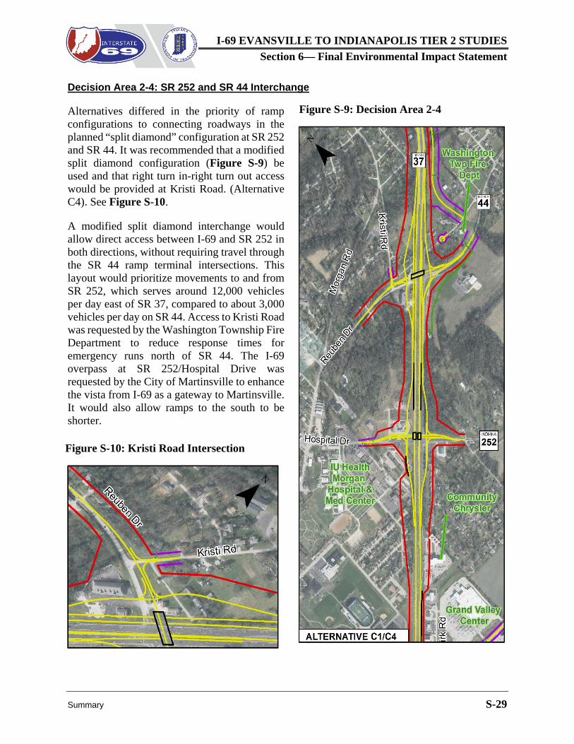
Decision Area 2-4: SR 252 and SR 44 Interchange
Alternatives differed in the priority of ramp configurations to connecting roadways in the planned “split diamond” configuration at SR 252 and SR 44. It was recommended that a modified split diamond configuration (Figure S-9) be used and that right turn in-right turn out access would be provided at Kristi Road. (Alternative C4). See Figure S-10.
A modified split diamond interchange would allow direct access between I-69 and SR 252 in both directions, without requiring travel through the SR 44 ramp terminal intersections. This layout would prioritize movements to and from SR 252, which serves around 12,000 vehicles per day east of SR 37, compared to about 3,000 vehicles per day on SR 44. Access to Kristi Road was requested by the Washington Township Fire Department to reduce response times for emergency runs north of SR 44. The I-69 overpass at SR 252/Hospital Drive was requested by the City of Martinsville to enhance the vista from I-69 as a gateway to Martinsville. It would also allow ramps to the south to be shorter.
Figure S-10: Kristi Road Intersection
Figure S-9: Decision Area 2-4
I-69 EVANSVILLE TO INDIANAPOLIS TIER 2 STUDIES Section 6— Final Environmental Impact Statement
S-30 Summary
Decision Area 2-5: Twin Branch Road/Cikana State Fish Hatchery
The alternatives varied in how access would be provided to the portion of Cikana State Fish Hatchery north of SR 44 and to residences along Twin Branch Road. Options were a new local service road around the north side of the hatchery or an extension of Twin Branch Road south to Old SR 44 along the east side of I-69.
It was determined that a new local service road should be provided to connect Twin Branch Road to SR 44 around the west side of the Cikana State Fish Hatchery south ponds next to I-69 (Alternative C1/C2/C4).
Aligning Twin Branch Road along the east side of I-69 would provide the most direct access to the local service road at Cikana Fish Hatchery and nearby residences at the least cost and with the lowest level of natural impacts.
Total Subsection 2 Impacts
Table S-7 summarizes the total Subsection 2 environmental impacts for Alternatives C1 through C4, including interchanges, local service roads, and preferred Mainline Option M2. New right of way and most impacts are lower with Alternative C1, but this alternative is infeasible unless I-69 is elevated with retaining walls through Martinsville (Mainline Option M1), which was opposed by the City of Martinsville and many stakeholders.
Table S-7: Environmental Impacts, Subsection 2 - SR 39 to Morgan St/Twin Branch Rd
Impact Criteria Subsection 2 Impacts
Alt C1 Alt C2 Alt C3 Alt C4 New Right of Way (ac) 129 148 166 159 Relocations (units)
Residential - Single Family 48 56 56 54 Residential – Duplex Units 6 6 6 6
Residential - Mobile Homes -- 29 13 29 Residential – Apartment Units 4 12 12 4
Business 22 31 36 37 Religious Facility/School -- 1 -- 1
I-69 EVANSVILLE TO INDIANAPOLIS TIER 2 STUDIES Section 6— Final Environmental Impact Statement
Summary S-31
Alternative C2 would have lower impacts in several categories, but it would not provide the Ohio Street interchange, which is in adopted local plans and prioritized by many stakeholders. Alternatives C3 and C4 include the Ohio Street interchange. Alternative C4 is lower in many impact categories than Alternative C3, although it would require more relocations, particularly mobile homes north of Ohio Street. See the preceding review of Subsection 2 Decision Areas for recommendations for the preferred alternative. See Section 6.3.2.2 for detailed decision area impact information.
S.4.5.2.3 Subsection 3: Morgan Street to Henderson Ford Road
Subsection 3 passes through low density residential areas and scattered woodlands north of Martinsville. Major land uses are the Martinsville Golf Club west of SR 37, and the Cikana and Ozark fish hatcheries east of SR 37. The Prince of Peace Lutheran Church is located on Morgan Street just west of SR 37, and the First United Methodist Church is located on the east side of SR 37 between Myra Lane and Egbert Road.
Local access needs in Subsection 3 would be addressed in all alternatives with a new local service road linking Morgan Street with Old SR 37 on the west side of I-69, and new grade separations across I-69 at Teeters Road, Myra Lane, and Egbert Road.
Decision Area 3-1: Morgan Street Connection and Myra Lane Grade Separation
Alternatives differed in how the Morgan Street extension would be aligned near the Prince of Peace Lutheran Church, and whether the Myra Lane grade separation of I-69 would be an overpass or an underpass. It was determined that the Morgan Street extension should be aligned around rather than through the church parking area (Alternative C2/C4), and that a Myra Lane underpass should be provided. The Morgan Street extension would avoid the Prince of Peace Lutheran Church parking area, and the Myra Lane underpass would be safer and more direct than an overpass, requiring less right of way, with lower wetland, stream, and floodplain impact. See Figure S-11.
Decision Area 3-2: Egbert Road Grade Separation
Alternatives differed in the alignment of Egbert Road across I-69 and how it would connect with Old SR 37. It was determined that Egbert Road should cross I-69 heading southwest following the existing alignment of Old SR 37 (Alternative C1/C4). The Egbert Road/Old SR 37 overpass would be more direct than other alternatives and
Figure S-11: Decision Area 3-1 at Myra Lane
I-69 EVANSVILLE TO INDIANAPOLIS TIER 2 STUDIES Section 6— Final Environmental Impact Statement
S-32 Summary
would require less right of way, with lower wetland, stream, and floodplain impact. See Figure S-12.
Total Subsection 3 Impacts.
Table S-8 summarizes total Subsection 3 impacts by alternative for interchanges and local service roads combined with the impacts of preferred Mainline Option M2. Alternative C4 would require less right of way and have the least environmental impact in nearly every category in this subsection due to the direct crossings and minimal local service road construction at Myra Lane and Egbert Road. See the preceding review of Subsection 3 Decision Areas for recommendations for the preferred alternative. See Section 6.3.2.3 for detailed decision area impact information.
Table S-8: Environmental Impacts, Subsection 3 - Morgan St to Henderson Ford Rd
Impact Criteria Subsection 3 Impacts
Alt C1 Alt C2 Alt C3 Alt C4 New Right of Way (ac) 111 123 133 108 Relocations (units)
Residential - Single Family 17 18 19 17 Business 3 3 3 3
S.4.5.2.4 Subsection 4: Henderson Ford Road to Banta Road
Subsection 4 is the longest of the I-69 Section 6 subsections. Most of the corridor is agricultural with limited development except at the north end near the town of Waverly. The White River parallels this subsection to the west, passing close to the I-69 alignment near Stotts Creek.
Figure S-12: Decision Area 3-2
I-69 EVANSVILLE TO INDIANAPOLIS TIER 2 STUDIES Section 6— Final Environmental Impact Statement
Summary S-33
Decision Area 4-1: Henderson Ford Road Interchange
Alternatives varied regarding whether a standard diamond or tight diamond interchange layout is used at Henderson Ford Road/Centennial Road. A standard diamond interchange was recommended, with approximately 800 feet between the ramp terminal intersections (Alternative C1/C2/C4). At slightly higher cost and impact, the standard diamond interchange would be more flexible for serving traffic growth from a nearby tax increment finance area.
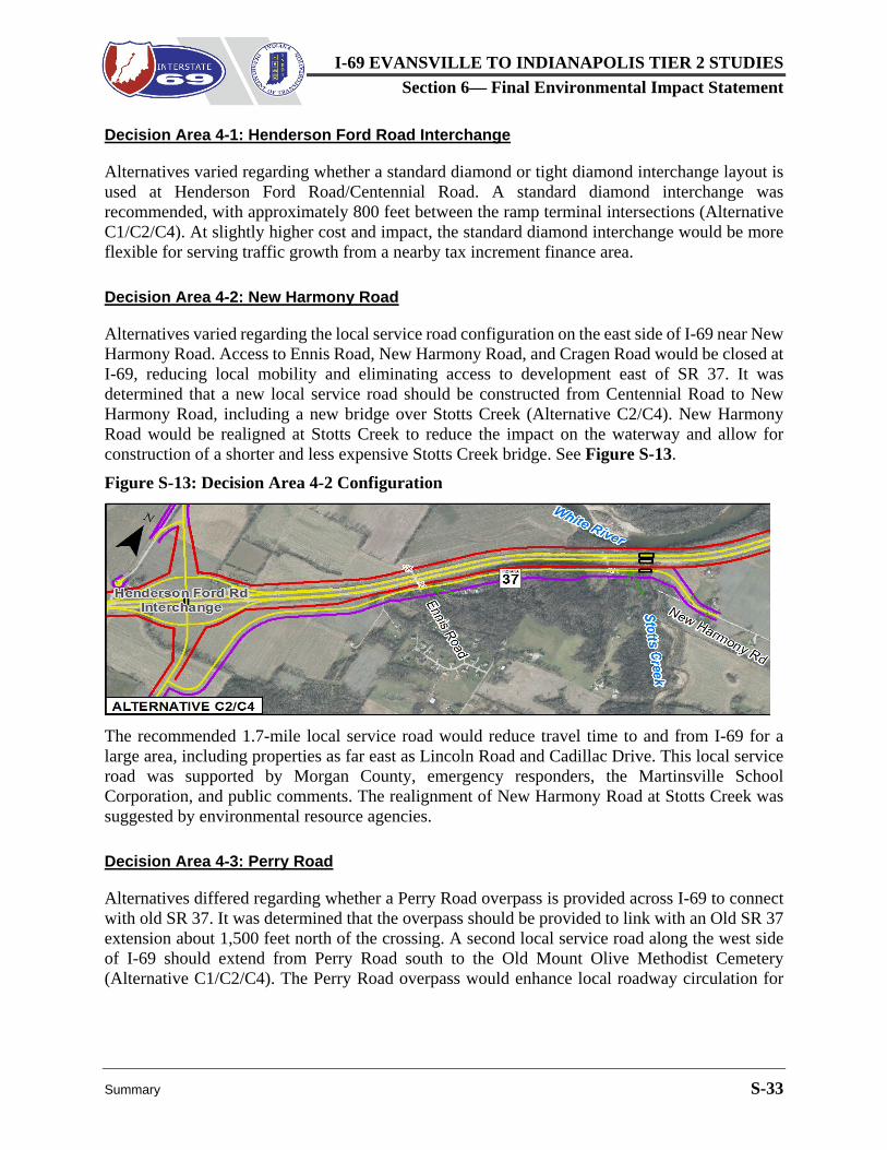
Decision Area 4-2: New Harmony Road
Alternatives varied regarding the local service road configuration on the east side of I-69 near New Harmony Road. Access to Ennis Road, New Harmony Road, and Cragen Road would be closed at I-69, reducing local mobility and eliminating access to development east of SR 37. It was determined that a new local service road should be constructed from Centennial Road to New Harmony Road, including a new bridge over Stotts Creek (Alternative C2/C4). New Harmony Road would be realigned at Stotts Creek to reduce the impact on the waterway and allow for construction of a shorter and less expensive Stotts Creek bridge. See Figure S-13. Figure S-13: Decision Area 4-2 Configuration
The recommended 1.7-mile local service road would reduce travel time to and from I-69 for a large area, including properties as far east as Lincoln Road and Cadillac Drive. This local service road was supported by Morgan County, emergency responders, the Martinsville School Corporation, and public comments. The realignment of New Harmony Road at Stotts Creek was suggested by environmental resource agencies.
Decision Area 4-3: Perry Road
Alternatives differed regarding whether a Perry Road overpass is provided across I-69 to connect with old SR 37. It was determined that the overpass should be provided to link with an Old SR 37 extension about 1,500 feet north of the crossing. A second local service road along the west side of I-69 should extend from Perry Road south to the Old Mount Olive Methodist Cemetery (Alternative C1/C2/C4). The Perry Road overpass would enhance local roadway circulation for
I-69 EVANSVILLE TO INDIANAPOLIS TIER 2 STUDIES Section 6— Final Environmental Impact Statement
S-34 Summary
the longest segment of I-69 without an interchange and avoid a 2-1/2-mile local service road with no outlet to access the cemetery.
Decision Area 4-4: Waverly Road or Whiteland Road
Alternatives differed in providing an I-69 overpass at Waverly Road or at Whiteland Road. Either way, a local service road would be provided to connect the two roads on the east side of I-69. It was determined that Waverly Road should continue across I-69. The local service road connector would be specially aligned to avoid an electric transmission tower (Alternative C4). The Waverly Road overpass would provide the best performance for school transportation and for emergency response. It was preferred by stakeholders at public meetings, and it would avoid the existing electric transmission tower.
Total Subsection 4 Impacts
Table S-9 summarizes total Subsection 4 impacts by alternative for interchanges and local service roads combined with the impacts of preferred Mainline Option M2. Impacts are higher with Alternatives C2 and C4 since these alternatives include an overpass at Perry Road and a continuous local service road link between Henderson Ford Road and New Harmony Road. These features provide much better local service than the other alternatives. See the preceding review of Subsection 4 Decision Areas for recommendations for the preferred alternative. See Section 6.3.2.4 for detailed decision area impact information.
Table S-9: Environmental Impacts, Subsection 4 - Henderson Ford Rd to Banta Rd
Impact Criteria Subsection 4 Impacts
Alt C1 Alt C2 Alt C3 Alt C4 New Right of Way (ac) 222 268 230 266 Relocations (units)
Residential - Single Family 21 22 17 22 Business 9 11 5 11
I-69 EVANSVILLE TO INDIANAPOLIS TIER 2 STUDIES Section 6— Final Environmental Impact Statement
Summary S-35
S.4.5.2.5 Subsection 5: Banta Road to Fairview Road
Subsection 5, from Banta Road to Fairview Road in Johnson County, passes through an area that is primarily agricultural, although residential density increases at the north end as SR 37 approaches the Marion County line. Commercial development is located at most cross roads. Farmers and landowners in the area between SR 37 and the White River that currently rely on SR 37 will require new options for mobility, which is the major consideration in this subsection.
Decision Area 5-1: SR 144 Interchange
Alternatives varied in the interchange area of SR 144 regarding the use of steeper side slopes and guardrail along SR 144 to avoid the Waverly Branch of the Morgan County Public Library. It was determined that the design features would be used that avoid the library (Alternative C2/C4). These features would add little or no cost due to reduced right of way needs, and would have fewer impacts in all categories except for a small increase in impact to upland forest.
Decision Area 5-2: West Local Service Road/Olive Branch Road
All alternatives included an overpass to link Stones Crossing Road with Old SR 37 west of I-69, but local service road configurations, including a potential grade crossing at Olive Branch Road, varied by alternative. It was determined that a new local service road should start south of the Stones Crossing Road overpass, allowing it to pass under the Stones Crossing Road bridge adjacent to I-69 (Figure S-14). The local service road would connect to Old SR 37, then extend further to Smith Valley Road. Olive Branch Road would be closed at I-69 (Alternative C2/C4). See Figure S-15. Figure S-15: Decision Area 5-2 Configuration
Figure S-14: Decision Area 5-2 at Stones Crossing Road
I-69 EVANSVILLE TO INDIANAPOLIS TIER 2 STUDIES Section 6— Final Environmental Impact Statement
S-36 Summary
The recommended alignment at Stones Crossing Road would eliminate the need to pass through the center of the Greenwood Mobile Home Park. The continuous local service road along the west side of I-69 would provide access to and between existing residential, agricultural, recreational, and commercial uses in that area, and would avoid creating landlocked parcels. It would eliminate the need for farm equipment and motorists that currently use the portion of SR 37 between Smith Valley Road and SR 144 to divert to longer and more heavily traveled local routes east of I-69.
Decision Areas 5-3/5-5: Smith Valley Road
These decision areas were reviewed together in Section 6.3.2.5 because both related to the Smith Valley Road Interchange. Alternatives differed in how they affected the White River Township fire station at the southeast corner of the intersection and the residential development along Wakefield Road, a local street on the east side of SR 37 north of Smith Valley Road. It was recommended that I-69 be shifted slightly west of the existing SR 37 alignment to avoid the subdivision, with no retaining wall to avoid impacts to the White River Township fire station at Smith Valley Road (Alternative C4). Shifting the alignment of I-69 would eliminate the need to reconstruct Wakefield Road, avoiding five residential relocations. Relocating the White River Township fire station would be required, but this is preferred by the fire department since reconfiguring the site under other alternatives would increase emergency response times.
Decision Area 5-4: West Local Service Road/Fairview Road
Alternatives differed in how access is to be provided to properties on the west side of I-69, between Smith Valley Road and County Line Road, and what accommodations should be made for farm equipment that currently travels along this segment of SR 37 but would not be allowed to use I-69. This evaluation is closely tied to Decision Area 6-2 concerning the West Local Service Road north of
Figure S-16: Decision Area 5-4 Configuration
I-69 EVANSVILLE TO INDIANAPOLIS TIER 2 STUDIES Section 6— Final Environmental Impact Statement
Summary S-37
Fairview Road. It was determined that a continuous local service road should be provided along the west side of I-69 between SR 144 and County Line Road. Fairview Road would not cross I-69 (Alternative C2/C4). See Figure S-16.
The continuous local service road along the west side of I-69 would provide good access and mobility for development in the area, and it would avoid creating landlocked parcels. It would also better serve local movements of farm equipment. The cost of this continuous road would be less than the cost of providing alternative access via an overpass at Fairview Road and there would be fewer relocations.
Total Subsection 5 Impacts.
Table S-10 summarizes the total Subsection 5 environmental impacts for Alternatives C1 through C4, including interchanges, local service roads, and preferred Mainline Option M2. Generally, Alternatives C2 and C4 require more new right of way and have higher impact values in most environmental categories due to the extent of local service roads to meet local access needs between Smith Valley Road and Fairview Road. Both require relocation of the fire station but avoid the need to relocate the library. See the preceding review of Subsection 5 Decision Areas for recommendations for the preferred alternative. See Section 6.3.2.5 for detailed decision area impact information.
I-69 EVANSVILLE TO INDIANAPOLIS TIER 2 STUDIES Section 6— Final Environmental Impact Statement
S-38 Summary
S.4.5.2.6 Subsection 6: Fairview Road to Wicker Road
Subsection 6 continues the transition into an area with greater density of development. Just north of Fairview Road, Alternative C1 would be raised above the existing SR 37 grade and remain elevated over crossing roads north to I-465. The mainline would shift to the west to avoid impacts to businesses in the southeast quadrant of the County Line Road interchange and to homes on the east side of I-69. Alternatives C2 and C4 would also be elevated just north of Fairview Road, passing over County Line Road and Wicker Road. Alternative C3 would remain at the existing SR 37 grade through the County Line Road interchange, and would be elevated just north of the interchange to pass over Wicker Road.
Decision Area 6-1: County Line Road Interchange
Alternatives varied in the interchange configuration at County Line Road, one of the higher volume roadways in the area. It was determined that I-69 should pass over County Line Road, with a folded loop ramp northbound and standard diamond ramps southbound. Roundabout intersections would be provided at the ramp termini, and Bluff Road would tie into the east roundabout. West of I-69, County Line Road would curve north to intersect Wicker Road. A fifth leg of the west roundabout (at southbound I-69 ramps) would tie with a local service road to access property west of I-69 and south of County Line Road (Alternative C1/C4). See Figure S-17.
The diamond interchange layout with a loop ramp for the northbound exit and roundabout intersections at ramp termini (Alternative C1/C4) would provide good traffic performance with direct connections for local roadways and shorter trip lengths along Bluff Road. Less right of way with fewer relocations would be required compared with other alternatives. There would also be fewer environmental impacts with this alternative.
Decision Area 6-2: West Local Service Road
Alternatives differed in how access is provided to properties west of I-69 between Fairview Road and County Line Road. Options are tied to Decision Area 5-4 concerning the West Local Service Road south of Fairview Road. It was determined that the recommended west local service road should continue, to provide a continuous west local service road between SR 144 and County Line Road (Alternative C2/C4). Fairview Road would not cross I-69. See Figure S-18.
The continuous local service road west of I-69 would provide good access and mobility for development in the area, and it would serve local movements of farm equipment. Combining all local service road sections from SR 144 to County Line Road would serve as an alternate route for
Figure S-17: Decision Area 6-1
I-69 EVANSVILLE TO INDIANAPOLIS TIER 2 STUDIES Section 6— Final Environmental Impact Statement
Summary S-39
local traffic, those that cannot use I-69 (e.g., farm vehicles and bicycles), and traffic that may be diverted in case of temporary I-69 closure. The cost of constructing this continuous road would be less than an overpass at Fairview Road. This option also results in fewer relocations. Figure S-18: Decision Area 6-2 Configuration
Total Subsection 6 Impacts.
Table S-11 summarizes total Subsection 6 environmental impacts for Alternatives C1 through C4, including interchanges, local service roads, and preferred Mainline Option M2. Alternative C4 requires more right of way and one more business relocation than Alternative C1, but it requires less right of way than the other alternatives, and has the lowest environmental impacts in all categories except wellhead protection areas and agricultural land. These higher impacts result from the extent of local service roads provided in Alternative C4. See the preceding review of Subsection 6 Decision Areas for recommendations for the preferred alternative. See Section 6.3.2.6 for detailed decision area impact information.
I-69 EVANSVILLE TO INDIANAPOLIS TIER 2 STUDIES Section 6— Final Environmental Impact Statement
S.4.5.2.7 Subsection 7: Wicker Road to Banta Road in Marion County
Subsection 7 is surrounded by urban development. At Southport Road, the Southern Dunes Apartments and the Southport Landing Shopping Center are west of SR 37, and Aspen Lakes Apartments are east of SR 37. With Alternatives C1, C2, and C3, I-69 would be entirely elevated, beginning with an I-69 overpass at Wicker Road. With Alternative C4, I-69 would be elevated over Wicker Road and Banta Road and would follow the elevation of SR 37 more closely between these locations, passing under Southport Road.
Decision Area 7-1: Southport Road Interchange Layout
This is the only decision area in Subsection 7. Alternatives varied in the alignment of I-69 and the layout of the Southport interchange. This will be highest volume interchange on I-69 Section 6 outside I-465, and adjacent dense development would be impacted with any interchange layout. Five interchange options were evaluated in the DEIS.
All alternatives would require relocation of all or most of the Southport Landing Shopping Center to the west or Aspen Lakes Apartments to the east. The I-69 alignment was shifted east or west in three options to avoid impacting both properties. In the other two options, I-69 followed the SR 37 alignment, and impacts to both properties were avoided by placing all ramps on the north side of Southport Road or shifting the Southport Road alignment north to pass over I-69. Details regarding the interchange layouts and their evaluation are provided in Section 6.3.2.4.
I-69 EVANSVILLE TO INDIANAPOLIS TIER 2 STUDIES Section 6— Final Environmental Impact Statement
Summary S-41
Ultimately, two options were advanced for public comment as part of the DEIS preferred alternative. These alternatives, referred to as Alternatives C4A and C4B, are illustrated in Figure S-19. Either alternative would perform better than the other interchange layout options and both would meet operational needs. The impacts of all Southport Road interchange alternatives are shown in Table S-12.
Figure S-19: Decision Area 7-1, Options C4A and C4B at Southport Road
I-69 EVANSVILLE TO INDIANAPOLIS TIER 2 STUDIES Section 6— Final Environmental Impact Statement
S-42 Summary
Due to the intensity of surrounding development, most impacts of Alternatives C1 through C4 in Subsection 7 are relocations. Alternative C4A would require the relocation of 332 apartment units and 3 businesses. Alternative C4B would require the relocation of 24 apartment units and 19 businesses. Both alternatives would impact 3 single family homes. Alternative C4B would impact more linear feet of streams and larger areas of floodplain, wellhead protection area, agricultural land, and forest than Alternative C4A. Information in Table S-12 was presented in the DEIS. See Section S.5.1.7 for a discussion of the final decision regarding the selected alternative in this subsection.
S.4.5.2.8 Subsection 8: Banta Road to I-465
Subsection 8 passes through a densely-developed area, with multiple crossing roadways, and large open water gravel pits next to I-465. The I-69/I-465 interchange is included in this subsection. Most land use in the vicinity is commercial and industrial. Sunshine Gardens residential community fronts I-465 west of the interchange area. I-69 would be fully elevated as it approaches the I-69/I-465 interchange.
Decision Area 8-1: I-69/I-465 Interchange Layout
This is the only decision area in this subsection. Alternatives differed in the alignment of I-69, the layout of ramp systems, and the means to integrate access to Epler Avenue and SR 37/Harding Street with the freeway to freeway connection. The SR 37/Harding Street interchange at I-465 would remain with all alternatives.
I-69 would be aligned straight north from Southport Road to I-465 in Alternative C1, through the existing gravel pits north of Epler Avenue. I-69 would shift west to minimize construction in the gravel pits with Alternatives C2 through C4. With all alternatives, I-465 would be widened from Mann Road to US 31 to provide sufficient capacity for the additional traffic generated by I-69. Five travel lanes would be provided in each direction, including an auxiliary lane each way to accommodate ramp movements at the interchanges. Details regarding the interchange layouts and their evaluation are provided in Section 6.3.2.4.
It was determined that Alternative C2/C4 would be included in the DEIS preferred alternative. Shifting the I-69/I-465 interchange west would lower construction and right of way costs and reduce most environmental impacts. Providing access to the SR 37/Harding Street area from both north and south is preferred by the public over access only from the I-465/Harding Street interchange. An underpass of I-69 at Edgewood Avenue is considered important for emergency response by the Indianapolis Fire Department and the City of Indianapolis. See Figure S-20.
Total Subsection 8 Impacts
The impacts of Alternatives C2 through C4 would be similar in all categories. The differences in impacts between Alternative C1 and the other alternatives are primarily due to the alignment of Alternative C1 further east, where it impacts less of the Sunshine Gardens neighborhood, but more
I-69 EVANSVILLE TO INDIANAPOLIS TIER 2 STUDIES Section 6— Final Environmental Impact Statement
Summary S-43
Figure S-20: Decision Area 8-1, I-69/I-465 Interchange
of the businesses and quarry areas closer to SR 37. The cost of constructing the I-69/I-465 system interchange would also be substantially higher with Alternative C1 due to the bridging or filling of the quarry pond between Epler Avenue and Thompson Road.
Table S-13 shows a comparison of the total Subsection 8 environmental impacts for Alternatives C1 through C4. This includes the impacts of interchanges and local service roads described within this decision area, combined with the impacts of the preferred Mainline Option M2 in this subsection.
I-69 EVANSVILLE TO INDIANAPOLIS TIER 2 STUDIES Section 6— Final Environmental Impact Statement
S-44 Summary
The impacts of Alternatives C2 through C4 would be similar in all categories. The differences in impacts between Alternative C1 and the other alternatives are primarily due to the alignment of Alternative C1 further east, where it impacts less of the Sunshine Gardens neighborhood, but more of the businesses and quarry areas closer to SR 37. The cost of constructing the I-69/I-465 system interchange would also be substantially higher with Alternative C1 due to the bridging or filling of the quarry pond between Epler Avenue and Thompson Road.
The Southside German Market Gardeners Historic District is located on both sides of I-465 near Bluff Road. Since the district already abuts the right of way of I-465, there is no opportunity to develop an avoidance alternative that includes the additional I-465 lanes. This constitutes Section 4(f) use of this historic district as discussed in the next section.
S.4.5.3 Section 4(f) Evaluation Section 4(f) of the Department of Transportation Act of 1966, 49 U.S.C. §303(c), requires that prior to the use of certain defined land types, it must be determined that there are no prudent and feasible alternatives that avoid such use and that the project includes all possible planning to minimize harm to such resources. One land type included in Section 4(f) legislation is land from an aboveground historic property that is listed in or eligible for inclusion in the National Register of Historic Places (NRHP). The Southside German Market Gardeners Historic District on Bluff Road is eligible to be listed in the NRHP. Chapter 8, Section 4(f) provides a detailed analysis of the Section 4(f) properties in the proximity of I-69 Section 6 and I-465. It describes the actions taken to define and reduce the potential Section 4(f) use of all identified resources, including the Southside German Market Gardeners Historic District. Since this NRHP eligible historic district is located on either side of I-465, widening of I-465 would require acquisition of property in the historic district which would constitute a Section 4(f) use. Due to the necessity of widening of I-465 there is no feasible and prudent avoidance alternative to this Section 4(f) use. Alternatives were analyzed to avoid or minimize harm to the district utilize retaining walls and side slopes. All alternatives would include a retaining wall on the south side of I-465 both east and west of Bluff Road to avoid direct impacts to a contributing structure located at 4425 Bluff Road and to minimize property acquisition within the historic district. Alternatives C2 and C4 would include earthen side slopes north of I-465 and would require removal of the contributing structure at 4401 Bluff Road, immediately east of Bluff Road. Alternatives C1 and C3 would use retaining walls north of I-465 and east of Bluff Road. This would minimize property acquisition within the historic district, but removal of the structure at 4401 Bluff Road would still be required and the retaining wall would cause an additional visual impact to the historic district. As a result, this was not considered the least harm alternative.
I-69 EVANSVILLE TO INDIANAPOLIS TIER 2 STUDIESSection 6— Final Environmental Impact Statement
Summary S-45
The Division of Historic Preservation and Archaeology – State Historic Preservation Officer (DHPA-SHPO) is the official with jurisdiction9 over these properties. On November 28, 2016, DHPA-SHPO indicated the following:
We accept the recommendation that an earthen slope be constructed east of Bluff Road and north of I-465 within the Southside German Market Gardeners Historic District, with MSE (i.e., mechanically stabilized earth) retaining walls being constructed around the electric transmission towers to the east of the house at 4401 Bluff Road.
On May 8, 2017, the Department of Interior (DOI) indicated in a letter to FHWA that “if a Memorandum of Agreement with the SHPO is fully executed, it [DOI] will have no objection to the draft evaluation and concur with the measures to mitigate impacts to 4(f) resources.” Although Alternatives C2 and C4 require one more acre of property from the Southside German Market Gardeners Historic District, they were considered the least overall harm alternatives because the vegetated earthen side slope would be less of a visual impact to the historic district than a retaining wall. See Chapter 8, Section 4(f) for additional information.
S.4.5.4 Overall Impacts and Costs of Alternatives C1 through C4 (DEIS)
As described in Section S.4.4, I-69 mainline, interchange, and local service road components were assembled in various combinations to form complete alternatives for public review and evaluation. The first three alternatives, Alternatives C1, C2, and C3, were structured to include the full range of project components that might be included in the preferred alternative. Based on additional technical review and extensive public and agency input, a fourth alternative, referred to as Alternative C4, was developed as a hybrid of the other alternatives. The intent of Alternative C4 was to incorporate the best features of Alternatives C1, C2 and C3. An option was added to Alternative C4 at the Southport Road interchanges. Each of these alternatives is illustrated in the map series provided at the end of Chapter 3, Alternatives.
Table S-14 includes the overall, end-to-end impacts of Alternatives C1 through C4, from Indian Creek to and including I-465. This table reflects the original assumed mainline option for each alternative rather than Mainline Option M2 of the DEIS preferred alternative. Alternative C4 is broken into two columns in Table S-14 to show the impacts of Options A and B for the Southport Road interchange, as described in Section S.4.5.2.7.
Interchanges and local service roads in the DEIS preferred alternative were identified based on a review of cost, impact, and effectiveness in serving purpose and need assuming mainline option M2 rather than using the end-to-end values in Table S-14. Comparing the values for complete alternatives in Table S-14 with the mainline options in Table S-5 indicates that most impacts are
9 Official with jurisdiction - The official empowered to represent a Section 4(f) resource on matters related to the property. Typically for historic sites the official with jurisdiction is the DHPA-SHPO and for public parks, recreation areas, and wildlife and waterfowl refuges the official with jurisdiction is the agency or agencies that own or administer the property.
I-69 EVANSVILLE TO INDIANAPOLIS TIER 2 STUDIES Section 6— Final Environmental Impact Statement
S-46 Summary
associated with interchanges and local service roads. These components provide greater benefit to the community, as discussed for each of the 23 local decision areas in Section S.4.5.2.
Table S-14: Total End-to-End Impacts by Alternative1
Impact Criteria Alt C1 Alt C2 Alt C3 Alt C4A Alt C4B
Right of Way (acres)
Existing Right of Way 924 941 921 942 943
New Right of Way 999 1,171 945 1,129 1,126
Total Right of Way 1,923 2,112 1,866 2,071 2,069
Number of Relocations
Residential - Single Family Home 135 172 167 142 143
Residential - Duplex Unit 6 6 6 6 6
Residential - Mobile Home 6 39 13 39 39
Residential - Apartment Unit 42 344 12 336 28
Business 83 77 89 78 94
Religious Facility/School -- 1 -- 1 1
Fire Station -- 1 -- 1 1
Library 1 -- 1 -- --
Non-Profit -- 1 1 -- --
Total Relocations 273 641 289 603 312
Section 4(f)
Park (acres) -- -- -- -- --
Historic (acres) 5 6 5 6 6
Total Wetland (acres)
Emergent Wetland 8.25 9.48 6.78 7.34 7.34
Forested Wetland 3.53 3.24 2.67 3.27 3.27
Scrub/Shrub Wetland 0.29 0.13 0.23 0.22 0.22
Total Wetland Impacts 12.07 12.85 9.68 10.83 10.83
Total Streams (linear feet)
Ephemeral 21,034 21,176 20,541 21,125 21,143
Intermittent 5,987 6,101 5,184 6,479 6,479
Perennial 15,759 17,322 16,650 15,932 15,940
Total Stream Impacts 42,780 44,599 42,375 43,536 43,562
Total Natural Stream Impacts 11,199 13,034 10,710 11,567 11,582
I-69 EVANSVILLE TO INDIANAPOLIS TIER 2 STUDIES Section 6— Final Environmental Impact Statement
Summary S-47
Impact Criteria Alt C1 Alt C2 Alt C3 Alt C4A Alt C4B
Floodplain (acres) 475 537 479 499 500
Wellhead Protection Areas (acres) 467 513 456 485 483
Agricultural Land (acres) 252 344 242 321 322
Managed Land (acres)
Publicly Owned 2.9 3.2 1.5 3.2 3.2
Privately Owned 7.1 10.7 7.1 10.7 10.7
Upland Forest (acres) 136 146 102 145 145
Core Forest (acres) 7.7 11.7 2.5 11.8 11.8
1. The alternatives in Table S-14 were developed prior to the designation of a preferred mainline option (See Section S.4.5.1). Alternatives in Table S-14 assume different mainline options (Mainline Option M1 with Alternative C1, Mainline Option M2 with Alternatives C2 and C4, Mainline Option M3 with Alternative C3). See Table S-4 for all components of the alternatives.
Table S-15 summarizes the major cost items and estimated overall cost for each alternative evaluated in the DEIS, from Indian Creek to and including I-465. These alternatives are described in Chapter 3, Alternatives. Table S-16 provides a breakdown of the estimated cost of each alternative by subsection. Alternative C4 is broken into two columns in these tables to show reflect the Southport Road interchange Options A and B, described in Section S.4.5.2.7.
Alternatives C2 and C4 would have similar estimated costs, which are higher than Alternative C3. This is due partly to additional shoulder, side slope, and drainage construction, but it also results from interchange and local service road components that are more effective in serving the project purpose and need, as discussed in Section S.4.5.2. Alternatives C2 and C4 would both use Mainline Option M2, which would reuse a substantial amount of existing SR 37 pavement.
Table S-15: Estimated Project Cost by Cost Item ($ Millions)* for Alternatives (DEIS)
Cost Item Alt C1 Alt C2 Alt C3 Alt C4A Alt C4B Preliminary Engineering $79.7 $63.9 $61.4 $65.8 $65.9
I-69 Construction $984.8 $771.1 $729.0 $800.5 $801.6
I-465 Construction $145.7 $134.8 $140.1 $134.8 $134.8
Utilities $148.9 $157.3 $143.2 $157.6 $158.5
Construction Administration $102.1 $81.8 $78.6 $84.7 $84.8
Total All Cost Items $1,674.2 $1,447.4 $1,374.5 $1,504.3 $1,487.6
* Costs are year of expenditure dollars, assuming design-bid-build construction begins in 2020 and ends in 2026.
I-69 EVANSVILLE TO INDIANAPOLIS TIER 2 STUDIES Section 6— Final Environmental Impact Statement
S-48 Summary
Table S-16: Estimated Project Cost by Subsection ($ Millions)* for Alternatives (DEIS)
Subsection Alt C1 Alt C2 Alt C3 Alt C4A Alt C4B Subsection 1 $67.0 $61.0 $46.7 $53.2 $53.2
Subsection 2 $226.5 $207.4 $197.3 $239.7 $239.7
Subsection 3 $86.5 $73.6 $67.4 $74.2 $74.2
Subsection 4 $160.4 $144.3 $111.8 $148.6 $148.6
Subsection 5 $206.5 $206.4 $201.0 $203.5 $203.5
Subsection 6 $106.1 $111.9 $102.7 $108.5 $108.5
Subsection 7 $149.3 $139.9 $137.3 $168.2 $151.5
Subsection 8 $671.9 $502.9 $510.3 $508.4 $508.4
Total All Subsections $1,674.2 $1,447.4 $1,374.5 $1,504.3 $1,487.6
* Costs are in year of expenditure dollars, assuming design-bid-build construction begins in 2020 and ends in 2026.
S.4.5.5 DEIS Preferred Alternative
The DEIS preferred alternative was Alternative C4, with the layout of the Southport Road interchange still to be determined, as described in Section S.4.5.2.7. The components of Alternative C4 are described in detail in Section 3.7 of Chapter 3, Alternatives. Mainline design dimensions are summarized in Table S-3 and a summary of access components is presented in Table S-4. Detailed maps of Alternative C4 are provided in the map series following Chapter 3, Alternatives.
As described in Section S.5.1, Mainline Option M2 (used by Alternative C4) would allow extensive reuse of SR 37 pavement, and the 12-foot outside shoulders would meet the acceptable design criteria typically used by INDOT and FHWA for freeway construction in Indiana. Reasons for recommending the interchange and local service road components of Alternative C4 are detailed for 23 local decision areas in Section S.4.5.2, and in Chapter 3, Alternatives, which links the recommendations to the project goals provided in Table 2-2 of Chapter 2, Purpose and Need.
Section S.5.2.9 notes that Alternative C4 would not have the lowest right of way requirement, fewest relocations, or least environmental impact of the end-to-end alternatives. Section S.5.2.10 shows that Alternative C4 would not have the lowest cost. Alternative C3 would appear to be the more attractive alternative based on impacts and costs, but these factors alone do not fully reflect value to the community. All alternatives would meet Goal 1 of the project purpose and need to provide an interstate highway between Martinsville and Indianapolis, but they are not equal in terms of how effective they are in serving the other goals of the project purpose and need.
The effectiveness of the recommended preferred alternative in meeting the project purpose and need is identified in Section 3.4.2.1 and in the review of the 23 decision areas in Section 6.3.2. As shown in Table 3-1, performance measures for the Alternative C route were the best among the preliminary alternatives. Section 6.3 identifies Alternative C4 as most effective in serving the
I-69 EVANSVILLE TO INDIANAPOLIS TIER 2 STUDIES Section 6— Final Environmental Impact Statement
Summary S-49
project purpose and need, listing specific benefits at locations throughout the corridor. This high level of performance warranted the selection of Alternative C4 as the preferred alternative in the DEIS.
S.5 REFINED PREFERRED ALTERNATIVE (RPA) DEFINITION AND EVALUATION
Alternative C4, as described in Section S.4.5.5, was identified as the preferred alternative in the DEIS. The Refined Preferred Alternative (RPA) retains most of the features of Alternative C4, with refinements based on public and agency input, more detailed technical evaluation, and value engineering studies. This section identifies the refinements made to Alternative C4 to define the RPA and compares RPA performance, impacts, and costs to those of Alternative C4 to gauge the effectiveness of the refinements. A Title IV/Environmental Justice review of the RPA is provided, and RPA wetland and stream impacts are summarized.
S.5.1 Definition and Impacts of the RPA
To define the RPA, technical adjustments were made to design details of Alternative C4 to better define anticipated project elements and construction limits. In some cases, these technical adjustments were made in response to comments. In other cases, they were based on more detailed information, particularly with respect to drainage, developed after the DEIS preferred alternative had been identified.
Many adjustments were made to Alternative C4 based on public and agency comments. Alternative C4 was presented as the DEIS preferred alternative in public hearings held on April 6, 2017, at Perry Meridian High School, and on April 10, 2017, at Martinsville High School. Comments on the DEIS and the preferred alternative were requested by May 8, 2017. Additional comments from key stakeholders and local government officials received soon after as part of ongoing coordination were also accepted. These comments and responses to each comment are provided in Volume III, Comments and Responses.
Other adjustments were made based on more detailed engineering analysis and additional information gathered after the DEIS was published. Construction limits were refined, and right of way lines for the RPA were adjusted based on property line boundaries where there was a potential for total acquisition. Traffic analyses and drainage designs were refined. Wetlands were delineated in the field, and additional information was developed in consultation with utility companies.
Adjustments were also made to Alternative C4 based on a value engineering study, conducted in accordance with FHWA and INDOT policy, to identify adjustments that might reduce construction cost or time without compromising the project purpose and need. The review was conducted by qualified and experienced professionals with no previous project involvement.
I-69 EVANSVILLE TO INDIANAPOLIS TIER 2 STUDIES Section 6— Final Environmental Impact Statement
S-50 Summary
I-69 is reduced from 6 lanes to 4 lanes in the RPA between SR 144 and Smith Valley Road based on refined traffic analysis and the value engineering study. Otherwise, the I-69 lane and shoulder widths of the RPA are the same as Alternative C4, as shown in Table S-2 and Table S-3. As recommended in the value engineering study, a closed median with concrete barrier is provided in the RPA from Southport Road to I-465. Slight variations in mainline alignment are provided at selected interchange or crossroad locations of the RPA, as described below.
Details of the RPA are illustrated in a series of maps at a scale of 1 inch = 500 feet at the end of Chapter 3, Alternatives. Most of the differences between the RPA and Alternative C4 are associated with interchanges and local service roads, as described in detail Section 3.8. These differences are reviewed using the same subsections used to define the alternatives in the DEIS (see Table S-4). The differences in impacts are summarized in tables comparing the RPA to Alternative C4 in each subsection.
S.5.1.1 Subsection 1: Indian Creek to SR 39
As described in Section 3.8.1, differences between Alternative C4 and the RPA are minimal in this subsection. Mainline bridges at Indian Creek will be higher, but the configuration of the SR 39 interchange and nearby local service roads is unchanged. New ramps in the interchange are realigned slightly to provide for more desirable design speed for the northbound exit ramp.
Table S-17 compares estimated environmental impacts in Subsection 1 for Alternative C4 and the RPA. The design refinements in the RPA resulted in small increases in wetland, stream, and forest impacts.
Table S-17: Environmental Impacts, Subsection 1 - Indian Creek to SR 39
Impact Criteria Subsection 1 Impacts
Alt C4 RPA New Right of Way (ac) 25 25
Non-Profit Relocation1 1 1
Total Wetlands (ac)2 0.42 0.44
Total Streams (lf) 1,887 2,181
Floodplain (ac) 56 63
Agricultural Land (ac) 14 14
Upland Forest (ac) 2 3
Core Forest (ac) -- --
1. Centerstone Behavioral Health Clinic was counted as a business relocation in the DEIS but has been redesignated as a non-profit in the FEIS. It is correctly shown in this table for Alternative C4 and the RPA.
2. Wetland calculations for Alternative C4 and the RPA were updated based on more precise data available from wetland delineation performed after the DEIS was published.
I-69 EVANSVILLE TO INDIANAPOLIS TIER 2 STUDIES
Summary S-51
S.5.1.2
Section 6— Final Environmental Impact
Subsection 2: SR 39 to Morgan Street
The layout of the RPA in Subsection 2 is illustrated in Figure S-21. Changes are included in the RPA at Burton Lane, at the Ohio Street interchange, and at Grand Valley Boulevard. These changes are described below.
In response to concerns expressed in numerous public comments and as recommended by the value engineering study, the Burton Lane overpass is eliminated in the RPA. Access to Burton Lane will be available from the SR 39 and Ohio Street interchanges. Eliminating the overpass avoids the relocation of the Martinsville Baptist Tabernacle Church and Tabernacle Christian School. A retaining wall will minimize impacts to the parking and recreation areas of that property.
The layout of the Ohio Street interchange is changed in the RPA in response to requests from the City of Martinsville, Morgan County, and many citizens to minimize commercial relocations in the vicinity. The RPA includes an elevated roundabout interchange, and the alignment of the I-69 mainline is shifted southwest, with retaining walls to avoid the mobile homes along SR 37 in Spring Valley and Sun Valley Mobile Home Parks.
Figure S-21: The RPA in Martinsville
I-69 EVANSVILLE TO INDIANAPOLIS TIER 2 STUDIES Section 6— Final Environmental Impact Statement
S-52 Summary
Commercial Boulevard is realigned in the RPA to provide access north from the interchange, but unlike Alternative C4, new construction will stop at Industrial Drive. James Baldwin Drive and Robert Curry Drive will continue to provide access to commercial areas. This adjustment responds to comments provided by the City of Martinsville and several local businesses.
Access from the Ohio Street interchange to Grand Valley Boulevard is provided in the RPA via a new roadway identified as Artesian Avenue, extending east from Mahalasville Road, then north to the existing Walmart entrance at Grand Valley Boulevard. A variation of this alignment was suggested in comments provided by Morgan County.
Refinements to the Grand Valley Boulevard overpass in the RPA allow Birk Road and Flag Stone Drive to be used as north/south connections, eliminating a new intersection further east in Alternative C4. The alignment of Grand Valley Boulevard between Walmart and Cramertown Loop is adjusted in the RPA to align with a proposed development platted in that area.
Table S-18 compares estimated environmental impacts in Subsection 2 for Alternative C4 and the RPA. Due to the changes described above, new right of way is less with the RPA and the number of relocations is substantially reduced. In addition to avoiding the Martinsville Baptist Tabernacle Church and Tabernacle Christian School. Eliminating the Burton Lane overpass results in four fewer commercial and six fewer residential relocations. The shift in mainline alignment, coupled with retaining walls, reduces the number of relocations in Spring Valley and Sun Valley Mobile Home Parks by 28 units, from 29 relocations to one.
Artesian Avenue would be longer than the Commercial Drive link of Alternative C4, but it eliminates six commercial relocations, and provides a more direct connection to Grand Valley Boulevard. Adding Artesian Avenue resulted in increases in stream and agricultural impacts.
Table S-18: Environmental Impacts, Subsection 2 - SR 39 to Morgan Street
Impact Criteria Subsection 2 Impacts
Alt C4 RPA New Right of Way (ac) 159 141 Relocations (units)
Residential - Single Family 53 51 Residential – Duplex Units 6 6
Residential - Mobile Homes1 30 2 Residential – Apartment Units 4 4
Business2 38 23 Religious Facility/School 1 --
Non-Profit3 1 1 Total Relocations 133 87
Total Wetlands (ac)4 0.20 0.16 Total Streams (lf) 11,350 11,576
I-69 EVANSVILLE TO INDIANAPOLIS TIER 2 STUDIES Section 6— Final Environmental Impact Statement
Summary S-53
Impact Criteria Subsection 2 Impacts
Alt C4 RPA Floodplain (ac) 47 36 Agricultural Land (ac) 8 26 Upland Forest (ac) 29 27
Core Forest (ac) 0.3 --
1. One mobile home unit included as a single-family home was misclassified in the DEIS. It is correctly shown in this table for Alternative C4 and the RPA. The mobile home unit is not located within a mobile home park.
2. Business relocations for Alternative C4 and the RPA were updated based on additional information regarding the use of properties. This additional information became available after the DEIS was published.
3. The Evening Lions Club counted as a business relocation in the DEIS was redesignated as a non-profit in the FEIS. It is correctly shown in this table for Alternative C4 and the RPA.
4. Business relocations for Alternative C4 and the RPA were updated based on additional information regarding the use of properties. This additional information became available after the DEIS was published.
5. Wetland calculations for Alternative C4 and the RPA were updated based on more precise data available from wetland delineation performed after the DEIS was published.
S.5.1.3 Subsection 3: Morgan Street to Henderson Ford Road
As described in Section 3.8.3, changes to DEIS preferred alternative C4 in the RPA are limited to an adjustment in the mainline elevation due to floodway elevations, a slight realignment of Egbert Road east of I-69 to avoid properties purchased with federal Hazard Mitigation Grant Program funds, and modification of access to Willowbrook Drive south of Egbert Road.
Table S-19 compares estimated environmental impacts in Subsection 2 for Alternative C4 and the RPA. Refinements in the RPA resulted in an increase in stream, floodplain, and agricultural impacts. Wetland impacts are reduced. These differences may be attributable to refinements of construction limits and property lines rather than to changes in the project components.
Table S-19: Environmental Impacts, Subsection 3 - Morgan St to Henderson Ford Rd
Impact Criteria Subsection 3 Impacts
Alt C4 RPA New Right of Way (ac) 108 108
Relocations (units)
Residential - Single Family1 18 19
Business1 4 5
Total Relocations 22 24
Total Wetlands (ac)2 1.86 1.87
Total Streams (lf) 4,129 4,597
Floodplain (ac) 49 57
I-69 EVANSVILLE TO INDIANAPOLIS TIER 2 STUDIES Section 6— Final Environmental Impact Statement
S-54 Summary
Impact Criteria Subsection 3 Impacts
Alt C4 RPA Agricultural Land (ac) 12 17
Managed Land – Publicly Owned (ac) 3.2 3.6
Upland Forest (ac) 36 37
Core Forest (ac) 2.1 2.1
1. Residential and business relocations for Alternative C4 and the RPA were updated based on additional information regarding the use of properties. This additional information became available after the DEIS was published.
2. Wetland calculations for Alternative C4 and the RPA were updated based on more precise data available from wetland delineation performed after the DEIS was published.
S.5.1.4 Subsection 4: Henderson Ford Road to Banta Road
As described in Section 3.8.4, changes to Alternative C4 in the RPA were minimal in this subsection. The primary change was elimination of the Big Bend Road overpass, which was included in Alternatives C1 through C4. Opposition to this overpass was expressed by nearby property owners in written comments, and the value engineering study recommended its elimination based on construction cost savings and a reduction in necessary relocations. Connectivity across I-69 will be available at nearby overpasses at Perry Road and Waverly Road.
The Henderson Ford Road interchange was shifted south to avoid wetland impacts. These wetlands were not identified as part of the original Alternative C4 alignment, but were found as refinements were being made in the RPA. Connecting the interchange to Henderson Ford Road impact a stream west of the roadway and a wetland east of the roadway. To minimize these impacts, the interchange was shifted to the south. This shift does result in stream impacts within the interchange which did not previously occur; however, these impacts are less than would have occurred without the realignment.
Table S-20 compares estimated environmental impacts in Subsection 4 for Alternative C4 and the RPA. The adjustments in the RPA result in 7 acres less new right of way and six fewer residential relocations than Alternative C4.
Impacts to wetlands are reduced with the RPA, but impacts to streams, floodplain, agricultural land, and forest are higher. The reduction in wetland impacts is due to engineering refinements of the RPA and the elimination of the Big Bend Road overpass. Impacts to floodplain, agricultural land and forests is higher with the RPA, due primarily to adjustments to construction limits and property line adjustments rather than to major changes in the project components.
I-69 EVANSVILLE TO INDIANAPOLIS TIER 2 STUDIES Section 6— Final Environmental Impact Statement
Summary S-55
Table S-20: Environmental Impacts, Subsection 4 - Henderson Ford Rd to Banta Rd
Impact Criteria Subsection 4 Impacts
Alt C4 RPA New Right of Way (ac) 266 259
Relocations (units)
Residential - Single Family 21 15
Mobile Home1 1 1
Business2 14 14
Total Relocations 36 30
Total Wetlands (ac)3 1.04 0.99
Total Streams (lf) 12,670 14,774
Floodplain (ac) 58 62
Agricultural Land (ac) 136 141
Upland Forest (ac) 48 53
Core Forest (ac) 9.4 9.4
1. One mobile home unit included in the alternatives as a single-family home was misclassified in the DEIS. It is correctly shown in this table for Alternative C4 and the RPA. The mobile home unit is not located within a mobile home park.
2. Business relocations for Alternative C4 and the RPA were updated based on additional information regarding the use of properties. This additional information became available after the DEIS was published.
3. Wetland calculations for Alternative C4 and the RPA were updated based on more precise data available from wetland delineation performed after the DEIS was published.
S.5.1.5 Subsection 5: Banta Road to Fairview Road
As described in detail in Section 3.8.5, changes in the RPA in Subsection 5 include the reconfiguration of the SR 144 interchange, realignment of Huggin Hollow Road, elimination of the Stones Crossing Road overpass, extension of the eastern local service road, reconfiguration of the Smith Valley Road interchange, and realignment of the western local service. Mainline lanes in the RPA are reduced from 6 to 4 from SR 144 to 2,000 feet south of Smith Valley Road. As shown in Figure S-22, a partially folded diamond with a loop ramp to serve southbound exiting traffic is provided in lieu of the diamond interchange at SR 144. This was recommended in the value engineering study to avoid relocating two service stations. It allows Huggin Hollow Road to intersect SR 144 for access to the service stations and Waverly Branch of the Morgan County Public Library.
The RPA includes the extension of Huggin Hollow Road from the south to connect to Old SR 37 west of the SR 144 interchange. This extension includes a new bridge across Bluff Creek. Huggin Hollow Road ended at a cul-de-sac in Alternative C4. This change responds to public comments regarding the loss of connectivity in this region. Huggin Hollow Road currently intersects SR 144 near SR 37 and provides access to Waverly and multiple residential areas.
I-69 EVANSVILLE TO INDIANAPOLIS TIER 2 STUDIES Section 6— Final Environmental Impact Statement
S-56 Summary
Figure S-22: The RPA from SR 144 to Stones Crossing Road
The Stones Crossing Road overpass in Alternative C4 is eliminated in the RPA. Instead, the local service road proposed in Alternative C4 from CR 144 to Travis Road is extended north to Stones Crossing Road. Stones Crossing Road does not currently cross the median of SR 37, so there is no loss of existing east-west connectivity. Eliminating the overpass allows the west local service road to be realigned to link directly with Old SR 37 at Stones Crossing Road. The RPA provides a different treatment of intersections in the Smith Valley Road interchange area. Roundabout intersections are provided at both ramp terminals of the diamond interchange in lieu of the standard intersections shown in Alternative C4. Table S-21 compares estimated environmental impacts in Subsection 4 for Alternative C4 and the RPA.
As shown in Table S-21, the RPA requires 8 more acres of new right of way than Alternative C4. This change is relatively small considering the extension of Huggin Hollow Road near SR 144 and the extension of the east local service road north of Travis Road. Right of way for these extensions is offset by reduced mainline right of way between SR 144 and Smith Valley Road where I-69 is reduced to 4 lanes. Eliminating the Stones Crossing Road overpass and realigning local service roads eliminates four relocations in the Greenwood Mobile Home Park.
I-69 EVANSVILLE TO INDIANAPOLIS TIER 2 STUDIES Section 6— Final Environmental Impact Statement
1. Residential relocations for Alternative C4 and the RPA were updated based on additional information regarding the use of properties. This additional information became available after the DEIS was published.
2. Wetland calculations for Alternative C4 and the RPA were updated based on more precise data available from wetland delineation performed after the DEIS was published.
Stream, floodplain stream, wellhead protection, agricultural, and forest impacts are all higher in the RPA due to the additional local service road mileage through undeveloped property. Stream and wetland impacts are higher in the RPA due to the new Huggin Hollow stream crossing at Bluff Creek, although this impact is offset to some degree by a smaller Honey Creek bridge on the west local service road north of Smith Valley Road.
The RPA offers several performance advantages over Alternative C4. The extension of Huggin Hollow Road to Old SR 37 will improve mobility options west of I-69 and avoid the creation of a mile-long dead-end road, affecting more than 50 residences. The extension of the east local service road north of Travis Road will provide additional mobility options in that area. The roundabout intersections at Mullinix Road and the Smith Valley Road interchange will maintain local circulation patterns and improve traffic operations. Concerns regarding congestion at this location were expressed in numerous comments on the DEIS.
I-69 EVANSVILLE TO INDIANAPOLIS TIER 2 STUDIES Section 6— Final Environmental Impact Statement
S-58 Summary
S.5.1.6 Subsection 6: Fairview Road to Wicker Road
As described in detail in Section 3.8.6, the RPA is essentially the same as Alternative C4 in this subsection. The design of the County Line Road interchange was refined to better define the details of ramps, but the function and layout is the same. Table S-22 compares estimated environmental impacts in Subsection 6 for Alternative C4 and the RPA.
As shown in Table S-22, the RPA will require more relocations in Subsection 6, from 11 properties with Alternative C4 to 19 properties with the RPA. Residential relocations are increased due to shifting of I-69 Section 6 to the east near the Wakefield subdivision. In addition, local service road changes in the RPA near Smith Valley Road reduce impacts to an existing gas main and avoid impacts to the Center Grove Little League baseball fields.
There are increases in estimated impacts to streams, floodplain, wellhead protection area, agricultural land, and forests. These differences are due to refinements of construction limits and property line adjustments rather than to changes in the project components.
1. Business relocations for Alternative C4 and the RPA were updated based on additional information regarding the use of properties. This additional information became available after the DEIS was published.
2. Wetland calculations for Alternative C4 and the RPA were updated based on more precise data available from wetland delineation performed after the DEIS was published.
S.5.1.7 Subsection 7: Wicker Road to Banta Road (Marion Co)
Two options for the Southport Road interchange layout were presented as preferred in the DEIS, with the decision deferred pending public and agency review of the DEIS, and value engineering
I-69 EVANSVILLE TO INDIANAPOLIS TIER 2 STUDIES Section 6— Final Environmental Impact Statement
Summary S-59
study. As described in detail in Section 3.8.7 of this FEIS, Alternative C4B was selected as the interchange option at Southport Road to be included in the RPA. Factors influencing the selection are presented in Table 3-10, and described in Section 3.8.7. Environmental impacts of Alternatives C4A, C4B, and the RPA in Subsection 7 are presented in Table S-23.
Alternative C4B avoids more than 300 residential relocations at Aspen Lakes Apartments. Minor refinements to the geometric layout of Southport Road interchange were made in defining the RPA. As a result, the right of way required in the northwest quadrant of the interchange allows one of the commercial buildings to remain for future development. See Figure S-23.
The RPA would impact about the same area of floodplain, and impacts to streams, wellhead protection areas, agricultural land, and forest would be higher. These differences are due to more detailed drainage designs, refinements of construction limits, and property line refinements in the RPA.
In addition to reducing the total number of relocations, the selection of Alternative C4B over Alternative C4A at Southport Road resulted in an estimated project cost savings of nearly $17 million, as shown in Table 3-10 of Chapter 3, Alternatives. This savings is also achieved in the RPA. The function of the RPA at Southport Road is the same as Alternative C4B.
Alt C4A Alt C4B RPA New Right of Way (ac) 65 89 82
Relocations (units)
Residential - Single Family 3 3 2
Residential – Apartment Unit 332 24 24
Business 3 19 16
Total Relocations 338 46 42
Total Wetlands (ac)1 0.02 0.05 0.05
Total Streams (lf) 839 1,172 1,422
Floodplain (ac) 36 68 67
Wellhead Protection Areas (ac) 121 142 148
Agricultural Land (ac) 7 21 24
Upland Forest (ac) 7 6 7
Core Forest (ac) -- -- --
1. Wetland calculations for Alternative C4B and the RPA have been updated based on more precise data available from wetland delineation performed after the DEIS was published.
I-69 EVANSVILLE TO INDIANAPOLIS TIER 2 STUDIES Section 6— Final Environmental Impact Statement
S-60 Summary
Figure S-23: The RPA at Southport Road
S.5.1.8 Subsection 8: Banta Road to and including I-465
As described in detail in Section 3.8.8, the RPA is essentially the same as Alternative C4 in this subsection, which includes the I-69/I-465 interchange. Changes to DEIS preferred alternative C4 in the RPA include use of a closed median with concrete median barrier on the mainline. The alignments of the ramps for the system interchange between I-69 and I-465 were refined to reduce impacts to Hanson Aggregates on the north side of I-465, as well as the impacts to the large quarry pond in the southeast quadrant of the interchange.
As shown in Table S-24, the adjustments to Alternative C4 in defining the RPA reduced estimated new right of way required from 206 acres to 131 acres. Most of this reduction is a result of ramp refinements at the Hanson Aggregates quarry north of I-465. Stream and floodplain, stream impact estimates are lower with the RPA, primarily due to refinements of construction limits and property line adjustments. Impacts to wetlands, wellhead protection areas, agricultural land, and forests are essentially unchanged.
The value engineering study identified a cost savings of approximately $18 million from the realignment of the ramps at the Hanson Aggregates quarry and the median changes on the mainline. These changes will not affect the function of the I-69/I-465 interchange.
I-69 EVANSVILLE TO INDIANAPOLIS TIER 2 STUDIES Section 6— Final Environmental Impact Statement
1. Residential relocations for Alternative C4 and the RPA were updated based on additional information regarding the use of properties. This additional information became available after the DEIS was published.
2. Wetland calculations for Alternative C4 and the RPA were updated based on more precise data available from wetland delineation performed after the DEIS was published.
S.5.2 Overall RPA Costs and Impacts Compared with Alternative C4
Table S-25 summarizes the major cost items and estimated overall cost for Alternative C4 and the RPA, from Indian Creek to and including I-465. Table S-26 provides a summary of the estimated overall cost for Alternative C4 and the RPA by subsection. Option C4B is assumed at Southport Road in Alternative C4, consistent with the option selected for the RPA.
I-69 EVANSVILLE TO INDIANAPOLIS TIER 2 STUDIES Section 6— Final Environmental Impact Statement
S-62 Summary
Table S-25: Estimated Cost by Cost Item ($ Millions) for Alternative C4 and the RPA
Cost Item Alt C41 RPA2
Preliminary Engineering $65.9 $54.2
Right of Way $201.2 $255.0
Environmental Mitigation $40.8 $39.8
I-69 Construction $801.6 $1,069.6
I-465 Construction $134.8 (Included in I-69 construction cost)
Utilities $158.5 $156.4
Construction Administration $84.8 (Included in I-69 construction cost)
Total All Cost Items $1,487.6 $1,575.0
1. Costs are year of expenditure dollars, assuming design-bid-build construction begins in 2020 and ends in 2026 2. Costs are year of expenditure dollars, assuming design begins in 2018 and construction ends in 2025.
Table S-26: Estimated Cost by Subsection ($ Millions) for Alternative C4 and the RPA
Subsection Alt C41 RPA2
1: Indian Creek to SR 39 $53.2 $57.0
2: SR 39 to Morgan Street/Twin Branch Road $239.7 $228.0
3: Morgan Street to Henderson Ford Road $74.2 $115.5
4: Henderson Ford Road to Banta Road $148.6 $147.1
5: Banta Road to Fairview Road $203.5 $217.8
6: Fairview Road to Wicker Road $108.5 $123.6
7: Wicker Road to Banta Road (Marion Co.) $151.5 $173.8
8: Banta Road to and including I-465 $508.4 $512.2
Total All Subsections $1,487.6 $1,575.0
1. Costs are for total project in year of expenditure dollars, assuming construction begins in 2020 and ends in 2026 2. Costs are year of expenditure dollars, assuming design begins in 2018 and construction ends in 2025.
Table S-27 includes the overall end-to-end impacts of Alternative C4 and the RPA, from Indian Creek to and including I-465. Option C4B is assumed at Southport Road in Alternative C4, consistent with the option selected for the RPA.
I-69 EVANSVILLE TO INDIANAPOLIS TIER 2 STUDIES Section 6— Final Environmental Impact Statement
Summary S-63
Table S-27: Total End-to-End Impacts of Alternative C4 and the RPA
Impact Criteria Alt C4 RPA
Right of Way (acres)
Existing Right of Way1 993 1,050
New Right of Way 1,076 1,025
Total Right of Way 2,069 2,075
Number of Relocations
Residential - Single Family Home2 145 142
Residential - Duplex Unit 6 8
Residential - Mobile Home3 41 9
Residential - Apartment Unit 28 28
Business2 99 81
Religious Facility/School 1 --
Fire Station 1 1
Non-Profit4 2 2
Total Relocations 323 271
Section 4(f)
Historic or NRHP Eligible (acres) 6 6
Total Wetland (acres)5
Emergent Wetland 1.79 1.90
Forested Wetland 1.82 1.70
Scrub/Shrub Wetland 0.46 0.39
Total Wetland Impacts5 4.07 3.99
Total Streams (linear feet)
Ephemeral 17,242 18,512
Intermittent 11,031 11,797
Perennial 15,160 16,994
Total Stream Impacts 43,433 47,253
Total Natural Stream Impacts 11,464 14,069
Stream Relocations (linear feet) 27,066 27,641
Floodplain (acres) 499 458
Wellhead Protection Areas (acres) 483 520
Agricultural Land (acres) 322 382
Managed Land (acres)
I-69 EVANSVILLE TO INDIANAPOLIS TIER 2 STUDIES Section 6— Final Environmental Impact Statement
S-64 Summary
Impact Criteria Alt C4 RPA
Publicly Owned 3.2 3.6
Privately Owned 10.7 2.6
Upland Forest (acres) 145 159
Core Forest (acres) 11.8 11.5
1. All non-INDOT right of way was included as new right of way in the DEIS. This table includes local right of way in the value for existing right of way for Alternative C4 and the RPA.
2. Residential and business relocations for Alternative C4 and the RPA were updated based on additional information regarding the use of properties. This additional information became available after the DEIS was published.
3. Two mobile home units included in the alternatives as single-family homes were misclassified in the DEIS. They are correctly shown in this table for Alternative C4 and the RPA. These units are not located within a mobile home park.
4. Centerstone Behavioral Health Clinic and the Evening Lions Club counted as business relocations in the DEIS were redesignated as non-profit in the FEIS. They are correctly shown in this table for Alternative C4 and the RPA
5. Wetland calculations for Alternative C4 and the RPA have been updated based on more precise data available from wetland delineations performed after the DEIS was published.
Due to the additional engineering development and the adjustments made during an FHWA cost estimating review process, some of the cost estimating assumptions and methodologies used for the RPA differ from those used for Alternative C4. INDOT and FHWA conducted the cost estimate review process on August 15-17, 2017. The process involved a detailed examination of the cost estimating assumptions used for the I-69 Section 6 project, as well as an examination of project risks and contingency amounts.
• Recognizing the challenges in making direct comparisons between cost estimates for Alternative C4 and the RPA, several observations can be made about the cost differences in the RPA. Subsection 8, with the I-69/I-465 interchange and added lanes on I-465, is the most expensive portion of the project. Differences in cost are small between Alternative C4 and the RPA, due to offsetting factors such as higher cost of I-465 pavement replacement with the RPA versus nearly 50 acres of right of way and deep fill in the Hanson Aggregates quarry in Alternative C4. Other offsetting factors relate to White River bridge replacement in the RPA versus bridge rehabilitation in Alternative C4.
• Subsection 2 in Martinsville is the next most expensive portion of the project. The lower cost for the RPA results from elimination of the Burton Road overpass, lower cost local service roads through open areas, and reduced right of way and relocation costs.
• The estimated cost for the RPA is higher in most other subsections due to design refinements and additional contingencies applied to right of way and relocation estimates. Design refinements in the RPA include elevation changes related to new flood mapping, better estimates of earthwork and grading, and more defined drainage plans.
I-69 EVANSVILLE TO INDIANAPOLIS TIER 2 STUDIES Section 6— Final Environmental Impact Statement
Summary S-65
S.5.3 Title VI / Environmental Justice Review
Under Title VI and related statutes, each federal agency is required to ensure that no person is excluded from participation in, denied the benefit of, or subjected to discrimination under any program or activity receiving federal financial assistance on the basis of race, color, national origin, age, sex, disability, or religion. Executive Order 12898 states that “…each Federal agency shall make achieving environmental justice part of its mission by identifying and addressing, as appropriate, disproportionately high and adverse human health or environmental effects of its programs, policies, and activities on minority populations and low-income populations…”
Pursuant to the Executive Order, FHWA issued Order 6640.23, FHWA Actions to Address Environmental Justice in Minority Populations and Low-Income Populations, on December 2, 1998. Under FHWA Order 6640.23A, FHWA and INDOT, as a recipient of funding from FHWA, are responsible to ensure that their programs, policies, and activities do not have a disproportionately high and adverse effect on minority or low-income populations. As defined in Section 5.8.2, a disproportionately high and adverse effect is an adverse effect that is predominantly borne by a minority population and/or a low-income population, or will be suffered by the minority population and/or low-income population and is appreciably more severe or greater in magnitude than the adverse effect that will be suffered by the non-minority and/or non-low-income population.
Section 5.8 assesses compliance with EJ requirements by identifying and analyzing minority and/or low-income populations within the socioeconomic study area for I-69 Section 6. Basic information is obtained from the 2010-2014 American Community Survey (ACS) from the U.S. Census, the FHWA Environmental Justice web page, public participation, and an assessment of communities within the socioeconomic study area.
The I-69 Section 6 development process has included extensive public outreach to insure full and fair participation of all persons, including low-income or minority individuals, in the decision-making process. Chapter 11, Comments, Coordination, and Public Involvement, provides a detailed summary of public participation activities. Appendix P describes the targeted outreach to engage potentially affected minority or low-income communities and relevant community-based organization that represent or advocate on behalf of those populations.
As described in Section 5.8.4, block groups with elevated levels of low-income or minority populations were identified relative to conditions in the surrounding area, (community of comparison10). A review of these block groups indicates that 29 percent of I-69 Section 6 residential relocations would occur in block groups with elevated low-income populations and 17 percent would occur in block groups with elevated minority populations.
Since I-69 Section 6 passes through areas of low population density, block group areas are large and may not represent conditions in the more narrowly defined project area. To more closely define project conditions, targeted public outreach was conducted in block groups with elevated minority
10 Appendix P provides a detailed summary of the community of comparison identification process.
I-69 EVANSVILLE TO INDIANAPOLIS TIER 2 STUDIES Section 6— Final Environmental Impact Statement
S-66 Summary
and low-income populations. The results were used to identify potential communities where these populations might be relocated for construction of I-69 Section 6. The evaluation was conducted in three segments of the corridor, representing the Martinsville area, the Indianapolis urbanized area, and the rural area in between (referred to, respectively, as the southern, northern, and central areas). The process and results are described in Section 5.8.5.
An area of potential low-income population was identified in Martinsville on the west side of SR 37 north of the Ohio Street interchange, including two contiguous mobile home parks, small apartment complexes, duplexes, and single-family homes. Nearly all the mobile homes (29 of 30) are avoided by the RPA. Other areas identified included Greenwood Mobile Home Park and Sunshine Gardens in the north area of the corridor. Impacts are reduced in the Greenwood Mobile Home Park with the RPA, but impacts on Sunshine Gardens are the same as Alternative C4.
The I-69 Section 6 corridor includes several areas where project impacts had the potential to disproportionately fall upon low-income or minority communities. The I-69 Section 6 project team conducted public outreach tailored specifically to meaningfully engage these communities and identified several related concerns associated with project impacts. These concerns include relocations of residences and businesses, changes in travel patterns, community cohesion, noise impacts, and air quality impacts). In response, the I-69 Section 6 project team modified the design of the project in several important ways to address these concerns through avoidance and minimization of impacts.
The I-69 Section 6 project team considers project impacts to be adverse but, because of minimization and avoidance measures incorporated into the design, these impacts are not considered to be high or disproportionate. The public outreach conducted since the release of the DEIS emphasized the important changes made to the project, and the responses from that outreach, including from the feedback from the CAC and SWG meetings, supported the selected alternative. In the preparation of the final design for this project, INDOT will implement the project commitments and will continue to seek ways to avoid and minimize impacts to low-income and minority communities.
INDOT could utilize the “housing of last resort” program if there are not adequate opportunities for relocation in the area. See Section 5.2.10.
S.5.4 RPA Wetland and Stream Impact Summary
The RPA would impact 47,253 linear feet of streams, but 52 percent (24,509 linear feet) of these impacts are within the existing SR 37 right of way. Stream acreage impacts for the RPA are anticipated to be 14.14 acres, with 8.62 acres or 35 percent of these impacts occurring within the existing SR 37 right of way. See Table 5.19-19.
The RPA is the least impactful of all the build alternatives for wetlands. With respect to non-open water wetland impacts, the RPA would impact 3.99 acres within the proposed right of way. Wetlands within the existing SR 37 right of way account for 47 percent of these impacts. Indiana
I-69 EVANSVILLE TO INDIANAPOLIS TIER 2 STUDIES Section 6— Final Environmental Impact Statement
Summary S-67
Wetland Rapid Assessment Protocol (InWRAP) quality evaluations identified most of these wetlands as poor for animal habitat and botanical quality, and fair for hydrology.
Similar to wetlands, there is little variability overall between all alternatives in terms of linear feet of impacts, acreage of impact, or quality of stream anticipated to be impacted (as reported using Headwater Habitat Evaluation Index (HHEI)/ Quantitative Habitat Evaluation Index (QHEI) scores). Total stream impact lengths differed between the least and greatest impacts by 4,878 linear feet over the project length of nearly 27 miles.
There was little variability between the average QHEI and HHEI score by alternative. QHEI evaluations are conducted on streams whose drainage area is greater than 1 square mile. These streams are generally intermittent and perennial. HHEI evaluations are conducted on headwater streams with drainage areas less than 1 square mile, generally ephemeral streams. The average QHEI score for all alternatives ranged from 42.82 for the RPA to 44.59 for Alternative C3. QHEI scores less than 51 suggest the stream is generally non-supporting for aquatic life use. Average HHEI scores ranged from 33.23 to 34.21, with 33.25 for the RPA. Streams with HHEI scores which range between 20 and 40 represent reaches that are normally dry (ephemeral) and do not support a diversity of aquatic life.
S.5.5 RPA Costs and Impacts Compared with Tier 1
The Tier 1 FEIS presented estimates of cost and some impacts for each Tier 2 section of the I-69 Preferred Alternative, including Section 6 (Table 6-31 of that document). As shown in Table S-28, estimates of project cost, right of way, relocations, wetlands, floodplains, and farmland impacts for the RPA are higher than Tier 1 FEIS estimates. Estimated farmland impacts are lower for the RPA. Streams were classified as perennial or intermittent and reviewed by total number of crossings in Tier 1 rather than length of stream impacted, and the estimates were not broken down by section. As a result, no comparisons are provided for streams from Tier 1 and Tier 2 studies.
The differences in Tier 1 and Tier 2 estimated cost and impacts for items broken down by section in Tier 1 are reviewed in Table S-28.
Table S-28: Comparison of I-69 Section 6 Tier 1 and RPA Impacts
Data and Resources Tier 1 RPA
Length (miles) 25.9 26.9
Project Cost ($ millions)1 $776 - $856 $1,575
New Right of Way (acres) 605 1,025
Farmland (acres) 465 382
Upland Forest (acres) 30 159
Wetlands (acres) 5 3.99
I-69 EVANSVILLE TO INDIANAPOLIS TIER 2 STUDIES Section 6— Final Environmental Impact Statement
S-68 Summary
Data and Resources Tier 1 RPA
Floodplain (acres) 85 459
Residential Relocations 127 187
Business Relocations 50 81
1. Tier 1 cost estimates are adjusted to year 2016 to account for inflation. The Tier 1 estimate does not include the cost for construction administration, utility relocation or mitigation. Tier 2 cost estimates include construction administration, utility relocation, and mitigation and is for year of expenditure.
S.5.5.1 Project Cost
The cost presented in Table S-28 for Tier 1 is shown in 2016 dollars rather than year of expenditure dollars for comparison between Tier 1 and Tier 2 cost estimates. The cost estimates shown for the RPA were calculated in year of expenditure dollars. The Tier 1 cost estimates were prepared in 2003, based on Year 2000 dollars, and were escalated to Year 2016 dollars assuming an annual inflation rate of 3.5 percent.
Tier 1 cost estimates were only for construction. Tier 2 cost estimates also include construction administration, utility relocation, and mitigation. These costs together equal approximately $285 million in 2016 dollars. Subtracting these costs leaves a total cost of $1,290 million for the RPA in Year 2016 costs for comparison with Tier 1 costs. The RPA also includes widening of I-465 which was not anticipated in Tier 1.
The Tier 1 cost estimate of $776 to $856 million is $434to $514 million less than the Tier 2 RPA costs using comparable assumptions. The difference can be attributed to additional mileage of roadway construction for I-69 Section 6 mainline, which is 1 mile (3.9 percent) longer due to refinements in the alignment at I-465. In addition, an extensive local service road network is included in I-69 Section 6 to connect with the local roadway system. In Tier 1, it was assumed that local service roads would connect with frontage roads adjacent to the I-69 mainline.
S.5.5.2 Right of Way and Relocations
The area of land required for right of way with the RPA is 420 acres more than the area estimated in the Tier 1 FEIS. The Tier 2 estimate is based on actual construction limits, including areas for the interchanges and local service roads. The increase in new right of way for the Tier 2 sections is attributable to the number and length of local service roads provided outside the typical section of the I-69 mainline.
The Tier 1 FEIS estimated 127 residential and 50 business relocations. This compares with187 residential and 81 business relocations estimated for the RPA. There have been many new developments since 2003 when Tier 1 estimates were prepared. Notable locations where this has occurred are in Martinsville on the east side of SR 37 and along SR 37 in northern Johnson County and southern Marion County.
I-69 EVANSVILLE TO INDIANAPOLIS TIER 2 STUDIES Section 6— Final Environmental Impact Statement
Summary S-69
S.5.5.3 Farmland and Forest
The Tier 1 FEIS estimated 465 acres of farmland impact and 30 acres of forest impact. The RPA would have a smaller area of direct farmland impact, at 361 acres, and a larger area of forest impact at 156 acres. These differences are due to the extensive local service road system in Tier 2 and conversions of farmland to other use. Higher estimates for forest impacts also reflects the greater accuracy of the field surveys in this Tier 2 study, which identified many smaller forested areas, such as fencerow and streamside forests which were likely not identified in the dataset used in Tier 1.
S.5.5.4 Wetlands and Floodplains
Tier 1 and Tier 2 wetland impact differences are due partly to the procedures used to identify impacts. Tier 1 used National Wetland Inventory (NWI) mapping. NWI maps are prepared by analyzing high altitude imagery. Resources are identified based on vegetation, visible hydrology, and geography. A margin of error is inherent in the use of imagery. Tier 2 wetlands were identified by field wetland delineations within the I-69 Section 6 field study area. The RPA is estimated to have 3.99 acres of wetland impact, which is 1.01 acre less than shown in the Tier 1 FEIS.
Floodplain impacts for the RPA, 458 acres, is larger than the Tier 1 estimate of 80 acres for the preferred alternative. The updated IDNR and FEMA floodplain mapping used in Tier 2, combined with the more precise determination of right of way requirements, provides a more reliable estimate of floodplain impact than in Tier 1. The additional right of way for local service roads is also a factor in the higher floodplain estimate for Tier 2.
S.6 OTHER MAJOR GOVERNMENTAL ACTIONS IN STUDY AREA
At the time of this FEIS, INDOT had one major project underway in the I-69 study area. That project is the completion of I-69 Section 5, starting at SR 37 near Bloomington in Monroe County and continuing northward approximately 21 miles to SR 39 near Martinsville in Morgan County. It is scheduled for 2018 completion.
The Indianapolis MPO, 2016-2019 Indianapolis Regional Transportation Improvement Program lists one project for construction in the near term. It is an INDOT project to improve SR 135/Meridian Street from CR 700 N/Stones Crossing Road to CR 850 N/Curry Road, from one lane to two lanes in each direction with a continuous center left turn lane. The Indianapolis MPO 2035 Long-Range Transportation Plan, lists a range of projects in the area. See Section 2.2.3.
I-69 EVANSVILLE TO INDIANAPOLIS TIER 2 STUDIES Section 6— Final Environmental Impact Statement
S-70 Summary
S.7 MAJOR ISSUES RAISED BY AGENCIES AND THE PUBLIC
FHWA and INDOT have provided opportunities for government agency and public involvement throughout the I-69 Section 6 Tier 2 study. A project website, newsletter, social media accounts, public involvement meetings, and project office were used to solicit input. The project office was established in April 2015 at 7847 Waverly Road north of Martinsville. Public agency input was also sought at key milestones in this Tier 2 Study. Opportunities for public and agency involvement are described in Chapter 11, Comments, Coordination, and Public Involvement. Opportunities for agency and public input included:
• Outreach meetings with community, business, and civic groups,
• Local government outreach meetings,
• Expert land use panel, and
• Community Advisory Committees (CACs) and Stakeholder Working Group (SWG).
Since this is the sixth and final section of I-69 between Evansville and Indianapolis, many issues and controversies raised about the overall project have already been resolved. Some issues specific to I-69 section 6, however, emerged during the Tier 2 study process, as described below.
Affirmation of the Tier 1 Selected Corridor – The issue of greatest interest to the public in this Tier 2 study was the route of I-69 from Martinsville to Indianapolis. This was the preferred alternative in the Tier 1 FEIS, but the ROD permitted the consideration of alternatives outside the corridor in Tier 2 when necessary to avoid significant impacts.11 Many citizens and elected officials called for analysis of alternate routes, primarily to avoid impacts on businesses in interchange areas. In the scoping and screening process described in Sections S.4.2 and S.4.3, use of the SR 37 corridor was affirmed. Other alternatives were either more expensive with no notable advantage in performance or environmental impact, or had similar cost and impact with lower performance. Ultimately, the SR 37 corridor received the highest level of public support. See Preliminary Alternatives Screening Report provided in Appendix EE
Local Access and Public Road Connectivity – Access to I-69 and connectivity of local roadways was a significant issue for I-69 Section 6. Emergency responders, business owners, area residents, and others voiced concerns about road closings, grade separations, and interchange locations. The need to restrict access to the interstate system to interchanges can result in the severance and closure of local public roads, rerouting of local roads, and construction of new local service roads, requiring motorists to change travel patterns and find new routes to destinations. Alternatives in this Tier 2 study focused on local access and connectivity in 23 separate decision areas along the corridor. See Section S.5.2.
11 See Tier 1 ROD, Section 2.3.5 (Potential to Consider Alternatives Outside Selected Corridor).
I-69 EVANSVILLE TO INDIANAPOLIS TIER 2 STUDIES Section 6— Final Environmental Impact Statement
Summary S-71
Construction Timetable – The public, CAC and SWG members, and local government officials commented that work on I-69 Section 6 should be expedited since completion of I-69 Section 5 will result in higher traffic levels on SR 37 between Martinsville and Indianapolis. Increased traffic on existing SR 37 is a safety concern for the public and local government. The construction timetable was also a concern for people with property that may be impacted. Many property owners, businesses, and local officials described a state of uncertainly regarding how the project will impact their property and future development.
I-465/SR 37 Interchange Area – Existing land use along SR 37 from Southport Road north to I-465 includes residential, commercial, and industrial, including specialized businesses catering to the trucking industry. Businesses in the I-465 interchange area provided comments that stress the importance of maintaining efficient access within the interchange area. Local commuters commented on the congested conditions at I-465/SR37 in the morning and evening peak travel times, and the desire to address the existing condition. Some businesses commented on the need to include improvements and/or additional capacity along I-465 and along existing SR37.
S.8 MITIGATION Throughout this study, efforts have been made to avoid human and natural resources. In particular, avoidance and the opportunity to minimize impacts were used in the decision-making process to identify a preferred alternative. Environmental agencies and the public have been instrumental in providing assistance to avoid and minimize impacts on the human and natural environment, and helped develop many of the mitigation measures identified in this FEIS.
Mitigation commitments for I-69 Section 6 include a wide variety of design and construction measured in the following categories.
• Land Use • Social and Neighborhood • Noise • Construction • Historic and Archaeological
• Wetland Impacts • Farmland Impacts • Forest Impacts • Stream and Water Body
Modifications • Ecosystem Impacts • Water Quality Impacts • Managed Lands • Threatened and Endangered Species
During the Tier 2 process, mitigation measures specific to the conditions and potential impacts of I-69 Section 6 were developed based on the more detailed information and interactions with the public and resource agencies. Where applicable, these mitigation measures incorporated and, in some cases, expanded upon the “major mitigation initiatives” developed during Tier 1. These
I-69 EVANSVILLE TO INDIANAPOLIS TIER 2 STUDIESSection 6—Final Environmental Impact Statement
S-72 Summary
mitigation initiatives are summarized in Table S-29. For more detailed discussion of mitigation measures, see Chapter 7, Mitigation and Commitments.
Table S-29: Major Mitigation Initiatives
Major Initiatives Description
Context Sensitive Solutions (CSS)/ Community Advisory Committees (CAC)
CSS is a collaborative, interdisciplinary approach that involves all stakeholders to develop a transportation facility that fits its physical setting and preserves scenic, aesthetic, historic, and environmental resources, while maintaining safety and mobility. CSS is an approach that considers the total context within which a transportation improvement project will exist. The CSS approach has been implemented during the I-69 Tier 1 and Tier 2 EIS development process and will continue through subsequent design. Invited stakeholders become members of the CAC for each section during the NEPA phase and provide input and information to INDOT and FHWA regarding the project and resources in the study corridor.
Indiana Bat Hibernacula
INDOT and FHWA will attempt to purchase and protect hibernacula (winter habitat) for the Indiana bat. Some sites have already been secured in other sections of the project.
Wetland Mitigation
INDOT and FHWA will replace wetlands impacted by the preferred alternative in accordance with INDOT’s Wetlands Memorandum of Understanding (MOU). Sites have been secured, and mitigation construction has been completed or is underway for some sections.
Forest Mitigation INDOT and FHWA will mitigate upland forests impacted by the preferred alternative at a ratio of 3:1. Multiple sites in other sections have been secured for this mitigation effort.
I-69 CommunityPlanning Program
INDOT and FHWA developed and implemented a program that established a regional strategy for assisting local communities in managing growth.
Update County Historic Surveys
INDOT and FHWA will provide financial and technical assistance to the Indiana Department of Natural Resources (IDNR), Division of Historic Preservation and Archaeology (DHPA), to support the completion of field surveys along the I-69 corridor. County interim reports are no longer being updated and all new information regarding historic resources is being updated in the Indiana State Historic Architectural and Archaeological Research Database (SHAARD).
Biological Surveys on Wildlife and Plants
INDOT has worked with resource agencies to conduct biological surveys for threatened and endangered species. Follow-up surveys for the Indiana bat are also being made prior to and during construction.
Geographic Information System (GIS)
INDOT and FHWA have helped to develop a statewide GIS Atlas that includes more than 170 different layers. This atlas is available on the Indiana Map website (http://www.indianamap.org/)
Distance Learning INDOT and FHWA have and will continue to support distance-learning opportunities for students in Southwest Indiana as part of the public outreach for transportation projects.
S.9 REGULATORY ACTIONS AND APPROVALSASSOCIATED WITH THIS PROJECT
Coordination with appropriate state and federal regulatory agencies occurred throughout the Tier 1 process and continued in Tier 2. Regulatory requirements are addressed throughout this FEIS, including a description of required permits in Section 5.23. Major permits and approvals required for this project are briefly described below.
I-69 EVANSVILLE TO INDIANAPOLIS TIER 2 STUDIES Section 6— Final Environmental Impact Statement
Summary S-73
• Section 404 Permits. Section 404 of the Clean Water Act requires permits from the U.S. Army Corps of Engineers (USACE) for discharges into wetlands or other waters of the United States. USACE has indicated that Under Section 404 of the Clean Water Act, the U.S. Corps of Engineers' Louisville District intends to review proposed impacts to waters of the United States on the basis of single and complete crossings. For linear projects, the term single and complete crossing is defined as that portion of the total linear project proposed by the applicant that includes all crossings of a single water body at a specific location. If the proposed impacts at a single and complete crossing meets the terms and conditions of Indiana Regional General Permit Number (RGP) 1, issued by the Louisville, Detroit, and Chicago Districts on December 15, 2014, the crossing would be processed under the RGP. Crossings that would have impacts exceeding the RGP limits would be processed using the standard (individual) permitting process. One or more individual Section 404 Department of the Army Permits are anticipated for I-69 Section 6 based on construction phasing and would be applied for during the design phase of this project.
• Section 401 Water Quality Certification. The Section 401 Water Quality Certification is a state review of applications for Section 404 USACE permits to ensure compliance with state water quality standards. Any activity involving dredging, excavation, or filling within waters of the U.S. requires a Section 401 Water Quality Certification from IDEM. One or more individual Section 401 Water Quality Certifications are anticipated for I-69 Section 6 based on construction phasing and would be applied for during the design phase of this project.
• Isolated Wetlands. Under the Indiana Isolated Wetlands Regulatory Program, IDEM regulates wetlands that do not fall under USACE jurisdiction, also referenced as isolated wetlands. Isolated wetlands are regulated under Indiana’s State Isolated Wetlands law (IC 13-18-22). One or more State Isolated Wetland Permits are anticipated for I-69 Section 6 based on construction phasing and would be applied for during the design phase of this project.
• Construction in a Floodway Permit. The Indiana Flood Control Act (IC 14-28-1) requires that any person proposing to construct a structure, place fill, or excavate material at a site located within the floodway of any river or stream, unless that activity is exempted, must obtain the written approval of IDNR prior to initiating the activity. A Construction in a Floodway permit for each affected floodway would be applied for during the design phase of this project.
• National Pollutant Discharge Elimination System Permit. As authorized by the Clean Water Act, the NPDES permit program controls water pollution by regulating point sources that discharge pollutants into waters of the U.S. Both construction stormwater runoff and post construction stormwater runoff are regulated under NPDES general permit requirements under Rule 5 and Rule 13. Rule 5 is a state regulation (327 IAC 15-5) to control erosion and prevent sediment from leaving the construction site. Rule 13 is a state regulation (327 IAC 15-13) that establishes requirements for stormwater discharges from MS4 conveyances to protect public health, existing water uses, and aquatic biota.
I-69 EVANSVILLE TO INDIANAPOLIS TIER 2 STUDIESSection 6—Final Environmental Impact Statement
S-74 Summary
Appropriate approvals by INDOT, IDEM and local officials will be obtained under these general permits during the design phase of this project.
• Tall-Structure Permit/FAA Permit. A tall-structure permit (IC 8-21-10) is requiredwhere proposed construction may impact the navigable airspace of a public-use airport.This includes permanent installations (e.g., high-mast lighting towers) or constructionequipment (e.g., crane, derrick). Indianapolis International Airport is a public-use airportwithin 20,000 feet of the I-69 Section 6 alternatives. The INDOT Office of Aviation willcoordinate with the FAA during the final design phase regarding the need for this permit.
S.9.1 Section 106 Consultation
As part of the Tier 2 Study for I-69 Section 6, a literature search and field survey of the standing structures within the Area of Potential Effect (APE) was conducted to determine if there were any properties or districts currently listed or eligible for listing in the NRHP. Based on the survey and evaluation, FHWA determined that 16 above-ground resources in I-69 Section 6 are listed in, or determined eligible to be listed in the NRHP. A determination of Adverse Effect by all alternatives has been made for one above-ground property and one historic district.
Recommendations for an Adverse Effect determinations were made for the Reuben Aldrich Farm, the Southside German Market Gardeners Historic District, and potential effects on archaeological resources. To mitigate the adverse effects on the Reuben Aldrich Farm, consultation with the property owner and consulting parties was undertaken to evaluate vegetative screening, preparation of a NRHP nomination form, or other suitable mitigation.
To mitigate the adverse effects on the Southside German Market Gardeners Historic District, consultation with property owners in the district and consulting parties is being undertaken to evaluate the use of retaining walls, vegetative screening, and/or MSE wall treatments, preparation of a NRHP nomination form, signage, or other suitable mitigation. See Section S.4.5.3 for additional information regarding the Southside German Market Gardeners Historic District. Mitigation for each of these resources has been finalized and documented in a Memorandum of Agreement (MOA).
To mitigate potential effects on archaeological resources, the MOA stipulates the identification and evaluation efforts as well as additional testing. The MOA was signed by DHPA-SHPO on November 3, 2017. By INDOT on November 11, 2017, and by FHWA on November 13, 2017. A copy of the MOU is provided in Appendix M. See Section 5.14 for additional information.
For Tier 2, a phased approach to investigating archaeological resources was developed, including research of existing records and literature to identify known and potential resources in the area. The literature review and research phase, and a Phase Ia above ground survey and visual inspection has been completed to locate potential resources within the area of the RPA.
I-69 EVANSVILLE TO INDIANAPOLIS TIER 2 STUDIES Section 6— Final Environmental Impact Statement
Summary S-75
The final results of the Phase Ia survey and other required surveys are included in this FEIS. Commitments to mitigate adverse impacts to archaeological resources that are determined eligible for the NRHP as a result of the project have been included in the MOA in Appendix M. See Section 5.13 for a full discussion of aboveground historic impacts and Section 5.14 for a detailed discussion of archaeologic impacts of I-69 Section 6.
S.9.2 Section 7 Consultation
FHWA and INDOT have completed formal Section 7 consultation with the USFWS for the Indiana bat (Myotis sodalis) and northern-long eared bat (Myotis septentrionalis). This consultation resulted in a “Likely to Adversely Affect” conclusion. However, the project is not likely to jeopardize the continued existence of these two species and an Incidental Take Statement has been issued by USFWS. The review of the data presented in the Tier 2 Biological Assessment (BA) prepared for I-69 Section 6 and other relevant project documents indicates that the overall impacts to the species will remain consistent with the USFWS findings in the Tier 1 Revised Biological Opinion (BO) and the Amendments to the Tier 1 Revised BO for the Indiana bat and for the Conference Opinion (CO) for the northern long-eared bat for the I-69 Project from Evansville to Indianapolis. See Appendix W.
Both the Indiana bat and the northern long-eared bat have been documented within the I-69 Section 6 project corridor. As part of the surveys prepared for I-69 Section 6, four Indiana bat colonies and five northern long-eared bat colonies as well as numerous roost trees have been located within the project vicinity along the White River valley. These areas all contain the White River, which has been identified by USFWS as an important area to focus mitigation.
USFWS published a final rule (FR 82 3186) to list the rusty patched bumble bee as endangered under the Endangered Species Act effective on February 10, 2017. On February 10, 2017, in 82 FR 10285, USFWS revised the effective date of the listing to March 21, 2017. USFWS has developed “high potential” zones around each current (2007-2016) rusty patched bumble bee record, and have concluded that the bee is only likely to be present within these specific areas. One zone is in northern Marion County. It is not near the I-69 project area and USFWS has determined that consultation for the rusty patched bumble bee under section 7 for the I-69 Section 6 project is not required.
Per the Tier 1 BO and amendments and CO, loss of Indiana bat and northern long eared bat habitat is being used as a surrogate to monitor levels of impact and incidental take within the project area. Impacts assessed for these species focus on loss of forest, wetland, stream, and floodplain habitat. Forest impacts are summarized in Section 5.20. Approximately 163 acres of upland and wetland forest are estimated to be directly impacted within the RPA. Section 5.19 of summarizes wetland, stream, and floodway impacts. The RPA would impact 6.77 acres of wetlands (including open water), cross 47,253 linear feet of stream, and impact 458 acres of floodplain.
Mitigation will be provided for impacts to forest and wetland habitat along I-69 Section 6. Per commitments made in the Tier 1 ROD, upland forests mitigation will be provided at a 3:1 ratio,
I-69 EVANSVILLE TO INDIANAPOLIS TIER 2 STUDIESSection 6—Final Environmental Impact Statement
S-76 Summary
plus extra acres for contingency and wetland impacts at standard ratios plus contingency. The resulting mitigation will result in approximately 468 acres of upland forest (See Table 5.20-5) and 12.59 acres of wetland mitigation (See Table 5.19-16). Mitigation will be provided along the project corridor in consultation with USFWS and other regulatory agencies.
Though multiple Section 4(f) resources have been identified in the vicinity of the I-69 Section 6 project, only one is expected to have a Section 4(f) use. See Chapter 8, Section 4(f) for full discussion of Section 4(f) resources.
The Southside German Market Gardeners Historic District is situated both north and south of I-465 along Bluff Road. All alternatives, including Preferred Alternative C4, include right of way acquisition adjacent to I-465 to accommodate added travel and ramp lanes. Earthen side slopes would be constructed in the northeast and northwest quadrants of the I-465 and Bluff Road crossing. Construction of these earthen slopes would result in the acquisition and demolition of a contributing house at 4401 Bluff Road. Therefore, the Southside German Market Gardeners Historic District would experience an adverse effect as a result of the project, requiring an individual Section 4(f) evaluation.
The preliminary determination is that there is no feasible and prudent alternative to the use of land from the Southside German Market Gardeners Historic District and the proposed action includes all possible planning to minimize harm to this Section 4(f) resource resulting from such use. The final decision will be made as part of the Record of Decision. See Section S.5.2.7 for additional information regarding the Southside German Market Gardeners Historic District.