6
Transportation Feasibility & Impact Analyses FY 2013 I-85 Future Interchange Location Analysis Technical Memorandum #1: Existing Conditions and Trends June 28, 2013
Transportation Feasibility & Impact Analyses FY 2013
I-85 Future Interchange Location Analysis
Technical Memorandum #1: Existing Conditions and Trends
June 28, 2013

Page 2 of 6
Contents
Introduction ................................................................. 2
Study Purpose .................................................... 2
Tech memo purpose .......................................... 2
Baseline Demographic Conditions ........................... 3
Review of Existing Plans ..................................... 3
Existing Population, Employment, and Land Use3
Existing Roadway Conditions ................................... 4
Study Area Travel Conditions ............................. 4
Traffic Conditions ............................................... 4
Crash History ...................................................... 5
Future Baseline Roadway Conditions ...................... 5
Planned Projects ................................................ 5
Travel Demand Model Results ........................... 5
Intersection Level Traffic Estimates ................... 5
Emergency Management............................................ 5
Economic Development ............................................. 6
Introduction
Study Purpose
This study focuses on the identification of three
potential I-85 interchange locations and the
resulting performance of the overall transportation
network performance, with due consideration given
to EMS response, economic development, and land
use. The purpose of this analysis is to recommend a
location for a new interchange that would meet the
federal interchange access justification criteria, one
that would improve mobility and emergency
management on I-85 while maintaining the existing
character of the study area (Figure 1) and providing
economic development opportunities. NC 56 at exit
191 and US 15 at exit 202 are central spines for
Butner, Creedmoor, and Oxford downtowns, and
the absence of additional exits between these towns
has no doubt influenced the development character
of these communities. Balancing mobility,
development, and incident management can be
accomplished through coordination and
consideration of various alternatives.
Tech memo purpose
The purpose of this technical memorandum is to
document the existing and future baseline travel
conditions within the areas of Exit 191 and Exit 202
and along I-85 between these interchanges as
reflected in the Triangle Regional Model, and
existing regional and local plans.
This tech memo is #1 of 3, with the others being:
• Tech Memo #2: Feasibility
• Tech Memo #3: Impacts

Page 3 of 6
FIGURE 1 STUDY AREA MAP
Baseline Demographic Conditions
Baseline conditions and trends includes a review of
previous studies and plans and their relevance,
existing population, employment, and land use,
interchange traffic conditions, emergency
management operations, and economic
development for the current and baseline future
year of 2040.
Review of Existing Plans
The following relevant regional studies were
reviewed.
• 2040 Metropolitan Transportation Plan
• CAMPO Transportation Improvement Program
• Granville County CTP
• NCDOT 2040 Plan
• CAMPO Congestion Management Process
(CMP)
• CAMPO Intelligent Transportation Systems
Strategic Deployment Plan Update
• Butner 2020 Comprehensive Land Use Plan
• Oxford Comprehensive Plan
• Creedmoor City Plan 2030
• NC50 Corridor Study
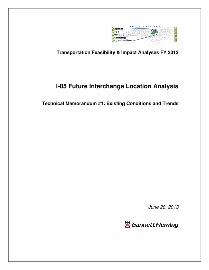
Existing Population, Employment, and Land Use
The study area is rural in nature with most of the
population and employment within the towns of
Creedmoor, Butner, and Oxford. However the area
is growing. According to the US Census, Granville
County had a total population of 59,916 in April of
2010 and 60,436 in June of 2012. This is up 24
percent from the 48,824 residents in 2000. This
growth has been based in south Granville primarily,
as exemplified by the four towns’ growth: Butner,
Creedmoor, and Stem have seen 31 percent, 85
percent and 102% population growth, respectively,
while Oxford has seen just over 1 percent growth.
Town 2000
Population
2010
Population
%
change
Butner1 5,792 7,591 31.1%
Creedmoor 2,232 4,124 84.7%
Oxford 8,338 8,461 1.5%
Stem 229 463 102.2%
Economic development growth has not been as
robust. In 2010 there were a total of 835 non-farm
businesses in the county, employing nearly 13,200
people. This is up only 6 percent from 785
establishments in 2000.
1 Butner was classified as a CDP in the 2000 Census, but as a
town in the 2010 Census
Page 4 of 6
FIGURE 2 2012 POPULATION AND EMPLOYMENT
FIGURE 3 LAND USE MAP
Existing Roadway Conditions
With limited transit service in the area, auto traffic
accounts for most travel mode choices. Below is a
review of existing regional roadway conditions, as
well as intersection-level conditions for I-85 Exits
191 and 202. The purpose of documenting these
conditions is to measure to what extent tested
improvements impact the transportation system.
Study Area Travel Conditions
Travel conditions were estimated for the study area
using the Triangle Regional Model’s outputs for
2010. Existing conditions are within acceptable
levels when looking at regional mobility. No
roadways within the study area currently experience
high levels of congestion.
Traffic Conditions
Traffic conditions are different from regional
conditions in that they account for geometry, signal
timing, turning movements, and traffic volumes at a
smaller level of detail. The existing traffic
conditions for I-85 Exits 202 and 191 are described
below.
Baseline analyses were performed for existing
(2012 due to availability of NCDOT AADT data)
conditions and an assumed build year of 2040.
Intersection traffic operations were modeled and
analyzed in accordance with the Transportation
Research Board’s Highway Capacity Manual2
(HCM).
Level-of–Service (LOS) is defined as a “qualitative
measure describing operation conditions within a
traffic stream, based on service measures such as
speed and travel time, freedom to maneuver, traffic
interruptions, comfort, and convenience
A model of the study area was developed in
Synchro 8.0. NCDOT 2012 AADT volumes and
field data was entered into the model including
turning movements, speed limits, lane geometry,
and signal phasing. AADT volumes were factored
2 National Research Council. Transportation Research Board.
Highway Capacity Manual, Special Report 209. 4th Edition,
Washington, DC. 2000.

Page 5 of 6
up in the model utilizing the growth projections for
the respective roadways from the Triangle
Regional Model for the 2040 baseline condition.
The signal phasing was obtained from the signal
upgrade plan dated May 2013 from the NCDOT.
Existing operational conditions were further
imputed into the model including the allowance of
Right-Turns on Red (RTOR).
The results of the capacity analysis for the 2012
existing conditions indicate that the intersections in
the study area operate within acceptable levels-of-
service of C or better for both the morning and
afternoon peak-hours, with a few movements
operating at a service level of D for both AM and
PM peak-hours. These intersections are very close
to LOS C and small operational changes may
provide less delay in the short-term.
Crash History
Historical crash data was collected for the study
area for the five years between 2007 and 2011.
These data provide information on the locations of
crashes in order to inform this analysis on areas for
potential roadway safety improvements, as well as
for EMS response when considering a potential
new interchange.
There were a total of 230 crashes on I-85 between
Exits 191 and 202 during the 5-year time period.
Two thirds of these occurred between Sanders
Road and Exit 191. There were 21 crashes at Exit
191 and 54 crashes at Exit 202.
Future Baseline Roadway Conditions
Future Baseline Roadway Conditions include the
existing infrastructure and planned projects within
the fiscally constrained regional Transportation
Improvement Program (TIP) or Long Range
Transportation Plan (LRTP). The horizon year for
this analysis is 2040 and traffic volumes were
estimated using the Triangle Regional Model.
Modeled highway volumes were then used to
factor interchange volumes from existing AADTs
to estimate future interchange LOS.
Planned Projects
There are two significant projects planned in the
study area. The first is a widening of NC 56, from
two lanes to four lanes, between the interchange and
W. Lyon Station Road. This project is planned for
implementation by the year 2040. The second is a
new interchange at I-85 and Brogden Road by the
year 2030. Since this analysis is aimed at assessing
a new interchange and its impacts within the study
area, and a future baseline condition was necessary
for the assessment, the Brogden Interchange was
removed to be tested as an alternative. The NC56
widening project was left in the baseline condition
as well as each alternative. The analysis of the
alternatives, especially at the detailed Exit 191
intersection level, would be much different if this
project were removed.
Travel Demand Model Results
All links within the modeled study area show
acceptable Volume to Capacity ratios and travel
speeds. Volumes are expected to increase steadily
over the time period with minor changes in the
study area. For example, volumes at NC 56 and I-
85 (Exit 191) are expected to increase as a result of
planned capacity improvements. These volumes are
diversions from Brogden Road, which is expected
to see a decrease in volumes from 2030 to 2040 as a
result of the project. V/C ratios also improve as a
result of these capacity improvements.
Intersection Level Traffic Estimates
Baseline intersection LOS is not expected to
significantly worsen over time, with a few
exceptions. The Northbound I-85 to Eastbound NC
56 (Exit 191) is expected to experience a minor
increase in delay, from an LOS C to and LOS D.
This is also true with Southbound W. Lyon Station
Road and Westbound NC 56. A significant change,
however, is expected at Exit 202 and the vehicle
movement from Northbound I-85 to Westbound US
15. This LOS may warrant signalization of the
interchange in the future.
Emergency Management
The Stem, Providence, and Butner Fire Departments
divide responsibility of this corridor. Emergency
management responders receive approximately 100-
120 incident reports per year along I-85 between
exits 191 and 202. There are three emergency
vehicle turnaround points on this stretch, at
locations just north and south of the Granville

Page 6 of 6
County Rest Area at milepost 199, and an
additional turnaround approximately 0.5 miles
north of exit 191.
Currently, responders are often forced to park on
the opposite side of the interstate, increasing
responder safety concerns. Incident management
personnel estimate that the minimum response time
from Providence Station to the midpoint between
exits 191 and 202 is 15 minutes. Based on an
analysis of a sample response data set from
Granville County Emergency Management,
average response times are a little over 8 min, with
a median response time of 7 minutes and 30
seconds.
The National Fire Protection Association (NFPA)
has developed standards for all aspects of response.
Standard NFPA 1720 is the Standard for the
Organization and Deployment of Fire Suppression
Operations, Emergency Medical Operations and
Special Operations to the Public by Volunteer Fire
Departments. The table below shows the
population/distance threshold, minimum staff, and
response time standards from NFPA. Currently,
the average and median response times are within
these standards.
TABLE 1 NFPA 1720 STANDARDS
Population
Protected
Minimum
Staff
Response
Time (min)
>1,000 people/sq. mi. 15 9
500-1,000 people/sq.
mi. 10 10
<500 people/sq. mi. 6 14
Travel distance ≥ 8
mi. 4 14
In the event of a road closure along the interstate,
police and fire departments are equipped to
coordinate detour routes, though no formal
alternative route exists. NCDOT is available to
assist on rerouting when low-weight bridges
require additional detours for trucks.
There is no Intelligent Transportation Systems
(ITS) equipment currently in use by the county
within the project study area, though NCDOT does
have cameras. Granville County has expressed
interest in obtaining access to these cameras,
though that has yet to occur and is not included in
the CAMPO ITS Deployment Plan.
Economic Development
One of the purposes of a new interchange is the
economic development potential it may bring for
the study area and region. As discussed earlier in
this report, economic development growth has not
been robust. The vast majority of the area north of
exit 191 is either being used for agricultural
purposes, or is unused or underused.
Exit 191 is currently characterized as retail strip
type development, accommodating restaurants, fuel
stations, etc. Heavy industrial, light industrial, and
general commercial uses are scattered on the towns’
peripheries. To the immediate south of the corridor,
there is interest by the Town of Butner to develop
land between Exits 189 and 191 adjacent to I-85 SB
between the interstate and Railroad tracks.
Currently the land has no access road, and the town
is currently planning to add one. The land is zoned
for light and heavy industrial use, and would remain
as such if an access road were built.
Much of the land in the study area is composed of
large parcels which, were there mutual interest by
landowner and developer, would be one criteria of
suitability for industrial and commercial
development. While many of the parcels
immediately adjacent to the interstate are smaller,
there are many large parcels along Brogden Road,
particularly south towards Creedmoor, as well as a
few large parcels along Sanders Road. Note again,
however, that this does not imply that these parcels
are available for purchase or redevelopment, merely
that industrial and commercial developers are more
likely to be interested in larger parcels and the
prevalence of such land suggests the possibility of
future redevelopment interest associated with a new
interchange.


