IASbaba’s 60 Days Plan – Day 10 (Geography) 2018 1 Q.1) Consider the following statements. 1. The western cyclonic disturbances are weather phenomena of the winter months brought in by the easterly flow from the Mediterranean region. 2. Western cyclonic disturbances usually influence the weather of the north and north western regions of India. 3. Tropical cyclones occur during the monsoon as well as in October-November and are part of the westerly flow. 4. Tropical cyclones disturbances affect the coastal regions of the country. Which of the above statements is/are correct? a) 2 and 4 only b) 1, 2 and 3 only c) 1 and 3 only d) All the above Q.1) Solution (a) The western cyclonic disturbances are weather phenomena of the winter months brought in by the westerly flow from the Mediterranean region. They usually influence the weather of the north and north-western regions of India. Tropical cyclones occur during the monsoon as well as in October -November and are part of the easterly flow. These disturbances affect the coastal regions of the country. Do you know? An easterly jet stream, called the sub-tropical easterly Jetstream blows over peninsular India, approximately over 14°N during the summer months. THINK! Subtropical westerly jet. Q.2) Consider the following statements about Cold Weather Season (winter): 1. During this season, the northeast trade winds prevail over the country. 2. The weather is normally marked by clear sky, low temperatures and low humidity. Choose the correct answer using the codes given below. a) 1 only b) 2 only c) Both 1 and 2
Transcript
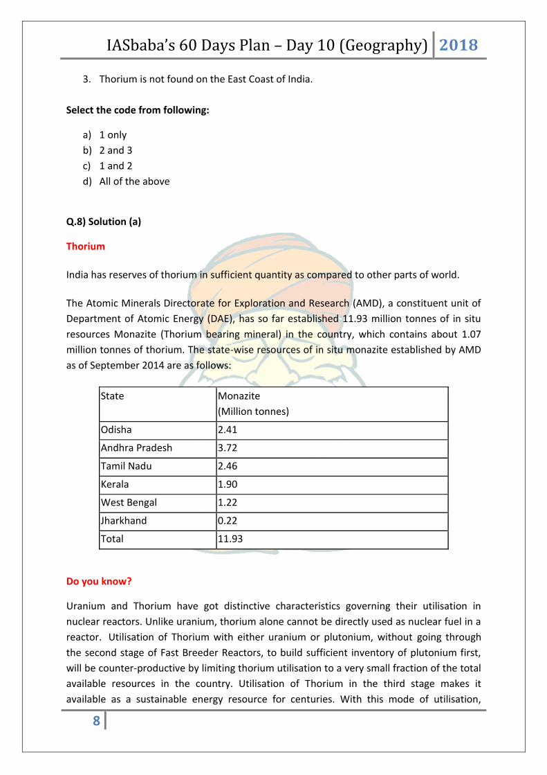
IASbaba’s 60 Days Plan – Day 10 (Geography) 2018
1
Q.1) Consider the following statements.
1. The western cyclonic disturbances are weather phenomena of the winter months
brought in by the easterly flow from the Mediterranean region.
2. Western cyclonic disturbances usually influence the weather of the north and north
western regions of India.
3. Tropical cyclones occur during the monsoon as well as in October-November and are
part of the westerly flow.
4. Tropical cyclones disturbances affect the coastal regions of the country.
Which of the above statements is/are correct?
a) 2 and 4 only
b) 1, 2 and 3 only
c) 1 and 3 only
d) All the above
Q.1) Solution (a)
The western cyclonic disturbances are weather phenomena of the winter months brought in
by the westerly flow from the Mediterranean region. They usually influence the weather of
the north and north-western regions of India. Tropical cyclones occur during the monsoon
as well as in October -November and are part of the easterly flow. These disturbances
affect the coastal regions of the country.
Do you know?
An easterly jet stream, called the sub-tropical easterly Jetstream blows over
peninsular India, approximately over 14°N during the summer months.
THINK!
Subtropical westerly jet.
Q.2) Consider the following statements about Cold Weather Season (winter):
1. During this season, the northeast trade winds prevail over the country.
2. The weather is normally marked by clear sky, low temperatures and low humidity.
Choose the correct answer using the codes given below.
a) 1 only
b) 2 only
c) Both 1 and 2
IASbaba’s 60 Days Plan – Day 10 (Geography) 2018
2
d) None of the above
Q.2) Solution (c)
The cold weather season begins from mid-November in northern India and stays till
February. December and January are the coldest months in the northern part of India. The
temperature decreases from south to the north. Days are warm, and nights are cold. Frost
is common in the north and the higher slopes of the Himalayas experience snowfall.
During this season, the northeast trade winds prevail over the country. They blow from
land to sea and hence, for most part of the country, it is a dry season. Some amount of
rainfall occurs on the Tamil Nadu coast from these winds as, here they blow from sea to
land. (In northwestern India, some weak temperate cyclones from the Mediterranean Sea
cause rainfall in Punjab, Haryana, Delhi and western Uttar Pradesh.)
In the northern part of the country, a feeble high-pressure region develops, with light winds
moving outwards from this area. Influenced by the relief, these winds blow through the
Ganga
valley from the west and the northwest. The weather is normally marked by clear sky, low
temperatures and low humidity.
Do you know?
The peninsular region does not have a well-defined cold season. There is hardly any
noticeable seasonal change in temperature pattern during winters due to the
moderating influence of the sea.
THINK!
Hot weather season.
Q.3) Which of the following is/are the implications of the shift of monsoon trough closer
to Himalayas?
1. There are longer dry spells in the plains.
2. The situation of drought establishes in the plains.
3. Widespread rain occurs in the mountainous catchment areas of the Himalayan
rivers.
Choose the correct answer using the codes given below.
a) 1 and 3 only
b) 1 and 2 only
c) 1 only
IASbaba’s 60 Days Plan – Day 10 (Geography) 2018
3
d) All the above
Q.3) Solution (a)
The Unique phenomenon associated with the monsoon is its tendency to have ‘breaks’ in
rainfall. Thus, it has wet and dry spells. In other words, the monsoon rains take place only
for a few days at a time. They are interspersed with rainless intervals. These breaks in
monsoon are related to the movement of the monsoon trough. For various reasons, the
trough and its axis keep on moving northward or southward, which determines the spatial
distribution of rainfall. When the axis of the monsoon trough lies over the plains, rainfall is
good in these parts. On the other hand, whenever the axis shifts closer to the Himalayas
there are longer dry spells in the plains, and widespread rain occur in the mountainous
catchment areas of the Himalayan rivers. These heavy rains bring in their wake, devastating
floods causing damage to life and property in the plains.
Do you know?
The frequency and intensity of tropical depressions too, determine the amount and
duration of monsoon rains.
THINK!
October Heat.
Q.4) Consider the Climatic Regions of India According to Koeppen’s Scheme.
Type of climate Areas
1. Amw- Monsoon with short dry
season
Most of the Peninsular plateaus, south of
the Tropic of Cancer
2. Aw – Tropical savannah West coast of India south of Goa
3. Dfc – Cold humid winter with short
summer
Arunachal Pradesh
4. Bwhw – Semi-arid steppe climate North-western Gujarat, some parts of
western Rajasthan and Punjab
Which of the above pairs is/are correctly matched?
a) 1 and 2 only
b) 1 and 3 only
c) 3 and 4 only
IASbaba’s 60 Days Plan – Day 10 (Geography) 2018
4
d) All the above
Q.4) Solution (c)
Climatic Regions of India According to Koeppen’s Scheme
Type of Climate
Areas
Amw- Monsoon with short dry season
West coast of India south of Goa
As – Monsoon with dry summer
Coromandel coast of Tamil Nadu
Aw – Tropical savannah
Most of the Peninsular plateaus, south of
the Tropic of Cancer
Bwhw – Semi-arid steppe climate
North-western Gujarat, some parts of
western Rajasthan and Punjab
Bwhw – Hot desert
Extreme western Rajasthan
Cwg – Monsoon with dry winter
Ganga plain, eastern Rajasthan, northern
Madhya Pradesh, most of North-east India
Dfc – Cold humid winter with short summer
Arunachal Pradesh
E – Polar type
Jammu and Kashmir, Himachal Pradesh and
Uttaranchal
Do you know?
Except Himalayas all the parts of the country have temperature above the threshold
level to grow the crops or plants throughout the year.
THINK!
Annual rainfall variability of India.
IASbaba’s 60 Days Plan – Day 10 (Geography) 2018
5
Q.5) Consider the following about statements about ‘Coal’ found in India.
1. The coal blocks found in northeastern India are much older than that found in
Damodar valley (West Bengal-Jharkhand), Jharia, Raniganj, Bokaro.
2. The coal blocks found in Damodar valley (West Bengal-Jharkhand), Jharia, Raniganj,
Bokaro are much superior in quality than the coal found in northeastern India.
Which of the above statement is/are correct?
a) 1 only
b) 2 only
c) Both 1 and 2
d) None
Q.5) Solution (b)
In India coal occurs in rock series of two main geological ages, namely Gondwana, a little
over 200 million years in age and in tertiary deposits which are only about 55 million years
old. Gondwana (200 million years old) coal forms India’s metallurgical grade as well as
superior quality coal.
The major resources of Gondwana coal, which are metallurgical coal, are located in
Damodar valley (West Bengal-Jharkhand). Jharia, Raniganj, Bokaro are important coalfields.
The Godavari, Mahanadi, Son and Wardha valleys also contain coal deposits.
Tertiary coal 55 million years old. Carbon content is very low. Coal generally has low
carbon and high percentage of moisture and Sulphur. [It takes few hundred million years for
the carbon content to improve]
Tertiary coals occur in the north eastern states of Meghalaya, Assam, Arunachal Pradesh
and Nagaland.
Do you know?
First coal mine was opened in 1774 at Raniganj in West Bengal. India is now the third
largest coal producer in the world after China and the USA.
THINK!
Privatization of coal mining.
Q.6) Consider the following statements
1. Dolomite, mica and gypsum are some of minor minerals as per Mines and Minerals
(Development and Regulation) Act, 1957 (MMDR Act 1957).
IASbaba’s 60 Days Plan – Day 10 (Geography) 2018
6
2. Major minerals are those minerals which are defined in Mines and Minerals
(Development and Regulation) Act, 1957 (MMDR Act 1957).
Which of the above statement is/are correct?
a) 1 only
b) 2 only
c) Both 1 and 2
d) None
Q.6) Solution (a)
In India, the minerals are classified as minor minerals and major minerals.
According to section 3(e) of the Mines and Minerals (Development and Regulation) Act,
1957 “Minor Minerals” means building stones, gravel, ordinary clay, ordinary sand other
than sand used for prescribed purposes, and any other mineral which the Central
Government may, by notification in the Official Gazette, declare to be a minor mineral. (For
the purposes of this Act, the word "minerals” includes all minerals except mineral oils-
natural gas and petroleum).
Major minerals are those specified in the first schedule appended in the Mines and
Minerals (Development and Regulation) Act, 1957 (MMDR Act 1957) and the common
major minerals are Lignite, Coal, Uranium, iron ore, gold etc. It may be noted that there is
no official definition for “major minerals” in the MMDR Act. Hence, whatever is not
declared as a “minor mineral” may be treated as the major mineral.
Ministry of Mines, on 10 February 2015, notified 31 additional minerals, hitherto under the
list of major minerals, as minor minerals. These 31 minerals account for over 55% of the
total number of leases and nearly 60% of total leased area. This was done with the
intention to “devolve more power to the States, and consequently, expedite the process of
mineral development in the country”. The 31 additional minerals notified as minor minerals