iCRESTRIGRS: a coupled modeling system for cascadingflood–landslide disaster forecastingKe Zhang1,2,3, Xianwu Xue2, Yang Hong2,5, Jonathan J. Gourley4, Ning Lu6, Zhanming Wan2, Zhen Hong2, andRick Wooten7
1Cooperative Institute for Mescoscale Meteorological Studies, University of Oklahoma, Norman, OK 73072, USA2Hydrometeorology and Remote Sensing (HyDROS) Laboratory, School of Civil Engineering and Environmental Science,and Advanced Radar Research Center, University of Oklahoma, Norman, OK 73072, USA3State Key Laboratory of Hydrology-Water Resources and Hydraulic Engineering, Hohai University, Nanjiang,Jiangsu, 210098, China4NOAA/National Severe Storms Laboratory, Norman, OK 73072, USA5Department of Hydraulic Engineering, Tsinghua University, Beijing, China6Department of Civil & Environmental Engineering, Colorado School of Mines, Golden, CO 80401, USA7North Carolina Geological Survey, North Carolina Department of Environmental Quality, Swannanoa, NC 28778, USA
Received: 22 March 2016 – Published in Hydrol. Earth Syst. Sci. Discuss.: 19 April 2016Revised: 30 September 2016 – Accepted: 23 November 2016 – Published: 20 December 2016
Abstract. Severe storm-triggered floods and landslides aretwo major natural hazards in the US, causing property lossesof USD 6 billion and approximately 110–160 fatalities peryear nationwide. Moreover, floods and landslides often oc-cur in a cascading manner, posing significant risk and lead-ing to losses that are significantly greater than the sum of thelosses from the hazards when acting separately. It is pertinentto couple hydrological and geotechnical modeling processesto an integrated flood–landslide cascading disaster model-ing system for improved disaster preparedness and hazardmanagement. In this study, we developed the iCRESTRIGRSmodel, a coupled flash flood and landslide initiation model-ing system, by integrating the Coupled Routing and ExcessSTorage (CREST) model with the physically based TransientRainfall Infiltration and Grid-Based Regional Slope-Stability(TRIGRS) landslide model. The iCRESTRIGRS system isevaluated in four river basins in western North Carolina thatexperienced a large number of floods, landslides and debrisflows triggered by heavy rainfall from Hurricane Ivan during16–18 September 2004. The modeled hourly hydrographs atfour USGS gauge stations show generally good agreementwith the observations during the entire storm period. In termsof landslide prediction in this case study, the coupled modelhas a global accuracy of 98.9 % and a true positive rate of
56.4 %. More importantly, it shows an improved predictivecapability for landslides relative to the stand-alone TRIGRSmodel. This study highlights the important physical connec-tion between rainfall, hydrological processes and slope sta-bility, and provides a useful prototype model system for op-erational forecasting of flood and landslide.
1 Introduction
Severe flooding and landslides are two major natural haz-ards in the US and the world. Flooding causes propertylosses of USD 3.7 billion and approximately 110 fatalitiesper year nationwide (Ashley and Ashley, 2008), while land-slides are responsible for 25–50 deaths and damage exceed-ing USD 2 billion annually (Spiker and Gori, 2003). Shal-low landslides induced by heavy rainfall have posed signif-icant threats to human lives and property worldwide (Honget al., 2006; Kirschbaum et al., 2010). Moreover, heavy rain-fall, floods and landslides often occur in a cascading manner,where a relatively low-consequence event like heavy rain-fall could trigger a severe flood and/or landslide that posessignificant risk to an affected community. Losses resultingfrom the combined hazards may be significantly greater than
Published by Copernicus Publications on behalf of the European Geosciences Union.
5036 K. Zhang et al.: iCRESTRIGRS: a coupled flood–landslide modeling system
the sum of the losses from the hazards if acting separately.One example is the intense precipitation in the ColoradoFront Range on 11–12 September 2013 that triggered flashfloods and at least 1138 debris flows, resulting in 8 fatal-ities and more than 20 000 buildings, 485 miles of roadsand 50 bridges either damaged or destroyed (Coe et al.,2014). Another example of the devastating impacts of cas-cading multiple hazards: rain from the remnants of hurri-canes Frances and Ivan triggered 400 reported slope failuresof various types in the Blue Ridge Mountains of North Car-olina, and at least 33 debris flows and major floods in MaconCounty, causing 5 deaths, destroying 16 homes, and damag-ing infrastructure (Wooten et al., 2008; Bauer et al., 2012).Such events make it critical to provide the public with risk-informed forecasting and warning systems in which multi-hazard threats are assessed and quantified.
According to a global natural disaster synthesis report(Dilley et al., 2005), over 790 million people are exposed tomore than one natural hazard, based on the past 2 decadesof historical loss data. Concurrent or time-lagged cascadingmulti-hazards are worldwide phenomena. In spite of theircascading nature, forecasts and warnings and risk assess-ments for such events conventionally are oriented towardssingle hazards, treating the cascading events as independentphenomena (Hsu et al., 2011; Wastl et al., 2011). One ex-ample is the severe storm system accompanied by a deadlytornado, heavy rain, and flash flooding that occurred in Ok-lahoma City (OKC) on 31 May 2013, in which more peo-ple were killed unexpectedly by the flash flooding than bythe tornado, making it the deadliest flooding event that hasever occurred in OKC. This is partly due to the fact that thestorm (accompanied by heavy precipitation and the tornado)and flash flood were forecasted by two separate warning sys-tems and their warnings were issued separately (Uccellini etal., 2014); the public was well aware of the tornado threatbut largely unaware of the flood threat in spite of severalNational Weather Service (NWS) products and outreach ef-forts (Uccellini et al., 2014). Moreover, the public’s attentionwas mostly drawn to the tornado warnings (not to the flashflooding threat) mainly because this storm occurred only10 days after the disastrous EF-5 tornado which devastatedMoore, OK, and resulted in 24 fatalities and USD 2 billionin property damage. Although several recent studies haveinvestigated multi-hazards and multi-hazard risk assessment(Budimir et al., 2014; Gill and Malamud, 2014; May, 2007;Mignan et al., 2014), these multi-hazard studies are still inthe early stages of conceptual development (Gill and Mala-mud, 2014; Kappes et al., 2010). Knowledge gaps and dis-ciplinary barriers in the development of multi-hazard ap-proaches remain formidable. It is essential to understand thecascading effects of multiple natural hazards in an integratedway in order to accurately forecast their occurrence and as-sess their potential risks and societal impacts.
Hydrological models have been used for operational floodforecasting since the development of the first watershed hy-
drological model in 1966 (Crawford and Linsley, 1966). Hy-drological models have evolved from lumped-process mod-els (Williams and Hann, 1978; Sugawara et al., 1984) tosemi-distributed models (Beven and Kirkby, 1979; Zhao etal., 1980) and fully distributed models (Abbott et al., 1986;Wigmosta et al., 1996; Wang et al., 2011). Several regionalto global real-time flood forecasting systems using hydrolog-ical models as major tools have been implemented, includingthe NASA–University of Oklahoma Ensemble FrameworkFor Flash Flood Forecasting (EF5) (Clark III et al., 2016),the Flooded Locations and Simulated Hydrographs (FLASH)project (Gourley et al., 2014), the European CommissionGlobal Flood Awareness System (Alfieri et al., 2013), andthe NASA–University of Maryland Global Flood MonitoringSystem (Wu et al., 2014), among others. In the last decade,physics-based, rainfall-triggered landslide models (Baum etal., 2010; Godt et al., 2009; Dietrich et al., 1995; Iverson,2000; Liao et al., 2010; Lu and Godt, 2008; Raia et al., 2014)have been developed to simulate slope stability influenced bytopography, geology, and hydrological processes. Some pio-neering studies have been conducted to couple hydrologicalmodels with landslide or slope-stability models to link thehydrological process with soil mechanics. For example, Si-moni et al. (2008) combined a distributed hydrological modelcalled GEOtop with a geotechnical model for probabilisticestimation of landslide occurrence. Lanni et al. (2012) uti-lized a dynamic topographic hydrological model to describethe subsurface processes and linked it with a simple hillslopeslope-stability model for modeling the initiation of shallowlandslides. Arnone et al. (2011), Lepore et al. (2013), Cam-era et al. (2013), and Tao and Barros (2014) have also con-ducted similar studies among others. However, there is stillmuch room for conducting studies on coupling hydrologicalmodels with landslide models for large-scale flood and land-slide prediction (Bogaard and Greco, 2014).
In this study, we present a framework that couples anestablished distributed hydrological model – the CoupledRouting and Excess STorage distributed hydrological model(CREST) (Wang et al., 2011) – with a well-known landslidemodel – Transient Rainfall Infiltration and Grid-Based Re-gional Slope-Stability (TRIGRS) (Baum et al., 2010) – torealize systematic and dynamical simulation of hydrologicalprocesses and their effects on slope stability. This integrated,coupled system is designed to serve as a prototype modelfor potential operational use. The objectives of this study are(1) to develop a coupled flood–landslide forecasting modelsystem that can be forced by satellite- or radar-based quan-titative precipitation estimation (QPE) systems or can beeasily forced with numerical weather prediction models orother weather models, and (2) to evaluate the performance ofthis coupled modeling system in forecasting streamflow andslope failures.
K. Zhang et al.: iCRESTRIGRS: a coupled flood–landslide modeling system 5037
2 Methodology and data
2.1 Methodology
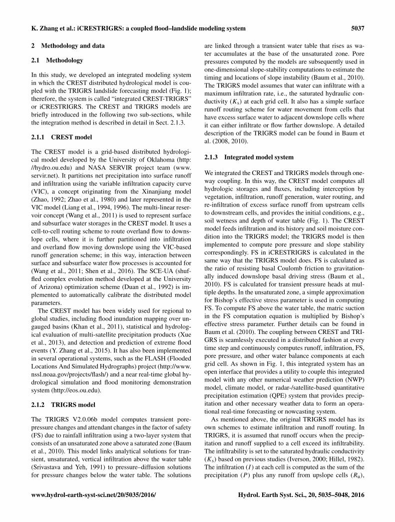
In this study, we developed an integrated modeling systemin which the CREST distributed hydrological model is cou-pled with the TRIGRS landslide forecasting model (Fig. 1);therefore, the system is called “integrated CREST-TRIGRS”or iCRESTRIGRS. The CREST and TRIGRS models arebriefly introduced in the following two sub-sections, whilethe integration method is described in detail in Sect. 2.1.3.
2.1.1 CREST model
The CREST model is a grid-based distributed hydrologi-cal model developed by the University of Oklahoma (http://hydro.ou.edu) and NASA SERVIR project team (www.servir.net). It partitions net precipitation into surface runoffand infiltration using the variable infiltration capacity curve(VIC), a concept originating from the Xinanjiang model(Zhao, 1992; Zhao et al., 1980) and later represented in theVIC model (Liang et al., 1994, 1996). The multi-linear reser-voir concept (Wang et al., 2011) is used to represent surfaceand subsurface water storages in the CREST model. It uses acell-to-cell routing scheme to route overland flow to downs-lope cells, where it is further partitioned into infiltrationand overland flow moving downslope using the VIC-basedrunoff generation scheme; in this way, interaction betweensurface and subsurface water flow processes is accounted for(Wang et al., 2011; Shen et al., 2016). The SCE-UA (shuf-fled complex evolution method developed at the Universityof Arizona) optimization scheme (Duan et al., 1992) is im-plemented to automatically calibrate the distributed modelparameters.
The CREST model has been widely used for regional toglobal studies, including flood inundation mapping over un-gauged basins (Khan et al., 2011), statistical and hydrolog-ical evaluation of multi-satellite precipitation products (Xueet al., 2013), and detection and prediction of extreme floodevents (Y. Zhang et al., 2015). It has also been implementedin several operational systems, such as the FLASH (FloodedLocations And Simulated Hydrographs) project (http://www.nssl.noaa.gov/projects/flash/) and a near real-time global hy-drological simulation and flood monitoring demonstrationsystem (http://eos.ou.edu).
2.1.2 TRIGRS model
The TRIGRS V2.0.06b model computes transient pore-pressure changes and attendant changes in the factor of safety(FS) due to rainfall infiltration using a two-layer system thatconsists of an unsaturated zone above a saturated zone (Baumet al., 2010). This model links analytical solutions for tran-sient, unsaturated, vertical infiltration above the water table(Srivastava and Yeh, 1991) to pressure–diffusion solutionsfor pressure changes below the water table. The solutions
are linked through a transient water table that rises as wa-ter accumulates at the base of the unsaturated zone. Porepressures computed by the models are subsequently used inone-dimensional slope-stability computations to estimate thetiming and locations of slope instability (Baum et al., 2010).The TRIGRS model assumes that water can infiltrate with amaximum infiltration rate, i.e., the saturated hydraulic con-ductivity (Ks) at each grid cell. It also has a simple surfacerunoff routing scheme for water movement from cells thathave excess surface water to adjacent downslope cells whereit can either infiltrate or flow farther downslope. A detaileddescription of the TRIGRS model can be found in Baum etal. (2008, 2010).
2.1.3 Integrated model system
We integrated the CREST and TRIGRS models through one-way coupling. In this way, the CREST model computes allhydrologic storages and fluxes, including interception byvegetation, infiltration, runoff generation, water routing, andre-infiltration of excess surface runoff from upstream cellsto downstream cells, and provides the initial conditions, e.g.,soil wetness and depth of water table (Fig. 1). The CRESTmodel feeds infiltration and its history and soil moisture con-dition into the TRIGRS model; the TRIGRS model is thenimplemented to compute pore pressure and slope stabilitycorrespondingly. FS in iCRESTRIGRS is calculated in thesame way that the TRIGRS model does. FS is calculated asthe ratio of resisting basal Coulomb friction to gravitation-ally induced downslope basal driving stress (Baum et al.,2010). FS is calculated for transient pressure heads at mul-tiple depths. In the unsaturated zone, a simple approximationfor Bishop’s effective stress parameter is used in computingFS. To compute FS above the water table, the matric suctionin the FS computation equation is multiplied by Bishop’seffective stress parameter. Further details can be found inBaum et al. (2010). The coupling between CREST and TRI-GRS is seamlessly executed in a distributed fashion at everytime step and continuously computes runoff, infiltration, FS,pore pressure, and other water balance components at eachgrid cell. As shown in Fig. 1, this integrated system has anopen interface that provides a utility to couple this integratedmodel with any other numerical weather prediction (NWP)model, climate model, or radar-/satellite-based quantitativeprecipitation estimation (QPE) system that provides precip-itation and other necessary weather data to form an opera-tional real-time forecasting or nowcasting system.
As mentioned above, the original TRIGRS model has itsown schemes to estimate infiltration and runoff routing. InTRIGRS, it is assumed that runoff occurs when the precip-itation and runoff supplied to a cell exceed its infiltrability.The infiltrability is set to the saturated hydraulic conductivity(Ks) based on previous studies (Iverson, 2000; Hillel, 1982).The infiltration (I ) at each cell is computed as the sum of theprecipitation (P ) plus any runoff from upslope cells (Ru),
5038 K. Zhang et al.: iCRESTRIGRS: a coupled flood–landslide modeling system
Slope failure prediction
Topographical & edaphicinformation:
Forcings
Input data
Factor of safety (Spatially dynamic & time-varying)
Integrated hydrological &landslide model system
Flood prediction
Figure 1. The framework of the proposed integrated CREST and TRIGRS modeling system, which is able to forecast flood and rainfall-triggered landslide events.
with the limitation that infiltration cannot exceed Ks (Baumet al., 2010):
I =
{P +Ru, P +Ru ≤KsKs, P +Ru > Ks
(1)
At each cell where P +Ru exceeds Ks, the excess is consid-ered runoff (Rd) and is diverted to adjacent downslope cells:
Rd =
{P +Ru−Ks, P +Ru−Ks > 00, otherwise . (2)
Overland flow between adjacent cells is assumed to occurinstantaneously; thus, the rate of overland flow is not consid-ered or computed in TRIGRS. TRIGRS the enforces massbalance for each time step but does not carry runoff overfrom one time step to the next or track water that enters stormdrains (Baum et al., 2008, 2010).
Unlike TRIGRS, the CREST model is a distributed hydro-logical model, which specializes in modeling all major sur-face hydrological processes. The rainfall–runoff generationprocesses in CREST start from the canopy interception. Af-ter P passes the canopy layer, the excess precipitation thatreaches the soil surface is net precipitation (Psoil), which isfurther divided into surface runoff (R) and infiltration (I ) ac-cording to the variable infiltration curve (VIC), a conceptoriginating from the Xinanjiang model (Zhao, 1992; Zhaoet al., 1980) and later represented in the VIC model (Lianget al., 1994, 1996). This model assumes that the point infil-tration capacity i, which is the maximum water depth that
can be stored in the soil column, varies over an area in thefollowing relationship (Wang et al., 2011):
i = im
[1− (1− a)
1b
], (3)
where im is the maximum infiltration capacity of a cell andis determined by soil properties; a is the fraction of a gridcell whose water capacity is less than or equal to the meanwater capacity of the whole cell; and b is an empirical shapeparameter. The amount of water available for infiltration cantherefore be calculated as follows (Wang et al., 2011):
I =
Wm−W,i+Psoil ≥ im
(Wm−W)+Wm ·
[1−
i+Psoil
im
]1+b
, i+Psoil < im, (4)
where Wm and W are the cell’s maximum water capac-ity and total mean water of the three soil layers, respec-tively. The overland and subsurface flows are further sep-arated from excess rain governed by the saturated soil hy-draulic conductivity. Then the cell-to-cell routing of the over-land and subsurface runoff is simulated using the multi-linear reservoir method at each time step. CREST couplesthe runoff-generation process and the routing scheme to rep-resent the interaction between the surface and subsurfaceflow in three better ways than simply routing surface flowdownslope without considering its contribution to infiltra-tion in downslope cells. First, overland runoff from upstreamcells is treated as additional precipitation at the appropriatedownstream cells available for infiltration and runoff parti-
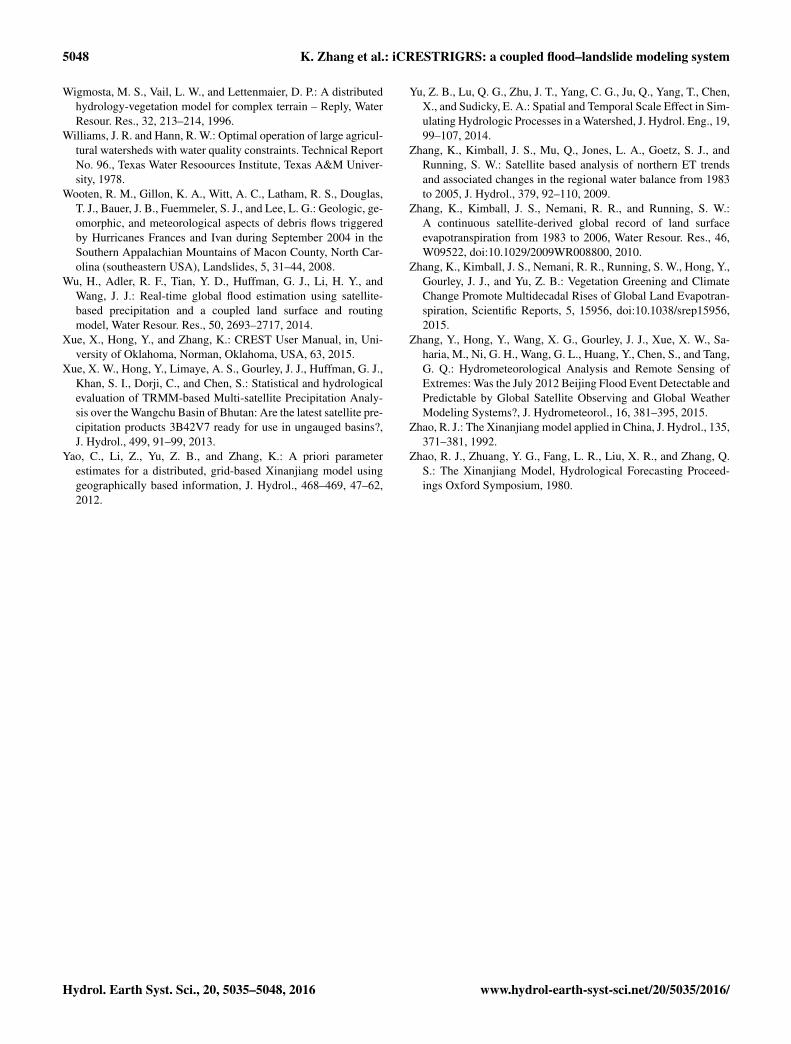
Figure 2. (a) Elevations, (b) slopes, (c) soil types, (d) land cover types, and (e) areal extent of reported individual slope movements duringthe study period in the study region, which include four river basins, the upper Little Tennessee River basin, Tuckasegee River basin, PigeonRiver basin, and French Broad River Basin (from left to right); the inset shows the locations of the four basins within North Carolina.
tioning. Second, soil water can be increased by lateral in-terflow from upstream cells. Third, channel runoff from up-stream cells contributes to the receptor cell’s overland reser-voir depth. This implemented cell-by-cell runoff routing en-ables this model to realistically compute the spatially andtemporally varying values of runoff, soil moisture and infil-tration. It also tracks the water movement through the basin.
In theory, replacing the simple infiltration and runoff rout-ing schemes in TRIGRS with the more sophisticated runoffgeneration and routing methods in CREST will produce morerealistic estimates of infiltration history in areas with nontriv-ial contributions of overland flow to infiltration. Moreover,the CREST model is able to simulate and provide necessaryinitial conditions and other inputs for the TRIGRS model.The iCRESTRIGRS model is, therefore, able to continuouslyand seamlessly simulate hydrological processes and solvepore pressure and factor of safety for each cell at each timestep with available forcing data. The minimum forcing data
required to run this model are only precipitation and evapo-transpiration, making it an easily implementable model.
2.2 Case study and data
2.2.1 Study area and case study
We chose four adjacent river basins, the Upper Little Ten-nessee River basin, the Tuckasegee River basin, the PigeonRiver basin, and the French Broad River basin, located inwestern North Carolina (Fig. 2a), as our study area. Thedrainage area of the four basins ranges between 1390 and4050 km2.
Hurricane Ivan, the tenth most intense Atlantic hurricaneever recorded, passed through this region between 16 and 19September 2004. It triggered over 110 landslides across thestudy region, and at least 33 debris flows occurred in MaconCounty, causing 5 deaths, destroying 16 homes, and dam-aging infrastructure (Wooten et al., 2008). Hurricane Ivanproduced rainfall rates of 150–230 mm h−1 and precipitation
5040 K. Zhang et al.: iCRESTRIGRS: a coupled flood–landslide modeling system
totals from 52 to 351 mm across the study area (NationalOceanic and Atmospheric Administration, 2004). The floodand landslide events triggered by the precipitation from Hur-ricane Ivan across western North Carolina serve as an idealcase study to test the integrated flood–landslide forecast sys-tem.
2.2.2 Input and validation data
Data used in this study include radar-measured rainfall- andsatellite-based estimates of actual evapotranspiration, digitalelevation models (DEM), land cover and soil texture maps,observed river streamflow from gauges, and an inventory oflandslide events (Bauer et al., 2012). All gridded data wereeither downscaled or aggregated to a spatial resolution of3 arcsec (3′′, i.e., ∼ 90 m) to ensure the forcing and auxil-iary data match with each other. Bilinear interpolation is themethod for spatial downscaling in this study, whereas area-weighted resampling is used for aggregation.
The precipitation data were from the hourly, 4 km NationalStage IV Quantitative Precipitation Estimation (QPE) prod-uct based on gauge and radar observations at NCEP (Linand Mitchell, 2005). The Stage IV data were downscaled to3′′ using bilinear interpolation. The actual evapotranspiration(ET) data were derived from a daily satellite remote-sensing-based ET record as input for the iCRESTRIGR model and areavailable at a spatial resolution of 8 km (Zhang et al., 2009,2010; K. Zhang et al., 2015). The daily, 8 km ET data werefirst downscaled to a spatial resolution of 3′′ using bilinearinterpolation and further downscaled to hourly resolution us-ing the solar zenith angle as a function of solar declination,latitude, and hour angle of each grid cell.
The 3′′ DEM (Fig. 2a), flow direction, and flow accu-mulation data were obtained from the USGS HydroSHEDS3′′ geo-referenced data sets (http://hydrosheds.cr.usgs.gov).These data serve as basic data for the distributed iCRE-STRIGRS model to establish topological and geomorpho-logical connections among grid cells and derive further to-pographical information such as slope (Fig. 2b). The mapof soil type (Fig. 2c) was from the State Soil Geographic(STATSGO) data set, distributed by the Natural ResourcesConservation Service (NRCS) of the US Department of Agri-culture. The soil texture classes were converted to 12 USDAsoil texture classes plus rock and organic matter. The landcover/land use map (Fig. 2d) was derived from the 30 m Na-tional Land Cover Database (NLDC) 2011 (Homer et al.,2015). Streamflow observations from four USGS stream-flow gauges (no. 03503000 at Little Tennessee River, no.03513000 at Tuckasegee River, no. 03460795 at PigeonRiver, and no. 03453500 at French Broad River) were aggre-gated from 15 min to hourly resolution and serve as stream-flow validation data for the model.
The locations and slope movement outlines of landslideevents during Hurricane Ivan shown in Fig. 2e were identi-fied by the North Carolina Geological Survey through field
-1
Figure 3. (a) Accumulated and hourly regional-average rainfallsduring the 16–18 September storm period in the study region,(b) spatial pattern of accumulated rainfall during the storm pe-riod, and (c) spatial pattern of rain peak times since 16 September,11:00 UTC.
surveys and other remote-sensing techniques (Wooten et al.,2008; Bauer et al., 2012). The areal extent of individual slopemovements ranges from 22 to 139 000 m2, with an averagesize of 6000 m2. The majority of these slope movement out-lines have a long and narrow shape (Fig. 2e).
2.2.3 Model parameters and initialization
As the developed prototype model system is aimed at op-erational use over a large region, we determined the val-
1 Values were roughly set to the means of the ranges determined from Das (2008), Hough (1969), Terzaghi etal. (1996) and Dysli, (2000); 2 values were estimated by the pedotransfer equations of Cosby et al. (1984) using themean sand and clay fractions of each soil class.
ues of model parameters at each grid cell based on its soilclass rather than using very limited local measured values.For this purpose, we built a parameter look-up table basedon the USDA textural soil classification. Table 1 summarizesthe values of key common parameters used in both TRIGRSand iCRESTRIGRS. The values of all these parameters wereroughly estimated as the means of their value ranges deter-mined from the literature. Parameter Wm of the iCRESTRI-GRS model was determined from topography using the a pri-ori estimation method developed by Yao et al. (2012), whileparameter b is set to a constant (1.5) across the study regionbased on our past experience. For the rest of the iCRESTRI-GRS parameters that are inherited from CREST, we deter-mined their distributed values using the parameter look-uptable provided by the CREST user manual (Xue et al., 2015)based on the land cover map and the soil texture map.
Because all model parameters were determined from soiltypes a priori, we did not conduct model calibration in thisstudy. To minimize the uncertainty in the initial conditions,the iCRESTRIGRS model was spun up for 1 year before-hand.
2.3 Statistical metrics for evaluating modelperformance
To evaluate the performance of this integrated model system,we applied a suite of statistical metrics to evaluate the modelresults. We computed relative bias, Pearson correlation co-efficient (CC), and Nash–Sutcliffe coefficient of efficiency(NSCE) for the modeled hourly discharge series using thefour USGS gauge stations.
To quantitatively measure the predictive capabilities of themodels for landslide prediction, we calculated the confusion
matrix through comparison between the binary predictions ofslope failure and the landslide inventory database. The con-fusion matrix consists of four possible outcomes (Fawcett,2006): (1) a modeled landslide is a true one (true positive,TP), (2) a modeled landslide is a false one (false positive,FP), (3) an observed landslide is not captured by the model(false negative, FN), and (4) a grid cell is stable in both modeland observation (true negative, TN). Based on the confusionmatrix, a series of indices can be calculated:
where TPR is the true positive rate and also called sensitiv-ity, and TNR is the true negative rate and also called speci-ficity. The sensitivity statistic measures the percentage ofpositive cases correctly predicted, while the specificity statis-tic quantifies the percentage of negative cases correctly pre-dicted (Begueria, 2006; Fawcett, 2006). The receiver operat-ing characteristic (ROC) curve analysis was further appliedto evaluate model results for landslide predictions and tocompare differences between the TRIGRS and iCRESTRI-GRS models. A ROC curve consists of TPR and TNR pairs,which are computed from the respective confusion matricesfor different cutoff values. In our case, the cutoff variableis FS. A ROC curve shifted towards the upper-right cornermeans better model performance. The better the performanceof the model, the larger the area under the ROC curve (AUC);therefore, the AUC index serves as a global statistical accu-racy indicator for the model.
5042 K. Zhang et al.: iCRESTRIGRS: a coupled flood–landslide modeling system
09/17 09/19 09/21 09/230
300
600
900
1200
1500
1800
Dis
char
ge (
m s
)
3
(a)
Bias= CC=
NSEC=
−33.2 %0.950.76
09/17 09/19 09/21 09/23
0
20
40
60
80
100
120
Rai
nfal
l (m
m h
)
Time
QobsQ
iCRESTRIGRS
Rainfall
09/17 09/19 09/21 09/230
300
600
900
1200
1500
1800
Dis
char
ge (
m s
)
3
(b)
Bias= CC=
NSEC=
−15.1 %0.910.75
09/17 09/19 09/21 09/23
0
20
40
60
80
100
120
Rai
nfal
l (m
m h
)
Time
09/17 09/19 09/21 09/230
300
600
900
1200
1500
1800
Dis
char
ge (
m s
)
3
(c)
Bias= CC=
NSEC=
−8.2 %0.900.65
09/17 09/19 09/21 09/23
0
20
40
60
80
100
120R
ainf
all (
mm
h )
Time09/17 09/19 09/21 09/23
0
300
600
900
1200
1500
1800
Dis
char
ge (
m s
)
3
(d)
Bias= CC=
NSEC=
−7.2 %0.81−0.13
09/17 09/19 09/21 09/23
0
20
40
60
80
100
120
Rai
nfal
l (m
m h
)
Time
-1-1
-1-1
-1-1
-1-1
Figure 4. Observed and modeled hydrographs and basin-average rainfall rates at the (a) upper Little Tennessee River basin, (b) TuckasegeeRiver basin, (c) Pigeon River basin, and (d) French Broad River basin.
3 Results
3.1 Characteristics of the Hurricane Ivan inducedstorm
Hurricane Ivan passed through western North Carolina be-tween 16 and 18 September 2004. The storm in this re-gion started around 11:00 UTC 16 September 2004 and com-pletely ceased around 03:00 UTC 18 September, while themajority of rainfall occurred in the first 24 h (Fig. 3a). Itbrought an average rainfall of ∼ 130 mm within 24 h acrossthe region (Fig. 3a), while accumulated rainfall reached max-imum values in the southern parts of the four river basins(Fig. 3b). The storm roughly moved from southwest to north-east (Fig. 3c); differences in peak time of rainfall across thisregion can be as large as 5 h (Fig. 3c). The storm was rapidand intense.
3.2 Model evaluation and comparison
The modeled hourly discharge series between 16 and24 September 2004 by the iCRESTRIGRS model were com-pared with the observations at the four USGS gauge stations(Fig. 4a–d). The modeled hydrographs show generally goodagreement with the observations. CC is larger than 0.80 atall stations. Relative bias falls within±34 %. The NSCE val-ues at three stations except the one located at French BroadRiver are larger than or equal to 0.65. The low NSCE valueat the French Broad River is largely due to a time shift be-tween modeled and observed peak discharges (Fig. 4d). Thedelayed peak discharge in the model implies that there is
likely some uncertainty in the flow concentration and rout-ing module of the iCRESTRIGRS model. In addition, uncer-tainty in the spatial distribution of Stage IV rainfall data canalso cause some uncertainty in the process of flow concen-tration. In general, the above results indicate that the iCRE-STRIGRS model is generally capable of simulating runoffprocess well and predicting the flood events.
In the model, whenever the FS value is less than 1.0, theregolith that covers the sloping ground surface is predictedto fail and there is a corresponding landslide. Figure 5a andb show the maps of minimum FS values during the wholestorm period modeled by TRIGRS and iCRESTRIGRS, re-spectively. In Fig. 5, the reported landslide events are plottedas magenta circles. When we actually evaluated the modelperformance, we compared the model results with the sur-veyed slope movement outlines. Therefore, we regard themodel as successfully predicting a real landslide if any of thegrid cells that overlap with the slope movement outline of thislandslide has a FS value of < 1; on the other hand, the modelis believed to have failed to capture a landslide event if noneof these cells overlapping the slope movement outline is sim-ulated as unstable. The spatial distribution of reported land-slides generally corresponds to the spatial patterns of modelminimum FS values (Fig. 5a, b). In other words, the actuallandslides are mostly located in the areas in which modelspredict unstable or close to unstable conditions (Fig. 5a, b).A notable difference in the spatial patterns of FS by the twomodels is that more areas in TRIGRS (Fig. 5a) have unstableslopes than in iCRESTRIGRS (Fig. 5b). This confirms thatthe factor of safety computed by the models is sensitive to
K. Zhang et al.: iCRESTRIGRS: a coupled flood–landslide modeling system 5043
Figure 5. Comparisons (a) between TRIGRS modeled FS and re-ported landslide events, and (b) between iCRESTRIGRS modeledFS and reported landslide events.
hydrological processes, in particular the infiltration process,because the largest difference between TRIGRS and iCRE-STRIGRS lies in the way that infiltration and runoff rout-ing are computed. For the TRIGRS model, the TPR, TNR,and accuracy statistics are 59.0, 97.5, and 97.7 %, respec-tively, when FS= 1 is set as a cutoff value for slope stability.For the iCRESTRIGRS model, the three metrics are 56.4,98.8, and 98.9 %. These results indicate that the iCRESTRI-GRS model shows generally better results and that couplingthe CREST distributed hydrological model with the TRIGRSmodel leads to an improved model performance, at least forthis case study.
The ROC analysis demonstrates that the coupled systemgenerally has higher specificity relative to the original TRI-GRS model (Fig. 6). The AUC values for the TRIGRS andiCRESTRIGRS models are 0.90 and 0.92, respectively, sug-gesting that iCRESTRIGRS performs better than TRIGRSin this case study. As mentioned above and shown in Fig. 7,the largest difference between the two models lies in themodel infiltration values. It is clear that the simple infiltration
0 0.2 0.4 0.6 0.8 10
0.1
0.2
0.3
0.4
0.5
0.6
0.7
0.8
0.9
1
AUCTRIGRS
=0.90 AUC
iCRESTRIGRS=0.92 FS=0.9
FS=1.0
FS=1.1
True negative
True
pos
itive
TRIGRSiCRESTRIGRS
Figure 6. Receiver operator characteristic (ROC) graph comparingslope-stability results from the TRIGRS and iCRESTRIGRS mod-els.
and rain excess routing schemes implemented in the TRI-GRS model lead to higher values of infiltration than in theiCRESTRIGRS model (Fig. 7a). The regional average accu-mulated infiltration during the 16–18 September storm mod-eled by TRIGRS is 104.9 mm, while the value modeled byiCRESTRIGRS is just half of it, i.e., 52.2 mm (Fig. 7a). Thelarger infiltration rate in TRIGRS than in iCRESTRIGRS ap-pears across the whole region (Fig. 7b, c). This explains whythe TRIGRS results have generally lower FS values than theiCRESTRIGRS results and why TRIGRS has a higher falsepositive rate than iCRESTRIGRS (Fig. 5).
3.3 Evolution of modeled cascading flood–landslidehazards
We further investigated the evolution of the storm in terms ofaccumulated rainfall during a 6 h period and the correspond-ing responses of hydrological processes (e.g., infiltration andoverland runoff), slope stability, and pressure modeled by theiCRESTRIGRS model (Fig. 8). In Fig. 8, the rainfall and in-filtration are 6 h accumulated values, while overland runoff isthe average value during each 6 h period. Factor of safety isthe minimum value during each period, while pore pressureis the value at the depth and at the time corresponding to thelowest FS.
During the first 6 h period, rainfall intensities are lowacross the region. The accumulated rainfall is generally lessthan 10 mm during this period (Fig. 8). In response to this, themodeled infiltration rate and its accumulated value are low aswell, while simulated overland runoff mainly appears in themain river channels. Very few unstable slopes appear acrossthis region in the model and pore pressure is generally low.During the second 6 h period, rainfall rate and modeled in-
5044 K. Zhang et al.: iCRESTRIGRS: a coupled flood–landslide modeling system
-1
Figure 7. (a) Accumulated and hourly infiltration values from theTRIGRS and iCRESTRIGRS models, and spatial patterns of accu-mulated infiltrations from the (b) TRIGRS and (c) iCRESTRIGRSmodels.
filtration rate increase to some extent, especially in the LittleTennessee River and Tuckasegee River basins. The model re-sults show that overland flow starts to appear in the small trib-utaries and creeks (Fig. 8). Pore pressure reaches high valuesin some areas of the Little Tennessee River and Tuckasegee
River basins, resulting in some unstable slopes. These unsta-ble slopes are largely located in the areas with steep slopes.During the third 6 h period, rainfall reaches a maximum andhas an accumulated value larger than 30 mm over most of theregion. Correspondingly, infiltration rates also reach maxi-mum and overland runoff appears everywhere, with rapidrises of streamflow in the drainage network. The number ofmodeled landslides has increased dramatically, accompaniedby large increases in pore pressures. As the storm enters thefourth 6 h period, rainfall and infiltration intensities declinebut still maintain high levels. Pore pressures in some regionscontinue to rise, resulting in some new landslides. During thefifth period, rainfall and infiltration intensities are reducedgreatly. Runoff on the land and in many upstream reaches ofthese rivers starts to subside. Pore pressure declines in manyareas, but remains high in some areas in response to accumu-lative infiltration processes. The number of modeled land-slides during this period also decreases. The detailed anal-yses of rainfall and modeled hydrological and geotechnicalresponses on a phase-by-phase basis show that the model re-sults show reasonable responses to the evolution of the stormin space and time. It also emphasizes the cascading nature ofrainfall-triggered floods and shallow landslides.
4 Conclusion and discussion
This study presents a new, coupled model system, which in-tegrates the CREST distributed hydrological model with theTRIGRS landslide model for flood and landslide forecast-ing. Driven by the hydrological states and fluxes modeledby CREST, iCRESTRIGRS improves over TRIGRS by pro-viding more accurate initial conditions such as degree of soilsaturation and depth of the water table. Furthermore, CRESTspecializes in the simulation of hydrological processes andfluxes and can thus provide more realistic hydrological fluxessuch as infiltration for TRIGRS, leading to better accuracyfor landslide forecasting. The case study demonstrates thatthe integrated model shows better results than the stand-aloneTRIGRS model for landslide forecasting.
The modeling system presented in this study is also de-veloped as a framework and is able to adopt other hydro-logical models and landslide models as alternatives to com-pute hydrological processes and soil stability. Therefore, thiscan be easily expanded to build an ensemble-based system.This coupled modeling system has low requirements for in-put data as well, making it easy to couple with other numeri-cal weather prediction models and real-time QPE forcings.
It is worth noting that there is still much room for improv-ing the predictive capabilities of iCRESTRIGRS for floodand landslide forecasting. In particular, the true positive ratefor landslide forecasting in iCRESTRIGRS in the case studyis not high. This can be improved through further parameteroptimization and/or implementation of reliable pedotransferfunctions. In addition, better characterization of soil proper-
K. Zhang et al.: iCRESTRIGRS: a coupled flood–landslide modeling system 5045
-1Accum. precip. (mm) Accum. infil. (mm) Mean runoff (m s )3 FS Pressure head (m)
Figure 8. Maps showing the evolution of storms (rainfall), hydrological responses such as infiltration and runoff, slope stability, and pressurehead at the depth corresponding to the lowest factor of safety.
ties, improved model formulation, and more information onfine-scale topography likely help improve model accuracy,because hydrological processes are highly scale-dependent(Yu et al., 2014). In particular, slope stability is highly de-pendent on the steepness of hillslopes, which is highly de-pendent on the model’s spatial resolution. In this study, thegrid spacing is set to 90 m rather than a finer resolution be-
cause we were limited by computational burden; plus, thisprototype system is designed from operational use, so it isimpractical to run this system with an extremely fine reso-lution over a large region. However, a nested modeling ap-proach, which executes the hydrological model at a coarserresolution, allows the landslide model to be executed at finerand coarser resolutions in the landslide prone areas and sta-
5046 K. Zhang et al.: iCRESTRIGRS: a coupled flood–landslide modeling system
ble areas, respectively. Introducing parallel computing intothe iCRESTRIGRS model using a new message passing in-terface (MPI) version of TRIGRS (Alvioli and Baum, 2016)will facilitate the application of the iCRESTRIGRS modelat a finer resolution. Additional evaluation of this model inlarger regions and under different conditions will better sup-port the predictive capability and robustness of this model.
5 Data availability
The DEM data are available from http://hydrosheds.cr.usgs.gov. The streamflow data are provided by the USGS (https://waterdata.usgs.gov), while the landcover data are avail-able through http://www.mrlc.gov/nlcd2011.php. Landsliderecords are available upon request to Rick Wooten, while allother data are available upon request to Ke Zhang.
Acknowledgements. This research was funded by the NOAA/Officeof Oceanic and Atmospheric Research under NOAA–Universityof Oklahoma Cooperative Agreement no. NA14OAR4830100,the NASA Surface and Interior program (NNH10ZDA001N-ESI), Fundamental Research Funds for the Central Universities(2015B28514) and the National Natural Science Foundation ofChina (71461010701).
Edited by: T. BogaardReviewed by: two anonymous referees
References
Abbott, M. B., Bathurst, J. C., Cunge, J. A., O’Connell, P. E., andRasmussen, J.: An introduction to the European Hydrologic Sys-tem – Systeme Hydrologique Europeen, “SHE” 1: history andphilosophy of a physically based distributed modeling system, J.Hydrol., 87, 45–59, 1986.
Alfieri, L., Burek, P., Dutra, E., Krzeminski, B., Muraro, D., Thie-len, J., and Pappenberger, F.: GloFAS – global ensemble stream-flow forecasting and flood early warning, Hydrol. Earth Syst.Sci., 17, 1161–1175, doi:10.5194/hess-17-1161-2013, 2013.
Alvioli, M. and Baum, R. L.: Parallelization of the TRIGRS modelfor rainfall-induced landslides using the message passing inter-face, Environ. Modell. Softw., 81, 122–135, 2016.
Arnone, E., Noto, L. V., Lepore, C., and Bras, R. L.: Physically-based and distributed approach to analyze rainfall-triggered land-slides at watershed scale, Geomorphology, 133, 121–131, 2011.
Ashley, S. T. and Ashley, W. S.: Flood fatalities in the United States,J. Appl. Meteorol. Clim., 47, 805–818, 2008.
Bauer, J. B., Fuemmeler, S. F., Wooten, R. M., Witt, A. C., Gillon,K. A., and Douglas, T. J.: Landslide hazard mapping in NorthCarolina – overview and improvements to the program, Proceed-ings of the 11th International Symposium on Landslides and2nd North American Symposium on Landslides, Banff, Alberta,Canada, 2012, 257–263, 2012.
Baum, R. L., Savage, W. Z., and Godt, J. W.: TRIGRS–A For-tran program for transient rainfall infiltration and grid-based re-
gional slope-stability analysis, Version 2.0, US Geological Sur-vey Open-File Report, 2008–1159, 75, 2008.
Baum, R. L., Godt, J. W., and Savage, W. Z.: Estimating the tim-ing and location of shallow rainfall-induced landslides using amodel for transient, unsaturated infiltration, J. Geophys. Res.,115, F03013, doi:10.1029/2009jf001321, 2010.
Begueria, S.: Validation and evaluation of predictive models in haz-ard assessment and risk management, Nat. Hazards, 37, 315–329, 2006.
Beven, K. J. and Kirkby, M. J.: A physically based, variable con-tributing area model of basin hydrology, Hydrological Sciences-Bulletin-des Sciences Hydrologiques, 24, 43–69, 1979.
Bogaard, T. and Greco, R.: Preface “Hillslope hydrological mod-elling for landslides prediction”, Hydrol. Earth Syst. Sci., 18,4185–4188, doi:10.5194/hess-18-4185-2014, 2014.
Budimir, M. E. A., Atkinson, P. M., and Lewis, H. G.: Earthquake-and-landslide events are associated with more fatalities thanearthquakes alone, Nat. Hazards, 72, 895–914, 2014.
Camera, C., Apuani, T., and Masetti, M.: A coupled distributedhydrological-stability analysis on a terraced slope of Valtellina(northern Italy), Hydrol. Earth Syst. Sci. Discuss., 10, 2287–2322, doi:10.5194/hessd-10-2287-2013, 2013.
Clark III, R., Flamig, Z., Vergara, H., Hong, Y., Gourley, J. J.,Mandl, D., Frye, S., Handy, M., and Patterson, M.: HydrologicalModeling and Capacity Building in the Republic of Namibia, B.Am. Meteorol. Soc., doi:10.1175/BAMS-D-15-00130.1, 2016.
Coe, J. A., Kean, J. W., Godt, J. W., Baum, R. L., Jones, E. S.,Gochis, D. J., and Anderson, G. S.: New insights into debris-flow hazards from an extraordinary event in the Colorado FrontRange, GSA Today, 24, 4–10, 2014.
Cosby, B. J., Hornberger, G. M., Clapp, R. B., and Ginn, T. R.:A Statistical Exploration of the Relationships of Soil-MoistureCharacteristics to the Physical-Properties of Soils, Water Resour.Res., 20, 682–690, 1984.
Crawford, N. H. and Linsley, R. S.: Digital simulation in hydrol-ogy: The Stanford Watershed Model IV, Technical Report No.39, Department of Civil Engineering, Stanford University, PaloAlto, California, 1966.
Dietrich, W. E., Reiss, R., Hsu, M. L., and Montgomery, D. R.:A Process-Based Model for Colluvial Soil Depth and ShallowLandsliding Using Digital Elevation Data, Hydrol, Process„ 9,383–400, 1995.
Dilley, M., Chen, R. S., Deichmann, U., Lerner-Lam, A. L., Arnold,M., Agwe, J., Buys, P., Kjekstad, O., Lyon, B., and Yetman,G.: Natural disaster hotspots: a global risk analysis synthe-sis report, International Bank for Reconstruction and Develop-ment/The World Bank and Columbia University, Washington,DC, 2005.
Duan, Q. Y., Sorooshian, S., and Gupta, V.: Effective and Effi-cient Global Optimization for Conceptual Rainfall-Runoff Mod-els, Water Resour. Res., 28, 1015–1031, 1992.
Dysli, M.: Swiss Standard SN 670 010b, Characteristic Coefficientsof soils, Strasse und Verkehr, 86, 93–94, 2000.
Fawcett, T.: An introduction of ROC analysis, Pattern Recogn. Lett.,27, 861–874, 2006.
Gill, J. and Malamud, B. D.: Reviewing and visualizing the interac-tions of natural hazards, Rev. Geophys., 52, 680–722, 2014.
K. Zhang et al.: iCRESTRIGRS: a coupled flood–landslide modeling system 5047
Godt, J. W., Baum, R. L., and Lu, N.: Landsliding in par-tially saturated materials, Geophys. Res. Lett., 36, L02403,doi:10.1029/2008GL035996, 2009.
Gourley, J. J., Flamig, Z. L., Hong, Y., and Howard, K. W.: Evalu-ation of past, present and future tools for radar-based flash-floodprediction in the USA, Hydrolog. Sci. J., 59, 1377–1389, 2014.
Hillel, D.: Introduction to soil physics, Academic Press, San Diego,California, 1982.
Homer, C., Dewitz, J., Yang, L. M., Jin, S., Danielson, P., Xian, G.,Coulston, J., Herold, N., Wickham, J., and Megown, K.: Com-pletion of the 2011 National Land Cover Database for the Con-terminous United States – Representing a Decade of Land CoverChange Information, Photogramm. Eng. Rem. S., 81, 345–354,2015.
Hong, Y., Adler, R., and Huffman, G.: Evaluation of the potential ofNASA multi-satellite precipitation analysis in global landslidehazard assessment, Geophys. Res. Lett., 33, 440–452, 2006.
Hough, B.: Basic soil engineering, Ronald Press Company, NewYork, 1969.
Hsu, W. K., Huang, P. C., Chang, C. C., Chen, C. W., Hung, D. M.,and Chiang, W. L.: An integrated flood risk assessment model forproperty insurance industry in Taiwan, Nat. Hazards, 58, 1295–1309, 2011.
Iverson, R. M.: Landslide triggering by rain infiltration, Water Re-sour. Res., 36, 1897–1910, 2000.
Kappes, M. S., Keiler, M., and Glade, T.: From single- to multi-hazard risk analyses: a concept addressing emerging challenges,in: Mountain Risks: Bringing Science to Society, edited by:Malet, J. P., Glade, T., and Casagli, N., CERG Editions, Stras-bourg, France, 351–356, 2010.
Khan, S. I., Hong, Y., Wang, J. H., Yilmaz, K. K., Gourley, J. J.,Adler, R. F., Brakenridge, G. R., Policelli, F., Habib, S., and Ir-win, D.: Satellite Remote Sensing and Hydrologic Modeling forFlood Inundation Mapping in Lake Victoria Basin: Implicationsfor Hydrologic Prediction in Ungauged Basins, IEEE T. Geosci.Remote, 49, 85–95, 2011.
Kirschbaum, D. B., Adler, R., Hong, Y., Hill, S., and Lerner-Lam,A.: A global landslide catalog for hazard applications: method,results, and limitations, Nat. Hazards, 52, 561–575, 2010.
Lanni, C., Borga, M., Rigon, R., and Tarolli, P.: Modelling shallowlandslide susceptibility by means of a subsurface flow path con-nectivity index and estimates of soil depth spatial distribution,Hydrol. Earth Syst. Sci., 16, 3959–3971, doi:10.5194/hess-16-3959-2012, 2012.
Lepore, C., Arnone, E., Noto, L. V., Sivandran, G., and Bras, R.L.: Physically based modeling of rainfall-triggered landslides: acase study in the Luquillo forest, Puerto Rico, Hydrol. Earth Syst.Sci., 17, 3371–3387, doi:10.5194/hess-17-3371-2013, 2013.
Liang, X., Lettenmaier, D. P., Wood, E. F., and Burges, S. J.: Asimple hydrologically based model of land surface water and en-ergy fluxes for general circulation models, J. Geophys. Res., 99,14415–14428, 1994.
Liang, X., Wood, E. F., and Lettenmaier, D. P.: Surface soil moistureparameterization of the VIC-2L model: Evaluation and modifica-tion, Global Planet. Change, 13, 195–206, 1996.
Liao, Z., Hong, Y., Wang, J., Fukuoka, H., Sassa, K., Karnawati,D., and Fathani, F.: Prototyping an experimental early warningsystem for rainfall-induced landslides in Indonesia using satellite
remote sensing and geospatial datasets, Landslides, 7, 317–324,2010.
Lin, Y. and Mitchell, K. E.: The NCEP Stage II/IV hourly precipita-tion analyses: development and applications, 19th Conference onHydrology, American Meteorological Society, San Diego, CA,9–13 January, 2005.
Lu, N. and Godt, J.: Infinite slope stability under steady unsaturatedseepage conditions, Water Resour. Res., 44, 2276–2283, 2008.
May, F.: Cascading disaster models in Postburn flash flood, The fireenvironment–innovations, management, and policy, Destin, FL,26–30 March 2007.
Mignan, A., Wiemer, S., and Giardini, D.: The quantificationof low-probability-high-consequences events: part I. A genericmulti-risk approach, Nat. Hazards, 73, 1999–2022, 2014.
National Oceanic and Atmospheric Administration: Storm data, Na-tional Climatic Data Center, 46, 1–262, 2004.
Raia, S., Alvioli, M., Rossi, M., Baum, R. L., Godt, J. W., andGuzzetti, F.: Improving predictive power of physically basedrainfall-induced shallow landslide models: a probabilistic ap-proach, Geosci. Model Dev., 7, 495–514, doi:10.5194/gmd-7-495-2014, 2014.
Shen, X., Hong, Y., Zhang, K., and Hao, Z.: Refining a distributedlinear reservoir routing method, J. Hydrol. Eng., 04016061,doi:10.1061/(ASCE)HE.1943-5584.0001442, 2016.
Simoni, S., Zanotti, F., Bertoldi, G., and Rigon, R.: Modelling theprobability of occurrence of shallow landslides and channelizeddebris flows using GEOtop-FS, Hydrol. Process., 22, 532–545,doi:10.1002/hyp.6886, 2008.
Spiker, E. C. and Gori, P. L.: National landslide hazards mitigationstrategy – a framework for loss reduction, US Department of theInterior and US Geological Survey, Reston, Virginia, 2003.
Srivastava, R. and Yeh, T. C. J.: Analytical Solutions for One-Dimensional, Transient Infiltration toward the Water-Table inHomogeneous and Layered Soils, Water Resour. Res., 27, 753–762, doi:10.1029/90wr02772, 1991.
Sugawara, M., Watanabe, I., Ozaki, E., and Katsugama, Y.: Tankmodel with snow component. Research Notes of the National Re-search Center for Disaster Prevention No. 65, Science and Tech-nolgoy, Ibaraki-Ken, Japan, 1984.
Tao, J. and Barros, A. P.: Coupled prediction of flood response anddebris flow initiation during warm- and cold-season events in theSouthern Appalachians, USA, Hydrol. Earth Syst. Sci., 18, 367–388, doi:10.5194/hess-18-367-2014, 2014.
Terzaghi, K., Peck, R., and Mesri, G.: Soil Mechanics in Engineer-ing Practice, Wiley, New York, 1996.
Uccellini, L. W., Suffern, P., Harding, K., Brown, V., Keeney, J.,Stammer, K., and Stefkovich, J.: Service assessment: May 2013Oklahoma tornadoes and flash flooding, US Department of Com-merce, National Oceanic and Atmospheric Administration, Na-tional Weather Service, Silver Spring, Maryland, 42, 2014.
Wang, J. H., Yang, H., Li, L., Gourley, J. J., Sadiq, I. K., Yilmaz,K. K., Adler, R. F., Policelli, F. S., Habib, S., Irwn, D., Limaye,A. S., Korme, T., and Okello, L.: The coupled routing and excessstorage (CREST) distributed hydrological model, Hydrolog. Sci.J., 56, 84–98, 2011.
Wastl, M., Stotter, J., and Kleindienst, H.: Avalanche risk assess-ment for mountain roads: a case study from Iceland, Nat. Haz-ards, 56, 465–480, 2011.
5048 K. Zhang et al.: iCRESTRIGRS: a coupled flood–landslide modeling system
Wigmosta, M. S., Vail, L. W., and Lettenmaier, D. P.: A distributedhydrology-vegetation model for complex terrain – Reply, WaterResour. Res., 32, 213–214, 1996.
Williams, J. R. and Hann, R. W.: Optimal operation of large agricul-tural watersheds with water quality constraints. Technical ReportNo. 96., Texas Water Resoources Institute, Texas A&M Univer-sity, 1978.
Wooten, R. M., Gillon, K. A., Witt, A. C., Latham, R. S., Douglas,T. J., Bauer, J. B., Fuemmeler, S. J., and Lee, L. G.: Geologic, ge-omorphic, and meteorological aspects of debris flows triggeredby Hurricanes Frances and Ivan during September 2004 in theSouthern Appalachian Mountains of Macon County, North Car-olina (southeastern USA), Landslides, 5, 31–44, 2008.
Wu, H., Adler, R. F., Tian, Y. D., Huffman, G. J., Li, H. Y., andWang, J. J.: Real-time global flood estimation using satellite-based precipitation and a coupled land surface and routingmodel, Water Resour. Res., 50, 2693–2717, 2014.
Xue, X., Hong, Y., and Zhang, K.: CREST User Manual, in, Uni-versity of Oklahoma, Norman, Oklahoma, USA, 63, 2015.
Xue, X. W., Hong, Y., Limaye, A. S., Gourley, J. J., Huffman, G. J.,Khan, S. I., Dorji, C., and Chen, S.: Statistical and hydrologicalevaluation of TRMM-based Multi-satellite Precipitation Analy-sis over the Wangchu Basin of Bhutan: Are the latest satellite pre-cipitation products 3B42V7 ready for use in ungauged basins?,J. Hydrol., 499, 91–99, 2013.
Yao, C., Li, Z., Yu, Z. B., and Zhang, K.: A priori parameterestimates for a distributed, grid-based Xinanjiang model usinggeographically based information, J. Hydrol., 468–469, 47–62,2012.
Yu, Z. B., Lu, Q. G., Zhu, J. T., Yang, C. G., Ju, Q., Yang, T., Chen,X., and Sudicky, E. A.: Spatial and Temporal Scale Effect in Sim-ulating Hydrologic Processes in a Watershed, J. Hydrol. Eng., 19,99–107, 2014.
Zhang, K., Kimball, J. S., Mu, Q., Jones, L. A., Goetz, S. J., andRunning, S. W.: Satellite based analysis of northern ET trendsand associated changes in the regional water balance from 1983to 2005, J. Hydrol., 379, 92–110, 2009.
Zhang, K., Kimball, J. S., Nemani, R. R., and Running, S. W.:A continuous satellite-derived global record of land surfaceevapotranspiration from 1983 to 2006, Water Resour. Res., 46,W09522, doi:10.1029/2009WR008800, 2010.
Zhang, K., Kimball, J. S., Nemani, R. R., Running, S. W., Hong, Y.,Gourley, J. J., and Yu, Z. B.: Vegetation Greening and ClimateChange Promote Multidecadal Rises of Global Land Evapotran-spiration, Scientific Reports, 5, 15956, doi:10.1038/srep15956,2015.
Zhang, Y., Hong, Y., Wang, X. G., Gourley, J. J., Xue, X. W., Sa-haria, M., Ni, G. H., Wang, G. L., Huang, Y., Chen, S., and Tang,G. Q.: Hydrometeorological Analysis and Remote Sensing ofExtremes: Was the July 2012 Beijing Flood Event Detectable andPredictable by Global Satellite Observing and Global WeatherModeling Systems?, J. Hydrometeorol., 16, 381–395, 2015.
Zhao, R. J.: The Xinanjiang model applied in China, J. Hydrol., 135,371–381, 1992.
Zhao, R. J., Zhuang, Y. G., Fang, L. R., Liu, X. R., and Zhang, Q.S.: The Xinanjiang Model, Hydrological Forecasting Proceed-ings Oxford Symposium, 1980.