GEOGRAPHICAL REPORTS OF TOKYO METROPOLITAN UNIVERSITY 56 (2021) 13–22 IDENTIFICATION OF EARLY PLEISTOCENE TEPHRAS IN THE FUCHU CORE, MUSASHINO UPLANDS, TOKYO Takehiko SUZUKI, Jordan HARVEY*, Jun MATSUKAZE, Junichi SATO, Kosuke SASAMORI, Keiichi AKIKUSA, Britta JENSEN*, Shinichi KAWASHIMA**, Kuniki KOKUBUN**, Masabumi KAWAI** and Toshio NAKAYAMA** Abstract Three widespread Early Pleistocene tephras were identified in a sediment core drilled at Fuchu in the central part of the Musashino Uplands of the West Kanto Plain, the central Japanese Islands. Characteristic properties such as geochemical composition and refractive indices of glass shards correlate these unknown tephras to three well-characterized tephras formed by caldera- forming eruptions. Ebs-Fkd (1.70 Ma), Nyg (1.75 Ma) and Sgn-Kd44 (2.0-1.8 Ma) tephras, all in the Kazusa Group, early Quaternary strata, are compared to Fuchu core samples and other boring cores from the Musashino Uplands area. Changes in altitudes of those tephras found in other cores under the upland reveal changes to the Kazusa Group’s sedimentary environment and landform at the time of the tephra’s deposition. Keywords: Tokyo, Kazusa Group, sediment, tephra, Pleistocene 1. Introduction The Kazusa Group, composed of Early Pleistocene marine and fluvial sediments distributed in the West Kanto Plain, central Japanese Islands, is a critical component in reconstructing and understanding the plains-forming processes that created the Kanto Plain. The stratigraphy of the Kazusa Group provides insight into the Kazusa Trough’s transition from a paleo-forearc basin, considered to have formed through the Philippine Sea Plate’s subduction beneath the North American Plate (Kaizuka 1987), into the filling and formation of the current Kanto Plain. The West Kanto Plain is mainly comprised of the Musashino Uplands and Tama Hills (Fig. 1). Stratigraphy and distribution of the Kazusa Group exposed in the Tama Hills have been well studied by previous studies, clarifying that its sedimentary environment has been affected by glacio-eustatic sea-level changes (Takano 1994; Ueki et al. 2013). Also, those in the Boso Peninsula and Choshi areas in the East Kanto Plain have been studied; however, the relationship of formations is still unclear between the Kazusa Group of the Tama Hills with those under the Musashino Uplands, where terrace deposits and volcanic soil deposits (tephric soil deposits) overlie the Kazusa Group. Identification of underground tephras as isochorons within the Kazusa Group beneath the uplands plays a significant role in correlating the Kazusa Group’s formation to other areas such as * Department of Earth and Atmospheric Sciences, University of Alberta, Canada. ** Civil Engineering Support and Training Center, Tokyo Metropolitan Government. - 13 -
Transcript
GEOGRAPHICAL REPORTS OF TOKYO METROPOLITAN UNIVERSITY 56 (2021) 13–22
IDENTIFICATION OF EARLY PLEISTOCENE TEPHRAS
IN THE FUCHU CORE, MUSASHINO UPLANDS, TOKYO
Takehiko SUZUKI, Jordan HARVEY*, Jun MATSUKAZE, Junichi SATO, Kosuke SASAMORI, Keiichi AKIKUSA, Britta JENSEN*,
Shinichi KAWASHIMA**, Kuniki KOKUBUN**, Masabumi KAWAI** and Toshio NAKAYAMA**
Abstract Three widespread Early Pleistocene tephras were identified in a sediment core drilled at Fuchu in the central part of the Musashino Uplands of the West Kanto Plain, the central Japanese Islands. Characteristic properties such as geochemical composition and refractive indices of glass shards correlate these unknown tephras to three well-characterized tephras formed by caldera-forming eruptions. Ebs-Fkd (1.70 Ma), Nyg (1.75 Ma) and Sgn-Kd44 (2.0-1.8 Ma) tephras, all in the Kazusa Group, early Quaternary strata, are compared to Fuchu core samples and other boring cores from the Musashino Uplands area. Changes in altitudes of those tephras found in other cores under the upland reveal changes to the Kazusa Group’s sedimentary environment and landform at the time of the tephra’s deposition. Keywords: Tokyo, Kazusa Group, sediment, tephra, Pleistocene 1. Introduction
The Kazusa Group, composed of Early Pleistocene marine and fluvial sediments distributed in the West Kanto Plain, central Japanese Islands, is a critical component in reconstructing and understanding the plains-forming processes that created the Kanto Plain. The stratigraphy of the Kazusa Group provides insight into the Kazusa Trough’s transition from a paleo-forearc basin, considered to have formed through the Philippine Sea Plate’s subduction beneath the North American Plate (Kaizuka 1987), into the filling and formation of the current Kanto Plain. The West Kanto Plain is mainly comprised of the Musashino Uplands and Tama Hills (Fig. 1). Stratigraphy and distribution of the Kazusa Group exposed in the Tama Hills have been well studied by previous studies, clarifying that its sedimentary environment has been affected by glacio-eustatic sea-level changes (Takano 1994; Ueki et al. 2013). Also, those in the Boso Peninsula and Choshi areas in the East Kanto Plain have been studied; however, the relationship of formations is still unclear between the Kazusa Group of the Tama Hills with those under the Musashino Uplands, where terrace deposits and volcanic soil deposits (tephric soil deposits) overlie the Kazusa Group.
Identification of underground tephras as isochorons within the Kazusa Group beneath the uplands plays a significant role in correlating the Kazusa Group’s formation to other areas such as * Department of Earth and Atmospheric Sciences, University of Alberta, Canada. ** Civil Engineering Support and Training Center, Tokyo Metropolitan Government.
- 13 -
Fig. 1 Map showing boring sites in relation to the Musashino Uplands and the regional Kanto Plain.
Altitude of Sgn-Kd44 is indicated in italic.
the Tama Hills. Hence, a tephrochronological study will contribute to clarify the precise distrubition of the Kazusa Group, and its integration into a regional cross-section will reveal new information on the development of the Kanto Plain as an emerged paleo-forearc basin.
Here, we show a new identification of three known Early Pleistocene tephras found within the Fuchu core drilled on the central Musashino Uplands. Geochemical correlations are made between the Fuchu core tephras and well-characterised tephras formed by large-scale eruptions using physical and chemical characteristics. Isochron depths and relationships are then compared to other parts of the Musashino Uplands to determine changes in sedimentary environment. 2. Description of Tephras in the Fuchu Core
In 1981, the Civil Engineering Support and Training Center, Tokyo Metropolitan Government (formerly, Institute of Civil Engineering of Tokyo Metropolitan Government; ICETMG) extracted a 706.0 m boring (N35°41'24.1", E139°27'45.7"; 70.42 m above sea level; asl) at Musashidai, Fuchu City, Tokyo, on the central Musashino Uplands, West Kanto Plain (Fig. 1).
Initial reports on this core by Endo et al. (1981) described lithostratigraphy, molluscan fossil, plant fossil, and geophysical logging. Three units were determined in the sediment; A unit (0–7.1 m depth), B unit (7.1–291.2 m depth) and C unit (291.2 –706.0 m depth). According to Ueki and Sakai (2007), A unit unconformably overlies the Kazusa Group and is composed of volcanic soil deposits (upper part) and gravels (lower part). The unit is interpreted as a combination of volcanic soil deposits and Late Pleistocene terrace deposits (Marine Isotope Stage 3). B unit (alternation of dominated sand, gravel and silt) and C unit (mainly sandy silt) were correlated with the Higashi-kurume Formation and Kita-tama Formations, respectively, and defined as parts of the Kazusa Group (Endo 1978; Endo et al. 1981, 1995). Based on foraminifera assemblage, it is concluded that
- 14 -
the Higashi-kurume Formation was formed on an outer and middle shelf, and the Kita-tama Formation represents an oceanic and bathyal environment (Endo 1978; ICETMG 1996). In 2019, we observed this core from 240–706 m depth (bottom of the core), equivalent to the lowest part of the Higashi-kurume Formation and the upper part of the Kita-tama Formation (Fig. 2).
Fig. 2 Lithological columnar sections of the Fuchu core. Tephra sample is labeled by FCU (abbreviation
of Fuchu) and its depth in cm, and those in red are tephras discussed in the main text.
- 15 -
In total, we collected 28 tephra samples including scattered lapilli in sand or silt, lapilli layers and ash layers (Table 1). Tephra samples were labeled according to their basal depths of tephra (e.g. FCU30552 for tephra observed at 305.51–305.52 m depth). A small number of vitric tephras mainly composed of finer glass shards (< 1 mm in diameter) are found in the core and are uniquely more distinguishable than those of the coaser pumiceous lapilli tephras frequently occurring in the Kazusa Group (Suzuki and Murata 2011; Suzuki et al. 2011). Therefore, we paid much attention to the vitric tephras, and attempted to explore the identification of vitric tephras in the Fuchu core correlative to known vitric tephras.
Table 1 List of collected tephra samples
In this study, all major element compositions in glass shards from selected samples and
candidate tephras for correlation were determined (Table 2). We employed a combination of energy-dispersive X-ray spectroscopy (EDS) and wavelength dispersive X-ray spectrometry (WDS) analyses for enhanced accuracy of major and minor elements. EDS was carried out by JSM–6390
- 16 -
scanning electron microscope (JEOL Ltd.) and an EDAX–Genesis APEX2 energy–dispersive X–ray spectrometry (AMETEK, Inc.) equipped at Tokyo Metropolitan University using a 0.6–nA current at 15 kV under the same condition as those used in Suzuki et al. (2014). WDS was carried out with similar conditions to Jensen et al. (2008) on a JEOL 8900 SuperProbe equipped at University of Alberta, using a 5 µm beam and 6 nA current at 15KeV accelerating voltage. Time-dependent intensity (TDI) corrections were made on WDS analyses using the “Probe for Windows” software to reduce the effects of alkali migration (Donovan et al. 2014). Refractive indices of glass shards were determined using a refractive measurement system (RIMS) refractometer (Danhara et al. 1992). 3. Correlation to Three Tephras with Known Tephras Ebisutoge-Fukuda Tephra (Ebs-Fkd)
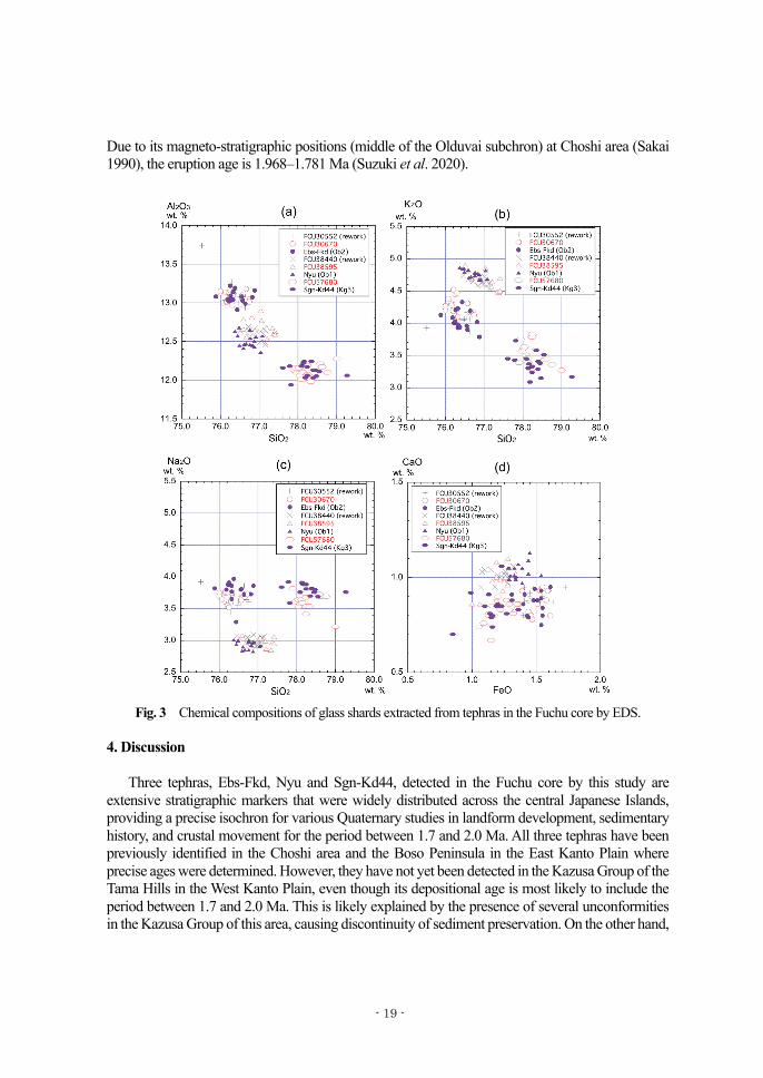
Tephra layers repeatedly occurred within a depth of 302.74–306.70 m in silt to sandy silt sediments, around 10 m below the boundary of the Higashi-kurume and the Kita-tama Formations. Except for basal FCU30670 (306.50–306.70 m depth), most of these layers contain rounded fine pumice clasts with diameters less than 1 mm, indicating their deposition as reworked tephras of FCU30670. Refractive indices and major element compositions of FCU30670 and FCU30552 are similar (Tables 1 and 2, Fig. 3), with FCU30670 mainly containing of stripe and bubble-wall type volcanic glass shards with refractive indices of 1.502–1.503 and high potassium content of 4.28 wt.%. These features display characterstic properties of tephras originating from certain volcanoes located in the Chubu area (around the Hida Mountains). Comparing known Lower Pleistocene widespread tephras derived from this area, only the Ebisutoge-Fukuda Tephra (Ebs-Fkd) (Machida and Arai 2003) can be correlative to FCU30670.
Ebs-Fkd is a representative Early Pleistocene widespread tephra derived from a caldera-forming eruption in the south part of the Hida Mountains in central Japanese Islands, with an estimated age of 1.70 Ma (Machida and Arai 2003). Characteristic properties of FCU30670 shown in Tables 1 and 2 are similar to those of Ob2 tephra in the Obama Formation of the Inubo Group, Choshi area, which correlates to Ebs-Fkd (Kd 38 Tephra in the Boso Peninsula) in the Kazusa Group (Fujioka and Kameo 2004). Nyukawa Tephra (Nyu)
Within the silts of the Kita-tama Formation, two vitric ash layers of FCU38595 and FCU38440 were detected at depthes of ca. 385 m. Both have very similar characteristic properties: abundant fiber, stripe and sponge-type glass shards characterised by refractive indices of 1.500–1.502, presence of orthopyroxene and clinopyroxene, and mean contents (determined by EDS) of SiO2: 76.91–76.99 wt.%, CaO: 0.97–1.01 wt.% and K2O: 4.65–4.67 wt.%. This similarity suggests that the upper layer is a reworked tephra of lower FCU38595. Although these properties of FCU38595 are distinctive from FCU30670 (and therefore Ebs-Fkd), the geochemistry suggests a similar but discrete tephra that also originated from the Chubu area. Thus, a strong candidate tephra correlative to FCU38595 and positioned below Ebs-Fkd, such as the Nyukawa Tephra (Nyu; Machida and Arai 2003), should be examined.
As shown in Table 2, Ob1 tephra in the Obama Formation of Inubo Group, which is correlative to Nyu (Kd39 Tephra in the Boso Peninsula) in the Kazusa Group (Fujioka and Kameo 2004), is mostly indistinguishable from FCU38595 (Table 2, Figs. 3 and 4). Although K2O contents
- 17 -
determined by WDS analysis are slightly higher than those by EDS analysis systematically, the similarity between FCU38595 and Ob1 is proven by both methods. Therefore, this data confims that FCU38595 is correlative to Nyu. Nyu, an Early Pleistocene tephra, was derived from a caldera-forming eruption that occurred in the southern part of the Hida Mountains, and its age is estimated to be 1.75 Ma (Machida and Arai 2003).
Table 2 Chemical compositions of volcanic glass shards
Sengan-Kd44 Tephra (Sgn-Kd44)
FCU57680 occurs at a depth of 576.65–576.80 m as a gray-colored vitric ash-fall deposit within the Kita-Tama Formation’s silts. With a total thickness of 15cm, this vitric ash bed is composed of abundant bubble-wall and stripe-type glass shards characterised by low refractive indices (1.500–1.501) and high SiO2 content (EDS; 78.27 wt.%). Its petrographic properties and stratigraphic position (below Nyu) indicate that this tephra correlates with Sg3 tephra in the Kasuga Formation of the Inubo Group, Choshi area, which is defiened as the Sengan-Kd44 Tephra (Sgn-Kd44; Suzuki et al. 2020) (Table 2).
Sgn-Kd44 originates from a caldera-forming eruption event rated VEI (volcanic explosivity index) 7 in the Sengan geothermal region of the north portion of Tohoku, northeast Japanese Islands.
- 18 -
Due to its magneto-stratigraphic positions (middle of the Olduvai subchron) at Choshi area (Sakai 1990), the eruption age is 1.968–1.781 Ma (Suzuki et al. 2020).
Fig. 3 Chemical compositions of glass shards extracted from tephras in the Fuchu core by EDS.
4. Discussion
Three tephras, Ebs-Fkd, Nyu and Sgn-Kd44, detected in the Fuchu core by this study are extensive stratigraphic markers that were widely distributed across the central Japanese Islands, providing a precise isochron for various Quaternary studies in landform development, sedimentary history, and crustal movement for the period between 1.7 and 2.0 Ma. All three tephras have been previously identified in the Choshi area and the Boso Peninsula in the East Kanto Plain where precise ages were determined. However, they have not yet been detected in the Kazusa Group of the Tama Hills in the West Kanto Plain, even though its depositional age is most likely to include the period between 1.7 and 2.0 Ma. This is likely explained by the presence of several unconformities in the Kazusa Group of this area, causing discontinuity of sediment preservation. On the other hand,
- 19 -
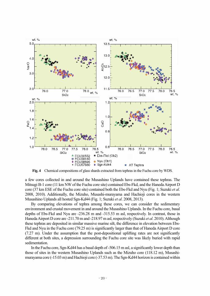
Fig. 4 Chemical compositions of glass shards extracted from tephras in the Fuchu core by WDS.
a few cores collected in and around the Musashino Uplands have contained these tephras. The Mitsugi B-1 core (11 km NW of the Fuchu core site) contained Ebs-Fkd, and the Haneda Airport D core (37 km ESE of the Fuchu core site) contained both the Ebs-Fkd and Nyu (Fig. 1; Suzuki et al. 2008, 2010). Additionally, the Mizuho, Musashi-murayama and Hachioji cores in the western Musashino Uplands all hosted Sgn-Kd44 (Fig. 1; Suzuki et al. 2008, 2013).
By comparing elevations of tephra among these cores, we can consider the sedimentary environment and crustal movement in and around the Musashino Uplands. In the Fuchu core, basal depths of Ebs-Fkd and Nyu are -236.28 m and -315.53 m asl, respectively. In contrast, those in Haneda Airport D core are -211.70 m and -218.97 m asl, respectively (Suzuki et al. 2010). Although these tephras are deposited in similar massive marine silt, the difference in elevation between Ebs-Fkd and Nyu in the Fuchu core (79.25 m) is significantly larger than that of Haneda Airport D core (7.27 m). Under the assumption that the post-depositional uplifting rates are not significantly different at both sites, a depression surrounding the Fuchu core site was likely buried with rapid sedimentation.
In the Fuchu core, Sgn-Kd44 has a basal depth of -506.15 m asl, a significantly lower depth than those of sites in the western Musashino Uplands such as the Mizuho core (118.12 m), Musashi-murayama core (-15.03 m) and Hachioji core (-37.53 m). The Sgn-Kd44 horizon is contained within
- 20 -
an alternation of coarse gravel beds and silts at each of the three sites, showing evidence of a changing sedimentary environment on the shelf. A glacio-eustatic sea-level change in the western Musashino Uplands would have affected the area in this way, in contrast to central Musashino Uplands where the bathyal environment had continued.
Acknowledgments
This study was conducted as part of the “Mitacs Globalink Research Award: Application of volcanic ash deposits to predict future geologic hazards in the Tokyo Metropolitan Area, Japan” fellowship project awarded to JH. We thank Dr. Masanori Murata, Mr. Ryruhei Oda, and Mr. Tatsuki Watanebe (Tokyo Metropolitan University) for helping in the observation of the core.
References Danhara, T., Yamashita, T., Iwano, H., and Kasuya, M. 1992. An improved system for measuring
refractive index using thermal immersion method. Quaternary International 13/14: 89–91. Donovan, J., Kremser, D., Fournelle, J., and Goemann, K. 2014. Probe for EPMA: acquisition,
Endo, T. 1978. Stratigraphy and geologic structure of the Quaternary system in the underground of the Tokyo district. Journal of the Geological Society of Japan 84: 505–520.**
Endo, T., Ogasawara, H., Kawashima, S., and Kawai, M. 1981. Hydrogeologic structure and land subsidence in the southern part of Kitatama area. Institute of Civil Engineering of Tokyo Metropolitan Government, Annual Report 1981: 165–180.*
Endo, T., Kawashima, S., and Kawai, M. 1995. Subsurface geology and some soil characters in Kitatama District, Tokyo. Journal of the Japan Society of Engineering Geology 36: 17–26.
Institute of Civil Engineering of Tokyo Metropolitan Government (ICETMG). 1996. Subsurface Geology in Wards District, Tokyo. Institute of Civil Engineering of Tokyo Metropolitan Government, Annual Report 1996: 193–216.
Fujioka, M., and Kameo, K. 2004. Correlation between the Obama formation of the Inubou Group in the Choshi district and the Kiwada, Otadai and Umegase formations of the Kazusa Group in the Boso Peninsula, central Japan, based on key tephra layers. Journal of the Geological Society of Japan 110: 480–496.**
Jensen, B., Froese, D., Preece, S., Westgate, J., and Stachel, T. 2008. An extensive middle to late Pleistocene tephrochronologic record from east-central Alaska. Quaternary Science Reviews 27: 411–427.
Kaizuka, S. 1987. Quaternary crustal movements in Kanto, Japan. Journal of Geography 96: 223–240.**
Machida, H., and Arai, F. 2003. Atlas of Tephra in and around Japan (Revised Edition). Tokyo: University of Tokyo Press.*
Sakai, T. 1990. Upper Cenozoic in the Choshi district, Chiba prefecture, Japan. -Litho-, magneto- and radiolarian biostratigraphy-. Bulletin of the Faculty of General Education, Utsunomiya University Sec. 2 23: 1–34.**
- 21 -
Suzuki, T., Murata, M., Oishi, M., Yamazaki, H., Nakayama, T., Kawashima, S., and Kawai, M. 2008. Tephrochronological study on the long-term activity of Tachikawa fault, Tokyo metropolitan area, central Japan. The Quaternary Research 47: 103–119.**
Suzuki, T., and Murata, M. 2011. Stratigraphy and correlation of tephras in the Lower Pleistocene Kiwada Formation and its correlatives beds, Kanto, Central Japan. Journal of the Geological Society of Japan 117: 379–397.**
Suzuki, T., Obara, M., Aoki, T., Murata, M., Kawashima, S., Kawai, M., Nakayama, T., and Tokizane, K. 2011. Identification of Lower Pleistocene tephras under Tokyo and reconstruction of Quaternary crustal movements, Kanto Tectonic Basin, central Japan. Quaternary International 246: 247–259.
Suzuki, T., Kasahara, A., Nishizawa, F., and Saito, H. 2014. Chemical characterization of volcanic glass shards by energy dispersive X-Ray spectrometry with EDAX Genesis APEX2 and JEOL JSM-6390. Geographical Reports of Tokyo Metropolitan University 49: 1–12.
Suzuki, T., Noguchi, T., Kanazawa, N., Hosoya, T., Endo, K., Osato, S., and Tanaka, M. 2010. Lower Pleistocene Eb-Fukuda and Ho-Kd39 Tephras under the Tokyo International Airport at Haneda, Central Japan. Abstracts, Japan Geoscience Union Meeting (CD-ROM), 2010: HQR010-16.*
Suzuki, T., Kasahara, A., Uemura, K., Murata, M., Aoki, T., Saito, H., Kawashima, S. and Kawai, M. 2013. Tephrochronological study on Quaternary stratigraphy under the west part of Musashino Upland, Tokyo, central Japan. Japan Association for Quaternary Research, Programme and Abstracts 43: 74–75.*
Suzuki, T., Maruyama, S., Danhara, T., Hirata, T., Machida, H., and Arai, F. 2020. Identification of Lower Pleistocene widespread tephras associated with large caldera–forming eruptions in the Tohoku area, north–east Japan. Journal of Quaternary Science 35: 316–333.
Takano, S. 1994. Stratigraphy of the Lower Pleistocene Kazusa Group in the Tama Hills, central Japan. Journal of the Geological Society of Japan 100: 675–691.**
Ueki, T., and Sakai, A. 2007. Geology of the Ome District, Quadrangle Series. 1:50,000. Tsukuba: Geological Survey of Japan, AIST.**
Ueki, T., Hara, H., and Ozaki, M. 2013. Geology of the Hachioji District, Quadrangle Series. 1:50,000. Tsukuba: Geological Survey of Japan, AIST.**
(*: in Japanese, **: in Japanese with English abstract)