8
IHS Kingdom ® Intuitive. Integrated. Interpretation.

IHS Kingdom®
Intuitive. Integrated. Interpretation.

IHS Kingdom Overview — The global demand for oil
and gas is growing. Your company is under pressure to
replace reserves and boost production. Management
faces decisions that could make - or cost - the
company millions. The question is, do your exploration
and asset teams have the best geoscience tools to
drive those decisions?
Kingdom Benefits• Bringsadvancedgeoscience,fromAVOandattributesto
geosteering,toeveryinterpreter,notjustthespecialist.
• EnablesnewgeoscientiststobecomeproductivefasterusingWindows-based,easytousesoftwarethatisallinoneexecutable.
• EnablesremoteofficeslackingITAdminsorGeoTechstostillenjoyfullinterpretationcapabilities.
• Enablesmobileinterpretation,theabilitytoworkwhiledisconnectedfromtheoffice,onanairplaneorinthefield.
• Dramaticallyreducescostonsoftware,hardware,IT,servicesandupgrades,andlowersfeesto3rdpartyspecialistsandprocessors.
Kingdom Provides• Theonlyfullyintegratedgeosciencesoftware.
• Integrated,multi-user,multi-authored,networked,32-bitor64-bitenvironment.
• Theabilitytohandlelargedatasetsandtheflexibilitytochoosethedatabasethat’srightforyourbusiness-Oracle®,Microsoft®SQLServer.
• Enhancedcollaborationbetweentheworkforce.
• FullscalabilityfromstandalonePC,tolocalnetworkorInternetnetwork.
• Theabilityfornetworkedclientstosharesoftwarebetweenoffices.
• TunnelTechnologythatallowsprojectstobeeasilyandcost-effectivelytransferredtoandfromUNIXandPCplatforms.
With Kingdom, exploration and asset teams can manage projects with flexibility and ease. Our modules are categorized by specific function, so you can use them as a fully integrated suite or you can select the modules that fit your interpretation needs.
Kingdom Streamlines Your Workflow
Easy to Use
• Familiar,Windows-basedPCplatform
• Intuitiveworkflows
• Connectivitywithwidelyuseddataformats
Integrated Workflows
• Integratedinterpretationfromprospecttoproduction
• Integratedcurvature,spectraldecompositionandsimilaritycapabilities
• Integratedprojectandknowledgemanagement
Workstation Flexibility
• Networkorstandalonelicenses
• PortablefromPCtolaptop
Technical Support & Training Staff of Experienced Geoscientists and Engineers
• Effectiveandresponsivetechnicalsupport
• Comprehensivetrainingcourses
Geosteering with complete project and application integration in user selected, multiple Geosteering Case displays and workspaces.

IHS Kingdom Advanced — As oil and gas fields
mature and new plays are discovered in remote terrain,
field evaluation has become increasingly sophisticated.
Today’s geoscientist must integrate geological data,
multi-dimensional seismic, modeling, and economic
analysis in a single interpretation. But just because
interpretation has become more complex, it doesn’t
mean that your software has to.
Kingdom Advanced-integrated software for your largest
and most complex geoscience workflows - lets you
complete work faster and with greater confidence.
Kingdom Advanced Differentiators• Integratereal-timegeosteeringdatawiththeinterpretation.
• Microseismicdataanalysistoevaluatefracturejobsinunconventionalplays.
• Patent-pendingAuto-Trackertoreducemanualworkpickingcomplexstructures.
• SurfaceCurvature,anedgedetectionattribute,tohelpreduceexplorationrisk.
• Multi-layerVolumetricstobetterunderstandgeologicuncertainty.
• Multi-segmentDeclineCurveforecaststohelpaccuratelyestimatereserves.
• EconomicAnalysisscenariostohelpforecastprospectvalueandreturn.
• UserSecurityprovidesprojectlevelpasswordcontroltoprotectdata.
Kingdom Advanced Benefits• Bringadvancedsciencetoeveryinterpreter,notjustthe
specialist.
• Increaseproductivitythroughintegratedworkflows.
• Achievehighperformanceeveninthelargestdatasetsandinthemostcomplexenvironments.
Geophysical Interpretation – 2d/3dPAK AdvancedReduce the time between research and finding first oil while minimizing risk by using the industry leader for geophysical interpretation, Kingdom 2d/3dPAK.
Seismic Analysis
• Generatehorizonsandfaultsonin-lines,crosslines,arbitrarylines,andslicesinbothtimeanddepthdomains.
• Auto-trackhorizonsoncomplexseismicdatawithpatent-pendingIlluminatortechnology.
• Produceseismic-basedinterpretationmapsbycombinedutilizationofhorizonandfaultpickingtools.
• Structureandmanageprojectsthroughuser-definedworktreestoorganizedataobjectsintosmaller,moremanageablesubsets.
Mapping & Gridding
• EditgeneratedsurfacesandgridsusingtheuniquegraphicalfeedbackdisplaysfoundinGridEditor.
• ProduceaccuratemapsquicklywithproprietaryFlexGridtechnologybybalancingminimumcurvaturewithminimumtension.
Well Control
• Displayboreholeandwellloginformationonseismicsectionsintimeordepth.
• Displaystraight,deviated,andhorizontalboreholesandsidetracks.
• Displayformationtopsinterpretedfromlogcurvesonverticalseismicdisplays,andthengridandcontourthetopsintheprojectarea.
Seismic Data Processing
• Conduct57volumecomputationslikeHilbert,PhaseRotation,InstantaneousPhaseandFiltering.
• Calculatethesurveyspectrumandstatistics.
• Computeorextractwavelets.
Produce accurate maps quickly with proprietary Flex Grid technology.

Geological Interpretation – EarthPAK Advanced and GeosteeringMake informed decisions and minimize risk with a clear and accurate vision of the prospect. Kingdom EarthPAK enables geoscientists to create presentation quality base maps, cross-sections, and crossplots, and conduct reserves estimations using geological data.
Manage Logs
• Importdigitalandrasterlogs.Createdigitallogsfromrasterlogs.
• Createcompositelogstoaddinterpretivelithologyandnotesinacross-section.
• Displaylogcurvesinstructure/stratigraphiccross-sectionswithshadingbasedonaconstantcut-offvalue,facieslogcurve,orcrossovershading.
• Analyzedigitallogcurveswithinteractivelogeditingandlogcalculatorsincludinglogstatistics,lognormalization,andpredefinedoruser-definedequations.
Manipulate Cross Sections• Generatestructuralandstratigraphiccross-sectionswith
one-clickinteractivecorrelation.Usedraganddropwelllogcorrelationwithinacross-section.
• Displayrasterlogsincross-sectionproportionallyorwithinaspecifiedtrack.
• Supportmultiplefaultsegmentsincross-sections,withspecifiedverticalseparations.
• Displaytrueverticalthicknessfordeviatedboreholesinthecross-section.
Analyze Production• Definezonesfromdepth,formationtops,grids,andhorizons.
• Calculatecumulativeproductionusingfield,formation,andcompletionfilters.Postusingattributeandbubblemaps.
• Calculatezonethicknesswithmeasuredlog,truevertical,andstratigraphicthickness.
Create Great Prospects Displays• Controlpostingofwelldatabyascale-basedlevelofdetail
(LOD)toincreasetheperformanceandavoidclutteringtheBaseMap.
• Emphasizestructure,isopach,andreservoirpropertieswithcolor-filledcontours.
• Increaseproductivitybyrecallingworkinprogress.
Calculate Multi-Layer Volumetrics• Evaluatemultiplereservoirssimultaneouslywithmulti-layer
volumetrics.
• AnalyzetherangeandprobabilityofpotentialreserveswithMonteCarlosimulation.
• Measuretheimpactofindividualvariablesonreservescalculationswithsensitivityanalysis.
Conduct Multi-Segment Decline Curve Analysis• Analyzetheincrementaleffectofaworkoverorrecompletion
withmulti-segmentdeclinecurveanalysis.
• Modelaproposedprogrambycreatingmanualdeclinecurvesegmentswithuser-definedproductionanddeclinerates.
• Conductentity-basedanalysisbycombiningmultiplewellsintogroupwells.
• Createforecastscombiningrate,volumeandtimelimits.
Perform Economic Analysis• Performeconomicanalysislinkedtoproductionforecasts.
• Accommodatemultipleproductstreamsintheanalysis.
• Linkmultipleeconomicscenariostoasingleforecast.
Conduct Quick Look Petrophysics• Useadvancedcurveeditingutilitieslikemulti-well
normalization,multi-wellde-spiking,automaticdepthshifting,andnearestvalueblocking.
• Neuralnetwork-basedutilityforthereconstructionofmissingorcorruptedlogcurveintervals.
Integrated Real-Time Geosteering• Auto-generaterealtimeviewsalongtheborehole.
• Mapreferencedandplannedwellscomparedtothedrillingwell.
• Correlate(bothautomaticandmanual)zonemarkers.
• Updatestructuralandstratigraphicguidingsurfacestoaccuratelyinterprettheposition.
• Displayseismicand/orinterpretfaultsallinasingleview.
EarthPAK integrated with seismic, well and log data for a more detailed interpretation.
Monte Carlo Simulation of Volumetric Analysis in EarthPAK.
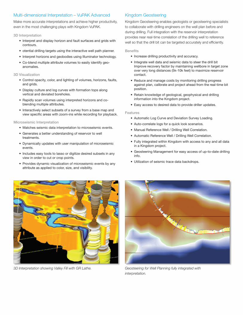
Multi-dimensional Interpretation – VuPAK AdvancedMake more accurate interpretations and achieve higher productivity, even in the most challenging plays with Kingdom VuPAK.
3D Interpretation
• Interpretanddisplayhorizonandfaultsurfacesandgridswithcontours.
• otentialdrillingtargetsusingtheinteractivewellpathplanner.
• InterprethorizonsandgeobodiesusingIlluminatortechnology.
• Co-blendmultipleattributevolumestoeasilyidentifygeo-anomalies.
3D Visualization
• Controlopacity,color,andlightingofvolumes,horizons,faults,andgrids.
• Displaycultureandlogcurveswithformationtopsalongverticalanddeviatedboreholes.
• Rapidlyscanvolumesusinginterpretedhorizonsandco-blendingmultipleattributes.
• Interactivelyselectsubsetsofasurveyfromabasemapandviewspecificareaswithzoom-inswhilerecordingforplayback.
Microseismic Interpretation
• Matchesseismicdatainterpretationtomicroseismicevents.
• Generatesabetterunderstandingofreservoirtowelltreatments.
• Dynamicallyupdateswithusermanipulationofmicroseismicevents.
• Includeseasytoolstolassoordigitizedesiredsubsetsinanyviewinordertocutorcroppoints.
• Providesdynamicvisualizationofmicroseismiceventsbyanyattributeasappliedtocolor,size,andvisibility.
Kingdom GeosteeringKingdom Geosteering enables geologists or geosteering specialists to collaborate with drilling engineers on the well plan before and during drilling. Full integration with the reservoir interpretation provides near real-time correlation of the drilling well to reference well so that the drill bit can be targeted accurately and efficiently.
Benefits
• Increasedrillingproductivityandaccuracy.
• IntegratewelldataandseismicdatatosteerthedrillbitImproverecoveryfactorbymaintainingwellboreintargetzoneoververylongdistances(5k-10kfeet)tomaximizereservoircontact.
• Reduceandmanagecostsbymonitoringdrillingprogressagainstplan,calibrateandprojectaheadfromthereal-timebitposition.
• Retainknowledgeofgeological,geophysicalanddrillinginformationintotheKingdomproject.
• Easyaccesstodesireddatatoprovidedrillerupdates.
Features
• AutomaticLogCurveandDeviationSurveyLoading.
• Auto-correlatelogsforaquicklookscenarios.
• ManualReferenceWell/DrillingWellCorrelation.
• AutomaticReferenceWell/DrillingWellCorrelation.
• FullyintegratedwithinKingdomwithaccesstoanyandalldatainaKingdomproject.
• GeosteeringManagementforeasyaccessofup-to-datedrillinginfo.
• Utilizationofseismictracedatabackdrops.
3D Interpretation showing Valley Fill with GR Lathe. Geosteering for Well Planning fully integrated with interpretation.

Add-On Modules — Not only does Kingdom provide
necessary and fundamental interpretation tools but
Kingdom also has fully integrated analytical tools that
are needed for today’s environments. Kingdom Add-On
Modules give you the tools you need to perform in-
depth analysis on your projects.
AVOPAK - Interpret Pre-Stack DataAVOPAK brings powerful visualization and interpretation of pre-stack gather data to the interpretation desktop by generating attributes that can be used to locate hydrocarbon indicators in rock volumes and presenting the gathers in a gallery. Using this gallery, you can dynamically compare gathers to multiple data types such as the stack trace, common offset or angle stack trace, well log curves, synthetics, or extracted seismic sections. This comparison can help reduce risk in prospecting for oil and gas.
• Integratedabilitytoview,interpret,andanalyzepre-stackgathersin2Dand3Dviews.
• Conditiondataandsaveprocessingtodisk.Thisincludessorting,dip-basedsupergathers,flatteningonahorizonorvelocity,spectralbalancing,anglegathergeneration,andotherimprovedprocessingcapabilities.
Colored Inversion – Seismic Inversion for Every DesktopKingdom Colored Inversion is a tool for enabling the interpreter to quickly generate a relative impedance data type for the purpose of more accurate, more confident seismic interpretation. It is a proven technique that is fast and easy to apply to seismic data, yet produces results that match more sophisticated and compute intensive techniques such as sparse spike inversion.
• Bringeasytouseseismicinversiontotheinterpretersdesktop.
• Matchseismictowelllogdatawithintheseismicspectrumtoreducenoiseandsignalinstability.
• Quicklyprocessseismicvolumestoinversionvolumes.
ModPAK - 2D Modeling of Stratigraphic and Structural ChangesIn the absence of direct velocity control, ModPAK can automatically convert resistivity or density logs to velocity. For simpler models, blocks can be defined with a constant velocity and density. The time-depth function at each well is interpolated to convert the depth section to time before convolution.
• Interpretsurfacesfromformationtopsorcorrelateon-the-fly.
• Modelfaults,channels,pinchoutsandfacieschanges.
• Modelonlaps,angularunconformitiesandreservoirfluidchanges.
Rock Solid Attributes (RSA) - Advanced 3D Post Stack AttributesRSA gives users access to 50+ advanced 2D and 3D post-stack seismic attributes, including curvature, spectral decomposition and similarity (edge detection processing). This capability is fully integrated to create a time-efficient, cost-effective solution for optimizing reservoir assets and increasing well accuracy.
• Curvatureattributesindicatetherateofchangeofsurfacetopologyandaccentfeaturessuchasfaultsandfracturesystems.
• AnalyzeGeometric,Instantaneous,Wavelet,andSpectralAttributetypes.
• Detectfaults,channels,unconformities,shalingout,andbeddinganomalies.
• Attributescanbecross-plottedforin-depthanalysis.
SynPAK - Synthetics and 1D Forward ModelingA key task in working with seismic data is the ability to correlate and tie the seismic to the wells in the survey. SynPAK provides the capability of generating 1D synthetic seismograms from well log data that can be correlated with any survey in a project, allowing for calculating and accurately tying synthetic to actual seismic data. Using SynPAK 1D forward modeling, geoscientists can compare real and synthetic seismic data to make geological inferences from the observed data.
Synthetics
• Editwelllogsthroughstretch/squeeze,bulkshift.
• Generatetheoreticalwavelets.
• Rotatephaseofthedatainteractively.
1D Lithologic and Fluid Composition Modeling
• CreatezonebasedmodelsofPandSVelocitycurvesandDensitycurves.
• Calculateandmodelporositiesorintervalthickness.
• UsefluidsubstitutionworkshopbasedonGassman’sequations.
VelPAK - Convert Seismic to Depth and Create Velocity ModelsDepth conversion and velocity modeling can be a time and labor-intensive process that often leaves nagging questions about accuracy. Kingdom’s depth conversion capability, built in partnership with Equipoise Software, Ltd., is designed for all levels of depth conversion- from simple to the most complex. Geoscientists can construct velocity models to predict depth from seismic time.
• DeriveparametersforVZ=V0+KZandmanyothers.
• Extractandsmoothintervalvelocities.
• ProducevelocityvolumesandwritetoSEGYorTDQformats.

Kingdom Data Management — The Kingdom
software solutions are built on open architecture for
total database integration. This helps maximize your
existing IT investment and historical data - and puts
all available information at your finger tips to help your
organization make better decisions faster.
Kingdom Data Management provides a full suite of
tools that allows geoscientists, data managers, and IT
organizations to fully understand, manage and share
Kingdom project data.
Kingdom ConnectKingdom Connect provides user with the ability to connect their Kingdom projects with any OpenSpirit enabled product. This enables the exchange of project information between Kingdom and the OpenSpirit project(s).
Benefits
• Reducesinterpreterdowntimewaitingfordatatransfersbetweenapplications.
• Simple,draganddropapproachtosharingdatabetweenKingdomandotherOpenSpirit-enabledapplicationsonthedesktop.
• Fullypreservedhistoryofdatamovement.
• ComplexitiesofOpenSpiritarehiddenfromtheuser.
Web ServicesKingdom Web Services provides users with the ability to easily manage their culture images/spatial data with a common interface.
Benefits
Kingdom Connectors - Transfer Data between Kingdom and Other PlatformsKingdom offers integrated connector technology to ensure harmonious co-existence of data in organizations using multiple interpretation platforms.
Benefits
• Choosebestofbreedtechnologywhilestillretaininginterconnectivitytoexistingdatasetsbeingmanagedbyothertechnologies.
• Usenativeconnectorstocommonplatforms.
• UseOpenSpiritenabledconnectorstoaccessdiverseplatforms.
Kingdom Data Management - Manage and Migrate Kingdom Information with EaseKingdom Data Management provides a fully integrated platform for proper stewardship of the ever-increasing complexity of data within an organization, allowing users to manage all information across the Kingdom environment. For example, geoscientists can compare multiple projects, query for key interpretation data, convert projects between multiple databases and make unique copies of projects to share with others.
Benefits
• AutomaticallysearchnetworksforKingdomprojects,andinventorydatacomponents.
• UseProjectComparisontolookforsimilaritiesanddifferencesbetweenprojects.
• UseDatabaseConversiontoconvertprojectstoandfromAccess,SQLServerorOracle.
Kingdom Data Management enables sharing of project information when and where you need it.
• SimpleinterfacethatallowsuserstopreviewalllayersinasingleUIpriortoaddingtoKingdombasemap.
• MultiplelayersfrommultipleservicescancoexistinasingleKingdomsession.
• Userscanleveragesubscriptionservicesaswellasinternalservicesinasinglesession.
• Userscanaddmanyspatiallayersandalwayshavethemostup-do-dateinformationwithouttheneedtoreloaddata.


