Wilshire Grand Redevelopment Project II. Project Description Draft Environmental Impact Report Page II-1 II. PROJECT DESCRIPTION The purpose of this Section is to identify the primary objectives and project characteristics of the proposed Wilshire Grand Redevelopment Project (the “Project”). As discussed on the following pages, the Project would involve construction and operation of new development on the site currently occupied by the Wilshire Grand Hotel and Centre, a hotel and office building with accessory retail and restaurant uses and subterranean parking. The Project is proposed to be developed on an approximately 3.2-acre site (the “Project Site”) (inclusive of the 0.51 acre area of Francisco Street proposed to be vacated) that is located in the Central City (downtown) area of the City of Los Angeles, approximately 0.04 miles east of the US/Interstate 110 (Harbor Freeway), 1.02 miles south of the US 101 (Hollywood Freeway), 1.05 miles north of the Interstate 10 (Santa Monica Freeway), and 2.6 miles west of the Interstate 5 (Golden State Freeway). 1. PROJECT LOCATION 2. EXISTING CONDITIONS a. Regional Setting b. Existing Land Use c. Surrounding Land Uses and Neighborhoods 3. PROJECT CHARACTERISTICS a. Proposed Development b. Conceptual Plan c. Land Use Equivalency Program d. Design Flexibility Program e. Access and Parking f. Transit Access g. Loading Dock h. Communication Facilities i. Public Space, Pedestrian Features, and Open Space j. Environmental Design Features
Transcript
Wilshire Grand Redevelopment Project II. Project Description Draft Environmental Impact Report Page II-1
II. PROJECT DESCRIPTION
The purpose of this Section is to identify the primary objectives and project characteristics of the proposed Wilshire Grand Redevelopment Project (the “Project”). As discussed on the following pages, the Project would involve construction and operation of new development on the site currently occupied by the Wilshire Grand Hotel and Centre, a hotel and office building with accessory retail and restaurant uses and subterranean parking. The Project is proposed to be developed on an approximately 3.2-acre site (the “Project Site”) (inclusive of the 0.51 acre area of Francisco Street proposed to be vacated) that is located in the Central City (downtown) area of the City of Los Angeles, approximately 0.04 miles east of the US/Interstate 110 (Harbor Freeway), 1.02 miles south of the US 101 (Hollywood Freeway), 1.05 miles north of the Interstate 10 (Santa Monica Freeway), and 2.6 miles west of the Interstate 5 (Golden State Freeway).
1. PROJECT LOCATION
2. EXISTING CONDITIONS
a. Regional Setting
b. Existing Land Use
c. Surrounding Land Uses and Neighborhoods
3. PROJECT CHARACTERISTICS
a. Proposed Development
b. Conceptual Plan
c. Land Use Equivalency Program
d. Design Flexibility Program
e. Access and Parking
f. Transit Access
g. Loading Dock
h. Communication Facilities
i. Public Space, Pedestrian Features, and Open Space
j. Environmental Design Features
City of Los Angeles July 2010
Wilshire Grand Redevelopment Project II. Project Description Draft Environmental Impact Report Page II-2
k. Helistop
l. Signs and Identity Elements
m. Construction Timeline
4. PROJECT ALTERNATIVES
a. Alternative 1 – No Project Alternative
b. Alternative 2 – Reduced Density Alternative
c. Alternative 3 – Phased Construction Alternative
d. Alternative 4 – Office-Only Alternative
e. Alternative 5 – Residential-Only Alternative
f. Alternative 6 – Reduced Height Alternative
g. Alternative 7 – Zoning Compliant Alternative
h. Alternative 8 – Reduced Signage Alternative
i. Alternative 9 – Zoning Compliant Signage Alternative
5. PROJECT OBJECTIVES
6. DISCRETIONARY ACTIONS
City of Los Angeles July 2010
Wilshire Grand Redevelopment Project II. Project Description Draft Environmental Impact Report Page II-3
1. PROJECT LOCATION
The Project is proposed to be developed on an approximately 3.2-acre site that is located in the Central City (downtown) area of the City of Los Angeles. The Project Site is generally bounded by Wilshire Boulevard to the north, Francisco Street to the west, 7th Street to the south, and Figueroa Street to the east. The Project region and vicinity area are shown in Figure II-1 (Regional and Project Vicinity Location Map), and an aerial photograph of the Project Site is shown in Figure II-2 (Aerial Photograph). The Project Site is located within the Central City Community Plan Area and the Central Business District Redevelopment Project Area of the Community Redevelopment Agency of the City of Los Angeles (CRA/LA). The Project Site is also located in the Financial Core district of downtown Los Angeles, which is bordered by South Park to the south and southwest, Historic Core to the east and southeast, Bunker Hill to the north and northeast, and City West to the north and northwest across the Harbor Freeway (see Figure II-3, Downtown Context Map).
The Project Site consists of two parcels (APN 5144-008-020 and 5144-008-021) and the 0.51-acre portion of Francisco Street to the west. The Project Site encompasses the following addresses: 900 and 930 Wilshire Boulevard; 655, 685, 695, and 699 Figueroa Street; and 916, 925, and 935 7th Street.
2. EXISTING CONDITIONS
a. Regional Setting
The Project Site is located approximately 0.04 miles east of the Harbor Freeway, 1.02 miles south of the Hollywood Freeway, 1.05 miles north of the Santa Monica Freeway, and 2.6 miles west of the Golden State Freeway. These highways provide regional access to the Project Site. Modified Major Secondary Highways serving the Project area include Wilshire Boulevard, Figueroa Street, and Olympic Boulevard. The Project Site is located adjacent to the 7th Street/Metro Center/Julian Dixon station (the “7th Street/Metro Center station”), which provides access to the Red, Purple, and Blue light rail transit lines operated by the Los Angeles County Metropolitan Transportation Authority (Metro) and to other hubs of the regional transit system via Union Station. The subway runs in a tunnel beneath 7th Street adjacent to the Project Site. In addition to the regional highways and rail transit lines that directly serve the Project Site, numerous bus lines and several Downtown Area Shuttle (DASH) lines also provide service to the Project Site.
b. Existing Land Uses
The Project Site is currently developed with the 16-story Wilshire Grand Hotel and Centre, which consists of a total of approximately 912,000 square feet including 896 hotel rooms, approximately 215,000 square feet of office uses, approximately 206,600 square feet of hotel amenity, accessory retail and restaurant uses, and subterranean parking with 286 parking spaces. The amenities for the hotel include meeting rooms, ballroom, pool and spa, and fitness facilities.
T
SFL
OWE
S FREMONT AVE
S GRA
C
FIGUEROA S
TREET
LEBANON S
TREET
BEAUDRY AVENUE
ST P
AUL
AVEN
UE
BIXE
L AV
ENUE
FLOW
ER STREET
HOPE STR
EET7TH STREET
WILSHIRE BOULEVARD
6TH STREET
8TH STREET
BOYLSTON STR
EET
7TH STREET
INGRAHAM STREET
ST P
AUL
PLAC
E
Beverly Hills
210
Miles
0 105
PROJECTLOCATION
118
5
170
134 210
10
110
2
5101405
10
1
110 710
107405
915
605
22
405
Northridge
Woodland Hills
NorthHollywood
Burbank
Glendale
SilverLake
Pasadena
Los Angeles
Culver City
Santa Monica
ManhattanBeach
Los AngelesInternational
Airport
Whittier
60
HermosaBeachRedondo
Beach
Long BeachPacific Ocean
101
105
Compton
Torrance
Hawthorne
Carson
Lakewood
Montebello
Monterey Pk
Anaheim
BeverlyHills
Hollywood
Angeles National Forest
110
Mid CityBrentwood
Inglewood
HuntingtonPark
Downey
BuenaPark
WestCovina
BaldwinPark
Altadena
Sunland
HuntingtonBeach
SealBeach
Figure II-1Regional and Project Vicinity Map
Source: Precision Mapping Streets and Christopher A. Joseph & Associates, 2009.
Feet
0 1000 2000
Legend
Project Site
FRANCISCO STREET
HARBOR FRWY
HARBOR FRWY
FRANCIS
CO STR
EET
WILSHIRE BOULEVARD
FIGUEROA S
TREET
7TH STREET
FLOW
ER S
TREE
T
BEAUDRY AVENUE
6TH STREET
LEBANON S
TREE
T7TH STREET
FIGUEROA S
TREET
WILSHIRE BOULEVARD
110
HARBOR FREEWAY
Figure II-2Aerial Photograph
Source: Google Earth Pro and Christopher A. Joseph & Associates, 2009.
Feet
0 100 200
Legend
Project Site
FIN
AN
CIA
LD
IST
RIC
T
JEW
ELR
YD
IST
RIC
T
BU
NK
ER
HIL
L
CIT
Y W
ES
T
WE
ST
LAK
E
EN
TE
RTA
INM
EN
TD
IST
RIC
T
Figu
re II
-3D
ownt
own
Nei
ghbo
rhoo
d C
onte
xt M
ap
Sou
rce:
Goo
gle
Ear
th P
ro, A
pril
2009
.
Sca
le (F
eet)
060
020
040
080
0
Lege
nd
Pro
ject
Site
FRANCISCO STREET
WIL
SHIR
E BOULE
VARD
FIGUEROA STREET
7TH S
TREE
T
6TH S
TREE
T
5TH S
TREE
T
4TH S
TREE
T
3RD S
TREE
T
FLOWER STREET
HOPE STREET
GRAND AVENUE
OLIVE STREET
8TH S
TREE
T
9TH S
TREE
T
7TH
STRE
ET
9TH
STRE
ET
8TH
STRE
ET
6TH
STRE
ET
WIL
SHIR
E BO
ULEV
ARD
ST PAUL AVENUE
BIXEL STREET
OLY
MPI
C BO
ULEV
ARD
COTTAGE PLACE
LUCAS AVENUE
WITMER STREET
HILL STREET
BROADWAY
GARLAND AVENUE
HARTFORD AVENUE
110
HARBOR FREE
WAY
HARBOR FREEWAY
FRANCISCO STREET
City of Los Angeles July 2010
Wilshire Grand Redevelopment Project II. Project Description Draft Environmental Impact Report Page II-7
Access to the subterranean parking garage is provided via Francisco Street and valet parking is provided on Wilshire Boulevard and 7th Street.
The Project Site is located entirely within the Central City Community Plan Area, subarea no. 1445, with a Regional Center Commercial land use designation.1 The majority of the Project Site has a corresponding existing zoning classification of C2-4D. After the vacation of Francisco Street, which does not currently have a zoning designation, the western half of the street would have a zoning classification of C4-4D and the eastern half would have a zoning designation of C2-4D. The C2-4D and C4-4D designations indicate that the site may be developed with Commercial uses and is within Height District 4. The “D” designation denotes a development limitation, which, subject to certain provisions, limits the developable floor area to six times the buildable area of the site.2 Provisions to the limitation can be found in Appendix II.1 to this EIR, which contains City Ordinance 164,307. The Project Site is subject to such provisions, and the developable floor area can be increased to 13 times the buildable area of the site with a transfer of floor area request.
c. Surrounding Land Uses and Neighborhoods
The Project Site is surrounded by a mix of high-density commercial/retail and office uses contained in structures ranging from small buildings to skyscrapers, which are physically separated from the Project Site by arterial and non-arterial roadways (see Figure II-2). The structures that immediately surround the Project Site include the 21-story, 350-foot tall 1000 Wilshire Boulevard building across Francisco Street to the west; the 23-story, 288-foot tall 911 Wilshire building across Wilshire Boulevard to the north; and the 52-story, 717-foot tall Figueroa at Wilshire building across Wilshire Boulevard to the northeast. To the east of the Project Site across the Wilshire Boulevard and Figueroa Street intersection are the six-story building at 835 Wilshire Boulevard, the 15-story Northwestern Mutual Life Building at 888 6th Street, and a five-story, above-ground parking structure fronting Figueroa Street amid these two buildings. Located across Figueroa Street to the southeast of the Project Site are a one-story building at the southern corner of the Wilshire Boulevard and Figueroa Street intersection; the approximately three-story Mullen Building/Historic Fire Station No. 28; and the 24-story, 356-foot Figueroa Tower. To the south of the Project Site across the 7th Street and Figueroa Street intersection is the 12-story, 174-foot 818 Plaza building with adjacent surface parking lot as well as two parking structures, one six-story and one seven-story, which also occupy the block. To the west and southwest of the Project Site across 7th Street are the 42-story, 534-foot Ernst & Young Plaza building and 7 + Fig Center; the 53-story, 725-foot 777 Tower; and an approximately 13-story parking structure which serves the Ernst & Young Plaza building, 7 + Fig Center, and the 777 Tower.
1 City of Los Angeles Ordinance No. 164,307.
2 Ibid.
City of Los Angeles July 2010
Wilshire Grand Redevelopment Project II. Project Description Draft Environmental Impact Report Page II-8
The surrounding structures described previously generally consist of office uses and ground floor retail uses with the exception of the 1000 Wilshire Boulevard building and the 777 Tower, which contain only office uses, and the Mullen Building/Historic Fire Station No. 28, which contains a restaurant. The nearest multi-family residential uses include The Pegasus apartments, Roosevelt Lofts, and 655 Hope to the east, Piero apartments to the north, and 1010 Wilshire, 1100 Wilshire, Medici, and Gas Co. Loft apartments to the west, each of which is within 750 feet from the Project Site. Further, a portion of the Figueroa Tower ground floor at the corner of 7th Street and Figueroa Street, immediately southeast of the Project Site, provides access to the 7th Street/Metro Center station which serves the Red, Purple, and Blue rail transit lines operated by Metro. The three-story Mullen Building/Historic Fire Station No. 28, which contains a restaurant on the ground floor, is southwest of the Project Site. There are several hotels and private clubs within the immediate vicinity of the Project Site including the Standard Hotel, the California Club, the Jonathan Club, the Westin Bonaventure Hotel and Suites, the Millennium Biltmore Hotel, the Hilton Checkers Hotel, and the Sheraton Los Angeles Downtown Hotel. The Los Angeles Central Library and the associated Maguire Gardens is located at 630 5th Street.
3. PROJECT CHARACTERISTICS
a. Proposed Development
The Project would include the demolition of the existing structure, including existing subterranean parking, vacation of Francisco Street, and redevelopment of the Project Site with a maximum of 560 hotel rooms and/or condo-hotel units, 100 residential dwelling units, 1,500,000 square feet of office uses, and 275,000 square feet of amenity areas including, but not limited to, Project-serving retail and restaurant uses, conference and meeting rooms, ballrooms, spa, fitness center, and other ancillary hotel, residential, and office areas (“Services”). The total maximum floor area of Project improvements proposed would be 2,543,437 square feet.3
The Project Site would be developed with an approximately 65-story structure, no more than 1,250 feet in height (“Building A”), an approximately 45-story structure, no more than 750 feet in height (“Building B”), and an approximately six-story podium structure, no more than 168 feet in height (“Podium”). The Project would be constructed over eight levels of subterranean parking containing approximately 1,900 parking spaces. Table II-1 (Development Summary), lists the unit count and floor area for the Project. Figures II-4 through II-13 show the conceptual plans for the first level, the podium level, typical hotel and residential floor plans, and the typical office floor plan, roof plan, as well as elevations and landscaping of the Project.
The Project would also include an approximately one-quarter of an acre outdoor plaza at the corner of 7th Street and Figueroa Street. Lobbies, elevators, and amenities for the residential dwelling units could be
3 The maximum floor area proposed would be acquired through a Transfer of Floor Area as further described in Section IV.A.1 (Land Use – Land Use Plans/Zones).
City of Los Angeles July 2010
Wilshire Grand Redevelopment Project II. Project Description Draft Environmental Impact Report Page II-9
shared or could be provided separate from the other proposed uses. The rooftop of Building A would also provide a helistop, described later in this Section, which would provide facilities for helicopter service for the Project.
Table II-1 Development Summary
Proposed Use Units Floor Area (square feet) Office - 1,500,000 Hotel
Hotel Rooms and/or Condo-Hotel Units 560 - Residential Dwelling Units 100 -
Services Conference, Meeting Rooms, Ballrooms - 55,000 Spa, Fitness Center - 20,000 Retail, Restaurant, Other Amenities - 50,000 Ancillary Areas - 150,000
Project Totals 660 1,775,000 Source: Thomas Properties Group, L.P., 2009.
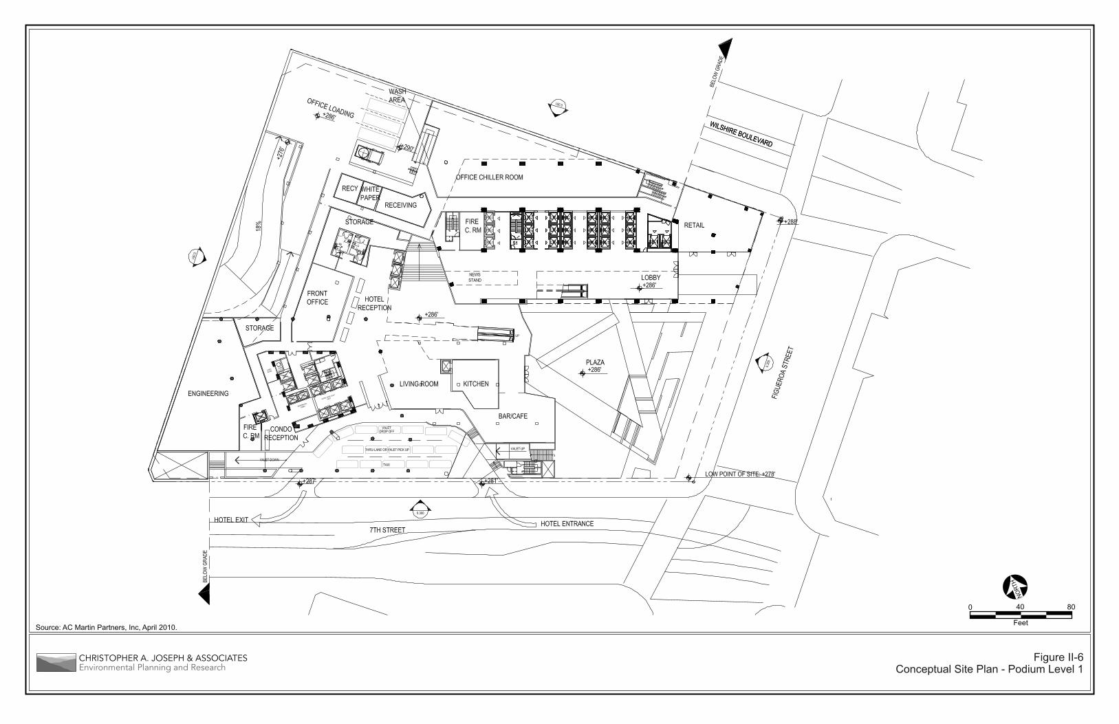
b. Conceptual Plan
The Project includes the development of office, hotel, residential, retail, restaurant, amenity, and ancillary areas, and parking, described previously. The Project, as described, is a conceptual plan, which has been formulated as an illustration of the how the Project may be configured, including the uses, location, massing, and orientation of buildings on the Project Site. The Conceptual Plan, as shown in Figures II-4 through II-8, illustrates how the Project Site could be developed, although the specific location and orientation of the proposed buildings has not yet been finalized. The Design Flexibility Program, described later in this Section, allows the analysis in this EIR to consider other site layouts with impacts no greater than those of the Project. Thus, the Conceptual Plan is not the only development scenario that would be possible. The uses described in the development summary table have been analyzed in this EIR based on maximum site densities, defined building envelopes providing height limitations, setbacks, and related urban design parameters.
c. Land Use Equivalency Program
The Project would include a Land Use Equivalency Program to maintain flexibility of Project land uses and floor areas so that the Project could, if necessary, respond to the changing needs of the Southern California economy. The Land Use Equivalency Program defines a framework within which the proposed mix of land uses could be modified within the development envelope defined by the approved entitlements without resulting in any new significant impacts or a substantial increase in the severity of previously identified significant impacts as analyzed in this EIR. Therefore, the application of the Land Use Equivalency Program would, by definition, not require preparation of a Subsequent or Supplemental EIR to address changes in Project land uses that are consistent with the Land Use Equivalency Program.
Figure II-4Conceptual Site Plan
Source: AC Martin Partners, Inc, April 2010.
0 8040
Figure II-5Conceptual Site Plan - Street Level
Source: AC Martin Partners, Inc, April 2010.Feet
0 8040
Figure II-6Conceptual Site Plan - Podium Level 1
Source: AC Martin Partners, Inc, April 2010. Feet
080400
Source: AC Martin Partners, Inc, April 2010.
Figure II-7Conceptual Site Plan - Podium Level 2
Feet
0 8040
Source: AC Martin Partners, Inc, April 2010.
Figure II-8Conceptual Site Plan - Typical Hotel and Residential Floor Plans
Not to Scale
Source: AC Martin Partners, Inc, May 2010.
Figure II-9Conceptual Site Plan - Typical Office Floor Plan
Not to Scale
Source: AC Martin Partners, Inc, May 2010.
Figure II-10Conceptual Site Plan - Roof Floor Plan
Feet
0 8040
Source: AC Martin Partners, Inc, April 2010.
Figure II-11Elevations-North and West
Source: AC Martin Partners, Inc, April 2010.
Figure II-12Elevations-South and East
Figure II-13Conceptual Site Plan - Landscape
Source: Rios Clementi Hale Studios and AC Martin Partners, April 2010.
PARKWAY PLANTING-1 GAL JUNCUS @ 24” O.C.
STREET TREES-(5) 36” BOX TIPUANA TIPU
PARKWAY PLANTING-1 GAL JUNCUS @ 24” O.C.
WILSHIRE BLVD.
STREET TREES-(3) 36” BOX TIPUANA TIPU
STREET TREES- (10) 36” BOX PLATANUS ACERIFOLIA
FIG
UER
OA
ST.
+278+284
+284
+306
+284
PLAZA LAWN
PLAZA TREES-(7) 48” BOX PLATANUS RACEMOSA
PARKWAY PLANTING-1 GAL CAREX @ 24” O.C.7TH ST.
FRAN
CISC
O S
T.
STREET TREES-1 GAL CAREX @ 24” O.C.
TRELLIS PLANTING-BOUGAINVILLEA
STREET TREES-(3) 36” BOX TIPUANA TIPU
PARKWAY PLANTING-1 GAL CAREX @ 24” O.C.
STREET TREES-(3) 36” BOX TIPUANA TIPU
STREET TREES-(4) 36” BOX
ARBUTUS ‘ MARINA’
GREEN WALL
GREEN WALL
STREET TREES-(5) 36” BOX
ARBUTUS ‘ MARINA’
VINE WALL PLANTING
Total units Req'd sq ft/unit005,71571001 sq ft
1,838 sq ft 7,350 sq ft2,108 sq ft 8,432 sq ft
000,5seinoclaB :ecapS nepO etavirP sq ft20,782 sq ft
(1) Open Space requirements were calculated based on LAMC §12.21 G.(2) Total Open Space provided inclusive of planted areas.
Open Space
Total Open Space Provided
Common Open Space: Podium TopCommon Open Space: Roof Top
Total Open Space req'd(1)
Planted Area Open Space provided(2)
STREET RETAIL KIOSK
+283
Feet
0 6432
City of Los Angeles July 2010
Wilshire Grand Redevelopment Project II. Project Description Draft Environmental Impact Report Page II-20
The purpose of the Land Use Equivalency Program is to identify a set of rules for exchanging land uses, one for another, within the scope of development approved for the Wilshire Grand Redevelopment Project such that any exchange:
1. Does not result in any increase in PM peak hour trip generation.
2. Does not result in any significant impacts beyond those identified in the EIR for the Wilshire Grand Redevelopment Project.
3. Does not require any further discretionary action on the part of the City of Los Angeles or any additional CEQA documentation.
The rules have been defined in such a way that no additional impacts would result from an exchange under the Land Use Equivalency Program. The impacts associated with implementation of the Land Use Equivalency Program are discussed in each of the EIR impact area sections.
The rules of the Land Use Equivalency Program provide for a three step process for ensuring that a land use exchange that does not result in any additional environmental impacts.
STEP 1: Determine Proposed Land Use Exchange Based On PM Peak Hour Trip Generation
STEP 2: Calculate Change in VOC emissions for Desired Exchange Compared to Project
STEP 3: If Calculated VOC Emissions are Higher than the Threshold, Identify an Additional Land Use Offset to Reduce the Emissions Below the Threshold
Below is a detailed explanation of each of these steps. Detailed explanations of the calculations associated with each of these steps are provided in Appendix II.2 of this EIR.
STEP 1: Determine Proposed Land Use Exchange Based On PM Peak Hour Trip Generation
The Land Use Equivalency Program set forth and evaluated in this EIR is based upon PM peak hour traffic generation rates. PM peak hour traffic rates were used since these rates would be the most impactful traffic factor for this type of project in the downtown area and are used as the basis of identifying the Project’s traffic impacts in the Transportation Study and EIR. The Land Use Equivalency Program would allow the uses set forth herein to be exchanged for one another such that no additional PM peak hour traffic generation would result from any exchange that would be consistent with the factors contained within the Land Use Equivalency Program. These factors are set forth on Table II-2, Land Use Equivalency Program. The conversion factor for a particular exchange is identified by finding the land use being exchanged from (called the donor land use) in the column on the left of Table II-2 and cross referencing to the land use being exchanged to (called the recipient land use) on the top row of Table II-2. The resulting factor indicates the number of units or 1,000 square feet of the recipient land use that could be included in the Project in exchange for the number of units or 1,000 square feet of the donor land use
City of Los Angeles July 2010
Wilshire Grand Redevelopment Project II. Project Description Draft Environmental Impact Report Page II-21
being removed from the Project. For example, 1,000 square feet of office use could be exchanged for 2 hotel rooms, or 1 hotel room could be exchanged for 210 (1,000 * 0.21) square feet of retail use.
However, within this context, the Project would not be allowed to exceed the total floor area that would be approved with the requested Transfer of Floor Area (TFAR). In addition, conversions would be limited so as not to exceed individual maximums of 1,120 hotel rooms, 1,100 residential dwelling units, 200,000 square feet of retail use, 50,000 square feet of fitness center use, 1,750,000 square feet of office uses, and 50,000 square feet of restaurant use. These figures represent the total amount of an individual land use that would be permitted under the Land Use Equivalency Program. The effects of individual land use exchanges are assessed based on the difference from the Project baseline. For instance, the Project includes 100 residential dwelling units and the maximum permitted number of residential dwelling units would be 1,100 units. Therefore the Land Use Equivalency Program would permit land use exchanges that could increase the number of residential dwelling units in the Project by 1,000 units.
Table II-2 Land Use Equivalency Program – PM Peak Hour Traffic
Donor Land Usea
Recipient Land Useb
Office (ksf) Hotel (room) Condo/Apt (du) Fitness Center (ksf) Retail (ksf) Restaurant (ksf)
Office (ksf) 2.00 3.11 0.58 0.41 0.41
Hotel (room) 0.50 1.56 0.29 0.21 0.21
Condo/Apt (du) 0.32 0.64 0.19 0.13 0.13
Fitness Center (ksf) 1.73 3.45 5.37 0.71 0.71
Retail (ksf) 2.43 4.86 7.56 1.41 1.00
Restaurant (ksf) 2.43 4.86 7.56 1.41 1.00
ksf = 1,000 square feet du = dwelling unit Apt = apartment a Land use changing from b Land use changing to Source (Generation Rates): Trip Generation, 9th Edition, Institute of Transportation Engineers, 2008. Source (Table): Christopher A. Joseph & Associates, 2010.
STEP 2: Calculate Change in VOC emissions for Desired Exchange Compared to Project
In addition to not generating any additional PM peak hour traffic, an additional constraint with respect to the Project is that, under any land use equivalency exchange, the resulting regional operational air emissions cannot exceed the thresholds established by the South Coast Air Quality Management District (SCAQMD). This is because the Project would not exceed any of the SCAQMD thresholds for regional operational emissions (i.e., no significant regional operational emissions impacts), as shown in Section IV.G (Air Quality). Of the six criteria pollutants for which significance thresholds have been established
City of Los Angeles July 2010
Wilshire Grand Redevelopment Project II. Project Description Draft Environmental Impact Report Page II-22
by SCAQMD (Volatile Organic Compounds [VOC], Nitrogen Oxides [NOx], Particulate Matter-less than 10 microns in diameter [PM10], Particulate Matter-less than 2.5 microns in diameter [PM2.5], Sulfur Dioxide [SO2], and Carbon Monoxide [CO]), analysis shows that the Land Use Equivalency Program only has the potential to cause an exceedance of the SCAQMD threshold for VOC emissions. Therefore, VOC Emissions are used as the controlling factor for ensuring that any proposed land use exchange under the Land Use Equivalency Program would not exceed SCAQMD thresholds.
The change in VOC emissions from the proposed land use exchange, compared to the Project, is calculated based on the factors shown on Table II-3. These factors show the change in VOC emissions associated with each potential land use exchange covered by the Land Use Equivalency Program. If the calculated VOC emissions from the proposed land use exchange are shown to be below the level that would cause an exceedance of the SCAQMD threshold, the exchange would be acceptable under the Land Use Equivalency Program and the change to the Project could be made without any further environmental review. The level of emissions that would remain below the SCAQMD threshold for VOC emissions is called the Equivalency Threshold and is 23.49 pounds per day for summertime VOC emissions.
Table II-3 Land Use Equivalency Program
Factors for Change in Summer VOC Emissions
Donor Land Usea
Recipient Land Useb Factors (pounds per day)
Office (ksf) Hotel (room) Condo/Apt (du) Fitness Center (ksf) Retail (ksf) Restaurant (ksf)
Office (ksf) 0.0400 0.1356 0.0090 0.0171 0.0171
Hotel (room) -0.0200 0.0478 -0.0155 -0.0155 -0.0155
ksf = 1,000 square feet du = dwelling unit Apt = apartment a Land use changing from b Land use changing to Note: when using these factors to determine the number of hotel rooms or residential units as a recipient land use, any non-whole number result would be rounded down to the nearest whole unit amount. Source (Emissions Factors): URBEMIS, 2007 Source (Table): Christopher A. Joseph & Associates, 2010.
City of Los Angeles July 2010
Wilshire Grand Redevelopment Project II. Project Description Draft Environmental Impact Report Page II-23
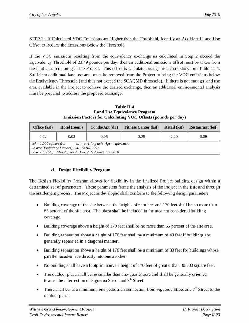
STEP 3: If Calculated VOC Emissions are Higher than the Threshold, Identify an Additional Land Use Offset to Reduce the Emissions Below the Threshold
If the VOC emissions resulting from the equivalency exchange as calculated in Step 2 exceed the Equivalency Threshold of 23.49 pounds per day, then an additional emissions offset must be taken from the land uses remaining in the Project. This offset is calculated using the factors shown on Table 11-4. Sufficient additional land use area must be removed from the Project to bring the VOC emissions below the Equivalency Threshold (and thus not exceed the SCAQMD threshold). If there is not enough land use area available in the Project to achieve the desired exchange, then an additional environmental analysis must be prepared to address the proposed exchange.
Table II-4 Land Use Equivalency Program
Emission Factors for Calculating VOC Offsets (pounds per day)
Office (ksf) Hotel (room) Condo/Apt (du) Fitness Center (ksf) Retail (ksf) Restaurant (ksf)
0.02 0.03 0.05 0.05 0.09 0.09
ksf = 1,000 square feet du = dwelling unit Apt = apartment Source (Emissions Factors): URBEMIS, 2007 Source (Table): Christopher A. Joseph & Associates, 2010.
d. Design Flexibility Program
The Design Flexibility Program allows for flexibility in the finalized Project building design within a determined set of parameters. These parameters frame the analysis of the Project in the EIR and through the entitlement process. The Project as developed shall conform to the following design parameters:
• Building coverage of the site between the heights of zero feet and 170 feet shall be no more than 85 percent of the site area. The plaza shall be included in the area not considered building coverage.
• Building coverage above a height of 170 feet shall be no more than 55 percent of the site area.
• Building separation above a height of 170 feet shall be a minimum of 40 feet if buildings are generally separated in a diagonal manner.
• Building separation above a height of 170 feet shall be a minimum of 80 feet for buildings whose parallel facades face directly into one another.
• No building shall have a footprint above a height of 170 feet of greater than 30,000 square feet.
• The outdoor plaza shall be no smaller than one-quarter acre and shall be generally oriented toward the intersection of Figueroa Street and 7th Street.
• There shall be, at a minimum, one pedestrian connection from Figueroa Street and 7th Street to the outdoor plaza.
City of Los Angeles July 2010
Wilshire Grand Redevelopment Project II. Project Description Draft Environmental Impact Report Page II-24
• Within the outdoor plaza, at least 30 percent of the area shall be landscaped or included in a water feature, as distinct from hardscape area.
• Within the outdoor plaza, the water feature shall be a minimum size of 500 square feet.
• On each of the four frontages of the property, the following minimum proportions of the building façades, from sidewalk grade to twenty feet above, shall be transparent (i.e., openings or glass) rather than opaque:
1. Figueroa Street 50 percent
2. 7th Street 50 percent
3. Wilshire Boulevard 50 percent
4. Francisco Street 25 percent
• There shall be at least one building constructed above a height of 170 feet on the site.
• No building above a height of 170 feet shall have any façade longer than 300 feet in length.
• Access points and site circulation shall be maintained in general conformance with the Conceptual Plan for the Project.
e. Access and Parking
Vehicular access to the Project Site would be provided at grade level via a drop-off area on Wilshire Boulevard, a drop-off and hotel valet area on 7th Street, and direct parking structure access on Francisco Street. Additionally, a passenger drop-off/loading area could be provided on Figueroa Street. Parking for the Project would be provided in a maximum of eight levels of subterranean parking containing approximately 1,900 parking spaces. Project parking requirements are based on the requirements as outlined for the Downtown Parking District for commercial uses, the Central City Parking District, and Advisory Agency Policy 2000-1 for condominiums. The Project includes a request for a reduction from the Los Angeles Municipal Code (LAMC) required parking and the provision of shared parking as further discussed in Section IV.B (Transportation) of this EIR; therefore, the number of parking spaces provided represents a maximum reduction (as permitted by the LAMC) of 40 percent from the required parking.
The Project includes the vacation of the portion of Francisco Street at the Project’s western boundary. Francisco Street would remain open and provide public vehicular and pedestrian circulation and access to parking for the Project and the 1000 Wilshire building during the construction and operation of the Project. Additionally, the Project could utilize the vacated subterranean area of Francisco Street for a portion of the subterranean parking garage. The Project would include streetscape improvements including sidewalk widening, landscape improvements, and additional street lighting to create a more pedestrian-friendly street.
City of Los Angeles July 2010
Wilshire Grand Redevelopment Project II. Project Description Draft Environmental Impact Report Page II-25
f. Transit Access
The Project Site is located across Figueroa Street from the 7th Street/Metro Center station, which serves the Red, Purple, and Blue rail transit lines operated by Metro. From this station, the Metro Red Line provides access to Hollywood and San Fernando Valley, with connecting service to the Metro Orange Line, as well as additional stations in downtown Los Angeles and to Los Angeles Union Station, where connecting service to the Metro Gold Line, Amtrak passenger rail, Metrolink commuter rail, and regional and local bus lines is available. The Purple Line provides access between Los Angeles Union Station and Koreatown. The Blue Line originates at the 7th Street/Metro Center station and provides access between downtown Los Angeles and downtown Long Beach with intermediate stops, as well as connecting service to the Metro Green Line. It is anticipated that the proximity of the Project Site to the 7th Street/Metro Center station would encourage the use of transit by employees, hotel guests, on-site permanent residents and their guests, and retail patrons.
The Project Site is also served by multiple bus and Downtown Area Shuttle (DASH) lines. Bus lines serving the Project Site include Metro Local 20, 26, 51, 52, and 60, Metro Limited Stop 352, Metro Express 442, Metro Transitway 444, 445, 446/447, 450X, 460, 487, and 489, Metro Rapid 760, Foothill Transit 493, 497, 498, 499, and 699, Antelope Valley Transit Authority 785, Santa Clarita Transit 799, and LADOT DASH A, E, and F. Transit is further discussed in Section IV.B (Transportation) of this EIR.
g. Loading Dock
The loading dock to serve the Project would be located within the subterranean parking structure. Access to the loading dock would be provided via a designated loading driveway on Francisco Street. Delivery trucks using the loading dock would include tractor-trailers, as well as small and medium-sized delivery trucks and vans. Operating hours for the loading dock would be 24 hours per day, seven days a week.
h. Communication Facilities
Wireless Telecommunications Facilities, including satellite and/or microwave dishes, two to three meters in diameter, antennas, and cellular facilities could be located on the rooftop of Building A or B.
i. Public Space, Pedestrian Features, and Open Space
Pedestrian access to the Project Site would be provided via Figueroa Street, Wilshire Boulevard, and 7th Street. Specifically, pedestrian access to Building A would be provided at grade level from the outdoor plaza, Figueroa Street, and Wilshire Boulevard. Pedestrian access to Building B and the Podium would be provided at grade level from the outdoor plaza, 7th Street, and Wilshire Boulevard via a pedestrian gallery. In addition, direct access would be provided via an escalator and/or elevator and stairwell connecting the parking structure with Buildings A and B and the Podium.
An outdoor plaza would be constructed at the corner of Figueroa Street and 7th Street, and may include landscaping, a water feature, and outdoor retail and dining areas. The approximately one-quarter of an
City of Los Angeles July 2010
Wilshire Grand Redevelopment Project II. Project Description Draft Environmental Impact Report Page II-26
acre plaza would provide pedestrian connectivity between the Project Site and the adjacent 7th Street/Metro Center station located at the northeast corner of Figueroa Street and 7th Street, as well as contribute to a pedestrian-oriented environment. The plaza would provide an outdoor gathering space for special events and would enhance the Project by providing outdoor areas for employees, residents, guests, and visitors. Figure II-13 (Conceptual Site Plan – Landscape), includes the landscape plan for the Project.
The Project would incorporate other pedestrian-friendly features such as public art, street lighting, streetscape, identity and way-finding signage, and other elements as described in the Downtown Design Guide.4
j. Environmental Design Features
The Applicant is pursuing Leadership in Energy and Environmental Design (LEED) certification from the Unities States Green Building Council (USGBC) for its efforts toward an energy efficient, sustainable, and environmentally-friendly design. The Project would be designed to meet, at a minimum, a certification level of Silver. In addition to the Project’s favorable building location, sustainable design features may include: roof- or building-mounted photovoltaic panels; building-integrated photovoltaic cells; daylighting of work areas; operable windows and fresh air circulation; dual piping to enable the use of recycled water; water efficient fixtures; and recycling during demolition and construction.
k. Helistop
A helistop would be provided on the rooftop of Building A. It is anticipated that the helistop would provide charter service to and from the following local airports: Los Angeles International Airport, LA/Ontario International Airport, Bob Hope Airport in Burbank, Santa Monica Municipal Airport, Van Nuys Airport, Long Beach Airport, John Wayne Airport in Santa Ana, Camarillo Airport, Santa Barbara Municipal Airport, LA/Palmdale Regional Airport, and other airports in the Los Angeles region. The helistop would not provide for helicopter refueling services or fuel storage.
l. Signs and Identity Elements
The system of signs and identity elements for the Project is intended to contribute to a lively, colorful, artistic, and exciting pedestrian atmosphere along the major arterials linking the Los Angeles Sports and Entertainment District and Convention Center to the Financial Core, by having, in part, animated and illuminated signs and graphics that are compatible with the commercial, entertainment, and retail uses in the downtown area. Signage regulations set forth in the Signage Supplemental Use District (Wilshire Grand SUD) would establish criteria for both opportunities and constraints of new identity elements of the Project. The Wilshire Grand SUD would set forth requirements governing the allowable sign types, locations, maximum size or coverage, hours of operation, and type of animation or controlled refresh for
4 City of Los Angeles, Department of City Planning, Urban Design Studio website: http://www.urbandesignla.com/downtown_guidelines.htm, March 1, 2010.
City of Los Angeles July 2010
Wilshire Grand Redevelopment Project II. Project Description Draft Environmental Impact Report Page II-27
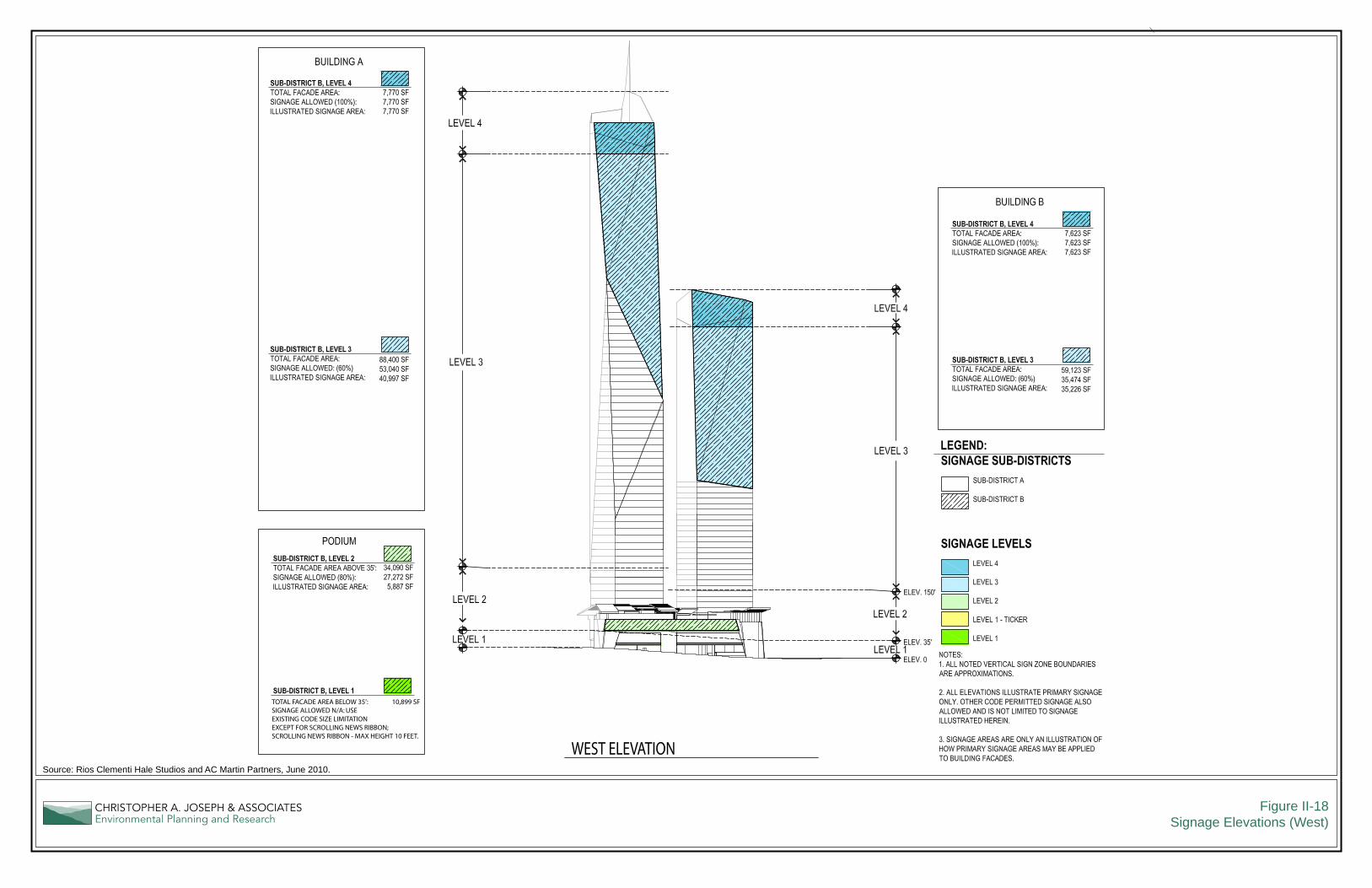
new signage. Project signage could include large-scale animated and static signs designed to convey a business, product, service, profession, commodity, activity, event, person, institution, brand, or any other commercial or noncommercial message, including Changeable Copy Signs (to be utilized for a scrolling news ribbon) and Integral Electronic Display Signs. Figure II-14 (Signage Subdistrict Map) shows the Project’s signage subdistricts. Signage elevations are shown on Figures II-15 (Signage Elevations [North]), II-16 (Signage Elevations [East]), II-17 (Signage Elevations [South]), and II-18 (Signage Elevations [West]).
i. Permitted and Prohibited Signs
The Wilshire Grand SUD lists permitted sign types, which include: all signs currently permitted by Section 14.4.2 of the LAMC, Changeable Copy Signs, Integral Electronic Display Signs, Pillar Signs, Pedestrian Signs, and Projected Image Signs. The Wilshire Grand SUD prohibits the following signs: Supergraphics, Billboards; Can Signs; Captive Balloon Signs; Illuminated Canopy Signs; Internally Illuminated Awnings; Luminous vacuum-formed letters; Conventional plastic-faced box, canister, or cabinet signs; Formed plastic-faced boxes or injection-molded plastic signs; Inflatable Devices; Odor-producing Signs or any other prohibited sign pursuant to LAMC Section 14.4.4 B.7; Pole Signs; and Sandwich board signs.
i. Sign Sub-District
The Wilshire Grand SUD establishes two Sign Sub-Districts. The following are the specific signage requirements for each of these Sign Sub-Districts:
• Sub-District A: This district generally encompasses the portion of the Project that faces Figueroa Street, Wilshire Boulevard, 7th Street, the intersections of Figueroa Street and Wilshire Boulevard and Figueroa Street and 7th Street.
• Sub-District B: This district generally encompasses the portion of the Project along Francisco Street and the intersections of Francisco Street and Wilshire Boulevard and Francisco Street and 7th Street.
ii. Sign Levels
For sign regulation purposes, the Wilshire Grand SUD area is divided into four Vertical Sign Zones or Levels. The purpose of the Sign Levels is to address different sign viewing distances, including pedestrian views from street level, pedestrian views from a distance, views from surrounding areas, and views from vehicles. The Sign Levels are applicable to Permitted Signs in the Wilshire Grand SUD and include the following:
• Level 1: Applicable to all signs located at street level, defined as 0 foot to 35 feet above grade;
Scale (Feet)
0 8040 6020
Figure II-14Signage Subdistrict Map
Source: Rios Clementi Hale Studios and AC Martin Partners, April 2010.
Figure II-15Signage Elevations (North)
Source: Rios Clementi Hale Studios and AC Martin Partners, June 2010.
NORTH ELEVATION
TOTAL FACADE AREA BELOW 35’: 1,238 SFSIGNAGE ALLOWED N/A: USEEXISTING CODE SIZE LIMITATIONEXCEPT FOR SCROLLING NEWS RIBBON; SCROLLING NEWS RIBBON - MAX HEIGHT 10 FEET.
Figure II-16Signage Elevations (East)
Source: Rios Clementi Hale Studios and AC Martin Partners, June 2010.
EAST ELEVATION
TOTAL FACADE AREA BELOW 35’: 8,135 SFSIGNAGE ALLOWED N/A: USEEXISTING CODE SIZE LIMITATIONEXCEPT FOR SCROLLING NEWS RIBBON; SCROLLING NEWS RIBBON - MAX HEIGHT 10 FEET.
Figure II-17Signage Elevations (South)
Source: Rios Clementi Hale Studios and AC Martin Partners, June 2010.
SOUTH ELEVATIONTOTAL FACADE AREA BELOW 35’: 4,158 SFSIGNAGE ALLOWED N/A: USEEXISTING CODE SIZE LIMITATIONEXCEPT FOR SCROLLING NEWS RIBBON; SCROLLING NEWS RIBBON - MAX HEIGHT 10 FEET.
Figure II-18Signage Elevations (West)
Source: Rios Clementi Hale Studios and AC Martin Partners, June 2010.
WEST ELEVATION
TOTAL FACADE AREA BELOW 35’: 10,899 SFSIGNAGE ALLOWED N/A: USEEXISTING CODE SIZE LIMITATIONEXCEPT FOR SCROLLING NEWS RIBBON; SCROLLING NEWS RIBBON - MAX HEIGHT 10 FEET.
City of Los Angeles July 2010
Wilshire Grand Redevelopment Project II. Project Description Draft Environmental Impact Report Page II-33
• Level 2: Applicable to all signs located between street level and the roof line of the podium, defined as 36 feet to 150 feet above grade (but not to exceed beyond the level of the roofline of the podium);
• Level 3: Applicable to all signs located above the roof line of the podium or 151 feet above grade, whichever is lower, up to Level 4; and
• Level 4: Applicable to all signs located in the top 10 percent of each building over 170 feet in height above grade.
iii. Sign Animation and Controlled Refresh
There are nine different types of animation, controlled refresh, or static signs, as shown in Table II-5 (Types of Animation). The nine types are: Unrestricted Animation; Scroll Animation; Limited Animation I and II; Controlled Refresh I, II, and III; Light Color Animation; and Static signage. New signage in the Wilshire Grand SUD is restricted as to each of these types of animation and controlled refresh as shown in Tables II-6 (Sub-District A Sign Regulations) and II-7 (Sub-District B Sign Regulations).
Table II-5 Types of Animation
Type Definition 1 Unrestricted
Animation The least restrictive level of animation for signs that contain images, text, parts, or illumination which flash, change, move, stream, scroll, blink, or otherwise are in motion. This is full motion display.
2 Scroll Animation
A type of animation for signs where text message changes regularly, either by modifying individual letters or by modifying the sign face electronically, including scrolling news ribbon or electronic message boards where text moves or rolls up, down, or across the sign.
3 Limited Animation I
A type of restricted animation for signs that contain images, text, parts, or illumination which flash, change, move, blink, or otherwise refresh in whole or in part at a maximum rate of one animated event per 2 minutes (i.e., must stay static for a minimum of 2 minutes before refreshing). Each animated effect shall change by transitional effect including but not limited to an irregular pixilated pattern cascade with non-adjoining pixels incrementally changing over a period of 2 minutes.
4 Limited Animation II
A type of restricted animation for signs that contain images, text, parts, or illumination to flash, change, move, blink, or otherwise refresh in whole or in part at a maximum rate of one animated event per 3 hours (i.e., must stay static for a minimum of 3 hours before refreshing). Each animated effect displayed on an Integral Electronic Display Sign shall change by an irregular pixilated pattern cascade with non-adjoining pixels incrementally changing over a period of 1 hour.
5 Controlled Refresh I
Restriction for any type of sign that contains images, text, parts, or illumination which flash, change, move, blink, or otherwise refresh in whole or in part at a maximum of one refresh event per 8 seconds (i.e., must stay static for a minimum of 8 seconds before refreshing). Each refresh event shall be an instant transition.
6 Controlled Refresh II
Restriction for any type of sign that contains images, text, parts, or illumination which flash, change, move, blink, or otherwise refresh in whole or in part at a maximum rate of one refresh event per 6 hours (i.e., must stay static for a minimum of 6 hours before refreshing). Each refresh event shall be an instant transition.
City of Los Angeles July 2010
Wilshire Grand Redevelopment Project II. Project Description Draft Environmental Impact Report Page II-34
Table II-5 Types of Animation
Type Definition 7 Controlled
Refresh III Restriction for any type of sign that contains images, text, parts, or illumination which flash, change, move, blink, or otherwise refresh in whole or in part at a maximum rate of one refresh event per 12 hours (i.e., must stay static for a minimum of 12 hours before refreshing). Each refresh event shall change be an instant transition.
8 Light Color Animation
Changes in color in whole or in part without changing images or text are exempt from other Animation restrictions. Each color effect displayed on a sign may change by gradient transition between colors once every 30 minutes.
9 Static Restriction for any type of sign to flash, change, move, blink, or otherwise refresh in whole or in part. All such signage shall remain static.
Source: PSOMAS and Thomas Properties Group, L.P., 2010.
iv. Sign Classification and Regulations
Tables II-6 (Sub-District A Sign Regulations) and II-7 (Sub-District B Sign Regulations) set forth the signage classification and regulations by Vertical Sign Zone for Sub-District A and B, respectively.
v. Permitted Sign Coverage and Size
Except as otherwise regulated by the Wilshire Grand SUD, maximum coverage for Levels 1 and 4 would be regulated by LAMC size limitations. The maximum coverage for permitted signs within Levels 2 and 3 of the Wilshire Grand SUD is a percentage of the building façade area, which is the general surface of any exterior wall of a building, not including cornices, bay windows, projections, indentations, or other architectural features or articulation of the exterior surface. The permitted maximum coverages are 80 percent for Level 2, and 60 percent for Level 3, as shown in Tables II-6 (Sub-District A Sign Regulations) and II-7 (Sub-District B Sign Regulations).
vi. Sign Hours of Operation
Signs shall be limited in their hours of animation or controlled refresh as shown in Tables II-5 (Sub-District A Sign Regulations) and II-6 (Sub-District B Sign Regulations). Light Color Animation and Static signs shall not be limited in their hours of operation.
m. Construction Timeline
Project construction, inclusive of the demolition of the existing structure, is anticipated to occur in one phase over an approximately 54-month period. Construction is anticipated to commence in 2011. In order to provide a conservative analysis in this EIR, Project buildout is anticipated in 2015 and full occupancy is anticipated to occur by 2020. Soil export for Project construction would be approximately 420,000 cubic yards.
City of Los Angeles July 2010
Table II-6 Sub-District A Sign Regulations
Vertical
Sign Zone
Permitted Signs
Animation and/or Refresh
Hours of Operation
Maximum Coverage
and Size
Brightness
Level 1 All signs currently permitted by Code, including Tenant ID Signs and Digital Display Signs, and Integral Electronic Display Signs
• Controlled Refresh II • Light Color Animation
No restrictions
Coverage to be regulated by LAMC size limitations, except as otherwise regulated by Section 7.D.
No restrictions
Digital Display Signs and Integral Electronic Display Signs that are in encapsulated areas that are no more than incidentally visible from the public right-of-way
Unrestricted Animation 7:00 am to 2:00 am
Limited Animation II 2:01 am to 6:59 am
Light Color Animation No restrictions
Changeable Copy Signs Scroll Animation Dawn to 2:00 am Changeable Copy Signs may have a maximum vertical dimension of 10 feet.
Level 2
All signs currently permitted by Code, including Digital Display Signs, and Integral Electronic Display Signs
• Limited Animation I • Controlled Refresh I and II • Light Color Animation
Dawn to 2:00 am for animated signs No restrictions for Static signs
Maximum of 80% of the combined façade area for each street frontage as further delineated on Exhibit A of the Wilshire Grand Signage SUD
No restrictions
Level 2
Digital Display Signs and Integral Electronic Display Signs that are in encapsulated areas that are no more than incidentally visible from the public right-of-way
Unrestricted Animation
7:00 am to 2:00 am
Maximum of 80% of the combined façade area for each street frontage as further delineated on Exhibit A of the Wilshire Grand Signage SUD.
No restrictions
Limited Animation II
2:01 am to 6:59 am
Light Color Animation
No restrictions
Wilshire Grand Redevelopment Project II. Project Description Draft Environmental Impact Report Page II-35
City of Los Angeles July 2010
Wilshire Grand Redevelopment Project II. Project Description Draft Environmental Impact Report Page II-36
Table II-6 Sub-District A Sign Regulations
Vertical
Sign Zone
Permitted Signs
Animation and/or Refresh
Hours of Operation
Maximum Coverage
and Size
Brightness
Level 3 Integral Electronic Display Signs and Wall Signs
• Limited Animation I • Controlled Refresh I and II
• Light Color Animation
Dawn to 2:00 am
Maximum of 60% of the combined façade area above 150 feet and below Level 4 for each street frontage as further delineated on Exhibit A of the Wilshire Grand Signage SUD. Signage shall be located only on spandrels and shall not cover windows.
The cumulative intensity of lumens shall not exceed 20 lumens per square foot.
Level 4
Tenant ID Signs
• Limited Animation I • Controlled Refresh II • Light Color Animation
All signs must remain Static between 2:00 am and dawn
Coverage to be regulated by LAMC size limitations, except as otherwise regulated by Section 7.D.
No restrictions
Integral Electronic Display Signs
Source: PSOMAS and Thomas Properties Group, L.P., 2010.
City of Los Angeles July 2010
Table II-7 Sub-District B Sign Regulations
Vertical Sign
Zone
Permitted Signs
Animation and/or Refresh
Hours of Operation
Maximum Coverage
and Size
Brightness
Level 1 All signs currently permitted by Code, including Tenant ID Signs and Digital Display Signs, and Integral Electronic Display Signs
• Controlled Refresh II • Light Color Animation
No restrictions
Coverage to be regulated by LAMC size limitations, except as otherwise regulated by Section 7.D.
No restrictions
Digital Display Signs and Integral Electronic Display Signs that are in encapsulated areas that are no more than incidentally visible from the public right-of-way
Unrestricted Animation
7:00 am to 2:00 am
Limited Animation II
2:01 am to 6:59 am
Light Color Animation
No restrictions
Level 2
All signs currently permitted by Code, including Digital Display Signs, and Integral Electronic Display Signs
• Limited Animation II • Controlled Refresh II and III • Light Color Animation
Dawn to 2:00 am for animated signs. No restrictions for Static signs.
Maximum of 80% of the combined façade area for each street frontage as further delineated on Exhibit A of the Wilshire Grand Signage SUD.
No restrictions
Digital Display Signs and Integral Electronic Display Signs that are in encapsulated areas that are no more than incidentally visible from the public right-of-way
Unrestricted Animation
7:00 am to 2:00 am
Limited Animation II
2:01 am to 6:59 am
Light Color Animation
No restrictions
Wilshire Grand Redevelopment Project II. Project Description Draft Environmental Impact Report Page II-37
City of Los Angeles July 2010
Wilshire Grand Redevelopment Project II. Project Description Draft Environmental Impact Report Page II-38
Table II-7 Sub-District B Sign Regulations
Vertical Sign
Zone
Permitted Signs
Animation and/or Refresh
Hours of Operation
Maximum Coverage
and Size
Brightness
Level 3 Integral Electronic Display Signs and Wall Signs
• Limited Animation II • Controlled Refresh II and III • Light Color Animation
Dawn to 2:00 am
Maximum of 60% of the combined façade area above 150 feet and below Level 4 for each street frontage as further delineated on Exhibit A of the Wilshire Grand Signage SUD. Signage shall be located only on spandrels and shall not cover windows.
The cumulative intensity of lumens shall not exceed 17,280 lumens per floor.
Level 4
Tenant ID Signs
• Limited Animation II • Controlled Refresh II • Light Color Animation
All signs must remain Static between 2:00 am and dawn.
Coverage to be regulated by LAMC size limitations, except as otherwise regulated by Section 7.D.
No restrictions
Integral Electronic Display Signs
Source: PSOMAS and Thomas Properties Group, L.P., 2010.
City of Los Angeles July 2010
Wilshire Grand Redevelopment Project II. Project Description Draft Environmental Impact Report Page II-39
4. PROJECT ALTERNATIVES
This EIR considers a range of alternatives to the Project to provide informed decision-making in accordance with Section 15126.6 of the CEQA Guidelines. As described in greater detail in the following paragraphs, the alternatives to the Project that are analyzed in this EIR include: 1) No Project Alternative; 2) Reduced Density Alternative; 3) Phased Construction Alternative; 4) Office Only Alternative; 5) Residential Only Alternative; 6) Reduced Height Alternative; 7) Zoning Compliant Alternative; 8) Reduced Signage Alternative; and 9) Zoning Compliant Signage Alternative.
a. Alternative 1 – No Project Alternative
The No Project Alternative is the circumstance under which the Project does not proceed, and no other project is built in its place. The CEQA Guidelines (Section 15126.6[e]) provide that the “no project” analysis shall discuss the existing conditions at the time the Notice of Preparation is published, as well as what would be reasonably expected to occur in the foreseeable future if the Project is not approved based on current plans and consistent with available infrastructure and community services. At the time the NOP was published for the Project, there was no evidence that another project would be forthcoming in the event the Project is not approved. Therefore, the No Project/Current Operation Alternative assumes that the Project Site would remain in its current condition, that is, developed with the Wilshire Grand Hotel and Centre. However, operation of the existing hotel and office may not continue given that the existing structure is deteriorating. The Applicant anticipates closure of the existing Wilshire Grand Hotel and Centre on or around 2011. The existing structure cannot sustain economic viability given that it is physically obsolete, is not competitive in the Downtown marketplace, and does not fulfill the City’s adopted regional land use, economic, design and transportation policies. Even so, the No Project Alternative is analyzed as described above, and assumes that the Project Site would remain in its current condition, that is, developed with the Wilshire Grand Hotel and Centre.
b. Alternative 2 – Reduced Density Alternative
Under the Reduced Density Alternative, the Project Site would be developed with the same office, residential, and hotel development as the Project, but would be reduced in overall density. The Reduced Density Alternative would include the demolition of the existing structure, including existing subterranean parking, and redevelopment of the Project Site with maximum of 560 hotel rooms and/or condo-hotel units, 100 residential dwelling units, 1,250,000 square feet of office uses, and 210,000 square feet of amenity areas. The Reduced Density Alternative would include approximately 1,566 parking spaces in a maximum of eight levels of subterranean parking. With the exception of the office and amenity floor areas and parking, all other aspects of the Reduced Density Alternative would be the same as described under the Project.
c. Alternative 3 – Phased Construction Alternative
Under the Phased Construction Alternative, the Project Site would be developed with the same office, residential, and hotel development as the Project, but would be built in two phases. In Phase I, Building
City of Los Angeles July 2010
Wilshire Grand Redevelopment Project II. Project Description Draft Environmental Impact Report Page II-40
B, the subterranean parking, the outdoor plaza, and the Podium would be constructed. Phase I of construction is anticipated to require approximately 47 months inclusive of demolition and construction. Phase II would include construction of Building A and is anticipated to require approximately 28 months of construction. With the exception of the construction scenario, all other aspects of the Phased Construction Alternative would be the same as described under the Project.
d. Alternative 4 – Office-Only Alternative
Under the Office-Only Alternative, the Project Site would be developed with office and associated retail and parking uses only. Hotel and residential dwelling units would not be included in the development. The Office-Only Alternative would include the demolition of the existing structure, including existing subterranean parking, and redevelopment of the Project Site with approximately 1,750,000 square feet of office and 90,000 square feet of amenity retail and restaurant. The Office-Only Alternative would include provision of approximately 1,384 parking spaces in a subterranean parking garage. The Land Use Equivalency Program as proposed for the Project is not included in this Alternative. All other aspects of the Office-Only Alternative would be the same as described under the Project.
e. Alternative 5 – Residential-Only Alternative
Under the Residential-Only Alternative, the Project Site would be developed with residential and associated retail, restaurant, and parking uses only. No office or hotel uses would be included in the development. The Residential-Only Alternative would include the demolition of the existing structure, including existing subterranean parking, and redevelopment of the Project Site with approximately 1,100 residential dwelling units and approximately 170,000 square feet of pedestrian-oriented retail. The Residential-Only Alternative would include provision of approximately 1,433 parking spaces in subterranean parking. However, there would be no helistop included in this scenario. The Land Use Equivalency Program and the Wilshire Grand SUD as proposed for the Project are not included in this Alternative. All other aspects of the Residential-Only Alternative would be the same as described under the Project.
f. Alternative 6 – Reduced Height Alternative
Under the Reduced Height Alternative, Buildings A and B would be the same height, both at approximately 53 stories, or a maximum of 717 feet tall; in order to maintain a helistop on the building, the structures cannot be lower than 717 feet due to the Federal Aviation Administration’s regulations regarding helistops on high-rise buildings and in relation to the heights of the surrounding buildings. The Reduced Height Alternative would include the demolition of the existing structure, including existing subterranean parking, and redevelopment of the Project Site with maximum of 560 hotel rooms and/or condo-hotel units, 100 residential dwelling units, 1,500,000 square feet of office uses, and 275,000 square feet of amenity areas. The Reduced Height Alternative would include provision of approximately 1,900 parking spaces in a maximum of eight levels of subterranean parking. All other aspects of the Reduced Height Alternative would be the same as described under the Project.
City of Los Angeles July 2010
Wilshire Grand Redevelopment Project II. Project Description Draft Environmental Impact Report Page II-41
g. Alternative 7 – Zoning Compliant Alternative
Under the Zoning Compliant Alternative, the Project Site would be developed up to a floor area ratio (FAR) of 6:1, based on a 2.7-acre site (which would not include the centerline of surrounding streets or vacation of Francisco Street). The Zoning Compliant Alternative would include the demolition of the existing structure, including existing subterranean parking, and redevelopment of the Project Site with maximum of 350 hotel rooms and/or condo-hotel units, 50 residential dwelling units, 350,000 square feet of office uses, and 132,500 square feet of amenity areas. These uses would be contained in one approximately 24-story structure. The Zoning Compliant Alternative would include provision of approximately 917 parking spaces in a subterranean parking garage, in compliance with code requirements. This Alternative would not vacate Francisco Street and would not include the helistop. Signage would be limited to what is currently permitted under the zoning code. All other aspects of the Zoning Compliant Alternative would be the same as described under the Project.
h. Alternative 8 – Reduced Signage Alternative
Under the Reduced Signage Alternative, the Project Site would be developed with the same office, residential, and hotel development as the Project. However, overall signage (as designated under the Signage Supplemental Use District [Wilshire Grand SUD]) would be reduced. The Reduced Signage Alternative would adopt the same signage regulations as set forth in the Wilshire Grand SUD for the Project, however; overall signage coverage for Sign Level 2 would be reduced and Sign Level 3 would be replaced with architectural lighting. Sign coverage for Sign Levels 1 and 4 would remain unchanged. Under this Alternative, Sign Level 2 would allow 50 percent coverage of the buildings’ facades, rather than 80 percent coverage of the buildings’ facades, as under the Project. Sign Level 3 under the Reduced Signage Alternative would continue to allow 60 percent coverage but would be limited to architectural lighting with no messaging permitted, commercial or non-commercial, rather than the signage permitted under the Project. With the exception of the Wilshire Grand SUD, all other aspects of the Reduced Signage Alternative would be the same as described under the Project.
i. Alternative 9 – Zoning Compliant Signage Alternative
Under the Zoning Compliant Signage Alternative, the Project Site would be developed with the same office, residential, and hotel development as the Project. However, signage would be limited to what is currently permitted under the Zoning Code and would not require the SUD. All other aspects of the Zoning Compliant Signage Alternative would be the same as those described under the Project. In addition, all applicable Project mitigation measures and design features would be implemented under this Alternative.
5. PROJECT OBJECTIVES
The overall purpose of the Project is to revitalize a full City block by replacing an existing, obsolete hotel and office facility with a state-of-the-art, urban mixed-use and transit-oriented center. The overall redevelopment would provide new development that complements downtown Los Angeles and supports
City of Los Angeles July 2010
Wilshire Grand Redevelopment Project II. Project Description Draft Environmental Impact Report Page II-42
the growth of the Los Angeles Convention and Exhibition Center. The specific objectives of the Project are as follows:
• Maximize the Redevelopment of an Underutilized Central Downtown Location with an Infill, Transit-Oriented, Mixed-Use Center consistent with local, regional, and state policies
The Project aims to redevelop an existing underutilized site with new state-of-the-art facilities integrating Class-A office uses, a four-plus star hotel, residential, related retail, and amenities in direct proximity to existing intensive land uses and visitor and tourist attractions. In order to provide greater utilization of existing infrastructure, the Project aims to maximize the redevelopment potential of an urban infill site that is located in close proximity to the regional transit system and transportation corridors. The Project aims to promote downtown Los Angeles as a regional center for business and serves as a catalyst for the future growth of the Los Angeles Convention and Exhibition Center.
• Support Regional Mobility Goals by Locating New Office, Hotel, Residential, and Retail Facilities in Direct Proximity to the Regional Transit System and Transportation Corridors
The Project aims to reduce vehicle trips and infrastructure costs by concentrating development in an existing activity center with direct proximity to transportation alternatives and transportation corridors. The Project aims to encourage the use of transit by employees, hotel guests, on-site permanent residents and their guests, and retail patrons given that the Project Site provides convenient accessibility to numerous bus lines and the 7th Street/Metro Center station. The Project aims to provide convenient pedestrian accessibility by creating an outdoor plaza to support the use of the regional transit system. The Project would minimize vehicle trips on surface streets because of its proximity to the freeway system.
• Assist in Meeting State, Regional, and Local Efforts To Achieve Greenhouse Gas Reduction Goals through the Construction of Energy-Efficient, Mixed-Use, Transit-Oriented Infill Projects that Reduces Vehicle Miles Traveled
Recent state legislation such as AB 32 and SB 375 require state and local agencies to achieve greenhouse gas emission reductions, in part by facilitating transit-oriented, energy-efficient infill development. Pursuant to SB 375, the Southern California Council of Governments (SCAG) will be formulating either a “sustainable communities strategy” (SCS) or an “alternative planning strategy” (APS) in connection with the next update of the SCAG Regional Transportation Plan (RTP). To the extent that the land use plans and approvals of the City of Los Angeles can contribute to regional reductions in per capita vehicle miles traveled and per capita greenhouse gas emissions, the City will be making it more likely that SCAG can adopt an SCS rather than an APS. Maximizing the redevelopment of existing urban sites near transit nodes and corridors with mixed-use development is recognized as one of the best ways to reduce vehicle miles traveled, thereby reducing greenhouse gas emissions associated with passenger vehicles. The Project would include a varied mix of land uses, including residential and commercial uses, in a location near several transit lines, allowing future residents, employees and visitors at the Project Site to minimize their use of passenger vehicles to travel to and from the site. The Project would also
City of Los Angeles July 2010
Wilshire Grand Redevelopment Project II. Project Description Draft Environmental Impact Report Page II-43
include several design elements that promote the efficient use of energy and water and minimize greenhouse gas emissions.
• Create a Landmark Mixed-Use Center that Contributes to Establishing a Prominent Downtown Los Angeles Skyline that Promotes Downtown Los Angeles as the Center of Business Activity in the Region
The Project aims to build iconic state-of-the-art facilities for office tenants, hotel guests, residents, and visitors that promote downtown Los Angeles as the center of business activity in the region and serve as a catalyst for future growth of the Los Angeles Convention and Exhibition Center. The Project aims to further the ongoing redevelopment of downtown Los Angeles by encouraging businesses to locate in the first modern high-rise office building in downtown in two decades, which strengthens downtown’s competitive position within the broader region. The Project aims to provide an architecturally distinctive development that includes a creative signage program integral to the building design that identifies the Project Site and surrounding area as a major area of concentration for office, retail, and hotel uses in the City of Los Angeles.
• Create a Vibrant and Exciting Visual Environment by Incorporating Creative Electronic Signage that will Attract Visitors and Strengthen the Connectivity Between the Financial and Entertainment Areas in Downtown Los Angeles
Through the use of a bright, vibrant, and dynamic signage program that features state-of-the-art energy-efficient electronic signs integrated into the architecture of the buildings, the Project aims to create a prominent landmark recognizable throughout the Los Angeles area identifying the Project as a focal point for Downtown Los Angeles. The prominent signage program and Project identity would be designed to attract office tenants, hotel guests, tourists, and other visitors to the Project, thereby promoting the economic redevelopment of Downtown Los Angeles. The Project’s prominent and vibrant signage program aims to create a visually exciting pedestrian environment that will link the Financial District to the Los Angeles Sports and Entertainment District and the Los Angeles Convention and Exhibit Center.
• Offer Flexible Land Uses and Floor Areas to Ensure that Downtown Los Angeles Can Remain Competitive given the Changing Needs of the Southern California Economy
The Project aims to provide a comprehensive development program that has the necessary flexibility to respond to the changing market conditions in the Los Angeles region. The Project aims to create a major mixed-use center in the downtown core enhancing business, resident, visitor, and cultural activities in the Financial Core, the Convention Center district, and Bunker Hill. The Project’s flexibility would ensure that the precise mix of uses developed would meet the needs of the downtown core at the time of development.
• Providing New, Four-Star-Plus Hotel Rooms Within Close Proximity of the Los Angeles Convention Center would Generate Additional Bookings of Large-Scale Conventions and Events
The Project aims to provide a properly sized world-class hotel and supporting facilities to address the deficiency of high-quality hotel facilities in downtown Los Angeles that support major events
City of Los Angeles July 2010
Wilshire Grand Redevelopment Project II. Project Description Draft Environmental Impact Report Page II-44
and expected increased levels of activity at the Convention Center as well as the visitor-oriented uses in the Los Angeles Sports and Entertainment District. The Project aims to enable the Convention Center to compete more favorably against other convention centers for national conventions by expanding the base of four-plus star hotel rooms available for overnight guests in close proximity and along a visually exciting corridor accented with creative signage. The Project aims to support the growth of the Convention Center by providing additional amenity spaces including meeting rooms, ballrooms, and related facilities.
• Provide New State-of-the-Art Office Facilities that Complement the Financial Core and Offer Opportunities for Corporations to Relocate or Expand Operations in Downtown Los Angeles
The Project aims to provide the first new office building in Downtown Los Angeles in over two decades. The Project aims to provide an architecturally distinctive high-rise office building which would reinforce the long-term economic viability of downtown Los Angeles. The office building would enhance the downtown office market by providing premium office uses to attract new tenants from other cities, states, and countries to locate operations in the downtown core. The office building would accommodate a new helistop providing charter service between downtown and local airports to serve the Project office users, hotel guests, and visitors who require ready access to local and regional airports. The visual excitement created by the creative signage program would enhance the attractiveness of the Project for new tenants interested in locating their business in state-of-the-art Class A office uses in Downtown Los Angeles.
• Improve the Local and Regional Economy through Job Generation, Increased Tax Revenues, and Future Expansion of the Convention Center
The Project aims to improve and enhance the economy vitality of the City of Los Angeles as well as the surrounding region through construction and permanent jobs and long-term enhancement of business opportunities. The Project aims to expand the base of four-plus star quality hotel rooms and amenities building upon the City’s existing investment in the Convention Center and supporting its future expansion. The Project aims to generate additional annual tax revenues for the region, including property taxes, sales taxes, utility taxes, and gross receipts taxes. The Project aims to maximize its potential contribution to the overall economy by including provisions that facilitate adjustments to the development program that may be needed in the future to respond to changing market conditions.
• Contribute Development that is Consistent with the Evolving Development Characteristics of Downtown
The Project aims to further walkability and design goals of the City by creating a pedestrian-oriented development including a one-quarter acre outdoor plaza, streetscape improvements and landscaping, public art, lighting, building setbacks, and other elements that provide a strong pedestrian presence along the Project edge. The Project aims to provide a pedestrian link to the surrounding community, including the 7th Street/Metro Center station, 7 + Fig retail center, L.A. Live! and the Convention Center. With the Project’s signage district, a visually exciting project
City of Los Angeles July 2010
Wilshire Grand Redevelopment Project II. Project Description Draft Environmental Impact Report Page II-45
would be created in the Financial District, which, when linked to the Los Angeles Sports and Entertainment District and the Convention Center, would activate the Figueroa Street corridor, thereby encouraging more pedestrian travel and enhancing the visual experience for visitors. The Project aims to improve the quality and safety of the pedestrian environment through the development of an integrated streetscape program including the outdoor plaza which would provide convenient access to the 7th Street/Metro Center station, outdoor gathering space for special events, and serve as an amenity for employees, residents, guests, and visitors.
• Incorporate Elements of Sustainable Development to Promote the Efficient Use of Energy and Water
The Project aims to incorporate state-of-the-art mechanical and electrical elements that would be designed to meet, at minimum, a LEED certification level of Silver. The Project aims to implement sustainable development practices that promote efficient use of energy and water and minimize greenhouse gas emissions.
• Fulfill Adopted Land Use, Economic, Design and Transportation Policies
As more fully discussed in Section IV.A.1 (Land Use – Land Use Plans/Zones) of this EIR, the Project aims to implement a number of key City and regional land use and transportation policies by focusing growth at a regional transportation hub, such as:
o Regional (from the Regional Comprehensive Plan and Guide, prepared by the Southern California Association of Governments, Chapter 3, Growth Management)
Encourage patterns of urban development and land use which reduce costs on infrastructure and development.
Encourage existing or proposed local jurisdictions’ programs aimed at designing land uses which encourage the use of transit.
Encourage local jurisdiction plans that maximize the use of existing urbanized areas accessible to transit through infill and redevelopment.
o City (from the General Plan Framework)
Provide for the spatial distribution of development that promotes an improved quality of life by facilitating a reduction of vehicle trips, vehicle miles traveled, and air pollution (Objective 3.2).
Encourage new multi-family residential, retail commercial, and office development in the City’s neighborhood districts, community, regional, and downtown centers as well as along primary transit corridors/boulevards, while at the same time conserving existing neighborhoods and related districts (Objective 3.4).
Encourage future development in centers and in nodes along corridors that are served by transit and are already functioning as centers for the surrounding neighborhoods, the community, or the region (Objective 5.2).
City of Los Angeles July 2010
Wilshire Grand Redevelopment Project II. Project Description Draft Environmental Impact Report Page II-46
o City (from the Central City Community Plan)
To improve Central City’s competitiveness as a location for offices, business, retail, and industry (Objective 2-1).
To promote land uses in Central City that will address the needs of all the visitors to downtown for business, conventions, trade shows and tourism (Objective 2-3).
Improve downtown’s pedestrian environment in recognition of its important role in the efficiency of downtown’s transportation and circulation systems and in the quality of life for its residents, workers and visitors (Policy 4.4-1).
6. DISCRETIONARY ACTIONS
The City of Los Angeles is the lead agency for the Project. In order to permit development of the Project, approval of one or more of the following discretionary actions would be required:
• Vesting Tentative Tract Map
o Street Vacation/Merger
o Haul Route Approval;
• Site Plan Review;
• Development Agreement;
• Ordinance for alternative “Buildable Area” definition;5
• Conditional Use Permit (CUP) for Alcohol;
• CUP for Wireless Telecommunications Facilities;
• Zoning Administrator Determination for Shared Parking;
• CUP for Heliport;6
• CUP for Major Development Project;
• Reduced On-site Parking with Remote Off-site Parking or Transportation Alternatives;
5 Please refer to Section IV.A.1 (Land Use – Land Use Plans/Zones), of this EIR for a discussion of the definition of “Buildable Area” under this ordinance.
6 The Federal Aviation Administration (FAA) distinguishes “heliport” from “helistop;” a heliport may provide refueling and fuel storage services, but a helistop may not provide such services. The City of Los Angeles does not make such a distinction and uses “heliport” to refer to facilities with and without fuel services. The Project would not include fuel services, and its facility is therefore referred to as a “helistop” throughout this EIR, even though the City of Los Angeles required approval is a “Conditional Use Permit for Heliport”.
City of Los Angeles July 2010
Wilshire Grand Redevelopment Project II. Project Description Draft Environmental Impact Report Page II-47
• Transfer of Floor Area Approval (to increase permitted FAR to 13:1 as allowed under “D” limitation) and relief from LAMC Section 14.5.12;
• Zone Variance (to allow outdoor dining areas above the ground floor);
• Supplemental Use District (SUD) or equivalent for signage;
• Transient Occupancy Tax (TOT) Subvention;
• Green Building Program Applications;
• Any approvals that may be required from the Federal Aviation Administration (FAA), pursuant to notification of the FAA under Form 7460; and
• Other approvals (as needed), ministerial or otherwise, may be necessary, as the City finds appropriate, in order to execute and implement the Project. Such approvals may include, but are not limited to: architectural design, landscaping, lighting and signage in accordance with the City of Los Angeles Department of Building and Safety; City of Los Angeles Department of Transportation permits for driveways/curb cuts; storm water discharge permit; issuance of permits from the City of Los Angeles Department of Building and Safety that may include permit approvals for demolition and grading, approval of the haul route for the export of demolition debris and import and export of soils, approvals for foundations, retaining walls, and structural improvements; building permit; vacation of existing City of Los Angeles easements; installation and hookup approvals for public utilities and related permits. Additional discretionary or ministerial action may include sewer and water hook-up permits from the City of Los Angeles Department of Water and Power and a Site Plan review by Department of City Planning.
Other reviewing agencies for the Project may include the following:
• Federal Aviation Administration
• California Department of Transportation
• South Coast Air Quality Management District
• Regional Water Quality Control Board
• Los Angeles County Metropolitan Transportation Authority
• Community Redevelopment Agency of the City of Los Angeles
• City of Los Angeles, Department of Public Works, Bureau of Engineering
• City of Los Angeles Department of Transportation