IMAGE: Integrated Methods for Advanced Geothermal Exploration Exploration and assessment of geothermal reservoir Gylfi Páll Hersir ÍSOR An open workshop on processes in high-enthalpy geothermal systems Synergy and cooperation in the DRG, COTHERM and IMAGE projects Organized by GEORG, Reykjavík September 10 th 2013
Transcript
IMAGE: Integrated Methods for Advanced
Geothermal Exploration
Exploration and assessment of geothermal reservoir
Gylfi Páll Hersir
ÍSOR
An open workshop on processes in high-enthalpy geothermal systems Synergy and cooperation in the DRG, COTHERM and IMAGE projects
Organized by GEORG, Reykjavík September 10th 2013
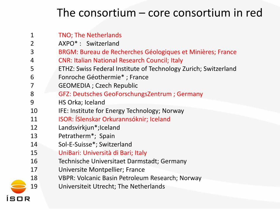
1 TNO; The Netherlands 2 AXPO* : Switzerland 3 BRGM: Bureau de Recherches Géologiques et Minières; France 4 CNR: Italian National Research Council; Italy 5 ETHZ: Swiss Federal Institute of Technology Zurich; Switzerland 6 Fonroche Géothermie* ; France 7 GEOMEDIA ; Czech Republic 8 GFZ: Deutsches GeoForschungsZentrum ; Germany 9 HS Orka; Iceland 10 IFE: Institute for Energy Technology; Norway 11 ISOR: ÍSlenskar Orkurannsóknir; Iceland 12 Landsvirkjun*;Iceland 13 Petratherm*; Spain 14 Sol-E-Suisse*; Switzerland 15 UniBari: Università di Bari; Italy 16 Technische Universitaet Darmstadt; Germany 17 Universite Montpellier; France 18 VBPR: Volcanic Basin Petroleum Research; Norway 19 Universiteit Utrecht; The Netherlands
The consortium – core consortium in red
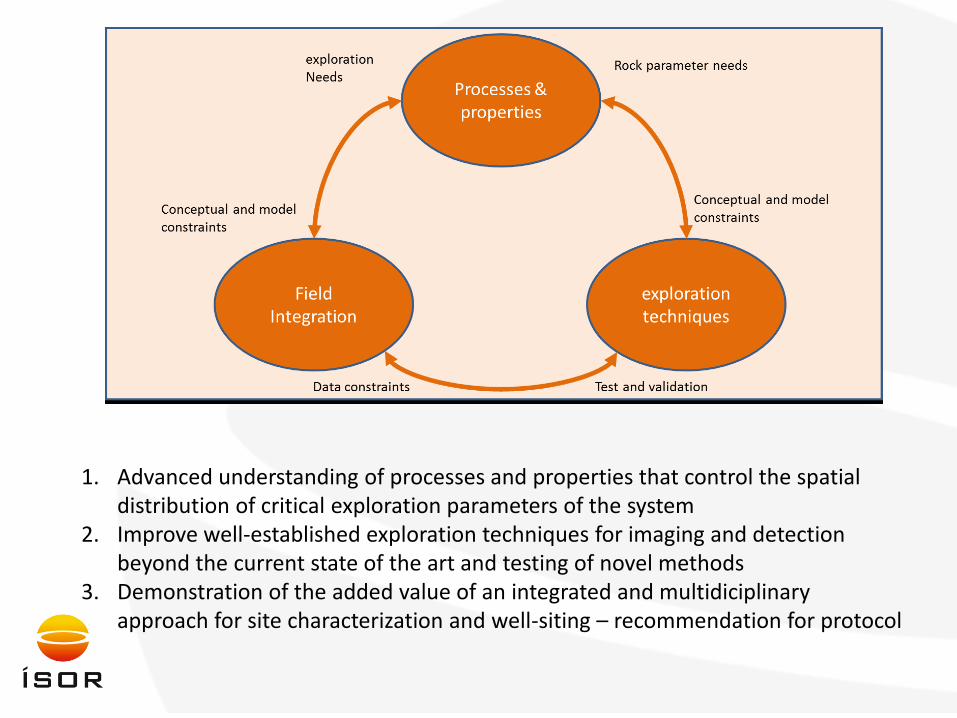
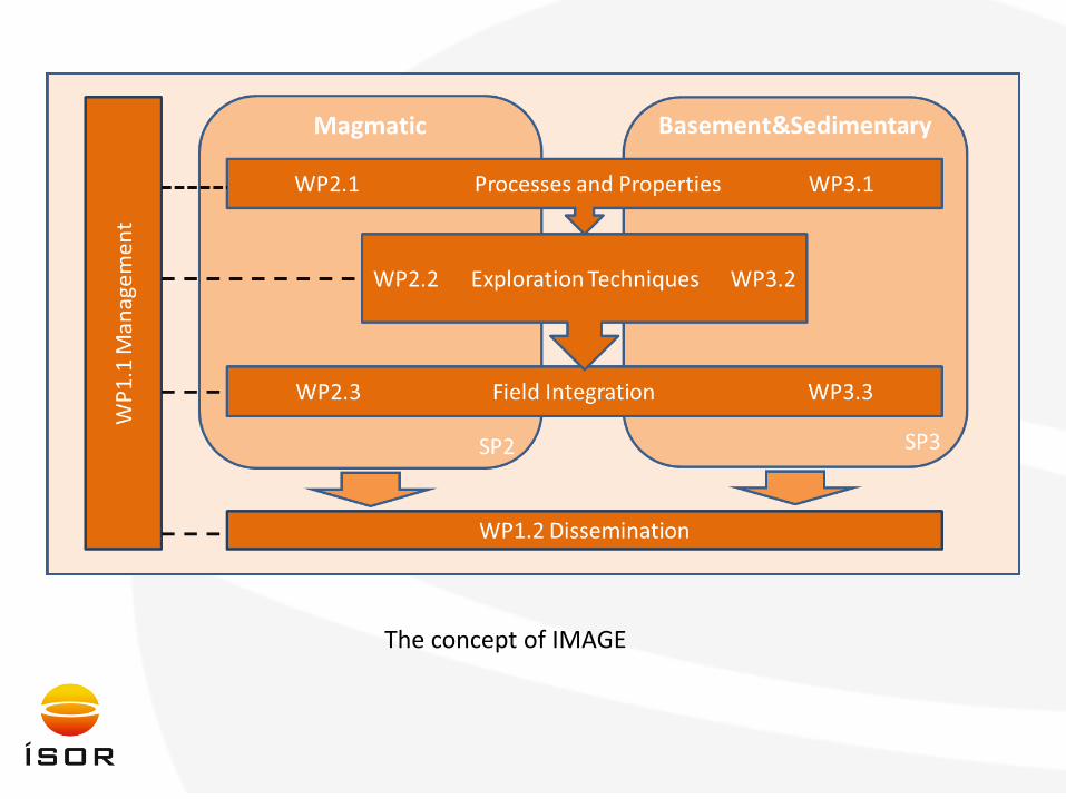
1. Advanced understanding of processes and properties that control the spatial distribution of critical exploration parameters of the system
2. Improve well-established exploration techniques for imaging and detection beyond the current state of the art and testing of novel methods
3. Demonstration of the added value of an integrated and multidiciplinary approach for site characterization and well-siting – recommendation for protocol
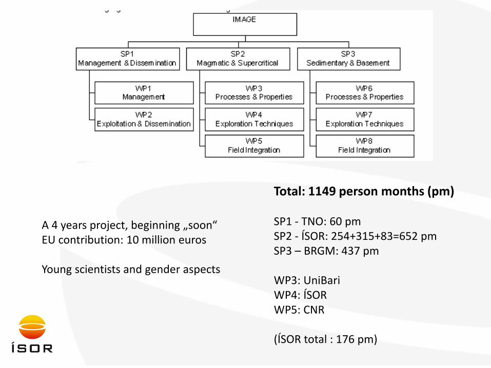
The concept of IMAGE
A 4 years project, beginning „soon“ EU contribution: 10 million euros Young scientists and gender aspects
Task 3.1 Understanding from deep drilling and exhumed systems: • Field work and rock sampling in fossil and exhumed geothermal systems in Elba Island (Italy) and
Geitafell (Iceland) to assess the structural features of the reservoir, the geometry of the conduits, fossil brittle-ductile boundary, fluid flow patterns and fluid rock interaction. This includes collection of core samples in ~50 m deep core holes drilled in Geitafell (Iceland) through the aureole into the heat source.
• Laboratory analysis of the samples from Elba Island and Geitafell to investigate the P-T, up to supercritical conditions, and geochemical and isotopic characteristics of fluid stored in the deep fossil reservoirs.
• Reconstruct the kinematic and geometric features of the active deformation in presently active fields in the context of the regional framework and with reference to the pressure-temperature, geochemistry-time evolution from the exhumed systems.
• Integrate geochemical and isotope characteristics of the fossil fluids with those available from the active high-temperature geothermal systems of Larderello and Krafla in order to achieve information on the fluids and on the fluid/rock interaction processes in deep high-temperature reservoirs.
• Analysis of fracture geometry and its distribution in boreholes through geophysical well-log interpretations and compare them with the exhumed systems.
• Use information on the geometry of the main structures, by correlating field data with variations in geophysical parameters measured in boreholes and on surface.
•
Task 3.2 Rock/fluid interactions at supercritical conditions: • Assessment of chemical water-rock interactions by hydrothermal autoclave apparatus at variable
supercritical pressure-temperature.
• Establish the chemical evolution of fluids as a function of temperature, pressure and mass flow evolution from heat source to geothermal reservoir. The focus will be on fluid concentrations and isotope ratios of volatile species that are released from magma during cooling. Steam and liquid samples will be collected from 3-4 geothermal systems in Italy and Iceland and their fluid compositions used to validate the chemical evolution outlined above.
Task 3.3 Physical properties of rock at reservoir conditions: • Build a database of existing measurements of physical properties at reservoir temperature
• Measure geomechanical, electrical and hydraulic properties on rock samples from exhumed and active
systems by laboratory investigations at 250-700°C. For this, a high temperature and pressure flow through cell with integrated electrode and ultrasonic transducer arrangement has been constructed.
• Validation of laboratory results with in situ down-hole measurements of physical properties at virgin temperatures up to 340°C.
• Assess sensitivity of exploration techniques by a quantitative link between chemical properties of fluid/rock and electrical resistivity as well as its implications for seismic and mechanical properties.
Task 4.1: Passive seismic at Magmatic : • Deploy a dense network of seismic broadband stations, including Ocean Bottom Seismometers stations
at the Reykjanes high temperature field and record for one year. • Review tomography seismic imaging with advanced techniques (ambient noise correlation techniques,
Vertical Seismic Profile) and conventional passive techniques (travel time tomography, attenuation tomography) and conventional active seismics (reflection, refraction active seismics). Define best approaches for exploration of magmatic geothermal fields.
• Process seismic data obtained in Reykjanes using the best defined techniques to image Reykjanes geothermal field prior to drilling of the supercritical well IDDP-2. Images will be based on conventional travel time tomography, image from natural seismicity, ambient noise correlation tomography image and active seismic images.
• Validate images of velocity models obtained by different techniques with other already existing geophysical parameters and integrate all analysis results to define best approach for the results.
• Set-up a fibreoptic cable in a deep well, preferably in the proposed IDDP-2 in the Reykjanes area. Use the cable to test and apply the cutting edge DAS (Distributed Acoustic Seismics) technology to obtain high resolution seismic image of the geothermal reservoir and compare with the more conventional seismic technology.
• Identify structural time dependence characteristics by natural seismicity due to exploitation and/or other dynamic excitation. Time-lapse characteristics of the potential reservoir.
Task 4.2: Active seismic with VSP: • Application of VSP borehole experiment will be carried out in the Krafla high temperature field, NE
Iceland to assess the applicability of VSP surveying as a method for sub-surface mapping in volcanic geothermal fields including zones of magma, supercritical fluid, superheated steam and high permeability. Test the complementary use of micro-earthquakes and noise recorded by surface
network and well bore recording. Task 4.3: High temperature (>380°C) measurement:
• Develop a method to measure high reservoir temperature (≥380°C) by the production of synthetic
fluid inclusions within an apparatus that will be placed in high-temperature geothermal wells.
Task 4.4: Estimating crustal stress and fracture permeability. Reconstruct the full stress field in active geothermal system in order to predict structural channels for fluid flow. This will be done through: • Well-bore breakouts data analyses in geothermal systems. • Analysis of fracture network and kinematics in the field to get orientation of the recent stress field. • Comparison of fracture network in borehole and the structural geologic study at the surface. • Analysis of focal mechanisms from local micro-seismicity. • Integration with the regional tectonic data and geophysical models.
Task 4.5: Tracer for supercritical conditions. Investigate the behavior of geothermal tracers under supercritical water condition by: • Construction of experimental set-up for supercritical conditions. Static batch autoclave experiments
will be performed to determine thermal stability and phase-partitioning behavior under supercritical conditions of the selected tracers.
• Fluid flow experiments under supercritical conditions will be performed in a flow cell. The behaviour of several tracer candidates with respect to interaction with the rock and the thermal stability will be tested against the behaviour of tritiated water.
• Field tests. Both high temperature tolerant organic isomer and mineral salt will be injected with re-injection waters into a borehole that is in direct contact with magma. Their return will be monitored from production wells. Through a combination of geological and geophysical studies, an overall conceptual model will be delivered.
Task 4.6: Imaging deep structure with electrical resistivity. Acquire and analyse resistivity, induced polarization and self-potential data from an experimental cross-hole set-up in Larderello (Italy) marked by temperature close to supercritical conditions in order to constrain resistivity zonation and interpretation of MT data at great depths and high temperature.
Task 5.1: Integrated application in field models: • Develop workflow for a 3D model representation and visualization to bring together multidisciplinary
results based on characterization, exploration results and modelling of known physical properties like resistivity and elastic and mechanical behaviour in the temperature range 200 – 700°C. The workflow will be constructed in Krafla and Larderello and applied in the new Guayafanta field on Tenerife.
• Build a-priori 3D model for 2 selected brownfields including a) 3D geological facies model, b) 3D fluid model based on geochemical data from wells and surface manifestations, c) 3D temperature model based on well data only, d) 3D temperature model based on well data, resistivity and seismic data e) Petrophysical model of permeability and porosity distribution from well data and structural geology, using the available petrophysical data base in Iceland, as-well-as composition and stress-assumptions in the field. f) Petrophysical model of resistivity based on incorporation of model step a-f. g) stress and rheology
• Update conceptual model with exploration results including a) constraining the petrophysical model with results from the inversion of resistivity data including anomalies based on surface resistivity surveys; b) update of 3D petrophysical model based on seismic models (ambient noise/VSP) to define criteria characterising reservoir properties such as one-phase liquid, two-phase boiling, superheated and supercritical conditions, magma bodies and permeability structures, and to detect structures in the 3D model. c) updated based on spatial characteristics of task 2.3.2.
Task 5.2: Analogue modelling for fracturing: • Define new analogue (sand-silicone) modelling procedures and requirements to predict the 3D
complexity of fracture network development associated with magma emplacement processes and characterization of new analogue materials to reproduce fractures within the country rocks.
• Test and validate these methods in reproducing mechanical features related to the emplacement process in fossil sites disentangling the relative importance of regional deformation and magma migration in the formation of fracture and faults. These models are calibrated by stress estimates from earthquakes and well data and structural analysis.
Task 5.3: MT-inversion techniques with external constraints: • Develop software that regularizes the inversion, by imposing a-priori constraints on the model. This will
build on the achievements made in the EU-supported I-GET project and the on-going development project “Advanced 3D Geophysical Imaging Technologies for Geothermal Resource Characterization” of ISOR and HR in Iceland, LBL and MIT in the USA, Uppsala in Sweden and Hefei in China.
• Optimise image resolution by connecting a-priori information on geometrical distribution of the main geological and physical units with their contrasting resistivity. Data from existing boreholes (geological, logging results) is used; reflection seismics (revealing the geometry of geological units); velocity models from seismic tomography; other EM methods. Test with synthetic and experimental data from Krafla and Larderello.
• Apply in two greenfield sites, resulting in understanding the most important information and parameters to be constrained in the inversion process of MT data.
• Develop recommendations for optimised MT site spacing for different a-priori constraints.
Task 5.4: Strategy for supercritical well design: • Make a stategy plan for targeting a deep well at supercritical fluid conditions. The intention is to
prepare for the proposed 4-5 km deep IDDP-2 at Reykjanes in SW Iceland and similar well in Larderello in Italy.
• Develop a strategy for the well design of IDDP-2 based on an Expert group workshop and finalize the selection of the drill site. The workshop would presumably involve around 40 experts, whereof about half would be from the IMAGE group, or 20 experts.
• Evaluate the potential of magmatic supercritical systems and create a European database of possible
geothermal sites with potential supercritical conditions.
Advisory Board: The Advisory Board will yearly review the results of the Project and give recommendations to the Project. • Dr. François Vuataz, a senior scientist in hydrogeology, geochemistry and geothermal
resource assessment at the Hydrogeology and Geothermal Centre – CHYN in Neuchâtel, Switzerland.
• Dr. Greg Bignall , a senior scientist in Geothermal Petrology/ Geochemistry at GNS Science in New Zealand.
• Dr. Gregory Newman, a Senior Scientist and the Head of the Geophysics Department within the Earth Sciences Division at Lawrence Berkeley National Laboratory in the United States.
• Dr. James E. Faulds, a senior scientist in structural geology, tectonics, and geologic mapping at Nevada Bureau of Mines and Geology, University of Nevada, Reno.
• Dr. Mike Sandiford, a professor of Geology and the Director of the Melbourne Energy Institute at the University of Melbourne.
A 4 years project, beginning „soon“ EU contribution: 10 million euros Young scientists and gender aspects