+ All Categories
Home > Documents > Impact-based Severe Weather Warning System: A Paradigm ...

Impact-based Severe Weather Warning System: A Paradigm ...

Date post: 30-Dec-2021
Category:
Upload: others
View: 3 times
Download: 0 times
Share this document with a friend
47
Impact-based Severe Weather Warning System: A Paradigm Shift, example from South Africa Elizabeth Webster (Presenter) Dr Eugene Poolman South African Weather Service IBF Workshop – Honiara 2019
Transcript

Impact-based Severe Weather Warning System: A Paradigm Shift, example from

South Africa

Elizabeth Webster (Presenter)

Dr Eugene Poolman

South African Weather Service

IBF Workshop – Honiara 2019

04/10/2019Doc Ref no: FCAST-PRE-2018 IDRR Symposium-

20181107-001.12

Outline of presentation

1. History of SAWS Early Warning System

2. Current Warning System

3. Impact-Based Warnings

4. Impact-Based SWWS project in South Africa

5. How will Impact-Based warnings work?

6. Future work

7. Questions

Where is South

Africa???

Where is South Africa?

04/10/2019 5

South African Weather Service Act (2001) as amended in 2013:

o Sets the environment for services based on free and cost recovery principles

oMandates SAWS to issue severe weather warnings

oDefines the role of SAWS as the single authoritative voice of

severe weather-related warnings in South Africa

oMandates SAWS to be the custodian of climate data information

Disaster Management Act (2002) and Disaster Management Framework (2004)

-identifies the role of SAWS in support of the national DRR environment

SAWS’ contributions to DRR: Legislation framework

04/10/2019 6

Forecasters:

• Monitor weather hazards using radar, satellite, observations and numerical weather prediction models

• Provide weather outlooks in DRR advisory forums and as requested

• Issue warnings for severe weather hazards to DRR structures and the general public (through media)

• Participate in JOCs prior and duringevents, providing specialised weather information

• Monitor progression of severe weather events, update warnings and shareinformation with DRR structures

• Continuously enhance the SWWS in collaboration with DRR structures

Severe Weather Warning Service (SWWS) within Multi-Hazard Early Warning System (MEWS)

2019/10/04 Templ ref: PPT-ISO-colour.001 Doc Ref no: 7

History: Public Warning Hazards: (up to 2012)

FCAST-PRE-20130226.001.1 7

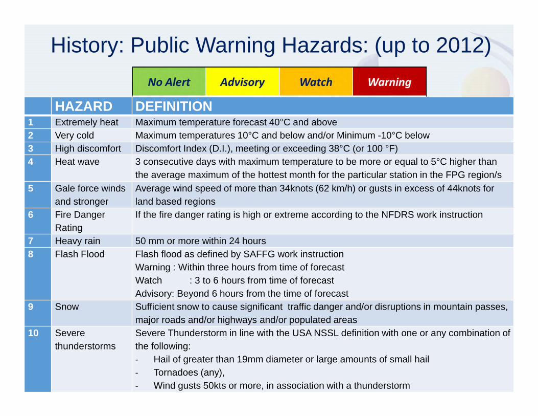
HAZARD DEFINITION1 Extremely heat Maximum temperature forecast 40°C and above2 Very cold Maximum temperatures 10°C and below and/or Minimum -10°C below3 High discomfort Discomfort Index (D.I.), meeting or exceeding 38°C (or 100 °F)4 Heat wave 3 consecutive days with maximum temperature to be more or equal to 5°C higher than

the average maximum of the hottest month for the particular station in the FPG region/s 5 Gale force winds

and strongerAverage wind speed of more than 34knots (62 km/h) or gusts in excess of 44knots for land based regions

6 Fire Danger Rating

If the fire danger rating is high or extreme according to the NFDRS work instruction

7 Heavy rain 50 mm or more within 24 hours 8 Flash Flood Flash flood as defined by SAFFG work instruction

Warning : Within three hours from time of forecastWatch : 3 to 6 hours from time of forecastAdvisory: Beyond 6 hours from the time of forecast

9 Snow Sufficient snow to cause significant traffic danger and/or disruptions in mountain passes, major roads and/or highways and/or populated areas

10 Severethunderstorms

Severe Thunderstorm in line with the USA NSSL definition with one or any combination of the following:- Hail of greater than 19mm diameter or large amounts of small hail - Tornadoes (any), - Wind gusts 50kts or more, in association with a thunderstorm

2019/10/04 Templ ref: PPT-ISO-colour.001 Doc Ref no: 8

Severe Weather Warning Levels (from 2013):Reduced number of hazards to 7

No AlertSpecial Weather Advisory

Weather WatchWeather Warning

Be Aware! Be Prepared! Take Action!

Nohazardous weather expected

Early warning of potential hazardous weather

Weather conditions are likely to become hazardous

Hazard is already occurring or is imminent

2 to 6 days 1 to 3 days Next 24 hours

Intense large weather systemsExtreme heatHeat Waves Strong windsHighdiscomfort

Heavy rainDisruptive snowGalesHigh wavesSevere T/SFloodingVeldfireconditions

Heavy rainDisruptive snowGalesHigh wavesSevere T/SFloodingVeldfire conditions

2019/10/04 Templ ref: PPT-ISO-colour.001 Doc Ref no: 9

• >3 days

Special Weather Advisory

• 2-3 days

Watch

• 24 hours

Warning

‘Current’ Warning System

2019/10/04 Templ ref: PPT-ISO-colour.001 Doc Ref no: 10

‘Current’ Warning System

Hazard Alert Level Valid From (SAST) Valid To (SAST)Heavy rain Warning 22/03/18 06h00 22/03/18 23h00

is expected over the Gert Sibande District tomorrow.

Description: Flooding / Heavy RainFlooding occurs when water overflows its normal channels such as streams and storm water drains. It can occur with

prolonged period of rain, with continuous heavy falls or in the form of flash floods which are usually associated with

severe thunderstorms. Heavy rain may also result in river flooding causing damage downstream to areas that may receive

no rainfall at all during the flooding event.

Precautions: Flooding / Heavy RainIf possible stay indoors and off the roads, avoid crossing rivers and swollen streams where water is above your ankles. If

trapped in flooding in a vehicle, abandon it and climb to higher ground. In buildings, move valuables to a safe place above

the expected flood level. Switch off electricity at the supply point to the building. In rural areas protect/relocate animals

to a safe place on higher ground. Abandon your home immediately if evacuation is recommended, before access is cut off

by flood water. NEVER drive on a road covered by water. You do not know how deep it is or if the road has been washed

away. If the vehicle stalls, leave it immediately and seek higher ground. Be especially cautious at night when it's harder to

recognize flood dangers. Listen to the radio or TV for warnings and obey the instructions from disaster management

officers.

2019/10/04 Templ ref: PPT-ISO-colour.001 Doc Ref no: 11

‘Current’ Warning System

- Only information is that heavy rain is

expected

- Questions???

- What is heavy rain?

- 50mm in 24 hour period?

- Heavy downpour?

- Standard warning

- Not clear

2019/10/04 Templ ref: PPT-ISO-colour.001 Doc Ref no: 12

Moving from:

What the weather will be: (Meteorological thresholds)

- 50mm in 24 hours- 35 knot winds

What the weather will do: (Impact Warnings)- Roads flooded

- Communities cut off

To:

What is Impact-Based forecasting?

2019/10/04 Templ ref: PPT-ISO-colour.001 Doc Ref no: 13

Why the change?

General public survey (2016 and 2017)• Lack of understanding (Special Weather Advisory, Watch

and Warning)• Level of response required for each alert not known• Translations

2019/10/04 Templ ref: PPT-ISO-colour.001 Doc Ref no: 14

Subsequent SA Disaster Management Survey and meetings (in 2013)

• Challenge from Disaster Managers:�Clear requirement of matter-of-fact information, i.e

non-scientific and to the point – minimize need for complex interpretation

�The need for improving communication to users to enable their effective decision making

�“Just tell me what is going to happen, when, where and how serious it is”

2019/10/04 Templ ref: PPT-ISO-colour.001 Doc Ref no: 15

Variation in vulnerability across South Africa

Densely populated areas

Large open areas Large rural areas

Main cities

2019/10/04 Templ ref: PPT-ISO-colour.001 Doc Ref no: 16

SA: Country with large climatic diversity• Essentially a dry country: Rainfall vary from <100 to >1200 mm per year

• Summer severe convective rainfall over north-eastern two-thirds

• Tropical rainfall (tropical lows) Jan-Mar in north-eastern provinces

• Winter frontal weather over south-western parts

• Cut-off lows lead to many flooding events over southern half of country

- Winter frontal rainfall- Strong coastal wind

Winter snow

- Summer Severe Thunderstorms- Tropical rainfall systems

2019/10/04 17

Impact-based Severe Weather Warning System

Scenario 1: 23 Feb 2010

- Road breached - Several sheep drowned

Scenario 2:8 June 2011

- Hundreds displaced- Communities threatened- Severe damaged

2019/10/04 Templ ref: PPT-ISO-colour.001 Doc Ref no: 18

Why Impact-based forecasting in South Africa?

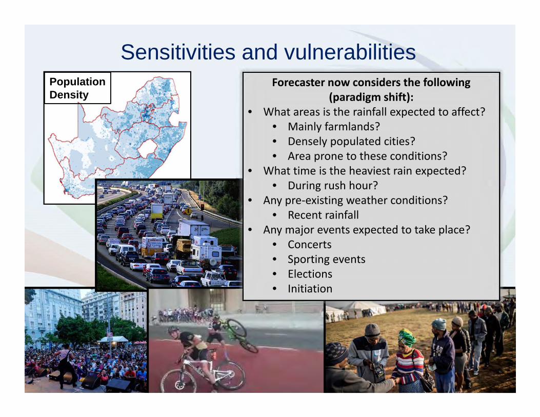
• Huge variation in vulnerability of communities across country (from densely populated cities, vast rural communities)

• Severe weather conditions leading to serious impacts in many places and limited impacts elsewhere

Impact-based Severe Weather Warning System

Requirement:�Need improved communication to users to enable their effective decision making�“Just tell me what is going to happen, when, where and how serious it is”

Involves a paradigm shift:•From weather threshold based warnings (50mm in 24hrs)•To warnings based on variations in vulnerability - impact levels and the likelihoodof those impacts to occur

2019/10/04 Templ ref: PPT-ISO-colour.001 Doc Ref no: 19

Current Warning: Heavy rain of more than 50mm in 24 hours is expected

We need to change from this to….

2019/10/04 Templ ref: PPT-ISO-colour.001 Doc Ref no: 20

Warning: 1. Orange warning for rain with a medium likelihood of significant impacts2. Yellow warning for rain with a high likelihood of minor impacts

1

2

An impact-based Early Warning System

1

2

4 Year Project: Developing an

Impact-Based Severe Weather Warning Service

• Aim: Based on WMO recommendations, to develop, test and implement an Impact-based forecasting and warning service in South Africa, through close collaboration between forecasters and disaster managers

• Associated projects and sponsors:

� SAWS and NDMC (Developing Impact-based SWWS)UK Newton Fund WP 4 (High Impact Weather)USAID/NOAA (Advancing IDSS in SA)

2019/10/04 Templ ref: PPT-ISO-colour.001 Doc Ref no: 22

Progress of ImpB SWWS in SA

OVERVIEW GANTT CHART: IMPACT-BASED SWWS (May 2018)

2015/16 2016/17 2017/18 2018/19

Activities Apr-Sep Oct-Mar Apr-Sep Oct-Mar Apr-Sep Oct-Mar Apr-Sep Oct-Mar

1 Project development

OUTCOME 1: Subjective decision making process

2 Develop Guidelines

3 Prototype test Phase (NFC and NDMC)

4 Summer Pilot Phase (all summer provinces) GT KZN,FS, etc

5 Winter Pilot Phase (WC, EC, KZN) WC, EC WC,EC,KZN

6 Community level stakeholder workshops (2:City and Rural) Jhb, EC

7 Public information and awareness campaigns

8 Operational implementation (preparation)

OUTCOME 2: Objective decision support system

10 Develop scientific DSS vs 1

11 Develop scientific DSS vs 2

General12 Wrap up workshop

13 Project conclusion

2019/10/04 Templ ref: PPT-ISO-colour.001 Doc Ref no: 23

• Prototype developed and tested (2016):

– Forecasting process developed and tested in

case studies

Risk Matrix

Progress of ImpB SWWS in SA

2019/10/04 Templ ref: PPT-ISO-colour.001 Doc Ref no: 24

Forecast Prototype Test Case study: 25 July 2016- Desktop case study

Impacts:

• 5 People died due to flooding

• Cars swept off bridges

• Houses and shops were

damaged due to floods as

well as wind

• Many passes closed due to

snow

Rainfall and Snow Data:

• Paddock, KZN: 351mm in 3

days

• Margate, KZN: 283mm in 3

days

• Tiffindell Ski Resort: Over 1m

snow

Airmass Image, 27 July

03:00 SAST

2019/10/04 Templ ref: PPT-ISO-colour.001 Doc Ref no: 25

Decision Making Process Development

• Prototype developed and tested (2016):

– Forecasting process developed and tested in

case studies

• Stakeholder Workshops

– Covering each of the provinces

– Disaster managers from each District

– Introduce the concept of ImpB SWWS

– Develop and update Impact tables, using their

experience

– Agree on co-ordination mechanisms during pilot

phases

Risk Matrix

2019/10/04 Templ ref: PPT-ISO-colour.001 Doc Ref no: 26

Progress of ImpB SWWS in SAStakeholder Workshops:

• Gauteng (December 2016)

• Western Cape (May 2017)

• Free State, Northern Cape and North West (August 2017)

• KwaZulu-Natal (October 2017)

• Limpopo and Mpumalanga (January 2018)

• Marine Workshop (March 2018)

• Eastern Cape (November 2018)

2019/10/04 Templ ref: PPT-ISO-colour.001 Doc Ref no: 27

Progress of ImpB SWWS in SA

“Other” Stakeholder Workshops:

• Gauteng Outreach Workshop (January

2019)

• Eastern Cape Outreach Workshop

(February 2019)

• Media Workshop (April 2019)

2019/10/04 Templ ref: PPT-ISO-colour.001 Doc Ref no: 28

• Prototype developed and tested (2016):

– Forecasting process developed and tested in

case studies

• Stakeholder Workshops

– Covering each of the provinces

– Disaster managers from each District

– Introduce the concept of ImpB SWWS

– Develop and update Impact tables, using their

experience

– Agree on co-ordination mechanisms during pilot

phases

• Forecaster Training

– Train all forecasters around the country for the

paradigm shift

Risk Matrix

Progress of ImpB SWWS in SA

2019/10/04 Templ ref: PPT-ISO-colour.001 Doc Ref no: 29

• Prototype developed and tested (2016):

– Forecasting process developed and tested in

case studies

• Stakeholder Workshops

– Covering each of the provinces

– Disaster managers from each District

– Introduce the concept of ImpB SWWS

– Develop and update Impact tables, using their

experience

– Agree on co-ordination mechanisms during pilot

phases

• Forecaster Training

– Train all forecasters around the country for the

paradigm shift

• Pilot phases

– Started with one province at a time

– Targeted provinces according to season

Risk Matrix

Progress of ImpB SWWS in SA

2019/10/04 Templ ref: PPT-ISO-colour.001 Doc Ref no: 30

Progress of ImpB SWWS in SA

Pilot phases:

• 2017 Summer Pilot

• 2017 Winter Pilot

• 2017/2018 Summer

• 2018 Winter

• 2018/2019 country-wide

• Present events during pilot phases

• Feedback of events (forecaster)

• Conduct Surveys assess SWWS

• Discuss co-ordination

2019/10/04 Templ ref: PPT-ISO-colour.001 Doc Ref no: 31

Progress of ImpB SWWS in SA- Washout Workshops

How does it work operationally?

1. Forecaster analyses the current and

expected weather conditions

2. Compiles a forecast

3. Considers possible sensitivities and

vulnerabilities

4. Using Impact tables, decides on possible

impact level

5. Contacts disaster manager

6. Issues ImpB weather warnings

7. Verifies and evaluates the impacts with

disaster managers and media reports

2019/10/04 Templ ref: PPT-ISO-colour.001 Doc Ref no: 33

Forecaster analyses models

2019/10/04 Templ ref: PPT-ISO-colour.001 Doc Ref no: 34

Compiles a forecast

Nil

30%

60%

80%

Rainfall chart for tomorrow

Population Density

Sensitivities and vulnerabilitiesForecaster now considers the following

(paradigm shift):

• What areas is the rainfall expected to affect?

• Mainly farmlands?

• Densely populated cities?

• Area prone to these conditions?

• What time is the heaviest rain expected?

• During rush hour?

• Any pre-existing weather conditions?

• Recent rainfall

• Any major events expected to take place?

• Concerts

• Sporting events

• Elections

• Initiation

Rainfall Impact TableMinimal Minor Significant Severe

Business as usual

Localised

Business as usual

Localised

Short term strain on emergency

personnel

Widespread

Prolonged strain on emergency

personnel

• Some pooling of water

on roads or in

formal/informal

settlements

• Day to day activities not

disturbed

• Wet roads and reduced

visibility

• Minimal traffic

congestion

• Isolated mudslides and

rockfalls

• Localised flooding of susceptible

formal/informal settlements or

roads, low-lying areas and bridges

• Major roads affected but can be

used, increased travel times

• Difficult driving conditions on dirt

roads

• Minor motor vehicle accidents due

to slippery roads and/ reduced

visibility

• Closure of roads crossing low water

bridges

• Localised and short term disruption

to essential services (water,

electricity, hospitals, schools etc)

• Localised mudslides, rockfalls and

soil erosion

• Localised disruption due to

sinkholes/potholes/blocked drainage

systems

• Isolated cases of breakages of farm

dam walls

• Localised damage to mud-

based/make-shift houses/structures

• Localised disruption of access to

drinking water and damage to crops

• Flooding of roads and

settlements (formal and

informal)

• Danger to life (fast flowing

streams / deep water)

• Displacement of affected

communities

• Some communities temporarily

not accessible/cut-off

• Damage to property,

infrastructure, loss of livelihood

and livestock

• Major disruption of traffic flow

due to major roads being flooded

or closed

• Possible damage to roads and

bridges

• Disruption to essential services

(water, electricity, comms,

schools, etc)

• Mudslides rockfalls and soil

erosion

• Disruption due to

sinkholes/potholes/ blocked

drainage systems

• Isolated incidents of

communicable diseases

• Isolated cases of breakages of

informal/farm dam walls

• Damage to mud-based/make-

shift houses/structures

• Disruption of access to drinking

water and damage to crops

• Widespread flooding of roads and

settlements

• Danger to life (fast flowing streams

/ deep water)

• Large communities not

accessible/cut-off for a prolonged

period

• Widespread displacement of

affected communities

• Widespread damage to property,

buildings and loss of livelihoods

and livestock

• Widespread transport routes and

travel services severely affected

• Major roads and bridges damaged

or washed away

• Widespread, prolonged disruption

to essential services (water,

electricity, comms, schools, etc)

• Widespread mudslides, rockfalls

and soil erosion

• Long term disruption due to

sinkholes/potholes/ blocked

drainage systems

• Widespread incidents of

communicable diseases

• Breakage of dam walls

• Widespread damage to mud-

based/make-shift

houses/structures

• Widespread disruption of access to

drinking water and damage to

crops

Rainfall impact table

2019/10/04 Templ ref: PPT-ISO-colour.001 Doc Ref no: 38

Warning chart for tomorrow

Warning areaL

ikel

ihoo

dV

ery

low

to H

igh

X

Minimal to SevereImpact

• Localised flooding of

susceptible

formal/informal

settlements or roads,

low-lying areas and

bridges

• Major roads affected but

can be used, increased

travel times

• Minor motor vehicle

accidents due to slippery

roads and/ reduced

visibility

• Localised mudslides,

rockfalls and soil erosion

2019/10/04 Templ ref: PPT-ISO-colour.001 Doc Ref no: 39

Warning chart for tomorrow

Warning areaL

ikel

ihoo

dV

ery

low

to H

igh

X X

Minimal to SevereImpact

• Flooding of roads and

settlements (formal and

informal)

• Danger to life (fast

flowing streams / deep

water)

• Displacement of affected

communities

• Damage to property,

infrastructure, loss of

livelihood and livestock

• Major disruption of

traffic flow due to major

roads being flooded or

closed

• Mudslides rockfalls and

soil erosion

2019/10/04 Templ ref: PPT-ISO-colour.001 Doc Ref no: 40

Feedback and Evaluation

• Submission of situation reports (Disaster

Management)

• Media (on the ground evidence, aware of

hoaxes)

• General public (surveys, social media)

Evaluation of

warning

2019/10/04 Templ ref: PPT-ISO-colour.001 Doc Ref no: 41

1. NOT weather threshold based (50mm in 24hrs), but impact level based (Paradigm shift for forecasters)

2. Combining expected • impact level in an area, and • likelihood of impact occurring• = Warning Risk Level (G,Y,O,R)

3. Co-ordination with disaster management is important for orangeand red warnings

Main points to remember

2019/10/04 Templ ref: PPT-ISO-colour.001 Doc Ref no: 42

Future work

Objective decision support system• To support to forecasters and disaster

managers in warning decision making

• Based on • Objective hazard prediction systems, • GIS-based spatial vulnerability

information at regional and local levels

• Vulnerability data from disaster management particularly at local levels, weather information from SAWS

Total Vulnerability to flash floods based

on Mesozones

Integrated “end-to-end” EWS

Large Scale weather patterns

National, regional, local scale weather impacts

Community, “house” scale social impacts

SAWS monitoring weather &

initiate alerts

PDMCs, MDMCs impact

assessment

Coordination

Warnings issued:Yellow, orange, red

DM structures Media

Rural villages, informal settlements,

Communities

Cities, Towns

Impact-B

ased S

WW

SC

B E

WS

Dissemination platforms

Some Lessons learnt so far

• Start simple – focus on a few hazards with social impacts to disasters only (other sectors can follow later)

• Development and implementation through a phased approach

• Effective coordination between forecasters and disaster managers during a severe weather event is crucial and must be developed at the initial workshops and tuned in pilot test phases

• Importance of involving both forecaster and disaster manager to create dual ownership of warnings

• Need for preparation of effective, actionable, communication to general public in layman’sterminology when going operational

• Include the media once readyDoc Ref no: FCAST-PRE-2019 IBF Intro Honiara

2019

2019/10/04 Templ ref: PPT-ISO-colour.001 Doc Ref no: 46

Conclusion

• Good progress in the project to implement an Impact-based

SWWS in South Africa

� Partnership established between SAWS and NDMC

� Forecasting process developed and tested

� Buy-in of the forecasters

� Pilot phases completed across the country

� Involves disaster management stakeholders, SAWS, DMCs

(national, provincial, local)

� Very positive feedback from disaster managers

• Based on international developments

• It will change the EWS to into a user oriented

risk-based EWS, adapted for South African conditions

2019/10/04 Templ ref: PPT-ISO-colour.001 Doc Ref no: 47

“Alone we can do so little; together we can do so much”

Hellen Keller

Successful ImpB forecasting requires collaboration

with partners using their expertise, knowledge and

data


Recommended