20
UNIVERSITY OF MARYLAND Impact of Stream Channel Urbanization on Dissolved O 2 Concentrations Tess Van Orden November 21, 2011 Senior Thesis 394 Advised by: Dr. Sujay Kaushal
UNIVERSITYOFMARYLAND
Impact of Stream Channel Urbanization on Dissolved
O2 Concentrations Tess Van Orden
November 21, 2011
Senior Thesis 394 Advised by: Dr. Sujay Kaushal
2
Table of Contents Page
ABSTRACT 3
INTRODUCTION 2
STUDY AREA 6
METHODS 10
RESULTS AND DISCUSSION 13
CONCLUSION 16
ACKNOWLEDGEMENTS 16
REFERENCES 17

3
Abstract
Dissolved oxygen concentrations in freshwater streams is an important regulator of ecosystem processes and an indicator of stream health. This study investigates the impacts of urbanization and temperature on dissolved oxygen fluctuations in streams. Field measurements, laboratory experiments, and statistical analysis of dissolved oxygen, land use and temperature were evaluated in eight streams of the Gwynns Falls and Anacostia watersheds along an urban to rural gradient. Temperature and dissolved oxygen measurements were taken from 8 long-term monitoring sites (5 Baltimore Long Term Ecological Research sites and 3 Anacostia branch sites monitored by the U.S. Geological Survey) in order to characterize fluctuations in dissolved oxygen influenced by changes in land use and temperature. Laboratory experiments were conducted to evaluate changes in 5-day biological oxygen demand (BOD) in 3 different temperatures (5°, 15°, and 20° Celsius) and across land use by using a temperature controlled incubator. Data collected from incubations, in situ temperature and land use underwent ANOVA multivariable tests and Pearson correlation. BOD typically increased with increasing temperature and varied with land use. There was a strong correlation between BOD in urban streams and forested streams at incubation temperatures between 15° and 20° Celsius. These characteristics of BOD dependence on temperature and land use are demonstrated to impact seasonal dynamics of dissolved oxygen.
______________________________________________________________________
Introduction Urbanization is a rapidly growing form of land use change, second to agriculture in its extensive total area globally (UN Population Division, 1997; US Census Bureau, 2001). Although it only consumes 2% of the earth surface, its ecological footprint is significant (Folke et al., 1997; Paul and Meyer, 2001); over 130,000 km of streams and rivers in the United States are impaired by urbanization, meaning streams do not meet EPA water quality standards for intended use (USEPA, 2000). Given forecasted patterns in urbanization, the extent of stream degradation in watersheds will likely increase globally (Paul and Meyer, 2001; Walsh et al., 2005; Kaushal et al., 2005) and it is expected that more than 60% of the world population will live in urbanized areas by 2030 (UN Population Division, 1997).
A main concern of urbanization is the hydrological response to an increase of impervious area within watersheds and streams including paved terrain and concreted drainage channels (Dunne and Leopold, 1978; Imbe et al., 1997; Finkenbine et al., 2000; Lee and Bang, 2000; Bledsoe and Watson, 2001; Rose and Peters, 2001; Brezonik and Stadelmann, 2002; Schoonover et al, 2005). Increased imperious area decreases surface water infiltration into soils resulting in frequent, volumous storm events (Hirsch et al., 1990 and Schoonover et al., 2005). In order to accommodate the
4
increase in flow, streams experience geomorphological changes through high erosion rates (Arnold et al., 1982; Gregory et al., 1992). These changes lead to increased sediment loads, toxic trace elements, nutrients and biotic activity (Walling and Gregory, 1970; Waller and Hart, 1986; Wahl et al., 1997; Hunter et al., 1979; Norman, 1991; Callender and Rice, 2000; Emmerth and Bayne, 1996; Herlihy et al., 1998; Lee and Bang, 2000; Rose, 2002; Gregory and Frick, 2000; Schoonover et al., 2005). Although a growing body of work focuses on the effects of urbanization on streams, less is known regarding how global warming and stream channel alteration will interact to influence biogeochemical processes and cycles.
I hypothesize that biological oxygen demand will decrease with an increase in temperature and increase in watershed land use. Conversely, I hypothesize that biological oxygen demand will increase with a decrease in temperature and decrease in watershed land use. In this study, a statistical approach has been taken to assess the influence of land use on biological oxygen demand (BOD) and temperature. Due to microbial respiration and elevated temperatures, dissolved oxygen (DO) concentrations fluctuate in a rapid manner and reach levels which are inhospitable to stream ecosystems. It is possible to analyze the significance of the relationship between temperature and land use and how these factors relate to biological activity through BOD.
Biological Controls on Dissolved Oxygen The general water quality of a stream can be inferred from the concentration of DO in the system (Alexander and Stefan, 1983 and Wang et al, 2003). The fluctuation of DO which a stream experiences can be attributed to physical, chemical and biogeochemical processes which are regulated by heterotrophic microbial communities and autotrophs. Previous research has shown that land use has a strong influence on stream chemistry and its biological components (Peierls et al., 1991; Hunsaker and Levine, 1995; Puckett, 1995; Howarth et al., 1996; Allan et al., 1997; Allan and Flecker, 1993; Richards et al., 1996; Ometo et al. 2000). If urbanization can alter the primary source of organic matter in a stream system, urbanization may change the dynamics of DO in stream systems. In stream communities, organisms rely on two sources of organic matter for survival: terrestrial material transported from upstream and material fixed within the channel (Kaushik and Hynes, 1971; Minshall, 1978; Young and Huryn, 1999). Land use within a stream’s drainage area can alter the source and relative importance of organic matter in a stream (Wilcock, 1986; Quinn et al., 1992; Young and Huryn, 1999). For example, deforestation can change the type and frequency of leaf litter input in a stream, changing the seasonal availability of organic matter due to differing plant inputs and decomposition rates (Delong and Brusven, 1994; Webster and Benfield, 1986; Cummins et al., 1989). Additionally, the resulting increase in sunlight penetration will increase primary productivity (Feminella et al., 1989; Young and Huryn, 1999). Land development also increases primary productivity, as nutrients and sediments are washed from construction and barren sites into streams (Malthus and Mitchell, 1988; Smith, 1989). However, changes in bedload, sediment metal accumulation, and turbidity due to storms can limit growth and reduce local microbial communities. Thus, urbanization may result in rapidly changing DO concentrations as microbial
5
communities appear and disappear due to changes in nutrients and sunlight and heterotrophic microbial consumption of organic matter and conversion to carbon dioxide.
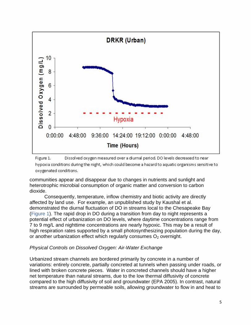
Consequently, temperature, inflow chemistry and biotic activity are directly affected by land use. For example, an unpublished study by Kaushal et al. demonstrated the diurnal fluctuation of DO in streams local to the Chesapeake Bay (Figure 1). The rapid drop in DO during a transition from day to night represents a potential effect of urbanization on DO levels, where daytime concentrations range from 7 to 9 mg/L and nighttime concentrations are nearly hypoxic. This may be a result of high respiration rates supported by a small photosynthesizing population during the day, or another urbanization effect which regularly consumes O2 overnight.
Physical Controls on Dissolved Oxygen: Air-Water Exchange Urbanized stream channels are bordered primarily by concrete in a number of variations: entirely concrete, partially concreted at tunnels when passing under roads, or lined with broken concrete pieces. Water in concreted channels should have a higher net temperature than natural streams, due to the low thermal diffusivity of concrete compared to the high diffusivity of soil and groundwater (EPA 2005). In contrast, natural streams are surrounded by permeable soils, allowing groundwater to flow in and heat to
6
be diffused evenly to surrounding materials. Overall, temperatures should be lower in natural streams and higher in urbanized streams. Thus, the temperature difference produced by urban heat island effects in nearby water bodies should influence oxygen’s aqueous solubility.
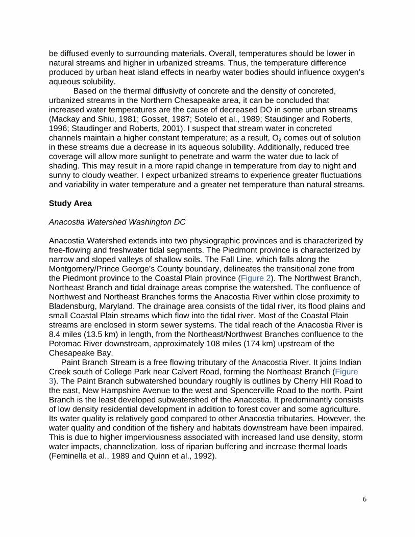
Based on the thermal diffusivity of concrete and the density of concreted, urbanized streams in the Northern Chesapeake area, it can be concluded that increased water temperatures are the cause of decreased DO in some urban streams (Mackay and Shiu, 1981; Gosset, 1987; Sotelo et al., 1989; Staudinger and Roberts, 1996; Staudinger and Roberts, 2001). I suspect that stream water in concreted channels maintain a higher constant temperature; as a result, O2 comes out of solution in these streams due a decrease in its aqueous solubility. Additionally, reduced tree coverage will allow more sunlight to penetrate and warm the water due to lack of shading. This may result in a more rapid change in temperature from day to night and sunny to cloudy weather. I expect urbanized streams to experience greater fluctuations and variability in water temperature and a greater net temperature than natural streams. Study Area Anacostia Watershed Washington DC Anacostia Watershed extends into two physiographic provinces and is characterized by free-flowing and freshwater tidal segments. The Piedmont province is characterized by narrow and sloped valleys of shallow soils. The Fall Line, which falls along the Montgomery/Prince George’s County boundary, delineates the transitional zone from the Piedmont province to the Coastal Plain province (Figure 2). The Northwest Branch, Northeast Branch and tidal drainage areas comprise the watershed. The confluence of Northwest and Northeast Branches forms the Anacostia River within close proximity to Bladensburg, Maryland. The drainage area consists of the tidal river, its flood plains and small Coastal Plain streams which flow into the tidal river. Most of the Coastal Plain streams are enclosed in storm sewer systems. The tidal reach of the Anacostia River is 8.4 miles (13.5 km) in length, from the Northeast/Northwest Branches confluence to the Potomac River downstream, approximately 108 miles (174 km) upstream of the Chesapeake Bay.
Paint Branch Stream is a free flowing tributary of the Anacostia River. It joins Indian Creek south of College Park near Calvert Road, forming the Northeast Branch (Figure 3). The Paint Branch subwatershed boundary roughly is outlines by Cherry Hill Road to the east, New Hampshire Avenue to the west and Spencerville Road to the north. Paint Branch is the least developed subwatershed of the Anacostia. It predominantly consists of low density residential development in addition to forest cover and some agriculture. Its water quality is relatively good compared to other Anacostia tributaries. However, the water quality and condition of the fishery and habitats downstream have been impaired. This is due to higher imperviousness associated with increased land use density, storm water impacts, channelization, loss of riparian buffering and increase thermal loads (Feminella et al., 1989 and Quinn et al., 1992).
7
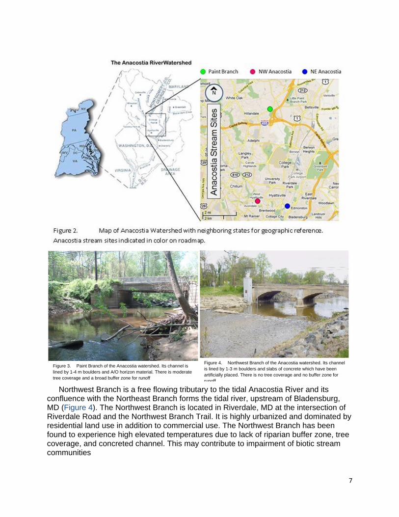
Northwest Branch is a free flowing tributary to the tidal Anacostia River and its
confluence with the Northeast Branch forms the tidal river, upstream of Bladensburg, MD (Figure 4). The Northwest Branch is located in Riverdale, MD at the intersection of Riverdale Road and the Northwest Branch Trail. It is highly urbanized and dominated by residential land use in addition to commercial use. The Northwest Branch has been found to experience high elevated temperatures due to lack of riparian buffer zone, tree coverage, and concreted channel. This may contribute to impairment of biotic stream communities
Figure 3. Paint Branch of the Anacostia watershed. Its channel is lined by 1-4 m boulders and A/O horizon material. There is moderate tree coverage and a broad buffer zone for runoff
Figure 4. Northwest Branch of the Anacostia watershed. Its channel is lined by 1-3 m boulders and slabs of concrete which have been artificially placed. There is no tree coverage and no buffer zone for runoff
8
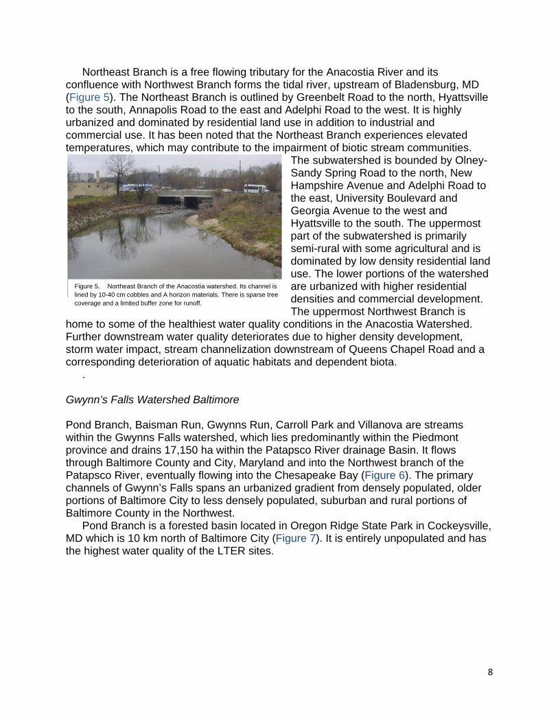
Northeast Branch is a free flowing tributary for the Anacostia River and its confluence with Northwest Branch forms the tidal river, upstream of Bladensburg, MD (Figure 5). The Northeast Branch is outlined by Greenbelt Road to the north, Hyattsville to the south, Annapolis Road to the east and Adelphi Road to the west. It is highly urbanized and dominated by residential land use in addition to industrial and commercial use. It has been noted that the Northeast Branch experiences elevated temperatures, which may contribute to the impairment of biotic stream communities.
The subwatershed is bounded by Olney-Sandy Spring Road to the north, New Hampshire Avenue and Adelphi Road to the east, University Boulevard and Georgia Avenue to the west and Hyattsville to the south. The uppermost part of the subwatershed is primarily semi-rural with some agricultural and is dominated by low density residential land use. The lower portions of the watershed are urbanized with higher residential densities and commercial development. The uppermost Northwest Branch is
home to some of the healthiest water quality conditions in the Anacostia Watershed. Further downstream water quality deteriorates due to higher density development, storm water impact, stream channelization downstream of Queens Chapel Road and a corresponding deterioration of aquatic habitats and dependent biota.
. Gwynn’s Falls Watershed Baltimore Pond Branch, Baisman Run, Gwynns Run, Carroll Park and Villanova are streams within the Gwynns Falls watershed, which lies predominantly within the Piedmont province and drains 17,150 ha within the Patapsco River drainage Basin. It flows through Baltimore County and City, Maryland and into the Northwest branch of the Patapsco River, eventually flowing into the Chesapeake Bay (Figure 6). The primary channels of Gwynn’s Falls spans an urbanized gradient from densely populated, older portions of Baltimore City to less densely populated, suburban and rural portions of Baltimore County in the Northwest.
Pond Branch is a forested basin located in Oregon Ridge State Park in Cockeysville, MD which is 10 km north of Baltimore City (Figure 7). It is entirely unpopulated and has the highest water quality of the LTER sites.
Figure 5. Northeast Branch of the Anacostia watershed. Its channel is lined by 10-40 cm cobbles and A horizon materials. There is sparse tree coverage and a limited buffer zone for runoff.

9
Baisman Run is located within the Oregon Ridge Park, near Ivy Hill Road (Figure 8).
It drains from forested landscape and unpolluted residential land into its headwaters. Stream flow at the gauge site is controlled by a concrete barrier, on the upstream side of the Ivy Hill Road Bridge.
Gwynns Run is located at the Carroll Park Municipal Golf Course, upstream from the bridge on Washington Blvd. and northwest of Morrell Park (Figure 9). Gwynns Run converges into Gwynns Falls less than 100 m upstream of the Carroll Park collection site. Over 99% of the stream is subsurface to the city, while ~100 m are above ground, downstream from Baltimore City. As a result, the stream receives substantial runoff from high-density land use; urban housing, commercial, and industrial sources. Carroll Park is located within the Carroll Park Municipal Golf course in Baltimore City and is bordered by Washington Boulevard near Exit 51 off I-95 (Figure 10). The stream drains from approximately 16,000 ha of suburban and urban development and its gauge is located a few yards from the Gwynn’s Falls trailhead.
Villanova is located inside the I-695 beltway, near the Baltimore City/County border. It drains from approximately 7400 ha of developed land and is monitored by a gauge located 300 ft east of the Liberty Road and Essex Road intersection (Figure 11).

10
Methods This study was broken up into two parts: sampling/experimentation and statistical analysis. In the first step, water samples were collected from 8 stream sites, three from the Anacostia Watershed and five from the Gwynn’s Falls Watershed. BOD incubations were conducted to produce data for multiple regression tests between land use, temperature and BOD. In the second step, incubation data were subjected to three ANOVA tests with long term temperatures and land use indices for the sampling sites.
.
Figure 7. Pond Branch of the Gwynns Falls watershed. Its channel is lined by 1-2 m boulders and A/O horizon material. There is moderate tree coverage and a broad buffer zone for runoff.
Figure 8. Baisman Run of the Gwynns Falls watershed. Its channel is lined by 10 cm cobbles to 1 m boulders and A/O horizon material. There is dense tree coverage and a broad buffer zone for runoff.
Figure 9. Gwynns Run of the Gwynns Falls watershed. Its channel is lined by 1-4 m boulders and A/O horizon material. There is moderate tree coverage and a limited buffer zone. The stream suffers from sewage leaks, street runoff and litter from the city.
Figure 10. Carroll Park of the Gwynns Falls watershed. Its channel is lined by rough vegetation and 10 to 40 cm cobbles which have been artificially placed. There is no buffer zone and sparse bridge coverage.
Figure 11. Villanova of the Gwynns Falls watershed. Its channel is lined by 1-4 m boulders and A/O horizon. There is dense tree coverage and a broad buffer zone for runoff.

11
Water Collection and BOD incubations Samples, temperature, pH and DO were taken from each site in single-day collections by watershed; Gwynn’s Falls from July to September (7/31, 8/14, and 9/4) and Anacostia from September to October (9/23, 10/25, and 10/29) in 2011. This sampling period coincides with the peak and recession of stream metabolism. Water samples were collected using the grab sampling technique and data was obtained from laboratory experiments, USGS, and Baltimore Ecological Study sources. The method of collection and incubation is a standard BOD analysis method set forth by the EPA. Sampling locations were identified as USGS site stations which are marked by sampling stations, described by the USGS with coordinates and are consistently used by the BES and LTER for research. These stations are mid- stream rather than at junctions or mouths of tributaries in order to sample whole-stream metabolism rather than tributary contribution. Glass bottles, black out to prevent photosynthesis, were used as incubation bottles, rinsed with liquinox then deionized water in the lab, prior to sampling. Bottles were then rinsed with stream water, filled and capped underwater for a water-tight seal for grab sampling. Samples were collected upstream of other study activity in the stream to prevent risk of contamination by stream disturbance (Lurry and Kolbe, 2000). Three collections and incubations were conducted for each of the watershed locations. Three bottles were collected per experiment for the Gwynn’s Falls Watershed (15 samples total) and six were collected per experiment for the Anacostia Watershed (18 samples total). Collection times were recorded and samples were placed on ice into returned to the lab for incubation. Initial DO and temperature measurements were made prior to experiment designation and incubation; time was noted at the time of measurement and placement in experimental temperature environments. The samples were incubated across three temperatures: 5° C, 10° C and 20° C (room temperature) for five days. All samples were incubated in closed containers and in dark enclosures in order to prevent excess interaction with the surrounding environment and isolate the metabolic activity which takes place within the bottles. Bottles were removed at 4.5 days into the experiment, time noted, and allowed to acclimate to room temperature for final DO and temperature measurement.
A laboratory refrigerated room in the Biochemistry building at University of Maryland was used for the 5° C environment, Fisher Scientific Isotemp Undercounter Refrigerated Incubator was used for the 15° C temperature environment, and an empty drawer monitored with a thermometer was used for the 20° C environment. The Isotemp Incubatory range of capability is -10° to 60° C, precision is ±0.2° C and uniformity is ±1° C. A Global Water Instrumentation, Inc. OXI 1970i Portable Dissolved Oxygen Meter was used for field and laboratory measurements. Its range of capability is ±0.1° C and ±0.5% DO at ambient temperature of 5° to 30° C after independently calibrated at room conditions. The historical temperature data collected from the Gwynn’s Falls sites were collected during similar field visits, over intervals from 2008 to present, where samples were collected for stream chemistry then measurements were made with the same instrumentation.
12
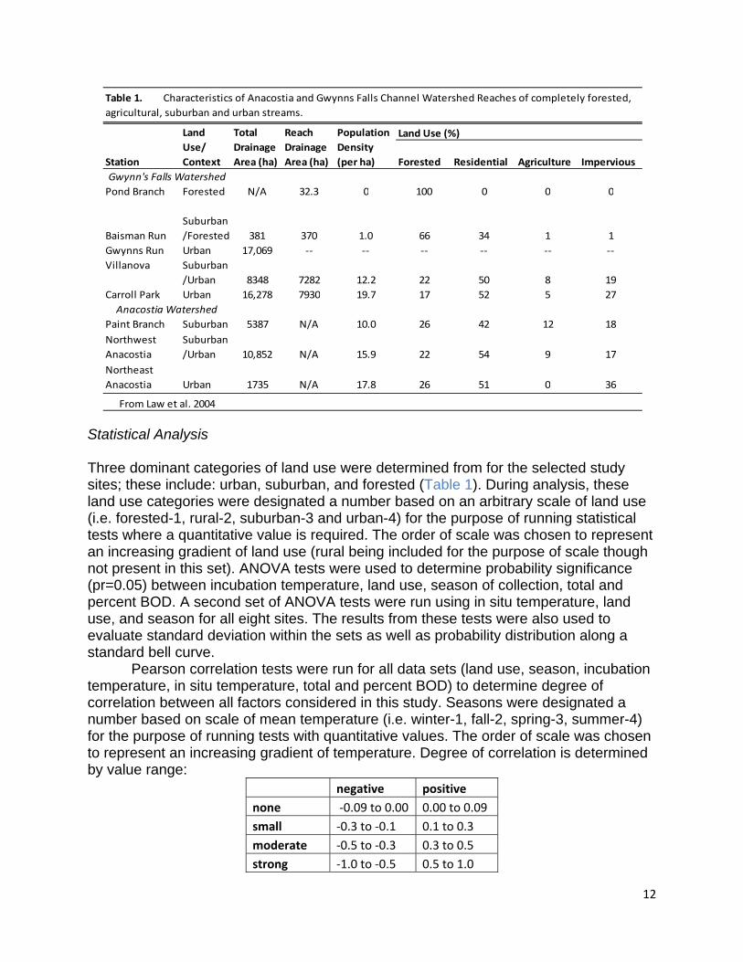
Statistical Analysis Three dominant categories of land use were determined from for the selected study sites; these include: urban, suburban, and forested (Table 1). During analysis, these land use categories were designated a number based on an arbitrary scale of land use (i.e. forested-1, rural-2, suburban-3 and urban-4) for the purpose of running statistical tests where a quantitative value is required. The order of scale was chosen to represent an increasing gradient of land use (rural being included for the purpose of scale though not present in this set). ANOVA tests were used to determine probability significance (pr=0.05) between incubation temperature, land use, season of collection, total and percent BOD. A second set of ANOVA tests were run using in situ temperature, land use, and season for all eight sites. The results from these tests were also used to evaluate standard deviation within the sets as well as probability distribution along a standard bell curve. Pearson correlation tests were run for all data sets (land use, season, incubation temperature, in situ temperature, total and percent BOD) to determine degree of correlation between all factors considered in this study. Seasons were designated a number based on scale of mean temperature (i.e. winter-1, fall-2, spring-3, summer-4) for the purpose of running tests with quantitative values. The order of scale was chosen to represent an increasing gradient of temperature. Degree of correlation is determined by value range:
negative positive
none ‐0.09 to 0.00 0.00 to 0.09
small ‐0.3 to ‐0.1 0.1 to 0.3
moderate ‐0.5 to ‐0.3 0.3 to 0.5
strong ‐1.0 to ‐0.5 0.5 to 1.0
Land Use (%)
Forested Residential Agriculture Impervious
Pond Branch Forested N/A 32.3 0 100 0 0 0
Baisman Run
Suburban
/Forested 381 370 1.0 66 34 1 1
Gwynns Run Urban 17,069 ‐‐ ‐‐ ‐‐ ‐‐ ‐‐ ‐‐
Villanova Suburban
/Urban 8348 7282 12.2 22 50 8 19
Carroll Park Urban 16,278 7930 19.7 17 52 5 27
Paint Branch Suburban 5387 N/A 10.0 26 42 12 18
Northwest
Anacostia
Suburban
/Urban 10,852 N/A 15.9 22 54 9 17
Northeast
Anacostia Urban 1735 N/A 17.8 26 51 0 36
From Law et al. 2004
Table 1. Characteristics of Anacostia and Gwynns Falls Channel Watershed Reaches of completely forested,
agricultural, suburban and urban streams.
Gwynn's Falls Watershed
Anacostia Watershed
Station
Land
Use/
Context
Total
Drainage
Area (ha)
Population
Density
(per ha)
Reach
Drainage
Area (ha)

13
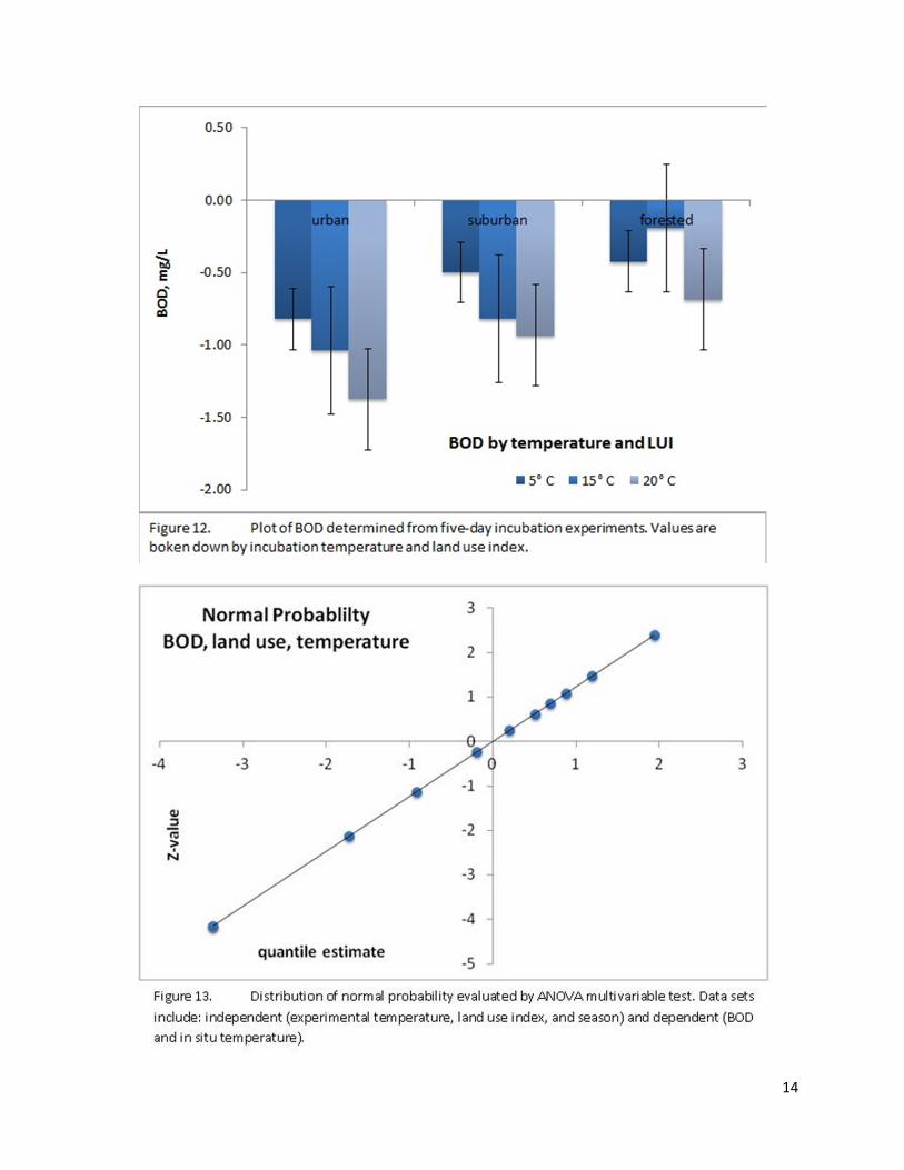
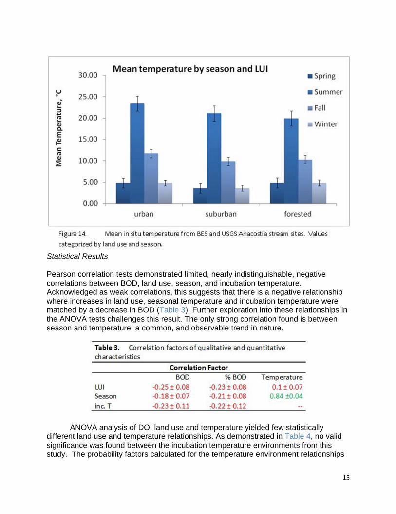
ANOVA performs analysis of variance in a balanced data set where a (quantitative) dependent variable is measured under conditions determined by two (quantitative/qualitative) independent variables. The variation response is concluded to be a result of interaction with the independent variables and considering random error for outliers. The Pearson correlation test measures values from two data sets against each other to produce a coefficient between -1 and +1, describing the extent to which two measured variables change together. This value range is independent of the units of the tested variables. Sign of the coefficient denotes whether the correlation is positive or negative. SAS Version 9.3 and Excel 2010 were used to run tests and perform statistical calculations. Results and Discussion Experimental Results All incubations yielded a loss of DO ranging from 0.2 mg/L to 1.4 mg/L ±0.4 mg/L in the greatest range of uncertainty (Figure 12). Urban streams experience a higher rate of BOD over the incubation period followed by suburban then forested sites. All sites experienced higher BOD in the 20°C temperature environment and the least consumption at 5° C. BOD in the 15° environment fell between 20° and 5° C in the suburban and urban sites, however, the forested site did not demonstrate similar behavior, falling below the BOD rate at 5° C. The range of error on this temperature/land use characteristic suggests it is possible the 15° C environment for the forested site may follow behavior of the suburban and urban 15° C environments or it may fall farther out of the trend. The overall ranges of error in this figure indicate the urban sites experience overall higher BOD than the forested site with little overlap. The suburban site falls within the overlap range and cannot be concluded as diagnostically different, only a transitional range between the two extreme endpoints. An even, standard distribution of experimental data was confirmed by a normal probability plot (Figure 13).
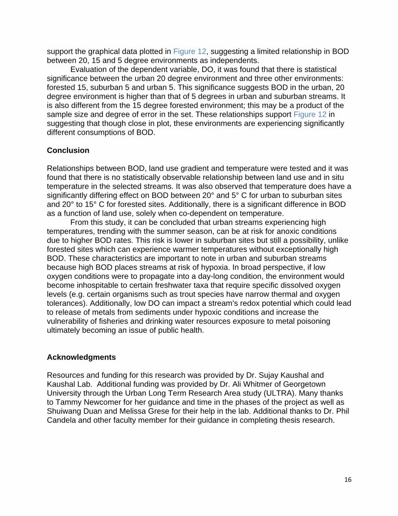
Mean in situ temperatures experienced between the urban, suburban and
forested streams are not greatly different during the same season as demonstrated in Figure 14. Although there is a slight decreasing trend from the urban to forested sites, the overlap in error prevents the sited from being truly distinguished by land use. The level of distinction in mean temperatures between the seasons is greater and does not overlap by error. The streams experienced highest temperatures in the summer and lowest in the winter with fall delving into cooler temperatures and spring in higher temperatures (Table 2).
14
15
Statistical Results Pearson correlation tests demonstrated limited, nearly indistinguishable, negative correlations between BOD, land use, season, and incubation temperature. Acknowledged as weak correlations, this suggests that there is a negative relationship where increases in land use, seasonal temperature and incubation temperature were matched by a decrease in BOD (Table 3). Further exploration into these relationships in the ANOVA tests challenges this result. The only strong correlation found is between season and temperature; a common, and observable trend in nature.
ANOVA analysis of DO, land use and temperature yielded few statistically different land use and temperature relationships. As demonstrated in Table 4, no valid significance was found between the incubation temperature environments from this study. The probability factors calculated for the temperature environment relationships
16
support the graphical data plotted in Figure 12, suggesting a limited relationship in BOD between 20, 15 and 5 degree environments as independents. Evaluation of the dependent variable, DO, it was found that there is statistical significance between the urban 20 degree environment and three other environments: forested 15, suburban 5 and urban 5. This significance suggests BOD in the urban, 20 degree environment is higher than that of 5 degrees in urban and suburban streams. It is also different from the 15 degree forested environment; this may be a product of the sample size and degree of error in the set. These relationships support Figure 12 in suggesting that though close in plot, these environments are experiencing significantly different consumptions of BOD. Conclusion Relationships between BOD, land use gradient and temperature were tested and it was found that there is no statistically observable relationship between land use and in situ temperature in the selected streams. It was also observed that temperature does have a significantly differing effect on BOD between 20° and 5° C for urban to suburban sites and 20° to 15° C for forested sites. Additionally, there is a significant difference in BOD as a function of land use, solely when co-dependent on temperature.
From this study, it can be concluded that urban streams experiencing high temperatures, trending with the summer season, can be at risk for anoxic conditions due to higher BOD rates. This risk is lower in suburban sites but still a possibility, unlike forested sites which can experience warmer temperatures without exceptionally high BOD. These characteristics are important to note in urban and suburban streams because high BOD places streams at risk of hypoxia. In broad perspective, if low oxygen conditions were to propagate into a day-long condition, the environment would become inhospitable to certain freshwater taxa that require specific dissolved oxygen levels (e.g. certain organisms such as trout species have narrow thermal and oxygen tolerances). Additionally, low DO can impact a stream’s redox potential which could lead to release of metals from sediments under hypoxic conditions and increase the vulnerability of fisheries and drinking water resources exposure to metal poisoning ultimately becoming an issue of public health. Acknowledgments Resources and funding for this research was provided by Dr. Sujay Kaushal and Kaushal Lab. Additional funding was provided by Dr. Ali Whitmer of Georgetown University through the Urban Long Term Research Area study (ULTRA). Many thanks to Tammy Newcomer for her guidance and time in the phases of the project as well as Shuiwang Duan and Melissa Grese for their help in the lab. Additional thanks to Dr. Phil Candela and other faculty member for their guidance in completing thesis research.
17
References Alexander, C.D. and Stefan, H.G. 1983. Model of Mississippi river pool dissolved
oxygen. J. Enviro. Engrg. ASCE. 109(5):1020-1036. Allan, J.D., Erickson, D.L. and Fay, J. 1997. The influence of catchment land use on
stream integrity acoss multiple spatial scales. Freshwater Biology. 37:149-161. Allan, J.D., and Flecker, A.S. 1993. Biodiversity conservation in running waters.
BioScience. 43:32-43. Arnold, C., Boison, P. and Patton, P. 1982. Sawmills Brook: An example of rapid
geomorphic change related to urbanization. Journal of Geology. 90:155-166. Bledsoe, B.P. and C.C. Watson. 2001. Effects of Urbanization on Channel Instability.
Journal of the American Water Resources Association 37(2):255-270. Brezonik, P.L. and Stadelmann, T.H. 2002. Analysis and predictive models of
stormwater runoff volumes, loads, and pollutant concentrations from watersheds in the Twin Cities metropolitan area, Minnesota, USA. Water Research. 36:1743-1757.
Butcher, J.B. and Covington, S. 1995. Dissolved oxygen analysis with temperature dependence. J. Enviro. Engrg. ASCE 121(10):756-759.
Callender, E. and Rice, K.C. 2000. The urban environmental gradient:anthropogenic influences on the spatial and temporal distributions of lead and zinc in sediments. Environmental Scienc and Technology. 34:232-238.
Chadhury, R.R., Sobrinho, J.A.H., Wright, R.M., Sreenivas, M. 1998. Dissolved oxygen modeling of the Blackstone River (northeastern US). Water Research. 32(8):2400-2412.
Cummins, K.W. 1974. Structure and function of stream ecosystems. BioScience. 24(11):631-641.
Cummins, K.W., Wilzbach, M.A., Gates, D.M., Perry, J.B., Taliaferro, W.B. 1989. Shredders and riparian vegetation. BioScience. 39:24-30.
Delong, M.D. and Brusven, M.A. 1994. Allochthonous input of organic matter from different habitats of an agriculturally impacted stream. Environmental Management. 18:59-71.
Dunne, T. and Leopold, L.B. 1978. Water in Environmental Planning. New York, Freeman. pp. 818.
Edwards. R.W., Duffield, A.N., Marshell, E.J. 1978. Estimates of community metabolism of drainage channels from oxygen distributions. Proceedings of the EWRS Fifth Symposium on Aquatic Weeds.
Emmerth, P.P. and Bayne, D.R. 1996. Urban influence on phosphorous and sediment loading of West Point Lake Georgia. Water Resources Bulletin. 32:145-154.
Feminella, J.W., Power, M.E., Resh, V.H. 1989. Periphyton responses to invertebrate grazing and riparian canopy in three northern California coastal streams. Freshwater Biology. 22:445-457.
Finkenbine, J.K., Atwater, J.W. and Mavinic, D.S. 2000. Stream health after urbanization. Journal of the American Water Resources Association. 35:1149-1160.
Folke, C., Jansson, A., Larsson, J., Costanza, R. 1997. Ecosystem appropriation by cities. Ambio. 26:167-172.
Gosset, R.M. 1987. Measurement of Henry’s Law constants for C1 and C2 chlorinated hydrocarbons. Environ. Sci. Technology. 21:202-208.

18
Gregory, K., Davis, R. and Downs, P. 1992. Identification of river channel change due to urbanization. Applied Geography. 12:299-318.
Gregory, M.B. and Frickm E.A. 2000. Fecal-coliform bacteria concentrations in streams of the Chattahoochee River National Recreation Area, metropolitan Atlanta, Georgia, May-October 1994 and 1995. U.S. Geological Survey Water-Resources Investigations Report. 00-4139.
Gulliver, J. and Stefan, H.G. 1984a. Stream productivity analysis with DORM-I. Development of computational model. Water Res. 18(12):1569-1576.
Gulliver, J. and Stefan, H.G. 1984b. Stream productivity analysis with DORM-II. Parameter estimation and sensitivity. Water Res. 18(12)1577-1588.
Gulliver, J. and Stefan, H.G. 1984c. Stream productivity analysis with DORM-III. Productivity of experimental streams. Water Res. 18(12):1589-1595.
Herlihy, A.T., Stoddard, J.L. and Johnson, C.B. 1998. The relationship between stream chemistry and watershed land cover data in the mid-Atlantic region, US. Water, Air, and Soil Pollution. 105:377-386.
Hirsch, R.M., Walker, J.F., Day, J.C. and Kallio, R. 1990. The influence of man on hydrologic systems. In Surface Water Hydrology (The Geology of America, vol. 0-1, M.G. Wolman and H.C. Riggs (eds.). Boulder, CO, Geological Society of America, pp. 329-359.
Hornberger, G.M. and Kelly, M.G. 1972. The determination of primary production in a stream using an exact solution to the oxygen balance equation. Water Resour. Bull. 8(4):795-801.
Howarth, R.W., Billen, G., Swaney, D., Townsend, A., Jaworski, N., Lajtha, K., Downing, A., Elmsgree, R., Caraco, N., Jorden, T., Berendse, F., Freney, J., Kudeyarov, V., Murdoch, P. and Zhao-ling, Z. 1996. Regional nitrogen budgets and riverine N & P fluxes for the drainages to the North Atlantic Ocean: Natural and human influences. Biogeochemistry. 35:181-226.
Hunsaker, C.T. and Levine, D.A. 1995. Hierarchical approaches to the study of water quality in rivers. BioScience. 3:193-203.
Hunter, J.V., Sabatino, T., Gomperts, R. and Mackenzie, M.J. 1979. Contribution of urban runoff to hydrocarbon pollution. Journal of Water Pollution Control Federation, WEF. 51:2129-2138.
Imbe, M., Ohta, T. and Takano, N. 1997. Quantitative assessment of improvements in hydrological water cycle in urbanized river basin. Water Science and Technology. 36(8-9):219-222.
Kaushal, S.S., P.M. Groffman, G.E. Likens, K.T. Belt, W.P. Stack, V.R. Kelly, L.E. Band, G.T. Fisher. 2005. Increased salinization of fresh water in the northeastern U.S. Proceedings of the National Academy of Sciences. 102:13517-13520.
Kaushik, N.K. and Hynes, H.B.N. 1971. The fate of dead leaves that fall into streams. Arch. Hydrobiol. 68:465-515.
Kelly, M.G., Hornberger, G.M., Cosby, B.J. 1974. Continuous automated measurement of photosynthesis and respiration in an undisturbed river community. Limnol. Oceanogr. 19(2):305-312.
Law, N.L., Band, L.E., and Grove, J.M. 2004a. Nutrient inputs to urban watersheds from fertilizer usage. Journal of Environmental Planning and Management (Forthcoming).

19
Law, N.L, Band, L.E., and Groffman, P.M., Belt, K.T. 2004b. Water quality trends and determinants in urban-suburban catchments. Hydrological Processes (Forthcoming).
Lee, J.H. and Bang K.W. 2000. Characterization of urban stormwater runoff. Water Research. 34(6):1773-1780.
Mackay, D and Shiu, W.Y. 1981. A critical review of Henry’s Law constants for chemicals of environmental interest. J. Phys. Chem. Ref. Data. 10:1175-1199.
Malthus, T.J. and Mitchell, S.F. 1988. Agriculture development and eutrophication of Lake Mahinerangi, New Zealand. Verhandlungen Internationalen Vereinigung fur Theoretische und Angewandte Limnologie. 23:1028-1031.
Minshall, G.W. 1978. Autotrophy in stream ecosystems. BioScience. 28:767-771. Norman, C.G. 1991. Urban runoff effects on Ohio River water quality. Water
Environment Technology. 3:44-46. Odum, H.T. 1956. Primary production in flowing waters. Limnol. Oceanogr. 1:102-117. O’Connor, D.J. and Di Toro, D.M. 1970. Photosynthesis and oxygen balance in
streams. J. Sanit. Engrg. ASCE. 96(2):547-571. Ometo, J.P.H.B., Martinelli, L.A., Ballister, M.V., Gessne, R.A., Krische, A.V. and
Victoria, R.L. 2000. The effects of land use on water chemistry and macroinvertebrates rates in two streams of the Piracicaba river basin South-east Brazil. Freshwater Biology. 44:327-337.
Parkhill, K.L. and Gulliver, J.S. 1999. Modeling the effect of light on whole-stream respiration. Ecol. Model. 117:333-342.
Paul, M.J. and Meyer, J.L. 2001. Streams in the Urban Landscape. Ann. Rev. Ecol. Syst. 32:333-365.
Peierls, B.L., Caraco, N.F., Pace M.I. and Cole, J.J. 1991. Human influence on river nitrogen. Nature. 350:386-387.
Puckett, L.J. 1995. Identify the major sources of nutrient water pollution. Environmental Science Technology. 29:408A-414A.
Quinn, J.M., Williamson, R.B., Smith, R.K., Vickers, M.L. 1992. Effects of riparian grazing and channelization on streams in Southland, New Zealand. 2. Benthic invertebrates. N.Z. J. Mar. Freshwat. Res. 26:259-273.
Richards, C., Johnson, L.B., Host, G.E. 1996. Landscape scale influences on stream habitats and biota. Canadian Journal of Fisheries and Aquatic Science 52 (Suppliment 1):295-311.
Rose, S. and Peters, N.E. 2001. Effects of urbanization on stream flow in the Atlanta
are (Georgie, USA): a comparative hydrological approach. Hydrological Processes. 15(8):1441-1457.
Rose, S. 2002. Comparative major ion geochemistry of Piedmont streams in the Atlanta, Georgia region: Possible effects of urbanization. Environmental Geology. 42:102-113.
Schoonover, J.E., Lockaby, B.G. and Pan S. 2005. Changes in chemical and physical properties of stream water across an urban-rural gradient in western Georgia. Urban Ecosystems. 8:107-124.
Schurr, J.M. and Ruchti, J. 1977. Dynamics of O2 and CO2 exchange, photosynthesis, and respiration in rivers from time-delayed correlation with ideal sunlight. Limnol. Oceanogr. 22(2):208-225.
20
Smith, C.M. 1989. Riparian pasture retirement effects on sedimentation, phosphorous, and nitrogen in channellised surface runoff from pasture. N.Z. Agric. Sci. 20:98-103.
Sotelo, J.L., Beltran, F.J., Benitez, F.J., Beltran-Heredia, J. 1989. Henry’s law constant for the ozone-water system. Water Research. 22(10):1239-1246.
Staudinger, J. and Roberts, P.V. 1996. A critical review of Henry’s constant for environmental applications. Crit. Rev. Environ. Sci. Technol. 26(3):205-297.
Staudinger, J. and Roberts P.V. 2001. A critical compilation of Henry’s law constant temperature dependence relations for organic compounds in dilute aqueous solutions. Chemosphere. 44(4):561-576.
UN Population Division. 1997. Urban and Rural Areas, 1950-2030 (The 1996 Revision). New York: United Nations.
US Census Bureau. 2001. http://www.census.gov US Environmental Protection Agency (USEPA). 2000. The quality of our nation’s
waters. EPA-841-S-00-001 US Environmental Protection Agency (USEPA). 2005. EPA Region 7, section 404 of the
Clean Water Act/Wetlands Program. Wahl, M.H., McKellar, H.N., Williams, T.M. 1997. Patterns of nutrient loading in forested
and urbanized coastal streams. Journal of Experimental Marine Biology and Ecology. 213:11-131.
Waller, D. and Hart, W.C. 1986. Solids, nutrients and chlorides in urban runoff. In NATO ASI Series, vol. G10, (H.C. Torno, J. Marsalek and M. Desbordes, eds.). Urban Runoff Pollition. Springer-Verlag, Berlin, Heidelberg, pp. 59-85.
Walling, D.E. and Gregory, K.J. 1970. The measurement of the effects of building construction on drainage basin dynamics. Journal of Hydrology. 11:129-144.
Walsh, C.J., Fletcher, T.D., Ladson, A.R. 2005. Stream restoration in urban catchments through redesigning storm water systems: looking to the catchment to save the stream. J. Nor. Am. Benth. Soc. 24(3):690-705.
Wang, H., Hondzo, M., Xu, C., Poole, V., Spacie. A. 2003. Dissolved oxygen dynamics of streams draining an urbanized and an agricultural catchment. Ecological Modeling. 160:145-161.
Webster, J.R. and Benfield, E.F. 1986. Vascular plant breakdown in freshwater ecosystems. Annu. Rev. Ecol. Syst. 17:567-594.
Wilcock, R.J. 1986. Agriculture runoff: a source of water pollution in New Zealand. N.Z.
Agric. Sci. 20:98-103. Wilcock, R.J., Nagels, J.W., McBride, G.B., Collier, K.J., Wilson, B.T., Huser, B.A. 1998.
Characterization of low-land streams using single station diurnal curve analysis model with continuous monitoring data for dissolved oxygen and temperature. N.Z. J. Mar. Freshwat. Res. 32:67-79.
Young, R.G. and Huryn, A.D. 1999. Effects of land use on stream metabolism and organic matter turnover. Ecol. Appl. 9(4):1359-1376.


