e-Journal Earth Science India Vol.2 (III), July, 2009, pp. 159- 173 http://www.earthscienceindia.info/ ; ISSN: 0974 - 8350 159 Impact of “urban development” on mangrove forests along the west coast of the Arabian Gulf M. Asif Khan and Arun Kumar* Center for Petroleum and Minerals The Research Institute King Fahd University of Petroleum and Minerals Dhahran 31261 Saudi Arabia E mail: [email protected]Abstract Development of urban infrastructure along the west coast of the Arabian Gulf has caused major disturbance to the coastal environment and mangrove ecosystem during the past 40 years. The mangrove forests along this coastline have particularly been adversely impacted in most areas. Temporal Landsat MSS images of 1972-1973 and Landsat ETM images of 1999-2001 were used to detect changes in mangrove forests at 10 sites along the Arabian Gulf coast. The temporal changes in the mangrove covered areas were calculated using geometrically registered and radiometrically corrected historical Landsat images. Region masks were employed to isolate the unwanted area from the images. Normalized Difference Vegetation Indices (NDVI) were computed from the satellite images. The analysis of satellite images revealed massive losses of mangrove forests at six sites due mainly to the infrastructure development of coastal areas. The depletion of mangrove forests has been uneven in the region. Out of ten sites six sites showed varying degrees of reduction but in four sites 4, 8, 9 and 10 area covered by mangrove forests actually increased despite urban development. This was because areas of mangrove stands were left undisturbed during the development process. Although there are laws to protect mangrove forests in the region but they are not implemented effectively. This study shows the urgent need to protect mangrove ecosystem and consequently coastal marine habitats of region’s flora and fauna and natural protection from erosion from waves and currents. Introduction The race for “socioeconomic development” among the Arabian Gulf countries has primarily focused on vast development of coastal infrastructure projects. This is especially true on the west coast nations like Bahrain, Qatar, Saudi Arabia and United Arab Emirates. This has resulted in far reaching adverse consequences to the coastal ecosystem in the region and makes west coast of the Arabian Gulf vulnerable to both environmental and unforeseen geological disasters (Kumar, 2009). Due to reckless construction activities this region is facing progressive resource degradation that certainly would have negative environmental consequences in future. In a critical analysis of policy issues on environment and sustainable development in the oil rich gulf countries Spiess (2008) states, “Predictions for the region’s outlook show that the vulnerability to further desertification will be enhanced due to the indicated increase in the incidence of severe drought globally (UNEP, 2006; Burke et al. 2006) and that novel 21 st century climates are projected for eastern Arabian Peninsula (Williams et al., 2007). Furthermore, the region will be confronted with severe water shortages as global temperatures rise (Al Kolibi, 2002).” He further notes that “Policies that implicitly subsidize or support a wasteful and environmentally destructive use of resources are still pervasive (Elhadj, 2006), while noteworthy environmental improvements still face formidable political and institutional constraints to the adaptation of
Transcript
e-Journal Earth Science India Vol.2 (III), July, 2009, pp. 159- 173 http://www.earthscienceindia.info/ ; ISSN: 0974 - 8350
159
Impact of “urban development” on mangrove forests along
the west coast of the Arabian Gulf
M. Asif Khan and Arun Kumar*
Center for Petroleum and Minerals The Research Institute King Fahd University of Petroleum and Minerals
Development of urban infrastructure along the west coast of the Arabian Gulf has caused major disturbance to the coastal environment and mangrove ecosystem during the past 40 years. The mangrove forests along this coastline have particularly been adversely impacted in most areas. Temporal Landsat MSS images of 1972-1973 and Landsat ETM images of 1999-2001 were used to detect changes in mangrove forests at 10 sites along the Arabian Gulf coast. The temporal changes in the mangrove covered areas were calculated using geometrically registered and radiometrically corrected historical Landsat images. Region masks were employed to isolate the unwanted area from the images. Normalized Difference Vegetation Indices (NDVI) were computed from the satellite images. The analysis of satellite images revealed massive losses of mangrove forests at six sites due mainly to the infrastructure development of coastal areas. The depletion of mangrove forests has been uneven in the region. Out of ten sites six sites showed varying degrees of reduction but in four sites 4, 8, 9 and 10 area covered by mangrove forests actually increased despite urban development. This was because areas of mangrove stands were left undisturbed during the development process. Although there are laws to protect mangrove forests in the region but they are not implemented effectively. This study shows the urgent need to protect mangrove ecosystem and consequently coastal marine habitats of region’s flora and fauna and natural protection from erosion from waves and currents.
Introduction
The race for “socioeconomic development” among the Arabian Gulf countries has primarily focused on vast development of coastal infrastructure projects. This is especially true on the west coast nations like Bahrain, Qatar, Saudi Arabia and United Arab Emirates. This has resulted in far reaching adverse consequences to the coastal ecosystem in the region and makes west coast of the Arabian Gulf vulnerable to both environmental and unforeseen geological disasters (Kumar, 2009). Due to reckless construction activities this region is facing progressive resource degradation that certainly would have negative environmental consequences in future. In a critical analysis of policy issues on environment and sustainable development in the oil rich gulf countries Spiess (2008) states, “Predictions for the region’s outlook show that the vulnerability to further desertification will be
enhanced due to the indicated increase in the incidence of severe drought globally (UNEP,
2006; Burke et al. 2006) and that novel 21st century climates are projected for eastern
Arabian Peninsula (Williams et al., 2007). Furthermore, the region will be confronted with
severe water shortages as global temperatures rise (Al Kolibi, 2002).” He further notes that “Policies that implicitly subsidize or support a wasteful and environmentally destructive use
of resources are still pervasive (Elhadj, 2006), while noteworthy environmental
improvements still face formidable political and institutional constraints to the adaptation of
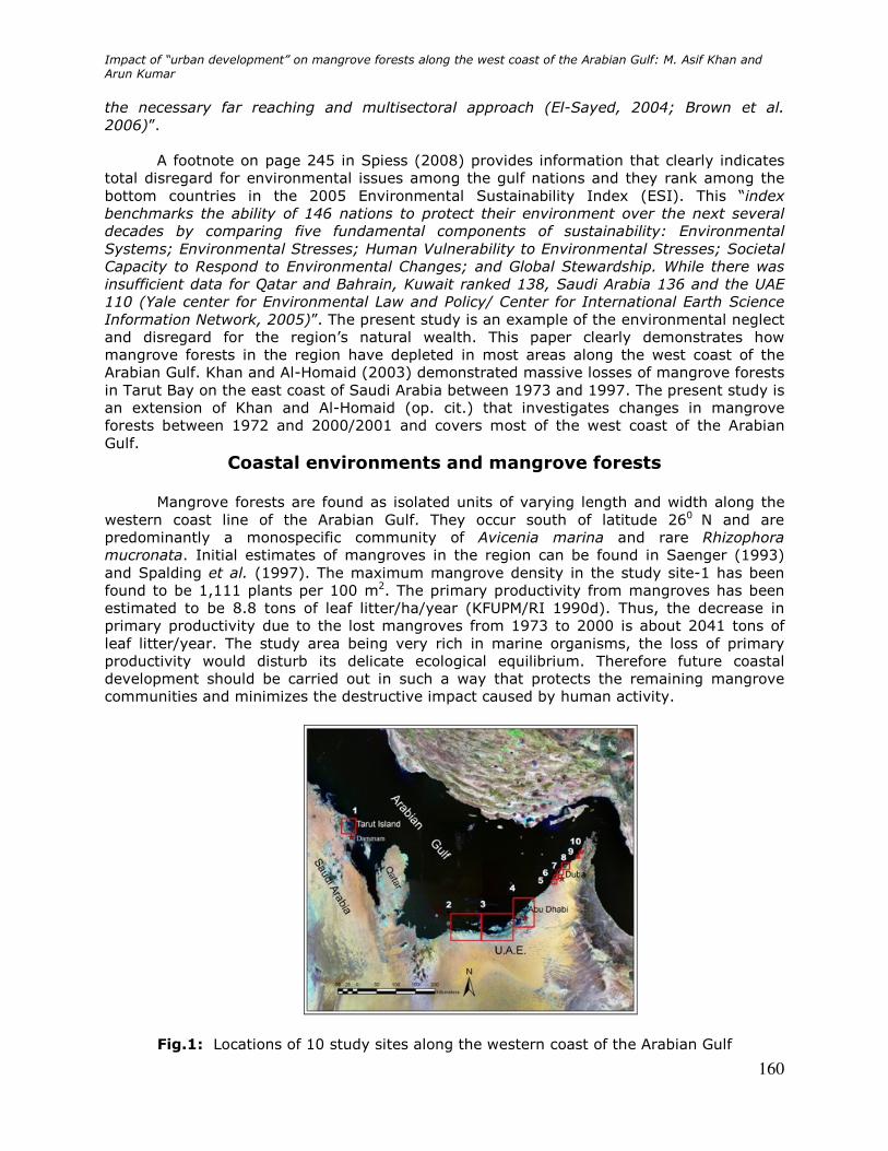
Impact of “urban development” on mangrove forests along the west coast of the Arabian Gulf: M. Asif Khan and Arun Kumar
160
the necessary far reaching and multisectoral approach (El-Sayed, 2004; Brown et al.
2006)”. A footnote on page 245 in Spiess (2008) provides information that clearly indicates
total disregard for environmental issues among the gulf nations and they rank among the bottom countries in the 2005 Environmental Sustainability Index (ESI). This “index benchmarks the ability of 146 nations to protect their environment over the next several
decades by comparing five fundamental components of sustainability: Environmental
Systems; Environmental Stresses; Human Vulnerability to Environmental Stresses; Societal
Capacity to Respond to Environmental Changes; and Global Stewardship. While there was
insufficient data for Qatar and Bahrain, Kuwait ranked 138, Saudi Arabia 136 and the UAE
110 (Yale center for Environmental Law and Policy/ Center for International Earth Science
Information Network, 2005)”. The present study is an example of the environmental neglect and disregard for the region’s natural wealth. This paper clearly demonstrates how mangrove forests in the region have depleted in most areas along the west coast of the Arabian Gulf. Khan and Al-Homaid (2003) demonstrated massive losses of mangrove forests in Tarut Bay on the east coast of Saudi Arabia between 1973 and 1997. The present study is an extension of Khan and Al-Homaid (op. cit.) that investigates changes in mangrove forests between 1972 and 2000/2001 and covers most of the west coast of the Arabian Gulf.
Coastal environments and mangrove forests
Mangrove forests are found as isolated units of varying length and width along the western coast line of the Arabian Gulf. They occur south of latitude 260 N and are predominantly a monospecific community of Avicenia marina and rare Rhizophora
mucronata. Initial estimates of mangroves in the region can be found in Saenger (1993) and Spalding et al. (1997). The maximum mangrove density in the study site-1 has been found to be 1,111 plants per 100 m2. The primary productivity from mangroves has been estimated to be 8.8 tons of leaf litter/ha/year (KFUPM/RI 1990d). Thus, the decrease in primary productivity due to the lost mangroves from 1973 to 2000 is about 2041 tons of leaf litter/year. The study area being very rich in marine organisms, the loss of primary productivity would disturb its delicate ecological equilibrium. Therefore future coastal development should be carried out in such a way that protects the remaining mangrove communities and minimizes the destructive impact caused by human activity.
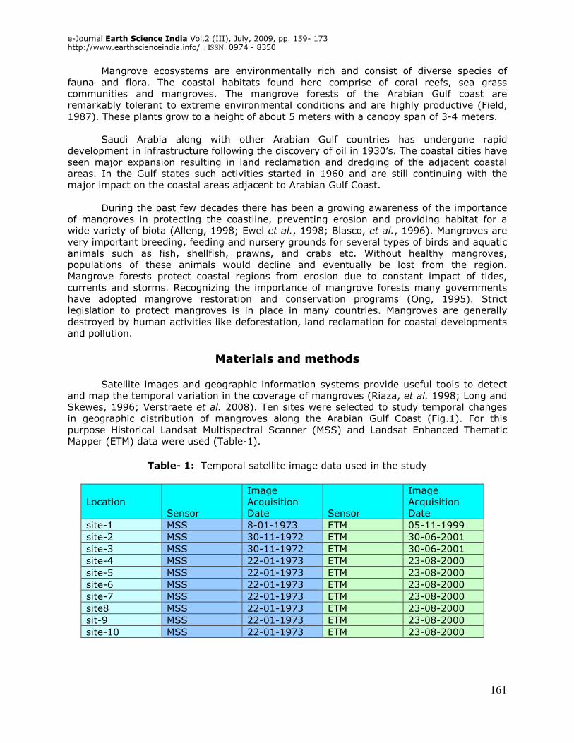
Fig.1: Locations of 10 study sites along the western coast of the Arabian Gulf
e-Journal Earth Science India Vol.2 (III), July, 2009, pp. 159- 173 http://www.earthscienceindia.info/ ; ISSN: 0974 - 8350
161
Mangrove ecosystems are environmentally rich and consist of diverse species of fauna and flora. The coastal habitats found here comprise of coral reefs, sea grass communities and mangroves. The mangrove forests of the Arabian Gulf coast are remarkably tolerant to extreme environmental conditions and are highly productive (Field, 1987). These plants grow to a height of about 5 meters with a canopy span of 3-4 meters.
Saudi Arabia along with other Arabian Gulf countries has undergone rapid development in infrastructure following the discovery of oil in 1930’s. The coastal cities have seen major expansion resulting in land reclamation and dredging of the adjacent coastal areas. In the Gulf states such activities started in 1960 and are still continuing with the major impact on the coastal areas adjacent to Arabian Gulf Coast.
During the past few decades there has been a growing awareness of the importance
of mangroves in protecting the coastline, preventing erosion and providing habitat for a wide variety of biota (Alleng, 1998; Ewel et al., 1998; Blasco, et al., 1996). Mangroves are very important breeding, feeding and nursery grounds for several types of birds and aquatic animals such as fish, shellfish, prawns, and crabs etc. Without healthy mangroves, populations of these animals would decline and eventually be lost from the region. Mangrove forests protect coastal regions from erosion due to constant impact of tides, currents and storms. Recognizing the importance of mangrove forests many governments have adopted mangrove restoration and conservation programs (Ong, 1995). Strict legislation to protect mangroves is in place in many countries. Mangroves are generally destroyed by human activities like deforestation, land reclamation for coastal developments and pollution.
Materials and methods
Satellite images and geographic information systems provide useful tools to detect and map the temporal variation in the coverage of mangroves (Riaza, et al. 1998; Long and Skewes, 1996; Verstraete et al. 2008). Ten sites were selected to study temporal changes in geographic distribution of mangroves along the Arabian Gulf Coast (Fig.1). For this purpose Historical Landsat Multispectral Scanner (MSS) and Landsat Enhanced Thematic Mapper (ETM) data were used (Table-1).
Table- 1: Temporal satellite image data used in the study
Impact of “urban development” on mangrove forests along the west coast of the Arabian Gulf: M. Asif Khan and Arun Kumar
162
An important step, in the comparison of multispectral remotely sensed images, is the
geometric registration (Richards, 1986). In this study image-to-image ground control points were used to geometrically register all of the Landsat ETM and MSS images to a UTM grid. In all cases 20 to 25 image control points were used and the geometric registration accuracy of better than one pixel (picture element) was obtained. The Landsat TM has a 30 meter spatial resolution whereas MSS data has 79 meter spatial resolution. In order to make the pixel size of both the data sets compatible the Landsat MSS data was resampled to 30 meter resolution. All the images were also radiometrically corrected using dark-pixel subtraction (Crane 1971), also known as histogram minimum method (Chavez et al. 1977).
The most widely used technique for detecting vegetation with remotely sensed
images is the Normalized Difference Vegetation Index (NDVI). Studies using NDVI and other vegetation indices are varied and include those involved with local, regional, and global mapping of vegetation (Townsend and Justice, 1986; Choudhury and Tucker, 1987; Jackson and Huete, 1991; Justice et al., 1991; Tucker et al., 1991; Richardson and Evert, 1992). Recently, Helldén and Tottrup (2008) used time series of annually integrated and standardized annual NDVI anomalies to study trends in regional desertification and suggested that this methodology is a robust and reliable way to assess and monitor vegetation trends and related desertification on a regional-global scale.
The Normalized Difference Vegetation Index (NDVI) is defined as:
NDVI = (RIR-R) / (RIR+R) Where RIR = Reflective Infrared band (MSS bands 6 and 7; TM band 4) And R = Red band (MSS band 5; TM band 3)
Since the mangroves grow along the coastline, the coastline boundary was used to mask the land areas from the Landsat images. This operation excluded the coastal vegetation comprising of palm trees, vegetable farms, halophytes and grassy recreational areas from the Landsat images. The vegetation associated with the mangroves such as halophytes and exposed algal mats could not be excluded. The masked Landsat images were used to create NDVI images. NDVI for Landsat MSS images was calculated using MSS bands 5(0.6-0.7 µm) and 7 (0.8-1.1 µm). NDVI for Landsat ETM images was calculated using bands 3(0.63-0.69 µm) and 4(0.76-0.90 µm).
Results and discussion
In Landsat images the red band records the absorption of red wavelength by chlorophyll thus lower values indicate higher chlorophyll. Reflected Infrared (RIR) band records the reflection of IR wavelengths by the cell structures of leaves thus higher values of IR indicate more vigorous growth (Richardson and Evert, 1992). Values of NDVI images ranged from -1.0 to 1.0. Higher values indicate higher concentrations of vegetation, which in this study are mangrove stands. Lower values indicate non-vegetated regions like water bodies and bare soil. Thresholds of NDVI greater than 0.1, were applied to the NDVI images to classify the mangrove stands in the images. The threshold criteria, was determined from the false color composites of two visible and one near infrared bands. In this color composite vegetation appears in hues of red and can be easily differentiated from bare land, mud flats and water bodies along the coastal regions. The familiarity with the area and known locations of mangroves were also helpful in determining the threshold boundary.
Fig. 1 shows studied sites 1 through 10 along the west coast of the Arabian Gulf and fig. 2 through 11 show images of geographical distribution of mangrove forests at sites 1 through 10 respectively. Each figure has a pair of A (MSS obtained during 1972-1973) and B (ETM obtained during 1999-2001) images of the same site that provides temporal NDVI
e-Journal Earth Science India Vol.2 (III), July, 2009, pp. 159- 173 http://www.earthscienceindia.info/ ; ISSN: 0974 - 8350
163
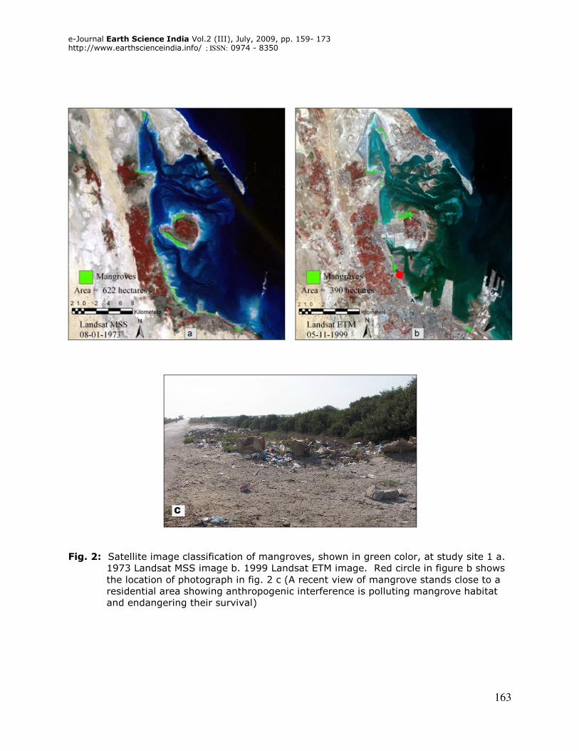
Fig. 2: Satellite image classification of mangroves, shown in green color, at study site 1 a. 1973 Landsat MSS image b. 1999 Landsat ETM image. Red circle in figure b shows the location of photograph in fig. 2 c (A recent view of mangrove stands close to a residential area showing anthropogenic interference is polluting mangrove habitat and endangering their survival)
Impact of “urban development” on mangrove forests along the west coast of the Arabian Gulf: M. Asif Khan and Arun Kumar
164
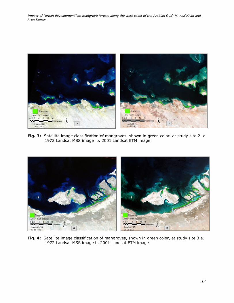
Fig. 3: Satellite image classification of mangroves, shown in green color, at study site 2 a. 1972 Landsat MSS image b. 2001 Landsat ETM image
Fig. 4: Satellite image classification of mangroves, shown in green color, at study site 3 a.
1972 Landsat MSS image b. 2001 Landsat ETM image
e-Journal Earth Science India Vol.2 (III), July, 2009, pp. 159- 173 http://www.earthscienceindia.info/ ; ISSN: 0974 - 8350
165
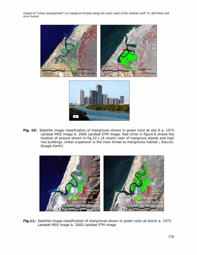
changes in mangrove distribution. Fig. 2c, 5c, 6c, and 10c show recent photographs of mangroves and high rise buildings at the locations shown by red circle in fig. 2b, 5b, 6b and 10b respectively.
Table-2: Past 25-30 years temporal changes in the geographical area of mangroves
for sites 1 through 10 in both numerical values in hectares and percentages.
Location Image
Acquisition
Date
Mangrove
area
(hectares) Image
Acquisition
Date
Mangrove
area
(hectares)
Temporal
change in
mangrove
area
(hectares)
Percentage
temporal
change in
mangrove
area
site-1 08-01-1973 622 05-11-1999 390 -232 -37
site-2 30-11-1972 2639 30-06-2001 2590 -49 -2
site-3 30-11-1972 4028 30-06-2001 3488 -540 -13
site-4 22-01-1973 4066 23-08-2000 4822 756 19
site-5 22-01-1973 648 23-08-2000 30 -618 -95
site-6 22-01-1973 84 23-08-2000 0 -84 -100
site-7 22-01-1973 212 23-08-2000 115 -97 -46
site8 22-01-1973 1063 23-08-2000 1131 68 6
sit-9 22-01-1973 100 23-08-2000 317 217 217
site-10 22-01-1973 182 23-08-2000 294 112 62
Table-2 shows the temporal changes in absolute and percentage values in the area
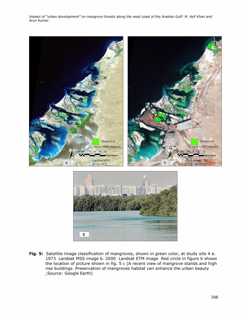
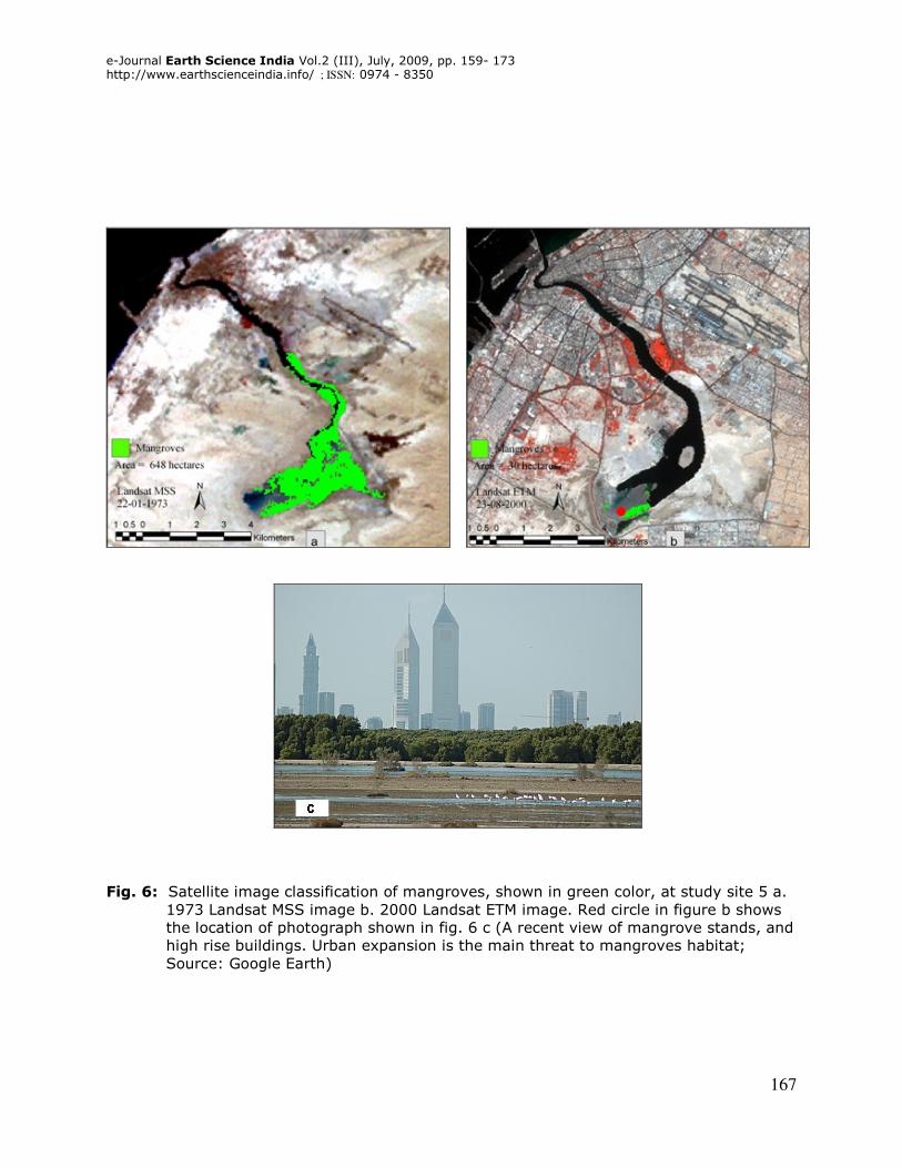
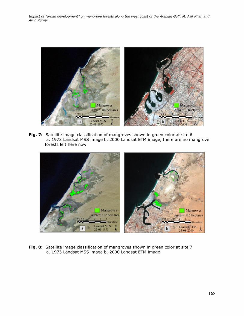
covered by mangrove forests at all the ten sites. Site 1 shows decrease from 622 hectares to 390 hectares (37 % loss; figures 2a, 2b); site 2 decrease from 2639 hectares to 2590 hectares (2 % loss; figures 3a, 3b); site 3 decrease from 4028 hectares to 3488 hectares (13 % loss; figures 4a, 4b); site 4 the mangroves area increase from 4066 hectares to 4822 hectares (19 % gain; figures 5a, 5b); site 5 decrease from 648 hectares to 30 hectares (95 % loss; figures 6a, 6b); site 6 decrease from 84 hectares to 0 hectares (100 % loss; figures 7a, 7b); site 7 decrease from 212 hectares to 115 hectares (46 % loss; figures 8a, 8b); site 8 increased from 1063 hectares to 1131 hectares (6 % gain; figures 9a, 9b); site 9 increase from 100 hectares to 317 hectares (217 % gain; figures 10a, 10b); and site 10 increase from 182 hectares to 294 hectares (62 % gain; figures 11a, 11b).
The main factor causing mangrove depletion in the study area has been extensive
land reclamation for coastal infrastructure development (Kumar, 2009). The other factors contributing to the mangrove depletion are dumping of solid and liquid waste, grazing by animals and pollution from oil spills. At study site 1 mangrove stands have also been adversely impacted by oil spill during the first Gulf war. However, it is very interesting to note that the sites along the coastal areas which were not affected by the anthropogenic interference, the mangrove forests have increased in area for example, sites 4, 8, 9 and 10.
Impact of “urban development” on mangrove forests along the west coast of the Arabian Gulf: M. Asif Khan and Arun Kumar
166
Fig. 5: Satellite image classification of mangroves, shown in green color, at study site 4 a. 1973 Landsat MSS image b. 2000 Landsat ETM image Red circle in figure b shows the location of picture shown in fig. 5 c (A recent view of mangrove stands and high rise buildings. Preservation of mangroves habitat can enhance the urban beauty ;Source: Google Earth)
e-Journal Earth Science India Vol.2 (III), July, 2009, pp. 159- 173 http://www.earthscienceindia.info/ ; ISSN: 0974 - 8350
167
Fig. 6: Satellite image classification of mangroves, shown in green color, at study site 5 a. 1973 Landsat MSS image b. 2000 Landsat ETM image. Red circle in figure b shows the location of photograph shown in fig. 6 c (A recent view of mangrove stands, and high rise buildings. Urban expansion is the main threat to mangroves habitat; Source: Google Earth)
Impact of “urban development” on mangrove forests along the west coast of the Arabian Gulf: M. Asif Khan and Arun Kumar
168
Fig. 7: Satellite image classification of mangroves shown in green color at site 6 a. 1973 Landsat MSS image b. 2000 Landsat ETM image, there are no mangrove forests left here now
Fig. 8: Satellite image classification of mangroves shown in green color at site 7
a. 1973 Landsat MSS image b. 2000 Landsat ETM image
e-Journal Earth Science India Vol.2 (III), July, 2009, pp. 159- 173 http://www.earthscienceindia.info/ ; ISSN: 0974 - 8350
169
Fig. 9: Satellite image classification of mangroves shown in green color at site 8
a. 1973 Landsat MSS image b. 2000 Landsat ETM image
Conclusions
Temporal Landsat data provided a useful tool to study depletion to almost total
destruction of mangrove forests in different areas along the west coast of the Arabian Gulf. The Normalized Vegetation Difference Index (NDVI) proved to be a useful measure to detect mangroves using near-infrared and red bands. Drastic damage to the coastal environment, loss of mangrove ecosystem, habitat for several marine and avian fauna of the region has occurred during the past 40 years. Such environmental adversity has resulted due to massive and mostly unplanned economic growth of the region. Although in few areas despite development, covered area of mangrove forests have increased mainly due the fact that mangrove ecosystem was left undisturbed.
Since mangroves grow along the coastline, primarily the reclamation activities in the region have resulted in their deterioration. It is estimated that there are several thousand species of marine organisms presently living within the selected sites. Some reports also point out complaints by local fishermen of decreasing fish and shrimp catch in the area. The present study shows degradation of the coastal environmental changes during the past forty years and suggests the need of careful planning to preserve the remaining mangrove forests which are vital to long term sustenance of not only for the regional flora and fauna but also for the quality of human life in the future.
Acknowledgements: The authors thank King Fahd University of Petroleum and Minerals (KFUPM), Dhahran, Saudi Arabia for permission to publish this paper. The authors thank Mr. Abdul Muqtadir for technical support.
Impact of “urban development” on mangrove forests along the west coast of the Arabian Gulf: M. Asif Khan and Arun Kumar
170
Fig. 10: Satellite image classification of mangroves shown in green color at site 9 a. 1973 Landsat MSS image b. 2000 Landsat ETM image. Red circle in figure b shows the location of picture shown in fig.10 c (A recent view of mangrove stands and high rise buildings. Urban expansion is the main threat to mangroves habitat ; Source: Google Earth)
Fig.11: Satellite image classification of mangroves shown in green color at site10 a. 1973
Landsat MSS image b. 2000 Landsat ETM image
e-Journal Earth Science India Vol.2 (III), July, 2009, pp. 159- 173 http://www.earthscienceindia.info/ ; ISSN: 0974 - 8350
171
References
Al Kolibi, F. M. (2002) Possible effects of global warming on agriculture and water resources in Saudi Arabia – impacts and responses. Climate Change, v. 54, pp. 225-245.
Alleng, G. P. (1998) Historical development of the Port Royal mangrove wetland, Jamaica. Journal of Coastal Research, v. 14(3), pp. 951-959.
Blasco, F., Saenger, P. and Janodet, E. (1996) Mangroves as indicators of coastal change. Catena, v. 27(3-4), pp. 167-178.
Brown, G., Peacock, J., Loughland, R., and Alhadrami, G. (2006) Coastal and terrestrial ecosystem management requirements in the Arabian Peninsula. In: Amer, K. M. et al.
(eds.) Policy Perspectives for Ecosystem and Water Management in the Arabian Peninsula. Ontario: United Nations International Network on Water, Environment and Health and UNESCO.
Burke, E. J., Brown, S. J. and Christidis, N. (2006) Modeling the recent evolution of global drought and projections for the twenty-first century with the Hadley Centre Climate model. Journal of Hydrometeorology, v. 7(5), pp. 1113-1125.
Chavez, P. S. Jr., Berlin, G. L. and Mitchell, W. B. (1977) Computer enhancement techniques of Landsat MSS images for land use/land cover assessments. Remote Sensing Earth Resources, University of Tennessee, v. 6, pp. 259.
Crane, R. B. (1971) Preprocessing techniques to reduce atmospheric and sensor variability in multispectral scanner data. Proceedings of the 7th International Symposium on Remote Sensing of Environment (Ann Arbor: University of Michigan), pp. 1345.
Choudhury, B. J. and Tucker, C. J. (1987) Satellite observed seasonal and inter-annual variations of vegetation over the Kalahari, the Great Victoria Desert, and the Great Sandy Desert: 1979-84. Remote Sensing of Environment, v. 23, pp. 233-241.
Elhadj, E. (2006) Experiments in achieving water and food self-sufficiency in the Middle-East: the consequences of contrasting endowments, ideologies and investment policies in Saudi Arabia and Syria. Boca Raton.
El-Sayed, S. M. (2004) Environmental security in the Arab world. Presentation at the “Meeting of the International Studies Association” 17-20 March, Montreal, Canada. (http://www.afes-press.de/pdf/Selim_Mont_4.pdf)
Ewel, K. C., Twilley, R. R. and Ong, J. E. (1998) Different kinds of mangrove forests provide different goods and services. Global Ecology and Biogeography Letters, v. 7(1), pp. 83-94.
Field, C. D. (1987) Salt tolerance in mangroves. Proceedings of the Research for Development Seminar, Australian Institute of Marine Science, Townsville, Australia, pp. 278-285.
Helldén, U. and Tottrup, C. (2008) Regional desertification: a global synthesis. Global and Planetary Change, v. 64, pp. 169-176.
Jackson, R. D., and Huete, A. R. (1991) Interpreting vegetation indices. Preventive Veterinary Medicine, v. 11, pp. 165-200.
Justice, C. O., Townsend, J. G. R. and Kalb, V. I. (1991) Representation of vegetation by continental data sets derived from NOAA-AVHRR data. International Journal of Remote Sensing, v. 12(5), pp. 999-1021.
KFUPM/RI (1990d) Final Report: Aramco Sustaining Research Project – Marine Environmental Studies, vol. IV, Tarut Bay Biotopes Investigation – Mangrove Communities. Prepared for Saudi Aramco by the Water Resources and Environment Division. Research Institute, King Fahd University of Petroleum and Minerals, Dhahran, Saudi Arabia, Report Project No. 24079.
Impact of “urban development” on mangrove forests along the west coast of the Arabian Gulf: M. Asif Khan and Arun Kumar
172
Khan, M. A. and Al-Homaid, N. A. (2003) Remote sensing study on mangrove depletion
Tarut Bay, Saudi Arabia . In: Alsharhan et al. (eds.), Desertification in the Third Millennium. Proceedings of an International Conference, Dubai, February 12-15, 2000. A.A. Balkema Publishers, The Netherlands, pp. 227-233.
Kumar, A. (2009) Reclaimed islands and new offshore townships in the Arabian Gulf: potential natural hazards. Current Science, v. 96 (4), pp. 480-485.
Long, B. G. and Skewes, T. D. (1996) A technique for mapping mangroves with Landsat TM satellite data and Geographic Information System. Estuarine Coastal and Shelf Science, v. 43(3), pp. 373-381.
Ong, J. E. (1995) The Ecology of Mangrove Conservation and Management. Hydrobiologia, v. 295(1-3), pp. 343-351.
Riaza, A., Martinez-Torres M. L., Ramon-Lluch, R., Alonso, J. and Heras, P. (1998) Evolution of equatorial vegetation communities mapped using Thematic Mapper images through a geographical information system (Guinea, Equatorial Africa). International Journal of Remote Sensing, v. 19(1), pp. 43-54.
Richardson, A.J., and Evert, J. H. (1992) Using spectral vegetation indices to estimate rangeland productivity. Geocarto International, v. 1, pp. 63-69.
Richards, J. A., (1986) Remote Sensing, Digital Image Processing and Analysis – An Introduction. New York: Springer-Verlag.
Spalding, M. D., Blasco, F. and Field, C. D. (1997) World Mangrove Atlas. The International Society for Mangrove Ecosystems, Okinawa, Japan.
Spiess, A. (2008) Developing adaptive capacity for responding to environmental change in the Arab Gulf States: Uncertainties to linking ecosystem conservation, sustainable development and society in authoritarian rentier economies. Global and Planetary Change, v. 64, pp. 244-252.
Townsend, J. G. R., and Justice, C. O. (1986) Analysis of the dynamics of African vegetation using the normalized difference vegetation index. International Journal of Remote Sensing, v. 7(11), pp. 1435-1445.
Tucker, C J., Newcomb, W. W., Los, S. O. and Price, S. D. (1991) Mean and inter-year variance of growing-season normalized difference vegetation index for the Sahel 1981-1989. International Journal of Remote Sensing, v. 12(6), pp. 1133-1135.
United Nations Environment Programme (UNEP), (2006) Global Deserts Outlook. Nairobi. Verstraete, M. M., Brink, A. B., Scholes, R. J., Beniston, M. and Smith, M. S. (2008) Climate
change and desertification: where do we stand, where should we go? Global and Planetary Change, v. 64, pp. 105-110.
Williams, J. W., Jackson, S. T., Kutzbach, J.E. (2007) Projected distributions of novel and disappearing climates by 2100 AD. PNAS Early edition for the week of March 26, 2007.
e-Journal Earth Science India Vol.2 (III), July, 2009, pp. 159- 173 http://www.earthscienceindia.info/ ; ISSN: 0974 - 8350
173
About the Authors
Mr. Muhammad Asif Khan is a Research Specialist II (Associate Professor) in the Remote Sensing unit, Center for Petroleum and Minerals, The Research Institute, King Fahd University of Petroleum and Minerals, Dhahran, Saudi Arabia. At the Research Institute, he established Remote Sensing Facility in 1982 which was the first of its kind in the entire Middle East. He has also participated in leading edge international experiments in remote sensing and authored numerous refereed research papers and technical reports.
Dr. Arun Kumar is a Research Scientist and Professor at the Center for Petroleum and Minerals, Research Institute, King Fahd University of Petroleum and Minerals, Dhahran, Saudi Arabia. He obtained his Ph.D. (Stratigraphic Palynology) from Michigan State University, USA and a second Ph.D. (Environmental Micropalaeontology) from Carleton University, Canada. Dr. Kumar taught geology at Kumaun University, Nainital, India, University of the West Indies, Kingston, Jamaica, Carleton University and Concordia University (Montreal) in Canada. He also worked as a geologist and palynologist with Oil and Natural Gas Corporation of India and Core Laboratories International (USA) in Singapore and Jakarta, Indonesia. Dr. Kumar has published extensively on Mesozoic and Cenozoic pollen, spores and dinoflagellate cysts, environmental applications of thecamoebians, benthic foraminifera as paleoclimate and paleoceanographic proxies, and on current environmental issues. His new research interest is in natural hazards and environmental issues. *corresponding Author