Sounder products for Weather and Climate applications Second Suomi-NPP Applications Workshop Thursday, Nov. 20, 2014, 9:00 am Chris Barnet 1 With lots of help : NUCAPS product graphics: Colby Francoeur (STC summer intern) Direct Broadcast Implementation: Thomas King and Letitia Soulliard (STAR), James Davies and Liam Gumley (CIMSS) CalWater-2 Field Campaign: Ryan Spackman (STC) NUCAPS AWIPS Initiative: Bill Sjoberg and Brian Motta
Transcript
1
Sounder products for Weather and Climate applications
Second Suomi-NPP Applications WorkshopThursday, Nov. 20, 2014, 9:00 am
Chris BarnetWith lots of help:NUCAPS product graphics: Colby Francoeur (STC summer intern)Direct Broadcast Implementation: Thomas King and Letitia Soulliard (STAR), James Davies and Liam Gumley (CIMSS)CalWater-2 Field Campaign: Ryan Spackman (STC)NUCAPS AWIPS Initiative: Bill Sjoberg and Brian Motta (NOAA)
2
Discussion Points
• Quick overview of NOAA-Unique CrIS/ATMS Processing System (NUCAPS)
• Status of Direct Broadcast implementation• NOAA Sounding Initiative Activities
– Improvements to AWIPS-II implementation– Cold Air Aloft Initiative– CalWater 2 Campaign, Jan/Feb 2015
• NASA Suomi-NPP Sounding discipline activities
3
NOAA-Unique CrIS/ATMS Processing System (NUCAPS)
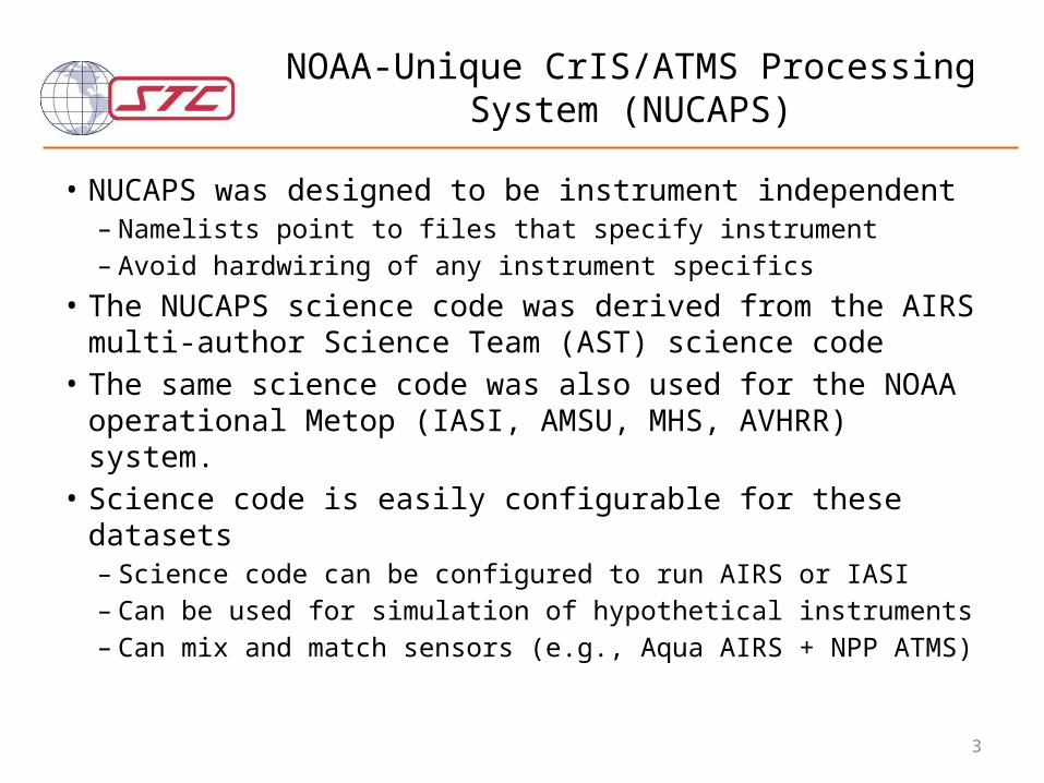
• NUCAPS was designed to be instrument independent– Namelists point to files that specify instrument– Avoid hardwiring of any instrument specifics
• The NUCAPS science code was derived from the AIRS multi-author Science Team (AST) science code
• The same science code was also used for the NOAA operational Metop (IASI, AMSU, MHS, AVHRR) system.
• Science code is easily configurable for these datasets– Science code can be configured to run AIRS or IASI– Can be used for simulation of hypothetical instruments– Can mix and match sensors (e.g., Aqua AIRS + NPP ATMS)
4
What makes this algorithm unique?
• Designed to use all available sounding instruments.– Climatological startup.
• Only ancillary information used is surface pressure from GFS– Microwave radiances used in microwave-only physical retrieval, “cloudy”
regression, “cloud cleared” regression and downstream physical T(p) and q(p) steps.
– Use a comparison of 4 independent retrieval steps for quality control (QC) in addition to traditional QC (residuals, etc.).
• Utilizes the high-information content of the hyper-spectral infrared – both radiances and physics.– All channels used in constrained regression first guesses.– Utilize forward model derivatives help constrain the solution.
• Physical steps use full off-diagonal covariance of (obs-calc) errors.• Minimizes arbitrary a-priori constraints.
5
Summary of products fromNUCAPS Algorithm (in AWIPS-II)
gas Range (cm-1) Precision d.o.f. Interfering Gases Sensitivity
Status of Direct Broadcast (DB) Implementation of NUCAPS
• NUCAPS is runnable on small unix/linux platforms– Operational preprocessor requires 4-scanset granules
• read HDF5 ATMS and CrIS SDR and GEO files• co-locate ATMS and CrIS• compute surface altitude and land fraction from Digital Elevation Model• co-locate GFS forecast information
– Surface pressure is used by retrieval (only external variable)– T(p), q(p), and O3(p) used for monitoring
• Write NETCDF files for retrieval code– Retrieval code compatible with many versions of FORTRAN (e.g.,
GNU gfortran, Intel, Portland Group, and Absoft compilers)• Processing speeds are ~2x (i.e., 4 seconds for 8 second scanset) on a
single CPU or 130 milli-second/retrieval
Chris Barnet reportOct. 29, 2014 NUCAPS Telecon
• NUCAPS implementation into CSPP– Verified BD and NOAA-operations get same results– Full implementation is nearing completion this week– Expect a hiccup on Nov. 15, when CrIS goes into full-
resolution mode• DB does not have FOV.4
– IDPS, STAR, CLASS versions are unaffected, have all 9 FOVs• This should be resolved quickly and an upgrade will be delivered
ASAP (most likely by Dec. 1)– Other upgrades include CF-compliant NETCDF– NUCAPS DB for pre- and post- CrIS modes should be
available in Dec. 2014
8
NOAA/JPSS Satellite Application Team Initiatives for Sounding
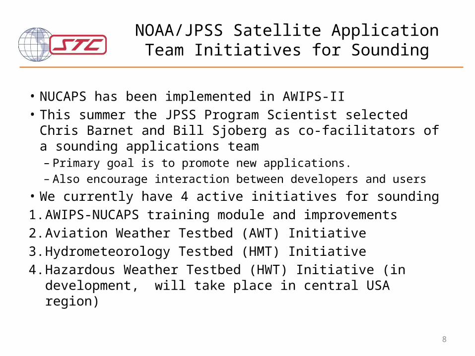
• NUCAPS has been implemented in AWIPS-II• This summer the JPSS Program Scientist selected Chris Barnet
and Bill Sjoberg as co-facilitators of a sounding applications team– Primary goal is to promote new applications.– Also encourage interaction between developers and users
• We currently have 4 active initiatives for sounding1. AWIPS-NUCAPS training module and improvements2. Aviation Weather Testbed (AWT) Initiative3. Hydrometeorology Testbed (HMT) Initiative4. Hazardous Weather Testbed (HWT) Initiative (in development,
will take place in central USA region)
9
1) NUCAPS-AWIPS-II Training Initiative(POC is Brian Motta, NOAA)
• Evaluate the current AWIPS implementation– NUCAPS locations are displayed on map, click to get skew-T plot– Quality control is absent – need to fix it
• Also consider better QC – a “bad” retrieval might still be best there is– Consider changing file formats to enable:
• Ability to plot soundings together with ACARS, radiosondes, etc.• And/or the ability to provide cross-section plots, comparison to models, etc.
– Study cases where NUCAPS fails• Forecaster can submit interesting cases to a developer who can then study
the case in detail, answer questions, and ultimately improve products.
• Training– Enable forecasters to understand what information is – and is not – in
the retrievals (e.g., using skew-T comparisons)– Enable developers to understand the needs of the forecasters
10
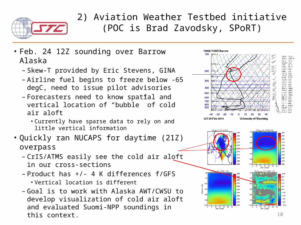
2) Aviation Weather Testbed initiative(POC is Brad Zavodsky, SPoRT)
• Feb. 24 12Z sounding over Barrow Alaska– Skew-T provided by Eric Stevens, GINA– Airline fuel begins to freeze below -65 degC,
need to issue pilot advisories– Forecasters need to know spatial and vertical
location of “bubble” of cold air aloft• Currently have sparse data to rely on and little
vertical information
• Quickly ran NUCAPS for daytime (21Z) overpass– CrIS/ATMS easily see the cold air aloft in our
cross-sections– Product has +/- 4 K differences f/GFS
• Vertical location is different– Goal is to work with Alaska AWT/CWSU to
develop visualization of cold air aloft and evaluated Suomi-NPP soundings in this context.
11
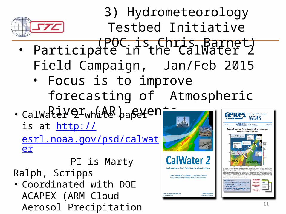
• Participate in the CalWater 2 Field Campaign, Jan/Feb 2015• Focus is to improve forecasting of
Atmospheric River (AR) events• CalWater 2 white paper is at
http://esrl.noaa.gov/psd/calwater PI is Marty Ralph, Scripps• Coordinated with DOE ACAPEX
(ARM Cloud Aerosol Precipitation Experiment)
PI is L. Ruby Leung, DOE
3) Hydrometeorology Testbed Initiative(POC is Chris Barnet)
• Interagency Campaign: • Scripps (Marty Ralph, Kim Prather)• NOAA (Allen White, Ryan Spackman)• DOE (PI: L. Ruby Leung) ARM Cloud
Aerosol Precipitation Experiment (ACAPEX)
13
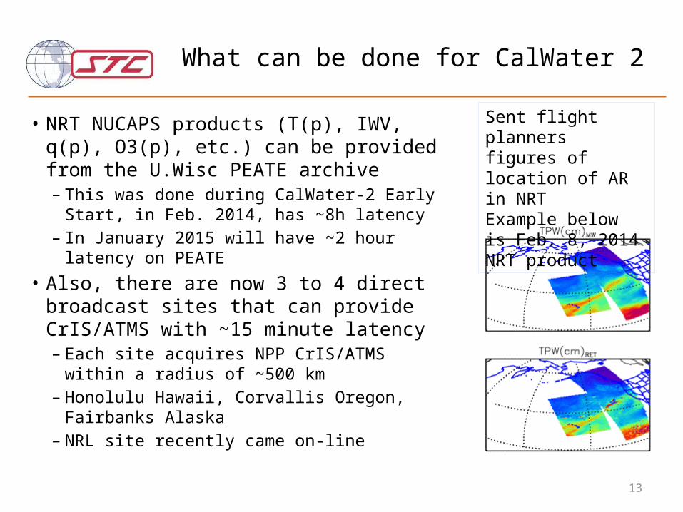
What can be done for CalWater 2
• NRT NUCAPS products (T(p), IWV, q(p), O3(p), etc.) can be provided from the U.Wisc PEATE archive– This was done during CalWater-2 Early Start, in
Feb. 2014, has ~8h latency– In January 2015 will have ~2 hour latency on
PEATE• Also, there are now 3 to 4 direct broadcast
sites that can provide CrIS/ATMS with ~15 minute latency– Each site acquires NPP CrIS/ATMS within a radius
of ~500 km– Honolulu Hawaii, Corvallis Oregon, Fairbanks
Alaska– NRL site recently came on-line
Sent flight planners figures of location of AR in NRTExample below is Feb. 8, 2014 NRT product
14
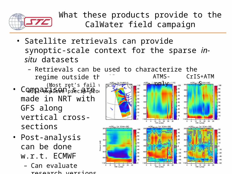
What these products provide to the CalWater field campaign
• Satellite retrievals can provide synoptic-scale context for the sparse in-situ datasets– Retrievals can be used to characterize the regime outside the AR (Most ret’s fail within AR due to heavy precipitation, will explore precip products)
• Comparison’s are made in NRT with GFS along vertical cross-sections
• Post-analysis can be done w.r.t. ECMWF– Can evaluate research
versions of code and QC
ATMS-only CrIS+ATMS
15
What we gain from CalWater 2
• CalWater 2 is an opportunity for product validation– Test NUCAPS in extreme weather that is of national and
societal interest• As algorithm developers, we need these kinds of
scenes to improve the retrieval skill and tailor the quality control.– We can test experimental versions of NUCAPS – We gain the expertise of the entire CalWater science
team to characterize the background environment.– Other in-situ measurements (CO, O3, CO2, aerosols) will
help the NPP validation,– WFO’s have shown interest in NUCAPS products (via
AWIPS-II)• Can demonstrate the value of NUCAPS in the field• an opportunity to work directly with WFO staff to understand
their concerns• form the basis of relevant training modules
On Feb. 8, 2014 29 dropsondes were deployed in AR
Example skew-T of sonde #8, CrIS FOR #11 & models
16
NASA Suomi-NPP Science Team:Sounder Discipline
Suomi-NPP NASA Sounder Discipline Selection (August 2014)
PI Name Company Name Title
Aumann, Hartmut
Jet Propulsion Laboratory
Analysis of the AIRS and CrIS radiometric calibration under cloudy conditions and error propagation into environmental variables.
Barnet, Christopher
Science and Technology Corporation
Discipline Lead: Development and validation of a community hyper-spectral infrared microwave Earth retrieval algorithm: CHIMERA
Cady-Pereira, Karen
Atmospheric and Environmental Research, Inc.
Developing retrieval algorithms for NH3 and CO from NPP CrIS measurements using TES heritage algorithm
Lambrigtsen, Bjorn
Jet Propulsion Laboratory
Microwave sounder Earth System Data Records
Moncet, Jean-Luc
Atmospheric and Environmental Research, Inc.
Refined Atmosphere Data Products from CrIS and ATMS
Susskind, JoelNASA Goddard Space Flight Center
Analysis of CrIS/ATMS using an AIRS Version 6-like retrieval algorithm
18
What are some guiding principles of a climate product for retrievals?
1. Requires reprocessing of full dataset– By extension, this implies (to me) that AIRS/AMSU and CrIS/ATMS
have same spectroscopy and retrieval method• Alternatively we could make the radiances look the same
– IASI/AMSU/MHS in the future (next call?)– Incorporate MODIS, AVHRR, and VIIRS in the future
2. Community accepted error estimates and/or product characterization (a.k.a., averaging kernels)– Requires formal error covariance of the a-priori– … and formal error covariance of the final products.
3. A well characterized a-priori suitable for a multi-instrument time series
19
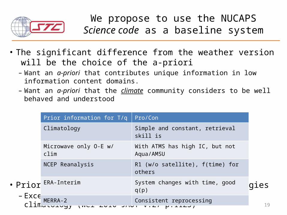
We propose to use the NUCAPS Science code as a baseline system
• The significant difference from the weather version will be the choice of the a-priori– Want an a-priori that contributes unique information in low information content domains.– Want an a-priori that the climate community considers to be well behaved and
understood
• Prior for trace gases will be simple climatologies– Except ozone, where we will use tropopause relative climatology (Wei 2010 JAOT
v.27 p.1123)
Prior information for T/q Pro/ConClimatology Simple and constant, retrieval skill is Microwave only O-E w/ clim With ATMS has high IC, but not Aqua/AMSUNCEP Reanalysis R1 (w/o satellite), f(time) for othersERA-Interim System changes with time, good q(p)MERRA-2 Consistent reprocessing
20
Validation of climate products
• "extraordinary claims require extraordinary evidence" Carl Sagan– We should avoid making algorithm choices using the same data
sets used in “training” of algorithm or quality control components.– We should partition improvements into those from null-space and
those from physical measurement concepts• Three tiers of validation: