Improving Natural Hazards Management on the Oregon Coast Recommendations of the Coastal Natural Hazards Policy Working Group 1994 Oregon Sea Grant Oregon State University Corvallis, Oregon ORESU-T-94-002
Transcript
Improving Natural Hazards Management
on the Oregon Coast
Recommendations of the Coastal Natural Hazards Policy Working Group
1994
Oregon Sea Grant Oregon State University
Corvallis, Oregon ORESU-T-94-002
ii Improving Natural Hazards Management on the Oregon Coast
Support This book is funded by the Na-tional Oceanic and Atmospheric Administration, through Ore-gon Sea Grant (grant numberNA36RGO451) and through
funds appropriated by the Oregon State Legis-lature. The views expressed herein are those of the authors and do not necessarily reflect the views of NOAA or any of its subagencies.
Ordering Information To order additional copies of this publica-
tion, write, call, FAX, or e-mail:
Sea Grant Communications Oregon State UniversityAdministrative Services A402 Corvallis, OR 97331-2134 Phone: (503) 737-2716FAX: (503) [email protected]
Single copies are available for $12.00, ship-ping and handling included.
Cover photo courtesy of Paul Komar.
Oregon Sea GrantOregon State UniversityAdministrative Services A402 Corvallis, OR 97331-2134
Improving Natural Hazards Management on the Oregon Coast iii
Contents Figures and Tables............................................................................................................................................iv
Preface and Acknowledgements.....................................................................................................................v
Executive Summary ........................................................................................................................................ ix
A PWG Members and Support Team ................................................................................................... 109
B Glossary of Terms and Acronyms.......................................................................................................111
C PWG Process and Meeting Schedule ................................................................................................ 115
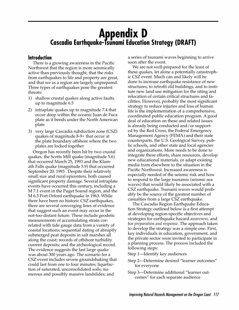
D Cascadia Earthquake-Tsunami Education Strategy ....................................................................... 117
iv Improving Natural Hazards Management on the Oregon Coast
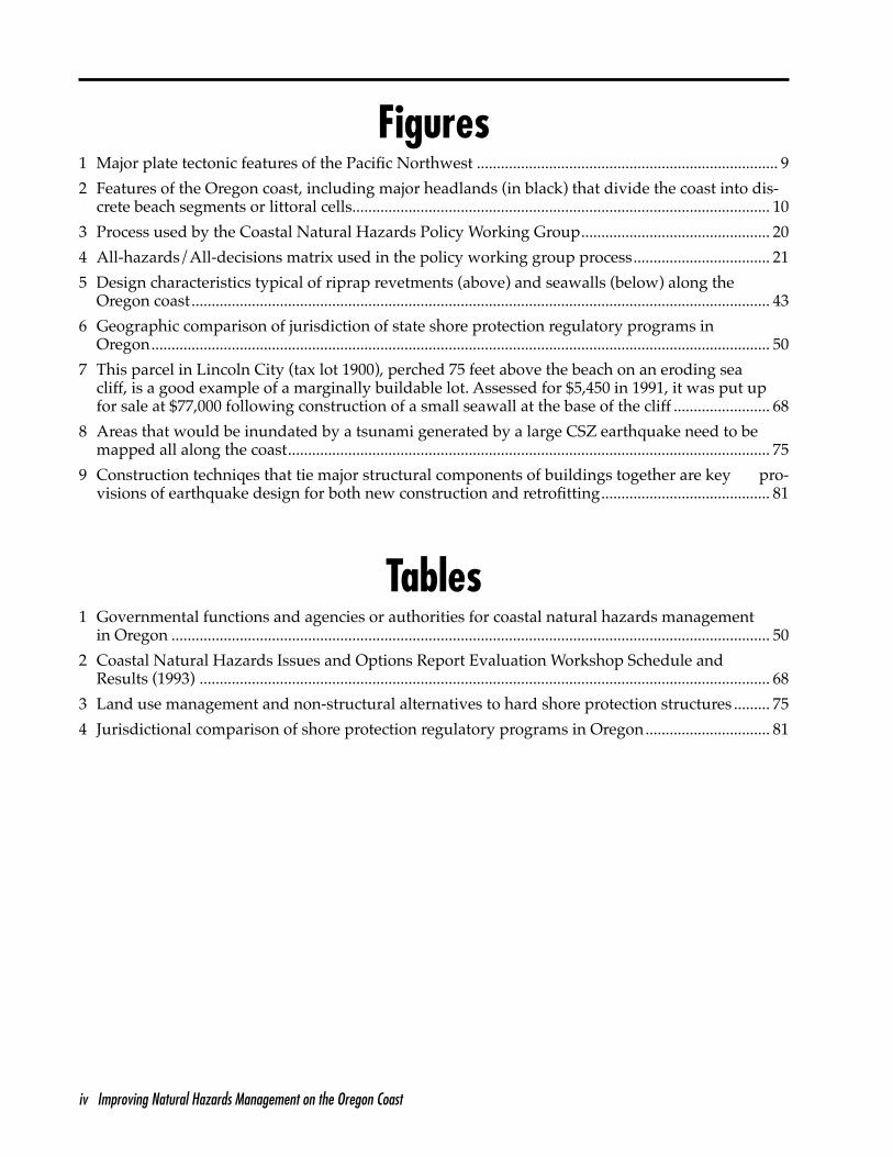
Figures 1 Major plate tectonic features of the Pacific Northwest ........................................................................... 9
2 Features of the Oregon coast, including major headlands (in black) that divide the coast into dis-crete beach segments or littoral cells........................................................................................................ 10
3 Process used by the Coastal Natural Hazards Policy Working Group............................................... 20
4 All-hazards/All-decisions matrix used in the policy working group process.................................. 21
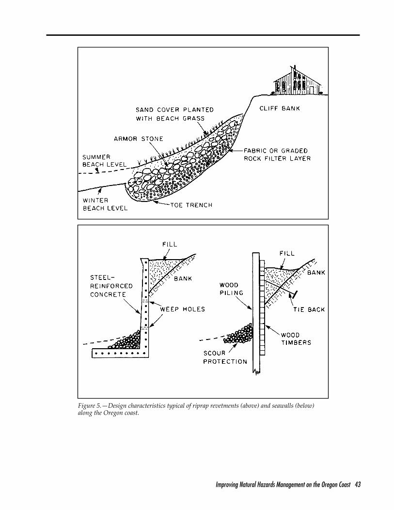
5 Design characteristics typical of riprap revetments (above) and seawalls (below) along the Oregon coast................................................................................................................................................ 43
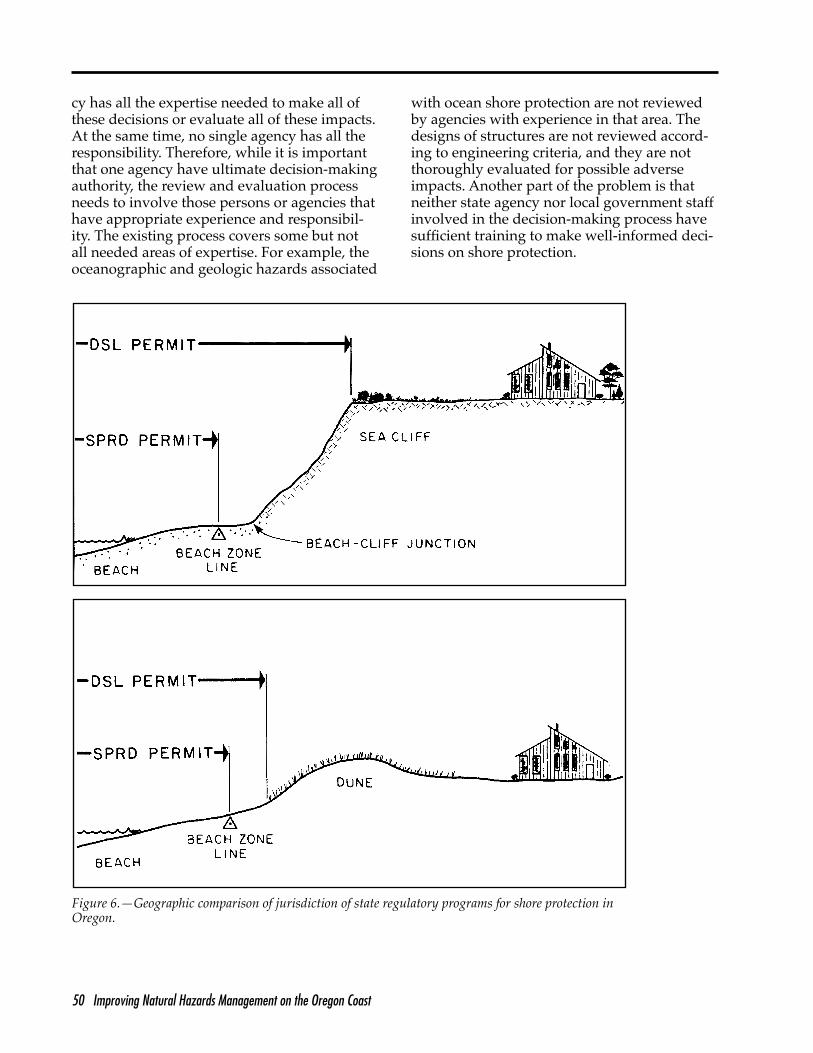
6 Geographic comparison of jurisdiction of state shore protection regulatory programs in Oregon.......................................................................................................................................................... 50
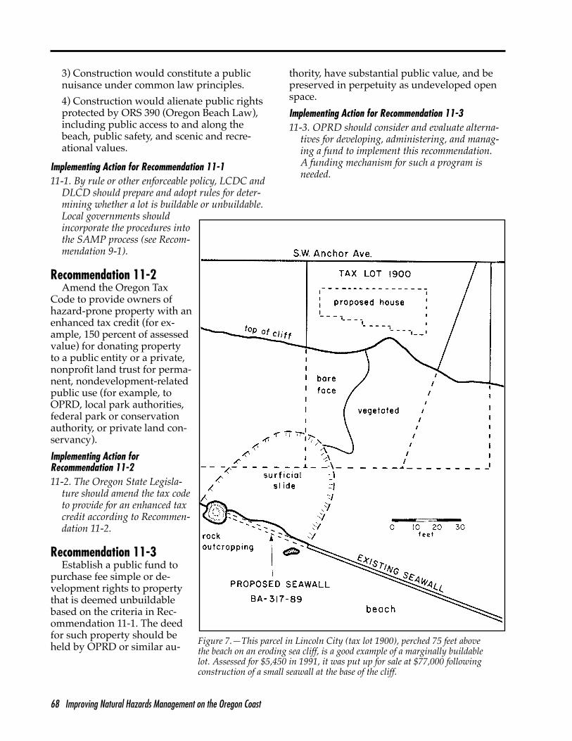
cliff, is a good example of a marginally buildable lot. Assessed for $5,450 in 1991, it was put up for sale at $77,000 following construction of a small seawall at the base of the cliff ........................ 68
7 This parcel in Lincoln City (tax lot 1900), perched 75 feet above the beach on an eroding sea
8 Areas that would be inundated by a tsunami generated by a large CSZ earthquake need to be mapped all along the coast........................................................................................................................ 75
9 Construction techniqes that tie major structural components of buildings together are key pro-visions of earthquake design for both new construction and retrofitting.......................................... 81
Tables 1 Governmental functions and agencies or authorities for coastal natural hazards management
in Oregon ..................................................................................................................................................... 50
2 Coastal Natural Hazards Issues and Options Report Evaluation Workshop Schedule and Results (1993) .............................................................................................................................................. 68
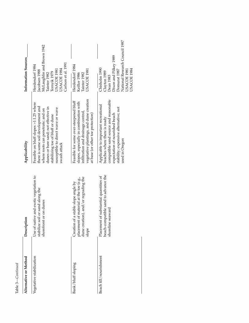
3 Land use management and non-structural alternatives to hard shore protection structures ......... 75
4 Jurisdictional comparison of shore protection regulatory programs in Oregon............................... 81
Improving Natural Hazards Management on the Oregon Coast v
Preface and Acknowledgements
This report is the culmination of more than two years of work by a dedicated group of 20 coastal residents and resource manag-
ers that made up Oregon’s Coastal Natural Hazards Policy Working Group (see Appendix A). To produce this report, these individuals participated in 19 one- or two-day workshopsbetween March 1992 and May 1994. The group identified natural hazard problems and possi-ble solutions, took their ideas to the public ina series of workshops, sought and considered public opinion, and formulated the recom-mendations in this report. Along the way, they benefitted from the advice of many specialists and citizens who made presentations or offered opinions on hazard issues and options.
The Policy Working Group arrived at the recommendations in this report through a pro-cess of consensus building. Consequently, the group’s recommendations do not necessarily represent what any one member might have recommended independently. Although some differences of opinion remain, the members of the group agreed that they can “live with” the negotiated recommendations presented here.
A special word of thanks is due to Ms. Ann Snyder, a professional facilitator and trainer from McMinnville, Oregon. Ann helped or-ganize and conduct more than a dozen of the policy group’s two-day workshops. Her out-standing facilitation, conflict resolution, and consensus-building skills and her good humorand chocolate contributed a great deal to the successful completion of the project. Much learning also took place as those skills were passed on. Ann, on behalf of the entire group, thank you.
Also deserving special mention are the three graduate research assistants from Oregon State University who ably assisted with all aspects ofthis project: Andrea Ansevin, Paul Salop, and Cal Sawyer.
Finally, this project would not have been possible without the support and assistance ofthe Oregon State University Extension Service, the Oregon Sea Grant Program, and the Or-egon Coastal Management Program. Several Extension faculty involved in the Public IssuesEducation Initiative provided project design and facilitation assistance, notably Pat Corcor-an, Flaxen Conway, Fred Smith, Greg Tillson, Larry Lev, Ray William, and Fielding Cooley. Sea Grant provided communications support in the person of editor Sandy Ridlington, aswell as financial support through the Nation-al Oceanic and Atmospheric Administration, Office of Sea Grant, Department of Commerce grant no. NA36RG0451 (project no. A/ESG-2) and from appropriations made by the Oregon State Legislature. Coastal Management Pro-gram staff assistance was provided by Emily Toby and John Marra, of the Department of Land Conservation and Development. Fund-ing was also provided by the Department of Land Conservation and Development through Section 309 of the Coastal Zone ManagementAct, administered by the National Oceanic and Atmospheric Administration, Office of Ocean and Coastal Resources Management.
—James W. Good Project Coordinator
vi Improving Natural Hazards Management on the Oregon Coast
Improving Natural Hazards Management on the Oregon Coast vii
Executive Summary
viii Improving Natural Hazards Management on the Oregon Coast
Improving Natural Hazards Management on the Oregon Coast ix
Executive Summary
In March 1992, Oregon’s Coastal Natural Hazards Policy Working Group was formed. Composed of 20 individuals representing a
broad range of public and private interests on the coast, the group began a two-year project to identify coastal hazard issues, examine how these issues were being addressed today, for-mulate alternative solutions, and recommend improved policies and practices, based on pub-lic input and their own analysis. The process the group used to accomplish this is outlined in the full report.
This summary outlines the issues and rec-ommendations presented in the full report. It is designed to give the reader an overview. However, as with any summary, many details are missing and, as they say, the devil is in the details. For specifics on issues of interest, the reader is urged to refer to the appropriate sec-tion of the full report.
Twenty-three issues are outlined here along with 79 recommendations. In italics, following each of the recommendations, the principal implementing agencies, organizations, or in-stitutions are listed. More detail on the issues, recommendations, and implementing actions, as well as on the findings of the policy group can be found in the full report. The issues are organized in four categories: hazard identifica-tion, beach and shore protection, land use, and disaster preparedness and response. The pageson which each issue appears in the full report are noted below.
Issues and Recommendations Hazard Assessment and Information Access
Issue 1—Existing maps and informationabout coastal natural hazards are inadequatefor planning and decision making (page 29).
Recommendation 1-1. Establish criteria and standards for collecting, reporting, and map-ping information about chronic and catastroph-ic coastal natural hazards. Give special atten-tion to classifying hazard areas, particularly to
the definition of “high-hazard areas” referred to elsewhere in these policy recommendations (Department of Geology and Mineral Industries[DOGAMI]).
Recommendation 1-2. Inventory and catalogcoastal natural hazards studies, maps, digital data (for example, bathymetry and topogra-phy), and other information available from city, county, state, federal, university, private, and other sources (DOGAMI, Oregon State University [OSU] Hatfield Marine Science Center[HMSC]).
Recommendation 1-3. Develop standardized coastal hazard maps for priority areas along the Oregon coast at a scale of 1:4,800 (1" = 400') or larger. Maps should include both chronic and catastrophic hazards information. Pub-lic funds should not be used for site-specificcoastal hazards investigations unless the public benefits outweigh the costs (DOGAMI).
Recommendation 1-4. Fund basic and applied research on chronic coastal natural hazards following specified priorities (DOGA-MI and other institutions).
Recommendation 1-5. Fund basic and applied research on earthquake and tsunami hazards and hazards mitigation following specified priorities (DOGAMI and other institu-tions).
Issue 2—Geotechnical site reports are inade-quate for making decisions on land develop-ment and shore protection projects (page 33).
Recommendation 2-1. Establish improved procedures for geotechnical site reports for coastal land development and shore protec-tion projects. Specific needs include content standards for geotechnical site reports, a list of “triggering mechanisms” that will initiatethe process, public disclosure requirements, a 10-year sunset clause, and local and state peerreview processes (DOGAMI).
Recommendation 2-2. Improve the licensing process for geologists, engineering geologists, and engineers who work in the coastal zone,requiring certification and continuing educa-tion on uniquely coastal topics (Oregon Board of
x Improving Natural Hazards Management on the Oregon Coast
Geologists and Engineering Geologists Examiners& Board of Engineering Examiners, DOGAMI).
Issue 3—Information about coastal natural hazards is not readily available, nor is it wellunderstood by users and effectively applied in decision making (page 37).
Recommendation 3-1. Establish a coastal hazards information system and repository with an easily accessible database and a specialcollection of materials (OSU Hatfield MarineScience Center).
Recommendation 3-2. Develop and imple-ment educational programs about coastal nat-ural hazards to increase the knowledge, skills, and effective application of hazards informa-tion to decisions (OSU Extension Sea Grant).
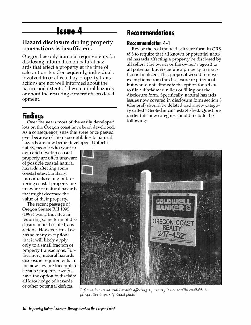
Issue 4—Hazard disclosure during propertytransactions is insufficient (page 40).
Recommendation 4-1. Revise the real estate disclosure form in Oregon Revised Statutes (ORS) 696 to require that all known or potential natural hazards affecting a property be dis-closed by all sellers (the owner or the owner’s agent) to all potential buyers before a property transaction is finalized (State Legislature, Ore-gon Seismic Safety Policy Advisory Commission[OSSPAC]).
Recommendation 4-2. Establish and main-tain a database that includes all known infor-mation on natural hazards affecting real prop-erty, and make this database available to the public so that it can be determined if a proper-ty is located in a hazardous area (OSU HMSC).
Recommendation 4-3. Prepare and make available to prospective buyers of potentially hazardous coastal property a “buyer’s guide” or hazards evaluation checklist. In the guide, include information on how to access addition-al information or contacts (OSU Extension SeaGrant).
Beach and Shore Protection Procedures
Issue 5—Goals and policies for shore protec-tion are inconsistent and outdated, particular-ly with regard to hard structures (page 44).
Recommendation 5-1. Establish clear, consistent goals and policies for operating thebeach and shore protection program admin-istered by the Oregon Parks and Recreation De-partment (OPRD) under the Beach Law (StateLegislature, OPRD).
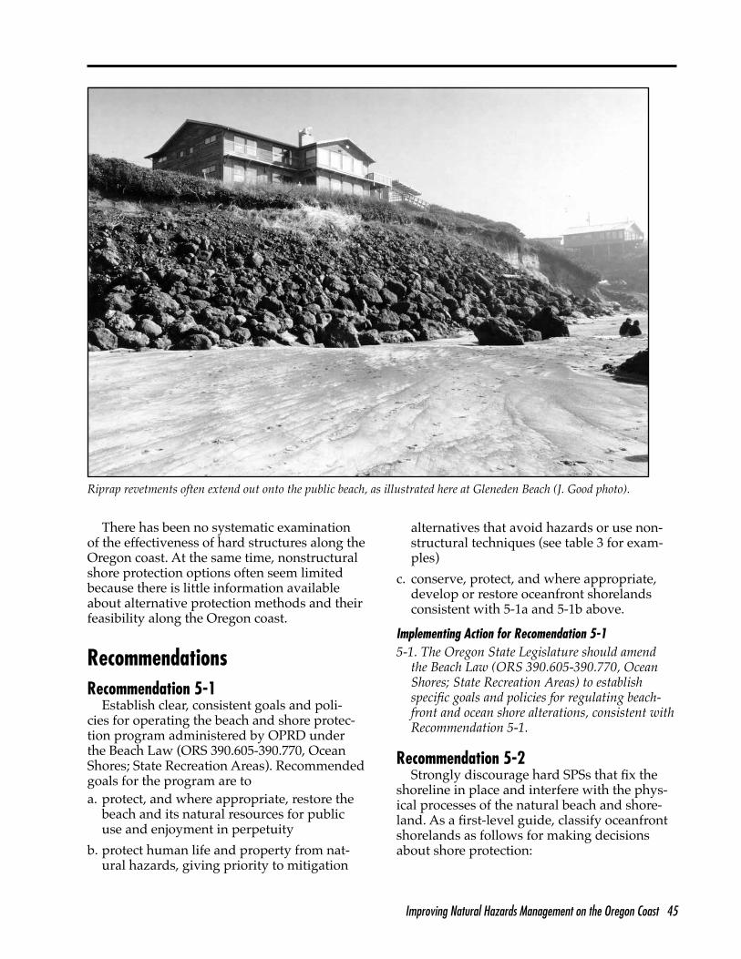
Recommendation 5-2. Strongly discourage hard shore protection structures (SPSs) that fix the shoreline in place and interfere with the physical processes of the natural beach and shoreland (State Legislature, OPRD).
Recommendation 5-3. Conduct a thorough review of studies of alternative shore protec-tion techniques throughout the U.S. and the world. Test and evaluate promising alterna-tives to revetments, seawalls, and other hard shore protection structures; some alternatives are dune construction, vegetative stabilization, beach nourishment, and dynamic revetments (U.S. Army Corps of Engineers [USACOE],OPRD, DOGAMI).
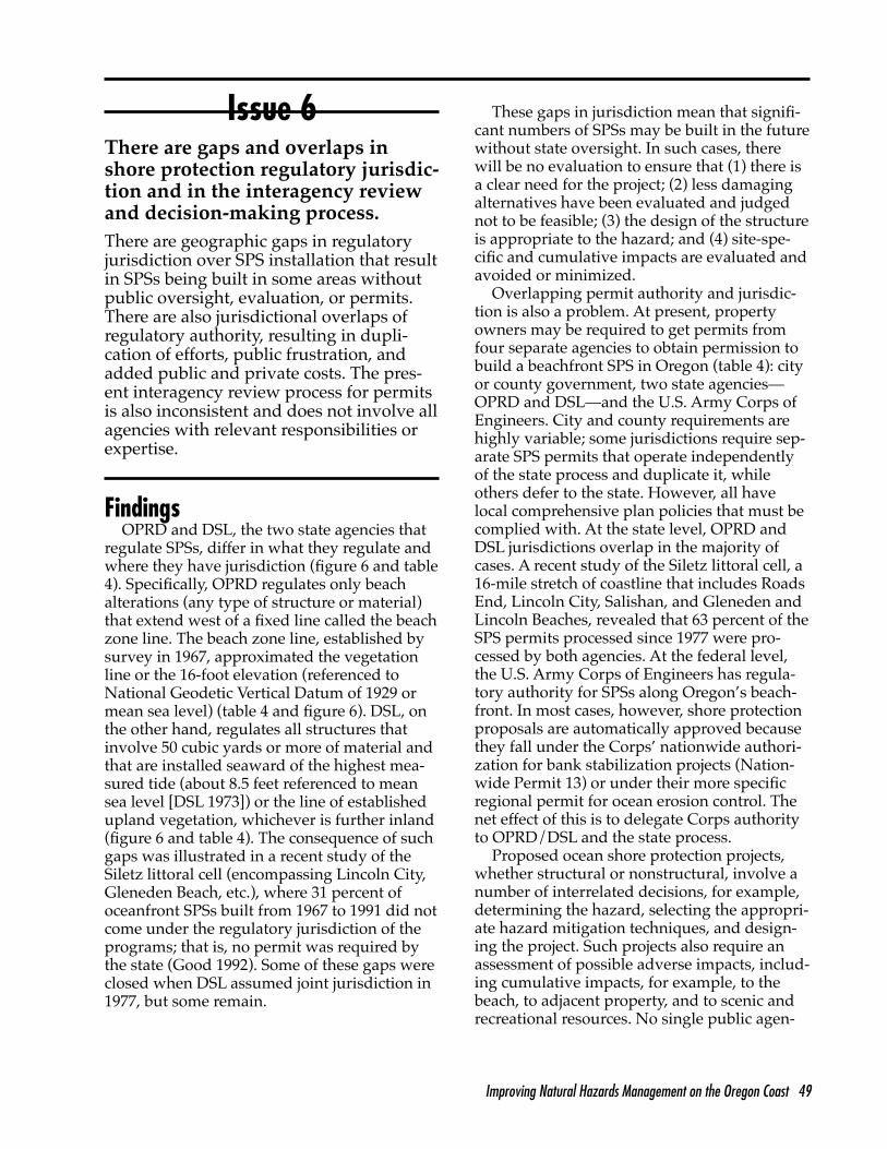
Issue 6—There are gaps and overlaps inshore protection regulatory jurisdiction andin the interagency review and decision-mak-ing process (page 49).
Recommendation 6-1. Regulate the instal-lation of all ocean shore protection structures, other activities designed to stabilize or protect the beach or oceanfront property, and other construction on or immediately adjacent to the beach, including repairs of existing structures. Precise jurisdiction should be determined jointly, in advance, by OPRD, Department of Land Conservation and Development (DLCD),DOGAMI, and the affected local government (State Legislature, OPRD).
Recommendation 6-2. Place exclusivelyunder OPRD’s control both regulatory permits and the decision-making authority for oceanshore protection structures and activities. Min-imize administrative costs by establishing anOPRD-coordinated permit review and evalu-ation process based on the legal authority and expertise of relevant state and local agencies (State Legislature, OPRD).
Improving Natural Hazards Management on the Oregon Coast xi
Issue 7—The shore protection permit processis poorly structured, has weak review stan-dards and limited enforcement authority, and the appeals process is antiquated (page 54).
Recommendation 7-1. Establish a coordi-nated process for shore protection decision making, including an evaluation of hazards and threats to property, alternative mitigation techniques and designs, impacts of alterna-tives, and compensation needs (State Legisla-ture, OPRD, DOGAMI, DLCD, and local govern-ments).
Recommendation 7-2. Vest sufficient ad-ministrative and civil enforcement authority in OPRD to ensure an effective beachfront and ocean shore regulatory program. Change the appeals process so that any person ag-grieved by an OPRD permit decision underORS 390.650 can petition the OPRD director for reconsideration of the final decision (StateLegislature, OPRD).
Issue 8—Emergency shore protection poli-cies and procedures are lacking (page 57).
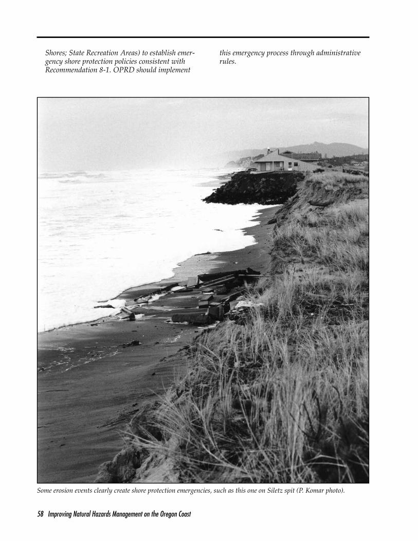
Recommendation 8-1. Establish clear, con-sistent definitions, policies, procedures, and conditions for allowing “emergency” shore protection. Specify what constitutes an “emer-gency,” who makes decisions, what measures are permissible (excluding revetments and sea-walls), and standard requirements, including the requirement for removal (State Legislature, OPRD).
Land Use Planning, Governmental Coordination, and Fiscal Responsibility
Issue 9—Land use planning and site-specificland use decisions, as they relate to coastalhazards, suffer from ineffective integration of existing and new hazards information, piece-meal decision making, and poor communica-tion and coordination among administratorsof land use, shore protection, beach manage-ment, and hazards research programs (page61).
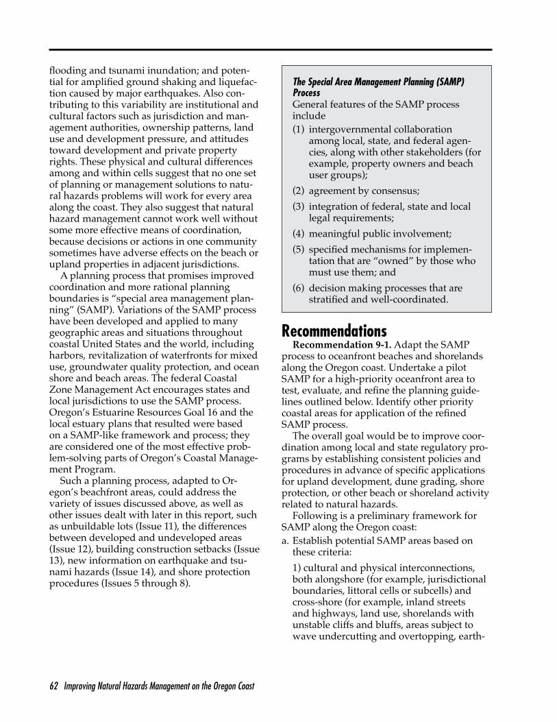
Recommendation 9-1. Adapt the specialarea management planning (SAMP) process to oceanfront beaches and shorelands along the Oregon coast. Undertake a pilot SAMP for
a high-priority oceanfront area, and identify other priority coastal areas for application of the refined SAMP process (Land Conservationand Development Commission [LCDC], DLCD,OPRD, cities and counties).
Recommendation 9-2. Establish a local land use notification process for oceanfront de-velopment projects that could lead to future OPRD-regulated shore protection proposals (LCDC, State Legislature).
Issue 10—Development in hazardous areasis often subsidized by public funding (page65).
Recommendation 10-1. Eliminate tax write-offs for capital losses due to natural hazards for new structures or major additions to existing structures in designated high-hazard areas (State Legislature).
Recommendation 10-2. Establish develop-ment surcharges for building permits and land use actions in high-hazard areas consistent with the actual costs of development (cities andcounties).
Recommendation 10-3. Establish a process for evaluating coastal natural hazards in gov-ernment development, grant, and loan proce-dures (Economic Development Department andother relevant agencies).
Recommendation 10-4. Prohibit direct pub-lic development, grants, loans, or loan guaran-tees for essential facilities, hazardous facilities, major structures, and special occupancy struc-tures in high-hazard areas. Exceptions would be for situations where such hazards are fully mitigated by structural or nonstructural means or when the facility cannot be feasibly locatedoutside high-hazard areas (for example, port facilities, marinas, other water-dependent facil-ities, water and waste treatment facilities, and similar uses). Public subsidies of other types ofdevelopment in high-hazard areas should gen-erally be discouraged (Economic DevelopmentDepartment and other relevant agencies).
Recommendation 10-5. Expand the federalflood insurance program to an all-hazards pro-gram, covering at least erosion, earthquakes, and tsunamis for residences, businesses, and public buildings; couple all-hazards insur-ance with stringent mitigation requirements designed to minimize disaster losses (U.S.
xii Improving Natural Hazards Management on the Oregon Coast
Congress, Federal Emergency Management Agency [FEMA]).
Issue 11—There is no consistent way todetermine what properties along the Oregoncoast are “unbuildable” due to natural haz-ards (page 67).
Recommendation 11-1. Establish and apply a classification system and criteria for determin-ing development capacity of oceanfront lots with respect to hazards (LCDC, DLCD).
Recommendation 11-2. Amend the Oregon Tax Code to provide owners of hazard-prone property with an enhanced tax credit for do-nating property to a public entity or a private, nonprofit land trust for permanent, nondevel-opment-related public use (State Legislature).
Recommendation 11-3. Establish a publicfund to purchase fee simple or development rights to property that is deemed unbuildable based on the criteria in Recommendation 11-1 (OPRD).
Issue 12—Past land use decisions and exist-ing uses unduly influence decisions on newdevelopment (page 69).
Recommendation 12-1. Establish a sunset clause for new subdivisions that limits the time allowed for development to occur and pro-vides for the automatic vacation of the subdi-vision at the time of sunset; review previously approved subdivisions as required by ORS 92.205-92.245 (Undeveloped Subdivisions),modifying or vacating as appropriate; simplify plat vacation and reconfiguration procedures to expedite the process (local government,DLCD, LCDC, State Legislature).
Recommendation 12-2. When a public orprivate infrastructure extension is proposed to service new development, evaluate the exten-sion for its potential to influence land develop-ment in hazardous areas. When an evaluation suggests increased hazard risks or impacts, require that the infrastructure extension be modified to eliminate or minimize such ad-verse impacts (LCDC, DLCD, local governments).
Recommendation 12-3. Evaluate existingpublic infrastructure in areas not yet built up for its influence on land development inhazardous areas. Where reasonable, abandon,
relocate, or otherwise restrict development to minimize threats to life or property (LCDC,DLCD, local governments).
Issue 13—Oceanfront construction setbacks, as now implemented, have not proven to bean effective means for avoiding hazards (page 71).
Recommendation 13-1. Develop, test, andrefine a coastwide technical methodology for coastal construction setbacks, whereby each property would be evaluated on its unique characteristics using the most up-to-date in-formation available (LCDC, DLCD, DOGAMI,OPRD, local government).
Recommendation 13-2. Using the coastalconstruction setback method in Recommenda-tion 13-1, require that setbacks be determined by a qualified professional for all shoreline development subject to coastal natural hazards (LCDC, DLCD).
Recommendation 13-3. Allow variances to required coastal construction setbacks only when (a) building design and proposed con-struction techniques minimize exposure to nat-ural hazards, (b) no concurrent or future hard shore protection structures are permitted, or (c) maximum setback variances on other partsof the property have been already been grant-ed and incorporated into the design (LCDC,DLCD).
Recommendation 13-4. Do not allow the use of lot coverage or building density allowancesas the basis for a variance to required coastal construction setbacks (LCDC, DLCD).
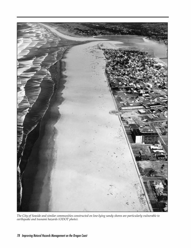
Issue 14—Development continues to besited in earthquake and tsunami high-hazardareas (page 74).
Recommendation 14-1. Establish a systemof special zones, procedures, restrictions, and conditions to limit development in earthquakeand tsunami high-hazard areas (LCDC, DLCD,DOGAMI, local governments).
Recommendation 14-2. Prohibit the con-struction of or significant additions to essential facilities, hazardous facilities, major structures, and special occupancy structures in earthquake and tsunami high-hazard areas (LCDC, DLCD,DOGAMI, local governments).
Improving Natural Hazards Management on the Oregon Coast xiii
Recommendation 14-3. Limit other types ofdevelopment in high-hazard areas to low-in-tensity uses. In addition, establish specificconditions and building standards for devel-opment that will prevent collapse of structures when they are subjected to expected earth-quake or tsunami forces (LCDC, DLCD, DOGA-MI, local governments).
Recommendation 14-4. Develop long-rangeplans to phase out existing essential facilities,hazardous facilities, major structures, and spe-cial occupancy structures located in earthquake or tsunami high-hazard areas. Similarly, phase out or relocate utilities and other infrastruc-ture in these high-hazard areas when normal replacement or major overhaul is due (localgovernments).
Recommendation 14-5. Incorporate infor-mation on tsunami run-up associated with forecasted Cascadia subduction zone (CSZ) earthquakes into the national flood insuranceprogram and rate maps as data becomes avail-able (FEMA, DOGAMI).
Earthquake and Tsunami Disaster Preparedness and Response
Issue 15—Because they are vulnerable toearthquakes or tsunamis, many structures andfacilities, including recently constructed ones,are potentially unsafe (page 79).
Recommendation 15-1. Identify and inspectstructures and facilities in coastal communities that are vulnerable to earthquake or tsunami hazards. At a minimum, make a visual inspec-tion, examine the underlying soil, and estimatethe survivability of the structure in the event of a major earthquake or tsunami. Communicatethe inspection results to local governments and the owners and operators of private structures and facilities (DOGAMI, Building Code Division[BCD], local building officials, private sector).
Recommendation 15-2. Establish procedures for retrofitting, upgrading, or relocating struc-tures and facilities identified as unsafe during inspections conducted in accordance with Recommendation 15-1 (BCD, DOGAMI, localbuilding officials, private sector).
Recommendation 15-3. Conduct a study ofseismic hazard zones 3 and 4 building code
requirements with respect to the sustained ground shaking, liquefaction, tsunami inun-dation, and other hazards expected during a large CSZ earthquake. Upgrade coastal Oregon building codes to conform to the results of this study with special requirements as needed (BCD, DOGAMI, local building officials).
Issue 16—There is limited public awarenessof what earthquake and tsunami hazards are,what risks are involved, and how to plan foror respond to such events (page 82).
Recommendation 16-1. Assign state leader-ship responsibility for earthquake and tsunami awareness, risk reduction, and preparedness and response education to DOGAMI, in part-nership with the Oregon Emergency Manage-ment Division (OEM). These agencies shouldintegrate their efforts and make full use of other centers of scientific and technical exper-tise, financial support, and educational services(State Legislature, DOGAMI, OEM).
Recommendation 16-2. Assign local leader-ship responsibility for earthquake and tsunami awareness, risk reduction, and disaster re-sponse and preparedness education to county emergency management authorities. Base such education on a likely earthquake scenario foreach area, recognizing the critical role of local chapters of the American Red Cross, fire and police departments, medical providers, the Coast Guard, Extension, and other agencies, organizations, and auxiliaries (State Legislature, local emergency managers).
Recommendation 16-3. Design and imple-ment broad-based, sustainable educational programs focused on increasing awareness of earthquake and tsunami hazards and improv-ing disaster preparedness and response. Target audiences are coastal residents and visitors, schools and youth, service providers, business-es and industry, developers and contractors, and financial and legal sectors (DOGAMI,OEM, local emergency managers, and education organizations and institutions).
Recommendation 16-4. Establish and par-ticipate in an earthquake education networkin the Cascadia region (Oregon, Washington, northern California, and British Columbia)to coordinate education activities, and share resources, materials, and know-how. Compose
xiv Improving Natural Hazards Management on the Oregon Coast
the network of educators, public and privateeducational institutions and organizations, and other interested individuals (DOGAMI, OEM,local governments, others).
Recommendation 16-5. Identify, collect, cat-alog, and store existing earthquake education materials at a statewide or regional clearing-house. Disseminate this information to edu-cators and others in the Cascadia region (leadagencies and the Cascadia Earthquake-Tsunami Education Network).
Recommendation 16-6. Identify outstand-ing educational materials and approaches from other areas. Tailor the material to specific audiences, learning styles, educational levels,and geographic areas of Cascadia (lead agenciesand the Cascadia Earthquake-Tsunami Education Network).
Issue 17—State and local emergency man-agement plans do not adequately address thescope and scale of coastal earthquake andtsunami hazards and risks (page 86).
Recommendation 17-1. Require preparation of an earthquake annex to Oregon’s all-haz-ards Emergency Operations Plan, based in part on what was learned in Quakex-94. At the state level, emphasize emergency relief hierar-chy and procedures; reestablishment of basic services and lifelines, including power, com-munications, water and sewer services; and emergency repair of roads and bridges (StateLegislature, OEM, FEMA, others).
Recommendation 17-2. Develop a modelearthquake annex for coastal county emergen-cy plans based on a detailed earthquake ortsunami scenario developed by DOGAMI andprovide technical assistance to counties and cities in adapting the model to their area (StateLegislature, OEM, local governments and emergen-cy managers).
Recommendation 17-3. Following the OEMmodel earthquake annex (to be developed asper Recommendation 17-2), counties, cities,and other organizations, as determined by counties, should develop earthquake annexesfor their all-hazard emergency plans (local gov-ernments and emergency managers).
Recommendation 17-4. Require that state and local earthquake annexes to emergency plans be peer reviewed periodically by a team
appointed by OEM; this is to ensure that the annexes are kept up-to-date with the ever-ex-panding knowledge base on coastal earthquake hazards and mitigation strategies (State Legisla-ture, OEM).
Issue 18—Earthquake preparedness andresponse planning for businesses, families,schools, and individuals are inadequate (page88).
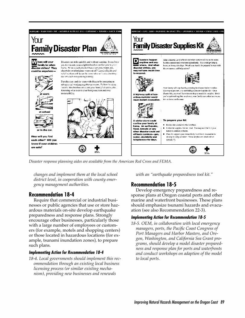
Recommendation 18-1. Evaluate existinglevels of disaster preparedness in homes, schools, and work places. Develop a strategyfor making structural and nonstructural in-spections and improvements and for distribut-ing FEMA and Red Cross guides and brochures that explain how to prepare disaster response plans and supply kits, eliminate home hazards, and respond to an earthquake (local emergency managers, DOGAMI, OEM, others).
Recommendation 18-2. Use grassroots orga-nizations such as community volunteer pro-grams, neighborhood associations, and com-munity planning organizations to contact and assist families and individuals (local emergency managers, local organizations).
Recommendation 18-3. Require school officials to develop and implement earthquakepreparedness plans consistent with FEMA Bul-letin 88 (Guidebook for Development of a SchoolEarthquake Safety Program) and additionalguidelines for tsunami evacuation, if applicable(State Legislature, OSSPAC, DOGAMI, OEM, Department of Education).
Recommendation 18-4. Require that com-mercial or industrial businesses or public agencies that use or store hazardous materials on-site develop earthquake preparedness and response plans. Strongly encourage other busi-nesses, particularly those with a large number of employees or customers or those locatedin hazardous locations, to prepare such plans (local governments).
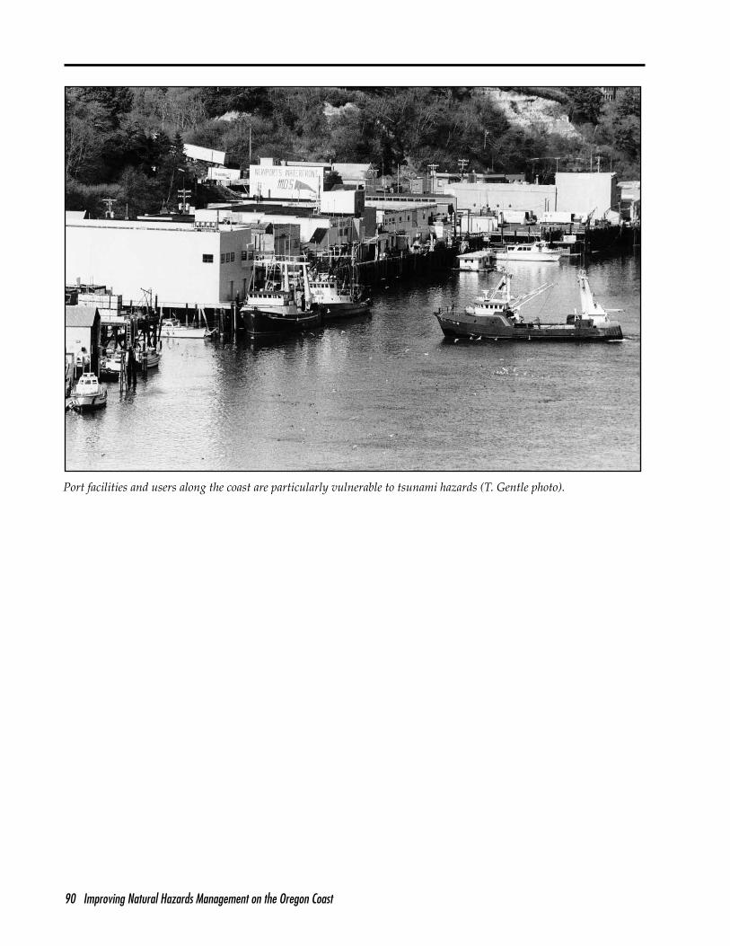
Recommendation 18-5. Develop emergency preparedness and response plans at Oregon coastal ports and other marine and waterfront businesses. These plans should emphasizetsunami hazards and evacuation (OEM, portofficials, local emergency managers, Sea Grant programs).
Improving Natural Hazards Management on the Oregon Coast xv
Issue 19—The organizational structure forcoastal emergency management is not fullyimplemented (page 91).
Recommendation 19-1. In the event of a regional disaster, automatically place under the command of county emergency manage-ment authorities all cities, special districts, andother emergency service providers who do not have an emergency plan or who do not specify incident command relationships (OEM, localemergency managers).
Recommendation 19-2. Organize all lo-cal emergency responders using a command system that follows one of several availablemodels. In the system selected, clearly definehierarchical relationships between counties, cit-ies, special districts, essential service providers, private relief organizations, OEM, and FEMA(OEM, local emergency managers).
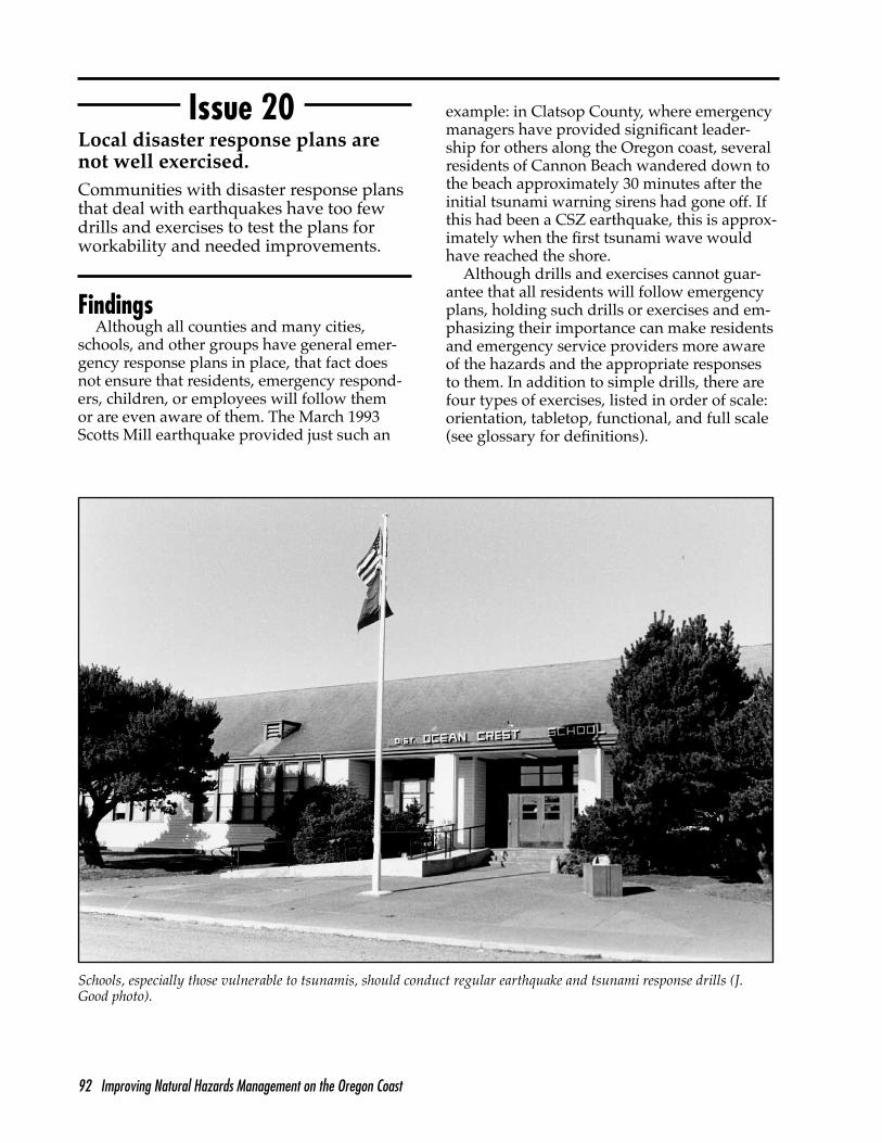
Issue 20—Local disaster response plans arenot well exercised (page 92).
Recommendation 20-1. Require earthquake and tsunami (if applicable) response and evac-uation drills. Keep for state review records that identify drills that had problems and describe how those problems were rectified. Require bimonthly drills for schools and annual drillsfor emergency response facilities, service providers, and other public buildings (OEM,Department of Education, local school districts,local emergency managers).
Recommendation 20-2. Require earthquake orientation or tabletop exercises annually. Con-sistent with available funding, require func-tional or full-scale exercises that focus specif-ically on earthquakes and earthquake-related effects every four years (OEM, local emergency managers).
Recommendation 20-3. Establish an ex-change program for emergency managers from Oregon to observe earthquake exercises occurring in other regions of the country. Have other states’ emergency managers observe and critique exercises in Oregon coastal communi-ties (OEM, local emergency managers).
Recommendation 20-4. Local emergency management organizations should use none-mergency events such as parades and festivals to exercise and improve command, response, and coordination functions that will be essen-
tial in the event of an earthquake or similardisaster (local governments).
Issue 21—Communication networks are insufficient to deal with a large earthquake(page 94).
Recommendation 21-1. Establish communi-ty low-power radio networks for the dissemi-nation of public emergency information during and after a large earthquake (local emergency managers, local organizations).
Recommendation 21-2. In cooperation withan officially designated radio or televisionstation, evaluate the emergency broadcasting system in each coastal region; on the basis of the outcome, make the system fully opera-tional. In addition, ensure (1) that emergency broadcast stations are well protected against physical damage caused by a potential cata-strophic event, (2) that station personnel are well prepared and versed in proper emergency procedures, and (3) that other stations, if still operational after a disaster, simultaneously broadcast the same information as that sent by the designated emergency broadcasting sta-tions (OEM, local emergency managers).
Recommendation 21-3. Establish uniform and effective tsunami warning systems us-ing siren and voice communication in coastal communities and vulnerable rural centers that lack them. Ensure that citizens and visitors are aware of the system by publishing information in phone directories and other local publica-tions and by requiring postings at public plac-es, restaurants, rental units, and motels (localemergency managers, OEM, DOGAMI, National Oceanic and Atmospheric Administration—Pacificand Alaska Tsunami Warning Centers).
Recommendation 21-4. Review the structur-al integrity (that is, ability of a system to with-stand a catastrophic earthquake) of all parts of state and county emergency communication systems and infrastructure, and retrofit where needed (BCD, DOGAMI, local building officials,private sector).
Recommendation 21-5. Establish commu-nication systems recovery teams to evaluate systems and make them operational after anearthquake (local emergency managers).
xvi Improving Natural Hazards Management on the Oregon Coast
Recommendation 21-6. Establish contingen-cy plans to organize local postdisaster commu-nication networks among HAM radio, marineradio, CB radio, and other informal communi-cation systems (such as low-power radio) as anadjunct to the formal communication system(local emergency managers).
Recommendation 21-7. Establish emergency communication systems within schools, using,for example, walkie-talkies (see FEMA Bulletin 88, Guidebook for Development of a School Earth-quake Safety Program) (local school officials).
Issue 22—Physical infrastructure, lifelines,and utility systems will be severely disruptedin the event of a large CSZ earthquake (page96).
Recommendation 22-1. Evaluate highways,roads, bridges, airports, harbors, and railroads for their vulnerability to earthquake or tsunamidamage, using existing geologic informationand a credible CSZ earthquake scenario. Pub-lish and distribute the results of the evaluation, identifying transportation infrastructure likely to be damaged, the infrastructure that would be most easily restored, and the areas likely to be isolated after a large CSZ earthquake. Also provide an estimated timetable for re-estab-lishment of transportation infrastructure and linkages in coastal communities based on likelyscenarios (Oregon Department of Transportation [ODOT], U.S. Forest Service, Bureau of Land Management, USACOE, and railroads).
Recommendation 22-2. Evaluate utilities, including water (and all types of dams), sew-er, electricity, and gas systems and pipelines for their vulnerability to earthquake damage,using existing geologic information and acredible CSZ earthquake scenario. Publish and distribute the evaluation results, identifying utilities and associated infrastructure likely to be damaged during a large earthquake. Also provide an estimated timetable for re-estab-lishing utility services to coastal communitiesbased on likely scenarios (Oregon Public Utili-ties Commission, Oregon Water Resources Depart-
ment, public and private utilities).Recommendation 22-3. Evaluate the vul-
nerability of coastal ports to seismic hazards and tsunamis. Develop appropriate disaster preparedness and response plans for ports to address the varying levels of a potentially catastrophic event (OEM, ports, local emergency mangers, USACOE, FEMA, Pacific Coast Con-gress of Port Managers and Harbor Masters, Sea Grant programs).
Recommendation 22-4. Require continu-ing education on structural codes and design standards for seismic and tsunami-prone areas for designers, engineers, architects, contractors, and building officials working in coastal areas (BCD, licensing boards).
Issue 23—Coastal communities do not have postdisaster recovery and reconstructionplans in place (page 99).
Recommendation 23-1. Develop postdis-aster reconstruction plans based on damage projections from a CSZ earthquake and tsuna-mi. Establish a state postdisaster planning andrecovery task force to plan for reconstruction and serve as the lead state coordinating body to oversee postdisaster reconstruction. Mem-bership of the task force should include DLCD, ODOT, DOGAMI, OSSPAC, OEM, the State Fire Marshall, and other relevant agencies (OS-SPAC, State Legislature).
Recommendation 23-2. Develop postdisas-ter reconstruction plans for cities and counties based on damage projections from a CSZ earth-quake and tsunami. Establish city and countytask forces to plan for reconstruction and over-see local postdisaster reconstruction activities. Assign to each task force a structural engineer, a sanitarian, a fire marshal, a geologist, an engi-neering geologist, a civil engineer, an emergen-cy manager, and building officials (OSSPAC, State Legislature, local emergency managers).
Improving Natural Hazards Management on the Oregon Coast 1
Introduction
2 Improving Natural Hazards Management on the Oregon Coast
Improving Natural Hazards Management on the Oregon Coast 3
Introduction
Natural forces, some cataclysmic and some gradual and relentless, have shaped the Oregon coast over millions of years. The
rocky shores and islands, rugged basalt cliffs and headlands, intricately carved sandstonebluffs, sand and cobble beaches, high dunes, estuaries, river valleys, and mountains thatmake up the coast owe much of their natu-ral beauty and diversity to these forces. The dynamic processes responsible—crustal uplift and subsidence, earthquakes and volcaniceruptions, sea level change, storms and ocean waves—are still at work today, constantly re-shaping the coast.
What is different about the coast today from the distant past is our ubiquitous human pres-ence—our cities and towns, ports and harbors,and network of highways and utilities. From nearly any coastal vantage point, evidence ofhuman presence is apparent and growing. One of the consequences of this growing presence is that the same natural forces that have shaped the coast so attractively in the past increasing-ly threaten human life and property. Severe winter storms, large waves, rain, high winds, and strong tides and nearshore currents cut into beaches and dunes; undermine sea cliffs, causing slumping and slides; and flood low-ly-ing coastal lands. In recent years, the vulner-ability of the coast to large, locally generated earthquakes and tsunamis has become widelyaccepted, adding this potential threat to the reality of the hazards we already experience.
In response to these threats and to expressed concerns that existing efforts to cope with them were inadequate, Oregon Sea Grant sponsored a conference in 1991 to present the results of recent scientific research on coastal hazards and discuss its implications for the coast. Conference participants concluded that new information about natural hazards and development practices warranted a thorough evaluation of public policy dealing with coastalnatural hazards. This led in 1992 to formation of the Coastal Natural Hazards Policy Working Group (PWG).
Who is the Policy Working Group?Organized and facilitated by the Oregon State
University (OSU) Extension Sea Grant Program with support from Oregon’s Coastal Manage-ment Program, the 20-member PWG (Appendix A) was drawn from attendees of the coastal hazards conference who expressed interest in serving. The group included individuals with a variety of coastal interests—oceanfront property owners, realtors, environmentalists, a consult-ing geologist, local planners, a school teacher, a county commissioner, an emergency manager, a fire chief, and managers from key state and federal agencies.
What was the mandate of the Policy Working Group?
The PWG had no formal mandate and so defined its own mission as follows: Represent-ing a broad range of public and private interests, the PWG is identifying important coastal natural hazardissues, evaluating existing management strategies,examining alternatives, and recommending and supporting needed policy improvements to decision makers at all levels.
At the outset, the PWG’s voluntary effort attracted support for its work. For example, theleaders of Oregon’s Coastal Management Pro-gram, responding to 1990 amendments of the federal Coastal Zone Management Act, desig-nated the PWG process as the centerpiece of its strategy to develop improved policies and pro-grams for coastal natural hazards management. The Oregon Seismic Safety Policy Advisory Commission (OSSPAC), established by the state legislature to provide advice on how Oregon should address its vulnerability to earthquakes, invited the PWG to serve as an advisory group.
As the PWG process evolved, several un-derlying goals for dealing with coastal hazards problems emerged that guided the work of the group as they identified issues, formulated op-tions, and made recommendations. These goals were
4 Improving Natural Hazards Management on the Oregon Coast
1) to reduce loss of human life and property due to natural or human-caused hazards
2) to protect valuable recreational and natural resources
3) to limit regulatory approaches to hazard mitigation to that needed to protect clear, legitimate public interests as defined above
How did the Policy Working Group address the issues?
The PWG used an “all-hazards/all-deci-sions” approach to identify issues and options for dealing with them. These issues and op-tions were organized for public review and evaluation and published as the Coastal Natural Hazards Issues and Options Report in October 1993. After a series of evaluation workshops designed to provide the PWG with the views of interested citizens and groups up and down the coast, the PWG reconvened to develop spe-cific recommendations. This report is the result of that effort.
The PWG operated by consensus. Conse-quently, the recommendations presented in this report were “negotiated” and are not neces-sarily what an individual PWG member mighthave recommended independently.
How will the recommendations be used?
A wide array of hazard-related recommen-dations affecting numerous agencies, organi-zations, and individuals are outlined in this report. Thus, it is likely that there will be many routes to adoption and implementation. In response to options presented in its earlier report, several of the PWG recommendations are already being implemented or are the basis for legislative proposals. Other recommenda-tions may be adopted directly or adapted by relevant agencies or organizations. For exam-ple, parts of Oregon’s Coastal Management
Program may be revised to incorporate certain recommendations. Individuals who served on the PWG as private citizens may ask their rep-resentative or senator to introduce legislation dealing with recommendations they especially want to see implemented. State agencies orrepresentatives of local jurisdictions may trans-late some of the recommendations into admin-istrative rules, policies, or ordinances. There will certainly be other unanticipated routes to implementation.
What is this report and how is it organized?
This is the final report of the PWG. It pro-vides background on the PWG process, iden-tifies 23 coastal natural hazard issues, summa-rizes the findings of the PWG for each issue,makes 79 specific recommendations for dealing with the issues, and suggests actions needed toimplement each recommendation.
The introduction to this report gives a brief overview of the work of the Coastal Natural Hazards Policy Working Group: how it came to be, how its members were selected, what its mission was, and how it developed its recom-mendations. The overview is followed by adescription of the natural hazards that affect the coast and existing policies and programs designed to mitigate them. The process used by the PWG to develop its recommendations is described next. This is followed by the mainbody of the report: the issues and recommen-dations. The issues and recommendations are divided into four subsections: hazard assess-ment, shore protection, land use, and disaster preparedness and response. Finally, there are references and several appendices: Appendix A-PWG Members and Support Team; B—Glos-sary of Terms and Acronyms; C—PWG Process and Meeting Schedule; and D-EarthquakeEducation Strategy.
Improving Natural Hazards Management on the Oregon Coast 5
The Heads at Port Orford on the southern Oregon coast (ODOT photo).
6 Improving Natural Hazards Management on the Oregon Coast
Improving Natural Hazards Management on the Oregon Coast 7
Coastal Natural Hazards and Policy in Oregon
8 Improving Natural Hazards Management on the Oregon Coast
Improving Natural Hazards Management on the Oregon Coast 9
Coastal Natural Hazards and Policy in Oregon
Natural Hazards Along the Oregon Coast
The tectonic setting of the Pacific Northwestis very important to the evolution and present character of Oregon’s coastal landforms, and the geologic, oceanic, and atmospheric process-es that contribute to natural hazards. From a tectonic perspective, the Pacific Northwest isa continental collision coast characterized bya relatively straight shoreline, raised terraces, narrow continental shelf, volcanism and seis-micity. Just offshore is the 700-mile long Casca-dia subduction zone (CSZ), the boundary be-tween the westward-moving continental North American plate and the northeast-movingJuan de Fuca plate (figure 1).
As a consequence of its tectonic setting,the Oregon coast is mountainous, with rocky headlands segmenting the shore into pocket beaches of varying lengths(figure 2). Seventeen coastal rivers drain the Coast Range and Klamath Mountains,discharging into the sea where they form estuaries. At a finer scale, the coast is highly irregular with a variety of land-forms and rock types of varying ages and origins (Snavely 1987). Rocky headlandscomposed of Tertiary basalts are one of the most prominent coastal features, often several hundred feet high and jutting sea-ward more than a mile. These, and other headlands composed of erosion-resistant sedimentary rocks, divide the Oregon coast into a series of 22 discrete littoral cells and subcells (Peterson et al. 1991).Much of the coastline between these head-lands is sea cliffs, composed of more erod-ible sedimentary sandstones, siltstones,and mudstones of different ages. These cliffs are generally fronted by beaches of varying width and composition. Thesea cliffs along the central Oregon coast and parts of the south coast are mostly uplifted marine terrace sands and silts ofPleistocene origin. At the river mouths,
narrow, unstable bay-barrier sand spits are common, some extending north and otherssouth to form the ocean side of estuaries. Large coastal sand dunes are another prominent fea-ture of the northern and central coast, includ-ing Clatsop Plains north of Tillamook Head, Sand Lake dunes just south of Cape Lookout,and the nearly 50-mile long dune sheet extend-ing from Cape Perpetua south to Coos Bay. Most of the latter dunes are part of the Oregon Dunes National Recreation Area. Of the 362 miles of Oregon coastline, 100 miles (28 per-cent) are rocky shore and 262 miles (72 percent) are sandy beach shores, including those backed by sea cliffs, dunes, and spits.
Figure 1.—Major plate tectonic features of the Pacific Northwest (source: Atlas of the Pacific Northwest, OSU Press).
10 Improving Natural Hazards Management on the Oregon Coast
Figure 2.—Features of the Oregon coast, including major headlands (in black) that divide the coast into discrete beach segments or littoral cells.
Natural hazards that affect the coast can up is periodically a problem for existing and be divided into two general classes—chron- new development. These hazards occur with a ic and catastrophic. Chronic hazards are relative degree of predictability and affect only those we can see clear evidence of along the limited areas at any given time. The damage shore—beach, dune, and bluff erosion; slides, they cause is usually gradual and cumulative.slumps, and gradual weathering of sea cliffs; Chronic hazards along the coast owe their and flooding of low-lying lands during major severity to the regional oceanic and climatic storms. Within some cells, excess sand build-
Improving Natural Hazards Management on the Oregon Coast 11
environments (Komar 1992) that result in large winter storms with waves up to 30 feet high;associated storm surge and wave setup along the beach and shoreland; strong nearshore cur-rents, including rips; high winds, rain, runoff, and associated lowland flooding; and elevatedsea levels, caused by seasonal effects and peri-odic El Ninos. Long-term sea level rise associ-ated with global warming poses no immediaterisk along the north and south coasts of Oregon because coastal emergence rates exceed long-term sea level rise. However, sea level rise is a problem along approximately 150 miles of the central coast, where coastal uplift is minimal. Although public policies addressing natural
hazard mitigation tend to focus on these chron-ic coastal hazards (except for sea level rise), there have been significant problems with how they have been implemented.
Catastrophic hazards are those associated with earthquakes, three types of which may occur in the Pacific Northwest coastal region: crustal, intraplate, and subduction zone (Ma-din 1992). Crustal earthquakes occur on local faults along the coast and may be as large as magnitude 6-6.5 on the Richter scale. Recentcrustal quakes in Oregon were the March 25, 1993 Scotts Mill quake (magnitude 5.6) andthe September 20, 1993 Klamath Falls quakes(magnitude 5.9 and 6.0). Despite their rela-tively small size and rural epicenters, both caused significant property damage. Intraplate
The central Oregon coast dune sheet extends nearly 50 miles and includes dunes up to 700 feet high (ODOT photo).
12 Improving Natural Hazards Management on the Oregon Coast
earthquakes occur along the subducting Juande Fuca plate, deep below the surface un-der the Coast Range and western Willamette Valley. The Puget Sound area has experienced intraplate quakes as large as magnitude 7.1 (1949) and 6.5 (1965), but no historic eventshave been documented in Oregon. Very large earthquakes are believed to occur along the CSZ. While there have been no major historic subduction zone earthquakes along this 700-mile long fault (there was a magnitude 7.1 event in April 1992 at the extreme south end of the subduction zone), there are several con-verging lines of evidence for powerful earth-quakes in the magnitude 8 to 9+ range. Theseinclude geodetic measurements of accumu-lating uplift strain (Weldon 1991), tide gauge data from a variety of coastal locations (Shih 1992), sequential dating of abruptly submerged peat deposits in salt marshes along the coast(Darienzo and Peterson 1990), records of off-shore turbidity current deposits (Adams 1990), and the archeological record (Woodward et al. 1990). Estimated recurrence intervals range from 340 to 590 years; the last large quake was about 300 years ago, placing the probability of another event in the next 50 years at 10 to 20percent (Priest pers. comm., October 20, 1992).
The scenario for a large CSZ earthquake is sobering: severe ground shaking lasting up to four minutes; liquefaction of saturated, uncon-solidated soils such as sand or silt; numerous and possibly massive landslides; land subsid-ence and flooding, particularly along the cen-tral and north coasts; and a series of large tsu-nami waves beginning to arrive soon after theevent. All of these hazards occurred during the 1960 Chilean subduction zone earthquake—probably a good comparison for a CSZ event—with heavy loss of life and property. Tsunamis generated by distant earthquakes occurringalong the Pacific rim are also a hazard along the Oregon coast. The 1964 Alaska earthquake, for example, caused significant damage withinmany of Oregon’s coastal estuaries.
Coastal Natural Hazards Management
The existing management framework formitigating coastal natural hazards in Oregon includes local, state, and federal laws and policies implemented through a variety of pro-grams and government agencies. Historically, in Oregon at least, state and local governments have played the most significant role in haz-ards management. These roles, divided into four categories—hazard assessment, shore pro-tection, land use planning and development,and disaster preparedness and response—are summarized in table 1, with more detail below.
Hazard Assessment Hazard mapping, research, and mitigation
assistance in Oregon are the responsibility of the Department of Geology and Mineral In-dustries (DOGAMI). In the early 1970s, DOG-AMI published environmental geology maps and assessments for all coastal counties that served as basic hazard inventories for many years. Oregon’s coastal management agency, the Department of Land Conservation andDevelopment (DLCD), required local gov-ernments to develop and use these and othernatural hazard inventories in their local com-prehensive planning process. However, much of the information used for the inventories was general and has proven to be of limited use for specific sites. DOGAMI and DLCD have begunmore detailed hazard assessment work recent-ly, as discussed later in the recommendations section of this report.
Shore Protection The typical response to shoreline erosion
or slumping along developed portions of theOregon coast has been to install a seawall or riprap revetments—referred to as “hard” shore protection structures (SPSs) throughout this re-port. The installation of SPSs along the ocean-front is regulated by two state laws: the Beach Law (ORS 390.605-390.770) and the Removal/Fill Law (ORS 196.800-196-990). These lawsare administered as a joint permit program by the Oregon Parks and Recreation Department (OPRD) and the Division of State Lands (DSL),
Improving Natural Hazards Management on the Oregon Coast 13
Tabl
e 1.
Gov
ernm
enta
l fun
ctio
ns a
nd a
genc
ies o
r aut
horit
ies f
or c
oast
al n
atur
al h
azar
ds m
anag
emen
t in
Ore
gon.
Gove
rnm
enta
l Fun
ction
Haz
ard
rese
arch
, ass
essm
ent,
and
map
ping
Shor
e pr
otec
tion
Land
use
pla
nnin
g an
dde
velo
pmen
t
Dis
aste
r pre
pare
dnes
s an
dre
spon
se
Fede
ral G
over
nmen
t
■ U
.S. G
eolo
gica
l Sur
vey:
geo
logi
cal
haza
rds
■ F
eder
al E
mer
genc
y M
anag
emen
t A
genc
y (F
EMA
): flo
od a
nd e
rosi
on
haza
rds
■ U
.S. A
rmy
Cor
ps o
f Eng
inee
rs
(USA
CO
E): e
rosi
on h
azar
ds
■ U
SAC
OE
Nat
ionw
ide
Perm
it N
o.13
: ban
k st
abili
zatio
n
■ F
EMA
: Nat
iona
l Flo
od In
sura
nce
Prog
ram
(NFI
P)
■ F
EMA
coa
stal
and
floo
d co
nstr
uctio
n st
anda
rds
■ F
EMA
: fed
eral
resp
onse
and
aid
co
ordi
nato
r ■ U
SAC
OE:
cle
anup
, con
stru
ctio
n,
wat
erw
ay a
ssis
tanc
e
Stat
e Go
vern
men
t
■ D
ept.
of G
eolo
gy a
nd M
iner
alIn
dust
ries (
DO
GA
MI):
haz
ards
info
an
d m
appi
ng■ D
ept.
of L
and
Con
serv
atio
n an
dD
evel
opm
ent (
DLC
D):
inve
ntor
yst
anda
rds
■ U
nive
rsiti
es/S
ea G
rant
: res
earc
h
■ O
rego
n Pa
rks a
nd R
ecre
atio
n D
epar
tmen
t (O
PRD
): Be
ach
Law
regu
late
s sho
re p
rote
ctio
n st
ruct
ures
■ D
ivis
ion
of S
tate
Lan
ds (D
SL):
Rem
oval
/Fill
Law
regu
late
s re
vetm
ents
and
fill
■ D
LCD
stat
ewid
e pl
anni
ngst
anda
rds:
Goa
l 7: N
atur
al H
azar
dsG
oal 1
7: C
oast
al S
hore
land
s G
oal 1
8: B
each
es a
nd D
unes
■ B
uild
ing
Cod
e D
ivis
ion:
bui
ldin
gst
anda
rds
■ O
rego
n Em
erge
ncy
Man
agem
ent
Div
isio
n (O
EM):
disa
ster
resp
onse
an
d pl
anni
ng■ O
rego
n Se
ism
ic S
afet
y Po
licy
Adv
isor
y C
omm
issi
on (O
SSPA
C):
eart
hqua
ke/t
suna
mi p
olic
y an
dpl
anni
ng
Loca
l Gov
ernm
ent
■ L
ocal
Com
preh
ensi
ve P
lan
(LC
P):
haza
rds i
nven
tory
and
map
s
■ L
CP
and
deve
lopm
ent o
rdin
ance
s(s
hore
pro
tect
ion
prov
isio
ns v
ary)
■ S
tate
-app
rove
d LC
P w
ith n
atur
alha
zard
s, sh
orel
ands
, bea
ches
, and
dune
s ele
men
ts; l
ocal
subd
ivis
ion,
zon
ing,
and
floo
d da
mag
e pr
even
tion
ordi
nanc
es
■ L
ocal
bui
ldin
g co
de a
dmin
istr
atio
n:ci
ty a
nd c
ount
y
■ E
mer
genc
y m
anag
emen
t: C
ount
ies
■ L
aw e
nfor
cem
ent,
fire,
med
ical
: C
ount
ies/
Citi
es
14 Improving Natural Hazards Management on the Oregon Coast
respectively. The emphasis in both laws is on protecting public recreation values and access to and along the beach. Both agencies regulate the riprap revetments and seawalls installed along the shore to control erosion and bluff slumping, though their jurisdictions differ somewhat. OPRD regulates all types and sizes of structures, but their geographic jurisdiction is limited to structures that extend west of a beach zone line (BZL) that was surveyed in1967, just after the Beach Law was passed. DSL, on the other hand, only regulates structures in-volving 50 cubic yards or more of material, but their geographic jurisdiction is not fixed andextends to the upland vegetation line. State-wide planning Goal 18 (Beaches and Dunes)also plays a role in regulating shore protection. The goal prohibits beachfront protective struc-tures in areas that were not developed or phys-ically improved as of January 1, 1977. “Devel-opment” is defined as houses, commercial and industrial buildings, and vacant subdivisionlots that are physically improved through con-struction of streets and provision of utilities to the lot, or areas where special exceptions have been approved. For SPSs, the goal also requires that visual impacts must be minimized andnecessary access to the beach be maintained,and that negative impacts on adjacent property, and long-term or recurring costs be minimized.
The U.S. Army Corps of Engineers (US-ACOE) regulates installation of SPSs under sec-tion 10 of the Rivers and Harbors Act of 1899 and section 404 of the Clean Water Act. The Portland District USACOE issued a nationwide permit for “bank stabilization” (NWP 13), with regional conditions for Oregon, effective Feb-ruary 14, 1992. NWP 13 effectively removes the Corps from the majority of day-to-day shore protection decision making. Concerns about present shore protection regulatory programs are addressed in the recommendations section of this report.
Land Use Planning and Development Oregon’s statewide land use planning pro-
gram, overseen by the Land Conservation andDevelopment Commission (LCDC), includeshazard-related planning goals used by local governments to develop local comprehensive plans. Three goals apply directly to hazards
management. LCDC Goal 7—Natural Hazards, mandates that development subject to naturalhazards not be located in known areas of nat-ural hazards without appropriate safeguards. LCDC Goal 17—Coastal Shorelands, requires that local comprehensive plans consider geo-logic and hydrologic hazards along shorelines, giving preference to non-structural mitiga-tion techniques to solve erosion and flooding problems. LCDC Goal 18—Beaches and Dunes, prohibits development on hazardous dune and interdune lands, prohibits breaching of fore-dunes, and sets hazard mitigation conditions on development on more stable dunelands.
Cities and counties were required to address these and other policies in their local compre-hensive plans, which were then reviewed and approved by the state. All coastal jurisdictions completed their initial round of planning in the early 1980s and have state-acknowledged plansand implementing ordinances. Specific provi-sions in local plans for regulating development in hazardous oceanfront areas vary. All coun-ties have required construction setbacks, either fixed or variable, some require geologic hazard reports from a registered geologist or engineer, and some use overlay ordinances and other provisions. However, there are few standard-ized hazard mitigation provisions in the plans, and some are more effective than others.
The federal government gets involved inland use management indirectly through provisions of the National Flood Insurance Program, administered by local governments through the Federal Emergency Management Agency (FEMA). The Upton Jones provision of the law, passed in 1987, authorizes advance payment for relocation or demolition of any structure that is covered by a current flood insurance policy and that is subject to immi-nent collapse because of erosion. However, this provision has not yet been applied in Oregon and it is not likely to be an important manage-ment tool. Most of the erosion-related property loss is for bluff-top areas where residents do not have federal flood insurance.
Disaster Preparedness and Response Numerous agencies are involved in disaster
preparedness and response. At the national level, the Federal Emergency Management
Improving Natural Hazards Management on the Oregon Coast 15
Planning Goals 7, 17, and 18 provide guidance for development in hazardous areas but have serious limitations (J. Good photo).
Agency (FEMA) takes the lead, with the U.S.Army Corps of Engineers and many otheragencies in support. FEMA’s counterpart at the state level is the Oregon Emergency Manage-ment Division (OEM), now a unit under theOregon State Police. At the local level, counties are in charge of emergency management and disaster preparedness, with cities and special districts usually coming under their juris-diction. The American Red Cross and other private relief agencies also play important roles in disaster preparedness and response. Each agency is charged with certain responsibilities for disaster preparedness, mitigation, response and recovery planning, and plan exercises.
Effective disaster preparedness and response are vital, regardless of the hazard. However, because of the lack of major historic coastalearthquakes or tsunamis, it has been difficult toplan effectively and execute a response. Many agencies are just now in the process of prepar-ing plans that are specific to coastal earthquake and tsunami hazards. Effective planning will require the active involvement of people in local government, law enforcement, fire and medical services, transportation, health andhuman resources, schools, and businesses and local citizens. Concerns about the present pre-paredness and response capacity of responsible agencies as it relates to a CSZ earthquake are addressed in the recommendations section of this report.
16 Improving Natural Hazards Management on the Oregon Coast
Improving Natural Hazards Management on the Oregon Coast 17
The Policy Working Group Process
18 Improving Natural Hazards Management on the Oregon Coast
Improving Natural Hazards Management on the Oregon Coast 19
The Policy Working Group Process Developing a Policy Improvement Strategy
By 1992, several indicators suggested theneed for a comprehensive review of Oregon’s coastal natural hazards management frame-work, including new research findings on earthquakes and other coastal hazards (Madin 1992; Komar 1992), accelerating coastal growth (Jones 1993), and recent evaluations of haz-ard-related policies and practices (Good 1992; DLCD 1992). However, given the relatively low profile this set of problems presented in comparison to state budget shortfalls, fundingfor education, health care, and salmon recov-ery, the continuing timber crisis, and other state and national issues, the key question forcoastal managers was how to develop work-able policy improvements and, at the same time, get the attention of the policymakers whowould be needed to initiate legislative andadministrative changes. The resulting strategy involved (1) a major conference to focus atten-tion on the issues, (2) the formation of an adhoc policy working group to examine issues in more detail and make recommendations for improvements, and (3) a gradual effort to build credibility and support for needed changes, first at the grassroots level, and later with state agency leaders and legislators.
The Coastal Natural Hazards Conference
In October 1991, Oregon Sea Grant and a number of state agencies and local organiza-tions sponsored a coastal hazards conference in Newport, Oregon, aimed at coastal residents, public officials and resource managers, real-tors, developers, and environmentalists. The purpose of the conference was to present what scientists and engineers have learned in recent years about coastal natural hazards, what their findings mean for coastal residents, visitors, and officials, and what kinds of public policiesmight be needed to address these hazards.
Probably the most significant concern of partic-ipants was the potential for a large subduction zone earthquake and our lack of preparedness. Other concerns were rapid growth in coastal high-hazard areas and limited hazard infor-mation and education on these issues. Paperspresented at the conference were published by Oregon Sea Grant—Coastal Natural Hazards: Science, Engineering, and Public Policy (Goodand Ridlington 1992). In addition, the results of “focus group” discussions at the conclusion of the conference identified a variety of problems and concerns that needed to be addressed. Participants expressed great interest in delving into these issues in more detail and working to find acceptable solutions. This led to formationof the Coastal Natural Hazards Policy Working Group.
Selection and Support of the Policy Working Group
Much of the credibility of the policy process came from the PWG’s diverse membership. The 20 members of the group were selected from among those who attended the coastal hazards conference, with representatives from a range of “stakeholders” with different per-spectives and interests—oceanfront property owners, builders, realtors, consultants, local officials and planners, state and federal regula-tors and resource managers, environmentalists, educators, and others. Representatives of the state and federal agencies with major respon-sibilities for coastal hazards management were also included in the group.
The group was supported by a team from the OSU Extension Sea Grant Program with funding from the National Oceanic and Atmo-spheric Administration, Office of Ocean and Coastal Resources Management, through Ore-gon’s Coastal Management Program (OCMP) and DLCD. A Technical Advisory Committee, an Education Advisory Committee, and a num-ber of other experts on hazard-related topics also assisted the PWG.
20 Improving Natural Hazards Management on the Oregon Coast
Stages and Features of the PWG Process
The PWG process had three stages: I—issue and option generation; II—evaluation andpublic feedback on draft policy options; andIII—development of recommendations to policymakers. These are illustrated in figure 3 and described below. Two features of the
PWG process are particularly noteworthy: the comprehensive all-hazards/all-decisions methodology and the structured, consensus-based workshop process.
All-Hazards/All-Decisions Approach There are many public and private deci-
sion-making situations in which the effects or potential effects of coastal natural hazards may
Figure 3.—Process used by the Coastal Natural Hazards Policy Working Group.
Improving Natural Hazards Management on the Oregon Coast 21
be important. To provide an entry point for the complex policy development process that was undertaken by the PWG, an all-hazards, all-de-cisions approach was developed and used to integrate hazard-related problems with poten-tial solutions. A matrix of decisions versus haz-
ards was developed to represent this approach conceptually (figure 4).
Stage I: Issue and Option Identification Stage I of the process involved 10 two-day
Locating public infrastructure and facilities in undeveloped areas
Designing private development in undeveloped areas
Designing public infrastructure and facilities in undeveloped areas
Protecting private development in undeveloped areas
Protecting public infrastructure and facilities in undeveloped areas
Locating private development in infill areas
Each of the PWG workshops was orga-nized around a limited set of hazards and decisions (for example, the area within the shaded box served as the basis for a single workshop).
Locating public infrastructure and facilities in infill areas
Designing private development in infill areas
Designing public infrastructure and facilities in infill areas
Protecting private development in infill areas
Protecting public infrastructure and facilities in infill areas
Locating private development in developed areas
Locahng public infrastructure and facilities in developed areas
Designing private development in developed areas
Designing public infrastructure and facilities in developed areas
Protecting private development in developed areas
Protecting public infrastructure and facilities in developed areas
Emergency respon se planning
Post-disaster reconstruction planning
Figure 4.—All-hazards/all-decisions matrix used in the policy working group process.
22 Improving Natural Hazards Management on the Oregon Coast
advisory committees and each of the PWGwork teams (see Appendix C for details). The matrix served as a guide to focus the initialPWG workshops on a limited set or blockof issues at any one time; for example, oneworkshop focused on the group of cells that represented “chronic hazards as they affect the location of development in undevelopedareas.” This and other blocks of cells were used to identify issues and generate potentialsolutions in a series of structured, brainstorm-ing workshops. Though the brainstormingprocess was structured, all issues (an issue is defined as a problem, concern, or opportunity) and solutions were accepted in a nonjudg-mental manner. These data were recorded and posted, serving as a kind of “group memory.” After each workshop, these raw data were reviewed and folded into an ongoing “working list,” using natural groupings such as hazard assessment, shore protection, land use, disaster preparedness and response, education, and so on. As the working list was gradually built through the 10 Stage I workshops, many over-lapping issues and options became apparent and were combined. This working list was the raw material for developing the “issues andoptions report” that was published in Stage II. By waiting until all hazards and decisions had been examined before developing the final issues and options list, the PWG wasable to formulate a more comprehensive set of policy options and to integrate chronic and catastrophic hazards with related public and private decision making.
Stage II: Evaluation of Issues and Options In Stage II of the process, three additional
two-day PWG workshops and many more small work group meetings were held to trans-form the working list into the Coastal Natural Hazards Issues and Options Report, published inOctober 1993. In the report, the PWG identified 27 significant coastal hazard policy issues and categorized them into four groups: Hazard As-sessment, Disaster Preparedness and Response, Land Use, and Shore Protection. For each issue, there were a range of options or poten-tial solutions for dealing with the problem or concern each issue represented. Accompanying the report was a detailed evaluation form that asked reviewers to provide feedback on the
issues and options.There were three principal purposes for the
Issues and Options Report, the evaluation pro-cess, and the public workshops: 1) to share important hazard-related issues that
coastal residents, visitors and managers face today and in the future
2) to suggest that there are a variety of solu-tions or “options” for dealing with theseissues
3) to ask reviewers to evaluate each of the options, to state their preferences, and give the PWG other ideas for solving identifiedproblems More than 700 copies of the issues and
options report were distributed at workshops and by direct mail to coastal residents, local officials, state agencies, planners, and othersinterested in or affected by these issues, along with the evaluation forms. Eleven workshopswere held with interested groups along the coast and more than 500 people participated (table 2). Some 65 individuals completed thefull evaluation form, a process that required reviewers to read the full report and then evaluate each of the options—about a three- to five-hour task. Although the data gathering effort was not “scientific” in a statistical sense, it did provide the PWG with some very useful written comments and a general sense of whatinterested reviewers thought about each of the options.
The evaluation process had three parts. First, for each of the options associated with an issue,reviewers were asked to evaluate how well the option answered the following question and rate the option accordingly:On the whole, how would you judge this option,
considering its potential effectiveness, public cost,private cost, and political feasibility?
RatingPoor Neutral Excellent
1 2 3 4 5
Next, after evaluating each of the options,evaluators checked the box for the option(s)that they wanted to see included in the PWG’sfinal recommendations. Finally, reviewers were asked to make comments on each issue and to suggest new option ideas.
Improving Natural Hazards Management on the Oregon Coast 23
Tabl
e 2.
Coa
stal
Nat
ural
Haz
ards
Issu
es a
nd O
ptio
ns R
epor
tEva
luat
ion
Wor
ksho
p Sc
hedu
le a
nd R
esul
ts (1
993)
.
Gro
upD
ate-
Tim
e-Lo
catio
nN
otes
(PW
G in
volv
emen
t, at
tend
ance
)
OC
ZMA
, Inc
.Se
p 16
, 110
0, F
lore
nce
Peg
Reag
an, J
eri A
llem
and
(50
part
icip
ants
, pre
limin
ary
resu
lts)
Cur
ry C
ount
y Ea
rthq
uake
Oct
16,
110
0, G
old
Beac
hJe
ri A
llem
and,
Peg
Rea
gan,
Phy
llis C
ottin
gham
, Jim
Goo
d (1
50W
orks
hop
part
icip
ants
)
ON
CR
Coa
st/O
cean
Con
f.O
ct 1
7, 0
830,
New
port
Elle
n W
arrin
g, E
mily
Tob
y, Ji
m G
ood
(abo
ut 4
0 pa
rtic
ipan
ts)
Ore
gon
Seis
mic
Saf
ety
Nov
5, 1
130,
Sal
emPe
g Re
agan
, Em
ily T
oby,
Jim
Goo
d (2
0 pa
rtic
ipan
ts)
Polic
y A
dvis
ory
Com
m.
Leag
ue o
f Ore
gon
Citi
esN
ov 8
, 134
5, E
ugen
eJe
ri A
llem
and,
Jim
Goo
d (M
arily
n Sc
hafe
r, G
old
Beac
h M
ayor
pres
ided
) (35
par
ticip
ants
)
Tilla
moo
k Bo
ard
of
Nov
9, 0
800,
Till
amoo
kPa
tric
ia W
illia
ms/
Vic A
ffolte
r, Jim
Goo
d (a
bout
45
part
icip
ated
)Re
alto
rs
Coa
stal
Pla
nner
s,N
ov 1
2, 1
300,
New
port
Mik
e Sh
ober
g, V
ic A
ffolte
r, Em
ily T
oby,
Jim
Goo
d (2
2 pa
rtic
ipan
ts)
Build
ing
Offi
cial
s,St
ate
Man
ager
s
Ore
gon
Shor
es C
onse
rva-
Nov
13,
113
0, N
ewpo
rtEl
len
War
ring,
Dav
id M
inte
r, Pa
ul S
alop
(45
part
icip
ants
)tio
n C
oalit
ion
Coa
st E
mer
genc
yN
ov 1
6, S
alem
Jeri
Alle
man
d (in
form
al m
eetin
g w
ith 7
coa
stal
cou
nty
Man
ager
sem
erge
ncy
man
ager
s)
Sout
h Li
ncol
n Bo
ard
ofN
ov 1
6, 1
130,
New
port
Tere
sa A
twill
, She
ridan
Jone
s, Pa
ul S
alop
(60
part
icip
ants
)Re
alto
rs
Oce
an P
olic
y A
dvis
ory
Dec
10,
150
0, N
ewpo
rtD
enni
s Olm
stea
d, P
ete
Bond
, Elle
n W
arrin
g, Ji
m G
ood
(25
Cou
ncil
part
icip
ants
)
24 Improving Natural Hazards Management on the Oregon Coast
Stage III: Developing and Presenting Recommendations
Following the evaluation process, the PWG reconvened for Stage III of the process. They examined the results of the evaluation process and deliberated on a package of final recom-mendations during six additional two-dayworkshops, completing their work in May1994. Again, the policies were developed through a consensus-building process and do not represent the views of any individual member, but the group as a whole.
Other Features of the PWG Process Several features of the PWG process that
were critical to the success of the group were derived or modified from several decades of experience in dispute resolution. They were as follows: 1) An open process based on the interests of
“stakeholders.” The diversity of stakehold-ers on the PWG was noted above. The PWG agreed to recognize, respect, and value the diversity of ideas and opinions held by itsmembers. All meetings were open to ob-servers, who were regularly consulted, and broad-based public involvement in eval-uation of PWG proposals was considered essential.
2) Consensus decision making. The PWGagreed to work by consensus. Consensus meant that members had an opportunityto state their views, that they believed theywere listened to, and that they could “live with” the decision, whether or not it was the same decision they would have come toindependently. Because of this and the com-mitment to public input, the PWG strove for solutions that were effective and equitable as well as acceptable to all stakeholders.
3) Neutral facilitation and support. A neu-tral, third-party facilitator was engaged to assist the PWG with group processes and decision making. Creativity and new think-ing in defining problems was encouraged. In part, this was stimulated by the diversity ofinterests represented within the PWG, and in part by the process itself. Funding for logis-tic and technical support for the group was provided by DLCD through federal Section
309 coastal grants. OSU, through its Exten-sion Sea Grant Program, provided coordina-tion, support, and management assistance.
4) The assistance of experts, educators, andresearchers. Many of the subjects addressed by the PWG were highly technical and cut across many disciplines. For each topic area addressed by the PWG, expert panels were convened and resource material was provid-ed by the support team. A research assis-tant researched issues in more depth when needed, a technical advisory committeedeveloped and presented the latest scientific consensus on issues (for example, a planningscenario for a large CSZ earthquake), an education advisory committee developed acomprehensive strategy for earthquake and tsunami education, and a variety of specialresearch projects were funded and conduct-ed by DLCD and other agencies under theauspices of the Section 309 CZM program (for example, an all-hazards mapping pilotproject).
5) Support building. Because the PWG effort was an ad hoc, bottom-up process with no formal legislative or other mandate, efforts were made throughout the process to build recognition and credibility. The evaluation process in Stage II was by far the most signif-icant of these efforts, but other presentations to local and state officials, legislators, andothers were also important.
The Policy Working Group facilitator leading the group in a consensus-building session (J. Good photo).
Improving Natural Hazards Management on the Oregon Coast 25
Issues and Recommendations
26 Improving Natural Hazards Management on the Oregon Coast
Improving Natural Hazards Management on the Oregon Coast 27
Hazard Assessment and Information Access
Accurate, up-to-date maps and informationon coastal hazards at scales useful for decision making are prerequisites for the
effective mitigation of natural hazards. Unfor-tunately, much of the available information is outdated or too generalized to be useful todecision makers.
Decision makers need answers to a varietyof hazard-related questions. For example, what is the erosion and landslide history of this piece of property? How vulnerable is it to ero-sion? What is needed to mitigate the hazard?
More recently, questions focus on hazards associated with large earthquakes. Decision makers want to know what parts of the com-munity are most vulnerable to tsunami inun-dation or what areas will experience amplified ground shaking, soil liquefaction, or subsid-ence. Answers to these and similar questions are urgently needed to factor the risks of coast-al hazards into daily decisions. These decisions concern, for example, siting critical facilities,preparing response plans for disasters, approv-ing new homes along the oceanfront, planning park improvements, updating comprehen-sive plans, and protecting beaches or upland buildings from erosion. For each purpose, the information needs, such as the required map scale or the level of technical detail or empha-sis, differ somewhat.
Although some of this information is avail-able, our increasing vulnerability to hazards, especially to large earthquakes, suggests a
need for more and better information. Some of this new information can be generated at rela-tively low cost, but much of it will require that we collect new field data, acquire and interpret remotely sensed data, and present the informa-tion in formats that are useful to decision mak-ers. Some hazards information will be needed for long-range planning, whereas some is more appropriate to site-specific decisions. Whatev-er the case, natural hazards maps and reports need to be more consistent in content and of higher quality than they now are. Information also needs to be more accessible to decision makers. Although improvements in natural hazards information will require significant public investment, the cost of inaction could bemuch greater.
Four issues are addressed in this section, with specific recommendations for each: • information and mapping needs, and stan-
dards for data collection • content standards and quality control of
site-specific geotechnical reports • information storage and improved access for
users, including formal and informal haz-ards education for professional and general audiences
• disclosure of hazards information during property transactions
28 Improving Natural Hazards Management on the Oregon Coast
Issue 1 Existing maps and informationabout coastal natural hazards are in-adequate for planning and decisionmaking. Maps, supporting data, and descriptive in-formation on coastal erosion and accretion, landslides, and other chronic natural haz-ards are outdated, inconsistent, too general, or not easily accessible to many potentialusers. Similar information for earthquakeand tsunami hazards is even more limited or simply not available. As a result, deci-sions that should consider these hazards are made without accurate information, placing life and property at undue risk and limiting our capacity to respond to disaster.
FindingsThe most recent standardized coastwide
mapping (1"= 1 mile) and assessment of coastalnatural hazards was conducted in 1973 by the state’s principal hazard research agency, DOG-AMI. Since then, other more detailed hazard assessments have been conducted by mostcounties and cites for comprehensive land use planning. There have also been other hazard studies for dune management and develop-ment site planning or shore protection, and FEMA has mapped flood hazards, including oceanfront “velocity” zones. In the last decade, however, there have been significant advances in understanding coastal hazards and process-es through research on beach erosion, sea cliff recession, and the impacts of shore protection structures. Incorporation of these new research results into inventories and decision making processes has been sporadic at best. Further, the state lags in the use of up-to-date hazard assessment and engineering techniques, for ex-ample, methods for assessing historic erosion rates and estimating future erosion.
Lacking accurate, up-to-date hazards infor-mation, coastal residents will make decisions with relatively unreliable information. The resulting hazard mitigation solutions may be either inadequate or excessive for dealing with
actual risks. The consequence will be eitherincreased long-term cost to the public, higher short-term cost to private property owners, or both.
Research on past occurrences of catastrophic earthquakes along the CSZ and the model-ling of future ones are progressing rapidly. However, few maps and little supporting information are available that detail specific areas that would be vulnerable to amplified ground shaking, soil liquefaction, landslides, subsidence-induced flooding, and tsunamiinundation during the next large earthquake. Such information is critical for developingreliable disaster preparedness and response plans, for making informed decisions on landuse and the siting of critical facilities, andfor revising structural codes and retrofitting existing structures. For low-lying coastal areas, the potential for large, locally generated tsu-namis is the most serious threat because of the lack of warning time for evacuation andthe resulting potential for loss of life. Cannon Beach and Seaside are two communities where preliminary tsunami run-up studies have been completed (based on paleotsunami data) andevacuation plans developed. Rockaway Beachand Manzanita have also established tsunami evacuation plans, but most other communitiesare poorly prepared.
DOGAMI, DLCD, OSU, Portland State University, and the Oregon Graduate Institute, have undertaken an “all-hazards” pilot pro-gram to map and describe shoreline hazards using up-to-date methods and data. The first part of the study, focusing on erosion, land-slides, and other chronic hazards in a 50-kilo-meter stretch of the central coast, is completed. The second part, dealing with seismic hazards in the south Lincoln City-Siletz Bay area, is slated for completion in late 1994. Researchers in the project are emphasizing the potential for coseismic landslides, ground acceleration, liquefaction, subsidence-induced flooding, andtsunami inundation. Both parts of the studyare funded under Section 309 of the federal Coastal Zone Management Act (DLCD 1992). The catastrophic hazards mapping is also sup-ported by FEMA and Oregon Sea Grant. This all-hazards mapping project serves as a model
Improving Natural Hazards Management on the Oregon Coast 29
30 Improving Natural Hazards Management on the Oregon Coast
Natural hazard inventories and maps of coastal areas were completed in the early 1970s by DOGAMI. They are too general and small in scale to be useful for site-specific work (J. Good photo).
for what is needed all along the coast. Devel-opment of these maps requires collecting all relevant information and establishing mapping criteria and standards. The resulting maps and data should be useful for long-range planningas well as site-specific development and shore protection decisions.
A number of other efforts are underway to research and map earthquakes and tsunamis. DOGAMI scientists are mapping and inter-preting catastrophic hazards and risks for the Portland area, using a red-yellow-green “stop-light” map to illustrate the combined hazards of slope, rock type amplification, and lique-faction potential (Mabey et al. 1993). PortlandState University researchers are seeking fund-ing to develop tsunami inundation maps basedon paleotsunami data (marsh sedimentaryrecords), and NOAA’s Pacific Marine Envi-ronmental Lab has an active tsunami research program (NOAA 1993). DOGAMI’s goal is to complete coastal mapping by 1996, contingenton funding availability.
Recommendations Recommendation 1-1
Establish criteria and standards for col-lecting, reporting, and mapping information about chronic and catastrophic coastal natural hazards. Give special attention to classifying hazard areas, particularly to the definition of “high-hazard areas” referred to elsewhere in these policy recommendations. a. For chronic hazards, base criteria and stan-
dards on two CZM Section 309 projects being conducted by DOGAMI and DLCD:(1) all-hazards mapping pilot project and (2) standards for the content of geotechnical reports.
b. For catastrophic hazards, base criteria and standards on the CZM Section 309 cata-strophic hazards pilot mapping project and on the tsunami hazard mapping projects referred to above.
c. Require that these criteria and standards
Improving Natural Hazards Management on the Oregon Coast 31
be used by consultants, local governments,state and federal agencies, and others con-ducting hazard assessments (see also Issue 3 concerning geotechnical reports).
Implementing Actions for Recommendation 1-1 1-1 A. DOGAMI should establish criteria and standards using a workshop process involving scientists and resource managers from private consulting firms, academia, DOGAMI, DLCD,OPRD, OSSPAC, and local governments.
1-1 B. DOGAMI, the Board of Geologists and En-gineering Geologists Examiners, and the Boardof Engineering Examiners should jointly adoptcriteria and standards by administrative rule;if such rule-making authority does not exist, itshould be sought from the Oregon State Legisla-ture.
Recommendation 1-2 Inventory and catalog coastal natural haz-
ards studies, maps, digital data (for example, bathymetry and topography), and other infor-mation available from city, county, state, feder-al, university, private, and other sources. a. Before investing new financial resources
in collecting and mapping chronic hazard data, evaluate the utility of existing infor-mation and mapping, based on the criteriaand standards developed in accordance with Recommendation 1-1. Generally, the kind of detailed information required to design and mitigate hazards or specific private proj-ects should not be done at public expense.Publicly funded mapping should focus onimproving long-range planning, identifying areas at risk generally, and helping decide when more detailed reports might be needed for specific development projects.
b. For catastrophic hazards information, evalu-ate the adequacy of the existing informationand the need to collect and map new data.Base this evaluation on the criteria and stan-dards being developed as part of the pilot mapping project.
c. Make the catalog of natural hazard infor-mation available through the information system proposed in Recommendation 1-3.
Implementing Actions for Recommendation 1-2
1-2 A. DOGAMI should inventory hazards in-formation and maps, establishing priorities inconsultation with DLCD, OPRD, DSL, OEM, OSSPAC, and other relevant state agencies; coastal cities, counties, emergency management offices, ports and other special districts; FEMA,the Corps of Engineers, and other relevant federal agencies; and academia.
1-2 B. The OSU Hatfield Marine Science Center (HMSC) Library, in cooperation with DOGA-MI, should develop a special collection on coastalnatural hazards, including an easily accessibledatabase of available information.
1-2 C. DOGAMI and HMSC should seek fundingfor the collection, inventory, and cataloging of natural hazard information, and for creating a way for users to access that information. Possiblefunding sources are DLCD, through the Oregon Coastal Management Program, FEMA, and other state or federal agency sources.
for priority areas along the Oregon coast at a scale of 1:4,800 (1" = 400') or larger. a. Chronic hazards maps should contain
information on the historic and potentialwave attack, erosion, flooding, or accretion (potential should be based on wave run-up calculations and assessment of rip current vulnerability); mass wasting (landslides,slumping, weathering) and slope stability(lithologic units [rock and surface depos-it types and composition], unit structure [jointing, bedding planes, etc.], and interrela-tionships [stratigraphy, nature of contacts]); and human activities (foot and vehiculartraffic, cliff carving and graffiti, adjacent development or other human alteration).These maps should be used principally toimprove planning, to identify general areas at risk, and to decide when to require more detailed reports, but not for site-specific deci-sion making. They should be produced with available information to the extent possibleand supplemented by additional field workas needed. With no regard to order listed, priority chronic hazard mapping areas are 1) relatively undeveloped areas under devel-opment pressure
32 Improving Natural Hazards Management on the Oregon Coast
2) developed areas with a history of chronic hazards and property loss 3) developed areas where improved map-ping and data would alleviate persistentconflicts between development and shore protection
b. Catastrophic hazards maps should include the potential for amplified ground shaking, fault rupture, landslides, or other ground failure; soil liquefaction; land subsidence; and tsunami inundation and run-up. Use the maps for disaster response and evacuation planning and for help in determining whensite-specific reports on vulnerability to seis-mic hazards are required by Oregon Revised Statutes (ORS) 455. Produce catastrophic hazard maps with available information and, to the extent possible, supplement themwith additional field work as needed. Pri-ority areas for catastrophic hazard mapping include at least the following: 1) low-lying areas with significant popula-tion that may be affected by locally gener-ated tsunamis, including coastal ports andharbors, other river mouths, diked lands bordering bays and estuaries, and low dune lands 2) other areas that are particularly vulnera-ble to the full range of earthquake hazards and where large numbers of people congre-gate (cities, towns, resorts, schools, shopping and tourist centers, parks, etc.)
c. Do not use public funds for site-specificcoastal hazards investigations that are highly sophisticated or field work intensive unlessthe public benefits of such investigationsclearly outweigh the costs.
d. Project applicants should fund site-spe-cific geotechnical investigations prepared in support of development or shore protection proposals (see Issue 3 concerning geotechni-cal reports).
Implementing Action for Recommendation 1-3 1-3. Using funds appropriated by the Oregon
state legislature, and from federal, local, other state, and private sources, and following criteria developed according to Recommendation 1-1
above, DOGAMI should collect data and prepare improved, standards-based chronic and cata-strophic hazards maps for priority coastal areas and publish and distribute such information.
Recommendation 1-4 Fund basic and applied research on chronic
coastal natural hazards following these general priorities: a. alternative shore protection methods and
their effectiveness b. design, engineering, and individual and
cumulative effects of hard shore protection structures
c. nearshore circulation processes and sedi-ment budgets
d. sea cliff erosion processes e. other chronic coastal hazards and processes
Implementing Action for Recommendation 1-4 1-4. With DOGAMI coordinating, state, federal,
and local agencies, academia, and private organi-zations should pursue funding for and conductbasic and applied research. Support should be provided based on the above priorities.
Recommendation 1-5 Continue to fund both basic and applied re-
search on earthquake and tsunami hazards and hazards mitigation, including the following: a. description and mapping of past earthquake
and tsunami events and modelling of future events in priority areas (see Recommenda-tion 1-3b)
b. other coastal research needs as outlined in OSSPAC’s report to the 1993 Oregon State Legislature (OSSPAC 1992), includ-ing geodetic studies, active fault mapping,establishing a strategic seismic network,earthquake-induced landslide studies, andtsunami run-up studies
Implementing Action for Recommendation 1-5 1-5. With DOGAMI coordinating, state, federal,
and local agencies, academia, and private orga-nizations should pursue funding for and con-duct basic and applied earthquake and tsunamiresearch.
Improving Natural Hazards Management on the Oregon Coast 33
Issue 2 Geotechnical site reports are inade-quate for making decisions on landdevelopment and shore protectionprojects. Site-specific geotechnical reports, prepared in support of land development projects or shore protection proposals, are especially weak in two areas: assessment of shoreline erosion hazards and evaluation of earth-quake and tsunami hazards. Because there are no content standards and review crite-ria, reports are also inconsistent in content and quality and are sometimes difficult to interpret. These problems with geotechni-cal site reports may result in inappropriate siting decisions, overreliance on structural shore protection for erosion mitigation, ill-conceived capital expenditures for infrastructure, indirect public subsidies of private development, and potentially, the loss of life and property.
FindingsThere are no standardized requirements
for site-specific geotechnical evaluation ofstructures or facilities as they relate to chronic hazards. Local governments generally require site-specific geotechnical reports to support development proposals in hazardous areas. There are a variety of problems with current reports and the process for using them in decision making. Among them are the lack of standardized triggering mechanisms for requiring reports; developers’ “shopping around” for favorable reports; inconsistent quality of reports; use of outdated methods for determining historic erosion and for project-ing erosion vulnerability; the lack of criteria and standards for what must be included in a report for different types of projects; the need for a more thorough review process for some reports; the lack of clear interpretations of data and technical jargon for nongeologist decision makers; and inadequate qualification or profi-ciency standards for the geologists, engineer-ing geologists, and engineers who prepare such
reports. These problems are equally true for shore protection projects handled at the state level, although such reports are not generally required of applicants. Both geological consul-tants working in coastal areas and the coastal planners who use such reports also cited these problems.
Nevertheless, these often-deficient site reports are used to make decisions about what is needed to mitigate hazards and protect resources. Consequently, decisions often do not adequately address hazard avoidance (for example, through adequate setbacks and build-ing design), shore protection alternatives and structure design, protection of adjacent proper-ty, beach sand supply, public access (particular-ly along the beach), and long-term issues, suchas long-term sea level rise.
Requirements for more detailed site-specific geotechnical reports for construction vulnera-ble to seismic hazards were established in 1991 and are codified in ORS Chapter 455. The de-sign of essential facilities, hazardous facilities, major structures, or special occupancy struc-tures must be preceded by an evaluation of the soil engineering properties at the building site. Such evaluation must be conducted by an “es-pecially qualified engineer or engineering ge-ologist and may require the services of persons especially qualified in engineering seismology, earthquake geology or geotechnical earthquakeengineering.” Building code officials can applythese same requirements and standards to oth-er construction as needed. Administrative rules for these reports were issued by the Building Code Division (BCD), effective April 1, 1994.
Recommendations Recommendation 2-1
Establish improved procedures for geotech-nical site reports for coastal land development and shore protection projects: a. Develop and require the use of content
standards for geotechnical site reports that are designed to improve report consistency, readability, and justification for recommen-dations. Such standards should also serve as a comprehensive guide from which ap-propriate subjects might be investigated at
34 Improving Natural Hazards Management on the Oregon Coast
Some Important Statue-based Definitions Oregon Senate Bill 96 (1991) Section 12 amended ORS 455 to require site specific evaluation of essen-tial facilities, hazardous facilities, major structures, and special occupancy structures for vulnerability to seismic hazards. Definitions of these terms, used throughout this report, are quoted from ORS 455.447:
(a) Essential facility means: (A)Hospitals and other medical facilities having surgery and emergency treatment areas; (B) Fire and police stations; (C) Tanks or other structures containing, housing or supporting water or fire-suppression materials or equipment required for the protection of essential or hazardous facilities or special occupancy structures; (D) Emergency vehicle shelters and garages; (E) Structures and equipment in emergency-prepared-ness centers; (F) Standby power generating equip-ment for essential facilities and; (G) Structures and equipment in government communication centers and other facilities required for emergency response.
(b) Hazardous facility means structures housing, supporting, or containing sufficient quantities of toxic or explosive substances to be of danger to the safety of the public if released.
(c) Major structure means a building over six stories with an aggregate floor area of 60,000 square feet or more, every building over 10 stories in height, and parking structures as determined by agency [Build-ing Code Agency] rule.
(d) Seismic hazard means a geologic condition that is a potential danger to life and property which includes but is not limited to earthquake, landslide, liquefaction, tsunami flooding, fault displacement, and subsidence.
(e) Special occupancy structure means: (A) Cov-ered structures whose primary occupancy is public assembly with a capacity greater than 300 persons; (B) Buildings for every public, private, or parochi-al school through the secondary level or day care centers with a capacity greater than 250 individuals; (C) Buildings for colleges or adult education schools with a capacity of greater than 500 persons; (D) Med-ical facilities with 50 or more resident, incapacitated patients not included in subparagraphs (A) or (C) of this paragraph; (E) Jails and detention facilities; and (F) All structures and occupancies with a capacity greater than 5000 persons.
particular levels of detail, depending on thenature and location of the site and the type and intensity of the proposed project.
b. Establish a list of “triggering mechanisms”that will initiate the geotechnical site report process, and determine the appropriate topics to be covered and level of detail for each. Possible triggering mechanisms are a particular project type or land use, the dollar value of investment required for a particular project, the location with respect to natural hazard zones, or the discretion of the local government.
c. Require that all geotechnical reports, wheth-er supporting or opposing a particularproject, be disclosed and made part of the public record at the local level. Also require that their location and availability be madeknown to potential users.
d. Require that geotechnical site reports, developed under approved content standard guidelines, be valid for a maximum of 10years, after which an updated or new report would be required.
e. For geotechnical site reports prepared to support applications for shore protection permits, require peer review by qualified professionals at DOGAMI (see Recommen-dation 6-2b). If a local development permit isrequired, require that the local and state peer reviews be concurrent.
f. For geotechnical site reports prepared to support development regulated by local government, require peer review by a qual-ified professional, with the project applicant bearing the cost of review. The triggering mechanism for peer review might be a par-ticular project type or land use, the dollar value of investment required for a particular project, the location with respect to natural hazard zones, or the judgement of the local government. The local process for preparing a geotechnical report and initiating the peer review might be as follows: 1) Local government determines if a geo-technical site report is required. 2) If a report is not required, the applicant proceeds with the regular project application process. If a report is required, the applicant
Improving Natural Hazards Management on the Oregon Coast 35
This subdivision along the oceanfront at Newport received a favorable geotechnical report and was approved by the city. Roads and utilities were installed, but the property began sliding seaward before any houses could be constructed. The engineering geologist involved lost his license (P. Komar photo).
36 Improving Natural Hazards Management on the Oregon Coast
hires a qualified geologist, engineer, or engi-neering geologist to prepare the report and submits it to the local government. 3) Qualified professionals at DOGAMI or the Board of Examiners, or a qualified contract person, conducts a peer review of the geo-technical report. 4) If the report is found to be satisfactory by the peer reviewer, the applicant continues with the regular project application process. If it is not satisfactory, the applicant returns the report to the consultant for additional geotechnical evaluation or analysis, suchevaluation is conducted, and the report is submitted once again to the local govern-ment. 5) Additional evaluation and analysis con-tinues until a satisfactory geotechnical report is completed and approved or the project is withdrawn.
Implementing Actions for Recommendation 2-1 2-1 A. DOGAMI, in coordination with DLCD,
BCD, OSSPAC, OPRD, appropriate professional examining boards, and local governments, shoulddevelop and implement administrative rules forthe following: (1) standards for the contents ofgeotechnical site reports, (2) site report trigger-ing mechanisms, (3) public disclosure and filing of site reports, and “sunset” periods, (4) and peer review processes for site reports prepared for state shore protection permit applications. In devel-oping and implementing these rules, DOGAMIshould seek authority from the Oregon State Legislature if needed.
2-1 B. Local governments, following state rules andin collaboration with DLCD and DOGAMI, should establish local procedures for geotechnical site reports, including a peer review process for geotechnical reports prepared to support develop-ment proposals.
2-1 C. Administrative fees for state shore protection or local development permits requiring geotech-nical site reports should include the cost of peer review.
Recommendation 2-2 Improve the licensing process for geologists,
engineering geologists, and engineers whowork in the coastal zone. a. Require certification of geologists, engineer-
ing geologists, and engineers who prepare geotechnical site reports and recommenda-tions for coastal areas, documenting their qualifications to evaluate coastal processes related to beach, dune, and sea cliff erosion, and to evaluate earthquakes, tsunamis, andrelated hazards.
b. To maintain coastal certification, require effective continued education or updates specific to the knowledge and skills required for Recommendation 2-1a.
Implementing Actions for Recommendation 2-2 2-2 A. The Oregon State Board of Geology and En-
gineering Geology Examiners and the Board ofEngineering Examiners should develop adminis-trative rules to improve the licensing process for geologists, engineering geologists, and engineerswho work in the coastal zone. If necessary, au-thority should be sought from the legislature.
2-2 B. DOGAMI, in collaboration with appropriate licensing boards and academic continuing educa-tion programs, should develop and deliver annual basic coastal certification and update programs for professionals working in coastal areas.
Issue 3 Information about coastal natural hazards is not readily available, noris it well understood by users andeffectively applied in decision mak-ing. Existing information on coastal naturalhazards, including academic research, government studies, reports and maps produced for local planning or site de-velopment, hazard assessments in permit records, aerial photographs, and other in-formation, is widely dispersed and difficultfor most users to access. Further, no means exist to catalog and store new information. As a result, collections of natural hazards data are incomplete, much of the informa-tion goes unused after initial application,data collection and mapping efforts are sometimes duplicated, and individualswho could benefit from coastal hazards in-formation do without. Furthermore, many who could benefit from this information do not have the knowledge or skill to apply it.
FindingsInformation on coastal hazards that is useful
for decision making is widely dispersed andnot easily accessible. Special collections that doexist, such as the DOGAMI library, the Uni-versity of Oregon’s Ocean and Coastal Law Library, and other departmental collections at academic institutions, are not physically or electronically accessible to most users. Infor-mation available at the local government levelor at management agencies is often outdated.Geotechnical site reports prepared for projects are often buried in permit files or remain in the possession of private landowners or con-sultants. No record is kept of their existence or location. Other potentially useful hazards in-formation developed by government agenciesor academia is not widely disseminated, noteasily accessible, not in a format or languagethat is understandable to nontechnical individ-uals, or simply not available. No single agency
is responsible for collecting and making in-formation available or for educating potentialusers about its existence and potential utility. As a consequence, the same information mustbe regenerated and decision-making periods lengthened, increasing both the public and pri-vate cost of development and shore protection.
Even when information on natural hazards is available, individuals who need to apply it to decision making often do not have the knowl-edge or skill to do so. For example, publicand private professionals working in natural hazards management often do not have appro-priate training and are not required to enroll in continuing education. As a result, they some-times make uninformed decisions. Informal education programs, such as those offered by DOGAMI or OSU’s Extension Sea Grant Pro-gram, are sporadic and reach only a fraction of those who need them. Information in print andother media is sparse and outdated. Individ-uals, companies, and organizations involved in land development and property transfer, including the buying public, are a largely overlooked audience for hazards education. Education initiatives aimed at these audiences, combined with regulatory and nonregulatory incentives, could be particularly effective strat-egies for hazard avoidance and mitigation.
Recommendations Recommendation 3-1
Establish a coastal hazards information sys-tem and repository with several staged compo-nents: a. Establish an ocean shore database in an
easily accessible, geographically referenced format, with information organized by land parcel. Applications of this database could include keeping records and reporting permit activity, assessing the initial impact of shore protection proposals, and coordinat-ing agency decision making. The databaseshould contain locational data, environ-mental and hazard conditions, land use and cultural data, shore protection activity, and permit information. As soon as possible, this database should be made accessible to the public through the Internet.
Improving Natural Hazards Management on the Oregon Coast 37
38 Improving Natural Hazards Management on the Oregon Coast
b. D evelop a special collection of coastal hazards publications, reports, maps, digital data, and other information useful for coast-al hazards research, evaluation, and decision making. Catalog this special collection andmake it available to the public through the Internet using Mosaic or a similar easy-ac-cess interface. Geotechnical reports prepared to support coastal development or otherprojects might also be filed and cataloged as part of this collection (see Recommendation2-1c).
Implementing Actions for Recommendation 3-1 3-1 A. OPRD, in consultation with DLCD, DOG-
AMI, and local governments, should establishand maintain the ocean shore database, making it available to all users through the Internet.
3-1 B. DOGAMI should inventory and collecthazards information and maps it does not al-ready have. Before doing so, it should establish priorities in consultation with DLCD, OPRD,DSL, OEM, OSSPAC, and other relevant state agencies; coastal cities, counties, emergency man-agement offices, ports and other special districts;FEMA, the Corps of Engineers, and other rele-vant federal agencies; and academia.
3-1 C. The library at the OSU HMSC should devel-op a special collection on coastal natural hazards,make it physically available to coastal users, andmake it and other information (for example, thatfrom DOGAMI and the Ocean and Coastal Law Center) available through an easily accessible electronic database, including the information developed in the DOGAMI inventory above.
3-1 D. Possible funding mechanisms for collection,inventory, cataloging, and creating user access of natural hazards information are DLCD, through the Oregon Coastal Management Program, and other state agency sources.
Recommendation 3-2 Develop and implement educational pro-
grams about coastal natural hazards to increase the knowledge, skills, and effective application of hazards information to decisions. Applica-ble techniques and media include brochures, displays, videos, workshops, field trips, shortcourses, technical guides and procedures, and
access to electronic databases. Some desired outcomes are better preparation and interpreta-tion of geotechnical site reports; improved per-sonal, business, and public agency decisionsrelated to hazards; and effective preparation for and response to earthquakes and tsunamis (see Issue 16 and Appendix D for details on earthquake- and tsunami-related education needs). Following are the audiences for edu-cation about chronic hazards and the specific needs of each audience. a. The general public: natural hazards and
their effects on beaches, dunes, and other shorelands; natural hazard planning and mitigation strategies and programs
b. Oceanfront property owners and prospec-tive owners and their agents (real estate personnel, consultants, architects, contrac-tors, lenders, insurers, etc.): natural hazards affecting beaches and oceanfront properties; land use and shore protection program goals and general and site-specific requirements; appropriate hazard mitigation techniques for different situations; decision-making consid-erations and standards; available technical assistance
c. Hazard mitigation consultants: land use and shore protection program goals and general and site-specific requirements; content stan-dards for geotechnical reports and appro-priate methods for assessing oceanographicand geologic hazards for oceanfront prop-erties, and appropriate hazard mitigation techniques, consistent with requirements of the Statewide Planning Goals and the OPRDregulatory program
d. Local planners and state agency permitadministrators, reviewers, and evalua-tors: natural hazards affecting beaches and oceanfront properties; land use and shore protection program goals and general and site-specific requirements; ways to review and evaluate geotechnical reports that assess oceanographic and geologic hazards for oceanfront properties, and ways to deter-mine appropriate hazard mitigation tech-niques, consistent with requirements of the Statewide Planning Goals and the OPRDregulatory program.
Improving Natural Hazards Management on the Oregon Coast 39
Implementing Action for Recommendation 3-2 3-2. Agencies involved in hazard management
(FEMA, the U.S. Geological Survey, NOAA, DOGAMI, DLCD, OPRD, local governments,etc.) and state and local educators (universities,community colleges, and outreach programs,
such as OSU Extension Sea Grant) shouldcollaborate in the development and deliveryof education programs about chronic natural hazards. They should use existing public andprivate funds for such programs, supplemented by additional initiatives as necessary.
40 Improving Natural Hazards Management on the Oregon Coast
Issue 4 Hazard disclosure during propertytransactions is insufficient. Oregon has only minimal requirements for disclosing information on natural haz-ards that affect a property at the time of sale or transfer. Consequently, individuals involved in or affected by property trans-actions are not well informed about the nature and extent of these natural hazards or about the resulting constraints on devel-opment.
FindingsOver the years most of the easily developed
lots on the Oregon coast have been developed. As a consequence, sites that were once passed over because of their susceptibility to naturalhazards are now being developed. Unfortu-nately, people who want to own and develop coastalproperty are often unaware of possible coastal naturalhazards affecting some coastal sites. Similarly, individuals selling or bro-kering coastal property are unaware of natural hazards that might decrease the value of their property.
The recent passage of Oregon Senate Bill 1095 (1993) was a first step inrequiring some form of dis-closure in real estate trans-actions. However, this law has so many exceptionsthat it will likely applyonly to a small fraction ofproperty transactions. Fur-thermore, natural hazards disclosure requirements in the new law are incomplete because property owners have the option to disclaimall knowledge of hazards or other potential defects.
Recommendations Recommendation 4-1
Revise the real estate disclosure form in ORS 696 to require that all known or potential natu-ral hazards affecting a property be disclosed by all sellers (the owner or the owner’s agent) to all potential buyers before a property transac-tion is finalized. This proposal would remove exemptions from the disclosure requirement but would not eliminate the option for sellersto file a disclaimer in lieu of filling out thedisclosure form. Specifically, natural hazards issues now covered in disclosure form section 8 (General) should be deleted and a new catego-ry called “Geotechnical” established. Questionsunder this new category should include thefollowing:
Information on natural hazards affecting a property is not readily available to prospective buyers (J. Good photo).
Improving Natural Hazards Management on the Oregon Coast 41
a. Is the property or any portion of it within a designated hazard area or zone, including floodway, floodplain, land slide or slump area, groundwater or drainage hazard area, erosion or accretion hazard area, dune haz-ard area, or earthquake-related hazard area (amplified ground shaking, soil liquefaction, fault zone, landslide potential, tsunami in-undation)?
b. Is the property or a portion of it subject to special zoning or other land use require-ments for development that are related to the above hazards (for example, hazard overlay ordinance or geotechnical report requirements prior to site development)?
c. Are all structures on the property built to current earthquake building code standards (zone 3)? If not, to what seismic zone stan-dard are they constructed and in what year did the construction occur?
d. To your knowledge, has there ever been a geotechnical report prepared for this prop-erty to address the hazards listed in 4-1a above?
e. To your knowledge, is there a record of any past hazard-related damage to the land or improvements caused by the hazards in 4-1a above or by wind or rain?
Implementing Action for Recommendation 4-1 4-1. OSSPAC should propose state legislation that amends ORS 696 to require complete hazard disclosure according to Recommendation 4-1.
Recommendation 4-2 Establish and maintain a database that
includes all known information on natural hazards affecting real property, and make this database available to the public so that it canbe determined if a property is located in a hazardous area (see Recommendation 3-1 for implementation).
Recommendation 4-3 Prepare and make available to prospective
buyers of potentially hazardous coastal prop-erty a “buyer’s guide” or hazards evaluation checklist. In the guide, include informationon how to access additional information or contacts (for example, through the database in Recommendation 4-2). Implementing Action for Recommendation 4-3 4-3. The OSU Extension Sea Grant Program, in collaboration with the Oregon Board of Realtors, lenders and insurers, DLCD, DOGAMI, local governments, and other relevant agencies, should prepare such a publication as part of its natural hazards education program.
42 Improving Natural Hazards Management on the Oregon Coast
Beach and Shore Protection Procedures
Over the last few decades, populationgrowth and accompanying development have increased dramatically along the
Oregon coast. Much of this growth has occurred in hazardous, low-lying beachfront areas and along erodible sea cliffs. New houses, motels, and condominiums and earlier developmentare increasingly threatened by gradual erosion, bluff slumping, and other hazards. The response to these hazards has generally been to construct SPSs—riprap revetments, seawalls, bulkheads—that are designed to fend off waves, stabilize cliffs, and retain the shoreland (figure 5). Permits for these structures, required by several agencies, are generally approved because of pressure from concerned property owners and because few alternatives seem to be available. As more development occurs adjacent to the beach, normal episodes of erosion create a demand for more and more SPSs.
Continued development pressure along the coast and the proliferation of SPSs have raised questions about the effectiveness of Oregon’s shoreline development and shore protection policies and decision-making procedures. Four such issues are addressed in this section, with recommendations for each: • lack of clear, consistent state policies for
shore protection generally, and hard SPSs in particular
• gaps and overlaps in regulatory jurisdiction and interagency review and coordination
• inadequate procedures and standards for permit application review and decision making
• the ad hoc, inconsistent process for emergency shore protection.
A new timber-pile retaining wall (left) and old concrete-reinforced seawall (right) at Arch Cape on the northern Oregon coast (J. Good photo).
Improving Natural Hazards Management on the Oregon Coast 43
Figure 5.—Design characteristics typical of riprap revetments (above) and seawalls (below) along the Oregon coast.
44 Improving Natural Hazards Management on the Oregon Coast
Issue 5 Goals and policies for shore protec-tion are inconsistent and outdated, particularly with regard to hard structures. State goals and policies for shore protec-tion, spread among a variety of statutes and administrative rules, are inconsistent, incomplete, and sometimes outdated. Oneresult is an overdependence on hard SPSs to solve problems of erosion and mass wasting to the exclusion of less-damagingmethods. These hard structures may have significant, adverse, short-term impactsand long-term cumulative effects on beach-es and adjacent shorelands.
FindingsOregon’s shore protection program con-
sists of a variety of state and local policies andregulatory programs designed principally to protect the recreational values and uses of the beach and the integrity of adjacent shoreland property. These programs, described earlier in this report (table 1), were created at dif-ferent times and for somewhat different, but interrelated purposes. Consequently, many of the policies are outdated or incomplete with respect to beach processes, coastal hazards, and hazard mitigation strategies. They are also inconsistent, often suggesting opposite cours-es of action for the same project. Overarching goals and policies guiding shore protection are needed, particularly with respect to hard shore protection structures that fix the shoreline in place. The proliferation of these hard shore protection structures along some parts of the coast has raised concerns about their adverse short-term and cumulative effects on beaches and adjacent shorelands.
Much of the scientific and engineering re-search on the effects of hard structures, includ-ing seawalls, revetments, groins, and jetties, has focused on physical impacts, such as ac-celeration of erosion in front of and adjacent to the structure, loss of sand supply, and gradual loss of beach sand volume and width. Howev-
er, there may be other impacts as well, includ-ing blockage of public access to the beach orof escape access from the beach during high tides or waves and loss of biological habitat orresources, including threatened or endangered species (for example, snowy plover). Hard structures also detract from the natural beau-ty of the shoreline and the beach recreational experience.
Kraus (1988) reviewed about 100 technical papers on the effects of seawalls on beaches, concluding that beach change near seawalls,both in magnitude and variation, is similar tothat on beaches without seawalls, if a sediment supply exists. However, on beaches with sea-walls, the form of erosional response is differ-ent, with toe scour and flanking effects com-mon. Laboratory studies conducted by Komarand McDougal (1988) quantified this effect, but their field studies along the Oregon coast have been inconclusive because few storms have affected monitored structures during the study period.
Other field studies by Griggs and Tait (1988) along the central California coast found thatseawalls and revetments cause excess winter scour in front of and at the ends of the struc-tures. The researchers believed this resulted from a combination of wave reflection and sand impoundment upcoast. Pilkey and Wright (1988) compared the dry beach width of a number of protected and unprotected beaches on the east coast. They found that dry sandwidths in front of seawalls is consistently and significantly narrower than beach width along unprotected shores. They point out that beach destruction may take place over several de-cades and that the study of single events orshort-term changes may be of limited value inunderstanding the effects of seawalls. Another aspect of the debate over the effects of hard SPSs has to do with cause and effect relation-ships (Weggel 1988; Kraus 1988). Do SPSs exac-erbate erosion, or is it simply that beaches with chronic erosion problems attract SPSs? Terich and Schwartz (1990), in their literature review of the subject, conclude that while more SPSs may be installed on chronically eroding beach-es, the preponderance of evidence suggests that seawalls do accelerate erosion of nearby beaches and adjacent properties.
Improving Natural Hazards Management on the Oregon Coast 45
Riprap revetments often extend out onto the public beach, as illustrated here at Gleneden Beach (J. Good photo).
There has been no systematic examination of the effectiveness of hard structures along the Oregon coast. At the same time, nonstructural shore protection options often seem limited because there is little information available about alternative protection methods and their feasibility along the Oregon coast.
Recommendations Recommendation 5-1
Establish clear, consistent goals and poli-cies for operating the beach and shore protec-tion program administered by OPRD under the Beach Law (ORS 390.605-390.770, OceanShores; State Recreation Areas). Recommended goals for the program are to a. protect, and where appropriate, restore the
beach and its natural resources for public use and enjoyment in perpetuity
b. protect human life and property from nat-ural hazards, giving priority to mitigation
alternatives that avoid hazards or use non-structural techniques (see table 3 for exam-ples)
c. conserve, protect, and where appropriate, develop or restore oceanfront shorelands consistent with 5-1a and 5-1b above.
Implementing Action for Recomendation 5-1 5-1. The Oregon State Legislature should amend the Beach Law (ORS 390.605-390.770, OceanShores; State Recreation Areas) to establish specific goals and policies for regulating beach-front and ocean shore alterations, consistent with Recommendation 5-1.
Recommendation 5-2 Strongly discourage hard SPSs that fix the
shoreline in place and interfere with the phys-ical processes of the natural beach and shore-land. As a first-level guide, classify oceanfront shorelands as follows for making decisions about shore protection:
46 Improving Natural Hazards Management on the Oregon Coast
a. For “undeveloped” oceanfront property, do not allow hard SPSs in any case. Un-developed shorelines are defined in State-wide Planning Goal 18, Beaches and Dunes(LCDC 1990), as vacant parcels of oceanfront shorelands that lacked physical improve-ments, such as streets and utilities, as of January 1, 1977.
b. For “infill” oceanfront property, do not allow hard SPSs unless applicants can provide clear and compelling evidence that hazard avoidance and other less damaging non-structural shore protection methods are not feasible. Infill properties are vacant par-cels-usually small to moderate sized-that are committed to development because of exist-ing roads, utilities, and other improvements.
c. For “developed” oceanfront property, allow hard SPSs, but only if applicants can demon-strate that hazard avoidance and other less damaging nonstructural shore protection methods are not feasible. Developed parcels are those that contain a permanent structure or building and are serviced by streets, utili-ties, and other improvements.
Implementing Action for Recommendation 5-2 5-2. The Oregon State Legislature should amend the Beach Law (ORS 390.605-390.770, OceanShores; State Recreation Areas) to limit use of
hard shore protection structures consistent with Recommendation 5-2. OPRD should developappropriate administrative rules to implement these provisions.
Recommendation 5-3 Conduct a thorough review of studies of al-
ternative shore protection techniques through-out the U.S. and the world. Test and evaluate promising alternatives to revetments, seawalls, and other hard shore protection structures; some alternatives are dune construction, veg-etative stabilization, and beach nourishment (table 3). The feasibility of dynamic revetments, which are composed of movable gravel- and cobble-sized materials placed on the backshore, should also be investigated (Ahrens and Heim-baugh 1989; Lorang 1991). Implementing Action for Recommendation 5-3 5-3. OPRD, DOGAMI, and DLCD, in cooperationwith the U.S. Army Corps of Engineers (US-ACOE) and coastal local governments, shouldestablish a program to systematically evaluate alternatives to hard shore protection structures, using state or federal property or voluntary, pri-vately owned property as test sites. Test results should be incorporated into the evaluation ofshore protection permit applications.
Improving Natural Hazards Management on the Oregon Coast 47
Tabl
e 3.
Lan
d us
e m
anag
emen
t and
non
-str
uctu
ral a
ltern
ativ
es to
har
d sh
ore
prot
ectio
n st
ruct
ures
.
Alte
rnat
ive
or M
etho
d
Des
crip
tion
Con
stru
ctio
n se
tbac
k H
oriz
onta
l set
back
from
shor
elin
e ba
sed
on b
each
type
, upl
and
land
form
and
eros
ion
resi
stan
ce, e
leva
tion.
long
-te
rm e
rosi
on o
r rec
essi
on ra
te,
susc
eptib
ility
to e
piso
dic
eros
ion,
rela
tive
sea
leve
l ris
e, re
loca
tion
fact
or,
etc.
Build
ing
desi
gn
Prop
er fo
unda
tion,
infil
trat
ion
&
drai
nage
con
trol
s, ro
of d
esig
n, b
uild
ing
mat
eria
ls, u
tility
loca
tion,
etc
. with
resp
ect t
o w
ind
forc
e, m
axim
um st
orm
surg
e an
d w
ave
setu
p &
run-
up,
flood
ing,
land
slid
e po
tent
ial,
eart
hqua
ke sh
akin
g, li
quef
actio
n, a
nd
subs
iden
ce
Relo
catio
n
Mov
ing
exis
ting
upla
nd b
uild
ings
land
war
d, o
n-si
te o
r off-
site
Infil
trat
ion/
drai
nage
con
trol
sPr
even
tion
of w
ater
from
ent
erin
g gr
ound
or r
emov
al o
f exi
stin
g w
ater
fr
om g
roun
d to
impr
ove
slop
e st
abili
ty;
uses
col
lect
ors,
drai
ns, w
ells
,de
wat
erin
g pu
mps
, out
lets
.
Dun
e cr
eatio
n &
rest
orat
ion
Pl
acem
ent o
f mou
nd o
r san
d se
awar
d of
exi
stin
g sh
orel
ands
fron
ted
by
beac
hes;
stab
ilize
d by
sand
fenc
es a
ndve
geta
tion
App
licab
ility
In
form
atio
n So
urce
s
Feas
ible
for n
ew o
r rel
ocat
ed
God
scha
lk e
t al.
1919
89co
nstr
uctio
n w
here
lot i
s suf
ficie
ntly
H
oula
han
1989
deep
and
topo
grap
hy re
lativ
ely
flat
Kei
llor a
nd M
iller
198
7N
atio
nal R
esea
rch
Cou
ncil
1990
Feas
ible
for a
ll ne
w a
nd re
mod
elle
d C
ollie
r Und
ated
cons
truc
tion;
var
ies b
ased
on
haza
rds
God
scha
lk e
t al.
1989
and
land
form
Pi
lkey
et a
l. 19
83
Feas
ible
on
leve
l, de
ep lo
ts o
r w
here
N
atio
nal R
esea
rch
Cou
ncil
1990
anot
her s
ite a
vaila
ble;
app
licab
le to
U
SAC
OE
1981
exis
ting
deve
lopm
ent o
r rem
odel
s G
riggs
198
6
Feas
ible
for n
ew a
nd e
xist
ing
site
s and
H
erde
ndor
f 198
4bu
ildin
gs; a
pplic
able
prin
cipa
lly o
n K
eillo
r 198
6hi
gh a
nd/o
r str
atifi
ed b
luffs
Ta
inte
r 198
2U
SAC
OE
1981
Use
ful a
s buf
fer a
gain
st u
plan
d er
osio
n; m
ost e
ffect
ive
in e
piso
dic
(not
ch
roni
c) e
rosi
on si
tuat
ion;
not
ver
y re
sist
ant t
o di
rect
wav
e at
tack
; mor
e ef
fect
ive
in c
ombi
natio
n w
ith “
soft”
st
ruct
ure
core
and
veg
etat
ive
stab
iliza
tion
Broo
me
et a
l. 19
82Ja
cobs
en 1
988
Mau
riello
198
9M
cLau
ghlin
and
Bro
wn
1942
Tern
yik
1979
USA
CO
E 19
84C
arls
on e
t al.
1991
Cont
inue
d on
nex
t pag
e
48 Improving Natural Hazards Management on the Oregon Coast
Tabl
e 3—
Cont
inue
d
Alte
rnat
ive
or M
etho
d
Des
crip
tion
Vege
tativ
e st
abili
zatio
n
Use
of n
ativ
e an
d ex
otic
veg
etat
ion
tost
abili
ze so
il or
sand
alo
ng th
esh
oref
ront
or o
n du
nes
Bank
/blu
ff sl
opin
g
Cre
atio
n of
a st
able
slop
e an
gle
by
plac
emen
t of m
ater
ial a
t the
toe
(e.g
.,du
ne c
reat
ion)
, and
/or r
egra
ding
the
slop
e
Beac
h fil
l/no
uris
hmen
tPl
acem
ent o
f sub
stan
tial q
uant
ities
of
beac
h-co
mpa
tible
sand
to a
dvan
ce th
esh
orel
ine
seaw
ard
App
licab
ility
In
form
atio
n So
urce
s
Feas
ible
on
bluf
f slo
pes >
1:1.
25 w
here
th
ere
is so
me
soil
deve
lopm
ent a
nd
whe
re ro
ots c
an p
enet
rate
; and
on
dune
s or b
are
sand
; not
effe
ctiv
e in
st
abili
zing
toe
of b
luff
or d
une
susc
eptib
le to
dire
ct w
ave
or w
ave
swas
h at
tack
Her
dend
orf 1
984
Jaco
bsen
198
8M
cLau
ghlin
and
Bro
wn
1942
Tain
ter 1
982
Tern
yik
1979
USA
CO
E 19
81U
SAC
OE
1984
Car
lson
et a
l. 19
91
Feas
ible
for s
ome
over
-ste
epen
ed b
luff
Her
dend
orf 1
984
slop
es, e
spec
ially
in c
ombi
natio
n w
ith
Kei
llor 1
986
infil
trat
ion
and
drai
nage
con
trol
, Ta
inte
r 198
2ve
geta
tive
plan
tings
, and
dun
e cr
eatio
n U
SAC
OE
1981
at b
ase
(or o
ther
toe
prot
ectio
n)
App
licab
le to
impo
rtan
t rec
reat
iona
l be
ache
s whe
re th
ere
is re
ady
com
patib
le sa
nd so
urce
and
reas
onab
le
expe
ctat
ion
of n
ouris
hed
beac
hst
abili
ty; e
xpen
sive
alte
rnat
ive;
not
used
in O
rego
n
Chi
shol
m 1
990
Cla
yton
198
9D
ean
1983
Dix
on a
nd P
ilkey
198
9D
omur
at 1
987
Nat
iona
l Res
earc
h C
ounc
il 19
87U
SAC
OE
1981
USA
CO
E 19
84
Issue 6 There are gaps and overlaps inshore protection regulatory jurisdic-tion and in the interagency reviewand decision-making process. There are geographic gaps in regulatory jurisdiction over SPS installation that result in SPSs being built in some areas without public oversight, evaluation, or permits.There are also jurisdictional overlaps of regulatory authority, resulting in dupli-cation of efforts, public frustration, and added public and private costs. The pres-ent interagency review process for permits is also inconsistent and does not involve all agencies with relevant responsibilities or expertise.
FindingsOPRD and DSL, the two state agencies that
regulate SPSs, differ in what they regulate and where they have jurisdiction (figure 6 and table 4). Specifically, OPRD regulates only beach alterations (any type of structure or material) that extend west of a fixed line called the beach zone line. The beach zone line, established bysurvey in 1967, approximated the vegetation line or the 16-foot elevation (referenced to National Geodetic Vertical Datum of 1929 or mean sea level) (table 4 and figure 6). DSL, on the other hand, regulates all structures that involve 50 cubic yards or more of material and that are installed seaward of the highest mea-sured tide (about 8.5 feet referenced to mean sea level [DSL 1973]) or the line of established upland vegetation, whichever is further inland(figure 6 and table 4). The consequence of such gaps was illustrated in a recent study of the Siletz littoral cell (encompassing Lincoln City, Gleneden Beach, etc.), where 31 percent of oceanfront SPSs built from 1967 to 1991 did not come under the regulatory jurisdiction of the programs; that is, no permit was required by the state (Good 1992). Some of these gaps were closed when DSL assumed joint jurisdiction in 1977, but some remain.
These gaps in jurisdiction mean that signifi-cant numbers of SPSs may be built in the future without state oversight. In such cases, there will be no evaluation to ensure that (1) there is a clear need for the project; (2) less damaging alternatives have been evaluated and judgednot to be feasible; (3) the design of the structure is appropriate to the hazard; and (4) site-spe-cific and cumulative impacts are evaluated and avoided or minimized.
Overlapping permit authority and jurisdic-tion is also a problem. At present, property owners may be required to get permits from four separate agencies to obtain permission tobuild a beachfront SPS in Oregon (table 4): city or county government, two state agencies—OPRD and DSL—and the U.S. Army Corps of Engineers. City and county requirements are highly variable; some jurisdictions require sep-arate SPS permits that operate independentlyof the state process and duplicate it, while others defer to the state. However, all have local comprehensive plan policies that must be complied with. At the state level, OPRD and DSL jurisdictions overlap in the majority of cases. A recent study of the Siletz littoral cell, a 16-mile stretch of coastline that includes Roads End, Lincoln City, Salishan, and Gleneden and Lincoln Beaches, revealed that 63 percent of the SPS permits processed since 1977 were pro-cessed by both agencies. At the federal level, the U.S. Army Corps of Engineers has regula-tory authority for SPSs along Oregon’s beach-front. In most cases, however, shore protection proposals are automatically approved because they fall under the Corps’ nationwide authori-zation for bank stabilization projects (Nation-wide Permit 13) or under their more specific regional permit for ocean erosion control. The net effect of this is to delegate Corps authority to OPRD/DSL and the state process.
Proposed ocean shore protection projects, whether structural or nonstructural, involve a number of interrelated decisions, for example, determining the hazard, selecting the appropri-ate hazard mitigation techniques, and design-ing the project. Such projects also require an assessment of possible adverse impacts, includ-ing cumulative impacts, for example, to thebeach, to adjacent property, and to scenic and recreational resources. No single public agen-
Improving Natural Hazards Management on the Oregon Coast 49
50 Improving Natural Hazards Management on the Oregon Coast
cy has all the expertise needed to make all ofthese decisions or evaluate all of these impacts.At the same time, no single agency has all theresponsibility. Therefore, while it is important that one agency have ultimate decision-makingauthority, the review and evaluation process needs to involve those persons or agencies thathave appropriate experience and responsibil-ity. The existing process covers some but not all needed areas of expertise. For example, the oceanographic and geologic hazards associated
with ocean shore protection are not reviewed by agencies with experience in that area. The designs of structures are not reviewed accord-ing to engineering criteria, and they are not thoroughly evaluated for possible adverse impacts. Another part of the problem is that neither state agency nor local government staff involved in the decision-making process have sufficient training to make well-informed deci-sions on shore protection.
Figure 6.—Geographic comparison of jurisdiction of state regulatory programs for shore protection in Oregon.
Improving Natural Hazards Management on the Oregon Coast 51
Tabl
e 4.
Juris
dict
iona
l com
paris
on o
f sho
re p
rote
ctio
n re
gula
tory
pro
gram
s in
Ore
gon.
Gov
ernm
enta
l Ty
pe o
f Per
mit
Type
s of S
PSs
Are
a of
Reg
ulat
ory
Leve
l/A
genc
y Re
gula
ted
Juris
dict
ion
Fede
ral—
Cor
ps o
f N
WP
13 w
/reg
iona
l Ri
prap
reve
tmen
ts; o
ther
s if
Belo
w o
rdin
ary
high
wat
er
Engi
neer
s (C
OE)
co
nditi
ons
notifi
catio
n pr
oced
ures
(O
HW
)—riv
ers;
or h
igh
tide
(new
/rep
air)
fo
llow
ed a
nd im
pact
line
(HTL
)—tid
al a
reas
m
inim
al
Regu
lar (
new
/rep
air)
Ve
rtic
al c
oncr
ete
and
othe
r Sa
me
as a
bove
reta
inin
g w
alls
, all
stru
ctur
es n
ot c
over
ed b
y N
WP
13
Stat
e—Pa
rks a
nd
Regu
lar (
new
onl
y)
All
stru
ctur
e ty
pes,
Wes
t of t
he 1
967
surv
eyed
Re
crea
tion
Dep
art-
incl
udin
g sa
nd o
r oth
er fi
ll be
ach
zone
line
(BZL
)m
ent (
OPR
D)
Emer
genc
y (n
ew
All
stru
ctur
e ty
pes (
usua
lly
Sam
e as
abo
veon
ly)
ripra
p re
vetm
ents
)
Stat
e—D
ivis
ion
of
Regu
lar (
new
/rep
air)
A
ll st
ruct
ure
type
s, Li
ne o
f est
ablis
hed
upla
ndSt
ate
Land
s (D
SL)
incl
udin
g sa
nd o
r oth
er fi
ll ve
geta
tion
or h
ighe
stm
easu
red
tide,
whi
chev
er is
high
est
Emer
genc
y A
ll st
ruct
ural
type
s (us
ually
Sa
me
as a
bove
(new
/rep
air)
rip
rap
reve
tmen
ts)
Loca
l—ci
ty o
r cou
nty
Regu
lar (
may
def
er to
A
ll ty
pes,
but v
arie
s with
Va
ries,
but m
ay in
clud
e O
PRD
/DSL
pro
cess
) ci
ty/c
ount
y ar
eas l
andw
ard
of st
ate
juris
dict
ion
Thre
shol
d of
Ju
risdi
ctio
n
<500
ft in
leng
th a
nd <
1/2
cu y
d of
ripr
ap b
elow
OH
Wor
HTL
>500
ft in
leng
th a
nd>1
/2 c
u yd
of r
ipra
p be
low
OH
W o
r HTL
Non
e—al
l im
prov
emen
tsco
vere
d, b
ut n
o pe
rmit
requ
ired
for r
epai
r to
orig
inal
con
ditio
n
Sam
e as
abo
ve
>50
cu y
d of
ripr
ap o
r oth
erfil
l (sa
nd, c
oncr
ete,
etc
.)
Sam
e as
abo
ve
Varie
s
52 Improving Natural Hazards Management on the Oregon Coast
Recommendations Recommendation 6-1
Regulate the installation of all ocean shore protection structures, other activities designed to stabilize or protect the beach or oceanfront property, and other construction on or imme-diately adjacent to the beach, including repairs of existing structures. Examples of regulated structures and activities are riprap and other revetments, seawalls, and other hard struc-tures that fix the shoreline in place; dynamic structures; beach fill or sand removal, beach nourishment, dune construction, or other sand alteration; sloping, lowering, fencing, or otheralteration of oceanfront banks, bluffs, or dunes; vegetative stabilization of oceanfront dunes, cliffs, banks, or bluffs; and other beach con-struction for any purpose.
Precise jurisdiction should be determined jointly, in advance,1 by OPRD, DLCD, DOG-AMI, and the affected local government, and include the following: a. all oceanfront beaches along the Oregon
coast, including stream and river outlet beaches strongly affected by ocean processes
b. all sand dunes adjacent to beaches (as de-fined above) that are subject to wave under-cutting or overtopping during high tidesand severe storms
c. all sea cliffs, bluffs, and banks adjacent to beaches (as defined above)
d. other oceanfront areas potentially subject to severe erosion, accretion, or other chronic hazards
Implementing Actions for Recommendation 6-1 6-1 A. The Oregon State Legislature should amend the Beach Law (ORS 390.605-390.770, OceanShores; State Recreation Areas) to establish new policies and procedures for regulating beachfront and ocean shore alterations, consistent with Rec-ommendation 6-1.
6-1 B. Following legislative changes, the OPRD, incooperation with DLCD, DOGAMI, and affectedlocal governments, should implement a program to determine precise regulatory jurisdiction, based on the criteria in Recommendation 6-1.
Recommendation 6-2 Place exclusively under OPRD’s control
both regulatory permit administration and decision-making authority for ocean shore protection structures and activities.2 No other state agency or local government should beallowed to require a separate permit for SPSs and activities. Minimize administrative costs by establishing an OPRD-coordinated permit review and evaluation process. Base the review and evaluation responsibilities of state agencies and local governments on the legal authorityand expertise of each agency. These responsi-bilities include the following: a. OPRD: serve as lead shore protection agency
and final decision-making authority; eval-uate shore protection proposals for their potential effects on beach recreation, scenic and aesthetic issues, public access to andalong the beach, public safety, and cultural resources
b. DOGAMI: assess the factors affecting shoreline stability and proposed mitigation strategies, including design and engineering;review and evaluate permit documentation or conduct peer review of consultant reports that include similar information (see Recom-mendation 2-1e)
c. DLCD: evaluate shore protection proposals for consistency with state land use goals andpolicies and the state permit consistencyrules
d. DSL: evaluate proposals for conflicts with state proprietary interests in tidelands, and public trust interests in navigation, com-merce, fishing, and recreation
1 The shore protection regulatory boundary should be established in advance to make it clear to the regulat-ed public; however, until such boundary is mapped, it should be determined on a case-by-case basis. Shore protection jurisdictional boundaries should be reviewed
and updated, as appropriate, every five years. 2 As an interim measure, OPRD and DSL have executed a Memorandum of Understanding implementing, tothe degree possible under current law, consolidation of permit responsibilities with OPRD.
Improving Natural Hazards Management on the Oregon Coast 53
e. ODFW: evaluate shore protection proposals for impacts on fisheries and wildlife
f. DEQ: evaluate proposals for water quality effects and provide certification if applicable
g. Cities and counties: evaluate shore protec-tion proposals for compatibility with the local comprehensive plan and state permit consistency, retaining veto power for incon-sistent projects. Such review shall not be considered a land use decision and is not subject to separate local appeals or hearings(all such appeals and hearings shall insteadbe part of the state permit decision-makingprocess).
Implementing Actions for Recommendation 6-2 6-2 A. The Oregon State Legislature should amend both the Beach Law (ORS 390.605-390.770,Ocean Shores; State Recreation Areas) and the Removal/Fill Law (ORS 196.800-196.990), vest-ing sole regulatory authority for beachfront and ocean shore alterations with OPRD, eliminating DSL’s separate regulatory authority for such decisions, and establishing review and advisory roles for DOGAMI, DLCD, DSL, ODFW, DEQ, and cities and counties consistent with Recom-mendation 6-2.
6-2 B. The Oregon State Legislature should autho-rize and the OPRD should establish an equitableadministrative fee that covers the cost of admin-istering the shore protection regulatory program, including costs of the principal review agencies, particularly DOGAMI.
54 Improving Natural Hazards Management on the Oregon Coast
Issue 7 The shore protection permit processis poorly structured, and has weakreview standards and limited en-forcement authority, and the ap-peals process is antiquated. The process for receipt, review, and techni-cal evaluation of shore protection applica-tions lacks sufficient structure and review standards, resulting in inconsistent deci-sions. OPRD lacks enforcement authority, and the appeals process is out-of-date and overly expensive and time consuming.
FindingsState and local shore protection policies in
the Statewide Planning Goals, local compre-hensive plans, the Beach Law, the Removal/Fill Law, and OPRD and DSL administrative rules imply a step-by-step decision-making process and various review criteria and standards. However, this process and these criteria and standards have not been fully and consciously implemented. The implied process includes the following general steps: (1) assessing thehazard and determining the threat or need; (2) evaluating alternative hazard mitigation mea-sures while giving preference to nonstructural and land use management methods over struc-tural methods; (3) evaluating potential adverseimpacts associated with each feasible tech-nique; (4) designing shore protection solutions that minimize individual project and long-term cumulative impacts, including compensatorymitigation. These steps suggest the need fordecision-making support tools and informa-tion. They include a hazard assessment model; criteria to decide what hazard poses sufficient threat or need; a set of alternative nonstructur-al and structural techniques that may work in given situations; a checklist for impact as-sessment and more detailed guidelines where needed; and engineering and design guide-lines. Finally, once a decision is made, weak enforcement procedures and penalties provide little incentive for compliance.
Another process-related issue is that the circuit court appeal procedure is antiquated, costly, and inefficient. Currently, all other state
natural resource agencies with permit jurisdic-tion operate using the contested case hearingprocess. This process was established in 1973 in the Administrative Practices Act, eight years after the Beach Bill was passed. It is costly foran applicant to hire an attorney and pay court costs when appealing to circuit court. It is also costly to the state to provide legal representa-tion and costs. Finally, circuit court workloads can unnecessarily delay a decision for up toseveral years, causing frustration for all parties involved.
Recommendations Recommendation 7-1
Establish a coordinated process for making decisions on shore protection proposals. The process should include an evaluation of haz-ards and threats to property, alternative mitiga-tion techniques and designs, impacts of alter-natives, and compensation needs. To determine the least damaging, effective shore protection method, include the following sequence ofsteps in the evaluation process: Step 1. Assess hazards affecting the property,
including the following: a. wave attack, erosion, flooding, or accre-tion history; wave attack, erosion, flooding, or accretion potential, based on wave run-up calculations and assessment of rip current potential b. mass wasting (landslides, slumping,weathering) and slope stability (lithologicunits [rock and surface deposit types and composition], unit structure [jointing, bed-ding planes, etc.], and interrelationships [stratigraphy, nature of contacts]) c. human activities (foot and vehicular traf-fic, cliff carving and graffiti, adjacent devel-opment, or other human alteration)
Step 2. Determine what property is threatened and the need for shore protection, based on the following: a. determine permissible shore protection techniques for the particular class or typeof property, that is, whether it is developed, infill, or “undeveloped as of January 1, 1977”(see Recommendation 5-2a)
Improving Natural Hazards Management on the Oregon Coast 55
b. an evaluation of the actual hazards as they relate to the physical safeness of a building or infrastructure for its present uses
Step 3. Evaluate alternative hazard mitigation measures (table 3). In solving problems of ocean flooding or erosion, give preference to hazard avoidance and nonstructural meth-ods over structural methods. a. Hazard avoidance techniques include building construction and infrastructure setbacks, relocation of existing buildings and infrastructure, and abandonment of threat-ened buildings. b. Nonstructural shore protection includes vegetative stabilization, preferably with native species, dune construction and oth-er sand alterations, and bank sloping andrevegetation.
c. Dynamic revetments, if feasible, are pre-ferred over engineered revetments or sea-walls.
Step 4. For each feasible hazard mitigation technique, estimate individual and cumula-tive impacts on public access and recreation, visual and scenic resources, the beach and adjacent land erosion and sediment sup-ply, public safety, and cultural and natural resource values.
Step 5. From among feasible techniques, select the shore protection solution, including its design and engineering specifications, thatbalances the need for effective hazard mit-igation with the need to minimize adverseimpacts.
Step 6. Require compensation for unavoidable, short- or long-term adverse impacts on sandsupply, public access and safety, recreational beach use, scenery, wildlife, etc. Examples are contribution to a “sand bank” for beach nourishment, replacement of public access, or funding for such access. Compensationshould be directly related to the adverse impact caused by the project.
Relocation of existing buildings threatened by erosion is a viable mitigation strategy in many cases, but is rarely used. This house at Cove Beach in southern Clatsop County is an exception (J. Good photo).
56 Improving Natural Hazards Management on the Oregon Coast
Implementing Action for Recommendation 7-1 7-1. Oregon State Legislative amendments to the Beach Law (ORS 390.605-390.770, OceanShores; State Recreation Areas) should include the general permit application review and deci-sion-making framework outlined in Recommen-dation 7-1. OPRD, in cooperation with review agencies, should adopt administrative rulesoutlining specific procedures for permit applica-tion review and evaluation. OPRD should also develop an improved application form for shore protection permits that includes the information needed to implement the process.
Recommendation 7-2 Vest sufficient administrative and civil
enforcement authority in OPRD to ensure an effective beachfront and ocean shore regulato-
ry program. Model such authority after DSL’s enforcement powers under the Removal/Fill Law (ORS 196.860-990). Change the appealsprocess so that any person aggrieved by an OPRD permit decision under ORS 390.650 canpetition the OPRD director for reconsideration of the final decision. The aggrieved person mayalso petition the OPRD for a formal contestedcase hearing, as prescribed in ORS 183.310. The outcome of the hearing should be final. Implementing Action for Recommendation 7-2 7-2. The Oregon State Legislature should amend the Beach Law (ORS 390.605-390.770, OceanShores; State Recreation Areas) to vest enforce-ment authority in OPRD and revise the appeals process, consistent with Recommendation 7-2.
Issue 8 Emergency shore protection poli-cies and procedures are lacking. Because emergency shore protection pro-cedures are essentially ad hoc, they result in inconsistent, uncoordinated decisions and violate both the letter and the spirit ofother shore protection policies. There are also no guidelines for actions following theemergency, such as site restoration.
FindingsThere are no criteria for what constitutes
an “emergency” with respect to hazards and threat or need. This situation presents special problems for property that was undeveloped as of January 1, 1977 because of the prohibition on hard SPSs on such property. Alternative per-missible methods of emergency shore protec-tion have not been outlined, sometimes result-ing in poorly placed or built structures. There is also no policy on what to do with emergency structures once the emergency has passed; at present, they become permanent structures.
sistent definitions, policies, procedures, and conditions for allowing “emergency” shore protection, beginning with the following: a. A shore protection “emergency” is a severe,
short-term episode of erosion or related hazard that threatens to damage or destroy an upland building, road, street, highway, sewer or water line, or other infrastructure or improvement.
b. OPRD, as lead shore protection agency, should make emergency determinations, consulting with DOGAMI, if needed.
c. Design emergency shore protection actions to provide immediate and temporary pro-tection from an active ocean erosion event or other natural hazard. Such measures may include the following:
1) dumping riprap or other erosion-resistant material, the size of which is the minimum needed to halt the erosion 2) grading or placing beach sand 3) placing sand bags or tubes 4) moving or placing driftwood
d. Construction of revetments or seawalls or other devices or alterations that provide more than immediate protection from active erosion are inappropriate for emergency shore protection.
e. Require the following standard conditions for emergency shore protection authoriza-tions: 1) Placement or movement of rock, sand, or driftwood shall be limited to the area imme-diately seaward of the threatened oceanfront property and be carried out in a manner that does not deflect erosive forces toward adjacent properties or the beaches that front them. 2) Within one year of their emergency autho-rization, recipients shall remove all rock or other permanent, erosion-resistant materials used for emergency shore protection and restore any damage to the recreational or scenic values of a beach that are attributed to the emergency measures that were taken. Restoration may include smoothing excavat-ed areas and restoring dunes or beach access points damaged during emergency shore protection activities. 3) Emergency authorizations for shore protection may not be converted to regular shore protection permits. The regular pro-cess for obtaining a shore protection permit is a separate procedure requiring indepen-dent evaluation of long-term solutions toerosion or related natural hazard problems. 4) For properties that were undeveloped as of January 1, 1977,” only nonstructural hazard mitigation techniques may be used as long-term solutions to erosion.
Implementing Action for Recommendation 8-1 8-1. The Oregon State Legislature should amend the Beach Law (ORS 390.605-390.770, Ocean
Improving Natural Hazards Management on the Oregon Coast 57
58 Improving Natural Hazards Management on the Oregon Coast
Shores; State Recreation Areas) to establish emer- this emergency process through administrative gency shore protection policies consistent with rules. Recommendation 8-1. OPRD should implement
Some erosion events clearly create shore protection emergencies, such as this one on Siletz spit (P. Komar photo).
Improving Natural Hazards Management on the Oregon Coast 59
Land Use Planning, Governmental Coordination, and Fiscal Responsibility
The vulnerability of development to naturalhazards is an increasingly important concern along the Oregon coast. Part of this
concern stems from the acceleration of building construction in recent years, much of it in areas subject to erosion, landslides, and other chron-ic hazards. But probably a more significant factor is the growing awareness that very large earthquakes have occurred in the past just offshore along the CSZ and that another quake could occur at any time. The likelihood of suchan event in the future, despite uncertainty as to its timing, places new and existing devel-opment at risk, particularly development onsteep slopes, unconsolidated and fill soils, andlow-lying ocean and estuary shorelands.
Oregon’s land use policies and local compre-hensive plans prohibit development in haz-ardous areas without appropriate safeguards, but implementation of these policies alongthe coast has not been uniformly effective. As might be expected, given the relatively recent revelations about past coastal earthquakes and tsunamis, few if any local governments havefactored the threat of such events into their land use plans or decisions. But more surpris-ing is that development continues to be sited inareas vulnerable to chronic hazards, particular-ly along the oceanfront. Some problems can be attributed to a lack of state policy guidance onhazards concerns, while others stem from weak local plans or ordinances or poor communi-cation and coordination among agencies with hazard management responsibilities.
Escalating property values are one of the principal forces driving development of many areas subject to natural hazards. Many hazard-ous sites, particularly along the oceanfront or bayfront, and on steep hillsides, that would be considered unbuildable under normal circum-stances, are simply deemed too valuable not to develop. Recent dramatic increases in assessed values and real property prices support this assertion. Because local governments derive
much of their revenue from property taxes, they often support such development, regard-less of potential hazards. For example, required oceanfront construction setbacks are routinely avoided through variances, which then lead to requests for seawalls or revetments. Anoth-er problem is that many of these sites were committed to future development earlier in the century; in many cases these commitmentswere included in state-approved local compre-hensive plans. Further, many property owners believe that they should have the right to dowith their land as they please, regardless of the hazards present. For the government to require otherwise would raise the specter of a “taking”of private property without just compensation.
Other development in hazardous areas occurs because technical information about hazards is of poor quality or simply not avail-able. If it is available, it may not be accessibleto those who need it or applied properly to the situation. For example, people who purchase property for development are often unaware of hazards.
Often, when owners do learn of the hazards, they believe they can be adequately mitigat-ed through engineering or other approaches. While this is true in some cases, there are often hidden public and private costs involved.Failure to account for the public costs may, in effect, result in a public subsidy of private development. Such hidden costs are rarely accounted for or factored into decision mak-ing. Examples are the installation and repair of public infrastructure (sewer, water supply, streets); grants, loans, and loan guarantees; and subsidized insurance.
In this section, we address the following six issues, making recommendations for each: • lack of integration and coordination of
hazards planning in land use, shore protec-tion, and beach management
• public subsidies for development in haz-ardous areas
60 Improving Natural Hazards Management on the Oregon Coast
• lack of guidelines for determining wheth- • ineffective oceanfront construction set-er an oceanfront lot is buildable backs
• effects of past decisions and existing uses • siting of development in earthquake andon future development in hazardous areas tsunami hazard areas
Undeveloped, erosion-prone dunes and shorelands along the southern Oregon coast. Will they be developed in the future and, if so, how will hazards be avoided (ODOT photo)?
Improving Natural Hazards Management on the Oregon Coast 61
Issue 9 Land use planning and site-specificland use decisions, as they relate tocoastal hazards, suffer from ineffec-tive integration of existing and newhazards information, piecemealdecision making, and poor commu-nication and coordination amongadministrators of land use, shore protection, beach management, andhazards research programs. Although there is broad recognition of the need to thoroughly integrate natural hazards concerns into land use planning, and to coordinate this planning with shore protection, beach management, and haz-ards information development, the princi-pal mechanism for accomplishing this—thelocal comprehensive plan—has not been particularly effective. Comprehensive plan policies are vague and inconsistently ap-plied by planners with little of the neededexpertise. Further, there is little impetus for improving plans, policies, or their imple-mentation. As a consequence, hazard-re-lated decision making is usually limited tosimplistic site-specific or single-jurisdictionconcerns. More complex site development issues and offsite effects of projects are not generally identified or considered. Simi-larly, the strong influences and controls on hazards exerted by larger-scale geologic, hydrologic, and oceanographic processes or conditions are not considered.
FindingsThe principal authorities and responsibilities
for beach and upland management are divided among OPRD, DSL, DOGAMI, DLCD, FEMA,the Corps of Engineers, and local governments,although other agencies may be involved insome cases. But the specific roles and respon-sibilities in any given project are often unclear, not just to the affected public, but sometimes to the regulatory agencies themselves. This situa-tion has led to a high level of frustration for the
general public when faced with the prospect of involvement by more than one agency, each with its own set of standards and criteria for approval. It has also led to conflicts between the various governmental agencies involved asto who is responsible for what and when. Gaps and overlaps in jurisdiction result in inade-quate oversight of some projects, duplication of effort in others, and public complaints about the loss of two very important resources—time and money. Unclear division of responsibility has also raised concerns over the lack of ac-countability and the enforcement of existing regulations.
For example, there is a recurring coordina-tion problem between local governments that issue oceanfront development permits and the state agencies that regulate shore protection. Local governments are not required to notify shore protection regulators (OPRD and DSL) when they issue local development permits.If building construction setbacks and other hazard mitigation are insufficient, as they often are, subsequent erosion or bank slumping can generate requests for hard shore protection structures. The need for these hard structures could be avoided if the state agencies respon-sible for beach management were adequately informed and could recommend more appro-priate setbacks. In the absence of improved local-state coordination, hard SPSs are likely to proliferate along developing shorelines.
Except for several efforts at regional, ad-vanced planning for foredune areas, oceanfront development and shore protection decisions are made case-by-case, are based on weak local comprehensive plan policies or general coast-wide policies, and rarely take into account the highly variable physical character and patternsof human development found along the coast.For example, the subdivision of the coast byrocky headlands into discrete littoral cells and subcells is given little consideration in plan-ning and management. These cells form natu-ral planning units for natural hazards manage-ment, varying in a number of important ways:tectonic uplift rates and relative sea level rise; supply of sand from rivers and sea cliffs and distribution along the shore; beach and land erodibility and stability related to geologic and oceanographic factors; susceptibility to ocean
62 Improving Natural Hazards Management on the Oregon Coast
flooding and tsunami inundation; and poten-tial for amplified ground shaking and liquefac-tion caused by major earthquakes. Also con-tributing to this variability are institutional and cultural factors such as jurisdiction and man-agement authorities, ownership patterns, landuse and development pressure, and attitudes toward development and private property rights. These physical and cultural differences among and within cells suggest that no one setof planning or management solutions to natu-ral hazards problems will work for every area along the coast. They also suggest that naturalhazard management cannot work well without some more effective means of coordination, because decisions or actions in one communitysometimes have adverse effects on the beach or upland properties in adjacent jurisdictions.
A planning process that promises improved coordination and more rational planning boundaries is “special area management plan-ning” (SAMP). Variations of the SAMP process have been developed and applied to manygeographic areas and situations throughout coastal United States and the world, includingharbors, revitalization of waterfronts for mixed use, groundwater quality protection, and ocean shore and beach areas. The federal Coastal Zone Management Act encourages states and local jurisdictions to use the SAMP process. Oregon’s Estuarine Resources Goal 16 and the local estuary plans that resulted were based on a SAMP-like framework and process; they are considered one of the most effective prob-lem-solving parts of Oregon’s Coastal Manage-ment Program.
Such a planning process, adapted to Or-egon’s beachfront areas, could address the variety of issues discussed above, as well asother issues dealt with later in this report, such as unbuildable lots (Issue 11), the differences between developed and undeveloped areas (Issue 12), building construction setbacks (Issue 13), new information on earthquake and tsu-nami hazards (Issue 14), and shore protection procedures (Issues 5 through 8).
The Special Area Management Planning (SAMP) Process General features of the SAMP process include (1) intergovernmental collaboration
among local, state, and federal agen-cies, along with other stakeholders (forexample, property owners and beach user groups);
(2) agreement by consensus; (3) integration of federal, state and local
legal requirements; (4) meaningful public involvement; (5) specified mechanisms for implemen-
tation that are “owned” by those who must use them; and
(6) decision making processes that are stratified and well-coordinated.
Recommendations Recommendation 9-1. Adapt the SAMP
process to oceanfront beaches and shorelands along the Oregon coast. Undertake a pilot SAMP for a high-priority oceanfront area to test, evaluate, and refine the planning guide-lines outlined below. Identify other priority coastal areas for application of the refined SAMP process.
The overall goal would be to improve coor-dination among local and state regulatory pro-grams by establishing consistent policies andprocedures in advance of specific applications for upland development, dune grading, shore protection, or other beach or shoreland activity related to natural hazards.
Following is a preliminary framework for SAMP along the Oregon coast: a. Establish potential SAMP areas based on
these criteria: 1) cultural and physical interconnections, both alongshore (for example, jurisdictional boundaries, littoral cells or subcells) andcross-shore (for example, inland streets and highways, land use, shorelands with unstable cliffs and bluffs, areas subject to wave undercutting and overtopping, earth-
Improving Natural Hazards Management on the Oregon Coast 63
quake-related hazards, including tsunami inundation areas, soil liquefaction, and land-slides) 2) the mix of public and private shoreland ownership, giving priority to areas that are predominantly private 3) an inventory of developed and undevel-oped lands, and a forecast of development pressures on these lands 4) the nature and severity of coastal natural hazards 5) existing or potential land use or beach-re-lated conflicts, and similar criteria
b. For the entire coastline, classify hazard-influ-enced ocean coastlines where SAMP might be appropriate, identifying the highest inten-sity of development that will be permitted
to occur in each area. Factors to be consid-ered might be regional and local geologic and oceanographic features, existing land ownership and the location and intensity ofdevelopment, the vulnerability of existingand potential development to chronic and potentially catastrophic natural hazards, the existing and potential need for hard shore protection structures, existing beach, dune, and other recreational resources, scenic and aesthetic values, aquatic and upland wildliferesources, and conflicts.
c. To begin the individual SAMP process, de-velop an inventory that identifies, describes,and maps chronic and catastrophic hazards as they affect beaches and oceanfront and estuary shorelands and relevant cultural, recreational, economic, and other resources
Special area management (SAMP) for stretches of coastline that are physically interconnected would solve some of the problems now faced by property owners and governmental agencies charged with beach and land use management (J. Good photo, from Cascade Head looking south toward Lincoln City and Gleneden Beach).
64 Improving Natural Hazards Management on the Oregon Coast
and values. Include the following specificinventory requirements: 1) Chronic hazards—identify beach and upland areas made unstable by erosion or flooding caused by ocean waves, or masswasting caused by geologic instability, stream or groundwater hydrology, physical or chemical weathering, or human alter-ations. 2) Catastrophic hazards—using a credible CSZ earthquake and tsunami scenario, mapthe areas and expected degree of amplified ground shaking, coseismic subsidence, soil liquefaction or settling, induced landslides,tsunami inundation, and seiches. 3) Cultural characteristics—determine landownership and values; existing patterns,types, intensities, and location of develop-ment with respect to natural hazards (for example, building setbacks) and how thesemight influence future development; beach and other recreational resources; scenic and aesthetic values; and aquatic and wildliferesources; land use and related conflicts.
d. Consistent with the overall area classifica-tion, establish beach and shoreland manage-ment units within SAMP areas; each man-agement unit should provide for appropriate types and intensities of development andrequire the use of particular strategies and techniques for hazard avoidance and mitiga-tion. As needed, also provide for especially tailored management units within SAMP areas.
e. Implement oceanfront SAMPs using a model ordinance that covers both local land use decision making and at the state level issu-ing shore protection permits (for example, a multipurpose coastal hazard overlay), mod-ified as needed to suit local conditions. The ordinance should require the incorporation of new information as it becomes available. Include appropriate management techniques detailed elsewhere in this report, including setbacks, coordination requirements, and enforcement procedures.
Implementing Actions for Recommendation 9-1 9-1 A. The Land Conservation and Development
Commission (LCDC) should establish an ocean-
front SAMP framework and process as Statewide Planning Goal amendments to Goal 7 (NaturalHazards), Goal 17 (Coastal Shorelands), and Goal 18 (Beaches and Dunes).
9-1 B. LCDC should establish a Coastline Classi-fication Task Force to establish and apply classi-fication criteria; the results of the classification process should be adopted by administrative rule.
9-1 C. DLCD, in consultation with local govern-ments, OPRD, DOGAMI, and other relevant agencies and interest groups, should select a pilot SAMP area, giving priority to areas within the pilot mapping project area (see Issue 1); the pilot SAMP should be funded with federal coastal zone management grants.
9-1 D. Cities, counties, special districts, DLCD,OPRD, DOGAMI, DSL, other relevant state and federal agencies, interest groups, and affected and interested citizens should develop SAMPs for appropriate oceanfront areas. Funding assis-tance should be provided through federal coastal zone management grants.
Recommendation 9-2 Establish a local land use notification process
for oceanfront development projects that could lead to future OPRD-regulated shore protec-tion proposals. Because most such projects are single-family dwellings, keep the process as simple as possible. Notifications could be trig-gered by an existing process (for example, indi-vidual building permits, subdivisions, or otherdiscretionary land use actions), requirements for geotechnical site reports, the availability of improved hazard maps and information, or other criteria, at the discretion of local govern-ments. Send notifications to OPRD, who will notify other agencies, such as DOGAMI andDLCD, as needed. For areas with an approved oceanfront SAMP, such a process could be eliminated. Implementing Action for Recommendation 9-2 9-2. If it has sufficient authority under ORS 197,
ORS 215, or ORS 227, LCDC should amend Goal 17 (Coastal Shorelands) and 18 (Beaches and Dunes) to require a local land use notifica-tion process for natural hazards, according to Recommendation 9-2. Alternatively, if it does not have authority, LCDC should seek such authority or propose appropriate legislative action to imple-ment this recommendation.
Issue 10 Development in hazardous areas isoften subsidized by public funding. Land development in hazardous areas is often subsidized by public investments incommunity and transportation infrastruc-ture, through grant and loan programs, insurance programs, and federal or state disaster response and postdisaster bailouts.
FindingsCoastal land development in areas subject
to natural hazards is often promoted or sub-sidized through local, state, and federal pro-grams or incentives. The full cost of these pro-grams, particularly the costs of maintenanceand repairs, and disaster relief and reconstruc-tion, is rarely considered in decision making. Examples of subsidies in hazardous areas are (1) the extension of public services at publiccost (water, sewer, streets, etc.); (2) the in-creased local cost of regulation, technical assis-tance, and inspection of such development; (3)the provision of subsidized hazard insurance (for example, for flooding), government grants,low-interest loans, and loan guarantees; (4) tax deferments, write-offs, or other tax relief; and (5) disaster relief. Disaster relief is often paid out in greater sums than would be required if individuals, businesses, and the public sectorhad taken voluntary hazard mitigation mea-sures ahead of time. Perhaps most troublesome is the additive nature of some of these subsi-dies; public tax monies are used to encourage unwise development that later must again bepublicly subsidized with disaster relief monies.
The National Flood Insurance Program is one of the major programs cited as examples of subsidies that promote unwise development. On the other hand, the National Flood Insur-ance Program requires that developers take certain measures to mitigate the effects of haz-ards, and its proponents argue that these mea-sures limit potential losses. Whatever the case, a number of studies have shown that individu-als, businesses, and even public entities do notvoluntarily adopt protective measures against flood hazards (Kunreuther 1993). The result is
huge disaster relief bills. No data is available for Oregon, but significant natural hazard damage risks exist, particularly for large CSZ earthquakes. Given this reality, there is increas-ing interest in expanding federally subsidized insurance programs to cover other hazards. For example, for several years, the U.S. Congress has been debating legislation to expand theprogram to cover erosion hazards (the program would require substantial coastal construction setbacks as mitigation). The insurance industryhas encouraged the government to enter theearthquake insurance arena. This is supported by a recent government study that cites the lack of private coverage in earthquake-prone areas as a serious threat to the federal treasury due to potential disaster relief costs.
Recommendations Recommendation 10-1
Eliminate tax write-offs for capital losses for new structures or major additions to existing structures, built after January 1, 1996 (or some other date), when that loss is caused by ero-sion, landslides, or other chronic hazards, or by earthquake or tsunami hazards in designated high-hazard areas. High-hazard areas are those designated on maps developed in response to Recommendation 1-3. Until such maps are available, determine high-hazard areas by eval-uating site-specific geotechnical informationprovided for land use decisions or building permits. Implementing Action for Recommendation 10-1 10-1. The Oregon State Legislature should amend
the tax code to eliminate hazard-related tax write-offs according to Recommendation 10-1.
Recommendation 10-2 Establish development surcharges for build-
ing permits and land use actions in high-haz-ard areas consistent with the actual costs of de-velopment. The charges should include the full cost of project review, evaluation, and decision making. If feasible and defensible, include theestimated future costs of maintenance, repair, or removal of associated infrastructure, basing these costs on well-defined criteria.
Improving Natural Hazards Management on the Oregon Coast 65
66 Improving Natural Hazards Management on the Oregon Coast
Implementing Action for Recommendation 10-2 10-2. Cities and counties should establish appropri-
ate development surcharges for hazardous areas.
Recommendation 10-3 Establish a process for evaluating coastal
natural hazards in government development, grant, and loan procedures. Hazard evaluation should, at a minimum, include an assessment of erosion, landsliding, and earthquake and tsunami hazards. Implementing Action for Recommendation 10-3 10-3. Each federal, state, and local development,
grant, or loan agencies should establish, byadministrative rule or policy, a means for evalu-ating natural hazards as part of its decision-mak-ing process.
Recommendation 10-4 Prohibit direct public development, grants,
loans, or loan guarantees for essential facil-ities, hazardous facilities, major structures, and special occupancy structures (as defined by ORS 455.477; see Issue 3) in high-hazard areas. Exceptions would be situations where such hazards are fully mitigated by structural or nonstructural means or when the facility cannot be feasibly located outside high-hazard areas (for example, port facilities, marinas, oth-er water-dependent facilities, water and waste treatment facilities, and similar uses). Public subsidies of other types of development inhigh-hazard areas should generally be discour-aged. Implementing Action for Recommendation 10-4 10-4. Federal, state, and local agency policies
governing approval of government development, grants, loans, or other assistance should beamended to prohibit public subsidy of essential facilities, hazardous facilities, major structures, and special occupancy structures in high-hazard areas. Public subsidies for other types of develop-
ment in high-hazard areas should be discouraged. Programs of the Economic Development Depart-ment should be given particular scrutiny, but all federal, state, and local agencies should carefully evaluate their programs for possible direct or indirect subsidies to development in high-hazard areas. The A-95 process used to review federal grants and programs should incorporate an eval-uation of high-hazard areas.
Recommendation 10-5 Expand the National Flood Insurance Pro-
gram to an all-hazards program, covering at least erosion, earthquakes, and tsunamis for residences, businesses, and public buildings. Specific provisions for such a program are as follows: a. Couple all-hazards insurance with stringent
mitigation requirements designed to min-imize disaster losses (for example, coastalconstruction setbacks [see Recommendations 13-1 to 13-4] and building standards appro-priate for high-hazard areas [see Recommen-dation 15-3]; and others).
b. For earthquake and tsunami hazards, ensure consistency with other recommendations in this report, particularly Recommendations 14-1 to 14-5 concerning the siting of develop-ment in earthquake and tsunami areas.
c. Require that such insurance be a condition for receiving and maintaining mortgage loans in these hazard areas.
Implementing Action for Recommendation 10-5 10-5. FEMA should support and the U.S. Congress
should enact an all-hazards insurance program that combines substantive mitigation require-ments for reducing actual damages with financial protection in the event of losses. Provisions for tailoring the federal program to West Coast con-ditions should also be included in such legislation and any implementing regulations.
Issue 11 There is no consistent way to de-termine what properties along theOregon coast are “unbuildable” dueto natural hazards. There are no clear or consistent guidelines for determining whether a property is buildable or unbuildable with respect to natural hazards. Definitions of buildable and unbuildable, responsibility for making such determinations, and decision-makingprocedures are lacking. It is also unclear what the legal and political consequencesof such determinations would be, partic-ularly with respect to infill development, public liability, and the “takings” issue. Finally, current policy does not address how properties change over time from be-ing buildable to unbuildable or vice versabased on new information, new technol-ogy, the effect of actions on neighboring properties, and natural hazard events.
FindingsNatural hazards effectively render some
coastal properties unbuildable, although en-gineering technology makes development ofmany hazard-prone sites possible if the prop-erty owner or developer is willing to invest theneeded dollars. However, there is a difference between what is physically possible at a specif-ic site at a given time and what may be con-sistent with the public interest. Unfortunately, there is no policy or mechanism for local gov-ernments to factor in the public interest when making a decision as to whether or not a lot ina hazard-prone area is buildable. Instead, the site development process focuses on whether or not hazards on the site can be sufficiently reduced to allow development to go forward.
Rarely have decisions about whether a site is buildable or unbuildable been made in advance (that is, during local comprehensive planning). However, one clue to this question as it relates to individual properties is the as-
sessed value of a site as determined by local tax assessors. For example, if a shallow oceanfront lot is assessed at $3,000 while the adjacent deeplot is assessed at $60,000, it might be assumedthat the assessor felt the former property was unbuildable (figure 7). However, such deter-minations have little meaning in the land usedecision-making process.
Not having explicit policies to determinewhether or not a site is buildable or unbuild-able results in a number of problems: pro-tracted deliberation, debate, or litigation overspecific proposals at either public or private expense; inappropriate development with adverse scenic, visual, and physical impacts onthe beach or upland; and diminished beach rec-reational values.
Recommendations Recommendation 11-1 Establish a classification system and crite-
ria for determining development capacity ofoceanfront lots with respect to hazards. Ap-ply the system on a jurisdiction-wide basis orthrough an established SAMP process (see Is-sue 9). A prototype classification system, based on the vulnerability to natural hazards and the possible need for property-owner compensa-tion or hazard mitigation, is outlined below: a. buildable with no special hazard mitigation
requirements other than hazard avoidance (for example, adequate building setback ordesign features)
b. buildable with appropriate hazard mitiga-tion (mitigation must be privately financed)
c. unbuildable, based on an evaluation of prop-erty rights, physical constraints, and publicinterest factors such as the following: 1) Public ownership or public easements ex-ist (for example, the lot or the major portionthereof is on the beach or in the water). 2) Physical constraints exist which preclude development without extraordinary struc-tural mitigation measures (for example, the lot is very narrow or is located in an active landslide or active foredune area).
Improving Natural Hazards Management on the Oregon Coast 67
68 Improving Natural Hazards Management on the Oregon Coast
3) Construction would constitute a public nuisance under common law principles. 4) Construction would alienate public rights protected by ORS 390 (Oregon Beach Law), including public access to and along thebeach, public safety, and scenic and recre-ational values.
Implementing Action for Recommendation 11-1 11-1. By rule or other enforceable policy, LCDC and
DLCD should prepare and adopt rules for deter-mining whether a lot is buildable or unbuildable.Local governments shouldincorporate the procedures into the SAMP process (see Recom-mendation 9-1).
Recommendation 11-2 Amend the Oregon Tax
Code to provide owners of hazard-prone property with an enhanced tax credit (for ex-ample, 150 percent of assessed value) for donating property to a public entity or a private,nonprofit land trust for perma-nent, nondevelopment-related public use (for example, toOPRD, local park authorities,federal park or conservationauthority, or private land con-servancy). Implementing Action for Recommendation 11-2 11-2. The Oregon State Legisla-
ture should amend the tax code to provide for an enhanced tax credit according to Recommen-dation 11-2.
Recommendation 11-3 Establish a public fund to
purchase fee simple or de-velopment rights to property that is deemed unbuildable based on the criteria in Rec-ommendation 11-1. The deed for such property should be held by OPRD or similar au-
thority, have substantial public value, and be preserved in perpetuity as undeveloped open space. Implementing Action for Recommendation 11-3 11-3. OPRD should consider and evaluate alterna-
tives for developing, administering, and manag-ing a fund to implement this recommendation. A funding mechanism for such a program is needed.
Figure 7.—This parcel in Lincoln City (tax lot 1900), perched 75 feet above the beach on an eroding sea cliff, is a good example of a marginally buildable lot. Assessed for $5,450 in 1991, it was put up for sale at $77,000 followingconstruction of a small seawall at the base of the cliff.
Improving Natural Hazards Management on the Oregon Coast 69
a. Establish a sunset clause for new subdivi-Issue 12 sions that limits the time allowed for devel-Past land use decisions and existinguses unduly influence decisions onnew development. Past decisions about private and publicdevelopment that did not fully considercoastal natural hazards often influence or prejudice today’s land use decisions. Because of previous commitments to de-velopment, critical facilities, industrial,commercial, and residential buildings, streets, highways, infrastructure, etc., are sometimes sited in areas now known to be hazardous or even life threatening. Exam-ples include extension of sewer and waterlines into undeveloped areas and subdivi-sions laid out without due consideration of natural hazards.
FindingsMany coastal properties are committed
to development at some level. Examples are existing subdivisions, installed infrastructure, and infill development of vacant lots in areas previously approved for development. Haz-ardous areas that were undeveloped earlier are now being developed or filled in. This contin-ues to occur despite improved hazard informa-tion that suggests that either no developmentshould take place or that changes in site plansare needed to avoid or mitigate natural haz-ards. The unlimited time frame for subdivision development, particularly in rural lands, cre-ates the potential for similar problems. In the same manner, installing infrastructure without full consideration of its impacts also encourag-es development of hazardous property.
Recommendations Recommendation 12-1
Subdivisions. Improve subdivision proce-dures with respect to natural hazards as fol-lows:
opment to occur and provides for automatic vacation of the subdivision at the time of sunset.
b. Review previously approved subdivisions as required by ORS 92.205-92.245 (Undevel-oped Subdivisions), modifying or vacatingas appropriate. Base the decision to modify or vacate, in part, on an evaluation of naturalhazards affecting the property (for example, erosion rates on the potential for oceanfront lot setback requirements, the potential for tsunami inundation).
c. Simplify plat vacation and reconfiguration procedures to expedite the process.
Implementing Action for Recommendation 12-1 12-1. If sufficient authority exists, local govern-
ments should implement these recommendations during periodic review of local comprehensive plans, development of oceanfront SAMPs, or independently. If such authority does not exist, DLCD should propose legislative action to autho-rize these subdivision procedures.
Recommendation 12-2 New Infrastructure. When a public or pri-
vate infrastructure extension is proposed to service new development, evaluate the exten-sion for its potential to influence land develop-ment in hazardous areas. When an evaluation suggests increased hazard risks or impacts, require that the infrastructure extension be modified to eliminate or minimize such ad-verse impacts. Implementing Action for Recommendation 12-2 12-2. LCDC should amend the Public Facilities
Goal 11 to require a hazards assessment of new infrastructure development. Local governments should update local coordination agreements and ordinances at periodic plan review or during development of SAMPs.
public infrastructure in areas not yet built up for its influence on land development inhazardous areas. Where reasonable, abandon,
70 Improving Natural Hazards Management on the Oregon Coast
relocate, or otherwise restrict development to minimize threats to life or property. Implementing Action for Recommendation 12-3 12-3. LCDC should amend the Public Facilities
Goal 11 to require a hazards assessment of exist-
ing infrastructure development. Local govern-ments should update local coordination agree-ments and ordinances at periodic plan review or during development of SAMPs.
Development continues to fill in on previously subdivided property in Pacific City without regard to obvious erosion hazards; unless the unbuilt lots are abandoned, the only available hazard mitigation is shoreline armoring with riprap (ODOT photo).
Issue 13 Oceanfront construction setbacks, as now implemented, have notproven to be an effective means for avoiding hazards. Construction setback procedures for build-ings along the oceanfront vary among coastal jurisdictions and differ in their effectiveness. Variances to required set-backs are common, leading to development of marginally buildable properties, placing upland improvements at risk, and creating demand for otherwise unnecessary shore protection structures. Overly permissive allowances for density and lot coverage are sometimes the basis of setback variances. In areas where buildable portions of ocean-front lots are shallow, required setbacks may effectively render lots unbuildable.
FindingsThe use of mandatory coastal construction
setbacks as a means of avoiding hazards and preventing loss of property is a well-accept-ed coastal management tool throughout the United States and other parts of the world. InOregon, several state-level general planning policies relate directly or indirectly to setbacks. Statewide Planning Goal 7 states “developmentshall not be...located in areas subject to haz-ards without appropriate safeguards.” Goal 17 requires that “land use management prac-tices and non-structural solutions to problems of erosion and flooding shall be preferred....” And Goal 18 prohibits most development “on beaches, on active foredunes, and on other foredunes which are conditionally stable and are subject to ocean undercutting or wave overtopping, and on interdune areas (deflation plains) subject to ocean flooding.”
Although these policies provide some guid-ance to local governments, the state has nospecific technical guidelines for determiningsetbacks. Each local jurisdiction thus uses itsown procedures and criteria; some are more effective than others. Setbacks that are too
small may quickly place upland buildings atrisk and create demand for seawalls or riprap revetments. These SPSs, in turn, may adversely affect neighboring properties, the public beach, and scenic and recreational qualities protected under the 1967 Beach Law.
Other kinds of problems arise in partially built-up areas (infill development) or where required setbacks are large enough to render property unbuildable. In these cases, setback waivers are often granted. Resulting setbacks may be based on existing setbacks for neigh-boring properties (in the case of infill) or on site-specific analysis and recommendations. These recommendations often call for installa-tion of a SPS in lieu of an appropriate setback. There is concern that new subdivisions con-tinue to be approved with oceanfront lots that may be too shallow for adequate construction setbacks.
Another problem on lots where only a por-tion of the lot is deemed buildable (for exam-ple, where part of the lot is upland and part is on the beach) is that some local governmentsuse the entire lot, rather than just the buildable portion, to determine lot coverage and densityallowances. As a result, developments cannot proceed without setback variances that unnec-essarily place development at risk or lead toproposals for seawalls or revetments.
Recommendations Recommendation 13-1 Develop, test, and refine a coastwide techni-
cal methodology for coastal construction set-backs, whereby each property would be eval-uated on its unique characteristics using themost up-to-date information available. Factorsto consider for this formula-based approach are as follows: a. wave run-up and surge potential for a 100-
year storm (assuming spring tides) b. local beach and dune erosion or accretion
rates c. landform and geology d. historic rate of sea cliff recession
Improving Natural Hazards Management on the Oregon Coast 71
72 Improving Natural Hazards Management on the Oregon Coast
e. the type, intensity, and expected life span of the proposed development
f. tsunami inundation limit and run-up height g. whether the property was “undeveloped” on January 1, 1977, in which case setbacksshould be greater because hard shore pro-tection structures are not permitted under Statewide Planning Goal 18
Implementing Action for Recommendation 13-1 13-1. LCDC should amend the Coastal Shorelands
Goal 17, requiring that DLCD, in cooperation with DOGAMI, OPRD, and coastal local gov-ernments, develop a consistent coastal construc-tion setback methodology. Once a reliable method is in place, it should be adopted by administra-tive rule and included in the content standards for geotechnical reports (see Issue 2). Funding should be provided through the Coastal Hazards component of the Coastal Zone Management ActSection 309 program for Oregon.
Recommendation 13-2 Require use of the coastal construction
setback method (Recommendation 13-1) for allshoreline development subject to coastal natu-ral hazards. Have coastal construction setbacks for upland buildings and infrastructure deter-mined by a qualified professional and include these setbacks in site-specific geotechnicalreports or other project proposals. Implementing Action for Recommendation 13-2 13-2. LCDC should require use of the approved coastal construction setback methodology; itshould be adopted by administrative rule and in-cluded in the content standards for geotechnicalreports (see Issue 2).
Recommendation 13-3 Allow variances to required coastal con-
struction setbacks only when all of the follow-ing conditions are met: a. It is demonstrated that building design (foot-
print and overhangs) and proposed con-struction techniques minimize exposure to natural hazards.
b. It is agreed upon and established by vari-ance condition that no concurrent or future hard shore protection structures will be permitted on the property.
c. Maximum setback variances on other partsof the property (sides and street or back) have already been granted and incorporated into the design.
Implementing Action for Recommendation 13-3 13-3. Through administrative rules or through
amendment of the Coastal Shorelands Goal 17, LCDC should set limits on variances to coastal construction setbacks.
Recommendation 13-4 Do not allow the use of lot coverage or
building density allowances as the basis fora variance to required coastal construction setbacks. Implementing Action for Recommendation 13-4 13-4. Through administrative rules or through
amendment of the Coastal Shorelands Goal 17, LCDC should set limits on variances to coastal construction setbacks.
Improving Natural Hazards Management on the Oregon Coast 73
Construction setback regulations differ markedly from jurisdiction to jurisdiction, resulting in distinctly different land-use patterns and scenic character (top, city of Gearhart; bottom, Coronado Shores, Lincoln County) (ODOT photos).
Issue 14 Development continues to be sit-ed in earthquake and tsunamihigh-hazard areas. Decisions on land use planning, siting, orcapital expenditure for public or private infrastructure, critical and lifeline facilities, and residential, commercial, industrial, and other development do not explicitly factorin potential earthquake-related hazards, including amplified ground shaking, soil liquefaction, ground subsidence or up-lift, fault rupture zone location, landslide potential, or tsunami or seiche inundationand run-up.
FindingsIn the last few years, Oregonians have be-
come aware of their vulnerability to extreme earthquake hazards, particularly on the coast. Just 20 to 40 miles offshore lies the longest and potentially most dangerous fault zone in North America (the 700-mile long CSZ—see figure 1). There is a 10 to 20 percent probability of a major quake (magnitude 8-9+) along the CSZin the next 50 years. Hundreds of other crust-al faults that crisscross the shoreline could be activated by a major quake. While adequatedisaster preparedness is essential for saving lives, it is also critical that the state integrateearthquake-related considerations into its land use planning and development process, espe-cially given the recent acceleration of coastal development. If appropriate land use measures are implemented now, it will save lives, reduce property losses, and facilitate effective disaster response when the inevitable CSZ quake does strike.
Of special concern with respect to hazards is the siting of lifelines and critical facilities(highways, water lines, fire and police facilities, hospitals, etc.) and other development thatattracts large groups of people or people with limited mobility (schools, nursing care, shop-ping centers, etc.). Of particular concern for thelatter groups are evacuation times and routes.
To prohibit all new construction in earth-quake and tsunami high-hazard areas and to relocate existing development away from these areas would severely curtail economic devel-opment in coastal communities and ports. Sucha move is not practical or justifiable. However, strictly limiting some kinds of new develop-ment and gradual replacement of some older facilities located in these areas make good economic sense and at the same time promote public safety.
Recommendations Recommendation 14-1
Establish a system of special zones, pro-cedures, restrictions, and conditions to limit development in earthquake and tsunamihigh-hazard areas (figure 8). Such a system would include the means to determine the ap-propriate level of allowable activities, depend-ing on the hazard. It would need to be based on relatively sophisticated information and mapping that would include a determinationof the hazard area, an evaluation of the hazard, an evaluation of the severity, and the level of allowable risk (see Recommendation 1-3). Implementing Action for Recommendation 14-1 14-1. LCDC, in cooperation with DOGAMI, cities,
counties, and emergency managers, should amend Goal 7, giving special attention to earth-quake and tsunami hazards. On the basis of thoseamendments, they should develop administrativerules that incorporate detailed guidelines for landuse related to these hazards, including the special zones, procedures, restrictions, and conditions (for example, see Recommendation 14-2).
Recommendation 14-2 Prohibit the construction of or significant
additions to essential facilities, hazardous facilities, major structures, and special occu-pancy structures in earthquake and tsunami high-hazard areas. Implementing Action for Recommendation 14-2 14-2. Rules established under Recommendation
14-1 should include the prohibition recommended in Recommendation 14-2. Cities and counties should evaluate high-hazard areas under their jurisdiction and rezone them accordingly.
74 Improving Natural Hazards Management on the Oregon Coast
Improving Natural Hazards Management on the Oregon Coast 75
Max water level Max intrusion point
H = Height of wave Max at shoreline R = Runup height
Sea Level above MSL MSL
IL Inundation Limit
Figure 8.—Areas that would be inundated by a tsunami generated by a large CSZ earthquake need to be mapped all along the coast.
Recommendation 14-3 Limit other types of development in
high-hazard areas to low-intensity uses. In addition, establish specific conditions andbuilding standards for development that will prevent collapse of structures when they are subjected to expected earthquake or tsunamiforces. Implementing Action for Recommendation 14-3 14-3. Following rules established under Recommen-
dations 14-1 and 14-2, cities and counties should evaluate high-hazard areas under their jurisdic-tion and rezone them or establish appropriate permitted uses or development conditions andstandards for them.
Recommendation 14-4 Develop long-range plans to phase out
existing essential facilities, hazardous facili-ties, major structures, and special occupancystructures located in earthquake or tsunami high-hazard areas. Similarly, phase out or relo-cate utilities and other infrastructure in these high-hazard areas when normal replacement or major overhaul is due.
Implementing Action for Recommendation 14-4 14-4. City and county planning and development
authorities, in cooperation with emergency man-agement officials, utilities, and other private par-ties, should develop and implement a long-rangeplan for phasing out these structures, facilities, and infrastructures.
Recommendation 14-5 Incorporate information on tsunami run-up
associated with forecasted CSZ earthquakes into the National Flood Insurance Program and rate maps as data becomes available. Implementing Action for Recommendation 14-5 14-5. In coordination with DOGAMI, FEMA should revise its flood insurance rate maps to incorporate locally generated CSZ tsunamihazards.
76 Improving Natural Hazards Management on the Oregon Coast
What, where, and how to develop in areas subject to tsunami hazards poses a conundrum for Oregon communities and ports (ODOT photo at Brookings).
Improving Natural Hazards Management on the Oregon Coast 77
Earthquake and Tsunami Disaster Preparedness and Response
There is a growing awareness in the Pacific Northwest that the region is more seismically active than previously thought,
that the risks of earthquakes to life and prop-erty are great, and that the region is largely unprepared. Three types of earthquakes pose threats: (1) shallow crustal quakes along ac-tive faults up to magnitude 6.5, (2) intraplatequakes up to magnitude 7.4 that occur deepwithin the oceanic Juan de Fuca plate as itbends under the North American plate, and (3) very large CSZ quakes of magnitude 8-9+ that occur offshore at the boundary where the Juan de Fuca and North American plates are locked together (for a more detailed discussion, see earlier section on Natural Hazards Along the Oregon Coast).
Oregonians are not well prepared for the least of these quakes, let alone a potentiallycatastrophic CSZ event that would be accompanied by severe ground shaking, local subsidence or uplift, soil liquefaction,landslides, and large tsunamis. More and better information is needed about potentialearthquake events and the risks they pose tolife and property. Response plans need to be updated and exercised, and organizational relationships and responsibilities clarified. Structural mitigation opportunities in the coastal zone need to be identified for new and old buildings, public and privateinfrastructure, and critical facilities (figure
8). And there needs to be a comprehensive program to educate residents, visitors, and critical service providers about earthquakes and tsunamis, the risks they pose, and how torespond effectively should one or both strike.
We address nine issues in this section, providing specific recommendations for each: • seismic safety of structures and facilities • limited public awareness of earthquake
and tsunami hazards and the need to plan for a disaster
• inadequate state and local emergency management plans with respect to large earthquakes
• inadequate earthquake and tsunamipreparedness in our schools, businesses, and homes
• incomplete organizational structure for emergency management
• insufficient exercise of earthquake and tsunami response plans
• communication networks that are insufficient to deal effectively with large earthquake disasters
• the severe disruption of physical infrastructure, lifelines, and utilities that will accompany a large earthquake
• need for postdisaster reconstruction planning
78 Improving Natural Hazards Management on the Oregon Coast
The City of Seaside and similar communities constructed on low-lying sandy shores are particularly vulnerable to earthquake and tsunami hazards (ODOT photo).
Issue 15 Because they are vulnerable toearthquakes or tsunamis, manystructures and facilities, includingrecently constructed ones, are po-tentially unsafe. A large earthquake with strong, sustained ground shaking would likely destroy many buildings in coastal communities, partic-ularly unreinforced masonry structures, nonductile concrete structures, and tilt-up buildings. In low-lying areas, many other types of buildings would also be destroyed by tsunami wave and current forces and by loose debris carried by waters. At pres-ent, many essential facilities, hazardous facilities, major structures, and special occupancy structures (as defined by ORS 455.477; see Issue 2) may be at risk. Theirvulnerability places a significant number oflives and property at risk in coastal com-munities.
FindingsMany old and even newer buildings on
the coast are vulnerable to intense, sustained ground shaking that would likely accompany a major earthquake and the inundation by tsuna-mis that likely will follow such an event. Cur-rently, it is unclear what structures would be at risk, but they may include essential facilities,hazardous facilities, major structures, special occupancy structures, and a variety of other key public and private buildings. Without better information on the vulnerability of suchstructures and facilities, it is difficult to devel-op priorities for retrofitting existing structures and facilities.
With respect to structural codes, western Oregon, including the coast, recently changed from earthquake zone 2B to zone 3. How-ever, some earthquake experts believe the coast should be upgraded to zone 4 or greater because of the threat of a large CSZ earth-quake. Without such an upgrade, some argue,
even new structures may be vulnerable to severe ground shaking. Further, local building elevation requirements and other standards designed to mitigate ocean flooding hazards under the National Flood Insurance Program may make some structures more vulnerable to ground-shaking hazards.
Recommendations Recommendation 15-1
Identify and inspect structures and facilities in coastal communities that are vulnerable to earthquake or tsunami hazards. At a minimum, make a visual inspection, examine the under-lying soil, and estimate the survivability of thestructure in the event of a major earthquake or tsunami. Communicate the inspection results to local governments and the owners and op-erators of private structures and facilities (see also Recommendation 21-4). Give inspectionpriority to a. essential facilities, hazardous facilities, major
structures, and special occupancy structures (as defined by ORS 455.477)
b. unreinforced masonry structures, nonductile concrete buildings, tilt-up structures, and other potentially unsafe structures
Implementing Actions for Recommendation 15-1 15-1 A. DOGAMI, in cooperation with BCD, localbuilding officials and emergency managers, and the private sector, has initiated a reconnais-sance-level evaluation of essential facilities, hazardous facilities, major structures, and special occupancy structures. A preliminary report is due in December 1994.
15-1 B. DOGAMI should initiate follow-up studiesas warranted, such as the inspections identifiedin Recommendation 15-1b. Funding should besought from the Oregon State Legislature as needed.
15-1 C. Cities and counties should be encouragedby DOGAMI to identify and examine vulnerablestructures in their communities to eliminate any possible gaps in information.
Improving Natural Hazards Management on the Oregon Coast 79
80 Improving Natural Hazards Management on the Oregon Coast
Recommendation 15-2 Establish procedures for retrofitting, upgrad-
ing, or relocating structures and facilities iden-tified as unsafe during inspections conductedin accordance with Recommendation 15-1 (see also Recommendation 21-4). a. For essential facilities, hazardous facilities,
major structures, and special occupancy structures (Recommendation 15-1a), require appropriate retrofitting or other action with-in the next 20 years.
b. For unreinforced masonry structures, non-ductile concrete buildings, tilt-up structures, and other potentially unsafe structures (Rec-ommendation 15-1b), recommend appropri-ate retrofitting or other action as needed.
Implementing Action for Recommendation 15-2 15-2. BCD, in cooperation with DOGAMI, OEM,local building officials and emergency managers, and structural engineers from the private sector,
should develop retrofitting guidelines consistent with this recommendation and adopt them by ad-ministrative rule. Local building officials shouldnotify the structure or facility owners of the re-quired retrofitting or other action and enforce it.
Recommendation 15-3 Conduct a study of seismic hazard zones 3
and 4 building code requirements with respect to the sustained ground shaking, liquefaction, tsunami inundation, and other hazards expect-ed during a large CSZ earthquake. Upgrade coastal Oregon building codes to conform with the results of this study with special require-ments as needed. Implementing Action for Recommendation 15-3 15-3. BCD and DOGAMI, in cooperation withlocal building officials, should evaluate seismichazard zones 3 and 4 with respect to a CSZ earthquake and implement needed changes for theOregon coast.
Sill
Caulk
Foundation
Expansion bolt
Figure 9.—Construction techniques that tie major structural components of buildings together are key provisions of earthquake design for both new construction and retrofitting.
Improving Natural Hazards Management on the Oregon Coast 81
Issue 16 There is limited public awarenessof what earthquake and tsunamihazards are, what risks are in-volved, and how to plan for or re-spond to such events. Most coastal residents and visitors and many government workers and othercritical service providers have a limited understanding and appreciation of what is known about earthquake and tsunamihazards and risks in the coastal zone, par-ticularly those associated with a large CSZ event. In addition, there is only limited understanding of how to prepare for and respond to a large earthquake. Although a great deal of general information is available about disaster preparedness and response from sources like the American Red Cross and FEMA, little of this infor-mation is tailored to specific areas of the Oregon coast. Such area-specific informa-tion is needed to plan a detailed response to a disaster.
FindingsAlthough there has been some improvement
in the availability of information about earth-quake and tsunami hazards and risks in the past few years, many coastal residents, visitors, and even providers of emergency services are ill-informed about them. Not all understand what earthquakes are and what causes them. Many are not aware of the kinds of earth-quakes that occur in the region or know the significance of the CSZ. Few know what to ex-pect during and after each type of earthquake.And some who are aware of earthquake haz-ards may not understand that although they are likely to survive even a major earthquake, the community might be severely affected (for example, there will be many injuries, isolation in small groups, and damage to buildings, roads, bridges, dams, and utilities).
With respect to disaster preparedness, detailed information is available, mostlyfrom federal agencies and the American Red Cross, covering such topics as preparation of emergency provisions, removing potential household hazards, and accessing emergen-cy communication systems. What is lacking,however, is more regional information cover-ing such topics as tsunami evacuation routes, areas deemed “safe” from catastrophic haz-ards, availability of local emergency services, and location of food and water. Whereas most general information deals with preparing for a catastrophic event, regional information is vital for the time during and immediately after justsuch an event.
Recommendations Recommendation 16-1. Assign state leader-
ship responsibility for earthquake and tsunami awareness, risk reduction, and preparedness and response education to DOGAMI, in part-nership with the OEM. These agencies shouldintegrate their efforts and make full use of oth-er centers of scientific and technical expertise,financial support, and educational services.Among these centers are FEMA, U.S. Geologi-cal Survey, OSSPAC, the American Red Cross, local emergency management organizations, the State Fire Marshall, the Oregon State Police and local law enforcement agencies, the De-partment of Education and local school dis-tricts, higher education institutions, the OSUExtension Service, and the community college system. Implementing Action for Recommendation 16-1 16-1. The Oregon State Legislature should desig-
nate DOGAMI as the lead state agency for earth-quake and tsunami education, in partnershipwith OEM and other listed agencies, commis-sions, institutions, and organizations.
Recommendation 16-2 Assign local leadership responsibility for
earthquake and tsunami awareness, risk reduc-tion, and disaster response and preparedness education to county emergency management authorities. Base such education on a likelyearthquake and tsunami scenario for each area, recognizing the critical role of local chapters of
82 Improving Natural Hazards Management on the Oregon Coast
Improving Natural Hazards Management on the Oregon Coast 83
The tsunamis that hit Crescent City, California, following the March 28, 1964 Alaskan earthquake claimed 11 lives and caused more than $7 million in damage (G. Griffin, Crescent City photo).
the American Red Cross, fire and police depart-ments, medical providers, the Coast Guard, lo-cal OSU Extension offices, and other agencies,organizations, and auxiliaries. Implementing Action for Recommendation 16-2 16-2. The Oregon State Legislature should desig-
nate county emergency management authorities as lead agencies for local earthquake and tsunamieducation, in partnership with DOGAMI, theAmerican Red Cross, and other agencies.
Recommendation 16-3 Design and implement broad-based, sustain-
able educational programs focused on increas-ing awareness of earthquake and tsunami haz-ards and improving disaster preparedness and response. Target audiences are coastal residents and visitors, schools and youth, service provid-ers, businesses and industry, developers and contractors, and financial and legal sectors. Implementing Actions for Recommendation 16-3 16-3 A. A preliminary framework for education pro-
grams is outlined in Recommendation 16-6 andin Appendix D, “Cascadia Earthquake—Tsuna-mi Education Strategy.” DOGAMI and OEM
should take the lead in implementing this effort,in partnership with other agencies.
16-3 B. The Oregon Legislature should support the DOGAMI 1995 legislative initiative for tsu-nami hazard education in schools, but broaden both the audience coverage and topics to includeother earthquake hazards along the coast, suchas structural hazards caused by ground shaking, landslides, and liquefaction of soils. Other edu-cational systems in the state—the Departmentof Education, the community college system,and the OSU Extension Service, including SeaGrant—should seek state and federal support toexpand their education programs in this area.
Recommendation 16-4 Establish and participate in a Cascadia
Earthquake—Tsunami Education Network in the region (Oregon, Washington, northern California, and British Columbia) to coordi-nate education activities, and share resources, materials, and know-how. Include educators, public and private educational institutions andorganizations, and other interested individuals in the network.
Tsunami warning zone and evacuation route signs like these have been approved for use in coastal communities by DOGAMIand ODOT. The signs will serve both as an educational device and as a real-time response aide in the event of an earthquake or tsunami.
84 Improving Natural Hazards Management on the Oregon Coast
Improving Natural Hazards Management on the Oregon Coast 85
Implementing Action for Recommendation 16-4 16-4. DOGAMI, OEM, and county emergency
managers should organize the Oregon component of the proposed Earthquake-Tsunami Education Network and develop ties with appropriate agen-cies in Washington and California to develop components of the network in those states.
Recommendation 16-5 Identify, collect, catalog, and store existing
earthquake and tsunami education materials ata statewide or regional clearinghouse. Dissem-inate this information to educators and others in the Cascadia region. Implementing Action for Recommendation 16-5 16-5. Lead agencies should implement this recom-
mendation through the proposed Cascadia Earth-quake-Tsunami Education Network.
and approaches from other areas (for exam-ple, from the California Office of Emergency
Services). Tailor the material to specific audi-ences, learning styles, educational levels, andgeographic areas of the Cascadia region. The following are examples: a. a model educational package with videos,
slide sets with text, fact sheets, a simulated earthquake experience, and preparedness-re-sponse demonstrations that could be tailored to specific audiences or areas
b. a Cascadia “speakers bureau” with regional experts on earthquake and tsunami hazards, techniques for reducing hazards in the home or office, preparing emergency kits, respond-ing to disasters, and communicating after adisaster
c. earthquake media packets with response and survival information, specialist contacts,etc., that radio, television, print, and othermedia could use when an earthquake occurs
Implementing Action for Recommendation 16-6 16-6. DOGAMI, OEM, and county emergency
managers should implement this recommen-dation through the proposed Cascadia Earth-quake-Tsunami Education Network.
Issue 17 Recommendations State and local emergency manage-ment plans do not adequately ad-dress the scope and scale of coastalearthquake and tsunami hazardsand risks. Emergency management plans for most coastal counties and communities do not adequately address earthquake, tsunami, and related natural hazards. The realiza-tion that the Oregon coast is susceptible to these types of hazards has been fully accepted only in the past decade. Most ofthe scientific data concerning the effects of such catastrophic events has been docu-mented within the past few years and hasnot yet been fully accounted for in emer-gency management plans.
FindingsDisaster response efforts at the local level
are coordinated by county emergency manage-ment staff and volunteers. Few county disaster response plans fully account for the range, severity, and distribution of destruction that would likely accompany a large CSZ earth-quake and associated tsunamis. Neither dothey deal adequately with the expected degree or length of isolation that may be experienced.This is in part due to the lack of area-specific information on what can be expected during alarge earthquake. Getting the financial resourc-es and political support to prepare such plans has also been a problem in some areas, in part because local officials do not want to overreact to the earthquake threat. Most communities are trying to prepare without unduly frightening residents and visitors. Quakex-94, a full-scale, state-wide exercise with a magnitude 8.5 CSZ earthquake and locally generated tsunamis,has provided state and local emergency man-agers additional information with which toupgrade their plans and develop earthquakeannexes (an annex is an appendix of specialprocedures).
Recommendation 17-1 Require preparation of an earthquake annex
to Oregon’s all-hazards Emergency Opera-tions Plan, based in part on what was learnedin Quakex-94. At the state level, emphasize emergency relief hierarchy and procedures; reestablishment of basic services and lifelines, including power, communications, water and sewer services; and emergency repair of roads and bridges. Implementing Action for Recommendation 17-1 17-1. The Oregon State Legislature should amend
ORS 401 to require that OEM prepare a state earthquake annex, in collaboration with FEMAand other relevant federal, state, and local agen-cies. Appropriate funding should be provided as well.
Recommendation 17-2 Develop a model earthquake annex for
coastal county emergency plans based on a detailed earthquake or tsunami scenariodeveloped by DOGAMI. Provide technical assistance to counties and cities in adaptingthe model to their area. The model local earth-quake annex should focus principally on caring for people but should assume that coastaljurisdictions will be isolated for a relatively long time following a large earthquake because they will be low on the priority list for receiv-ing post-disaster aid from outside sources. Amodel earthquake annex should contain thefollowing a. an inventory of locally available equipment
and supplies (including those in adjacentcounties) that could be used during an earth-quake disaster and a plan for mobilizing inevent of an earthquake
b. an inventory of hazardous materials along with plans for making the sites earth-quake-ready, if they are not already so
c. an inventory of critical facilities and serviceproviders (for example, hospitals, schools, water treatment plants) and their suscepti-bility to earthquake damage
86 Improving Natural Hazards Management on the Oregon Coast
Improving Natural Hazards Management on the Oregon Coast 87
d. an inventory of residents or groups who may need special help during or after anearthquake
e. evacuation plans based on infrastructure that is expected to remain usable after an earthquake or a tsunami
Implementing Action for Recommendation 17-2 17-2. The Oregon State Legislature should amend
ORS 401 to require that OEM prepare a model local earthquake annex, in collaboration withFEMA, DOGAMI, and other relevant federal, state, and local agencies. Appropriate funding should be provided as well.
Recommendation 17-3 Following the OEM model earthquake an-
nex (developed as per Recommendation 17-2),counties, cities, and other organizations, as determined by counties, should develop earth-quake annexes for their all-hazard emergency plans.
Implementing Action for Recommendation 17-3 17-3. Responsibility for development of local earth-
quake annexes should be vested in local emer-gency management organizations, with technical assistance from FEMA, OEM, and other emer-gency preparedness agencies.
Recommendation 17-4 Require that state and local earthquake
annexes to emergency plans be peer reviewed periodically by a team appointed by OEM toensure that they are kept up-to-date with the ever-expanding knowledge base on coastal earthquake hazards and mitigation strategies. Implementing Action for Recommendation 17-4 17-4. The Oregon State Legislature should amend
ORS 401 to require periodic peer review and up-date of state and local emergency operation plans. OEM should implement this provision, seeking assistance from the Oregon Emergency Manag-ers Association.
Issue 18 Earthquake preparedness and re-sponse planning for businesses,families, schools, and individuals are inadequate. Most businesses, schools, homes, and individuals are not well prepared for an earthquake or tsunami disaster. Few have instituted the full array of precaution-ary mitigation measures, have adequate emergency supplies stockpiled, and have written response plans that are regularly exercised.
FindingsFew homes and families have the plan of
action needed to reduce the initial shock of an earthquake and to promote family self-suf-ficiency for at least 72 hours afterwards (or longer in the event of a large earthquake). Similarly, few workplaces have preparedness and response plans in place. Schools may have such plans, but few incorporate needed pro-visions, most are not adequately exercised, and few make needed links with family plans.In addition, most homes, schools, and work-places have not conducted assessments ofthe structural integrity of their buildings and implemented needed retrofitting (see Issue 15); nor have they taken nonstructural mitigation precautions, such as measures to secure book-shelves, water heaters, hazardous materials, or other equipment or supplies.
Recommendations Recommendation 18-1
Evaluate existing levels of disaster pre-paredness in homes, schools, and work places. Develop a strategy for making structural and nonstructural inspections and improvements and for distributing FEMA and Red Cross guides and brochures that explain how to pre-pare disaster response plans and supply kits, eliminate home hazards, and respond to an earthquake.
Implementing Action for Recommendation 18-1 18-1. Local emergency managers should imple-
ment this recommendation, with assistance from DOGAMI, OEM, local Red Cross offices, and other emergency management personnel in communities.
Recommendation 18-2 Use grassroots organizations such as com-
munity volunteer programs, neighborhood associations, and community planning orga-nizations to contact and assist families and individuals. Implementing Action for Recommendation 18-2 18-2. Local emergency managers should implement
this recommendation, with the assistance of lead-ers in grassroots organizations.
Recommendation 18-3 Require school officials to develop and
implement earthquake preparedness plans consistent with FEMA Bulletin 88 (Guidebookfor Development of a School Earthquake SafetyProgram) and additional guidelines for tsunamievacuation, if applicable. The consequences ofthis planning are as follows: a. students will have their own earthquake pre-
paredness “ready kit” at school b. students will know what their role is in both
their family plan and the school plan andfeel confident about their own safety andthat of family members
c. school administrators will have a plan forwhat to do with school children after the earthquake
d. staff will have their own family emergen-cy plans in place so they can concentrate onemergency duties at school
e. school safety personnel will 1) identify and mitigate structural and non-structural hazards in their school 2) determine if their school is in a potentialtsunami inundation area, and if so, have appropriate evacuation procedures in place.
Implementing Action for Recommendation 18-3 18-3. The Department of Education, DOGAMI,
OEM, and local school districts, with the supportof OSSPAC, should initiate needed legislative
88 Improving Natural Hazards Management on the Oregon Coast
Improving Natural Hazards Management on the Oregon Coast 89
Disaster response planning aides are available from the American Red Cross and FEMA.
changes and implement them at the local schooldistrict level, in cooperation with county emer-gency management authorities.
Recommendation 18-4 Require that commercial or industrial busi-
nesses or public agencies that use or store haz-ardous materials on-site develop earthquake preparedness and response plans. Strongly encourage other businesses, particularly thosewith a large number of employees or custom-ers (for example, motels and shopping centers)or those located in hazardous locations (for ex-ample, tsunami inundation zones), to prepare such plans. Implementing Action for Recommendation 18-4 18-4. Local governments should implement this rec-
ommendation through an existing local business licensing process (or similar existing mecha-nism), providing new businesses and renewals
with an “earthquake preparedness tool kit.”
Recommendation 18-5 Develop emergency preparedness and re-
sponse plans at Oregon coastal ports and other marine and waterfront businesses. These plans should emphasize tsunami hazards and evacu-ation (see also Recommendation 22-3). Implementing Action for Recommendation 18-5 18-5. OEM, in collaboration with local emergency managers, ports, the Pacific Coast Congress of Port Managers and Harbor Masters, and Ore-gon, Washington, and California Sea Grant pro-grams, should develop a model disaster prepared-ness and response plan for ports and waterfronts and conduct workshops on adaption of the modelto local ports.
90 Improving Natural Hazards Management on the Oregon Coast
Port facilities and users along the coast are particularly vulnerable to tsunami hazards (T. Gentle photo).
Issue 19 Recommendations The organizational structure forcoastal emergency management isnot fully implemented. Although counties have overall coordina-tion responsibilities for emergency man-agement, relationships to state and federal emergency management authorities is un-clear in some cases, and participation in theemergency management system by cities, rural centers, special districts, and essential service providers is inconsistent.
FindingsAlthough there is a hierarchical structure in
county emergency management, no real com-mand and control system is in place that could deal effectively with a major disaster like a CSZ earthquake. Some emergency managers are interested in dealing with the large earthquake scenario; others are not and are instead waiting for the state to enforce the mandate that was established by the 1993 state legislature (House Bill 3567). There is a limited leadership at the state level and in some counties; there is little interest or participation by some cities and other key entities; and there are few resources available to address the situation adequately.
Recommendation 19-1 In the event of a regional disaster, such as
an earthquake, automatically place under thecommand of county emergency management authorities all cities, special districts, and otheremergency service providers who do not have an emergency plan or who do not specify inci-dent command relationships. Implementing Action for Recommendation 19-1 19-1. OEM should develop and implement and
enforce rules that place cities, special districts, and other local emergency responders under the command of county-level emergency managers.
Recommendation 19-2 Organize all local emergency responders
using a command system that follows one ofseveral available models (for example, Inci-dent Command System [ICS] or the NationalIncident Management System [NIMS]). In thesystem selected, clearly define hierarchical relationships between counties, cities, special districts, essential service providers, private relief organizations, OEM, and FEMA. Implementing Action for Recommendation 19-2 19-2. OEM should develop and implement rules
that require county-level emergency managers to establish an effective and consistent command system, consistent with House Bill 3567 (ORS401 amendments). To facilitate this improved emergency response organization, OEM should provide technical assistance to counties and other local emergency responders.
Improving Natural Hazards Management on the Oregon Coast 91
92 Improving Natural Hazards Management on the Oregon Coast
Issue 20 Local disaster response plans arenot well exercised. Communities with disaster response plans that deal with earthquakes have too fewdrills and exercises to test the plans for workability and needed improvements.
FindingsAlthough all counties and many cities,
schools, and other groups have general emer-gency response plans in place, that fact does not ensure that residents, emergency respond-ers, children, or employees will follow them or are even aware of them. The March 1993 Scotts Mill earthquake provided just such an
example: in Clatsop County, where emergency managers have provided significant leader-ship for others along the Oregon coast, several residents of Cannon Beach wandered down to the beach approximately 30 minutes after the initial tsunami warning sirens had gone off. If this had been a CSZ earthquake, this is approx-imately when the first tsunami wave wouldhave reached the shore.
Although drills and exercises cannot guar-antee that all residents will follow emergency plans, holding such drills or exercises and em-phasizing their importance can make residents and emergency service providers more aware of the hazards and the appropriate responses to them. In addition to simple drills, there are four types of exercises, listed in order of scale: orientation, tabletop, functional, and full scale(see glossary for definitions).
Schools, especially those vulnerable to tsunamis, should conduct regular earthquake and tsunami response drills (J. Good photo).
Improving Natural Hazards Management on the Oregon Coast 93
Recommendations Recommendation 20-1
Require earthquake and tsunami (if applica-ble) response and evacuation drills. Keep for state review records that identify drills that had problems and describe how those problems were rectified. Require drills on the following schedule: a. drills every two months for schools b. annual drills for emergency response fa-
cilities, service providers, and other public buildings
Implementing Action for Recommendation 20-1 20-1. OEM should require such drills and record
keeping and periodically review records. County emergency managers should ensure that such drills are conducted and that identified problems are rectified. For schools, county emergency managers should cooperate with school adminis-trators and local school site councils (establishedunder recent educational reforms) and observe such drills at least annually.
Recommendation 20-2 Require earthquake orientation or tabletop
exercises annually. Consistent with available funding, require functional or full-scale exer-cises that focus specifically on earthquakes andtsunamis and their effects every four years.
Implementing Action for Recommendation 20-2 20-2. Local emergency management organizations,
under the leadership of counties, should conductsuch exercises, reporting results to OEM.
Recommendation 20-3 Establish an exchange program for emer-
gency managers from Oregon to observe earthquake exercises occurring in other regions of the country. Have other states’ emergency managers observe and critique exercises in Oregon coastal communities. Implementing Action for Recommendation 20-3 20-3. OEM should implement an exchange program
(in accordance with Recommendation 20-3), withthe assistance of the Oregon Emergency Manag-ers Association.
Recommendation 20-4 Local emergency management organiza-
tions should use nonemergency events such as parades and festivals to exercise and improve command, response, and coordination func-tions that will be essential in the event of an earthquake or similar disaster. Implementing Action for Recommendation 20-4 20-4. Local emergency facilities and service provid-
ers, under the leadership of counties, should usesuch nonemergency situations for emergency response preparedness as such situations arise. They should coordinate improvements with county emergency managers.
Issue 21 Implementing Action for Recommendation 21-1
Communication networks are in-sufficient to deal with a large earth-quake. Traditional public communication net-works will be incapacitated at the time of alarge CSZ earthquake and for a long time thereafter. Sufficient emergency communi-cation networks are not in place to fill the void.
FindingsAll communication networks will be af-
fected by a large earthquake. Telephone lines will likely be out for a long period. Television stations will likely be out unless adequatebackup power is available; generally, it is not. Radio stations will be off the air unless they have backup emergency power generators that work. This is also true of stations that are part of the nationwide emergency broadcast-ing system. HAM radio operators will enablecritical service providers (fire, police, medical, etc.) to keep in touch with the incident com-mand headquarters, but they will not provide the broad communication link that is needed to warn people of hazards and prevent chaos in the community. Improved cellular phone technology is coming slowly to Oregon coastal regions.
Structures and equipment in government communication centers and other facilities required for emergency response, such as the emergency broadcasting system, are “essen-tial facilities” as defined by ORS 455.447. SeeRecommendations 15-1 and 15-2 for additional policy initiatives regarding these facilities.
Recommendations Recommendation 21-1
Establish community low-power radio net-works for the dissemination of public emer-gency information during and after a large earthquake.
21-1. County emergency mangers should help implement low-power radio networks for com-munities within their jurisdiction, in cooperationwith nonemergency users, such as Chambers of Commerce (for tourist information), local Exten-sion Service offices, etc.
Recommendation 21-2 In cooperation with an officially designated
radio or television station, evaluate the emer-gency broadcasting system in each coastal region; on the basis of the outcome, make the system fully operational. In addition, ensure (1) that emergency broadcast stations are well protected against physical damage caused by a potential catastrophic event, (2) that station personnel are well prepared and versed in proper emergency procedures, and (3) that oth-er stations, if still operational after a disaster, simultaneously broadcast the same informa-tion as that sent by the designated emergency broadcasting stations. Implementing Action for Recommendation 21-2 21-2. OEM, as operator of the state emergency
broadcasting system, should conduct the recom-mended evaluation of the system, in cooperationwith county emergency management organiza-tions.
Recommendation 21-3 Establish uniform and effective tsunami
warning systems using siren and voice com-munication in coastal communities and vulner-able rural centers that lack them. Ensure that citizens and visitors are aware of the system by publishing information in phone directories and other local publications and by requiring postings at public places, restaurants, rental units, and motels. Implementing Action for Recommendation 21-3 21-3. Local emergency management organizations,
with assistance from county, state, and federal emergency managers, and from the National Oceanic and Atmospheric Administration—Pacific and Alaska Tsunami Warning Centers, should fund and implement tsunami warningsystems and notifications. Local ordinancesshould be used to enforce such notification proce-dures.
94 Improving Natural Hazards Management on the Oregon Coast
Improving Natural Hazards Management on the Oregon Coast 95
Recommendation 21-4 Review the structural integrity (that is, the
ability of a system to withstand a catastrophic earthquake) of all parts of state and countyemergency communication systems and infra-structure, and retrofit where needed (see also Recommendations 15-1 and 15-2). Implementing Action for Recommendation 21-4 21-4. See Implementing Actions 15-1 and 15-2.
Recommendation 21-5 Establish recovery teams to evaluate com-
munication systems after an earthquake and tomake them fully operational. Implementing Action for Recommendation 21-5 21-5. County emergency managers should identify
local communication systems recovery teams, include this information in their emergency operations plans, and provide for their training and exercising.
Recommendation 21-6 Establish contingency plans to organize local
postdisaster communication networks amongHAM radio, marine radio, CB radio, and other informal communication systems (such aslow-power radio) as an adjunct to the formalcommunication system. Implementing Action for Recommendation 21-6 21-6. County emergency managers should identi-
fy local postdisaster communication networks,include this information in their emergency op-erations plans, and provide for network training and exercising.
Recommendation 21-7 Establish emergency communication sys-
tems within schools, using, for example,walkie-talkies (see FEMA Bulletin 88, Guidebook for Development of a School Earthquake SafetyProgram). Implementing Action for Recommendaion 21-7 21-7. Schools, with assistance from local emergency
managers and school site councils, should imple-ment such a system.
Issue 22 Physical infrastructure, lifelines,and utility systems will be severe-ly disrupted in the event of a largeCSZ earthquake. Transportation systems—highways, bridg-es, railroads, ports, waterways, and air-ports—are likely to be severely damaged by a CSZ earthquake and the tsunamis thatfollow. Utilities, including water, sewer, and gas lines, and other lifeline and com-munication systems will be similarly dis-rupted.
FindingsThe severe ground shaking, liquefaction,
landslides, flooding, and tsunamis associatedwith a large CSZ earthquake will likely affect the entire coastal zone. The physical infra-structure that connects affected areas to their
supplies of basic necessities will be greatly disrupted by a disaster. Transportation by land will obviously be hindered. North-south and east-west highways will be severed by slides. Many bridges will be destroyed or become im-passable. Rail lines will also be cut, removing a major route for disaster aid.
Other modes of transport will also be af-fected. Harbors and waterways will be filledwith debris and disabled vessels, making themunusable. Most airport runways will become unsafe for air transport.
Utility and communication systems will alsobe destroyed or disrupted. Water supplies may be cut off or be made unpotable, and water storage facilities, including dams, may fail.Electricity and gas will be cut off, creating fire and explosion hazards as well. As a result of these disruptions, coastal residents and visi-tors could be isolated in small clusters up anddown the coast and will need to survive with-out outside aid for 3 to 10 days and possiblylonger.
Many older bridges along the coast, such as this one at Florence, would likely be severely damaged by a large CSZ earthquake (J. Good photo).
96 Improving Natural Hazards Management on the Oregon Coast
Improving Natural Hazards Management on the Oregon Coast 97
Recommendations Recommendation 22-1
Evaluate highways, roads, bridges, airports, harbors, and railroads for their vulnerability to earthquake or tsunami damage, using exist-ing geologic information and a credible CSZ earthquake scenario. Publish and distribute theresults of the evaluation, identifying transpor-tation infrastructure likely to be damaged, the infrastructure that would be most easily re-stored, and the areas likely to be isolated after a large CSZ earthquake. Also provide an esti-mated timetable for re-establishment of trans-portation infrastructure in coastal communities based on likely scenarios. Implementing Action for Recommendation 22-1 22-1. The Oregon Department of Transportation (ODOT), in cooperation with the U.S. Forest Service, the Bureau of Land Management, US-ACOE, counties, cities, and railroad companies, should undertake the transportation infrastruc-ture evaluation described in Recommendation 22-1.
Recommendation 22-2 Evaluate utilities, including water (and
all types of dams), sewer, electricity, and gas systems and pipelines for their vulnerabilityto earthquake damage, using existing geologicinformation and a credible CSZ earthquake scenario. Publish and distribute the evaluation results, identifying utilities and associated infrastructure likely to be damaged during a large earthquake. Also provide an estimated timetable for re-establishing utility services to coastal communities based on likely scenarios. Implementing Actions for Recommendation 22-2 22-2 A. The Oregon Public Utility Commission, in
cooperation with public and private utilities, theOregon Water Resources Department, county emergency management authorities, cities, and special utility districts, should undertake theutility infrastructure evaluation described in Recommendation 22-2.
Electrical power substations are one of the most vulnerable components of the power generation and delivery system (J. Good photo).
98 Improving Natural Hazards Management on the Oregon Coast
22-2 B. For dams, the Oregon Water Resources Department should evaluate and update itsinventory of dams, map all coastal dam siteswith vulnerability ratings, and develop quickdam-failure inundation maps and downstream notification procedures.
Recommendation 22-3 Evaluate the vulnerability of coastal ports to
seismic hazards and tsunamis. Develop ap-propriate disaster preparedness and response plans for ports to address the varying levels of a potentially catastrophic event (see also Rec-ommendation 18-5). Implementing Action for Recommendation 22-3 22-3. OEM, in collaboration with ports, local emer-gency managers, USACOE, FEMA, the PacificCoast Congress of Port Managers and Harbor
Masters, and Oregon, Washington, and Califor-nia Sea Grant Programs, should develop a model disaster preparedness and response plan for ports and waterfronts and conduct workshops on adapting the model to local ports and associatedwaterfront businesses.
Recommendation 22-4 Require continuing education on structural
codes and design standards for seismic and tsunami-prone areas for designers, engineers, architects, contractors, and building officials working in coastal areas. Implementing Action for Recommendation 22-4 22-4. Appropriate licensing boards should add such requirements to their qualifications and licensing and license renewal processes.
Issue 23 should include DLCD, ODOT, DOGAMI, OS-
Coastal communities do not have postdisaster recovery and recon-struction plans in place. Long-term recovery from a major CSZ earthquake will require the rebuilding of cities and towns and the infrastructure that supports them. At present, state agencies responsible for infrastructure, principally the Department of Transportation, do not have postdisaster reconstruction plans. Neither do cities and counties, who have responsibility for regulating development and reconstruction at the local level.
FindingsA large CSZ earthquake may destroy a sig-
nificant percentage of the buildings in coastal communities, as well as much of the public andprivate infrastructure that ties them together and connects them with other communities. Reconstruction of buildings and associated infrastructure will be a massive, long-term undertaking requiring a great deal of financial aid, planning, technical assistance, and cooper-ation among agencies and the public. Although tragic, such a disaster will also present commu-nities with an opportunity to physically rede-sign and reshape themselves, creating safer places for people to live and work. However, no attention has been given to planning forreconstruction after a disaster. In the absence of a viable decision-making framework for suchreconstruction, restoration could be delayed or carried out in a haphazard manner and would be more costly in both the short and long term.
Recommendations Recommendation 23-1
Develop postdisaster reconstruction plans based on damage projections from a CSZ earthquake and tsunami. Establish a statepostdisaster planning and recovery task force to plan for reconstruction and serve as the lead state coordinating body to oversee postdisaster reconstruction. Membership of the task force
SPAC, OEM, the State Fire Marshall, and other relevant agencies. The task force would have the following responsibilities: a. develop a state-wide damage classification
scheme to delineate potential damage zonesand determine the potential magnitude,types, and causes of damage based on DOG-AMI hazard maps
b. review assessments of damage to transpor-tation and utilities and determine prioritiesand a schedule for reconstruction, using as a guide: 1) Priority I: essential transportation facil-ities; other essential facilities, hazardous facilities, major structures, and special occu-pancy structures (in accordance with ORS 455.447) 2) Priority II: other structures and facilities requiring minor repairs 3) Priority III: other structures and facilities requiring major repairs 4) Priority IV: new construction
c. help local jurisdictions develop a plan forbuilding, demolition, salvage, and debrisremoval and develop other features of local plans as needed
Implementing Action for Recommendation 23-1 23-1. OSSPAC should conduct a more thorough
study of this issue, considering this recommen-dation as a beginning point. After the study, OSSPAC should make appropriate recommenda-tions to the Oregon State Legislature, including a mandate for the necessary level of planning forpostdisaster reconstruction.
for cities and counties based on damage pro-jections from a CSZ earthquake and tsunami. Establish city and county task forces to plan for reconstruction and oversee local postdisaster reconstruction activities. Assign to each task force a structural engineer, a sanitarian, a fire marshal, a geologist, an engineering geologist,a civil engineer, an emergency manager, and building officials. The task force should have the following responsibilities:
Improving Natural Hazards Management on the Oregon Coast 99
100 Improving Natural Hazards Management on the Oregon Coast
a. establish local teams and direct them to assess damage from the disaster, using the state-prepared damage classification scheme, and to evaluate postdisaster hazard zones
b. review local damage assessments and deter-mine priorities and schedule for reconstruc-tion, using the following as a guide: 1) Priority I: essential facilities, hazardous facilities, major structures, and special occu-pancy structures (in accordance with ORS 455.447) 2) Priority II: other structures and facilities requiring minor repairs
3) Priority III: other structures and facilities requiring major repairs 4) Priority IV: new construction
c. establish limitations, standards, and approv-al procedures for reconstruction and imple-ment postdisaster construction moratoria as needed
d. develop a plan for construction, demoli-tion, salvage, and removal of debris
Implementing Action for Recommendation 23-2 23-2. As with Recommendation 23-1, OSSPAC
should further evaluate needs in this area, in-cluding the necessary local government actions.
Where and how redevelopment would occur was a hot topic in Crescent City, California, following the tsunami generated by the March 28, 1964 Alaskan earthquake (G. Griffin, Crescent City photo).
Improving Natural Hazards Management on the Oregon Coast 101
References
102 Improving Natural Hazards Management on the Oregon Coast
Improving Natural Hazards Management on the Oregon Coast 103
ReferencesAdams, J. 1990. Paleoseismicity of the cascadia
subduction zone: evidence from turbidites off the Oregon-Washington margin. Tecton-ics 9:569-583.
Ahrens, J.P. and M.S. Heimbaugh. 1989. Dy-namic stability of dumped riprap. In Coastal Zone ‘89, Proceedings of the Sixth Sympo-sium on Coastal and Ocean Management,edited by O.T. Magoon, H. Converse, D. Miner, L.T. Tobin, D. Clark, and G. Douma-rat, 3377-3389. New York: American Society of Civil Engineers.
Ansevin, A. and J.W. Good. 1993. A strategy for improving coastal natural hazards man-agement: Oregon’s policy working group approach. In Coastal Zone ’93, Proceedings of the Eighth Symposium on Coastal and OceanManagement, O.T. Magoon, W. S. Wilson, H. Converse, and L.T. Tobin (eds.), 2929-2841. New York: American Society of Civil Engineers.
Broome, S.W., E.D. Senaca, and W.W. Wood-house. 1982. Building and stabilizing coast-al dunes with vegetation. UNC-SG-82-05. Raleigh: University of North Carolina Sea Grant Program.
Carlson, J., F. Reckendorf, and W. Terniyk. 1991. Stabilizing coastal sand dunes in the Pa-cific Northwest. Agriculture Handbook 687. Soil Conservation Service, U.S. Departmentof Agriculture.
Chisholm, T.A. 1990. Hopper dredge direct pumpout for beach placement. Dredging Research Information Exchange Bulletin, DRP-90-2. Vicksburg: Waterways Experiment Station, U.S. Army Corps of Engineers.
Clayton, T.D. 1989. Artificial beach replenish-ment on the U.S. Pacific shore: a brief over-view. In Coastal Zone ‘89, Proceedings of the Sixth Symposium on Coastal and OceanManagement, edited by O.T. Magoon, H. Converse, D. Miner, L.T. Tobin, D. Clark, and G. Doumarat, 2033-2045. New York: American Society of Civil Engineers.
Coastal Natural Hazards Policy Working Group (CNHPWG). 1993. Coastal Natural Hazards: Issues and Options Report. Corvallis: Oregon Sea Grant.
Dean, R.G. 1983. Principles of beach nourish-ment. In CRC Handbook of Coastal Processes and Erosion, edited by P.D. Komar. Boca Rotan: CRC Press.
Department of Land Conservation and De-velopment (DLCD). 1992. Oregon Coastal and Ocean Resources Planning: Strategies for Program Enhancement. Salem: Oregon Department of Land Conservation andDevelopment.
Dixon, K. and O.H. Pilkey. 1989. Beach Replen-ishment along the U.S. coast of the Gulf ofMexico. In Coastal Zone ‘89, Proceedings of the Sixth Symposium on Coastal and OceanManagement, edited by O.T. Magoon, H. Converse, D. Miner, L.T. Tobin, D. Clark, and G. Doumarat, 2007-2020. New York: American Society of Civil Engineers.
Division of State Lands (DSL). 1973. Oregon Estuaries. Salem: Oregon Division of State Lands.
Domurat, G.W. 1987. Beach nourishment—a working solution. Shore and Beach 55:92-95.
Godschalk, D.R., D.J. Brower, T. Beatley. 1989. Catastrophic coastal storms: hazard mitigation and development management. Durham: Duke University Press.
Good, J.W. 1992. Ocean shore protection poli-cy and practices in Oregon: an evaluation of implementation success. Ph.D. diss., Depart-ment of Geosciences, Oregon State Univer-sity, Corvallis.
Griggs, G.B. 1986. Relocation or reconstruction: viable approaches for structures in areas of high coastal erosion. Shore and Beach 54(1):8-16.
Griggs, G.B. 1992. Responding to Oregon’s shoreline erosion hazards: Some lessons learned from California. In Coastal Natural Hazards: Science, Engineering, and Public Pol-icy, edited by J.W. Good and S.S. Ridling-ton, 104-116. Corvallis: Oregon Sea Grant.
Griggs, G.B. and K. Fulton-Bennett. 1987. Coast-al protection structures and their effectiveness.University of California Santa Cruz and State of California Department of Boatingand Waterways.
Griggs, G.B. and K. Fulton-Bennett. 1988. Riprap revetments and seawalls and their effectiveness along the central California coast. Shore and Beach, 56(2):3-11.
Griggs, G.B. and J.F. Tait. 1988. The effects of coastal protection structures on beaches along the Northern Monterey Bay, Califor-nia. Journal of Coastal Research 4:93-111.
Herdendorf, C.E. (ed.). 1984. Guide to Lake Erie bluff stabilization. OHSU-GS-7. Columbus: The Ohio State University.
Houlahan, J.M. 1989. Comparison of state con-struction setbacks to manage development in coastal hazard areas. Coastal Management17:219-228.
Jacobsen, S. 1988. Use of European beach grass (Ammophila arenaria). Letter to Robert Cor-tright, Department of Land Conservationand Development, April 13, 1988.
Jones, E. 1993. Managing growth on the Oregon coast. Portland: 1000 Friends of Oregon.
Keillor, J.P. 1986. How to use fill material in stabilizing shoreline bluffs or banks. WIS-SG-86-428-5. Madison: University of Wis-consin Sea Grant Advisory Services.
Keillor, J.P. and A.H. Miller. 1987. Coastal pro-cesses workbook: evaluating the risks of floodingand erosion for Great Lakes coastal property. WIS-SG-87-431. Madison: University ofWisconsin Sea Grant Institute.
Komar, P.D. 1976. Erosion of Siletz Spit, Ore-gon. Shore and Beach 44:9-15.
———. 1983. The erosion of Siletz Spit, Ore-gon. In Handbook of Coastal Processes and Erosion. Boca Rotan: CRC Press.
———. 1992. Ocean processes and hazards along the Oregon coast. In Coastal Natural Hazards: Science, Engineering, and Public Pol-icy, edited by J.W. Good and S.S. Ridling-ton, 38-73. Corvallis: Oregon Sea Grant.
———. 1993. Contents of Geotechnical ReportsRelated to the Impacts of Coastal erosion and Related Hazards. Report to the Oregon Department of Land Conservation andDevelopment. Corvallis: College of Oceanicand Atmospheric Sciences, Oregon State University.
Komar, P.D. and W.G. McDougal. 1988. Coast-al erosion and engineering structures: the Oregon experience. Journal Coastal Research 4:77-92.
Komar, P.D. and C.C.Rea. 1975. The causes of erosion of Siletz Spit, Oregon. Publication no. ORESU-75-001. Oregon State University Sea Grant College Program.
Komar, P.D. and S.M. Shih. 1991. Sea cliff erosion along the Oregon coast. In Coastal Sediments ‘91, 1558-1570. Washington, DC: American Society of Civil Engineers.
Kraus, N.C. 1988. The effects of seawalls on the beach: An extended literature review. Journal of Coastal Research 4:1-28.
Kraus, N.C. and W.G. McDougal. 1992. Shore protection and engineering with special reference to the Oregon coast. In Coastal Natural Hazards: Science, Engineering, andPublic Policy, edited by J.W. Good and S.S. Ridlington. Oregon Sea Grant, Corvallis, Oregon.
Kunreuther, H. 1993. Combining insurance with hazard mitigation to reduce disaster losses. Natural Hazards Observer 17(4):1-3.
Land Conservation and Development Com-mission (LCDC). 1990. Oregon’s Statewide Planning Goals. Salem: Oregon Land Con-servation and Development Commission.
104 Improving Natural Hazards Management on the Oregon Coast
Improving Natural Hazards Management on the Oregon Coast 105
Lorang, M.S. 1991. An artificial perched-grav-el beach as a shore protection structure. In Coastal Sediments ‘91, Proceedings of a Specialty Conference/Water Resources Division, 1916-1925. New York: American Society of Civil Engineers.
Mabey, M.A., I.P. Madin, D.E. Drescher, O.G. Uba, and M. Bosworth. 1993. Relative Earth-quake Hazard Map:Portland, Oregon 7-_ Min-ute Quadrangle. Portland: Oregon Depart-ment of Geology and Mineral Industries.
Madin, I. 1992. Seismic hazards on the Oregon coast. In Coastal Natural Hazards: Science, Engineering, and Public Policy, edited by J.W. Good and S.S. Ridlington, 3-27. Corvallis:Oregon Sea Grant.
Mauriello, M.N. 1989. Dune maintenance and enhancement: a New Jersey example. InCoastal Zone ‘89, Proceedings of the Sixth Symposium on Coastal and Ocean Man-agement, edited by O.T. Magoon, H. Con-verse, D. Miner, L.T. Tobin, D. Clark, and G. Doumarat, 1023-1037. New York: American Society of Civil Engineers.
McLaughlin, W.T. and R.L. Brown. 1942. Controlling coastal sand dunes in the Pacific Northwest. Circular No. 660. Washington: U.S. Department of Agriculture.
National Oceanic and Atmospheric Adminis-tration (NOAA). 1993. Program Development Plan for Protection the People: A Tsunami Haz-ard Reduction Program for the United States.Pacific Marine Environmental Laboratory, Office of Oceanic and Atmospheric Re-search, and the National Weather Service, NOAA, U.S. Department of Commerce.
National Research Council (NRC). 1990. Man-aging coastal erosion. Committee on Coastal Erosion Zone Management. Washington: National Academy Press.
Oregon Seismic Safety Policy Advisory Com-mission (OSSPAC). 1992. Actions to Address Earthquake Risk in Oregon, December 1, 1992, Salem.
Peterson, C.D., M.E. Darienzo, D. Hamilton, D.J. Pettit, R. Yeager, P.L. Jackson, and C.L.Rosenfeld, and T.A. Terich. 1993. Casca-dia beach-shoreline database, Pacific Northwest region, USA. Open File Report 0-93, Port-land: Oregon Department of Geology and Mineral Industries.
Peterson, C.D., M.E. Darienzo, D.J. Pettit, P.L. Jackson, and C.L.Rosenfeld. 1991. Littoral cell development in the convergent Casca-dia margin of the Pacific Northwest, USA. In From Shoreline to Abyss, edited by R. Os-bourne. SEPM Special Publication No. 46,Shepard Commemorative Volume, SEPM.
Pilkey, O.H., W.D. Pilkey, O.H. Pilkey, Jr., W.J. Neal. 1983. Coastal design: a guide for build-ers, planners, and home owners. New York: Van Nostrand Reinhold Company.
Pilkey, O.H. and H.L. Wright III. 1988. Seawalls versus beaches. Journal of Coastal Research 4:41-64.
Priest, G.R., I. Saul, and J. Diebenow. 1993. Pilot erosion rate study of the central Oregon coast, Lincoln County. Open-File Report O-93-10,Portland: Oregon Department of Geology and Mineral Industries.
Shih, S.M. 1992. Sea cliff erosion on the Oregon coast: from neotectonics to wave run-up. Ph.D. diss., College of Oceanography, Oregon State University, Corvallis.
Snavely, P.D. Jr. 1987. Tertiary geologic frame-work, neotectonics, and petroleum poten-tial of the Oregon-Washington continental margin. In Geology Resource Potential of the Continental Margin of Western North Amer-ica and Adjacent Ocean Basins, edited byD.W. Scholl, A. Granz, and J.G. Vedder, V. 6, Earth Science Series, 305-335. Houston: Circum-Pacific Council for Energy and Mineral Resources.
Straton, K.A. 1977. Oregon’s beaches: a birthright preserved.Salem: Oregon State Parks and Recreation Branch.
Tainter, S.P. 1982. Bluff slumping and stability: aconsumer’s guide. MICHU-SG-82-902. Ann Arbor: Michigan Sea Grant.
Terich, T.A. and M.L. Schwartz. 1990. The effect of seawalls and other hard erosion protection structures upon beaches: an annotated bibliog-raphy and summary. Western Washington University for Shorelands and Coastal Zone Management Program, Washington Department of Ecology, Olympia.
Ternyik, W.E. 1979. Dune stabilization and res-toration. Newport: Oregon Coastal Zone Management Association.
U.S. Army Corps of Engineers (USACOE).1981. Low cost shore protection ... a guide for engineers and contractors.
————. 1984. Shore Protection Manual, Vol-umes I and II. Vicksburg: Coastal Engineer-ing Research Center, Waterways Experi-ment Station.
Weggel, J. R. 1988. Seawalls: the need for re-search, dimensional considerations, and a suggested classification. Journal of Coastal Research 4:29-39.
Weldon, R. J. 1991. Active tectonic studies in the United States, 1987-90. In Reviews of Geophysics, Supplement, 890-906, U.S. National Report to the IUGG 1987-1990,American Geophysical Union.
Woodward, J., J. White, and R. Cummings. 1990. Paleoseismicity and the archeolog-ical record: areas of investigation on the northern Oregon coast. Oregon Geology 52(3):57-65.
106 Improving Natural Hazards Management on the Oregon Coast
Improving Natural Hazards Management on the Oregon Coast 107
AppendicesAppendix A
108 Improving Natural Hazards Management on the Oregon Coast
Improving Natural Hazards Management on the Oregon Coast 109
Coastal Natural Hazards Policy Working Group Members and Coordination Team
Members Teresa Atwill
affiliation: coastal property owner, school teacher and geologist, Lincoln County
Patricia Williams affiliation: coastal property owner, real
estate broker, fire chief, Manzanita David Minter
affiliation: biologist and environmentalist, University of Oregon
Sheridan Jones affiliation: Roads End Improvement Associ-ation, coastal property owner
County, oceanfront property owner Dana Siegfried/Bill Fuji/Ken Bierly/John Lilly
affiliation: Division of State Lands Ellen Warring
affiliation: coastal property owner, Kalmi-opsis Audubon, Curry County
Christianna Paapanenaffiliation: coastal planner, Lane County
Paul See affiliation: coastal property owner, consult-ing geologist, Clatsop County
Vic Affolter affiliation: coastal property owner, plan-ning director, Tillamook County
Kevin Coulton affiliation: consulting engineer, Beaverton
Lee Lyonaffiliation: realtor, developer, oceanfront
property owner, Seal Rock Emily Toby
affiliation: policy specialist, Department ofLand Conservation and Development
Pete Bond/Curtis Smithaffiliation: beach program, Oregon Parks and Recreation Department
Carl Cook/Chris Jonientz-Trisleraffiliation: natural hazards mitigation,
Federal Emergency Management Agency
Coordination Team James Good
affiliation: extension specialist, OSU Exten-sion Sea Grant
Andrea Ansevin/Paul Salop/Cal Sawyeraffiliation: extension research assistants,
OSU Ann Snyder
affiliation: facilitator and trainer, McMinn-ville
John Marra affiliation: consulting geologist, Newport
110 Improving Natural Hazards Management on the Oregon Coast
Improving Natural Hazards Management on the Oregon Coast 111
Appendix BGlossary of Terms and Acronyms
Terms amplification—a numerical factor that de-
scribes the intensification of ground accel-eration or shaking in an earthquake; forexample, certain unstable soils will amplifygroundshaking
annex—a special addition or addendum to adocument, such as an earthquake annex toan all-hazards emergency operations plan
bathymetric—of or pertaining to the measure-ment of depths in oceans, seas, estuaries, orother large bodies of water; also the bottom contour of such waters
beach zone line—a surveyed line along Ore-gon beaches that approximated the vegeta-tion line in 1967; the survey was commis-sioned by the legislature in the 1967 Beach Law and corresponds to the upland limit of State Parks and Recreation Department regulatory jurisdiction for beach improve-ments, shore protection structures, etc.
bulkhead—a type of seawall, usually con-structed of wood, that protects the shore from waves and provides for upland slope stability
Cascadia—the coastal and inland region adjacent to the Cascadia subduction zone,generally extending from Cape Mendicino, California, to the northern extent of Van-couver Island, British Columbia
emergency operations plan—a formal, govern-ment-adopted emergency plan that details the operation of an all-hazards approach to disaster response, including fire, earth-quake, tsunami, windstorm, hazardous material spill, flood, radiological release, etc. It is an approach that addresses emer-gency communication, evacuation, alertand warning, shelter and feeding, healthand sanitation, medical response, transpor-tation, and public information
fee simple—a kind of property ownership that is virtually absolute and includes the entire bundle of rights normally associated withprivate property, subject to governmental restrictions
footprint—with respect to buildings and build-ing plans, the outline of the foundation ofthe structure on the ground
full-scale exercise—an emergency response activity intended to evaluate the operation-al capability of emergency management systems in an interactive manner over asignificant time period
functional exercise—an emergency response activity designed to test or evaluate thecapability of an individual to function, or acomplex activity within a function
geodetic—pertaining to the science that dealswith the shape, area, and curvature of the earth, with precise mapping of land eleva-tions and locations
hazard mitigation—any action designed tolessen the threat natural hazards pose to human life or property; examples are limitations or restrictions on development, building construction setbacks, relocation of buildings, dune building and vegetativestabilization, and seawalls and revetments
Incident Command System—also known as ICS, this is a “first-in-response” system that activates all other response groups in the event of an emergency; the lead agency then continues as the command and coor-dination center throughout an emergency. For example, in the event of a disaster suchas an earthquake, the county emergency operations center would take control
jetty—massive, constructed rock structures built to stabilize and protect harbor en-trances, usually built perpendicular to theshore to stabilize a river mouth
liquefaction—the transformation of uncon-solidated sediment (e.g., sand, silt, mud)from its solid state into a liquified state as a result of seismic waves passing through and destabilizing the sediments
littoral—of or pertaining to the shore, especial-ly the ocean shore
littoral cell—a shoreline segment or reach that is bounded in a longshore direction by physical features such as a headland or jetty that limits or blocks longshore sand transport. A littoral cell extends seaward to a depth where beach-nearshore sediment exchange ceases (about the 60 ft depth con-tour along the Oregon coast) and inland to the point where there is no beach-shoreland sediment interaction. The sediment budgetwithin each of Oregon’s 22 distinct litto-ral cells encompasses a complete cycle ofsupply, storage and transport, and ultimate loss of sediment from the coastal environ-ment.
National Incident Management System— also known as NIMS, this is a “first-in-response” system that activates all other response groups in the event of an emer-gency; it is similar to ICS.
ocean shore—in Oregon, the land lying be-tween extreme low tide of the Pacific Ocean and the line of vegetation as establishedand described by ORS 390.770
orientation seminar—an emergency response activity that is an orientation to a localor state plan, procedure, organization, or response strategy, bringing together those with particular roles
overhang—with respect to buildings and building plans, the parts of a structure that extend beyond the building foundationfootprint.
riprap revetment—sloping structures (typ-ically 1V:1.5H or greater) built to protect ex-isting land or newly created embankments against erosion by wave action, nearshore currents, or weather. Riprap refers to the large, erosion-resistant quarry rock com-monly used to construct these structures,
though other materials may be used. Typi-cal revetments include a graded rock bed-ding or fabric filter layer, overlain by armor stones; a toe trench dug down to bedrock or the water table to prevent undermining when the beach is lowered by erosion; and often, a covering layer of sand planted withbeach grass.
wave run-up—the swash of ocean waves as they impinge on the beach. Run-up hasthree principal components: (a) wave set-up, which is the super-elevation of mean water level above the still-water level of the sea; (b) fluctuations of the swash of individ-ual waves about that mean; and (c) otherswash oscillations of longer period thannormal ocean waves.
seawall—a vertical or near vertical structure, or a stepped series of such structures, made of concrete, wood, steel or some combina-tion thereof, designed to prevent landslid-ing or control wave-induced erosion (in-cludes bulkheads and retaining walls)
seiche—the nontidal, oscillatory rise and fallof water in enclosed or partially enclosedlagoons or bays that may be generated byearthquakes
setback—in building construction, the hori-zontal distance measured from a hazardous zone (e.g., receding bluff face) to the first physical structure on the land; generally based on recession rate or other factors
subduction—the process of one crustal block descending beneath another, by folding or faulting or both
subduction zone—an extended region of sub-duction, as along the Cascadia subductionzone, where the Juan de Fuca oceanic plate subducts under the North American plate
subsidence—sinking or downward settling of the earth’s surface; along the coast duringan earthquake, subsidence may be rapidand occur over a large area, resulting in permanent flooding of low-lying areas.
sunset clause—a provision in a law or policy that limits the time period that an action,report, or policy is in effect and valid.
112 Improving Natural Hazards Management on the Oregon Coast
Improving Natural Hazards Management on the Oregon Coast 113
tabletop exercise—an activity in which elect-ed and appointed officials and key agencystaff are presented with simulated emer-gency situations without time constraintsfor action
tilt-up structures—buildings constructed of prefabricated slabs, usually concrete, that are tilted up to fit in place to form the sides or roofs of structures; unless very well tied together and reinforced, such structures may collapse during severe ground-shak-ing associated with earthquakes.
tsunami—a series of travelling waves ofextremely long length and period, gen-erated by disturbances associated withearthquakes below or near the ocean floor, submarine landslides, or volcanic erup-tions (also called seismic sea waves and,popularly, tidal waves). Tsunamis may reach enormous dimensions, steepening and increasing in height as they approach shallow water, inundating low-lying areas, and where submarine topography is steep, breaking and causing great damage.
turbidity current—a type of bottom current on continental slopes and rises causedwhen a sediment-covered submarine slope becomes unstable and begins to collapseunder its own weight or stirred into sus-pension in the overlying water. The sedi-ment creates a water mass of higher density which flows downslope, gaining speed andflushing out submarine canyons and fillingup the abyssal plains.
unreinforced masonry structure—also known as URMs, these are buildings constructed of bricks, concrete, or other masonry prod-ucts that are not tied together with reinforc-ing steel attachments; such structures may collapse during severe ground-shaking associated with earthquakes.
Acronyms BCD
CSZ DLCD
DOGAMI
DSL FEMA
ICS LCDC
NIMS
ODOT
OEM
OPRD
ORS OSSPAC
PWG
SAMP SPS
USACOE
Building Code Division, Oregon Department of Consumer andBusiness Services Cascadia subduction zone Department of Land Conservationand Development Department of Geology and Min-eral Industries Division of State Lands Federal Emergency Management Agency Incident Command System Land Conservation and Develop-ment Commission National Incident ManagementSystem Oregon Department of Transporta-tion Oregon Emergency Management Division Oregon Parks and Recreation De-partment Oregon Revised Statutes Oregon Seismic Safety Policy Ad-visory Commission Policy Working Group (for coastal natural hazards) special area management plan shore protection structure U.S. Army Corps of Engineers
114 Improving Natural Hazards Management on the Oregon Coast
Improving Natural Hazards Management on the Oregon Coast 115
Appendix CCoastal Natural Hazards Policy Working Group
Process and Meeting Schedule The long-term goal of the Coastal Natural
Hazards Policy Working Group (PWG) was to develop a specific set of recommendations to improve the management of natural haz-ards along the Oregon coast. The focus of the group’s work was on measures that will re-duce the potential for loss of life and property and protect valuable recreational and natural resources. Implementation of recommended measures are likely to include major roles for both the public and private sectors.
Keyed to the PWG process, below is a list of actual PWG meetings and related workshops, along with the topics covered. 1992
Stage I—Identifying Issues and Alternative Solutions (Options) Using the “all-hazards/all-decisions matrix”
as the basis for its process, the PWG identified problems and opportunities associated with each set of hazards/decisions, and then gen-erated ideas for dealing with them. Hazards examined included chronic hazards, such as erosion, flooding, and potentially catastrophic hazards, such as earthquakes and tsunamis. Examples of decisions examined included locat-ing private development and public infrastruc-ture, designing buildings, protecting ocean-front development, and providing emergency services. As each set of hazards-decisions was discussed, a “working list” of issues andpotential solutions identified by the PWG wasgrouped into categories. The product of Stage I of the process was a working list of issues and options for coastal natural hazards manage-ment.
Mar 20 Introductory Workshop: Pro-cess, schedule, expectations, concerns
May 14 Chronic Hazards: Locating Private Development in Unde-veloped Areas
Jun 17-18 Chronic Hazards: Locating Pri-vate Development in Undevel-oped Areas & Protecting Private Development in UndevelopedAreas Technical Advisory Committee Meeting: All-hazards mapping
Aug 19-20 Chronic Hazards: Protecting Private Development in Un-developed Areas & Locating Private Development in Infill/Developed Areas
Sep 23-24 Chronic Hazards: Locating Private Development in Infill/Developed Areas & Locating Public Infrastructure/Facilities in Undeveloped, Infill, and De-veloped Areas Technical Advisory Committee Meeting: Catastrophic hazards scenario
Oct 21-22 Catastrophic Hazards: Locating Private and Public Developmentand Infrastructure in Coastal Areas Technical Advisory Committee Meeting: All-hazards mapping
Nov 18-19 Catastrophic Hazards: Locating and Designing Private and Pub-lic Development and Infrastruc-ture
Dec 16-17 Catastrophic Hazards: Design-ing Private and Public Devel-opment/Infrastructure & Emer-gency Management/Post-disas-ter Reconstruction
1993 Jan 20-21 Catastrophic hazards: Emergen-
cy Management and Post-disas-ter Reconstruction Planning
Stage II—Evaluate Feasibility/ Workability of Alternatives (Options)
Through public meetings/workshops, facilitated decision-making sessions, and thesupport of a writing team, the PWG produced 1) an Issues and Options Report, and 2) a finalrecommendations report.
Feb 17-18 PWG Issues and Options ReportSmall Group Selection/Work: Hazard Assessment; Disaster Preparedness and Response; Land Use; Shore Protection PWG/Education AdvisoryCommittee Joint Workshop
Mar (various) Meetings of small works groups Apr 21-22 PWG Issues and Options Report
Small Group Work
May (various) Meetings of small works groups Jun 16-17 PWG Issues and Options Report
Small Group Selection/Work Options Evaluation GuidelinesDevelopment
Jul (various) Meetings of small works groups Writing Team: Prepare Issues and Options Report and review process/evaluation framework
Aug (various) Meetings of small works groups (same tasks as July) Writing Team: Prepare Issues and Options Report and review process/evaluation framework
Sep 22-23 1) Review/approve Issues and Options Report 2) Review/approve review pro-cess 3) Select groups for presenta-tions and workshops 4) Review public meeting mate-rials and workshop format
Oct Public Review Meetings Nov Public Review Meetings
Stage III—Recommend Policies/ Needed Actions
Dec 1-2 PWG meeting: Review publicinput and begin decision-mak-ing on final recommendations
Dec 15-16 PWG meeting: Continue workon final recommendations
1994 Jan 19 PWG meeting: Continue work
on final recommendations Feb 16 PWG meeting: Continue work
on final recommendations Mar 17 PWG meeting: Continue work
on final recommendations Apr Writing Team: Prepare first draft
of final recommendations report May 19-20 PWG meeting: Review, critique,
approve first draft of final rec-ommendations report
Jun-Sep Writing Team: Complete final recommendations report, send to PWG for final review, and prepare for publication
Oct-Dec Present recommendations to state legislators, local govern-ments, boards and commissions, state agencies, and privategroups as appropriate. Work to-ward implementation of recom-mendations.
116 Improving Natural Hazards Management on the Oregon Coast
Improving Natural Hazards Management on the Oregon Coast 117
Introduction There is a growing awareness in the Pacific
Northwest that the region is more seismically active than previously thought, that the risks from earthquakes to life and property are great, and that we as a region are largely unprepared. Three types of earthquakes pose the greatest threats: 1) shallow crustal quakes along active faults
up to magnitude 6.5 2) intraplate quakes up to magnitude 7.4 that
occur deep within the oceanic Juan de Fucaplate as it bends under the North American plate
3) very large Cascadia subduction zone (CSZ) quakes of magnitude 8-9+ that occur atthe plate boundary offshore where the two plates are locked together
Oregon has recently been hit by two crustal quakes, the Scotts Mill quake (magnitude 5.6)that occurred March 25, 1993 and the Klam-ath Falls quake (magnitude 5.9) that occurred September 20, 1993 . Despite their relatively small size and rural epicenters, both caused significant property damage. Several intraplate events have occurred this century, including a M 7.1 event in the Puget Sound region, and the M 6.3 Port Orford earthquake in 1963. While there have been no historic CSZ earthquakes, there are several converging lines of evidence that suggest such an event may occur in thenot-too-distant future. These include geodetic measurements of accumulating strain cor-related with tide gauge data from a variety of coastal locations; sequential dating of abruptly submerged peat deposits in salt marshes all along the coast; records of offshore turbidity current deposits; and the archeological record. The evidence suggests the last large quake was about 300 years ago. The scenario for aCSZ event includes severe groundshaking that could last from one to four minutes; liquefac-tion of saturated, unconsolidated soils; nu-merous and possibly massive landslides; and
a series of tsunami waves beginning to arrivesoon after the event.
We are not well-prepared for the least of these quakes, let alone a potentially catastroph-ic CSZ event. Much can and likely will bedone to increase earthquake resistance of new structures, to retrofit old buildings, and to insti-tute new land use mitigation for the siting andrelocation of certain critical structures and fa-cilities. However, probably the most significant strategy to reduce injuries and loss of human life is the implementation of a comprehensive, coordinated public education program. A good deal of education on these and related issues is already being conducted and/or support-ed by the Red Cross, the Federal Emergency Management Agency (FEMA) and their state counterparts, the U.S. Geological Survey, pub-lic schools, and other state and local agenciesand organizations. More needs to be done to integrate these efforts, share resources, develop new educational materials, or adapt existingmedia from elsewhere to the situation in the Pacific Northwest. Increased awareness is especially needed of the seismic risk and howto respond to the large tsunamis (seismic sea waves) that would likely be associated with aCSZ earthquake. Tsunami waves would prob-ably be the source of the greatest number of casualties from a large CSZ earthquake.
The Cascadia Region Earthquake Educa-tion Strategy outlined below is a first attemptat developing region-specific objectives and strategies for earthquake hazard awareness, and for preparation and response. The approach taken to develop the strategy was a simple one. First,key individuals in education, government, andthe private sector were invited to participate in a planning process. The process included the following steps: Step 1—Identify key audiences Step 2—Determine desired “learner outcomes”
for everyone Step 3—Determine additional “learner out-
comes” for each separate audience
Step 4—To achieve each “learner outcome” (all-audience and specific audience):—Select strategies and tactics—Identify materials available or needed—Identify leadership roles, and human and financial resources available and/or need-ed — Develop an evaluation program to measure changes in knowledge, attitudes, skills, andbehavior
Step 5—Integrate strategies as a working draftfor review
Step 6—Seek active support and initiate imple-mentation
The basic elements suggested by the aboveprocess are outlined below. The plan is “au-dience-based,” in part because educationalleadership and in some cases, educational ma-terials, are likely to be audience-specific. How-ever, many of the techniques, methods, and materials used to educate one audience will be directly applicable to other audiences. Because of this, a key implementation recommendation for the overall strategy is the establishment ofthe Cascadia Earthquake-Tsunami Education Network. This network will help ensure max-imum sharing of educational resources and information.
Audiences for Earthquake Education Six key audiences for earthquake education
were identified, recognizing that individuals will tend to fall into more than one category: Audience 1: Residential, Workplace, and Gathering Place Residential: parents, children, seniors, the
physically-challenged, and other individ-uals who live in private homes, apartmentbuildings, group homes, and other places of residence.
Workplace: owners and employees of small and large service and information or technology-based businesses; workersand managers of factories and other lightand heavy industrial facilities; individualsinvolved in farming, logging, fishing andother resource industries; etc.
Gathering Places: people involved in churches, community centers, senior centers, etc.
Audience 2: Schools and Youth Preschool and K-12 school children, teachers,
administrators, staff, board members, and parents, including building site councils; home schoolers and their parents; stu-dents, faculty, and staff at community and other colleges and universities; childcare providers (baby sitters); participants in after-school programs such as sports, Little League, Scouts, YMCA, 4-H, church groups, specialty youth programs, hang-outs, community pools, recreation centers, gangs.
Audience 3: Government and Critical Service Providers Local, state, and federal government elected
and appointed officials and professionals who make and implement policy; emer-gency service managers and providers, including fire, police, medical emergency and hospital, Red Cross, transportation and public works, TV, media, Coast Guard, Na-tional Guard and other military; transporta-tion facilities and workers (airports, ports,rail, highway, street); communicators, in-cluding the Emergency Broadcast System, television, paper media; public and privateutilities, including gas, electric, water, sewer; home health deliverers; Salvation Army/churches; social services, including psychologists, counselors, etc.; food anddrink outlets, including grocery stores and supermarkets; scientific and emergency response experts that can interpret events.
Audience 4: Visitors and Tourists Visitors at hotels and motels, campgrounds,
RV parks, and other temporary residential accommodations; second home owners; day visitors at parks and other public areas, including lakes, beaches, and rivers; bicy-clists; business conference and pleasure tour groups; transporters (bus companies), foreign visitors with language barriers; travel agents, short course teachers and stu-dents; seasonal workers; vacationing youthor school groups; sponsors of attractions.
118 Improving Natural Hazards Management on the Oregon Coast
Improving Natural Hazards Management on the Oregon Coast 119
structural engineers, builders, and other construction contractors; geologists and engineering geologists; surveyors; land useplanners and consultants.
Audience 6: Financial and Legal Sector Real estate brokers, associates, appraisers; title
insurance companies; attorneys; insuranceagents and companies; bankers and otherlenders; private home and building inspec-tors; asset and property managers.
Education Strategy Applicable to all Audiences Learner Outcomes and Education Strategies and Tactics
Learner outcomes are the desired changes in knowledge, attitudes, skills, and behavior ofthe target audience of an educational program. They are usually expressed in terms that are specific, measurable, and subject to evaluation.What became clear in developing the overallstrategy was that two learner objectives applyto nearly all audiences.
First, everyone needs to be aware of the fre-quency, type, magnitude, and destructiveness of potential earthquakes in Oregon—earth-quake awareness.
Second, everyone should prepare for earth-quakes including; knowing what to do whenan earthquake strikes and developing a planahead of time, for survival after the quake—preparedness and response.The specifics that apply to all audiences are
detailed below. In subsequent discussions of education plans for each specific audience, oth-er details applicable to that audience, as well asadditional learner outcomes are found. Learner Outcome 1: Earthquake Awareness Everyone will be aware of and understand
earthquake potential, risks, and vulnerabilityin the Cascadia region.
They will: • understand what earthquakes are and what
causes them; • be aware of the kinds of earthquakes that
could occur in the region, especially of the presence and significance of the CSZ;
• know what to expect during and after eachtype of earthquake;
• know what tsunamis and seiches are; • understand and respect earthquake hazards,
• understand that they are likely to survive, but that the community might be severely affected, e.g., some loss of life, many inju-ries, isolation in small groups/areas, and damage to buildings, roads, bridges, dams, utilities, etc.;
Hazard means the probability of a given area being affected by potential disaster phe-nomenon within a given time frame;
Vulnerability means a measure of proportion of value likely to be lost (lives, property, etc., e.g., 10%);
Risk means the possibility of a loss within area subject to the hazard (Risk = value x vul-nerability x hazard);
Learner Outcome 2: Preparation and Response All agencies, organizations, institutions,
and individuals will prepare in advance for an earthquake; they will have a written emergen-cy plan of action for what they will do when anearthquake strikes. They will: • know the appropriate action to take during
and after an earthquake; • examine their home, workplace, other
gathering places, etc., for structural and non-structural hazards and will eliminate or minimize them;
• have earthquake emergency kits at home, the workplace, and automobile that will getthem through at least 72 hours;
• know the community, business, family plans, the chain-of command in the com-munity, and their own role;
• know where emergency and operation cen-ters in the community will be located;
• know the value of emergency planning for saving lives and in enabling people/businesses/schools/etc. to return to normal more quickly after a disaster;
• know how to file plans with appropriate agencies.
• determine if they live or work in a tsuna-mi inundation zone and, if so, develop anevacuation plan.
• know to what extent they are legally liable for preparing for earthquakes and for mit-igating earthquake hazards in their school, business, hospital, etc.
Strategies/Tactics 1. Establish a Cascadia Earthquake-Tsunami
Education Network of educators, publicand private educational institutions andorganizations, and other interested individ-uals; establish a coordinating office; seek grant funding to support this network.Such a network would be something likeBAREPP (Bay Area Regional Earthquake Preparedness Project).
2. Identify, collect, catalog, disseminate, critique, and adapt existing earthquakeeducation materials to Cascadia region; put a catalog together. Establish a single library.
3. Tailor materials to specific audiences, learning styles, educational levels, and geo-graphic areas of Cascadia.
4. Develop a Cascadia-wide speakers bureau on earthquake hazards; a who’s who of earthquake and preparedness experts.
5. Develop a model educational package w/video, slide set w/text, fact sheets, etc. thatcould be adapted; plus a model workshopw/ expert panel on earthquakes, experi-ential earthquake, preparedness/response needs
7. Develop media packets that could be usedwhen a earthquake happens. Include thefollowing: general earthquake information,specialist contacts, tsunami warnings, etc.(check BAREPP for ideas) (see recent EERI article on what media needs to know)
8. Develop an earthquake awareness, pre-paredness, and response education fair (e.g., in Pioneer Square, Marine Science Center (South Beach Marina); also in asso-ciation with other events
9. Develop master earthquake advisor pro-gram similar to master gardener program
10. Develop clear, simple educational mate-rials on earthquake hazards that can be delivered through print media, radio, and television. Include examples of what mighthappen to roads, sewers, facilities, etc. that aren’t adequately protected.
Educational Materials and Resources Principal resources include publications and
materials from: • Earthquake Engineering Research Institute • FEMA • U.S. Geological Survey • American Red Cross • California Seismic Safety Commission • Bay Area Regional Earthquake Prepared-
ness Project (BAREPP)
Additional needs include: • detailed information on the tsunami threat
from a large earthquake • videos or other materials that simply ex-
plain the threat of earthquakes in Oregon
Leadership/Human Resources Technical: U.S. Geological Survey, FEMA,
NOAA, CSZ Working Group, University faculty, state, provincial, and local emer-gency management, fire marshals and departments, police.
Education Design/Development: CascadiaEarthquake-Tsunami Education Network, U.S. Geological Survey, FEMA, state and provincial departments of geology and education, educational service districts cur-riculum development, offices of emergency management, police, and fire safety (state, provincial, county, city), Red Cross, univer-sities, schools (K-12), extension services,community colleges.
Delivery: Cascadia Earthquake-Tsunami Education Network and associated local network, U.S. Geological Survey, FEMA, state and provincial departments of geol-ogy and education, offices of emergency
120 Improving Natural Hazards Management on the Oregon Coast
Improving Natural Hazards Management on the Oregon Coast 121
management, police, and fire safety (state, provincial, county, city), Red Cross, schools (K-12), universities, extension services,community colleges, public radio/TV, li-braries, insurance companies, other disaster relief organizations.
Funding Resources FEMA, U.S. Geological Survey, National
Science Foundation, Land and Sea Grant insti-tutions, professional societies, private founda-tions, federal and state departments of edu-cation, offices of emergency management and seismic safety, other federal, state, and local public and private sources.
Educational Strategies for Residential, Workplace, and Gathering Place Audiences Learner Outcome 1: Earthquake Awareness (see overall learner outcomes for general strategies)
Learner Outcome 2: Preparation and Response (see overall learner outcomes for general strategies)
Strategies/Tactics 1. Identify and distribute earthquake aware-
ness information through non-traditional sources (malls, department stores, etc.); have earthquake prep “scavenger hunt” in stores with your kids.
2. Make members of communities aware of the need to protect critical services (specific to government/critical service providers).
3. Have information included with power orother bills.
Other Learner Outcomes 1. Critical suppliers of food, fuel, etc, will un-
derstand the importance of having coordi-nated community and neighborhood plans to provide such materials and prevent looting.
2. Boat owners will have a specific plan fordealing with earthquake and tsunami haz-ards.
3. Factory owners and others dealing withhazardous materials will have materials stored in a way to prevent fires or explo-sions during a quake.
tion through children (school), church, em-ployment, media, utility bills, phone book,local awareness campaigns, neighborhood meetings, civic organizations, homeowner association meetings, celebrity endorse-ments, mobile demonstration van, etc.
2. Workplace: Stress the importance of a plan for returning to business after an earth-quake, including how to determine a build-ing is safe to reenter. Require an earthquake plan as a condition for obtaining a businesspermit or other licenses, for essential facili-ties and businesses with hazardous materi-als; have the Chamber of Commerce design and distribute planning guidelines, orga-nize talks at business association meetings, etc.
3. Gathering Places: Require an earthquake plan as part of building and fire safety in-spections; disseminate information through churches, councils, and other organizations.
4. Outline and distribute a checklist to helpdevelop a plan and stock the 72 hour kit.
5. Tailor kits to number of persons in the living or work unit. Include informationsources and a list of available materials.
6. Identify and distribute information through non-traditional sources (malls, department stores, etc.) on awareness, kits; have kits available; have earthquake prep “scavenger hunt” in stores with your children.
7. Work with professional organizations and publications on how to prepare for events; civic organizations; chambers of commerce.
8. Include earthquake preparedness as an element of performance appraisals for per-sonnel with responsibilities for groups of people (schools, pre-schools, group homes).
9. Develop/adapt/disseminate info on modelearthquake preparedness plans, and disas-ter kit.
10. Financial Incentives including: insurancerate discounts, tax incentives, available low-cost items needed for kit (through retail store).
Education Strategies for Schools and Youth Audiences Learner Outcome 1: Earthquake Awareness (see overall learner outcomes for general strategies)
Learner Outcome 2: Preparation and Response (see overall learner outcomes for general strategies)
Other Learner Outcomes 1. Child care providers and school adminis-
trators will know how to make an earth-quake preparedness plan, which will include (at a minimum or in accordance with FEMA bulletin 88, see appendix):
2. Schools will send earthquake informationto home schoolers.
3. All educational agencies will have earth-quake preparedness and survival curricu-lum in place.
4. Staff and students will know whether they are in an area susceptible to tsunami inun-dation and know how to lead students to safety in the event of an earthquake.
5. Schools will send information to radio sta-tions about how parents can retrieve their children after an earthquake.
Strategies/Tactics 1. Prepare earthquake curriculum specific to
the Northwest. 2. Should involve common curriculum goals
(integrated curriculum with science, math,social science) that can be cross referenced.
3. Have an outside person/agency come intoschool to talk (fire, police).
4. Tie into an “Earthquake Safety Week.” 5. Use FEMA earthquake curriculum and
make it simple for teachers to instruct. 6. Media blitz to announce materials (as done
by U.S. Geological Survey in CA). 7. Require earthquake drills for all students
(pre-schoolers to college), not ending at eighth grade
8. Distribute with fire safety skills curriculum. 9. Prepare a basic set of lessons that are the
basic information students need to know in
order to survive an earthquake, and then have additional supplementary lessonsavailable for teachers interested in teaching more about earthquakes.
10. Develop a CD-Rom that includes all theearthquake curriculum available.
11. Workshops for teachers—free, sponsored by GSA.
12. Course ware for teachers to help meet learning outcome.
13. Lists of outside resource experts who can come into the schools.
14. Require all schools to file earthquake drill information with fire departments as they presently do with fire drills.
Education Strategies for Government and Critical Service Providers Learner Outcome 1: Earthquake Awareness (see overall learner outcomes for general strategies)
Learner Outcome 2: Preparation and Response (see overall learner outcomes for general strategies)
Other Learner Outcomes 1. Government officials will understand the
magnitude of impact a large earthquake will have on their community.
2. All legislators will know/learn the impor-tance of continued support of earthquakeeducation.
3. State and local government will know toevaluate vulnerability, hazard potential, and response capability.
4. Critical services will recognize that they may not be able to respond as well as planned.
5. Priority: Critical service providers will have personal/family plans in place that theyhave confidence in so they can concentrateon their job—they will know that the com-munity emergency management system is in place and working.
6. Critical emergency workers (including utilities) will have confidence in their ownfamily plan so they can do their expectedduties.
122 Improving Natural Hazards Management on the Oregon Coast
Improving Natural Hazards Management on the Oregon Coast 123
7. Government will have a plan for helpingpeople with post-disaster response.
8. Lifelines staff will review interdependent relationships among lifelines (e.g. same conduit or tower).
9. Local emergency managers and the Red Cross will include likely scenarios for iso-lation due to bridge collapse etc. into theirplanning process.
10. Emergency workers will know how to deal with looting and panic.
11. Maintenance supervisors will know how toidentify earthquake hazards at their work sites.
12. Government will have a plan in place torecord the information on structural and other damage information after the quake.
13. All critical service provider groups will know how they will communicate witheach other after an earthquake.
14. Governments will know the importance ofpost-disaster reconstruction planning, and will incorporate this into their earthquakeplanning process.
Strategies/Tactics 1. Ensure that critical individuals know who
they are. 2. Put together a good information package
for decision-makers to educate them on the need for a community emergency manage-ment plan, so resources and support are available.
3. Organize a “getting started” workshop series for all coastal jurisdictions with localand other experts.
4. Education program content: • identify the magnitude of the problem • personal experiences with earthquakes • how to do a “plan”/system (steps, resourc-
es, follow-up) • have a local earthquake/tsunami scenario
5. Require county, city, or community audit of emergency preparedness.
6. The governor’s office will establish policies for agencies to prepare, coordinate, and respond to earthquakes.
7. Require all government and service agen-cies (including National Guard and Coast Guard) to have an earthquake prepared-ness component in their planning process.
8. Enforcement and emergency services will have an earthquake information and/ortraining program for employers of local businesses.
Resources • CSZ technical group looking for a mission • planning experts
Leaders • FEMA (sell as “model program”), OEM,
OSU, CSZ group
Education Strategies for Visitor and Tourist Audiences Learner Outcome 1: Earthquake Awareness (see overall learner outcomes for general strategies)
Learner Outcome 2: Preparation and Response (see overall learner outcomes for general strategies)
Other Learner Outcomes 1. Tourists will look or ask for information.
Education Strategies/Tactics 1. Motels/Hotels/Parks/Campgrounds will
provide information in every room and to every visitor about earthquake/tsunamihazards, and will include an evacuation plan.
2. Tourism sponsors will educate visitors to coastal hazards using their particular ven-ue/contact link.
3. Low power radio will broadcast earth-quake education information.
Education Stretegies for Developers, Contractors, and Consultants Audience Learner Outcome 1: Earthquake Awareness (see overall learner outcomes for general strategies)
Learner Outcome 2: Preparation and Response (see overall learner outcomes for general strategies)
Other Learner Outcomes 1. Developers and contractors will know the
hazard potential and the structural require-ments needed to mitigate the earthquakehazard.
2. Geotechnical specialists will know how toidentify and assess earthquake and tsunami hazards.
3. Contractors, architects, engineers, etc. need to know how to build to code and be able to deal with specific site or use needs (con-tinuing education).
4. Contractors, architects, engineers, etc. will continue to educate themselves about earthquake construction techniques for new structures and retrofitting (continuing education).
5. Engineers need to understand seismic haz-ards, design, construction, inspection.
6. Contractors, architects, engineers, etc. will understand how to rebuild after an earth-quake; assess the damage, recycle building materials, etc.
Strategies/Tactics 1. Require as part of licensing procedure addi-
tional training in dealing with earthquakehazards.
2. Offer courses that result in special certifica-tion. (i.e., contractors with special certifica-tion in earthquake retrofitting or geologists with certification to identify earthquakeproblems).
3. Publish manuals, write articles in pro-fessional journal, create videos, etc, with information on earthquakes specific to eachspecialty.
4. Teach special short courses at professional meetings.
5. Require earthquake certification for com-pleting certain type of jobs.
Education Strategies for Legal and Real Estate Audiences Learner Outcome 1: Earthquake Awareness (see overall learner outcomes for general strategies)
Learner Outcome 2: Preparation and Response (see overall learner outcomes for general strategies)
Other Learner Outcomes 1. Bankers will know that they must have an
earthquake plan that includes providing money (services) and keeping records in an alternate location that would not be affect-ed by a large CSZ earthquake.
2. Insurers will be aware of the structural and site hazards before insuring property for earthquakes.
3. Lending institutions will reassess their lending practices and standards in light of our new knowledge of seismic risk.
4. Lenders, title companies, etc. will inquire about the hazard status of each property in question.
5. Buyers will have seismic hazards disclosed to them.
6. Realtors/sellers will be required to disclose coastal hazards information.
Strategies/Tactics 1. Special classes for lenders/insurers 2. Video, articles, etc. that are aimed at lend-
ers/insurers 3. Require training as part of licensing proce-
dure.
124 Improving Natural Hazards Management on the Oregon Coast
Improving Natural Hazards Management on the Oregon Coast 125