32
A COMMUNITY INITIATED INTEGRATED CATCHMENT MANAGEMENT STRATEGY Improving Water Quality in the Papanui Catchment A STRATEGY FOR DRAFT: NOVEMBER 2015

A COMMUNITY INITIATED INTEGRATED CATCHMENT MANAGEMENT STRATEGY
Improving Water Quality in the Papanui Catchment
A STRATEGY FOR
DRAFT: NOVEMBER 2015

VISION STATEMENT
The Papanui Catchment is a highly productive and economically sustainable landscape, celebrated for its rich heritage and its contribution to improving water quality and ecological health, locally and in the Tukituki River.

3
1 Introduction P4
2. What is the Papanui Catchment Strategy? P5
3 The Papanui Catchment: land and water resources P8
4. The story of the Papanui P10
5. Catchment issues and needs P16
6. Key strategy outcomes P24
ACKNOWLEDGEMENTS
Hawke’s Bay Regional Council and the Papanui Catchment Focus Group are grateful for the input of many people, especially Dr Roger Maaka, Dr Andy Hicks, Dr Adam Uytendaal, Hugh McBain and Dr James Graham.
Historical information has been used from the book ‘Opening the Gate - The Story of the Te Aute District Book’, Baker et al., 2006.
SHARE YOUR VIEW
This is a draft strategy and we look forward to the views and contributions of landowners and residents in this important catchment.
See the timeline on page 7 for when input from landowners and the wider Papanui catchment community can be provided.
Contents

4
The 16,400 ha Papanui Catchment is one of 16 sub-catchments that flow into the Tukituki River. The catchment and surrounding area has a rich cultural history.
Blessed with an abundance of natural resources, the catchment was regarded by Māori as a ‘bread basket’ prior to European settlement. Since then, the Papanui Stream and its tributaries have been extensively modified for agriculture. There are approximately 130 farms in the catchment producing sheep and beef, dairy and a range of crops.
The Papanui has been identified as one of six ‘priority sub-catchments’ for addressing water quality issues in the wider Tukituki Catchment. Despite being a relatively intensively farmed catchment, levels of dissolved inorganic nitrogen in the Papanui Stream are not considered excessive. However, high concentra-tions of dissolved phosphorus and excessive macrophyte growth in the catchment’s waterways are of serious concern.
The Regional Resource Management Plan Change 6 outlines regulatory and non-regulatory policies for addressing water quality issues in the wider Tukituki Catchment. It is acknowledged that within the Papanui and other priority catchments additional effort will be required if water quality targets are to be met.
The results of a landowner survey carried out in the Papanui and other priority sub catchments in 2013 showed a high regard for the importance of freshwater resources and an understanding of the issues that lead to declining water quality. A willingness to voluntarily adopt good industry practices was also expressed, it recognises the commitment of the community in taking ownership and playing a role in looking after the catchment.
While improving water quality is the primary focus of this
strategy, related issues such as biodiversity enhancement, protecting landscape values, and preserving the cultural and historical significance of the catchment are also important to landowners and the wider community. This strategy outlines a community led approach: firstly, to consolidate catchment outcomes; and secondly, to outline a course of actions for achieving these.
The strategy acknowledges the values and aspirations of the wider community. However, it is first and foremost an action plan, oriented toward those whose actions will have the greatest impact in achieving outcomes. There is an expectation that landowners will make the greatest contribution toward addressing water quality issues. It is therefore appropriate that landowners have an input into how this will be achieved.
1. Introduction
PHOTO: Phil Smith

5
New rules and requirements under the Tukituki Catchment Plan Change 6 will affect all landowners farming in the Tukituki Catchment. These include rules around the exclusion of stock from waterways and requirements for farm environment plans and nutrient budgets.
The Tukituki Catchment is made up of 16 different sub-catchments and these vary widely in terms of size, geology, climate and land use. Water quality issues and combinations of issues differ significantly between sub-catchments, requiring actions that are tailored and appropriate to the condition of the sub-catchment you are in.
Specific issues relating to the Papanui Catchment have been identified as:
• A disproportionately large phosphorus contribution from
the Papanui Stream exacerbating water quality issues in
the main stem of the Tukituki River.
• Excessive seasonal instream plant growth in catchment
waterways, leading to a range of problems including poor
water quality and ecological health.
• Generally low levels of indigenous and beneficial
biodiversity due to degraded and fragmented habitat.
• Decline in the ‘mauri’ of waterways over time. Mauri refers
to ’life-force’ and encompasses the cultural, ecological and
spiritual health of waterways.
• The potential expansion of the Ruataniwha Water Storage
Scheme (RWS) into the catchment, including the development
of infrastructure to convey irrigation water and the potential
effects of land use intensification.
• The need to maintain a watching brief to ensure that concen-
trations of dissolved inorganic nitrogen (DIN) remain below
environmental thresholds.
• Other exceedences in water quality parameters,
e.g. E. coli, sediment.
Managing these issues can be more suited to an integrated and adaptive approach that enables local solutions to be found and tailored to local needs. The purpose of this strategy is to coordinate a targeted, solution focused programme developed by and for the catchment community.
New rules and requirements under the Regional Resource Management Plan Change 6 will affect all landowners farming in the Tukituki Catchment.
2. What is the Papanui Catchment Strategy ?
PHOTO TO COME FROM COMMUNITY

6
This strategy uses information from research and established science, combined with local knowl-edge, to identify where to best target the invest-ment of effort and resource to achieve catchment outcomes.
Key aims of the strategy are to:
• Provide a vision for the future based on agreed
outcomes and to outline a set of actions for
achieving this vision.
• Encourage land management practices that im-
prove water quality, ecosystem health and mauri
in the Papanui Stream and downstream in the
Tukituki River.
• Guide farm and landscape scale action pro-
grammes for achieving catchment outcomes.
• Keep the community informed of water quality
issues and the effectiveness of programmes to
address them.
• Facilitate local ownership, stewardship and leader-
ship of issues and solutions.
• Provide a vehicle to engage and leverage support
from external agencies.
This strategy is intended to be a living document to be reviewed and updated when appropriate and as new information and insights become available.
This strategy incorporates the water quality objectives of the Tukituki Plan Change 6 with wider catchment values identified by affected landowners, iwi and the wider community.
2.1 Aims and objectives

72.2 Time frame
Implementation 2016 onwards
2013-15 Papanui sub-catchment characterisation•Waterqualityinvestigations
•Catchmentgroundwaterstudy
•Culturalimpactassessment
•Streamecologicalassessments
•Detailedcatchmentsoilmapping
We’ve undertaken extensive science and land investigations:
Feb 2016 Final Catchment Strategy document published and made available to catchment community
Dec 2015 Feedback, comments and changes consolidated for final strategy
Jan 2016 Final Catchment Strategy prepared and adopted by HBRC
Early Nov 2015 Draft Strategy sent to catchment landowners affected by Plan Change 6 and made available to the wider catchment community
Sept 2015 Catchment Focus Group completes draft Catchment Strategy
Dec 2015 Public meeting to present the findings of water quality investigations and receive feedback on the draft strategy

83. The Papanui Catchment: land and water resources
The Papanui Catchment covers an area of approximately 16,400ha. It extends from just north of Waipawa to the Te Aute Hill, 4.5km south of Lake Poukawa.
Hemmed by the Raukawa Range to the west and the Kaokaoroa Range to the east, the Papanui catchment is essentially a basin that once contained a large expanse of lakes and wetland. The catchment drains into the Tukituki River approximately 10 km north of Patangata.
Topographically the Papanui Catchment is dissected by a low-lying valley through which the Waipawa River periodically flowed until the stream was permanently redirected in the 1890s.
The Papanui Stream has three significant tributaries as well as numerous springs and ephemeral streams:
• Kaikora Stream originates from limestone springs in the
Raukawa Range and drains much of the hill country in the
western catchment.
• Holmwood Stream drains lower country within the middle
catchment including the Otane Township.
• Kaikora Drain or ‘Big Cut’ was excavated to drain what had
until the late 19th century, been Lake Roto-ā-Tara. The
main drain is fed from a network of drainage channels in the
productive peat flats that were formerly wetlands and lake bed.
• Much of what is today referred to as the Papanui Stream
includes the former Waipawa river-bed. Springs near the
boundary with the Waipawa River catchment provide a
residual flow in the former river bed.
The catchment landscape has been highly modified. Native forest remnants only exist in a few small pockets, mostly on the Raukawa Range. The vast lakes and wetlands have all but completely disappeared with only around 70 ha of willow infested wetland remaining.
Productive agricultural landscapes now dominate in the Papanui Catchment with sheep and beef, dairy, forestry and a range of cropping types and systems.
IMAGE: Digital elevation model of the Papanui Catchment

93. The Papanui Catchment: land and water resources
TUKITUKI CATCHMENT
PAPANUI CATCHMENT
Makara Stream
Tukitu
ki Rive
r
Papanu
i Stre
am
Te Aute Drain
Wharem
ate Stream
Otane
Pukahu
Te Aute
Waipawa
Pukehou
Poukawa
Frimley
Te Hauke
Pakipaki
Woolwich
HASTINGS
ElsthorpePatangata
Longlands
Maraekakaho

10
4.1 Pre Human
The land forms of the Papanui are the result of uplifted
sedimentary marine deposits, subsequently shaped by faulting,
erosion, and volcanic activity in the central North Island.
The catchment is bounded by the limestone capped Argyle
Range to the west and the foothills of the Kaokaoroa Range to
the north. A series of low mudstone and argillite hills and ridges
define the southern and eastern boundaries. The Papanui
Stream drains the catchment on a north eastern route to the
Tukituki River.
The Otane Basin is the result of a tectonic depression through
which the Poukawa fault zone breaks to the surface. An
extensive network of lakes and wetlands running parallel with
the fault would become known as Ngā-Puna-ā-Tara.
One of these lakes, Roto-ā-Tara, would have covered more
than 1500 ha of the Otane Basin. The margins of these lakes
and surrounding wetlands would have contained dense stands
of raupō and harakeke (flax). The islands in the lake and
surrounding hill country would have been covered in a lowland
podocarp forest, dominated by tōtara, matai and kahikatea.
The catchment boasted a wide diversity of terrestrial and
wetland ecosystems. There is evidence to show that the lakes
and wetlands were particularly rich in birdlife. The bones of
many rare and extinct native bird species, including complete
skeletons of moa and takahe discovered preserved in the
catchment’s thick peat deposits.
4. The story of Papanui

11
4.2 The people
The district surrounding the Papanui Catchment is known to be one of the earliest inland areas of New Zealand to be settled. There are still families living in the district today that can trace their ancestry back to the earliest Māori inhabitants and European settlers.
4.3 Maori arrival
Māori were in the district from around 1250 following the arrival of Tara, the great explorer and the first known ancestor of the Ngāti Tara and Rangitāne tribes who first inhabited the Hawke’s Bay region.
Since Tara’s arrival, succeeding generations have valued the area for its abundance of mahinga kai (food resources). This included freshwater mussels, pipis and crayfish (kōura), eel, inanga and other fish species as well as, birds (including moa) and edible plants.
As well as food, the area offered other resources such as flax, timber and strategic and defendable pa sites. In time the Papanui became heavily populated with many pā sites located along the old Waipawa river bed, Papanui Stream and around the lakes. Because much of the lowland areas flooded regularly, pa sites and urupā were built on higher reaches. The fortified pā
Roto-ā-Tara, on the island of Te Awarua ō Porirua and Kahotea which overlooked the south eastern shores of the lake Roto-ā Tara were a hub of Māori society in the district.
The local marae of the district celebrate a number of prominent ancestral chiefs. Among them were the charismatic Te Whatuiāpiti, who through his influence and cunning was able to assert his mana over large areas of Kahungunu, and the brilliant
military strategist and defender of Roto-ā-Tara, Pareihe.
Today the tangata whenua of the Papanui Catchment are repre-sented by five marae: Mataweka, Tapairu, Pukehou, Kahuranaki and Te Whatuiapiti. Like many of New Zealand’s rural marae communities, most families have chosen to live in towns or cities outside the region for employment and other opportuni-ties. However, families retain close links with their marae, many returning home for tangi (funerals) and other events.
4. The story of Papanui

Not surprisingly, the Papanui Catchment’s vast resources
and strategic location was the subject of plenty of interest
from outside the district. Consequently Roto-ā-Tara became
the stage of numerous intertribal hostilities. The battle of Te
Kahupapa was the most fierce and bloody of these.
In 1821, forces from Ngāti Te Upokoiri, who had been de-
feated earlier by the hapu of Te Whatuiapiti, returned with a
huge war party. Backed by other central North Island tribes
including Ngati Tuwharetoa and Ngati Maniapoto, warriors
assembled at what is now the corner of SH2 and College
Road and laid siege to Roto-ā-Tara. Ngati Te Upokoiri’s
strategy was to build a timber causeway out to the heavily
defended pā from which their troops could attack. The
remains of the causeway extending into the now drained
lake could still be seen until the 1950s.
Under Pareihe’s leadership, Te Whatuiāpiti constructed a
causeway of their own from which to successfully repel the
invaders. However, such was the scale of the battle and
the number of invading chiefs killed, Pareihe knew that utu
(reprisal) would be sought. Pareihe made the decision to
abandon the pā and led his people into 20 years of exile at
Nukutaurua near Mahia.
Despite living in exile, Te Whatuiapiti never relinquished
their mana whenua (territorial rights) over Roto-ā-Tara.
When Pareihe learned that Ngāti Te Upokoiri had occupied
Kahotea and Roto-ā-Tara, war parties were sent to reclaim
them. Pareihe’s warriors had travelled by waka (canoe)
from the Mahia Peninsula, up the Tukituki River and Pa-
panui Stream to attack and successfully retake their pā.
The battles to reclaim Roto-ā-Tara in the 1820s are some
of the biggest and most drawn out battles in pre European
history. Peace was finally declared in 1843 in a declaration
between Te Heuheu and Pareihe.
12The Battle of Te Kahupapa

13
The first record of a European presence in the Papanui Catch-
ment was in 1842 when Archdeacon William Williams met Bishop
George Augustus Selwyn at Roto-ā-Tara.
Interestingly, Williams and Samuels arrived to find the Māori
population of Roto-ā-Tara already practicing Christianity. Te Wera
Hauraki, a Ngapuhi chief, had already bought Christianity to the
area from Northland several years earlier.
The 1851 Waipukurau land purchase paved the way for rapid
expansion of European settlers into inland central Hawke’s Bay.
With the departure of William Colenso, Governor George Grey saw
the need for a moderating influence to ease tensions between
warring hapū, and allow the peaceful integration of Pakeha
settlers into the area.
The Archdeacon’s nephew, Samuel Williams, had by this stage
become a well-respected clergyman and teacher. Such was his
mana among both the Māori and Pakeha populations, it was not
surprising that Grey and Bishop Selwyn were eager for him to
undertake the mission at Te Aute.
Williams with his wife and infant daughter made the arduous
journey from Otaki to Roto-ā-Tara in 1854. Governor Grey had
offered 1624 ha of Crown land as an endowment, which together
with 1729 ha gifted by Ngāti Te Whatuiapiti chiefs was to fund the
establishment of a school for Māori boys - the forerunner of the Te
Aute College.
Williams left an enduring legacy. As well as establishing Te Aute
College which opened permanently in 1872, Williams built the
original Christ Church which when consecrated in 1859 was the
only church between Te Awamutu and Otaki.
Williams also changed the catchment’s landscape and hydrology,
overseeing the re-diversion of the Waipawa River and the draining
of the lake, Roto-ā-Tara.
European settlement of the area was initially slowed by the difficul-
ty of access. Until Middle Road and later what is now State High-
way 2 were completed, the transportation of goods to and from
the Papanui Catchment involved canoes or punts travelling the
Tukutuki between the coast and present day Pātāngata. A journey
between Napier and Waipukurau was said to take ten days.
Middle Road was completed in the late 1850s and the Te Aute
Road a few years later. But it was the construction of the railway
route between Napier and Waipukurau that would ultimately
breathe life into the Te Aute/Otane district. Work on the rail link
began in 1874, taking two years to complete. The roading and
railway crews significantly increased the population of the area
bringing with them housing, hotels, schools and stores.
The site of the Otane Township was located to facilitate the con-
struction of the railway. Otane, or Kaikora as it was known until
1910, became one of the busiest rail heads in the North Island.
Waipawa had already by this time become a thriving town with
a progressive community and administration centre. Formerly
known as Abbotsford, Waipawa was founded in 1860 and is the
oldest inland town in Hawke’s Bay and one of the first established
inland towns in New Zealand.
4. The story of Papanui
4.4 Arrival of European

14
The harvesting of indigenous timber and flax were major
industries in the Papanui catchment before the development of
land for farming. Most land was retained in Māori ownership,
with cutting rights sold to the European logging crews.
The hills around the Papanui Catchment and neighbouring Lake
Poukawa were heavily forested in tōtara, matai and kahikatea.
Records show that at the peak of felling, 14 steam powered
sawmills operated in Central Hawke’s Bay, including one at Te
Onepu overlooking the Te Aute valley.
Processing flax for fibre was a major industry until World War 1,
with flax mills located in Otane, Waipawa, Patangata and Argyll.
The first record of land development for large scale farming
involved the 8000 acres of ‘Te Aute endowment land’ vested to
Samuel Williams by the Crown and local Māori. This involved
burning off the scrub and fern cover before it could be grazed
with merino sheep.
The initial funding Williams received to develop the land proved
to be insufficient and the first lessees abandoned their leases
when they were found to be uneconomic.
The challenges faced by Williams and other early pastoralists
included wild pigs and dogs, parasites, rabbits and crickets.
Access was also problematic as, until the railway was completed,
wool could only be transported to Napier by bullock dray.
It was not until Williams was able to acquire sufficient funding
for fencing and pasture development that the land was able to
return a reasonable profit. As pastures in the area improved,
Merino flocks were replaced with Leister, Cotswold, Lincoln
and eventually Romney. Shorthorn were the first breed of cattle
bought into the area.
Although cereal crops were grown in the catchment as early as
1859, large scale production did not occur until after 1900 when
the lake was drained. Cereals were grown first ahead of pasture
development, then later as a profitable cropping venture in its
own right.
Today the Papanui Catchment is well known for producing grass
seed, peas, maize, sweetcorn and squash, which since the late
1980s has been cropped on impressive scale as it thrives in the
low lying peat areas.
Commercial scale dairy farming appeared in the district in the
1950s. Today there are four family-owned dairy farms operating
in Papanui Catchment.
Despite having a low annual rainfall with high seasonal variability
and challenging soil types, the Papanui punches above its weight
in terms of agricultural production. The catchment has a long
proud farming history and is well represented among winners of
regional farming awards.
4.5 History - land development, farming and industry
4. The story of Papanui

15The re-diversion of the Waipawa River and draining of Roto-ā-Tara
The lakes and wetlands of the Papanui catchment were an important source of food and other resources for local Maori and before the major flood in 1867 there had been no plans to drain the lake Roto-ā-Tara. The flood caused the Waipawa River to divert into the Papanui Stream and overflow into Roto-ā-Tara. During subsequent floods, the lake would overtop flooding up to 6000 acres (2428 hectares) between Pukehou and Otane.
The feasibility of re-diverting the Waipawa River and draining Roto-ā-Tara to reclaim valuable production land was first looked at in 1867.
Initial attempts to re-divert the river in 1884 and then again in 1885 failed. The successful third attempt used iron piles, timber and earth in the construction of a substantial embankment that reached a height of 20 feet (6m) above the diverted stream channel.
So that farmers in the Southern Papanui catchment would not be deprived of a reliable water source, a thick layer of gravel was incorporated beneath the embankment to allow for some residual flow into what is now regarded as the headwaters of the Papanui Stream. Fortunately, in the five years following construction there were no significant floods. This allowed the embankment to settle and the thousands of willows planted to protect it to establish.
By 1887 works began to drain Roto-ā-Tara. Knowing that this would be in effect taking away an important source of food and traditional resources, Williams’ intention was to teach local Maori how to develop their land, farm livestock and grow European food crops.
Digging the channel that would eventually drain the lake Roto-ā-Tara was no mean feat. To carry the volume and achieve the necessary fall, the ‘Big Cut’ as it was known required a broad channel 11 feet (3.3m) deep. By 1899 the lake had been reduced to just 200 - 300 acres (80-120 hectares) which was later planted in willow to further dry it out.
Breaking in the reclaimed land was not easy. First the extensive areas of flax and rushes had to be burned before the long and slow process of stumping the former lake bed so it could be ploughed. Teams of bullocks were used to extract the stumps, with up to 48 bullocks working a large stump.
Once cleared the former lake bed proved to be highly productive, although flooding continued to be a problem. The inevitable shrinkage of peat soils under cultivation required that the drains be deepened regularly.
Following a devastating flood in 1974, the Hawke’s Bay Catchment Board made plans for a comprehensive catchment wide drainage scheme. This included erosion control planting, stopbanks and sediment control structures. Today the scheme focuses primarily on maintaining flood channels.
Acknowledgement: ‘Opening the Gate - The Story of the Te Aute District’, Baker et al., 2006; Hugh McBain and Dr James Graham.

16
The Papanui is one of six Tukituki sub-catchments identified as having elevated phosphorus levels. Phosphorus - along with other plant nutrients, sunlight, water temperature and flow - influences the extent of periphyton (slime and algae) growth in rivers and streams.
To achieve the targets set out in the Tukituki Plan Change 6, average concentrations of dissolved reactive phosphorus in the Papanui Stream need to be reduced by over 80%.
Analysis of historic data has shown that phosphorus concentrations in streams draining the catchment have been increasing over time.
In the Papanui as much as 96% of the total catchment phosphorus load originates from man made sources.
Contributing sources include fertiliser, animal waste and soil disturbance leading to sedimentation in waterways.
In 2013 HBRC initiated a catchment characterisation study to identify critical source areas for phosphorus losses and methods to reduce their impact in the Papanui Catchment.
The study identified a number of management practices and landscape factors that lead to phosphorus enrichment of
waterways. These include:
• Management practices that increase soil disturbance leading
to sedimentation in waterways, including grazing winter crops
and intensive (short rotation) cropping on leaky or weakly
structured soils
• Erosion of soft sedimentary hill country
• Intensive (heavy) stocking on leaky soils and/or near
waterways
• Soils with a limited ability to retain soluble phosphorus from
fertiliser or organic sources. For example peats and gravels
• Municipal wastewater treatment
• Direct deposition of animal dung and urine in waterways
• Above-optimal applications of phosphate fertilisers.
Land use studies and in-stream monitoring are now focused on confirming the relative contributions of these and other sources. HBRC is also working with scientists and research institutions to identify cost effective mitigation technologies and management options for reducing phosphorus losses to waterways.
5. Catchment issues and needs
5.1 Excessive phosphorus concentrations in catchment waterways.

17
Over summer, macrophyte growth explodes in the Papanui due to the combination of warm temperatures, sunlight and nutrient rich and low stream flows. Macrophytes refer to the broad group of aquatic plants that grow below, float on or grow through the water surface.
Aquatic macrophytes are a critical component of healthy ecosystems. They recycle nutrients and provide habitat for fish and other invertebrates.
However, excessive macrophyte growth is problematic, obstruct-ing stream flows, driving extreme fluctuations in oxygen levels, damaging flood gates and clogging up water intakes and filters.
While these plants do help to remove phosphorus from the stream, unless harvested they are simply storing this nutrient for
subsequent release when the plants die back annually.
Like all vascular plants, macrophytes release oxygen during the day through photosynthesis, but then absorb dissolved oxygen from the water column in the evening through respiration.
Excessive weed growth in the Papanui Stream can cause oxygen deprived conditions that affect stream ecology and also release phosphate trapped in bed sediments.
Shading and cooling stream flows (with appropriate planting) along with addressing high concentrations of dissolved phosphorus, is one of the most effective ways of controlling excessive macrophyte growth. However, not all stream margins will be suitable, due to flooding risks and management issues.
5.2 Excessive macrophyte growth in catchment waterways
5. Catchment issues and needs

185. Catchment issues and needs
The Papanui Stream, its tributaries and watershed have been highly modified from their pre-human state. As a developed agricultural landscape, the catchment’s waterways and near-stream habitats no longer support the abundance and diversity of freshwater fish and invertebrate communities that once existed.
Waterways in the Papanui Catchment contain some notable indigenous species including both long-finned and short-finned eels, torrentfish and inanga (the main whitebait species). However, the potential for these species to flourish and spread is restricted by habitat integrity issues such as water temperature, seasonal low flows, restricted fish passage, and a lack of riparian vegetation.
Water quality issues such as sedimentation from soil erosion, anoxic conditions and high nutrient levels will also affect the abundance and health of fish and invertebrate communities.
Ecosystem health is considered a more direct and outcome focused measurement of water quality than interpreting specific water chemistry parameters such as nitrogen and phosphorus concentrations. Healthy in-stream and near-stream ecosystems will generally provide a very good proxy for water quality.
Improving biodiversity outcomes may therefore help to guide an integrated approach to improving water quality outcomes.
Biodiversity values can be improved by:
• Addressing excessive levels of sediment, nutrients and
other contaminants entering waterways
• Maintaining minimum flows in permanent streams
• Addressing barriers to habitat connectivity such
as fish passage
• Planting appropriate riparian vegetation to shade and
cool waterways and shade out excessive macrophyte
growth
• Maintain vegetated strips to improve in and
near-stream habitat values.
5.3 Declining biodiversity/habitat values

19
Suspended sediment refers to mineral and organic particles that are held in the water column.
Erosion and runoff are natural processes. However the level of sediment generated can be greatly increased by processes and practices that expose soil, or increase its mobility. In the Papanui Catchment these processes include short rotation cropping, hill country erosion, break-feeding winter crops and other intensive feeding operations and stock disturbance in waterways.
High sediment loads in waterways affect water quality and habitat values and can also damage pumps and equipment. Sediment particles contain nutrients and also potentially harmful pathogens such as E. coli. Sediment that settles in the beds of waterways will release nutrients over time, contributing to a lag effect that delays improvements in water quality.
The loss of sediment from land also represents a loss of farm capital in the form of productive soils and investment in applied nutrient.
Trials were carried out in Southland to quantify sediment loss from a 23.3 ha catchment - they measured a total loss of 38 tonnes of sediment containing an estimated $6000 worth of fertiliser over a period of 4 years.
There are some relatively simple management practices that landowners can do to dramatically reduce sediment losses to
waterways:
• Exclude stock from the beds and margins of permanent water-
ways, and ephemeral waterways when they are flowing
• Grazing management: Maintain adequate pasture covers
on soils vulnerable to sheet erosion. Strategically break feed
winter crops toward waterways rather than away from, in or
parallel to waterways, to maintain an intercepting wedge of
vegetation for as long as possible
• Cultivation management: Minimum or non-till cultivation, cul-
tivate across slope rather than up and down slope. Maintain
grass buffers between the cultivated paddock and waterways
• Soil conservation: A programme of tree planting to reduce
erosion on vulnerable hill country
• Manage the runoff from laneways, races and yards where
soil and high concentrations of animal excreta are readily
mobilised
• Using sediment traps and bunds to filter and collect sediment
in runoff which can then be redistributed on farm.
5.4 High levels of suspended sediment in catchment waterways
5. Catchment issues and needs

20
5.5 A decline in mauri of streams and waterways
The concept of ‘mauri’ can be difficult to define from a non-Māori world view. It essentially refers to the ‘life-force’ of all living and non-living things and encompasses cultural, ecological and spiritual health.
The mauri of a stream or waterway includes its capacity to provide for life, as well as the wellbeing of the community who use it actively (kai and water use) and passively (recreation and scenic enjoyment).
Over the last 150 years, the waterways of the Papanui Catchment have been highly modified. Its lakes and wetlands have all but disappeared, stream channels have been diverted and straightened and indigenous vegetation removed.
Returning the catchment’s waterways to their original state is not a feasible option. However this does not mean that these waterways no longer have mauri, or lack the potential for mauri to be improved.
Taking steps to address water quality issues and improve biodiversity values will significantly improve mauri outcomes. Other outcomes identified by local taiwhenua include safe and accessible mahinga kai (food resources) and the appropriate acknowledgement and management of culturally significant sites.
5. Catchment issues and needs
PHOTOS: Dr James Graham
21
5.6 The Ruataniwha water storage scheme
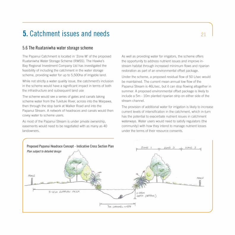
The Papanui Catchment is located in ‘Zone M’ of the proposed Ruataniwha Water Storage Scheme (RWSS). The Hawke’s Bay Regional Investment Company Ltd has investigated the feasibility of including the catchment in the water storage scheme, providing water for up to 5,500ha of irrigable land.
While not strictly a water quality issue, the catchment’s inclusion in the scheme would have a significant impact in terms of both the infrastructure and subsequent land use
The scheme would see a series of gates and canals taking scheme water from the Tukituki River, across into the Waipawa, then through the stop bank at Walker Road and into the Papanui Stream. A network of headraces and canals would then covey water to scheme users.
As most of the Papanui Stream is under private ownership, easements would need to be negotiated with as many as 40 landowners.
As well as providing water for irrigators, the scheme offers the opportunity to address nutrient issues and improve in-stream habitat through increased minimum flows and riparian restoration as part of an environmental offset package.
Under the scheme, a proposed residual flow of 50 L/sec would be maintained. The current mean annual low flow of the Papanui Stream is 46L/sec, but it can stop flowing altogether in summer. A proposed environmental offset package is likely to include a 5m - 10m planted riparian strip on either side of the stream channel.
The provision of additional water for irrigation is likely to increase current levels of intensification in the catchment, which in-turn has the potential to exacerbate nutrient issues in catchment waterways. Water users would need to satisfy regulators (the community) with how they intend to manage nutrient losses under the terms of their resource consents.
5. Catchment issues and needs
Proposed Papanui Headrace Concept - Indicative Cross Section PlanPlan subject to detailed design
Dissolved inorganic nitrogen (DIN) refers to the concentration of biologically available forms of nitrogen N (e.g. nitrate) in catchment waterways. As well as supporting nuisance plant and algae growth, high levels of DIN can affect stream ecology and can even be toxic to humans and livestock.
Despite being a relatively intensively farmed catchment, water sampling in the catchment’s waterways has not shown DIN concentrations to be excessive in relation to water quality benchmarks.
Farmers in the Papanui will still need to comply with their land use capability (LUC) nitrogen leaching allowance and also look to adopt good management practices that minimise nitrogen loss. However the requirement for additional mitigations to meet sub-catchment DIN limits is not likely in the medium term.
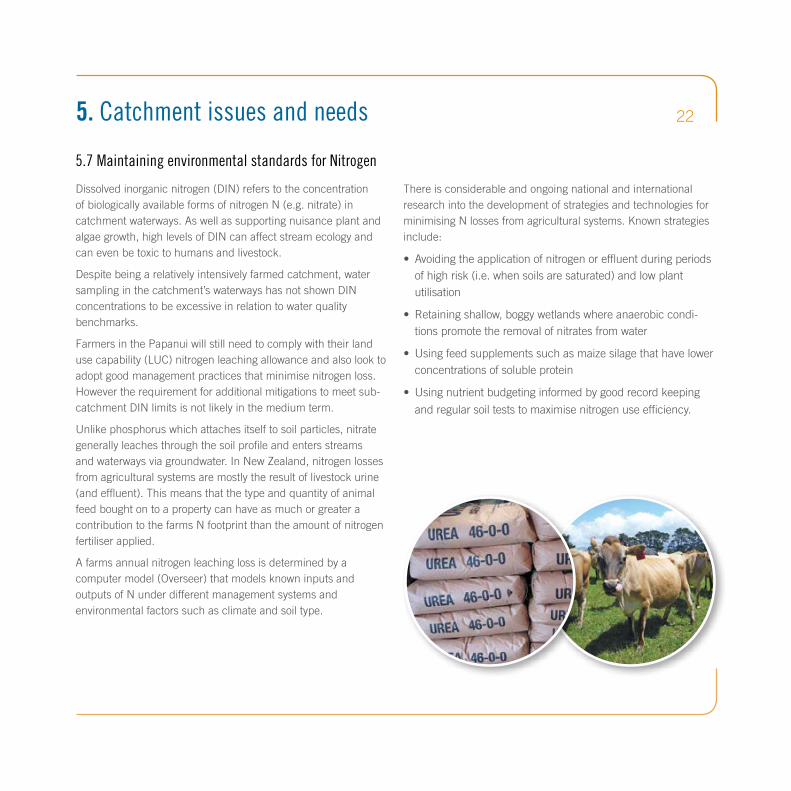
Unlike phosphorus which attaches itself to soil particles, nitrate generally leaches through the soil profile and enters streams and waterways via groundwater. In New Zealand, nitrogen losses from agricultural systems are mostly the result of livestock urine (and effluent). This means that the type and quantity of animal feed bought on to a property can have as much or greater a contribution to the farms N footprint than the amount of nitrogen fertiliser applied.
A farms annual nitrogen leaching loss is determined by a computer model (Overseer) that models known inputs and outputs of N under different management systems and environmental factors such as climate and soil type.
There is considerable and ongoing national and international research into the development of strategies and technologies for minimising N losses from agricultural systems. Known strategies include:
• Avoidingtheapplicationofnitrogenoreffluentduringperiodsofhighrisk(i.e.whensoilsaresaturated)andlowplantutilisation
• Retainingshallow,boggywetlandswhereanaerobiccondi-tionspromotetheremovalofnitratesfromwater
• Usingfeedsupplementssuchasmaizesilagethathavelowerconcentrationsofsolubleprotein
• Usingnutrientbudgetinginformedbygoodrecordkeeping
andregularsoilteststomaximisenitrogenuseefficiency.
5.7 Maintaining environmental standards for Nitrogen
5. Catchment issues and needs 22

23KEY STRATEGIC OUTCOMES
OUTCOME 1:
Landowners in the Papanui Catchment are well informed
OUTCOME 2:
There is active and willing participation across the community
OUTCOME 3:
There is an improvement in the water quality and ecological health of catchment waterways
OUTCOME 4:
Mauri is enhanced in catchment streams and waterways
OUTCOME 5:
Economic wellbeing and ability to prosper through sustainable primary production is maintainedOUTCOME 6:
Successful outcomes through non-regulatory integrated catchment management approach

246. Key strategy outcomes
The following outcomes were identified by a focus group of catchment land owners, taiwhenua representatives and HBRC staff.
Outcome 1. Landowners in the Papanui Catchment are well informed
Outcome 2. There is active and willing participation across the community
Outcome 3. There is an improvement in the water quality and ecological health of catchment waterways
It is crucial that catchment landowners are kept informed of what is required
from them under Plan Change 6, the reasons behind these and what
information and resources are available to assist.
Landowners must also be kept up to date with any changes, developments
or progress regarding water quality. They will have access to any research
and monitoring work undertaken by and on behalf of HBRC in the Papanui
Catchment.
An ‘integrated catchment management’ approach to address water quality
issues requires wide-scale participation from landowners and the wider
catchment community. The strategy should therefore provide a ‘story’, or ‘vision’
to foster buy-in and ownership, as well as provide opportunities for the wider
community, including schools and marae to become involved.
It is acknowledged that water quality in the Papanui is generally poor, and that
excessive concentrations of phosphorus, in particular, contribute to adverse
periphyton growth in the Lower Tukituki River. To improve catchment water
quality it is necessary to accurately identify and quantify the source of water
quality issues. The next step is to develop and promote a range of appropriate
and cost effective mitigation technologies and management actions.

256. Key strategy outcomes
Outcome 4. Mauri is enhanced in catchment streams and waterways
Outcome 5. Economic wellbeing and ability to prosper through sustainable primary production is maintained
Outcome 6. Successful outcomes through an integrated catchment management approach
The term mauri refers to the ‘life force’ of all living and non-living things.
Addressing a decline in the mauri of the Tukituki River and its tributaries is a
key outcome of Plan Change 6 as identified by tangata whenua. Mauri can also
provide a useful proxy for the natural, cultural and spiritual health of a stream or
waterway. Selecting appropriate ‘mauri indicators’ will be important in monitoring
the effectiveness of catchment programmes.
The Papanui Catchment and surrounding district has a proud farming history
and a local economy dependent on primary production. It is important that
the full costs to landowners of meeting Plan Change 6 are known, as these
may affect the capacity of land owners to adopt the industry good practice and
mitigation strategies promoted in this strategy.
Landowners must be provided with solutions that offer the flexibility necessary
to adopt the most cost effective strategies. Likewise, any available resources or
assistance must be targeted to where it will be most effective,
or offer multiple outcomes.
Non-regulatory, integrated catchment management can be effective in achieving
water quality targets and can avoid the need for further regulation. However,
depending on the ‘lag time’ there can be considerable time before the effects of
mitigation and management strategies are reflected in improved water quality. It
is therefore important that the adoption of management and mitigation strategies
are monitored or tracked. This will enable programs and processes to adapt and
change where necessary to ensure their success.

26Outcome 1. Landowners in the Papanui Catchment are well informed.
Action Explanation Responsibility Timeline
1.1 Develop a communication strategy to keep catchment landowners up to date with issues, develop-ments, programmes and resources available.
There is still a considerable lack of awareness throughout the wider Tukituki Catchments around the implications of Plan Change 6 and the expectations it places on land owners and the reasons behind these.A comprehensive communication strategy will inform landowners of water quality issues and programmes underway in the catchment through publications, online resources, meetings, field days and workshops.This will include informing on progress toward meeting water quality targets, the promotion of industry good practice as well as any assistance available.
HBRC & Catchment focus group
Underway
1.2 Produce and maintain a detailed map of the catchment that shows, among other things, critical source areas for water quality issues and the locations of programmes and mitigations as they are developed and implemented.
A ‘live’ map displaying the geographical spread of factors contributing to water quality issues and programmes underway, will provide confidence that mitigation efforts are being focused most effectively.
HBRC December 2015
1.3 Build adequate resourcing and capacity to enable a streamlined farm environmental planning and resource consent processing.
Currently there is a lack of clarity around the provision of farm planning services and resource consent requirements. Capacity issues will need to be addressed if landowners are to meet statutory timeframes.
HBRC, industry groups and private providers
Underway
1.4 Facilitate a catchment focus group. Landowner and community input is essential in the development and implementation of an integrated catchment strategy and programmes. The catch-ment focus group will help to identify information requirements, assist with cross-boundary solutions and disseminate information.
HBRC and catchment focus group
Underway and ongoing
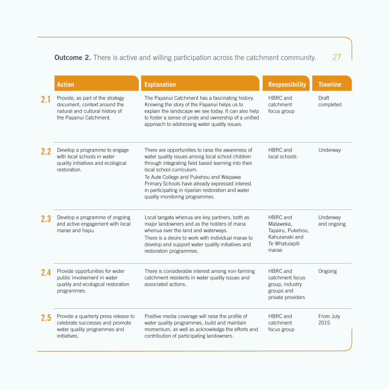
27Outcome 2. There is active and willing participation across the catchment community.
Action Explanation Responsibility Timeline
2.1 Provide, as part of the strategy document, context around the natural and cultural history of the Papanui Catchment.
The Papanui Catchment has a fascinating history. Knowing the story of the Papanui helps us to explain the landscape we see today. It can also help to foster a sense of pride and ownership of a unified approach to addressing water quality issues.
HBRC and catchment focus group
Draft completed
2.2 Develop a programme to engage with local schools in water quality initiatives and ecological restoration.
There are opportunities to raise the awareness of water quality issues among local school children through integrating field based learning into their local school curriculum.Te Aute College and Pukehou and Waipawa Primary Schools have already expressed interest in participating in riparian restoration and water quality monitoring programmes.
HBRC and local schools
Underway
2.3 Develop a programme of ongoing and active engagement with local marae and hapu.
Local tangata whenua are key partners, both as major landowners and as the holders of mana whenua over the land and waterways.There is a desire to work with individual marae to develop and support water quality initiatives and restoration programmes.
HBRC and Mataweka, Tapairu, Pukehou, Kahuranaki and Te Whatuiapiti marae
Underway and ongoing
2.4 Provide opportunities for wider public involvement in water quality and ecological restoration programmes.
There is considerable interest among non-farming catchment residents in water quality issues and associated actions.
HBRC and catchment focus group, industry groups and private providers
Ongoing
2.5 Provide a quarterly press release to celebrate successes and promote water quality programmes and initiatives.
Positive media coverage will raise the profile of water quality programmes, build and maintain momentum, as well as acknowledge the efforts and contribution of participating landowners.
HBRC and catchment focus group
From July 2015

28
3.1 Provide a list of mitigation strat-egies for meeting water quality objectives along with information on their suitability, effectiveness and associated costs.
Landowners will require a degree of flexibility in adopting ‘fit for purpose’ mitigation options that are effective and economically viable.
HBRC and catchment focus group
December 2015
3.2 Identify and map all major water-ways or stream sections where riparian management will be of most benefit.
Plan Change 6 will require that stock other than sheep are excluded from most major waterways by May 2020. However, there will be areas where incentivising earlier action, or additional measures such as planting for shade will have significant water quality benefits. Identifying these areas will help to prioritise and focus effort and resources where they are most effective.
HBRC. Sponsors, landowners
December 2015
3.3 Accelerate the exclusion of stock from priority waterways by provid-ing low cost fencing materials for early adopters.
Statutory requirements for stock exclusion do not come into effect until 2020 and there will be a delay before any resulting improvements in water quality become apparent. Voluntary early adoption will demonstrate to the wider community that landowners are proactive in meeting addressing water quality issues.
HBRC. Sponsors, landowners
December 2015
3.4 Target assistance to landowners who are willing to go beyond minimum requirements to meet water quality outcomes (e.g. riparian planting).
Additional gains in water quality can be achieved through voluntary measures such as leaving wider margins, appropriate riparian planting and the retirement of some waterways that do not require stock exclusion under Plan Change 6. Any assistance should be targeted where there is a cost to landowners in going above and beyond regulatory requirements.
HBRC Underway
3.5 Determine the actual contribution of phosphorus from the Otane municipal wastewater treatment to the Papanui stream.
Phosphorus from municipal waste water treatment is likely to be a significant contributor to water quality issues. Landowners will want assurance that efforts in addressing water quality issues will be shared by the urban community.
HBRC & CHBDC September 2015
Action Explanation Responsibility Timeline
Outcome 3. The health of catchment waterways is improved.

29
4.1 Define indicators of cultural/mauri health and establish and document a monitoring protocol.
The concept of mauri is difficult to define from a non-Māori world view. However tangible indicators will be required to establish a benchmark from which to measure.
Mataweka, Tapairu, Pukehou, Kahuranaki and Te Whatuiapiti Marae with assistance from HBRC
January 2016
4.2 Select sites for mauri monitoring. Similar to water quality and ecological monitoring, replicated mauri monitoring will be necessary to establish a change in state. Ideally this will occur in parallel with ecological monitoring.
Mataweka, Tapairu, Pukehou, Kahuranaki and Te Whatuiapiti Marae with assistance from HBRC
Underway
4.3 Implement a mauri monitoring framework in the Papanui catchment.
It will be important that benchmarks are estab-lished and monitoring is underway prior to the initiation of catchment management programmes that could lead to a change in the state of mauri.
Mataweka, Tapairu, Pukehou, Kahuranaki and Te Whatuiapiti Marae with assistance from HBRC
January 2016
4.4 Engage with iwi regarding the appropriate acknowledgement and management of culturally significant and wāhi tapu sites.
The aspirations of iwi with regard to the acknowl-edgement, management and disclosure of wāhi tapu sites will vary between marae. Ongoing engagement will be necessary to ensure that culturally significant sites are not compromised, or offence caused.
Mataweka, Tapairu, Pukehou, Kahuranaki and Te Whatuiapiti Marae with assistance from HBRC
Underway and ongoing
Action Explanation Responsibility Timeline
Outcome 4. Mauri in streams and waterways is enhanced.

30
5.1 Undertake an economic assess-ment to determine the costs to land owners in complying with Plan Change 6 regulatory requirements.
Establishing the costs of meeting regulatory requirements, including stock exclusion and farm planning, will enable a better understanding of expectations and timeframes for achieving targets.
Independent financial analyst
Underway
5.2 Make available a comprehensive list and cost benefit analysis of appropriate mitigation strategies for addressing water quality issues to landowners.
Cost effectiveness will be the greatest factor in determining the willingness of landowners to adopt mitigation strategies. Understanding this will also assist the regional council in identifying where to best target and invest effort and resource.
HBRC & CRI Underway
5.3 Provide facilitated workshop sessions to enable landowners to complete some, or all of their own farm plans.
Generally landowners know their own properties better than anyone else. By participating in the farm planning process, landowners can help to keep costs to a minimum. This will also increase the level of buy in and ‘ownership’ in plans and associated work programmes.
HBRC & sponsors March 2016
5.4 Map detailed land and soil resource information for the Papanui catchment and make this available online.
Having detailed and readily accessible soils and land resource mapping for the catchment will help to reduce individual farm planning costs. It will provide information to help landowners better understand the strengths and weaknesses of their soils and manage them accordingly.
HBRC Completed
Action Explanation Responsibility Timeline
Outcome 5. Economic wellbeing and ability to prosper through sustainable primary production is maintained.

31
6.1 Put in place a monitoring, evaluation and reporting framework for catchment programmes.
A monitoring and evaluation system is required to measure the success or otherwise of programmes, explain results and make changes where necessary.
HBRC March 2016
6.2 Allow sufficient time for non-regulatory programmes to show improvements in water quality.
There will be a time lag between the implemen-tation of integrated catchment management programmes and any improvement shown in water quality outcomes. This will need to be acknowl-edged by both landowners and regulators.
HBRC & landowners
2025
Action Explanation Responsibility Timeline
Outcome 6. Successful outcomes through non-regulatory integrated catchment management approach
REFERENCES: Regional Resource Management Plan, Change 6. Available at www.hbrc.govt.nz /search on Plan Change 6.
The Papanui Catchment focus group members are:
•DonCooper(HomewoodRd)•BrianGregory(TapairuMarae)•NickHarker(CollegeRoad)•MaitlandManningCHBDCCouncillor(ElsthorpeRd)•RogerMaaka(TamateaTaiwhenua)
•ShaneNewman(TeKuraRd)•BrentOliver(BrownriggAgriculture)•HughRitchie(DrumpeelRd)•PeterTod(TodRd)•NeilWhite(DrumpeelRd)
Warwick HeskethAdvisor,LandManagementP068338001|M0274966289|[email protected]

Hawke’sBayRegionalCouncil.
FREEPHONE0800108838.WEBwww.hbrc.govt.nz
ISBN 978-0-947499-00-6
HBRC Publication No. 4775
A COMMUNITY INITIATED INTEGRATED CATCHMENT MANAGEMENT STRATEGY


