IN PREPARATION FOR IEEE COMMUNICATIONS SURVEYS & TUTORIALS 1 Location-Enabled IoT (LE-IoT): A Survey of Positioning Techniques, Error Sources, and Mitigation You Li, Member, IEEE, Yuan Zhuang, Member, IEEE, Xin Hu, Senior Member, IEEE, Zhouzheng Gao, Jia Hu, Long Chen, Senior Member, IEEE, Zhe He, Member, IEEE, Ling Pei, Member, IEEE, Kejie Chen, Maosong Wang, Xiaoji Niu, Ruizhi Chen, John Thompson, Fellow, IEEE, Fadhel Ghannouchi, Fellow, IEEE, and Naser El-Sheimy Abstract—The Internet of Things (IoT) has started to empower the future of many industrial and mass-market applications. Localization techniques are becoming key to add location con- text to IoT data without human perception and intervention. Meanwhile, the newly-emerged Low-Power Wide-Area Network (LPWAN) technologies have advantages such as long range, low power consumption, low cost, massive connections, and the capability for communication in both indoor and outdoor areas. These features make LPWAN signals strong candidates for mass- market localization applications. However, there are various error sources that have limited the localization performance by using such IoT signals. This paper reviews the IoT localization system through the following sequence: IoT localization system review - localization data sources - localization algorithms - localization error sources and mitigation - localization performance evalu- ation. Compared to the related surveys, this paper has a more comprehensive and state-of-the-art review on IoT localization methods, an original review on IoT localization error sources and mitigation, an original review on IoT localization performance evaluation, and a more comprehensive review of IoT localization applications, opportunities, and challenges. Thus, this survey provides comprehensive guidance for peers who are interested in enabling localization ability in the existing IoT systems, using IoT systems for localization, or integrating IoT signals with the Y. Li, Z. He, F. Ghannouchi, and N. El-Sheimy are with Department of Geomatics Engineering, University of Calgary ([email protected]; [email protected]; [email protected]; [email protected]). Y. Zhuang and R. Chen are with the State Key Laboratory of Surveying, Mapping and Remote Sensing, Wuhan University ([email protected]; [email protected]). X. Hu is with the School of Electronic Engineering, Beijing University of Posts and Telecommunications ([email protected]). Z. Gao is with the Department of Land Sciences, China University of Geosciences (Beijing) ([email protected]). J. Hu is with the Department of Computer Science, the University of Exeter ([email protected]). L. Chen is with the School of Data and Computer Science, Sun Yat-sen University ([email protected]). L. Pei is with the Shanghai Key laboratory of Navigation and Location Based Services, School of Electronic Information and Electrical Engineering, Shanghai Jiao Tong University ([email protected]). K. Chen is with the the Department of Earth and Space Sciences, Southern University of Science and Technology ([email protected]). M. Wang is with the College of Intelligence Science and Technology, National University of Defense Technology ([email protected]). X. Niu is with the GNSS Research Center, Wuhan University ([email protected]). J. Thompson is with the School of Engineering, University of Edinburgh ([email protected]). Corresponding author: Y. Zhuang. This paper is partly supported by the National Natural Science Foundation of China (NSFC) Grants (No. 41804027, 61771135, and 61873163), the Natural Sciences and Engineering Research Council of Canada (NSERC) Discovery Grants, NSERC CREATE Grants, NSERC Strategic Partnership Grants, the Canada Research Chair (CRC) Grants, and the Alberta Innovates Technology Future (AITF) Grants existing localization sensors. Index Terms—Low-Power Wide-Area Networks; indoor navi- gation; LoRa; NB-IoT; Sigfox; LTE-M; 5G; machine learning; ar- tificial intelligence; neural networks; vehicle positioning; wireless communication; geo-spatial information; location data fusion; multi-sensor integration. I. I NTRODUCTION T HE Internet of Things (IoT) is shaping the future of many industrial and mass-market applications [1]. As a core technology to acquire spatial IoT data, localization techniques are both an important application scenario and a distinguished feature for the next-generation IoT [2]. In particular, Location- Enabled IoT (LE-IoT) is becoming key to add location context to IoT data without human perception and intervention. This section answers three questions: (1) why is it necessary to review localization techniques for IoT systems; (2) what are the advantages and challenges for IoT-signal-based localiza- tion; and (3) what are the differences between this survey and the previous ones. Table I illustrates the notations and symbols that will be used in this survey. A. Localization Technologies and Applications As a military-to-civilian application, localization has been intensively researched and successfully commercialized in outdoor areas. Figure 1 demonstrates the timeline of location- based services (LBS). The devices used in these applica- tions are actually “things” in the IoT. The main technologies for these use cases are Global Navigation Satellite Systems (GNSS) and Inertial Navigation Systems (INS) [3]. In con- trast, robust localization in indoor and urban areas is still an open challenge [4]. The development of indoor localization technologies has two directions: professional and mass-market applications. Professional applications (e.g., underground con- struction and machine industry) are commonly implemented in small areas, require high (e.g., decimeter or centimeter level) location accuracy; thus, they need specific network infrastructure, devices, and manpower. Furthermore, many professional applications also require intellisense techniques for environment sensing. In contrast, mass-market applications commonly do not need high localization accuracy. Meter-level accuracy is al- ready within the human sensing range. However, mass-market arXiv:2004.03738v1 [cs.NI] 7 Apr 2020
Transcript
IN PREPARATION FOR IEEE COMMUNICATIONS SURVEYS & TUTORIALS 1
Location-Enabled IoT (LE-IoT): A Survey ofPositioning Techniques, Error Sources, and
Fadhel Ghannouchi, Fellow, IEEE, and Naser El-Sheimy
Abstract—The Internet of Things (IoT) has started to empowerthe future of many industrial and mass-market applications.Localization techniques are becoming key to add location con-text to IoT data without human perception and intervention.Meanwhile, the newly-emerged Low-Power Wide-Area Network(LPWAN) technologies have advantages such as long range,low power consumption, low cost, massive connections, and thecapability for communication in both indoor and outdoor areas.These features make LPWAN signals strong candidates for mass-market localization applications. However, there are various errorsources that have limited the localization performance by usingsuch IoT signals. This paper reviews the IoT localization systemthrough the following sequence: IoT localization system review -localization data sources - localization algorithms - localizationerror sources and mitigation - localization performance evalu-ation. Compared to the related surveys, this paper has a morecomprehensive and state-of-the-art review on IoT localizationmethods, an original review on IoT localization error sources andmitigation, an original review on IoT localization performanceevaluation, and a more comprehensive review of IoT localizationapplications, opportunities, and challenges. Thus, this surveyprovides comprehensive guidance for peers who are interestedin enabling localization ability in the existing IoT systems, usingIoT systems for localization, or integrating IoT signals with the
Y. Li, Z. He, F. Ghannouchi, and N. El-Sheimy are with Department ofGeomatics Engineering, University of Calgary ([email protected];[email protected]; [email protected]; [email protected]). Y.Zhuang and R. Chen are with the State Key Laboratory of Surveying,Mapping and Remote Sensing, Wuhan University ([email protected];[email protected]). X. Hu is with the School of ElectronicEngineering, Beijing University of Posts and Telecommunications([email protected]). Z. Gao is with the Department of Land Sciences,China University of Geosciences (Beijing) ([email protected]). J.Hu is with the Department of Computer Science, the University of Exeter([email protected]). L. Chen is with the School of Data and ComputerScience, Sun Yat-sen University ([email protected]). L. Pei iswith the Shanghai Key laboratory of Navigation and Location BasedServices, School of Electronic Information and Electrical Engineering,Shanghai Jiao Tong University ([email protected]). K. Chen is withthe the Department of Earth and Space Sciences, Southern Universityof Science and Technology ([email protected]). M. Wang is withthe College of Intelligence Science and Technology, National Universityof Defense Technology ([email protected]). X. Niu is withthe GNSS Research Center, Wuhan University ([email protected]). J.Thompson is with the School of Engineering, University of Edinburgh([email protected]). Corresponding author: Y. Zhuang. This paperis partly supported by the National Natural Science Foundation of China(NSFC) Grants (No. 41804027, 61771135, and 61873163), the NaturalSciences and Engineering Research Council of Canada (NSERC) DiscoveryGrants, NSERC CREATE Grants, NSERC Strategic Partnership Grants, theCanada Research Chair (CRC) Grants, and the Alberta Innovates TechnologyFuture (AITF) Grants
THE Internet of Things (IoT) is shaping the future of manyindustrial and mass-market applications [1]. As a core
technology to acquire spatial IoT data, localization techniquesare both an important application scenario and a distinguishedfeature for the next-generation IoT [2]. In particular, Location-Enabled IoT (LE-IoT) is becoming key to add location contextto IoT data without human perception and intervention.
This section answers three questions: (1) why is it necessaryto review localization techniques for IoT systems; (2) what arethe advantages and challenges for IoT-signal-based localiza-tion; and (3) what are the differences between this survey andthe previous ones. Table I illustrates the notations and symbolsthat will be used in this survey.
A. Localization Technologies and ApplicationsAs a military-to-civilian application, localization has been
intensively researched and successfully commercialized inoutdoor areas. Figure 1 demonstrates the timeline of location-based services (LBS). The devices used in these applica-tions are actually “things” in the IoT. The main technologiesfor these use cases are Global Navigation Satellite Systems(GNSS) and Inertial Navigation Systems (INS) [3]. In con-trast, robust localization in indoor and urban areas is still anopen challenge [4]. The development of indoor localizationtechnologies has two directions: professional and mass-marketapplications. Professional applications (e.g., underground con-struction and machine industry) are commonly implementedin small areas, require high (e.g., decimeter or centimeterlevel) location accuracy; thus, they need specific networkinfrastructure, devices, and manpower. Furthermore, manyprofessional applications also require intellisense techniquesfor environment sensing.
In contrast, mass-market applications commonly do notneed high localization accuracy. Meter-level accuracy is al-ready within the human sensing range. However, mass-market
arX
iv:2
004.
0373
8v1
[cs
.NI]
7 A
pr 2
020
IN PREPARATION FOR IEEE COMMUNICATIONS SURVEYS & TUTORIALS 2
Fig. 1. Timeline of location-based applications. Devices used in these applications are “things” in IoT
applications are usually implemented in wide areas withvarying environments; meanwhile, these applications are notaffordable for specific devices or manpower. In particular, formass-market IoT applications, power consumption is new keyfactor that should be considered. In general, mass-market IoTlocalization is more challenging due to the following factors:
• Many IoT nodes (including user end-devices) cannot af-ford GNSS receivers due to their high power consumptionand cost.
• The complexity of environments. For example, the oc-currence of Non-Line-of-Sight (NLoS) [5], multipath [6],wide-area [7] and multi-floor [8] effects, and interferenceby moving objects and human bodies [9].
• The necessity of using low-cost sensors which havesignificant sensor errors. The sensor errors also changeover time and are susceptible to environmental factors(e.g., temperature [10]).
• The variety of node motions, such as changes of speedand orientation [11]. Also, it may be difficult to constrainnode motion with predefined paths [12].
There are various types of localization technologies. Theiradvantages and disadvantages are
• GNSS. Because of its capability to provide globalweather-independent positioning solutions, GNSS hasbeen commercialized successfully. However, its perfor-mance can be degraded by signal outages, degradations,and multipath in indoor and urban environments [3].
• Wireless localization. Localization using wireless signalscan provide long-term location accuracy. However, itsperformance is highly dependent on signal availabilityand geometry [13]; meanwhile, its accuracy can be de-graded by signal fluctuations and interferences due toNLoS conditions [5], reflections [14], and multipath [6],and the outage [15] and time variance [11] of radio maps.
• Environmental signals (e.g., magnetic, air pressure, light,and sound intensity). Database matching (DB-M) is onemain technique for localization using environmental sig-nals. The challenges include the dependency on featuresin environmental signals [16], the low signal dimension[11], and the time variance and outage [17] of environ-
sor, magnetometer, and odometer) based DR can provideautonomous outdoor/indoor localization solutions [18].Nevertheless, it is challenging to obtain long-term accu-rate DR solutions with low-cost sensors because of theexistence of sensor errors [10], the misalignment anglesbetween vehicle (e.g., human body and land vehicles) anddevice [20], and the requirement for position and headinginitialization.
• Vision localization. Vision sensors (e.g., cameras andLight Detection and Ranging (LiDAR)) can provide highlocation accuracy when loop closures have been correctlydetected [21]. Meanwhile, some previous issues, such asa large computational load, are being eliminated by mod-ern processors and wireless transmission technologies.However, the performance of vision localization systemsis highly dependent on whether the measured featuresare distinct in space and stable over time. It is difficultto maintain accuracy in environments with indistinct orreduplicative features (e.g., areas with glass or solid-colorwalls) [22].
In general, the existing technologies have their own advan-tages and limitations [23]. Thus, it is difficult to generate low-cost but high-performance localization solutions through theuse of a stand-alone technology. Due to the complementarycharacteristics of various technologies, multi-sensor integra-tion has become a trend to achieve reliable, continuous, andaccurate outdoor/indoor seamless localization.
The Low-Power Wide-Area Network (LPWAN) and 5Gtechnologies have been used for communication in pilot sites.However, their localization capability has not been fully devel-oped. Many of the existing IoT systems still rely on locationsolutions from the existing localization technologies such asGNSS [24] and Wireless Fidelity (WiFi) [25]. There are tworeasons for this phenomenon. First, the deployment density(i.e., the number within a given area) of current IoT BaseStations (BS) are not high enough for accurate localization.Second, there are several error sources and challenges in IoTlocalization uses. For the second factor, this survey provides
IN PREPARATION FOR IEEE COMMUNICATIONS SURVEYS & TUTORIALS 3
Fig. 2. Coverage ranges and power consumption of IoT signals (modified on[31] [78] [125])
detailed investigation and guidance.
B. Advantages and Challenges of IoT Signals for Localization
The latest communication infrastructure is beginning tosupport the research on IoT signal based localization because:(1) IoT signals have been supported by mainstream IoTdevices and are expected to be supported by more intelli-gent consumer devices. (2) IoT systems can already providevarious localization-signal measurements such as ReceivedSignal Strength (RSS), Time Difference of Arrival (TDoA),and Channel State Information (CSI). (3) The popularizationof IoT/5G small BSs and the possibility to enable the com-munication capability of smart home appliances (e.g., lamps,routers, speakers, and outlets) are increasing the density oflocalization BSs. This survey focuses on LPWAN signals butalso covers other IoT technologies such as cellular networks(e.g., 5G) and local wireless networks (e.g., WiFi, BluetoothLow Energy (BLE), Zigbee, and Radio-Frequency IDentifi-cation (RFID)). Figure 2 demonstrates the coverage rangesand power consumption of the main IoT signals. As a typeof newly-emerged IoT signals, LPWAN has the followingadvantages:
• Communication capability. LPWAN nodes do not requireextra costly communication modules.
• Long range. Theoretically, 5 to 40 kilometers in ruralareas and 1 to 5 kilometers in urban areas can be achieved[26].
• Low power consumption. LPWAN nodes are expected tohave over 10 years of battery lifetime [27]. With the samebattery, LPWAN can support transmissions that are twoorders more than GNSS [28].
• Low cost. The cost of a LPWAN radio chipset are beingreduced to within 2 dollars, while the operation cost ofeach node can reach 1 dollar per year [29].
• Massive connections. It is expected to support millionsof nodes per BS (or gateway) per square kilometers [29].
• The capability to work both outdoors and indoors [30].The research paper [29] has reviewed the physical struc-
tures, techniques, and parameters for LPWAN, as well as the
specific techniques for meeting the requirements such as longrange, low power consumption, and low cost.
On the other hand, the emergence of LPWAN has broughtnew challenges for localization techniques. Such challengesinclude the existence of wide-area scenarios, the high require-ment for power consumption, the necessity of using low-data-rate and low-cost nodes, the high density of nodes, and theexistence of complex node motions. Section IV reviews theIoT localization error sources and their mitigation in detail.
C. Related Surveys and Tutorials
The survey paper [26] describes the development and tech-nical differences among three main LPWAN technologies:Sigfox, NarrowBand IoT (NB-IoT), and Long-Range Wide-Area Network (LoRaWAN). Meanwhile, it describes severalkey IoT parameters, such as quality of service, scalability,latency, network coverage, battery life, payload length, cost,and deployment model. Also, it discusses the potential IoTapplications, such as electric metering, manufacturing automa-tion, smart building, and smart farming.
The review paper [29] investigates the LPWAN physicalprinciples and techniques, such as band selection, modula-tion, narrowband, and spread spectrum techniques to meetlong range requirements; topology, duty cycling, lightweightmedium access control, and offloading complexity techniquesto meet low-power-consumption requirements; hardware com-plexity reduction, minimum infrastructure, and license-freebands to meet low-cost requirements; and diversification,densification, and channel and data rate adaptive selectiontechniques for scalability. Moreover, the IoT standardizationsfrom main standards organizations, such as the 3rd GenerationPartnership Project (3GPP), the LoRa Alliance, the Instituteof Electrical and Electronics Engineers (IEEE), the EuropeanTelecommunications Standards Institute (ETSI), the InternetEngineering Task Force (IETF), the Weightless Special In-terest Group (Weightless-SIG), and the Dash7 Alliance, aredescribed.
The paper [2] reviews the existing indoor localization tech-nologies and methods. Specifically, localization signals, suchas RSS, Time of Arrival (ToA), TDoA, Angle of Arrival(AoA), CSI, and fingerprints, are described, followed bythe sensors that provide these measurements. The sensorsinclude WiFi, BLE, ZigBee, RFID, Ultra-Wide Band (UWB),Visible Light Positioning (VLP), ultrasound, and acousticones. Furthermore, the paper illustrates several key indoorlocalization evaluation indicators, including availability, cost,accuracy, scalability, coverage range, latency, and energy ef-ficiency. These evaluation indicators are also suitable for IoTlocalization. For LPWAN, the paper describes the principles,design parameters, and possibility for localization.
The review paper [32] surveys the hardware design andapplications of LoRaWAN. Specifically, tools and method-ologies such as system-level simulators, testbed deployments,physical layer (PHY) performance evaluation (e.g., coverageand interference impact), and Media Access Control (MAC)layer performance evaluation (e.g., network models, powerusage, and security) are investigated. Meanwhile, the paper
IN PREPARATION FOR IEEE COMMUNICATIONS SURVEYS & TUTORIALS 4
Abbreviation Definition Abbreviation Definition2D/3D Two/Three-Dimensional LoRaWAN Long Range Wide-Area Network3GPP 3rd Generation Partnership Project LoS Line-of-Sight5G 5th Generation cellular network LPWAN Low-Power Wide-Area NetworkA3C Asynchronous Advantage Actor-Critic LSTM Long Short-Term MemoryAHRS Attitude and Heading Reference System LTE-M Long Term Evolution for MachinesAI Artificial Intelligence MAC Media Access ControlANN Artificial Neural Network MIMO Multiple-Input and Multiple-OutputAoA Angle of Arrival ML Machine LearningAR Augmented Reality MLP Multi-Layer PerceptronBLE Bluetooth Low Energy NB-IoT Narrowband Internet of ThingsBS Base Station NHC Non-Holonomic ConstraintCNN Convolution Neural Network NLoS Non-Line-of-SightCRLB Cramr-Rao Lower Bound PF Particle FilterCSI Channel State Information PHY Physical layerD2D Device-to-Device PLM Path-Loss ModelDB-M Database Matching PLM-P Path-Loss Model ParameterDOP Dilution of Precision PoA Phase-of-ArrivalDQN Deep Q-Networks RBF Radial Basis FunctionDR Dead-Reckoning RFID Radio-Frequency IDentificationDRL Deep Reinforcement Learning RNN Recurrent Neural NetworkDRSS Differential RSS RP Reference PointsDTM Digital Terrain Model RPMA Random Phase Multiple AccessEKF Extended Kalman Filter RSS Received Signal StrengtheMBB Enhanced Mobile BroadBand RTT Round-Trip TimeETSI European Telecommunications Standards
InstituteSLAM Simultaneous Localization And Mapping
GNSS Global Navigation Satellite Systems SNR Signal-to-Noise RatioGP Gaussian Processes SVM Support Vector MachineGSM Global System for Mobile Communications TDoA Time Difference of ArrivalHMM Hidden Markov Model ToA Time of ArrivalIEEE Institute of Electrical and Electronics Engi-
neersUKF Unscented Kalman Filter
IETF Internet Engineering Task Force UNB Ultra NarrowBandINS Inertial Navigation Systems UNREAL UNsupervised REinforcement and Auxil-
iary LearningIoT Internet of Things URLLC Ultra-Reliable and Low Latency Communi-
cationIPv6 Internet Protocol version 6 UWB Ultra-Wide BandITU-R International Telecommunication Union Ra-
LEO Low Earth Orbits ZUPT Zero velocity UPdaTesLF Localization FeatureLiDAR Light Detection And RangingLoRa Long Range
TABLE ILIST OF ABBREVIATIONS
provides methods for enhancing LPWAN communication. Themethods include network scalability assessment and improve-ment, scheduling and synchronization, new MAC design,Internet Protocol version 6 (IPv6) networks, multihop net-works, and multi-modal networks. Furthermore, the strengths,weaknesses, opportunities, and threats analysis for LoRaWANhas been provided.
The paper [33] reviews the development of cellular com-munication technologies (i.e., 1G to 5G). It also reviewsthe cellular localization methods, such as proximity, sceneanalysis, trilateration, and hybrid localization. In particular,it predicts the impact of several 5G features on localization.These 5G features include mmWave massive Multiple-Inputand Multiple-Output (MIMO), multipath-assisted localization,and Device-to-Device (D2D) communication. The localizationapplication aspects, such as indoor positioning, heterogene-
ity, synchronization, interference, power consumption, device-centric and network-centric, network planning, and commer-cial exploitation, are covered as well.
The whitepaper [34] has systematically introduced the 5Gand IoT standards, new features, applications, and limitations.Meanwhile, it points out several localization challenges, suchas heterogeneity, multipath propagation, Line-of-Sight (LoS)availability, time synchronization, hardware complexity inlarge antenna array systems, power consumption and com-putational burden, and MAC latency and bandwidth usage.Also, the theoretical accuracy limitation for 5G ToA and AoAlocalization methods are derived.
The review paper [35] surveys the characteristics of vari-ous LPWAN technologies, including Sigfox, LoRaWAN, NB-IoT, Long Term Evolution for Machines (LTE-M), RandomPhase Multiple Access (RPMA), and WavIoT. The investigated
IN PREPARATION FOR IEEE COMMUNICATIONS SURVEYS & TUTORIALS 5
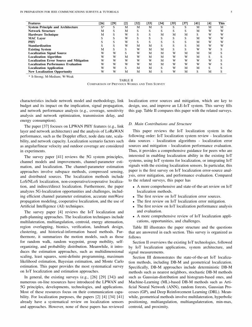
Features [26] [29] [2] [32] [33] [34] [35] [37] [41] [4] ThisSystem Principle and Architecture S* S M M M S S S M M MNetwork Structure M S M S S S S S M W WHardware Technique M S W S S M M M S W WMAC Layer S S W S S S S S M W WPHY S S W S S S S S M W WStandardization S S W M M S S S M W WExisting System M S S W M M S S W W SLocalization Signal Source W W S W M M W M M M SLocalization Algorithm W W M W M M W W M S SLocalization Error Source and Mitigation W W W W W M W W W W SLocalization Performance Evaluation W W W W M M W W W W SLocalization Application W W S M M S W M M S SNew Localization Opportunity W W M M M S W M S M S
* S-Strong; M-Medium; W-WeakTABLE II
COMPARISON OF PREVIOUS WORKS AND THIS SURVEY
characteristics include network model and methodology, linkbudget and its impact on the implication, signal propagation,and network performance analysis (e.g., coverage, sensitivityanalysis and network optimization, transmission delay, andenergy consumption).
The paper [37] focuses on LPWAN PHY features (e.g., linklayer and network architecture) and the analysis of LoRaWANperformance, such as the Doppler effect, node data rate, scala-bility, and network capacity. Localization scenario factors suchas angular/linear velocity and outdoor coverage are consideredin experiments.
The survey paper [41] reviews the 5G system principles,channel models and improvements, channel-parameter esti-mation, and localization. The channel-parameter estimationapproaches involve subspace methods, compressed sensing,and distributed sources. The localization methods includeLoS/NLoS localization, non-cooperative/cooperative localiza-tion, and indirect/direct localization. Furthermore, the paperanalyzes 5G-localization opportunities and challenges, includ-ing efficient channel parameter estimation, accurate mmWavepropagation modeling, cooperative localization, and the use ofArtificial Intelligence (AI) techniques.
The survey paper [4] reviews the IoT localization andpath-planning approaches. The localization techniques includemultilateration, multiangulation, centroid, energy attenuation,region overlapping, bionics, verification, landmark design,clustering, and historical-information based methods. Fur-thermore, it summarizes the motion models, such as thosefor random walk, random waypoint, group mobility, self-organizing, and probability distribution. Meanwhile, it intro-duces the estimation approaches, such as multidimensionalscaling, least squares, semi-definite programming, maximumlikelihood estimation, Bayesian estimation, and Monte Carloestimation. This paper provides the most systematical surveyon IoT localization and estimation approaches.
In general, the existing surveys (e.g., [26] [29] [34]) andnumerous on-line resources have introduced the LPWAN and5G principles, developments, technologies, and applications.Most of these resources focus on their communication capa-bility. For localization purposes, the papers [2] [4] [34] [41]already have a systematical review on localization sensorsand approaches. However, none of these papers has reviewed
localization error sources and mitigation, which are key todesign, use, and improve an LE-IoT system. This survey fillsthis gap. Table II compares this paper with the related surveys.
D. Main Contributions and Structure
This paper reviews the IoT localization system in thefollowing order: IoT localization system review - localizationdata sources - localization algorithms - localization errorsources and mitigation - localization performance evaluation.Thus, it provides a comprehensive guidance for peers who areinterested in enabling localization ability in the existing IoTsystems, using IoT systems for localization, or integrating IoTsignals with the existing localization sensors. In particular, thispaper is the first survey on IoT localization error-source anal-ysis, error mitigation, and performance evaluation. Comparedto the related surveys, this paper has
• A more comprehensive and state-of-the-art review on IoTlocalization methods.
• The first review on IoT localization error sources.• The first review on IoT localization error mitigation.• The first review on IoT localization performance analysis
and evaluation.• A more comprehensive review of IoT localization appli-
cations, opportunities, and challenges.
Table III illustrates the paper structure and the questionsthat are answered in each section. This survey is organized asfollows
Section II overviews the existing IoT technologies, followedby IoT localization applications, system architecture, andsignal measurements.
Section III demonstrates the state-of-the-art IoT localiza-tion methods, including DB-M and geometrical localization.Specifically, DB-M approaches include deterministic DB-Mmethods such as nearest neighbors, stochastic DB-M methodssuch as Gaussian-distribution and histogram-based ones, andMachine-Learning (ML)-based DB-M methods such as Arti-ficial Neural Network (ANN), random forests, Gaussian Pro-cesses (GP), and Deep Reinforcement Learning (DRL). Mean-while, geometrical methods involve multilateration, hyperbolicpositioning, multiangulation, multiangulateration, min-max,centroid, and proximity.
IN PREPARATION FOR IEEE COMMUNICATIONS SURVEYS & TUTORIALS 6
• What are the new opportunities for localization dueto the emergence of LPWAN and 5G signals
TABLE IIISTRUCTURE OF THIS SURVEY
Afterwards, Section IV systematically reviews IoT local-ization error sources and mitigation. The location errors aredivided into four parts: (1) end-device-related errors (e.g., de-vice diversity, motion/attitude diversity, low response rate/lowsampling rate/data loss/data latency, and channel diversity),(2) environment-related errors (e.g., multipath, NLoS, wide-area effects, multi-floor effects, human-body effects, weathereffects, and signal variations), (3) BS-related errors (e.g.,number of BSs, BS geometry, BS location uncertainty, BSPath-Loss Model Parameter (PLM-P) uncertainty, and BStime synchronization errors), and (4) data-related errors (e.g.,database timeliness/training cost, Reference Point (RP) lo-cation uncertainty, database outage, data and computationalloads, and localization integrity).
Then, Section V illustrates the localization performanceevaluation methods, including theoretical analysis, simulationanalysis, in-the-lab testing, field testing, and signal grafting.
Finally, Section VI shows the new localization opportuni-ties, such as cooperative localization, AI, multi-sensor inte-gration, motion constraints, fog/edge computing, blockchain,airborne-land integration, and multipath-assisted localization.
II. OVERVIEW
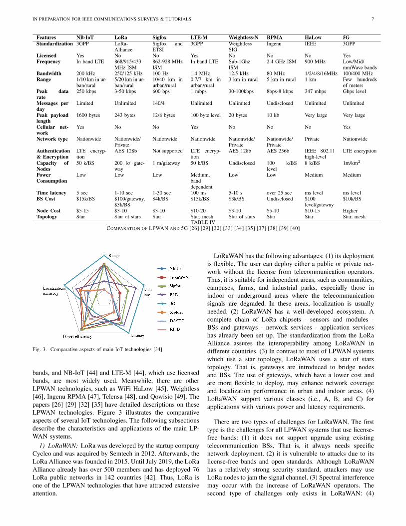
This section first compares the existing LPWAN systemsfrom the perspective of localization-system users, followedby the application scenarios of IoT localization. Afterwards,the IoT localization system architecture and the types oflocalization signal measurements are described. This sectionanswers the following questions: (1) how to choose a LPWANsystem for localization purposes; (2) what are the potentialapplication scenarios for LE-IoT systems; and (3) what are thepossible measurements that can be used for localization. TableIV compares the features of the main LPWAN techniques.
A. LPWAN Technologies
IoT, which was started as embedded internet or pervasivecomputing in 1970s and was termed in 1999, has a historyof decades. The early-state IoT systems mainly used localcommunication technologies (e.g., RFID, WiFi, BLE, andZigbee) and GNSS localization until LPWAN systems becameavailable in around 2013 [26]. Afterwards, over ten LPWANtechnologies, licensed or license-free, were presented. Amongthem, LoRaWAN [42] and Sigfox [43], which use license-free
IN PREPARATION FOR IEEE COMMUNICATIONS SURVEYS & TUTORIALS 7
1600 bytes 243 bytes 12/8 bytes 100 byte level 20 bytes 10 kb Very large Very large
Cellular net-work
Yes No No Yes No No No Yes
Network type Nationwide Nationwide/Private
Nationwide Nationwide Nationwide/Private
Nationwide/Private
Private Nationwide
Authentication& Encryption
LTE encryp-tion
AES 128b Not supported LTE encryp-tion
AES 128b AES 256b IEEE 802.11high-level
LTE encryption
Capacity ofNodes
50 k/BS 200 k/ gate-way
1 m/gateway 50 k/BS Undisclosed 100 k/BSlevel
8 k/BS 1m/km2
PowerConsumption
Low Low Low Medium,banddependent
Low Low Medium Medium
Time latency 5 sec 1-10 sec 1-30 sec 100 ms 5-10 s over 25 sec ms level ms levelBS Cost $15k/BS $100/gateway,
$3k/BS$4k/BS $15k/BS $3k/BS Undisclosed $100
level/gateway$10k/BS
Node Cost $5-15 $3-10 $3-10 $10-20 $3-10 $5-10 $10-15 HigherTopology Star Star of stars Star Star, mesh Star of stars Star Star Star, mesh
TABLE IVCOMPARATION OF LPWAN AND 5G [26] [29] [32] [33] [34] [35] [37] [38] [39] [40]
Fig. 3. Comparative aspects of main IoT technologies [34]
bands, and NB-IoT [44] and LTE-M [44], which use licensedbands, are most widely used. Meanwhile, there are otherLPWAN technologies, such as WiFi HaLow [45], Weightless[46], Ingenu RPMA [47], Telensa [48], and Qowisio [49]. Thepapers [26] [29] [32] [35] have detailed descriptions on theseLPWAN technologies. Figure 3 illustrates the comparativeaspects of several IoT technologies. The following subsectionsdescribe the characteristics and applications of the main LP-WAN systems.
1) LoRaWAN: LoRa was developed by the startup companyCycleo and was acquired by Semtech in 2012. Afterwards, theLoRa Alliance was founded in 2015. Until July 2019, the LoRaAlliance already has over 500 members and has deployed 76LoRa public networks in 142 countries [42]. Thus, LoRa isone of the LPWAN technologies that have attracted extensiveattention.
LoRaWAN has the following advantages: (1) its deploymentis flexible. The user can deploy either a public or private net-work without the license from telecommunication operators.Thus, it is suitable for independent areas, such as communities,campuses, farms, and industrial parks, especially those inindoor or underground areas where the telecommunicationsignals are degraded. In these areas, localization is usuallyneeded. (2) LoRaWAN has a well-developed ecosystem. Acomplete chain of LoRa chipsets - sensors and modules -BSs and gateways - network services - application serviceshas already been set up. The standardization from the LoRaAlliance assures the interoperability among LoRaWAN indifferent countries. (3) In contrast to most of LPWAN systemswhich use a star topology, LoRaWAN uses a star of starstopology. That is, gateways are introduced to bridge nodesand BSs. The use of gateways, which have a lower cost andare more flexible to deploy, may enhance network coverageand localization performance in urban and indoor areas. (4)LoRaWAN support various classes (i.e., A, B, and C) forapplications with various power and latency requirements.
There are two types of challenges for LoRaWAN. The firsttype is the challenges for all LPWAN systems that use license-free bands: (1) it does not support upgrade using existingtelecommunication BSs. That is, it always needs specificnetwork deployment. (2) it is vulnerable to attacks due to itslicense-free bands and open standards. Although LoRaWANhas a relatively strong security standard, attackers may useLoRa nodes to jam the signal channel. (3) Spectral interferencemay occur with the increase of LoRaWAN operators. Thesecond type of challenges only exists in LoRaWAN: (4)
IN PREPARATION FOR IEEE COMMUNICATIONS SURVEYS & TUTORIALS 8
LoRa chipsets have been patented by Semtech. The excessiveconcentration of chip patents is not conducive to industrialgrowth.
2) Sigfox: Sigfox was developed by the startup Sigfox andthen has experienced rapid development in the recent years.Until July 2019, Sigfox has already deployed networks in over60 countries and regions [43]. It has generally completed thecoverage of western Europe and is promoting to Asia andAmerica. Although Sigfox and LoRaWAN use license-freebands, they have different operation modes. A main differenceis that the Sigfox company itself acts as the global networkoperator.
The main advantages of Sigfox include: (1) it has a lownode hardware cost and power consumption. To reduce cost,Sigfox uses the Ultra NarrowBand (UNB) technology andlimits the data rate (100 bit/s/node level), message length (12bytes) and the number of messages (140 message/day/node).Such a low data rate can reduce the node cost because evenlow-cost Binary Phase Shift Keying (BPSK) modules canmeet the requirement [26]. (2) Due to the use of UNB andshort messages, a Sigfox network can be deployed by usinga smaller number of long-range BSs. (3) It is straightforwardto deploy a Sigfox network. The Sigfox company, which actsas the global operator, helps the users to deploy networks.Meanwhile, Sigfox is a global network, which does not needroaming between countries. (4) In contrast to LoRaWAN,Sigfox allows users to select chipsets from various chipmanufacturers.
The challenges for Sigfox include: (1) having the Sigfoxcompany as a global operator has limited user permission andapplication flexibility. The users need to register and pay to theSigfox company for services. Furthermore, the data has to bestored on the Sigfox server. (2) Both the UNB technologyand the narrow downlink (i.e., the link from BS to node)have strongly limited the application scenarios. It is not cost-effective to use a Sigfox network for low-data-rate applicationsand use another LPWAN network for other applications. (3)From the localization perspective, having high-density BSs isgenerally beneficial. However, increasing the density of BSscontradict Sigfox’s advantage of a lower BS density.
3) NB-IoT: Both NB-IoT and LTE-M started later thanLoRaWAN and Sigfox. The 3GPP released the R13 NB-IoTstandardization in 2016. However, the NB-IoT communityis growing quickly. Until March 2019, it already has 140operators in 69 countries [50].
NB-IoT is mainly promoted by telecommunication opera-tors. The main advantages of NB-IoT include: (1) it is highlyvalued by telecommunication operators. First, it supportsupgrade on existing telecommunication BSs. Second, it canincrease the number of users and bring extra service feesto the operators. (2) NB-IoT is based on licensed bands,which has an operator-level security and quality assurance. (3)The promotion from the government. For example, the ChinaMinistry of Industry and Information Technology has releaseda policy to promote the development of NB-IoT in June 2017.On the other hand, NB-IoT has met the following challenges:(1) it is difficult for independent companies, which are notcooperating with telecommunication operators, to participate.
Fig. 4. Advantages and challenges for mainstream LPWAN technologies
(2) The use of licensed bands increases the costs of both BSsand nodes. (3) NB-IoT started later than LoRa and Sigfox andthus may need time to achieve the same industry and marketmaturity.
4) LTE-M: LTE-M, which includes enhanced MachineType Communication (eMTC), was released in the 3GPP R13standardization. This is similar to NB-IoT. Meanwhile, LTE-M is also designed for low-bandwidth cellular communicationsfor the internet devices that transmit small amounts of data andhave lower costs but higher battery life. Until March 2019, ithas 60 operators in 35 countries [50]. Generally, LTE-M isrelatively more supported by telecommunication operators inNorth America, while NB-IoT is more popular in China andEurope.
Compared to NB-IoT, LoRa, and Sigfox, LTE-M has itsown advantages: (1) LTE-M has much higher (i.e., up to1 Mbps) data speeds. (2) It supports voice communication.(3) It has better mobility for devices in movement. Thus,LTE-M is suitable for applications such as vehicle networks,transportation, and security cameras.
The challenges for LTE-M include: (1) its nodes have ahigher complexity and cost. LTE-M has a higher bandwidth(1.4 MHz) than NB-IoT (200 KHz); thus, both front end anddigital processing are more complex for LTE-M. (2) LTE-M has a smaller signal coverage compared to other LPWANtechnologies.
5) Summary and Insight on LPWAN Technologies: Figure4 illustrates the advantages and challenges of NB-IoT, LTE-M, LoRaWAN, and Sigfox. Although they have attractedmost interests, there are various other LPWAN systems thathave their own advantages. Therefore, it is expected thatthe users can select LPWAN technologies according to theirrequirements and integrate multiple LPWAN signals for bettercommunication and localization performances.
6) Relation Between LPWAN and 5G: In addition to LP-WAN, the development of 5G (i.e., the fifth-generation cellu-lar network) technology has brought opportunities for bothcommunication and localization. Thus, it is worthwhile tointroduce the relation between LPWAN and 5G.
IN PREPARATION FOR IEEE COMMUNICATIONS SURVEYS & TUTORIALS 9
5G has been well-known for its high speed, massive con-nection, high reliability, and low latency in communication.Compared to 4G, 5G has innovatively designed various stan-dards and solutions for different application scenarios. TheInternational Telecommunication Union RadiocommunicationSector (ITU-R) has defined three 5G application categories:Ultra-Reliable and Low Latency Communication (URLLC),Enhanced Mobile BroadBand (eMBB), and massive Machine-Type Communication (mMTC) [51]. Specifically, URLLC hasthe advantages of high reliability (e.g., 99.999 % reliableunder 500 km/h high-speed motion) and low-latency (e.g.,millisecond level); thus, it is suitable for applications suchas vehicle networks, industrial control, and telemedicine. Bycontrast, eMBB has an extremely high data rate (e.g., Gbpslevel, with a peak of 10 Gbps) and strong mobility; thus, it issuitable for video, Augmented Reality (AR), Virtual Reality(VR), and remote officing applications. In contrast, mMTC isdesigned for application scenarios that have massive nodeswhich have a low cost, low power consumption, and lowdata rate, and are not sensitive to latency. Examples of theseapplications include Intelligent agriculture, logistics, home,city, and environment monitoring.
Therefore, LPWAN can aid 5G as follows: (1) LPWANprovides an important application direction for 5G, especiallymMTC, applications. (2) Besides NB-IoT and LTE-M, whichare within the 5G standardization group, there are various LP-WAN networks and systems. They can provide complementarysupports to 5G techniques and applications.
On the other hand, 5G can help the development of LP-WAN: (1) 5G is expected to build the fundamental infrastruc-ture for communication services. In particular, the coveragerange for 5G BSs may shrunk from kilometers to hundredsof meters or even under 100 m [52]. The existence of suchsmall BSs can help LPWAN communication and localization.(2) 5G features (e.g., mmWave MIMO, large-scale antenna,beamforming, and D2D communication) may enhance theLPWAN performance and experience. (3) 5G has a strongerconnection with the new-generation information technologies(e.g., big data, cloud/edge computing, and AI) and thus canextend the application space of LPWAN.
B. IoT Localization Applications
According the above analysis, IoT systems are especiallysuitable for applications that have massive connection, lowdata rate, low power consumption, and are not sensitive tolatency. Many of such applications have a strong requirementfor localization. Examples of these applications include
• Emergency service: determining people location is a fea-ture of increasing importance for emergency systems suchas the Enhanced 911 (E-911) in North America [53] andthe E-112 in Europe [54]. The current E-911 system usescellular signals and has a typical localization accuracyof 80 % for an error of 50 m. To enhance locationaccuracy in urban and indoor areas, other localizationsignals, including IoT signals, are needed.
• Smart community: through the deployed IoT BSs andnodes around a community, it is possible to localize and
track the residents as well as obtain their surroundingfacilities (e.g., security alarms, fire alarms, lamps, airconditioners, and surveillance cameras).
• Shopping mall: LE-IoT can be used for wide-area productpositioning and management. Meanwhile, the data per-tinent to people and products can be used for big-dataanalysis and service optimization. LE-IoT can providethe localization and management of public infrastructuresuch as vending machines, point-of-sale terminals, andadvertising light boxes.
• Intelligent transportation: LE-IoT nodes or chips in vehi-cles (e.g., cars or bikes) can be used for positioning andinformation tracking. The vehicle and related infrastruc-ture (e.g., charging piles and parking spaces) locationscan be used for traffic monitoring and parking guidance.
• Smart logistics: LE-IoT can provide city-level wide-areaproduct tracking and management.
• Environmental monitoring: LE-IoT can be used for local-izing environmental hazards such as debris flows, sewerabnormities, and hazardous wastes.
• Smart animal husbandry: LE-IoT can be used to tracklivestock locations and motions and thus provide servicessuch as diet monitoring and meat traceability.
• Animal tracking: LE-IoT can be used for wildlife track-ing, pet monitoring, and animal movement data analysis.
• Smart agriculture: LE-IoT nodes around farms can beused to localize fertilization devices and monitoring en-vironmental factors (e.g., temperature and humidity).
• Smart home: LE-IoT nodes in smart home appliances(e.g., smart speakers, lamps, and outlets) and those onthe human body can provide personalized services suchas automatic temperature adjustment and light control.
• Health care: LE-IoT can localize patients and medicaldevices and then provide services such as remote moni-toring, fall detection, and motion analysis.
Figure 5 demonstrates some of the LE-IoT applications.Many of the current LE-IoT nodes use existing localizationsensors (e.g., GNSS, inertial sensors, WiFi, and RFID) and anextra communication module (e.g., LTE). Thus, these nodeshave relatively high cost and high power consumption, whichhave limited their applications. With the advent of LPWAN,some costly communication modules can be replaced byLPWAN based modules. For example, the configuration ofLPWAN plus GNSS have been used for applications such asbus tracking [56], highway tracking [57], and patient-motionmonitoring [58]. Also, it is feasible to use LPWAN to sendGNSS raw measurements to a server for processing [24], orusing WiFi instead of GNSS for localization [25]. In theseapplications, the node hardware cost has been significantlyreduced. Furthermore, if the LPWAN localization capabilitycan be explored, it will be possible to remove all or parts ofother localization sensors and thus further reduce node costand power consumption.
C. IoT Localization System Architecture
A LE-IoT system is comprised of four components: nodes(including end-devices), BSs (including gateways or anchors),
IN PREPARATION FOR IEEE COMMUNICATIONS SURVEYS & TUTORIALS 10
Fig. 5. Example of LE-IoT applications [55]
Fig. 6. LE-IoT system architecture
network servers, and application servers [29]. Figure 6 showsan LE-IoT system architecture. The LE-IoT system has anextra localization engine compared to an ordinary IoT system.The localization module may be located at either nodes ornetwork servers, depending on user requirements on factorssuch as node computational load, communication load, anddata security. The main functionalities of its components areas follows.
1) Nodes: A node contains a transponder, which transmitssignals, and optionally a micro-controller with on-board mem-ory. Meanwhile, the node optionally has application sensorssuch as a GNSS receiver for precise positioning, inertialsensors for motion tracking, and environmental sensors formonitoring temperature, humidity, smoke, gas, light, magnetic,and sound. The sensors may be connected to or integratedwithin the transponder chip. Also, the nodes may be fixedfor static monitoring, mounted on dynamic objects (e.g.,products, vehicles, and animals) as tags, or put on humanbody as user devices. In some IoT applications, the nodes onlybroadcast signals frequently, instead of processing data, to saveenergy. There are also applications in which motion-trackingor localization data processing is implemented on nodes toreduce communication load. Meanwhile, some applicationsmay use ToA localization, which requires precise timing onnodes. This requirement can only be met in relatively high-endIoT applications.
2) BSs: The main communication function of BSs is toroute the data between nodes and network servers. The BSsmay connect to network servers via the standard user datagramprotocol / internet protocol and transmit the data from nodesensors to network servers and vice versa. BSs usually havefixed and known locations as well as globally unique IDentities(IDs, e.g., MAC addresses). For LE-IoT, BSs also need tomeasure localization signals, such as node ID, BS ID, the datareception time, channel, RSS, payload, and Signal-to-NoiseRatio (SNR). Furthermore, BS time synchronization may berequired for TDoA or ToA based localization [59]. Meanwhile,multi-array antennae and phase detection may be needed forAoA localization [60].
3) Network servers: A network server is responsible fordecoding data from BSs, recording data into databases, option-ally implementing localization computation, and transmittingprocessed data to application servers. Network servers can beused for both sensor-to-application and application-to-sensorcommunication. For TDoA based localization, it is importantthat the packets from different BSs arrive at a network server.Furthermore, for localization applications, there are extralocalization-signal databases on network servers. Meanwhile,motion-tracking and localization data-processing engines arelocated at network servers for many LPWAN applications.Network servers may be either cloud or edge servers.
4) Application servers: Their main functions are to obtaindata from network servers, parse it, and process it for furtherapplications.
D. IoT Localization Signal Measurements
Compared to IoT, LE-IoT systems measure localizationsignals and process them to estimate motion states such aslocation, velocity, attitude, and motion modes. This subsectionillustrates the commonly used localization signals.
1) RSS: RSS is measured when a BS or node receives thedata packet from the other side. The advantages of using RSSinclude: (1) RSS can be straightforwardly collected withoutextra hardware on either nodes or BSs. (2) RSS can be flexiblyused for various localization algorithms, such as proximity,region-determination, multilateration, and DB-M. On the otherhand, the challenges for using RSS include: (1) it is difficult todetermine the PLM-P accurately in wide-area [61], urban [62],and indoor [63] scenarios, where many IoT applications takeplace. (3) The RSS-ranging resolution degrades over node-BSdistance. Specifically, an RSS change of one dBm may leadto distance differences of meters in small areas but hundredsof meters in wide areas. Meanwhile, RSS measurements varysignificantly when the node-BS distance changes within acertain range but less significantly when the node-BS distancebecomes far [30]. (4) RSS variations and interference due toenvironmental factors are issues inherent to wireless signals.
2) ToA: ToA is obtained by measuring the time intervalbetween signal transmission and reception. The advantages ofusing ToA include: (1) theoretically, ToA measurements canbe linearly converted to node-BS distances without any knownPLM-P. (2) Take UWB [64] and ultrasonic [65] as examples,ToA ranging can achieve high accuracy (e.g., decimeter or
IN PREPARATION FOR IEEE COMMUNICATIONS SURVEYS & TUTORIALS 11
even centimeter level) in light-of-sight (LoS) environments. (3)ToA localization has a well-researched theoretical-derivationand accuracy-assessment mechanism [66]. The challengesfor ToA localization include: (1) ToA measurements requireprecise timing on both nodes and BSs, or precise time syn-chronization between them. A ten-nanosecond-level timingaccuracy is required to achieve meter-level ranging. Suchtiming accuracy is not affordable for many IoT nodes. Thus,TDoA operating across multiple BSs is commonly used in IoTlocalization to eliminate the requirement for precise timing onnodes. (2) A high accuracy is commonly expected when ToA isused. In this case, the degradations from environmental factors(e.g., NLoS and multipath) are relatively more significant.
3) TDoA: TDoA is measured by computing the signal ar-rival time differences among multiple BSs. TDoA localizationhas the following advantages: (1) it does not need precisetiming on nodes or precise time synchronization betweennodes and BSs. Instead, it only requires precise BS time syn-chronization, which is affordable for many IoT systems suchas LoRa, Sigfox, and NB-IoT [59]. (2) The impact of nodediversity can be mitigated through the use of differential mea-surements between BSs. (3) TDoA localization methods, suchas hyperbolic localization, have a well-researched theoretical-derivation and accuracy-assessment mechanism [67]. On theother hand, the challenges for TDoA localization include: (1)the requirement of precise time synchronization increases theBS cost. (2) The use of differential measurements enhancesthe impact of noise in localization signals.
4) AoA: AoA systems provide the node position by mea-suring BS-node angles [68]. The advantages of AoA position-ing include: (1) typical AoA localization systems (e.g., theHAIP system [69]) can provide high-accuracy (e.g., decimeteror centimeter level) locations. (2) AoA requires less BSsthan ToA and TDoA. It is feasible to use two BS-nodeangle measurements, or one BS-node angle and one BS-nodedistance, for two-dimensional (2D) localization. By fixingthe AoA BS on the ceiling with known height, it is evenpossible to provide accurate localization with one BS [69].(3) AoA localization approaches, such as multiangulation,have a well-researched theoretical-derivation and accuracy-assessment mechanism [70]. The challenges for AoA localiza-tion include: (1) AoA systems need specific hardware such asmulti-array antennae and phase detection [60]. The high nodecost has limited the use of AoA in low-cost IoT applications.(2) Although there are low-cost RSS-based AoA systems[71], the accuracy of both angular-measuring and positioningdegrade significantly when the BS-node distance increases.Thus, a high-density BS network is still needed for wide-areaapplications.
5) Round-Trip Time (RTT): RTT can be collected by mea-suring the round-trip signal propagation time to estimate thedistance between nodes and BSs [72]. The use of RTT hasadvantages such as: (1) compared to ToA, RTT needs lessaccurate clock synchronization between BSs and nodes [2].(2) RTT can be collected from the MAC layer, instead of thePHY [73]. (3) It is straightforward to use ToA-localizationmethods for RTT localization. The challenges for RTT local-ization include: (1) Modification on nodes is not affordable
for many low-cost IoT applications. (2) The response delaybetween signal reception and transmission, which is difficultto eliminate, directly leads to ranging errors [2]. (3) RTT-estimation accuracy is degraded by the same error sourcesas ToA.
6) CSI: It is becoming possible to collect CSI between IoTnodes and BSs [74]. The advantages of using CSI include (1)CSI localization can achieve a high accuracy (e.g., decimeterlevel or higher) [75]. (2) CSI measurements have more featuresthan RSS [76]. (3) CSI is more robust to multipath and indoornoise [2]. (4) Many existing localization approaches, such asDB-M and multilateration, can be used for CSI localization.The challenges for CSI localization include: (1) CSI may notbe available on off-the-shelf Network Interface Controllers(NICs). (2) The CSI measurements may suffer from deviationsbecause of factors such as limitations in channel parameterestimation [76]. (3) It is challenging to assure the CSI-basedToA measurement accuracy due to the limited IoT signalbandwidth [76]. To mitigate this issue, techniques such asfrequency hopping may be needed [77].
7) Phase-of-Arrival (PoA): PoA is obtained by measuringthe phase or phase difference of carrier signals between nodesand BSs. PoA measurements can be converted to BS-nodedistances [78]. The advantages for PoA localization include:(1) PoA measurements can achieve high (e.g., centimeter-levelor higher) ranging accuracy [79]. (2) The existing ToA andTDoA algorithms can be directly used for PoA localization.The challenges for PoA localization include: (1) Extra nodeand BS hardware are needed to measure PoA [78]. Mean-while, accurate PoA-ranging requires a relative high data rate,which is not suitable for many IoT applications. (2) A highaccuracy is commonly expected when PoA is used. In thiscase, the degradations from environmental factors (e.g., NLoSand multipath) are relatively more significant [78]. (3) PoAmeasurements may suffer from the integer-ambiguity issue[80] and cycle slips [81].
8) Summary and Insight on IoT Localization-Signal Mea-surements:
• Similar to other engineering problems, the selection ofIoT localization signals is a tradeoff between performanceand cost. Some measurements (e.g., ToA, AoA, RTT, andPoA) can be used to achieve high localization accuracybut require extra hardware or modifications on nodes,which are not affordable for many low-cost IoT appli-cations. In contrast, measurements such as RSS can becollected without any change on hardware; however, theirlocalization accuracy is lower, especially for wide-areaapplications. Another types of measurements (e.g., TDoAand CSI) may be realized by adding extra hardware ormodifications on the BS side, which is affordable forsome IoT applications. Besides performance and cost,other factors should be considered when selecting local-ization signals. Example of these factors include environ-ment size, outdoors or indoors, node motion modes, andthe number of nodes.
• Because each type of localization measurement hasadvantages and limitations, it is common to combinevarious types of measurements (e.g., TDoA/RSS [82]
IN PREPARATION FOR IEEE COMMUNICATIONS SURVEYS & TUTORIALS 12
Fig. 7. Localization algorithms
and AoA/TDoA [83]) for a higher localization perfor-mance. Furthermore, data from other sensors (e.g., inertialsensors, magnetometers, barometers, and maps) can beintroduced to enhance localization solutions by mitigatingthe impact of error sources that are inherent to wirelesssignals.
• Moreover, all the localization signals suffer from bothdeterministic and stochastic measurement errors. The im-pact of deterministic errors (e.g., sensor biases, scale fac-tor errors, and thermal drifts) may be mitigated throughcalibration [84] or on-line estimation. In contrast, it isdifficult to compensate for stochastic measurement errors.These errors can be modeled as stochastic processes[85]. The statistical parameters for stochastic modelsmay be estimated through methods such as correlation,power spectral density analysis, Allan variance [86], andmultisignal wavelet variance [87].
III. IOT LOCALIZATION METHODS
This section will answer the following questions: (1) whatare the state-of-the-art localization approaches; and (2) whatare the advantages and challenges for each type of localizationmethod. The existing surveys (e.g., [2], [4], and [36]) alreadyhave detailed reviews on localization approaches. Most ofthese surveys classify the existing methods by sensor typesor localization signal types. With the development of MLtechniques and the diversification of modern localization sce-narios, new localization methods have emerged. Specifically,over one decade ago, the majority of localization methodswere geometrical ones, which are realized on geometric mea-surements such as distances and angles. By contrast, DB-Mmethods, which are data-driven, have been well developedduring this decade. As a result, the IoT localization approachescan be divided into two categories: DB-M and geometricallocalization. Meanwhile, there are DR methods which usesensors such as inertial, odometer, and vision ones. Figure7 demonstrates part of the main localization algorithms.
Fig. 8. Principles of DB-M localization
A. Database-Matching Localization Methods
Although different localization technologies have variousphysical measurements and principles, they can generally beused for localization through DB-M. The basic principle forDB-M localization is to compute the difference between themeasured fingerprints and the reference fingerprints in thedatabase, and find the closest match. The DB-M processconsists of three steps: (1) Localization feature (LF) extrac-tion, (2) database training (or learning or mapping), and (3)prediction. Figure 8 demonstrates the principle of the trainingand prediction steps. The details of the steps are as follows.
• In LF extraction, valuable LFs are extracted from rawlocalization signals. A valuable LF should be stable overtime and distinct over space. Examples of the LFs includeRSS/CSI for wireless localization, magnetic intensityfor magnetic matching, and visual features for visionlocalization. The extracted LFs are recorded and used fortraining and prediction.
• At the database-training step, [LF, location] fingerprintsat multiple RPs are used to generate or update a database,which can also be regarded as a type of map. Thedatabase may be a data structure that stores the LFs atmultiple RPs, or be the coefficients of parametric models.
• At the prediction step, the real-time measured LFs arecompared with the database to locate the node. Thelikelihood (or weight) for each RP can be computedthrough (a) deterministic (e.g., nearest neighbors [88]),(b) stochastic (e.g., Gaussian distribution [89] and his-togram [90]), and (c) ML (e.g., ANNs [91], randomforests [92], GP [93], and DRL [94]) methods. Thesemethods are described separately in the following sub-sections.
1) Deterministic DB-M: In these methods, only determin-istic values (e.g., the mean value) of each LF at each RPare stored in the database. Thus, the LF values at each RPconstruct a vector, while the reference LF values at multipleRPs build a matrix. Each column vector in the matrix isthe reference LF vector at one RP. At the prediction step,
IN PREPARATION FOR IEEE COMMUNICATIONS SURVEYS & TUTORIALS 13
the similarity between the measured LF vector and eachreference LF vector in the matrix is calculated by computingthe vector distance. The RPs that have the highest similarityvalues are the nearest neighbors. To compute the similarity,the Euclidean distance [88] is widely used. Meanwhile, thereare other types of vector distances, such as Manhattan distance[95], Minkowski distance [96], Spearman distance [97], andinformation entropy [96].
The deterministic DB-M methods have advantages of smalldatabase size and computational load. On the other hand,a main limitation is that the stochastic LFs, which may becaused by various factors in real-world practices, have notbeen involved.
2) Stochastic DB-M: Compared to the deterministic meth-ods, stochastic DB-M approaches introduce stochastic LFsat each RP through various methods, such as the Gaussian-distribution [89] and histogram [90] methods. Meanwhile,likelihood [99] between measured LFs and the reference onesin database is used to replace vector distance as the weight ofsimilarity.
It is notable that the majority of related works assumethat various LFs (e.g., RSS values with different BSs) areindependent with one another, so as to simplify the like-lihood computation to the product (or summation) of thelikelihood values for all LF components. Then, the likelihood-computation problem becomes how to estimate the likelihoodvalue for each LF component. If the Gaussian-distributionmethod is used, the likelihood value for a LF can be estimatedby applying Gaussian-distribution model [89].
Although the Gaussian-distribution model is one of themost widely used models for stochastic errors in localizationapplications, there may be systematic LF measurement errorsdue to environmental factors. The existence of systematic er-rors theoretically breaks the Gaussian-distribution assumption.However, the Gaussian distribution is still widely used inengineering practices because real-world environmental factorsis difficult to predict and model. One approach for reducingthe degradation from systematic errors is to set relative largervariance values in localization filters to absorb the impact ofsuch errors.
Moreover, WiFi [98] and LoRa [30] RSS values may havenot only symmetric histograms but also asymmetric ones,such as left-skewed, bimodal, and other irregular histograms.Such asymmetric measurement distributions may be caused byenvironmental factors. An approach for mitigating the impactof asymmetric measurement distributions is to use histograms[90] or advanced stochastic models, such as those discussedin [87].
The histogram method can obtain likelihood values withoutassumption on signal distributions. The histograms for all LFcomponents at all RPs are calculated in the training step. In theprediction step, the measured fingerprint is compared with thecorresponding histogram to find the likelihood. However, sinceit determines likelihood values through histogram matching,instead of using a parametric model, it may suffer from alarge database size and overfitting.
3) ML-based DB-M: In recent years, ML has started tobring empowerment to numerous applications because of the
increased data volume, the increased computing power, and theenhanced ML algorithms. This subsection reviews the typicalML algorithms that have been utilized for localization.
- ANN: ANN is a type of framework for using ML methodsto process complex (e.g., nonlinear and non-Gaussian) data.ANN consists of one input layer, at least one hidden layer,and one output layer. Each layer contains at least one neuron.The neurons are connected via weights and biases, whichare trained and stored. There are numerous publications (e.g.,[100]) on the principle of ANN. Also, there are various typesof ANN, such as the recurrent neural network (RNN) [101],convolutional neural network (CNN) [102], radial basis func-tion neural network (RBF) [103], and multi-layer perceptron(MLP) [104].
As an example, MLP is used to illustrate the mechanismwithin ANN. MLP is a supervised-learning approach that isbased on the error back-propagation algorithm, which opti-mizes the parameters (i.e., weights and biases) by minimizingthe cost function (e.g., the sum of squared errors) of theneurons at the output layer. Specifically, the back-propagationalgorithm can be divided into five steps [105]: input, feed-forward, output error computation, error back-propagation, andoutput. Four standard back-propagation equations [106] can beused to calculate the errors at the output layer and then back-propagate these errors to update the weights and biases basedon a learning rate.
ANN techniques have been used for localization over adecade ago [107]; however, it has not been widely adopted un-til recent years. RSS (e.g., RSS from WiFi [108], BLE [109],ZigBee [110], RFID [111], cellular [104], and photodi-ode [102]), RSS features (e.g., 2D RSS map [112], differentialRSS (DRSS) [103], and RSS statistics [113]), CSI [101], andAoA [114] have been used. The majority of these works di-rectly output node locations, while the others also generate theidentification of floors [113], rooms [108], and regions [115],NLoS [101], similarity of fingerprints [116], localizationsuccess rate [117], and localization accuracy prediction [91].
ANN has several advantages: (1) the algorithm has beenwell-developed and successfully in various fields (e.g., speechrecognition [118] and image processing [119]). (2) The currentANN platforms and toolboxes are open and straightforward touse. On the other hand, the shortcomings of ANN include: (1)an ANN model is similar to a black box for most users. It isdifficult to determine an explicit model representation of howthe ANN works. (2) It is difficult to understand and adjustthe internal algorithms. For example, although the majority oflocalization works above use one to three hidden layers, theyset the numbers of hidden layers and neurons through brute-force data processing, instead of following a theoretical guide.Such specifically-tuned ANN parameters may be not suitablefor varying localization environments.
- GP: GP is a supervised ML method for regression andprobabilistic classification [120]. A GP is a set of randomvariables which have joint Gaussian distributions. Therefore,for localization applications, GP can involve the correla-tion among all RPs. This characteristic makes GP differentfrom many other localization methods which treat each RPseparately. Another characteristic for GP is that it can be
IN PREPARATION FOR IEEE COMMUNICATIONS SURVEYS & TUTORIALS 14
uniquely determined by a mean function and a kernel function(i.e., covariance function). In the localization area, the meanfunction may be set by using geometrical LF models [121];meanwhile, a zero mean function is used in some scenar-ios [93]. In contrast, there are various types of covariancefunctions, such as the constant, linear, squared exponential,Matrn, and periodic ones [120]. The geometrical LF modelshave not been involved in covariance functions in the existingworks. The research in [123] has presented a hyperparameterestimation model for learning the GP model parameters.
The use of GP for RSS localization has been proposed in[122] for cellular networks. The paper [123] extends the workby introducing a Bayesian filter that builds on a graphed spacerepresentation. Afterwards, GP has been used in processingdata from various localization sensors, such as magnetometers[17] and RFID [124]. Furthermore, GP has become one ofthe main techniques for localization-database prediction (orinterpolation), that is, to predict LFs at unvisited or out-of-date RPs based on training data at other RPs. Reference [125]compares the performance of DB prediction by using GPand geometrical (e.g., linear, cubic, thin plate, and quinticpolynomial) interpolation methods.
GP has advantages such as: (1) it has a physical meaningand an explicit model representation, compared to many otherML methods. (2) GP captures both the predicted solutionand its uncertainty. The latter is not provided in ANN. (3)GP has a small number of parameters; thus, its engineeringimplementation is straightforward. The challenges for GPinclude: (1) it is based on a Gaussian-process assumption,which may be degraded in challenging localization scenarios.Integrating GP with geometrical localization models may be apossible method to mitigate this degradation [121]. (2) GP hasa small number of parameters. Thus, in localization scenariosthat have complex environments and massive data, GP maynot be able to exploit the potential of complex databases aswell as other ML methods (e.g., ANN).
- Random forests: The random forests algorithm is anensemble classifier that uses a set of decision trees (i.e.,classification and regression trees) for supervised classification[126]. The paper [127] has a detailed description on itsprinciple and theoretical formulae. Random forests can beimplemented through three steps: subsampling, decision-treetraining, and prediction. In the subsampling step, the algorithmrandomly selects a subsample that contains a fixed numberof randomly-selected features from the original dataset. Thesubsample is trained with a decision in the decision-treetraining step. The training process creates the if-then rules ofthe tree. One typical method for this process is Gini impurity[128], which is a measure of how often a randomly selectedelement will be incorrectly labeled if the element is randomlylabeled according to the label distribution in the subset.
When splitting a branch in the tree, all possible conditionsare considered and the condition with the lowest Gini impurityis chosen as the new node of the decision tree. If the split isperfect, the Gini impurity of that branch would be zero. Thereare other criteria (e.g., information gain [129]). For prediction,each tree in the ensemble gives a prediction result. Based onthe votes from all trees, a probabilistic result can be generated.
In the localization area, the random-forest approach hasbeen applied for RSS fingerprinting [92], CSI fingerprinting[132], vision localization [130], NLoS condition identifica-tion [5], loop-closure detection [131], and VLP [133]. Theadvantages of random forests include [134]: (1) comparedto other decision-tree based methods, it is less sensitive tooutliers in training data. (2) The random-forest parameterscan be set easily. (3) Random forests can generate variableimportance and accuracy together with prediction solutions.The shortcomings of random forests include: (1) it is notefficient in computational load. A large number of trees areneeded for an accurate vote. This phenomenon leads to largedatabases and computational loads. (2) It may be over-fitted.Also, it is sensitive to noise [135].
- DRL: DRL, which is the core algorithm for AlphaGo,has attracted intensive attention. It combines deep learningand reinforcement learning. The former provides a learningmechanism, while the later provides goals for learning [136].In general, DRL allows the agent to observe states and act tocollect long-term rewards. The states are mapped to an actionthrough a policy [94].
The DRL algorithm has experienced stages such as DeepQ-Networks (DQN), Asynchronous Advantage Actor-Critic(A3C), and UNsupervised REinforcement and AuxiliaryLearning (UNREAL). Specifically, DQN [137] introducesvalue networks to represent the critic module, and constructsvalue networks according to specific applications by usingANNs (e.g., Long Short-Term Memory (LSTM) networks andCNN). Then, A3C [138] applies the actor-critic frameworkand asynchronous learning. The basic idea of actor-criticis to evaluate the output action and tune the possibility ofactions based on evaluation results. Compared to A3C, theUNREAL algorithm is closer to the human-learning mode.Specifically, UNREAL enhances the actor-critic mechanismthrough multiple auxiliary tasks. The research in [139] haspointed out three components for a DRL solution: basis/core(e.g., state definition, action definition, and reward definition),basic units (e.g., Q-network, action selection, replay memory,and target network), and state reformulation (i.e., the methodfor state-awareness data processing).
DRL has been used for navigation in Atari games [137],mazes [140], and the real world [141]. Meanwhile, DRL hasbeen applied for navigation using data from monocular camera[141], 360-degree camera [142], LiDAR [143], magnetic sen-sor [144], wireless sensor [145], and Google street view [146].Many of the recent DRL research works focus on navigationwithout a map [143], in new environments [147], and withvarying targets [148]. However, most of these methods aredesigned for navigation, instead of localization. Navigationand localization both use data from wireless, environmental,and vision sensors as inputs, they have different principles.Navigation is the issue of finding the optimal motion pathbetween the node and a target location; in contrast, a local-ization module outputs the node location. It is straightforwardto model a navigation process as a Markov decision process;thus, it can be processed by DRL. By contrast, localization iscloser to a deep learning problem.
The advantages of DRL include: (1) it can obtain not
IN PREPARATION FOR IEEE COMMUNICATIONS SURVEYS & TUTORIALS 15
Fig. 9. Principle of geometrical localization methods
only the optimal solution at the current moment, but alsothe long-term reward. (2) DRL can reduce the computationalcomplexity caused by re-optimization due to factors such asenvironment changes [139]. The challenges of DRL include:(1) the set of reward definition is key to the DRL performance.However, it is challenging to determine a theoretical model forreward definition. (2) The DRL algorithm itself has met severalchallenges [149], such as hyperparameter sensitivity, sampleefficiency, off-policy learning, and imitation learning. (3) Thefuture DRL algorithms may need supports from ML chips dueto their large computational loads.
There are also other ML methods for enhancing localization.For example, the Hidden Markov Model (HMM) approach hasbeen used for RSS fingerprinting [150], trajectory modeling[151], and room recognition [152]. Also, the Support VectorMachine (SVM) method has been applied for CSI localiza-tion [153], RSS localization [154], and wide-area localization[155]. Meanwhile, the fuzzy-logic method has been used forsmartphone localization [156] and VLP [157]. Various MLmethods have different advantages and thus are suitable fordifferent localization use cases.
B. Geometrical Localization Methods
Geometrical localization methods have been researched fordecades. To use such methods, BS locations are commonlyknown or can be estimated. The main measurements are BS-node distances and angles. The main localization methodsinclude multilateration, hyperbolic localization, multiangula-tion, multiangulateration, and other simplified methods such asmin-max, centroid, and proximity. Previous survey papers [2]and [36] already have detailed descriptions on these methods.Thus, this survey only summarizes their main characteristics.Figure 9 illustrates the principle of several geometrical local-ization methods.
1) Multilateration: Multilateration can be used to estimatenode location by using locations of at least three BSs andtheir distances to the node. Its basic principle is to estimatethe intersection between spheres (for 3D localization) andcircles (for 2D localization). This method has been widelyused in GNSS and wireless Ad Hoc network node [158] or BS[159] location estimation. The common estimation techniques
are least squares and Kalman filter (KF). The multilaterationperformance may be enhanced through improving rangingaccuracy by mitigating the impact of environment-related andreceiver errors [160]. There are also well-developed blunder-detection and accuracy-evaluation mechanisms [161] as wellas geometry indicators such as the Dilution of Precision (DOP)[163].
2) Hyperbolic Localization: Hyperbolic localization, whichwas developed for Loran navigation [165], is the main methodfor TDoA localization. It is based on the distance differencesbetween the node and various BSs. Because hyperbolic local-ization has eliminated the requirement for precise timing onnodes, it has strong potential for LPWAN localization. Thereis also accuracy analysis [67] for this method.
3) Multiangulation: Multiangularation can be implementedby measuring the angles between the node and at least two BSs[68]. Theoretically, two BS-node angles can determine a 2Dpoint. When considering angle-measurement errors, a quadran-gle can be determined. The multiangulation method has beenused in wireless Ad Hoc networks to reduce the requirementon BS (or anchor) locations [166]. The performance analysisof multiangulation has also been provided [70].
4) Multiangulateration: Multiangulateration localizes anode by at least one BS-node angle and one BS-node distance.This method has been widely used in traverse networks inengineering surveying [167]. For indoor localization, it isfeasible to use one AoA (e.g., VLP [36] and BLE [69]) BSon the ceiling with known height for localization.
5) Min-Max: Min-max is a variant of multilateration. Itsgeometrical principle is to calculate the intersection betweencubes (for 3D localization) and squares (2D localization),instead of spheres and circles. The benefit for using cubes andsquares is that their intersections can be directly computedthrough deterministic equations [168], which have signifi-cantly lighter computational loads than least squares. Thelimitation of min-max is that it has not considered thestochastic measurements. Meanwhile, compared to spheres,cubes deviate from spatial distribution with a certain BS-nodedistance. The min-max method can be used to generate coarselocalization solutions [169], which provide initial positions forfine-localization approaches such as multilateration.
6) Centroid: Centroid is a simplification of multilateration.It estimates the node location by weighted average of thelocations of various BSs. The weights for BS locations arecommonly determined by BS-node distances [170]. Similarto min-max, the centroid has a low computational load buthas not considered stochastic measurements. Furthermore, thecentroid result will be limited within the region that has aboundary formed by BS locations. Similar to min-max, thecentroid is commonly used for coarse localization.
7) Proximity: Proximity can be regarded as a further sim-plification of the centroid approach. The possible locationregion is determined by using the location of one BS asthe circle center and using the BS-node distance as theradius. Proximity is commonly used in RFID [171] and cell-identification [172] localization. The method has the lowestcomputational load, the lowest number of BS, but the largestlocation uncertainty. Thus, it is commonly used for near-field
IN PREPARATION FOR IEEE COMMUNICATIONS SURVEYS & TUTORIALS 16
localization, coarse localization, or for bridging the outageswhen the other localization methods do not have sufficientBSs.
Meanwhile, there are other geometrical localization meth-ods, such as the zone-based [173], compressed-sensing [174],law-of-cosines [175] methods.
C. Summary and Insight on Database-Matching and Geomet-rical Localization Methods
DB-M and geometrical localization methods have severalsimilarities, such as
• Both methods have the training and prediction steps. InDB-M methods, a [LF, location] database is generatedthrough training; in contrast, in geometrical methods,the coefficients for parametric models are estimated andstored at the training step.
• They have some common error sources, such as devicediversity, orientation diversity, and human-body effects.
On the other hand, these methods have differences (orcomplementary characteristics), such as
• Geometrical methods are more suitable for scenarios(e.g., outdoor and indoor open environments) that can beexplicitly modeled and parameterized. In contrast, DB-Mapproaches are more suitable for complex scenarios (e.g.,wide-area urban and indoor areas) that are difficult to beparameterized.
• For geometrical methods, environmental factors such asNLoS and multipath conditions are error sources thatneed to be modeled and mitigated. By contrast, DB-Mmethods may use the measurements of these factors asfingerprints to enhance localization.
• Geometrical methods are based on parametric models;thus, the databases contain only model parameter valuesand thus are relatively small. On the other hand, it is dif-ficult to describe complex scenarios by using parametricmodels with limited numbers of parameters. In contrast,DB-M methods directly describe localization scenarios byusing data at all points in the space; thus, both databaseand computational loads are large, especially for wide-area applications. However, DB-M approaches have morepotential to provide higher resolution and more details oncomplex localization scenarios.
• Progresses in ML algorithms have brought great potentialto localization methods, especially for the applicationsthat have complex scenarios that are difficult to model,parameters that are difficult to determine and tune, andhave nonlinear, non-parametrical, correlated measure-ments that are caused by environmental and motionfactors. Although ML methods are classified into theDB-M group in this survey according to the existingworks, ML can also be used to enhance geometricallocalization, such as training of parametric models andtheir parameters.
Due to their complementary characteristics, geometrical andDB-M methods can be integrated. For example, geometricalmethods can be used to reduce the computational load ofDB-M [176], to aid database prediction [121], and to provide
localization uncertainty prediction [99]. It is also feasible todirectly integrate geometrical and DB-M methods for morerobust localization solutions [177].
IV. IOT LOCALIZATION ERROR SOURCES ANDMITIGATION
This section describes the main IoT-localization errorsources and their mitigation. These two topics are key compo-nents in a LE-IoT system. This section answers two questions:(1) what are the error sources for IoT localization; and (2) howto mitigate or eliminate the impact of these error sources. Thelocalization error sources are classified into four groups as
• End-device-related errors: device diversity,motion/attitude diversity, data loss and latency, andchannel diversity.
• Environment-related errors: multipath, NLoS, wide-areaeffects, multi-floor effects, human-body effects, weathereffects, and signal variations.
• Base-station-related errors: the number of BSs, BS ge-ometry, BS location uncertainty, BS PLM-P uncertainty,and BS time synchronization errors.
Figure 10 shows the main IoT-localization error sources.The details for the listed error sources are provided in thefollowing subsections.
A. End-Device-Related Errors
This subsection introduces the error sources on thenode side. The error sources include device diversity, mo-tion/attitude diversity, data loss and latency, and channeldiversity.
1) Node (Device) Diversity: A large numbers of low-cost MEMS sensors are used in IoT nodes. Such low-costsensors may have diversity when measuring the same physicalvariable. For example, the RSS diversity for the same-brandBLE nodes may reach 20 dBm [178]. Such node diversitydirectly leads to localization errors [178].
To alleviate the impact of node diversity, there arecalibration-based methods that fit data from multiple nodesthrough the use of histograms [179], least squares [180], ANNs[181], multi-dimensional scaling [183], and motion states fromDR [182]. Reference [84] provides details about several node-diversity calibration methods, such as nonlinear adjustment,sensitivity threshold correction, and interdependence acrossBSs.
Meanwhile, there are calibration-free differential-measurement-based approaches. Examples of such methodsinclude the differential approach that subtracts the data from aselected datum BS from those from the other BSs [184], takesthe differences between data from all BS couples [185], usesthe average data from all BSs [186] or selected BSs [187] asthe datum, and adopts the advanced datum-selection method[188]. Additionally, differential measurements are used inmultilateration [189] and other geometrical [190] methods.There are two challenges for using differential signals: (1) it is
IN PREPARATION FOR IEEE COMMUNICATIONS SURVEYS & TUTORIALS 17
Fig. 10. IoT localization error sources
challenging to switch the datum for differential computation ina wide-area IoT application. (2) The differential computationincreases the noise levels in measurements.
2) Motion/Attitude Diversity: IoT nodes may experiencevarious motion modes, such as being held horizontally, dan-gling in the hand, mounted on chest, and stored in pocketsor bags. This phenomenon leads to changes in node attitude(or orientation). Meanwhile, movements of nodes also lead tochanges in the relative attitude angles between node- and BS-antenna directions. Such attitude changes lead to localizationerrors [178].
To reduce the impact of motion/attitude diversity, the re-search in [195] proposes a compass-aided method by usingattitude-matched databases; furthermore, the paper [196] ex-tends the method to dynamic localization scenarios. Mean-while, the papers [193] and [194] present a heading-aidedmethods that add the node attitude into fingerprints and de-cision trees, respectively. Moreover, reference [197] uses his-togram equalization for orientation-effect compensation, whilethe research in [178] presents an orientation-compensationmodel to compensate for orientation diversity.
The orientation angles of BS antennae are commonly con-stant, while the node attitude angles are dynamic and canbe estimated in real time through the Attitude and HeadingReference System (AHRS) algorithm [198]. In such an algo-rithm, gyro measurements are used to construct the systemmodel, while accelerometer and magnetometer data providemeasurement updates. Meanwhile, autonomous gyro calibra-tion is important to enhance attitude estimation [19].
3) Data Loss and Latency: Response rate is a practicalfactor in wireless localization. Data from some BSs may bewrongly missed in the scanning duration [199]. Also, theresponse rate may vary across BSs and are related with thelevel of signals [199]. BSs with lower RSS values tend to havelower response rates. The response rate can also be used asfingerprint information [200].
Meanwhile, to meet the requirement of low power con-sumption, IoT nodes commonly have low sampling rates.Furthermore, the existence of massive numbers of nodes maylead to data collision, loss [62], and latency [201]. Both data
loss and latency may directly lead to localization errors. Inparticular, the loss or delay of data from an important BS (e.g.,a BS that is geographically close to the node) [202] may leadto significant degradation on localization performance.
A possible method to mitigate this issue is to predictlocalization signals by using approaches such as time-seriesanalysis [203] and ML [204]. Furthermore, data from otherlocalization sensors or vehicle-motion constraints may be usedto construct node-motion models, which can be used forlocalization-signal prediction.
4) Channel Diversity: In IoT applications, especially thosewith a high node density (e.g., in animal-husbandry applica-tions), multi-channel mechanisms may be utilized to reducedata collision [204]. The difference between training andprediction data channels may lead to localization errors. To al-leviate such errors, one method is to calibrate channel diversitythrough parametric models [205] or ML [204]. Meanwhile,data from multiple channels may be combined [206] or treatedas data from various BSs [207] to enhance localization.
B. Environment-Related Errors
This subsection describes the environment-related localiza-tion error sources, including multipath, NLoS, wide-area ef-fects, multi-floor effects, human-body effects, weather effects,and signal variations.
1) Multipath: Multipath is a common issue when usingwireless signals, especially in indoor and urban areas. It isdifficult to discriminate between multipath propagations andthe direct path. There are papers that evaluate the impactof multipath in localization. For example, the paper [208]compares the impact of multipath on AoA and PoA methodswith a photodiode and found that AoA localization wasaffected by an order of magnitude lower than PoA. Meanwhile,the research [209] has investigated the impact of multipathon RSS and CSI localization and found that CSI localizationsuffered from less degradation. In the localization area, theresearch on multipath are mainly on two aspects: mitigating itsdegradation on localization solutions and using it to enhancelocalization.
IN PREPARATION FOR IEEE COMMUNICATIONS SURVEYS & TUTORIALS 18
There are various methods for mitigating the degradationfrom multipath. Some research reduce multipath errors byusing specific node design, such as adopting antenna ar-rays [210], beamforming [212], frequency-hopping [212], amodified delay locked loop [213], and multi-channel signals[206]. Meanwhile, there are approaches for distinguishing thedirect path from multipath reflections [214] and extractingindividual multipath propagation delays [215]. Using 3D citymodels to assist multipath detection, which is a combinationof localization and mobile mapping, has also been researched[216] in recent years. Furthermore, some papers focus onmodeling the multipath components by using different Path-Loss Models (PLMs) for direct-path and multipath signals[217], involving multipath components in PLMs [218], andestimating multipath parameters in real time by using SLAM[219] and Extended KF (EKF) [220] algorithms.
Moreover, due to the new features such as MIMO, denseminimized BS, and mmWave systems in 5G, using multipathsignals to enhance localization is attracting research interest.The research in [221] describes the principle and methodologyfor multipath-assisted localization. Meanwhile, reference [6]has derived the statistical performance bounds and evaluationmodels, while the paper [222] derives the Cramr-Rao lowerbound (CRLB) for multipath-assisted localization. Multipath-assisted localization has been utilized in outdoor [223] andindoor [224] single-BS systems. Moreover, the research in[225] treats multipath components as signals emitted fromvirtual transmitters and uses them to assist localization within aSLAM algorithm, while the paper [226] improves the accuracyof RSS fingerprinting by introducing multipath-sensitive signalfeatures. Furthermore, there are approaches that directly usemultipath signals for DB-M [227] and multilateration [228]computation.
2) NLoS: Similar to the multipath effect, the NLoS effectis an important error source for wireless localization. Actually,NLoS is one factor that will cause multipath propagation.This subsection focuses on other effects of NLoS. It has beenrevealed that NLoS environments may significantly reducethe coverage range of IoT signals [229] and change theirPLM-P values [62]. The paper [230] investigates the effectof NLoS signals on RSS localization and attempts to quantifythe relation between localization errors and NLoS, while theresearch in [231] derives the NLoS-based CRLB. In general,the research on NLoS can be classified into three groups:identification, modeling, and mitigation.
To identify NLoS signals, algorithms such as ANN [232],random forests [5], SVM [233], the Dempster-Shafer evidencetheory [234], and the Neyman-Pearson test [235] have beenapplied. There is also a method that detects NLoS by compar-ing the difference between signals in multiple frequency bands[236].
Examples of NLoS-modeling approaches include that useadvanced PLMs involving walls [238] and building floors[63]. Furthermore, there are research that have consideredthe thickness of obstacles and intersection angles betweenobstacles and the direct path [239] as well as the wall andinteraction loss factors [160].
To mitigate the NLoS effect, there are methods that use
various estimation techniques, including Monte-Carlo Gaus-sian smoothing [240], residual analysis [241], least trimmedsquares [242], and improved filtering techniques, such asthe cubature KF [243], skew-t variational Bayes filter [244],Particle Filter (PF) [245], Unscented KF (UKF) [246], finiteimpulse response filter [247], and biased KF [248]. Advancedmodels (e.g., the radial extreme value distribution model [249])have also been used. Furthermore, it is feasible to realize NLoSmitigation by introducing external localization sensors, such asvision [250] and inertial [251] sensors.
3) Wide-Area Effects: Wide-area localization is more chal-lenging than local localization due to factors such as lowerRSS, SNR, and response rate values [30], and stronger mul-tipath and fading effects [252]. Moreover, it is challenging toobtain wide-area PLM-P values because they change signifi-cantly with factors such as environment type (e.g., highway,rural, and urban) [253], terrain category (e.g., hilly, flat,with light/moderate/heavy tree densities, and on water/ground)[254], and even BS-node distances and BS antenna heights [7].
Advanced PLMs have been used to enhance wide-arealocalization. Example of these PLMs include the multi-slopePLM for BS-node distances from meters to hundreds of meters[255], the higher-order PLM [61], and the height-dependentPLM [256]. ML methods (e.g., ANN) have been used todetermine the PLM-P values [257]. Meanwhile, there are otherimproved wide-area localization algorithms, such as the BS-identity [252] and minimum-mean-square-error [258] ones.Considering the popularization of small BSs, it may become atrend to use wide-area IoT signals for coarse positioning anduse local IoT signals for fine localization.
4) Multi-Floor Effects: Most of the existing works arefocusing on 2D localization. However, in the IoT era, nodesmay be used in 3D scenarios. A practical 3D-localizationapproach is to find the floor at which the node is locatedand then localize the node in the floor. Thus, robust floordetection is required. For this purpose, researchers have useddata from various sensors, such as wireless sensors [113], abarometer [259], inertial sensors [261], a floor plan [260], anda user-activity probability map [262]. There are also variousestimation techniques, such as KF [259], PF [260], and ANNs[113]. The impact of multi-floor effects on PLM-P values hasalso been researched [63].
5) Human-Body Effects: It is necessary to consider thehuman-body effect in some IoT-localization applications, espe-cially when the nodes are placed on the human body. There arefour types of research on the human-body effect: evaluation,modeling, mitigation, and utilization.
There are papers that evaluate the impact of the humanbody on multilateration [263], centroid [264], and severalother localization algorithms [265]. It has been found thatthe human body may cause degradation on localization; also,the degradation is more significant when the node is carriedon human body, compared to the use case when a humanblocks the BS-node LoS [264]. Meanwhile, the research [9]has revealed that influence of the human-body effect varieswith the node position and orientation. Also, the tests in[226] show that the human body leads to short-term RSSfluctuations, instead of long-term signal shifts.
IN PREPARATION FOR IEEE COMMUNICATIONS SURVEYS & TUTORIALS 19
There are approaches for modeling the human-body effect.For example, the literature [267] models the impacts on bothToA ranging and localization. Also, the paper [9] presents acompensation model for the human-body effect by introducingthe user orientation toward fixed infrastructure. For modern lo-calization applications, it may be feasible to use other sensors,such as vision, to detect the human body and compensate forits effect.
Moreover, to mitigate the human-body effect, the researchin [266] treats it as a NLoS signal and mitigates its effect byusing NLoS-mitigation methods. Also, the paper [9] combinesthe data from multiple nodes at different places on a humanbody to control the human-body effect.
Furthermore, human-body effects have been utilized fordevice-free localization [268]. Signals such as range [269],RSS [270], CSI [271], and AoA [272] are used. Moreover,there are other works that use the human-body effect foractivity recognition [273], fall detection [274], and peoplecounting [275].
6) Weather Effects: Researchers have studied the weathereffect on wireless signal propagation. Theoretically, large-wavelength wireless signals are not susceptible to externalfactors, such as precipitation and vegetation [276]. Meanwhile,the research in [226] indicates that FM RSS has a weak corre-lation with temperature, relative humidity, air pressure, windspeed, and aviation-specific runway visibility. The research hasnot considered weather-dependent environment changes suchas movements of trees and power-line wires as well as changesof ground conductivity and the multipath effects.
However, on-site experimental results in [277] show thatvariations in rain conditions and wind speeds significantlydegraded accuracy in distance estimation using Global Systemfor Mobile communication (GSM) RSS. Meanwhile, reference[254] shows that LoRa RSS measurements suffer from signifi-cant noise and drifts when operating near lakes. Thus, whetherthe weather change has a significant impact on a certain typeof IoT signal need specific evaluation. Meanwhile, integrat-ing IoT signals with self-contained localization technologies,such as INS, may reduce the weather impact on positioningsolutions.
7) Signal Variations: Fluctuations is an issue inherent towireless signals, especially for those in indoor and urban areas.The LoRa RSS variation can reach several dBm and over10 dBm under static and dynamic motions, respectively [30].Although signal variations cannot be eliminated, their effectscan be mitigated through denoising methods such as averaging[278], autoregressive [279], wavelet [280], KF [281], and ANN[282].
Many denoising methods assume the noise follows a Gaus-sian distribution. However, both LoRa [30] and WiFi [98]RSS variations can follow either symmetric or asymmetricdistributions. To model an irregular distribution, stochastic-signal analysis methods such as Allan variance [86] andmultisignal wavelet variance [87] can be used.
C. Base-Station-Related ErrorsExamples of localization error sources on the BS side in-
clude insufficient number of BSs, poor geometry, BS location
uncertainty, BS PLM-P uncertainty, and BS time synchroniza-tion errors.
1) Number of BSs: Public telecommunication and IoT BSsare mainly deployed for communication, instead of local-ization. Communication uses require signals from at leastone BS, while localization needs signals from multiple BSs.Thus, the dependence on the number of BSs is a challengefor telecommunication- and IoT-signal based localization. Toalleviate this issue, there are several approaches, such as usingsingle-BS localization techniques, adding motion constraints,choosing localization algorithms that need fewer BSs, andintegration with other sensors.
Single-BS localization techniques can be conducted byusing various measurements, such as ToA, AoA, and RSS.Similar to multi-BS localization, ToA [283] and AoA [284]based localization may provide high-accuracy locations butrequire professional nodes for distance and angle measure-ments, respectively. RSS-based single-BS localization can alsobe implemented through either DB-M [285] or parametric-model-based methods [71]. Compared to multi-BS localizationmethods, single-BS localization has great potential to beused in existing telecommunication systems but face newchallenges, such as the difficulty to detect outliers in its results[71].
To mitigate this issue, other approaches are needed. First,adding motion constraints can reduce the requirement forlocalization-signal measurements. For example, adding aconstant-height constraint can reduce one state to be estimated[161]. Meanwhile, coarse-localization algorithms (e.g., min-max, centroid, and proximity) require localization signals fromless BSs. Furthermore, it is feasible to fuse wireless signalmeasurements with data from other sensors (e.g., inertial andvision sensors) for tightly-coupled localization [162].
2) BS Geometry: The wireless-localization performance isdirectly correlated with BS geometry. The research in [286]and [160] investigate BS location optimization from the indoorcommunication and multi-floor signal coverage perspective,respectively. In the localization field, poor BS geometry maylead to the problem of location ambiguity [199]. The rela-tion between BS geometry and localization performance hasbeen investigated through simulation [287] and field testing[288]. Furthermore, there are indicators, such as DOP [163],to quantify the geometry. DOP can be used to predict themultilateration accuracy given BS locations. A small DOPvalue is a necessary condition for accurate multilateration.
On the other hand, a small DOP value is not a sufficientcondition for accurate localization because DOP can reflectonly the geometrical BS-node relation, instead of many othererror sources, such as NLoS, multipath, and stochastic errors.Therefore, other approaches for BS location optimization havebeen presented. For example, the research in [289] combinesDOP and a floor plan to address the problem. Meanwhile,there are methods for BS-geometry evaluation and optimiza-tion through CRLB analysis [290] and the Genetic algorithm[291]. The research in [292] analyzes the influence of BSgeometry on indoor localization and has involved the impactof obstacles. According to the existing works, it is worthwhileto evaluate the BS geometry in advance and optimize it based
IN PREPARATION FOR IEEE COMMUNICATIONS SURVEYS & TUTORIALS 20
on the actual localization environment.In the future, more BSs will become available for lo-
calization due to the popularization of small IoT BSs. Theexistence of more BSs is generally beneficial for localization;however, too many BSs may increase the complexity oflocation estimation. For example, if several BSs are locatedin close proximity, a location ambiguity problem may occuraround the region in which these BSs are located. Thus,it is also necessary to use BSs selectively based on theirimportance. The research in [202] quantifies the importanceof each BS by the signal discrimination between distinctlocations. Meanwhile, the paper [293] examines several BS-selection criteria, such as the Kullback-Leibler divergence,dissimilarity, maximum value, and entropy. The literature[294] adds more criteria, including the number of RPs, theaverage, and variance values. Moreover, there are BS-selectionapproaches through the use of theoretical-error analysis [295],adaptive cluster splitting [296], and strong-signal detection[297]. Meanwhile, the research in [298] investigates optimalBS selection through a tradeoff btween localization accuracyand energy consumption.
3) BS Location Uncertainty: Geometrical localizationmethods commonly need known BS locations, a requirementwhich cannot be met in many IoT applications. To solve thisissue, BS-localization approaches have been researched. Theliterature [159] reflects the idea of estimating the locationsof BSs by using their distances to multiple RPs that hasknown locations. The research in [299] improves the accu-racy of BS localization by using RSS gradient. Meanwhile,there are improved BS-localization methods by using particle-swarm optimization [300], Fresnel-zone identification [301],and recursive partition [302]. The BS-localization methodshave been applied in 5G mmWave systems [303], Ad-Hocnetworks [166], and cooperative-localization systems [304].Meanwhile, the literature [305] estimates BS PLM-P valuesbefore BS-location determination.
Another challenge is that the locations of IoT BSs maychange, which cause localization errors. Thus, SLAM (e.g.,Foot-SLAM [306] and Fast-SLAM [307]) and crowdsourcing-based methods (e.g., [199]) have been applied to estimate nodeand BS locations simultaneously. Meanwhile, there is researchthat involves the changes of BS locations in node localization[308].
4) BS Path-Loss Model Parameter Uncertainty: To achieveaccurate RSS-based ranging and geometrical localization, BSPLM-P values are commonly estimated. The SLAM [307] andcrowdsourcing [199] methods estimate PLM-P values simulta-neously with BS locations. Meanwhile, there are other PLM-P estimation methods, such as those based on geometricalprobability [309], the finite-difference time-domain technique[310], and the Cayley-Menger determinant [311]. Also, thereare improved estimation techniques such as the closed-formweighted total least squares [312] and PF [313]. The papers[314] and [315] have derived the CRLB and hybrid CRLBmodels for PLM-P estimation errors, respectively.
Meanwhile, to enhance the ranging and localization perfor-mance, researchers have applied advanced PLMs, such as thethird-order polynomial long-distance PLM [316], its combina-
tion with Gaussian models [317], and the models that involvesignal degradation by walls, floors, and topological features[318]. Furthermore, specific localization signals are introducedto improve PLM-P estimation. For example, the research in[319] introduces the measurements of the Doppler effect, while[302] adds extra directional detection hardware. Moreover, theresearch in [320] implements dynamic PLM-P estimation incooperative localization, while the literature [321] performsBS selection simultaneously with PLM-P estimation.
5) BS Time-Synchronization Errors: The BS timing-synchronization error is a practical and important error sourcefor time (e.g., ToA, TDoA, and RTT) based localizationmethods. The research in [59] investigates multiple wiredand wireless time-synchronization approaches and the relationbetween BS time-synchronization errors and localization er-rors, while the research in [322] evaluates several wirelesstime-synchronization approaches for indoor devices. Also,the literature [323] examines the degradation in localizationaccuracy caused by time-synchronization errors through theCRLB analysis under Gaussian noise, while the paper [324]derives the CRLB for TDoA localization when multiple BSssubject to the same time-synchronization error.
D. Data-Related Errors
IoT localization systems also meet challenges at the datalevel. Examples of such challenges include those for databasetimeliness and training cost, RP location uncertainty, databaseoutage, intensive data, data and computational loads, and thedegradation of localization integrity in challenging environ-ments.
1) Database Timeliness/Training Cost: To maintain local-ization accuracy in public areas, periodical database update isrequired. The most widely used database-training method is tocollect data at every RP. Such a method can improve databasereliability by averaging LFs at each RP [325]. However,the static data-collection process becomes extremely time-consuming and labor-intensive when dense RPs are neededto cover a large area [326]. To reduce time and manpowercosts, dynamic-survey methods have been applied through theuse of landmarks (e.g., corners and intersections with knownpositions and corridors with known orientations) on floor plansand a constant-speed assumption [327] or DR solutions [336].To further reduce user intervention, there are other types ofdatabase-update methods based on crowdsourcing [328] orSLAM [329]. The research in [330] divides crowdsourcingapproaches to active and passive ones. The former allows usersto participate in the database-updating process, while the latteris an unsupervised method which completes data uploadingand processing automatically without user participation. Achallenge for crowdsourcing is to obtain robust RP positions,which is discussed in the next subsection.
2) RP Location Uncertainty: The uncertainty in RP loca-tions will lead to drifts in localization databases. In particu-lar, for dynamic-survey or crowdsourcing based localizationdatabase training, it is difficult to assure the reliability of RPlocations. DR can provide autonomous localization solutions[18]; however, it is challenging to obtain long-term accurate
IN PREPARATION FOR IEEE COMMUNICATIONS SURVEYS & TUTORIALS 21
DR solutions with low-cost sensors because of the existenceof sensor errors [19], the requirement for position and headinginitialization, and the misalignment angles between the vehicle(e.g., the human body) and the node [20]. Thus, constraints areneeded to correct for DR errors. Vehicle-motion constraints,such as Zero velocity UPdaTes (ZUPT), Zero Angular RateUpdates (ZARU), and Non-Holonomic Constraints (NHC)[23], are typically adopted. However, these motion constraintsare relative constraints, which can only mitigate the drifts ofDR errors, instead of eliminating them. Absolute constraints,such as GNSS position [99] and user activity constraint [328]updates, can be used to ensure the quality of DR solutions inthe long term. However, such position updates are not alwaysavailable in indoor environments.
From the perspective of geo-spatial big data, only a smallpart of crowdsourced data is robust enough for updatingdatabases. Thus, the challenge becomes how to select thecrowdsourced data that have the most reliable DR solutions.Reference [330] presents a general framework for assessingsensor-data quality. This framework contains the impact ofmultiple factors, such as indoor localization time, user motion,and sensor bias. The research in [99] enhances this frameworkand introduces stricter quality-assessment criteria.
3) Database Outage: To obtain a reliable database, suf-ficient training data are required for all accessible areas.However, such a requirement is difficult to meet in wide-areaapplications [331]. If there is an outage of databases in certainareas, it will be impossible to locate the user correctly withtraditional DB-M methods. To mitigate the database-outageissue, geometrical interpolation (e.g., mean interpolation [15],inversed distance weighted interpolation [332], bilinear in-terpolation [333], and Kriging interpolation [334]) and MLmethods (e.g., GP [123] and support vector regression [335])have been presented for DB prediction, that is, predictingLFs at arbitrary locations based on training data at otherlocations. The research in [125] compares the performanceof DB prediction by using GP and geometrical interpolationmethods such as linear, cubic, and thin plate interpolation.Furthermore, as demonstrated in [121], the combination ofgeometrical and ML-based methods may provide database-prediction solutions with higher accuracy and resolution.
4) Data and Computational Loads: The localizationdatabase becomes large in wide-area loT applications. Thisphenomenon brings three challenges: large data load, largecomputational load, and potentially large mismatch (i.e., thenode is localized to a place that is far from its actual position)rate. Therefore, for wide-area IoT localization, a coarse-to-fine localization strategy can be used. The coarse-localizationsolutions from algorithms such as min-max, centroid, andproximity may be used to limit the search region for finelocalization. A practical strategy is to use LPWAN or cellularsignals for coarse localization and use local wireless (e.g.,WiFi, BLE, and RFID) signals for fine localization. Mean-while, there are other methods that use wireless signals forcoarse localization and use magnetic measurements for finelocalization [336].
Furthermore, region-based algorithms can be applied toreduce the search space within the database. Examples of
these algorithms include region division [337], correlation-database filtering [338], genetic algorithms [338], and timingadvanced-based algorithms [339]. Region-based algorithmscan effectively reduce the data and computational loads. Onthe other hand, correct region detection and handover betweenadjacent regions are key for region-based methods.
5) Localization Integrity: The integrity of localization solu-tions, which describes the consistency between actual localiza-tion errors and the estimated localization uncertainty, is evenmore important than the localization accuracy. To be specific,it may be difficult to provide accurate localization solutionsdue to the limitation of physical environment. At this time,the localization system should be able to output an accurateindicator of the location uncertainty, which makes it possibleto reduce the weight of an inaccurate localization result.
However, most of the widely-used DB-M approaches donot have an indicator for the uncertainty of location outputs.Also, DB-M methods such as random forests and GP can onlyprovide an indicator for relative probability (i.e., the probabil-ity of the selected RPs compared to other RPs), instead of theabsolute location uncertainty. In contrast, geometrical methodshave theoretical location-accuracy prediction indicators suchas DOP [163], CRLB [164], and observability [341]. However,these indicators have not involved many real-world errorsources, such as the environment-related and motion-relatederrors. This phenomenon leads to poor localization integrity.For example, smartphones may provide over-estimated GNSSlocation accuracy when a user stands at indoor window areas.The reason for this phenomenon is that the device can actuallyreceive an enough number of wireless signal measurements buthas not detected the presence of environment-related errorssuch as multipath.
Thus, assuring location integrity for IoT systems is chal-lenging but important. In particular, the future IoT systemswill have a higher requirement on scalable localization, whichis less dependent on the human perception and intervention.Thus, the existing localization solutions, which do not havean accuracy metric, will limit the promotion of localizationtechniques in IoT.
To predict the uncertainty of localization solutions, bothfield-test [342] and simulation [343] methods are utilized tolocalize the node and compare with its reference locations.Meanwhile, since IoT signals are susceptible to environmentalfactors, data from other localization sensors (e.g., inertialsensors) can be used to detect unreliable wireless signal mea-surements through adaptive KFs based on variables such asresiduals [345] and innovations [344]. Furthermore, to enhancelocalization-uncertainty prediction for wireless localization,mathematical model [99] and ML [91] based methods canbe used. However, it is still a challenge to assure localizationintegrity in indoor and urban areas due to the complexity andunpredictability of localization environments.
E. Summary and Insight on IoT Error Sources and Mitigation
• Different IoT applications may suffer from various de-grees of localization errors. For example, professionalIoT use cases commonly have limited application areas,
IN PREPARATION FOR IEEE COMMUNICATIONS SURVEYS & TUTORIALS 22
End-device-related errorsNode(Device)Diversity
• Calibration-based methods: least squares [180], histograms [179], ANN [181], multi-dimensional scaling [183], integration with DR [182],nonlinear adjustment, and sensitivity-threshold correction [84].
• Calibration-free methods #1: real-time estimation through crowdsourcing [191] and SLAM [192].• Calibration-free methods #2: use differential measurements such as pairwise difference [185], signal strength difference [184], mean
difference [186]; use advanced datum BS selection [188], and averaged measurements from selected BSs [187]; use differentialmeasurements in multilateration [189] and other geometrical [190] methods.
Motion/AttitudeDiversity • DB-M based approaches: attitude-appended fingerprints [193] and decision trees [194], magnetometer-aided databases [195], and dynamic
AHRS-aided databases [196].• Combination of DB-M and parametric models: attitude compensation through histogram equalization [197].• Parametric model based methods: orientation-compensation model [178].
Data Lossand Latency • Predict localization signals: time-series analysis [203], multi-channel mechanisms [204], and ML [204].
• Evaluate and control impact of data loss [62], lagency [201], response rate [199] [200], especially those for important BSs [202].
Channel Di-versity • Calibrate channel diversity through parametric models [205] and ML [204].
• Data from multiple channels may be combined [206] or treated as data from various BSs [207].
Environment-related errorsMultipath
• Multipath detection: direct-path and multipath separation [214], multipath-delay extraction [215], and 3D city model assisting [216].• Multipath modeling: different PLMs for direct-path and multipath signals [217], multipath components in PLMs [218], and real-time
multipath-parameter estimation by using SLAM [219] and EKF [220].• Multipath-effect mitigation: antenna arrays [210], beamforming [212], frequency-hopping [212], a modified delay locked loop [213], and
multi-channel signals [206].• Multipath-assisted localization: principle and methodology [221], statistical performance bounds and evaluation models [6], CRLB [222],
and uses in outdoor [223] and indoor [224] signal-BS systems; SLAM that treats multipath components as signals emitted from virtualBSs [225]; the use of multipath-sensitive signal features [226]; methods that use multipath signals for localization computation, such asDB-M [227] and multilateration [228].
NLoS• NLoS identifiction: algorithms such as ANN [232], random forests [5], SVM [233], the Dempster-Shafer evidence theory [234], and
Neyman-Pearson test [235]; use multi-channel data [236]; relation between NLoS and location errors [230]; NLoS-based CRLB [231].• NLoS modeling: advanced PLMs that involve walls [237] [238], building floors [63], factors such as thickness of obstacles and intersection
angles between obstacles and direct path [239], and losses of walls and interactions [160].• NLoS-effect mitigation: estimation techniques such as Monte-Carlo Gaussian smoothing [240], residual analysis [241], Least Trimmed
Squares [242], and improved filtering techniques, such as the cubature KF [243], skew-t variational Bayes filter [244], PF [245], UKF [246],finite impulse response filter [247], and biased KF [248]; advanced models such as radial extreme value distribution [249]; integrationwith external sensors (e.g., vision [250] and inertial [251] sensors).
Wide-AreaEffects • Evaluate wide-area PLM changes with factors such as environment type (e.g., highway, rural, and urban) [253], terrain category (e.g.,
hilly, flat, with light/moderate/heavy tree densities, and on water/ground) [7] [254], and BS antenna heights [7].• Use advanced wide-area PLMs: the multi-slope PLM [255], the higher-order PLM [61], and the height-dependent PLM [256]; ML methods
for determining the PLM-P values [257].• Improved wide-area localization algorithms such as BS identity [252] and minimum-mean-square-error [258]; use wide-area and local
IoT signals for coarse and fine localization, respectively.
Multi-FloorEffects • Floor detection using data from wireless sensors [113], a barometer [259], inertial sensors [261], a floor plan [260], and a user-position
probability map [262]; use estimation techniques such as KF [259], PF [260], and ANN [113].• Evaluate the impact of multi-floor effects on PLMs [63].
Human-Body Effects • Evaluate the human-body impact on multilateration [263], centroid [264], and other localization algorithms [265]; evaluate the human-body
effect when the node is carried on the human body and when a human is close to a BS [264]; evaluate the influence when the node islocated at various places and with different orientations on human body [9], and short-term and long-term human-body effects [226].
• Human-body effect modeling: model it on ToA ranging and localization [267]; model its relation with node orientation toward fixed BSs[9]; may use other sensors (e.g., vision) to detect human bodies and aid the modeling of their effects.
• Human-body effect mitigation: treat it as a NLoS signal and use NLoS-mitigation methods [266]; combine data from multiple nodes ondifferent human body locations [9].
• Use human-body effects for device-free localization [268] by using signals such as ranges [269], RSS [270], CSI [271], and AoA [272];use human-body effects for activity recognition [273], fall detection [274], and people counting [275].
Weather ef-fects • Evaluate the relation between ranging/localization performance and factors such as temperature, relative humidity, air pressure, aviation-
specific runway visibility [226], rain condition and wind speed [277], and water [254].• Integrate IoT signals with self-contained localization technologies (e.g., INS) to reduce weather effects.
Signal Varia-tions • Model stochastic signals by using methods such as Allan variance [86] and multisignal wavelet variance [87].
• Mitigation through denoising methods such as averaging [278], autoregressive [279], wavelet [280], KF [281], and ANN [282].
TABLE VLOCALIZATION ERROR SOURCES AND MITIGATION, PART #1: END-DEVICE- AND ENVIRONMENT-RELATED ERRORS
IN PREPARATION FOR IEEE COMMUNICATIONS SURVEYS & TUTORIALS 23
Base-station-related errorsNumber ofBSs • Single-BS localization techniques: ToA [77] [283], AoA [69] [284], and RSS DB-M [285] and parameter-model [71] based ones.
• Motion constraints, such as the uniform-motion assumption, height constraint [161], ZUPT, ZARU, and NHC [23] constraints.• Use coarse-localization algorithms, such as min-max [168], centroid [170], and proximity [172].• Fuse wireless signal measurements with data from other sensors (e.g., inertial and vision sensors) for tightly-coupled localization [162].
BS geometry• BS-geometry evaluation and optimization: DOP [163], CRLB analysis [290], location ambiguity analysis [199], and Genetic algorithms
[291]; involve the impact of the obstacles [292]; investigate the relation between BS geometry and localization performance throughsimulation [287] and field testing [288].
• BS selection: BS importance evaluation [202]; BS-selection criteria (e.g., Kullback-Leibler divergence, dissimilarity, maximum value,entropy [293], mean value, variance, and the number of RPs [294]); theoretical-error analysis [295], adaptive cluster splitting [296],strong-signal detection [297], and tradeoff between localization accuracy and energy consumption [298].
and recursive partition [302]; applied in 5G mmWave systems [303], Ad-Hoc networks [166], and cooperative-localization systems [304].• SLAM (e.g., Foot-SLAM [306] and Fast-SLAM [307]) and crowdsourcing [199] methods that estimate node and BS locations
simultaneously; consider changes of BS locations [308].
BS PLM-PUncertainty • PLM-P estimation: geometrical probability [309], finite-difference time-domain [310], Cayley-Menger determinant [311], and estimation
techniques such as closed-form weighted total least squares [312] and PF [313]; derive CRLB [314] and hybrid CRLB [315] models.• Advanced PLMs: third-order polynomial long-distance PLM [316], its combination with Gaussian models [317], and models that involve
walls, floors, and topological features [318]; introduce specific localization signals such as Doppler [319] and directional detection [302];dynamic PLM-P estimation in cooperative localization [320] or simultaneously with BS selection [321].
BS Time-SynchronizationError
• Evaluate relation between BS time-synchronization errors and localization errors [59], relation between localization accuracy and time-synchronization errors through CRLB analysis under Gaussian noise [323], and CRLB for TDoA localization when multiple BSs subjectto the same time-synchronization error [322].
• Static survey: [325], which is time-consuming and labor-intensive [326].• Dynamic survey: use of landmarks, floor plans, and the constant-speed assumption [327] or short-term DR trajectories [327] [336].• Crowdsourcing [328] and SLAM [329] based database-updating; active and passive crowdsourcing approaches [330].
RP LocationUncertainty • Enhanced DR: autonomous sensor calibration [19], misalignment estimation [20], motion constraints (e.g., ZUPT, ZARU, and NHC) [23],
position-fixing constraints [99], and user-activity constraints [328].• Sensor data quality control: crowdsourced data quality-assessment framework [330] and improved quality-assessment criteria [99].
DatabaseOutage • Geometrical database prediction: mean interpolation [15], inversed distance weighted interpolation [332], bilinear interpolation [333], and
Kriging interpolation [334].• ML-based database prediction: GP [123], SVM [335], and their comparison [125]; combination of ML and geometrical methods [121].
Data andCompu-tationalLoad
• Coarse-to-fine localization: use coarse locations from algorithms (e.g., min-max, centroid, and proximity) and sensors (e.g., LPWAN andcellular) to limit search regions for fine localization; use wireless signals for coarse localization and use magnetic measurements for finelocalization [336].
• Region-based algorithms: region division [337], correlation-database filtering [338], genetic algorithms [338], and timing advanced-basedalgorithms [339].
LocalizationIntegrity • Theoretical location-performance prediction indicators such as DOP [163], CRLB [340], and observability [341].
• Localization uncertainty prediction: field testing [342], simulation [343], use KF residuals [345] and innovations [344], mathematicalmodels [99], and ML [91].
TABLE VILOCALIZATION ERROR SOURCES AND MITIGATION, PART #2: BASE-STATION- AND DATA-RELATED ERRORS
IN PREPARATION FOR IEEE COMMUNICATIONS SURVEYS & TUTORIALS 24
which make it more straightforward to model and miti-gate environment-related errors; also, the use of high-endsensors and in-the-lab sensor calibration can effectivelyreduce many end-device-related errors; meanwhile, theavailability of specifically designed and deployed BSscan control BS-related errors; finally, the availability ofpowerful communication and computation hardware canalleviate the data-related errors. Therefore, it is morestraightforward to promote localization techniques inprofessional IoT applications. By contrast, it is commonlynot affordable for mass-market IoT applications to addspecific node or BS hardware or implement in-the-labsensor calibration; meanwhile, the mass-market localiza-tion environment varies significantly; finally, only low-cost localization, communication, and processing sensorscan be used. Thus, it is necessary to involve more errorsources when designing localization algorithms for mass-market IoT applications.
• In real-world localization scenarios, especially those fordynamic applications, the actual localization error is acombination of multiple error sources. Each error sourcemay change in real time. The complexity and diversifica-tion of actual IoT application scenarios have greatly in-creased the challenge to mitigate some errors (e.g., manyenvironment-related errors). Thus, although the reviewedapproaches can effectively reduce or eliminate the influ-ence of some errors in some scenarios, it is challengingto mitigate other errors due to the physical environmentlimitations. To mitigate this issue, integrating IoT signalswith data from other sensors such as inertial sensors is afeasible approach. IoT signals may provide long-term andwide-area absolute location solutions, while DR solutionsfrom inertial sensors can provide short-term reliable andsmooth relative location solutions. Also, DR solutionscan bridge short-term outages and resist outliers in IoTsignals.
• Some error sources occur in both DB-M and geomet-rical localization methods. These error sources includethe majority of end-device-related errors (e.g., devicediversity, motion/attitude diversity, data loss/latency, andchannel diversity), the minority of environment-relatederrors (e.g., wide-area effects, weather effects, and sig-nal variations), the minority of BS-related errors (e.g.,the number of BSs and geometry), and the minorityof data-related errors (e.g., RP location uncertainty andlocalization integrity issues). By contrast, there are errorsources that mainly exist in geometrical methods. Theseerror sources include several main environment-relatederrors (e.g., multipath, NLoS, multi-floor effects, andhuman-body effects) and the majority of BS-related errors(e.g., BS location uncertainty, BS PLM-P uncertainty, andBS time-synchronization errors). The error sources thatmainly exist in DB-M approaches include the majorityof data-related errors (e.g., database timeliness/trainingcost, database outage, intensive data, and data and compu-tational loads). Thus, in-depth knowledge of localizationerror sources is vital for selecting localization sensors andalgorithms.
• Although some factors (e.g., multipath, NLoS, andhuman-body effects) have been listed as localization errorsources, they can also be used as valuable measurementsto enhance localization. Furthermore, these factors caneven be used as the key component for new localizationapproaches, such as device-free localization. This phe-nomenon can also partly explain why DB-M methods arecommonly more suitable for complex environments (e.g.,indoor environments). A main reason is that the existenceof these factors is beneficial to DB-M.
V. IOT LOCALIZATION-PERFORMANCE EVALUATION
This section describes the existing localization-performanceevaluation approaches, including theoretical analysis, simula-tion analysis, in-the-lab testing, field testing, and signal graft-ing. These methods are important for evaluating and predictingthe localization performance of LE-IoT systems. Meanwhile,these approaches reflect the tradeoff between performance andcost. In general, this section answers the following questions:(1) what are the existing localization-performance evaluationmethods; and (2) what are the advantages and limitations ofthese methods.
A. Theoretical analysis
There are various theoretical-analysis methods, includingDOP, CRLB, and observability analysis. The existing researchon DOP have been described in Subsection IV-C2. The CRLBanalysis methods have been applied on various localizationapplications, such as those for multilateration [66], hyperbolicpositioning [67], multiangulation [70], DB-M [346], generic3D localization [340], and the combination of multiple local-ization methods such as multilateration and multiangulation[340]. The influence of other factors, such as SNR [347], hasalso been investigated.
Besides DOP and CRLB, observability describes the abilityin correctly estimating the states in a system [348]. With betterobservability, it is more straightforward to estimating a state inthe localization filter. By contrast, an unobservable state cannotbe estimated correctly even when the system does not havemeasurement noise [349]. Observability-analysis methods arecommonly applied in inertial sensor-based localization [350]and have also been used in wireless positioning [341].
Theoretical-analysis methods have advantages such as: (1)they have a rigorous theoretical derivation. (2) They can beused to analyze not only a certain error source, but also therelation between multiple error sources. (3) They have a lowhardware complexity and algorithm computational load. (4)They can be directly transposed to other localization methods.On the other hand, the limitations of theoretical-analysismethods include: (1) it is difficult to involve actual localizationerror sources in theoretical analysis. Thus, theoretical-analysismethods can only provide the necessary conditions and a lowerbound on performance. (2) Real-world localization scenariossuch as the environmental and motion factors are difficult tomodel and derive.
IN PREPARATION FOR IEEE COMMUNICATIONS SURVEYS & TUTORIALS 25
B. Simulation Analysis
Simulation analysis is also a widely used localization-performance evaluation approach, especially for frontier ap-plications (e.g., LPWAN and 5G) in which field-test data isdifficult to obtain. Simulation analysis can be implemented inadvance and its outputs can guide the design of subsequenttests such as in-the-lab and field testing. The simulation maybe conducted based on localization software [351] or specificsimulation platforms [352].
There are several advantages for simulation analysis: (1) ithas a low hardware cost. (2) It can analyze the impact of acertain error source (e.g., BS geometry, BS-node range, motionmode, and noise level) [353] as well as the relation betweenmultiple error sources [351]. (3) It is straightforward to setand tune parameter values and assess performance trends. Onthe other hand, the limitations of simulation analysis include:(1) most of the existing simulation-analysis models are relyingon simplified models and have not reflected complex environ-mental and motion factors. (2) It is difficult to reflect actuallocalization situation through simulation.
C. In-The-Lab Testing
In-the-lab testing is a localization-performance evaluationmethod between simulation analysis and field testing. Com-pared to simulation, in-the-lab testing uses real hardware andsensors for data collection. Compared to real-field testing, in-the-lab testing is implemented in a controlled environment andis commonly affordable to use specific calibration and testingequipment such as a turntable [354] or shake table [355].
The advantages of in-the-lab testing include: (1) the local-ization sensor data are real. (2) It is feasible to test a certaintype of error source (e.g., antenna radiation pattern [354] andobstructions [237]) in lab environment. However, in-the-labtesting methods have limitations such as (1) it may be difficultto reflect some error sources in lab environments due to thelimitation of available equipment. Thus, it is still challengingto reflect real localization scenarios by in-the-lab testing. (2)In-the-lab tests may require specific equipment, which is notaffordable for many low-cost IoT applications.
D. Signal Grafting
The signal-grafting method is a tradeoff between fieldtesting and in-the-lab testing [358]. The idea of signal graftingis to add data from low-cost sensors to the data obtainedfrom higher-end sensors, so as to mimic low-cost sensor data.Specifically, real localization data are collected by taking high-end sensors and moving under real scenarios. Thus, both thelocalization environmental and motion factors are real; also,the data from aiding sensors (e.g., GNSS, magnetometers, andodometers) are real. Meanwhile, the data of low-cost sensorsare collected in the lab and grafted into the field-tested high-end sensor data.
The advantages of signal grafting include: (1) it is signifi-cantly more cost-effective than field testing. In particular, it isnot necessary to conduct specific field test for each low-costnode. Only typical high-end sensor data in real localizationscenarios and low-cost sensor data in the lab are needed. (2)
Fig. 11. Example wide-area LoRaWAN and Sigfox data [356]. Red dotsrepresent data-collection points
It has real localization environment, movement, and aidinginformation. Thus, it is closer to real localization situation thanin-the-lab testing. On the other hand, its challenges include: (1)it is difficult to reflect the sensor errors that are correlated withreal localization scenarios. (2) This method has not yet beenapplied in published IoT-signal-based localization studies.
E. Field Testing
The field-testing method has been widely used in IoTpositioning applications, such as Sigfox and LoRaWAN DB-M [356], TDoA [357], and RSS localization [30]. Figure 11demonstrates an example wide-area LoRaWAN and Sigfoxdata. In field testing, the whole process from sensor selectionto data processing is real. However, a main challenge for fieldtesting is the high cost, especially for wide-area applications.Meanwhile, for low-cost wide-area IoT applications, it is notaffordable to carry out a field test that may cost much morethan the actual IoT nodes.
F. Summary and Insight on Localization-Performance Evalu-ation Methods
The evaluation of localization performance is a tradeoffbetween performance and cost. For example, from the per-spective of reflecting real localization scenarios, the order ofthe methods from the best to the worst is field testing, signalgrafting, in-the-lab testing, simulation analysis, and theoreticalanalysis. In contrast, from the cost-effectivity perspective, theopposite order prevails. In LE-IoT applications, especiallythe low-cost ones, it is preferred to implement localization-performance evaluation through the methods in the orderof theoretical analysis, simulation analysis, in-the-lab testing,signal grafting, and finally field testing.
An important factor for in-the-lab, signal-grafting, andfield-testing methods is the acquirement of location refer-ences. When higher-accuracy external position-fixing tech-niques (e.g., GNSS Real-time kinematic, optical tracking,vision localization, UWB, ultrasonic, and RFID) are available,their positioning results can be used as location references.Otherwise, manually selected landmark points may be used forevaluating the localization solutions when the node has passedthese points. Meanwhile, the constant-speed assumption [327]or short-term DR solutions [336] may be used to bridge thegap between landmark points. In this case, it is importantto assure the accuracy of landmark positions and motion-assumption/DR solutions. Compared with the handheld andwearable modes, foot-mounted DR [365] provide significantly
IN PREPARATION FOR IEEE COMMUNICATIONS SURVEYS & TUTORIALS 26
more robust location solutions. Thus, it is feasible to combinefoot-mounted DR and external landmark and position-fixingdata to generate location references.
VI. LOCALIZATION OPPORTUNITIES FROM LPWAN AND5G
The newly-emerged LPWAN and 5G signals are bringingchanges into the localization field. For example, they areexpected to bring new technologies [52] [359] such as smallerBSs, smarter devices, mmWave, MIMO, the support for D2Dcommunications, and device-centric architectures. These newtechnologies may bring opportunities and changes to IoTlocalization.
A. Cooperative Localization
The research of cooperative localization mainly covers twotopics. First, there are cooperative-localization methods thatuse the connection between multiple nodes and localizationsensors on each node [360]. Meanwhile, there may be masternodes, which are equipped with higher-end sensors, and slavenodes, which have lower-end sensors [361]. The theoreticalmodel and accuracy bounds of non-cooperative [362] andcooperative [362] [363] localization systems have been re-searched. Meanwhile, the research in [364] provides theoreti-cal and simulation analysis of vehicle cooperative localizationthrough vehicle-to-vehicle and vehicle-to-infrastructure com-munications.
Meanwhile, there are cooperative-localization approachesthat use multiple sets of nodes (e.g., smartphone, smart watch,and smart glasses) at various places on the human body [366].The research in [367] has a detailed description on the softand hard constraints as well as the state-constrained KF forlocalization using multiple devices on the same human body.
In the coming years, the characteristics of dense BSs andD2D communication capability may make it possible to pro-vide accurate cooperative localization. The research in [359]has reviewed 5G cooperative localization and pointed out thatcooperative localization can be an important feature for 5Gnetworks.
B. Machine Learning / Artificial Intelligence
Subsection III-A3 has demonstrated the use of ML methodsin IoT localization. Furthermore, the papers [368] and [369]have illustrated some challenges for using ML in sensornetworks and location-based services. Examples of thesechallenges include how to improve ML effectiveness underlocalization scenario changes and how to collect, transfer,and store massive localization data. It is expected that MLwill be more widely and deeply used in IoT localizationapplications due to factors such as the popularization of IoTBSs and nodes, the emergence of geo-spatial big data, and thefurther development of ML platforms and algorithms. Howto combine the existing geometrical and DB-M localizationmethods with the state-of-the-art ML techniques will be asignificant direction for IoT localization.
C. Multi-Sensor Integration
Multi-sensor integration is becoming a mainstream tech-nique for enhanced IoT localization. Technologies such asLPWAN, 5G, GNSS, WiFi, and BLE can provide long-termlocation updates [99]. Meanwhile, inertial sensors and magne-tometers can be used to provide attitude updates [370], whichcan be used for compensating for orientation diversity in IoTsignals [178]. Moreover, it is possible to obtain a DR solutionby fusing data from inertial sensors, odometers [371], air-flow sensors [372], and vision sensors [373]. Furthermore, toenhance localization performance, barometers [8] and DigitalTerrain Models (DTMs) [374] can provide height or floorconstraints, while road networks [375] and floor plans [376]can provide map constraints. Observability analysis [350] canbe applied to indicate the unobservable or weakly-observablestates in the localization system; then, it becomes possible todetermine which types of sensors can be added to enhancelocalization.
D. Motion Constraints
For many low-cost IoT applications, it is not affordable toenhance localization through adding extra sensor hardware.Therefore, the use of motion constraints within the algorithmhas a great potential. The typical constraints including vehiclekinematic constraints (e.g., NHC, ZUPT, and ZARU) [377],vehicle dynamic models (e.g., steering constraints [378], ac-celerating/braking constraints [379], multi-device constraints[367], aerodynamic forces [380], air-flow constraints [372],and path information [374]), and control inputs (e.g., [381]).It is also possible to evaluate the contribution of algorithmconstraints through methods such as observability [350] andCRLB [340] analyses.
E. Airborne-Land Integrated Localization
With the development of small satellite and Low EarthOrbits (LEO) communication technologies, it has becomepossible to extend IoT-signal coverage by using LEOs [387].The research in [388] introduces the optimization of LEOsignals, while the paper [389] characterizes the performanceof localization signals from LEOs.
Besides LEOs, enhancing localization signals from airborneplatforms may also become a trend. For example, the researchin [256] uses UAVs as BSs for IoT localization. There is greatacademic and industrial potential to integrate airborne- andland-based signals for enhanced IoT localization.
F. Multipath-Assisted Localization
Due to new features such as MIMO, dense miniaturizedBS, and mmWave systems in 5G, using multipath signalsto enhance localization, instead of reducing the multipatheffect is attracting research interest. The research in [221]describes the principle and methodology for multipath-assistedlocalization, which has shown its potential to provide high-accuracy localization solutions.
IN PREPARATION FOR IEEE COMMUNICATIONS SURVEYS & TUTORIALS 27
G. Fog/Edge Computing
Fog and edge computing are being intensively researchedin the IoT field. The papers [382] and [383] have describedin detail the relation between IoT and fog/edge computing.However, the influence of fog/edge computing on localizationhas not been investigated. The research in [384] points out thatthere is a trend to use fog computing technology to achievelow-latency localization and location awareness solutions. Onthe other hand, an accurate IoT localization solution maycontribute to the use of fog/edge computing. Therefore, theintegration of IoT localization and fog/edge computing needsfurther investigation.
H. Blockchain
Blockchain is another newly-emerged technology that hasgained wide attentions in numerous fields. The paper [385]has reviewed the relation between blockchain and IoT but hasnot involved IoT localization. For localization, the research in[386] presents a blockchain-based geofencing and localizationstrategy. In general, the combination of blockchain and IoTlocalization is still at an early stage and thus requires furtherinvestigation.
VII. CONCLUSION
This paper reviews the IoT localization system throughthe sequence of IoT localization system review, localizationdata sources, localization algorithms, localization error sourcesand mitigation, localization performance evaluation, and newlocalization opportunities. Specifically,
Section II overviews the existing IoT technologies, followedby IoT localization applications, system architecture, andsignal measurements.
Section III demonstrates the state-of-the-art IoT localizationmethods, including DB-M (e.g., deterministic, stochastic, andML based DB-M) and geometrical (e.g., multilateration, hy-perbolic positioning, multiangulation, and multiangulateration)localization.
Afterwards, Section IV systematically reviews IoT local-ization error sources and mitigation. The localization errorsare divided into four parts: (1) end-device-based errors (e.g.,device diversity, motion/attitude diversity, data loss/latency,and channel diversity), (2) propagation errors (e.g., multipath,NLoS, wide-area effects, multi-floor effects, human-body ef-fects, weather effects, and signal variations), (3) base-station-based errors (e.g., number of BSs, BS geometry, BS locationuncertainty, BS PLM-P uncertainty, and BS time synchroniza-tion errors), and (4) data-based errors (e.g., database timeli-ness/training cost, RP location uncertainty, database outage,data and computational loads, and localization integrity).
Then, Section V illustrates IoT localization performanceevaluation methods, including theoretical analysis, simulationanalysis, in-the-lab testing, signal grafting, and field testing.
Finally, Section VI shows the possible localization opportu-nities, such as cooperative localization, AI, multi-sensor inte-gration, motion constraints, fog/edge computing, blockchain,airborne-land integration, and multipath-assisted localization.
In general, the emergence of LPWAN and 5G technologieshave brought not only great advantages but also new chal-lenges to localization applications. These technologies haveattractive features such as long-range, low-power, and low-cost IoT signals, massive node connections, small and high-density BSs, the communication capacity. Therefore, it isdefinitely worthwhile to conduct further research on exploringlocalization functionality for future LE-IoT systems.
REFERENCES
[1] A. Zanella, N. Bui, A. Castellani, L. Vangelista and M. Zorzi, “Internetof Things for Smart Cities,” IEEE Internet Things J, vol. 1, no. 1, pp.22-32, Feb. 2014.
[2] F. Zafari, A. Gkelias and K. K. Leung, “A Survey of Indoor Lo-calization Systems and Technologies,” IEEE Commun Surv Tut, doi:10.1109/COMST.2019.2911558, Apr. 2019.
[3] Z. Gao, Y. Li, Y. Zhuang, H. Yang, Y. Pan, H. Zhang, “Robust KalmanFilter Aided GEO/IGSO/GPS Raw-PPP/INS Tight Integration”. Sensors,vol. 2019, no. 19, pp. 1-17, Jan. 2019.
[4] R. Shit, S. Sharma, D. Puthal and A. Zomaya, “Location of Things(LoT): A Review and Taxonomy of Sensors Localization in IoT In-frastructure,” IEEE Commun Surv Tut, vol. 20, no. 3, pp. 2028-2061,thirdquarter 2018.
[5] M. Ramadan, V. Sark, J. Gutierrez and E. Grass, “NLoS Identificationfor Indoor Localization using Random Forest Algorithm,” in Int ITGWorksh Smart Ante, Bochum, Germany, 14-16 Mar. 2018.
[6] P. Meissner, “Multipath-assisted Indoor Positioning”, Ph.D. Thesis, GrazUniversity of Technology, Austria, Oct. 2014.
[7] V. Erceg, L. Greenstein, S. Tjandra, R. Bianchi, et. al., “An empiricallybased path loss model for wireless channels in suburban environments,”IEEE J Sel Areas Commun, vol. 17, no. 7, pp. 1205-1211, Jul. 1999.
[8] Y. Li, Z. Gao, Z. He, P. Zhang, R. Chen and N. El-Sheimy, “Multi-Sensor Multi-Floor 3D Localization With Robust Floor Detection,” IEEEAccess, vol. 6, pp. 76689-76699, Nov. 2018.
[9] J. Trogh, D. Plets, A. Thielens, L. Martens and W. Joseph, “EnhancedIndoor Location Tracking Through Body Shadowing Compensation,”IEEE Sens J, vol. 16, no. 7, pp. 2105-2114, Apr. 2016.
[10] X. Niu, Y. Li, H. Zhang, Q. Wang, and Y. Ban, “Fast ThermalCalibration of Low-Grade Inertial Sensors and Inertial MeasurementUnits”, Sensors, vol. 13, no. 9, pp. 12192-12217, Sept. 2013.
[11] Y. Li, Y. Zhuang, P. Zhang, H. Lan, X. Niu, and N. El-Sheimy, “Animproved inertial/wifi/magnetic fusion structure for indoor navigation,”Inform Fusion, vol. 2017, no. 34, pp. 101-119, Mar. 2017.
[12] S. Saeedi, “Context-Aware Personal Navigation Services Using Multi-level Sensor Fusion Algorithms”, Ph.D. Thesis, University of Calgary,Canada, Oct. 2013.
[13] Y. Cheng, X. Wang, M. Morelande, and B. Moran, “Informationgeometry of target tracking sensor networks,” Inform Fusion, vol. 14,no. 3, pp. 311-326, Jul. 2013.
[14] J. Torres-Solis, T. H. Falk, and T. Chau, “A review of indoor localizationtechnologies: towards navigational assistance for topographical disorien-tation,” Ambient Intelligence, IntechOpen, London, UK, pp. 51-84, Mar.2010.
[15] J. Talvitie, M. Renfors and E. S. Lohan, “Distance-Based Interpolationand Extrapolation Methods for RSS-Based Localization With IndoorWireless Signals,” IEEE T Veh Technol, vol. 64, no. 4, pp. 1340-1353,Apr. 2015.
[16] Y. Li, Y. Zhuang, H. Lan, P. Zhang, X. Niu, and N. El-Sheimy, “Self-Contained Indoor Pedestrian Navigation Using Smartphone Sensors andMagnetic Features,” IEEE Sens J, vol. 16, no. 19, pp. 7173-7182, Oct.2016.
[17] A. Solin, M. Kok, N. Wahlstrm, T. B. Schn and S. Srkk, “Modeling andInterpolation of the Ambient Magnetic Field by Gaussian Processes,”IEEE T Robot, vol. 34, no. 4, pp. 1112-1127, Aug. 2018.
[18] N. Yu, X. Zhan, S. Zhao, Y. Wu, and R. Feng, “A Precise DeadReckoning Algorithm Based on Bluetooth and Multiple Sensors,” IEEEInternet Things J, vol. 5, no. 1, pp. 336-351, Feb. 2018.
[19] Y. Li, J. Georgy, X. Niu, Q. Li, and N. El-Sheimy, “AutonomousCalibration of MEMS Gyros in Consumer Portable Devices,” IEEE SensJ, vol. 15, no. 7, pp. 4062-72, Jul. 2015.
[20] L. Pei, D. Liu, D. Zou, R. Choy, Y. Chen, and Z. He, “Optimal HeadingEstimation Based Multidimensional Particle Filter for Pedestrian IndoorPositioning,” IEEE Access, vol. 6, pp. 49705-49720, Sept. 2018.
IN PREPARATION FOR IEEE COMMUNICATIONS SURVEYS & TUTORIALS 28
[21] T. Lee, C. Kim and D. Cho, “A Monocular Vision Sensor-Based EfficientSLAM Method for Indoor Service Robots,” IEEE T Ind Elec, vol. 66,no. 1, pp. 318-328, Jan. 2019.
[22] R. Mur-Artal, J. M. M. Montiel and J. D. Tards, “ORB-SLAM: AVersatile and Accurate Monocular SLAM System,” IEEE T Robot, vol.31, no. 5, pp. 1147-1163, Oct. 2015.
[23] Y. Li, “Integration of MEMS Sensors, WiFi, and Magnetic Features forIndoor Pedestrian Navigation with Consumer Portable Devices”, Ph.D.Thesis, University of Calgary, Canada, Jan. 2016.
[24] M. Wang, H. Qin, T. Jin, “Massive terminal positioning system withsnapshot positioning technique”, GPS Solutions, vol. 23, no. 31, pp.1-14, Apr. 2019.
[25] T. Janssen, M. Weyn, R. Berkvens, “Localization in Low Power WideArea Networks using Wi-Fi Fingerprints”, Applied Science, vol. 7, no.936, pp. 1-16, Sept. 2017.
[26] K. Mekki, E. Bajic, F. Chaxel, and F. Meyer, “A Comparative Study ofLPWAN Technologies for Large-scale IoT Deployment”, ICT Express,vol. 5, no. 1, pp. 1-7, Mar. 2019.
[27] N. Podevijn, D. Plets,J. Trogh, L. Martens, P. Suanet, K. Hendrikse, andW. Joseph, “TDoA-Based Outdoor Positioning with Tracking Algorithmin a Public LoRa Network”, Wirel Commun Mob Comput, vol. 2018, no.1, pp. 1-9, May 2018.
[28] Semtech, “LoRa Low Energy Consumption Design”, https://www.semtech.com/uploads/documents/LoraLowEnergyDesign STD.pdf, Re-trieved 21 Aug. 2019.
[29] U. Raza, P. Kulkarni and M. Sooriyabandara, “Low Power Wide AreaNetworks: An Overview,” IEEE Commun Surv Tut, vol. 19, no. 2, pp.855-873, Secondquarter 2017.
[30] Y. Li, Z. He, Y. Li, H. Xu, L. Pei, and Y. Zhang, “Towards LocationEnhanced IoT: Characterization of LoRa Signal For Wide Area Local-ization”, in Conf Ubiq Position In Nav Location Based Serv, Wuhan,China, 22-23 Mar. 2018.
[31] S. Thielemans, M. Bezunartea and K. Steenhaut, “Establishing transpar-ent IPv6 communication on LoRa based low power wide area networks(LPWANS),” in Wirel TeleCommun Sym, Chicago, IL, USA, pp. 1-6,26-28 Apr. 2017.
[32] J. Haxhibeqiri, E. Poorter, I. Moerman, and J. Hoebeke, “A Survey ofLoRaWAN for IoT: From Technology to Application”, Sensors, vol. 18,no. 11, pp. 1-38, Nov. 2018.
[33] J. Peral-Rosado, R. Raulefs, J. Lpez-Salcedo, and G. Seco-Granados,“Survey of Cellular Mobile Radio Localization Methods: From 1Gto 5G,” IEEE Commun Surv Tut, vol. 20, no. 2, pp. 1124-1148,Secondquarter 2018.
[34] COST Action CA15104, “Whitepaper on New Localization Methodsfor 5G Wireless Systems and the Internet-of-Things”, http://www.iracon.org/wp-content/uploads/2018/03/IRACON-WP2.pdf, Retrieved 21 Aug.2019.
[35] A. Ikpehai, B. Adebisi, K. Rabie, K. Anoh, R. Ande, M. Hammoudeh,H. Gacanin, and U. Mbanaso, “Low-Power Wide Area Network Tech-nologies for Internet-of-Things: A Comparative Review,” IEEE InternetThings J, vol. 6, no. 2, pp. 2225-2240, Apr. 2019.
[36] Y. Zhuang, L. Hua, L. Qi, J. Yang, P. Cao, Y. Cao, Y. Wu, J. Thompsonand H. Haas, ”A Survey of Positioning Systems Using Visible LEDLights,” IEEE Commun Surv Tut, vol. 20, no. 3, pp. 1963-1988,thirdquarter 2018.
[37] J. Petjjrvi, K. Mikhaylov, M. Pettissalo, J. Janhunen, and J. Iinatti,“Performance of a Low-Power Wide-Area Network based on LoRaTechnology: Doppler Robustness, Scalability, and Coverage”, Int J DistSens Net, vol. 13, no. 3, pp. 1-16, Feb. 2017.
[38] I. De Almeida, L. Mendes, J. Rodrigues and M. Da Cruz, “5G Wave-forms for IoT Applications,” IEEE Commun Surv Tut, vol. 21, no. 3,pp. 2554-2567, thirdquarter 2019.
[39] Actility, “Whitepaper - LoraWAN and Cellular IoT (NB-IoT, LTE-M): How do they complement each other”,https://www.slideshare.net/Actility/whitepaper-lorawan-and-cellular-iot-nbiot-ltem-how-do-they-complement-each-other, Retrieved 21Aug. 2019.
[40] M. Rewers,“5G-IoT-LPWAN: What is the Relationship?”, https://www.linkedin.com/pulse/5g-iot-lpwan-what-relationship-mark-rewers/,Retrieved 21 Aug. 2019.
[41] F. Wen, H Wymeersch, B. Peng, W. Tay, H. So, and D. Yang, “A Surveyon 5G Massive MIMO Localization”, Digital Signal Proces, in press,pp. 1-8, May 2019.
[50] Global mobile Suppliers Association, “Global Narrowband IoT - LTE-M networks - March 2019”, https://gsacom.com/paper/global-narrowband-iot-lte-m-networks-march-2019/, Retrieved 21 Aug. 2019.
[51] J. Restrepo, “World Radio 5G Roadmap: Challenges and Opportu-nities Ahead”, https://www.itu.int/en/ITU-R/seminars/rrs/RRS-17-Americas/Documents/Forum/1 ITU%20Joaquin%20Restrepo.pdf, Retrieved21 Aug. 2019.
[52] J. Andrews, S. Buzzi, W. Choi, S. Hanly, A. Lozano, A. Soong, and J.Zhang, ”What Will 5G Be?,” IEEE J Sel Areas Commun, vol. 32, no.6, pp. 1065-1082, Jun. 2014.
[53] Federal Communications Commission, “FCC 15-9”, https://ecfsapi.fcc.gov/file/60001025925.pdf, Retrieved 21 Aug. 2019.
[54] I. Chochliouros, A. Spiliopoulou-Chochliourou and G. Lalopoulos,“Emergency call (eCall) services based on approved E-112 regulationsand infrastructures”, J Commun Networks, vol. 4, no. 3, pp. 76-84, Apr.2005.
[55] Y. Mehmood, F. Ahmad, I. Yaqoob, A. Adnane, M. Imran and S.Guizani, “Internet-of-Things-Based Smart Cities: Recent Advances andChallenges,” IEEE Commun Mag, vol. 55, no. 9, pp. 16-24, Sept. 2017.
[56] P. Guan, Z. Zhang, L. Wei and Y. Zhao, “A Real-Time Bus PositioningSystem Based on LoRa Technology,” in Int Conf Smart Grid SmartCities, Kuala Lumpur, pp. 45-48, 12-14 Aug. 2018.
[57] W. Da Silva, L. Oliveira, N. Kumar, R. Rabłlo, C. Marins, and J.Rodrigues, “An Internet of Things Tracking System Approach Basedon LoRa Protocol,” in IEEE Global Commun Conf, Abu Dhabi, UnitedArab Emirates, pp. 1-7, 9-13 Dec. 2018.
[58] A. Nugraha, R. Wibowo, M. Suryanegara, and N. Hayati, “An IoT-LoRa System for Tracking a Patient with a Mental Disorder: Correlationbetween Battery Capacity and Speed of Movement,” in Int Conf ComputCommu Engineer, Kuala Lumpur, pp. 198-201, 19-20 Sept. 2018.
[59] S. Leugner, M. Pelka and H. Hellbrck, “Comparison of wired andwireless synchronization with clock drift compensation suited for U-TDoA localization,” in Worksh Position Nav Commun, Bremen, pp.1-4, 19-20 Oct. 2016.
[60] A. Badawy, T. Khattab, D. Trinchero, T. Elfouly and A. Mohamed, “ASimple AoA Estimation Scheme”, CoRR, vol. abs/1409.5744, pp. 1-7,Sept. 2014.
[61] H. Sallouha, A. Chiumento and S. Pollin, “Localization in long-rangeultra narrow band IoT networks using RSSI,” in IEEE Int Conf Commun,Paris, pp. 1-6, 21-25 May 2017.
[62] M. Bor, U. Roedig, T. Voigt, and J. Alonso, “Do LoRa Low-PowerWide-Area Networks Scale?”, in ACM Int Conf on Modeling, Analysisand Simulation of Wirel and Mobile Systems, Malta, Malta, 13-17 Nov.2016.
[63] S. Seidel and T. Rappaport, “914 MHz path loss prediction models forindoor wireless communications in multifloored buildings,” IEEE T AntPropag, vol. 40, no. 2, pp. 207-217, Feb. 1992.
[64] D. Dardari, A. Conti, U. Ferner, A. Giorgetti, and M. Win, “RangingWith Ultrawide Bandwidth Signals in Multipath Environments,” ProcIEEE, vol. 97, no. 2, pp. 404-426, Feb. 2009.
[65] Marvelmind, “Marvelmind Indoor Navigation System Operating man-ual”, https://marvelmind.com/pics/marvelmind navigation system manual.pdf, Retrieved 21 Aug. 2019.
[66] J. Shen, A. F. Molisch and J. Salmi, “Accurate Passive LocationEstimation Using TOA Measurements,” IEEE T Wirel Commun, vol.11, no. 6, pp. 2182-2192, Jun. 2012.
[67] R. Kaune, J. Hrst and W. Koch, “Accuracy analysis for TDOA localiza-tion in sensor networks,” in Int Conf Inform Fusion, Chicago, IL, 2011,pp. 1-8, 5-8 Jul. 2011.
[68] L. Bai, C. Peng and S. Biswas, “Association of DOA Estimation FromTwo ULAs,” IEEE T Inst Meas, vol. 57, no. 6, pp. 1094-1101, Jun.2008.
[69] Quuppa, “Product and Technology”, http://quuppa.com/technology/, Re-trieved 01 Oct. 2018.
IN PREPARATION FOR IEEE COMMUNICATIONS SURVEYS & TUTORIALS 29
[70] Y. Wang and K. Ho, “An Asymptotically Efficient Estimator in Closed-Form for 3-D AOA Localization Using a Sensor Network,” IEEE T WirelCommun, vol. 14, no. 12, pp. 6524-6535, Dec. 2015.
[71] Y. Li, K. Yan, Z. He, Y. Li, Z. Gao, L. Pei, R. Chen, and N. El-Sheimy,“Cost-Effective Localization Using RSS from Single Wireless AccessPoint,” IEEE T Inst Meas, doi: 10.1109/TIM.2019.2922752, Jun. 2019.
[72] M. Ciurana, F. Barcelo-Arroyo and F. Izquierdo, “A ranging system withIEEE 802.11 data frames,” in IEEE Radio and Wirel Sym, Long Beach,CA, pp. 133-136, 9-11 Jan. 2007.
[73] A. Gnther and C. Hoene, “Measuring Round Trip Times to Determinethe Distance Between WLAN Nodes”, Lect Note Comput Sci, vol. 3462,no. 1, pp. 768-779, May. 2005.
[74] D. Halperin, W. Hu, A. Sheth, and D. Wetherall, “Tool Release: Gather-ing 802.11n Traces with Channel State Information”, ACM SIGCOMMComputer Commu Review, vol. 41, no. 1, Jan. 2011.
[75] K. Wu, J. Xiao, Y. Yi, D. Chen, X. Luo, and L. Ni, “CSI-Based IndoorLocalization,” IEEE T Parallel Dist Sys, vol. 24, no. 7, pp. 1300-1309,Jul. 2013.
[76] R. Chen and F. Ye, “An Overview of Indoor Positioning TechnologyBased on Wi-Fi Channel State Information”, Geomatics Inform SciWuhan Univ, vol. 43, no. 12, pp. 2064-2070, May 2018.
[77] D. Vasisht, S. Kumar, and D. Katabi, “Decimeter-Level Localizationwith a Single WiFi Access Point,” in Proc Sym Net Sys Design Implem,vol. 1, no. 1, pp. 1-14, Santa Clara, CA, 16-18 Mar. 2016.
[78] C. Gu, L. Jiang, R. Tan, “LoRa-Based Localization: Opportunities andChallenges”, in Worksh Low Power Wide Area Net Internet Thing,Sentosa, Singapore, 11-13 Dec. 2018.
[79] M. Scherhufl, M. Pichler, D. Mller, A. Ziroff and A. Stelzer, “Phase-of-arrival-based localization of passive UHF RFID tags,” in IEEE MTT-SInt Microwave Sym Digest, Seattle, WA, pp. 1-3, 2-7 Jun. 2013.
[80] J. Geng, X. Meng, A. Dodson, M. Ge, and F. Teferle, “Rapid re-convergences to ambiguity-fixed solutions in precise point positioning”,J Geodesy, vol. 84, no. 12, pp. 705-714, Dec. 2010.
[81] W. Jiang, Y. Li, C. Rizos, B. Cai, and W. Shangguan, “SeamlessIndoor-Outdoor Navigation based on GNSS, INS and Terrestrial RangingTechniques”, J Nav, vol. 70, no. 6, pp. 1183-1204, Nov. 2017.
[82] E. Kazikli and S. Gezici, “Hybrid TDOA/RSS based localization forvisible light systems”, Digital Signal Proces, vol. 86, no. 1, pp. 19-28,Mar. 2019.
[83] J. Yin, Q. Wan, S. Yang and K. C. Ho, “A Simple and Accurate TDOA-AOA Localization Method Using Two Stations,” IEEE Signal ProcesLe, vol. 23, no. 1, pp. 144-148, Jan. 2016.
[84] C. Figuera, J. L. Rojo-Alvarez, I. Mora-Jimenez, A. Guerrero-Curieses,M. Wilby, and J. Ramos-Lopez, “Time-Space Sampling and MobileDevice Calibration for WiFi Indoor Location Systems,” IEEE T MobComput, vol. 10, no. 7, pp. 913-926, Jul. 2011.
[85] P. Maybeck, “Stochastic Models, Estimation, and Control”, AcademicPress, New York, 1982.
[86] C. Luo, P. Casaseca-de-la-Higuera, S. McClean, G. Parr and P. Ren,”Characterization of Received Signal Strength Perturbations Using AllanVariance,” IEEE T Aero Elec Sys, vol. 54, no. 2, pp. 873-889, Apr. 2018.
[87] A. Radi, G. Bakalli, S. Guerrier, N. El-Sheimy, A. B. Sesay andR. Molinari, ”A Multisignal Wavelet Variance-Based Framework forInertial Sensor Stochastic Error Modeling,” IEEE T Inst Meas, doi:10.1109/TIM.2019.2899535, pp. 1-13, Mar. 2019.
[88] H. Lim, L. Kung, J. Hou and H. Luo, “Zero-Configuration, RobustIndoor Localization: Theory and Experimentation,” Proc IEEE Int ConfComput Commun, Barcelona, pp. 1-12, 23-29 Apr. 2006.
[89] A. Haeberlen, E. Flannery, A. M. Ladd, A. Rudys, D. S. Wallach, andL. E. Kavraki, “Practical robust localization over large-scale 802.11wireless networks,” in Proc annu Int Conf Mob comput net, pp. 70-84, Philadelphia, PA, 26 Sept. - 01 Oct. 2004.
[90] C. Laoudias, R. Piche, and C. Panayiotou, “Device self-calibration inlocation systems using signal strength histograms”, J Location BasedServices, vol. 7, no. 3, pp. 165-181, May 2013.
[91] Y. Li, Z. Gao, Z. He, Y. Zhuang, A. Radi, R. Chen, N. El-Sheimy,“Wireless Fingerprinting Uncertainty Prediction Based on MachineLearning.” Sensors, vol. 19, no. 2, Jan. 2019.
[92] X. Guo, N. Ansari, L. Li and H. Li, “Indoor Localization by Fusing aGroup of Fingerprints Based on Random Forests,” IEEE Internet ThingsJ, doi: 10.1109/JIOT.2018.2810601, Feb. 2018.
[93] Z. He, Y. Li, L. Pei and K. OKeefe, “Enhanced Gaussian Process-BasedLocalization using a Low Power Wide Area Network,” IEEE CommunLe, doi: 10.1109/LCOMM.2018.2878704, Oct. 2018.
[94] B. Peng, G. Seco-Granados, E. Steinmetz, M. Frhle and H. Wymeersch,“Decentralized Scheduling for Cooperative Localization With Deep
Reinforcement Learning,” IEEE T Veh Technol, vol. 68, no. 5, pp. 4295-4305, May 2019.
[95] J. Niu, B. Wang, L. Shu, T. Q. Duong and Y. Chen, “ZIL: An Energy-Efficient Indoor Localization System Using ZigBee Radio to DetectWiFi Fingerprints,” IEEE J Sel Areas Commun, vol. 33, no. 7, pp. 1431-1442, Jul. 2015.
[96] J. Torres-Sospedra, R. Montoliu, S. Trilles, . Belmonte, and J. Huerta,“Comprehensive analysis of distance and similarity measures for Wi-Fifingerprinting indoor positioning systems,” Expert Sys Appl, vol. 42, no.23, pp. 9263-9278, Dec. 2015.
[97] Y. Xie, Y. Wang, A. Nallanathan and L. Wang, ”An Improved K-Nearest-Neighbor Indoor Localization Method Based on Spearman Distance,”IEEE Signal Proces Le, vol. 23, no. 3, pp. 351-355, Mar. 2016.
[98] K. Kaemarungsia and P. Krishnamurthy, “Analysis of WLANs receivedsignal strength indication for indoor location fingerprinting”, PervasiveMob Comput, vol. 8, no. 2, pp. 292-316, Apr. 2012.
[99] Y. Li, Z. He, Z. Gao, Y. Zhuang, C. Shi and N. El-Sheimy, “TowardRobust Crowdsourcing-Based Localization: A Fingerprinting AccuracyIndicator Enhanced Wireless/Magnetic/Inertial Integration Approach,”IEEE Internet Things J, vol. 6, no. 2, pp. 3585-3600, Apr. 2019.
[100] K. Gurney, “An Introduction to Neural Networks”, CRC Press, London,1997.
[101] J. Choi, W. Lee, J. Lee, J. Lee and S. Kim, “Deep Learning BasedNLoS Identification With Commodity WLAN Devices,” IEEE T VehTechnol, vol. 67, no. 4, pp. 3295-3303, Apr. 2018.
[102] D. Konings, B. Parr, F. Alam and E. Lai, “Falcon: Fused Application ofLight Based Positioning Coupled With Onboard Network Localization,”IEEE Access, vol. 6, pp. 36155-36167, 2018.
[103] Z. Li, G. He, M. Li, L. Ma, Q. Chen, J. Huang, J. Cao, S. Feng, H.Gao and S. Wang, “RBF neural network based RFID indoor localizationmethod using artificial immune system,” in Chinese Control DecisionConf, Shenyang, pp. 2837-2842, 9-11 Jun. 2018.
[104] A. Abdallah, S. Saab and Z. Kassas, “A machine learning approach forlocalization in cellular environments,” in IEEE/ION Position LocationNav Sym, Monterey, CA, pp. 1223-1227, 23-26 Apr. 2018.
[105] I. Goodfellow, Y. Bengio, and A. Courville, “Deep Learning”, MITPress, 2016.
[106] M. T. Hagan and M. B. Menhaj, “Training feedforward networks withthe Marquardt algorithm,” IEEE T Neural Net, vol. 5, no. 6, pp. 989-993,Nov. 1994.
[107] K. Chiang, A. Noureldin and N. El-Sheimy, “A new weight updatingmethod for INS/GPS integration architectures based on neural net-works”, Meas Sci Tech, vol. 15, no. 10, pp. 2053-2061, 2004.
[108] B. Akram, A. Akbar and O. Shafiq, “HybLoc: Hybrid Indoor Wi-Fi Localization Using Soft Clustering-Based Random Decision ForestEnsembles,” IEEE Access, vol. 6, pp. 38251-38272, 2018.
[109] J. Li, Y. Wei, M. Wang, J. Luo and Y. Hu, “Two indoor locationalgorithms based on sparse fingerprint library,” in Chinese ControlDecision Conf, Shenyang, pp. 6753-6758, 9-11 Jun. 2018.
[110] S. Gharghan, R. Nordin, A. Jawad, H. Jawad and M. Ismail, “AdaptiveNeural Fuzzy Inference System for Accurate Localization of WirelessSensor Network in Outdoor and Indoor Cycling Applications,” IEEEAccess, vol. 6, pp. 38475-38489, 2018.
[111] E. L. Berz, D. A. Tesch and F. P. Hessel, “Machine-learning-basedsystem for multi-sensor 3D localisation of stationary objects,” IETCyber-Physical Sys Theory & Appl, vol. 3, no. 2, pp. 81-88, 2018.
[112] J. Jang and S. Hong, “Indoor Localization with WiFi FingerprintingUsing Convolutional Neural Network,” in Int Conf Ubiq Future Net,Prague, pp. 753-758, 2018.
[113] R. Elbakly, H. Aly and M. Youssef, “TrueStory: Accurate and RobustRF-Based Floor Estimation for Challenging Indoor Environments,” IEEESens J, vol. 18, no. 24, pp. 10115-10124, Dec. 2018.
[114] X. Wang, X. Wang and S. Mao, “Deep Convolutional Neural Networksfor Indoor Localization with CSI Images,” IEEE T Network Sci Engi-neering, doi: 10.1109/TNSE.2018.2871165, Sept. 2018.
[115] X. Zhang, H. Sun, S. Wang and J. Xu, “A New Regional LocalizationMethod for Indoor Sound Source Based on Convolutional NeuralNetworks,” IEEE Access, vol. 6, pp. 72073-72082, 2018.
[116] B. Dong, T. Burgess, H. Neuner and S. Fercher, “Neural Network BasedRadio Fingerprint Similarity Measure,” in Int Conf In Position In Nav,Nantes, France, pp. 1-8, 2018.
[117] N. Akail, L. Y. Moralesl and H. Murase, “Reliability Estimation ofVehicle Localization Result,” in IEEE Intell Veh Sym, Changshu, pp.740-747, 2018.
[118] Alex Graves A. Mohamed and G. Hinton, “Speech Recognition withDeep Recurrent Neural Networks”, in IEEE Int Conf Acoustics SpeechSignal Proces, Vancouver, Canada, 26-31, May 2013.
IN PREPARATION FOR IEEE COMMUNICATIONS SURVEYS & TUTORIALS 30
[119] K. Gregor, I. Danihelka, A. Graves, D. Rezende, D. Wierstra, “DRAW:A Recurrent Neural Network For Image Generation”, Proc Int ConfMach Learn, Lille, France, 2015.
[120] C. Rasmussen and C. Williams, “Gaussian Processes for MachineLearning”, MIT Press, Cambridge, MA, 2006.
[121] Y. Li, Z. He, Y. Zhuang, Z. Gao, G. Tsai, and L. Pei, “Robust Local-ization through Integration of Crowdsourcing and Machine Learning”,in Int Conf Mob Map Tech, Shenzhen, China, 6-8, May 2019.
[122] S. Anton, M. Grigoras, V. Tresp and C. Hoffmann, “GPPS: A GaussianProcess Positioning System for Cellular Networks”, Adv Neural InformProces Sys, MIT Pres, Cambridge, MA, pp. 579-586, 2004.
[123] B. Ferris, D. Hhnel and D. Fox. “Gaussian Processes for SignalStrength-Based Location Estimation”, in Robot Sci Sys, Philadelphia,PA, USA, 16-19, Aug. 2006.
[124] F. Seco, C. Plagemann, A. R. Jimnez and W. Burgard, ”ImprovingRFID-based indoor positioning accuracy using Gaussian processes,” inInt Conf In Position In Nav, Zurich, pp. 1-8, 15-17 Sept. 2010.
[125] W. Choi, Y. Chang, Y. Jung and J. Song, “Low-Power LoRa Signal-Based Outdoor Positioning Using Fingerprint Algorithm”, ISPRS J Geo-Inf, vol. 7, no. 11, pp. 1-15, Nov. 2018.
[126] F. Pedregosa, G. Varoquaux, A. Gramfort, V. Michel, B. Thirion, et al.,“Scikit-learn: Machine Learning in Python”, J Mach Learn Res, vol. 12,no. 1, pp.2825-2830, Oct. 2011.
[127] J. Rodriguez, L. Kuncheva and C. Alonso, “Rotation Forest: A NewClassifier Ensemble Method,” IEEE T Pattern Anal Mach Intell, vol. 28,no. 10, pp. 1619-1630, Oct. 2006.
[128] B. Menze, M. Kelm, R. Masuch, U. Himmelreich, P. Bachert, W.Petrich and F. Hamprecht, “A comparison of random forest and its Giniimportance with standard chemometric methods for the feature selectionand classification of spectral data”, BMC Bioinform, vol. 10, no. 213,pp. 1-16, Jul. 2009.
[129] J. Quinlan, “Induction of Decision Trees”, Machine Learning, vol. 1,no. 1, pp. 81-106, Mar. 1986.
[130] D. Massiceti, A. Krull, E. Brachmann, C. Rother and P. Torr, “RandomForests versus Neural Networks - What’s Best for Camera Localiza-tion?”, in IEEE Int Conf Robot Auto, Marina Bay Sands, Singapore,May 29 - Jun 3, 2017.
[131] J. Kua, N. Corso and A. Zakhor, “Automatic loop closure detectionusing multiple cameras for 3D indoor localization”, in Proc Int SocietyOptic Engineering, California, USA, 10 Feb. 2012.
[132] Y. Wang, C. Xiu, C. Zhang, D. Yang, “WiFi Indoor Localization withCSI Fingerprinting-Based Random Forest”, Sensors, vol. 18, no. 9, pp.1-23, Aug. 2018.
[133] X. Guo, S. Shao, N. Ansari and A. Khreishah, “Indoor LocalizationUsing Visible Light Via Fusion of Multiple Classifiers,” IEEE PhotonicsJ, vol. 9, no. 6, pp. 1-16, Dec. 2017.
[134] N. Horning, “Introduction to decision trees and random forests”,http://whrc.org/wp-content/uploads/2016/02/Horning DecisionTrees RandomForest.pdf, Retrieved 21 Aug. 2019.
[135] G. Briem, J. Benediktsson and J. Sveinsson, “Multiple classifiersapplied to multisource remote sensing data,” IEEE T Geoscience RemoteS, vol. 40, no. 10, pp. 2291-2299, Oct. 2002.
[136] M. Hessel, J. Modayil, H. Hasselt, T. Schaul, G. Ostrovski, W.Dabney, D. Horgan, B. Piot, M. Azar, D. Silver, “Rainbow: CombiningImprovements in Deep Reinforcement Learning”, in AAAI Conf ArtifIntell, New Orleans, USA, 2-7 Feb. 2018.
[137] V. Mnih, K. Kavukcuoglu, D. Silver, A. Rusu, D. Hassabis, et. al,“Human-level control through deep reinforcement learning”, Nature, vol.518, no. 1, pp. 529-533, Feb. 2015.
[138] V. Mnih, A. Badia1, M. Mirza, A. Graves, K. Kavukcuoglu, et. al.,“Asynchronous Methods for Deep Reinforcement Learning”, Proc IntConf Mach Learn New York, NY, USA, 19-24, Jun. 2016.
[139] X. Hu, S. Liu, R. Chen, W. Wang and C. Wang, “A Deep Reinforce-ment Learning-Based Framework for Dynamic Resource Allocation inMultibeam Satellite Systems,” IEEE Commun Le, vol. 22, no. 8, pp.1612-1615, Aug. 2018.
[140] V. Dhiman, S. Banerjee, B. Griffin, J. Siskind, J. Corso, “A CriticalInvestigation of Deep Reinforcement Learning for Navigation”, ArXiv,arXiv:1802.02274v2, Jan. 2019.
[141] J. Zhang, J. Springenberg, J. Boedecker, W. Burgard, “Deep rein-forcement learning with successor features for navigation across similarenvironments,” IEEE/RSJ Int Conf Intell Robot Sys, Vancouver, BC,Canada, pp. 2371-2378, 24-28 Sept. 2017.
[142] J. Bruce, N. Snderhauf,P. Mirowski, R. Hadsell, M. Milford, “One-ShotReinforcement Learning for Robot Navigation with Interactive Replay”,in Conf Neural Inform Proces Sys, Long Beach, CA, USA, 4-9 Dec.2017.
[143] L. Tai, G. Paolo and M. Liu, “Virtual-to-real deep reinforcementlearning: Continuous control of mobile robots for mapless navigation,”in IEEE/RSJ Int Conf Intell Robot Sys, Vancouver, BC, Canada, pp.2371-2378, 24-28 Sept. 2017.
[144] E. Bejar and A. Moran, “Deep reinforcement learning based neuro-control for a two-dimensional magnetic positioning system,” Int ConfControl Auto Robot, Auckland, pp. 268-273, 20-23 Apr. 2018.
[145] M. Mohammadi, A. Al-Fuqaha, M. Guizani and J. Oh, “Semisuper-vised Deep Reinforcement Learning in Support of IoT and Smart CityServices,” IEEE Internet Things J, vol. 5, no. 2, pp. 624-635, Apr. 2018.
[146] P. Mirowski, M. Grimes, M. Malinowski, et al., “Learning to Navigatein Cities Without a Map”, ArXiv, arXiv:1804.00168, Mar. 2018.
[147] O. Zhelo, J. Zhang, L. Tai, M. Liu, W. Burgard, “Curiosity-driven Ex-ploration for Mapless Navigation with Deep Reinforcement Learning”,ArXiv, arXiv:1804.00456, May 2018.
[148] Y. Zhu, R. Mottaghi, E. Kolve, et al., “Target-driven visual navigationin indoor scenes using deep reinforcement learning,” in IEEE Int ConfRobot Auto, Singapore, 2017, pp. 3357-3364, 29 May-3 Jun. 2017.
[149] J. Scholz, “Deep Reinforcement Learning Tutorial”, http://www.robot-manipulation.uk/jon scholz deep reinforcement learning tutorial.pdf,Retrieved 21 Aug. 2019.
[150] S. Sun, Y. Li, W. S. T. Rowe, X. Wang, A. Kealy and B. Moran, “Prac-tical evaluation of a crowdsourcing indoor localization system using hid-den Markov models,” IEEE Sens J, doi: 10.1109/JSEN.2019.2925457,Jun. 2019.
[151] A. Jitta and A. Klami, “Partially hidden Markov models for privacy-preserving modeling of indoor trajectories”,Neurocomputing, vol. 266,no. 1, pp. 196-205, Nov. 2017.
[152] J. Carrera, Z. Zhao and T. Braun, “Room Recognition Using Discrim-inative Ensemble Learning with Hidden Markov Models for Smart-phones”, in IEEE Annu Int Sym Personal In Mob Radio Commun,Bologna, Italy, 9-12, Sept. 2018.
[153] T. Sanam and H. Godrich, “An Improved CSI Based Device Free IndoorLocalization Using Machine Learning Based Classification Approach,”Europ Signal Proces Conf, Rome, Italy, pp. 2390-2394, 3-7, Sept. 2018.
[154] H. Ahmadi and R. Bouallegue, “Exploiting machine learning strategiesand RSSI for localization in wireless sensor networks: A survey,” in IntWirel Commun Mob Comput Conf, Valencia, pp. 1150-1154, 26-30 Jun.2017.
[155] R. Timoteo, L. Silva, D. Cunha, G. Cavalcanti, “An approach usingsupport vector regression for mobile location in cellular networks”,Comput Network, vol. 95, no. 1, pp. 51-61, Feb. 2016.
[156] F. Orujov, R. Maskelinas, R. Damaeviius, W. Wei, Y. Li, “Smartphonebased intelligent indoor positioning using fuzzy logic”, Future Genera-tion Computer Sys, vol. 89, no. 1, pp. 335-348, Dec. 2018.
[157] G. Pau, M. Collotta, V. Maniscalco, K. Choo, “A fuzzy-PSO system forindoor localization based on visible light communications”, Soft Comput,vol. 23, no. 14, pp. 5547-5557, Jul. 2019.
[158] I. Guvenc and C. Chong, “A Survey on TOA Based Wireless Local-ization and NLoS Mitigation Techniques,” IEEE Commun Surv Tut, vol.11, no. 3, pp. 107-124, 3rd Quarter 2009.
[159] Y. Cheng, Y. Chawathe, A. LaMarca and J. Krumm, “AccuracyCharacterization for Metropolitan-scale Wi-Fi Localization”, in Proc IntConf Mob Sys Appl Services, pp. 233-245, Seattle, USA, June 6-8,2005.
[160] D. Plets, W. Joseph, K. Vanhecke, E. Tanghe, L. Martens, “Cover-age prediction and optimization algorithms for indoor environments”,EURASIP J Wirel Commun Net, vol. 2012, no. 123, pp. 1-23, Mar.2012.
[161] M. Petovello, “Real-Time Integration of a Tactical-Grade IMU andGPS for High-Accuracy Positioning and Navigation”, Ph.D. Thesis,University of Calgary, Canada, Apr. 2003.
[162] Y. Zhuang, J. Yang, L. Qi, Y. Li, Y. Cao and N. El-Sheimy, “APervasive Integration Platform of Low-Cost MEMS Sensors and Wire-less Signals for Indoor Localization,” IEEE Internet Things J, doi:10.1109/JIOT.2017.2785338, Dec. 2017.
[163] R. Langley, “Dilution of precision”, GPS world, May 1999.[164] B. Zhou, Q. Chen and P. Xiao, “The Error Propagation Analysis
of the Received Signal Strength-Based Simultaneous Localization andTracking in Wireless Sensor Networks,” IEEE T Inform Theory, vol. 63,no. 6, pp. 3983-4007, Jun. 2017.
[165] G. Hefley, “The Development of Loran-C Navigation and Timing”,NBS Monograph 129, Boulder, CO: U.S. National Bureau of Standards,1972.
[166] D. Niculescu and Badri Nath, “Ad hoc positioning system (APS)using AOA,” Annu Joint Conf IEEE Comput Commun Societies, SanFrancisco, CA, pp. 1734-1743, 30 Mar.-3 Apr. 2003.
IN PREPARATION FOR IEEE COMMUNICATIONS SURVEYS & TUTORIALS 31
[167] W. Schofield, “Engineering Surveying: Theory and Examination Prob-lems for Students”, Butterworth-Heinemann, 2001.
[168] H. Will, T. Hillebrandt, Y. Yuan, Z. Yubin and M. Kyas, “TheMembership Degree Min-Max localization algorithm,” in Ubiq PositionIn Nav Location Based Service, Helsinki, pp. 1-10., 3-4 Oct. 2012.
[169] A. Savvidesm, H. Park, M. Srivastava, “The bits and flops of the N-hopmultilateration primitive for node localization problems”, in ACM IntWorksh Wirel Sens Net Appl, Atlanta, Georgia, USA, 28, Sept. 2002.
[170] P. Pivato, L. Palopoli and D. Petri, “Accuracy of RSS-Based CentroidLocalization Algorithms in an Indoor Environment,” IEEE T Inst Meas,vol. 60, no. 10, pp. 3451-3460, Oct. 2011.
[171] M. Bouet and A. Santos, “RFID tags: Positioning principles and local-ization techniques,” in IFIP Wirel Days, Dubai, United Arab Emirates,pp. 1-5, 24-27 Nov. 2008.
[172] M. Bshara, U. Orguner, F. Gustafsson and L. Van Biesen, “RobustTracking in Cellular Networks Using HMM Filters and Cell-ID Mea-surements,” IEEE T Veh Technol, vol. 60, no. 3, pp. 1016-1024, Mar.2011.
[173] Y. Wu, Y. Chen and S. Sheu, “Indoor location estimation using virtualfingerprint construction and zone-based remedy algorithm,” in Int ConfCommu Prob Solv, Taipei, China, pp. 1-3, 7-9 Sept. 2016.
[174] F. Kirsch, M. Gottinger, Y. Dobrev and M. Vossiek, “AdvancedWireless Local Positioning via Compressed Sensing,” IEEE Access, vol.6, pp. 25110-25120, Apr. 2018.
[175] A. Lagias, T. Lagkas and J. Zhang, “New RSSI-Based Tracking forFollowing Mobile Targets Using the Law of Cosines,” IEEE WirelCommun Le, vol. 7, no. 3, pp. 392-395, Jun. 2018.
[176] J. Zhang, G. Han, N. Sun and L. Shu, “Path-Loss-Based FingerprintLocalization Approach for Location-Based Services in Indoor Environ-ments,” IEEE Access, vol. 5, no. 1, pp. 13756-13769, Jul. 2017.
[177] N. Kodippili and D. Dias, “Integration of fingerprinting and trilaterationtechniques for improved indoor localization,” in Int Conf Wirel OptiCommun Net, Colombo, Sri Lanka, pp. 1-6, 6-8 Sept. 2010.
[178] Y. Li, Z. He, Y. Li, Z. Gao, R. Chen and N. El-Sheimy, “EnhancedWireless Localization Based on Orientation-Compensation Model andDifferential Received Signal Strength,” IEEE Sens J, vol. 19, no. 11,pp. 4201-4210, Jun. 2019.
[179] C. Laoudias, R. Piche and C. Panayiotou, “Device signal strength self-calibration using histograms,” in Int Conf In Position In Nav, Sydney,NSW, 2012, pp. 1-8, Nov. 2012.
[180] S. Lee, B. Cho, B. Koo, S. Ryu, J. Choi, and S. Kim, “Kalman Filter-Based Indoor Position Tracking with Self-Calibration for RSS VariationMitigation,” Int J Dist Sens Net, vol. 11, no. 8, pp. 1-10, Jan. 2015.
[181] A. Tsui, Y. Chuang and H. Chu, “Unsupervised Learning for SolvingRSS Hardware Variance Problem in WiFi Localization”, Mobile NetwAppl, vol. 14, no. 5, pp. 677-691, Jan. 2009.
[182] S. He, S. Chan, L. Yu, and N. Liu, “SLAC: Calibration-Free Pedometer-Fingerprint Fusion for Indoor Localization,” IEEE T Mob Comput, vol.17, no. 5, pp. 1176-1189, May 2018.
[183] L. Ma, M. Jin, Y. Zhang, Y. Xu, “RSRP difference eliminationand motion state classification for fingerprint-based cellular networkpositioning system”, TeleCommu Sys, vol. 71, no. 2, pp. 191-203, Jun.2019.
[184] A. Hossain, Y. Jin, W. Soh and H. N. Van, “SSD: A Robust RF LocationFingerprint Addressing Mobile Devices’ Heterogeneity,” IEEE T MobComput, vol. 12, no. 1, pp. 65-77, Jan. 2013.
[185] F. Dong, Y. Chen, J. Liu, Q Ning, and S. Piao, “A Calibration-FreeLocalization Solution for Handling Signal Strength Variance”, in IntWorksh Mob Entity Local Track GPS Environ, pp 79-90, Sept. 2009.
[186] C. Laoudias, P. Kolios and C. Panayiotou, “Differential signal strengthfingerprinting revisited,” in Int Conf In Position In Nav, Busan, pp. 30-37, Oct. 2014.
[187] S. Yang, P. Dessai, M. Verma and M. Gerla, “FreeLoc: Calibration-freecrowdsourced indoor localization,” in Proc IEEE INFOCOM, Turin, pp.2481-2489, Apr. 2013.
[188] A. Ye, J. Sao, and Q. Jian, “A robust location fingerprint based ondifferential signal strength and dynamic linear interpolation,” SecurityComm Networks, vol. 9, no. 1, pp. 3618-3626, Jul. 2016.
[189] L. Lin, H. So, and Y. Chan, “Accurate and simple source localizationusing differential received signal strength,” Digital Signal Proces, vol.23, no. 3, pp. 736-743, May 2013.
[190] J. Lee and R. Buehrer, “Location Estimation Using Differential RSSwith Spatially Correlated Shadowing,” in IEEE Global TeleCommunConf, Honolulu, HI, pp. 1-6, Dec. 2009.
[191] W. Zhao, S. Han, R. Q. Hu, W. Meng and Z. Jia, “Crowdsourcing andMultisource Fusion-Based Fingerprint Sensing in Smartphone Localiza-tion,” IEEE Sens J, vol. 18, no. 8, pp. 3236-3247, Apr. 2018.
[192] X. Zhang, A. K. Wong, C. Lea and R. S. Cheng, “UnambiguousAssociation of Crowd-Sourced Radio Maps to Floor Plans for IndoorLocalization,” IEEE T Mob Comput, vol. 17, no. 2, pp. 488-502, Feb.2018.
[193] A. Papapostolou and H. Chaouchi, “Orientation-based radio mapextensions for improving positioning system accuracy,” in Proc Int ConfWirel Commun Mob Comput, pp. 947-951, Jun. 2009.
[194] D. Sanchez, J. M. Quinteiro, P. Hernandez-Morera and E. Martel-Jordan, “Using data mining and fingerprinting extension with deviceorientation information for WLAN efficient indoor location estimation,”in IEEE Int Conf Wirel Mob Comput Net Commun, Barcelona, pp.77-83, Oct. 2012.
[195] T. King, S. Kopf, T. Haenselmann, C. Lubberger, and W. Effelsberg,“COMPASS: A probabilistic indoor positioning system based on 802.11and digital compasses,” in Proc. WiNTECH, pp. 34-40, Sept. 2006.
[196] Z. Deng, Z. Qu, C. Hou, W. Si, and C. Zhang, “WiFi PositioningBased on User Orientation Estimation and Smartphone Carrying PositionRecognition,” in Wirel Commun Mob Comput, vol. 2018, no. 1, pp. 1-11, Sept. 2018.
[197] S. Fang, C. Wang and Y. Tsao, “Compensating for Orientation Mis-match in Robust Wi-Fi Localization Using Histogram Equalization,”IEEE T Veh Technol, vol. 64, no. 11, pp. 5210-5220, Nov. 2015.
[198] H. Dai, S. Song, C. Hu, B. Sun and Z. Lin, “A Novel 6-D TrackingMethod by Fusion of 5-D Magnetic Tracking and 3-D Inertial Sensing,”IEEE Sens J, vol. 18, no. 23, pp. 9640-9648, Dec. 2018.
[199] Y. Zhuang, Z. Syed, Y. Li and N. El-Sheimy, “Evaluation of Two WiFiPositioning Systems Based on Autonomous Crowdsourcing of HandheldDevices for Indoor Navigation,” IEEE T Mob Comput, vol. 15, no. 8,pp. 1982-1995, Aug. 2016.
[200] J. Ledlie, J. Park, D. Curtis, A. Cavalcante, L. Camara, A. Costa, R.Vieira, “Mole: A scalable, user-generated WiFi positioning engine,” inInt Conf In Position In Nav, Guimaraes, Portugal, pp. 1-10, 21-23 Sept.2011.
[201] L. Oliveira “Performance Assessment of LoRa and Sigfox Protocols inMobility Scenarios”, MSc. Thesis, National Institute of TeleCommun,Dec. 2018.
[202] S. Fang and T. Lin, “Accurate Indoor Location Estimation by In-corporating the Importance of Access Points in Wireless Local AreaNetworks,” IEEE Global TeleCommun Conf, pp. 1-5, Miami, FL, USA,6-10 Dec. 2010.
[203] J. Hamilton, Time Series Anal, Princeton University Press, 1994.[204] Z. He, Y. Li, L. Pei, R. Chen and N. El-Sheimy, “Calibrating Multi-
Channel RSS Observations for Localization Using Gaussian Process,”IEEE Wirel Commun Le, vol. 8, no. 4, pp. 1116-1119, Aug. 2019.
[205] T. Choi, Y. Chon, Y. Kim, D. Kim and H. Cha, “Enhancing WiFi-fingerprinting accuracy using RSS calibration in dual-band environ-ments,” Pervasive Mob Comput, vol. 30, no. 1, pp. 45-57, Aug. 2016.
[206] A. Zanella and A. Bardella, “RSS-Based Ranging by Multichannel RSSAveraging,” IEEE Wirel Commun Le, vol. 3, no. 1, pp. 10-13, Feb. 2014.
[207] Y. Zhuang, J. Yang, Y. Li, L. Qi, and N. El-Sheimy, “Smartphone-BasedIndoor Localization with Bluetooth Low Energy Beacons,” Sensors, vol.16, no. 5, pp. 1-20, 2016.
[208] A. De-La-Llana-Calvo, J. Lzaro-Galilea, A. Gardel-Vicente, D.Rodrguez-Navarro, I. Bravo-Muoz and F. Espinosa-Zapata, “Character-ization of Multipath Effects in Indoor Positioning Systems by AoA andPoA Based on Optical Signals”, Sensors, vol. 19, no. 4, pp. 1-20, Feb.2016.
[209] Z. Yang, Z. Zhou and Y. Liu, “From RSSI to CSI: Indoor localizationvia channel response”, ACM Comput Surveys, vol. 46, no. 2, pp. 1-15,Nov. 2013.
[210] K. Saman, “Novel Methodologies to Mitigate Multipath for IndoorLocalization”, Ph.D. Thesis, University of California Irvine, 2019.
[211] C. Tao and B. Zhou, “Indoor Localization with Smart Antenna System:Multipath Mitigation with MIMO Beamforming Scheme,” in IEEE IntConf Mob Ad Hoc Sens Sys, Orlando, FL, pp. 303-307, 22-25 Oct.2017.
[212] J. del Peral-Rosado, J. Lpez-Salcedo and G. Seco-Granados, “Impact offrequency-hopping NB-IoT positioning in 4G and future 5G networks,”IEEE Int Conf Commun Worksh, Paris, France, pp. 815-820, 21-25 May2017.
[213] A. Van Dierendonck, P. Fenton and T. Ford, “Theory and Performanceof Narrow Correlator Spacing in a GPS Receiver”, Navigation, vol. 39,no. 3, pp. 265-283, Fall 1992.
[214] S. Sen, J. Lee, K. Kim and P. Congdon, “Avoiding multipath to reviveinbuilding WiFi localization”, in Proc Annu Int Conf Mob Sys ApplServ, Taipei, China, 25-28 Jun. 2013.
IN PREPARATION FOR IEEE COMMUNICATIONS SURVEYS & TUTORIALS 32
[215] A. Zayets and E. Steinbach, “Robust WiFi-based indoor localizationusing multipath component analysis,” in Int Conf In Position In Nav,pp. 1-8, 18-21 Sept. 2017.
[216] R. Kumar, “3D Building Model-Assisted Snapshot GNSS PositioningMethod”, Ph.D. Thesis, University of Calgary, Mar. 2017.
[217] T. Deyle, C. Kemp and M. Reynolds, “Probabilistic UHF RFID tagpose estimation with multiple antennas and a multipath RF propagationmodel,” in IEEE/RSJ Int Conf Intell Robot Sys, Nice, pp. 1379-1384,22-26 Sept. 2008.
[218] J. Shen, B. Huang, Y. Tian and L. Zhao, “On the Reliable Localizationof WiFi Access Points,” IEEE Access, vol. 7, no. 1, pp. 90931-90940,Jul. 2019.
[219] M. Vanderveen, A. Van der Veen and A. Paulraj, “Estimation of mul-tipath parameters in wireless communications,” IEEE T Signal Proces,vol. 46, no. 3, pp. 682-690, Mar. 1998.
[220] M. Zhu, J. Vieira, Y. Kuang, K. strm, A. F. Molisch and F. Tufvesson,“Tracking and positioning using phase information from estimated multi-path components,” IEEE Int Conf Commu Worksh, London, pp. 712-717, 8-12 Jun. 2015.
[221] K. Witrisal, P. Meissner, E. Leitinger, M. Win, et. al., “High-AccuracyLocalization for Assisted Living: 5G systems will turn multipath chan-nels from foe to friend,” IEEE Signal Proces Mag, vol. 33, no. 2, pp.59-70, Mar. 2016.
[222] E. Leitinger, P. Meissner, C. Rdisser, G. Dumphart and K. Witrisal,“Evaluation of Position-Related Information in Multipath Componentsfor Indoor Positioning,” IEEE J Sel Areas Commun, vol. 33, no. 11, pp.2313-2328, Nov. 2015.
[224] B. Groswindhager, M. Rath, J. Kulmer, M. Bakr, K. Romer, et.al., “SALMA: UWB-based Single-Anchor Localization System UsingMultipath Assistance”, Proc of ACM Conf Embedded Net Sens Sys,Shenzhen, China, pp. 132-144, 4-7, Nov. 2018.
[225] C. Gentner, T. Jost, W. Wang, S. Zhang, A. Dammann and U. Fiebig,“Multipath Assisted Positioning with Simultaneous Localization andMapping,” IEEE T Wirel Commun, vol. 15, no. 9, pp. 6104-6117, Sept.2016.
[226] A. Popleteev, “Improving ambient FM indoor localization usingmultipath-induced amplitude modulation effect: A year-long experi-ment,” Pervasive Mob Comput, vol. 58, no. 1, Aug. 2019.
[227] E. Kupershtein, M. Wax and I. Cohen, “Single-Site Emitter Localiza-tion via Multipath Fingerprinting,” IEEE T Signal Proces, vol. 61, no.1, pp. 10-21, Jan. 2013.
[228] E Soltanaghaei, A Kalyanaraman and K Whitehouse, “Multipath trian-gulation: Decimeter-level wifi localization and orientation with a singleunaided receiver”, in Proc Annu Int Conf Mob Sys Appl Ser, pp. 376-388, Munich, Germany, 10-15, Jun. 2018.
[229] M. Bor, J. Vidler and U. Roedig, “LoRa for the Internet of Things”,in Proc Int Conf Embedded Wirel Sys Net, pp. 361-366, Graz, Austria,15-17, Feb. 2016.
[230] G. Shi, Y. Li, W. Cheng, L. Dong, J. Yang and W. Zhang, “Accuracyanalysis of indoor visible light communication localization system basedon received signal strength in non-line-of-sight environments by usingleast squares method”, Optical Engineering, vol. 58, no. 5, pp. 1-11,May 2019.
[231] B. Zhou, A. Liu and V. Lau, “Performance Limits of Visible Light-Based User Position and Orientation Estimation Using Received SignalStrength Under NLOS Propagation,” IEEE T Wirel Commun, doi:10.1109/TWC.2019.2934689.
[232] M. Heidari, N. Alsindi and K. Pahlavan, “UDP identification and errormitigation in toa-based indoor localization systems using neural networkarchitecture,” IEEE T Wirel Commun, vol. 8, no. 7, pp. 3597-3607, Jul.2009.
[233] S. Marano, W. Gifford, H. Wymeersch and M. Win, “NonparametricObstruction Detection for UWB Localization,” in Global TeleCommunConf, Honolulu, HI, USA, pp. 1-6, 30 Nov.-4 Dec. 2009.
[234] S. Li, Z. Meng and C. Own, “The Indoor NLoS Identification onDempster-shafer Evidence Theory”, in Proc Int Conf Commu InformProces, pp. 238–243, Singapore, Singapore, Nov. 2016.
[235] Z. Xiao, H. Wen, A. Markham, N. Trigoni, P. Blunsom, and J. Frolik,“Non-Line-of-Sight Identification and Mitigation Using Received SignalStrength,” IEEE T Wirel Commun, vol. 14, no. 3, pp. 1689-1702, Mar.2015.
[236] H. Jo and S. Kim, “Indoor Smartphone Localization Based on LOSand NLoS Identification”, Sensors, vol. 18, no. 11, pp. 1-14, Nov. 2018.
[237] A. Durantini and D. Cassioli, “A multi-wall path loss model for indoorUWB propagation,” in IEEE Veh Technol Conf, Stockholm, Sweden,pp. 30-34, 30 May-1 Jun. 2005.
[238] F. Lemic, V. Handziski, G. Caso, L. De Nardis and A. Wolisz,“Enriched Training Database for improving the WiFi RSSI-based indoorfingerprinting performance,” in IEEE Annu Consumer Commun & NetConf, Las Vegas, NV, USA, pp. 875-881, 9-12 Jan. 2016.
[239] Q. Ngo, P. Roussel, B. Denby and G. Dreyfus, “Correcting non-line-of-sight path length estimation for ultra-wideband indoor localization,” inInt Conf Local GNSS, Gothenburg, Sweden, pp. 1-6, 22-24 Jun. 2015.
[240] J. Vila-Valls and P. Closas, “NLoS mitigation in indoor localizationby marginalized Monte Carlo Gaussian smoothing”, EURASIP J AdvSignal Proces, vol. 2017, no. 1, pp. 1-11, Aug. 2017.
[241] Y. Wang, X. Wu and L. Cheng, “A Novel Non-Line-of-Sight IndoorLocalization Method for Wireless Sensor Networks, J Sensors, vol. 2018,no. 1, pp. 1-10, Sept. 2018.
[242] J. Khodjaev, S. Tedesco and B. O’Flynn, “Improved NLoS Error Mit-igation Based on LTS Algorithm,” Progress Electromagnetics ResearchLe, vol. 58, no. 1, pp. 133-139, Feb. 2016.
[243] W. Li, Y. Jia, J. Du and J. Zhang, “Distributed Multiple-ModelEstimation for Simultaneous Localization and Tracking With NLoSMitigation,” IEEE T Veh Technol, vol. 62, no. 6, pp. 2824-2830, Jul.2013.
[244] H. Nurminen, T. Ardeshiri, R. Pich and F. Gustafsson, “A NLoS-robustTOA positioning filter based on a skew-t measurement noise model,” inInt Conf In Position In Nav, Banff, Canada, pp. 1-7, 13-16 Oct. 2015.
[245] M. Boccadoro, G. De Angelis and P. Valigi, “TDOA positioning inNLoS scenarios by particle filtering”, Wirel Networks, vol. 18, no. 1,pp. 579-589, Jul. 2012.
[246] J. Huerta, J. Vidal, A. Giremus and J. Tourneret, “Joint Particle Filterand UKF Position Tracking in Severe Non-Line-of-Sight Situations,”IEEE J Sel Topics Signal Proces, vol. 3, no. 5, pp. 874-888, Oct. 2009.
[247] J. Pak, C. Ahn, P. Shi, Y. Shmaliy and M. Lim, “Distributed HybridParticle/FIR Filtering for Mitigating NLoS Effects in TOA-Based Lo-calization Using Wireless Sensor Networks,” IEEE T Ind Elec, vol. 64,no. 6, pp. 5182-5191, Jun. 2017.
[248] C. Rhrig and M. Mller, “Indoor location tracking in non-line-of-sightenvironments using a IEEE 802.15.4a wireless network,” in IEEE/RSJInt Conf Intell Robot Sys, St. Louis, MO, USA, pp. 552-557, 10-15 Oct.2009.
[249] K. Okusa and T. Kamakura, “Statistical indoor location estimation forthe NLoS environment using radial extreme value weibull distribution”,in Proc World Cong on Engine, pp. 555-560, London, UK, Jan. 2017.
[250] Z. Su, “Position Estimation in Indoor Localization with Trilateration”,Ph.D. Thesis, Oregon State University, May 2017.
[251] Mohammadreza Yavari, “Indoor Real-Time Positioning Using Ultra-Wideband Technology”, MSc. Thesis, University of New Brunswick,Aug. 2015.
[252] M. Bshara, U. Orguner, F. Gustafsson and L. Van Biesen, “Finger-printing Localization in Wireless Networks Based on Received-Signal-Strength Measurements: A Case Study on WiMAX Networks,” IEEE TVeh Technol, vol. 59, no. 1, pp. 283-294, Jan. 2010.
[253] J. Karedal, N. Czink, A. Paier, F. Tufvesson and A. F. Molisch, “PathLoss Modeling for Vehicle-to-Vehicle Communications,” IEEE T VehTechnol, vol. 60, no. 1, pp. 323-328, Jan. 2011.
[254] J. Petajajarvi, K. Mikhaylov, A. Roivainen, T. Hanninen and M.Pettissalo, “On the coverage of LPWANs: range evaluation and channelattenuation model for LoRa technology,” Int Conf ITS TeleCommun,Copenhagen, Denmark, pp. 55-59, 2-4 Dec. 2015.
[255] A. Hrovat, G. Kandus and T. Javornik, “Four-slope channel model forpath loss prediction in tunnels at 400 MHz,” IET Microw Ante & Propag,vol. 4, no. 5, pp. 571-582, May 2010.
[256] H. Sallouha, M. M. Azari, A. Chiumento and S. Pollin, “Aerial AnchorsPositioning for Reliable RSS-Based Outdoor Localization in UrbanEnvironments,” IEEE Wirel Commun Le, vol. 7, no. 3, pp. 376-379,Jun. 2018.
[257] S. Hosseinzadeh, M. Almoathen, H. Larijani and K. Curtis, “A NeuralNetwork Propagation Model for LoRaWAN and Critical Analysis withReal-World Measurements”, Big Data Cogn Comput, vol. 1, no. 7. pp.1-10, Dec. 2017.
[258] L. Xiao, L. Greenstein and N. Mandayam, ”Sensor-assisted localizationin cellular systems,” IEEE T Wirel Commun, vol. 6, no. 12, pp. 4244-4248, Dec. 2007.
[259] F. Haque, V. Dehghanian, A. Fapojuwo and J. Nielsen, “Wi-Fi RSS andMEMS Barometer Sensor Fusion Framework for Floor Localization,”IEEE Sens J, vol. 19, no. 2, pp. 623-631, Jan. 2019.
IN PREPARATION FOR IEEE COMMUNICATIONS SURVEYS & TUTORIALS 33
[260] C. Lo, T. Chiang, T. Lee, L. Chen and Y. Tseng, “Wireless locationtracking by a sensor-assisted particle filter and floor plans in a 2.5-Dspace,” in IEEE Wirel Commun Net Conf, Barcelona, Spain, pp. 1-6,15-18 April 2018.
[261] K. Ramana, N. Jianwei, M. Aziz and M. Umair, “A robust multi-cueblending-based approach for floor detection,” in Int Bhurban Conf AppSci Tech, Islamabad, pp. 647-653, Jan. 2016.
[262] J. Herrera, P. Ploger, A. Hinkenjann, J. Maiero, M. Flores and A.Ramos, “Pedestrian indoor positioning using smartphone multi-sensing,radio beacons, user positions probability map and IndoorOSM floor planrepresentation,” in Int Conf In Position In Nav, Busan, pp. 636-645, Oct.2014.
[263] Y. Kili, A. J. Ali, A. Meijerink, M. J. Bentum and W. G. Scanlon, “Theeffect of human-body shadowing on indoor UWB TOA-based rangingsystems,” in Worksh Position Nav Commu, Dresden, Germany, 2012,pp. 126-130, 15-16 Mar. 2012.
[264] N. Pathanawongthum and P. Cherntanomwong, “Empirical evaluationof RFID-based indoor localization with human body effect,” in Asia-Pacific Conf Commun, Shanghai, China, pp. 479-482, 8-10 Oct. 2009.
[265] S. Schmitt, S. Adler and M. Kyas, “The effects of human bodyshadowing in RF-based indoor localization,” in Int Conf In PositionIn Nav, Busan, Korea, pp. 307-313, 27-30 Oct. 2014.
[266] W. Cully, S. Cotton, W. Scanlon and J. McQuiston, “Body shadowingmitigation using differentiated LOS / NLoS channel models for RSSI-based Monte Carlo personnel localization,” in IEEE Wirel Commun NetConf, Shanghai, China, pp. 694-698, 1-4 Apr. 2012.
[267] Y. Geng, Jie he, Haokun Deng and Kaveh, “Modeling the effect ofhuman body on TOA ranging for indoor human tracking with wristmounted sensor,” in Int Sym Wirel Personal Multimedia Commun,Atlantic City, NJ, USA, pp. 1-6, 24-27 Jun. 2013.
[268] F. Adib, Z. Kabelac, D. Katabi and R. Miller, “3D Tracking via BodyRadio Reflections”, in Proc USENIX Conf Net Sys Des and Implem,Seattle, WA, USA, pp. 317-329, 02-04, Apr. 2014.
[269] Y. Kilic, H. Wymeersch, A. Meijerink, M. J. Bentum and W. G. Scan-lon, “Device-Free Person Detection and Ranging in UWB Networks,”IEEE J Sel Topics Signal Proces, vol. 8, no. 1, pp. 43-54, Feb. 2014.
[270] A. Saeed, A. Kosba and M. Youssef, “Ichnaea: A Low-OverheadRobust WLAN Device-Free Passive Localization System,” IEEE J SelTopics Signal Proces, vol. 8, no. 1, pp. 5-15, Feb. 2014.
[271] Q. Gao, J. Wang, X. Ma, X. Feng and H. Wang, “CSI-Based Device-Free Wireless Localization and Activity Recognition Using Radio ImageFeatures,” IEEE T Veh Technol, vol. 66, no. 11, pp. 10346-10356, Nov.2017.
[272] L. Zhang, Q. Gao, X. Ma, J. Wang, T. Yang and H. Wang, “DeFi:Robust Training-Free Device-Free Wireless Localization With WiFi,”IEEE T Veh Technol, vol. 67, no. 9, pp. 8822-8831, Sept. 2018.
[273] J. Wang, X. Zhang, Q. Gao, H. Yue and H. Wang, “Device-FreeWireless Localization and Activity Recognition: A Deep LearningApproach,” IEEE T Veh Technol, vol. 66, no. 7, pp. 6258-6267, Jul.2017.
[274] Y. Wang, K. Wu and L. M. Ni, “WiFall: Device-Free Fall Detection byWireless Networks,” IEEE T Mob Comput, vol. 16, no. 2, pp. 581-594,Feb. 2017.
[275] C. Xu, B. Firner, R. Moore, Y. Zhang, et. al., “SCPL: Indoor device-free multi-subject counting and localization using radio signal strength,”in ACM/IEEE Int Conf Inform Proces Sens Net, Philadelphia, PA, 2013,pp. 79-90, 8-11 Apr. 2013.
[276] ITU-R, “P.620: Propagation data required for the evaluation of co-ordination distances in the frequency range 100 MHz to 105 GHz”,https://www.itu.int/rec/R-REC-P.620-7-201706-I/en, Retrieved 21 Aug.2019.
[277] S. Fang and Y. S. Yang, “The Impact of Weather Condition on Radio-Based Distance Estimation: A Case Study in GSM Networks WithMobile Measurements,” IEEE T Veh Technol, vol. 65, no. 8, pp. 6444-6453, Aug. 2016.
[278] J. Small, A. Smailagic and D. Siewiorek, “Determining User Loca-tion For Context Aware Computing Through the Use of a WirelessLAN Infrastructure”, https://pdfs.semanticscholar.org/bc90/2fc0ff01ebe11908dc9ab7f80228950b3abe.pdf, 2000.
[279] S. Nassar, K-P. Schwarz, N. El-Sheimy and A. Noureldin, “ModelingInertial Sensor Errors Using Autoregressive (AR) Models”, in Proc NatTech Meet Inst Nav, Anaheim, CA, USA, pp. 116-125, 22-24, Jan. 2003.
[280] S. Chang, B. Yu and M. Vetterli, “Adaptive wavelet thresholding forimage denoising and compression,” IEEE T Image Proces, vol. 9, no.9, pp. 1532-1546, Sept. 2000.
[281] R. Peesapati, S. Sabat, K. Karthik, J. Nayak, and N. Giribabu, “Efficienthybrid Kalman filter for denoising fiber optic gyroscope signal”, Optik,vol. 124, no. 20, pp. 4549-4556, Oct. 2013.
[282] J. Xie, L. Xu and E. Chen, “Image Denoising and Inpainting withDeep Neural Networks”, in Annu Conf Neural Inform Proces Sys, pp.341-349, Lake Tahoe, USA, 3-8 Dec. 2012.
[283] Y. Xie, Z. Li and M. Li, “Precise Power Delay Profiling with Com-modity Wi-Fi,” IEEE T Mob Comput, doi: 10.1109/TMC.2018.2860991,Jul. 2018.
[284] A. Guerra, F. Guidi and D. Dardari, “Single-Anchor Localizationand Orientation Performance Limits Using Massive Arrays: MIMO vsBeamforming,” IEEE Trans Wirel Commun, vol. 17, no. 8, pp. 5241-5255, Aug. 2018.
[285] M. Rzymowski, P. Woznica and L. Kulas, “Single-Anchor IndoorLocalization Using ESPAR Antenna,” IEEE Antenn Wirel Pr, vol. 15,no. 1, pp. 1183-1186, Nov. 2015.
[286] M. Abdulwahid, S. Al-Ani, M. Mosleh and R. Abd-Alhmeed, “OptimalAccess Point Location Algorithm Based Real Measurement for IndoorCommunication”, in Proc Int Conf Inform Commu Technol, Baghdad,Iraq, 15-16 Apr. 2019.
[287] M. Kihara, “Study of a GPS satellite selection policy to improvepositioning accuracy,” in Proc IEEE Position Location Nav Sym, LasVegas, NV, USA, 1994, pp. 267-273, 11-15 Apr. 1994.
[288] X. Meng, G. Roberts, A. Dodson, E. Cosser, J. Barnes and C.Rizos, “Impact of GPS satellite and pseudolite geometry on structuraldeformation monitoring: analytical and empirical studies”, J Geodesy,vol. 77, no. 12, pp. 809-822, Jun. 2004.
[289] N. Rajagopal, S. Chayapathy, B. Sinopoli and A. Rowe, “Beaconplacement for range-based indoor localization,” in Int Conf In PositionIn Nav, Alcala de Henares, Spain, pp. 1-8, 4-7 Oct. 2016.
[290] E. Laitinen and E. Lohan, “Access Point topology evaluation and opti-mization based on Cramr-Rao Lower Bound for WLAN indoor position-ing”, in Int Conf Local GNSS, doi: 10.1109/ICL-GNSS.2016.7533850,Jun. 2016.
[291] R. Campos and L. Lovisolo, “Genetic algorithm-based cellular networkoptimisation considering positioning applications,” IET Commun, vol.13, no. 7, pp. 879-891, Apr. 2019.
[292] O. Baala, Y. Zheng and A. Caminada, “The Impact of AP Placementin WLAN-Based Indoor Positioning System,” in Int Conf Networks,Gosier, Guadeloupe, 2009, pp. 12-17, 1-6 Mar. 2009.
[293] E. Laitinen and E. Lohan, “Are all the access points necessary inWLAN-based indoor positioning?,” in Int Conf Local GNSS, Gothen-burg, Sweden, pp. 1-6, 22-24 Jun. 2015.
[294] E. Laitinen, E. Lohan, J. Talvitie and S. Shrestha, “Access pointsignificance measures in WLAN-based location,” in Worksh Position,Nav and Commu, Dresden, Germany, pp. 24-29, 15-16 Mar. 2012.
[295] B. Jia, B. Huang, H. Gao, W. Li and L. Hao, “Selecting Critical WiFiAPs for Indoor Localization Based on a Theoretical Error Analysis,”IEEE Access, vol. 7, pp. 36312-36321, 2019.
[296] D. Liang, Z. Zhang and M. Peng, “Access Point Reselection andAdaptive Cluster Splitting-Based Indoor Localization in Wireless LocalArea Networks,” IEEE Internet Things J, vol. 2, no. 6, pp. 573-585,Dec. 2015.
[297] P. Jiang, Y. Zhang, W. Fu, H. Liu and X. Su, “Indoor MobileLocalization Based on Wi-Fi Fingerprints Important Access Point”, IntJ Dist Sens Net, vol. 2015, no. 1, pp. 1-8, Mar. 2015.
[298] A. Bel, J. Vicario and G. Seco-Granados, “Node selection for coopera-tive localization: Efficient energy vs. accuracy trade-off,” IEEE Int Symon Wirel Pervasive Computing, Modena, Italy, pp. 307-312, 5-7 May2010.
[299] D. Han, D. Andersen, M. Kaminsky, K. Papagiannaki, S. Seshan,“Access Point Localization Using Local Signal Strength Gradient”,Passive and Active Network Meas, Springer Berlin Heidelberg, pp. 99-108, 2009.
[300] F. Awad, M. Al-Refai and A. Al-Qerem, “Rogue access point local-ization using particle swarm optimization,” in Int Conf Inform CommuSys, Irbid, Jordan, pp. 282-286, 4-6 Apr. 2017.
[301] Y. Chen, X. Wang, D. Yu, Y. Yang and J. Chen, “Localizing AccessPoint Through Simple Gesture,” IEEE Access, vol. 6, pp. 38870-38880,2018.
[302] W. Liu, X. Luo, Qing Mu, Y. Liu and F. Liu, “An indoor Wi-Fiaccess points localization algorithm based on improved path loss modelparameter calculation method and recursive partition”, Int J Dist SensNetworks, vol. 15, no. 5, pp. 1-13, Apr. 2019.
[303] A. Landstrm and J. van de Beek, “Transmitter localization for 5GmmWave REMs by stochastic generalized triangulation,” in Int ConfTeleCommun, Thessaloniki, Greece, pp. 1-5, 16-18 May 2016.
IN PREPARATION FOR IEEE COMMUNICATIONS SURVEYS & TUTORIALS 34
[304] F. Awad, M. Naserllah, A. Omar, A. Abu-Hantash and A. Al-Taj,“Collaborative Indoor Access Point Localization Using AutonomousMobile Robot Swarm”, Sensors, vol. 18, no. 2, pp. 1-21, Feb. 2018.
[305] J. Yu, T. Venkataramani, X. Zhao, Z. Jia, “Bootstrapped Learning ofWiFi Access Point in Hybrid Positioning System,” in Proc Int Tech Meetof Satellite Division Inst Nav, Nashville, TN, pp. 960-966, Nashville,TN, USA, 17-21 Sept. 2012.
[306] L. Bruno and P. Robertson, “WiSLAM: Improving FootSLAM withWiFi,” in Int Conf In Position In Nav, Guimaraes, Portugal, pp. 1-10,21-23 Sept. 2011.
[307] F. Seco and A. Jimnez, “Autocalibration of a wireless positioningnetwork with a FastSLAM algorithm,” in Int Conf Position In Nav,Sapporo, Japan, pp. 1-8, 18-21 Sept. 2017.
[308] S. He, W. Lin and S. Chan, “Indoor Localization and AutomaticFingerprint Update with Altered AP Signals,” IEEE T Mob Comput,vol. 16, no. 7, pp. 1897-1910, Jul. 2017.
[309] M. Hassan-Ali and K. Pahlavan, ”A new statistical model for site-specific indoor radio propagation prediction based on geometric opticsand geometric probability,” IEEE T Wirel Commun, vol. 1, no. 1, pp.112-124, Jan. 2002.
[310] Y. Wu, M. Lin and I. Wassell, “Path loss estimation in 3D environmentsusing a modified 2D Finite-Difference Time-Domain technique,” IET IntConf Comput Electromag, Brighton, UK, pp. 98-99, 7-10 Apr. 2008.
[311] G. Mao, B. Anderson and B. Fidan, “Path loss exponent estimation forwireless sensor network localization”, Computer Networks, vol. 51, no.10, pp. 2467-2483, Jul. 2007.
[312] Y. Hu and G. Leus, “Self-Estimation of Path-Loss Exponent in WirelessNetworks and Applications,” IEEE T Veh Technol, vol. 64, no. 11, pp.5091-5102, Nov. 2015.
[313] J. Rodas and C. Escudero, “Dynamic path-loss estimation using aparticle filter”, Int J Comput Sci Issue, vol. 7, no. 3, pp. 1-5, May 2010.
[314] X. Li, ”RSS-Based Location Estimation with Unknown PathlossModel,” IEEE T Wirel Commun, vol. 5, no. 12, pp. 3626-3633, Dec.2006.
[315] N. Salman, M. Ghogho and A. H. Kemp, “On the Joint Estimation ofthe RSS-Based Location and Path-loss Exponent,” IEEE Wirel CommunLe, vol. 1, no. 1, pp. 34-37, Feb. 2012.
[316] Y. Tian, Z. Tang and Y. Yu, “Third-Order Channel Propagation Model-Based Indoor Adaptive Localization Algorithm for Wireless SensorNetworks,” IEEE Ant Wirel Propagation Le, vol. 12, pp. 1578-1581,Dec. 2013.
[317] J. Vallet, O. Kaltiokallio, M. Myrsky, J. Saarinen and M. Bocca, “Si-multaneous RSS-based Localization and Model Calibration in WirelessNetworks With a Mobile Robot”, Procedia Comput Sci, vol. 10, no. 1,pp. 1106-1113, Oct. 2012.
[318] H. Ahmadi, A. Polo, T. Moriyama, M. Salucci and F. Viani, “Semanticwireless localization of WiFi terminals in smart buildings,” Radio Sci,vol. 51, no. 6, pp. 876-892, Jun. 2016.
[319] N. Alam, A. Balaie and A. Dempster, “Dynamic Path Loss Exponentand Distance Estimation in a Vehicular Network Using Doppler Effectand Received Signal Strength,” in IEEE Veh Technol Conf, Ottawa, ON,Canada, pp. 1-5, 6-9 Sept. 2010.
[320] C. Liang and F. Wen, “Received Signal Strength-Based Robust Coop-erative Localization With Dynamic Path Loss Model,” IEEE Sens J, vol.16, no. 5, pp. 1265-1270, Mar. 2016.
[321] A. Bel, J. Vicario, G. Seco-Granados, “Localization Algorithm withOn-line Path Loss Estimation and Node Selection”, Sensors, vol. 11,no. 7, pp. 1-21, Jul. 2011.
[322] C. McElroy, D. Neirynck and M. McLaughlin, “Comparison of wirelessclock synchronization algorithms for indoor location systems,” in IEEEInt Conf Commun Worksh, Sydney, NSW, Australia, pp. 157-162, 10-14Jun. 2014.
[323] Y. Wang and K. C. Ho, “TDOA Source Localization in the Presence ofSynchronization Clock Bias and Sensor Position Errors,” IEEE T SignalProces, vol. 61, no. 18, pp. 4532-4544, Sept. 2013.
[324] X. Chen, D. Wang, J. Yin and Y. Wu, “Performance Analysis andDimension-Reduction Taylor Series Algorithms for Locating MultipleDisjoint Sources Based on TDOA Under Synchronization Clock Bias,”,IEEE Access, vol. 6, pp. 48489-48509, Aug. 2018.
[325] J. Cheng, L. Yang, Y. Li, and W. Zhang, “Seamless outdoor/indoornavigation with WIFI/GPS aided low cost Inertial Navigation System”,Physical Commu, vol. 13, no. A, pp. 31-43, Dec. 2014.
[326] P. Bolliger, “Redpin-adaptive, zero-configuration indoor localizationthrough user collaboration”, in Proc of ACM Int Worksh Mob entityLocal and track GPS-less environ, pp. 55-60, Sept. 2008.
[327] L. Nguyen and J. Zhang, “Wi-Fi fingerprinting through active learningusing smartphones”, in Proc of ACM Conf on Pervasive and ubiquitouscomputing adjunct publication, pp. 969-976, Sept. 2013.
[328] B. Zhou, Q. Li, Q. Mao, W. Tu, X. Zhang, and L. Chen, “ALIMC:Activity Landmark-based Indoor Mapping via Crowdsourcing”, IEEETrans Intell Transp, vol. 16, no. 5, pp.2774-2785, May 2015.
[329] M. Kok and A. Solin, “Scalable Magnetic Field SLAM in 3D UsingGaussian Process Maps,” in Int Conf Inform Fusion, Cambridge, pp.1353-1360, Jul. 2018.
[330] P. Zhang, R. Chen, Y. Li, X. Niu, L. Wang, and Y. Pan , “A LocalizationDatabase Establishment Method based on Crowdsourcing Inertial SensorData and Quality Assessment Criteria,” IEEE Internet Things, vol. 1, pp.2327-4662, Mar. 2018.
[331] H. Shin, Y. Chon, Y. Kim and H. Cha, “MRI: Model-Based RadioInterpolation for Indoor War-Walking,” IEEE T Mob Comput, vol. 14,no. 6, pp. 1231-1244, Jun. 2015.
[332] D. Denkovski, V. Atanasovski, L. Gavrilovska, J. Riihijarvi and P.Mahonen, “Reliability of a radio environment Map: Case of spatialinterpolation techniques,” in Int Conf Cognitive Radio Oriented WirelNetworks and Commun, Stockholm, pp. 248-253, 2012.
[333] Y. Tao, L. Zhao, Q. Zhang and Z. Chen, “Wi-Fi Fingerprint DatabaseRefinement Method and Performance Analysis,” in Ubiq Position IndNav Location Serv, pp. 1-6, 2018.
[334] S. Jan, S. Yeh and Y. Liu, “Received Signal Strength Database Inter-polation by Kriging for a Wi-Fi Indoor Positioning System”, Sensors,vol. 15, no. 9, pp. 21377-21393, Aug. 2015.
[335] Y. Jia and J. Ma, “What can machine learning do for seismic dataprocessing? An interpolation application”, Geophysics, vol. 82, no. 3,pp. 163-177, May 2017.
[336] Y. Li, Y. Zhuang, H. Lan, P. Zhang, X. Niu, N. El-Sheimy, “WiFi-AidedMagnetic Matching for Indoor Navigation with Consumer PortableDevices”, Micromachines, vol. 6, no. 6, pp. 747-764, Jun. 2015.
[337] F. Shang, Y. Jiang, A. Xiong, W. Su and L. He, “A Node LocalizationAlgorithm Based on Multi-Granularity Regional Division and the La-grange Multiplier Method in Wireless Sensor Networks”, Sensors, vol.16, no. 11, Nov. 2016.
[338] R. Zekavat and M. Buehrer, “Handbook of Position Location: Theory,Practice, and Advances”, Wiley-IEEE Press, Oct. 2011.
[339] L. Klozar and J. Prokopec, “Wireless Network Localization: Optimiza-tion Processing”, Int Conf on Digital TeleCommun, Mont Blanc, France,29 Apr.-4 May, 2012.
[340] Z. Abu-Shaban, X. Zhou, T. Abhayapala, G. Seco-Granados and H.Wymeersch, “Error Bounds for Uplink and Downlink 3D Localizationin 5G Millimeter Wave Systems,” IEEE T Wirel Commun, vol. 17, no.8, pp. 4939-4954, Aug. 2018.
[341] P. Lourenco, P. Batista, P. Oliveira, C. Silvestre and P. Chen, “A re-ceived signal strength indication-based localization system,” in Mediter-ranean Conf Cont Auto, Chania, pp. 1242-1247, Jun. 2013.
[342] S. Yiu and K. Yang, “Gaussian Process Assisted Fingerprinting Lo-calization,” IEEE Internet Things J, vol. 3, no. 5, pp. 683-690, Oct.2016.
[343] C. Nguyen, O. Georgiou, Y. Yonezawa and Y. Doi, “The WirelessLocalization Matching Problem,” IEEE Internet Things J, vol. 4, no. 5,pp. 1312-1326, Oct. 2017.
[344] F. Aghili and C. Su, “Robust Relative Navigation by Integration ofICP and Adaptive Kalman Filter Using Laser Scanner and IMU,”IEEE/ASME T Mechatronics, vol. 21, no. 4, pp. 2015-2026, Aug. 2016.
[345] M. Yu, “INS/GPS Integration System using Adaptive Filter for Esti-mating Measurement Noise Variance,” IEEE T Aero Elec Sys, vol. 48,no. 2, pp. 1786-1792, Apr. 2012.
[346] A. Nikitin, C. Laoudias, G. Chatzimilioudis, P. Karras and D.Zeinalipour-Yazti, “Indoor Localization Accuracy Estimation from Fin-gerprint Data,” in IEEE Int Conf Mob Data Manage, Daejeon, Korea,pp. 196-205, 29 May-1 Jun. 2017
[347] J. Peral-Rosado, J. Lpez-Salcedo, S. Kim and G. Seco-Granados,“Feasibility study of 5G-based localization for assisted driving,” in IntConf Local GNSS, Barcelona, Spain, pp. 1-6, 28-30 Jun. 2016.
[348] F. Ham and R. Brown, “Observability, Eigenvalues, and KalmanFiltering,” IEEE T Aero Elec Sys, vol. 19, no. 2, pp. 269-273, Mar.1983.
[349] D. Goshen-Meskin and I. Bar-Itzhack, “Observability analysis of piece-wise constant systems. II. Application to inertial navigation in-flightalignment (military applications),” IEEE T Aero Elec Sys, vol. 28, no.4, pp. 1068-1075, Oct. 1992.
[350] Y. Li, X. Niu, Q. Zhang, Y. Cheng, C. Shi, “Observability Analysisof Non-Holonomic Constraints for Land-Vehicle Navigation Systems,”
IN PREPARATION FOR IEEE COMMUNICATIONS SURVEYS & TUTORIALS 35
[351] Y. Li, Q. Chen, X. Niu, C. Shi, “Simulation Analysis for the Influ-ences of Vehicle Maneuvers to the Attitude Estimations of GNSS/INSNavigation Systems”, in China Satellite Nav Conf, Guangzhou, China,15-19 May, 2012.
[352] K. Baik, S. Lee and B. Jang, “Hybrid RSSI-AoA Positioning Systemwith Single Time-Modulated Array Receiver for LoRa IoT”, in EuropeanMicrowave Conf, Madrid, Spain, 23-27 Sept. 2018.
[353] K. Langendoen and N. Reijers, “Distributed localization in wirelesssensor networks: a quantitative comparison”, Comput Networks, vol. 43,no. 4, pp. 499-518, Nov. 2003.
[354] E. Coca and V. Popa, “Antenna Radiation Pattern Influence on theLocalization Accuracy in Wireless Sensor Networks,” Adv Elec ComputEngineer, vol.13, no.2, pp.43-46, Feb. 2013.
[355] P. Xu, C. Shi, R. Fang, J. Liu, X. Niu, Q. Zhang and T. Yanagidani,“High-rate precise point positioning (PPP) to measure seismic wavemotions: an experimental comparison of GPS PPP with inertial mea-surement units”, J Geodesy, vol. 87, no. 4, pp. 361-372, Apr. 2013.
[356] M. Aernouts, R. Berkvens, K. Vlaenderen and M. Weyn, “Sigfox andLoRaWAN Datasets for Fingerprint Localization in Large Urban andRural Areas”, Data, vol. 3, no. 2, pp. 1-13, Apr. 2018.
[357] D. Plets, N. Podevijn, J. Trogh, L. Martens, W. Joseph, “Experimentalperformance evaluation of outdoor TDoA and RSS positioning in apublic LoRa network”, in Int ConfIn Position In Nav, Nantes, France,pp. 1-8, 2018.
[358] X. Niu, Q. Wang, Y. Li, Q. Zhang and P. Jiang, “An IMU EvaluationMethod Using a Signal Grafting Scheme,” Sensors, vol. 16, no. 6, pp.1-21, Jun. 2016.
[359] P. Zhang, J. Lu, Y. Wang and Q. Wang, “Cooperative localization in5G networks: A survey”, ICT Exp, vol. 3, no. 1, pp. 27-32, Mar. 2017.
[360] S. Li, M. Hedley and I. Collings, “New Efficient Indoor CooperativeLocalization Algorithm With Empirical Ranging Error Model,” IEEE JSel Areas Commun, vol. 33, no. 7, pp. 1407-1417, Jul. 2015.
[361] J. Lee, D. Grejner-Brzezinska and C. Toth, “Network-based Collabo-rative Navigation in GPS-Denied Environment”, J Nav, vol. 65, no. 3,pp. 445-457, Mar. 2012.
[362] R. Ouyang, A. Wong and C. Lea, “Received Signal Strength-BasedWireless Localization via Semidefinite Programming: Noncooperativeand Cooperative Schemes,” IEEE T Veh Technol, vol. 59, no. 3, pp.1307-1318, Mar. 2010.
[363] B. Zhou and Q. Chen, “On the Particle-assisted Stochastic SearchMechanism in Wireless Cooperative Localization”, IEEE T Wirel Com-mun, vol.15, no.7, pp.4765-4777, Jul. 2016.
[364] H. Kim, S. H. Lee and S. Kim, “Cooperative localization with dis-tributed ADMM over 5G-based VANETs,” in IEEE Wirel Commun andNetworking Conf, Barcelona, Spain, pp. 1-5, 15-18 Apr. 2018.
[365] X. Niu, Y. Li, J. Kuang and P. Zhang, “Data Fusion of Dual Foot-Mounted IMU for Pedestrian Navigation,” IEEE Sens J, vol. 19, no. 12,pp. 4577-4584, Jun. 2019.
[366] M. Omr, J. Georgy, W. Abdelfatah, D. Auld and Z. Shen, “T-PNME: An Enhanced Real-Time Indoor/Outdoor Navigation System UsingMultiple Portable/Wearable Devices”, Proc of Int Tech Meet SatelliteDivision of Inst Nav, Tampa, FL, USA, 8-12 Sept. 2014.
[367] H. Lan, “Multiple Systems Integration for Pedestrian Indoor Naviga-tion”, Ph.D. Thesis, University of Calgary, Jul. 2016.
[368] M. Alsheikh, S. Lin, D. Niyato and H. Tan, “Machine Learning inWireless Sensor Networks: Algorithms, Strategies, and Applications,”IEEE Commun Surv Tut, vol. 16, no. 4, pp. 1996-2018, Fourthquarter2014.
[369] Z. Li, K. Xu, H. Wang, Y. Zhao, X. Wang and M. Shen, “Machine-Learning-Based Positioning: A Survey and Future Directions,” IEEENetwork, vol. 33, no. 3, pp. 96-101, Jun. 2019.
[370] M. Wang, W. Wu, J. Wang and X. Pan, ”High-order attitude compensa-tion in coning and rotation coexisting environment,” IEEE T Aero ElecSys, vol. 51, no. 2, pp. 1178-1190, Apr. 2015.
[371] Y. Wu, M. Wu, X. Hu and D. Hu, “Self-Calibration for Land NavigationUsing Inertial Sensors and Odometer: Observability Analysis”, in AIAAGuid, Nav, and Con Conf, Chicago, Illinois, USA, 10-13 Aug. 2009.
[372] Y. Li, S. Zahran, Y. Zhuang, Z. Gao, Y Luo, Z. He, L. Pei, R. Chen,and N. El-Sheimy, “IMU/Magnetometer/Barometer/Mass-Flow SensorIntegrated Indoor Quadrotor UAV Localization with Robust VelocityUpdates”, Remote S, vol. 11, no. 7, pp. 838-860, Apr. 2019.
[373] D. Nister, O. Naroditsky and J. Bergen, “Visual odometry,” in Procof IEEE Computer Society Conf on Computer Vision and PatternRecognition, Washington, DC, USA, 27 Jun.-2 Jul. 2004.
[374] A. Nowak, “Dynamic GNSS Mission Planning Using DTM for PreciseNavigation of Autonomous Vehicles”, J Nav, vol. 70, no. 3, pp. 483-504,May 2017.
[375] M. Quddus, W. Ochieng, L. Zhao and R. Noland, “A general mapmatching algorithm for transport telematics applications”, vol. 7, no. 3,pp. 157-167, Dec. 2003.
[376] J. Link, P. Smith, N. Viol and K. Wehrle, “FootPath: Accurate map-based indoor navigation using smartphones,” Int Conf on In Position InNav, Guimaraes, Portugal, pp. 1-8, 21-23 Sept. 2011.
[377] E. Shin, “Estimation Techniques for Low-Cost Inertial Navigation”,Ph.D. Thesis, University of Calgary, May 2005.
[378] X. Niu, H. Zhang, K. Chiang, “Using land-vehicle steering constraintto improve the heading estimation of mems GPS/ins georeferencingsystems”, in Int Archives of the Photogrammetry, Remote S and SpatInform Sci, 2010.
[379] H. Ahmed and M. Tahir, “Accurate Attitude Estimation of a MovingLand Vehicle Using Low-Cost MEMS IMU Sensors,” IEEE T IntellTransp Sys, vol. 18, no. 7, pp. 1723-1739, Jul. 2017.
[380] S. Keshmiri, M. Mirmirani and R. Colgren, “Six-DOF Modeling andSimulation of a Generic Hypersonic Vehicle for Conceptual DesignStudies”, in AIAA Model and Simul Tech Conf Exhibit, Providence,Rhode Island, 16-19 Aug. 2004.
[381] M. Blsch, S. Weiss, D. Scaramuzza and R. Siegwart, “Vision basedMAV navigation in unknown and unstructured environments,” in IEEEInt Conf on Robot and Auto, Anchorage, AK, USA, pp. 21-28, 3-7 May2010.
[382] S. Oteafy and H. Hassanein, “IoT in the Fog: A Roadmap for Data-Centric IoT Development,” IEEE Commun Mag, vol. 56, no. 3, pp.157-163, Mar. 2018.
[383] W. Shi, J. Cao, Q. Zhang, Y. Li and L. Xu, “Edge Computing: Visionand Challenges,” IEEE Internet Things J, vol. 3, no. 5, pp. 637-646,Oct. 2016.
[384] F. Tong, Y. Sun and S. He, “On Positioning Performance for theNarrow-Band Internet of Things: How Participating eNBs Impact?,”IEEE T Ind Inform, vol. 15, no. 1, pp. 423-433, Jan. 2019.
[385] O. Novo, “Blockchain Meets IoT: An Architecture for Scalable AccessManagement in IoT,” IEEE Internet Things J, vol. 5, no. 2, pp. 1184-1195, Apr. 2018.
[386] F. Victor and S. Zickau, “Geofences on the Blockchain: EnablingDecentralized Location-based Services”, in Worksh Blockchain andSharing Economy Appl, Singapore, 17 Nov. 2018.
[387] S. Cluzel, L. Franck, J. Radzik, et. al., “3GPP NB-IOT CoverageExtension Using LEO Satellites,” in IEEE Veh Technol Conf, Porto,Portugal, pp. 1-5, 3-6 Jun. 2018.
[388] S. Liu, X. Hu, Y. Wang, G. Cui and W. Wang, “Distributed CachingBased on Matching Game in LEO Satellite Constellation Networks,”IEEE Commun Le, vol. 22, no. 2, pp. 300-303, Feb. 2018.
[389] L. Wang, R. Chen, D. Li, et. al., “Initial Assessment of the LEO BasedNavigation Signal Augmentation System from Luojia-1A Satellite”,Sensors, vol. 18, no. 11, pp. 1-20, Nov. 2018.
IN PREPARATION FOR IEEE COMMUNICATIONS SURVEYS & TUTORIALS 36
You Li (M’16) received Ph.D. degrees with theUniversity of Calgary and Wuhan University in2016. He is a Senior Researcher at the University ofCalgary, and has been the R&D Lead at AppropolisInc., the Lead Scientist of EZRoad Ltd, the Algo-rithm Designer at Trusted Positioning Inc. (acquiredby InvenSense Inc.). His research interests includelocation, motion, and related problems. He has co-authored 70 academic papers and has over 20 patentsfiled or pending. Also, he has been the winner of theIEEE EvAAL indoor localization competition and
four best paper awards from IEEE, ISPRS or ION conferences. He serves as anAssociate Editor of the IEEE Sensors Journal and the TPC of the InternationalConference on Mobile Mapping Technology (MMT).
Yuan Zhuang (M’16) received the bachelor degreein information engineering from Southeast Univer-sity, Nanjing, China, in 2008, the master degreein microelectronics and solid-state electronics fromSoutheast University, Nanjing, China, in 2011, andthe Ph.D. degree in geomatics engineering from theUniversity of Calgary, Canada, in 2015. Since 2015,He is a lead scientist in Bluvision Inc. (acquired byHID Global), Fort Lauderdale, FL, USA. His currentresearch interests include real-time location system,personal navigation system, wireless positioning,
multi-sensors integration, Internet of Things (IoT), and machine learning fornavigation applications. To date, he has co-authored over 50 academic papersand 11 patents and has received over 10 academic awards. He is an associateeditor of IEEE Access, the guest editor of the IEEE Internet of Things Journaland IEEE Access, and a reviewer of over 10 IEEE journals.
Xin Hu (M’16-SM19) received the Ph.D. degreefrom the Institute of Electrics, Chinese Academyof Sciences, in 2012. He is currently an Asso-ciate Professor with the Information and ElectronicsTechnology Lab, Beijing University of Posts andTelecommunications. He has been a visit scholar atthe Department of Electrical and Computer Engi-neering, University of Calgary. His research interestsinclude smart signal processing, space and groundinformation integration, aerospace electronic infor-mation synthesis, and communication/navigation in-
tegration.
Zhouzheng Gao received his bachelor degree andmaster degree from China University of GeosciencesBeijing, China in 2008 and 2012, and he receivedthe PhD degree in school of Geodesy and Geo-matics at Wuhan University in 2016. During 2014and 2017, He worked in German Research Centerfor Geosciences (GFZ) in Potsdam, Germany as avisiting scholar (2014-2016) and post-Doctor (2016-2017), respectively. Currently he is a researcher inSchool of Land Science and Technology at ChinaUniversity of Geosciences Beijing. To date, he has
one authorized software copyright and publishes 30 papers. Currently, hisresearch interest focusses on GNSS precise positioning algorithms (PPP andRTK), GNSS/INS integration, multi-sensor integration, multi-constellationGNSS real-time positioning, and the application of multi-GNSS/multi-sensorintegration.
Jia Hu is a Lecturer of computer science with theUniversity of Exeter, Exeter, U.K. His research hasbeen supported by the U.K. EPSRC, EU, ChinaNSFC, and industry such as Huawei. His currentresearch interests include performance evaluation,next generation networking, resource allocation andoptimization, and network security. He has authoredor co-authored over 50 research papers in the aboveareas in prestigious international journals and atreputable international conferences. Dr. Hu was arecipient of the Best Paper Award of IEEE SOSE16
and IUCC14. He serves on Editorial Boards and has guest-edited many specialissues in major international journals. He has served as the chair/co-chair ofmany international conferences.
Long Chen (M’14-SM’19) received the B.Sc. de-gree in communication engineering and the Ph.D.degree in signal and information processing fromWuhan University, Wuhan, China, in 2007 and 2013,respectively. From 2010 to 2012, he was a co-trained Ph.D. Student with the National Universityof Singapore. He is currently an Associate Professorwith the School of Data and Computer Science, SunYat-sen University, Guangzhou, China. His areasof interest include autonomous driving, robotics,artificial intelligence, where he has contributed more
than 70 publications. He received the IEEE Vehicular Technology Society2018 Best Land Transportation Paper Award, the IEEE Intelligent VehicleSymposium 2018 Best Student Paper Award, and the Best Workshop PaperAward. He serves as an Associate Editor for the IEEE Transactions onIntelligent Transportation Systems and the IEEE Technical Committee onCyber-Physical Systems newsletter. He serves as the Guest Editor for theIEEE Transactions on Intelligent Vehicles and the IEEE Internet of ThingsJournal.
Zhe He (M’16) received his B.S. and M.S. degreesin Shanghai Jiao Tong University, majoring in Nav-igation Guidance and Control, and Ph.D. degree inGeomatics Engineering in University of Calgary inCanada. He worked as a post-doctoral fellow in thePosition, Location And Navigation (PLAN) Groupin the Department of Geomatics Engineering at theUniversity of Calgary and is with a IoT company inCalgary. His research interests are statistical estima-tion theory applied to GNSS, inertial and integratednavigation systems, low power wide area networks
LBS systems.
Ling Pei (M’13) received the Ph.D. degree fromSouth- east University, Nanjing, China, in 2007.From 2007 to 2013, he was a Specialist ResearchScientist with the Finnish Geospatial Research In-stitute. He is currently an Associate Professor withthe School of Electronic Information and ElectricalEngineering, Shanghai Jiao Tong University. He hasauthored or co-authored over 90 scientific papers.He holds 24 patents and pending patents. His mainresearch is in the areas of indoor/outdoor seamlesspositioning, ubiquitous computing, wireless posi-
tioning, bio-inspired navigation, context-aware applications, location-basedservices, and navigation of unmanned systems. He was a recipient of theShanghai Pujiang Talent in 2014.
IN PREPARATION FOR IEEE COMMUNICATIONS SURVEYS & TUTORIALS 37
Kejie Chen is now an assistant professor of theDepartment of Earth and Space Sciences, SouthernUniversity of Science and Technology, China, andthe focus of his current mainly lies in precise GNSSdata processing and its geophysical application. Dr.Chen received his PhD degree from University ofPotsdam, Germany in 2016. From May 2016 to May2018, he worked as a postdoc at National Aero-nautics and Space Administrations Jet PropulsionLaboratory, where he had employed real-time GNSSdata to build an operational tsunami early warning
system. From May 2018 to September 2019, he was an assistant researchscientist in Seismological Laboratory, California Institute of Technology,where he extended his knowledge from geodetic to geophysical field.
Maosong Wang received the B.S. degree fromHarbin Engineering University in 2012, and theM.S. and Ph.D. degrees from National University ofDefense Technology in 2014 and 2018, respectively.From September 2016 to March 2018, he was aVisiting Student Researcher at the University ofCalgary, Canada. Currently, he is a lecturer at theNational University of Defense Technology. His re-search interests include inertial navigation algorithm,and multi-sensor integrated navigation theory andapplication.
Xiaoji Niu is currently a Professor with the GNSSResearch Center, Wuhan University, China. He re-ceived the Bachelors and Ph.D. degrees from theDepartment of Precision Instruments, Tsinghua Uni-versity, in 1997 and 2002, respectively. He didhis Postdoctoral Research with the University ofCalgary. He was a Senior Scientist with SiRF Tech-nology Inc. He has published more than 100 aca-demic papers and own 28 patents. He leads theMulti-Sensor Navigation Group, which focuses onGNSS/INS integrations, low-cost navigation sensor
fusion, and its new applications.
Ruizhi Chen is the Director of the State KeyLaboratory of Information Engineering in Surveying,Mapping and Remote Sensing, Wuhan University.He has been an Endowed Chair and Professor inTexas A & M University Corpus Christ, U.S. andHead & Professor of the Department of Navigationand Positioning at the Finnish Geodetic Institute,Finland. He has co-authored two books, 5 bookchapters, and over 200 scientific papers. Dr. Chenis the general chair of the IEEE conferences “Ubiq-uitous Positioning, Indoor Navigation and Location-
based Services”, Editor-in-Chief the J Global Positioning Systems and asso-ciate editor of the J Navigation. He was the President of the InternationalAssociation of Chinese Professionals in Global Positioning Systems (2008)and board member of the Nordic Institute of Navigation (2009-2012). Hisresearch interests include smartphone positioning indoors/outdoors, contextawareness and satellite navigation.
John Thompson (M’94-SM’13-F’16) is currentlythe Personal Chair in Signal Processing and Com-munications with the University of Edinburgh,U.K.His main research interests are in wireless com-munications, sensor signal processing and energyefficient communications networks, and smart grids.He has published around 300 papers in these topics.He was a recipient of the Highly Cited ResearcherAward from Thomson Reuters in 2015 and 2016.He also currently leads the European Marie CurieTraining Network ADVANTAGE, which trains 13
Ph.D. students in smart grids. He was a Distinguished Lecturer on greentopics for ComSoc in 2014 and 2015. He is also currently an Editor ofthe Green Series of IEEE Communications Magazine and an AssociateEditor for the IEEE TRANSACTIONS ON GREEN COMMUNICATIONSANDNETWORKS.
Fadhel M. Ghannouchi (S’84-M’88-SM’93-F’07)is a Professor, a Fellow of several institutions, in-cluding the Institution of Electrical and ElectronicsEngineers (IEEE), the Royal Society of Canada(RSC), the Engineering Institute of Canada (EIC),the Canadian Academy of Engineering (CAE), andthe Institution of Engineering and Technology (IET),a Canada Research Chair of Green Radio Systems,and the Director of the iRadio Laboratory with theDepartment of Electrical and Computer Engineering,University of Calgary, Canada. He has experience in
wireless communication, positioning, and navigation for over thirty years andhave authored or co-authored over 700 refereed publications and 25 U.S.patents (5 pending), 6 books, and 3 spun-off companies in these fields.
Naser El-Sheimy is a Professor at the Departmentof Geomatics Engineering, the University of Cal-gary. He is a Fellow of the Canadian Academy ofEngineering and the US Institute of Navigation, anda Tier-I Canada Research Chair in Geomatics Multi-sensor Systems. His research expertise includes Ge-omatics multi-sensor systems, GPS/INS integration,and mobile mapping systems. He is also the founderand CEO of Profound Positioning Inc. He publishedtwo books, 6 book chapters and over 450 papersin academic journals, conference and workshop pro-
ceedings, in which he has received over 30 paper awards. He supervisedand graduated over 60 Masters and PhD students. He is the recipient of manynational and international awards including the ASTech “Leadership in AlbertaTechnology Award, and the Association of Professional Engineers, Geologists,and Geophysicists of Alberta (APEGGA) Educational Excellence Award.