In Search of King Solomon’s Temple by George Wesley Buchanan, Ph.D., Litt.D., D.S.L., June 2009
Composition by David Sielaff, September 2013
Read the accompanying Newsletter for September 2013
Editor’s Note: This article was reprinted from George Wesley Buchanan’s 23 page booklet with permission from AMEU, Americans for Middle East Understanding, www.ameu.org.
ASK reprinted two other articles by Professor Buchanan, both of which give powerful evidence supporting the correct site of the Temples in Jerusalem: “The Tower of Siloam” in December 2003, and “Running Water in the Temple of Zion” in January 2005. DWS
I was standing alone in the Kidron Valley at the edge of Jerusalem, gazing at the long, steep western bank of the valley, at the place where the Spring of Siloam used to pour out tons of water each minute into Hezekiah’s Tunnel. I had been there many times before, but I never before had an experience like that. I suddenly remembered Ezekiel chapter 47 and realized that the temple at Jerusalem had to have been located right there near the Spring of Siloam and not up the hill in the heavily walled area about 1,000 feet to the north where the Dome of the Rock and Al-Aqsa Mosque are now located.
This was very important. I had just come from examining the ruins of the Tower of Siloam, about 500 feet to the south and had not foreseen this experience as part of my itinerary.
The reason this was so surprising was that the Dome of the Rock, also known as the Haram al-Shariff or Noble Sanctuary, has been believed for more than 1,000 years to be on the very place where Solomon’s temple was originally located. It is the oldest extant Islamic building in the world, whose construction was completed in 691 AD.
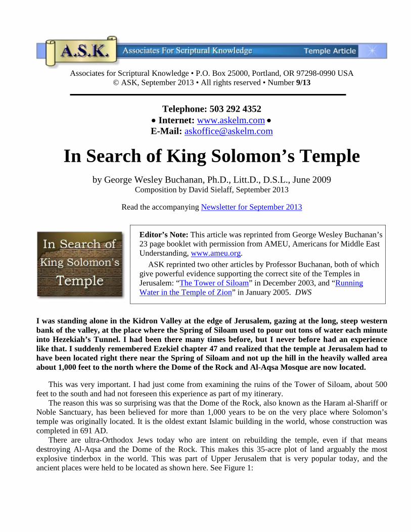
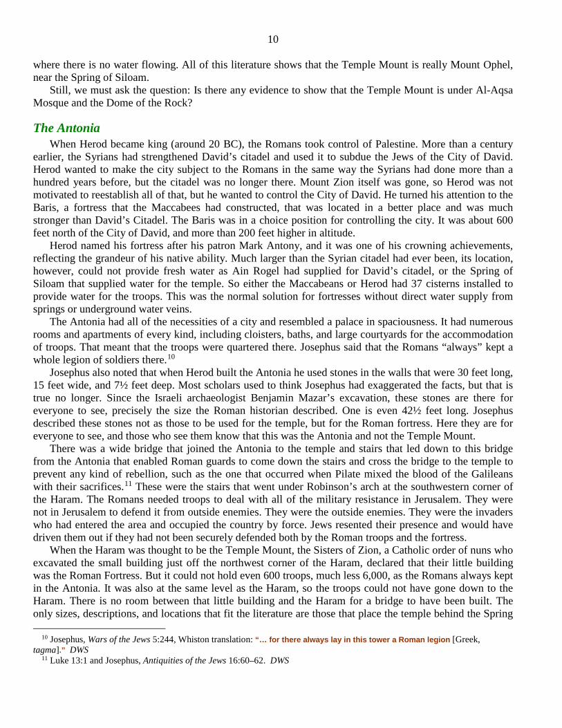
There are ultra-Orthodox Jews today who are intent on rebuilding the temple, even if that means destroying Al-Aqsa and the Dome of the Rock. This makes this 35-acre plot of land arguably the most explosive tinderbox in the world. This was part of Upper Jerusalem that is very popular today, and the ancient places were held to be located as shown here. See Figure 1:
2 1. The Citadel of David was very close to the Jaffa Gate. 2. Mount Zion was the tallest point of the Upper City,
across the Hinoam Valley from the Church of Scotland.
3. The room where Jesus conducted the Last Supper was across the road from the place we had called Mount Zion.
4. The Temple Mount where all three of the temples of Jerusalem had been erected was the large heavily walled area where the Dome of the Rock and Al-Aqsa Mosque are stationed. Muslims call this the Haram al-Shariff.
5. Just off the northwest corner of the Haram al-Shariff to the north are the ruins of a small build-ing that has been called the Roman Fortress of Antonia. The entire city of Jerusalem was called both “Zion” and “the City of David.”
This is the concept of Jerusalem that prompted Hershel Shanks, founder of the Biblical Archaeology Society, to say, “Everything you ever knew about Jerusalem is wrong.”1
The Kidron Valley where I was standing, on the other hand, has not been well developed. Some maps of Jerusalem do not even include it, but more than forty years ago the English archaeologist Kathleen Kenyon claimed this small unattractive ridge was the entire City of David before it was destroyed in 70 AD.
I have lived in Jerusalem at different times and was there in 1967, just a few years after Kenyon exposed a part of the Jebusite wall that surrounded Jerusalem when David took the city near the end of the 11th cen-tury BC. From this and other archaeological finds, Kenyon concluded that the City of David excluded all of the popular Upper City of Jerusalem. It consisted only of this 10-acre ridge alongside of the Kidron Valley. At first, most of us were rather shocked at the suggestion and wondered how that could be, but soon most scholars agreed with her, and archaeologists were encouraged to continue directing their attention to this ridge. I, too, agreed with Kenyon and went down to the Kidron Valley to see some of the ruins for myself.
I did not come to Jerusalem to see the City of David, but I had learned that archaeologists had only recently discovered a wall nearby that was 5,000 years old, and that enabled them to identify some ruins as those belonging to the Tower of Siloam reported in Luke chapter 13. My purpose in coming to Jerusalem was to examine these ruins on the western bank of the Kidron Valley. The ruins had been first uncovered in 1920 by the French archaeologist Raymond Weill, a member of the first Jewish archaeological initiative in Jerusalem. At that time, he did not know what they were, listing them only as “a circular structure.” When the archaeologists Eli Shukron of the Israel Antiquities Authority and Ronny Reich of the University of Haifa discovered a wall more than 5,000 years old that had once circumscribed the ridge forming the west-ern bank of the Kidron Valley, they realized that this circular structure, with its interior diameter of 19 feet, constituted the remains of the Tower of Siloam. The old wall made the identification certain.
But it was not the old wall that held my attention. It was the Tower of Siloam. The only time the Tower of Siloam is actually mentioned in the New Testament is in Luke 13:1–5. Jesus was being questioned about
1 H. Shanks, “Everything You Ever Knew about Jerusalem Is Wrong,” Biblical Archaeology Review 25.6 (1999):20–29, and “I
3 suffering and the connection between natural and moral good and evil; the text reads:
“They were going along at that time when some of them mentioned the Galileans whose blood Pilate mixed with their sacrifices. He answered them, ‘Do you think that these Galileans were the worst criminals of all Galileans, because they suffered this way? No, but I tell you, if you do not repent all of you will likewise perish.’ Or those 18 on whom the Tower of Siloam fell and killed them, do you think that they were worse offenders than all the others who lived in Jeru-salem? No, I tell you, but unless you repent all of you will likewise perish.”
• Luke 13:1–5
This text was preserved in two chreias — a literary form that was not designed to tell anything new. It was used only to remind readers of something they already knew. Chreias were just reminders. The Galile-ans whose blood Pilate mixed with their sacrifices are nowhere else mentioned in scripture or surrounding literature. Likewise, the 18 who were killed when the Tower of Siloam fell are mentioned nowhere else. Both events occurred around Jerusalem, not far from one another, during Jesus’ ministry, when Pilate was the Roman governor (26–36 AD).
We don’t know all the details: Who were these Galileans? Who were the 18 on whom the tower fell? Were they both involved in an insurrection against the Romans, of which there were many? The details aren’t given, because they didn’t need to be given. It was that day’s “hot news.” These reports were written down at a time when the people who read the chreias knew the details, but not everyone in the world knew them. These lines were written for contemporary local people.
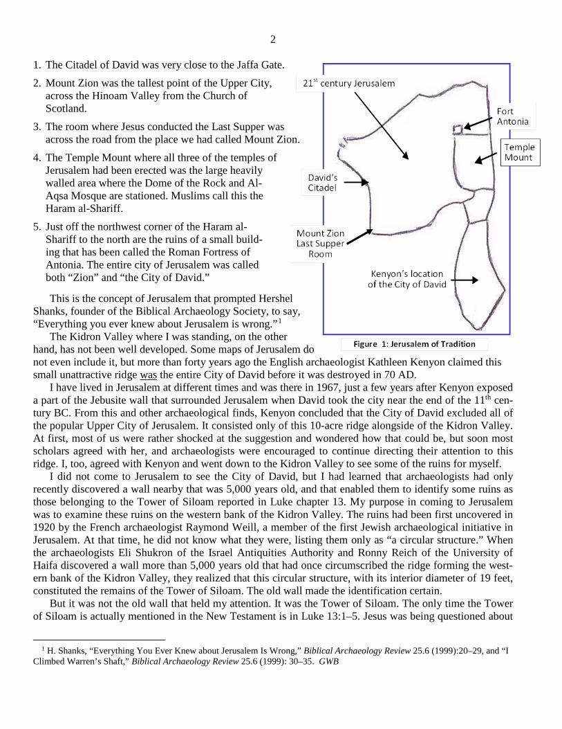
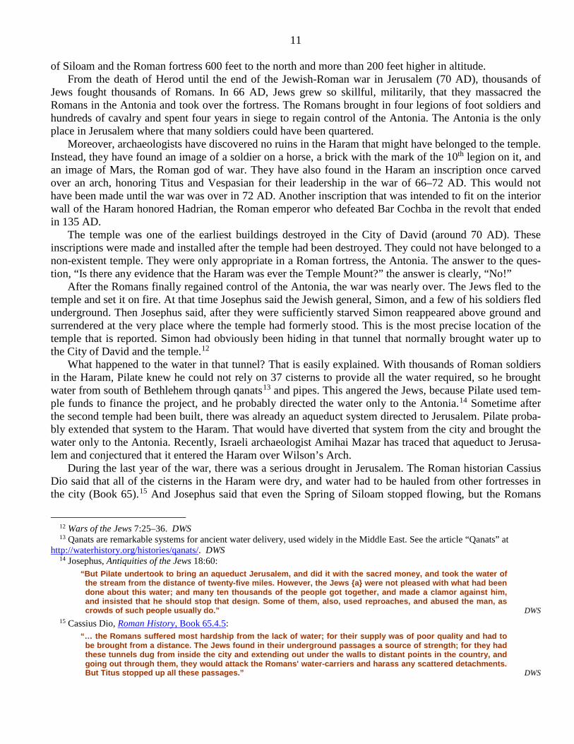
Now, 2,000 years later, we can see the connection between the Galileans, whose blood Pilate mixed with their sacrifice in the temple and the 18 who were killed when the nearby tower fell on them. The ruins of this tower have been discovered inside the City of David, near the old wall and about 500 feet south of the Spring of Siloam, confirming the validity of Luke 13:1–4. I had come to see the ruins of the tower, but I was suddenly distracted by the realization that the temple had to be located very close to the spring and the tower; see Figure 2.
Figure 2
The Dome of the Rock (Roman Fortress of
Antonia)
Northern boundary of the City of David
Spring of Siloam (Gihon)
Watchtower of Siloam
Temple Mount (Mount Ophel)
David’s Citadel (used by Syrians)
4
After viewing the footings of the tower, I stood in the Kidron Valley, just 500 feet north of the tower, and looked at the area where the Spring of Siloam ran into Hezekiah’s Tunnel, the 1,750-foot aqueduct carved around 701 BC to bring water to Jerusalem. Suddenly, I remembered a passage in Ezekiel 47:1: “Look! The water was pouring out from under the threshold of the temple toward the east.” That’s when the insight came to me: Follow the water!
I knew the rest of the Ezekiel account. It told the way the water ran all the way down the streambed to the Dead Sea, where it sweetened the salty water of the Dead Sea, so that fish could survive along the west-ern bank all the way from Ain Eglaim to Ain Gedi. These were the two springs on the western shore of the Dead Sea. The streambed began at the Kidron Valley and followed all the way to the Dead Sea, just as Ezekiel said.
I knew at once that Ezekiel was describing a situation with which he was familiar, and he had described it accurately. The water from the two springs near the Dead Sea would have been supplemented by the huge addition of water from the Spring of Siloam in Ezekiel’s day. Ezekiel said this was possible because of the water that flowed out from under the temple).2 This meant the temple had to have been just above that Spring of Siloam that ran under the temple threshold. The text shows that the temple and the Tower of Siloam were not more than a city block apart from one another.
I realized that there was more to this story than I could see at once, but it meant that the temple could not have been on the dry hill about 1,000 feet to the north that had been called the Temple Mount. The water that supplied that unit came only from the 37 cisterns in the ground under the buildings. That is when my research began. My next step was to search the scriptures for more references to the spring and the temple.
Biblical Evidence The first tent (tabernacle) of God that David brought up to Jerusalem was placed right there, near the
spring. Events that occurred while David was dying show where he had the first tent installed. When Adonijah was celebrating his succession to the throne at Ain Rogel — about 1,000 feet south of Ain Gihon — Solomon, Nathan, and the priest Zadok were gathered at Ain Gihon. Ain Gihon was the earliest name given to the spring that was later called the Spring of Siloam. While there, “Zadok, the priest, took the horn of oil from the tent” (1 Kings 1:39) — that is the tent of the Lord that David established for the chest con-taining the covenant between Yehowah and his people. He placed the tent adjacent to the altar near Ain Gihon, and Solomon later had the temple built at the same location. This location is confirmed by other texts.
The temple was the place where “Yehowah sits over the flood,” where he is “enthroned as king for the age” (Psalm 29:10). “The voice of Yehowah is over the water; the God of glory roars; Yehowah over much water” (Psalm 29:3).
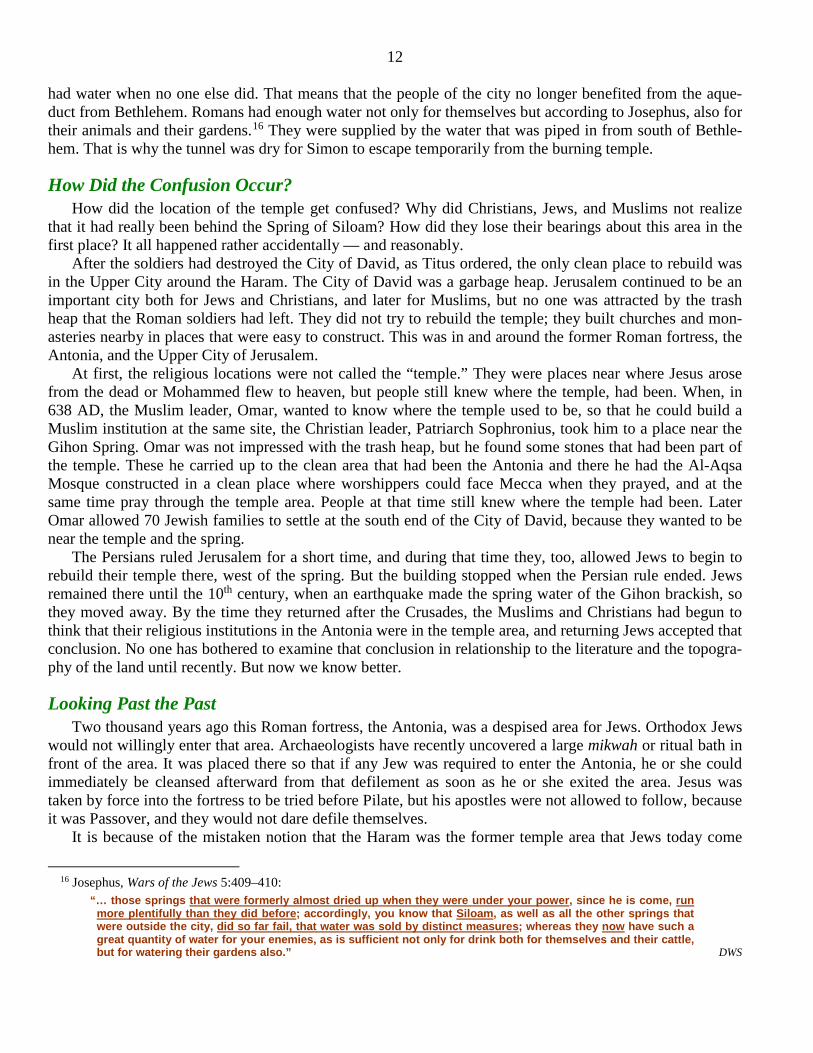
The flood was the huge fountain of water pouring tons of water through Hezekiah’s tunnel every minute under the temple. Hezekiah’s Tunnel is 1,750 feet long, about three feet wide, and roughly six feet tall; see Figure 3. (Fifty years ago the water in that tunnel was between waist and shoulder deep.) This prompted the Psalmist to write, “There is a river whose streams make glad the city of God, the holy dwelling place of the Most High” (Psalm 46:4). The “dwelling place of the Most High” was the temple positioned near the streams that “make glad the city of God.” The City of God, of
2 Ezekiel 47:1:
“Afterward he brought me again unto the door of the house; and, behold, waters issued out from under the threshold of the house eastward: for the forefront of the house stood toward the east, and the waters came down from under from the right side of the house, at the south side of the altar.” DWS
Figure 3: The Gihon Water Flow
5 course, was the City of David, the little ridge alongside of the Kidron Valley, where water flows freely from the spring.
One of the factors the prophet Zechariah anticipated in the future restoration, when Yehowah would become king over all the land, was having “the water of life flowing out from Jerusalem” (Zechariah 14:8–9). The Jerusalem he pictured was Zion, near the spring of Gihon (Siloam) — not the hill to the north that later became Herod’s city.
Similarly, in the New Testament, when the seer of the Book of Revelation looked forward to a new Jeru-salem, he anticipated a heavenly city that had come to earth from God in heaven, prepared as a bride for a new wedding contract. In this new city one of the basic descriptions was, “The river of the water of life going out from the throne of God” (Revelation 22:1). The Throne of God was one of the names given for the tem-ple at Zion. It was known both in Greek and Hebrew.
Those who had come up out of great tribulation would be before the “throne of God,” where “the Lamb would lead them to the springs of the water of life” (Revelation 7:15, 17). These “springs of the water” were Ain Gihon and Ain Rogel, the two springs at the base of the temple mount in Zion, where the Spring of Gihon streamed from the altar of the temple down the Kidron Valley to the south. The seer related the tem-ple to the area near the spring of Gihon, the spring that was later called Siloam.
The Contribution of Ernest Martin I had not yet begun to study the Roman historian Josephus, the rabbinic literature, the apocrypha, pseud-
epigrapha, or other historical reports when I saw advertised a new book by Dr. Ernest Martin, The Temples that Jerusalem Forgot (Portland: ASK Publications, 2000). I had known Ernest Martin for about 30 years. From 1960 to 1972 he taught history, theology and elementary meteorology at the Ambassador College in Bricket Wood, England, where he became Dean of Faculty. In 1961, he visited Jerusalem where he met Israeli archeologist Benjamin Mazar and his son, Ory. It was Ory who told him that both he and his father believed that the Temple of Solomon was located on the Ophel mound to the north of the original Mount Zion. Between 1969 and 1973, Ambassador College partnered with Hebrew University in Israel to under-take a five-year archaeological excavation near the Western Wall of the Temple Mount.
After I had read about half way through his excellent book, I phoned Dr. Martin. I was delighted to learn that he reached some of the same conclusions that I had, beginning from a different perspective. I agreed with him that Solomon’s temple had to have been west of the Spring of Siloam, rather than up on the Dome of the Rock. I also thought David’s altar and tent had to have been here. At that point, however, I thought that Herod’s temple was probably inside Herod’s city, and I told him that. He said, “Read the rest of the book,” and I did. He had collected literary evidence, both contemporary and later Jewish, Christian and Muslim literature, and had proved that Herod’s temple was also down, behind the Spring of Siloam. I should have realized that at once, but I did not. As soon as the City of David is known as only that little ridge, it becomes clear that all of the temples belonged there. The Dome of the Rock area is out of bounds; see Figure 4.
I sent Martin the results of my research at that point, and we were both thrilled at the notion of working together to bring this insight to the attention of scholars. We planned to read papers together at academic meetings and publish together. Our first step was to offer papers at the next Middle Atlantic States regional meeting of the Society of Biblical Literature in Baltimore. He would present the archeological evidence, and I would give the biblical evidence for the true location of the temple. I called him to make continued plans but, even though he had four telephone lines and I called them all, I received no response. I sent him e-mail messages, but he did not reply. So I offered a paper at that meeting alone.
Martin, I learned, had died. Later, his assistant, David Sielaff, who has proofread several of the papers that I delivered before academic meetings and later published, accompanied me to Jerusalem to revisit the relevant area. We were both invited to speak at the University of Dundee, Scotland graduate school. I also read other illustrative papers at academic meetings.
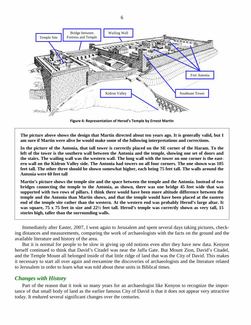
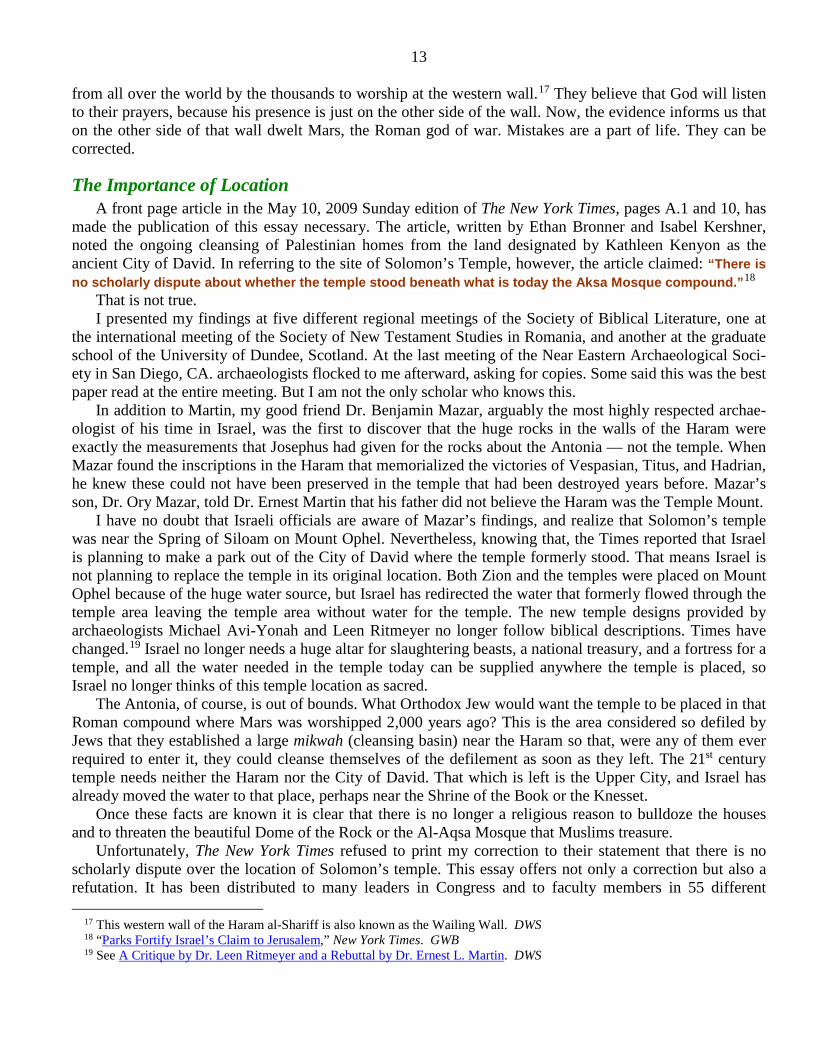
Figure 4: Representation of Herod’s Temple by Ernest Martin
The picture above shows the design that Martin directed about ten years ago. It is generally valid, but I am sure if Martin were alive he would make some of the following interpretations and corrections.
In the picture of the Antonia, that tall tower is correctly placed on the SE corner of the Haram. To the left of the tower is the southern wall between the Antonia and the temple, showing one set of doors and the stairs. The wailing wall was the western wall. The long wall with the tower on one corner is the east-ern wall on the Kidron Valley side. The Antonia had towers on all four corners. The one shown was 105 feet tall. The other three should be shown somewhat higher, each being 75 feet tall. The walls around the Antonia were 60 feet tall
Martin’s picture shows the temple site and the space between the temple and the Antonia. Instead of two bridges connecting the temple to the Antonia, as shown, there was one bridge 45 feet wide that was supported with two rows of pillars. I think there would have been more altitude difference between the temple and the Antonia than Martin shows, and that the temple would have been placed at the eastern end of the temple site rather than the western. At the western end was probably Herod’s large altar. It was square, 75 x 75 feet in size and 22½ feet tall. Herod’s temple was correctly shown as very tall, 15 stories high, taller than the surrounding walls.
Immediately after Easter, 2007, I went again to Jerusalem and spent several days taking pictures, check-ing distances and measurements, comparing the work of archaeologists with the facts on the ground and the available literature and history of the area.
But it is normal for people to be slow in giving up old notions even after they have new data. Kenyon herself continued to think that David’s Citadel was near the Jaffa Gate. But Mount Zion, David’s Citadel, and the Temple Mount all belonged inside of that little ridge of land that was the City of David. This makes it necessary to start all over again and reexamine the discoveries of archaeologists and the literature related to Jerusalem in order to learn what was told about these units in Biblical times.
Changes with History Part of the reason that it took so many years for an archaeologist like Kenyon to recognize the impor-
tance of that small body of land as the earlier famous City of David is that it does not appear very attractive today. It endured several significant changes over the centuries.
Temple Site Bridge between
Fortress and Temple
Kidron Valley Southeast Tower
Wailing Wall
Fort Antonia
7 • The Israelites captured it from the Jebusites sometime around 1000 BC, when David was king.
• During the 8th century BC, Hezekiah built his huge tunnel from the spring to a pool in the Tyropoeon Valley.
• During the Maccabean period, the Syrians took control of the citadel, the point from which it controlled the entire city. Jews hated that intrusion, and as soon as the Hasmonean, Simon, gained freedom from Syria in 142 BC, he spent three years removing the entire hill, down to bedrock, dumping the rocks and soil into the Tyropoeon Valley and filling in the canyon between Zion and the ridge to the west. The tall Mount Zion that had been the tallest part of the ridge and city was removed and the area that was formerly Mount Zion became the lower city.
• In 70 AD, the Roman soldiers destroyed this city so completely that no one would ever realize that a city had been there.
• And after the Bar Cochba Revolt, the Roman emperor, Hadrian, completed the desolation in 135 AD by ordering that the city become a place where the trash and garbage from the upper city would be thrown.
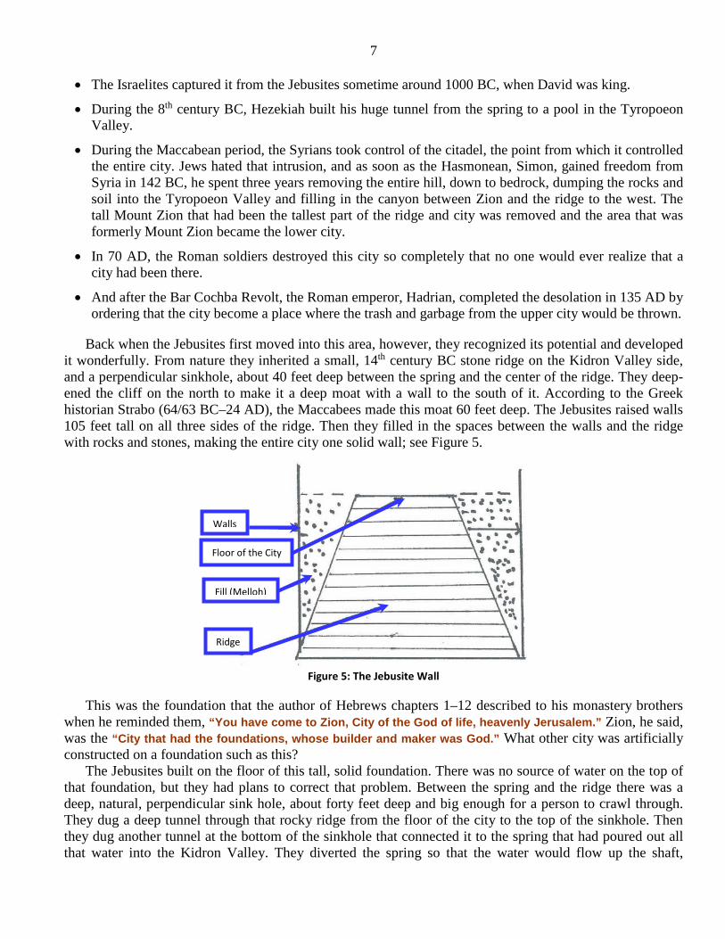
Back when the Jebusites first moved into this area, however, they recognized its potential and developed it wonderfully. From nature they inherited a small, 14th century BC stone ridge on the Kidron Valley side, and a perpendicular sinkhole, about 40 feet deep between the spring and the center of the ridge. They deep-ened the cliff on the north to make it a deep moat with a wall to the south of it. According to the Greek historian Strabo (64/63 BC–24 AD), the Maccabees made this moat 60 feet deep. The Jebusites raised walls 105 feet tall on all three sides of the ridge. Then they filled in the spaces between the walls and the ridge with rocks and stones, making the entire city one solid wall; see Figure 5.
Figure 5: The Jebusite Wall
This was the foundation that the author of Hebrews chapters 1–12 described to his monastery brothers when he reminded them, “You have come to Zion, City of the God of life, heavenly Jerusalem.” Zion, he said, was the “City that had the foundations, whose builder and maker was God.” What other city was artificially constructed on a foundation such as this?
The Jebusites built on the floor of this tall, solid foundation. There was no source of water on the top of that foundation, but they had plans to correct that problem. Between the spring and the ridge there was a deep, natural, perpendicular sink hole, about forty feet deep and big enough for a person to crawl through. They dug a deep tunnel through that rocky ridge from the floor of the city to the top of the sinkhole. Then they dug another tunnel at the bottom of the sinkhole that connected it to the spring that had poured out all that water into the Kidron Valley. They diverted the spring so that the water would flow up the shaft,
Walls Floor of the City
Fill (Melloh)
Ridge
8 through the tunnel, to bring fresh water up to the floor of the city, from which it could be piped to cisterns wherever they needed it, with the surplus flowing down to the Dead Sea.
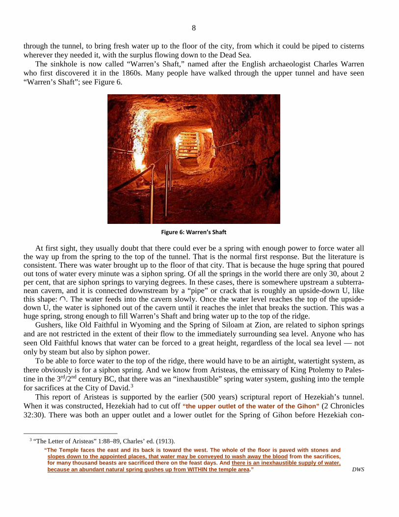
The sinkhole is now called “Warren’s Shaft,” named after the English archaeologist Charles Warren who first discovered it in the 1860s. Many people have walked through the upper tunnel and have seen “Warren’s Shaft”; see Figure 6.
Figure 6: Warren’s Shaft
At first sight, they usually doubt that there could ever be a spring with enough power to force water all the way up from the spring to the top of the tunnel. That is the normal first response. But the literature is consistent. There was water brought up to the floor of that city. That is because the huge spring that poured out tons of water every minute was a siphon spring. Of all the springs in the world there are only 30, about 2 per cent, that are siphon springs to varying degrees. In these cases, there is somewhere upstream a subterra-nean cavern, and it is connected downstream by a “pipe” or crack that is roughly an upside-down U, like this shape: ∩. The water feeds into the cavern slowly. Once the water level reaches the top of the upside-down U, the water is siphoned out of the cavern until it reaches the inlet that breaks the suction. This was a huge spring, strong enough to fill Warren’s Shaft and bring water up to the top of the ridge.
Gushers, like Old Faithful in Wyoming and the Spring of Siloam at Zion, are related to siphon springs and are not restricted in the extent of their flow to the immediately surrounding sea level. Anyone who has seen Old Faithful knows that water can be forced to a great height, regardless of the local sea level — not only by steam but also by siphon power.
To be able to force water to the top of the ridge, there would have to be an airtight, watertight system, as there obviously is for a siphon spring. And we know from Aristeas, the emissary of King Ptolemy to Pales-tine in the 3rd/2nd century BC, that there was an “inexhaustible” spring water system, gushing into the temple for sacrifices at the City of David.3
This report of Aristeas is supported by the earlier (500 years) scriptural report of Hezekiah’s tunnel. When it was constructed, Hezekiah had to cut off “the upper outlet of the water of the Gihon” (2 Chronicles 32:30). There was both an upper outlet and a lower outlet for the Spring of Gihon before Hezekiah con-
3 “The Letter of Aristeas” 1:88–89, Charles’ ed. (1913).
“The Temple faces the east and its back is toward the west. The whole of the floor is paved with stones and slopes down to the appointed places, that water may be conveyed to wash away the blood from the sacrifices, for many thousand beasts are sacrificed there on the feast days. And there is an inexhaustible supply of water, because an abundant natural spring gushes up from WITHIN the temple area.” DWS
9 structed the tunnel. The upper outlet took the water up Warren’s Shaft and the Jebusite tunnel to the top of the ridge. The lower tunnel, now called the Tunnel of Siloam, ran along the bottom of the ridge from the spring to the south end of the ridge. Hezekiah planned his tunnel so that the water would run down to his tunnel and avoid the other lower tunnel, but he had to block off the upper outlet that had been bringing water up to the temple area.
The sacrifices at the temple could never have depended on rainwater cisterns, such as those 37 cisterns established at the site of today’s Dome of the Rock and Al-Aqsa Mosque. Aristeas said that the water sys-tem was under the temple and that it was “indescribably” well developed, with lead-lined, plastered cisterns, and countless pipes. Running water could be heard underground even from the surface, directing water to the various places the city needed.4 Aristeas further explained how the landscape of the temple area was designed with paved stones and gutters to carry away the blood washed down from the sacrifices.5
From the Book of Enoch, written between 200 BC and 100 BC, we read that the prophet claimed to have seen the holy mountain with a stream that flowed underneath that mountain toward the south (1 Enoch 26:2–3).6 There is no such stream flowing underneath the Dome of the Rock. Hezekiah’s tunnel does not flow north. The holy mountain was obviously the Temple Mount, located just above Ain Gihon. This is the location of which Ezekiel spoke, where the stream that flowed underneath the mountain also flowed under-neath the temple near Siloam. This suggests that part of the temple was built over the spring or else the temple was so close to the spring that water could be directed from it into the temple itself.
The Temple Scroll gives directions for establishing a place near the temple where priests could change their garments, bathe, and change into priestly garments before participating in the temple services. This bathhouse required flowing water with a canal around it so the bath water, like the blood, could flow away into a drain that escaped into the ground (11QT 32:11–15).7 This mixture should not be touched before it vanished into the ground, because it would be defiled with blood. Rabbis said it would flow into the brook Kidron (mMiddoth 3:2).8
The Israeli archaeologist Yigael Yadin noticed that there was a great deal of agreement among the sources regarding the necessity of flowing water for sacrifices, but he evidently did not think of all the rami-fications related to his discovery.9 He continued to think of the Haram Al-Shariff as the Temple Mount,
4 “The Letter of Aristeas” 1:89–90:
“There are moreover wonderful and indescribable cisterns underground, as they pointed out to me, at a distance of five furlongs all round the site of the temple, and each of them has countless pipes so that the different streams converge together. And all these were fastened with lead at the bottom and at the sidewalls, and over them a great quantity of plaster had been spread, and every part of the work had been most carefully carried out. There are many openings for water at the base [of the altar] which are invisible to all except to those who are engaged in the ministration, so that all the blood of the sacrifices which is collected in great quantities is washed away in the twinkling of an eye.” DWS
“And there I saw a holy mountain, and underneath the mountain to the east there was a stream and it flowed towards the south. And I saw towards the east another mountain higher than this, and between them a deep and narrow ravine: in it also ran a stream underneath the mountain.” DWS
7 Temple Scroll: “Above the house of the ... when they come to minister in the sanctuary. You shall make a trench around the
laver beside its house and the trench shall go [from the house of] the laver to a cavity. It shall descend [rapid]ly to the ground where the water shall flow and disappear. It shall not be touched by any man for it is mingled with the blood of the holocaust.” DWS
8 Mishnah Middoth 3:2, Danby translation: “And at the south-western corner there were two holes like two narrow nostrils by which the blood that was
poured over the western base and the southern base used to run down and mingle in the water-channel and flow out into the brook Kidron.” DWS
9 Y. Yadin (ed.), The Temple Scroll (Jerusalem: The Israel Exploration Society, 1983), I, 222. GWB
10 where there is no water flowing. All of this literature shows that the Temple Mount is really Mount Ophel, near the Spring of Siloam.
Still, we must ask the question: Is there any evidence to show that the Temple Mount is under Al-Aqsa Mosque and the Dome of the Rock?
The Antonia When Herod became king (around 20 BC), the Romans took control of Palestine. More than a century
earlier, the Syrians had strengthened David’s citadel and used it to subdue the Jews of the City of David. Herod wanted to make the city subject to the Romans in the same way the Syrians had done more than a hundred years before, but the citadel was no longer there. Mount Zion itself was gone, so Herod was not motivated to reestablish all of that, but he wanted to control the City of David. He turned his attention to the Baris, a fortress that the Maccabees had constructed, that was located in a better place and was much stronger than David’s Citadel. The Baris was in a choice position for controlling the city. It was about 600 feet north of the City of David, and more than 200 feet higher in altitude.
Herod named his fortress after his patron Mark Antony, and it was one of his crowning achievements, reflecting the grandeur of his native ability. Much larger than the Syrian citadel had ever been, its location, however, could not provide fresh water as Ain Rogel had supplied for David’s citadel, or the Spring of Siloam that supplied water for the temple. So either the Maccabeans or Herod had 37 cisterns installed to provide water for the troops. This was the normal solution for fortresses without direct water supply from springs or underground water veins.
The Antonia had all of the necessities of a city and resembled a palace in spaciousness. It had numerous rooms and apartments of every kind, including cloisters, baths, and large courtyards for the accommodation of troops. That meant that the troops were quartered there. Josephus said that the Romans “always” kept a whole legion of soldiers there.10
Josephus also noted that when Herod built the Antonia he used stones in the walls that were 30 feet long, 15 feet wide, and 7½ feet deep. Most scholars used to think Josephus had exaggerated the facts, but that is true no longer. Since the Israeli archaeologist Benjamin Mazar’s excavation, these stones are there for everyone to see, precisely the size the Roman historian described. One is even 42½ feet long. Josephus described these stones not as those to be used for the temple, but for the Roman fortress. Here they are for everyone to see, and those who see them know that this was the Antonia and not the Temple Mount.
There was a wide bridge that joined the Antonia to the temple and stairs that led down to this bridge from the Antonia that enabled Roman guards to come down the stairs and cross the bridge to the temple to prevent any kind of rebellion, such as the one that occurred when Pilate mixed the blood of the Galileans with their sacrifices.11 These were the stairs that went under Robinson’s arch at the southwestern corner of the Haram. The Romans needed troops to deal with all of the military resistance in Jerusalem. They were not in Jerusalem to defend it from outside enemies. They were the outside enemies. They were the invaders who had entered the area and occupied the country by force. Jews resented their presence and would have driven them out if they had not been securely defended both by the Roman troops and the fortress.
When the Haram was thought to be the Temple Mount, the Sisters of Zion, a Catholic order of nuns who excavated the small building just off the northwest corner of the Haram, declared that their little building was the Roman Fortress. But it could not hold even 600 troops, much less 6,000, as the Romans always kept in the Antonia. It was also at the same level as the Haram, so the troops could not have gone down to the Haram. There is no room between that little building and the Haram for a bridge to have been built. The only sizes, descriptions, and locations that fit the literature are those that place the temple behind the Spring
10 Josephus, Wars of the Jews 5:244, Whiston translation: “… for there always lay in this tower a Roman legion [Greek, tagma].” DWS
11 Luke 13:1 and Josephus, Antiquities of the Jews 16:60–62. DWS
11 of Siloam and the Roman fortress 600 feet to the north and more than 200 feet higher in altitude.
From the death of Herod until the end of the Jewish-Roman war in Jerusalem (70 AD), thousands of Jews fought thousands of Romans. In 66 AD, Jews grew so skillful, militarily, that they massacred the Romans in the Antonia and took over the fortress. The Romans brought in four legions of foot soldiers and hundreds of cavalry and spent four years in siege to regain control of the Antonia. The Antonia is the only place in Jerusalem where that many soldiers could have been quartered.
Moreover, archaeologists have discovered no ruins in the Haram that might have belonged to the temple. Instead, they have found an image of a soldier on a horse, a brick with the mark of the 10th legion on it, and an image of Mars, the Roman god of war. They have also found in the Haram an inscription once carved over an arch, honoring Titus and Vespasian for their leadership in the war of 66–72 AD. This would not have been made until the war was over in 72 AD. Another inscription that was intended to fit on the interior wall of the Haram honored Hadrian, the Roman emperor who defeated Bar Cochba in the revolt that ended in 135 AD.
The temple was one of the earliest buildings destroyed in the City of David (around 70 AD). These inscriptions were made and installed after the temple had been destroyed. They could not have belonged to a non-existent temple. They were only appropriate in a Roman fortress, the Antonia. The answer to the ques-tion, “Is there any evidence that the Haram was ever the Temple Mount?” the answer is clearly, “No!”
After the Romans finally regained control of the Antonia, the war was nearly over. The Jews fled to the temple and set it on fire. At that time Josephus said the Jewish general, Simon, and a few of his soldiers fled underground. Then Josephus said, after they were sufficiently starved Simon reappeared above ground and surrendered at the very place where the temple had formerly stood. This is the most precise location of the temple that is reported. Simon had obviously been hiding in that tunnel that normally brought water up to the City of David and the temple.12
What happened to the water in that tunnel? That is easily explained. With thousands of Roman soldiers in the Haram, Pilate knew he could not rely on 37 cisterns to provide all the water required, so he brought water from south of Bethlehem through qanats13 and pipes. This angered the Jews, because Pilate used tem-ple funds to finance the project, and he probably directed the water only to the Antonia.14 Sometime after the second temple had been built, there was already an aqueduct system directed to Jerusalem. Pilate proba-bly extended that system to the Haram. That would have diverted that system from the city and brought the water only to the Antonia. Recently, Israeli archaeologist Amihai Mazar has traced that aqueduct to Jerusa-lem and conjectured that it entered the Haram over Wilson’s Arch.
During the last year of the war, there was a serious drought in Jerusalem. The Roman historian Cassius Dio said that all of the cisterns in the Haram were dry, and water had to be hauled from other fortresses in the city (Book 65).15 And Josephus said that even the Spring of Siloam stopped flowing, but the Romans
12 Wars of the Jews 7:25–36. DWS 13 Qanats are remarkable systems for ancient water delivery, used widely in the Middle East. See the article “Qanats” at
http://waterhistory.org/histories/qanats/. DWS 14 Josephus, Antiquities of the Jews 18:60:
“But Pilate undertook to bring an aqueduct Jerusalem, and did it with the sacred money, and took the water of the stream from the distance of twenty-five miles. However, the Jews {a} were not pleased with what had been done about this water; and many ten thousands of the people got together, and made a clamor against him, and insisted that he should stop that design. Some of them, also, used reproaches, and abused the man, as crowds of such people usually do.” DWS
15 Cassius Dio, Roman History, Book 65.4.5: “… the Romans suffered most hardship from the lack of water; for their supply was of poor quality and had to
be brought from a distance. The Jews found in their underground passages a source of strength; for they had these tunnels dug from inside the city and extending out under the walls to distant points in the country, and going out through them, they would attack the Romans' water-carriers and harass any scattered detachments. But Titus stopped up all these passages.” DWS
12 had water when no one else did. That means that the people of the city no longer benefited from the aque-duct from Bethlehem. Romans had enough water not only for themselves but according to Josephus, also for their animals and their gardens.16 They were supplied by the water that was piped in from south of Bethle-hem. That is why the tunnel was dry for Simon to escape temporarily from the burning temple.
How Did the Confusion Occur? How did the location of the temple get confused? Why did Christians, Jews, and Muslims not realize
that it had really been behind the Spring of Siloam? How did they lose their bearings about this area in the first place? It all happened rather accidentally — and reasonably.
After the soldiers had destroyed the City of David, as Titus ordered, the only clean place to rebuild was in the Upper City around the Haram. The City of David was a garbage heap. Jerusalem continued to be an important city both for Jews and Christians, and later for Muslims, but no one was attracted by the trash heap that the Roman soldiers had left. They did not try to rebuild the temple; they built churches and mon-asteries nearby in places that were easy to construct. This was in and around the former Roman fortress, the Antonia, and the Upper City of Jerusalem.
At first, the religious locations were not called the “temple.” They were places near where Jesus arose from the dead or Mohammed flew to heaven, but people still knew where the temple, had been. When, in 638 AD, the Muslim leader, Omar, wanted to know where the temple used to be, so that he could build a Muslim institution at the same site, the Christian leader, Patriarch Sophronius, took him to a place near the Gihon Spring. Omar was not impressed with the trash heap, but he found some stones that had been part of the temple. These he carried up to the clean area that had been the Antonia and there he had the Al-Aqsa Mosque constructed in a clean place where worshippers could face Mecca when they prayed, and at the same time pray through the temple area. People at that time still knew where the temple had been. Later Omar allowed 70 Jewish families to settle at the south end of the City of David, because they wanted to be near the temple and the spring.
The Persians ruled Jerusalem for a short time, and during that time they, too, allowed Jews to begin to rebuild their temple there, west of the spring. But the building stopped when the Persian rule ended. Jews remained there until the 10th century, when an earthquake made the spring water of the Gihon brackish, so they moved away. By the time they returned after the Crusades, the Muslims and Christians had begun to think that their religious institutions in the Antonia were in the temple area, and returning Jews accepted that conclusion. No one has bothered to examine that conclusion in relationship to the literature and the topogra-phy of the land until recently. But now we know better.
Looking Past the Past Two thousand years ago this Roman fortress, the Antonia, was a despised area for Jews. Orthodox Jews
would not willingly enter that area. Archaeologists have recently uncovered a large mikwah or ritual bath in front of the area. It was placed there so that if any Jew was required to enter the Antonia, he or she could immediately be cleansed afterward from that defilement as soon as he or she exited the area. Jesus was taken by force into the fortress to be tried before Pilate, but his apostles were not allowed to follow, because it was Passover, and they would not dare defile themselves.
It is because of the mistaken notion that the Haram was the former temple area that Jews today come
16 Josephus, Wars of the Jews 5:409–410:
“… those springs that were formerly almost dried up when they were under your power, since he is come, run more plentifully than they did before; accordingly, you know that Siloam, as well as all the other springs that were outside the city, did so far fail, that water was sold by distinct measures; whereas they now have such a great quantity of water for your enemies, as is sufficient not only for drink both for themselves and their cattle, but for watering their gardens also.” DWS
13 from all over the world by the thousands to worship at the western wall.17 They believe that God will listen to their prayers, because his presence is just on the other side of the wall. Now, the evidence informs us that on the other side of that wall dwelt Mars, the Roman god of war. Mistakes are a part of life. They can be corrected.
The Importance of Location A front page article in the May 10, 2009 Sunday edition of The New York Times, pages A.1 and 10, has
made the publication of this essay necessary. The article, written by Ethan Bronner and Isabel Kershner, noted the ongoing cleansing of Palestinian homes from the land designated by Kathleen Kenyon as the ancient City of David. In referring to the site of Solomon’s Temple, however, the article claimed: “There is no scholarly dispute about whether the temple stood beneath what is today the Aksa Mosque compound.”18
That is not true. I presented my findings at five different regional meetings of the Society of Biblical Literature, one at
the international meeting of the Society of New Testament Studies in Romania, and another at the graduate school of the University of Dundee, Scotland. At the last meeting of the Near Eastern Archaeological Soci-ety in San Diego, CA. archaeologists flocked to me afterward, asking for copies. Some said this was the best paper read at the entire meeting. But I am not the only scholar who knows this.
In addition to Martin, my good friend Dr. Benjamin Mazar, arguably the most highly respected archae-ologist of his time in Israel, was the first to discover that the huge rocks in the walls of the Haram were exactly the measurements that Josephus had given for the rocks about the Antonia — not the temple. When Mazar found the inscriptions in the Haram that memorialized the victories of Vespasian, Titus, and Hadrian, he knew these could not have been preserved in the temple that had been destroyed years before. Mazar’s son, Dr. Ory Mazar, told Dr. Ernest Martin that his father did not believe the Haram was the Temple Mount.
I have no doubt that Israeli officials are aware of Mazar’s findings, and realize that Solomon’s temple was near the Spring of Siloam on Mount Ophel. Nevertheless, knowing that, the Times reported that Israel is planning to make a park out of the City of David where the temple formerly stood. That means Israel is not planning to replace the temple in its original location. Both Zion and the temples were placed on Mount Ophel because of the huge water source, but Israel has redirected the water that formerly flowed through the temple area leaving the temple area without water for the temple. The new temple designs provided by archaeologists Michael Avi-Yonah and Leen Ritmeyer no longer follow biblical descriptions. Times have changed.19 Israel no longer needs a huge altar for slaughtering beasts, a national treasury, and a fortress for a temple, and all the water needed in the temple today can be supplied anywhere the temple is placed, so Israel no longer thinks of this temple location as sacred.
The Antonia, of course, is out of bounds. What Orthodox Jew would want the temple to be placed in that Roman compound where Mars was worshipped 2,000 years ago? This is the area considered so defiled by Jews that they established a large mikwah (cleansing basin) near the Haram so that, were any of them ever required to enter it, they could cleanse themselves of the defilement as soon as they left. The 21st century temple needs neither the Haram nor the City of David. That which is left is the Upper City, and Israel has already moved the water to that place, perhaps near the Shrine of the Book or the Knesset.
Once these facts are known it is clear that there is no longer a religious reason to bulldoze the houses and to threaten the beautiful Dome of the Rock or the Al-Aqsa Mosque that Muslims treasure.
Unfortunately, The New York Times refused to print my correction to their statement that there is no scholarly dispute over the location of Solomon’s temple. This essay offers not only a correction but also a refutation. It has been distributed to many leaders in Congress and to faculty members in 55 different
17 This western wall of the Haram al-Shariff is also known as the Wailing Wall. DWS 18 “Parks Fortify Israel’s Claim to Jerusalem,” New York Times. GWB 19 See A Critique by Dr. Leen Ritmeyer and a Rebuttal by Dr. Ernest L. Martin. DWS
14 theological seminaries. An article summarizing my findings was featured in The Washington Report on Middle East Affairs, a magazine that reaches 25,000 people.20
The true location of former Jewish temples is no longer a secret, and there is no longer any reasonable basis for threatening Muslim ownership and security of the Haram al-Sharif.
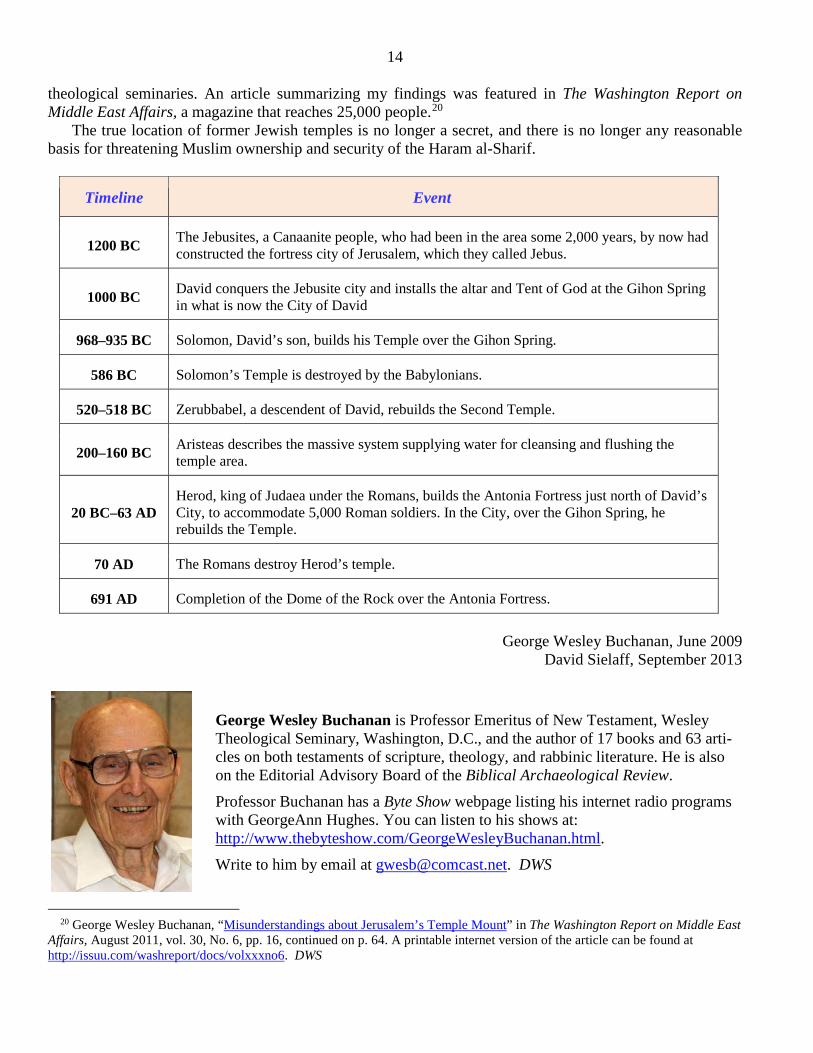
Timeline Event
1200 BC The Jebusites, a Canaanite people, who had been in the area some 2,000 years, by now had constructed the fortress city of Jerusalem, which they called Jebus.
1000 BC David conquers the Jebusite city and installs the altar and Tent of God at the Gihon Spring in what is now the City of David
968–935 BC Solomon, David’s son, builds his Temple over the Gihon Spring.
586 BC Solomon’s Temple is destroyed by the Babylonians.
520–518 BC Zerubbabel, a descendent of David, rebuilds the Second Temple.
200–160 BC Aristeas describes the massive system supplying water for cleansing and flushing the temple area.
20 BC–63 AD Herod, king of Judaea under the Romans, builds the Antonia Fortress just north of David’s City, to accommodate 5,000 Roman soldiers. In the City, over the Gihon Spring, he rebuilds the Temple.
70 AD The Romans destroy Herod’s temple.
691 AD Completion of the Dome of the Rock over the Antonia Fortress.
George Wesley Buchanan, June 2009
David Sielaff, September 2013
George Wesley Buchanan is Professor Emeritus of New Testament, Wesley Theological Seminary, Washington, D.C., and the author of 17 books and 63 arti-cles on both testaments of scripture, theology, and rabbinic literature. He is also on the Editorial Advisory Board of the Biblical Archaeological Review. Professor Buchanan has a Byte Show webpage listing his internet radio programs with GeorgeAnn Hughes. You can listen to his shows at: http://www.thebyteshow.com/GeorgeWesleyBuchanan.html. Write to him by email at [email protected]. DWS
20 George Wesley Buchanan, “Misunderstandings about Jerusalem’s Temple Mount” in The Washington Report on Middle East Affairs, August 2011, vol. 30, No. 6, pp. 16, continued on p. 64. A printable internet version of the article can be found at http://issuu.com/washreport/docs/volxxxno6. DWS