In search of the North Island Archaic: archaeological excavations at Sarah’s Gully, Coromandel Peninsula,
New Zealand, from 1956 to 1960
Janet Davidson
Honorary Research Associate, Museum of New Zealand Te Papa Tongarewa9 Maple Lane, Martinborough, New Zealand 5711 ([email protected])
ABSTRACT: Excavations led by Jack Golson at Sarah’s Gully on the Coromandel Peninsula between 1957 and 1960 represented a landmark in New Zealand archaeology. A total area of about 1350 m2 was hand-excavated at six separate locations, recorded as three separate sites. Stratified deposits are dated to various points between about ad 1300 and 1800.
Artefactual remains show little change through time, with continuity in use of the important basalt resource at nearby Tahanga hill for stone adzes. Although moa and the North Island adzebill (Aptornis otidiformis) soon disappeared from the record, the faunal remains as a whole reflect continuity in fishing, shellfish-gathering and the taking of birds. The original forest was cleared very soon after people arrived. Storage pits, probably for kümara (sweet potato), were present throughout the sequence. Although the headland at the entrance to the bay was partly fortified during the middle of the sequence, the defences appear token in nature.
Overall, the excavations revealed a way of life that involved periodic visits to fish, to garden, and to make and repair stone tools. This changed very little over the centuries.
Cambridge-trained archaeologist Jack Golson arrived in New Zealand early in 1954 to take up an appointment as lecturer in prehistory in the young Anthropology Department at what was then Auckland University College. He immediately immersed himself in New Zealand archaeology: its history, literature, and field evidence (Golson 1957; Groube 1993).
After relatively small field operations at Oruarangi and Great Mercury Island (Ahuahu) (Golson 1955), and a rescue excavation at the volcanic cone of Taylor’s Hill in Auckland (Leahy 1991), Golson set about finding and excavating a site or sites in the North Island that would produce faunal and cultural evidence for comparison with the large, extensively excavated South Island moa-hunter sites, such as Wairau Bar, Shag River and Papatowai. The results of his excavations at Sarah’s Gully on the Coromandel Peninsula and Pig Bay on Motutapu Island near Auckland were fundamental to the development of his views on what he would call the North Island Archaic (Golson 1959a).
The present paper provides an account of the four seasons of excavation at Sarah’s Gully, for which there have previously been only interim and summary reports (Golson 1959a,b; Birks 1960; Birks & Birks 1970, 1973). My aim is to reconstruct the excavations from the notes, photographs and material items that have survived, and consider them in the light of more than five decades of subsequent research in New Zealand archaeology and prehistory.
The paper draws on original field notes, including diaries and drawings made available by Golson and Lawrie Birks; photographs in the archive of the Anthropology Department, University of Auckland, and photographs provided by Wallace Ambrose and Helen Birks; additional notes, plans and photographs assembled by Roger Green; and the dating of surplus material from some radiocarbon samples originally submitted by Golson for dating by the Institute of Nuclear Sciences. This material is held in the Auckland Institute and Museum. I took part briefly in the final excavation season at Sarah’s Gully in January 1960.
In his quest for a suitable Moa-hunter (or, as he would later call it, Archaic) site, Golson drew on artefact distributions
and existing literature. His review of documented finds of stone adze blades in museum collections revealed a concentration of stylistically early adzes on the east coast of the Coromandel Peninsula (Golson 1959a: 69). An early report of moa bones in association with humans (Owen 1848, cited by Duff 1956: 250), and a 1930s excavation that had yielded moa-hunter-style fishhooks and other items (Fisher 1936), drew his attention to Opito Bay on the Kuaotunu Peninsula north of Mercury Bay.
Golson went with a small group of colleagues to Opito early in 1956 and talked to one of the landowners, R.H. (Skipper) Chapman, who suggested he go to nearby Sarah’s Gully, where artefact collector Arthur Black had recently made some interesting discoveries. During their visit, a member of the group found a typically early-style ‘hog-back’ adze that had eroded out of the beach face (Susan Davis, pers. comm., January 1959).
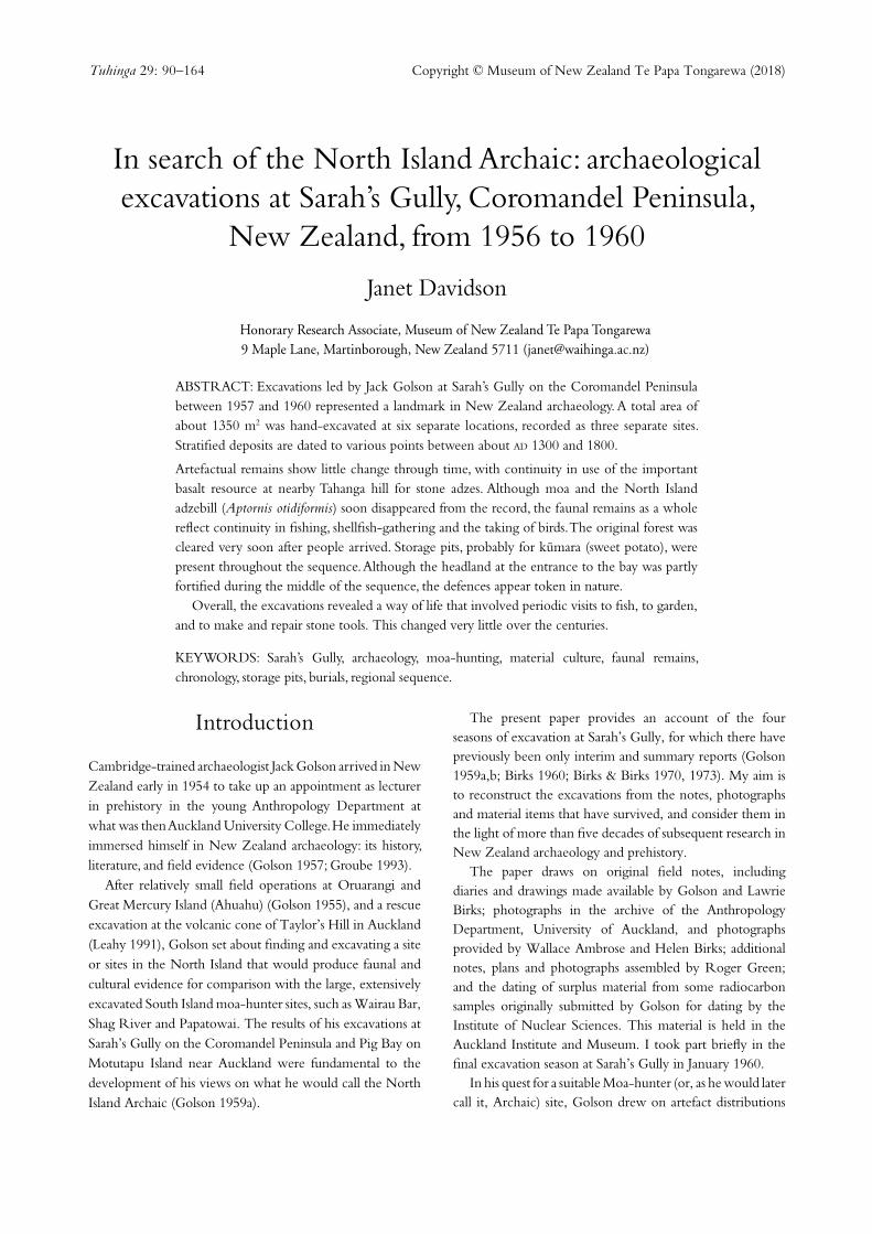
Fig. 1 The location of Sarah’s Gully, showing sites recorded in the New Zealand Archaeological Association’s database (New Zealand Archaeological Association 2009): A, the Kuaotunu Peninsula on the east coast of the Coromandel Peninsula in northern New Zealand; B, Sarah’s Gully; C, Tahanga hill; D, Skipper’s Ridge and the Opito Beach Midden. The inaccuracy of the overlay reflects the difficulty of precisely locating sites using grid references. The overlay is slightly to the south of the true positions.
The scene was set for the subsequent four seasons of excavations at Sarah’s Gully and Opito. In his fieldwork on Great Mercury Island (Ahuahu), Golson had already established the desirability of a location that would be attractive to his volunteer labour force: a site adjacent to a safe swimming beach in a remote place with fishing opportunities from nearby rocks. Sarah’s Gully amply met these requirements. Although the location was accessible by way of the then notoriously dangerous Black Jack Road from Whitianga and a walking track, the gear and some of the personnel travelled from Auckland on the coastal vessel Lady Jocelyn and were rowed ashore.
Sarah’s Gully and Opito are part of the rohe (territory) of Ngäti Hei. However, there is no indication in the surviving documentation of the four seasons’ work there that any approach was made to the iwi, or that Skipper Chapman had any involvement with Ngäti Hei.
Archaeological Excavations at Sarah’s Gully
Tuhinga, Number 29 (2018)92
Fig. 3 The excavations at Sarah’s Gully Settlement, as mapped by Roger Green in January 1959. Some minor inaccuracies in the map are discussed in the text. Details are shown as follows: 1, Fig. 12; 2, Fig. 13; 3, Fig. 15; 4, Fig. 16.
Fig. 2 Sarah’s Gully, looking northeast. The sites discussed in this paper are at the far end of the beach: 1, the Settlement; 2, Sarah’s Midden; 3, the Pä (photo: W.R. Ambrose).
The localitySarah’s Gully (Whaorei Bay) is a small northwest-facing bay on the northern part of the Kuaotunu Peninsula, between the larger beaches of Otama to the west and Opito to the east (Fig. 1). It has an open sandy beach, with rocky shores at either end. The main stream enters the sea about two-thirds of the way up the beach to the northeast; there is a smaller stream further up the beach and a third that comes down into the beach at the northern end, separating the northern headland from the remainder of the bay (Fig. 2).
The original Sarah’s Gully site was initially recorded by Green as Sarah’s Gully Settlement, N40/9 (now T10/167), and is called the Settlement in this paper. South of the stream was the Cross Creek site (N40/260; T10/399), surface-collected by Ron Scarlett and others during Golson’s excavations, and later investigated by Brenda Sewell (1984, 1986, 1988; Furey et al. 2008).
On the northern headland is the Sarah’s Gully Pä (N40/10; T10/168), here called the Pä. Below the Pä on the seaward side of the mouth of the northern stream was
93
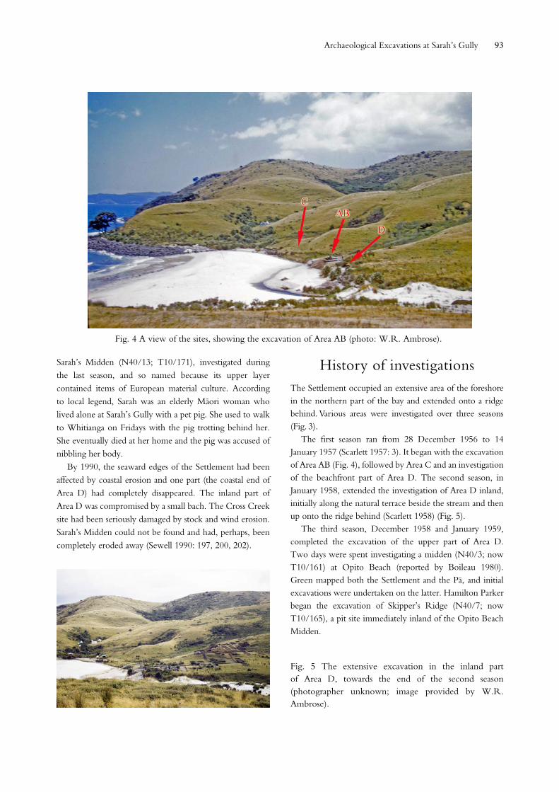
Fig. 4 A view of the sites, showing the excavation of Area AB (photo: W.R. Ambrose).
Fig. 5 The extensive excavation in the inland part of Area D, towards the end of the second season (photographer unknown; image provided by W.R. Ambrose).
Sarah’s Midden (N40/13; T10/171), investigated during the last season, and so named because its upper layer contained items of European material culture. According to local legend, Sarah was an elderly Mäori woman who lived alone at Sarah’s Gully with a pet pig. She used to walk to Whitianga on Fridays with the pig trotting behind her. She eventually died at her home and the pig was accused of nibbling her body.
By 1990, the seaward edges of the Settlement had been affected by coastal erosion and one part (the coastal end of Area D) had completely disappeared. The inland part of Area D was compromised by a small bach. The Cross Creek site had been seriously damaged by stock and wind erosion. Sarah’s Midden could not be found and had, perhaps, been completely eroded away (Sewell 1990: 197, 200, 202).
History of investigationsThe Settlement occupied an extensive area of the foreshore in the northern part of the bay and extended onto a ridge behind. Various areas were investigated over three seasons (Fig. 3).
The first season ran from 28 December 1956 to 14 January 1957 (Scarlett 1957: 3). It began with the excavation of Area AB (Fig. 4), followed by Area C and an investigation of the beachfront part of Area D. The second season, in January 1958, extended the investigation of Area D inland, initially along the natural terrace beside the stream and then up onto the ridge behind (Scarlett 1958) (Fig. 5).
The third season, December 1958 and January 1959, completed the excavation of the upper part of Area D. Two days were spent investigating a midden (N40/3; now T10/161) at Opito Beach (reported by Boileau 1980). Green mapped both the Settlement and the Pä, and initial excavations were undertaken on the latter. Hamilton Parker began the excavation of Skipper’s Ridge (N40/7; now T10/165), a pit site immediately inland of the Opito Beach Midden.
Archaeological Excavations at Sarah’s Gully
Tuhinga, Number 29 (2018)94
During the summer of 1959/60, Golson was in New Caledonia. Parker continued excavations at Skipper’s Ridge (reported in Davidson 1974, 1975; Davidson & Green 1975). Birks directed excavations at the Pä and Sarah’s Midden. He and his wife had continued the excavation of the Pä in the early months of 1959, and took it further in early 1960 after the conclusion of the main excavation season in January.
Altogether, the excavations at the Settlement exposed a little more than 1000 m2. The excavation on the Pä exposed an additional 332 m2. In contrast, only 6.5 m2 were fully excavated in Sarah’s Midden, with a further 3.25 m2 taken to the surface of layer 3. Even so, this small excavation made an important contribution to the whole picture.
The excavationsThe Settlement
Area ABThis excavation was on a gently sloping natural terrace. The main stream had cut into this terrace, exposing cultural deposits. Amateur archaeologist and collector Black and an associate had dug into the site from the seaward edge in what became Area B, exposing deposits about 1.5 m deep, including what appeared to be a very large hängï (earth oven) (Fig. 6).
A grid of 6 ft (c. 1.8 m) squares was laid out parallel to the beach face and designated E–H from east to west (the stream edge), and 7–16 from south to north. Initially, an area of 18 x 20 ft (c. 5.5 x 6 m) was excavated in Area A to the south and 16 x 14 ft (c. 4.9 x 4.3 m) in Area B. Area B was subsequently extended north by 6 ft (c. 1.8 m) and the baulk between the two areas was removed (Fig. 7). This resulted in an excavated area of approximately 140 m2, as the H row of squares reached to, and sometimes just beyond, the edge of the eroding stream bank.
In the eastern part of the excavation – E and F, and part of the G, lines of squares – the deposit was relatively shallow, comprising only three main layers. To the seaward side, however, there appeared to be several structures cut into the natural consolidated sand deposits and filled with a series of cultural layers. As this area had been severely cut back by stream erosion, it was difficult to assess the nature of the structures.
The total depth of the upper deposits varied between about 28 cm and 38 cm (excluding overlying patches of windblown sand). The layers were described as follows, from the top:
1 Black sand beneath sparse turf and windblown sand; quite hard in places, with some bone, stone flakes and broken oven stones. There was a restricted shell lens on the seaward edge in E11. Remains of a small hearth or hängï were found in F13.
2 Light brown sand, with shelly patches in western parts of the area. There were two distinct areas of hängï stones in G8 and G8/9 and one in Area B. Some cultural material.
3 Mainly darker brown sand, but varying in colour and composition, sometimes softer, and sometimes grittier. Layer 3 overlaid the natural consolidated sand throughout the eastern part of the excavation. Hollows underlay the layer 2 fire features; other shallow, amorphous features were found in the surface of the natural, filled with layer 3. There was a possible shallow posthole in E/F9 and two definite postholes in G9 and H9, 7½ in (19 cm) and 16 in (40.5 cm) deep, respectively. Remains of a hängï were found in E/F16; a similar dished depression in the surface of layer 3 in E/F15 contained black soil and charcoal but no stones. Some cultural material.
Fig. 6 The exposed beach section in Area B in December 1956, after cleaning down and before excavation (photo: W.R. Ambrose).
Fig. 7 The completed excavation of Area AB, looking towards the Cross Creek site. A drain is clearly visible in the centre (photo: W.R. Ambrose).
95
In the baulk between Areas A and B was a drain, dug into the natural consolidated sand and filled with layer 3 (Fig. 7). This entered the excavation at the junction of E12 and E13, ran diagonally through F12 and G12, and was lost in the eroding beach face in H12, so that its relationship to presumed structures in this area could not be ascertained. In January 1958, two squares (shown in Fig. 3) were opened on the inland side of the Area AB excavation in an attempt to trace the drain upslope. The result was the same as had been found that summer in the inland part of Area D: the drain petered out at the base of the slope. These squares added at least 10 m2 to the excavation of Area AB (the exact size of
these two squares is uncertain). In layer 2, higher up in the baulk, were two substantial clusters of hängï stones in H11 and two smaller patches in H12.
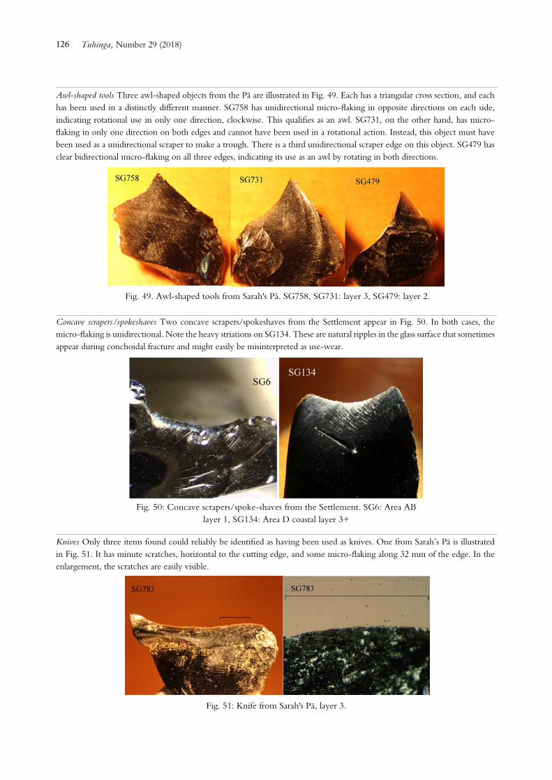
In the H line of squares in Area A were remnants of several structures cut into the natural consolidated sand. A ‘ledge’ ran along below the edge of layer 3 in H9–11 and appeared to have been cut by a deep pit, which in turn had cut into an earlier pit. Complex fill layers suggested occupation breaks between the two pits and between the pits and the shelf. Several postholes were found, which appeared to relate to a possible house structure (Fig. 8).
Layers in the lower part of Area A were as follows (Fig. 9):
Fig. 8 The vestigial remains of a complex of structures on the seaward edge of Area AB. The upper deposits can be seen in section beneath a layer of white windblown sand at top right (photo: W.R. Ambrose).
Fig. 9 The deep section in Area AB. The drawing is annotated ‘2 ft N. of line 10/11’ (photo: W.R. Ambrose).
Archaeological Excavations at Sarah’s Gully
Tuhinga, Number 29 (2018)96
4 Brownish grey with shell fragments, extending into H10 and thinly into H9.
5 Similar to layer 2, with numerous shell fragments.
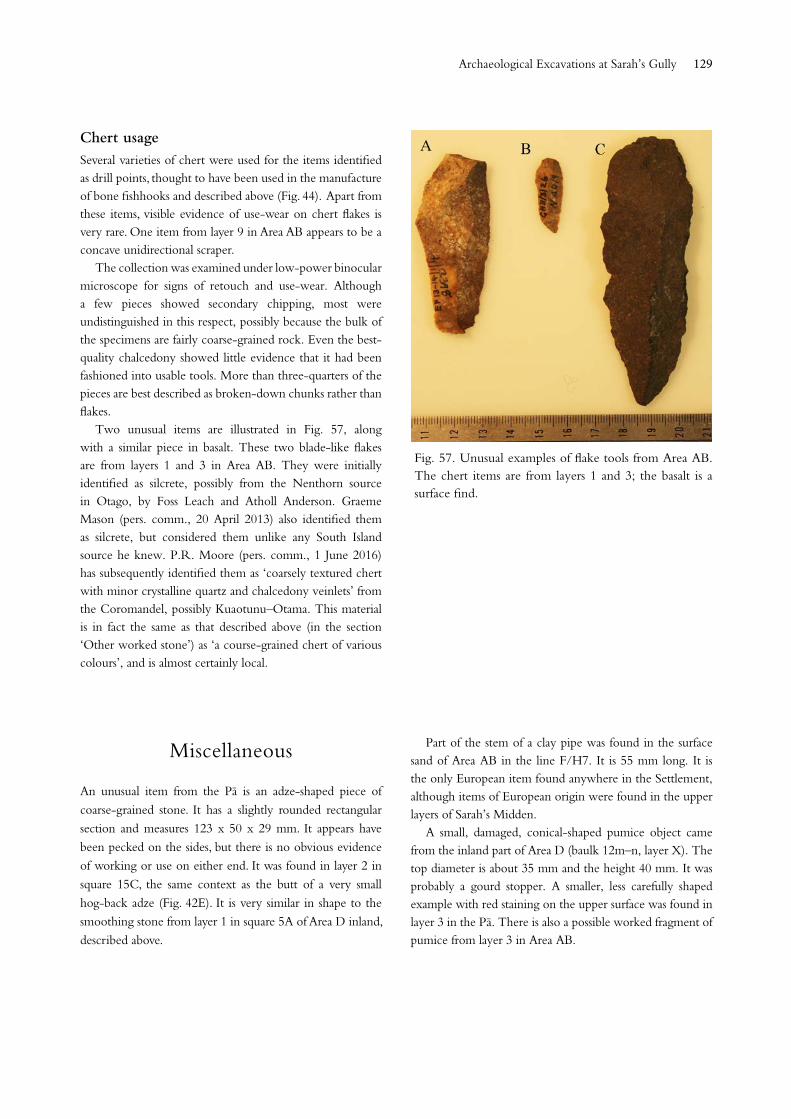
6 Similar to layer 4.
7 Grey sand with considerable cultural material.
8 Reddish sand, apparently derived from the consolidated natural and apparently a living surface.
9 Grey sand with considerable cultural material, more in the form of a midden than a living surface.
10 Yellow shelly sand, above a natural deposit of white shelly sand.
In Area B, layer 3 was thicker in G15, above what had been presumed to be a large oven. This main feature, sectioned by Black, was found to be a large, deep, dished depression about 15 ft (4.6 m) wide, filled with very black soil and charcoal. There were no stones in the depression, but there was a layer of very large stones, almost like a pavement, on the centre of its surface, with a much smaller, shallow, dished depression, filled with sand and charcoal, immediately beneath it, dug into the surface of the big depression (see Fig. 6).
Most of the artefacts from the surface and layer 1 were not catalogued to square. In layer 2, in addition to nine ‘loose finds’, 10 were from the G row of squares, with one each from F8 and E14. Layer 3 saw a concentration in the area of G–H/9–12 with only scattered finds elsewhere. This continued to the bottom of the deposits, with the exception of layer 4, with only a fishhook fragment and some stone flakes from G–H/10–11. Finds in layers 7 and 9 were almost entirely restricted to G11.
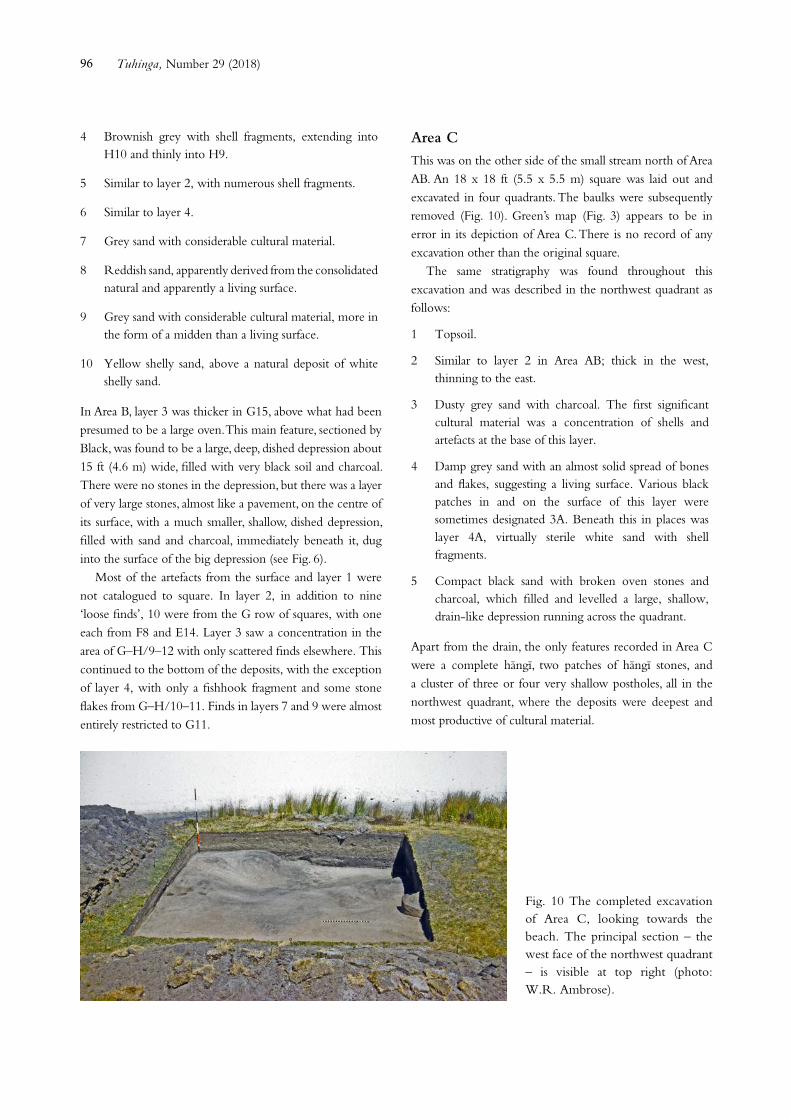
Area CThis was on the other side of the small stream north of Area AB. An 18 x 18 ft (5.5 x 5.5 m) square was laid out and excavated in four quadrants. The baulks were subsequently removed (Fig. 10). Green’s map (Fig. 3) appears to be in error in its depiction of Area C. There is no record of any excavation other than the original square.
The same stratigraphy was found throughout this excavation and was described in the northwest quadrant as follows:
1 Topsoil.
2 Similar to layer 2 in Area AB; thick in the west, thinning to the east.
3 Dusty grey sand with charcoal. The first significant cultural material was a concentration of shells and artefacts at the base of this layer.
4 Damp grey sand with an almost solid spread of bones and flakes, suggesting a living surface. Various black patches in and on the surface of this layer were sometimes designated 3A. Beneath this in places was layer 4A, virtually sterile white sand with shell fragments.
5 Compact black sand with broken oven stones and charcoal, which filled and levelled a large, shallow, drain-like depression running across the quadrant.
Apart from the drain, the only features recorded in Area C were a complete hängï, two patches of hängï stones, and a cluster of three or four very shallow postholes, all in the northwest quadrant, where the deposits were deepest and most productive of cultural material.
Fig. 10 The completed excavation of Area C, looking towards the beach. The principal section – the west face of the northwest quadrant – is visible at top right (photo: W.R. Ambrose).
97
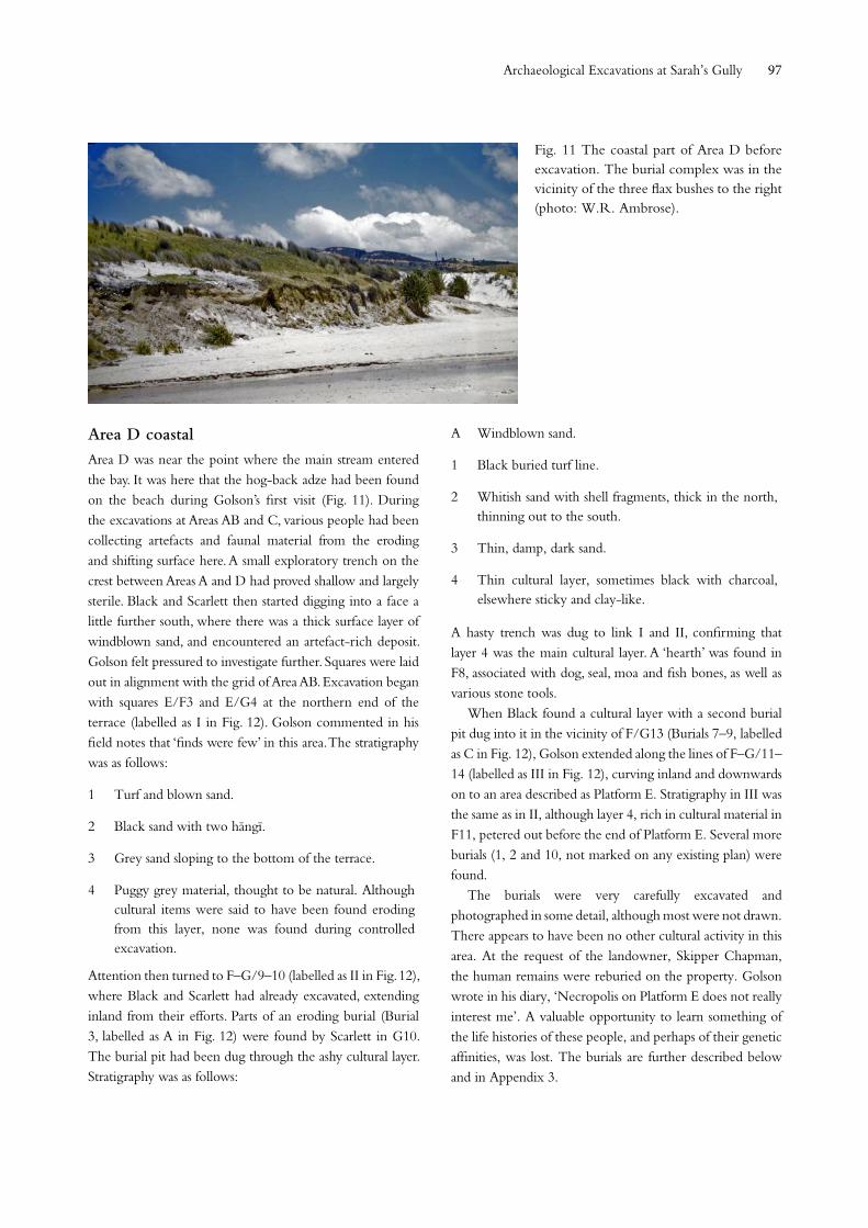
Area D coastal Area D was near the point where the main stream entered the bay. It was here that the hog-back adze had been found on the beach during Golson’s first visit (Fig. 11). During the excavations at Areas AB and C, various people had been collecting artefacts and faunal material from the eroding and shifting surface here. A small exploratory trench on the crest between Areas A and D had proved shallow and largely sterile. Black and Scarlett then started digging into a face a little further south, where there was a thick surface layer of windblown sand, and encountered an artefact-rich deposit. Golson felt pressured to investigate further. Squares were laid out in alignment with the grid of Area AB. Excavation began with squares E/F3 and E/G4 at the northern end of the terrace (labelled as I in Fig. 12). Golson commented in his field notes that ‘finds were few’ in this area. The stratigraphy was as follows:
1 Turf and blown sand.
2 Black sand with two hängï.
3 Grey sand sloping to the bottom of the terrace.
4 Puggy grey material, thought to be natural. Although cultural items were said to have been found eroding from this layer, none was found during controlled excavation.
Attention then turned to F–G/9–10 (labelled as II in Fig. 12), where Black and Scarlett had already excavated, extending inland from their efforts. Parts of an eroding burial (Burial 3, labelled as A in Fig. 12) were found by Scarlett in G10. The burial pit had been dug through the ashy cultural layer. Stratigraphy was as follows:
A Windblown sand.
1 Black buried turf line.
2 Whitish sand with shell fragments, thick in the north, thinning out to the south.
3 Thin, damp, dark sand.
4 Thin cultural layer, sometimes black with charcoal, elsewhere sticky and clay-like.
A hasty trench was dug to link I and II, confirming that layer 4 was the main cultural layer. A ‘hearth’ was found in F8, associated with dog, seal, moa and fish bones, as well as various stone tools.
When Black found a cultural layer with a second burial pit dug into it in the vicinity of F/G13 (Burials 7–9, labelled as C in Fig. 12), Golson extended along the lines of F–G/11–14 (labelled as III in Fig. 12), curving inland and downwards on to an area described as Platform E. Stratigraphy in III was the same as in II, although layer 4, rich in cultural material in F11, petered out before the end of Platform E. Several more burials (1, 2 and 10, not marked on any existing plan) were found.
The burials were very carefully excavated and photographed in some detail, although most were not drawn. There appears to have been no other cultural activity in this area. At the request of the landowner, Skipper Chapman, the human remains were reburied on the property. Golson wrote in his diary, ‘Necropolis on Platform E does not really interest me’. A valuable opportunity to learn something of the life histories of these people, and perhaps of their genetic affinities, was lost. The burials are further described below and in Appendix 3.
Fig. 11 The coastal part of Area D before excavation. The burial complex was in the vicinity of the three flax bushes to the right (photo: W.R. Ambrose).
Archaeological Excavations at Sarah’s Gully
Tuhinga, Number 29 (2018)98
In the 1958/59 season, squares 1B, 2A and 2B (Fig. 12)
were dug to try to link up the stratigraphy of I and II. These
revealed a sloping depression between the two areas, similar
to one found in square 5C (described below), which had
contributed to the erosion. Both of these appeared to have
been formed by drains coming down from above (see Fig. 12).
It seems that there was only one main cultural occupation
layer in this area: layer 4, which was thin but relatively
rich in both faunal and artefactual material. Transient later
occupation is indicated by the hängï in layer 2 in I and a
few artefacts from upper layers. The fact that several of the
burials had been dug into layer 4 from a higher level suggests
that the whole burial complex was probably more recent
than the layer 4 occupation.
The exact extent of the excavation in Area D coastal is not
known. Green’s map, made two summers later, following
further erosion, is clearly not quite correct, and there is no
documentation of the linking trench between I and II or of
the burial area. A conservative estimate of 35 m2 excludes
the burial area.
Area D inlandThe large area excavation running inland began on the flat terrace immediately behind the seaward part of Area D (Figs 12 and 13). Stratigraphy on this terrace was as follows:
1 Turf.
2 Black sand, thicker towards the seaward end, containing a few flakes of obsidian and pieces of burnt stone.
3 Greyish sand, thicker towards the seaward end. This was thought to be the same layer that sealed the ‘moa- hunter’ deposit in the coastal excavation in Area D. Activity on the surface of layer 3 on the inland terrace consisted mainly of ‘fire pits’: shallow scoops with charcoal but little stone.
4 Softish, more yellow sand, beginning in square 2 and thickening towards the inland end, but giving out towards the creek and the rise up the ridge.
5 More compact, greyish sand with minute shell. Restricted to the central part of the terrace, from square 4A to square 8. Scattered mammalian bone and some charcoal pieces were present in square 7A.
Natural Hard consolidated sand.
Fig. 12. Plan 2, Area D, showing the further extension of excavations inland along the low terrace; the upper termination of the second and third drains; and the initial extension up on to the flat above.
99
The principal features here were three shallow but distinct drains, first encountered in square 5 (Figs 12 and 13). They were dug into the underlying natural, sealed, and sometimes filled with layer 5; in squares 4A and 5, the northern edge of the first drain marked the northern edge of this layer. In squares 8A and 9A, where layer 5 was not present, the drain was filled with layer 4. The drains petered out at the base of the slope on the uphill side. The one traced into
Fig. 13. Plan 1, Area D, showing the area of the coastal excavation and the initial extension inland, including parts of the first two drains. A. Burial 3; B. Burial 4; C. Burials 7 to 9. D. Burial 11. The other burials were in the unmapped area just to the south.
square 5B petered out before what appeared to be a natural embayment leading down to the stream on the western edge of square 5C.
Other structural features were shallow postholes in several squares, apparently dug from the surface of layer 4, notably a line of four in squares 4 and 4A. A small rectangular feature in square 4A was deemed to be a modern intrusion.
Archaeological Excavations at Sarah’s Gully
Tuhinga, Number 29 (2018)100
A remarkable burial (here designated Burial 11) was found in square 5A (Fig. 14). There was no grave pit and the body appeared to have been placed on the natural ground surface and covered with heaped layer 5 material.
The excavation was then extended to the base of the slope through squares 8 and 9a–c, where the stratigraphy was limited to the turf layer (equated to the previous layer 2) and a greyish to lighter-coloured sand (layer 2, equated to previous layers 3–4) on top of consolidated natural sand. There were traces of hängï and burning in layer 2 and actual
hängï in the natural surface. Half squares 9d and 9e (not shown on Fig. 13) were opened to carry the excavation to the flat area above. Here, layer 2 became more turf-like and layer 3 more clay-like but both still contained sand.
On the flatter area above, in squares f–g/9–14, the stratigraphy was described as follows:
A Topsoil.
B Soft greyish-yellow soil of sandy texture.
C Friable brownish-yellow soil.
Fig. 14. Burial 11 in square 5A Area D. Upper: photograph W.R. Ambrose; lower: drawing by John Parry.
101
The principal features in this area were pits (Fig. 15), which were covered and sealed by layer C. The pits are described below. A large, deep posthole in square 9g was thought possibly to be for supporting a pätaka (raised storehouse) or whata (storage platform). Squares 7f, 8g, 10i (not shown on the plan), 12j–k, 13i–k, 14i–k, 15k and 17f (not shown on the plan) were sterile. There are no notes about other featureless squares in Fig. 15, which may also have been sterile.
What Golson considered the crucial stratigraphic link between the pits and the lower terrace was found in square 13c, where layer C, which sealed the pits above, was found to underlie layer 3, followed up from the flat below. Golson (1959a: 45) argued that this proved the pits were associated with the ‘moa-hunter’ occupation on the beach front below, which was also sealed by layer 3.
In the summer of 1958/59, a further attempt was made
to confirm the link between the lower flat and the pit complex by the excavation of squares 12b–e. This did not prove satisfactory, however, as layer C was not found. The excavation then progressed to 11–12/h–i and intervening baulks, where two further shallow rectangular pits (6 and 7) were found (Fig. 15). Squares above and inland of these pits were sterile, except for 11k, until the row of squares 12–16m was reached (Fig. 16). In square 11k, a complex structure of what had probably been superimposed hängï pits was discovered. Only some contained stones, although most or all contained charcoal. This feature was thought to be more recent than most of the features further up. In squares 12–16/m–p, three layers were identified: 1 and 2 as before; and an underlying cultural deposit designated layer X, which contained cracked hängï stones, charcoal, a shell fragment and a few pieces of obsidian.
Fig. 15. Plan 3 Area D, showing the pits uncovered. The feature in square k11 appeared to be a complex of superimposed hängi pits. The large posthole in the corner of square G9 may have supported a raised storage house (pätaka) or platform (whata).
Archaeological Excavations at Sarah’s Gully
Tuhinga, Number 29 (2018)102
The principal features in this uppermost area were postholes, some definite, some doubtful (Fig. 16). Although it is possible to see a rectangular grid pattern in these, their variation in width and depth leaves this interpretation uncertain. Of the larger features, 13 was described as a ‘shallow oval pit’, probably filled with layer B; 35 as a ‘large hole’; 39 as a ‘pit’; and 46 as a ‘not very convincing hollow’. Most significant was feature 37, a definite pit sealed by layer X and partly overlain by a hängï associated with layer B. Thus, there was some evidence for successive use of this upper part of the site, as there had been below, with sporadic cooking activities overlying earlier features. Although numerous charcoal samples were taken from this area, none was dated. Similarly, numerous soil samples were taken for analysis of the composition and origin of the various layers,
although this was not carried out. The exact area of the extensive excavation in Area D
inland is not certain, as at least two squares are not shown on the plans and several apparently excavated during the second season, before the map was made, have no documentation. Assuming that these were excavated, the total size of Area D inland was 786 m2.
Pits and drainsDetails of pit dimensions and features are given in Appendix 1. Pits A, B and C were very shallow and ill-defined. Pits 3–5 were larger, more clearly defined and slightly deeper. Pits 1 and 2, which might be described as bin pits, were smaller and deeper, with a ledge below the surface on some or all sides. Pits 6 and 7 were again very shallow. All, including the bin
Fig. 16. Plan 4 Area D, showing the features (mostly postholes) in the highest area investigated. Numbers refer to features described in the text.
103
pits, had lower edges on the downslope sides and/or ends. Some of the postholes in the floors of the rectangular pits were quite deep, indicating a fairly substantial superstructure. There were no signs of fire features or habitation debris in any of the pits, most of which were too small to have been anything other than storage structures. Several had a distinct thin layer of sand or other introduced material on their floors.
The two rounded features dug into the base of the downslope wall of Pit 3 were initially thought to be sumps but, as they were not fed by the drain, seem more likely to have been for the storage of some special part of whatever was stored in the pit.
The drains across the pit floors, although shallow, were clearly defined and were sometimes deep where they passed out through the pit walls. However, the drop along the drain from Pit 5, from the point where it exited the pit to where it passed into the baulk 10g/h, 12 ft (3.7 m) away, was only 4 degrees.
The drains on the terrace below were wider than the pit drains but just as shallow. Attempts to follow drains either upslope from the lower terrace or beyond the limits of excavation on the middle terrace (e.g. in part square 9h) were unsuccessful, and Golson regretfully concluded in his field notes that the drains gave out at the tops of the steeper slopes and resumed at their bases. As noted above, this also appeared to be the case with the drain in Area AB.
BurialsThe burials from the southern part of Area D (Fig. 12), uncovered during the first season of excavation, were described by Scarlett before reburial. An edited version of his report is presented as Appendix 3, and the comments attributed to Scarlett here are from that report. Scarlett noted that the crania were typical of the Polynesian form, although he did not have the necessary equipment to take precise and detailed measurements. Some of the burials were eroding, some had already been partially uncovered by Black, and some were not fully excavated; even so, this does not explain the incompleteness of most of the skeletons.
All were crouched and/or bundle burials, including one group of three that Scarlett considered possibly members of one family (parents and one child). They varied from virtually intact trussed bodies to bundles of disarticulated bones, suggesting that some had been buried immediately after death, while others had been exposed before retrieval and burial. Skulls and/or mandibles were missing from some otherwise largely complete individuals, while in the multiple burial of Individuals 7–9, one was complete except for the
mandible, while the other two were represented only by the skull and some vertebrae and ribs. Scarlett noted that the ‘base of the skull’ had been removed in some instances. He found no evidence of trauma, but the incomplete nature of many of the burials does not rule this out. An example of severe head trauma and decapitation was reported from a site at nearby Opito (Calder & Calder 1977). Houghton (1977: 46–47) described this last individual as a female aged 20–25 years and her death as possibly ‘an anthropophagus occasion’ (cannibalism).
Three of the burial pits had been dug through the early occupation layer (4) in Area D into the sterile sand below. The others were beyond the limit of the occupation layer, but since they were all in the same general area, it is likely that they were contemporary – the remains of one group of people, who used this place for burial over a relatively short period time. This time could have been at any point after the deposition of layer 4 in about the fourteenth century. The absence of any European items does not rule out the possibility that they belong to the early European contact period, as there were no grave goods of any kind. The incomplete nature of most of these burials raises questions that cannot be answered. Were some exposed bodies subject to scavenging? Were some bones deliberately removed before burial? Why were some cranial bases removed? Or was the incompleteness at least partly due to erosion and fossicking? This last could, at best, be only a partial reason, given the apparently undisturbed nature of Burials 7–9, for instance.
Scarlett noted evidence of tooth wear (including so-called ‘fern-root’ wear in one case). The most detailed description is of Burial 2, who had severe caries, pre-mortem tooth loss and considerable wear on the surviving cusps. All this suggests a harsh diet.
The burial found further inland on the lowest terrace of Area D (here designated Burial 11) was quite different. This person was lying on their right side. Both lower legs were bent upwards towards the pelvis, and the hand and foot bones were scattered. Both arms were folded, so that the hands could have been on the breast. There were no grave goods, unless a ‘fish bone’ (with no modification) shown at the neck in the drawing was a snapper tilly bone worn as an ornament (one such perforated ornament was found in layer 2 of Sarah’s Midden).
An extended burial was also found at the Opito Beach Midden, during the brief excavation there (Fig. 17). It was fairly well down in the sandy matrix, with no indications of a grave pit. The body had been placed on its left side, with the legs slightly flexed. The arms appear to have been folded. There were no grave goods.
Archaeological Excavations at Sarah’s Gully
Tuhinga, Number 29 (2018)104
Houghton (1977: 48–51) described two skulls from Sarah’s Gully (Individuals 4 and 5), presented to the Anatomy Department at Auckland University by Golson, which do not match any of the burials described by Scarlett. Since all the human remains from the coastal part of Area D were reburied, it is possible that these two skulls are from Burials 11 and 12. Houghton described Individual 4 as a female aged about 25. She had little tooth wear, moderate subgingival calculus and no caries. This is in marked contrast to Scarlett’s comments on the teeth of the individuals in the main burial area in the coastal part of Area D.
Burial practices were variable at all periods of New Zealand prehistory, although there was a trend away from primary burials in and near settlements during the early period, to seclusion of human remains removed from living areas in later times. Extended, crouched and disarticulated burials are found in both early and later sites (Davidson 1984: 172–177). All that can be said about the Sarah’s Gully burials is that Burials 1–10 appear to reflect repeated use of one small area by one group of people, probably over a fairly short period, which could have been any time after the early layer 4 occupation of the coastal part of Area D. Burials 11 and 12 could be of any age, and may be representative of a different group of people or of a different period of time. Houghton (1977: 52) used a now discredited technique of nitrogen dating to argue that Individuals 4 and 5 were relatively early in the regional sequence, and then relied on this interpretation to support his theory that early people in the area had a softer diet than those of the later pre-European period.
A cache of 14 large, unfinished adzes found with a burial at Opito many years ago and now in the Auckland War Memorial Museum (Auckland Museum), and a burial with two necklaces at Hahei (Edson & Brown 1977), are evidence that in this area at least some early people were buried with precious things. However, the absence of grave goods at Sarah’s Gully need not mean that none of the burials is early. Although grave goods are more typical of earlier practice, by no means all early burials had them.
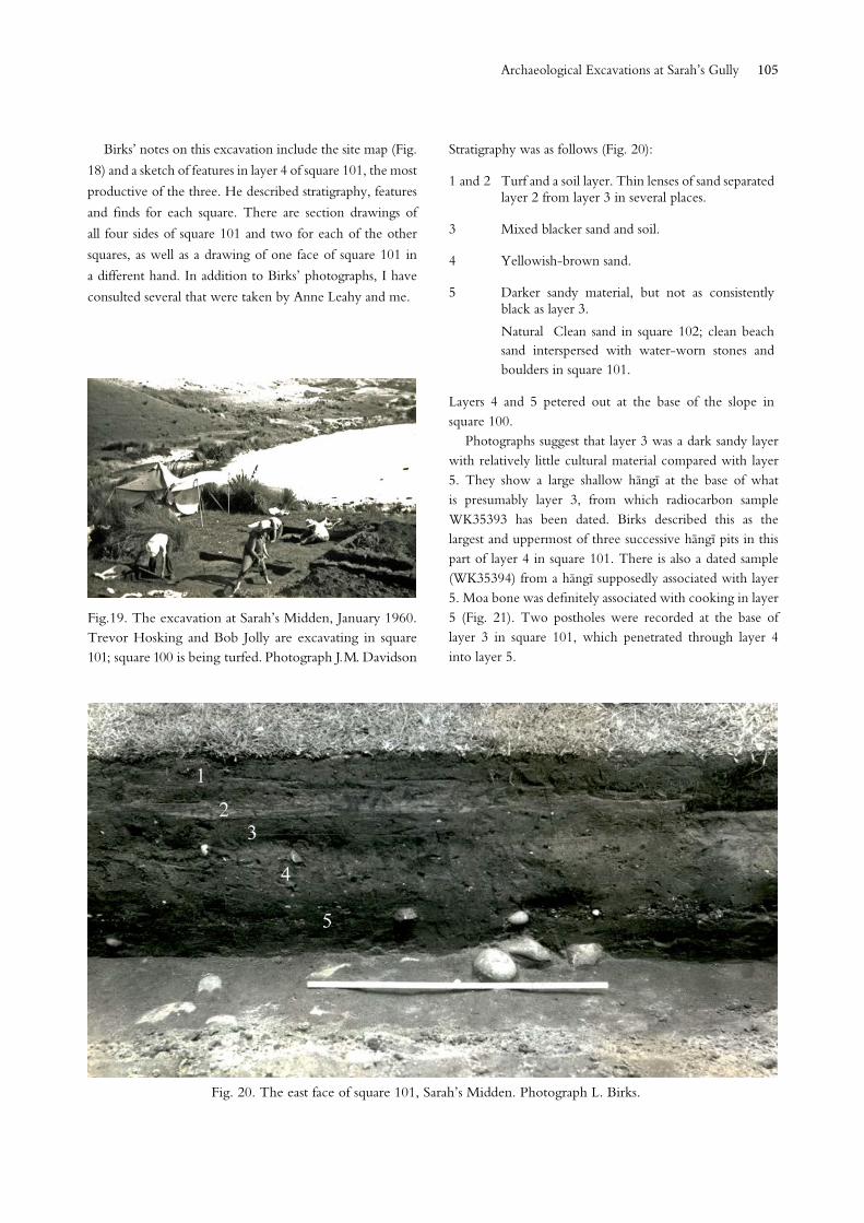
Sarah’s MiddenSarah’s Midden was on a natural terrace on the western side of the northernmost creek, below the headland on which the Pä is situated. Two 6 ft (1.8 m) squares, designated 100 and 101, were excavated over several days in January 1960 (Figs 18 and 19). A third square (102) was fully excavated only to the base of layer 2, with 1 ft (30 cm) square test pits taken down to natural in the four corners. The excavation has been mentioned only minimally in print (Birks 1960: 20; Green 1963a: 67–68).
Fig. 17. Burial 12, from the Opito Beach Midden.
Fig. 18. Birks’ plan of the excavation of Sarah’s Midden.
105
Birks’ notes on this excavation include the site map (Fig.
18) and a sketch of features in layer 4 of square 101, the most
productive of the three. He described stratigraphy, features
and finds for each square. There are section drawings of
all four sides of square 101 and two for each of the other
squares, as well as a drawing of one face of square 101 in
a different hand. In addition to Birks’ photographs, I have
consulted several that were taken by Anne Leahy and me.
Stratigraphy was as follows (Fig. 20):
1 and 2 Turf and a soil layer. Thin lenses of sand separated layer 2 from layer 3 in several places.
3 Mixed blacker sand and soil.
4 Yellowish-brown sand.
5 Darker sandy material, but not as consistently black as layer 3.
Natural Clean sand in square 102; clean beach sand interspersed with water-worn stones and boulders in square 101.
Layers 4 and 5 petered out at the base of the slope in square 100.
Photographs suggest that layer 3 was a dark sandy layer with relatively little cultural material compared with layer 5. They show a large shallow hängï at the base of what is presumably layer 3, from which radiocarbon sample WK35393 has been dated. Birks described this as the largest and uppermost of three successive hängï pits in this part of layer 4 in square 101. There is also a dated sample (WK35394) from a hängï supposedly associated with layer 5. Moa bone was definitely associated with cooking in layer 5 (Fig. 21). Two postholes were recorded at the base of layer 3 in square 101, which penetrated through layer 4 into layer 5.
Fig.19. The excavation at Sarah’s Midden, January 1960. Trevor Hosking and Bob Jolly are excavating in square 101; square 100 is being turfed. Photograph J.M. Davidson
Fig. 20. The east face of square 101, Sarah’s Midden. Photograph L. Birks.
Archaeological Excavations at Sarah’s Gully
Tuhinga, Number 29 (2018)106
Some European material (mostly fragments of iron nails) was found in layer 2 in square 102 and layer 3 in squares 101 and 102. Birks considered that layer 3 was associated with Sarah’s occupation, and suggested that some square-shaped postholes probably represented foundation piles of her house.
The significance of Sarah’s Midden, not recognised at the time, lies mainly in the faunal material (mostly from square 101), discussed below. The artefactual material was relatively sparse, although the presence of two dorsoventrally perforated bone trolling lure shanks is significant.
Fig. 21. Trevor Hosking uncovering part of a moa bone in Layer 5 of Sarah’s Midden. Photograph J.M. Davidson.
Fig. 22. A view of the Pä towards the end of the first season of excavation. Photograph L. Birks.
The Pä
As noted above, excavations on the Pä took place over two seasons. In January 1959, an initial line of squares was laid out through the defensive ditches and down the central part of the site, with a row at right angles sectioning the southeastern scarp. The grid was 12 ft (3.66 m), within which 9 ft (2.74 m) squares were excavated (Golson 1959b: 16–17). Initially, squares 10, 12, 14–18 and 18D–E were opened. The Birks returned in mid-February and carried on by themselves until mid-April (Fig. 22). During the main season in January 1960, they resumed work, and later continued by themselves until they had completed all the areas shown in Fig. 23. According to surviving plans and notes, the total area excavated was 327 m2, excluding some test pits outside the defences.
Documentation includes notes by both Golson and Birks on almost all squares and baulks excavated; notes by Birks on most but not all sections and plans; and numerous black-and-white photographs, most of which have the context noted beside the mounted prints. The excavations were well summarised by Birks (1960).
Although Green’s map (Fig. 23) shows the main axis of the Pä running from north-northeast to south-southwest, Birks in his notes describes the outer ditch as east and the toe of the Pä as west. Green’s orientation is followed here, with the defensive ditches running from west (Birks’ north) to east (Birks’ south).
107
Stratigraphy Throughout the interior of the Pä, there were three main layers:
1 Turf zone (generally less than 5 cm thick).
2 Developed soil zone (varying from 5 cm to 15 cm thick, but up to 30 cm thick on some slopes).
3 Variously described as the weathered or puddled surface of the natural, not always present, and usually less than 8 cm thick except over features.
Birks’ notes summarised the variable subsoil as ‘sand with rhyolite lumps, having the appearance of sandstone, overlying rhyolitic sand, having the appearance of intractable clay. Weathering and human interference had removed the upper component in many areas.’
In a few places, compacted fine sand, apparently derived from natural, sealed some features and was described as layer 4. Other localised layers were identified in some pit fills and in the ditch and bank defences.
Cultural material, widely scattered through layer 2 in particular, included heat-fractured stone from the numerous
hängï; flakes and chips of basalt, chert and obsidian; shell; fish bone; and charcoal. There were some quite large pieces of rock, sometimes wedged in features (Fig. A2.2) and sometimes set in the ground (Fig. 24). There were also concentrations of small smooth pebbles, often described at that time as moa crop stones or gizzard stones. Birks suggested in his notes that a particularly dense concentration associated with hängï stones in layer 3 in square 14A might reflect the cooking of a whole moa on the site.
Fig. 23. The excavation of the Sarah’s Gully Pä. The total area excavated has been superimposed on Green’s original map, which showed only the initial squares excavated in January 1959
Fig. 24. Upright slabs in square 19A of the Pä. Photograph L. Birks.
Archaeological Excavations at Sarah’s Gully
Tuhinga, Number 29 (2018)108
The defencesAs shown on Fig. 23, the visible defences consisted of two discontinuous ditches, which defined the inland edges of the site, and an extensive but discontinuous scarp along much of the eastern (and less steep) flank, with a ditch and low outer bank along its southern part. The bank inside the outer ditch continued across to the northeast end of that ditch, although this was not shown on Green’s map (Fig. 23).
The outer ditch was still present in square 10a. It appeared as if it had taken advantage of a natural dip at this point, as the inner side was slightly higher. A series of test pits (not marked on the plan) found that this ditch and a minimal inner bank continued across the entire width of the headland. The slight ditch appeared to continue down the western slope.
In square 10, the outer ditch was only 20 cm deep in the west face and 46 cm deep in the east (Fig. 25). In the east face of square 10A, its base was 50 cm below the surface and 81 cm below the probable ground surface at the time it was dug, while the top of the bank was a mere 23 cm above that surface.
In square 12a, the base of the inner ditch was 61 cm below its present surface and had probably been dug to 84 cm below the ground surface at the time (Fig. 26). The present top of the bank was 46 cm above the original ground surface; the bank had apparently eroded both back into the ditch and for a considerable distance inwards. The inner ditch clearly terminated at the edge of square 12.
The layers in the banks and ditch fills included layers 2 and 3, and material derived from, and eroding back into, the ditches.
Fig. 25. The outer ditch of the Pä in square 10, looking east.. Photograph L. Birks.
Fig. 26. The east faces of the inner ditch of the Pä in square 12 and the outer ditch in square 10.
The two rectangles in squares 10C and 11C showed only what appeared to be natural slopes. However, the northern end of the ditch along the eastern side of the Pä was found in the southeastern corner of square 13C, well beyond the point at which it was shown on Green’s map. The other end of this eastern ditch was defined in the half square 25B.
The only features suggesting any kind of structure along the defences were a single posthole 30 cm deep in the crest of the bank associated with the outer ditch in square 10A; two very shallow square postholes on the bank in square 10
109
(Fig. 25); two matching, similar square postholes in baulk 10–10a; and two 18 cm-deep postholes in the outer slope of the bank at the end of the inner ditch in baulks 12–12a and 13–13a. Birks (1960: 19) suggested that the square holes on the outer bank perhaps related to an entrance, and represented a structure or structures set on, rather than in, the ground. There were two rows of small, shallow postholes underneath the bank of the inner defence, perhaps representing earlier light fences.
The outer ditch and bank did not constitute a strong defensive feature. Although the inner ditch and bank were more impressive, they extended less than halfway across the width of the Pä. Moreover, the inner ditch and bank were rounded off in such a way as to suggest that there was no intention of continuing them further. It is hard to escape the conclusion that the defences of the Pä were largely symbolic.
Other features
Other structural features included several varieties of pits, assumed to be for storage, hängï scoops and postholes. Many of the postholes contained stones wedged into them, presumably to hold posts in place.
Only two features were found in the area between the inner and outer defensive ditches (Fig. 27): a ‘grave pit’ in the northwest part of square 11 (Fig. A2.6), aligned parallel with the outer ditch and bank; and a rectangular pit lying largely in baulk 11–12A. A single posthole was noted in square 11.
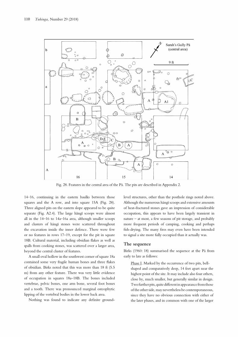
There was much more evidence of occupation inside the inner ditch. The initial line of squares ran down the spine of
the site, a hard, hummocky ridge. Features such as storage and hängï pits were clustered on either side of it, particularly in squares 14–16A to 14a–16a (Fig. 28).
Most of the pits are described in Appendix 2. The majority were relatively shallow rectangular pits, usually with central postholes and sometimes also side postholes. They were not unlike the pits in the inland part of Area D in the Settlement, although none had drains. There were also bell-shaped pits, usually circular in plan with undercut sides. In the baulks between squares 15 and 16, and extending into both squares, were various shallow intercut features, which may have been parts of pits or, as Birks described them in his notes, ‘shelves’ into which oval or bell-shaped pits had been dug.
The numerous hängï were mostly associated with layer 2, although a few were associated with layer 3. No clear posthole patterns could be discerned, with three exceptions, where a circular scoop (presumed to be a hängï pit) was surrounded by a ring of postholes: nine ranging from 8 cm to 19 cm deep around a small scoop in square 16a; six ranging from 15 cm to 29 cm deep around a larger scoop in square 15a, with traces of three others, largely eroded away, in the edge of one side; and six ranging from 6 cm to 10 cm deep around a small scoop in baulk 14–15. Birks (1960: 18–19) speculated that these may represent some form of wind protection near the exposed top of the ridge, noting the absence of similar posthole rings around hängï on the more sheltered landward side of the site.
The main group of features, both pits and hängï, began under the inner defensive bank in square 12a and continued to 16a. To the east, the concentration was mainly in squares
Fig. 27. The area between the ditches of the Pä, with relatively few features. Photograph L. Birks.
Archaeological Excavations at Sarah’s Gully
Tuhinga, Number 29 (2018)110
14–16, continuing in the eastern baulks between those squares and the A row, and into square 15A (Fig. 28). Three aligned pits on the eastern slope appeared to be quite separate (Fig. A2.4). The large hängï scoops were almost all in the 14–16 to 14a–16a area, although smaller scoops and clusters of hängï stones were scattered throughout the excavation inside the inner defence. There were few or no features in rows 17–19, except for the pit in square 18B. Cultural material, including obsidian flakes as well as spalls from cooking stones, was scattered over a larger area, beyond the central cluster of features.
A small oval hollow in the southwest corner of square 18a contained some very fragile human bones and three flakes of obsidian. Birks noted that this was more than 18 ft (5.5 m) from any other feature. There was very little evidence of occupation in squares 18a–18B. The bones included vertebrae, pelvic bones, one arm bone, several foot bones and a tooth. There was pronounced marginal osteophytic lipping of the vertebral bodies in the lower back area.
Nothing was found to indicate any definite ground-
level structures, other than the posthole rings noted above. Although the numerous hängï scoops and extensive amounts of heat-fractured stones gave an impression of considerable occupation, this appears to have been largely transient in nature – at most, a few seasons of pit storage, and probably more frequent periods of camping, cooking and perhaps fish-drying. The many fires may even have been intended to signal a site more fully occupied than it actually was.
The sequenceBirks (1960: 18) summarised the sequence at the Pä from early to late as follows:
Phase I. Marked by the occurrence of two pits, bell- shaped and comparatively deep, 14 feet apart near the highest point of the site. It may include also four others, close by, much smaller, but generally similar in design. Two further pits, quite different in appearance from those of the other side, may nevertheless be contemporaneous, since they have no obvious connection with either of the later phases, and in common with one of the larger
Fig. 28. Features in the central area of the Pä. The pits are described in Appendix 2.
111
pits, one had a layer of brown soil on the floor. Narrow in plan and straight-sided, they had a grave-like appearance, but the fill, clearly artificial, contained nothing except scattered charcoal and the ubiquitous flakes of andesite oven-stone.
Phase II. To this belongs a number of rectangular pits, with two exceptions, shallow in relation to floor area, and having a fairly regular pattern of associated postholds [sic]. Generally there were three or more on the longitudinal axis, and varying numbers up to four along one or both sides. The regular shape of some of these pits has been modified by later extensions.
Phase III. Characterised by haangi pits over a large part of the site, notably on the more level central portion, and by a liberal dispersal of material from these, including stones of local andesite, charcoal, shell, fish bones and flakes of obsidian. The pits in several cases had been dug into the fill of the earlier rectangular structures, but some of the largest had penetrated through the topsoil into the underlying rhyolitic material.
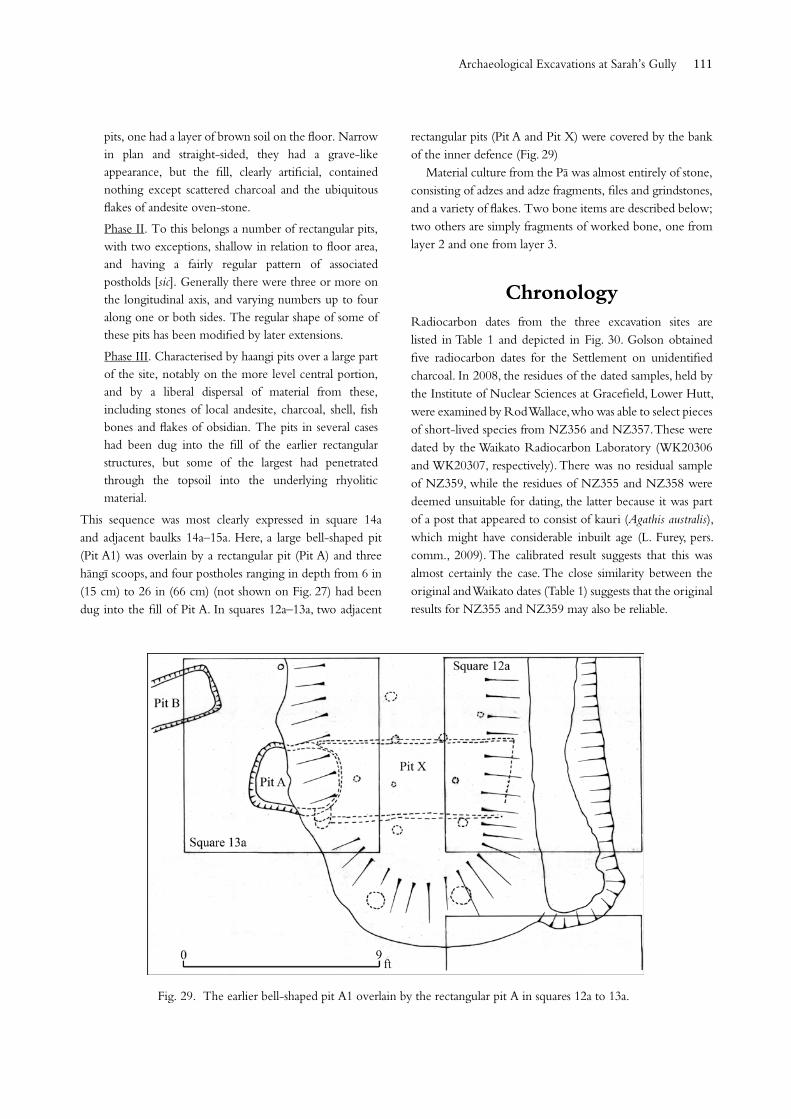
This sequence was most clearly expressed in square 14a and adjacent baulks 14a–15a. Here, a large bell-shaped pit (Pit A1) was overlain by a rectangular pit (Pit A) and three hängï scoops, and four postholes ranging in depth from 6 in (15 cm) to 26 in (66 cm) (not shown on Fig. 27) had been dug into the fill of Pit A. In squares 12a–13a, two adjacent
rectangular pits (Pit A and Pit X) were covered by the bank of the inner defence (Fig. 29)
Material culture from the Pä was almost entirely of stone, consisting of adzes and adze fragments, files and grindstones, and a variety of flakes. Two bone items are described below; two others are simply fragments of worked bone, one from layer 2 and one from layer 3.
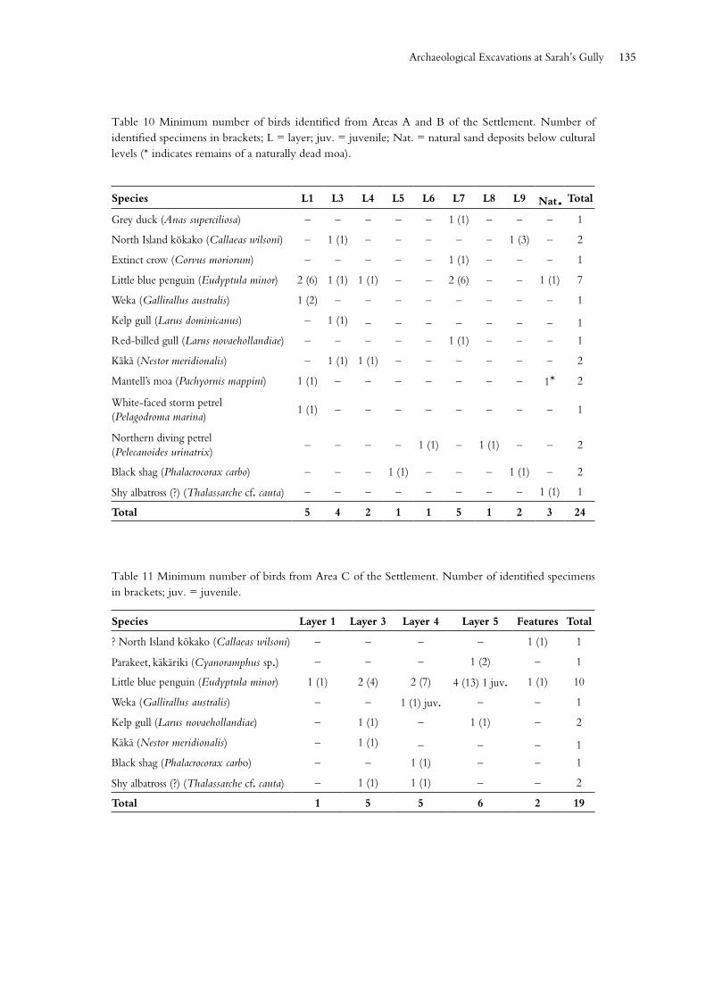
ChronologyRadiocarbon dates from the three excavation sites are listed in Table 1 and depicted in Fig. 30. Golson obtained five radiocarbon dates for the Settlement on unidentified charcoal. In 2008, the residues of the dated samples, held by the Institute of Nuclear Sciences at Gracefield, Lower Hutt, were examined by Rod Wallace, who was able to select pieces of short-lived species from NZ356 and NZ357. These were dated by the Waikato Radiocarbon Laboratory (WK20306 and WK20307, respectively). There was no residual sample of NZ359, while the residues of NZ355 and NZ358 were deemed unsuitable for dating, the latter because it was part of a post that appeared to consist of kauri (Agathis australis), which might have considerable inbuilt age (L. Furey, pers. comm., 2009). The calibrated result suggests that this was almost certainly the case. The close similarity between the original and Waikato dates (Table 1) suggests that the original results for NZ355 and NZ359 may also be reliable.
Fig. 29. The earlier bell-shaped pit A1 overlain by the rectangular pit A in squares 12a to 13a.
Archaeological Excavations at Sarah’s Gully
Tuhinga, Number 29 (2018)112
The samples dated as NZ356 and NZ357 were both described in Golson’s submission as from layer 3, the former associated with fish bone and the latter associated with moa bone. However, it is clear from Golson’s diary that NZ356 was from a fire feature cut into the surface of layer 3, while NZ357 was from the large oven in the surface of layer 4.
The two samples from Sarah’s Midden were labelled as being from a hängï in layer 3 and a hängï in layer 5, dug into the underlying natural sand. This supposedly layer 5 date is anomalous, in view of the fauna in layer 5. Trevor Worthy (pers. comm., n.d.) considers the layer 5 deposit in Sarah’s Midden to be probably the earliest excavated deposit at Sarah’s Gully. The dated sample may therefore have been wrongly labelled and actually be from one of several successive hängï dug into layer 4.
Birks obtained five dates for the Pä. As part of the project of redating ‘early’ dates from Sarah’s Gully, the residue of NZ1080 was examined by Wallace but was found to have no suitable material for further dating. The charcoal dates have been recalculated since the original determinations were published, while the shell dates are the conventional radiocarbon ages (CRAs) before adjustment for the marine effect. In Fig. 30, these two dates have been calibrated using Marine 13 with Delta-R set at 0 (C. Prior, pers. comm., 6 July 2015).
Lab no. Context CRA
Sarah’s Gully Settlement, T10/167
NZ355 Area D, square F7, layer 4 656 ± 40
NZ356
WK23206
Area A, square G9, hängï in surface of layer 3
216 ± 39189 ± 30
NZ357
WK23207
Area B, squares G15 and G16, hängï in surface of layer 4
702 ± 40703 ± 34
NZ358 Area A, posthole D, layer 8 873 ± 40
NZ359 Area A, square H11, layer 9 650 ± 50
Sarah’s Midden, T10/171
WK35393 Layer 3 hängï 285 ± 31
WK35394 Layer 5 hängï 369 ± 37
Sarah’s Gully Pä, T10/168
NZ1080 Charcoal from pit, phase 1 703 ± 46
NZ1081 Charcoal from pit, phase 2 388 ± 49
NZ1082 Charcoal from defensive bank material 335 ± 48
NZ698 Shell from pit fill, phase 3 260 ± 51
NZ699 Shell from pit fill, phase 3 292 ± 41
Table 1 Radiocarbon dates from the three Sarah’s Gully sites (CRA = conventional radiocarbon age).
Fig. 30. Calibrated radiocarbon dates from the three Sarah’s Gully sites.
113
The dates place occupation of layer 4 of Area D and layers 4–9 of Area AB of the Settlement broadly between ad 1280 and 1400, as would be expected from the associated faunal and material items. These deposits can be grouped together as representing an early phase of occupation at Sarah’s Gully. The age of the earliest deposit at Sarah’s Midden is unclear.
Unfortunately, the early date from the Pä could not be verified on identified short-lived plant species. It falls in the same time bracket as the early occupations at the Settlement, and it is quite possible that people in the area at that time would have constructed a storage pit on the headland, particularly given the likelihood that at least some of the pits in the inland part of Area D of the Settlement were thought to have been contemporary with the early beachfront occupations.
The remaining dates can tentatively be divided into middle (Pä Phase II) and late (Pä Phase III, Area AB, layer 3). As the only indication of European influence (apart from the material in upper layers at Sarah’s Midden) is a single clay pipe stem from Area AB, it seems unlikely that any of the deposits at the Settlement or the Pä is later than about ad 1800.
Sewell (1988: 8) obtained three radiocarbon dates for the Cross Creek site, just across the creek from Area D. The sequence there has more recently been modelled using the original dates for cultural layers 3A, 5 and 7, and four additional dates for layer 9 (Furey et al. 2008). The Kaharoa ash, an important geochronological marker that has been dated to ad 1314 ±12 (Hogg et al. 2003), separates layers 7 and 9. Unfortunately, the Kaharoa ash was not identified at any of the other Sarah’s Gully sites. However, both layers 7 and 9 at Cross Creek fall within the time range of the early-phase deposits from the Settlement and, at least potentially, at the Pä. The date range for the next cultural layer at Cross Creek, layer 5, has a slight overlap with the early-phase dates at the Settlement, but contained shell fishhooks, none of which were found at the Settlement, and probably corresponds more closely with the middle-phase occupations at the other sites.
The two sites at nearby Opito excavated as part of Golson’s research programme also date at least partly to the early phase. The Opito Beach Midden has a CRA of 689 ±40 cal. bp (calibrated age at 2σ ad 1287–1395), while the date obtained for the earliest occupation at Skipper’s Ridge was reported as NZ1740: 780 +60/ō50 (Davidson 1974). This result has been recalculated as 814 ±70 bp (University of Waikato n.d). This sample, from the base of a large storage pit, was identified as short-lived charcoal (Panax sp.), possibly part of a post or roof beam. As it falls outside the
currently accepted date of human settlement, and other early dates from the region, in-built age might be suspected.
Subsequent investigations of sites at Opito include Bellwood’s (1969) excavation further up Skipper’s Ridge, which gave two late dates, and the recent excavations on a very large ridge site at the north end of the bay, which revealed evidence of food storage, cooking and at least one substantial house at various times in the late fourteenth, sixteenth, seventeenth to eighteenth, and eighteenth centuries (Bickler et al. 2014: 169). As was the case at Area D inland at Sarah’s Gully, this ridge site produced relatively little in the way of faunal or artefactual material.
Taken together, the radiocarbon dates from Sarah’s Gully and Opito cover the entire sequence of pre-European occupation in New Zealand.
Material cultureThe excavations at Sarah’s Gully did not produce the range of material culture Golson had hoped for to assist his definition of the North Island Archaic. The principal items recovered from the Settlement were fishhooks and items associated with their manufacture, stone adzes (largely broken and/or partly reworked preforms) and a range of other stone items – mostly flakes, of obsidian, chert and basalt. Even so, most of these objects are not incompatible with material from ‘early’ sites. No artefacts were found with the burials. The material culture from the lowest layer of Sarah’s Midden is even more limited.
A few items from the upper layers of Sarah’s Midden, the Pä, and Area AB of the Settlement suggest later pre-European visits to Whaorei Bay.
Personal ornamentsThe small number of ornaments and worked bone (other than that relating to fishhook manufacture) at the Settlement was disappointing. Of particular interest was ‘the poor man’s rei puta’ (Fig. 31E), a pendant of Päua shell (Haliotis sp.), which has previously been described in some detail (Davidson 1986). This came from the lowest cultural layer in Area AB: layer 9 in square H11. From the same context are a tiny bone needle, broken at the perforation (Fig. 31A); 24 units of Dentalium nanum; and a single bird-bone bead. The apparent association of the pendant with Dentalium units suggests that it might have been the central part of a necklace. The only other definite item of adornment found in Area AB is a broken worked tooth of a dog or seal (Fig.
Archaeological Excavations at Sarah’s Gully
Tuhinga, Number 29 (2018)114
31B), from layer 1. Probable parts of ornaments are a carefully cut, but unperforated, piece of a small sea mammal tooth (24 x 12 mm) from the surface, and a rectangular shell tab (29 x 12 mm) from layer 6 (Fig. 31F). The latter is clearly broken at one end and would have been longer.
The only personal ornament from Area C (from layer 5) is a broken bone pendant, apparently made from part of a large, one-piece bone fishhook (Fig. 31D).
The beachfront section of Area D produced two bird-bone beads and a cut section of bird bone, possibly relating to their manufacture, from layer 4 (Fig. 31C). Dentalium shell units are mentioned by Golson (1959a: 14), but are no longer present in the assemblage.
A broken snapper tilly bone, perforated for suspension, from layer 2 of square 101 at Sarah’s Midden, is the only ornament from that site. No items of adornment were found at the Pä.
Fig. 31. Ornaments from Sarah’s Gully Settlement. A bone needle; B worked dog or seal tooth; C bone tubes and worked bone; D broken bone pendant; E shell pendant; F Shell tab.
Fig.32. (below) Fishing gear from Area AB. A layer 0; C–G layer 2; B, H layer 3; K layer 6; L, M layer 7; N layer 8; I, J layer 9.
Fishing gear
Parts of bone fishhooks and items relating to their manufacture were found in Areas AB, C and the coastal part of Area D of the Settlement, along with a single example from layer 3 in the baulk between squares 2 and 3, just inland from the latter. Nearly all are parts or preforms of one-piece bone bait hooks. No stone sinkers were identified.
Examples of one-piece hooks from each area, along with tabs relating to their manufacture, are shown in Figs 32–34. All are simple hooks, most with incurved points. Some have bait notches on the point leg, and one a notch on the base. Head forms are more varied in what was presumably a single, brief occupation layer in Area D; hooks from Area AB and Area C have only one of the head forms represented in Area D. The distribution of these items is shown in Table 2.
115
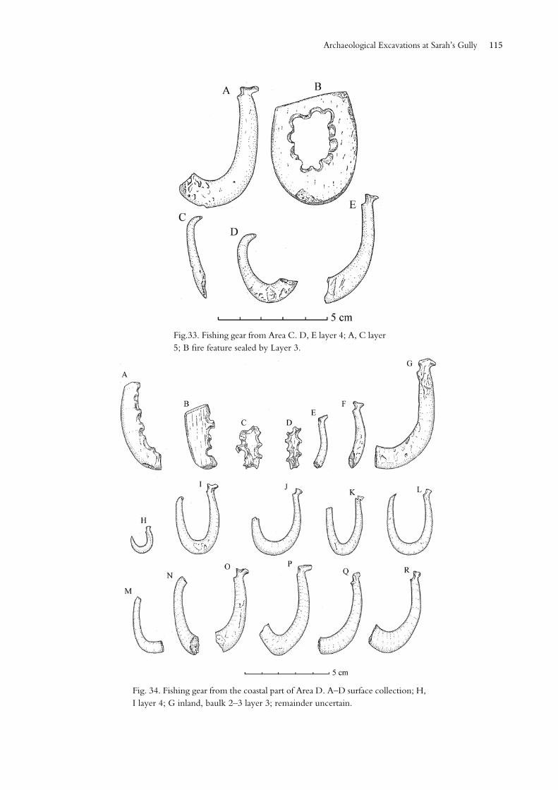
Fig.33. Fishing gear from Area C. D, E layer 4; A, C layer 5; B fire feature sealed by Layer 3.
Fig. 34. Fishing gear from the coastal part of Area D. A–D surface collection; H, I layer 4; G inland, baulk 2–3 layer 3; remainder uncertain.
Archaeological Excavations at Sarah’s Gully
Tuhinga, Number 29 (2018)116
A different, later style is represented by the point of a two-piece fishhook (Fig. 32A) from the surface of Area AB. It is worth emphasising, however, that the typical ‘early’ one-piece bone hook is present in almost all contexts in the Settlement.
In striking contrast, the only one-piece fishhook at Sarah’s Midden is a small point-leg fragment with bait notch from layer 2 of square 102, presumably displaced from its original context. There is no evidence of hook manufacture apart from a fragment of a stone file from layer 5, which could have been used for purposes other than making fishhooks. A different kind of hook is suggested by a small, square-sectioned copper nail, the lower third bent at a right angle to the rest of the nail, from layer 3 in square 102. A small, flattish oval pebble, slightly notched at each end, from layer 4 of square 101 appears to be a sinker, perhaps for a small baited hook, or for a net.
Trolling is indicated at the Settlement by what is presumably a broken uniperforate lure point from layer 9 in Area A (Fig. 32J), and an unbarbed, unperforated point from the main cultural layer (4) in Area D (Golson 1959a: 14), which is no longer present in the collection.
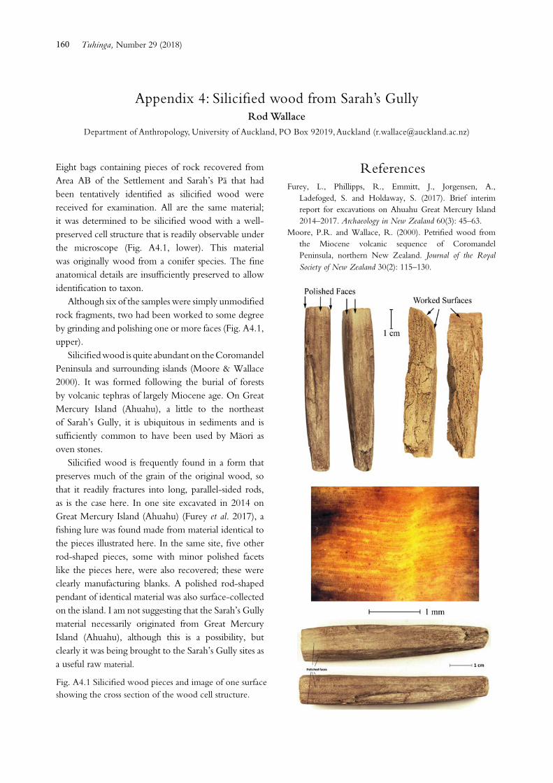
A complete bone trolling lure shank and part of a similar item were found in the lowest cultural layer of Sarah’s Midden. Both are flat and oval-sectioned with dorsoventral perforation. The complete example has disappeared and is recorded only in a photograph (Fig. 35A); the fragment is a snapped-off proximal end, also broken at the perforation (Fig. 35B). The complete example had side notches to secure the point lashing. A worked piece of silicified wood from the surface of Area AB is probably a blank for a trolling lure shank (Appendix 4 and Fig. A4.1). A similar but only slightly worked piece came from layer 2 in the Pä.
Only three items of fishing gear were found at the Pä: two stone sinkers from layer 2 in squares 16 and 16b, and part of a barbed point of mammal bone in an apparently deliberately filled posthole in a small rectangular pit in the same area as the sinkers. The base of the point is broken off, so the nature of attachment to the shank is not known (Fig. 36A). One of the sinkers weighs 134 g (Fig. 36C). The other is largely unmodified, but has faint traces of working around its edges. It weighs 76 g and is of a size and shape suitable for enclosing in the edge of a net (Fig. 36B).
Fig. 35. Bone lure shanks from Sarah’s Flat. A probably from layer 5 (from a photograph by Anne Leahy); B layer 5.
Area Layer Hook or hook part
Tab or unfinished
Drill point
File
AB Surface and 1 9 2 3 –
2 6 6 1 2
3 2 6 2 1
4 1 – 1 –
5 – – 1 –
6 1 2 1 2
7 2 – – 1
8 3 – 1 –
9 2 – – –
Subtotal 26 16 10 6
Area C 3 – – 2 1
4 2 1 – –
5 3 – – –
Subtotal 5 1 2 1
Area D Surface 3 4 1 2
Localised,no layer
9 – – –
4 5 – – –
Inland – – – 3
Subtotal 17 4 1 5
Total 48 21 13 13
Table 2 Distribution of fishhooks and related items at Sarah’s Gully Settlement.
117
Fig. 36. Fishing gear from the Pä.
Fig. 37. Broken pieces of large well-finished adzes from Area D, layer 4.
Adzes and adze workingMost of the stone adze blades and adze-related material from the Sarah’s Gully sites can only be described as small and scruffy. However, a few fragments show that the occupants of the Settlement, at least, had access to large, well-finished tools, which were not left behind when the people moved on. This is best illustrated by the butt of a very large, well-polished hog-back blade, of which four joining pieces were found in adjacent squares of layer 4, Area D, along with a single mid-section of a well-polished quadrangular-sectioned adze in a darker stone (Fig. 37). How or why these beautiful tools
were broken is not known, but ritual shattering cannot be ruled out. There are also a number of chips, some quite large, with a high degree of polish, from the deposits in all three areas. One of these, from an uncertain context in Area D, is almost certainly from an adze made from the black-veined, light grey metasomatised argillite best known at Ohana on D’Urville Island, but also found in other places in the Nelson mineral belt. A piece from square F8, layer 2, in Area AB has also been identified by P.R. Moore (pers. comm., 1 June 2016) as ‘dark grey meta-argillite: Nelson–Marlborough’.
The other items from the coastal part of the Settlement are mostly broken, unfinished preforms of small to medium size, although there is one butt from a large preform. Most of these are illustrated in Figs 38–40. The exceptions are a small, partly reworked piece from layer 7 in Area AB; a scrappy quadrangular fragment from layer 5 in Area C; and a quadrangular-sectioned butt and a rough preform from layer 4 in Area D. Chips from finished adzes were found in all layers except layer 6 in Area AB, and layers 2 and 3 in Area D. The latter absence may well be due to poor retention strategy. It seems that people were using and reworking existing adzes as well as working small to medium preforms, at least, at all stages of occupation. It is notable that only one small rough adze was found in Area C (Fig. 39A), although a concentration of basalt waste in layer 2 suggests adze working in that area. Again, the small number from Area D may reflect collection strategy.
Archaeological Excavations at Sarah’s Gully
Tuhinga, Number 29 (2018)118
Fig. 38. Adze preforms and fragments from Area AB. A–C layer 1; D–E layer 2; F layer 4; G–H layer 6; I layer 7; J–K layer 9.
Fig. 39. Adzes and performs from Areas C and D. A Area C layer 4; B–D Area D just inland from the coastal excavation. B layer 3; C–D layer 2.
Fig. 40. Adze and performs from Area D Inland. A upper terrace Layer A; B–E lowest terrace layer 3.
119
Adzes and other stone tools were also found in the inland parts of Area D. Three items found just inland from the beachfront excavation on the terrace beside the stream are illustrated in Fig. 39 (B–D). One from further inland on the bottom terrace, and one from the uppermost flat, beside Feature 37, are shown in Fig. 40. Also from this part of the site were found bevel ends of a quadrangular-sectioned adze and one with a triangular section that appears to have been intended as a reversed-triangular adze (Duff type 3) (Duff 1956: 171, fig. 38). Both are poorly made. These adzes from the inland part of the settlement are indistinguishable from those from the beachfront deposits.
Six of the seven broken preforms from Sarah’s Midden are illustrated in Fig. 41. Two were clearly intended to be
small hog-backs, while the other two could be either hog-backs or reversed-triangular adzes. All would have been medium or small tools when finished.
Most of the adzes and preforms from the Pä are illustrated in Fig. 42. The only complete adze – a substantial blade of irregular shape and rounded cross section – has a well-sharpened, double-bevelled cutting edge (Fig. 42A). Other items include the butt of what was probably a very small hog-back adze (Fig. 42E), and three fragments of what were probably triangular-sectioned preforms (Fig. 42D and F) Two of these (one not illustrated) were from under the defensive bank in square 13A. Some chips from finished adzes were found: six from layer 2, three from layer 3 and two from pit fills.
Fig. 41. Adze fragments and preforms from Sarah’s Flat. All from layer 5 except C, which is from layer 3.
Fig. 42. Adzes and adze fragments from the Pä. A pit fill; B, D–F, J–L layer 2; C posthole fill; G–I layer 3.
Archaeological Excavations at Sarah’s Gully
Tuhinga, Number 29 (2018)120
Adze manufacture and repair was evidently an ongoing task. The distribution of basalt flakes and chips in the sites is shown in Table 3. There were notable concentrations in several places, including layer 7 in Area AB, layer 3 in Area C and layer 4 in Area D. These concentrations included some very large flakes, some with cortex. These suggest that larger preforms may have been manufactured at these locations than the discards actually recovered suggest.
Although most of the basalt appears to be waste, there are several blade-like pieces that may be tools in their own right, and at least one possible awl or drill tip.
There is no evidence of chronological change in the adze material from the three excavations. It seems that basalt from the nearby source at Tahanga hill continued to be
worked by similar techniques into similar forms throughout the occupation sequence. Golson’s comment about the sequence at Pig Bay on Motutapu Island – ‘the remarkable thing is that the material is Archaic throughout’ (1959a: 46) – could also be made about the adze material from Sarah’s Gully.
Included in the material from Golson’s excavations at Sarah’s Gully, but undocumented, is an unfinished and unusually small example of a ‘side-hafted’ adze (Duff’s type V) (Duff 1956: 191, fig. 48), apparently fashioned from a larger adze, as a partly ground surface is more compatible with a finished adze than with the preform as it exists now (Fig. 43). It could be a surface find from anywhere in the vicinity, but is important in adding to the known distribution of this rare style.
Site and layer No. Weight (g)
Settlement
Area AB, 0–3 615 4308
Area AB, 4–10 532 3092
Total 1147 7400
Area C, 3–3A 105 1803
Area C, 4 16 315
Area C, 5 8 114
Total 129 2232Area D, surface and 2
121 2192
Area D, 3+ 2 301
Area D, 4 102 1984
Total 225 4477
Sarah’s Midden
2 3 36
3 6 175
4 20 221
5 6 157
Total 35 589
Sarah’s Pä
2 73 1795
3 15 293
Features 6 166
Total 94 2274
Table 3 Distribution of basalt flakes at the Sarah’s Gully sites.
Fig. 43. Small preform, apparently of a side-hafted adze, reworked from a larger tool. Context unknown.
121
Drill points The majority of items from the Settlement identified as drill points came from Area AB. Their distribution is reasonably consistent with that of drilled tabs from fishhook manufacture (Table 2), although there may have been many more drills and tabs from Area D that were not included in the official collection from that area. Three broken drill points are from layer 8 of Area AB, and layers 2 and 4 of Area D. A less certain example is from layer 3 of Area AB.
With one exception, the points are made from siliceous stone in a wide range of colours, from white to grey, brown and dark red. Most are illustrated in Fig. 44. The exception is a basalt point, now broken, from Area AB, which is the only item in the group not definitely a drill tip.
No drill points were found at Sarah’s Midden or the Pä, which is consistent with the lack of evidence of fishhook manufacture in those sites.
Abrading toolsNo large grinding stones or pieces were found in the Settlement. A broken rectangular stone of fine-grained rock, which had clearly been used as a smoothing stone, is from layer 1 in square 5A on the lowest terrace of the inland part of Area D. It is very regular in shape, 57 cm wide and 38 cm thick, with a gently rounded end and edges. The existing length is 10 cm. It is similar in size and proportions to a stone found on the Pä, but that has no evidence of smoothing (see below). Three burnt pieces of possible grindstones came from squares 11f and 12n in the upper part of Area D inland. A piece of pumice shaped like a sandstone file and possibly used as an abrader was found in layer 5 of Area C.
Sandstone files were scattered throughout the Settlement deposits, but were not numerous. Most appear to be broken, which is probably why they were discarded. Their distribution in the beachfront areas is shown in Table 2; some are illustrated in Fig. 45 (F–I). There were also three from the inland part of Area D: squares 2–3, layer 3; squares 6–7, layer 1; and an uncertain context further up. These last were not associated with fishhook manufacture.
The only abrading tools from Sarah’s Midden are a small file, tapering at one end (Fig. 45J); a piece of pumice with one flat face bearing signs of use as a smoothing tool (both from square 101, layer 5); and a tiny fragment of a grindstone from square 101, layer 3.
Fig. 44. Stone drill points from Area AB of the Settlement. D, G, J Layer 1; I Layer 2; A, C, E Layer 3; H Layer 5; B; Layer 6; F Layer 8.
Fig. 45: Stone files from the three sites. A–E the Pä: A layer 1; B–D layer 2; E layer 3. F–I the Settlement: F Area D layer 3; G Area D layer 2; H Area AB layer 6; I Area AB layer 7; J Sarah’s Flat layer 5.
Archaeological Excavations at Sarah’s Gully
Tuhinga, Number 29 (2018)122
The Pä yielded part of a grindstone and several files. The former was found in the fill of a pit; it weighs 1.5 kg and has two dished surfaces. Several files are illustrated (Fig. 45A–E). Two other probable abraders – two matching pieces of an oval-sectioned piece of sandstone with little or no sign of use, and a broken central section of a larger piece – were found together in a context not properly documented. Another part of a probable file came from layer 2 in square 17a. A now broken pumice pebble measuring 62 mm long, from layer 2, has clear signs of abrasion in the form of a shallow groove in one surface. An unusual stone with several grooves suggesting use as an abrader (from square 17a, layer 2) was identified as grey perlite (perlitic rhyolite). This material is not known on the Coromandel Peninsula north of Whitianga, although it may occur on Great Mercury (Ahuahu) and Ohinau Islands and is common on Great Barrier Island (Aotea Island) (P.R. Moore, pers. comm., 1 June 2016).
Hammer stonesOnly one definite hammer stone was found, despite the numbers of basalt flakes and broken preforms. This is a heavy spherical object with extensive pitting on one flattened surface. It came from square 3, layer 4, in Area D, just inland from the coastal excavation. A pebble suitable for fine knapping came from layer 3 in Area C of the Settlement. Some other apparently unworked pebbles may also have been brought to the sites for use as hammers. This general absence of hammer stones was also noted at Golson’s Pig Bay site, where adze manufacture was a major activity (Davidson & Leach 2017: 30).
Other worked stoneIn addition to Tahanga basalt, the people at Sarah’s Gully collected obsidian and a variety of other types of rock for fashioning usable hand tools from small pieces. Items of obsidian and what was described at the time of excavation as chert were abundant in the excavations, although distributed somewhat differently. Eight hundred and twenty-one pieces of obsidian were recovered, of which 683 were from the excavations and the remainder from the large surface collection in Area D coastal. The chert assemblage consists of 402 items, only 11 of which are from the Area D surface collection. There is more chert from all layers in Area AB and layer 4 in Area D, similar amounts of chert and obsidian from Area C and Sarah’s Midden, and far more obsidian than chert from the Pä.
The sources of the obsidian have not been established. Sarah’s Gully is close to a number of known sources and it is likely that the people who periodically occupied the various sites had access to most or all of them. It would, however, be very useful to determine whether they were also obtaining obsidian from more distant sources in Northland and Taupo. The obsidian is all of high quality, without spherulites.
The chert has also been described as sinter or siliceous sinter. This term was introduced to the archaeological literature by Best (1975) and Best and Merchant (1976), who suggested that drill points found at the early archaeological site of Houhora in the far north of the North Island were made of sinter from the Coromandel Peninsula. The Kuaotunu Peninsula is home to an extensive area of siliceous sinter (Hamilton et al. 2016). Newton studied what he called Waitaia sinter, and provided a detailed map of its distribution and variety (Newton 2000: 3). This shows its ready accessibility on the headland and foreshore at the western headland of Otama Beach. It is likely that all the Sarah’s Gully chert is local.
The most common material in the collection is a fine-grained, light brown chert, which produces high-quality conchoidal fracture. This must be abundant in the vicinity because the flakes and cores in the assemblage are larger than those of the other types of material. There is also quite a lot of a fine-grained, very dark to black chert with good-quality conchoidal fracture. A large core of the light brown chert shows a gradation to this very dark grey material; they are clearly the same.
The second-most abundant material is chalcedony of various types, some pieces of which are also quite large. Most are translucent, and some are transparent and glass-like. They are of various shades, including light pink. Next most abundant is a course-grained chert of various colours. Some bright red flakes are probably jasper. Finally, there is quite a lot of quartz in the collection.
Mass distribution
All pieces of obsidian and chert were inspected and weighed individually to the nearest milligram to obtain an idea of the general size of the pieces being used and discarded.
In any collection of flake debitage, a strong preponderance of small flakes and a decreasing number of larger specimens would be expected. Consequently, normal size-frequency diagrams are so heavily skewed to the left that comparison between assemblages is difficult. One common way to observe any central tendency in choice of size is to use a
123
logarithmic scale. This approach is taken here. To illustrate the point, the two types of distribution curve are shown in Fig. 46.
In the lower graph, the raw data are used. The right-hand tail actually extends out to 68.51 g, but is here truncated at 15 g, otherwise no structure would be observable. In the upper graph, the raw data have been log-transformed, using milligrams rather than grams to avoid negative values. This clearly shows a central tendency, depicting human selectivity by size. The excavated sample of 683 pieces ranged in size from 78 mg to 68.51 g, and weighed a total of 2.646 kg. The arithmetic mean size is 3.87 g.
Fortunately, a large body of data is available with which the Sarah’s Gully collection can be compared. Seelenfreund-Hirsch (1985) studied collections from numerous archaeological sites around New Zealand, totalling 14,355 pieces, and documented flake mass and maximum dimension.
Fig. 46. The Sarah's Gully obsidian showing the two methods of depicting the size frequency distribution.
A suitable nearby assemblage for comparison in Seelenfreund-Hirsch’s study is that from the Kauri Point Swamp on the coast of the Tauranga Harbour (Table 4). The log-transformed mass data are shown in Fig. 47. There are several notable features in this comparison. The surface-collected specimens from Sarah’s Gully show a greater preponderance of larger pieces than the excavated material. This is not surprising, as very small items are often ignored in surface collecting. The Kauri Point collection has far more very small flakes than the excavated collection from Sarah’s Gully, which may reflect a similar tendency not to retain the smallest excavated specimens from Sarah’s Gully. Although some sieves were used in the excavation, the extent of such use is not known.
The analysis of chert mass is summarised in Table 5. As with the obsidian, a normal size-frequency distribution would show very little, so the data were log-transformed (Fig. 48). It is not surprising that the chert being used was, on the whole, larger than the obsidian.
Archaeological Excavations at Sarah’s Gully
Tuhinga, Number 29 (2018)124
Obsidian use-wear patterns
Each obsidian item from the excavations at Sarah’s Gully was examined with oblique light using a Kyowa SDZ stereo binocular microscope with 10× eyepiece, 0.5 lens with 0.7–4.5 zoom and a MEM 1300 digital USB microscope camera. Additional photographs were taken with a Canon EOS 6D camera with Macro lens and one barrel extension.
Of the 683 excavated pieces examined, a surprisingly large number showed evidence of use-wear, almost all of which was micro-flaking along one or more edges. Since multiple items were originally stored in single plastic bags, some use-wear can be attributed to post-excavation damage. To prevent this happening in future, all items were rebagged in individual plastic bags and given unique catalogue numbers. Because of the possibility of post-excavation wear and tear, only items that showed the most certain pre-European use-wear were selected for description. This amounted to 147 pieces, or about 22% of the collection (the real percentage is probably somewhat higher than this figure).
Although any one piece of obsidian may have several edges that might be utilised as tools, by far the most common form of use-wear was seen on only one edge. An edge used in a sawing action (knife) produces scratches that are parallel to the edge, while a scraping action produces micro-flakes along the edge. If the scraping action is in only one direction, then the micro-flakes occur only on the side opposite the direction of the scraping. If a scraper is used back and forth, then micro-flakes form on both sides of the edge.
Kauri Point
Swamp
Sarah’s Gully
excavations
Settlement, Area D, surface
No. 5733 683 124
Total weight (kg) 21.951 2.646 0.698
Lightest (g) 0.020 0.078 0.327
Heaviest (g) 135.240 68.51 40.5
Mean weight (g) 3.829 3.87 5.63
Fig. 47: Comparison of the Sarah's Gully obsidian with the Kauri Point Swamp assemblage and the surface collection from Sarah's Gully, using log-transformed mass.
Table 4 Kauri Point Swamp and Sarah’s Gully obsidian dispersion statistics.
125
Normal data Log-transformed data
No. 402 –
Lightest 129.000 mg 4.860 ln(mg)
Heaviest 947,000.000 mg 13.761 ln(mg)
Total weight 5,681,022.000 mg –
Mean weight 14,131.896 mg –
Table 5 Mass analysis of chert.
Fig. 48. The Sarah's Gully chert size-frequency distribution, using log-transferred mass.
Consequently, such use-wear patterns allow a simple classification of tool types: knife and scraper. Scrapers can be classified as unidirectional or bidirectional. In addition, the shape of the edge can be used to subdivide scrapers as straight, concave (spokeshave) or convex (nose scraper). A special form of scraper is one that shows evidence of rotational use (awl), and the micro-flaking can easily determine whether one was rotated clockwise, anticlockwise or in both directions.
Finally, a few obsidian pieces had evidence of use on several edges; these are classified as multi-purpose tools. The distribution of these various kinds of tools is shown in Table 6.
By far the commonest form of tool was a straight unidirectional scraper (56%). Some typical examples of the tools found in the collection are described below.
Tool The Settlement Sarah’s
PäāSarah’s Midden Total
Area AB Area C Area D
A 18 6 7
B 2 1 2 8 – 13
C 4 2 2 1 – 9
D – – – 1 – 1
E 2 – – 10 1 13
F 2 – – – – 2
G – – – 5 – 5
H 1 – – 2 – 3
I 2 – 14 2 18
Total 31 9 11 85 11 147
Table 6 Distribution of obsidian tools in the Sarah’s Gully sites. Tool types: A, straight unidirectional scraper; B, straight bidirectional scraper; C, concave unidirectional scraper/spokeshave; D, concave bidirectional scraper/spokeshave; E, convex unidirectional scraper (nose scraper); F, convex bidirectional scraper (nose scraper); G, awl; H, knife edge; I, multi-purpose tool.
Archaeological Excavations at Sarah’s Gully
Tuhinga, Number 29 (2018)126
Awl-shaped tools Three awl-shaped objects from the Pä are illustrated in Fig. 49. Each has a triangular cross section, and each has been used in a distinctly different manner. SG758 has unidirectional micro-flaking in opposite directions on each side, indicating rotational use in only one direction, clockwise. This qualifies as an awl. SG731, on the other hand, has micro-flaking in only one direction on both edges and cannot have been used in a rotational action. Instead, this object must have been used as a unidirectional scraper to make a trough. There is a third unidirectional scraper edge on this object. SG479 has clear bidirectional micro-flaking on all three edges, indicating its use as an awl by rotating in both directions.
Concave scrapers/spokeshaves Two concave scrapers/spokeshaves from the Settlement appear in Fig. 50. In both cases, the micro-flaking is unidirectional. Note the heavy striations on SG134. These are natural ripples in the glass surface that sometimes appear during conchoidal fracture and might easily be misinterpreted as use-wear.
Fig. 50: Concave scrapers/spoke-shaves from the Settlement. SG6: Area AB layer 1, SG134: Area D coastal layer 3+
Fig. 51: Knife from Sarah's Pä, layer 3.
Knives Only three items found could reliably be identified as having been used as knives. One from Sarah’s Pä is illustrated in Fig. 51. It has minute scratches, horizontal to the cutting edge, and some micro-flaking along 32 mm of the edge. In the enlargement, the scratches are easily visible.
127
Straight-edged unidirectional scrapers Five of the 83 scrapers in this category are illustrated in Fig. 52. Although, strictly speaking, the edges of these are not always straight, those that are concave or convex are much more obviously chosen by the stone workers because of their non-straight-shaped edge. The five scrapers are: SG3, 14 mm wide, slight concavity; SG37, 21 mm long, slightly convex edge; SG132, 29 mm; SG386, very heavy flake damage along 24 mm; SG429, micro-flaking along 48 mm of slightly convex edge.
Fig. 52: Straight-edged uni-directional scrapers. SG3: Area AB layer 1; SG37: Area AB layer 3; SG132: Area D coastal layer 3+; SG386: Sarah's Pä layer 1; SG429: Sarah's Pä layer 2.
Fig. 53: Straight-edged bi-directional scraper (right hand vertical edge). Area C: layer 5.
Straight-edged bidirectional scrapers One of these scrapers, from Area C of the Settlement, is illustrated in Fig. 53. It is a small block of obsidian. The vertical right-hand edge in the image has bidirectional use-wear flaking along 22 mm. The upper horizontal edge in the image shows considerable attempts to remove small flakes. This is not use-wear.
Archaeological Excavations at Sarah’s Gully
Tuhinga, Number 29 (2018)128
Convex unidirectional scrapers (nose scrapers) Ten of these tools were identified. An example from Sarah’s Pä is illustrated in Fig. 54. The use-wear extends 31 mm along each side of the ‘nose’. Although this item has an awl shape, the term awl is normally reserved for a tool that is used for drilling holes, in which case the micro-flake use-wear is either on alternate edges (rotating in one direction), or on both edges (rotating back and forth in both directions). An awl-shaped tool that has micro-flake use-wear on both edges in the same direction must have been used as a scraper, presumably to make a trough-shaped depression in some object. A similar function is interpreted for SG731 in Fig. 49.
Multi-purpose tools Only about 12% of the tools identified from use-wear had more than one function, in the sense that more than one area of the object displayed signs of use. Two of these, both from Sarah’s Pä, are illustrated in Fig. 55. SG576 has two worked edges, one 21 mm long and the other 14 mm long; both edges are straight and show unidirectional micro-flaking. SG416 has three worked edges, all showing unidirectional micro-flaking; two are straight (24 mm and 13 mm), and one is convex and 37 mm long.
Fine retouching on obsidian by pressure flaking A number of items from the Sarah’s Gully sites display clear evidence of pressure flaking, rather than cruder, hammer-stone knapping. An example from Area C of the Settlement is illustrated in Fig. 56. SG105 is not a recognisable tool (36 mm maximum dimension), but shows very fine, shallow surface flaking. This is reminiscent of advanced flaking technologies like the Solutrean, which use the outre passé, or overshot pressure-flaking technique to reduce the thickness of an object without reducing its width. Intentional thinning does not seem to be the purpose with SG105, or other examples of the same pressure-flaking technique in the sites (see SG129 in Fig. 51 and SG576 in Fig. 55). By way of contrast, the method of flaking by hammer-stone knapping can be observed on item SG728 in Fig. 54.
Fig. 56: Fine re-touching on obsidian by pressure flaking. Area C: layer 3.
129
Chert usageSeveral varieties of chert were used for the items identified as drill points, thought to have been used in the manufacture of bone fishhooks and described above (Fig. 44). Apart from these items, visible evidence of use-wear on chert flakes is very rare. One item from layer 9 in Area AB appears to be a concave unidirectional scraper.
The collection was examined under low-power binocular microscope for signs of retouch and use-wear. Although a few pieces showed secondary chipping, most were undistinguished in this respect, possibly because the bulk of the specimens are fairly coarse-grained rock. Even the best-quality chalcedony showed little evidence that it had been fashioned into usable tools. More than three-quarters of the pieces are best described as broken-down chunks rather than flakes.
Two unusual items are illustrated in Fig. 57, along with a similar piece in basalt. These two blade-like flakes are from layers 1 and 3 in Area AB. They were initially identified as silcrete, possibly from the Nenthorn source in Otago, by Foss Leach and Atholl Anderson. Graeme Mason (pers. comm., 20 April 2013) also identified them as silcrete, but considered them unlike any South Island source he knew. P.R. Moore (pers. comm., 1 June 2016) has subsequently identified them as ‘coarsely textured chert with minor crystalline quartz and chalcedony veinlets’ from the Coromandel, possibly Kuaotunu–Otama. This material is in fact the same as that described above (in the section ‘Other worked stone’) as ‘a course-grained chert of various colours’, and is almost certainly local.
Miscellaneous
An unusual item from the Pä is an adze-shaped piece of coarse-grained stone. It has a slightly rounded rectangular section and measures 123 x 50 x 29 mm. It appears have been pecked on the sides, but there is no obvious evidence of working or use on either end. It was found in layer 2 in square 15C, the same context as the butt of a very small hog-back adze (Fig. 42E). It is very similar in shape to the smoothing stone from layer 1 in square 5A of Area D inland, described above.
Fig. 57. Unusual examples of flake tools from Area AB. The chert items are from layers 1 and 3; the basalt is a surface find.
Archaeological Excavations at Sarah’s Gully
Part of the stem of a clay pipe was found in the surface sand of Area AB in the line F/H7. It is 55 mm long. It is the only European item found anywhere in the Settlement, although items of European origin were found in the upper layers of Sarah’s Midden.
A small, damaged, conical-shaped pumice object came from the inland part of Area D (baulk 12m–n, layer X). The top diameter is about 35 mm and the height 40 mm. It was probably a gourd stopper. A smaller, less carefully shaped example with red staining on the upper surface was found in layer 3 in the Pä. There is also a possible worked fragment of pumice from layer 3 in Area AB.
Tuhinga, Number 29 (2018)130
Other portable itemsPumiceUnworked pieces of pumice (mostly small) were found in various contexts in each of the sites.
The largest amount is from the Settlement, with 31 pieces from Area AB, from all layers except 5 and 9, and 15 from layers 3 and 5 in Area C, of which two from layer 3 show possible signs of use as abraders. Only one piece was retained from the coastal excavation in Area D (a surface find); there are two from square 4 on the lowest inland terrace and three (two of which were once part of one large piece) from the uppermost excavation. Although pumice from the beach could have blown into the coastal deposits, it is likely that some, at least, and certainly the large pieces from the inland part of Area D, were carried in by people.
Similarly, pumice in the Pä is most likely to have been brought in by people, although as the pieces are all fairly small, they could have come in with fishing gear or even been brought in by children. There are 10 pieces from layer 2, two from layer 3 and one from a pit fill.
The only pumice retained from Sarah’s Midden is from layer 5. It consists of 14 small pieces, which could well have been on the sandy surface when the site was first occupied.
OchreA few pieces of crumbly red material were probably intended to be used for kököwai (ochre). There are single pieces from layers 1 and 4 in Area AB, and from layer 2 of square 2A and layer X of square 12n in Area D inland. There are also two pieces of similar but yellow material from the last context and one from layer 4 in Area AB. Several red pieces were found in square 18A and one in baulk 16a/17a in the Pä, all in layer 2.
Kauri gumThe small amount of kauri gum retained is likely to have derived from the local environment. As might be expected, all examples from the Settlement are from Area D inland: about five largish pieces (now fragmented) from the natural surface in squares 15m and 15n; and a largish piece from square 4–4A and a smaller piece from square 2A, both from layer 3. There are several from the Pä: one from square 16B and two from square 13A, all from layer 2; and two tiny pieces from layer 3 of square 16A.
Unworked stoneA substantial amount of non-artefactual stone was retained from the excavations. Some of it (nearly all from the
Settlement) is heat-shattered debris from oven stones of local andesite and is not further considered here. There is also a range of pebbles (smooth round or oval stones) and irregularly shaped stones of various kinds. Some of the pebbles are suitable for hammers or smoothing stones, and may have been brought to the sites for such purposes.
Small, highly polished pebbles, regarded at the time of the excavation as moa crop or gizzard stones, were particularly numerous in the Pä (11 from layer 1, 200 from layer 2, 167 from layer 3, 16 from under the outer defensive bank, and 10 from the fills of pits or postholes). There was also a concentration (111) in squares n–p in Area D inland, where there were a further 78 pebbles. These last may represent an actual concentration or simply reflect a change in collection strategy in this particular area. P.R. Moore (pers. comm., 6 June 2016) discusses them as follows:
The fact that they are virtually all composed of the same material would suggest they were purposely selected, unless small pebbles on the nearby beach consist almost exclusively of chert with a similar degree of rounding. Some of the chert is typical of that from the Waitaia Sinter, in terms of colour, texture and the presence of fossil plant remains. None is obviously exotic (i.e. non-Coromandel). Therefore if the stones represent gastroliths then the animal(s) obtained the bulk of them locally. This would probably rule out seals but not moa. Stones thrown up onto land as a result of major storms or tsunami would be expected to include a wider range of lithologies and perhaps sizes.
Unusual stone included rod-like pieces of silicified wood from the Pä and Areas AB and D of the Settlement. Two worked pieces, mentioned above, may have been blanks for trolling lures. There are three (and probably another one) from layer 2 at the Pä, four from layer 2 of square 4 in Area D inland, and one from layer 8 of Area AB. This last is the only piece from a definite early context. Silicified or petrified wood is found in many parts of the Coromandel Peninsula (Moore & Wallace 2000) and is particularly abundant on nearby Great Mercury Island (Ahuahu) (Appendix 4). All these pieces would have been brought to the sites deliberately.
Two unused, rough, small pieces of quartz, probably local, came from the Pä (layers 1 and 2) and one from Area D inland (baulk 4–5, layer 2); there was a piece of grey chert with quartz veins from the Pä (layer 2), a piece of poor-quality chert with quartz veins from layer 2 of Area AB, and an unworked pebble of the similar material from Sarah’s Midden (square 100, layer 2).
131
Table 7 Charcoal identifications from the Pä and Sarah’s Midden. L = layer.
Table 8 Charcoal identifications from Areas AB and C at the Settlement. L = layer.
Charcoal and vegetation
Charcoal samples from the Sarah’s Gully sites were analysed by Wallace in 2003 and 2007; the results are summarised and discussed in Appendix 5. He describes the probable forest composition in the area immediately before occupation and finds that, by and large, the charcoal assemblages reflect a landscape from which forest had already been cleared before occupation.
The results according to context are shown in Tables 7–9; the totals from the three excavation sites are compared in Table A5.1 in Appendix 5. Most of the identified charcoal is from contexts that are either undated, or known to be relatively recent. It thus reflects a landscape considerably altered from that found by the earliest arrivals, as Wallace concludes. The probable early contexts are layers 6 and 7 in Area AB of the Settlement (three samples); layer 5 in Area C (three samples) and arguably the other five samples
133
Table 9 Charcoal identifications from Area D inland at the Settlement.
Species Plant type Lowest terrace Old surface Layer X Fire features Pits %
Bracken (Pteridium esculentum)
Fern – 6 – – – 3%
Tutu (Coriaria sp.)
Shrub or
scrub spp.
–
– 5 6 8 5
80%
Hebe (Hebe sp.) 2 4 19 11 6
Coprosma (Coprosma sp.) – 13 16 14 8
Olearia (Olearia sp.) – – 1 – –
Pittosporum(Pittosporum sp.) 3 – – – –
Whärangi (Melicope ternata) – – – 3 –
Ribbonwood (Hoheria
or Plagianthus sp.) – – – – 2
Akeake (Dodonaea viscosa) – 2 – 5 –
Ngaio (Myoporum laetum) – 3 1 12 1
Mänuka (Leptospermum scoparium)
2 9 1 7 7
Mähoe(Melicytus ramiflorus) – – 1 – –
Taraire (Beilschmiedia taraire) Broadleaved
trees
– – – 1 –10%
Pöhutukawa (Metrosideros excelsa)
– 5 3 11 1
Kauri (Agathis australis)
Conifers
3 – – – –
3%Kahikatea (Dacrycarpus dacrydioides)
2 – 1 – 1
Total 12 47 49 72 31 211
from Area C; and layer 5 at Sarah’s Midden (three samples). Even these do not suggest anything like a pristine landscape. Unfortunately, no charcoal was retained from layer 4 in the coastal part of Area D.
There are, however, some interesting points. Pöhutukawa (Metrosideros excelsa) is the most ubiquitous species across all contexts, absent from only two small samples in Area D inland, layer 4 at Sarah’s Midden (which yielded only one piece of kauri) and, more surprisingly, layer 2 and the
pit fills on the Pä. Wallace explains that pöhutukawa and pōriri (Vitex lucens) tend to survive on otherwise cleared landscapes. However, Beever et al. (1969: 56) suggested that the relatively young open canopy of pöhutukawa on Cuvier Island (Repanga Island), just north of the Coromandel Peninsula, probably developed following eighteenth-century clearance by Mäori of forest on the island. Similar processes of rapid recolonisation may have followed Mäori clearance of forest on parts of the Coromandel Peninsula.
Archaeological Excavations at Sarah’s Gully
Tuhinga, Number 29 (2018)134
The Pä charcoal is interesting in other ways, too. Känuka (Kunzia ericoides), which is not represented at all in Sarah’s Midden or the Settlement, is the single most numerous species at the Pä, where it even outnumbers the commonest shrubs – coprosma and hebe species – in all contexts. It is thus unlikely to relate specifically to any defensive features. One of two charred kauri post fragments came from baulk 10–10a and is probably from one of the two square postholes on the inner defensive bank; the other, however, was from a small posthole in square 17 on the edge of the main concentration of features.
Wallace compares the Sarah’s Gully charcoal with studies from two other sites in the area. T11/914, on the northern outskirts of Whitianga, appears to indicate the state of the near-pristine forest in the region at the time of first settlement – evidence lacking from the Sarah’s Gully samples. This is not surprising, as there is very little charcoal from the early layers at Sarah’s Gully. The relevant part of T11/914 is thought to date to the fifteenth century (New Zealand Archaeological Association 2009). The other site is a large ridge settlement (T10/777) at nearby Opito, which was not unlike Area D inland at the Sarah’s Gully Settlement, although much more extensive. Three areas were dated as late fifteenth to sixteenth centuries, sixteenth century, and post-AD 1650. A number of species present at the Opito site were not found at Sarah’s Gully and vice versa. There was a far greater representation of kauri and less of pöhutukawa at T10/777, while känuka seems to have been absent. Wallace suggests that the kauri in T10/777 was from residual logs and stumps surviving in the landscape long after forest clearance. The species’ absence at Sarah’s Gully is further evidence that much of the charcoal from there is more recent, dating to a time when the residual kauri resource had been exhausted.
At T10/777 a clear distinction was made by the excavators between charcoal from fire features and that from general occupational debris. The earlier fire features (which did not include large ovens) were dominated by kauri, with pöhutukawa, mänuka (Leptospermum scoparium), olearia and hebe also common. Later, olearia and pöhutukawa increased significantly and quantities of kauri dropped. At Sarah’s Gully, the distinction between fire features and other domestic deposits is clearest in Area D inland, where there is little difference between the two; shrub species dominate each assemblage. This could well indicate that, despite Golson’s stratigraphic argument for the contemporaneity of the inland pits with the coastal midden, the features of Area D inland are relatively recent.
It is clear that more large charcoal assemblages would greatly expand understanding of vegetation history and Mäori use of timber in this part of the Coromandel Peninsula.
FaunaThe faunal assemblages from the three excavation sites have had varied post-excavation histories of storage and analysis. Much of the material was taken to Canberra, but some from Sarah’s Midden and the Pä was retained in Auckland by the Birks.
Bird remains from the Settlement and Sarah’s Midden have previously been analysed and are available for further study, as are the mammal remains from the three excavation sites. Small assemblages of fish remains from Sarah’s Midden and the Pä are available for further study, but only a few fish remains from the Settlement appear to have survived. Shells from the three excavation sites are also available for further study.
Retention methods were not described at the time of the excavations. One photograph depicts a sieve in use in Area AB. The mesh size is not apparent but was probably ¼ in (6.35 mm). It is not known how extensively sieves were used.
BirdsBird remains were initially identified by Ron Scarlett, who summarised the results from Sarah’s Gully Settlement (including the Cross Creek surface collection) and Opito (Scarlett 1979: 77–78). A more detailed listing of these bird identifications was available for the present study (Scarlett n.d.). The bird bones from the Settlement have been restudied by Trevor Worthy, who also analysed the bird bones from Sarah’s Midden. His results are included here.
Ten fragmentary bird bones, including parts of long bones and ribs, were recovered from various contexts in the Pä. Most were unidentifiable, but there is a petrel bone (not identified to species) from a pit fill and two little blue penguin (Eudyptula minor) bones from layer 2 in baulk 16a/17a.
At Sarah’s Gully, as at Marfell’s Beach (Worthy 1999: 135–137) and some other locations around the New Zealand coast, remains of moa and other birds are present in natural sand deposits underlying the cultural layers. Scarlett excavated the partial remains of such a moa in what he described as Late Pleistocene sand below the bottom cultural layer in square G16 in Area B of the Settlement, and noted that Arthur Black had previously recovered bones of the same bird when he dug into the area, exposing the large oven in the section above, before Golson’s excavation began. Single bones of a little blue penguin and a black shag (Phalacrocorax carbo) were also recovered from this natural
135
Table 10 Minimum number of birds identified from Areas A and B of the Settlement. Number of identified specimens in brackets; L = layer; juv. = juvenile; Nat. = natural sand deposits below cultural levels (* indicates remains of a naturally dead moa).
Table 11 Minimum number of birds from Area C of the Settlement. Number of identified specimens in brackets; juv. = juvenile.
Table 12 Minimum numbers of individuals of birds from Area D of the Settlement. Number of identified specimens in brackets; juv. = juvenile.
Table 13 Minimum numbers of birds from Sarah’s Midden. Number of identified specimens in brackets.
137
deposit. Scarlett identified the moa as Euryapteryx exilis, now considered a synonym of the coastal moa (E. curtus) (Worthy & Holdaway 2002: 74, 78). He recovered mainly ribs and vertebrae, as well as a partial right tibiotarsus and the left ischium, and commented: ‘This bird had apparently drifted for several yards after decomposition, down the old beach, and was very soft and friable (very damp) when I excavated it, after the Moahunter layer above had been finished, but after lying in paper bags in the Anthropology Dept. store room for a year or so, had hardened considerably’ (Scarlett n.d.: 11). Worthy considers this bird to be Mantell’s moa (Pachyornis geranoides, formerly Pachyornis mappini) (see Gill et al. 2010). His opinion is based on the fragments of the right tibiotarsus.
Minimum numbers of individuals (MNI) and number of identified specimens (NISP) of birds from each of the three beach-front excavation areas of the Settlement and Sarah’s Midden are given in Tables 10–13.
Although identified moa are shown in only three contexts at the Settlement (Area AB, layer 1 and natural; Area D, layer 4), other fragments of moa bone, sometimes worked, were found throughout these deposits as follows, with Scarlett’s tentative identifications where given:
Area ABLayers 2, 3 and 3A ? Slender bush moa (Dinornis struthoides); drain fill below layer 3
Layers 4, 5, 7, 9 Fragments too small for identification.
Area CLayer 3 One fragment Dinornis sp., other fragments too small for identification (one burnt).
Layer 3A One cut fragment.
Layer 4 Fragments.
Layer 5 Burnt fragment.
Area DLayer 1 Cut fragment from medium-sized moa.
Layer 2 Fragment.
Layer 3+ Pelvic fragment and rat-gnawed sacral rib fragment.
Layer 4 Dinornis ?struthoides, numerous fragments of tibiotarsus, tracheal ring.
At each of the excavated areas at Sarah’s Gully Settlement, the number of seabird remains is more than double that of forest, forest fringe, scrub and coastal (but not marine) birds. One of the seabirds, the black shag, nests in trees and ledges up river valleys, as well as on coastal cliffs and rocks. Some of the seabird species recorded now nest mainly on offshore islands, but at the time of early human occupation of the Kuaotunu Peninsula, many may have been breeding there. Although only a few juvenile birds have been identified, this may be partly due to retention practices. There is no evidence to indicate systematic muttonbirding, as suggested at Parker’s Midden at Opito (Davidson 1979: 188).
A suggestion of seasonal human occupation is supported by the presence of flesh-footed shearwater (Puffinus carneipes) in Area AB and white-faced storm petrel (Pelagodroma marina) in Area D. These two species are not normally present in New Zealand during the winter (Falla et al. 1970: 41, 56). Their presence therefore suggests summer occupation by humans, but their absence (and from such small samples) does not necessarily rule out winter occupation. The presence of a few juvenile birds (penguins, gulls and a weka, Gallirallus australis) also suggests summer occupation. On the other hand, the presence of the shy albatross or shy mollymawk (Thalassarche cauta), if indeed it is that species, could indicate winter occupation, as it breeds only on the subantarctic islands to the south of New Zealand and Australia. However, these few bones could be industrial, rather than food remains (see Rowland 1977: 140, on the Tairua site).
Although relatively few forest bird remains are recorded,
they do indicate the presence of some forest habitat in the
vicinity. The kōkō (Nestor meridionalis) is the forest bird most
widely reported from early Coromandel sites and appears to
have been a particular target at Port Jackson, where remains
of at least 50 individuals were identified (Davidson 1979:
188, 191). No such targeting is apparent at Sarah’s Gully.
Nothing much can be said about butchering or other
possible practices such as the use of feathers (see B.F. Leach
1979: 120), as the sample is too small and the retention
methods unclear. Of the little blue penguins (the most
numerous birds), the most common identified bones,
complete or partial, at the Settlement were the tibiotarsus
(16), femur (13), coracoid (12) and humerus (8). Other
bones represented were the ulna (1 adult, 1 juvenile), the
ilium (2), cervical and thoracic vertebrae (2 each), sternum
(1 juvenile, not from the same context as the other juvenile),
scapula (1), mandible (1), premaxilla (1) and syn (1). The
proportions of penguin bones from Sarah’s Midden, all from
one square, were slightly different, comprising 6 tibiotarsi,
No bone bird-spear points were found in the excavations.
Wooden spear tips might have been used, but the forest
birds may have been captured in snares, and some of the
flightless birds hunted with dogs. It is possible that some
or even most of the seabirds were captured in fishing nets.
Certainly, it appears that a wide range of birds of varying
habitats was available in the vicinity of Sarah’s Gully during
the early occupations.
MammalsScarlett initially provided mammal identifications for the Settlement, which were entered in the Sarah’s Gully catalogues. He compiled a separate list of dog remains. The dog remains were also studied by a Taihape vet, G.C. Herd, whose unpublished report is included here (Appendix 6) as an interesting early example of archaeozoology, other than bird studies, in New Zealand.
No records survive of a further study of what were assumed to be dog coprolites, referred to in Herd’s paper and listed by context. Ten of the 11 samples Herd examined are still present in the collection. These are from layers 6 and 9 of Area AB, layers 4 and 5 of Area C, layers 2, 3+ and 4 Area D, and uncertain. Herd observed splinters of bird or rat bone in AB layer 9; largish fish vertebral fragments and spicules of bird bone in one of the C layer 5 samples, and bird bone fragments in another; numerous spicules of bird and/or rat bone in D layer 2, very small occasional fragments of bone in D layer 3x, and many fragments of bird and/or rat bone in D layer 4. He could make no observations on the other samples. His notes are sufficient to suggest that the Sarah’s Gully dogs were being fed at least partly on scraps from their masters’ table, so to speak.
Mammal remains from the various excavations were studied in detail by Smith (1981). His results are summarised in Table 15. His layer groupings may not adequately reflect minimum numbers, as it can be argued that there was really only one occupation layer at each of Areas C and D, where minimum numbers may be inflated; while at Area AB it might be better to group together layer 1 and 2 as level I, layer 3 as Level II, and the other layers as Levels III, IV and V.
Archaeological Excavations at Sarah’s Gully
Tuhinga, Number 29 (2018)140
Table 15 Minimum numbers of dogs and sea mammals at Sarah’s Gully (from Smith 1981: 114). Level groupings in Area AB are as follows: level I = layers 1–3; level II = layers 4–5; Level III = layers 6–7; Level IV = layers 8, 9 and natural.
Assemblage Dog New Zealand fur seal Cetacean Southern
elephant sealNew Zealand
sea lion Total
Area AB
Level I 2 – 1 – – 3
Level II 1 – – – – 1
Level III 3 – 1 – – 4
Level IV 2 – 1 – – 3
Subtotal 8 – 3 – – 11
Area C
Layer 3 1 – 1 – – 2
Layer 4 2 1 1 – – 4
Layer 5 2 1 1 – – 4
Subtotal 5 2 3 – – 10
Area D
Surface 1 1 1 – – 3
Layer 1 1 – – – – 1
Layer 2 1 – – – – 1
Layer 3 1 – 1 – – 2
Layer 4 2 1 – 1 – 4
Subtotal 6 2 2 1 – 11
Sarah's Midden
Layers 2 and 3 1 – – – – 1
Layers 3 and 4 1 1 – – 1 3
Subtotal 2 1 – – 1 4
Pä
Layer 2 1 – – – – 1
Layer 3 1 – 1 – – 2
Layer 4 1 – – – – 1
Subtotal 3 – 1 – – 4
Total 24 5 9 1 1 40
141
Smith comments on the relatively high number of immature dogs, as reflected in epiphyseal fusion and tooth wear, a fact also commented on by Herd. The absence of the New Zealand fur seal (Arctocephalus forsteri) from Area AB is notable, since remains of the species were present in all the other beach middens and almost as numerous as dogs at the Opito Beach Midden. It should be remembered, however, that the area excavated in the lower layers at Area AB was very small compared with the excavation at the Opito Beach Midden. Fur seals were also absent from the rather different sites of Skipper’s Ridge and the Pä. There are no dog or seal remains from the inland part of Area D at Sarah’s Gully, although Golson’s notes mention scattered mammal bones in square 7A on the lowest inland terrace. Smith subsequently examined further mammal fragments from the Pä, identifying additional dog remains from each layer, in six different contexts, including those of a very small individual (foetal or a tiny pup), probably from Layer 3, and one additional sea mammal fragment. Six other fragments from three additional contexts were unidentifiable. The fur seals from the Settlement comprised two juveniles and two seals of indeterminate age. Juvenile fur seals were also present at the Opito Beach Midden, Arthur Black’s Midden and Sarah’s Midden; only one pup was identified – at the Opito Beach Midden (Smith 1981: 117). Smith’s calculation of meat weights from the settlement was confined to his Level IV in Area AB (the earliest cultural layer), and layer 3 in Area C. These contexts he found unusual in his study, since here the dog remains comprised only the parts that might be expected to be removed and discarded during the butchering process, rather than the prime eating cuts. This may partly explain Herd’s observation about the discard of mandibles (Appendix 6). Bones of the Polynesian rat or kiore (Rattus exulans) were collected from all three areas of the Settlement and catalogued, but have not been studied. They were from the following contexts (number of bones in parentheses; * indicates mandibles): Area AB, layer 1 (1*), layer 3 (1*), layer 6 (10), layer 8 (3, including 1*), layer 9 (1), layer 10 (21), top of natural (93, including 3*); Area C, layer 3 (1*), layer 4 (1*), layer 5 (1); Area D, surface (17, including 1*), layer 2 (fragments, including 1*), layer 4 (1*). The large number from the base of the Area AB deposits is yet another indication that this was not a pristine area at the time of first occupation. Nine rat bones were collected from layer 5 in square 101 of Sarah’s Midden. Five unsided humeri are listed, giving an MNI between 3 and 5. No rat bones appear to have survived from the Pä if, indeed, any were collected.
TuataraThe easily recognisable mandible of the tuatara (Sphenodon punctatus) was identified only in Area D. One was from layer 3A, close to one of the burials, and two were from layer 4. These bones no longer appear to be in the collection.
FishFish from Sarah’s Midden and the 1960 excavation at the Pä (squares 13a–18a and adjacent baulks) were recently identified using the methods originally outlined by Leach (1986) and widely followed since. No fish remains appear to have survived from the 1959 excavations at the Pä. In both sites, snapper (Pagrus auratus) was by far the most common species, followed by leatherjackets (Parika scaber) and, in the case of the Pä, labrids (Pseudolabrus spp.) (Table 16). The limited extent and simple stratigraphy of Sarah’s Midden means that the fish can be readily summarised according to layer (Table 17). Most of the fish are from layers 3 and 5; the few snapper from layers 2 and 4 are probably displaced from those layers. Closer inspection of the distribution of fish remains in the Pä is more difficult, as many of them come from the fills of pits.
Species Sarah’s Midden Pä
No. % No. %
Snapper (Pagrus auratus) 41 62.12 32 43.84
Leatherjacket (Parika scaber) 11 16.67 15 20.55
Labrid (Pseudolabrus sp.) 3 4.55 10 13.70
Kahawai (Arripis trutta) 1 1.52 4 5.48
Sharks, skates and rays (Elasmobranchii) 1 1.52 3 4.11
Trevally (Pseudocaranx dentex) 3 4.55 1 1.37
Gurnard (Chelidonichthys kumu) – – 3 4.11
Porcupine fish (Diodontidae) 2 3.03 – –
Teleostomi species A (unidentified) – – 2 2.74
Blue moki (Latridopsis ciliaris) 1 1.52 1 1.37
Barracouta (Thyrsites atun) 1 1.52 1 1.37
Common conger eel (Conger verrauxi) 1 1.52 – –
Blue cod (Parapercis colias) – – 1 1.37
Common trumpeter (Latris lineata) 1 1.52 – –
Total 66 100 73 100
Table 16 Minimum numbers of fish from Sarah’s Midden and the Sarah’s Gully Pä.
Archaeological Excavations at Sarah’s Gully
Tuhinga, Number 29 (2018)142
All fish remains collected from the Settlement were individually catalogued and variously described as jaws, vertebrae, fins, special bones, fragmentary and undistinguished bones, and scales. Golson had consulted the then Dominion Museum curator of fishes, Jock Moreland, who advised him that fish bones were impossible to identify. However, distinctive bones of three taxa are identified in the catalogue, perhaps on the advice of Ron Scarlett: four types of ‘jaw bone’ of snapper, described as
A, B, C and D – presumably the left and right dentary and premaxilla; ‘upper and lower pharyngeal plates’ of labrids; and leatherjacket spines. Minimum numbers of snapper are noted as the largest number of A, B, C or D in any context, and the MNI is therefore probably inflated. The largest number of one bone was 36, from layer 7 of square H10–11 in Area AB. The only other possible identification was a register entry of ‘1 very large spine ? groper’ from layer 2 of Area AB.
Species Layer 2 Layer 3 Layer 4 Layer 5 Total
Snapper (Pagrus auratus) 1 10 6 24 41
Leatherjacket (Parika scaber) – 1 – 10 11
Labrid (Pseudolabrus sp.) – – – 3 3
Kahawai (Arripis trutta) – – – 1 1
Sharks, skates and rays (Elasmobranchii) – 1 – – 1
Trevally (Pseudocaranx dentex) – 1 – 2 3
Porcupine fish (Diodontidae) – 2 – – 2
Blue moki (Latridopsis ciliaris) – – – 1 1
Barracouta (Thyrsites atun) – – – 1 1
Common conger eel (Conger verrauxi) – – – 1 1
Common trumpeter (Latris lineata) – – – 1 1
Total 1 15 6 44 66
Table 17 Minimum numbers of fish by layer at Sarah’s Midden.
Layer Snapper (Pagrus auratus)
Leatherjacket (Parika scaber)
Labrid (Pseudolabrus sp.) Other Total
1 12 1 3 1 172 17 4 1 1 23
3 *8 – – – 8
4 3 2 – – 5
5 2 – – – 2
6 19 2 – 1 22
7 39 4 4 1 48
8 10 2 1 2 15
9 19 4 3 3 29
10 1 – – – 110a 3 – – – 3
Total 143 19 12 9 173
Table 18 Minimum numbers of fish from Area AB at Sarah’s Gully Settlement (*includes one from the fill of the drain).
143
Species Layer 2 Layer 3 Layer 4 Layer 5 Total
Snapper (Pagrus auratus) 1 10 6 23 40
Leatherjacket (Parika scaber) – 1 – 10 11
Labrid (Pseudolabrus sp.) – – – 2 2
Kahawai (Arripis trutta) – – – 1 1
Sharks, skates and rays (Elasmobranchii) – 1 – – 1
Trevally (Pseudocaranx dentex) – 1 – 2 3
Porcupine fish (Diodontidae) – 3 – – 3
Blue moki (Latridopsis ciliaris) – – – 1 1
Barracouta (Thyrsites atun) – – – 1 1
Common conger eel (Conger verrauxi) – 1 – – 1
Common trumpeter (Latris lineata) – – – 1 1
Total 1 17 6 41 65
Table 19 Minimum numbers of fish from Area C of the Settlement.
The results for Areas AB and C are presented in Tables 18 and 19. The entries for Area D are less precise, but include estimates of five snapper and five ‘other jaws’ from layer 2, three snapper from layers 3 and 3A, and 63 snapper and one labrid from layer 4. The surface collection included an unspecified number of snapper, ‘1 ?snapper’, five leatherjackets, one stingray and one unidentified ‘jaw’. As snapper, followed by leatherjackets and, in the Pä, labrids were the most numerous fish identified in Sarah’s Midden and the Pä, there are reasonable grounds for comparison. It is notable, however, that fewer ‘jaw bones’ other than snapper were listed in the catalogue, suggesting a narrower range of species than in the other two sites; the ‘special bones’ may have been mostly other cranial bones of the most numerous species, snapper. A small sample of distinctive fish bones (other than snapper) was included in the collection returned to Auckland. These were recently identified. They include a leatherjacket spine and some labrid bones already identified in the catalogue, and add some labrid premaxillae, which do not affect the minimum numbers already given. The range of species is expanded by the addition of one kahawai (Arripis trutta) to each of layer 2 in Area AB, layer 3 in Area
C, and the surface collection in Area D; one porcupine fish to layer 4 in Area C; and two tarakihi (Nemadactylus macropterus) and an eagle ray (Myliobatis tenuicaudatus) to layer 5 in Area C. This brings the Settlement even more into line with the other two sites. Despite the apparently strikingly different evidence of fishing technology between the Settlement and the other two sites – a profusion of one-piece hooks in the former and very little fishing gear in the other two – the resulting catches appear to be similar. There is slight evidence for trolling only at Area AB and Sarah’s Midden. Apart from the stone sinkers from the Pä and Sarah’s Midden, which could well be net sinkers, there is no evidence of nets, but most or all of the fish from these three excavation sites (and some of the birds, as noted above) may have been caught in nets. Fish may also have been caught in traps. Snapper were the principal species caught by pre-European Mäori in most sites studied on the Coromandel Peninsula and other sites in the northern North Island (Leach 2006: 78–79). The emphasis on leatherjackets and sometimes also labrids is typical of some other early Coromandel sites, such as Hot Water Beach and Hahei (ibid.: 337, 338).
Archaeological Excavations at Sarah’s Gully
Tuhinga, Number 29 (2018)144
ShellfishPhotographs in the Anthropology Photographic Archive at the University of Auckland show that there were no ‘concentrated’ shell midden deposits at the three Sarah’s Gully sites. Shells were collected from virtually all contexts in the coastal excavations at the Settlement and Sarah’s Midden and from the area of the Pä excavated in 1960, but retention strategy was not recorded for any location. The shells from Sarah’s Gully Settlement were identified and counted in Auckland before Golson left for Australia in 1961. A list compiled in Canberra gives the catalogue numbers of all shells according to species. These analyses yielded a long list of species but relatively few examples of each in any context, giving the impression that excavators were asked to collect examples of as many different kinds of shell as possible. These shells had been returned to the Auckland Museum and were re-examined against the detailed lists of identifications from the previous analyses. A few shells are now missing and two previously unanalysed bags were found. It was apparent that fragments had often been counted during the initial analyses, inflating minimum numbers, particularly of minor species. Shells from the Pä and Sarah’s Midden had not previously been analysed. For the present analysis, minimum numbers of bivalves are based largely on sided valves with intact hinges, although in a few cases fragments that cannot be part of any other counted shell have been included. The greater number of left or right valves was taken in each context; this may have inflated minimum numbers. In the case of gastropods, fragments have been included only if they are not part of other counted shells. The larger number of shells or opercula in each context has been taken in the case of Cook’s turban (Cookia sulcata) and common cat’s eye (Lunella smaragda). The more brittle shells, such as Cellana, Haliotis and Perna, were very fragmented and numbers are almost certainly underestimated. During the analysis, attempts were made to distinguish radiate limpet (Cellana radians) from Cellana denticulata, and päua (Haliotis iris) from silver päua (H. australis), but the fragmentary nature of the material meant that this was unreliable and possibly misleading. Cellana denticulata is definitely present in the lowest layers of Area AB, but less clearly present in other deposits. A similar problem arose with Diloma aethiops and D. zelandica, which have also been grouped together as similar shells from similar habitat. The majority appear to be D. zelandica. Tables 20–22 summarise the identifications. In Table 20, upper and lower layers are listed separately in Areas AB and
D. There were very few shells from Area C and almost none from the upper layers there. The single bag from Area D inland (not included in Table 20) contained minimum numbers of 10 tuatua (Paphies subtriangulata), two dark rock shells (Haustrum haustorium) and one common cat’s eye. In Table 21, the column headed ‘Features’ groups together shells from the fills of a number of pits and two large postholes. The shells are grouped according to soft-shore and rocky-shore habitats.1 The rocky-shore species would probably all have been available in the immediate vicinity, at either end of the beach. The soft-shore species are a more diverse group, coming both from exposed beaches, and more tidal and muddy habitats. The former, particularly tuatua, could probably have been gathered in the immediate vicinity. Sarah’s Gully has an open, somewhat exposed sand beach. The longer beaches at Otama and Opito would also have been a good source of this species. Several species, particularly large dog cockle (Tucetona laticostata) and morning star (Tawera spissa), which are normally found beyond the low-tide limit, may have been dead shells collected for purposes other than food: Tucetona as a raw material for ornaments (Furey 1986) or scrapers (Nichol 1988: 392, fig. 9.13E); and the others perhaps also for decorative purposes. The single lucine (Divaricella cumingi) specimen would also have been a dead shell collected on the beach. Although dead shells of queen scallop (Pecten novaezelandiae) may have been collected, live shellfish of this species are known to wash up at Sarah’s Gully from large beds offshore during rough seas (L. Furey, pers. comm., n.d.). Some shells, including chitons, ribbed slipper shells (Maoricrypta costata) (which normally live on mussels) and the smallest gastropods, probably arrived at the site attached to other, larger shells. The vermetid snail (Novastoa lamellose) would also have been an incidental arrival. A single specimen of silver päua (Haliotis australis) from layer 3 of Sarah’s Midden is heavily encrusted with small barnacles (not listed in Table 22). Despite the small numbers and the doubts about retention strategy, there are some suggestions of chronological change. In the Settlement, soft-shore species, particularly the tuatua, are relatively more numerous in upper than lower layers. The principal rocky-shore species are far more common in lower layers. On the present evidence, it cannot be argued that there is a particular decline in Cellana denticulata at Sarah’s Gully, rather than a relative decline in rocky-shore species generally. Rowland (1976: 9) came to a similar conclusion about the Sarah’s Gully limpets. The general impression provided by the shells from the lower layers in the Settlement is of rather indiscriminate
harvesting from the nearby rocks, with some larger species, such as Haustrum, and a greater number of the medium to small Turbo and small Nerita and Diloma species, and other small gastropods. The assemblage from Sarah’s Midden, like those from Areas C and D in the Settlement, is too small to be seen as anything other than a selection of species present. Although the two Paphies species together dominate, there is also a good range of rocky-shore species, particularly in layers 4 and 5. Similarly, in the larger assemblage from the Pä, tuatua is by far the most numerous single species, but is outnumbered in all layers by the total number of shells from the rocky shore. In sum, despite the lack of information on sampling and retention, it appears that shell gathering at the three excavation sites at Sarah’s Gully was probably primarily focused on the local rocky shore at all periods, although with an increasing emphasis on tuatua at later times. There does not appear to have been any concentrated gathering and processing of soft-shore species.
SummaryThe picture that emerges from the faunal analysis is one of small groups of people periodically harvesting a wide range of resources and probably having relatively little impact on their environment. Much of their protein came from the sea: fish, predominantly snapper, but a range of other species; and shellfish from both rocky- and soft-shore habitats. They also enjoyed meat from their dogs, occasional sea mammals and a range of birds, mostly seabirds but also some land birds. They had no need to concentrate on particular resources or process food for later consumption elsewhere – they were free to enjoy the bountiful resources of what must have seemed a very pleasant place to be, particularly during the summer.
Discussion and conclusionGolson’s research at Sarah’s Gully and Opito took place at a time when important changes were happening in New Zealand archaeology (Golson 1959a; Golson & Gathercole 1962). New ideas and techniques had been introduced and applied, initially by Golson in the northern North Island from his base at Auckland University College, followed soon afterwards by Peter Gathercole at the University of Otago. Previously, archaeological work in New Zealand had been the province of a tiny number of museum directors and curators and a larger number of amateurs, most of whom
were primarily artefact collectors, with little interest in context. The only comprehensive archaeological picture of early New Zealand prehistory was a South Island one, based largely on Roger Duff’s work (1942, 1947, 1949, 1950, 1956) at the Wairau Bar moa-hunter site in Marlborough. Prehistoric sequences had been based on attempts to derive a single coherent account for the whole of New Zealand from a mélange of Mäori tribal and regional oral traditions (e.g. Hiroa 1950: chapters 1–4). As noted above, Golson set out to investigate a North Island moa-hunter site or sites for comparison with those in the South Island. His work at Sarah’s Gully and Opito showed that some moa had been hunted in the area, but not on any scale. Much more controversial was his claim that the pits in the inland part of Area D at Sarah’s Gully, which were thought to be storage pits for kümara, had been contemporary with the moa-hunter occupation on the beach front. This ran counter to the belief at the time that moa hunters had been just that – hunters – and that horticulture had been introduced by a second wave of migrants associated with the ‘Great Fleet’ of Mäori tradition. Roger Green (1963b: 12), in his review of the prehistoric sequence in New Zealand, had argued that the earliest settlers did not have horticulture. Golson (1965) responded in a well-argued and important paper on the role of theory in New Zealand archaeology. The issue caused considerable discussion for quite a few years, until the existence of early horticulture was clearly confirmed by radiocarbon dates of garden systems, notably in Palliser Bay (H.M. Leach 1979), rather than relying on interpretations of inadequately dated pits, assumed to be for the storage of kümara. While the details of Golson’s excavations at Sarah’s Gully, Opito and elsewhere remained largely unpublished, his legacy was his theoretical contribution to the rejection of oral traditions as a framework for organising archaeological evidence (Golson 1960), the development of sequences, and his emphasis on the need to understand regional variation (Golson 1959a). Sadly, most of the heated debates of the early 1960s boiled down to terminological squabbles over terms like Moa-hunter, Archaic and East-Polynesian (Duff 1963). But the ground was laid for the exploration of regional sequences and the consideration of economic, social and environmental factors, in addition to the obsession with moa bones and stone adzes. Recent archaeological research at Wairau Bar has shone the spotlight again on that site as perhaps the central place of the first settlers of New Zealand (Blundell 2014). It has
149
been suggested that small exploring and colonising parties ranged far and wide from Wairau Bar, with some people periodically returning there and even being buried there. The early deposits at the Sarah’s Gully sites (including the Pä) can certainly fit such a picture, for none seems to have been a place of extensive or sustained occupation. Rather, they were the scene of occasional visits by people enjoying the rich natural food resources of the area, growing crops for a season or two, and taking advantage of the most important natural resource of all: the Tahanga basalt. Sarah’s Gully was just a small part of a scene that included not only other sites at Opito and elsewhere on the Kuaotunu Peninsula, but sites up and down the coasts of the Coromandel Peninsula and nearby islands. Significantly, the later deposits, too, are very similar. Apart from one stylistically late fishhook point from both the Pä and the Settlement, and a lack of extinct bird bones from upper deposits, there is little in either artefacts or fauna to differentiate early from late. Later visitors had probably not travelled to the Coromandel from Wairau Bar, but they were nonetheless continuing an established tradition of mobility, albeit within a much smaller territory. Two recent papers argue for rapid extinction of moa by a small founding human population. Holdaway et al. (2014) suggest that moa became extinct in the early to mid-fifteenth century AD. Although their paper is primarily concerned with the South Island, they suggested that there is no convincing evidence of human occupation in the North Island before the now precisely dated Kaharoa eruption (AD 1314 ±12; Hogg et al. 2003).2 They further argue that the human population of New Zealand would not have exceeded 2000 people by the time moa became extinct. Perry et al. (2014) distinguish between a time when hunting stopped and total extinction (150 and 200 years after human arrival, respectively). They assume a slightly earlier human arrival, in the thirteenth century, on the basis of dated rat-gnawed seeds. Both papers support the view of a small, highly mobile human population during the first one to two centuries of occupation of the country. The relative scarcity of moa remains at Sarah’s Gully is consistent with these views. There has been considerably more research at Sarah’s Gully and Opito since 1960, including renewed excavation at Skipper’s Ridge (Bellwood 1969), Sewell’s study of the Cross Creek Midden (Sewell 1984, 1988; Furey et al. 2008), and the recent excavation of a large ridgetop settlement at Opito (Bickler et al. 2014). These investigations add support to the picture that was already emerging from Golson’s excavations. Recent investigations on Great Mercury Island
(Ahuahu), at Whangamata and near Whitianga show that there is still much that can be learned in this region, even though important sites are coming under increasing threat from coastal erosion and ongoing subdivision of coastal land. Sadly, attempts to secure permanent protection of the important archaeological landscape of the Kuaotunu Peninsula, especially the region of Tahanga, Opito and Sarah’s Gully, have been unsuccessful. The significance of the Tahanga basalt resource, unknown at the time of the excavations described here, has been increasingly recognised following an initial report by Shaw (1963), a brief unpublished excavation by Green and me in 1965 at the request of R.G.W. Jolly, and more detailed accounts by Moore (1975, 1976), Best (1975, 1977) and Turner (Turner 1992; Turner & Bonica 1994). The importance of Tahanga in attracting people to the area cannot be overemphasised. It seems increasingly unlikely that the pits in Area D were, in fact, contemporary with the early occupations of the beachfront areas nearby. But this does not negate the likelihood that the earliest visitors to the area were growing crops and storing them in pits. The early radiocarbon date from Skipper’s Ridge on charcoal from short-lived species (Davidson 1974) remains the best evidence for early pit storage on the Kuaotunu Peninsula, and suggests that the early date for a level 3 pit on the Pä may also be correct. Evidence of early pit storage has also been reported from Hahei, further south on the Coromandel east coast (Harsant 1983, 1984). Periodic use of storage pits throughout the sequence at Sarah’s Gully and Opito is therefore documented at Sarah’s Pä, Skipper’s Ridge I, T10/777, Area D inland, and Skipper’s Ridge II. Material culture shows little change through time. Use of the Tahanga basalt seems to have continued throughout the sequence and there are very few items, even in the most recent deposits, that would be considered typically ‘Classic Mäori’. A change in fishing technology from bone to shell one-piece hooks is well documented at Cross Creek but not reflected in other sites. This, in turn, suggests that other changes may have been felt that are not yet documented. Apart from the absence from later layers of the few extinct birds found earlier, there is little indication of change in the exploitation of a fairly wide range of birds and fish. Only a slight shift in preference from rocky- to soft-shore shellfish can be seen, with rocky-shore species continuing in importance throughout the sequence, and little or no indication of intensive processing of soft-shore species. In other words, the Sarah’s Gully and Opito sites appear to reflect a regional sequence that is hardly a sequence at all.
Archaeological Excavations at Sarah’s Gully
Tuhinga, Number 29 (2018)150
The appearance of a ditch and bank fortification, albeit a rather symbolic one, certainly echoes a major and important change felt in most of the country during the middle of the prehistoric sequence. The only other slight indication of important change is the unconfirmed possibility that two extended burials at Sarah’s Gully and Opito are earlier than the crouched and bundled burials of the coastal part of Area D.
This is an important outcome for research that took place at a time of intense interest in ‘the change’ from Moa-hunter to Classic Mäori. It reinforces the importance of exploring regional sequences. On the Kuaotunu Peninsula (as at Motutapu Island), early adze technology was maintained in the vicinity of an important natural resource for which it was best suited, while new styles and techniques developed elsewhere. It could be argued that the Coromandel was a backwater. But the counterargument would be that people in the Coromandel had no need to change. They were in occupation of a region that was ideally suited to their way of life. The other important aspects of the research at Sarah’s Gully, I believe, are the scope and nature of the investigations, which were unprecedented in New Zealand at that time; the training they provided for those who took part; and the survival of the material for future study. At least 1340 m2 were officially hand-excavated at Sarah’s Gully and a further 205 m2 at the two sites at Opito, according to good practice at the time, and fully recorded in notes, plans, sections and photographs. That there are a few missing details after almost 60 years is hardly surprising; that so much material and documentation has survived trans-Tasman trips, transport within New Zealand and less than ideal storage conditions is to be celebrated. Retention strategy certainly fell far below what would be required today, but that is hardly surprising. There are still relatively few sites that have a comparable amount of well-documented faunal and artefactual material available for ongoing study.
AcknowledgementsThis paper has been long in the making and a great many people have helped with it over the years. First, I must acknowledge the help and inspiration I received from Jack Golson while I was an undergraduate student at Auckland University. Lawrie and Helen Birks became kind friends and mentors. Roger Green provided constant encouragement and the benefit of his own knowledge of Sarah’s Gully; Wal Ambrose has been a wonderful source of assistance
during the last few years, generously providing me with his photographs of Sarah’s Gully, and replying promptly and patiently to a barrage of questions. Foss Leach negotiated with Jack Golson for the return of the Sarah’s Gully and other archaeological collections to New Zealand in 1976, and has helped me with many aspects of the project, including illustrations, radiocarbon dates, stone tool analysis and faunal analysis. Ron Scarlett carried out the initial identification of faunal remains; Trevor Worthy has subsequently helped greatly with bird bones; Ian Smith studied the mammal remains; A.W.B. Powell, many years ago, and Bruce Marshall, much more recently, assisted with shell identifications; and Foss Leach guided me through the fish bone identifications. Rod Wallace has once again brought his expertise to bear on charcoal samples, and made an additional contribution on silicified wood. P.R. Moore has provided insights into unworked stone. Artefact illustrations were mostly drawn by Jane Perry at the then National Museum in Wellington in the late 1980sōearly 1990s; recently, Joan Lawrence has provided final versions of Lawrie Birks’ plans and section of the Pä. Alan Hogg and Fiona Petchey of Waikato University and Christine Prior, formerly of GNS, assisted with radiocarbon dating. Louise Furey kindly shared information about the redating of some of the Sarah’s Gully samples, and has been supportive of the project in other ways as well. I am grateful for her thorough and helpful comments on the manuscript. Two referees provided helpful and perceptive comments. Last but not least, on behalf of all those who have worked at Sarah’s Gully and Opito from 1956 to the present day, I would like to acknowledge the generosity and assistance of the late Skipper Chapman and his wife Joyce, and his daughter and son-in-law, Sue and Murray Edens.
Notes1 The speckled whelk (Cominella adspersa) is common on mudflats as well as rocky shores, but the soft-shore shells at Sarah’s Gully are almost all from open beaches, rather than estuaries.2 They appear to be unaware of the evidence from Cross Creek (Furey et al. 2008).
151
References
Beever, R.E., Parris, B.S. and Beever, J.E. (1969). Studies on the vegetation of Cuvier Island. 1. The plant communities and a vascular plant species list. Tane 15: 53–68.Bellwood, P. (1969). Excavation at Skipper’s Ridge, Opito Bay, Coromandel Peninsula, North Island of New Zealand. Archaeology and Physical Anthropology in Oceania 4(3): 198–221.Best, S. (1977). The Maori adze: an explanation for change. Journal of the Polynesian Society 86(3): 307–337.Best, S.J. and Merchant, R.J. (1976). Siliceous sinter and the early Maori. New Zealand Archaeological Association Newsletter 19: 106–109.Birks, L. (1960). Pä at Sarah’s Gully. New Zealand Archaeological Association Newsletter 3(2): 16–20.Birks, L. and Birks, H. (1970). Radiocarbon dates for a pä site at Sarah’s Gully. New Zealand Archaeological Association Newsletter 13(2): 63.Birks, L. and Birks, H. (1973). Additional dates for Sarah’s Gully pä site. New Zealand Archaeological Association Newsletter 16(2): 73.Blundell, S. (2014). Where it all began. New Zealand Listener, 1 January.Boileau, J. (1980). The artefact assemblage from the Opito Beach Midden, N40/3, Coromandel Peninsula. Records of the Auckland Institute and Museum 17: 65–95.Calder, A. and Calder, J. (1977). A head-ache or a pain in the neck? A small-scale excavation of a midden/burial at Opito Bay, Coromandel. New Zealand Archaeological Association Newsletter 20(1): 39–40.Davidson J.M. (1974). A radiocarbon date from Skippers Ridge (N40/7), Opito, Coromandel Peninsula. New Zealand Archaeological Association Newsletter 17: 50–52.Davidson, J.M. (1975). The excavation of Skipper’s Ridge (N40/7), Coromandel Peninsula, in 1959 and 1960. Records of the Auckland Institute and Museum 12: 1–42.Davidson, J.M. (1979). Archaic middens of the Coromandel Region: a review. In: Anderson, A. (ed.). Birds of a feather. Osteological and archaeological papers from the South Pacific in honour of R.J. Scarlett. New Zealand Archaeological Association Monograph 11 and BAR International Series 62. Oxford: British Archaeological Reports. Pp. 183–202.Davidson, J.M. (1984). The prehistory of New Zealand. Auckland: Longman Paul. 270 pp.Davidson, J.M. (1986). The poor man’s rei puta: a shell pendant from Sarah’s Gully. New Zealand Archaeological Association Newsletter 29(4): 224–227.
Davidson, J.M. and Leach, B.F. (2017). Archaeological excavations at Pig Bay (N38/21, R10/22), Motutapu Island, Auckland, New Zealand, in 1958 and 1959. Records of the Auckland Institute and Museum 52: 9–39.Davidson, J.M. and Green, R.C. (1975). A locality map for Skipper’s Ridge (N40/7), Opito. Records of the Auckland Institute and Museum 12: 43–46.Duff, R.S. (1942). Moa-hunters of the Wairau. Records of the Canterbury Museum 5: 1–43.Duff, R.S. (1947). The evolution of native culture in New Zealand: moa-hunters, Morioris, Maoris. Mankind 3(10, 11): 281–92, 313–22.Duff, R.S. (1949). Moas and man (part I). Antiquity 23: 172–179.Duff, R.S. (1950). Moas and man (part II). Antiquity 24: 72–83.Duff, R.S. (1956). The Moa-hunter period of Maori culture. Wellington: Government Printer. xix + 400 pp.Duff, R.S. (1963). New Zealand archaeology. Antiquity 37: 65–68 [Notes and News].Edson, S. and Brown, D. (1977). Salvage excavation of an Archaic burial context, N44/97, Hahei. Records of the Auckland Institute and Museum 14: 25–36.Falla, R.A., Sibson, R.B. and Turbott, E.G. (1970). A field guide to the birds of New Zealand. 2nd edn. London: Collins. 256 pp.Fisher, V.F. (1936). Ethnologist’s report. In: Annual report of the Auckland Institute and Museum for 1935–1936. Auckland: Auckland Institute and Museum. Pp. 18–19 and plate.Furey, L. (1986). Maori pendants made from dog cockle shells. New Zealand Archaeological Association Newsletter 29(1): 20–28. Furey, L., Petchey, F., Sewell, B. and Green, R. (2008). New observations on the stratigraphy and radiocarbon dates at the Cross Creek Site, Opito, Coromandel. Archaeology in New Zealand 51(1): 46–64.Golson, J. (1955). New Zealand Archaeological Association. Journal of the Polynesian Society 64: 349–351.Golson, J. (1957). Field archaeology in New Zealand. Journal of the Polynesian Society 66(1): 64–109.Golson, J. (1959a). Culture change in prehistoric New Zealand. In: Freeman, J.D. and Geddes, W.R. (eds). Anthropology in the South Seas. New Plymouth: Avery. Pp. 29–74.Golson, J. (1959b). Excavations on the Coromandel Peninsula. New Zealand Archaeological Association Newsletter 2(2): 13–18.Golson, J. (1960). Archaeology, tradition and myth in New
Archaeological Excavations at Sarah’s Gully
Tuhinga, Number 29 (2018)152
Zealand prehistory. Journal of the Polynesian Society 69(4): 380–402.Golson, J. (1965). Some considerations of the role of theory in New Zealand archaeology. New Zealand Archaeological Association Newsletter 8(2): 79–92. Golson, J. and Gathercole, P. (1962). The last decade in New Zealand archaeology. Antiquity 36: 168–174, 271– 278.Green, R.C. (1963a). Summaries of sites at Opito, Sarah’s Gully, and Great Mercury Island. New Zealand Archaeological Association Newsletter 6(1): 57–69.Green, R.C. (1963b). A review of the prehistoric sequence of the Auckland province. New Zealand Archaeological Association Monograph 2. Auckland: New Zealand Archaeological Association.Groube, L.M. (1993). Dig up those moa bones, dig. Golson in New Zealand, 1954–1961. In: Spriggs, M., Yen, D.E., Ambrose, W., Jones, R., Thorne A. and Andrews, A. (eds). A community of culture. The people and prehistory of the Pacific. Occasional Papers in Prehistory, 21. Canberra: Department of Prehistory, Research School of Pacific Studies, Australian National University. Pp. 6–17.Hamilton, A., Campbell, K., Rowland, J. and Browne, P. (2016). The Kohuamuri siliceous sinter as a vector for epithermal mineralisation, Coromandel Volcanic Zone, New Zealand Mineralium Deposita. International Journal for Geology, Mineralogy and Geochemistry of Mineral Deposits 126: 1–16.Harsant, W. (1983). Radiocarbon dates from N44/97, Hahei, Coromandel Peninsula. New Zealand Archaeological Association Newsletter 26(1): 59–61.Harsant, W. (1984). Archaic storage pits at N44/97, Hahei, Coromandel Peninsula, New Zealand. New Zealand Journal of Archaeology 6: 23–35. Hiroa, T.R. (Buck, P.) (1950). The coming of the Maori. 2nd edn. Wellington: Maori Purposes Fund Board. 551pp. + xxiv pls.Hogg, A.C., Higham, T.G.F., Lowe, D.J., Palmer, J., Reimer, P. and Newnham, R.M. (2003). A wiggle match date for Polynesian settlement of New Zealand. Antiquity 77: 116–125.Holdaway, R.N., Allentoft, M.E., Jacomb, C., Oskam, C.L., Beavan, N.R. and Bunce, M. (2014). An extremely low- density human population exterminated New Zealand moa. Nature Communications 5. doi: 10.1038/ncomms6436.Houghton, P. (1977). Human skeletal material from excavations in eastern Coromandel. Records of the Auckland Institute and Museum 14: 45–56.
Leach, B.F. (1979). Maximizing minimum numbers: avian remains from the Washpool Midden Site. In: Anderson, A. (ed.). Birds of a feather. Osteological and archaeological papers from the South Pacific in honour of R.J. Scarlett. New Zealand Archaeological Association Monograph 11 and BAR International Series 62. Oxford: British Archaeological Reports. Pp. 103–121.Leach, B.F. (1986). A method for the analysis of Pacific island fishbone assemblages and an associated data base management system. Journal of Archaeological Science 13(2): 147–159.Leach, B.F. (2006). Fishing in pre-European New Zealand. New Zealand Archaeological Association Special Publication and Archaeofauna 15. Wellington: New Zealand Archaeological Association. iv + 359 pp.Leach, H.M. (1979). Evidence of prehistoric gardens in eastern Palliser Bay. In: Leach, B.F. and Leach, H.M. (eds). Prehistoric man in Palliser Bay. Bulletin of the National Museum of New Zealand 21. Wellington: National Museum of New Zealand. Pp. 137–161.Leahy, A. (1991). Excavations at Taylor’s Hill, R11/96, Auckland. Records of the Auckland Institute and Museum 28: 33–68.Moore, P.R. (1975). Preliminary investigation of the Tahanga basalt, Coromandel Peninsula. New Zealand Archaeological Association Newsletter 18(1): 32–36.Moore, P.R. (1976). The Tahanga basalt: an important stone resource in North Island prehistory. Records of the Auckland Institute and Museum 13: 77–93.Moore, P.R. and Wallace, R. (2000). Petrified wood from the Miocene volcanic sequence of Coromandel Peninsula, northern New Zealand. Journal of the Royal Society of New Zealand 30(2): 115–130.New Zealand Archaeological Association (2009). ArchSite: Archaeological Site Recording Scheme [website]. Retrieved 7 June 2016, from www.archsite.org.nz.Perry, G.W.L, Wheeler, A.B., Wood, J.R. and Wilmshurst, J.M. (2014). A high-precision chronology for the rapid extinction of New Zealand moa (Aves, Dinornithiformes). Quaternary Science Reviews 105: 126–135.Rowland, M.J. (1976). Cellana denticulata in middens on the Coromandel Coast, NZ – possibilities for a temporal horizon. Journal of the Royal Society of New Zealand 6(1): 1–15.Rowland, M.J. 1977. Seasonality and the interpretation of the Tairua Site, Coromandel Peninsula, NZ. Archaeology and Physical Anthropology in Oceania XII(2): 135–150.Scarlett, R.J. (ed.) (1957). Members’ doings. New Zealand Archaeological Association Newsletter 1(1): 3.
153
Scarlett, R.J. (ed.) (1958). Editorial. New Zealand Archaeological Association Newsletter 1(3): 1.Scarlett, R.J. (1979). Avifauna and man. In: Anderson, A. (ed.). Birds of a feather. Osteological and archaeological papers from the South Pacific in honour of R.J. Scarlett. New Zealand Archaeological Association Monograph 11 and BAR International Series 62. Oxford: British Archaeological Reports. Pp. 75–90.Sewell, B. (1986). Radiocarbon dates from the Cross Creek site (N40/260), Sarah’s Gully, Coromandel Peninsula. New Zealand Archaeological Association Newsletter 29(4): 228–229.Sewell, B. (1988). The fishhook assemblage from the Cross Creek site (N40/260; T10/399), Sarah’s Gully, Coromandel Peninsula, New Zealand. New Zealand Journal of Archaeology 10: 5–17.Sewell, B. (1990). Opito and Otama sites revisited. Archaeology in New Zealand 33(4): 189–202.Shaw, E. (1963). Maori quarry, Tahanga hill. New Zealand Archaeological Association Newsletter 6(1): 34–36.Smith, I.W.G. (1981). Prehistoric mammalian fauna from the Coromandel Peninsula. Records of the Auckland Institute and Museum 18: 107–125.Turner, M.T. and Bonica, D. (1994). Following the flake trail: adze production on the Coromandel east coast, New Zealand. New Zealand Journal of Archaeology 16: 5–32.University of Waikato (n.d.). New Zealand radiocarbon database [online database]. Retrieved 10 July 2015, from www.waikato.ac.nz/cgi-bin-nzcd. Worthy, T.H. (1999). What was on the menu? Avian extinction in New Zealand. New Zealand Journal of Archaeology 19(1997): 125–160.Worthy, T.H. and Holdaway, R.N. (2002). The lost world of the moa. Prehistoric life of New Zealand. Christchurch: Canterbury University Press. 718 pp.
Unpublished sourcesBest, S. (1975). Adzes, rocks and men. M.A. research essay, University of Auckland, Auckland.Bickler, S., Baquié, B., Brown, A., Clough, R., Dawson, L., Hand, A., Judge, C., et al. (2014). Opito Bay T10/777, Coromandel Peninsula: archaeological excavation. Unpublished report in fulfilment of NZHPT Authority No. 2008/85, Clough and Associates, Auckland.Newton, Z.J. (2000). Waitaia silica sinter: occurrence and aspects of genetic history. B.Sc. Hons thesis, University of Auckland, Auckland. Nichol, R. (1988). Tipping the feather against a scale: archaeozoology from the tail of the fish. Ph.D. thesis, University of Auckland, Auckland. Scarlett, R.J. (n.d.). Handwritten list of bone identifications (principally birds) from Sarah’s Gully, sent to Jack Golson; copy sent to Roger Green. Pp. 9–14 of a larger manuscript.Seelenfreund-Hirsch, A. (1985). The exploitation of Mayor Island obsidian in prehistoric New Zealand. Ph.D. thesis, Anthropology Department, University of Otago, Dunedin.Sewell, B. (1984). The Cross Creek site (N40/260), Coromandel Peninsula. M.A. thesis, Department of Anthropology, University of Auckland, Auckland.Turner, M.T. (1992). Make or break: adze manufacture at the Tahanga quarry. M.A. thesis, University of Auckland, Auckland.
Archaeological Excavations at Sarah’s Gully
Tuhinga, Number 29 (2018)154
Pit 1: oblong4 ft x 2 ft 3in (122 x 68 cm). Maximum depth, 18 in (45 cm). Internal ledge at downslope end only. Depth of ledge, 4 in (10 cm). Shallow posthole-like depression in one corner of ledge. Partly filled, and sealed, by layer C.
Pit 2: square (Golson 1959a: plate 1C)3 ft x 3 ft (91 x 91 cm). Maximum depth into natural on upslope side, 2 ft 4 in (71 cm). Maximum depth into natural downslope side, 18 in (45 cm). Maximum depth below ledge, 18 in (45 cm). Ledge significantly wider and deeper at downslope end. Thin black layer on floor. Feature in corner of ledge labelled ‘minute post base’.
Pit 3: rectangular
(Golson 1959a: plate 1B rear)6 ft 2 in x 2 ft 10 in (187 x 86 cm). Maximum depth in natural, 15 in (38 cm); depth minimum, 9 in (22 cm). Two rounded subsurface ‘bins’ dug into and below pit wall in one corner. Maximum depth of bin floor, 20 in (50 cm) below top of natural. Posthole depths, east to west, 9 in (22 cm), 1 ft 5 in (43 cm), 12 in (30 cm). Thin layer of clean, water-washed sand on floor. Drain 3 in (7 cm) deep in floor, 13 in (33 cm) below natural at exit, c. 11 in (28 cm) at 12f–g boundary.
Pit 4: rectangular
(Golson 1959a: plate 1B foreground)6 ft x 3 ft 3 in (182 x 99 cm). Maximum depth in natural, 12 in (30 cm); minimum depth, 8 in (20 cm). Depths of three main postholes, 17 in (43 cm). Depth of small posthole in north wall, 2 ft 5 in (73 cm). Thin layer of clean, water-washed sand on floor. Drain 3 in (7 cm) deep in pit floor, 11 in (27 cm) in north face of square 12f, 7 in (17 cm) at west edge of square 12g.
Pit 5: rectangular 5 ft 5 in x 3 ft 6 in (165 x 106 cm). Maximum depth in natural, 18 in (45 cm); minimum depth, 12 in (30 cm). No postholes. Drain present and shallow in about half pit length, 18in (45 cm) deep in natural at exit, dropping to 6 in (15 cm) 12 ft (3.65 m) away. There was a long, shallow depression in the surface of the pit fill, sealed by layer B, with several fill layers, including one with lumps of weathered rhyolite.
Pit 6: rectangular6 ft 6 in x 3 ft–3 ft 6 in (198 x 91–106 cm). Maximum depth in natural, 8 in (20 cm); minimum depth, 3 in (17 cm). Slight lip around edge. No features. Bottom fill of natural silting, covered by layers A and B. Partly sealed by layer C.
Pit 7: rectangular10 ft 6 in x 4 ft 6 in (320 x 137 cm). Maximum depth, 8 in (20 cm); minimum depth, 6 in (15 cm). External shelf near southwest corner. Depths of central postholes from north to south, 6 in (15 cm), 4 in (10 cm), 10 in (25 cm). Depth of external postholes from east to west, 6 in (15 cm) and 3 in (7 cm). Thin dark layer with earth and sand on pit floor. Partly sealed by layer C.
Pit A: rectangular4 ft 3 in x 1 ft 11 in (129 x 55 cm). Maximum depth in natural, 7 in (18 cm); minimum depth, 3 in (7 cm). Depth of postholes, 13 in (33 cm) at centre of upslope wall, 7 in (18 cm) in pit floor. Drain from Pit 4 appears to run into corner of pit. Partly sealed by layer C.
Pit B: rectangular5 ft 6 in x 3 ft (167 x 91 cm). Maximum depth in natural, 3 in (7 cm). One central posthole, 9 in (23 cm) deep.
Pit C: rectangular (?)>4 ft x 2 ft 4 in (122 x 71 cm). Maximum depth, 3 in (7 cm). No recorded features.
Feature 37: rounded square2 ft 9 in (84 cm) diameter. Maximum depth into natural, 6 in (15 cm). No features. Sealed by layer X.
Appendix 1: Details of pits in Area D inland, Sarah’s Gully Settlement
155
Rectangular pitsOrientation of the main group of pits is described as north–south if the long axis followed the central spine of the ridge, transverse if at right angles, and diagonal if neither of the other two. Depth is the depth of the pit floor below the surface of the natural into which it was dug, rather than the level from which it was actually dug. Three shallow structures in squares 16B to 18B were described by Birks in his field notes as pits, but had little or no wall on the downhill sides. They followed the side of the ridge (although not the contour, rising from northeast to southwest) and were thus diagonal to the main group.
Squares 11A–12A, including baulk 11A–12AUnnumbered Transverse. Rounded rectangular pit, 213 x 130 cm. Depth not recorded. Three central postholes down long axis, 28 cm, 15 cm and 30 cm deep. One andesite slab resting in hole against south wall, one in pit fill (Figs A2.1 and A2.2).
Squares 12a–13a, including baulk 12a–13aPit A North–south. Rounded rectangular pit, 130 x 91 x 30 cm. Probably but not definitely more recent than Pit X.
Pit X North–south. 270 x 114 cm. Depth not recorded. Shallow, with floor rounded up at sides. Three central postholes in middle part of pit floor; three postholes outside along southern edge and two on northern edge.
Squares 13a–14a, including baulk 13a–14aPit B (square 13a)/Pit C (square 14a) Diagonal. 175 x 69 x 20 cm. One posthole 40 cm deep, central, but close to southern end; one shallow posthole, probably intrusive from layer 2, in southeast corner.
Appendix 2: Details of pits at Sarah’s Pä
Fig. A2.1. The transverse rectangular pit in squares 11A to 12 A. The hole on the right contained a large block of andesite.
Fig. A2.2. The stone in its original position in the pit. A second similar stone was in the fill on the opposite side of the pit.
Square 14, baulk 14–14APit A North–south. 221 x 99 x 28 cm. Slightly narrower at north end. Shallow postholes, one at south end, one at middle of east side. One posthole central, 35 cm deep; two other postholes in floor off centre line, 33 cm and 20 cm deep.
Square 14a, baulks 14–14b, 14b–15bPit A North–south. 198 x 137 x 28 cm. One posthole (not central) in each of east, south and west walls, two in midline of floor.
Square 15A, baulk 15A–15Pit B North–south. 102 x 81 x 30 cm. Uneven floor. Three probable central postholes.
Archaeological Excavations at Sarah’s Gully
Tuhinga, Number 29 (2018)156
Square 16, baulks 16–16A, 15–16Pit A North–south. 198 x 137 x 28 cm. At least four central postholes (Fig. A2.3).
Square 16, baulk 16–16aPit B Transverse. 160 x 76 x 38 cm. One posthole in the midline of the floor towards the west end, one against the centre of the east wall. A 20 cm-deep, 30 cm-diameter hole in the floor on the north side, undercutting the pit wall.
Fig. A2.4. The three adjoining rectangular “pits” in squares 16B to 18B. A: foreground, B: centre, D: rear.
Fig. A2.5. The bin pit in square 16 and adjacent baulks.
Pit A 236 x 84 cm (north end), widening to 99 cm (south end); 18 cm deep on uphill side, no wall remaining on downhill side. Continuous with Pit B but set down about 10–15 cm at the junction of the two. One central posthole in floor near each end wall; southern one not vertical so that post would incline towards centre of pit.
Pit B 190 x 99 cm (north end), tapering to 69 cm (south end). Four postholes on midline of floor, four along downhill long edge. A semi-circular shelf, c. 45 x 45 cm, set into the uphill wall 10 cm above pit floor, with two postholes aligned at right angles to the pit wall. Uphill wall 18 cm, no wall remaining on downhill side. The southeast corner of Pit B was about 40 cm from the northwest corner of the extension to Pit C.
Pit C 305 x 140 cm, with a partial lengthwise extension, 61 x 69 cm, at the northeast corner; 23 cm deep on the uphill side and as little as 10 cm deep on the downhill side. Five shallow postholes (6–19 cm deep), irregularly aligned on the floor; three postholes (9–13 cm deep) evenly spaced on the downhill rim.
Bin pitsThese are rectangular pits, but considerably smaller than the rest of the rectangular pits. Orientation is as described for the rectangular pits.
Square 16 and baulks 15–15a–16–16aUnnumbered Transverse. Sharply rectangular with straight sides. 93 x 68 x 40 cm. One central posthole, 20 cm deep (Fig. A2.5).
157
Square 15aUnnumbered Diagonal. 46 x 30 x 18cm
Bell-shaped pits
Square 14a, baulk 14–14aPit A1 Irregular rounded square mouth, c. 120 cm wide; 79 cm deep. Slightly undercut all round.
Square 15 and baulk 15–16 Pit A Mouth diameter 46 cm, depth 107 cm, floor diameter 68 cm.
Pit B Mouth diameter 53 cm, maximum depth 46 cm, floor slanting upwards to undercut south side.
Pit C Irregular mouth, 76 x 53 cm, depth not recorded. Floor sloping at about 20 degrees south to north, undercut on north side only.
Pit D Irregular mouth, 84 x 56 cm, depth not recorded, curved floor, slightly undercut on southwest side.
Pit E Oval mouth, 64 x 38 cm, floor 64 x 61 cm, heavily undercut on northwest side only.
Square 15 and baulk 15–26Pit A Oval shape, slightly undercut. 102 x 81 x 30 cm.
Baulk 14–15Unnumbered 96 x 58 x 30 cm.
Fig. A2.6. The “grave” pit in square 11.
Appendix 3: Burials in the coastal part of Area D, Sarah’s Gully Settlement
R.J. Scarlett Formerly of Canterbury Museum, Christchurch
Burial 1, 1a. Platform D lowerBones of this mixed burial had weathered out. Later, a few bones were recovered from the ashy midden layer, and it was learned that Arthur Black had already found some bones and reburied them. Other miscellaneous bones were also found adjacent to Burial 2. All these were probably from the one burial. They consisted of a number of vertebrae, ribs, phalanges, long bones, a mandible and cranial fragments. The mandible and some of the long bones (broken) were those of a young adult male (designated Burial 1). All teeth had been present at death, and the incisors, canines, right
‘Grave pits’Square 11Unnumbered Diagonal. Oval plan, slightly undercut at each end. 127 x 33 (maximum) x 53 cm. No postholes (Fig. A2.6).
Square 14, baulk 14–14aUnnumbered Diagonal. Oval plan. 127 x 51 (maximum) x 40 cm. No postholes.
first premolar, first and second right molars, and first and third left molars were still in the mandible when recovered. There was little wear on the cusps, except for the first (‘fern-root’) molars, which were considerably worn. Other long bones, being considerably smaller, much smoother and less callused at the proximal and distal ends, were almost certainly of an adult female, designated Burial 1a. To this individual can be added a frontal fragment, with part nasals and part palate, from which the teeth had been lost after death. This bone showed signs of being considerably older than those of Burial 1.
Archaeological Excavations at Sarah’s Gully
Tuhinga, Number 29 (2018)158
Burial 3 (originally Burial X). Platform D upper
A few phalanges, ribs and other fragments from this burial had been found weathered down the slope. The grave had been dug through the ashy midden into clean sand, and surrounded by a ring of stones. No long bones, cranium or mandible were present. The body was an adult, probably male. The excavated remains consisted of the pelvis (in pieces), vertebrae, ribs, scapulae and a few digits. These bones were not in a position of articulation.
Burial 4. Platform D lower, facing sea (Fig. A3.3)
The cranium had been uncovered by Arthur Black. It had been disturbed and the mandible was missing. The remainder of the crouched, trussed burial was undisturbed. It was an adult male aged 30 or more. The cranial sutures were well defined, but partly fused. Both third molars had been lost before death; the second molars on each side were well worn. The first molars and second premolars were very large. The two front incisors had been lost after death. All teeth were larger than normal, and the cusps were well worn. The maxilla was fairly prognathous. This skeleton lay in clean yellow sand.
Fig. A3.1. Burial 2, Area D.
Fig. A3.2. Burial 2, Area D.
Burial 2. Platform D lower (Figs A3.1 and A3.2)
This was a trussed burial. The grave had been dug down through ashy midden sand into clean yellow sand and surrounded by a ring of stones. The cranium had sunk forward onto the breast. The limbs were drawn up sideways. The cranium was of an adult male. The maxilla lacked an incisor (probably lost after death). The mandible showed strong evidence of caries. The first and second molars and three premolars were absent. Most of the missing teeth were probably lost long before death as the bone had healed over the gaps. The surviving cusps were well worn. The mandible had a pronounced chin. The sutures were well defined and partly fused. The age was estimated at 25–40 or possibly more.
Fig. A3.3. Burials 4 to 6 and 6a, Area D.
159
Burial 5. Platform D lowerThis was in darker sand, adjacent to Burial 4. The cranium and mandible were absent. The body was that of an adult male, crouched and trussed and placed in a partly supine position. Lengths of long bones were: femur, 18 in [46 cm]; tibia, 15 in [38 cm]; humerus 12½ in [32 cm].
Burial 6. Platform D lowerThis adult male was below Burial 5, in the darker sand, in a different orientation to Burial 5. The body was only partly excavated, but did not appear to be trussed. The cranium and mandible were not present.
Burial 6a. Platform D lowerThis was a large young adult male, lying in clean sand, adjacent to Burial 4. The body was only partly excavated. The cranium and mandible were not present.
Burials 7, 8 and 9 (originally designated Burial Y). Platform D lower (Fig. A3.4)
This group burial, probably a family group, was initially exposed by Arthur Black. The three individuals were tightly packed together in a pit about 2 ft [60 cm] in diameter, dug through the black sand into the yellow sand, and about 2 ft [60 cm] or 3 ft [90 cm] distant from Burial 2.
Burial 7Adult male. All bones except the mandible were present. The cranial sutures were well fused but visible. The base had been removed, but the frontals and right zygomatic arch were present. Age estimated as 30 or more. Long bone lengths: humerus, 15 in [38 cm]; ulna, 11 in [28 cm]; femur, 17¼ in [44 cm]; tibia, 20 in [51 cm].
Burial 8Adult female represented by the cranium only, cracked into fragments after burial (? by pressure). The walls were thin with advanced fusion of sutures. The base had been removed. No other bones.
Burial 9Cranium of a child, cracked in the same way as Burial 8, with the base removed. Neck vertebrae and a few ribs were present. Possibly 8–10 years old.
Burial 10. Platform D middleThis was in a hole about 30 cm square and was similar to Burial 3, except that no ring of stones was present. This burial consisted of a collection of disarticulated bones, including vertebrae, pelvis (no sacrum) and ribs, but no cranium or long bones. The individual was an adult, sex not determined.
Fig. A3.4. Burials 7 to 9, Area D.
Archaeological Excavations at Sarah’s Gully
Tuhinga, Number 29 (2018)160
Appendix 4: Silicified wood from Sarah’s GullyRod Wallace
Department of Anthropology, University of Auckland, PO Box 92019, Auckland ([email protected])
Eight bags containing pieces of rock recovered from Area AB of the Settlement and Sarah’s Pä that had been tentatively identified as silicified wood were received for examination. All are the same material; it was determined to be silicified wood with a well-preserved cell structure that is readily observable under the microscope (Fig. A4.1, lower). This material was originally wood from a conifer species. The fine anatomical details are insufficiently preserved to allow identification to taxon. Although six of the samples were simply unmodified rock fragments, two had been worked to some degree by grinding and polishing one or more faces (Fig. A4.1, upper). Silicified wood is quite abundant on the Coromandel Peninsula and surrounding islands (Moore & Wallace 2000). It was formed following the burial of forests by volcanic tephras of largely Miocene age. On Great Mercury Island (Ahuahu), a little to the northeast of Sarah’s Gully, it is ubiquitous in sediments and is sufficiently common to have been used by Mäori as oven stones. Silicified wood is frequently found in a form that preserves much of the grain of the original wood, so that it readily fractures into long, parallel-sided rods, as is the case here. In one site excavated in 2014 on Great Mercury Island (Ahuahu) (Furey et al. 2017), a fishing lure was found made from material identical to the pieces illustrated here. In the same site, five other rod-shaped pieces, some with minor polished facets like the pieces here, were also recovered; these were clearly manufacturing blanks. A polished rod-shaped pendant of identical material was also surface-collected on the island. I am not suggesting that the Sarah’s Gully material necessarily originated from Great Mercury Island (Ahuahu), although this is a possibility, but clearly it was being brought to the Sarah’s Gully sites as a useful raw material.
ReferencesFurey, L., Phillipps, R., Emmitt, J., Jorgensen, A., Ladefoged, S. and Holdaway, S. (2017). Brief interim report for excavations on Ahuahu Great Mercury Island 2014–2017. Archaeology in New Zealand 60(3): 45–63. Moore, P.R. and Wallace, R. (2000). Petrified wood from the Miocene volcanic sequence of Coromandel Peninsula, northern New Zealand. Journal of the Royal Society of New Zealand 30(2): 115–130.
Fig. A4.1 Silicified wood pieces and image of one surface showing the cross section of the wood cell structure.
161
Appendix 5: Sarah’s Gully charcoal and vegetationRod Wallace
Department of Anthropology, University of Auckland, PO Box 92019, Auckland ([email protected])
The use of results from identification of charcoal in reconstructing vegetation surrounding sites during their occupation is not always straightforward. Much of the charcoal will be residue from firewood collected daily by the inhabitants from dead wood gathered in the immediate vicinity of settlements. As such, it potentially represents a repeated sampling of the local vegetation present at the time the sites were occupied. Other firewood sources, however, are likely to have been exploited. Driftwood that originated
from distant areas will have been collected from beaches adjacent to sites and used, as will wood from old logs and stumps left behind from forests that were cleared well before the sites were occupied. Charcoal samples collected from fills of pits, postholes and other features representing built structures typically contain a somewhat different range of species from those from cooking features that contain only firewood remains. The former may include remains of building timbers
Table A5.1 All charcoal identifications from Sarah’s Gully.
Archaeological Excavations at Sarah’s Gully
Tuhinga, Number 29 (2018)162
quite possibly obtained from outside the immediate area. Furthermore, charcoal from post-occupation landscape fires tends to accumulate in the fills of abandoned pits and ditches, and will include species such as bracken (Pteridium esculentum), tutu, hebe and coprosma that colonise the disturbed environments of abandoned sites. Finally, it is quite common to find veins or zones of charcoal in natural soil horizons in the sites, often all from a single species, which are clearly burnt-out tree roots from fires that occurred long before the sites were occupied. In 2003, I identified material in 28 charcoal samples (plus two wood samples from postholes) from the Pä and five from Sarah’s Midden (Wallace 2004). In 2007, I examined 72 bags from the Settlement, 41 of which were sampled (Wallace 2007). The combined results are shown in Table A5.1. In general, the charcoal results are dominated by shrub and scrub species, accompanied by püriri and pöhutukawa as the only common broadleaved trees. The latter trees typically survive forest clearance and remain on cleared and farmed landscapes today. There is some minor variation between the sites. The Settlement samples have a little more conifer charcoal (kauri and kahikatea, Dacrycarpus dacrydioides) than the other sites, perhaps reflecting the presence of more building timbers. The Pä has a higher proportion of känuka and püriri. Sarah’s Midden has a higher percentage of pöhutukawa, probably reflecting its beachfront location. Mänuka and känuka are scrub species that become dominant in vegetation regenerating on landscapes after clearance by fire, yet, except at the Pä, even these are present in limited amounts. Very frequent firing of the landscape will suppress most woody vegetation, which will be replaced by a cover of bracken, accompanied by a range of small shrubs. The charcoal evidence from all these sites clearly indicates that forest had been removed long before they were occupied, and that frequent fires had resulted in a plant cover of fern and scrub species, with püriri and pöhutukawa the only surviving broadleaved trees. The charcoal results from the Sarah’s Gully sites can usefully be compared with those from two other local sites. The first of these is T11/914, an early site with moa remains at Whitianga (Table A5.2). Here, more than 80% of the charcoal was from 10 species of broadleaved trees and five species of conifers. This clearly demonstrates that primary forest was present when the site was occupied. The second site for which data are available is at Opito Bay (T10/777), less than 2 km from Sarah’s Gully (Table A5.3). Three areas of occupation on a ridge behind the beach at the northern end of the bay were investigated (Bickler et al. 2014: 150–162, 200–205). At the end of the ridge two
Species Plant type No. ofPieces
%
Bracken (Pteridium esculentum) 2 0.2%
Hebe (Hebe sp.)
Shrub and scrub species
12
18%
Coprosma (Coprosma sp.) 10
Whärangi (Melicope ternata) 1
Dracophyllum (Dracophyllum sp.) 7
Ramarama (Lophomyrtus bullata) 31
Akeake (Dodonaea viscosa) 24
Pseudopanax (Pseudopanax sp.) 6
Pittosporum (Pittosporum sp.) 8
Olearia (Olearia sp.) 20
Mäpou (Myrsine australis) 26
Ngaio (Myoporum laetum) 7
Mänuka (Leptospermum scoparium) 8
Tawa (Beilschmiedia tawa)
Broadleaved trees
1
24%
Mähoe (Melicytus ramiflorus) 7
Tawäpou (Pouteria costata) 13
Täwheowheo (Quintinia serrata) 1
Pukatea (Laurelia novae-zelandiae) 1
Rewarewa (Knightia excelsa) 1
Hïnau/Pökäkä (Elaeocarpus sp.) 4
Maire (Nestegis sp.) 10
Püriri (Vitex lucens) 17
Pöhutukawa (Metrosideros excelsa) 162
Kahikatea (Dacrycarpus dacrydioides)
Conifers
290
57%Tötara (Podocarpus totara) 13
Rimu (Dacrydium cupressinum) 3
Mataï (Prumnopitys taxifolia) 92
Kauri (Agathis australis) 113
Mangrove (Avicennia marina var. resinifera) Estuarine 6 1%
Total 896
Table A5.2 Charcoal identifications from T11/914, Whitianga.
Archaeological Excavations at Sarah’s Gully 163
large concentrations of archaeological features were found (Areas 1 and 2), with numerous storage pits of varying sizes and types, postholes suggestive of above-ground structures, and areas of burning and cooking. A third concentration of small fire scoops and midden (Area 3), to the north, was also uncovered. Nine radiocarbon dates indicate occupation from the mid-fifteenth to sixteenth centuries in Areas 1 and 2, and the mid-nineteenth century in Area 3. The charcoal was systematically collected both from structural features (mainly fills of pits) and from cooking areas. The results show charcoal from structural features has a wider range of species than the firewood remains, indicating that building timbers were probably present.
At Areas 1 and 2, kauri forms 55% of the charcoal from cooking areas, with shrub species contributing 40% and all other trees contributing only 5%. Although kauri is the most abundant firewood species present, living coastal broadleaved podocarp forest, such as that indicated for T11/914 at Whitianga, contains a diverse collection of large trees, with kauri as only one element. There is no such thing as a living kauri forest accompanied only by shrubs. The only possible situation that could have produced this association of species is one where a kauri forest had been destroyed and replaced by shrubs and scrub vegetation, but had left behind logs and stumps of the durable resinous wood on the landscape, which were collected and used for firewood. Interestingly, the
Table A5.3 Charcoal identifications from site T10/777 at Opito Bay.
Tuhinga, Number 29 (2018)164
charcoal from the fire scoops and midden in Area 3 dating to around the nineteenth century was mainly from shrubs (74%) and pöhutukawa (23%), indicating that by that time, sub-fossil kauri wood had all been used and the local woody vegetation consisted of shrubs and pöhutukawa.
DiscussionThe charcoal identified from the Sarah’s Gully sites reflects a landscape considerably altered from that found by the earliest arrivals in the area. The original natural vegetation would almost certainly have been closed-canopy forest growing down close to the water’s edge, as is indicated at T11/914 at Whitianga. What is interesting is that the traces of kauri-dominated forest, which is present in the sixteenth century at T10/777 in nearby Opito Bay, are absent from the Sarah’s Gully samples. Most of these were from contexts that are either undated, or known to be relatively recent. The charcoal results strongly suggest that almost all was from later periods in the prehistoric era, when the area supported a vegetation cover of fern, shrubs and scrub, with a fringe of pöhutukawa and some persistent stands of püriri.
ReferencesUnpublished sourcesBickler, S., Baquié, B., Brown, A., Clough, R., Dawson, L., Hand, A., Judge, C., et al. (2014). Opito Bay T10/777, Coromandel Peninsula: archaeological excavation. Unpublished report in fulfilment of NZHPT Authority No. 2008/85, Clough and Associates, Auckland.Wallace, R. (2004). Charcoal identification, Sarah’s Pa and Sarah’s Gully Flat, Opito, Coromandel Peninsula. Unpublished report to Janet Davidson, 8 January. Wallace, R. (2007). Charcoal from Sarah’s Gully Midden and Settlement. Unpublished report to Janet Davidson, 30 November.