31
In The Name of God, The compassionate, The merciful A Report on Using Mobile Digital Systems in “Industrial Producers Price Index” in Tehran ّ Feb. 2007 Statistical Center of Iran
| Date post: | 03-Jan-2016 |
| Category: |
Documents |
| Upload: | eugene-boone |
| View: | 213 times |
| Download: | 0 times |

In The Name of God,The compassionate, The merciful
A Report on Using MobileDigital Systems in
“Industrial Producers Price Index”in Tehran
�ّFeb. 2007
Statistical Center of Iran

Introduction Goals and Objectives Executive procedures of the survey Abstract Introduction to Industrial Producers Price Index Survey Organizational Chart Quality of field workers ( education, training and…) Survey Conduction and supervision procedures �ِDefining Work area Feasibility study on different methods of data transfer to the
head-quarter An example of the field work Assessment of Data enumerator’s view points Major Results of the survey
Table of contents:

IntroductionStatistical center of Iran has done the best to use
Information Technology (IT) available capabilities in the data gathering and data extraction of yearly statistical surveys.
Considering the fast changing environment of IT recently a survey conducted by adopting PDA. The aim was to evaluate this technique and hardware capabilities in field work.
Major assumptions were the fact that by using PDAs not only the speed and quality of gathered data increases, but also there is a considerable saving on paper-works and questionnaires as well as elevation of IT knowledge in SCI.

Goals and ObjectivesFeasibility study on PDAs capabilities in
the field work both for software and hardwares involved.
Feasibility study on preparing questionnaires and its data base in PDAs.
Study of the procedures of linking GIS software to compile both digital maps and a separate database of the survey.
Feasibility study to compile GPS systems with GIS and Survey’s database to upgrade the quality of data by linking Geo-referenced data with unique address of the respondents of the survey.
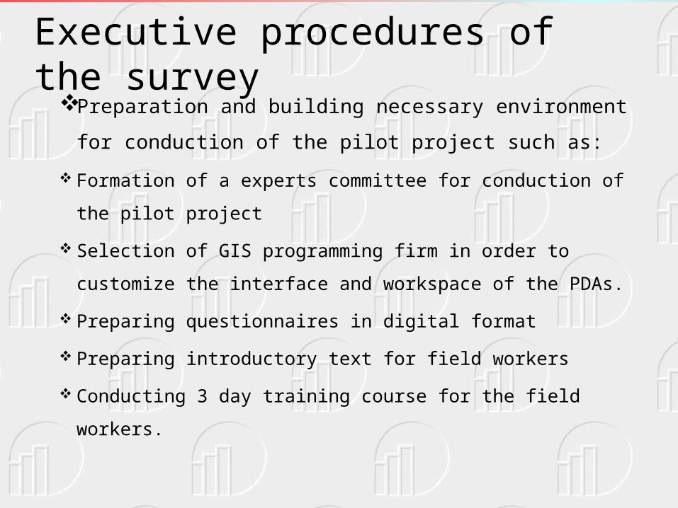
Executive procedures of the survey Preparation and building necessary environment for
conduction of the pilot project such as:
Formation of a experts committee for conduction of the pilot
project
Selection of GIS programming firm in order to customize the
interface and workspace of the PDAs.
Preparing questionnaires in digital format
Preparing introductory text for field workers
Conducting 3 day training course for the field workers.

Abstract Introduction to Industrial Producers Price Index Survey
Industrial Producers Price Index (IPPI) is currently conducted on a monthly basis all over the nation.
In this survey a small questionnaire is prepared for selected industrial production.
The questionnaire is comprised of 4 different sections which are as follows:
1- Geographic address of the work shop or factory. 2- Work shop or factory specifications 3- Enumerator’s name, and address 4- Specifications and price of the selected goods in the current
month including: name and unit of production, ISIC code of selected goods, price per unit and reasons for its change (if any).

Organizational Chart of Pilot Survey

Quality of Field workers (education, training and…)• Considering the new aspects of the pilot survey, a group field
workers have been selected. This group are mostly youngsters who are well familiar and handy with computer and cell phone as an operator.
• Education degree of the field workers
- BA / Bs 12
- Technicians 2
- Diploma 6
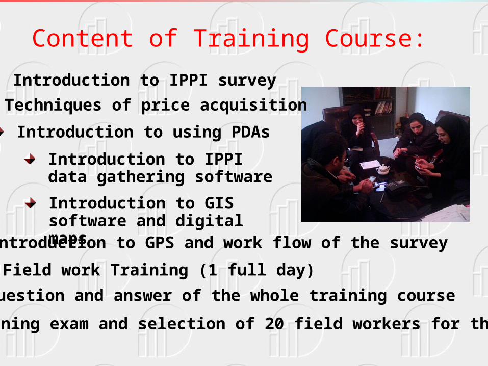
Content of Training Course:
Introduction to IPPI survey
Techniques of price acquisition
Introduction to using PDAs
Introduction to IPPI data gathering software
Introduction to GIS software and digital mapsIntroduction to GPS and work flow of the survey
Field work Training (1 full day)
Question and answer of the whole training course
Training exam and selection of 20 field workers for the survey

Survey Conduction and supervision procedures Teaming of the field workers. Assigning a survey district to each field worker. Supervision and Monitoring: - Direct supervision by the members of conducting
committee. - Gathering Daily reports as well as finished units
of work from all field workers. - On-site and remote problem solving of the field
workers. - Data verification and modification by the
provincial expert of the survey in at most 12-18 hours

STANDING POINT TO STANDING POINT TO LOCATION LOCATION

DATA GHATHERING BY FIELD WORKERDATA GHATHERING BY FIELD WORKER
جمع آوري جمع آوري داده هاي داده هاي آماري آماري
مرتبط به مرتبط به داده هاي داده هاي
مكانيمكاني
جمع آوري جمع آوري داده هاي داده هاي آماري آماري
مرتبط به مرتبط به داده هاي داده هاي
مكانيمكاني
ثبت نقطه مورد نظر برای ثبت نقطه مورد نظر برای آمار گيريآمار گيري
ثبت نقطه مورد نظر برای ثبت نقطه مورد نظر برای آمار گيريآمار گيري
فرم مخصوص سرشماري فرم مخصوص سرشماري طرح جمع آوري قيمت طرح جمع آوري قيمت
توليدكننده محصوالت صنعتيتوليدكننده محصوالت صنعتي
فرم مخصوص سرشماري فرم مخصوص سرشماري طرح جمع آوري قيمت طرح جمع آوري قيمت
توليدكننده محصوالت صنعتيتوليدكننده محصوالت صنعتي
محل محل استقرارآمار استقرارآمار
گيرگير
محل محل استقرارآمار استقرارآمار
گيرگير

ماه
سال
روز
استان
شهرستان
شهر/دهستان
رديف كارگاه
Questionnaire fill up by the field workerQuestionnaire fill up by the field worker

كارگاه
آدرس
تلفن
دفتر مركزي
Questionnaire fill up by the field workerQuestionnaire fill up by the field worker
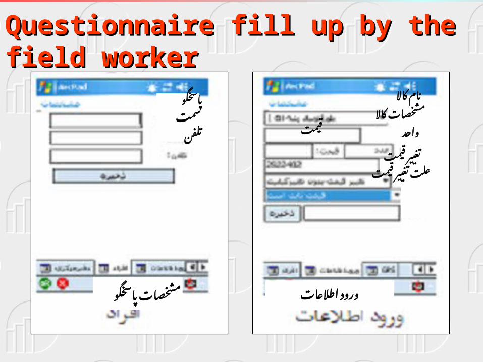
مشخصات پاسخگو
پاسخگو
سمت
تلفن
مشخصات كاال
ورود اطالعات
نام كاال
مشخصات كاال
واحد
قيمت
تغيير علت تغيير قيمت
قيمت
Questionnaire fill up by the field workerQuestionnaire fill up by the field worker

X
Y
T
3956273.1871116
12/02/2007 09:39:23 Õ
546741.91867355
Recording Geographic coordination of the statistical
unit and questionnaire fill up date and time
Questionnaire fill up by the field workerQuestionnaire fill up by the field worker

Delimitation of survey area by work units

Map of Work Unit assignment to field workers

Feasibility of different methods of Feasibility of different methods of data Transfer to the head quarterdata Transfer to the head quarter
1. Data transfer to the head quarter by the field worker
2. Using internet for data transfer i.e.: coffee nets,
personal internet access …

Internet link on provincial website for remote connection
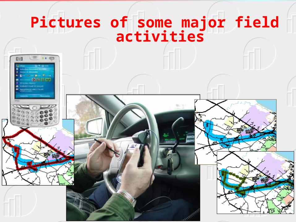
Pictures of some major field activities

Field work districts and GPS tracking
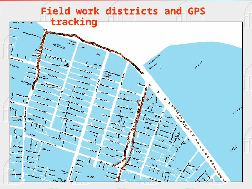
Field work districts and GPS tracking

موقعيت كارگاه
Field work districts and GPS tracking

Relationship of Address database and GIS maps

Movement track of the field worker (by GPS)
Relationship of address database, GIS maps and GPS tracking
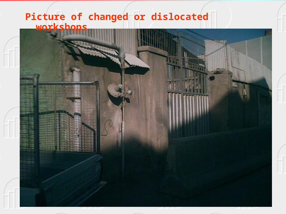
Picture of changed or dislocated workshops

Picture of changed or dislocated workshops
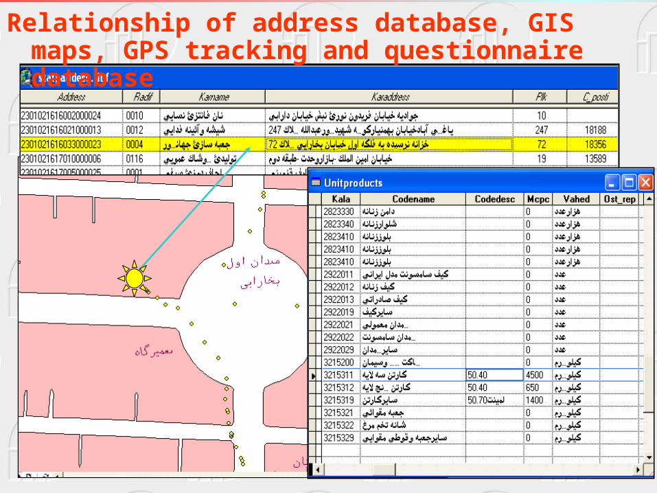
Relationship of address database, GIS maps, GPS tracking and questionnaire database

Results and Outcomes• In addition to large amount of budget cuts, use of
PDAs does have an extensive effect on quality of data.• By using intelligent techniques of data gathering, on
site verification as well as necessary data modifications and corrections are easily accessible.
• By adopting this technique and proper communication infrastructure, on-line monitoring, supervision and problem solving is possible and easy.
• To ensure the coverage as well as updating with IT techniques needs preparation of GIS ready maps for address geo-referencing which in turn will exerts huge burden for the mapping unit of SCI.

Thank for your patience


