46
INDEPENDENT STRATEGIC TOWN PLANNING ASSESSMENT CEDAR WOODS, UPPER KEDRON DEVELOPMENT APPLICATION MINISTERIAL CALL IN (DA-15-19) 27 May 2015

INDEPENDENT STRATEGIC TOWN PLANNING ASSESSMENT
CEDAR WOODS, UPPER KEDRON DEVELOPMENT APPLICATION
MINISTERIAL CALL IN (DA-15-19)
27 May 2015

REEL PLANNING EXECUTIVE SUMMARY
EXECUTIVE SUMMARY The purpose of this report is to provide an independent town planning assessment of the development application for the master planned community known as “Cedar Woods” at Upper Kedron. The development application is currently subject to a Ministerial call in. The development application sought preliminary approval under section 242 of the Sustainable Planning Act 2009 to vary the effect the Brisbane City Plan 2000 for a master planned residential community, including a neighbourhood centre and environmental / open space purposes. The application also sought a development permit for the first two stages of the application. The application was approved subject to conditions by Brisbane City Council on 11 December 2014. An infrastructure agreement for the delivery of open space and environmental corridors across the site (a total area of 91.05 hectares) was entered into between the previous owner of the property and Brisbane City Council on the 27 February 2014. This infrastructure agreement preceded the development application by four months and the outcome of the infrastructure agreement (the dedication of land) was used as justification / grounds by both the Applicant and Council to support the application. It was also referenced in pre-lodgement meetings with Council as clearly implying the balance of the site (i.e. the land outside the dedicated corridors) has potential for development, despite planning instruments indicating otherwise. I have significant concerns about the weight given to the infrastructure agreement, its lawfulness and its role in overriding the local planning instruments. For the purposes of this report I have focussed on the strategic planning framework only, being the higher order strategic provisions of the relevant planning instruments. My primary focus has been on the South East Queensland Regional Plan and the Strategic Plan and Local Plan of Brisbane City Plan 2000. I have also given significant weight to Strategic Framework and Neighbourhood Plan of City Plan 2014 as it came into effect a short period (four days) after the development application was lodged and had been in operation for almost six months when the application was approved. It has been in operation now for almost 12 months. The site is in the Urban Footprint of the South East Queensland Regional Plan 2009-2031. Initially under the superseded Regional Plan (2005-2026) only the eastern portion of the site was in the Urban Footprint. In July 2009, the Urban Footprint was extended to include the whole site. Whilst the Urban Footprint designation gives an indication that the site may be developed for urban purposes at some time, the Regional Plan directs local government planning schemes as the primary mechanism for determining the form and timing of development on land in the Urban Footprint. The Strategic Plan of Brisbane City Plan 2000 includes part of the site in the Residential Neighbourhoods and partly in the Greenspace System. The Strategic Plan also identifies other values across the site including landscape and biodiversity values, particularly over the southern portion of the site. The Ferny Grove and Upper Kedron Local Plan provides a clear direction on the local planning intent for the site. It includes the northern section of the site in a Potential Development Area (consistent with the extent of land in the Emerging Community Area) and sets out the development densities for this area. The Local Plan also identifies further constraints including waterway corridors, ecological corridors and landscape features within the Potential Development Area. The Local Plan does not provide any indication that the land outside the Potential development Area is intended for urban development. In fact, the Local Plan remains silent on these areas and relies on the intent of the underlying area classification / zoning. These areas are included in the Rural Area (western side of

REEL PLANNING EXECUTIVE SUMMARY
Ross Road Reserve) and the Environmental Protection Area (eastern side of Ross Road Reserve and south of the Potential Development Area). I note the Local Plan does refer to some development prospects on land to the west of Ross Road, however I believe this applies to land zoned Rural and within a Potential Development Area north of the site and therefore is not applicable to the assessment of this application. The reasonable development expectation in both the Rural Area and the Environmental Protection Area is for a minimum lot size of 10 hectares and very low intensity land uses. Both these areas acknowledge that larger lots will potentially be required on constrained sites. The Ferny Grove / Upper Kedron Local Plan had not been substantially amended since the introduction of the SEQ Regional Plan in 2009. So whilst the Regional Plan extended the Urban Footprint on the site, the local planning instruments were not significantly amended as a result of this. Whether this was a deliberate act of Council or simply a due to a lack of resources to review the local plan, is unknown to me. However, I cannot ignore the reasonable development expectations under the Local Plan as it forms a statutory part of the planning scheme and, in particular, given it has been ‘re-introduced’ in City Plan 2014 (as a Neighbourhood Plan), I believe considerable weight must be given to the Local Plan and I believe it cannot be reasonably argued that it has been overtaken by events. City Plan 2014 did not change the local planning intent for the site significantly. One change that did occur was in the Strategic Framework, with the inclusion of a Metropolitan Park generally in the northern portion of the site and an Investigation Area over the southern portion of the site. The Investigation Area is the first indication in the local planning framework of any development prospects over the southern portion of the site. However, it must be noted, City Plan 2014 specifically states that development should not occur in this Investigation Area until a planning scheme amendment takes place. The Local Plan, zone and overlay provisions of City Plan 2014 are generally consistent with City Plan 2000. Both Brisbane City Plan 2000 and 2014 included a Priority Infrastructure Plan (PIP). The PIP identifies a trunk Metropolitan Park with an area of 85.7ha at a value of approximately $7.5 million (for acquisition and embellishments as at 2014) indicatively on the site. The Metropolitan Park is generally consistent with the location shown on the Strategic Framework Map of City Plan 2014. Brisbane City Council, through infrastructure charges on development in the area, would be taking contributions for this trunk park. I believe the proposal is inconsistent with the Priority Infrastructure Plan as the proposal does not demonstrate how the trunk metropolitan park of 85.7ha will be achieved on the site. I appreciate the proposal includes a dedication of approximately 90ha of open space and recreation purposes, however this has been identified in the infrastructure agreement as ‘non-trunk’ infrastructure. Council would therefore obtain, free of charge, 90ha of park through the infrastructure agreement whilst continuing to take contributions up to $7.5 million for the acquisition and embellishments of a trunk park that, if the development is approved, could not be achieved on the site in addition to the non-trunk park contribution. My general observations of the proposal, in the absence of the planning framework, is that the development represents a highly desirable infill development opportunity and will deliver a variety of housing types in this part of the City. It will also assisting in achieving the Regional Plan dwelling targets for Brisbane. The constraints of the site appear to have been considered by the relevant experts and the development footprint established on this basis. It is my opinion the Brisbane City Council’s assessment of this proposal against the local planning framework, including both City Plan 2000 and City Plan 2014, was superficial and predicated on the infrastructure agreement locking in conservation areas / ecological corridors and the open space

REEL PLANNING EXECUTIVE SUMMARY
network for the site. A significant portion of the assessment by Council of this application appears that this is based on the assumption that the infrastructure agreement over-rides the local planning instruments. The infrastructure agreement that was entered into between Council and the property owner/developer effectively froze the community out of the scheme amendment process. It had the effect of over-riding the planning outcomes sought under both City Plan 2000 and City Plan 2014 with an agreement in place well before a development application was made over the site. In my opinion this serves to undermine the planning process (in the eyes of the community) and brings into question the integrity of City Plan 2014. From my assessment of the application, I am of the opinion that the proposal steps far outside the statutory planning context established under both City Plan 2000 and City Plan 2014. There is significant conflict with both these schemes. These conflicts can be summarised as:
x The proposal is in conflict with the Strategic Plan / Framework in terms of permitting development in areas identified greenspace values and the abandonment of a planned Metropolitan Park;
x The proposal is in conflict with the Local Plan / Neighbourhood Plan as it seeks a development footprint that is substantially beyond that contemplated under the City Plan. On the eastern side of Ross Road there is a loss of approximately 18 hectares of land that was intended for ecological / conservation corridor purposes. The potential development areas under the Local Plan / Neighbourhood Plan contemplate approximately 480 dwellings on the site, with all vehicle access to the north. The development proposal contemplates 1,350 dwellings with access distributed north and south.
x The proposal is in conflict with the Area / Zone provisions as the development footprint steps well outside the Emerging Community designation into the environmental Protection and Rural Zoned land which is not intended for urban development.
I have identified three options for deciding this application and discussed my recommendations in relation to each. In summary, it is my opinion that the proposal should be approved in part. I believe the extent of the development within the potential development area is substantially consistent with the planning instruments. For this part of the site I do not believe the proposal is in significant conflict with the planning scheme. A conflict on the matter of density is present, as the proposal seeks densities that are greater than the gradation of densities shown in the Potential Development Area under the Local Plan, however I believe this is a minor conflict and there are sufficient grounds to justify the conflict, being need for housing, providing housing diversity and the economic outcomes being achieved with the development. The approval in part would allow the Preliminary Approval (generally within the Potential Development Areas of Local Plan). This would enable the full approval of the Development Permit for Stage 1. As Stage 2 is included in the Environmental Protection Area, it should be refused until the Brisbane City Plan 2014 is amended to achieve consistency with intended development outcome. I do not believe the application should be refused. Whilst I acknowledge in the report that Council’s assessment of the application appears to undermine the integrity of the planning scheme and did not allow for genuine public consultation, particularly for the development outside the Potential Development area I believe there are, however, aspects of the proposal that are based on sound planning principles and are consistent with the overall strategic planning intent for part of the site, being the area within the Potential Development Areas. I recommend therefore that stage 1 of the development be approved. In my opinion development within the Environmental Protection Area and Rural Areas should be not be approved for urban residential development (nor should the ultimate external access to the overall site be resolved) until such time as a formal planning scheme amendment process is

REEL PLANNING EXECUTIVE SUMMARY
undertaken of City Plan 2014 (i.e. reviewing the Strategic Plan, the Neighbourhood Plan and the Zone provisions) to establish a sustainable development outcome for the site that is aligned with a rational adopted planning framework.

REEL PLANNING CONTENTS
CONTENTS 1. PURPOSE AND SCOPE OF THE REPORT ........................................................................................... 7
2. SITE DETAILS .................................................................................................................................... 7
3. APPLICATION DETAILS ..................................................................................................................... 7
4. INFRASTRUCTURE AGREEMENT ...................................................................................................... 8
5. TOWN PLANNING CONTEXT ............................................................................................................ 8
5.1. State Planning Policy (SPP) .......................................................................................................... 9
5.2. South East Queensland Regional Plan ......................................................................................... 9
5.3. Brisbane City Plan 2000 ............................................................................................................... 9
5.4. City Plan 2014 ............................................................................................................................ 14
6. DISCUSSION ON REASONBLE DEVELOPMENT EXPECTATIONS ...................................................... 15
6.1. Regional Planning Intent ........................................................................................................... 15
6.2. Local Planning Intent ................................................................................................................. 16
7. DISCUSSION ON THE PROPOSAL ................................................................................................... 17
7.1. General Observations ................................................................................................................ 17
7.2. Supporting Experts Reports ....................................................................................................... 17
8. COMMENTS ON BRISBANE CITY COUNCIL’S ASSESSMENT ........................................................... 19
9. CONFLICT WITH THE PLANNING INSTRUMENTS & SUFFICIENT GROUNDS .................................. 20
9.1. Conflicts ..................................................................................................................................... 20
9.2. Grounds ..................................................................................................................................... 20
10. OPTIONS FOR A DECISION AND RECOMMENDATIONS ............................................................. 21 APPENDICES: Appendix A - City Plan 2000 - Strategic Plan Figures Appendix B - City Plan 2000 - Local Plan Figures Appendix C - City Plan 2000 - Area Classification Figures Appendix D - City Plan 2000 - Priority Infrastructure Area Figures Appendix E - City Plan 2014 - Figures
REEL PLANNING PAGE 7
1. PURPOSE AND SCOPE OF THE REPORT The purpose of this report is to provide an independent town planning assessment of the development application for the master planned community known as “Cedar Woods” at Upper Kedron. The development application is currently subject to a Ministerial call in. I have been instructed to specifically limit my assessment to the strategic planning provisions of the relevant planning instruments. For that reason I have not reviewed all applicable codes and planning scheme policies applicable to the assessment of the application. In preparing this report I have reviewed:
x Brisbane City Plan 2000 (version 2 May 2014), in effect at the date of lodgement of the application (version 2 May 2014);
x Brisbane City Plan 2014 (version 30 June 2014), in effect shortly after the application was lodged and when the application was decided; and
x South East Queensland Regional Plan 2009-2031 (version 28 July 2009 and amended Regulatory Provisions 2 May 2014).
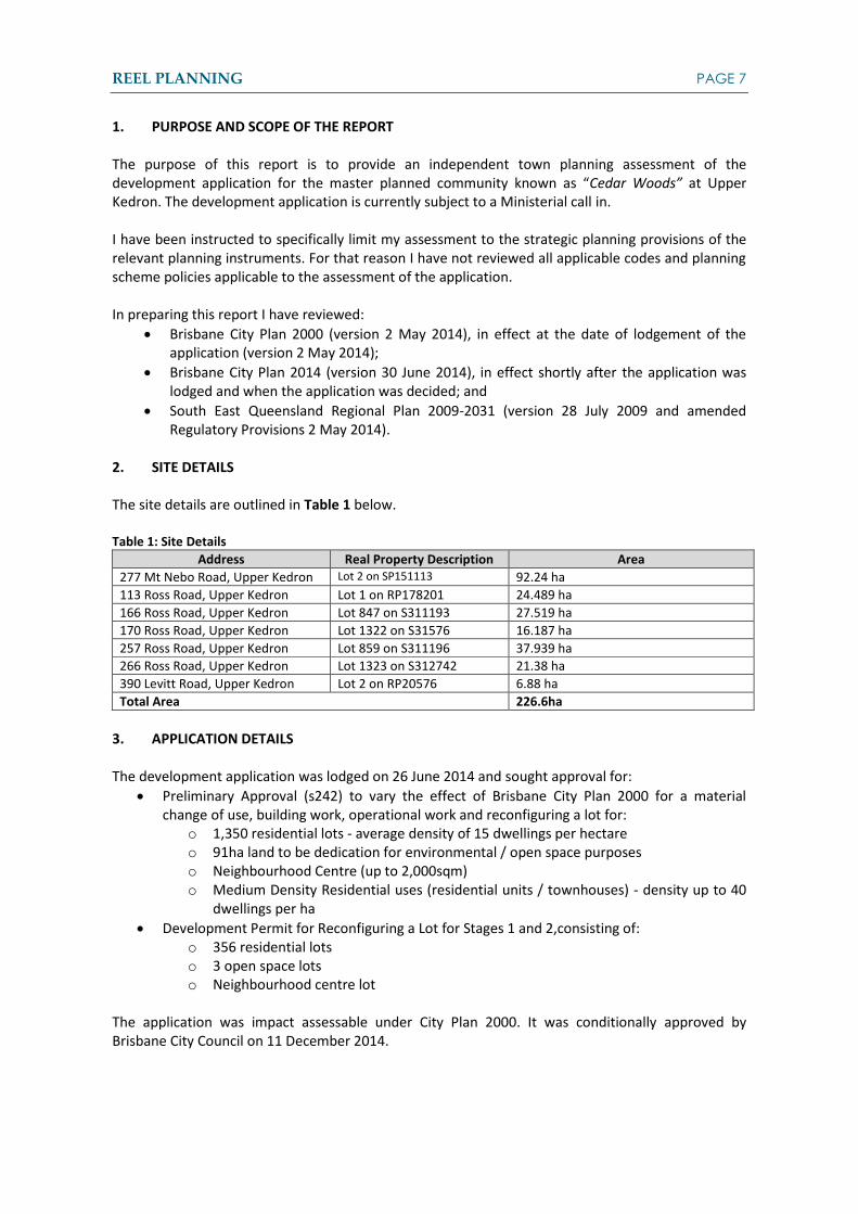
2. SITE DETAILS The site details are outlined in Table 1 below. Table 1: Site Details
Address Real Property Description Area 277 Mt Nebo Road, Upper Kedron Lot 2 on SP151113 92.24 ha 113 Ross Road, Upper Kedron Lot 1 on RP178201 24.489 ha 166 Ross Road, Upper Kedron Lot 847 on S311193 27.519 ha 170 Ross Road, Upper Kedron Lot 1322 on S31576 16.187 ha 257 Ross Road, Upper Kedron Lot 859 on S311196 37.939 ha 266 Ross Road, Upper Kedron Lot 1323 on S312742 21.38 ha 390 Levitt Road, Upper Kedron Lot 2 on RP20576 6.88 ha Total Area 226.6ha
3. APPLICATION DETAILS The development application was lodged on 26 June 2014 and sought approval for:
x Preliminary Approval (s242) to vary the effect of Brisbane City Plan 2000 for a material change of use, building work, operational work and reconfiguring a lot for:
o 1,350 residential lots - average density of 15 dwellings per hectare o 91ha land to be dedication for environmental / open space purposes o Neighbourhood Centre (up to 2,000sqm) o Medium Density Residential uses (residential units / townhouses) - density up to 40
dwellings per ha x Development Permit for Reconfiguring a Lot for Stages 1 and 2,consisting of:
o 356 residential lots o 3 open space lots o Neighbourhood centre lot
The application was impact assessable under City Plan 2000. It was conditionally approved by Brisbane City Council on 11 December 2014.

REEL PLANNING PAGE 8
4. INFRASTRUCTURE AGREEMENT An infrastructure agreement (IA) was entered into between the previous owner of the site (Institutional Investments) and Brisbane City Council on the 27 February 2014, four months before the development application the subject of this report was lodged with Council. The IA states it is an agreement made in accordance with section 658 and 660 of the Sustainable Planning Act 2009. The IA is for the delivery of non-trunk infrastructure, specifically for community purpose infrastructure being public parks and community facilities. The IA requires a land contribution, with a total area of approximately 91.05 hectares, to be transferred to Council as part of subsequent development approvals over the land to ‘assist in meeting waterways, environmental and community purpose requirements.’ The status of this IA and its role in the framing of and assessment of the Preliminary Approval application is discussed later in this report. 5. TOWN PLANNING CONTEXT An overview of the town planning context is provided in Table 2. Table 2: Town Planning Context
LOCAL CONTEXT City Plan 2000 (at the date of lodgement)
City Plan 2014 (at the date of decision and current)
Planning Scheme City Plan 2000 (v- 2 May 2014) City Plan 2014 (v - 30 June 2014, including amendment 12 September 2014)
Local Plan / Neighbourhood Plan
Ferny Grove / Upper Kedron Local Plan
Ferny Grove - Upper Kedron Neighbourhood Plan
Area Classification / Zone
Emerging Community Area Rural Area Environmental Protection Area
Emerging Community Zone Rural Zone Environmental Management Zone
Constraints / Overlays Overland Flow Path Flooding Waterway Corridor NALL - Significant Native Vegetation, Waterway and Wetland Vegetation
Airport Environs Bicycle Network Biodiversity (High Ecological Significance) Bushfire (High & Medium Hazard Area; High & Medium Hazard Buffer Area) Critical Infrastructure and Movement Network Flood (Creek and Waterway areas 1-5; overland flow) Regional Infrastructure and Substations (Major Electricity Infrastructure High Voltage Power Line and easement) Road Hierarchy Significant Landscape Tree (Landscape features) Water Resource Catchment Waterway Corridors (Citywide; Local)
STATE & REGIONAL CONTEXT State Planning Policy
Biodiversity (MSES - protected area, wildlife habitat, regulated vegetation, regulated vegetation intersecting a watercourse, high ecological value waters (wetland and watercourse)) Waterway Quality Natural Hazards
South East Urban Footprint

REEL PLANNING PAGE 9
LOCAL CONTEXT City Plan 2000 (at the date of lodgement)
City Plan 2014 (at the date of decision and current)
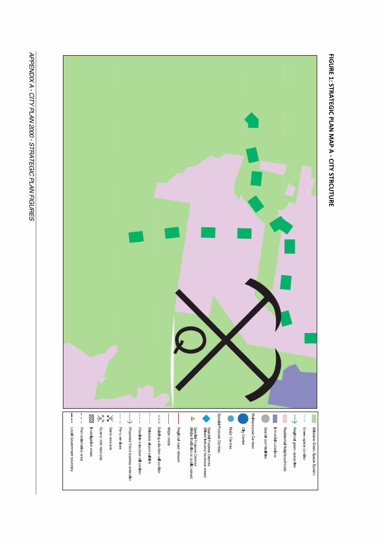
Queensland Regional Plan 2009-2026 5.1. State Planning Policy (SPP) The State Planning Policy (December 2013) was in effect when the development application was lodged. Whilst the SPP includes matters of State interest that are relevant to the assessment of a development application, it is considered that these matters are technical in nature and not of significance to a strategic planning assessment of the application. It is understood that technical consultants are advising the State on compliance with the SPP with respect to ecological, hydraulic and bushfire matters. 5.2. South East Queensland Regional Plan The site is in the Urban Footprint of the South East Queensland Regional Plan 2009-2031. The intent of the Urban Footprint is to accommodate the region’s urban development needs, however all land in the Urban Footprint may not be developed for urban purposes. Constraints such as flooding, land slope, scenic amenity, and biodiversity values may make the land unsuitable for development. Local Government planning schemes are the main instrument to establish and refine the desired land use and the timing of development in the Urban Footprint. Upper Kedron is identified (but not mapped) as broadhectare land in the Regional Plan. The Regional Plan notes that remnant broadhectare land includes undeveloped lots in the Urban Footprint that could potentially be developed for urban purposes but are not currently zoned for higher density development. Development of all the broadhectare areas, including Upper Kedron, will deliver some (approximately 30,000 dwellings) of Brisbane’s residential dwelling target in the short-medium term. Previous versions of the Regional Plan included only the eastern portion of the site in the Urban Footprint (to the Ross Road Reserve) and the western portion was in the Regional Landscape and Rural Production Area. The Regional Plan was amended in July 2009 to include the whole site in the Urban Footprint. The Ferny Grove / Upper Kedron Local Plan (discussed below) has not been substantially altered, including the most recent 2014 version adopted as a Neighbourhood Plan, since the Regional Plan came into effect in 2009. 5.3. Brisbane City Plan 2000 The application was made under City Plan 2000 (version 2 May 2014). The Strategic Plan The Strategic Plan sets the blueprint for development across the City through DEOs and associated strategies. There are a range of elements (preferred dominant land use, greenspace, movement systems etc.) which provide a broad expression of how the City’s structure should develop to achieve the DEOs. This is spatially expressed in a series of maps which are not intended to be interpreted on a site by site basis as they are not cadastrally based. However given the large size of the subject site and its strategic importance as broadhectare infill development opportunity, the strategic plan mapping for the site can be interpreted with some degree of confidence.
REEL PLANNING PAGE 10
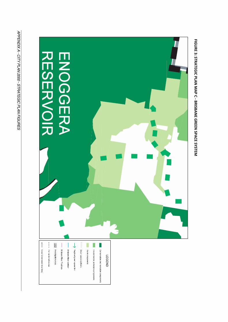
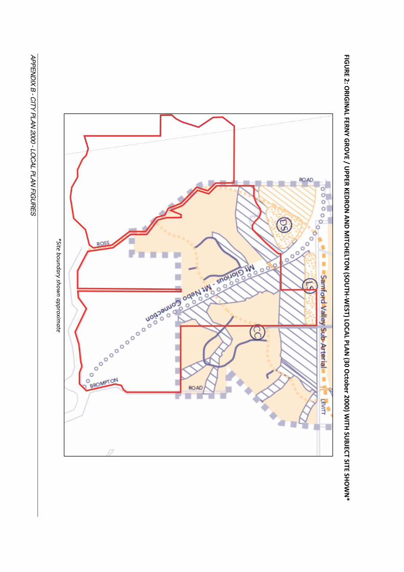
The Strategic Plan (Map A City Structure) (Appendix A - Figure 1) includes the site in the Residential Neighbourhoods and Greenspace System. It also identifies a green space corridor traversing the site north-south. Part of the site (southern and western portion) is also mapped in the Strategic Plan as having rural, semi-rural / semi natural and open space landscape value, biodiversity value and natural scenic value (Map B Greenspace System Values) (Appendix A - Figure 2). The Brisbane Greenspace System Map (Map C) (Appendix A - Figure 3) identifies Rural Components and Conservation and Recreation Components and a Greenspace Corridor across the site. It appears that the Strategic Plan maps were last amended on 1 January 2008. However, I note the Residential Neighbourhoods area of the Strategic Plan reflects the superseded (pre-2007) Area classification, in particular the Emerging Community Area, and the superseded Local Plan Potential Development Area (as discussed below). Ferny Grove / Upper Kedron Local Plan The Ferny Grove / Upper Kedron and Mitchelton (South-West) Local Plan (the original Local Plan) came into effect as part of City Plan 2000 on 31 October 2000. The Local Plan was derived from the Local Area Outline Plan of the same name from the former 1987 Town Plan, which was a statutory part of that scheme. The original Local Plan in City Plan 2000 affected only part of the site (Appendix B - Figures 1 & 2), with the balance of the site being located outside the boundary of the Local Plan area. The ‘potential development area’ of the Local Plan reflected the Emerging Community area classification at that time - see discussion on area classification changes in the following section. The Local Plan was substantially amended in July 2007, at which point it became the Ferny Grove / Upper Kedron Local Plan (‘first revision’) (Appendix B - Figures 3 & 4). This amendment included a number of changes and additions. Of most significance:
x the extension of the Local Plan boundary to include the entire site; x the extent of the ‘potential development area’ was reduced (to reflect the reduced Emerging
Community Area - see discussion on changes to the area classification below) x A Table of Assessment was added (applicable to indoor sport and recreation only) and a Local
Plan Code was included. x The ‘elements’ of the Local Plan were broadened (and mapped) and included additional
provisions regarding habitat areas and ecological corridors, open space and parks, potential development areas (including sequencing of development) and movement systems.
The Potential Development Areas & Sequencing of Development When read in conjunction with the provisions for Local Plans for Outer Suburbs1, the 2007 version of the Local Plan became more prescriptive with regard to allowable residential densities within the ‘potential development area’ of the site and divided this area into intended uses and densities, being:
x Houses and multi-unit dwellings - 16 dwellings per hectare (low density residential); x Houses - 12 dwellings per hectare (low density residential); and x Very-low density residential - 5 dwellings per hectare (very low density residential).
It is the stated in the Local Plan provisions of City Plan 2000 for the outer suburbs2, after land is developed in the ‘potential development areas’ it would be included in the most applicable area classification being: very-low density residential would be included in the Environmental Protection area; Low density residential would be included in the Low Density Area Residential Area and Low- 1 City Plan 2000 (1 July 2007), Chapter 4, Part 4, Section 4.2.3 2 City Plan 2000 (1 July 2007), Chapter 4, Part 4, Section 4.2.3

REEL PLANNING PAGE 11
medium Density Residential would be including the Low-Medium Density Residential Area. From my interpretation of the potential development areas of the Ferny Grove / Upper Kedron Local Plan within the boundaries of the site, the intended densities are between 5 dwellings per ha up to 16 dwellings per ha. On that basis, following development these areas would go to the Environmental Protection Area and the Low Density Residential Area. For the areas shown as white / blank on the Local Plan, the underlying area classification is to be used to determine the land use intent3. The parts of the site left blank are in the Emerging Community Area (at the Levitt Road frontage), the Environmental Protection Area (southern portion) and Rural Area (western portion). With regard to the sequencing of development, the Local Plan notes that ‘Land west of Ross Road will not be developed until the land east of Ross Road provides the water supply and sewerage connections. Only under these circumstances will development in this Rural Area be assessed against the Emerging Community Area provisions in Chapter 3 of City Plan.’ It is my opinion this statement is referring only to the land west of Ross Road included in the ‘potential development area’. I believe this is the case as the Regional Plan in effect at the time of this local plan (i.e. SEQ Regional Plan 2005-2026) did not include all the land west of Ross Road in the Urban Footprint, but only that small northern portion that was zoned Rural and designated as a ‘potential development area’ under the Local Plan (Appendix B - Figure 5). That land is in fact outside of the subject site. In my opinion it would be unusual (and in fact inconsistent with the SEQRP) for Council to include statements about the urban development opportunities of land outside the Urban Footprint. Therefore I do not believe this statement is referring to all the Rural zoned land west of Ross Road. In addition the Local Plan does not allow for access from Mt Nebo Road, Brompton Road or the unconstructed part of Ross Road to the very-low residential development south of Cedar Creek; requiring access to be through the potential development area to the north. Therefore in my opinion there is no expectation or entitlement for access to the site to be achieved via Waterworks Road. Ecological Corridors, Waterway Corridors and Open Space / Parks The Local Plan identifies waterway corridors, habitat areas and ecological corridors, and open space / parks across part of the eastern section of the site. The Local Plan provisions of City Plan require habitat areas and ecological corridors and waterway corridors to be included in the Conservation Area (if transferred to public ownership) or the Environmental Protection Area (if privately retained) following development approval and appropriately protected. Waterway Corridors: The provisions for Local Plans for Outer Suburbs4 (Chapter 4, s4) notes that waterway corridors shown on local plans have been identified through studies and are ‘more accurately depicted’ than the generic waterway corridors of City Plan. The corridors have specifically been excluded from the Potential Development Areas, as they are not suitable for development. Habitat Areas and Ecological Corridors: Similarly to waterway corridors, habitat areas and ecological corridors are not included in the Potential Development Area as they are not suitable for development. Specific to the site, the Ferny Grove / Upper Kedron Local Plan states: ‘An ecological corridor adjacent to Mt Nebo and Brompton Roads will provide connectivity from Brisbane Forest Park through the Keperra Saddle to Enoggera Military Barracks. This corridor requires protection and rehabilitation to ensure it fulfils its role as a
3 City Plan 2000 (1 July 2007), Chapter 4, Part 4, Section 4.1 4 City Plan 2000 (1 July 2007), Chapter 4, Part 4, Section 4.2.1

REEL PLANNING PAGE 12
regionally significant corridor.’ 5 Open Space / Parks: Cedar Creek runs adjacent to and through part of the site. The Local Plan notes that Cedar Creek is a Citywide ecological corridor. It will act as a corridor link part which will provide recreational uses as well as protection of biodiversity and waterway functions. Further recreational links across the site between Cedar Creek and Mt Nebo road are envisaged, to provide connections to Brisbane Forest Park. 6 Other Provisions Other changes and additions to the 2007 Local Plan of relevance to the site include:
x Inclusion of Landscape Features, noting the land above the 95m contour line as having high visual exposure and low capacity to visually absorb new development.
x The future transport corridor for investigation was relocated further to the west (still within the site).
x Possible primary school site (potential to be multi-unit dwellings if a school did not proceed) x Convenience Centre relocated to be within the site, rather than on adjoining land.
Since the 2007 significant amendment to the Local Plan there were further minor amendments to the Ferny Grove / Upper Kedron Local Plan, but no changes of significance to the site or the assessment of the proposal. As such, the Local Plan at the date of lodgement of the application was generally as per the 2007 version discussed above.
Area Classification When City Plan 2000 was originally released (October 2000) the site was included in the Emerging Community Area and the Rural Area classifications (Appendix C - Figure 1). In 2007 (as part of the Local Plan review) the scheme was amended and the area classification of the site revised with respect to the extent of the Emerging Community Area (a reduced area) and part of the eastern portion of the site changed to Environmental Protection Area. The Environmental Protection Area covered the southern portion of the site and along the ridgeline adjacent to the eastern side of the Ross Road reserve (Appendix C - Figure 2). In summary, the intent of these area classifications are:
x Emerging Community Area: o generally suitable for urban purposes at some time in the future, with some land
unsuitable for development due to constraints; o requires the preparation of a neighbourhood structure plan before development can
occur. x Environmental Protection Area:
o minimum lot size of 10ha, with lager lots potentially required on constrained sites; o primarily very low density residential and rural uses; o ‘features natural and semi-natural broad hectare land that has important
biodiversity, natural landscape, native vegetation, waterways and water supply catchment values, elements and functions.’
x Rural Area: o minimum lot size of 10ha, with lager lots potentially required on constrained sites; o accommodates residential and rural uses; o some broad hectare, low intensity uses contemplated; o good quality agricultural land is protected
As noted above in the discussion of the Ferny Grove / Upper Kedron Local Plan, the Local Plan 5 City Plan 2000 (1 July 2007), Chapter 4, Ferny Grove / Upper Kedron Local Plan, Section 2.1 6 City Plan 2000 (1 July 2007), Chapter 4, Ferny Grove / Upper Kedron Local Plan, Section 2.2
REEL PLANNING PAGE 13
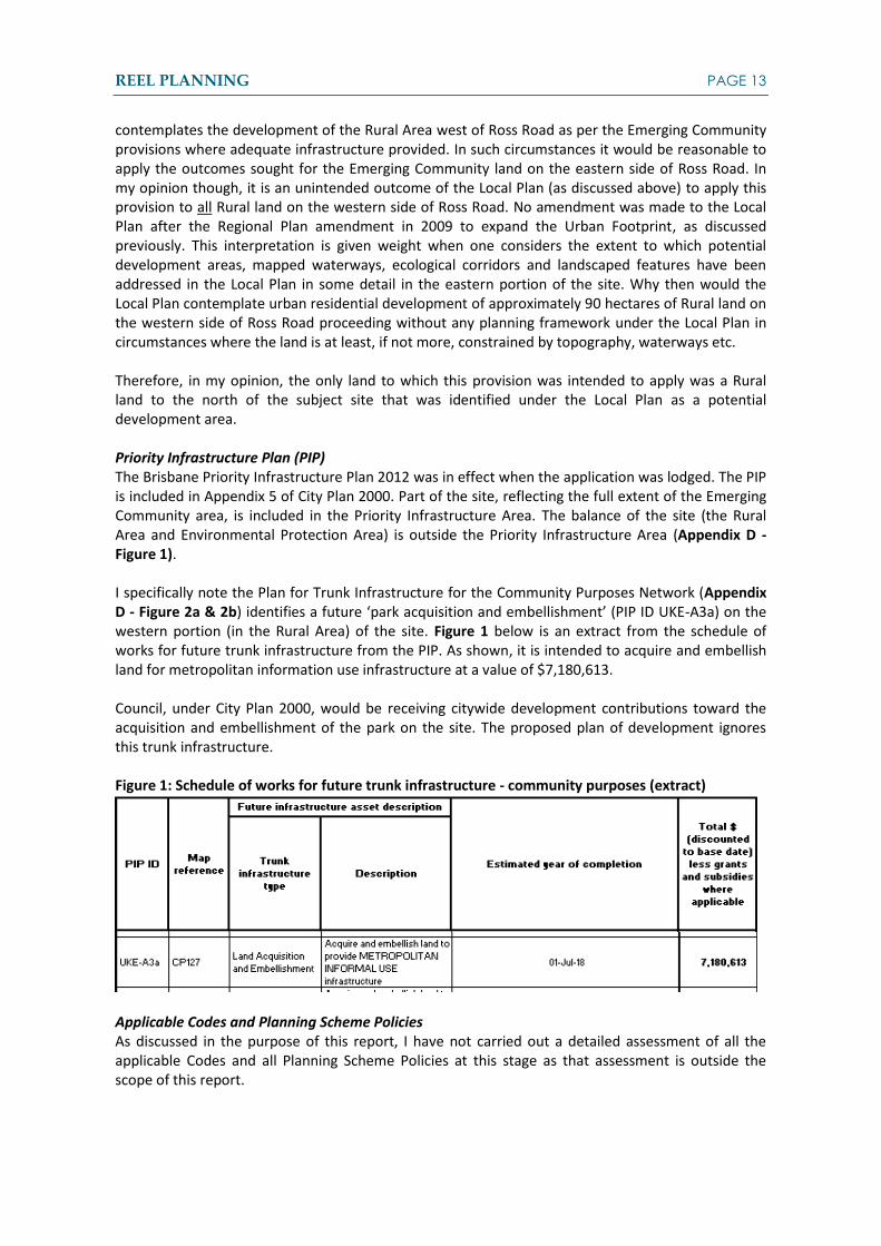
contemplates the development of the Rural Area west of Ross Road as per the Emerging Community provisions where adequate infrastructure provided. In such circumstances it would be reasonable to apply the outcomes sought for the Emerging Community land on the eastern side of Ross Road. In my opinion though, it is an unintended outcome of the Local Plan (as discussed above) to apply this provision to all Rural land on the western side of Ross Road. No amendment was made to the Local Plan after the Regional Plan amendment in 2009 to expand the Urban Footprint, as discussed previously. This interpretation is given weight when one considers the extent to which potential development areas, mapped waterways, ecological corridors and landscaped features have been addressed in the Local Plan in some detail in the eastern portion of the site. Why then would the Local Plan contemplate urban residential development of approximately 90 hectares of Rural land on the western side of Ross Road proceeding without any planning framework under the Local Plan in circumstances where the land is at least, if not more, constrained by topography, waterways etc. Therefore, in my opinion, the only land to which this provision was intended to apply was a Rural land to the north of the subject site that was identified under the Local Plan as a potential development area. Priority Infrastructure Plan (PIP) The Brisbane Priority Infrastructure Plan 2012 was in effect when the application was lodged. The PIP is included in Appendix 5 of City Plan 2000. Part of the site, reflecting the full extent of the Emerging Community area, is included in the Priority Infrastructure Area. The balance of the site (the Rural Area and Environmental Protection Area) is outside the Priority Infrastructure Area (Appendix D - Figure 1). I specifically note the Plan for Trunk Infrastructure for the Community Purposes Network (Appendix D - Figure 2a & 2b) identifies a future ‘park acquisition and embellishment’ (PIP ID UKE-A3a) on the western portion (in the Rural Area) of the site. Figure 1 below is an extract from the schedule of works for future trunk infrastructure from the PIP. As shown, it is intended to acquire and embellish land for metropolitan information use infrastructure at a value of $7,180,613. Council, under City Plan 2000, would be receiving citywide development contributions toward the acquisition and embellishment of the park on the site. The proposed plan of development ignores this trunk infrastructure. Figure 1: Schedule of works for future trunk infrastructure - community purposes (extract)
Applicable Codes and Planning Scheme Policies As discussed in the purpose of this report, I have not carried out a detailed assessment of all the applicable Codes and all Planning Scheme Policies at this stage as that assessment is outside the scope of this report.
REEL PLANNING PAGE 14
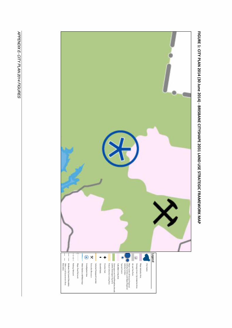
5.4. City Plan 2014 Strategic Framework The site is in the Suburban Living Area and Greenspace and Rural Neighbourhoods (within Greenspace System) of the Brisbane CityShape 2031 Land Use Strategic Framework map (Appendix E - Figure 1). This map also identifies an ‘Investigation Area’ which generally falls over the southern portion of the site. Section 3.7.1 (3) of the Strategic Framework notes the Investigation Area is to be protected from development until detailed investigations are carried out by Council and long-term land use decisions are made by Council through an amendment to the planning scheme. The Brisbane Greenspace System Strategic Framework Map (Appendix E - Figure 2), which is not cadastrally based, appears to identify on the site Corridor Value, Conservation and Environmental Management and Biodiversity in addition to a Planned District and Metropolitan Parks Facility. The latter designation is consistent with the Priority Infrastructure Plan under the superseded planning scheme discussed above and is discussed further below. Ferny Grove - Upper Kedron Neighbourhood Plan No significant changes were made to the Ferny Grove - Upper Kedron Neighbourhood Plan between the superseded City Plan 2000 and City Plan 2014. The changes that did occur are largely administrative and also appear to be as a result of the conversion of the document to a QPP scheme format. The changes of note are:
x The future transport corridor investigation area has been completely removed. x Some features have been removed by the Local Plan and included in the relevant overlay,
such as the ecological corridor and waterway corridors (now shown in the Biodiversity Overlay and the Waterway Corridors Overlay in City Plan 2014). These features, when read together, remain generally consistent with the previous Local Plan.
x The Landscape Features have been removed from the Local Plan. These do not appear to be reflected elsewhere in the new City Plan. The Significant Landscape Trees Overlay includes Landscape Features on the site, but this is not an equivalent area to that of the previous Local Plan and has a different intent to the Landscape Features of the previous Local Plan.
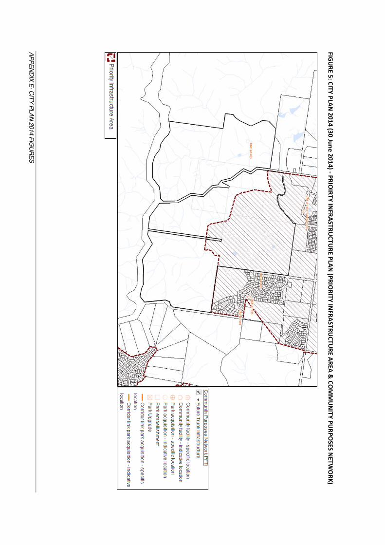
I note the Potential Development Areas (extent and densities) of the Neighbourhood Plan remain consistent with the superseded scheme (Appendix E - Figure 3). Zone The zone of the land remains consistent with the superseded City Plan 2000 (Appendix E - Figure 4) designation and includes the site in the Emerging Community Zone, Rural Zone and Environmental Management Zone. The general intent of each zone remains consistent with the same zonings under the superseded planning scheme. Priority Infrastructure Plan (PIP) Like the superseded City Plan 2000, City Plan 2014 includes a Priority Infrastructure Plan. As per the superseded City Plan, the current PIP includes only part of the site (Emerging Community Area) in the Priority Infrastructure Area. Again I note the Plans for Trunk Infrastructure – Community Purposes Network, which includes an annotation (UKE-A3-001) on the western portion of the site (in the Rural Area) for park acquisition - indicative location. The schedule of works for this infrastructure identifies a total area of 85.70ha is intended to be acquired and embellished for park purposes at a value of $7,449,367 (Appendix E - Figure 5) and as outlined in Figure 2 on the following page.
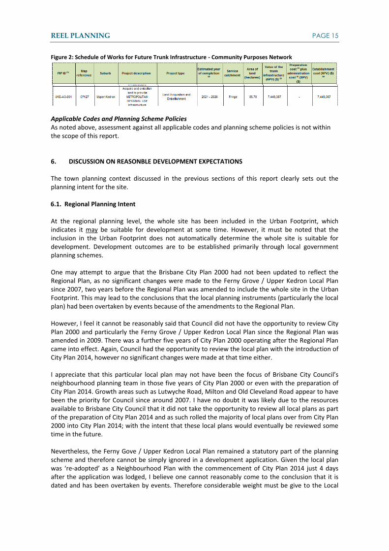
REEL PLANNING PAGE 15
Figure 2: Schedule of Works for Future Trunk Infrastructure - Community Purposes Network
Applicable Codes and Planning Scheme Policies As noted above, assessment against all applicable codes and planning scheme policies is not within the scope of this report.
6. DISCUSSION ON REASONBLE DEVELOPMENT EXPECTATIONS The town planning context discussed in the previous sections of this report clearly sets out the planning intent for the site. 6.1. Regional Planning Intent At the regional planning level, the whole site has been included in the Urban Footprint, which indicates it may be suitable for development at some time. However, it must be noted that the inclusion in the Urban Footprint does not automatically determine the whole site is suitable for development. Development outcomes are to be established primarily through local government planning schemes. One may attempt to argue that the Brisbane City Plan 2000 had not been updated to reflect the Regional Plan, as no significant changes were made to the Ferny Grove / Upper Kedron Local Plan since 2007, two years before the Regional Plan was amended to include the whole site in the Urban Footprint. This may lead to the conclusions that the local planning instruments (particularly the local plan) had been overtaken by events because of the amendments to the Regional Plan. However, I feel it cannot be reasonably said that Council did not have the opportunity to review City Plan 2000 and particularly the Ferny Grove / Upper Kedron Local Plan since the Regional Plan was amended in 2009. There was a further five years of City Plan 2000 operating after the Regional Plan came into effect. Again, Council had the opportunity to review the local plan with the introduction of City Plan 2014, however no significant changes were made at that time either. I appreciate that this particular local plan may not have been the focus of Brisbane City Council’s neighbourhood planning team in those five years of City Plan 2000 or even with the preparation of City Plan 2014. Growth areas such as Lutwyche Road, Milton and Old Cleveland Road appear to have been the priority for Council since around 2007. I have no doubt it was likely due to the resources available to Brisbane City Council that it did not take the opportunity to review all local plans as part of the preparation of City Plan 2014 and as such rolled the majority of local plans over from City Plan 2000 into City Plan 2014; with the intent that these local plans would eventually be reviewed some time in the future. Nevertheless, the Ferny Gove / Upper Kedron Local Plan remained a statutory part of the planning scheme and therefore cannot be simply ignored in a development application. Given the local plan was ‘re-adopted’ as a Neighbourhood Plan with the commencement of City Plan 2014 just 4 days after the application was lodged, I believe one cannot reasonably come to the conclusion that it is dated and has been overtaken by events. Therefore considerable weight must be give to the Local

REEL PLANNING PAGE 16
Plan as at the date of lodgement and as it stands now as a statutory Neighbourhood Plan in City Plan 2014. 6.2. Local Planning Intent I discuss in section 4.3 above, the Ferny Grove / Upper Kedron Local Plan underwent significant amendments in 2007. I’ve noted these amendments, as I feel there was a deliberate change to the local planning intent for this site at the time. Of particular note, the local plan boundary was extended to include the whole site, the ‘potential development area’ was reduced in size and residential densities were specified. Constraints such as waterway corridors and landscape features were added and further refined. At the same time the area classification of the site changed to include a large portion of Environment Protection Area across the southern portion of the site and up the central ridgeline. The Emerging Community Area was actually reduced in size at this time. The Local Plan was also amended to give direction about vehicle access; restricting access south to Mt Nebo Road, which gives the community the reasonable expectation that any vehicle access to this site will be to the north. As discussed previously, City Plan 2014 did not change the local planning intent for the site substantially. The Local Plan (when read together with the overlays) remains generally consistent with the superseded City Plan 2000. Of note, the ‘potential development area’ is consistent and the Biodiversity Overlay reinforces the ecological corridor designation in the south-east corner of the site, consistent with the superseded Local Plan. A noted difference in City Plan 2014 is the Strategic Framework map, which included an Investigation Area over the southern portion of the site. In my opinion, this is the first indication in the local planning framework of any development opportunities over the southern portion of the site. I note however, the scheme specifically states that development should not occur until a planning scheme amendment takes place. It may be arguable that a preliminary approval to override the planning scheme is in its own right a planning scheme amendment. However I note there are the following significant departures from the land use and open space/conservation strategy under the Local Plan / Neighbourhood Plan:
x a substantial increase in the development envelope and corresponding reduction in the designated ecological corridor;
x a significant uplift in density on the site; and x direct vehicular access to the south via waterworks Road in circumstances where no access
was intended, On the basis of the above, it is my opinion that the Ferny Grove / Upper Kedron Local Plan, and its successor) provides a clear planning intent for the site. It is not a planning strategy that has been overtaken by events given it has been reconfirmed in City Plan 2014. It is clear that the intent is to limit the development to the northern portion of the site within the designated potential development area. The land within the Environmental Protection Area could be developed for very low intensity housing on 10 hectare lots, with the intent to retain the ecological function of the corridors. It could be argued (on face value) that there is scope to support urban development on all the Rural zoned land west of Ross Road through a structure planning process, however, as explained above, provisions of the Local Plan or Neighbourhood Plan were not amended after the change to the Regional Plan in 2009 and prior to that, the Local Plan intended for only a small section of Rural land (that is actually outside of the site) to be considered as if it was zoned Emerging Community. In my opinion the development of all the Rural land west of Ross Road would be an unintended outcome of

REEL PLANNING PAGE 17
the scheme. If the scheme had intended it to be developed, then guidance would have been provided in the Local Plan/ Neighbourhood Plan (post 2009) on the potential development area, preferred density and ecological and waterway corridors to be conserved. That would be consistent to the planning undertaken to the east of Ross Road. In light of the above I have undertaken an analysis of the potential development yield in terms of reasonable development expectations under the Local Plan. This is based on an interrogation of the potential development areas and intended densities prescribed in the Local Plan/ Neighbourhood Plan. By my calculations a dwelling yield of approximately 480 dwellings is anticipated. 7. DISCUSSION ON THE PROPOSAL I have reviewed the development application documents lodged by Place, the planning consultants for Cedar Woods, as well as the correspondence with Brisbane City Council during the assessment of the development application. 7.1. General Observations There were extensive supporting reports underpinning the proposal and in my opinion a structurally sound Preliminary Approval planning framework was advanced in the application. Putting the planning scheme to one side, from a strategic first principles perspective, the proposal represents a highly desirable Infill development opportunity, delivering a variety of housing types in response to a clear community need for housing in this part of the City. It will also assist in delivering the Regional Plan’s infill development dwelling targets for the City. The site contains a number of constraints requiring careful site based planning. It requires analysis of constraints and measures introduced (through conditions and codes) to protect ecologically important parts of the site including corridor functions, visually sensitive areas, steep land and waterway corridors. The settlement pattern and ultimate dwelling yield should respond to these site constraints. In my opinion the constraints of the site appear to have been considered by the relevant experts and the development footprint established on this basis. As an observation, the intent of the application to achieve an average dwelling density of 15 dwellings per hectare across all the areas identified for potential development appears ambitious given the site constraints. Such a density has not been achieved in stages 1 and 2 and the balance of the site is much more constrained. Nominating a maximum number of dwellings at 1,350 (which is well less than 15 dwellings per hectare) appears more realistic. Beyond the assessment of site constraints, a key consideration in determining ultimate yield is the ability of the external road network, both local connection roads, as well as the broader arterial road network, to accommodate the ultimate development. It is understood that other consultants have been engaged to peer review and independently assess the various supporting technical reports, including traffic engineering issues that were prepared in support of the proposal. 7.2. Supporting Experts Reports I have not carried out a detailed assessment of all the supporting reports lodged with the application, as they largely apply to technical, rather than addressing strategic planning matters. However I would

REEL PLANNING PAGE 18
like to make some observations on the ecological assessment and its implications for the proposal. Ecological Assessment 28 South Environmental prepared an ecological assessment which accompanied the development application. This report addresses the applicable Commonwealth, State and Local Government instruments relevant to ecology. The ecological assessment acknowledges that the development footprint for the proposal was defined by the Infrastructure Agreement (previously noted in Section 4 of this report) and refers to the same ecological corridors identified in the Infrastructure Agreement. This infrastructure agreement was informed by background studies on ecological matters, including a report also prepared by 28 South Environmental dated August 2013. Whilst the 28 South report appears soundly based, it relies heavily on the Infrastructure Agreement and its supporting studies to justify departure from the planning instruments. The ecological assessment seems to indicate, since the Infrastructure Agreement was signed off by Council, no further corridors or assessment needs to be provided with respect to a number of the code provisions. I believe the Infrastructure Agreement is a significant departure from the zoning / land use intent for the site and the overall conservations strategy set out in both City Plan 2000 and City Plan 2014 and therefore cannot, and should not, be used as justification for compliance with the planning scheme. The 28 South report dated August 2013, which informed the Infrastructure Agreement, completely ignores the Environmental Protection Area and the Ferny Grove / Upper Kedron Local Plan ecological corridors, and appears to rely on a development expectation under the Regional Plan - i.e. the site’s inclusion in the Urban Footprint. For the reasons I note above, I do not believe the Regional Plan on its own solely informs the development expectations for this site. The August 2013 28 South Report also discusses a 2002 report prepared by Ecotone, which was apparently commissioned by Brisbane City Council. 28 South was critical of the 2007 version of the Local Plan because it failed to reflect the outcomes of the Ecotone Report with respect to the ecological corridors on the site. I must note here that I have not seen the Ecotone Report, however based on the commentary in the 28 South Report I assume that the corridor recommended by Ecotone was smaller than Council adopted in their 2007 Scheme. Whilst there may be a disconnect between the 2002 Ecotone Report and the Local Plan designations of ecological corridors, that does not necessarily mean the Local Plan is ill-conceived or has been overtaken by events. I expect the drafting of the Local Plan sought to balance a range of considerations (not just ecology) including other physical constraints (such as topography), character / visual amenity, servicing and access and community expectations. I further note the Ecotone Report was prepared in 2002, so Council had the opportunity to embrace the recommendations of the Ecotone Report through the amendments to the Local Plan in 2007 and again through the new scheme drafting process in 2014, but according to 28 South Environmental, chose not to adopt those recommendations in full. I am not an ecologist, but I believe it is reasonable to assume that a larger corridor (as envisaged under the Local Plan) would generally lead to an improved ecological outcome than that proposed by 28 South. Put another way it is difficult to argue a wider corridor, when combined with changes to the area classification at the same time to include an Environmental Protection Zone and the other corridors shown in the local plan across the site, is a poorer ecological outcome than the corridors put forward by the Infrastructure Agreement. I have carried out an assessment of the ecological, waterway and open space corridors identified in the Local Plan for the land on the eastern side of Ross Road reserve. The corridors required under the

REEL PLANNING PAGE 19
local plan equate to a total area of approximately 78.1 hectares. The proposal seeks to allocate approximately 60.2 hectares of land to corridors in the equivalent area; that equates to approximately 17.9ha less than that required by the local plan. I have deliberately excluded the area on the western side of Ross Road reserve in this calculation. Detailed planning has not been carried out in the local plan for this land and as such the local plan has not identified constraints mapping, including corridors, for this land. Including this land in a comparison of corridors required by the planning framework and that provided by the applicant would therefore be deceptive. 8. COMMENTS ON BRISBANE CITY COUNCIL’S ASSESSMENT It is my opinion, based on the matters discussed in this report and a review of Council’s file on the application, that the Brisbane City Council’s assessment of this proposal against the planning framework, including both City Plan 2000 and City Plan 2014, is heavily predicated on the Infrastructure Agreement locking in conservation areas / ecological corridors and the open space network for the site. A significant portion of the assessment by Council of this application appears to be based on the assumption that the Infrastructure Agreement over-rides the local planning instruments (see section 3.3(b) of the Infrastructure Agreement). It appears that the negotiations surrounding this development application have been undertaken in a vacuum, with no detailed or meaningful assessment of the planning context by either the development proponent or Council. The IA pre-empted the outcome of the development application and appears to have provided Council with no discretion to consider community expectations during public notification of the impact assessment application. This is evident in the pre-lodgement meeting notes attached to the application which state: “The IA (infrastructure agreement) clearly implies that the balance of the site has potential for development.” In my opinion this serves to undermine the credibility, accountability and transparency of the IDAS/scheme drafting process. This has occurred at a time when Council has reaffirmed its land use / conservation intentions for the site with the adoption of the Ferny Grove / Upper Kedron Neighbourhood Plan in City Plan 2014 (on 30 June 2014). I seriously question the validity of the IA (pursuant to sections 658 and 600 of the Sustainable Planning Act 2009), as it has not been derived from a condition of a development approval, but rather was entered into prior to a development application even being lodged over the site. I recommend legal advice be obtained as to the status of the infrastructure agreement and its role in prevailing over local planning instruments where there is a conflict. The Infrastructure Agreement is also at odds with Council’s Priority Infrastructure Plan intentions under both planning schemes with respect to open space requirements, and in particular the strategic intent to acquire 85.7 hectares of the subject site for a “Metropolitan Park” which is identified as trunk infrastructure. In approving the application the Council (presumably in response to the State’s prohibition of vehicular access to the south) has framed conditions that set a maximum of 780 dwellings for the development with the opportunity to increase this up to 980 dwellings with upgrading of Ross Road. There is no town planning basis for this requirement. It is understood that the thresholds and maximum yield have been established based on traffic engineering advice and the ability of the external road network to accommodate traffic flows to the north.

REEL PLANNING PAGE 20
9. CONFLICT WITH THE PLANNING INSTRUMENTS & SUFFICIENT GROUNDS It is acknowledged that in assessing applications under performance based planning schemes they should be interpreted broadly rather than narrowly, with a sensible practical approach. The planning scheme is to be considered as a whole and in a way that achieves the purpose and objectives of the planning scheme. The foregoing discussion on the planning context has considered the strategic framework in which the proposal must be assessed. While there is some anomalies, such as the strategic plan designations over the site reflecting the superseded zoning (i.e. prior to the 2007 amendment), in my opinion this is not significant and overall it is evident that vertical integration of the various layers within both City Plan 2000 and City Plan 2014 has been achieved. The City Plan is a relatively complex document. It is multi-layered and deals with a range of planning dimensions in a relatively high growth environment across Brisbane City. Consistent with the Queensland Planning Provisions adopted pursuant to SPA and the IDAS provisions of SPA, it is a performance based document. In my experience as a planner in overseeing development applications and assisting the Court with appeals involving both City Plan 2000 and City Plan 2014, there is generally a poor level of understanding on the part of the community in relation to the operation of the planning scheme and the flexibility afforded to its implementation. In respect of the subject site the planning strategy is however clear. In my opinion a sensible, practical approach to the planning schemes’ implementation would see the area designated as Emerging Community developed generally consistent with the Local Plan designations and density provisions. There is scope, in my opinion, to be flexible “at the edges” to rationalise boundaries based on natural features, constraints or values rather than arbitrary lines. There is also scope to review density/ yield within potential development areas to deliver on the broader objectives of City Plan and the Regional Plan. This is discussed further below. 9.1. Conflicts It is my opinion that the proposal sits in clear and significant conflict with the planning framework established under City Plan 2000 and City Plan 2014. Those conflicts can be summarised as:
x The extent of the proposed development footprint and open space/conservation outcomes being inconsistent with the zoning, local / neighbourhood plan and strategic plan provisions
x The proposed access south to Mt Nebo Road. I note that the application as decided removes access to Mt Nebo Road.
x The density of development. Pursuant to SPA there is the opportunity to approved development in the face of conflict with the planning scheme. One must identify grounds in the public interest and there is a statutory guideline pursuant to SPA on this matter. 9.2. Grounds The Council, in approving the application, identified the following grounds in the public interest, to justify approval of the application:
1. The proposal meets the requirements of the State Planning Policies; 2. The South East Queensland Regional Plan 2009-2031 identifies the subject site within the
Urban Footprint;
REEL PLANNING PAGE 21
3. The proposal is consistent with the desired environmental outcomes of the Brisbane City Plan 2000 and contributes to enhancing Citywide desired environmental outcomes, in particular: - The restoration of the City’s biodiversity - The enhancement of ecology and quality of waterways - Protecting landscapes to enhance waterways
4. The proposed future development responds to the identified additional dwelling targets for Brisbane identified under the Regional Plan through the provision of additional residential allotments;
5. The scale and nature of the development will contribute positively to the economic growth of Brisbane over the expected 10 year construction phase of the development;
6. The proposal provides community benefit through the rehabilitation and dedication of almost 91 hectares of land for environmental and drainage purposes at no charge to Brisbane;
7. Environmental impacts are managed to protect the ecological values associated with the adjoining D’Aguilar National Park, which includes the Keppera Saddle Corridor, Enoggera Reservoir and Brisbane Forest Park;
8. The proposal provides for a range of housing choices to meet a wide spectrum of needs and desires of the community;
9. The proposal facilitates the construction of a multi-purpose centre to meet the convenience shopping needs of the surrounding residential community;
10. The proposal improves and promotes public transport links to the surrounding area; 11. Residential uses conform with the existing and approved uses to the north and east of the
site; 12. Infrastructure for water supply sewerage and telecommunications can be provided to the
site. In my opinion the grounds advanced above would be sufficient to consider an uplift in density within the Emerging Community Area and potential minor incursions into the Environmental Protection Area (essentially a rationalisation of boundaries) where constraints have been evaluated and widening of the development footprint is warranted. These are not sufficient grounds to effectively abandon the land use, open space and conservation strategy for the site that underpins the Strategic Plan, Neighbourhood Plan and Zoning Plan for the site under both City Plan 2000 and City Plan 2014. 10. OPTIONS FOR A DECISION AND RECOMMENDATIONS This section of the report identifies three options for a decision on the application. I have provided a summary of what each option entails and included my recommendations based on the findings of this report. Option 1 - Refusal in Full Option 1 is to refuse the entire development application including both the preliminary approval and the development permits for Stages 1 and 2. The refusal would be on the basis that:
x The application is in significant conflict with the planning scheme and the applicant has failed to demonstrate sufficient grounds to approve the application despite this conflict; AND
x The assessment of the development application by Brisbane City Council was flawed and by entering into an Infrastructure Agreement with the property owner/ applicant, it undermined the IDAS process in terms of its transparency and in doing so it undermined the integrity of the planning scheme.

REEL PLANNING PAGE 22
Recommendation: I do not support the full refusal of the development application. I have acknowledged in this report that I believe the Council’s assessment of this application was heavily driven by the outcome of the Infrastructure Agreement, which was set in place before the development application was even lodged over this site. I believe this assessment significantly undermines the IDAS process and did not allow for genuine public consultation. Of particular concern is the extent of development outside the Potential Development Area now earmarked for urban residential development. However, I believe there are aspects of the proposal that are based on sound planning principles and are consistent with the overall strategic planning intent for part of the site, being the area within the Potential Development Areas. I discuss this further in my recommendations for Option 2 below. Option 2- Partial Approval Option 2 is to approve the application in part. This decision would be on the basis that part of the application is consistent with the planning instruments, or for that part, if a conflict is found there are sufficient grounds to justify the conflict. Recommendation: I support the approval of the application in part. As I note above, I believe the extent of the development within the potential development area is substantially consistent with the planning instruments. For this part of the site I do not believe the proposal is in significant conflict with the planning scheme. A conflict on the matter of density is present, as the proposal seeks densities that are greater than the gradation of densities shown in the Potential Development Area under the Local Plan, however I believe this is a minor conflict and there are sufficient grounds to justify the conflict, being need for housing, providing housing diversity and the economic outcomes being achieved with the development. I envisage this option would allow for part approval of the Preliminary Approval (generally within the Potential Development Areas of Local Plan). This would enable the full approval of the Development Permit for Stage 1. As Stage 2 is included in the Environmental Protection Area, it should be refused. Option 3 - Approval in Full Option 3 is to approve the application in full. This decision would have to acknowledge that there are conflicts with the planning scheme, but there are sufficient grounds to justify those conflicts. It would assume that Brisbane City Council acted reasonably in their assessment of the application and consistent with the IDAS process. Recommendation: I do not support the approval of the application in full for the reasons discussed in this report and in my recommendations outlined in Options 1 and 2. The proposed development outside the Potential Development Area is in significant conflict with the planning instruments, in particular the Ferny Grove / Upper Kedron Local Plan. In my opinion the Environmental Protection Area and Rural Area should be not be approved for urban residential development until such time as a formal scheme amendment process is undertaken (reviewing the strategic plan, the Neighbourhood Plan and the Zone Provisions) to establish the appropriate sustainable development outcomes for the site that is aligned with a rational adopted planning
REEL PLANNING PAGE 23
framework. Failure to do so would undermine the public’s confidence in the planning system and bring into question the integrity of the planning scheme. I do not believe it can be demonstrated that Brisbane City Council acted reasonably in their assessment of the application in accordance with the IDAS process. In particular, I believe the Infrastructure Agreement should not have been used as a ground for approval, as it pre-empted the development application and was never assessed against all the relevant planning instruments. It was also not subject to any public consultation. I also believe that by Council entering into this agreement before the development application was even lodged undermines the integrity of City Plan 2000 and City Plan 2014. I have recommended that your Department obtain legal advice on the status of this agreement in terms of the IDAS process and its interplay with the planning instruments.
Greg Ovenden Reel Planning Pty Ltd

APPENDIX A - CITY PLAN 2000 - STRATEGIC PLAN FIGURES
APPENDIX A
CITY PLAN 2000 - STRATEGIC PLAN
FIGURES
APPENDIX A - CITY PLAN 2000 - STRATEGIC PLAN FIG
URES
FIGU
RE 1: STRATEGIC PLAN
MAP A - CITY STRCU
TURE

APPENDIX A - CITY PLAN 2000 - STRATEGIC PLAN FIG
URES
FIGU
RE 2: STRATEGIC PLAN M
AP B - GREENSPACE SYSTEM
VALUES
APPENDIX A - CITY PLAN 2000 - STRATEGIC PLAN FIG
URES
FIGU
RE 3: STRATEGIC PLAN
MAP C - BRISBAN
E GREEN SPACE SYSTEM

APPENDIX B - CITY PLAN 2000 - LOCAL PLAN FIGURES
APPENDIX B
CITY PLAN 2000 - LOCAL PLAN FIGURES

APPENDIX B - CITY PLAN 2000 - LOCAL PLAN FIGURES
FIGURE 1: ORIGINAL FERNY GROVE / UPPER KEDRON AND MITCHELTON (SOUTH-WEST) LOCAL PLAN (30 October 2000)
APPENDIX B - CITY PLAN 2000 - LOCAL PLAN FIG
URES
FIGU
RE 2: ORIGIN
AL FERNY GRO
VE / UPPER KEDRO
N AN
D MITCHELTO
N (SO
UTH
-WEST) LO
CAL PLAN (30 O
ctober 2000) WITH SU
BJECT SITE SHOW
N*
*Site b
ou
nd
ary sh
ow
n a
pp
roxim
ate

APPENDIX B - CITY PLAN 2000 - LOCAL PLAN FIGURES
FIGURE 3: FERNY GROVE / UPPER KEDRON LOCAL PLAN (1 July 2007)

APPENDIX B - CITY PLAN 2000 - LOCAL PLAN FIG
URES
FIGU
RE 4: FERNY GRO
VE / UPPER KEDRO
N LO
CAL PLAN (1 July 2007) W
ITH SUBJECT SITE SHO
WN
*
*Site b
ou
nd
ary sh
ow
n a
pp
roxim
ate

APPENDIX B - CITY PLAN 2000 - LOCAL PLAN FIGURES
FIGURE 5: FERNY GROVE / UPPER KEDRON LOCAL PLAN (1 July 2007) WITH SEQ REGIONAL PLAN 2005-2026
Site Shown (yellow)
SEQ Regional Plan 2005 Urban Footprint Boundary (pink)
Potential Development Area west of Ross Road, within the Urban Footprint & outside the site

APPENDIX C - CITY PLAN 2000 - AREA CLASSIFICATION FIGURES
APPENDIX C
CITY PLAN 2000 - AREA CLASSIFICATION FIGURES

APPENDIX C - CITY PLAN 2000 - AREA CLASSIFICATION FIG
URES
FIGURE 1: CITY PLAN
2000 (30 October 2000) AREA CLASSIFICATIO
N
Rural Area
Emerging
Comm
unity Area
Future Transport Corridor. N
ote - different location to 2007 Local Plan

APPENDIX C - CITY PLAN 2000 - AREA CLASSIFICATION FIGURES
FIGURE 2: CITY PLAN 2000 (1 July 2007) - AREA CLASSIFICATION
APPENDIX D - CITY PLAN 2000 - PRIORITY INFRASTRUCTURE PLAN FIGURES
APPENDIX D
CITY PLAN 2000 - PRIOIRTY
INFRASTRUCTURE PLAN FIGURES

APPENDIX D - CITY PLAN 2000 - PRIORITY INFRASTRUCTURE PLAN FIGURES
FIGURE 1: CITY PLAN 2000 (2 May 2014) PRIORITY INFRASTRUCTURE AREA

APPENDIX D - CITY PLAN 2000 - PRIORITY INFRASTRUCTURE PLAN FIG
URES
FIGU
RE 2A: CITY PLAN 2000 (2 M
ay 2014) - Western Portion of the Site

APPENDIX D - CITY PLAN 2000 - PRIORITY INFRASTRUCTURE PLAN FIG
URES
FIGU
RE 2B: CITY PLAN 2000 (2 M
ay 2014) - Eastern Portion of the Site

APPENDIX E - CITY PLAN 2014 FIGURES
APPENDIX E
CITY PLAN 2014 FIGURES
APPENDIX E- CITY PLAN 2014 FIGURES
FIGU
RE 1: CITY PLAN 2014 (30 June 2014) - BRISBAN
E CITYSHAPE 2031 LAND U
SE STRATEGIC FRAMEW
ORK M
AP

APPENDIX E- CITY PLAN 2014 FIGURES
FIGU
RE 2: CITY PLAN 2014 (30 June 2014) - BRISBAN
E GREEN
SPACE SYSTEM STRATEG
IC FRAMEW
ORK M
AP

APPENDIX E- CITY PLAN 2014 FIGURES
FIGURE 3: CITY PLAN 2014 (30 June 2014) - FERNY GROVE - UPPER KEDRON NEGIBHOURHOOD PLAN

APPENDIX E- CITY PLAN 2014 FIGURES
FIGU
RE 4: CITY PLAN 2014 (30 June 2014) - ZO
NE
APPENDIX E- CITY PLAN 2014 FIGURES
FIGU
RE 5: CITY PLAN 2014 (30 June 2014) - PRIO
IRTY INFRASTRU
CTURE PLAN
(PRIORITY IN
FRASTRUCTU
RE AREA & CO
MM
UN
ITY PURPO
SES NETW
ORK)


