INDIAN CLAIMS COMMISSION TAKU RIVER TLINGIT FIRST NATION WENAH SPECIFIC CLAIM INQUIRY PANEL Commissioner Jane Dickson-Gilmore (Chair) Commissioner Daniel J. Bellegarde Commissioner Sheila G. Purdy COUNSEL For the Taku River Tlingit First Nation Alisa Noda and Allan Donovan To the Indian Claims Commission John B. Edmond / Diana Kwan March 2006
Transcript
INDIAN CLAIMS COMMISSION
TAKU RIVER TLINGIT FIRST NATION
WENAH SPECIFIC CLAIM INQUIRY
PANEL
Commissioner Jane Dickson-Gilmore (Chair)Commissioner Daniel J. Bellegarde
Commissioner Sheila G. Purdy
COUNSEL
For the Taku River Tlingit First NationAlisa Noda and Allan Donovan
To the Indian Claims CommissionJohn B. Edmond / Diana Kwan
March 2006
Note from the Editors: In this document, the unofficial English translation of a Frenchquote is indicated by the use of [T] or [Translation].
CONTENTS
SUMMARY v
PART I INTRODUCTION 1
MANDATE OF THE COMMISSION 2
PART II THE FACTS 5
PART III ISSUES 11
PART IV ANALYSIS 13
ISSUE 3: LAWFUL OBLIGATION UNDER THE SPECIFIC CLAIMS POLICY 13Canada’s Refusal to Participate in the Inquiry 13The First Nation’s Definition of Its Claim 15Analysis of the ICC’s Jurisdiction 16
ISSUE 1: CANADA’S FIDUCIARY OR STATUTORY OBLIGATIONS TO THE
TAKU RIVER TLINGIT FIRST NATION 19The Fiduciary Relationship between the Crown and First Nations 19Wewaykum Indian Band v. Canada 21Application of Pre-Reserve–Creation Fiduciary Duties to the
TRTFN Claim 24ISSUE 2: BREACH OF OBLIGATION 28
Selection of Reserve Lands by the McKenna-McBride Commission 29Alienation of Wenah Lands to Private Landholders 41Surrender of Part of McDonald Lake IR 1 45
PART V CONCLUSIONS AND RECOMMENDATION 51
APPENDICES 53
A Historical Background 53B Summary of Title Transfers 99C Taku River Tlingit First Nation: Wenah Specific Claim Inquiry – Chronology 105
BritishColumbia
Yukon
Alberta
NWT
Whitehorse
Atlin
Prince Rupert
Vancouver
Victoria
SUMMARY
TAKU RIVER TLINGIT FIRST NATIONWENAH SPECIFIC CLAIM INQUIRY
British Columbia
The report may be cited as Indian Claims Commission, Taku River Tlingit First Nation: Wenah SpecificClaim Inquiry (Ottawa, March 2006).
This summary is intended for research purposes only. For a complete account of the inquiry, the reader should refer to the published report.
On August 22, 1997, the Taku River Tlingit First Nation submitted the historical part of its claim to theSpecific Claims Branch of the Department of Indian Affairs and Northern Development (DIAND); legalarguments followed on June 15, 1998. These arguments asserted that the federal Crown failed to carry outits legal obligations with respect to the Taku River Tlingit First Nation and its lands at Wenah. The TakuRiver Tlingit allege a breach of the fiduciary duty owed by the Crown through its Indian Agent to the FirstNation before the creation of reserves.
On October 29, 1998, the First Nation was informed by the Minister of Indian Affairs and NorthernDevelopment that its “case does not fit within the criteria for Specific Claims”; this rejection was confirmedby the Specific Claims Branch on January 15, 2001.
On June 18, 2002, the Taku River Tlingit First Nation requested that the Indian Claims Commission(ICC) conduct an inquiry into its rejected specific claim. The request for inquiry was accepted by the ICCon August 20, 2002. In November 2002, Canada took the position that the claim fell outside of the SpecificClaims Policy and refused to participate. In June 2003, the ICC panel confirmed its mandate to conduct thisinquiry, and, in September 2003, Canada provided its documents to the ICC but advised that it would notparticipate any further in the inquiry. The Taku River Tlingit First Nation proceeded with the inquiry withoutfunding from Canada.
BACKGROUND
The Taku River Tlingit First Nation has a long history in northern British Columbia, with a villageestablished around Atlin Lake, referred to as “Wenah” by the Taku people. The oral history of the Elderssuggests that, at one time, the Taku occupied the entire area around Atlin Lake.
In 1898, gold was discovered in the fields surrounding Atlin Lake, drawing settlers to the area. TheProvince of British Columbia appointed Joseph Graham as the first Gold Commissioner and GovernmentAgent of Atlin. The Taku people then moved to a small area on the southern edge of the Atlin townsite. Theirpresence was noted by Provincial Surveyor J.H. Brownlee, who completed an official survey plan of Atlinin October 1899, depicting an Indian village.
In 1904, another survey of Atlin was completed by a provincial land surveyor named Taylor. Hissurvey did not note the “Indian Village” previously surveyed by Brownlee. Taylor’s survey divided the Atlintownsite and surrounding area into lots and blocks. The area that Brownlee had previously identified as an
vi Indian Claims Commission
Indian village was subdivided into block 52 (lots 1–6), block 53 (lots 1–2), and block 54. However, the Takucontinued to live in their village in the Atlin townsite.
By July 1907, Father Joseph Allard, OMI, had established a Roman Catholic mission in Atlin. FatherAllard opened a day school (funded by an education grant from the Department of Indian Affairs until theschool was closed in 1912). In July 1908, Superintendent A.W. Vowell and the Inspector of Indian Schools,A.H. Green, visited the Atlin day school. Vowell also reported that, according to Chief Taku Jack, there were86 Taku band members living in Atlin. In his annual report, Vowell wrote that a reserve was required inAtlin. In July 1909, Indian Agent G.D. Cox visited the town and provided a description and population countof the Atlin Band in the department’s 1910 annual report.
In 1912, the McKenna-McBride Commission was established to facilitate the final resolution of theIndian lands question and it travelled throughout the province, setting aside lands for reserve purposes. TheCommission arrived in Atlin in June 1915 and met with the Atlin Board of Trade as well as Chief Taku Jack.The minutes of decision of the McKenna-McBride Commission, dated April 1916, confirmed all eight of theBC reserves suggested by Indian Agent W. Scott Simpson, as well as an additional three-acre reservecovering the graveyard near Atlin. No reserves were recommended for the land occupied by the Atlin Indianswithin the Atlin townsite.
Although the Taku people did not have a reserve set aside for them in the Atlin townsite, theycontinued to live in their village in the face of more settlers obtaining Crown grants to the land. From 1923to 1926, Crown grants were issued on lots 1 and 2 of block 53 and on block 54. The Taku asked Indian AgentHarper Reed about their legal standing with respect to the land in their village. Reed advised IndianCommissioner W.E. Ditchburn of these queries, adding that the Taku had been living on the land before thetownsite was surveyed. Ditchburn, however, believed that Reed was mistaken, based on information he hadobtained from the Provincial Lands Branch. Reed had inquired about purchasing the lots for reserve purposesbut was advised that a provincial ruling prevented the sale of land to Indians. The matter was put intoabeyance.
In 1945, a band member was refused funding to repair her house on the basis that it was not locatedon reserve land. Indian Agent R.H.S. Sampson investigated and concluded that the Taku people living in thetownsite should be moved to the Five Mile Point reserve. When the Taku refused to move, Sampsoninvestigated the history in Atlin more thoroughly. He reported that the village was a permanent camp fromwhich parties hunted and fished, and, at the time of the first survey, the Atlin Indians had brush huts orwigwams on the Indian townsite. Sampson also stated that the Indians had protested the disturbance by thesurveyor and requested recognition of their rights to the Indian village site. He subsequently concluded thatthe Taku people should have a reserve in Atlin, and, furthermore, that they should have had their village siteset aside by the McKenna-McBride Commission. He reported his findings to Indian Commissioner W.S.Arneil.
Following this report, the Department of Indian Affairs began negotiations with the province toacquire the land and establish the area as a reserve. The province, however, refused to transfer the landbecause the Atlin Board of Trade was opposed to a reserve in the townsite. In 1949, the province sold lots 4,5, and 6 of block 52 to private purchasers. Over the next decade, the Department of Indian Affairs’ attemptsto acquire the lots in the Wenah village site were continually opposed by the province. In 1958, the proposalto acquire lots 1, 2, and 3 of block 52 in exchange for the surrender of a portion of land at McDonald LakeIndian Reserve (IR) 1 was raised. The Department of Indian Affairs met with the Taku, who apparentlyagreed to the exchange. The province also agreed to the exchange of reserve lands for lots 1, 2, and 3 inblock 52.
Order in Council 1963-927 was passed on June 20, 1963, transferring the surrendered land atMcDonald Lake to the province, and on October 22, 1963, provincial Order in Council 2675 was passed,
Taku River Tlingit First Nation: Wenah Specific Claim Inquiry vii
transferring lots 1, 2, and 3, block 52, to the federal government, for the purpose of creating a reserve in theAtlin townsite for the Taku.
The federal government had also purchased some of the lots in Atlin. In 1961, Canada purchased thesoutheast portion of lot 1 (parcel A), block 53, from the church. Also, in 1970, lots 4, 5, and 6 of block 52were purchased. Finally, in 1985, lots 1–6 of block 52 and lot 1 (parcel A) of block 53 were set aside as areserve and confirmed for the Atlin Band as Indian Reserve (IR) 10 by Order in Council 1985-472.
ISSUES
Did Canada breach a lawful obligation within the meaning of the Specific Claims Policy? Did Canada havea fiduciary or statutory obligation or duty of care to the Taku River Tlingit First Nation (the “TRTFN”) inany of the following circumstances: the selection of reserve lands by the McKenna-McBride Commission;the alienation of Wenah lands to private landholders; and the surrender of a portion of McDonald LakeIndian Reserve 1? If Canada had a fiduciary or statutory obligation or duty of care with respect to anythingin the circumstances outlined, did Canada breach this obligation?
FINDINGS
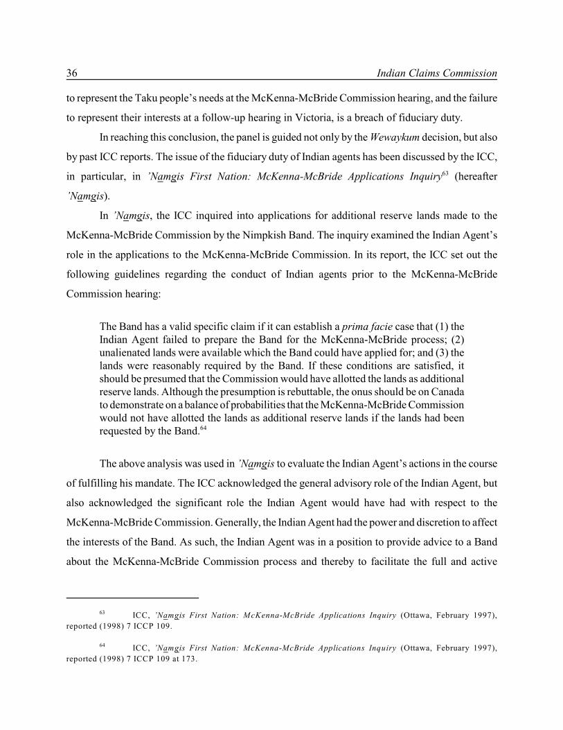
The panel concludes that the Taku River Tlingit claim is a specific claim, and that Canada’s participationin this inquiry would have been warranted.
The panel concludes that the Taku had a specific interest in Indian Town. Because Canada undertookto act on behalf of the Taku people in the reserve-creation process, Canada owed the First Nation a fiduciaryduty to act, in the words of Wewaykum, with “loyalty, good faith in the discharge of its mandate, providingfull disclosure appropriate to the subject matter, and acting with ordinary prudence with a view to the bestinterest of the aboriginal beneficiaries.”
With respect to the selection of reserve lands by the McKenna-McBride Commission, the panel findsthat Indian Agent W. Scott Simpson failed to fulfill his mandate to protect the Indians and advise themproperly. He failed to prepare the Taku River Tlingit First Nation properly to meet the Commission, andfailed to represent its interests at the hearings in Atlin and in Victoria. Implicit in these failures is a breachof fiduciary duty. With respect to the alienation of Wenah lands to private landholders, the panel has examined theactions of Indian Commissioner W.E. Ditchburn and Indian Agent Harper Reed, and concludes that theycould have pursued remedies for the First Nation through provincial legislation. However, the course ofaction chosen was to put the issue in abeyance. This action was a continuance of the initial breach of notsetting aside the Wenah village site in Atlin for the Taku River Tlingit.
With respect to the surrender of McDonald Lake IR 1 land, the panel finds the surrender valid;however, this surrender is deemed to be a direct result of the initial breach of the Crown’s duty. The Bandwas given only one option to acquire its village lands: to trade part of McDonald Lake reserve for the lotsin the village in Atlin. The basis for the surrender was part of the Crown’s original breach of its basicfiduciary duties.
RECOMMENDATION
That the specific claim of the Taku River Tlingit First Nation be accepted for negotiation.
REFERENCES
In addition to the various sources noted below, ICC inquiries depend on a base of oral and documentaryresearch, often including maps, plans, and photographs, that is fully referenced in the report.
viii Indian Claims Commission
Cases Referred ToGuerin v. The Queen, [1984] 2 SCR 335; Lac Minerals v. International Corona Resources Ltd., [1989] 2SCR 574; Frame v. Smith, [1987] 2 SCR 99; Hodgkinson v. Simms, [1994] 3 SCR 377; R. v. Sparrow, [1990]1 SCR 1075; Quebec (A.G.) v. Canada (National Energy Board), [1994] 1 SCR 159; M. (K) v. M. (H) (1992)96 DLR (4th) 289 at 326 (SCC); Blueberry River Indian Band v. Canada (sub nom. Apsassin), [1995] 4 SCR344; Osoyoos Indian Band v. Oliver (Town), [2001] 3 SCR 746; Ross River Dena Council Band v. Canada,[2002] 2 SCR 816; Wewaykum Indian Band v. Canada, [2002] 4 SCR 245.
ICC Reports Referred ToICC, Kluane First Nation: Kluane Game Sanctuary and Kluane National Park Reserve Creation InquiryInterim Ruling (Ottawa, December 2000), reported (2003) 16 ICCP 75; ICC, ’Namgis First Nation:Cormorant Island Inquiry (Ottawa, March 1996), reported (1998) 7 ICCP 3; ICC, ’Namgis First Nation:McKenna-McBride Applications Inquiry (Ottawa, February 1997), reported (1998) 7 ICCP 109; ICC,Mamaleleqala Qwe’Qwa’Sot’Enox Band: McKenna-McBride Applications Inquiry (Ottawa, March 1997),reported (1998) 7 ICCP 199.
Treaties and Statutes Referred ToLand Act RSBC 1911.
Other Sources Referred ToDIAND, Outstanding Business: A Native Claims Policy – Specific Claims (Ottawa: Minister of Supply andServices, 1982), reprinted (1994) 1 ICCP 171.
COUNSEL, PARTIES, INTERVENORS
A. Noda, A. Donovan for the Taku River Tlingit First Nation; J.B. Edmond, D. Kwan to the Indian ClaimsCommission.
The Taku River Tlingit First Nation will be referred in this report as the Taku, the Taku people, the1
Taku River people, the First Nation.
PART I
INTRODUCTION
The Taku River Tlingit First Nation traditionally lived in the northern areas of British Columbia,1
just south of the Yukon Territory. Many of the Taku River people’s village sites were established
around the Taku River, Nakina River, and Atlin Lake. The village site that is the subject of this claim
is known as Wenah and is located on the shore of Atlin Lake.
In 1898, as a result of the discovery of gold in the area and the influx of non-Aboriginal
miners in the ensuing gold rush, the townsite of Atlin was surveyed. This survey, which was
produced by Provincial Surveyor J.H. Brownlee, depicted an “Indian Village” at the southern end
of the townsite. In 1904, Gold Commissioner J.A. Fraser commissioned a second survey to enlarge
the townsite. This time, in place of the site noted previously by Brownlee as “Indian Village,” was
an area that had been subdivided into lots. The Taku River Tlingit continued to live at the Wenah
village site in Atlin following the surveys.
In 1916, when the Taku River Tlingit First Nation was allocated nine separate reserves by
the McKenna-McBride Commission, the lands comprising the “Indian Village” at Atlin were not
included in the lands set aside or reserved for the Taku people. Notwithstanding this omission, the
Taku continued to use the village site in Atlin. The continued residence of the Taku at the Indian
village site was brought to the attention of Indian Agent Harper Reed in 1928, but the matter was put
into abeyance. The issue came to light again in 1945, at which time it was investigated by Indian
Agent R.H.S. Sampson, who concluded that the Taku River Tlingit First Nation should have a
reserve in the Atlin townsite.
Canada’s attempts to acquire lands in Atlin in order to create a reserve for the First Nation
at its village site were carried out over a period of 20 years, from 1950 to 1970. Some of these lands
were acquired through a land exchange involving a surrender of a portion of McDonald Lake Indian
Reserve (IR) 1, and land purchases. Lots 1–6 of block 52 and lot 1 of block 53 were set aside as a
reserve and confirmed for the Taku River people as IR 10 in 1985.
2 Indian Claims Commission
Commission issued September 1, 1992, pursuant to Order in Council PC 1992-1730, July 27, 1992,2
amending the Commission issued to Chief Commissioner Harry S. LaForme on August 12, 1991, pursuant to Order in
Council PC 1991-1329, July 15, 1991.
Department of Indian Affairs and Northern Development (DIAND), Outstanding Business: A Native3
Claims Policy – Specific Claims (Ottawa: Minister of Supply and Services, 1982), 20; reprinted in (1994) 1 ICCP
171–85 (hereafter Outstanding Business).
On August 22, 1997, the Taku River Tlingit First Nation submitted the historical part of its
claim to the Specific Claims Branch of the Department of Indian Affairs and Northern Development
(DIAND); legal arguments followed on June 15, 1998. These arguments asserted that the federal
Crown failed to carry out its legal obligations with respect to the Taku River Tlingit First Nation and
its lands at Wenah. On October 29, 1998, the First Nation was informed by the Minister of Indian
Affairs and Northern Development that its “case does not fit within the criteria for Specific Claims”;
this rejection was confirmed by the Specific Claims Branch on January 15, 2001.
On June 18, 2002, the Taku River Tlingit First Nation requested that the Indian Claims
Commission (ICC) conduct an inquiry into its rejected specific claim. The request for inquiry was
accepted by the ICC on August 20, 2002. However, in November 2002, Canada took the position
that the claim fell outside of the Specific Claims Policy and refused to participate. In June 2003, the
ICC panel confirmed its mandate to conduct this inquiry, and, in September 2003, Canada provided
its documents to the ICC but advised that it would not participate any further in the inquiry. The
Taku River Tlingit First Nation proceeded with the inquiry without funding from Canada.
MANDATE OF THE COMMISSION
The mandate of the Indian Claims Commission is set out in federal Orders in Council providing the
Commissioners with the authority to conduct public inquiries into specific claims and to issue reports
on “whether a claimant has a valid claim for negotiation under the [Specific Claims] Policy where
the claim was already rejected by the Minister.” This Policy, outlined in DIAND’s 1982 booklet2
entitled Outstanding Business: A Native Claims Policy – Specific Claims, states that Canada will
accept claims for negotiation where they disclose an outstanding “lawful obligation” on the part of
the federal government. The term “lawful obligation” is defined in Outstanding Business as follows:3
Taku River Tlingit First Nation: Wenah Specific Claim Inquiry 3
Outstanding Business, 20; reprinted in (1994) 1 ICCP 179–80.4
The government’s policy on specific claims is that it will recognize claims by Indianbands which disclose an outstanding “lawful obligation,” i.e., an obligation derivedfrom the law on the part of the federal government.
A lawful obligation may arise in any of the following circumstances:
i) The non-fulfillment of a treaty or agreement between Indians and the Crown.ii) A breach of an obligation arising out of the Indian Act or other statutes
pertaining to Indians and the regulations thereunder.iii) A breach of an obligation arising out of government administration of Indian
funds or other assets.iv) An illegal disposition of Indian land.4
McDONALD LAKE 1
ALKHILI 2
ATLIN-TESLIN INDIAN CEMETERY 4
FIVE MILE POINT 3
SILVER SALMON LAKE 5
TAKU 6
TESLIN LAKE 9
JENNINGS RIVER 8
TESLIN LAKE 7
reviR
yalsehS
ATLIN
Na
hlin
R
iver
revi
R
nilse
T
anikaN R
iver
keerC e
nacirru
H
reviR ukaT
Teslin
LakeAtlin
Lake
Taku
Arm
reviO R 'D o n nel
revi
R
sg
nin
neJ
Surprise
Lake
Tagis
k
L
ake
BritishColumbia
Yukon
Alberta
NWT
Whitehorse
Atlin
Prince Rupert
Vancouver
Victoria
Claim Area MapMap 2
PART II
THE FACTS
The Taku River Tlingit First Nation has a long history in northern British Columbia, just south of
the Yukon Territory. Many of the Taku’s villages were established around the Taku River, Nakina
River, and Atlin Lake. The oral history of the Elders suggests that, at one time, the Taku occupied
the entire area around Atlin Lake.
By 1898, the way of life of the Taku would change. Gold had been discovered in the fields
surrounding Atlin Lake, drawing a vast number of settlers to the area. In response to the growing
population, the Province of British Columbia appointed Joseph Graham as the first Gold
Commissioner and Government Agent of Atlin.
The Taku, according to oral history, moved to a small area on the southern edge of the Atlin
townsite. Their presence was noted by Provincial Surveyor Brownlee, who completed an official
survey plan of Atlin in October 1899, depicting an Indian village. This Indian village, located on the
shore of Atlin Lake, is referred to as “Wenah” by the Taku River Tlingit. The use and occupation
of the village was reportedly confirmed by a “paper” given to Chief Taku Jack by Gold
Commissioner Graham. This paper has never been found.
In 1904, another survey of Atlin was completed by a provincial land surveyor named Taylor.
His survey did not note the “Indian Village” previously surveyed by Brownlee. Taylor’s survey
divided the Atlin townsite and surrounding area into lots and blocks. The area that Brownlee had
previously identified as an Indian village was subdivided into block 52 (lots 1–6), block 53
(lots 1–2), and block 54. These blocks were put up for sale by public auction in 1905. Only block 54
was sold at the auction, to the Northern Power & Lumber Company.
The Taku continued to live in their village in the Atlin townsite. Their request for a school,
reported in a 1906 letter to the Deputy Superintendent General of Indian Affairs, is the first time an
Indian band at Atlin is mentioned in correspondence. Around this time, the Stikine Agency of the
Department of Indian Affairs opened, with its first Indian Agent, G.D. Cox, appointed in 1906. Atlin
officially became part of the Stikine Agency in 1909–10.
Adding to the growing mix of settlers and Indians in the area were missionaries who also
made their way to Atlin. By July 1907, Father Joseph Allard, OMI, had established a Roman
6 Indian Claims Commission
J.A.J. McKenna and Richard McBride, Memorandum of Agreement, September 24, 1912, in Royal5
Commission on Indian Affairs for the Province of British Columbia, Final Report (Victoria, 1916) Book 1, 10–11 (ICC
Exhibit 1a, p. 43).
Catholic mission in Atlin. Father Allard also opened a day school and requested an education grant
from the Department of Indian Affairs, which he received annually until the school was closed in
1912.
The Department of Indian Affairs’ awareness of the Taku River Tlingit in Atlin grew
steadily. On July 17,1908, Superintendent A.W. Vowell and the Inspector of Indian Schools, A.H.
Green, visited the Atlin day school operated by the Oblates. Vowell also reported that, according to
Chief Taku Jack, there were 86 Taku band members living in Atlin. In his annual report, Vowell
wrote that a reserve was required in Atlin.
In July 1909, Indian Agent Cox visited the town and provided a description and population
count of the Atlin Band in his April 13, 1910, annual report. Cox was succeeded by W. Scott
Simpson, in August 1911. Simpson reported in his 1912 annual report that he had not been able to
visit Atlin.
In 1912, the McKenna-McBride Commission was established “to settle all differences
between the Governments of the Dominion and the Province respecting Indian lands and Indian
Affairs generally in the Province of British Columbia.” When British Columbia joined5
Confederation in 1871, the province retained control of its lands and natural resources, and agreed
to convey land to the dominion for the use and benefit of Indians as required. Between 1876 and
1912, a series of commissions had addressed the Indian lands issue. The McKenna-McBride
Commission was intended to facilitate the final resolution of the Indian lands question and, to this
end, it travelled throughout the province, setting aside lands for reserve purposes.
In 1914, the Secretary of the McKenna-McBride Commission requested information from
the Indian Agent at the Stikine Agency regarding his agency. Indian Agent Simpson advised that the
Taku did not have a reserve. At around the same time, friction between the settlers in Atlin and Taku
River Tlingit prompted the Atlin Board of Trade to write to the McKenna-McBride Commission in
February 1915 and request, on behalf of the settlers of Atlin, the removal of the Taku from the
townsite.
Taku River Tlingit First Nation: Wenah Specific Claim Inquiry 7
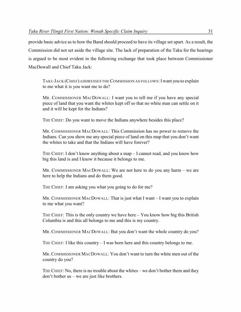
When Commissioner D.H. MacDowall of the McKenna-McBride Commission arrived in
Atlin in June 1915, he met with the Board of Trade, as well as with Chief Taku Jack. The Board of
Trade confirmed that they wanted the Taku removed from the townsite as they felt it was not
desirable to have Indians living in the centre of town. Indian Agent Simpson had advised that the
Taku were reluctant to move from Atlin. The next day, Commissioner MacDowall interviewed the
Chief of the Atlin Band. MacDowall explained to Chief Taku Jack that the government wanted to
give the Indians their first choice of land; otherwise, some day the white man would take it. Chief
Taku Jack, however, replied that the government had no land to give to the Indians because it already
belonged to them. By the time Commissioner MacDowall left Atlin, the McKenna-McBride
Commission had allotted nine reserves to the Taku River Tlingit, but none of these reserves included
the Wenah village site in Atlin.
Following up on the Commission’s hearings, Indian Agent Simpson met with the
Commissioners in Victoria in January 1916. The nine parcels of land that had been set aside for the
Taku were reviewed. Eight of the parcels were within British Columbia, and one was for land in the
Yukon Territory. Simpson did not mention that the Atlin Indians lived within the Atlin townsite, or
suggest that the land they lived on there should be reserved for them. The minutes of decision of the
McKenna-McBride Commission, dated April 1916, confirmed all eight of the BC reserves suggested
by Indian Agent Simpson, as well as an additional three-acre reserve covering the graveyard near
Atlin. No reserves were recommended for the land occupied by the Atlin Indians within the Atlin
townsite.
On July 23, 1923, Provincial Order in Council 911 was passed, confirming the McKenna-
McBride Commission reserve allotments. No changes were made to the existing reserves confirmed
in 1916 for the “Atlin (Teslin Lake)” Band, and no new reserves were created for them at that time.
Although the Taku did not have a reserve set aside for them in the Atlin townsite, they
continued to live in their village, in the face of more settlers moving in and obtaining Crown grants
to the land. From 1923 to 1926, Crown grants were issued on lots 1 and 2 of block 53, and on
block 54. The Taku asked Indian Agent Harper Reed about their legal standing with respect to the
land in their village. Reed then advised Indian Commissioner W.E. Ditchburn, adding that the Taku
had been living on the land before the townsite was surveyed. Ditchburn, however, believed that
8 Indian Claims Commission
Reed was mistaken, based on information he had obtained from the Provincial Lands Branch, which
did not acknowledge the Taku in Atlin.
Indian Commissioner Ditchburn outlined two options for the Taku band members living in
Atlin – either purchase the lots or move to their reserve located at Five Mile Point. Reed had inquired
about purchasing the lots for reserve purposes, but he was advised that a provincial ruling prevented
the sale of land to Indians. The matter was put into abeyance, and no further investigation was
undertaken by Reed.
The question of the Taku’s right to its village in Atlin remained in abeyance from 1928 until
1945, when a band member was refused funding to repair her house on the basis that it was not
located on reserve land. Indian Agent R.H.S. Sampson investigated the matter and originally
concluded that the Taku people living in the townsite should be moved to the Five Mile Point
reserve. When the Taku refused to move, Indian Agent Sampson completed a more thorough
investigation of its history in Atlin. He reported that the village was a permanent camp from which
parties hunted and fished, and, at the time of the first survey, the Atlin Indians had brush huts or
wigwams on the Indian townsite. Sampson also stated that the Indians had protested the disturbance
by the surveyor and requested recognition of their rights to the Indian village site. He subsequently
concluded that the Taku should have a reserve in Atlin, and, furthermore, that they should have had
their village site set aside by the McKenna-McBride Commission. He reported his findings to Indian
Commissioner W.S. Arneil.
Following this report, the Department of Indian Affairs began negotiations with the province
to acquire the land and establish the area as a reserve. The province, however, refused to transfer the
land because the Atlin Board of Trade was opposed to a reserve in the townsite. In 1949, the
province sold lots 4, 5, and 6 of block 52 to private purchasers. Over the next decade, the
Department of Indian Affairs’ attempts to acquire the lots in the Wenah village site were continually
opposed by the province.
In 1958, the proposal to acquire lots 1, 2, and 3 of block 52 in exchange for the surrender of
a portion of reserve land was raised. The Department of Indian Affairs met with the Taku who
apparently agreed to the exchange. The province also agreed to the exchange of reserve lands for
lots 1, 2, and 3 in block 52.
Taku River Tlingit First Nation: Wenah Specific Claim Inquiry 9
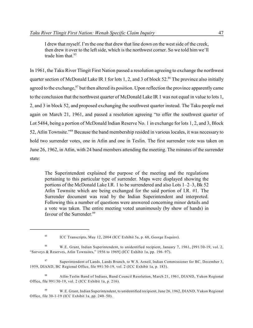
In 1961, the Taku passed a resolution agreeing to exchange the northwest quarter section of
McDonald Lake IR 1 for lots 1, 2, and 3 of block 52. However, the province believed that the
northwest quarter was not equal in value to lots 1, 2, and 3 in block 52, and proposed exchanging
the southwest quarter instead. The Taku met again, and another resolution was passed on March 21,
1961, agreeing to offer the southwest quarter.
Because the band membership resided in various locales, it was necessary to hold two
surrender votes, one in Atlin and one in Teslin. The first surrender vote was taken on June 26, 1962,
in Atlin, with 24 band members attending the meeting. The second surrender vote was taken on
June 27, 1962, in Teslin, with 19 band members attending the meeting. Minutes of the surrender vote
stated that the entire membership voted unanimously by a show of hands in favour of the surrender.
Henry T. Jack and George Jack signed the surrender form, and the surrender affidavit was
confirmed by Order in Council 1963-479 on March 25, 1963. Order in Council 1963-927 was passed
on June 20, 1963, transferring the surrendered land at McDonald Lake to the province, and on
October 22, 1963, provincial Order in Council 2675 was passed, transferring lots 1, 2, and 3,
block 52, to the federal government, for the purpose of creating a reserve in the Atlin townsite for
the Taku.
The federal government had also purchased some of the lots in Atlin. In 1961, Canada
purchased the southeast portion of lot 1 (parcel A), block 53, from the church. Also, in 1970, lots 4,
5, and 6 of block 52 were purchased. Finally, in 1985, lots 1–6 of block 52 and lot 1 (parcel A) of
block 53 were set aside as a reserve and confirmed for the Atlin Band as IR 10 by Order in Council
1985-472.
PART III
ISSUES
The Indian Claims Commission is inquiring into the following three issues:
Issue 1: Did Canada have a fiduciary or statutory obligation or duty of care to the Taku RiverTlingit First Nation (the “TRTFN”) in any of the following circumstances:
i) the selection of reserve lands by the McKenna-McBride Commission;ii) the alienation of Wenah lands to private landholders; andiii) the surrender of a portion of McDonald Lake Indian Reserve No. 1.
Issue 2: If Canada had a fiduciary or statutory obligation or duty of care with respect toanything in issue one, did Canada breach this obligation?
Issue 3: Did Canada breach a lawful obligation within the meaning of the Specific ClaimsPolicy?
PART IV
ANALYSIS
The Taku River Tlingit First Nation’s original claim submission states that the Crown failed to fulfill
its legal obligations to the Taku people with respect to the lands located at the Wenah village site.
More specifically, the First Nation argues that pre-reserve–creation fiduciary duties were breached
by the Indian Agent during the McKenna-McBride Commission hearings when the Indian Agent
failed to have the Wenah village site set aside for the Taku. This inquiry, therefore, focuses
primarily, but not solely, on the actions of the Indian Agent during the McKenna-McBride
Commission hearings with respect to blocks 52, 53, 54, and lots 6351 and 6353. Block 52 and lot 1,
parcel A, of block 53 were confirmed as IR 10 in 1985; the remainder of block 53, block 54, and
lots 6351 remain at issue. As Canada is not participating, and Issue 3 in the inquiry addresses the
jurisdiction of the ICC, this issue will be dealt with first.
ISSUE 3: LAWFUL OBLIGATION UNDER THE SPECIFIC CLAIMS POLICY
Did Canada breach a lawful obligation within the meaning of the SpecificClaims Policy?
Canada has refused to participate in this inquiry. Nevertheless, the panel is required, in this issue,
to examine the basis of the Taku River Tlingit First Nation’s claim, and determine whether the
Commission has jurisdiction to conduct an inquiry.
Canada’s Refusal to Participate in the Inquiry
Canada has alleged that the First Nation’s claim is based on unextinguished Aboriginal title and, as
a result, has refused to participate in this inquiry. In a letter dated November 12, 2002, legal counsel
for Canada advised:
[A]fter reviewing the submission of the Taku River Tlingit First Nation, we are ofthe view that every aspect of the claim is based upon unextinguished aboriginal titleto land. As you are aware, the Outstanding Business Policy explicitly states thatclaims based “on traditional Native use and occupancy of land” are designated ascomprehensive claims.
14 Indian Claims Commission
Kevin McNeil, Counsel for Canada, to Denielle Boissoneau-Thunderchild, Associate Counsel, Indian6
Claims Commission (ICC), November 12, 2002 (ICC file 2109-29-1).
Kevin McNeil, Counsel for Canada, to Alisa Noda, Counsel for the TRTFN, January 29, 2003 (ICC7
file 2109-29-1).
Mme Renée Dupuis, Daniel Bellegarde, and Sheila Purdy, ICC, to Alisa Noda, Counsel for the8
TRTFN, and Kevin McNeil, Counsel for Canada, June 3, 2003 (ICC file 2109-29-1).
In the circumstances, we are not in a position to participate in this inquiry. Webelieve the ISCC should decline to hear the matter given the concerns raised above.6
In a letter dated January 29, 2003, legal counsel for Canada further advised:
Canada’s primary position is that the claim presented does not fit within the criteriafor a claim under Canada’s Specific Claims Policy. The claim of the Taku RiverTlingt First Nation to Wenah is premised on a claim of “unextinguished native title.”... [F]iduciary duties do not exist at large but in relation to a specific Indian interest(see Weywaykum Indian Band v. Canada [2002] SCC 79). The allegations listed inthe issues presented by the First Nation to the ISCC are allegations of breaches offiduciary and statutory duties related to and dependent upon an Indian interest of“unextinguished native title.” In other words, we cannot proceed to determine thelisted breaches of fiduciary and statutory duties without a determination of the Indianinterest in issue.7
Canada continued to confirm its position on non-participation in the inquiry in a conference
call on February 20, 2003, and questioned the ICC’s mandate to conduct an inquiry into this claim.
The panel confirmed its mandate to conduct the inquiry on June 3, 2003:
After careful consideration of the exchange of correspondence between the partiesand a review of the conference call summaries wherein Canada made clear that theissues being advanced to the Indian Claims Commission by the Taku River TlingitFirst Nation as of November 13, 2002, are not issues that are currently beingnegotiated at the Comprehensive Claims negotiation table, the Commission isprepared to proceed with this Inquiry into the Wenah Lands specific claim of theTaku River Tlingit First Nation. While we understand Canada has taken the positionnot to participate in any aspect of this Inquiry, we continue to welcome Canada’sassistance in our review.8
Taku River Tlingit First Nation: Wenah Specific Claim Inquiry 15
Written Submissions on Behalf of the Taku River Tlingit First Nation, August 12, 2004, p. 88.9
Wenah village is also referred to as Indian Town in this report.10
ICC Transcript, August 12, 2004 (p. 18, Alisa Noda).11
ICC Transcript, August 12, 2004 (p. 16, Allan Donovan).12
Canada provided its documents and final confirmation of non-participation in September
2003.
The First Nation’s Definition of Its Claim
Although Canada has alleged that the First Nation’s claim is based on unextinguished Aboriginal
title, the First Nation has stated that the basis of its claim is the failure of Canada to “challenge the
illegal alienations of the Wenah village as they took place over the decades ...”9
The specific claim for the Wenah village was identified during the oral session as including10
blocks 52, 53, 54, and lot 6351. Although block 52 and a part of block 53 became a reserve in11
1985, it is argued that these lands should have been set aside earlier. The Taku River Tlingit First
Nation acknowledges that Wenah falls within its traditional territories, and that it is involved in
treaty negotiations concerning those larger lands. The issues that form the subject matter of its
specific claim, however, concern actions and inactions which the First Nation asserts transpired in
the pre-reserve context of the 1900s, and which specifically concern the lands comprising blocks 52,
53, 54, and lot 6351. The First Nation argues:
As it is, the evidence focuses on Canada’s breaches in the 1900s, breaches at a timewhen the TRT was particularly vulnerable to the discretion of the Indian Agent toprotect their communities, to advance their interests before the McKenna-McBrideCommission.12
The Taku River Tlingit’s specific claim thus alleges a breach of the fiduciary duty owed by
the Crown through its Indian Agent to the First Nation before the creation of reserves – a fiduciary
duty of loyalty, good faith, full disclosure appropriate to the subject matter, and ordinary diligence.
16 Indian Claims Commission
ICC Transcript, August 12, 2004 (p. 24, Allan Donovan).13
Commission issued September 1, 1992, pursuant to Order in Council PC 1992-1730, July 27, 1992,14
amending the Commission issued to Chief Commissioner Harry S. LaForme on August 12, 1991, pursuant to Order in
Council PC 1991-1329, July 15, 1991.
Outstanding Business, 20; reprinted in (1994) 1 ICCP 171 at 179.15
Outstanding Business, 20; reprinted in (1994) 1 ICCP 171 at 179.16
According to the First Nation, the Indian Agent failed “to protect settlement lands from alienation”
and failed to properly represent the First Nation before the McKenna-McBride Commission.13
Analysis of the ICC’s Jurisdiction
The Indian Claims Commission was established and given its mandate by order of the Governor in
Council on September 1, 1992. Drawing its authority to conduct inquiries from the Inquiries Act, the
ICC’s enabling Order in Council states:
that our Commissioners on the basis of Canada’s Specific Claims Policy ... byconsidering only those matters at issue when the dispute was initially submitted tothe Commission, inquire into and report on:
(a) whether a claimant has a valid claim for negotiation under the Policy wherethat claim has already been rejected by the Minister; and
(b) which compensation criteria apply in negotiation of a settlement, where aclaimant disagrees with the Minister’s determination of the applicablecriteria.14
In conducting an inquiry, the ICC must assess whether Canada breached an outstanding lawful
obligation to the First Nation, and thus whether the First Nation may be seen to have a specific15
claim against the Crown for that breach.
The Specific Claims Policy is outlined in a 1982 DIAND publication entitled Outstanding
Business: A Native Claims Policy – Specific Claims. This Policy identifies a “lawful obligation” as
a breach of a treaty, statute, or agreement, a breach arising from the administration of Indian funds
or assets, or an illegal disposition of land. Claims of this type are distinguished from claims based16
on unextinguished Aboriginal title. These latter claims are excluded from consideration as a specific
claim and must instead be expressed within the federal government’s comprehensive claims policy.
Taku River Tlingit First Nation: Wenah Specific Claim Inquiry 17
Indian Claims Commission, Kluane First Nation: Kluane Game Sanctuary and Kluane National Park17
Reserve Creation Inquiry Interim Ruling (Ottawa, December 2000), reported (2003) 16 ICCP 75; ICC, ’Namgis First
Nation: Cormorant Island Inquiry (Ottawa, March 1996), reported (1998) 7 ICCP 3; ICC, ’Namgis First Nation:
In some cases, the parties may disagree with the Commission’s execution of its mandate, and
the ICC process allows for formal challenges to its mandate to conduct an inquiry. Canada has17
chosen not to press its objection to the ICC’s jurisdiction through a formal mandate challenge,
focusing instead on its view of the Taku River claim as comprehensive, rather than specific. The
ICC’s mandate has, however, faced previous challenges on this very question, including most
notably that which arose in regard to Kluane First Nation’s inquiry. On that occasion, the ICC stated
the following:
In our view, the general intent of In All Fairness [the Comprehensive Claims Policy]is to establish a framework for the negotiation of settlements of aboriginal landclaims in Canada. The policy refers repeatedly to the essence or “thrust” ofcomprehensive claims being the exchange of “general and undefined Native title”and “undefined aboriginal land rights” for “concrete rights and benefits.” It seemsapparent from our review of the policy as a whole that comprehensive claimsencompass those issues arising as a matter of the existence and content of aboriginalrights or title rather than grievances resulting from Canada’s past conduct ... Canadadeveloped the Comprehensive Claims Policy to deal with the exchange of rights, andthen dealt with the residual conduct-related claims in Outstanding Business....
... In our opinion, where a claim involves a grievance arising out of Canada’sconduct in a specific, isolated incident, the presence of unextinguished aboriginalrights or title is merely incidental to the overall claim. In such circumstances, in ourview, the claim cannot be said to be based on unextinguished aboriginal rights or titleand will not fall within the exclusive purview of the Comprehensive Claims Policy.The very essence of the Specific Claims Policy is the resolution of these types ofhistorical grievances.
Historical grievances of this nature are to be distinguished from cases inwhich the parties are exchanging undefined aboriginal land rights for concrete rightsand benefits. In such cases, which turn on the existence and content of aboriginalrights or title, the claims can be said to be “based on unextinguished native title”within the meaning of guideline 7 [of Outstanding Business], and on this basis theylie outside the Specific Claims Policy – meaning that the comprehensive claimsprocess is clearly at play. Such claims are based upon unextinguished native titlebecause they involve, at least to some extent, the surrender or relinquishment of all
18 Indian Claims Commission
ICC, Kluane First Nation: Kluane Game Sanctuary and Kluane National Park Reserve Creation18
Inquiry Interim Ruling (Ottawa, December 2000), reported (2003) 16 ICCP 75 at 92, 108. Emphasis in original.
or some aspects of a First Nation’s undefined aboriginal land rights – includingperhaps the First Nation’s traditional use and occupancy of some parts of the land –in exchange for the sort of concrete rights and benefits contemplated by agreementslike the Yukon Umbrella Agreement and its band-specific final agreements.18
Even if the Taku River Tlingit First Nation’s claim is viewed as entailing issues of traditional use
and occupancy, the panel is prepared to conclude, as in the Kluane report, that the presence of these
issues is incidental to the fundamental question of whether Canada’s actions through its Indian Agent
at the McKenna-McBride Commission constituted a specific breach of Canada’s fiduciary
obligations to the First Nation. As a result, the panel confirms that the specific claim of the Taku
River people is based on an allegation of a breach of fiduciary duties owed by the Crown to the Taku
River Tlingit First Nation through its Indian Agent prior to the creation of the reserve. Given this
finding, the ICC has the jurisdiction to conduct an inquiry into this claim.
The panel regrets that Canada did not formally challenge the ICC’s exercise of jurisdiction
in this inquiry. Essentially, an ICC inquiry is an alternative process to court action in which specific
claims can be addressed. If the ICC’s jurisdiction in an inquiry is in question, then that question can
and should be dealt with through due process. This process includes filing a formal challenge to the
ICC’s jurisdiction before the Commission, providing submissions, and receiving a ruling from the
panel. If there is further disagreement, one of the parties may seek judicial review in the Federal
Court.
Canada’s refusal to challenge the ICC’s mandate in this claim, resulting in the First Nation
proceeding before the ICC with neither funding nor the benefit of Canada’s arguments, undermines,
in our view, the mandated process. It is incumbent on the Government of Canada to demonstrate a
high level of good faith in its approach to the ICC’s inquiries and a willingness to follow its process.
Canada’s refusal to formally challenge the ICC’s mandate in this inquiry and the subsequent denial
of funding to the Taku reflects a lack of commitment to the full and just resolution of claims.
Taku River Tlingit First Nation: Wenah Specific Claim Inquiry 19
Guerin v. The Queen, [1984] 2 SCR 335.19
ISSUE 1: CANADA’S FIDUCIARY OR STATUTORY OBLIGATIONS TO THE TAKU RIVER
TLINGIT FIRST NATION
Did Canada have a fiduciary or statutory obligation or duty of care to the TakuRiver Tlingit First Nation (the “TRTFN”) in any of the following circumstances:
i) the selection of reserve lands by the McKenna-McBride Commission;ii) the alienation of Wenah lands to private landholders; andiii) the surrender of a portion of McDonald Indian Reserve No. 1.
The First Nation argues that Canada has a lawful obligation to the Taku people based on breach of
fiduciary duty, breach of statutory duty, or breach of duty of care. These sources of lawful obligation
can be framed in the alternative. That is, in order to find a breach of lawful obligation, it is only
necessary to base the breach on one ground of liability, whether fiduciary, statutory, or duty of care.
Thus, for example, if a breach based on fiduciary duty is found, it will not be necessary to examine
the other grounds.
In examining whether or not a breach of fiduciary duty exists, the panel must answer the
following questions:
1 What is the nature of the fiduciary relationship between the Crown and First Nations?
2 Did the fiduciary relationship between the Crown and the Taku give rise to a fiduciary dutyowed to the Taku?
The analysis in this section will proceed with a view to answering these questions.
The Fiduciary Relationship between the Crown and First Nations
The fiduciary relationship between the Crown and First Nations was first acknowledged by the
Supreme Court of Canada in Guerin v. The Queen. In this case, the Musqueam Band surrendered19
reserve land for lease to a golf club; however, the Band later learned that the terms of the lease
obtained by the Crown were significantly different from those the Band had agreed to and were less
favourable. The Court unanimously found that, by unilaterally changing the terms of a lease
20 Indian Claims Commission
Guerin v. The Queen, [1984] 2 SCR 335 at 376.20
Guerin v. The Queen, [1984] 2 SCR 335 at 384.21
Lac Minerals v. International Corona Resources Ltd., [1989] 2 SCR 574: dependency or vulnerability22
as an essential element indicating a fiduciary relationship. Frame v. Smith, [1987] 2 SCR 99: exercise of discretion or
power; unilateral exercise of power; and vulnerability of the beneficiary. The beneficiary is subject to discretionary uses
of power as another element characterizing a fiduciary relationship. Hodgkinson v. Simms, [1994] 3 SCR 377: reasonable
expectations of one party expecting another party to act in their best interests may also characterize a fiduciary
relationship.
originally agreed to by the Band, Canada had breached its duty to the Band. Dickson J, with the
concurrence of Beetz, Chouinard, and Lamer JJ, stated the following regarding fiduciary principles:
In my view, the nature of Indian title and the framework of the statutory schemeestablished for disposing of Indian land places upon the Crown an equitableobligation, enforceable by the courts, to deal with the land for the benefit of theIndians. This obligation does not amount to a trust in the private law sense. It israther a fiduciary duty. If, however, the Crown breaches this fiduciary duty it will beliable to the Indians in the same way and to the same extent as if such a trust were ineffect.
The fiduciary relationship between the Crown and the Indians has its roots inthe concept of aboriginal, native or Indian title. The fact that Indian bands have acertain interest in lands does not, however, in itself give rise to a fiduciaryrelationship between the Indians and the Crown. The conclusion that the Crown isa fiduciary depends upon the further proposition that the Indian interest in the landis inalienable except upon surrender to the Crown.20
In identifying a fiduciary relationship, Dickson J quoted Professor E.J. Weinrib’s statement that “the
hallmark of a fiduciary relation is that the relative legal positions are such that one party is at the
mercy of the other’s discretion.” This description has been supported in other Supreme Court of21
Canada judgments.22
The concept of a fiduciary duty in the context of the relationship between the Crown and
Aboriginal peoples was further explained in R. v. Sparrow, [1990] 1 SCR 1075, to include
Aboriginal and treaty rights in section 35 of the Constitution Act, 1982. This case dealt with
Aboriginal fishing rights, and whether a legislative restriction in the federal Fisheries Act was
contrary to section 35 of the Constitution Act, 1982. Dickson CJ and LaForest J wrote:
Taku River Tlingit First Nation: Wenah Specific Claim Inquiry 21
R. v. Sparrow, [1990] 1 SCR 1075 at 1108, [1990] 3 CNLR 160, Dickson CJ and LaForest J. 23
Quebec (A.G.) v. Canada (National Energy Board), [1994] 1 SCR 159 at 183; M. (K) v. M. (H) (1992),24
96 DLR (4th) 289 at 326 (SCC).
Blueberry River Indian Band v. Canada (sub nom. Apsassin), [1995] 4 SCR 344. In a concurring25
judgment, McLachlin J observed that, prior to consenting to a surrender proposed by an Indian Band, the Crown has a
fiduciary duty limited to preventing exploitative bargains (at 371).
Guerin v. The Queen, [1984] 2 SCR 335.26
Osoyoos Indian Band v. Oliver (Town), [2001] 3 SCR 746.27
R v. Sparrow, [1990] 1 SCR 1075.28
Ross River Dena Council Band v. Canada, [2002] 2 SCR 816.29
Wewaykum Indian Band v. Canada, [2002] 4 SCR 245.30
In our opinion, Guerin, together with R. v. Taylor and Williams (1981), 34 O.R. (2d)360, [1981] 3 C.N.L.R.114, ground a general guiding principle for s. 35(1). That is,the Government has the responsibility to act in a fiduciary capacity with respect toaboriginal peoples. The relationship between the Government and aboriginals istrust-like, rather than adversarial, and contemporary recognition and affirmation ofaboriginal rights must be defined in light of this historic relationship.23
Although the courts have recognized that a fiduciary relationship exists between the Crown and
Aboriginal people, they have also noted that not all aspects of the fiduciary relationship will give rise
to fiduciary obligations. The Supreme Court of Canada has recognized certain fiduciary obligations24
on the Crown that arise prior to a surrender of reserve lands, following a surrender of reserve25
lands, before the expropriation of reserve lands, or as a result of the regulation or infringement26 27
of a constitutionally protected Aboriginal or treaty right. 28
Wewaykum Indian Band v. Canada
In 2002, the Supreme Court recognized the existence of a fiduciary duty in relation to reserve
creation in Ross River Dena Council Band v. Canada, and, more importantly, in Wewaykum Indian29
Band v. Canada. While Wewaykum deals specifically with reserve creation in British Columbia,30
the case is also the Supreme Court of Canada’s most recent statement regarding the
Crown/Aboriginal fiduciary relationship, and when this relationship gives rise to a fiduciary duty.
22 Indian Claims Commission
Wewaykum Indian Band v. Canada, [2002] 4 SCR 245 at 286–87. Emphasis added.31
Wewaykum Indian Band v. Canada, [2002] 4 SCR 245 at 288.32
Wewaykum Indian Band v. Canada, [2002] 4 SCR 245 at 288.33
In Wewaykum, two different bands claimed each other’s reserve or compensation from the
Crown over the allocation of the reserves. The Supreme Court of Canada dismissed the appeals of
both bands. In so doing, the Court said the following regarding fiduciary law in the context of reserve
creation:
The fiduciary duty imposed on the Crown does not exist at large but in relation tospecific Indian interests. In this case, we are dealing with land, which has generallyplayed a central role in aboriginal economies and cultures ... Fiduciary protectionaccorded to Crown dealings with aboriginal interests in land (including reservecreation) has not to date been recognized by this Court in relation to Indian interestsother than land outside the framework of s. 35(1) of the Constitution Act, 1982.31
It is clear that, as a prerequisite to a fiduciary duty in relation to land, a band must first prove that it
has a specific interest in the land that is the subject of the dispute.
The Court went on to affirm the principle that “not all obligations existing between the
parties to a fiduciary relationship are themselves fiduciary in nature.” Therefore, with respect to the32
relationship between the Crown and Aboriginal peoples, it is necessary “to focus on the particular
obligation or interest that is the subject matter of the particular dispute and whether or not the Crown
had assumed discretionary control in relation thereto sufficient to ground a fiduciary obligation.”33
In other words, if a band proves that it has a specific interest in land, it must then prove, in a situation
of reserve creation, that the Crown assumed the responsibility of acting on behalf of the band in that
process.
Mr Justice Binnie, speaking for the Court, then defined the content of the fiduciary duty in
relation to the bands’ interest in specific lands subject to a reserve-creation process, and in relation
to which the Crown became the exclusive intermediary with the BC government:
Taku River Tlingit First Nation: Wenah Specific Claim Inquiry 23
Wewaykum Indian Band v. Canada, [2002] 4 SCR 245 at 289–90.34
Wewaykum Indian Band v. Canada, [2002] 4 SCR 245 at 292.35
Wewaykum Indian Band v. Canada, [2002] 4 SCR 245 at 291.36
Wewaykum Indian Band v. Canada, [2002] 4 SCR 245 at 294.37
Wewaykum Indian Band v. Canada, [2002] 4 SCR 245 at 293.38
Prior to reserve creation, the Crown exercises a public law function under the IndianAct – which is subject to supervision by the courts exercising public law remedies.At that stage a fiduciary relationship may also arise but, in that respect, the Crown’sduty is limited to the basic obligations of loyalty, good faith in the discharge of itsmandate, providing full disclosure appropriate to the subject matter, and acting withordinary prudence with a view to the best interest of the aboriginal beneficiaries.34
Of particular importance to the Taku First Nation’s specific claim is the recognition in Wewaykum
of a fiduciary duty imposed on the Crown in relation to a specific or cognizable Indian interest. That
interest was identified in Wewaykum as the land occupied by the bands. Also relevant to the Taku’s
claim was the Court’s recognition that, during the reserve-creation process, “the Crown constituted
itself the exclusive intermediary with the province.” Mr Justice Binnie described the bands as being35
“entirely dependent on the Crown to see the reserve-creation process through to completion.” 36
The Court concluded that the nature of the bands’ interest in the lands that were subject to
the reserve-creation process, and the Crown’s intervention as exclusive intermediary, triggered a
fiduciary duty on the Crown. The content of that duty to the Aboriginal peoples, as the Court stated
above, was to act “with loyalty, good faith, full disclosure appropriate to the subject matter and with
‘ordinary’ diligence in what it reasonably regarded as the best interest of the beneficiaries.”37
The Court cautioned, however, that consideration must be given to the context of the time
and the likelihood of the Crown facing conflicting demands. The Court stressed that, prior to reserve
creation, the Crown is no ordinary fiduciary but must “have regard to the interest of all affected
parties, not just the Indian interest.” This would seem to imply that the Crown must balance its38
obligations to First Nations and others in the reserve-creation process.
24 Indian Claims Commission
Application of Pre-Reserve–Creation Fiduciary Duties to the TRTFN Claim
On the basis of Wewaykum, the following questions must be answered: first, did the Taku people
have a specific interest in the land that was subject to the reserve-creation process in British
Columbia, and second, did the Crown assume responsibility as the exclusive intermediary to deal
with the province and others on behalf of the Band? If the answer to these two questions is yes, then
it follows that the Crown had a fiduciary duty to act in accordance with the standards of loyalty and
good faith set out in Wewaykum. At the same time, however, Wewaykum also confirms that the
Crown was entitled to have regard for competing interests in meeting its fiduciary duty to the Taku
River Tlingit First Nation. Thus, if a fiduciary duty is found on the facts of this claim, the panel must
answer a third question in considering the allegations of breach of fiduciary, namely, did the Crown
properly balance the competing interests of the Taku, the province, and the settlers in Atlin?
The First Nation alleges that the Wenah village site, also known as Indian Town, should have
been allotted as a reserve by the McKenna-McBride Commission. It is also further alleged that the
Taku people had a specific interest in the lands of the Wenah village site or Indian Town.
During the community session held on May 12, 2004, Elders provided oral history that
suggested Taku people had occupied the entire town of Atlin, as well as parts of the surrounding
areas, at one time. However, following the gold rush, it appears that the members of the Taku River
Tlingit community were pushed to the far reaches of their traditional village site to the area along
the south shore of the lake. According to Antonia Jack, the daughter of Chief Taku Jack, who was
Chief of the Taku people in the 1900s:
And the time that they start pushing them away from here is when the gold rush went.It’s the native people that found that gold too when they went down to Juneau, theyshow it around, and that’s how the white people came, and they had a gold rush. Andthat’s what you call a real rush. They pushed all the native people out of their way toget to the gold, and they started to keep that place, to stay there and put up their tentsor whatever they’re doing. They don’t care who they push out of their way.
And after a while when everything started to seem to settle down a bit, thegovernment moved in. The policemen, the government building, the people that usedto work there. There was only the policemen and the man they call himcommissioner, gold commissioner, they called him. That’s the one that they used to– that building, I think that’s the same building that’s sitting down there.
Taku River Tlingit First Nation: Wenah Specific Claim Inquiry 25
ICC Transcript, May 12–13, 2004 (ICC Exhibit 5a, p. 41, Antonia Jack).39
“La croix dans les Rocheuses,” Rev. Father Jules Le Chevallier, OMI, undated, Deschâtelets Archives,40
Ottawa, HPK 5006.B86C (ICC Exhibit 13h, p. 415 [translation]).
That’s when they start pushing the native people out of there. They pushedthem out of that place where they used to live down there. And they got thepolicemen after them and everything. Finally they pushed them out and they pushedthem over there where they are now. That’s where they pushed them. And they hadto just stay there.
After they were staying there finally my dad was the one that was – was theonly one that was fighting not to see the people get pushed around like that. Finallythey got after – because when this place was getting full with white people, they’retrying to push the native people from that place where we are now.39
This evidence is reinforced by the report of Father Joseph Allard, an Oblate missionary, who
described the location of Indian Town in Atlin in his journal:
[translation][A number of miners took him up on his invitation,] as did a group of Tlingit Indians,whose village sat on a point jutting out into the lake and was separated from the townof Atlin by a small creek.40
Although Taylor’s 1904 survey of Atlin did not note the existence of the “Indian Village Site”
recorded by J.H. Brownlee’s 1899 survey, all the evidence of the time establishes that, by the most
conservative estimate, the Taku people had permanently settled in the area of Atlin they currently
occupy as of 1907. As a result and in answer to the first question, the panel finds that the Taku has
a specific, cognizable interest in the area.
The second question requires the panel to determine whether the Crown acted exclusively
on behalf of the Band; to do so, we must investigate the evidence relating to the Crown’s knowledge
of the Taku, including the earliest presence of an Indian Agent in the area. Our starting point is 1906,
when the first Indian Agent, G.D. Cox, was appointed to the Stikine Agency, whose jurisdiction
included Atlin. In the documentary record, there is correspondence addressed to the Deputy
Superintendent General of Indian Affairs stating that, “in July 1906, Mr. School Inspector Green
reported to Superintendent Vowell that the Indians at Atlin were asking for a school for their children
26 Indian Claims Commission
Martin Benson to DSGIA, February 11, 1908, Library and Archives Canada (LAC), RG 10, vol. 6384,41
file 801-1, pt 1 (ICC Exhibit 13a, p. 1).
Martin Benson to DSGIA, February 11, 1908, LAC, RG 10, vol. 6384, file 801-1, pt 1 (ICC42
Exhibit 13a, p. 1).
William Sloan, House of Commons, to Frank W. Pedley, DSGIA, January 16, 1908, LAC, RG 10,43
A.W. Vowell, Indian Superintendent and Indian Reserve Commissioner for BC, to Frank Pedley,44
DSGIA, February 5, 1909, Canada, Annual Report of the Department of Indian Affairs for the Year Ended March 31,
1909, 267 (ICC Exhibit 12, p. 4).
G.D. Cox, Indian Agent, Stikine Agency, to Frank Pedley, DSGIA, April 13, 1910, Canada, Annual45
Report of the Department of Indian Affairs for the Year Ended March 31, 1910, 242–44 (ICC Exhibit 12, pp. 12–14).
W.S. Simpson, Indian Agent, Stikine Agency, to Frank Pedley, DSGIA, April 12, 1912, Canada,46
Annual Report of the Department of Indian Affairs for the Year Ended March 31, 1912, 252–53 (ICC Exhibit 12, p. 16).
at that place.” The department’s response was that it required more information regarding the need41
for a school, and information about the “character of the Indians.”42
In 1907, Father Allard opened a day school in Atlin, and requested an education grant from
the Department of Indian Affairs; the school was inspected by Green within the following year, in43
July 1908. Two years after the opening of the school, in February 1909, A.W. Vowell, Indian
Reserve Commissioner of British Columbia, included in his report to Frank Pedley, Deputy
Superintendent General of Indian Affairs in Ottawa, a “List showing work yet to be done in
connection with the Indian Reserve Commission and Surveys in British Columbia.” Within that44
list was the provision of an Indian reserve for the people at Atlin. Later that same year, Indian Agent
Cox visited Atlin, and provided a description and population count of the Atlin Band in the annual
report of the Stikine Agency, dated April 13, 1910.45
In August 1911, W. Scott Simpson became the Indian Agent at the Stikine Agency. In his
first annual report dated April 12, 1912, he wrote that he was unable to visit Atlin. 46
This history of Indian agents in the area demonstrates that the Department of Indian Affairs
was, at the very least, aware of an Indian Band in Atlin as early as 1906, and had undertaken
responsibility for providing an educational grant to the Atlin Day School. More importantly, the
Indian Reserve Commissioner had acknowledged that this Band, as of 1909, required a reserve.
There can be little question that, implicit within the acknowledgment that the Taku people required
Taku River Tlingit First Nation: Wenah Specific Claim Inquiry 27
Wewaykum Indian Band v. Canada, [2002] 4 SCR 245 at 261.47
a reserve at Atlin, was an undertaking by the federal government to act on behalf of the Taku to
create the required reserve. As observed by the Supreme Court of Canada in Wewaykum, however,
reserve creation in British Columbia at this juncture was a joint process; thus, for Canada to act upon
its awareness of a need for a reserve at Atlin, the cooperation of the BC government would be
necessary. Commenting on the province’s unique relationship with Canada in this regard, the Court
stated:
Federal-provincial cooperation was required in the reserve-creation process because,while the federal government had jurisdiction over “Indians, and Lands reserved forthe Indians” under s. 91(24) of the Constitution Act 1867, Crown lands in BritishColumbia, on which any reserve would have to be established, were retained asprovincial property. Any unilateral attempt by the federal government to establish areserve on the public lands of the province would be invalid: Ontario Mining Co. v.Seybold [1903] A.C. 73 (P.C.). Equally, the province had no jurisdiction to establishan Indian reserve within the meaning of the Indian Act, as to do so would invadeexclusive federal jurisdiction over “Indians, and Lands reserved for the Indians.”47
The federal Crown was ultimately responsible for the Taku River Tlingit, and no other party could
act on its behalf in the joint reserve-creation process. As such, and as noted above, by acknowledging
that a reserve was required, the federal Crown undertook to act on behalf of the Taku people in
creating one.
The panel has concluded that the Taku River Tlingit First Nation had a specific interest in
Indian Town, and that Canada undertook to act exclusively on behalf of the Taku River Tlingit First
Nation. It follows that, in accordance with the principles set out in Wewaykum, Canada owed a
fiduciary duty to act with loyalty, good faith, full disclosure appropriate to the subject matter, and
with “ordinary” prudence in what it reasonably regarded as the best interests of the Taku people in
the reserve-creation process.
Having found a fiduciary duty in the circumstances, it is unnecessary to consider whether
there is a statutory obligation or duty of care owed to the First Nation.
28 Indian Claims Commission
Wewaykum Indian Band v. Canada, [2002] 4 SCR 245 at 289–90.48
Written Submission on Behalf of the Taku River Tlingit First Nation, August 12, 2004, pp. 38–39.49
Emphasis added.
ISSUE 2: BREACH OF OBLIGATION
If Canada had a fiduciary or statutory obligation or duty of care with respectto anything in issue one, did Canada breach this obligation?
Canada’s fiduciary duty in the pre-reserve–creation process, when it arises, “is limited to the basic
obligations of loyalty, good faith in the discharge of its mandate, providing full disclosure
appropriate to the subject matter, and acting with ordinary prudence with a view to the best interest
of the aboriginal beneficiaries.” In arguing that this fiduciary duty was breached, the First Nation48
directs the panel’s attention to the actions of the Indian Agent, as the arm of the Crown, at the time
of the McKenna-McBride Commission. Essentially, the Taku River Tlingit First Nation argues that
Canada has breached its fiduciary duty to exercise good faith in the discharge of its mandate.
The mandate of the Crown obtains practical expression in and through the duties assigned
to its Indian agents. In written submissions, legal counsel for the Taku people cite a December 20,
1879, letter to the BC Indian Superintendent from the Deputy Superintendent General of Indian
Affairs which outlines the nature of those duties:
The duties of the agents will mainly consist of advising the Indians and in protectingthem in the possession of their farming, grazing and woodlands, fishing and otherrights; and prosecuting trespasses upon or interference with the same.
As the department has no treaty payments to make to the Indians of BritishColumbia, and it proposes to do away entirely with the system of giving presents tothem, there will be little other responsibility attaching to the position of Indian Agentthan the ordinary care of the interests of the Indians and their protection fromwrongs at the hands of those of other nationalities. Thus while the Agent need notnecessarily possess such qualifications as would be required were there muchhandling of money or other valuables connected with his office, he shouldnevertheless possess such qualifications as will adapt him for properly andintelligently advising and acting energetically on their behalf in the respectsdescribed in the previous part of this letter. 49
Taku River Tlingit First Nation: Wenah Specific Claim Inquiry 29
Written Submission on Behalf of the Taku River Tlingit First Nation, August 12, 2004, p. 43. Emphasis50
added.
Written Submission on Behalf of the Taku River Tlingit First Nation, August 12, 2004, p. 51.51
J.A.J. McKenna and Richard McBride, Memorandum of Agreement, September 24, 1912, in Royal52
Commission on Indian Affairs for the Province of British Columbia, Final Report (Victoria, 1916) Book 1, 10–11 (ICC
Exhibit 1a, p. 43).
As further evidence of the duties of the Indian Agent, legal counsel cites the Chairman of the
McKenna-McBride Commission, who described these duties as follows:
The Indian Agents are appointed and paid for the by the Dominion Government.Their duty is to stand by and protect the Indians in all their rights, to visit theirreserves from time to time and to see that no one has interfered with them in theirprivileges; to be their friend and to give them good advice; to tell them what is bestfor them to do and to look after them as a father would his children.50
It is the position of the Taku River Tlingit that the Indian Agent failed in the proper
discharge of these duties, and thereby of the Crown’s mandate, and that this failure equates with a
breach of the Crown’s fiduciary duty to the Taku people. The Taku assert that this breach is
evidenced in three capacities, including:
(i) the selection of reserve lands by the McKenna-McBride Commission;(ii) the alienation of Wenah lands to private landholders; and(iii) the surrender of a portion of McDonald Lake Indian Reserve No. 1.51
We turn now to a specific consideration of each alleged breach.
Selection of Reserve Lands by the McKenna-McBride Commission
In 1912, the McKenna-McBride Commission was established “to settle all differences between the
Governments of the Dominion and the Province respecting Indian lands and Indian Affairs generally
in the Province of British Columbia.” As a central expression of its mandate, the Commission52
travelled throughout the province conducting hearings with Aboriginal and non-Aboriginal people
regarding land use and soliciting feedback on issues relating to the setting aside lands for reserve
purposes. The Commission travelled to Atlin and heard from the Atlin Board of Trade, the Chief of
30 Indian Claims Commission
A.B. Taylor, Secretary, Atlin Board of Trade, to J. Bergeron, Secretary, Royal Commission on Indian53
Affairs, February 17, 1915, in BC Archives (BCA), file 8313/12 (ICC Exhibit 1a, p. 51).
A.B. Taylor, Secretary, Atlin Board of Trade, to J. Bergeron, Secretary, Royal Commission on Indian54
Affairs, February 17, 1915, in BCA, file 8313/12 (ICC Exhibit 1a, p. 51).
Transcript of interview with the Atlin Board of Trade, Royal Commission on Indian Affairs for the55
Province of British Columbia, June 16, 1915, LAC, RG 10, vol. 11025, file AH11 (ICC Exhibit 1a, p. 53).
Transcript of interview with the Atlin Board of Trade, Royal Commission on Indian Affairs for the56
Province of British Columbia, June 16, 1915, LAC, RG 10, vol. 11025, file AH11 (ICC Exhibit 1a, p. 55).
the Taku people, and Indian Agent Simpson, among others. In anticipation of the Commission’s
attendance at its community, the Atlin Board of Trade had corresponded with the Commissioners,
and reported that it was “the desire of the white inhabitants to have the natives removed from the
Atlin townsite.” The letter suggested that a “very suitable” location for a “native settlement” existed
at Five Mile Bay, located about five miles from Atlin, and noted:53
The removal of the natives to this or some other location should be effected at anearly date, as the portion of the townsite at present occupied by them is one of themost desirable localities in the town, and if their occupancy is permitted to continuemuch longer we may experience the same difficulties as those other places referredto.54
In June 1915, Commissioner MacDowall of the McKenna-McBride Commission visited
Atlin to meet with the Atlin and Teslin Bands, as well as the Atlin Board of Trade. When the Board
of Trade met with Commissioner MacDowall, its representatives confirmed that they wanted the
Indians moved. They also testified that the Indians “came and squatted there when the white men
came,” and that “the Indians have been approached before by the Agent, and they seem to be
perfectly willing to move to some other place as long as they get an Indian reserve.” Indian Agent55
Simpson, who attended the meeting, noted that, in fact, “the Indians here are very adverse to being
removed from their present abode.”56
According to the Taku people, Agent Simpson did little beyond communicate their reluctance
to relocate to Five Mile Bay. It is their position that, notwithstanding their vulnerability before the
reserve-allocation process and dependence upon the Indian Agent to ensure they were able to interact
with the Commission, the Indian Agent failed to meet with the Band to explain the process or to
Taku River Tlingit First Nation: Wenah Specific Claim Inquiry 31
provide basic advice as to how the Band should proceed to have its village set apart. As a result, the
Commission did not set aside the village site. The lack of preparation of the Taku for the hearings
is argued to be most evident in the following exchange that took place between Commissioner
MacDowall and Chief Taku Jack:
TAKU JACK (CHIEF) ADDRESSES THE COMMISSION AS FOLLOWS: I want you to explainto me what it is you want me to do?
MR. COMMISSIONER MACDOWALL: I want you to tell me if you have any specialpiece of land that you want the whites kept off so that no white man can settle on itand it will be kept for the Indians?
THE CHIEF: Do you want to move the Indians anywhere besides this place?
MR. COMMISSIONER MACDOWALL: This Commission has no power to remove theIndians. Can you show me any special piece of land on this map that you don’t wantthe whites to take and that the Indians will have forever?
THE CHIEF: I don’t know anything about a map – I cannot read, and you know howbig this land is and I know it because it belongs to me.
MR. COMMISSIONER MACDOWALL: We are not here to do you any harm – we arehere to help the Indians and do them good.
THE CHIEF: I am asking you what you going to do for me?
MR. COMMISSIONER MACDOWALL: That is just what I want – I want you to explainto me what you want?
THE CHIEF: This is the only country we have here – You know how big this BritishColumbia is and this all belongs to me and this is my country.
MR. COMMISSIONER MACDOWALL: But you don’t want the whole country do you?
THE CHIEF: I like this country – I was born here and this country belongs to me.
MR. COMMISSIONER MACDOWALL: You don’t want to turn the white men out of thecountry do you?
THE CHIEF: No, there is no trouble about the whites – we don’t bother them and theydon’t bother us – we are just like brothers.
32 Indian Claims Commission
Transcript of interview with the Chief Taku Jack, Atlin Band of Indians, Royal Commission on Indian57
Affairs for the Province of British Columbia, June 17, 1915, LAC, RG 10, vol. 11025, file AH11 (ICC Exhibit 1a,
pp. 57–60).
MR. COMMISSIONER MACDOWALL: When a white man wants land the first thing hedoes is to go to the Government and gets that piece of land. When the Indians wanta piece of land they have to go to the Government and get a title to that piece of land.If they just go wandering about the country, some day a white man will come in andtake the very piece of land the Indians want – so we want to give the Indians the firstchoice so that it will be secured to them.
THE CHIEF: You got no land to give to me – This land belongs to me....THE CHIEF: I don’t quite understand this business – The way I think that you peopleare going to try and push us out of this country. I was born here and I was here beforethe whites ever came here. I don’t think myself that the whites would try to make usgo a very long way from here, and I don’t think the white men will try and push usout of here so that the white men cannot see us. Everyone of us used to be here in thiscountry before the whites came here right in this place ... it is no good for us to havea piece of land all by ourselves – If you give us people a piece of land we are not free.This is my own country and I want to keep it. A white man comes to a creek and getsgold out of that creek after awhile he leaves it and we are sorry to see the white mango away – but we are not like that – we stay here all the time because the land is ours.It is no good for us to move out of this place because this is our country. We gave thenames to the places around here and these old names came from our old forefathersand they are just named the same to this day – I don’t think you believe me when Itell you I belong to this place.
MR. COMMISSIONER MACDOWALL: Yes, I believe you belong to this place.
THE CHIEF: Do you know what this lake (Atlin) is called?
MR. COMMISSIONER MACDOWALL: I know it is called Atlin Lake, but I don’t knowwhat it is called in Atlin?
THE CHIEF: What does Atlin mean?
MR. COMMISSIONER MACDOWALL: I don’t know what it means?
THE CHIEF: Atlin means BIG LAKE, and that is the place where we used to stay – thatis the reason I used to think that the whites were not going to give me any troublebecause they call us after this lake – they call us Atlin Indians because they know thatI belong to this country.57
Taku River Tlingit First Nation: Wenah Specific Claim Inquiry 33
Transcript of interview with Indian Agent W. Scott Simpson, Royal Commission on Indian Affairs for58
the Province of British Columbia, January 18, 1916 (ICC Exhibit 1a, p. 77–82).
Transcript of interview with Indian Agent W. Scott Simpson, Royal Commission on Indian Affairs for59
the Province of British Columbia, January 18, 1916 (ICC Exhibit 1a, pp. 76–86).
“New Reserves: Stikine Agency,” in Royal Commission on Indian Affairs for the Province of British60
Columbia, Final Report (Victoria, 1916) (ICC, Exhibit 1a, pp. 91–92).
In the wake of these hearings, the McKenna-McBride Commission allotted nine reserves to the Taku
River Tlingit, but none of these reserves included the Wenah village site in Atlin.
In January 1916, Indian Agent Simpson met with the Commissioners in Victoria, and
identified nine parcels of land “that have been applied for by the Chief of the Atlin Band, Taku
Jack.” Eight of these applications were for land within British Columbia, and one was for land58
within the Yukon Territory. Although he was given an opportunity to introduce any other matters,
Simpson did not mention that the Atlin Indians lived within the Atlin townsite, or suggest that the
land they lived on there should be reserved for them. In the view of the First Nation, this lapse59
constitutes a conspicuous failure to adequately represent its interests before the McKenna-McBride
Commission hearing. In failing to recommend that “Indian Town” be set aside, and by failing to
provide the Commission with accurate information concerning the status of the Indian Town lands,
the Agent did not respect his duties to the First Nation. Moreover, the omission of Indian Town from
the lands secured for the Taku is argued to comprise a failure to balance the Indian interests fairly
against the competing interests of the Atlin settlers, as required by Wewaykum. According to the
Taku River Tlingit First Nation, the interests of the Taku people in maintaining their village site, and
those of the Atlin Board of Trade to separate the Indians from the townspeople were balanced in
favour of the Atlin Board of Trade. The Taku people argue that this balancing was not justified.
The minutes of decision of the McKenna-McBride Commission confirmed all eight of the
BC reserves suggested by Simpson, as well as an additional three-acre reserve, which included the
graveyard near Atlin. No reserves were recommended for the land occupied by the Atlin Indians60
within the Atlin townsite at this time.
The First Nation offers one further argument on the selection of reserve lands by the
McKenna-McBride Commission. Here, it is argued that Indian Agent Simpson failed to provide the
34 Indian Claims Commission
Transcript of interview with the Atlin Board of Trade, Royal Commission on Indian Affairs for the61
Province of British Columbia, June 16, 1915 (ICC Exhibit 1a, p. 56).
Commission with accurate information concerning the lands in Indian Town. Indian Town partly
comprises blocks 52 (lots 1–6), 53 (parcel A, lot 1), and 54. The area was surveyed in 1904, and the
blocks were put up for auction in 1905, when only block 54 was sold. None of the lands had been
granted by the Crown at the time of the McKenna-McBride Commission hearing. However,
Commissioner MacDowall appeared to be under the erroneous impression that some of the lands
were not available, specifically lot 5 of block 52. This misapprehension is evidenced in his
comments to the Board of Trade:
I beg to thank you for your attendance here this evening and I can assure you,gentlemen, that all that you have said will have the careful attention of the fullCommission on our return to Victoria. I might say I went to the Lands Office todaywith Mr. Fraser, your Government Agent, who showed me the Government maps,and I discovered that the Indians houses are mostly located on Lot 5 – there are 3houses on Lot 6 and about 2 on Lot 4. On Lot 6, the three Indians who are locatedthere made an application to purchase but this application has not as yet been actedupon. I learned further that Lot 5, on which there are some Indian houses, is theprivate property of the Rev. Father Bunoz – I believe that Lot was purchased byFather Allard and was later turned over to Father Bunoz as his private property of theRoman Catholic Church. Being the private property of Father Bunoz or the RomanCatholic Church, it is beyond the jurisdiction of this Commission, and we can notorder anyone off private property as they have same liberty as anyone else. 61
Furthermore, during the hearing, the following exchange took place between Chief Taku Jack
and Commissioner MacDowall:
THE CHIEF: Mr. Simpson knows where we are now and this is our country.
MR. COMMISSIONER MACDOWALL: The place where you are now, I believe belongsto Rev. Father Bunoz and we cannot possibly give you that because we cannot giveyou land that belongs to any white man – we can only give you free Governmentland. Father Allard bought the land and then he transferred it to Rev. Father Bunozand he holds it and its his property or the property of the Catholic Church.
THE CHIEF: That is the way the white men are treating the Indians. This man (FatherBunoz) he put up the school in our place and now he wants the whole place.
Taku River Tlingit First Nation: Wenah Specific Claim Inquiry 35
Transcript of interview with the Atlin Board of Trade, Royal Commission on Indian Affairs for the62
Province of British Columbia, June 16, 1915 (ICC Exhibit 1a, p. 66).
MR. COMMISSIONER MACDOWALL: The probability is that Father Allard purchasedthat so that the Indian could use it?
THE CHIEF: John Jack was going to move his place nearer the church and I told himto move it further away from the church and Father Allard said “Don’t you do itbecause I am going to buy all this country so that you people can live on it.”
MR. COMMISSIONER MACDOWALL: Well, he is a very kind friend? However, wefound in Mr. Fraser’s office that this land belongs to him or to the Catholic church?
THE CHIEF: I want to tell Father Allard that we don’t want any trouble about thisland.
MR. COMMISSIONER MACDOWALL: This land belongs to the Priest and we cannot sayanything regarding it.62
Commissioner MacDowall, however, had been given incorrect information. The historical
documents reveal that the lands had not yet been granted by the Crown; therefore, the lands were still
available to be set aside for the Taku. The Taku River Tlingit First Nation argues that the Indian
Agent knew or should have known that the lands were available, and that he should have been able
to correct the false impression about it at the hearing. This breach is deemed to have been continued
by the conduct of Agent Simpson at the Commission’s hearings in Victoria, at which he once again
failed to stress the ongoing residence of the Taku people at the Indian village in the Atlin townsite,
and that the village had been there for some time.
It is the finding of the panel that the Taku River Tlingit First Nation has a specific, cognizable
interest in Indian Town, located in the Atlin townsite at the time in question. As a result, the Crown
owed the Taku people a fiduciary duty of loyalty, good faith, full disclosure appropriate to the
subject matter, and was required to act with “ordinary” prudence. The next question is whether this
fiduciary duty was breached by the actions of the Indian Agent with respect to the selection of
reserve lands.
The panel concludes that the Indian Agent’s conduct in the selection of reserve lands, which
includes the failure to prepare the Taku community for the McKenna-McBride process, the failure
36 Indian Claims Commission
ICC, ’Namgis First Nation: McKenna-McBride Applications Inquiry (Ottawa, February 1997),63
reported (1998) 7 ICCP 109.
ICC, ’Namgis First Nation: McKenna-McBride Applications Inquiry (Ottawa, February 1997),64
reported (1998) 7 ICCP 109 at 173.
to represent the Taku people’s needs at the McKenna-McBride Commission hearing, and the failure
to represent their interests at a follow-up hearing in Victoria, is a breach of fiduciary duty.
In reaching this conclusion, the panel is guided not only by the Wewaykum decision, but also
by past ICC reports. The issue of the fiduciary duty of Indian agents has been discussed by the ICC,
in particular, in ’Namgis First Nation: McKenna-McBride Applications Inquiry (hereafter63
’Namgis).
In ’Namgis, the ICC inquired into applications for additional reserve lands made to the
McKenna-McBride Commission by the Nimpkish Band. The inquiry examined the Indian Agent’s
role in the applications to the McKenna-McBride Commission. In its report, the ICC set out the
following guidelines regarding the conduct of Indian agents prior to the McKenna-McBride
Commission hearing:
The Band has a valid specific claim if it can establish a prima facie case that (1) theIndian Agent failed to prepare the Band for the McKenna-McBride process; (2)unalienated lands were available which the Band could have applied for; and (3) thelands were reasonably required by the Band. If these conditions are satisfied, itshould be presumed that the Commission would have allotted the lands as additionalreserve lands. Although the presumption is rebuttable, the onus should be on Canadato demonstrate on a balance of probabilities that the McKenna-McBride Commissionwould not have allotted the lands as additional reserve lands if the lands had beenrequested by the Band.64
The above analysis was used in ’Namgis to evaluate the Indian Agent’s actions in the course
of fulfilling his mandate. The ICC acknowledged the general advisory role of the Indian Agent, but
also acknowledged the significant role the Indian Agent would have had with respect to the
McKenna-McBride Commission. Generally, the Indian Agent had the power and discretion to affect
the interests of the Band. As such, the Indian Agent was in a position to provide advice to a Band
about the McKenna-McBride Commission process and thereby to facilitate the full and active
Taku River Tlingit First Nation: Wenah Specific Claim Inquiry 37
ICC, ’Namgis First Nation: McKenna-McBride Applications Inquiry (Ottawa, February 1997),65
reported (1998) 7 ICCP 109 at 171–72.
ICC, ’Namgis First Nation: McKenna-McBride Applications Inquiry (Ottawa, February 1997),66
reported (1998) 7 ICCP 109 at 172.
ICC, ’Namgis First Nation: McKenna-McBride Applications Inquiry (Ottawa, February 1997),67
participation of the First Nation in that process. Equally important, the Indian Agent was in a
position to determine which lands were not alienated. In ’Namgis, the ICC concluded that the65
Indian Agent failed in his duties to properly prepare the Nimpkish Band for the McKenna-McBride
hearings, most notably in his failure to disclose material information to the Commission and to
provide basic advice to the Band in its preparations for the hearings.66
The ICC went on to examine the Indian Agent’s actions during the McKenna-McBride
hearing and after the hearings. The ICC concluded the following with respect to the fiduciary duty
of the Indian Agent during the McKenna-McBride hearings:
The Band has a valid specific claim if it can establish a prima facie case that (1) areasonable person acting in good faith would have provided a differentrecommendation to the Commission than that provided by the Indian Agent if thatperson had consulted with the Band and made other appropriate investigations; and(2) the relevant lands were unalienated. If these conditions are satisfied, it should bepresumed that the Commission would have allotted some or all of the landsencompassed by that different recommendation, providing that the lands werereasonably required by the Band.67
As well, the ICC concluded that the Indian Agent had the same obligation to provide
reasonable and well-informed recommendations to the McKenna-McBride Commission after the
hearings. A similar analysis was undertaken by the ICC in the Mamaleleqala Qwe’Qwa’Sot’Enox
Band: McKenna-McBride Applications Inquiry.68
Applying the fiduciary principles from the Supreme Court of Canada and ICC precedents to
the specific facts before us in this inquiry, the panel concludes that the Indian Agent’s mandate, as
outlined in instructions to Indian agents in 1879, should have been carried out in accordance with
38 Indian Claims Commission
R.H.S. Sampson was appointed Indian Agent in 1944; a few years later, the position was reclassified69
and his title became Indian Superintendent.
the Crown’s basic fiduciary duties of loyalty, good faith, full disclosure appropriate to the subject
matter, and ordinary prudence. These duties were not met in this case.
The Indian Agent’s mandate focuses on an advisory and protective role. In order to advise
a First Nation properly, the Indian Agent was obligated to familiarize himself with the First Nation
and understand its interests. More specifically and in the context of the present inquiry, for Indian
Agent Simpson to have prepared the Taku River Tlingit and its leadership properly for the McKenna-
McBride Commission hearing, he should have known that none of the lots in Indian Town had been
granted by the provincial Crown, and that the Taku had occupied the area for some time.
There is a significant contrast in the actions of Indian Agent Simpson around the time of the
McKenna-McBride Commission hearings and the actions taken much later, in 1949, by then Indian
Agent R.H.S. Sampson. Confronted with the ongoing question of the Taku residents in Atlin and69
the issue of the Indian village, Sampson’s reaction offers an apposite instruction as to the nature of
what a responsible Indian Agent can and should do. When the Taku people living in Atlin refused
to move to the reserve at Five Mile Point, Sampson completed a comprehensive history of the
Wenah site. He concluded that they should have a reserve in the Atlin townsite and in his report to
Indian Commissioner Arneil on the results of his inquiries, he wrote:
Careful enquiry was made into the statement that these people had actually occupiedthe land of their village before the coming of the white man, and the following factswere brought out:
(1) As stated above, the village was a permanent camp known as “Weynah” in theTlinkit tongue. From this camp parties hunted into Fourth of July Creek, SurpriseLake, north up Atlin Lake, west to Taku Arm, etc., and had regular fishing camps inthese areas to which they dispersed at regular seasons. It was also a fish-curing andstorage point.
(2) At the time of arrival of the first white surveyor at the site of the present town ofAtlin the Indians had brush huts, or wigwams, on the actual “Indian Town” sectionof the Atlin Townsite. As the surveyors went to work cutting lines through theIndian’s village an Indian named Billy Williams protested to the head surveyor aboutdisturbing their camp, but was forced to retreat without any acknowledgment of theIndian’s rights because he was alone. The remaining Indians were away on their usual
Taku River Tlingit First Nation: Wenah Specific Claim Inquiry 39
R.H.S. Sampson, Indian Superintendent, to W.S. Arneil, Indian Commissioner, April 26, 1949,70
DIAND, BC Regional Office, file 801/30-19-0 (ICC Exhibit 1a, pp. 124–25).
spring hunt. On his return from the hunt Chief Taku Jack went to the GoldCommissioner then recently established at Atlin, and asked for some recognition oftheir right to retain use of the land of their village. It is reported that the GoldCommissioner gave the Chief a “paper” entitling the Indians to use the land, andsigns were placed on the road leading to the village which stated the land from acertain point on was “Indian Ground.” These signs were later burned during a fire atthe nearby sawmill.
(3) No white ever had a building on the ground until 1905, but Indian homes werestarted shortly after 1900 when the sawmill opened in town.
(4) The Indian graveyard located a half mile south of the present village was used forthe burial of Indians long before 1900. Indian Burials at that time were made inburned-out cottonwood logs for coffins, the remains of which may still be seen. Thisfact establishes beyond any doubt that the Indians had an established camp at thelocation of their village.
In Addition:
(1) No official notice has ever been received by the Indians either individually, or asa Band, that the land upon which they have lived for generations is not their own, orthat no improvements might be made to their dwellings.
(2) At the time of Gold Commissioner J.A. Fraser’s appointment at Atlin officials ofthe White Pass Railway Company wished to secure the Indians’ land, but it was notgranted because the Gold Commissioner respect the “paper” the Indian Chief had inhis possession, and which was shown to the Commissioner by the Chief.(Unfortunately this possibly important paper cannot be located, – it has not been seensince the death of Chief Taku Jack, but a copy may be in Provincial Governmentrecords.)70
Although Indian Superintendent Sampson conducted his investigation in 1949, the panel reasons that
Indian Agent Simpson should have been able to discover the same facts had he conducted a proper
investigation in the early 1900s. If such an investigation had been completed at any time prior to the
McKenna-McBride Commission, Simpson would have been aware of the extent of the history of the
Taku people in the area and likely would have reached the same conclusions as his more recent
successor regarding the question of establishment of a reserve in Indian Town.
40 Indian Claims Commission
Without familiarizing himself with those whose interests he was instructed to defend, Indian
Agent Simpson was not in a position to advise the Taku people and their leadership properly or to
protect their interests. As a result, Simpson could not fulfill his mandate with the basic fiduciary
duties of acting with loyalty, good faith, full disclosure appropriate to the subject matter, and
ordinary prudence with a view to the best interests of the Taku River Tlingit First Nation. The panel
finds that in failing to fulfill these basic fiduciary duties, a balance of the interests of the First Nation
and the settlers in Atlin was not achieved.
The panel also finds that Indian Agent Simpson did not properly inform himself of the status
of the lots in Indian Town, or, alternatively, if Indian Agent Simpson was so informed, he failed to
communicate that information to Commissioner MacDowall at any of the meetings appropriately
struck for that purpose. While present at the meeting between Commissioner MacDowall and the
Board of Trade, and at the Commission’s hearing with Chief Taku Jack, Indian Agent Simpson did
not advise Commissioner MacDowall that the none of the lots had been granted by the Crown. As
a result, Commissioner MacDowall was under the impression that the lands were not available and
was thus denied the opportunity to consider or confirm the Indian Town lands as a reserve. The panel
concludes that Indian Agent Simpson should have been able to correct this impression at the hearing.
Had the Commission been aware that the land was available, it is reasonable to infer that Indian
Town would have been set aside. As it is, the failure of Indian Agent Simpson to represent properly
and fully the interests of the Taku River Tlingit before the McKenna-McBride Commission had the
result of severing Indian Town from the reserved lands and undermining extant residential patterns
of the Taku people. It is reasonable to suggest that, had Agent Simpson fully and faithfully fulfilled
his mandate, a different recommendation would likely have resulted.
Indian Agent Simpson further failed in his duty to represent the Taku people’s interests at
the follow-up hearings held by the Commission in Victoria. Presented with a second opportunity to
communicate the status of the lands at Indian Town, the Agent should have advised that those lands
were not alienated, and, furthermore, that the Taku people resident there were not willing to move
from these lands. In this regard, Agent Simpson failed to provide reasonable and well-informed
recommendations to the Commission.
Taku River Tlingit First Nation: Wenah Specific Claim Inquiry 41
Written Submissions on Behalf of the Taku River Tlingit First Nation, August 12, 2004, pp. 61, 62.71
Alienation of Wenah Lands to Private Landholders
The failure of Indian Agent Simpson to prepare the Taku people and their leadership for the
McKenna-McBride Commission hearings and his failure to represent their interests fully and
faithfully at both the McKenna-McBride Commission hearing and the follow-up meeting in Victoria
constitute a breach of the Crown’s fiduciary duty. Because of this breach, Indian Town or Wenah
village was not allotted as a reserve for the Taku River Tlingit First Nation even though the Taku
people occupied the village and continued to live there. The consequences were serious, in that
several lots in Indian Town were sold off.
The First Nation has argued that Canada breached a fiduciary duty in failing to prevent or
challenge unlawful alienations of the Wenah village lands in two ways:
1 failure of the 1876–1907 reserve commissions to set aside land for the Taku River Tlingitat Atlin;
2 failure of the federal Crown to challenge the alienations – the Taku River Tlingit First Nationargues that Canada should have acted in its fiduciary capacity in any of the following ways:
• filing adverse claims as specified in the BC Land Act;• exercising political pressure on British Columbia through constitutional means (i.e.,
division of powers);• allotting the Wenah village site as a reserve at the McKenna-McBride Commission• conducting an investigation in 1928 upon learning that the Wenah site was still
occupied.71
The argument alleging the failure of the 1876–1907 reserve commissions to set aside land for the
Taku people was not before Canada during the initial review of this specific claim, as noted by Taku
River Tlingit First Nation’s legal counsel. We are therefore not prepared to examine the merits of
this argument at this stage. We will instead address the First Nation’s argument that the Crown failed
to challenge the alienation of the lots comprising Indian Town or Wenah village site, thereby
compounding the initial breach of fiduciary duty. The lands that are the subject of this issue include:
the alienation in 1923 of lot 2, block 53, by the Crown to the Delta Gold Mining Company; the 1924
alienation by the Crown of lot 1, block 53, to Father Bunoz; the issuing in 1926 of title to block 54
42 Indian Claims Commission
Written Submissions on Behalf of the Taku River Tlingit First Nation, August 12, 2004, p. 58.72
Following the McKenna-McBride Commission hearings, the Ditchburn-Clark Commission was struck73
to review the conclusions in 1920. After this review, W.E. Ditchburn was appointed Indian Commissioner for British
Columbia in 1923.
W.E. Ditchburn, Indian Commissioner for BC, to Harper Reed, Indian Agent, December 4, 1928,74
DIAND file 991/30-19 (ICC Exhibit 1a, p. 104).
to Louis Schulz, which was later followed in 1949 by the passing of title to lot 5, block 52, to Fred
Ackles and lots 4 and 6, block 52, to Ross Peebler; and, finally, the 1952 grant of lot 6351 by the
Crown to Harper Reed. In considering these alienations, it will be necessary to examine the actions72
of Indian Commissioner W.E. Ditchburn and Indian Agent Reed from the perspective of pre-73
reserve–creation fiduciary duty.
Despite the McKenna-McBride Commission’s recommendations and the passing of Order
in Council 911 in 1923 which confirmed Taku River Tlingit’s reserve allotments, all of which were
outside of Atlin, the Taku people continued to reside in Atlin at Indian Town. Five years later, in
1928, and in the wake of queries raised by the Taku people resident in Indian Town regarding their
legal rights to those lands, Indian Agent Harper Reed advised Indian Commissioner Ditchburn that
the Taku had been living on the land before the townsite was surveyed. Ditchburn, however,
challenged Reed’s view of these matters, asserting that the records of the Agent at Atlin around the
time the townsite was established did not record any such Indian village in that place. Had there been
Taku people resident in the Atlin Townsite, Ditchburn surmised, the Indian Agent at the time would
have recorded this fact:
I note your statement that the Indians were occupying this land before the Townsitewas surveyed, but information I have obtained from the Provincial Lands Branchleads me to believe that this was not the case, because Mr. Graham who wasGovernment Agent at Atlin when the Townsite was established and laid out the same,would have made some mention of Indian occupancy of a portion of it.74
Consistent with this view, Ditchburn believed that the Taku people had two options: purchase their
lots in Indian Town, or relocate to the reserve at Five Mile Point. Indian Agent Reed inquired about
purchasing the lots comprising Indian Town; however, he was advised that a provincial ruling
Taku River Tlingit First Nation: Wenah Specific Claim Inquiry 43
RSBC 1911, c. 129.75
Land Act, RSBC 1911, c. 30, s. 1 (ICC Exhibit 6g, p. 19).76
prevented the sale of land to Indians, and does not appear to have pursued the matter further. The
question of the Indian Town lands was put into abeyance, and no further investigation was
undertaken by Indian Agent Reed.
It is the position of the Taku River Tlingit First Nation that, had he been so disposed, Agent
Reed could have taken advantage of a range of provincial statutes which contained provisions
supporting the challenge of the alienation of the Indian Town lands. The terms of the 1911 Land
Act, for example, contained numerous provisions which both prohibited the sale or pre-emption75
of Indian settlements and provided a process for protecting the rights of claimants to lost lands
through the filing of adverse claims. This legislation, which attempted to protect Indian village sites,
did not permit individual Indians to pre-empt land; thus, the First Nation argues, Canada had a
fiduciary obligation to act on behalf of the Taku people to protect interests in the Indian Town lands
as an “Indian village site.”
This argument may be extended to the issue of the alienation of the foreshore lands, as the
Land Act contained provisions prohibiting the granting of such lands:
50. There shall not be granted under the provisions of this Part of this Act anyforeshore lands, tidal lands, the bed of the sea, or lands covered by any navigablewater, quarries, or lands suitable for fishing stations or cannery sites, except by aspecial order of the Lieutenant-Governor in Council, and upon such terms andconditions as may be therein specified. 76
The foreshore lands provided the historic setting for potlatch ceremonies and were thus integral to
the continued practice of the Taku people’s traditional culture. The foreshore also provided access
to the lake and was thus imperative to their successful pursuit of a fishing economy, and the Crown,
in our view, had an obligation to pursue the protections contained in section 50 of the Land Act.
The Land Act was not the only vehicle through which the Crown could have protected the
Indian Town lands. The Prescription Act, RSBC, 1897, c. 156, s. 2, and the Quieting Titles Act,
RSBC 1897, c. 161, s. 3, both provided for the acquisition of statutory title following 60 years of
44 Indian Claims Commission
Written Submissions on Behalf of the Taku River Tlingit First Nation, August 12, 2004, p. 21.77
ICC Transcript, August 12, 2004 (pp. 86–87, Alisa Noda).78
Written Submissions on Behalf of the Taku River Tlingit First Nation, August 12, 2004, pp. 24–30.79
“peaceable possession” of the lands in question. The Taku people assert that either of these Acts77
could have been used to acquire title to their lands and observe that, in fact, Canada had considered
this legislation in attempting to resolve the issue surrounding the Indian Town lots. In the end,
however, the Crown did not pursue this course of action. As well, the Taku argue, the Land78
Registry Act, SBC 1921, c. 26, provided numerous provisions through which the Crown could have
challenged the grants of the Indian Town lands, but did not do so (i.e., sections 37, 38, 39, 40, 41,
G.H. Hallet, Government Agent, to R.H.S. Sampson, Indian Agent, June 21, 1946, DIAND, BC82
Regional Office, file 30-1-19, vol. 1, located at DIA’s Whitehorse Office (ICC Exhibit 1a, p. 116).
Historical search form for block 52, lots 4 and 6, Atlin Townsite, Cassiar District, Plan 1294, Land83
Titles Office, Prince Rupert (ICC Exhibit 10a, pp. 1–9).
W.G. Jutras, Indian Superintendent, to Indian Commissioner for BC, April 30, 1958, DIAND, Yukon84
Regional Office, file 30-1-19 (ICC Exhibit 1a, p. 158).
Following this report, the Department of Indian Affairs began negotiations with the province
to acquire the land and establish the area as a reserve. The province, however, refused to transfer81
the land because the Atlin Board of Trade was opposed to the presence of a reserve in the townsite.82
Indian Town lands continued to be alienated by the province, and in 1949 lots 4, 5, and 6 of block 52
were sold to private purchasers. Over the next decade, the Department of Indian Affairs’ attempts83
to acquire the lots in the Wenah village site were continually opposed by the province.
In 1958, in an attempt to resolve the Indian Town issue once and for all, the Crown proposed
a surrender of the northwest quarter of McDonald Lake IR 1, which would be exchanged for lots 1,
2, and 3 of block 52. The Department of Indian Affairs met with the Taku leadership and proposed
the option, which they then presented to the Taku community, who apparently agreed to the
exchange. Elder George Esquiro, a council member at the time, testified about his meetings with84
various band members:
We went back to the people again and we talked to them. We never had no bigmeetings or anything. We went individually, because some were having a hard timegetting around. So we thought if we went, the three of us, and talked to them and toldthem what’s going on, maybe they’d give us an idea of what to do; the eldersespecially. That’s the ones we were talking to. And they said, “No, for God’s sake,we don’t want to move no more. We’ve been moved once. That’s enough. We’re tooold to move now. We want to stay right here and die here.”
So that’s when we backed off. We went to tell the Indian agent about it.“We’ll exchange that piece of land at McDonald Lake, whatever it is, acre for acre.”He said, “All right. Which one do you want to give us?” So we saw the map. I did.I looked at it. But it was a map with a creek on it that came down and made a curvetowards the highway. So I kept looking at the map, and I can see the drawing on themap. They have leaves or grass or whatever. It shows that it was a swampy land. So
Taku River Tlingit First Nation: Wenah Specific Claim Inquiry 47
ICC Transcripts, May 12, 2004 (ICC Exhibit 5a, p. 68, George Esquiro).85
W.E. Grant, Indian Superintendent, to unidentified recipient, January 7, 1961, [991/30-19, vol. 2,86
“Surveys & Reserves, Atlin Townsites,” 1956 to 1969] (ICC Exhibit 1a, pp. 196–97).
Superintendent of Lands, Lands Branch, to W.S. Arneil, Indian Commissioner for BC, December 3,87
1959, DIAND, BC Regional Office, file 991/30-19, vol. 2 (ICC Exhibit 1a, p. 183).
Atlin-Teslin Band of Indians, Band Council Resolution, March 21, 1961, DIAND, Yukon Regional88
Office, file 991/30-19, vol. 2 (ICC Exhibit 1a, p. 216).
W.E. Grant, Indian Superintendent, to unidentified recipient, June 26, 1962, DIAND, Yukon Regional89
Office, file 30-1-19 (ICC Exhibit 1a, pp. 240–50).
I drew that myself. I’m the one that drew that line down on the west side of the creek,then drew it over to the left side, which is the northwest corner. So we told him we’lltrade him that.85
In 1961, the Taku River Tlingit First Nation passed a resolution agreeing to exchange the northwest
quarter section of McDonald Lake IR 1 for lots 1, 2, and 3 of block 52. The province also initially86
agreed to the exchange, but then altered its position. Upon reflection the province apparently came87
to the conclusion that the northwest quarter of McDonald Lake IR 1 was not equal in value to lots 1,
2, and 3 in block 52, and proposed exchanging the southwest quarter instead. The Taku people met
again on March 21, 1961, and passed a resolution agreeing “to offer the southwest quarter of
Lot 5484, being a portion of McDonald Indian Reserve No. 1 in exchange for lots 1, 2, and 3, Block
52, Atlin Townsite.” Because the band membership resided in various locales, it was necessary to88
hold two surrender votes, one in Atlin and one in Teslin. The first surrender vote was taken on
June 26, 1962, in Atlin, with 24 band members attending the meeting. The minutes of the surrender
state:
The Superintendent explained the purpose of the meeting and the regulationspertaining to this particular type of surrender. Maps were displayed showing theportions of the McDonald Lake I.R. 1 to be surrendered and also Lots 1–2–3, Bk 52Atlin Townsite which are being exchanged for the said portion of I.R. #1. TheSurrender document was read by the Indian Superintendent and interpreted.Following this a number of questions were answered concerning minor details anda vote was taken. The entire meeting voted unanimously (by show of hands) infavour of the Surrender.89
48 Indian Claims Commission
W.E. Grant, Indian Superintendent, to unidentified recipient, June 27, 1962, DIAND, Yukon Regional90
Office, file 30-1-19 (ICC Exhibit 1a, p. 251).
Governor General in Council, Order in Council 1963-479, March 25, 1963, DIAND, Indian Land91
Registry, Instrument no. 15611 (ICC Exhibit 1a, p. 254).
Governor General in Council, Order in Council 1963-927, June 20, 1963, DIAND, Yukon Regional92
Office, file 30-1-19 (ICC Exhibit 1a, pp. 257–58).
The second surrender vote was taken on June 27, 1962, in Teslin, with 19 band members attending
the meeting. Minutes of the surrender vote stated that the entire membership voted unanimously, by
a show of hands, in favour of the surrender. Henry T. Jack and George Jack then signed the90
surrender form, and the surrender affidavit was confirmed by Order in Council 1963-479 on
March 25, 1963. Order in Council 1963-927 was passed on June 20, 1963, transferring the91
surrendered land to the province, and on October 22, 1963, provincial Order in Council 2675 was92
passed transferring lots 1, 2, and 3, block 52, to the federal government, for the purpose of creating
a reserve in Atlin for the Taku.
With regard to the matter of the surrender of a portion of McDonald Lake IR 1, the Taku
River Tlingit takes the position that Canada breached a fiduciary duty to the Taku people by
misrepresenting both the need for, and conditions of, the surrender. With regard to the former, the
First Nation points to the facts that only two parcels of land in the Wenah village site had been
granted, and that Canada knew of the province’s breach of its own legislation protecting Indian
village sites, and should have been aware of other legislative provisions by which Canada could have
pursued remedy for those actions. As a result, allege the Taku, the surrender of other lands was not
the only means of acquiring reserve lands in the village site. It is also clear, the First Nation argues,
that the extent and conditions of the surrender were problematic, as the land that the Taku people
understood they were giving up at the McDonald Lake reserve was not the land that was actually
surrendered, nor was the Taku’s assumption of the terms of the surrender and exchange accurate.
Although the Taku people believed they were surrendering a part of the McDonald Lake reserve in
exchange for the entirety of the Wenah site to Wash Bay, in fact they received only lots 1, 2, and 3
in block 52. Finally, the Taku allege that the surrender vote was illegal, as the Indian Act of the day
required an actual vote (other than a show of hands) and an independent valuation of the land
Taku River Tlingit First Nation: Wenah Specific Claim Inquiry 49
Written Submissions on Behalf of the Taku River Tlingit First Nation, August 12, 2004, pp. 68–75.93
surrendered. The First Nation argues that the absence of these aspects of a legal surrender are93
deemed therefore to invalidate the surrender of the portions of the McDonald Lake reserve.
In examining the surrender of some portions of the McDonald Lake reserve, a hunting and
fishing area, the panel must determine whether the statutory requirements and fiduciary duties were
met. After reviewing the relevant sections of the Indian Act and surrender documentation, the panel
has concluded that the statutory requirements for a surrender were met, resulting in a valid surrender.
However, the panel does find that the need for the surrender was a consequence which
flowed from the initial breach of fiduciary duties committed by the Indian Agent in failing to ensure
that the Indian Town/Wenah village site was reserved for the Taku people in 1916. In addition, had
the initial breach been addressed by Indian Agent Reed in 1928, instead of being put into abeyance,
the need for the surrender would not have arisen. That being said, it is to the Crown’s credit that,
once it recognized its error in not initially setting aside the Wenah village site, efforts were
undertaken to correct this initial error. These efforts, however, were frustrated by the province’s lack
of cooperation and, in some contexts, outright intransigence in responding to Indian land issues
(most reprehensible among British Columbia’s actions in this regard was an executive order passed
by the province forbidding the sale of provincial lands for reserve purposes). And yet, although
British Columbia was clearly complicit in the land issues facing the Taku people, the federal Crown
as fiduciary was in an exceptional relationship with the Taku and did not do all it could have done
to protect the Taku people’s interests in the Indian Town lands. Faced with what was an apparently
unconstitutional executive order, the Crown did not challenge the order, preferring instead to pursue
a further surrender and land exchange in order to secure the Taku’s village site. In effect, this course
of action placed the Taku people in the position of correcting the Crown’s error – the Taku were
required to surrender part of IR 1 in order to obtain as a reserve an area which, had the Crown upheld
its initial duty to the Taku, should have already been a reserve, namely, their village in Atlin. The
panel finds that this choice by the Crown did not demonstrate loyalty, good faith, or ordinary
prudence. As a result, the panel concludes that requiring the surrender was part of the Crown’s
original breach of its basic pre-reserve–creation fiduciary duties.
50 Indian Claims Commission
ICC Transcript, May 12–13, 2004 (ICC Exhibit 5a, p. 100, Jackie Williams).94
ICC Transcript, May 12–13, 2004 (ICC Exhibit 5a, p. 24, Jackie Williams).95
The failure to allot Indian Town or Wenah village to the Taku people had particular,
significant negative impacts on the community. As noted above, through the alienation of the
foreshore, the Taku people lost access to the south shore of Atlin Lake, and thus to the continued
practice of their traditional economy, which relied heavily on fishing and was linked intimately with
the lakes and waterways of Wenah. The impacts of this loss were not only economic, however, as
the south shore was also an important potlatch site. As described by Elder Jackie Williams:
So lots of this land like that bay down there where our reserve is, where the Catholicbuilding is, that used to be a flat spot and that’s why they used to have a potlatchplace when all these people came across from Teslin and wherever they came from,to have a potlatch. And according to what I hear a long time ago, that elder peopletalk about, that spot we’re on now was too small sometimes for potlatch. So that’show many people used to come here. 94
The panel recognizes the importance of the shoreline to the livelihood and culture of the Taku
people, and the negative impacts on these activities by the Crown’s failure to respect its obligations
to the Taku River Tlingit First Nation. Today, and as a direct consequence of the breach, the
shoreline adjacent to the village is owned by a third party and the Taku remain without access to the
shoreline and lake. The panel thus recommends that Canada undertake efforts to restore the Taku
people’s historic right of access to the foreshore and lake which is so integral to their traditional
culture and economy.
In addition, and as a further consequence of the alienations, the Taku people’s access to their
graveyard was cut off by the development of a farm on lot 6351. The owner of the farm built a road
to allow access, but the graveyard was never fenced off, resulting in vandalism. Although95
responsibility for road access may lie with the province, the panel recommends that Canada request
that a gate be erected to prevent any further vandalism.
PART V
CONCLUSIONS AND RECOMMENDATION
The panel concludes that the Taku River Tlingit claim is a specific claim, and that Canada’s
participation in this inquiry would have been warranted.
The panel concludes that the Taku had a specific interest in Indian Town. Because Canada
undertook to act on behalf of the Taku people in the reserve-creation process, Canada owed the First
Nation a fiduciary duty to act, in the words of Wewaykum, with “loyalty, good faith in the discharge
of its mandate, providing full disclosure appropriate to the subject matter, and acting with ordinary
prudence with a view to the best interest of the aboriginal beneficiaries.”
With respect to the selection of reserve lands by the McKenna-McBride Commission, the
panel finds that Indian Agent W. Scott Simpson failed to fulfill his mandate to protect the Indians
and advise them properly. He failed to prepare the Taku River Tlingit First Nation properly to meet
the Commission, and failed to represent its interests at the hearings in Atlin and in Victoria. Implicit
in these failures is a breach of fiduciary duty.
With respect to the alienation of Wenah lands to private landholders, the panel has examined
the actions of Indian Commissioner W.E. Ditchburn and Indian Agent Harper Reed, and concludes
that they could have pursued remedies for the First Nation through provincial legislation. However,
the course of action chosen was to put the issue in abeyance. This action was a continuance of the
initial breach of not setting aside the Wenah village site in Atlin for the Taku River Tlingit.
With respect to the surrender of McDonald Lake IR 1 land, the panel finds the surrender
valid; however, this surrender was a direct result of the initial breach of the Crown’s duty. The Band
was given only one option to acquire its village lands: to trade part of McDonald Lake reserve for
the lots in the village in Atlin. The basis for the surrender was part of the Crown’s original breach
of its basic fiduciary duties.
52 Indian Claims Commission
We therefore recommend to the parties:
THAT the specific claim of the Taku River Tlingit First Nation be accepted fornegotiation.
FOR THE INDIAN CLAIMS COMMISSION
Jane Dickson-Gilmore Daniel J. Bellegarde Sheila G. PurdyCommissioner Commissioner Commissioner
Dated this 28th day of March, 2006
APPENDIX A
HISTORICAL BACKGROUND
TAKU RIVER TLINGIT FIRST NATION
WENAH SPECIFIC CLAIM INQUIRY
THE CLAIMANT AND THE CLAIM AREA 54THE GOLD RUSH AND THE SURVEY OF THE ATLIN TOWNSITE, 1898–1904 55
Atlin Gold Rush, 1898–99 55Survey of Atlin Townsite, 1899 56
Land Act, 1897, and Amendments 59Leasing of Land within Wenah Village Site, 1899–1902 60
Survey of Atlin Townsite, 1904 61Sale of Lots, 1905 62
Creation of Reserves for the Atlin-Teslin Band, 1916 74Confirmation of Reserves by Ditchburn and Clark, 1923–24 75Status of “Indian Town,” 1928–29 75Conveyance of Reserve Land to Dominion Government, 1938 77
DIA ATTEMPTS TO ACQUIRE ATLIN VILLAGE SITE 77Block 52, 1945–49 77Block 52, Lots 1–6, Atlin District, 1950–54 82
Proposed Hydroelectric Project, 1955 84Exchange and Surrender of Reserve Land, 1958–63 85Lots 4, 5, and 6, Block 52, 1959–70 91
Lot 6351, 1958–73 93Church Lot 1, Parcel A, Block 53, 1961 94Remaining Lands 96Creation of IR 10, 1985 97
54 Indian Claims Commission
The Taku River Tlingit First Nation was formerly part of what was called the Atlin-Teslin Indian Band,1
an amalgamation it formed with the Teslin Indian Band. The two bands separated in 1974.
TRTFN, “Wenah – A Chronology of the Taku River Tlingit Village Site, Wenah 1898–1997,”2
September 1997, p. 6 (ICC Exhibit 2a, p. 11).
Author and recipient unknown, January 11, 1898, British Columbia Archives (hereafter BCA),3
GR-047, box 4, file 1571 (ICC Exhibit 1a, p. 4).
TRTFN, “Wenah – A Chronology of the Taku River Tlingit Village Site, Wenah 1898–1997,”4
September 1997, p. 6 (ICC Exhibit 2a, p. 11).
THE CLAIMANT AND THE CLAIM AREA
The lands of the Taku River Tlingit First Nation (hereafter TRTFN) are located in the upper1
northwest part of British Columbia, approximately 175 kilometres south of Whitehorse, Yukon
Territory. The TRTFN’s traditional territories encompass the areas around the Taku River, Nakina
River, and Atlin Lake. In January 1898, the area was described as “a good district for moose and2
caribon [sic] also for bears, foxes, beaver, and other fur bearing animals.” The TRTFN lived in3
seasonal or permanent villages in this area, including the Wenah village site (also known as Indian
Town), which is located on the shore of Atlin Lake.
The TRTFN’s original claim submission stated that the Crown failed to fulfill its legal
obligations to the First Nation with respect to the lands located at the Wenah village site. More
specifically, the First Nation argues that pre-reserve–creation fiduciary duties were breached by the
Indian Agent during the McKenna-McBride Commission hearings. It argues that the Indian Agent,
in failing to have the Wenah village site set aside for the Taku, failed to fulfill basic fiduciary duties.
Part of the Wenah village site is located within the town limits of present-day Atlin, and several of
the village lots line the shores of Atlin Lake. The translation of the Tlingit word “Wenah” is “alkali
water, the place where water comes out of the ground.” Antonia Jack testified at the community4
session about the traditional lands:
And that slough back there, they call it Wenah Alkali, that’s Alkali pond. That island,the first island right in front of the town, that’s the one, they call it Wenah Althee[phonetic], Alkali Island. And this hill here too, they call it Wenah Toosli, AlkaliHill....
Taku River Tlingit First Nation: Wenah Specific Claim Inquiry 55
ICC Transcript, May 12, 2004 (ICC Exhibit 5a, pp. 40–41, Antonia Jack).5
TRTFN, “Wenah – A Chronology of the Taku River Tlingit Village Site, Wenah 1898–1997,”6
September 1997, p. 6 (ICC Exhibit 2a, p. 11).
W.W. Bilsland, “Atlin, 1889–1910: The Story of the Gold Boom” (1952) XVI, nos. 3, 4 British7
Columbia Historical Quarterly 127–29 (ICC Exhibit 8d, pp. 8–10). See also W.C. Gwillam, in Geological Survey of
Canada Annual Report, 1899 (published in Sessional Papers, 1902), 6b (ICC Exhibit 1a, p. 1).
W.W. Bilsland, “Atlin, 1889–1910: The Story of the Gold Boom” (1952) XVI, nos. 3, 4 British8
Columbia Historical Quarterly 130 (ICC Exhibit 8d, p. 11).
And they used to live down here in this place here. This is the place where they reallylived. There’s some people that are living in Teslin now. They used to come aroundhere too. But all the people that are living in Atlin, that’s where they used to live,down here. And they stay there all summer round and gather their food. They do allkinds of things in there. That’s the main place where they used to live, right herewhere the white people town is.5
The location of Wenah village suited the Tlingit way of life, which was centred on fishing, hunting,
and trapping; the village included permanent structures, such as smokehouses along the shore of
Atlin Lake. 6
THE GOLD RUSH AND THE SURVEY OF THE ATLIN TOWNSITE, 1898–1904
Atlin Gold Rush, 1898–99
Before 1898, few non-Aboriginals had explored or lived around the area of Atlin Lake. This situation
changed dramatically when prospector Fritz Miller arrived in the summer of 1898 and discovered
gold in the area. Word soon spread of the gold fields, leading to a huge influx of miners by the end
of 1898 and the beginning of the gold rush at Atlin Lake. In his work entitled Atlin, 1889–1910: The7
Story of the Gold Boom, W.W. Bilsland stated that, by “late summer and early fall of 1898 the creeks
and rivers flowing into Atlin Lake swarmed with miners,” and, by the end of the year, “every creek,
gold-bearing or not, in the district had been prospected and staked.”8
A town, which took its name from the lake, sprang up quickly and was at first dominated by
tents rather than permanent buildings, owing to a lack of lumber. According to Bilsland, the first
56 Indian Claims Commission
W.W. Bilsland, “Atlin, 1889–1910: The Story of the Gold Boom” (1952) XVI, nos. 3, 4 British9
Columbia Historical Quarterly 153 (ICC Exhibit 8d, p. 35).
ICC Transcript, May 12, 2004 (ICC Exhibit 5a, pp. 41–42, Antonia Jack).10
W.W. Bilsland, “Atlin, 1889–1910: The Story of the Gold Boom” (1952) XVI, nos. 3, 4 British11
Columbia Historical Quarterly 131 (ICC Exhibit 8d, p. 12).
J. Fred Hourne, Provincial Secretary, Government of British Columbia, to J.D. Graham, Government12
Agent, December 27, 1898, no file reference available (ICC Exhibit 1a, p. 5).
sawmill started operations in 1898 and others followed in 1899, leading to a great deal of
construction in Atlin between 1899 and 1901.9
At the community session, Elder Antonia Jack stated that the arrival of gold miners caused
the displacement of members of the TRTFN to the southern tip of the Atlin townsite referred to as
Indian Town:
And the time that they start pushing them away from here is when the gold rush went.It’s the native people that found that gold too when they went down to Juneau, theyshow it around, and that’s how the white people came, and they had a gold rush. Andthat’s what you call a real rush. They pushed all the native people out of their way toget to the gold, and they started to keep that place, to stay there and put up their tentsor whatever they’re doing. They don’t care who they push out of their way....That’s when they start pushing the native people out of there. They pushed them outof that place where they used to live down there. And they got the policemen afterthem and everything. Finally they pushed them out and they pushed them over therewhere they are now. That’s where they pushed them. And they had to just staythere.10
Survey of Atlin Townsite, 1899
The provincial government of British Columbia appointed Joseph Graham as the first Gold
Commissioner and Government Agent for Atlin on December 1, 1898. Prior to Graham’s
appointment, there was no provincial or federal government presence in the area. J. Fred Hourne,11
the BC Provincial Secretary, instructed Graham in regard to the Atlin townsite: “before you dispose
of building lots it is desired that a plan of the lots occupied by squatters and of reserves made by
yourself should be submitted, accompanied by the values placed upon the former and your reasons
for making the latter, for the information of the Government.” 12
Taku River Tlingit First Nation: Wenah Specific Claim Inquiry 57
J.H. Brownlee, Surveyor, to W.S. Gore, Deputy Commissioner of Lands and Works, February 11,13
1899, no file reference available (ICC Exhibit 1a, p. 9).
J.H. Brownlee, PLS, Unofficial survey plan of Atlin, BC, April 17, 1899 (ICC Exhibit 7a).14
J.H. Brownlee, PLS, Official “Plan of the Provincial Government Townsite of Atlin, Cassiar District,15
B.C.,” October 1899 (ICC Exhibit 7b).
Tabular statement, “Division of lots sold at Public Auction, and [illegible] sale, in the townsite of Atlin16
and the Prices realized thereon,” May 17, 1899, BCA, GR-0440, file 5874/99 (ICC Exhibit 1a, pp. 16–20).
It is alleged by the TRTFN that Billy Williams may have been also known as Indian Billy. If so, Indian17
Billy was referred to in George Dawson’s Survey of northern British Columbia and the Yukon in 1887.
R.H.S. Sampson, Indian Superintendent, to W.S. Arneil, Indian Commissioner, April 6, 1949, DIAND,18
file 801/30-19-0 (ICC Exhibit 1a, p. 124).
Provincial Surveyor J.H. Brownlee arrived at the beginning of 1899 to survey the Atlin
townsite. He reported to the Deputy Commissioner of Lands and Works on February 11, 1899, that
“Atlin City” covered approximately 100 acres along the Atlin Lake waterfront and was “sparsely
built over” with “few permanent buildings.” Although Brownlee’s field notes have not been13
located, two survey plans are available. The first plan, dated April 17, 1899, and labelled “Atlin,
B.C., Not Official,” shows the lots and streets surveyed by Brownlee, and notes the presence of an
unsurveyed “Indian Village” at the southern end of the townsite, on the far side of a lagoon. It should
also be noted that Brownlee left the strip of land along the Atlin Lake waterfront unsurveyed.14
Brownlee also produced a second survey plan, dated October 1899 and designated as the
“official” plan of the townsite. This plan also shows an unsurveyed “Indian Village” located south
of the surveyed townsite lots. The October 1899 version is slightly different from the April 1899
version in that it locates the Indian village within two enclosed rectangular areas and does not
include the topographical information provided on the unofficial plan. On May 17, 1899, the15
townsite lots surveyed by Brownlee were sold by public auction.16
In 1949, Indian Superintendent R.H.S. Sampson reported to the Indian Commissioner that,
“at the time of arrival of the first white surveyor,” an Indian named Billy Williams had “protested17
to the head surveyor about disturbing their camp” after surveyors commenced “cutting lines through
the Indian’s village.” Elder Jackie Williams stated at the community session that the refusal of his18
58 Indian Claims Commission
ICC Transcript, May 12, 2004 (ICC Exhibit 5a, pp. 3–5, Jackie Williams).19
ICC Transcript, May 12, 2004 (ICC Exhibit 5a, pp. 7–8, Jackie Williams; pp. 47–49, Antonia Jack).20
See also Transcript of interview with Antonia Jack, March 1995 (ICC Exhibit 1a, pp. 305–7); and Transcript of interview
with Jackie Williams, [1995] (ICC Exhibit 1a, p. 293).
R.H.S. Sampson, Indian Superintendent, to W.S. Arneil, Indian Commissioner, April 6, 1949, DIAND,21
file 801/30-19-0 (ICC Exhibit 1a, p. 124).
grandfather, Billy Williams, to allow surveyors to survey “Indian town” was because of an agreement
previously made by Taku Jack and the government regarding the boundaries of their village:
What I was told by what they said, that Taku Jack, when they made him thechief, when the Ottawa government made him a chief, they had to ask Taku Jack ifit was all right to put the sawmill here. And they told him, the way we’re going to putthe sawmill, we’ll have a 99-year lease on this property. And he said – and when wemove it, we’re going to move it when we’re finished. But he said, meantime, youguys will have all the lumber you can buy, he says, and build your houses. And thoseare the houses right there, all these houses. Even these ones here, every one of them,from that sawmill....
That creek there that goes there, that’s our borderline for our village, rightthere, and this fence. And the way it’s explained to me was the creek was – any creekthat we used for borderline a long time ago is where it’s really important to us, yousee, because we never had no maps or anything. That creek is all this area here now,and that creek’s running down below that way.19
Elders of the TRTFN testified that, at the time of survey, Billy Williams, who was the deputy
of Chief Taku Jack at the time, confronted surveyors who arrived and attempted to survey their
village. It is not clear from the Elders’ testimony or the documentary record whether this20
confrontation occurred during the 1899 survey or during a subsequent survey in 1904. Indian
Superintendent Sampson reported that, after this confrontation, Chief Taku Jack
went to the Gold Commissioner then recently established at Atlin, and asked forsome recognition of their right to retain use of the land of their village. It is reportedthat the Gold Commissioner gave the Chief a “paper” entitling the Indians to use theland, and signs were placed on the road leading to the village which stated the landfrom a certain point on was “Indian Ground.”21
Taku River Tlingit First Nation: Wenah Specific Claim Inquiry 59
Transcript of interview with George Esquiro Sr, September 5, 1997 (ICC Exhibit 1a, pp. 323–24).22
Transcript of interview with George Esquiro Sr, September 5, 1997 (ICC Exhibit 1a, p. 324).23
Land Act, SBC 1897, c. 113, s. 4 (ICC Exhibit 6b, p. 5).24
Land Act, SBC 1897, c. 113, s. 31 (ICC Exhibit 6b, p. 15).25
Elder George Esquiro Sr testified in a 1997 deposition that Chief Taku Jack’s son, Henry,
had told him that for a long time his family had kept a “paper” given to his father at the time the
Atlin people were moved to the edges of town by white settlers. However, he noted that his father22
did a lot of travelling, and “in the shuffle it got lost.”23
Land Act, 1897, and Amendments
Surveyor Brownlee surveyed the Atlin townsite pursuant to the 1897 Land Act and 1899
amendments. Clauses within this Act describe the system a surveyor is to employ while completing
his field book for a survey. In particular, section 4, subsection 12, specifies:
(12) Indian villages or settlements, houses and cabins, fields or other improvements,shall be carefully noted.24
Concerning the sale of surveyed lands, the 1897 Land Act states:
31. So much of the unappropriated and unoccupied lands of the Province, the surveysof which have been duly made and confirmed in the British Columbia Gazette, whichare not the sites of towns or the suburbs thereof, nor Indian settlements, and as arenot reserved from sale by the Lieutenant-Governor in Council, may be classified inthe same manner as unsurveyed lands, and purchased (subject to the provisions ofsub-section (c) of sub-section (4) of section 30 of this Act), at the same price.25
Section 31 of the Land Act was amended in 1899 to state:
31. The public lands of the Province, of which surveys have been made, includingtown or city lots, not Indian settlements, and not reserved from sale by theLieutenant-Governor in Council, may be directed to be sold by the Lieutenant-
60 Indian Claims Commission
Lands Act Amendment Act, SBC 1899, c. 38, s. 4 (ICC Exhibit 6c, p. 4).26
Lands Act Amendment Act, SBC 1901, c. 30, s. 5 (ICC Exhibit 6d, p. 3).27
Attachment to letter, J.A. Fraser, Government Agent, to W.S. Gore, Deputy Commissioner of Lands28
and Works, August 22, 1902, BCA, GR-0440, file 6092/02 (ICC Exhibit 1a, pp. 24–25).
Attachment to letter, J.A. Fraser, Government Agent, to W.S. Gore, Deputy Commissioner of Lands29
and Works, August 22, 1902, BCA, GR-0440, file 6092/02 (ICC Exhibit 1a, p. 24).
Governor in Council, either by public auction or by tender. Due notice of any suchintended sale shall be given in the British Columbia Gazette.26
In 1901, the 1899 Lands Act Amendment Act was amended once more to read:
31. So much of the unappropriated and unoccupied lands of the Province, the surveysof which have been duly made and confirmed in the British Columbia Gazette, whichare not the sites of towns or the suburbs thereof, nor Indian settlements, and as arenot reserved from sale by the Lieutenant-Governor in Council, may be classified inthe same manner as unsurveyed lands, and purchased at the same price.27
These provisions were in force when the 1904 survey of the Atlin townsite took place.
Leasing of Land within Wenah Village Site, 1899–1902
On August 22, 1902, Government Agent J.A. Fraser forwarded to W.S. Gore, Deputy Commissioner
of Lands and Works, a list of land leases, which included: one lease to the Atlin Lake Lumber
Company for a mill site at the south end of the townsite of Atlin (most probably situated in
block 54); one lease to the Atlin Lumber and Mining Company for another mill site at the south end
of the townsite of Atlin (most probably situated in block 54); and finally a lease to the British
America Corporation for a wharf site at the foot of Rant Avenue (lot 6353). All of the leases were28
for a term of one year. Apparently the sawmill leases were entered into on June 30, 1899, and July
1, 1899, respectively, and the rental amounts had been paid through June 30, 1901. The wharf lease29
was entered into on July 1, 1899, and subsequently cancelled in July 1901, although Fraser’s list
Taku River Tlingit First Nation: Wenah Specific Claim Inquiry 61
Attachment to letter, J.A. Fraser, Government Agent, to W.S. Gore, Deputy Commissioner of Lands30
and Works, August 22, 1902, BCA, GR-0440, file 6092/02 (ICC Exhibit 1a, pp. 24–25).
T.H. Taylor, PLS, to J.A. Fraser, Gold Commissioner, September 1, 1904, in BCA, BC Department31
of Lands and Forests, GR-0440, file 7540/04 (ICC Exhibit 1a, p. 39).
J.H. Brownlee, PLS, Official “Plan of the Provincial Government Townsite of Atlin, Cassiar District,32
B.C.,” October 1899 (ICC Exhibit 7b); Natural Resources Canada, Plan 51807, Canada Lands Surveys Records (CLSR),
“Plan of Subdivision of Crown Lands to form an addition to the Town Plot of Atlin, Cassiar District, B.C.,” surveyed
by T.H. Taylor, PLS, September 1904 (ICC Exhibit 7c).
T.H. Taylor, PLS, to J.A. Fraser, Gold Commissioner, September 1, 1904, in BCA, BC Department33
of Lands and Forests, GR-0440, file 7540/04 (ICC Exhibit 1a, p. 39).
T.H. Taylor, PLS, Field notes for “addition to Atlin Town,” August 1904 (ICC Exhibit 7n, pp. 2–4);34
T.H. Taylor, PLS, to J.A. Fraser, Gold Commissioner, September 1, 1904, in BCA, BC Department of Lands and Forests,
GR-0440, file 7540/04 (ICC Exhibit 1a, p. 39); Natural Resources Canada, Plan 51807, CLSR, “Plan of Subdivision of
Crown Lands to form an addition to the Town Plot of Atlin, Cassiar District, B.C.,” surveyed by T.H. Taylor, PLS,
September 1904 (ICC Exhibit 7c).
T.H. Taylor, PLS, Field notes for “addition to Atlin Town,” August 1904 (ICC Exhibit 7n, pp. 2–4).35
includes a notation indicating that a new wharf lease was to be issued upon return of the cancelled
one.30
Survey of Atlin Townsite, 1904
In August 1904, Provincial Land Surveyor T.H. Taylor surveyed and subdivided a 500-acre addition
to the Atlin townsite following the instructions of Government Agent J.A. Fraser. Although most31
of the additional lots were located north and east of the town, Taylor also surveyed and subdivided
the area south of the lagoon where Brownlee had noted the presence of an “Indian Village” in 1899.
This land became block 52 (lots 1–6), block 53 (lots 1–2), and block 54 of the Atlin townsite.32
Taylor’s survey report noted that “some of the lots had to be laid out to suit the requirements of
present occupants,” but he was not specific about which lots or occupants he was referring to. 33
Taylor’s report, field notes, and survey plan do not indicate any Indian village in the area in
which it had been noted by Brownlee in 1899. However, his field notes show two houses in34
block 52, two houses in block 53, and two sawmills within block 54 (one situated on the northern
part of the lagoon and the other on the southern side). These sawmills may have been the ones35
previously mentioned as being leased in 1899 by the Atlin Lake Lumber Company and the Atlin
62 Indian Claims Commission
List of valuations for “Atlin Townsite Addition,” undated, BCA, Department of Lands, Deputy36
Minister, GR-0440, vol. 121 (ICC Exhibit 13m, pp. 42–43).
J.A. Fraser, Government Agent, Province of British Columbia, to W.S. Gore, Deputy Commissioner37
of Lands and Works, August 16, 1905, BCA, Department of Lands, Deputy Minister, GR-0440, vol. 121 (ICC
Exhibit 13m, p. 39).
Natural Resources Canada, Plan 51807, CLSR, “Plan of Subdivision of Crown Lands to form an38
addition to the Town Plot of Atlin, Cassiar District, B.C.,” surveyed by T.H. Taylor, PLS, September 1904 (ICC
Exhibit 7c).
TRTFN, “Wenah – A Chronology of the Taku River Tlingit Village Site, Wenah 1898–1997,”39
September 1997 (ICC Exhibit 2a, p. 17).
J.A. Fraser, Government Agent, to W.S. Gore, Deputy Commissioner of Land and Works, August 16,40
1905, in BCA, GR-0440 file 5874/99 (ICC Exhibit 1a, p. 41).
Lumber and Mining Company. Government Agent J.A. Fraser’s valuations of the new lots included
amounts for improvements in block 52, lots 1, 4, 5, and 6, and block 54. In his accompanying letter,36
Fraser commented that “all the other items in the ‘Improvements’ column except the Northern Power
and Lumber Company are for dwellings, etc.”37
Taylor left most of the Atlin Lake waterfront unsurveyed. The survey plan noted that a
portion of the waterfront at the northern end of the townsite was “reserved from alienation”;
however, two small lots were surveyed south of that reserved portion. These two lots abutted the38
lakeshore and were probably wharfs. One of these lots (lot 6353) is noted in the First Nation’s claim
submission as part of the lands included within its specific claim.39
It is important to note that, at the time of the 1899 and 1904 surveys, the documentary record
does not reveal that there was any communication between the provincial government or its
surveyors and the Department of Indian Affairs.
Sale of Lots, 1905
The newly surveyed lots were offered for sale at a public auction on June 29, 1905. There was little
interest in the sale, however, and “not more than a half dozen people were in attendance and they
would not buy.” Government Agent J.A. Fraser reported that “only one parcel or lot was sold, viz-40
Block 54 containing about three acres which was sold to the Northern Power and Lumber
Taku River Tlingit First Nation: Wenah Specific Claim Inquiry 63
J.A. Fraser, Government Agent, to W.S. Gore, Deputy Commissioner of Land and Works, August 16,41
1905, in BCA, GR-0440, file 5874/99 (ICC Exhibit 1a, p. 41).
J.A. Fraser, Government Agent, to W.S. Gore, Deputy Commissioner of Land and Works, August 16,42
1905, in BCA, GR-0440, file 5874/99 (ICC Exhibit 1a, p. 42).
This island, although referred to by the Elders of the Taku River Tlingit, does not form part of the43
claim.
Natural Resources Canada, Plan 51807, CLSR, “Plan of Subdivision of Crown Lands to form an44
addition to the Town Plot of Atlin, Cassiar District, B.C.,” surveyed by T.H. Taylor, PLS, September 1904 (ICC
Exhibit 7c).
ICC Transcript, May 12, 2004 (ICC Exhibit 5a, pp. 104–5, Jackie Williams).45
Company.” Fraser also mentioned that there were people residing on the unsold surveyed lots and41
he recommended that “the three islands lying in front of the Town be reserved or set aside for public
or park purposes.” One of these islands, Third Island, measured 13.78 acres and was described42 43
as being 4,000 feet due west of the town. Surveyor Taylor’s 1904 survey plan does not appear to44
indicate that he surveyed the three islands. Third Island had been used as a graveyard by the TRTFN.
At the community session, Elder Jackie Williams stated:
Third Island. Yeah, Third Island. There was an Indian doctor was buried out there,and like in our history, like when our Indian doctor going to die, he knows it, and sohe choose a place to be cremated and put away. And this is the way Third Island was,here, right there. That’s where he was buried. Not buried, he was put in a cabin thereand cremated, and he was put in there. Gee, I forget the name of the person. But,anyway, when they gave us this grave site here, when they gave us that, the Indianagent told the people, “Move the bones to there.”45
CORRESPONDENCE REGARDING ATLIN BAND, 1906–12
As noted above, no correspondence has been found indicating any communication between the
provincial government and the Department of Indian Affairs during and concerning the surveys of
the Atlin townsite. The first documented contact between the Department of Indian Affairs and the
TRTFN occurred in July 1906, when Inspector of Indian Schools A.H. Green reported to A.W.
Vowell, Indian Superintendent for British Columbia, that “the Indians at Atlin were asking for a
64 Indian Claims Commission
Martin Benson to Deputy Superintendent General of Indian Affairs (DSGIA), February 11, 1908,46
Library and Archives Canada (hereafter LAC), RG 10, vol. 6384, file 801-1, pt 1 (ICC Exhibit 13a, p. 1).
Martin Benson to DSGIA, February 11, 1908, LAC, RG 10, vol. 6384, file 801-1, pt 1 (ICC47
Exhibit 13a, p. 1); see also Frank Pedley to unidentified recipient, April 4, 1908, LAC, RG 10, vol. 6384, file 801-1, pt 1
(ICC Exhibit 13a, p. 4).
Martin Benson to DSGIA, April 21, 1908, LAC, RG 10, vol. 6384, file 801-1, pt 1 (ICC Exhibit 13a,48
p. 8).
J. Allard, OMI, to Rev. E. Bunoz, July 29, 1907, Deschâtelets Archives, Ottawa, W1001 M58 11 (ICC49
Exhibit 13i, p. 3 [translation]).
Father Joseph Allard, “Twenty-five Years of Missionary Work in the Yukon,” May 12, 1929 (ICC50
Exhibit 13g, p. 2 [translation]).
Atlin Lot Register, BCA, Department of Lands, GR-2600, vol. 1 (ICC Exhibit 13k, p. 2).51
school for their children at that place.” In October of that year, the provincial Government Agent46
stationed at Atlin, J.A. Fraser, wrote to Member of Parliament William Sloan, asking what could be
done “to arrange for the education of these Indians.” In response to these requests, the department47
instructed Superintendent Vowell and Inspector Green to visit Atlin and report on the situation there,
but they were unable to do so for some time.48
In July 1907, Father Joseph Allard, OMI, established a Roman Catholic mission in Atlin and
a school for the children of the Atlin Band in the “Indian village.” In a letter to his superior, the
Reverend E. Bunoz, Father Allard described the presence of homes belonging to band members,
located [T] “at the far southern end of town.” His journal further notes that [T] “[o]n a point of land49
jutting into the bay in Atlin Lake, and separated from the town of Atlin by a small creek, lived a band
of about 80 Tlingit savages.” Allard took up residence in the Indian village. The Atlin Townsite50
Register shows that he made payments on lot 5, block 52, beginning August 10, 1910, although the
sale was later cancelled.51
Shortly after Father Allard established a school at Atlin, he began making appeals to the
provincial and dominion governments for financial support. On January 16, 1908, MP William Sloan
forwarded a letter from Allard to Frank Pedley, Deputy Superintendent General of Indian Affairs,
in which Allard requested support for the “Indian school at Atlin, B.C.” Sloan asked that the matter
be looked at favourably, as “the Indians of Atlin have not received the same consideration that other
Taku River Tlingit First Nation: Wenah Specific Claim Inquiry 65
William Sloan, House of Commons, to Frank W. Pedley, DSGIA, January 16, 1908, LAC, RG 10,52
Martin Benson to DSGIA, February 11, 1908, LAC, RG 10, vol. 6384, file 801-1, pt 1 (ICC53
Exhibit 13a, p. 1).
Petition, c. April 1908, LAC, RG 10, vol. 6384, file 801-1, pt 1 (ICC Exhibit 13a, p. 11).54
William Sloan, House of Commons, to F.W. Pedley, DSGIA, April 23, 1908, LAC, RG 10, vol. 6384,55
file 801-1, pt 1 (ICC Exhibit 13a, p. 16).
Canada, Annual Report of the Department of Indian Affairs for the Year Ended March 31, 1908, 1–6156
(ICC Exhibit 12, p. 1).
A.W. Vowell, Superintendent of Indian Affairs, BC, and A.H. Green, Inspector of Indian Schools, BC,57
to Secretary, Department of Indian Affairs, August 14, 1908, LAC, RG 10, vol. 6384, file 801-1, pt 1 (ICC Exhibit 13a,
p. 17).
portions of British Columbia have.” In a departmental memorandum dated February 11, 1908,52
Martin Benson, an official in the department, noted that a letter from Allard to the Premier
(subsequently transferred to the Department of Indian Affairs) was “the first intimation we have had
of the establishment of a Roman Catholic school at this point.” Benson also suggested that a report53
from Superintendent Vowell or the Inspector of Indian Schools would be required before the request
could be considered further. In April 1908, the citizens of Atlin signed a petition requesting that their
MP, William Sloan, “urge the Dominion Government to provide the Atlin Indian School” with
financial support. Sloan forwarded the petition to Frank Pedley on April 23, 1908.54 55
The first time a band situated at Atlin is mentioned in the Department of Indian Affairs
Annual Reports pertained to an expenditure of $200 for medical attendance noted in the 1908
Auditor General’s report. 56
On July 17, 1908, Superintendent A.W. Vowell and Inspector of Indian Schools A.H. Green
visited the school in Atlin and reported that “[t]he school was carried on in a small cabin, under
many difficulties, during the summer months” for 16 pupils, and that Allard boarded nine pupils
during the winter. They recommended that a boarding school be established in Atlin, rather than a
day school, “[o]wing to the nomadic habits of these Indians.” Vowell also reported that according57
66 Indian Claims Commission
A.W. Vowell, Superintendent of Indian Affairs, BC, to Secretary, Department of Indian Affairs,58
August 20, 1908, LAC, RG 10, vol. 6384, file 801-1, pt 1 (ICC Exhibit 13a, p. 18).
A.E. Green, Inspector, British Columbia Inspectorate, to Frank Pedley, DSGIA, April 10, 1909,59
Canada, Annual Report of the Department of Indian Affairs for the Year Ended March 31, 1909, 449 (ICC Exhibit 12,
p. 6).
A.W. Vowell, Indian Superintendent and Indian Reserve Commissioner for BC, to Frank Pedley,60
DSGIA, February 5, 1909, Canada, Annual Report of the Department of Indian Affairs for the Year Ended March 31,
1909, 266 (ICC Exhibit 12, p. 3).
A.W. Vowell, Indian Superintendent and Indian Reserve Commissioner for BC, to Frank Pedley,61
DSGIA, February 5, 1909, Canada, Annual Report of the Department of Indian Affairs for the Year Ended March 31,
1909, 267 (ICC Exhibit 12, p. 4).
Secretary to A.W. Vowell, Indian Superintendent, March 3, 1909, LAC, RG 10, vol. 6384, file 801-1,62
pt 1 (ICC Exhibit 13a, p. 26).
to Chief Taku Jack there were 86 members living in Atlin. Green later reported that 24 pupils were58
enrolled in the school.59
On February 5, 1909, Vowell, Indian Superintendent and Indian Reserve Commissioner for
British Columbia, wrote to Pedley, submitting a report of the work performed by the Indian Reserve
Commission in 1908. In his letter, Vowell stated that surveys of Indian reserves in British Columbia
were hampered:
Owing to the dispute between the Dominion and provincial governments as to theultimate reversion of the reserves, the Honourable Chief Commissioner of Lands hasrefused to sanction any further allotment of land to the Indians. The work, therefore,cannot be proceeded with until that question is settled; the greater part of the surveys,however, can be done as soon as the weather permits.60
Vowell’s report included a list “showing work yet to be done in connection with the Indian Reserve
Commission and Surveys in British Columbia.” Listed under “Bands for which no reserves have
hitherto been made” is an entry for the Atlin Band stating “Reserve required.”61
In March 1909, the department agreed to provide financial support – a $500 annual salary
for Father Allard and $200 for rental of a building – for a day school in Atlin effective from
January 1, 1909. It is uncertain exactly how long support for the school continued, but in his annual62
report dated June 1, 1912, Superintendent of Indian Education Duncan Campbell Scott reported that
Taku River Tlingit First Nation: Wenah Specific Claim Inquiry 67
Duncan C. Scott, Superintendent of Indian Education, to Frank Pedley, DSGIA, June 1, 1912, Canada,63
Annual Report of the Department of Indian Affairs for the Year Ended March 31, 1912, 397 (ICC Exhibit 12, p. 18).
G.D. Cox, Indian Agent, Stikine Agency, to Frank Pedley, DSGIA, April 13, 1910, Canada, Annual64
Report of the Department of Indian Affairs for the Year Ended March 31, 1910, 242–44 (ICC Exhibit 12, pp. 12–14).
“Census of Indians and Eskimos – Religions, ages, sexes, births and deaths, by provinces,” March 31,65
1910, Canada, Annual Report of the Department of Indian Affairs for the Year Ended March 31, 1910, 80 (ICC
Exhibit 12, p. 10).
there were 80 to 90 members of the Atlin Band living at Atlin, and that the grant for the school there
had been withdrawn by the department.63
On April 13, 1910, Indian Agent G.D. Cox wrote in his annual report on the affairs of the
Stikine Agency:
I cannot ascertain from any one here to what tribe or nation the Indians of this agencybelong. They comprise at present three bands and some of them are to some extentintermarried with other bands with whom they come in contact....ATLIN BAND.Reserve – These Indians have no reserve. They make Atlin their headquarters wheremost of them have built houses, and where they spend most of their time in the earlypart of the summer.Population.– The population of this band is 86....Buildings – Their buildings are all rather poorly constructed frame houses. In mostcases they are large enough, but have thin walls, being one inch lumber, nailed on alight frame.64
A census dated March 31, 1910, also notes 86 Indians living at Atlin.65
MCKENNA-MCBRIDE COMMISSION, 1912–16
In 1912, the Royal Commission on Indian Affairs for the Province of British Columbia (also known
as the McKenna-McBride Commission) was established “to settle all differences between the
Governments of the Dominion and the Province respecting Indian lands and Indian Affairs generally
68 Indian Claims Commission
J.A.J. McKenna and Richard McBride, Memorandum of Agreement, September 24, 1912, in Royal66
Commission on Indian Affairs for the Province of British Columbia, Final Report (Victoria, 1916), Book 1, 10–11 (ICC
Exhibit 1a, p. 43).
Secretary, [Royal Commission on Indian Affairs for the Province of British Columbia], to Indian67
Agent, [Stikine Agency], January 20, 1914, in LAC, RG 10, vol. 11021, file 541B (ICC Exhibit 1a, p. 47).
W. Scott Simpson, Indian Agent, Stikine Agency, to Secretary, Royal Commission on Indian Affairs68
for the Province of British Columbia, February 28, 1914, in LAC, RG 10, vol. 11021, file 541B (ICC Exhibit 1a, p. 49).
W. Scott Simpson, Indian Agent, to Frank Pedley, April 12, 1912, Canada, Annual Report of the69
Department of Indian Affairs for the Year Ended March 31, 1912, 259 (ICC Exhibit 12, p. 21).
W. Scott Simpson, Indian Agent, to Frank Pedley, March 31, 1913, Canada, Annual Report of the70
Department of Indian Affairs for the Year Ended March 31, 1912, 253 (ICC Exhibit 12, p. 16).
in the Province of British Columbia.” In 1914, the Secretary of the Royal Commission requested66
information from the Indian Agent of the Stikine Agency regarding the reserves within his agency
of which TRTFN was part. In his reply, Indian Agent W. Scott Simpson noted that the Atlin and67
Teslin Bands had no reserves, but that “some live at Atlin” and that “[t]he Indians usually assemble
in Atlin during the summer.” A year earlier, Simpson, who had been appointed Indian Agent for68
the Stikine Agency in 1911, submitted his annual report to the department and described the Atlin69
Band as follows:
This band is closely allied to the Thlinkit and Tackoo tribes of the coast, and wasoriginally living in a village near the junction of the Nahlin and Shesley, which formthe Tackoo river. They traded with the coast Indians prior to the influx of miners intoJouneau, Alaska, which afterwards became their nearest trading point and place ofresort during the summer months, which accounts for the erroneous statement thatthey were American Indians. Since the opening of the placer mines in Atlin, thesepeople moved into that section of the country and have made that place theirrendezvous for the past fifteen years. They earn a living by trapping and hunting, andoccasionally seek employment in the mines. They are said to be good all-roundworkmen and are intelligent. A few of them have log cabins, but for the greaterportion of the year they live in open camps and in tents, with a stove in place of anopen camp fire. All the younger members of the tribe speak English and as a rule arewell dressed.70
On February 17, 1915, Secretary A.B. Taylor of the Atlin Board of Trade wrote to the Royal
Commission regarding “the desire of the white inhabitants to have the natives removed from Atlin
Taku River Tlingit First Nation: Wenah Specific Claim Inquiry 69
A.B. Taylor, Secretary, Atlin Board of Trade, to J. Bergeron, Secretary, Royal Commission on Indian71
Affairs, February 17, 1915, in BCA, file 8313/12 (ICC Exhibit 1a, p. 50).
A.B. Taylor, Secretary, Atlin Board of Trade, to J. Bergeron, Secretary, Royal Commission on Indian72
Affairs, February 17, 1915, in BCA, file 8313/12 (ICC Exhibit 1a, p. 51).
A.B. Taylor, Secretary, Atlin Board of Trade, to J. Bergeron, Secretary, Royal Commission on Indian73
Affairs, February 17, 1915, in BCA, file 8313/12 (ICC Exhibit 1a, p. 51).
A.B. Taylor, Secretary, Atlin Board of Trade, to J. Bergeron, Secretary, Royal Commission on Indian74
Affairs, February 17, 1915, in BCA, file 8313/12 (ICC Exhibit 1a, pp. 50–51).
Transcript of interview with the Atlin Board of Trade, Royal Commission on Indian Affairs for the75
Province of British Columbia, June 16, 1915 (ICC Exhibit 1a, p. 52).
townsite.” Taylor suggested that “it would be to the benefit of both whites and natives that the latter
should not be permitted to continue residence within the town limits, or to establish themselves in
close proximity thereto,” in view of “the unfortunate experience” at other places in the province
where natives were allowed to live near townsites. He suggested that a “very suitable” location for71
a “native settlement” existed at Five Mile Bay, located about five miles from Atlin, and noted:72
The removal of the natives to this or some other location should be effected at anearly date, as the portion of the townsite at present occupied by them is one of themost desirable localities in the town, and if their occupancy is permitted to continuemuch longer we may experience the same difficulties as those other places referredto.73
Taylor also stated that “the natives did not occupy their present location until the discovery of gold
in the district led to the establishment of the town by the whites, and the latter are therefore entitled
to whatever privileges attach to prior location.”74
Commissioner D.H. MacDowall visited Atlin on June 16–19, 1915, to meet with the Atlin
and Teslin Bands, as well as with the Atlin Board of Trade. Representatives of the Board of Trade
met with the Commissioner on June 16 and testified that they wanted the Indians moved “to some
further spot than where they are now because where they are now is part of the surveyed town and
we think it is not desirable to have the Indians right what I might call the center of the town because
at some future date the place might be required for white people.” They also testified that the75
Indians “came and squatted there when the white men came,” and that “the Indians have been
70 Indian Claims Commission
Transcript of interview with the Atlin Board of Trade, Royal Commission on Indian Affairs for the76
Province of British Columbia, June 16, 1915 (ICC Exhibit 1a, p. 53).
Transcript of interview with the Atlin Board of Trade, Royal Commission on Indian Affairs for the77
Province of British Columbia, June 16, 1915 (ICC Exhibit 1a, p. 55).
Transcript of interview with the Atlin Board of Trade, Royal Commission on Indian Affairs for the78
Province of British Columbia, June 16, 1915 (ICC Exhibit 1a, p. 55).
Transcript of interview with the Atlin Board of Trade, Royal Commission on Indian Affairs for the79
Province of British Columbia, June 16, 1915 (ICC Exhibit 1a, p. 56).
approached before by the Agent, and they seem to be perfectly willing to move to some other place
as long as they get an Indian reserve.” In reply to this statement, Indian Agent Simpson noted that,76
in fact, “the Indians here are very adverse to being removed from their present abode.” In contrast77
to the other members of the Board of Trade, Captain R.N. Hawthorn felt that the Indians were “quite
an asset to the place.” He stated:
They have gone to a lot of trouble putting up buildings and they have always behavedthemselves remarkable well and I think it would be very disagreeable for them if wewere to shift them and leave them alone where they would be the target for a certainnumber of undesirable white men who would be sure to go and live alongside ofthem.78
Commissioner MacDowall noted that, according to maps in the possession of Government Agent
J.A. Fraser,
the Indians houses are mostly located on Lot 5 – there are 3 houses on Lot 6 andabout 2 on Lot 4. On Lot 6 the three Indians who are located there made anapplication to purchase but this application has not as yet been acted upon. I learnedfurther that Lot 5, on which there are some Indian houses, is the private property ofthe Rev. Father Bunoz – I believe that Lot was purchased by Father Allard and waslater turned over to Father Bunoz as his private property of the Roman CatholicChurch. Being the private property of Father Bunoz or the Roman Catholic Church,it is beyond the jurisdiction of this Commission, and we can not order anyone offprivate property as they have the same liberty as anyone else.79
The following day, Commissioner MacDowall interviewed the Chief of the Atlin Band, Taku
Jack. Their exchange is quoted at length below:
Taku River Tlingit First Nation: Wenah Specific Claim Inquiry 71
TAKU JACK (CHIEF) ADDRESSES THE COMMISSION AS FOLLOWS: I want you to explainto me what it is you want me to do?
MR. COMMISSIONER MACDOWALL: I want you to tell me if you have any specialpiece of land that you want the whites kept off so that no white man can settle on itand it will be kept for the Indians?
THE CHIEF: Do you want to move the Indians anywhere besides this place?
MR. COMMISSIONER MACDOWALL: This Commission has no power to remove theIndians. Can you show me any special piece of land on this map that you don’t wantthe whites to take and that the Indians will have forever?
THE CHIEF: I don’t know anything about a map – I cannot read, and you know howbig this land is and I know it because it belongs to me.
MR. COMMISSIONER MACDOWALL: We are not here to do you any harm – we arehere to help the Indians and do them good.
THE CHIEF: I am asking you what you going to do for me?
MR. COMMISSIONER MACDOWALL: That is just what I want – I want you to explainto me what you want?
THE CHIEF: This is the only country we have here – You know how big this BritishColumbia is and this all belongs to me and this is my country.
MR. COMMISSIONER MACDOWALL: But you don’t want the whole country do you?
THE CHIEF: I like this country – I was born here and this country belongs to me.
MR. COMMISSIONER MACDOWALL: You don’t want to turn the white men out of thecountry do you?
THE CHIEF: No, there is no trouble about the whites – we don’t bother them and theydon’t bother us – we are just like brothers.
MR. COMMISSIONER MACDOWALL: When a white man wants land the first thing hedoes is to go to the Government and gets that piece of land. When the Indians wanta piece of land they have to go to the Government and get a title to that piece of land.If they just go wandering about the country, some day a white man will come in andtake the very piece of land the Indians want – so we want to give the Indians the firstchoice so that it will be secured to them.
72 Indian Claims Commission
Transcript of interview with Chief Taku Jack, Atlin Band of Indians, Royal Commission on Indian80
Affairs for the Province of British Columbia, June 17, 1915 (ICC Exhibit 1a, pp. 57–60).
THE CHIEF: You got no land to give to me – This land belongs to me....THE CHIEF: I don’t quite understand this business – The way I think that you peopleare going to try and push us out of this country. I was born here and I was here beforethe whites ever came here. I don’t think myself that the whites would try to make usgo a very long way from here, and I don’t think the white men will try and push usout of here so that the white men cannot see us. Everyone of us used to be here in thiscountry before the whites came here right in this place ... it is no good for us to havea piece of land all by ourselves – If you give us people a piece of land we are not free.This is my own country and I want to keep it. A white man comes to a creek and getsgold out of that creek after awhile he leaves it and we are sorry to see the white mango away – but we are not like that – we stay here all the time because the land is ours.It is no good for us to move out of this place because this is our country. We gave thenames to the places around here and these old names came from our old forefathersand they are just named the same to this day – I don’t think you believe me when Itell you I belong to this place.
MR. COMMISSIONER MACDOWALL: Yes, I believe you belong to this place.
THE CHIEF: Do you know what this lake (Atlin) is called?
MR. COMMISSIONER MACDOWALL: I know it is called Atlin Lake, but I don’t knowwhat it is called in Atlin?
THE CHIEF: What does Atlin mean?
MR. COMMISSIONER MACDOWALL: I don’t know what it means?
THE CHIEF: Atlin means BIG LAKE, and that is the place where we used to stay – thatis the reason I used to think that the whites were not going to give me any troublebecause they call us after this lake – they call us Atlin Indians because they know thatI belong to this country.80
The Chief did not identify any specific places where the Atlin Band wanted reserves laid out
at that time, but Commissioner MacDowall informed him that, “[i]f afterwards you talk among
yourselves and you come to the conclusion that you want more land,” he should notify the Indian
Agent of the Band’s wishes. The Chief replied that “Mr. Simpson knows where we are now and this
Taku River Tlingit First Nation: Wenah Specific Claim Inquiry 73
Transcript of interview with Chief Taku Jack, Atlin Band of Indians, Royal Commission on Indian81
Affairs for the Province of British Columbia, June 17, 1915 (ICC Exhibit 1a, pp. 65–66).
Transcript of interview with Edgar Sidney, Royal Commission on Indian Affairs for the Province of82
British Columbia, June 17, 1915 (ICC Exhibit 1a, p. 67).
Memo of Harper Reed, ex-Indian Agent, January 24, 1961, DIAND, Yukon Regional Office,83
file 30-1-19 (ICC Exhibit 1a, pp. 200–1).
Notes by Commissioner D.H. MacDowall, Royal Commission on Indian Affairs for the Province of84
British Columbia, June 18, 1915 (ICC Exhibit 1a, p. 70).
A.B. Taylor, Secretary, Atlin Board of Trade, to J. Bergeron, Secretary, Royal Commission on Indian85
Affairs, February 17, 1915, in BCA, file 8313/12 (ICC Exhibit 1a, p. 51); Transcript of interview with the Atlin Board
of Trade, Royal Commission on Indian Affairs for the Province of British Columbia, June 16, 1915 (ICC Exhibit 1a,
p. 53).
is our country.” On the same day, Commissioner MacDowall interviewed translator Edgar Sidney81
regarding the wishes of the Teslin Band. Sidney replied that “[t]he Indians want to be free in the
country and they think if they take or ask for a piece of land that it will be no good for them.”82
A second version of the Royal Commission proceedings was recounted in a letter by the
former Indian Agent Harper Reed in 1961. Reed, who was attached to the Stikine Agency during the
late 1920s, stated:
The Indian Reserve Royal Commission held sittings here on Reserves & after severalsmall areas were granted they obtained a large tract of lake shore called 5 MileReserve. None of the Indians really wished or wanted it. Chief Taku Jack at the closeof sittings was asked if he wished to have their Atlin Fish Camp where they all metmade into a Reserve. He said “why” that our groun [sic] now – we live there now &our houses there & we don’t need Reserves for all Country ours now.83
On June 18, 1915, the Commissioners inspected Five Mile Point and ordered an estimate of
the cost of a survey “of about 1,800 acres at this point which would be suitable for the Indians.”84
It may be noted that the Atlin Board of Trade had suggested this same site as a possible point to
which the Indians living in the town of Atlin could be removed.85
Indian Agent Simpson met with the Commissioners in Victoria on January 8, 1916. In the
discussion concerning the Stikine Agency, Simpson identified on a map for the Commissioners
74 Indian Claims Commission
Transcript of interview with Indian Agent W. Scott Simpson, Royal Commission on Indian Affairs for86
the Province of British Columbia, January 18, 1916 (ICC Exhibit 1a, p. 77).
Transcript of interview with Indian Agent W. Scott Simpson, Royal Commission on Indian Affairs for87
the Province of British Columbia, January 18, 1916 (ICC Exhibit 1a, p. 78).
Transcript of interview with Indian Agent W. Scott Simpson, Royal Commission on Indian Affairs for88
the Province of British Columbia, January 18, 1916 (ICC Exhibit 1a, pp. 76–86).
Royal Commission on Indian Affairs for the Province of British Columbia, Final Report (Victoria,89
1916) (ICC Exhibit 1a, p. 90).
“New Reserves: Stikine Agency,” in Royal Commission on Indian Affairs for the Province of British90
Columbia, Final Report (Victoria, 1916) (ICC Exhibit 1a, pp. 91–92).
“certain tracts of land that have been applied for by the Chief of the Atlin Band, Taku Jack.” Eight86
of these applications were for land within British Columbia, and one was for land within the Yukon
Territory. Included among these applications was one for a reserve at Five Mile Point, although the
Agent did not specifically note that the Chief had requested this land. Simpson noted that
Government Agent J.A. Fraser had already posted a notice at Five Mile Point “prohibiting white
people from trespassing” on it. Although he was given an opportunity to mention any other matters,87
Simpson did not mention that the Atlin Indians lived within the Atlin townsite, or suggest that the
land they lived on there should be reserved for them.88
Creation of Reserves for the Atlin-Teslin Band, 1916
Following their visit to Atlin, the Royal Commission issued a report on the Stikine Agency and
issued minutes of decision setting aside nine reserves for the “Atlin (Teslin Lake) Band.” The report
noted that “heretofore no provisions in the way of Reserves has been made for the Indian population
of this Northern region, owing to there having been until of late years comparatively little advance
of white settlement therein.” Although this statement may have been true for most of the agency,89
Atlin had experienced a huge influx of settlers in 1898, 18 years earlier. The minutes of decision,
dated April 28, 1916, confirmed all eight of the BC reserves suggested by Indian Agent Simpson,
as well as an additional three-acre reserve covering the graveyard near Atlin. In 1949, Indian90
Superintendent Sampson noted that “[t]he Indian graveyard [IR 4] located a half mile south of the
Taku River Tlingit First Nation: Wenah Specific Claim Inquiry 75
W.S. Arneil, Indian Commissioner, to C.E. Harper, Superintendent of Lands, June 16, 1949, DIAND,91
file 801/30-19-0 (ICC Exhibit 1a, p. 129).
BC Order in Council 911, July 25, 1923, no file reference available (ICC Exhibit 1a, pp. 94–98); Order92
in Council 1265, July 19, 1924, no file reference available (ICC Exhibit 1a, pp. 99–103).
Canada, Department of Mines and Resources, Indian Affairs Branch, Schedule of Indian Reserves in93
the Dominion of Canada, Part 2: Reserves in the Province of British Columbia, March 31, 1943 (ICC Exhibit 1a, p. 109).
W.E. Ditchburn, Indian Commissioner for BC, to Harper Reed, Indian Agent, December 4, 1928,94
DIAND, file 991/30-19 (ICC Exhibit 1a, p. 104).
present village was used for the burial of Indians long before 1900.” No reserves were made for91
the land occupied by the Atlin Indians within the Atlin townsite at this time.
Confirmation of Reserves by Ditchburn and Clark, 1923–24
Following the Royal Commission’s Report in 1916, W.E. Ditchburn and J.W. Clark were appointed
to represent the dominion and provincial governments, respectively, to review and adjust jointly the
reserves set out in that report. Provincial Order in Council 911, dated July 25, 1923, and Dominion
Order in Council 1265, dated July 19, 1924, confirmed the Report of the Royal Commission of
Indian Affairs, as amended by W.E. Ditchburn and J.W. Clark. No changes were made to the92
existing reserves confirmed in 1916 for the “Atlin (Teslin Lake)” Band, and no new reserves were
created for them at that time. The nine reserves were first surveyed for the Band in 1928 and 1930.93
Status of “Indian Town,” 1928–29
Although reserves were set aside for the Atlin Indians, they apparently continued to reside in Indian
Town. W.E. Ditchburn, the Indian Commissioner for British Columbia, wrote to Indian Agent
Harper Reed on December 4, 1928, apparently in response to a letter from Reed “reporting that a
number of Indians had buildings on Atlin Townsite, and stating that they wished to know what
standing they have with regard to the ownership of the land so occupied.” This letter is the first94
indication that the band members living within Atlin had become aware of the uncertain title to the
land they occupied. In his letter, Ditchburn stated:
76 Indian Claims Commission
W.E. Ditchburn, Indian Commissioner for BC, to Harper Reed, Indian Agent, December 4, 1928,95
DIAND, file 991/30-19 (ICC Exhibit 1a, p. 104).
W.E. Ditchburn, Indian Commissioner for BC, to Harper Reed, Indian Agent, December 4, 1928,96
DIAND, file 991/30-19 (ICC Exhibit 1a, p. 104).
W.E. Ditchburn, Indian Commissioner for BC, to Harper Reed, Indian Agent, December 4, 1928,97
DIAND, file 991/30-19 (ICC Exhibit 1a, p. 104).
Harper Reed, Indian Agent, to W.E. Ditchburn, Indian Commissioner for BC, April 25, 1929, DIAND,98
file 991/30-19 (ICC Exhibit 1a, p. 105).
[L]egally the Indians have no standing in the Atlin Townsite, where they have builthouses on land that does not belong to them, and in view of the possibility of privateparties purchasing the land the Indians would, undoubtedly, have to move off. Thereis therefore one of two proceedings they should follow. First, that they shouldpurchase the land they have been occupying, or second, move to the Reserve at FiveMile Point, which has been allotted for their use and has been surveyed. From aDepartmental standpoint, it would be more preferable if these Indians moved to theirReserve, though there is nothing to prevent them purchasing land in the Townsite.95
Ditchburn instructed Reed to “ascertain the prices of the Lots the Indians are occupying and then
notify the Indians in the matter.” In closing, Ditchburn remarked:96
I note your statement that the Indians were occupying this land before the Townsitewas surveyed, but information I have obtained from the Provincial Lands Branchleads me to believe that this was not the case, because Mr. Graham who wasGovernment Agent at Atlin when the Townsite was established and laid out the same,would have made some mention of Indian occupancy of a portion of it.97
However, an official plan of Atlin completed by Brownlee in October 1899 indicates an Indian
village.
Indian Agent Reed later contacted Government Agent Munroe in Atlin regarding the “Atlin
Indian Town.” In a letter to Indian Commissioner Ditchburn dated April 25, 1929, Reed reported
that, according to Munroe, a “Provincial Government Land ruling” would not allow him “to ‘sell’
town lots to Indians,” and had asked “that the matter be allowed to rest for the time being.” Reed98
remarked that, “upon looking over some Maps of the Townsite, one was found that did not include
this area, now known as Indian Town, which might go to show, that it was an addition to the
Taku River Tlingit First Nation: Wenah Specific Claim Inquiry 77
Harper Reed, Indian Agent, to W.E. Ditchburn, Indian Commissioner for BC, April 25, 1929, DIAND,99
file 991/30-19 (ICC Exhibit 1a, p. 105).
Harper Reed, Indian Agent, to W.E. Ditchburn, Indian Commissioner for BC, April 25, 1929, DIAND,100
file 991/30-19 (ICC Exhibit 1a, p. 105).
Order in Council 1036, July 29, 1938 (ICC Exhibit 1a, p. 106).101
Order in Council 1036, July 29, 1938 (ICC Exhibit 1a, p. 108).102
Canada, Department of Mines and Resources, Indian Affairs Branch, Schedule of Indian Reserves in103
the Dominion of Canada, Part 2: Reserves in the Province of British Columbia, March 31, 1943 (ICC Exhibit 1a, p. 109).
Townsite proper.” Indian Agent Reed concluded by stating that the matter was being left “in99
abeyance, for future attention, as requested.”100
Conveyance of Reserve Land to Dominion Government, 1938
On July 29, 1938, the provincial government passed Order in Council 1036, which conveyed Indian
lands “to His Majesty the King in the right of the Dominion of Canada in trust for the use and benefit
of the Indians of the Province of British Columbia.” The attached schedule included the nine101
reserves for the “Atlin (Teslin Lake)” Band which appear in earlier schedules, although the acreages
differ in some cases. In 1943, the Indian Affairs Branch of the Department of Mines and Resources102
published a “Schedule of Indian Reserves in the Dominion of Canada,” which included all nine of
the reserves conveyed to the dominion by the province in 1938.103
DIA ATTEMPTS TO ACQUIRE ATLIN VILLAGE SITE
Block 52, 1945–49
Governmental officials acknowledged in departmental correspondence that the Tlingit people did
indeed use their village site as a summer camp prior to the arrival of non-Aboriginal settlers. On
April 3, 1945, Indian Agent R.H.S. Sampson wrote to D.M. MacKay, Indian Commissioner for
British Columbia, that, “[b]efore the coming of white men to Atlin the Indians used their present
village site as a summer camp and when the townsite was surveyed the Indian camp was included
in the townsite area. This occurred prior to the establishing of Indian Reserves and apparently no
78 Indian Claims Commission
R.H.S. Sampson, Indian Agent, to D.M. MacKay, Indian Commissioner for BC, April 3, 1945,104
DIAND, BC Regional Office, file 991/30-19 (ICC Exhibit 1a, p. 111).
R.H.S. Sampson, Indian Agent, to D.M. MacKay, Indian Commissioner for BC, April 3, 1945,105
DIAND, BC Regional Office, file 991/30-19 (ICC Exhibit 1a, p. 112).
D.M. MacKay, Indian Commissioner for BC, to R.H.S. Sampson, Indian Agent, May 4, 1945, DIAND,106
R.H.S. Sampson, Indian Agent, to G.H. Hallet, Government Agent, March 7, 1946, BC Department108
of Lands and Forests, file 0114454, and DIAND, BC Regional Office, file 30-1-19, vol. 1 (ICC Exhibit 1a, p. 114).
R.H.S. Sampson, Indian Agent, to G.H. Hallet, Government Agent, March 7, 1946, BC Department109
of Lands and Forests, file 0114454, and DIAND, BC Regional Office, file 30-1-19, vol. 1 (ICC Exhibit 1a, p. 115).
G.H. Hallet, Government Agent, to R.H.S. Sampson, Indian Agent, June 21, 1946, DIAND, BC110
Regional Office, file 30-1-19, vol. 1, located at DIA’s Whitehorse Office (ICC Exhibit 1a, p. 116).
recognition of the Indians’ holdings was made.” Sampson supported the notion of moving the104
Indians to Five Mile Point (IR 3) as possibly a “post-war improvement project.” The purpose of105
the letter was to ask the department to provide him with instructions should the Indians remain in
the Atlin townsite. MacKay replied that “in my opinion the Indian settlement should have been
excluded from the survey in the first place.” MacKay also indicated that he doubted that the106
Indians could be persuaded to move five miles away from town, and suggested exploring the
possibilities of having the area established as a reserve. Upon receiving instructions from the107
department, Sampson wrote to G.H. Hallet, Government Agent, on March 7, 1946, and asked
whether the provincial Lands Department would consider allowing his department to acquire land
for the use of the Atlin-Teslin Lake Band. Sampson explained that land was required to establish108
an Indian reserve for the use of the Band because, “from information secured from long time
residents of Atlin, the Indians had a camp on the ground they currently occupy, at the time the town
of Atlin was first surveyed, and it is felt that some recognition of the Indian’s right to ownership of
the ground should have been given, rather than including the area in a survey of the townsite.” In109
a brief reply on June 21, 1946, Hallet stated that the “Superintendent of Lands has given great
consideration to your request, has received the views of the Atlin District Board of Trade, Etc. and
finds that it is not considered in the public interest to entertain the application.” 110
Taku River Tlingit First Nation: Wenah Specific Claim Inquiry 79
R.H.S. Sampson, Indian Agent, to A.E. Roddis, Land Commissioner, Atlin District, February 25, 1948,111
DIAND, BC Regional Office, file 30-1-19, vol. 1, located at DIA’s Whitehorse Office, (ICC Exhibit 1a, p. 117).
R.H.S. Sampson, Indian Agent, to A.E. Roddis, Land Commissioner, Atlin District, February 25, 1948,112
DIAND, BC Regional Office, file 30-1-19, vol. 1, located at DIA’s Whitehorse Office (ICC Exhibit 1a, pp. 117–18).
A.E. Roddis, Land Commissioner, Atlin District, to R.H.S. Sampson, Indian Agent, March 11, 1948,113
DIAND, BC Regional Office, file 30-1-19, vol. 1, located at DIA’s Whitehorse Office (ICC Exhibit 1a, p. 120).
R.H.S. Sampson, Indian Agent, to W.S. Arneil, Indian Commissioner, February 25, 1948, DIAND,114
BC Regional Office, file 30-1-19, vol.1, located at DIA’s Whitehorse Office (ICC Exhibit 1a, p. 119).
Two years later, on February 25, 1948, Indian Agent Sampson continued to pursue the issue
of improving living conditions of the Indians. He wrote to Hallet’s successor, A.E. Roddis, Land
Commissioner, Atlin District, to suggest a way of improving the appearance of the townsite without
removing the Indians to another location. Sampson suggested that the Department of Lands consider
taxing the Indians holding property in “Indian Town.” His goal was to establish title to land for the
individual Indian landholders so that the department “would be in a position to help the Indians
improve their dwellings, and surroundings.” He advised that, as the Indians lacked secure title to111
the land, they were not inclined to make improvements. He suggested building new houses to replace
those in dilapidated condition. Furthermore, he stated:
It is realized that the question of responsibility for indigents arises immediately thehomes are taxed, and the Indians thereby become tax-payers, but I feel that if theProvincial Government were to grant the Indians the opportunity of securing title totheir property, co-operating with this Department in an effort to raise the livingstandards of this group, my Department might be willing to undertake theresponsibility of the welfare of indigents for stated period of time. 112
Sampson requested that the matter be taken up with the Department of Lands. However, Roddis only
acknowledged receipt of the letter on March 11, 1948, and stated that a reply would come once the
matter had been considered.113
In another letter also dated February 25, 1948, Sampson advised W.S. Arneil, Indian
Commissioner, that the Indians did not agree to the suggestion of moving to Five Mile Point IR 3.114
Sampson stated that the department could not secure title to the land in the Atlin townsite since the
BC Land Act prohibited the purchase of Crown land by an Aboriginal and suggested: “the Provincial
80 Indian Claims Commission
R.H.S. Sampson, Indian Agent, to W.S. Arneil, Indian Commissioner, February 25, 1948, DIAND,115
BC Regional Office, file 30-1-19, vol.1, located at DIA’s Whitehorse Office (ICC Exhibit 1a, p. 119).
W.S. Arneil, Indian Commissioner, to R.H.S. Sampson, Indian Agent, April 29, 1948, DIAND, BC116
Regional Office, file 30-1-19, vol.1, located at DIA’s Whitehorse Office (ICC Exhibit 1a, p. 121).
It appears that Sampson’s title changed from Indian Agent to Indian Superintendent sometime between117
1948 and 1949.
R.H.S. Sampson, Indian Agent, to W.S. Arneil, Indian Commissioner, April 26, 1949, DIAND, BC118
Regional Office, file 30-1-19, vol.1, located at DIA’s Whitehorse Office (ICC Exhibit 1a, p. 123).
R.H.S. Sampson, Indian Agent, to W.S. Arneil, Indian Commissioner, April 26, 1949, DIAND, BC119
Regional Office, file 30-1-19, vol.1, located at DIA’s Whitehorse Office (ICC Exhibit 1a, pp. 123–24).
authorities should either grant the property to the Indians as an Indian Reservation, or give them the
opportunity of securing title.” Arneil replied on April 29, 1948; he was not able to obtain115
concessions from the province, he wrote, and the province had reiterated its position that it was in
the public interest to remove the Indians to a reserve outside of the town.116
A year later, on April 26, 1949, Indian Superintendent Sampson reported that another117
meeting had taken place with members of the Atlin Band to discuss their removal to Five Mile Point
IR 3. At the meeting, Chief Henry Taku Jack refused to move and provided Sampson with eight118
reasons for the refusal. These reasons included: a permanent camp existed before the arrival of
settlers; land should have been set aside for them at the time of the Royal Commission; they had
remained undisturbed for the 50-year duration of the non-Aboriginal settlement; they spent their
earnings in the town of Atlin; they had never asked for special concessions because of Indian status;
their cost of living would increase at Five Mile Point; they would not be able to send their children
to school; and the Roman Catholic Mission was established in the Indian village. In support of the119
Indian refusal to move, Sampson reported at great length:
Careful enquiry was made into the statement that these people had actually occupiedthe land of their village before the coming of the white man, and the following factswere brought out:
(1) As stated above, the village was a permanent camp know as “Weynah” in theTlinkit tongue. From this camp parties hunted into Fourth of July Creek, SurpriseLake, north up Atlin Lake, west to Taku Arm, etc., and had regular fishing camps in
Taku River Tlingit First Nation: Wenah Specific Claim Inquiry 81
R.H.S. Sampson, Indian Superintendent, to W.S. Arneil, Indian Commissioner, April 26, 1949,120
DIAND, BC Regional Office, file 801/30-19-0 (ICC Exhibit 1a, pp. 124–25).
these areas to which they dispersed at regular seasons. It was also a fish-curing andstorage point.
(2) At the time of arrival of the first white surveyor at the site of the present town ofAtlin the Indians had brush huts, or wigwams, on the actual “Indian Town” sectionof the Atlin Townsite. As the surveyors went to work cutting lines through theIndian’s village an Indian named Billy Williams protested to the head surveyor aboutdisturbing their camp, but was forced to retreat without any acknowledgement of theIndian’s rights because he was alone. The remaining Indians were away on their usualspring hunt. On his return from the hunt Chief Taku Jack went to the GoldCommissioner then recently established at Atlin, and asked for some recognition oftheir right to retain use of the land of their village. It is reported that the GoldCommissioner gave the Chief a “paper” entitling the Indians to use the land, andsigns were placed on the road leading to the village which stated the land from acertain point on was “Indian Ground.” These signs were later burned during a fire atthe nearby sawmill.
(3) No white ever had a building on the ground until 1905, but Indian homes werestarted shortly after 1900 when the sawmill opened in town.
(4) The Indian graveyard located a half mile south of the present village was used forthe burial of Indians long before 1900. Indian Burials at that time were made inburned-out cottonwood logs for coffins, the remains of which may still be seen. Thisfact establishes beyond any doubt that the Indians had an established camp at thelocation of their village.
In Addition:
(1) No official notice has ever been received by the Indians either individually, or asa Band, that the land upon which they have lived for generations is not their own, orthat no improvements might be made to their dwellings.
(2) At the time of Gold Commissioner J.A. Fraser’s appointment at Atlin officials ofthe White Pass Railway Company wished to secure the Indians’ land, but it was notgranted because the Gold Commissioner respect the “paper” the Indian Chief had inhis possession, and which was shown to the Commissioner by the Chief.(Unfortunately this possibly important paper cannot be located, – it has not been seensince the death of Chief Taku Jack, but a copy may be in Provincial Governmentrecords.)120
82 Indian Claims Commission
W.S. Arneil, Indian Commissioner for BC, to C.E. Hopper, Superintendent of Lands, June 16, 1949,121
DIAND, BC Regional Office, file 30-1-19 (ICC Exhibit 1a, p. 130).
W.S. Arneil, Indian Commissioner for BC, to C.E. Hopper, Superintendent of Lands, June 16, 1949,122
DIAND, BC Regional Office, file 30-1-19 (ICC Exhibit 1a, p. 130).
Historical search form for block 52, lots 4 and 6, Atlin Townsite, Cassiar District, Plan 1294, Land123
Titles Office, Prince Rupert (ICC Exhibit 10a, pp. 1–9).
Historical search form for block 52, lot 5, Atlin Townsite, Cassiar District, Plan 1294, Land Titles124
Office, Prince Rupert (ICC Exhibit 10b, pp. 1–13).
W.S. Arneil, Indian Commissioner for BC, to Superintendent of Lands, Department of Lands and125
Forests, November 28, 1950, DIAND, BC Regional Office, file 991/30-19, vol. 2 (ICC Exhibit 1a, p. 131).
Indian Commissioner Arneil, in turn, wrote to C.E. Hopper, Superintendent of Lands,
summarizing the reasons his department believed the Indians should be able to remain at the village
near the townsite and stating that the department had gone as far as possible to persuade the Indians
to move to the reserve. Arneil indicated that Indian Superintendent Sampson had held private
discussions with a few Atlin residents and the only objection they had was that the Indians’ houses
were unsightly from a tourist point of view. Arneil further advised:121
If the Atlin Board of Trade would agree to the permanent establishment of this groupon the townsite and if the Province would sell us the land required, this Departmentwould undertake to improve the housing conditions. If this suggestion is notacceptable to any of the parties concerned it would appear there is nothing thisDepartment can do to meet the wishes of the Atlin Board of Trade.122
Block 52, Lots 1–6, Atlin District, 1950–54
In July 1949, provincial land grants were issued to Mr Ross Peebler for lots 4 and 6, block 52, and123
to Mr Frederick Ackles for lot 5, block 52. Despite the lots being sold, Indian Commissioner124
Arneil continued to pursue the possibility of acquiring the remaining lots within block 52 for the
Atlin Band. On November 28, 1950, he applied to the Superintendent of Lands in Victoria to
purchase lots 2 and 3, block 52, in the Atlin District. In May 1951, correspondence indicates that125
Taku River Tlingit First Nation: Wenah Specific Claim Inquiry 83
W.S. Arneil, Indian Commissioner for BC, to F.A. Clark, Superintendent, Indian Agency, May 18,126
1951, DIAND, BC Regional Office, file 991-30-19, vol. 2 (ICC Exhibit 1a, p. 133).
W.S. Arneil, Indian Commissioner for BC, to Superintendent of Lands, Department of Lands and127
Forests, October 21, 1953, DIAND, BC Regional Office, file 991/30-19, vol. 2 (ICC Exhibit 1a, p. 134).
W.S. Arneil, Indian Commissioner for BC, to Ross R. Peebler, October 21, 1953, DIAND, BC128
negotiations with the province to purchase lands had been unsuccessful. Two years later, Arneil126
reapplied to the provincial Department of Lands and Forests to purchase lots 2 and 3 and to add lot 1:
You will recall that during 1950 negotiations were being carried out with a view toour purchase Lots 1, 2, and 3, Block 52, Atlin Townsite, from your Department foruse as an Indian Reserve. These negotiations ceased, when by executive order, nofurther Provincial lands could be purchased by our Department. With the rescindingof this order, we wish to re-apply to purchase the above-mentioned lots. 127
On the same day, Indian Commissioner Arneil wrote to Ross Peebler, the new landholder of lots 4
and 6, block 52, asking him to forward his asking price to the department for its consideration.128
RCMP Constable Mercer was asked by Arneil to interview Joseph Yonaites, the new landholder of
lot 5, block 52, and, shortly thereafter, Mercer responded to say that both Yonaites and Peebler129
were asking for an “absurd figure” after consulting one another. Yonaites offered to sell his lot for130
$1,500 while Peebler asked for $3,000 for his two lots; according to Mercer, these prices were too
high considering that the lots were undeveloped. Mercer also noted that the non-Indian owners131
were not anxious to see the Indians remain in town, and, since they knew it was the government
84 Indian Claims Commission
R.J. Mercer, Constable, RCMP, to W.S. Arneil, Indian Commissioner for BC, November 13, 1953,132
W.S. Arneil, Indian Commissioner for BC, to Indian Affairs Branch, September 16, 1955, no file138
reference available (ICC Exhibit 1a, pp. 151–52).
for land values which they don’t own.” Applewhaite also suggested that the department acquire136
additional land for the displaced residents who had been living there since “time immemorial.”137
On September 16, 1955, Indian Commissioner Arneil wrote to the Indian Affairs Branch:
Our negotiations with the Provincial Department of Lands, in an endeavour topurchase the present land occupied by Indians in the Atlin townsite, is still very mucha live issue and has been discussed with the Deputy Minister of Lands a number oftimes during the past year, with a request that Cabinet reconsideration be given tomake the occupied lands available for sale to this Branch to be created an IndianReserve. To date, the executive order forbidding the sale of Provincial lands forIndian Reserve purposes has not been rescinded, neither has advice been receivedthat our application has again been refused. It may well be that the matter shall nowbe deferred, pending the selection of a new site following the advent of the hydro-electric development project. I might add that presently another application is beforethe Provincial Cabinet covering the purchase of a parcel of land at Pendleton Bay forthe creation of an Indian Reserve at that point, and favourable consideration isanticipated. In the writer’s opinion, the Pendleton Bay application [has] less meritthan the Atlin application where the Atlin Indians have been in continuousoccupation since long before Atlin Townsite was ever planned.138
Examination of the historical record does not show any further correspondence regarding the
proposed hydroelectric project. However, it is important to note that, as late as 1955, provincial law
prohibited the sale of lands for Indian reserve purposes.
Exchange and Surrender of Reserve Land, 1958–63
On April 30, 1958, Indian Superintendent W.G. Jutras wrote to Indian Commissioner Arneil
resurrecting the proposal to acquire lots 1, 2, and 3 of block 52 in exchange for the surrender of a
portion of reserve land. Jutras described the events of a meeting of the Atlin-Teslin Band held on
April 24, 1958:
86 Indian Claims Commission
W.G. Jutras, Indian Superintendent, to Indian Commissioner for BC, April 30, 1958, DIAND, Yukon139
Regional Office, file 30-1-19 (ICC Exhibit 1a, p. 158).
W.G. Jutras, Indian Superintendent, Yukon Agency, to L. Sands, Government Agent, June 25, 1958,140
no file reference available (ICC Exhibit 1a, p. 160).
L. Sands, Government Agent, to W.G. Jutras, Indian Superintendent, July 2, 1959, no file reference141
available (ICC Exhibit 1a, p. 161).
Land Registry Documents for district lot 6351, Cassiar District, Land Titles Office, Prince Rupert (ICC142
Exhibit 10g).
W.S. Arneil, Indian Commissioner for BC, to C.T.W. Hyslop, Superintendent of Lands, Department143
of Lands and Forests, November 14, 1958, DIAND, Yukon Regional Office, file 30-1-19 (ICC Exhibit 1a, pp. 163–64).
The Band at that meeting agreed to an exchange of lands. It was thought that theProvince may be prepared to consider such a plan since it would not conflict with theExecutive Order forbidding the sale of Provincial Lands for Reserve purposes. If theparcel now occupied by the Indians could be made into a Reserve, the Band wouldrelinquish one of their present reserves in favour of the Province.139
The department also obtained information on owners of the lots within block 52 – lots 4, 5,
and 6 – that it wished to purchase. In June 1958, Jutras visited Government Agent L. Sands, and
shortly thereafter wrote to Sands inquiring about the ownership of two other parcels of land
bordering blocks 52 and 53, identified as “Anaconda” and “Copper Queen.” In reply, Sands140
informed Jutras the property south and adjoining blocks 52 and 53 (lot 6351) were owned by Harper
Reed, the former Indian Agent. Reed had received a Crown grant for the property on July 11,141
1952.142
On November 14, 1958, the department again raised the possibility of acquiring title to lots 1,
2, and 3 in block 52 from the province. In a letter to C.T.W. Hyslop, Superintendent of Lands, Indian
Commissioner Arneil stated:
In again renewing our application on behalf of these families of the Atlin Band toacquire these Lots, it is with the hope that title may be obtained at an early date andthus pave the way at long last for the establishment of these Indian families in homesof a permanent nature on lands which they and their ancestors have occupied priorto the coming of the white man.143
Taku River Tlingit First Nation: Wenah Specific Claim Inquiry 87
W.S. Arneil, Indian Commissioner for BC, to the Indian Affairs Branch, March 6, 1969, DIAND,144
Yukon Regional Office, file 30-1-19, vol. 2, and DIAND, Yukon Regional Office, file 30-1-19 (ICC Exhibit 1a, p. 166).
C.T.W. Hyslop, Superintendent of Lands, Lands Branch, to W.S. Arneil, Indian Commissioner for BC,145
July 23, 1959, DIAND, BC Regional Office, file 991/30-19, vol. 2 (ICC Exhibit 1a, p. 171); see also C.T.W. Hyslop,
Superintendent of Lands, Lands Branch, to W.S. Arneil, Indian Commissioner for BC, October 26, 1959, DIAND, BC
Regional Office, file 991/30-19, vol. 2 (ICC Exhibit 1a, p. 177), and C.T.W. Hyslop, Superintendent of Lands, Lands
Branch, to W.S. Arneil, Indian Commissioner for BC, December 3, 1959, DIAND, BC Regional Office, file 991/30-19,
vol. 2 (ICC Exhibit 1a, p. 183).
It is believed that Ewen took over W.G. Jutras’s position as Indian Superintendent at this time even146
though he refers to himself as Officer in Charge.
A memorandum written by Indian Commissioner Arneil to the Indian Affairs Branch in the
spring of 1959 also referred to parcels of land that might be exchanged for lots 1, 2, and 3:
The file discloses the willingness of the Atlin Indian group to exchange Reservelands for the Provincial owned Lots, and the suggestion was made that the Five MilePoint Indian Reserve No. 5 of 2178 acres be given as an exchange. It is our thinkingthat this is much too generous an offer and it is suggested that in any communicationto the Province, that an exchange, if required, be the McDonald Lake Indian ReserveNo. 1 of 159 acres extent.144
On July 23, 1959, Hyslop wrote to Arneil advising him of the province’s willingness to
exchange reserve lands for lots 1, 2, and 3. That November, G.D. Ewen, Officer in Charge at145
Yukon Agency, wrote to Arneil about these lots:146
Lot 1 is of very little value, most of it being in the swamp. There is a small possibilitythat we may be able to utilize the north-east corner of the lot. Slightly less than one-half of lot 2 is swampy, and we could be able to build on the remainder. Lot 3, asnear as we can find, is located on a sloping hill-side, and is well drained. We wouldbe able to build houses on all of this lot. I would recommend that we obtain all threelots from the Province as soon as possible.
With regard to lots 4, 5 and 6, owned by Mr. J. Yonaites, and Mr. R. Peebler,I attach hereto the copy of a letter received from Mr. Peebler, offering to sell us lots 4and 6 for $4,000.00. I have not as yet had a reply from Mr. Yonaites, but expect thathe will want the same ($2,000.00) for lot 5. All the Indian houses are located on thesethree lots. The amount asked by Mr. Peebler is, to my mind, far too high, but he is ofthe opinion that there will be a road, and possibly a railroad constructed through Atlinin the near future ...
With reference to the Superintendent of Land’s letter of July 23, I am quitesure that the Indians would consider exchanging some of their reserve land for the
88 Indian Claims Commission
G.D. Ewen, Officer In Charge, Yukon Agency, to W.S. Arneil, Indian Commissioner for BC,147
November 3, 1959, DIAND, Yukon Regional Office, file 991/30-19, vol. 2 (ICC Exhibit 1a, p. 180).
ICC Transcripts, May 12, 2004 (ICC Exhibit 5a, pp. 68–69, George Esquiro).148
W.S. Arneil, Indian Commissioner for BC, to Superintendent, Yukon Agency, January 11, 1960,149
three lots presently owned by the Province. I think however, we should not give toomuch in return for these lots, I would suggest acre for acre. The trading of land on theMcDonald Lake Reserve No. 1, was discussed at one of the Band meetings, and themembers were then in agreement with a trade of this nature.147
Elder George Esquiro testified at the community session that he, along with two other band
members, canvassed various members to get their views on the proposed exchange:
We went back to the people again and we talked to them. We never had no bigmeetings or anything. We went individually, because some were having a hard timegetting around. So we thought if we went, the three of us, and talked to them and toldthem what’s going on, maybe they’d give us an idea of what to do; the eldersespecially. That’s the ones we were talking to. And they said, “No, for God’s sake,we don’t want to move no more. We’ve been moved once. That’s enough. We’re tooold to move now. We want to stay right here and die here.”
So that’s when we backed off. We went to tell the Indian agent about it.“We’ll exchange that piece of land at McDonald Lake, whatever it is, acre for acre.”He said, “All right. Which one do you want to give us?” So we saw the map. I did.I looked at it. But it was a map with a creek on it that came down and made a curvetowards the highway. So I kept looking at the map, and I can see the drawing on themap. They have leaves or grass or whatever. It shows that it was a swampy land. SoI drew that myself. I’m the one that drew that line down on the west side of the creek,then drew it over to the left side, which is the northwest corner. So we told him we’lltrade him that.148
In January 1960, Indian Commissioner Arneil instructed Ewen to raise the matter with the
Atlin Band Council and obtain a resolution that set out the area of reserve land it would be willing
to exchange for lots 1, 2, and 3, block 52. Shortly after, W.C. Bethune, Chief, Reserves and Trusts,149
Indian Affairs Branch, advised Arneil: “With respect to the exchange of land with the Province, it
is expected this will be followed, however, we must advise that a surrender will be required before
Taku River Tlingit First Nation: Wenah Specific Claim Inquiry 89
W.C. Bethune, Chief, Reserves & Trusts, Indian Affairs Branch, to the Indian Commissioner for BC,150
January 28, 1960, DIAND, Yukon Regional Office, file 991/30-19, vol. 2 (ICC Exhibit 1a, p. 185).
The members residing at Atlin Lake formally asked the department at this meeting that the name of151
the band be changed to the Atlin Band.
W.E. Grant, Indian Superintendent, to unidentified recipient, January 7, 1961, [991/30-19, vol. 2,152
“Surveys & Reserves, Atlin Townsites,” 1956 to 1969] (ICC Exhibit 1a, pp. 196–97).
G.T.W. Hyslop, Superintendent, Lands Branch, to Indian Commissioner for BC, March 10, 1961,153
DIAND, Yukon Regional Office, file 991/30-19 (ICC 1a, p. 214). Lot 5484 is also known as McDonald Lake IR 1.
Atlin-Teslin Band of Indians, Band Council Resolution, March 21, 1961, DIAND, Yukon Regional154
Office, file 991/30-19, vol. 2 (ICC Exhibit 1a, p. 216).
W.E. Grant, Indian Superintendent, to Indian Commissioner for BC, February 6, 1962, DIAND, Yukon155
this transaction could be formally approved. The reserve land to be given in exchange should, if
possible be of a nature and size that will eliminate the need for a survey.”150
Approximately one year later, on January 7, 1961, a meeting was held with the Atlin-Teslin
Band to discuss various issues, including the land exchange. W.E. Grant reported that the Band151
had passed a resolution agreeing to exchange the northwest quarter section of the McDonald Lake
IR 1 (approximately 40 acres of lot 5484) in exchange for lots 1, 2, and 3, block 52.152
On March 10, 1961, C.T.W. Hyslop, Superintendent of the Lands Branch, informed the
Indian Commissioner for British Columbia that “[o]ur investigations disclose that the northwest ¼
of Lot 5484 is not of equal value to the three town lots in Atlin Townsite; however, the Department
is prepared to consider an exchange of these town lots for the southwest ¼ of Lot 5484.” The153
matter of the southwest quarter, instead of the northwest quarter as originally proposed, was brought
before the Band on March 21, 1961. A Band Council Resolution (BCR) was issued on that date,
which resolved “to offer the southwest quarter of Lot 5484, being a portion of McDonald Indian
Reserve No. 1 in exchange for lots 1, 2, and 3, Block 52, Atlin Townsite.”154
In a memo dated February 6, 1962, Indian Superintendent Grant suggested that a series of
meetings be held at Atlin, Whitehorse, and Teslin to consider the surrender proposal because the
entire Atlin band membership lived in various locales, and “it would be impossible to get the
majority of voters at any one of these locations.” On March 21, 1962, the Band passed a BCR155
90 Indian Claims Commission
W.E. Grant, Indian Superintendent, to Chief of Reserves and Trusts, March 29, 1962, no file reference156
available (ICC Exhibit 1a, p. 235).
H.M. Jones, Director, Indian Affairs Branch, to Deputy Minister, Department of Civilization and157
Immigration, April 18, 1962, no file reference available (ICC Exhibit 1a, p. 236).
W.E. Grant, Indian Superintendent, to unidentified recipient, June 26, 1962, DIAND, Yukon Regional158
Office, file 30-1-19 (ICC Exhibit 1a, p. 239).
W.E. Grant, Indian Superintendent, to unidentified recipient, June 27, 1962, DIAND, Yukon Regional159
Office, file 30-1-19 (ICC Exhibit 1a, p. 251).
Surrender and affidavits, June 26, 1962, DIAND, Indian Land Registry, Instrument no. 15611 (ICC160
Exhibit 1a, pp. 240–50).
requesting a referendum at Atlin, BC, and Teslin, YT, to determine if a majority of the electors
favoured the proposed surrender. H.M. Jones, Director of the Indian Affairs Branch, recommended156
that, “pursuant to the provisions of subsection 1(a) of Section 3 of the Indian Referendum
Regulations, authority be granted for the holding of such a referendum and that the vote be by a show
of hands.”157
The first surrender was taken in Atlin on June 26, 1962, with 24 band members attending.
Jack Williams was sworn in as interpreter. The minutes of the surrender state:
The Superintendent explained the purpose of the meeting and the regulationspertaining to this particular type of surrender. Maps were displayed showing theportions of the McDonald Lake I.R. 1 to be surrendered and also Lots 1–2–3, Bk 52Atlin Townsite which are being exchanged for the said portion of I.R. #1.
The Surrender document was read by the Indian Superintendent andinterpreted. Following this a number of questions were answered concerning minordetails and a vote was taken. The entire meeting voted unanimously (by show ofhands) in favour of the Surrender.158
A second surrender was taken in Teslin on June 27, 1962, with 19 band members attending
the referendum meeting. David Johnston acted as interpreter and the minutes of the surrender vote
stated that the entire membership voted unanimously by show of hands in favour of the surrender.159
The surrender of 39.2 acres of lot 5484 in McDonald Lake IR 1 was signed by Henry T. Jack
and George Jack and dated June 26, 1962. The surrender was accepted by Order in Council160
Taku River Tlingit First Nation: Wenah Specific Claim Inquiry 91
Governor General in Council, Order in Council 1963-479, March 25, 1963, DIAND, Indian Land161
Registry, Instrument no. 15611 (ICC Exhibit 1a, p. 254).
Governor General in Council, Order in Council 1963-927, June 20, 1963, DIAND, Yukon Regional162
Office, file 30-1-19 (ICC Exhibit 1a, pp. 257–58).
Provincial Order in Council 2675, October 22, 1963, DIAND, Yukon Regional Office, file 991/30-19,163
vol. 2 (ICC Exhibit 1a, pp. 260–61).
See W.G. Jutras, Indian Superintendent, to Ross Peebler, September 30, 1959, no file reference164
available (ICC Exhibit 1a, p. 175), and W.G. Jutras, Indian Superintendent, to J. Yonaites, September 30, 1959, no file
reference available (ICC Exhibit 1a, p. 176).
ICC Transcript, May 12, 2004 (ICC Exhibit 5a, p. 67, George Esquiro).165
Historical search form for block 52, lots 4 and 6, Atlin Townsite, Cassiar District, Plan 1294, Land166
Titles Office, Prince Rupert (ICC Exhibit 10a, pp. 1–9).
R.R. Peebler to the Indian Superintendent, October 29, 1959, no file reference available (ICC167
Exhibit 1a, p. 178).
G.D. Ewen, Officer In Charge, Yukon Agency, to W.S. Arneil, Indian Commissioner for BC,168
November 3, 1959, DIAND, Yukon Regional Office, file 991/30-19, vol. 2 (ICC Exhibit 1a, p. 180).
G.D. Ewen, Indian Superintendent, to the Indian Commissioner, March 22, 1960, DIAND, Yukon169
Margaret Veerman, Executrix, Estate of Ross R. Peebler, to E.J. Underwood, Superintendent,172
February 4, 1969, DIAND, Yukon Regional Office, file 991/30-19, vol. 2 (ICC Exhibit 1a, p. 263).
Historical search form for block 52, lots 4 and 6, Atlin Townsite, Cassiar District, Plan 1294, Land173
Titles Office, Prince Rupert (ICC Exhibit 10a, p. 1).
Historical search form for block 52, lot 5, Atlin Townsite, Cassiar District, Plan 1294, Land Titles174
Office, Prince Rupert (ICC Exhibit 10b, pp. 1–13).
1960. It is noteworthy that W.E. Grant, the new Indian Superintendent for the Yukon Agency,170
faulted the province in originally selling the lands to Peebler:
According to the Indian people who are living on Peebler’s property their ancestorshave occupied this land long before the White people ever came to Atlin. It wouldcertainly appear to me that the Province of British Columbia was at fault in sellingthis land when the Indians had been in peaceful possession of it for hundreds of yearsand should at least be considered as having squatter’s rights....
Should the B.C. Government acknowledge the fact that one of theiremployees allowed this land to be sold when it was recognized as an “IndianSettlement” they would be in a position where they could re-purchase the land fromMr. Peebler at a fair price, following which, our Department should be able tonegotiate with the Province on reasonable terms.171
Little discussion occurred between the parties for another decade; on February 4, 1969,
Margaret Veerman, executor of the Peebler estate, advised the department that the estate was willing
to sell lots 4 and 6, block 52, to the department. Approval was given on April 21, 1970, to172
purchase Peebler’s estate lots for $6,000. Title to the land was transferred to Canada on October 21,
1970.173
Lot 5, block 52, was originally purchased by Frederick Ackles in 1949, was sold to Joseph
Yonaities a month later, and was eventually sold to Paul Lemieux in 1963. Little information is174
found on the negotiation of the sale of this lot by Lemieux and the department. However, on May 5,
Taku River Tlingit First Nation: Wenah Specific Claim Inquiry 93
E.J. Underwood, Superintendent, to Regional Superintendent of Economic Development, May 5, 1970,175
Historical search form for block 52, lot 5, Atlin Townsite, Cassiar District, Plan 1294, Land Titles176
Office, Prince Rupert (ICC Exhibit 10b, p. 1).
Order in Council, 1985-472, February 14, 1985 (ICC Exhibit 1a, pp. 284–85).177
Historical search form for district lot 6351, Cassiar District, Land Titles Office, Prince Rupert (ICC178
Exhibit 10g, p. 1).
W.E. Grant, Indian Superintendent, to Indian Commissioner, March 9, 1961, DIAND, Yukon Regional179
Office, file 30-1-19 (ICC Exhibit 1a, p. 212).
W.E. Grant, Indian Superintendent, to the Indian Commissioner for BC, October 19, 1961, no file180
reference available (ICC Exhibit 1a, p. 223).
1970, the department approved Lemieux’s offer to sell lot 5, block 52, and Canada acquired title175
to the land on October 21, 1970.176
On February 14, 1985, lots 4, 5, and 6 were officially set apart as reserve lands for the benefit
of the Atlin Band of Indians by Order in Council 1985-472.177
Lot 6351, 1958–73
Lot 6351 was first purchased on June 11, 1952, by former Indian Agent Harper Reed. On March 9,178
1961, Indian Superintendent Grant wrote to the Indian Commissioner for British Columbia stating
that Reed was willing to sell approximately four acres of land:
The acquisition of four acres from Mr. Reed would provide the answer to a numberof problems.
(i) Access to Lots 1-2-3 via Robinson Street.(ii) Sufficient space for the Atlin Indian people, at least for a few years until Mr.
Peebler reduces his price.(iii) Water-frontage and boat dock.(iv) Access to water over Indian lands, for domestic water supply in the future.179
On October 19, 1961, Grant notified the department that Harper Reed had sold his interest
in lot 6351 to a party from Riverside, California. On October 20, 1961, Grant wrote to the new180
owners of lot 6351, H.W. McKay and C.F. McKay, asking them whether they would consider selling
94 Indian Claims Commission
W.E. Grant, Indian Superintendent, to Messrs H.W. and C.F. McKay, Riverside, California,181
October 20, 1961, DIAND, Yukon Regional Office, file 30-1-19 (ICC Exhibit 1a, p. 227).
W.E. Grant, Indian Superintendent, to Messrs H.W. and C.F. McKay, Riverside, California,182
October 20, 1961, DIAND, Yukon Regional Office, file 30-1-19 (ICC Exhibit 1a, pp. 226–27).
Release, August 22, 1973, DIAND, Yukon Regional Office, file 801/30-1-19 (ICC Exhibit 1a, p. 279).183
R. Kohls, Regional Director, Yukon Region, to Messrs. MacDonnell, Graham & Errico, Barristers,184
October 16, 1973, DIAND, Yukon Regional Office, file 801/30-1-19 (ICC Exhibit 1a, p. 281).
Historical search form for block 53, lot 1, Atlin Townsite, Cassiar District, Plan 1294 Except Plan185
4257, Land Titles Office, Prince Rupert (ICC Exhibit 10c, p. 1).
a four-acre portion of the lot for $800. Grant, interestingly enough, added the following notation181
to his letter:
As a point of interest, it is interesting to note that the areas presently known as Block54-53-52 and Lot 6351 were all Indian property at one time but due to unscrupulousactions by certain people many years ago, the Indians were deprived of this land. I amcertainly not insinuating that these past injustices have anything to do with yourtransactions.182
The question of purchasing a portion of lot 6351 remained dormant until 1969 when the
department again inquired whether the McKay family was willing to sell the land in question. On
August 22, 1973, the McKay family and the department negotiated a release to relinquish all claims
against the Department of Indian Affairs “pertaining to the negotiations for purchase and removal
of buildings” in lot 2, DL 6351, in consideration of $550. This release appeared to compensate the183
McKay family for costs during the negotiation; however, it did not transfer ownership of the land
in question. On October 16, 1973, the department informed counsel for the McKay family that it was
no longer interested in acquiring the property since the “Indian Residence which was situated on this
property has been removed.”184
Church Lot 1, Parcel A, Block 53, 1961
On May 3, 1924, title to lot 1, block 53, was granted to Maria Bunoz. Seven months later, title was
transferred to the Roman Catholic Episcopal Corporation of Prince Rupert. Testimony at the185
community session indicated that Chief Taku Jack was persuaded by the then Oblate minister, Father
Taku River Tlingit First Nation: Wenah Specific Claim Inquiry 95
ICC Transcript, May 12, 2004 (ICC Exhibit 5a, pp. 44–45, Antonia Jack).186
Minutes of January 7, 1961, meeting, W.E. Grant, Indian Superintendent, to Indian Commissioner,187
January 12, 1961, DIAND, Yukon Regional Office, file 991/30-19, vol. 2 (ICC Exhibit 1a, p. 197).
W.E. Grant, Indian Superintendent, to Indian Commissioner, January 12, 1961, DIAND, Yukon188
Allard, to allow the church to move onto the reserve from a location within the downtown core of
the town. Antonia Jack recounted the pressure her father encountered:
He went after my dad and he said to my dad, “Can we bring the church down here?”And my dad said, “No, I don’t want no church down here. Leave that church up townwhere it was. I don’t want it down here.”
The priest keep talking to my dad, and finally he told my dad my dad was areal good Catholic. Because I know he used to take us to church, me and my sister.We used to go with him to church. The priest got a hold of him and he said, “Look,you’re such a good Catholic. You come to church all the time, you make communion.Why you don’t want the church to come down here?”
“Well, this is our land, that I don’t want everybody moving in here. This isours,” he said. And the priest told him, “Look, don’t you realize what you’re sayingto God? You’re saying no to God. You’re telling God you don’t want his house downhere, down where you are. That’s bad, what you’re doing to God, for you being aCatholic. That is bad. You’re telling God right to his face you don’t want his churcharound.”186
On January 7, 1961, a meeting was held with members of Atlin Band and departmental
officials to discuss “land matters at Atlin.” Although most of the discussion centred on the six lots
in block 52, the minutes of the meeting also state that one family of band members were living on
lot 1, block 53, which was owned by the Roman Catholic Church. Indian Superintendent Grant187
wrote that he had discussed the possible purchase of land from the church and thought that the
department would be able to acquire them for a reasonable cost. On February 17, 1961, Indian188
Superintendent Grant held a meeting with church officials at which it was agreed that the church
would sell the southeast portion of lot 1, block 53 (approximately 100 feet by 200 feet), to the
96 Indian Claims Commission
J.L. Coudert, OMI, to W.E. Grant, Indian Superintendent, February 21, 1961, DIAND, Yukon189
Regional Office, file 991/30-19, vol. 2 (ICC Exhibit 1a, p. 211). See also W.E. Grant, Indian Superintendent, to Mr.
Harper Reed, February 20, 1961, no file reference available (ICC Exhibit 1a, p. 210).
Indenture between the Catholic Episcopal Corporation of Whitehorse and Her Majesty the Queen,190
November 22, 1961, Land Titles Office, Prince Rupert (122/35004) (ICC Exhibit 1a, pp. 230–31).
Attachment to letter, J.A. Fraser, Government Agent, to W.S. Gore, Deputy Commissioner of Lands191
and Works, August 22, 1902, BCA, GR-0440, file 6092/02 (ICC Exhibit 1a, pp. 24–25).
Natural Resources Canada, Plan 51807, CLSR, “Plan of Subdivision of Crown Lands to form an192
addition to the Town Plot of Atlin, Cassiar District, B.C.,” surveyed by T.H. Taylor, PLS, September 1904 (ICC
Exhibit 7c).
See TRTFN, “Wenah – A Chronology of the Taku River Tlingit Village Site, Wenah 1898–1997,”193
September 1997 (ICC Exhibit 2a, pp. 53–57).
See TRTFN, “Wenah – A Chronology of the Taku River Tlingit Village Site, Wenah 1898–1997,”194
September 1997 (ICC Exhibit 2a, pp. 53–57).
J.A. Fraser, Government Agent, to W.S. Gore, Deputy Commissioner of Lands and Works, August 16,195
1905, BCA, GR-0440, file 5874/99 (ICC Exhibit 1a, p. 41).
government for the use of the “Indian people of Atlin” for the sum of $100. On November 22,189
1961, the land was officially sold to the department for $100.190
Remaining Lands
Lot 6353 was first leased in 1899 to the British America Corporation for a wharf site at the foot of
Rant Street and was first surveyed by T.H. Taylor in 1904. Little evidence relevant to this lot191 192
is extant in the historical record or within the claim submission other than a chart entitled “Title
Transfers for Blocks 52, 53, and 54. Also Lots 6351, 6352, 6353, and 4357.” This chart notes that
Harper Reed bought the lot in 1952. The remainder of lots l and 2 in block 53, along with193
lots 6352 and 4357, are included in the First Nation’s claim. Again, little relevant evidence is found
in the historical record or within the claim submission other than the chart referred to above.194
Block 54 also forms part of the claim. On June 29, 1905, an auction was held to sell the
recently surveyed lands within the Atlin townsite. Block 54, containing about three acres and
occupied by two sawmills, was sold to the Northern Power and Lumber Company. Although the195
historical documentation suggests that the Northern Power Company owned the property, the first
Taku River Tlingit First Nation: Wenah Specific Claim Inquiry 97
Historical search form for block 54, Atlin Townsite, Cassiar District, Plan 1294, Land Titles Office,196
Prince Rupert (ICC Exhibit 10f, p. 1).
TRTFN, “Wenah – A Chronology of the Taku River Tlingit Village Site, Wenah 1898–1997,”197
September 1997 (ICC Exhibit 2a, pp. 8–11). The events described on these pages explain the Band’s difficulties with
the Atlin Advisory Planning Committee and shore designations as public and commercial without any consultation with
the TRTFN.
ICC transcripts, May 12, 2004 (ICC Exhibit 5a, pp. 14–15, Jackie Williams).198
ICC transcripts, May 12, 2004 (ICC Exhibit 5a, p. 77, George Esquiro).199
Order in Council PC 1985-472, DIAND, Indian Land Registry, Instrument no. 100812, February 14,200
1985 (ICC Exhibit 1a, pp. 284–87).
land grant from the Crown was issued on June 26, 1926, to Louis Schulz. This block remains in196
possession of non-native owners.
It should be noted that the TRTFN’s original claim submission of September 1997 describes
events in the 1980s and 1990s that threatened to deprive the Band of access to the shore of Atlin
Lake. Evidence at the community session indicated that the TRTFN had smokehouses along the197
lakeshore in the northern part of the bay. Furthermore, the lakeshore abutting block 54 was198
formerly used by the First Nation for access to the lake, but this access has been cut off by the
present non-native landowner.199
Creation of IR 10, 1985
On February 14, 1985, Order in Council 1985-472 set apart lots 1, 2, 3, 4, 5, 6, block 52, and lot 1,
parcel A, block 53, as Indian Reserve (IR) 10 for the use and benefit of the Atlin Band of Indians.200
APPENDIX B
SUMMARY OF TITLE TRANSFERS
Date Block 52
Lots 1, 2, 3
Block 52
Lots 4, 5, 6
Block 53
Lots 1, 2
Block 54 Anaconda
Lot 6351
McDonald Lake
Lot 5484
1899 Brownlee survey
notes unsurveyed
“Indian Village”1
Brownlee survey
notes unsurveyed
“Indian Village”
1904 Taylor survey did
not note “Indian
Village”2
Taylor survey did
not note “Indian
Village”
Taylor survey did
not note “Indian
Village”
Taylor survey did
not note “Indian
Village”
Taylor survey did
not note “Indian
Village”
1905 Sale to Northern
Power and Lumber
(auction)3
1916 Set aside as IR 2 by
McKenna-McBride
Commission4
1923 Lot 2: Granted to
Delta Gold Mining
Co.5
1924 Lot 1: Granted to
Bishop Bunoz, who
sells lot 1, SE
portion, to RC6
church7
1926 Granted to Schulz8
1947 Lot 2: Transferred
to BC9
Date Block 52
Lots 1, 2, 3
Block 52
Lots 4, 5, 6
Block 53
Lots 1, 2
Block 54 Anaconda
Lot 6351
McDonald Lake
Lot 5484
1949 Lots 4 & 6: Granted
to Peebler10
Lot 5: Granted to
Ackles; Ackles sells
to Yonaites11
1950–51 Canada applies to
BC Crown to
purchase lots 2 & 3,
but is refused 12
1952 Granted to Harper
Reed13
1953 Canada reapplies to
purchase lots 1, 2,
& 3, but is refused
again14
Canada offers to
purchase lots 4, 5,
& 6 from Peebler
and Yonaites, but
their asking prices
are too high15
1959 Peebler offers to sell
lots 4 & 6 at a high
price, but no
agreement16
1961 Lot 1: SE portion is
purchased by
Canada17
Reed sells to
McKay 18
1962 Exchange for
McDonald Lake SW
quarter section 19
SW quarter section
(39.2 acres)
surrendered for
block 52, lots 1, 2,
& 3
Date Block 52
Lots 1, 2, 3
Block 52
Lots 4, 5, 6
Block 53
Lots 1, 2
Block 54 Anaconda
Lot 6351
McDonald Lake
Lot 5484
1963 Lots 1, 2, & 3
transferred from BC
to Canada20
Lot 5: Yonaites sells
to Lemieux21
1966–85 Multiple sales22
1969 Lots 4 & 6:
Veerman, executrix
of Peebler estate,
advises Canada that
the estate is willing
to sell the lots23
Canada offers to
purchase, but the
sale never takes
place24
1970 Lots 4, 5, & 6 are
purchased by
Canada25
1973 Canada advises it is
no longer interested
in this lot26
1978 Lot 2: Transferred
to BC Buildings
Corp27
1985 Lots 1, 2, & 3 set
apart as IR 1028
Lots 4, 5, & 6 set
apart as IR 1029
Sale to Norm Vig
(Norseman
Adventures) 30
1987 Lot 2: Transferred
to the McKenzies31
As of 2004 TRTFN IR 10 TRTFN IR 10 Lot 1, parcel A, is
part of TRTFN
IR 10
Lot 2 is privately
held
Privately held Held by BC TRTFN IR 132
1 J. H. Brownlee, Provincial Land Surveyor (PLS), Official “Plan of the Provincial Government Townsite of Atlin, CassiarDistrict, B.C.,” October 1899 (ICC Exhibit 7b).
2 Natural Resources Canada, Plan 51897, Canada Lands Surveys Records (CLSR), “Plan of Subdivision of Crown Lands to forman addition to the Town Plot of Atlin, Cassiar District, B.C.,” surveyed by T.H. Taylor, PLS, September 1904 (ICC Exhibit7c).
3 J.A. Fraser, Government Agent, to W.S. Gore, Deputy Commissioner of Lands and Works, August 16, 1905, British ColumbiaArchives (BCA), GR-0440, file 5874/99 (ICC Exhibit 1a, p. 41).
4 “New Reserves: Stikine Agency,” in Royal Commission on Indian Affairs for the Province of British Columbia, Final Report(Victoria, 1916) (ICC Exhibit 1a, pp. 91–92).
5 Historical search form for block 53, lot 2, Atlin Townsite, Cassiar District, Plan 1294, Land Titles Office, Prince Rupert (ICCExhibit 10e, pp. 1–12).
6 Historical search form for block 53, lot 1, Atlin Townsite, Cassiar District, Plan 1294 except Plan 4257, Land Titles Office,Prince Rupert (ICC Exhibit 10c, p. 1).
7 Historical search form for block 53, lot 1, Atlin Townsite, Cassiar District, Plan 1294 except Plan 4257, Land Titles Office,Prince Rupert (ICC Exhibit 10c, p. 1).
8 Historical search form for block 54, Atlin Townsite, Cassiar District, Plan 1294, Land Titles Office, Prince Rupert (ICCExhibit 10f, p. 1).
9 Historical search form for block 53, lot 2, Atlin Townsite, Cassiar District, Plan 1294, Land Titles Office, Prince Rupert (ICCExhibit 10e, pp. 1–12).
10 Historical search form for block 52, lots 4 and 6, Atlin Townsite, Cassiar District, Plan 1294, Land Titles Office, Prince Rupert(ICC Exhibit 10a, pp. 1–9).
11 Historical search form for block 52, lot 5, Atlin Townsite, Cassiar District, Plan 1294, Land Titles Office, Prince Rupert (ICCExhibit 10b, pp. 1–13).
12 W.S. Arneil, Indian Commissioner for BC, to Superintendent of Lands, Department of Lands and Forests, November 28, 1950,DIAND, BC Regional Office, file 991/30-19, vol. 2 (ICC Exhibit 1a, p. 131).
13 Historical search form for district lot 6351, Cassiar District, Land Titles Office, Prince Rupert (ICC Exhibit 10g, p. 1).
14 W.S. Arneil, Indian Commissioner for BC, to Superintendent of Lands, Department of Lands and Forests, October 21, 1953,DIAND, BC Regional Office, file 991/30-19, vol. 2 (ICC Exhibit 1a, p. 134).
15 R.J. Mercer, Constable, RCMP, to W.S. Arneil, Indian Commissioner for BC, November 13, 1953, DIAND, Yukon RegionalOffice, file 991/30-19, vol. 2 (ICC Exhibit 1a, p. 138).
16 R.R. Peebler to the Indian Superintendent, October 29, 1959, no file reference available (ICC Exhibit 1a, p. 178).
17 Indenture between the Catholic Episcopal Corporation of Whitehorse and Her Majesty the Queen, November 22, 1961, LandTitles Office, Prince Rupert (122/35004) (ICC Exhibit 1a, pp. 230–31).
18 Historical search form for district lot 6351, Cassiar District, Land Titles Office, Prince Rupert (ICC Exhibit 10g, p. 1).
19 Surrender and affidavits, June 26, 1962, DIAND, Indian Land Registry, Instrument no. 15611 (ICC Exhibit 1a, pp. 240–50).
20 Provincial Order in Council 2675, October 22, 1963, DIAND, Yukon Regional Office, file 991/30-19, vol. 2 (ICC Exhibit 1a,pp. 260–61).
21 Historical search form for block 52, lot 5, Atlin Townsite, Cassiar District, Plan 1294, Land Titles Office, Prince Rupert (ICCExhibit 10b, pp. 1–13).
22 Historical search form for block 54, Atlin Townsite, Cassiar District, Plan 1294, Land Titles Office, Prince Rupert (ICCExhibit 10f, p. 1).
23 Margaret Veerman, Executrix, Estate of Ross R. Peebler, to E.J. Underwood, Superintendent, February 4, 1969, DIAND,Yukon Regional Office, file 991/30-19, vol. 2 (ICC Exhibit 1a, p. 263).
24 R. Kohls, Regional Director, Yukon Region, to Messrs. MacDonnell, Graham & Errico, Barristers, October 16, 1973, DIAND,Yukon Regional Office, file 801/30-1-19 (ICC Exhibit 1a, p. 281).
25 Historical search form for block 52, lots 4 and 6, Atlin Townsite, Cassiar District, Plan 1294, Land Titles Office, Prince Rupert(ICC Exhibit 10a, p. 1); historical search form for block 52, lot 5, Atlin Townsite, Cassiar District, Plan 1294, Land TitlesOffice, Prince Rupert (ICC Exhibit 10b, p. 1).
26 R. Kohls, Regional Director, Yukon Region, to Messrs. MacDonnell, Graham & Errico, Barristers, October 16, 1973, DIAND,Yukon Regional Office, file 801/30-1-19 (ICC Exhibit 1a, p. 281).
27 Historical search form for block 53, lot 2, Atlin Townsite, Cassiar District, Plan 1294, Land Titles Office, Prince Rupert (ICCExhibit 10e, pp. 1–12).
28 Order in Council PC 1985-472, DIAND, Indian Land Registry, Instrument no. 100812, February 14, 1985 (ICC Exhibit 1a,pp. 284–87).
29 Order in Council PC 1985-472, DIAND, Indian Land Registry, Instrument no. 100812, February 14, 1985 (ICC Exhibit 1a,pp. 284–87).
30 Historical search form for block 54, Atlin Townsite, Cassiar District, Plan 1294, Land Titles Office, Prince Rupert (ICCExhibit 10f, p. 1).
31 Historical search form for block 53, lot 2, Atlin Townsite, Cassiar District, Plan 1294, Land Titles Office, Prince Rupert (ICCExhibit 10e, pp. 1–12).
32 Historical search form for district lot 6351, Cassiar District, Land Titles Office, Prince Rupert (ICC Exhibit 10g, p. 1).
APPENDIX C
CHRONOLOGY
TAKU RIVER TLINGIT FIRST NATION: WENAH SPECIFIC CLAIM INQUIRY
1 Planning conference Conference call, January 20, 2004
2 Community session Atlin, BC, May 12, 2004
The Commission heard evidence from Elders Antonia Jack, George Esquiro, JackieWilliams, Naomi Mitchum, and John Ward.
4 Written legal submission
• Written Submissions on Behalf of the Taku River Tlingit First Nation, August 12,2004
5 Oral legal submissions Atlin, BC, August 12, 2004
6 Content of formal record
• the document collection, with annotated index (Exhibit 1)
• Exhibits 2–12 tendered during the inquiry
• transcripts of community session (1 volume) (Exhibit 5a)
• transcript of oral session (1 volume)
The report of the Commission and letter of transmittal to the parties will complete the formalrecord of this inquiry.