12

2
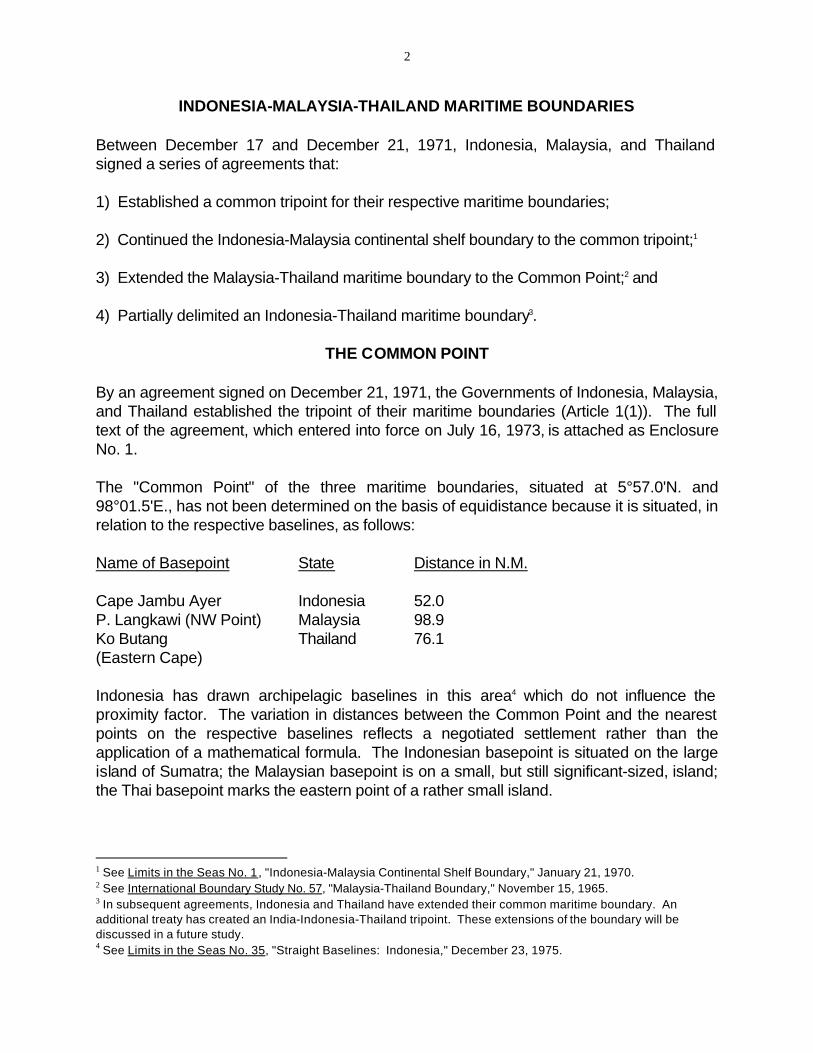
INDONESIA-MALAYSIA-THAILAND MARITIME BOUNDARIES
Between December 17 and December 21, 1971, Indonesia, Malaysia, and Thailand signed a series of agreements that:
1) Established a common tripoint for their respective maritime boundaries;
2) Continued the Indonesia-Malaysia continental shelf boundary to the common tripoint;1
3) Extended the Malaysia-Thailand maritime boundary to the Common Point;2 and
4) Partially delimited an Indonesia-Thailand maritime boundary3.
THE COMMON POINT
By an agreement signed on December 21, 1971, the Governments of Indonesia, Malaysia, and Thailand established the tripoint of their maritime boundaries (Article 1(1)). The full text of the agreement, which entered into force on July 16, 1973, is attached as Enclosure No. 1.
The "Common Point" of the three maritime boundaries, situated at 5°57.0'N. and 98°01.5'E., has not been determined on the basis of equidistance because it is situated, in relation to the respective baselines, as follows:
Name of Basepoint State Distance in N.M.
Cape Jambu Ayer Indonesia 52.0 P. Langkawi (NW Point) Malaysia 98.9 Ko Butang Thailand 76.1 (Eastern Cape)
Indonesia has drawn archipelagic baselines in this area4 which do not influence the proximity factor. The variation in distances between the Common Point and the nearest points on the respective baselines reflects a negotiated settlement rather than the application of a mathematical formula. The Indonesian basepoint is situated on the large island of Sumatra; the Malaysian basepoint is on a small, but still significant-sized, island; the Thai basepoint marks the eastern point of a rather small island.
1 See Limits in the Seas No. 1, "Indonesia-Malaysia Continental Shelf Boundary," January 21, 1970.2 See International Boundary Study No. 57, "Malaysia-Thailand Boundary," November 15, 1965.3 In subsequent agreements, Indonesia and Thailand have extended their common maritime boundary. An additional treaty has created an India-Indonesia-Thailand tripoint. These extensions of the boundary will be discussed in a future study.4 See Limits in the Seas No. 35, "Straight Baselines: Indonesia," December 23, 1975.
-3-
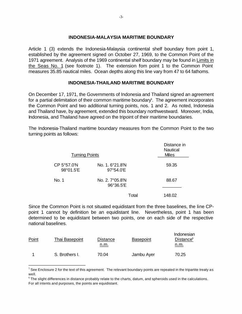
INDONESIA-MALAYSIA MARITIME BOUNDARY
Article 1 (3) extends the Indonesia-Malaysia continental shelf boundary from point 1, established by the agreement signed on October 27, 1969, to the Common Point of the 1971 agreement. Analysis of the 1969 continental shelf boundary may be found in Limits in the Seas No. 1 (see footnote 1). The extension from point 1 to the Common Point measures 35.85 nautical miles. Ocean depths along this line vary from 47 to 64 fathoms.
INDONESIA-THAILAND MARITIME BOUNDARY
On December 17, 1971, the Governments of Indonesia and Thailand signed an agreement for a partial delimitation of their common maritime boundary5. The agreement incorporates the Common Point and two additional turning points, nos. 1 and 2. As noted, Indonesia and Thailand have, by agreement, extended this boundary northwestward. Moreover, India, Indonesia, and Thailand have agreed on the tripoint of their maritime boundaries.
The Indonesia-Thailand maritime boundary measures from the Common Point to the two turning points as follows:
Distance in Nautical
Turning Points Miles
CP 5°57.0'N No. 1. 6°21.8'N 59.35 98°01.5'E 97°54.0'E
No. 1 No. 2. 7°05.8'N 88.67 96°36.5'E ________
Total 148.02
Since the Common Point is not situated equidistant from the three baselines, the line CP-point 1 cannot by definition be an equidistant line. Nevertheless, point 1 has been determined to be equidistant between two points, one on each side of the respective national baselines.
Indonesian Point Thai Basepoint Distance Basepoint Distance6
n.m. n.m.
S. Brothers I. 70.04 Jambu Ayer 70.25
5 See Enclosure 2 for the text of this agreement. The relevant boundary points are repeated in the tripartite treaty as well.6 The slight differences in distance probably relate to the charts, datum, and spheroids used in the calculations. For all intents and purposes, the points are equidistant.
1

-4
The same relative situation prevails for the line between points 1 and 2. The latter point is equidistant from the nearest points on the respective national baselines, although the intervening line, 1-2, is not equidistant from the respective baselines. The line is closer to Thailand than to the Indonesian baseline.
Indonesian Point Thai Basepoint Distance Basepoint Distance6
n.m. n.m.
1 S. Brothers I. 103.8 Pedir Pt. 104.1 Pulo Weh 104.5
The boundary from CP to point 2 is not a true equidistant boundary; it appears to have been negotiated on equitable principles using a selective equidistant line.
Water depths increase northward from the Common Point to point 2 from 64 to nearly 600 fathoms.
MALAYSIA-THAILAND MARITIME BOUNDARY
Article 1(4) describes the Malaysia-Thailand maritime boundary in the Straits of Malacca. The agreement does not relate to a maritime limit between the states in the Gulf of Thailand.
The distances between the turning points are as follows: Distance in Nautical
Turning Points Miles
CP 5°57.0'N No. 1. 6°18.0'N 68.23 98°01.5'E 99°06.7'E
No. 1 No. 2. 6°16.3'N 12.66 99°19.3'E
No. 2 No. 3 6°18.4’N 99°27.5’E
________
Total 148.02
The negotiated turning points relating to the respective baselines are as follows:
6 The slight differences in distance probably relate to the charts, datum, and spheroids used in the calculations. For all intents and purposes, the points are equidistant.

-5
Malaysian Point Thai Basepoint Distance Basepoint Distance
CP Ko Butang 76.11 Langkawi I. 98.88 6°31.9'N 6°23.3'N 99°09.5'E 99°37.2'E
1 Observatory I. 12.37 Langkawi I. 30.82 6°29.7'N 6°23.3'N 99°10.9'E 99°37.2'E
2 Nipis I. 12.46 Langkawi I. 19.14 6°28.8'N 6°23.3'N 99°18.6'E 99°37.2'E
3 Pin I. 10.82 Langkawi I. 11.89 6°29.0'N 6°23.3'N 99°22.0'E 99°37.2'E
The negotiated maritime boundary lies, at all four points, closer to the Thai baseline than to the Malaysian. The Thai islands, all in the Butang Group, are all smaller than the Malaysian island, P. Langkawi. No consistent ratio of distance between turning points and the nearest points on the respective baselines could be determined. Consequently, it is assumed that the boundary was negotiated on the basis of equitable principles.
Attachments: 1. Enclosure No. 1. Agreement etc. 2. Enclosure No. 2. Agreement etc.
-6
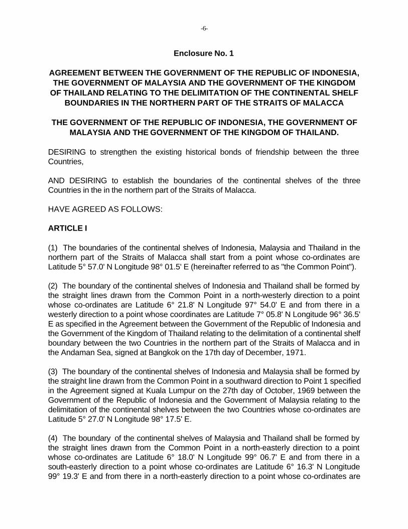
Enclosure No. 1
AGREEMENT BETWEEN THE GOVERNMENT OF THE REPUBLIC OF INDONESIA, THE GOVERNMENT OF MALAYSIA AND THE GOVERNMENT OF THE KINGDOM
OF THAILAND RELATING TO THE DELIMITATION OF THE CONTINENTAL SHELF BOUNDARIES IN THE NORTHERN PART OF THE STRAITS OF MALACCA
THE GOVERNMENT OF THE REPUBLIC OF INDONESIA, THE GOVERNMENT OF MALAYSIA AND THE GOVERNMENT OF THE KINGDOM OF THAILAND.
DESIRING to strengthen the existing historical bonds of friendship between the three Countries,
AND DESIRING to establish the boundaries of the continental shelves of the three Countries in the in the northern part of the Straits of Malacca.
HAVE AGREED AS FOLLOWS:
ARTICLE I
(1) The boundaries of the continental shelves of Indonesia, Malaysia and Thailand in the northern part of the Straits of Malacca shall start from a point whose co-ordinates are Latitude 5° 57.0' N Longitude 98° 01.5' E (hereinafter referred to as "the Common Point").
(2) The boundary of the continental shelves of Indonesia and Thailand shall be formed by the straight lines drawn from the Common Point in a north-westerly direction to a point whose co-ordinates are Latitude 6° 21.8' N Longitude 97° 54.0' E and from there in a westerly direction to a point whose coordinates are Latitude 7° 05.8' N Longitude 96° 36.5' E as specified in the Agreement between the Government of the Republic of Indonesia and the Government of the Kingdom of Thailand relating to the delimitation of a continental shelf boundary between the two Countries in the northern part of the Straits of Malacca and in the Andaman Sea, signed at Bangkok on the 17th day of December, 1971.
(3) The boundary of the continental shelves of Indonesia and Malaysia shall be formed by the straight line drawn from the Common Point in a southward direction to Point 1 specified in the Agreement signed at Kuala Lumpur on the 27th day of October, 1969 between the Government of the Republic of Indonesia and the Government of Malaysia relating to the delimitation of the continental shelves between the two Countries whose co-ordinates are Latitude 5° 27.0' N Longitude 98° 17.5' E.
(4) The boundary of the continental shelves of Malaysia and Thailand shall be formed by the straight lines drawn from the Common Point in a north-easterly direction to a point whose co-ordinates are Latitude 6° 18.0' N Longitude 99° 06.7' E and from there in a south-easterly direction to a point whose co-ordinates are Latitude 6° 16.3' N Longitude 99° 19.3' E and from there in a north-easterly direction to a point whose co-ordinates are

-7
Latitude 6° 18.4' N Longitude 99° 27.5' E.
(5) The co-ordinates of the points specified above are geographical co-ordinates derived from the British Admiralty Charts No. 793 and No. 830 and the straight lines connecting them are indicated on the chart attached as Annexure "A" to this Agreement.
(6) The actual location of the above-mentioned points at sea shall be determined by a method to be mutually agreed upon by the competent authorities of the respective Governments concerned.
(7) For the purposes of paragraph (6), "competent authorities" in relation to the Republic of Indonesia means the Chief of the Co-ordinating Body for National Survey and Mapping, Republic of Indonesia, and includes any person authorised by him; in relation to Malaysia the Director of National Mapping, Malaysia, and includes any person authorised by him; and in relation to the Kingdom of Thailand the Director of the Hydrographic Department, Thailand, and includes any person authorised by him.
ARTICLE II
Each Government hereby undertakes to ensure that all the necessary steps shall be taken at the domestic level to comply with the terms of this Agreement.
ARTICLE III
If any single geological petroleum or natural gas structure extends across the boundary line or lines referred to in Article I and the part of such structure which is situated on one side of the said line or lines is exploitable, wholly or in part from the other side or sides of the said line or lines, the Governments concerned shall seek to reach agreement as to the manner in which the structure will be most effectively exploited.
ARTICLE IV
Any dispute between the three Governments arising out of the interpretation or implementation of this Agreement shall be settled peacefully by consultation or negotiation.
ARTICLE V
This Agreement shall be clarified in accordance with the legal requirements of the three Countries.
ARTICLE VI
This Agreement shall enter into force on the date of the exchange of the Instruments of Ratification.
-8
IN WITNESS WHEREOF the undersigned being duly authorised thereto by their respective Governments, have signed this Agreement.
DONE IN TRIPLICATE at Kuala Lumpur the 21st day of December, 1971 in Indonesian, Malaysian, Thai and English languages. In the event of any conflict between the texts, the English text shall prevail.
FOR THE GOVERNMENT FOR THE GOVERNMENT FOR THE GOVERNMENT OF THE REPUBLIC OF OF MALAYSIA OF THE KINGDOM OF INDONESIA THAILAND
sgd. sgd. sgd.
(Prof. Dr. Soemantri (Tan Sri Haji Abdul Kadir bin (Mr. Vija Sethaput, Under-Brodjonegoro, Minister of Yusof, Attorney General Secretary of State for Mines, Republic of Malaysia.) National Development, in Indonesia.) charge of the Ministry of
National Development.)
Enclosure No. 2
AGREEMENT BETWEEN THE GOVERNMENT OF THE REPUBLIC OF INDONESIA AND THE GOVERNMENT OF THE KINGDOM OF THAILAND RELATING TO THE DELIMITATION OF A CONTINENTAL SHELF BOUNDARY BETWEEN THE TWO
COUNTRIES IN THE NORTHERN PART OF THE STRAITS OF MALACCA AND IN THE ANDAMAN SEA.
THE GOVERNMENT OF THE REPUBLIC OF INDONESIA AND THE GOVERNMENT OF THE KINGDOM OF THAILAND.
DESIRING to strengthen the existing bonds of friendship between the two countries, and
DESIRING to establish continental shelf boundaries between the two countries in the northern part of the Straits of Malacca and in the Andaman Sea.
HAVE AGREED AS FOLLOWS:

-9
ARTICLE I
1) The boundary between the continental shelves of Indonesia and Thailand in the northern part of the Straits of Malacca and in the Andaman Sea is the straight line drawn from a point whose co-ordinates are Latitude 6° 21.8' N Longitude 97° 54.0' E (hereinafter referred to as point 1) in a westerly direction to a point whose co-ordinates are Latitude 7° 05.8' N Longitude 96° 36.5' E (hereinafter referred to as point 2).
2) The boundary line between point 1 and the Common Point specified in the Memorandum of Understanding signed at Bangkok on 15 October 1970 by the representatives of Indonesia, Malaysia and Thailand shall be formally included in a tripartite agreement to be concluded shortly among the three Governments.
3) The co-ordinates of the points specified in paragraph 1), which are geographical coordinates, and the straight line connecting them are indicated on the chart attached as an Annex to this Agreement.
4) The actual location of the above-mentioned points at sea shall, at the request of either Government, be determined by a method to be mutually agreed upon by the competent authorities of the two Governments.
5) For the purpose of paragraph 4), the term "competent authorities" in relation to the Republic of Indonesia refers to Ketua Badan Koordinasi Survey dan Pemetaan Nasional (Chief of the Co-ordinating Body for National Survey and Mapping) and includes any person authorized by him; and in relation to the Kingdom of Thailand refers to Chao Krom Uthoksat (Director of the Hydrographic Department) and includes any person authorized by him.
ARTICLE II
If any single geological petroleum or natural gas structure extends across the straight line referred to in Article I and the part of such structure which is situated on one side of the said line is exploitable, wholly or in part, from the other side of the said line, the two Government shall seek to reach agreement as to the manner in which the structure shall be most effectively exploited.
ARTICLE III
Any dispute between the two Governments arising out of the interpretation or implementation of this Agreement shall be settled peacefully by consultation or negotiation.
ARTICLE IV
This Agreement shall be ratified in accordance with the legal requirements of the two countries.

-10
ARTICLE V
This Agreement shall enter force on the date of the exchange of Instruments of Ratification.
IN WITNESS WHEREOF the undersigned, being duly authorized thereto by their respective Governments, have signed this Agreement.
DONE IN DUPLICATE at Bangkok, this seventeenth day of December, one thousand nine hundred and seventy one, in the Indonesian Thai and English languages. In the event of any conflict between the texts, the English text shall prevail.
FOR THE GOVERNMENT OF FOR THE GOVERNMENT OF THE REPUBLIC OF INDONESIA THE KINGDOM OF THAILAND
sgd. sgd.
(Professor Dr. Sumantri Brodjonegoro) (Mr. Vija Sethaput)


