The distribution of site generated trips was determined by examining the proportion of traffic
travelling east and west along Algoma Road as determined in the October 1, 2013 traffic counts.
The counts determined that commercial/industrial traffic in the area was distributed to
approximately the following distribution along Algoma Road for both the peak AM and PM
hours:
To/From the East - 65 percent
To/From the West - 35 percent
The above distribution was used for both the peak AM and PM hours. Figure 3.2 shows the
expected distribution of site generated trips during the weekday peak AM and PM hours.
4. TRANSPORTATION IMPACT
The study will examine the operation of the Comstock/Algoma intersection and the site’s
accesses onto Comstock Road and Algoma Road. The study will analyze the operation of the
Industrial Building Page 1660 Comstock Road, Ottawa Transportation Overview
7
FIGURE 3.2
WEEKDAY PEAK AM AND PM HOUR SITE GENERATED TRIPS
Industrial Building Page 1660 Comstock Road, Ottawa Transportation Overview
8
Comstock/Algoma intersection for the existing 2013 traffic counts and for all intersections for
the future 2019 traffic volumes which represents five years beyond substantial completion of the
light industrial building. The analysis will use the Highway Capacity Software, which utilizes
the intersection capacity analysis procedure as documented in the 2010 Highway Capacity
Manual. For unsignalized intersections, the level of service of each lane movement is
determined as a function of the delay of vehicles at the approach. The following relates the level
of service of each lane movement with the expected delay at the approach.
LEVEL OF SERVICE DELAY
Level of Service A 0-10 sec./vehicle Little or No Delay
Level of Service B >10-15 sec./vehicle Short Traffic Delays
Level of Service C >15-25 sec./vehicle Average Traffic Delays
Level of Service D >25-35 sec./vehicle Long Traffic Delays
Level of Service E >35-50 sec./vehicle Very Long Traffic Delays
Level of Service F >50 sec./vehicle Extreme Delays – Demand Exceeds Capacity
The expected length of queue at the critical lane movements for an unsignalized intersection was
determined by the calculation of the 95th percentile queue at the lane approach. The 95
th
percentile queue length is the calculated 95th greatest queue length out of 100 occurrences at a
movement during a 15-minute peak period. The 95th percentile queue length is a function of the
capacity of a movement and the total expected traffic, with the calculated value determining the
magnitude of the queue by representing the queue length as fractions of vehicles.
4.1 Background and Total Traffic Volumes
The 2019 background traffic volumes used in the study analysis represents the future volume of
traffic at the Comstock/Algoma intersection which does not include the expected traffic from the
site, or the existing Stock Transportation traffic. The future background traffic was determined
by examination of the historical traffic counts at the Comstock/Algoma intersection. Traffic
counts taken by the consultant in 2006 were compared to the 2013 counts which determined that
traffic increased at an average annual rate of approximately 5 percent. The study has therefore
utilized the 5 percent annual growth to increase the 2013 traffic volumes six years to the year
2019. The 2019 background traffic volumes are shown in Figure 4.1. The 2019 total traffic is
the addition of the 2019 background traffic (Figure 4.1) and the expected site generated trips
(Figure 3.2). The 2019 total volume of peak AM and PM hour traffic is shown in Figure 4.2.
4.2 Traffic Analysis
The Transportation Overview report has examined the operation of the three site access points
onto Comstock Road and Algoma Road, and the Comstock/Algoma intersection. The results of
the analysis are discussed in detail in the following sections:
Access 1 and Comstock Road Intersection
Access 1 onto Comstock Road would be located approximately 55 metres south of the
Comstock/Algoma intersection. The access would have a width of 7.2 metres with one lane
entering and one lane exiting which would consist of a shared left/right turning movement.
Industrial Building Page 1660 Comstock Road, Ottawa Transportation Overview
9
FIGURE 4.1
YEAR 2019 PEAK AM AND PM HOUR BACKGROUND TRAFFIC
Industrial Building Page 1660 Comstock Road, Ottawa Transportation Overview
10
FIGURE 4.2
YEAR 2019 PEAK AM AND PM HOUR TOTAL TRAFFIC
Industrial Building Page 1660 Comstock Road, Ottawa Transportation Overview
11
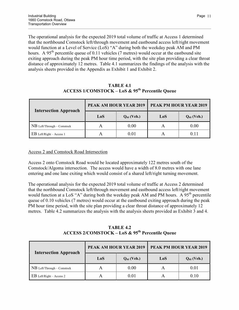
The operational analysis for the expected 2019 total volume of traffic at Access 1 determined
that the northbound Comstock left/through movement and eastbound access left/right movement
would function at a Level of Service (LoS) “A” during both the weekday peak AM and PM
hours. A 95th percentile queue of 0.11 vehicles (7 metres) would occur at the eastbound site
exiting approach during the peak PM hour time period, with the site plan providing a clear throat
distance of approximately 12 metres. Table 4.1 summarizes the findings of the analysis with the
analysis sheets provided in the Appendix as Exhibit 1 and Exhibit 2.
TABLE 4.1
ACCESS 1/COMSTOCK – LoS & 95th Percentile Queue
Intersection Approach
PEAK AM HOUR YEAR 2019 PEAK PM HOUR YEAR 2019
LoS Q95 (Veh.) LoS Q95 (Veh.)
NB Left/Through – Comstock A 0.00 A 0.00
EB Left/Right – Access 1 A 0.01 A 0.11
Access 2 and Comstock Road Intersection
Access 2 onto Comstock Road would be located approximately 122 metres south of the
Comstock/Algoma intersection. The access would have a width of 8.0 metres with one lane
entering and one lane exiting which would consist of a shared left/right turning movement.
The operational analysis for the expected 2019 total volume of traffic at Access 2 determined
that the northbound Comstock left/through movement and eastbound access left/right movement
would function at a LoS “A” during both the weekday peak AM and PM hours. A 95th percentile
queue of 0.10 vehicles (7 metres) would occur at the eastbound exiting approach during the peak
PM hour time period, with the site plan providing a clear throat distance of approximately 12
metres. Table 4.2 summarizes the analysis with the analysis sheets provided as Exhibit 3 and 4.
TABLE 4.2
ACCESS 2/COMSTOCK – LoS & 95th Percentile Queue
Intersection Approach
PEAK AM HOUR YEAR 2019 PEAK PM HOUR YEAR 2019
LoS Q95 (Veh.) LoS Q95 (Veh.)
NB Left/Through – Comstock A 0.00 A 0.01
EB Left/Right – Access 2 A 0.01 A 0.10
Industrial Building Page 1660 Comstock Road, Ottawa Transportation Overview
12
Access 3 and Algoma Road Intersection
Access 3 onto Algoma Road would be located approximately 105 metres west of the
Comstock/Algoma intersection. The access would function as a one-way exit for trucks from the
loading area at the rear of the building (west side). The access would have a width of 10.2
metres with traffic controlled by signage which would restrict traffic to only exiting movements.
The operational analysis for the expected 2019 total volume of traffic at Access 3 determined
that the northbound exit with shared left/right turning movements would function at a LoS “B”
during both the weekday peak AM and PM hours. A 95th percentile queue of 0.02 vehicles
would occur at the northbound site exiting approach during the peak PM hour time period, with
the site plan providing a clear throat distance of approximately 12 metres. Table 4.3 summarizes
the findings of the analysis with the analysis sheets provided as Exhibit 5 and Exhibit 6.
TABLE 4.3
ACCESS 3/ALGOMA – LoS & 95th Percentile Queue
Intersection Approach
PEAK AM HOUR YEAR 2019 PEAK PM HOUR YEAR 2019
LoS Q95 (Veh.) LoS Q95 (Veh.)
NB Left/Right – Access 3 B 0.01 B 0.02
Comstock Road and Algoma Road Intersection
The intersection of Comstock Road and Algoma Road is a two-way stop controlled intersection
with stop signs placed at the northbound and southbound Comstock Road approaches. The
intersection has no exclusive turn lanes, with all approaches comprising of a shared
left/through/right lane movement.
The operational analysis using the traffic counts taken on October 1, 2013 determined that during
the peak AM hour the eastbound and westbound Algoma approaches functioned at a LoS “A”,
and the northbound Comstock approach at a LoS “A” and southbound a LoS “B”. During the
peak PM hour the Algoma approaches functioned at a LoS “A” and Comstock approaches at a
LoS “B”. Table 4.4 summarizes the findings of the analysis for the 2013 traffic counts with the
analysis sheets provided as Exhibit 7 for the existing peak AM hour traffic and Exhibit 8 for the
peak PM hour traffic.
For the expected traffic volumes at the year 2019, the eastbound and westbound Algoma
approaches functioned at a LoS “A”, and northbound and southbound Comstock approaches at a
LoS “B” during both the peak AM and PM hours. The 95th percentile queue at the northbound
Comstock Approach was determined to be 0.45 vehicles during the peak PM hour. With Access
1 located approximately 55 metres south of the intersection, queuing at the northbound approach
would not interfere with the operation of Access 1. The eastbound Algoma approach would
Industrial Building Page 1660 Comstock Road, Ottawa Transportation Overview
13
experience a 95th percentile queue of 0.03 vehicles with Access 3 located approximately 105
metres west of the intersection. The queuing at the eastbound approach would not interfere with
the operation of Access 3. Table 4.4 summarizes the findings of the analysis with the analysis
sheets provided as Exhibit 9 and Exhibit 10.
TABLE 4.4
COMSTOCK/ALGOMA – LoS & 95th Percentile Queue
Intersection Approach
PEAK AM HOUR (2013) 2019 PEAK PM HOUR (2013) 2019
LoS Q95 (Veh.) LoS Q95 (Veh.)
EB Left/Through/Right – Algoma (A) A (0.02) 0.02 (A) A (0.03) 0.03
WB Left/Through/Right – Algoma (A) A (0.04) 0.13 (A) A (0.06) 0.07
NB Left/Through/Right – Comstock (A) B (0.15) 0.20 (B) B (0.11) 0.45
SB Left/Through/Right – Comstock (B) B (0.19) 0.24 (B) B (0.31) 0.38
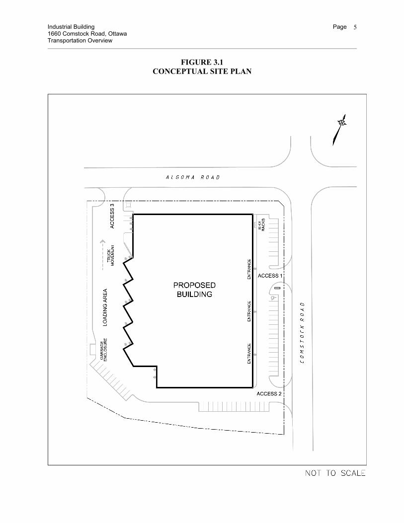
4.3 Site Circulation of Traffic
The proposed Site Plan shows an efficient movement of vehicles throughout the site. Car traffic
accessing the front of the building would utilize either Access 1 or Access 2 off of Comstock
Road. Trucks would enter at Access 2 on Comstock Road and exit at Access 3 on Algoma Road.
Access 3 onto Algoma Road would be restricted to only exiting movements. All access points
would provide sufficient clear throat distance for queued vehicles exiting the site.
4.4 Pedestrian, Cycling, and Transit Facilities
Both Comstock Road and Algoma Road are local roads with no sidewalks provided along either
side of the road. Traffic counts at the Comstock/Algoma intersection showed few pedestrians
walking along the street.
The Site Plan provides a bicycle rack which can accommodate 8 bikes close to the building
entrances. There are no dedicated cycling facilities along Comstock Road of Algoma Road.
OC Transpo Route 121 travels along Algoma Road past the site. Bus stops are located in close
proximity to the site.
Industrial Building Page 1660 Comstock Road, Ottawa Transportation Overview
14
5. FINDINGS
Simluc Contractors Limited has proposed the redevelopment of land at 1660 Comstock Road.
The land has an area of 13,969.96 m2, and is situated at the southwest corner of Comstock Road
and Algoma Road. The land is currently occupied by Stock Transportation which provides bus
transit for schools. The Site Plan proposes to replace Stock Transportation with a light industrial
use which may accommodate potentially three tenants. The site will have two accesses onto
Comstock Road and one access onto Algoma Road which would be restricted to only exiting
truck traffic. The current zoning of the land will support the proposed redevelopment of the site.
The proposed building is expected to be substantially completed and occupied by the year 2014.
With the site proposing to generate fewer than 75 new trips during the peak hour, City of Ottawa
staff has requested that a Transportation Overview be prepared which would address the number
of site trips and operation of the accesses. The land use of the site will be light industrial which
would have the peak hours of operation to occur on a weekday. The study analysis has therefore
examined the site access points and Comstock/Algoma intersection for the impact of the site
during the weekday peak AM and PM hour of the adjacent roads at a time period of five years
beyond the completion of the site (2019). The findings and recommendations of the study are
summarized in the following:
1) The trip generation analysis determined that the proposed development would generate 64 vehicles during the peak AM hour and 68 vehicles during the peak PM hour. These
trips would replace the existing trips generated by Stock Transport.
2) The three site accesses and Comstock/Algoma intersection were determined to function at an acceptable level of service for the expected 2019 traffic volumes, with all
approaches functioning at a LoS “A” or LoS “B”. The site accesses would be constructed
as private approaches as shown on the Site Plan, with no required modifications to
Comstock Road and Algoma Road due to the redevelopment of the site.
3) Access 3 onto Algoma Road would be an exit for trucks from the loading area and would be restricted to one-way traffic exiting the site. The approach would be designated with
suitable signs erected in a conspicuous location adjacent to the roadway to indicate the
direction of traffic for the private approach. All signs would be erected and maintained
by the owner to the satisfaction of City of Ottawa staff.
Prepared by:
David J. Halpenny, P. Eng.
Industrial Building Page 1660 Comstock Road, Ottawa Transportation Overview
15
APPENDIX
OPERATIONAL ANALYSIS WORK SHEETS
Industrial Building Page 1660 Comstock Road, Ottawa Transportation Overview
16
EXHIBIT 1
YEAR 2019 PEAK AM HOUR TOTAL TRAFFIC ANALYSIS – Access 1/Comstock Road
HCS+: Unsignalized Intersections Release 5.6 _______________________TWO-WAY STOP CONTROL SUMMARY___________________________ Analysis Time Period: Peak AM Hour Intersection: Comstock/Access 1 Analysis Year: Year 2019 Project ID: Industrial Building - 1660 Comstock Road East/West Street: Access 1 North/South Street: Comstock Road Intersection Orientation: NS Study period (hrs): 0.25 ______________________Vehicle Volumes and Adjustments_________________________ Major Street: Approach Northbound Southbound Movement 1 2 3 | 4 5 6 L T R | L T R ______________________________________________________________________________ Volume 0 39 52 28 Peak-Hour Factor, PHF 0.92 0.92 0.92 0.92 Hourly Flow Rate, HFR 0 42 56 30 Percent Heavy Vehicles 0 -- -- -- -- Median Type/Storage Undivided / RT Channelized? Lanes 0 1 1 0 Configuration LT TR Upstream Signal? No No ______________________________________________________________________________ Minor Street: Approach Westbound Eastbound Movement 7 8 9 | 10 11 12 L T R | L T R ______________________________________________________________________________ Volume 3 0 Peak Hour Factor, PHF 0.92 0.92 Hourly Flow Rate, HFR 3 0 Percent Heavy Vehicles 0 0 Percent Grade (%) 0 0 Flared Approach: Exists?/Storage / No / Lanes 0 0 Configuration LR ______________________________________________________________________________ __________________Delay, Queue Length, and Level of Service___________________ Approach NB SB Westbound Eastbound Movement 1 4 | 7 8 9 | 10 11 12 Lane Config LT | | LR ______________________________________________________________________________ v (vph) 0 3 C(m) (vph) 1523 888 v/c 0.00 0.00 95% queue length 0.00 0.01 Control Delay 7.4 9.1 LOS A A Approach Delay 9.1 Approach LOS A ______________________________________________________________________________
Industrial Building Page 1660 Comstock Road, Ottawa Transportation Overview
17
EXHIBIT 2
YEAR 2019 PEAK PM HOUR TOTAL TRAFFIC ANALYSIS – Access 1/Comstock Road
HCS+: Unsignalized Intersections Release 5.6 _______________________TWO-WAY STOP CONTROL SUMMARY___________________________ Analysis Time Period: Peak PM Hour Intersection: Comstock/Access 1 Analysis Year: Year 2019 Project ID: Industrial Building - 1660 Comstock Road East/West Street: Access 1 North/South Street: Comstock Road Intersection Orientation: NS Study period (hrs): 0.25 ______________________Vehicle Volumes and Adjustments_________________________ Major Street: Approach Northbound Southbound Movement 1 2 3 | 4 5 6 L T R | L T R ______________________________________________________________________________ Volume 0 52 30 4 Peak-Hour Factor, PHF 0.92 0.92 0.92 0.92 Hourly Flow Rate, HFR 0 56 32 4 Percent Heavy Vehicles 0 -- -- -- -- Median Type/Storage Undivided / RT Channelized? Lanes 0 1 1 0 Configuration LT TR Upstream Signal? No No ______________________________________________________________________________ Minor Street: Approach Westbound Eastbound Movement 7 8 9 | 10 11 12 L T R | L T R ______________________________________________________________________________ Volume 29 0 Peak Hour Factor, PHF 0.92 0.92 Hourly Flow Rate, HFR 31 0 Percent Heavy Vehicles 0 0 Percent Grade (%) 0 0 Flared Approach: Exists?/Storage / No / Lanes 0 0 Configuration LR ______________________________________________________________________________ __________________Delay, Queue Length, and Level of Service___________________ Approach NB SB Westbound Eastbound Movement 1 4 | 7 8 9 | 10 11 12 Lane Config LT | | LR ______________________________________________________________________________ v (vph) 0 31 C(m) (vph) 1588 915 v/c 0.00 0.03 95% queue length 0.00 0.11 Control Delay 7.3 9.1 LOS A A Approach Delay 9.1 Approach LOS A ______________________________________________________________________________
Industrial Building Page 1660 Comstock Road, Ottawa Transportation Overview
18
EXHIBIT 3
YEAR 2019 PEAK AM HOUR TOTAL TRAFFIC ANALYSIS – Access 2/Comstock Road
HCS+: Unsignalized Intersections Release 5.6 _______________________TWO-WAY STOP CONTROL SUMMARY___________________________ Analysis Time Period: Peak AM Hour Intersection: Comstock/Access 2 Analysis Year: Year 2019 Project ID: Industrial Building - 1660 Comstock Road East/West Street: Access 2 North/South Street: Comstock Road Intersection Orientation: NS Study period (hrs): 0.25 ______________________Vehicle Volumes and Adjustments_________________________ Major Street: Approach Northbound Southbound Movement 1 2 3 | 4 5 6 L T R | L T R ______________________________________________________________________________ Volume 0 37 24 28 Peak-Hour Factor, PHF 0.92 0.92 0.92 0.92 Hourly Flow Rate, HFR 0 40 26 30 Percent Heavy Vehicles 0 -- -- -- -- Median Type/Storage Undivided / RT Channelized? Lanes 0 1 1 0 Configuration LT TR Upstream Signal? No No ______________________________________________________________________________ Minor Street: Approach Westbound Eastbound Movement 7 8 9 | 10 11 12 L T R | L T R ______________________________________________________________________________ Volume 2 0 Peak Hour Factor, PHF 0.92 0.92 Hourly Flow Rate, HFR 2 0 Percent Heavy Vehicles 0 0 Percent Grade (%) 0 0 Flared Approach: Exists?/Storage / No / Lanes 0 0 Configuration LR ______________________________________________________________________________ __________________Delay, Queue Length, and Level of Service___________________ Approach NB SB Westbound Eastbound Movement 1 4 | 7 8 9 | 10 11 12 Lane Config LT | | LR ______________________________________________________________________________ v (vph) 0 2 C(m) (vph) 1562 926 v/c 0.00 0.00 95% queue length 0.00 0.01 Control Delay 7.3 8.9 LOS A A Approach Delay 8.9 Approach LOS A ______________________________________________________________________________
Industrial Building Page 1660 Comstock Road, Ottawa Transportation Overview
19
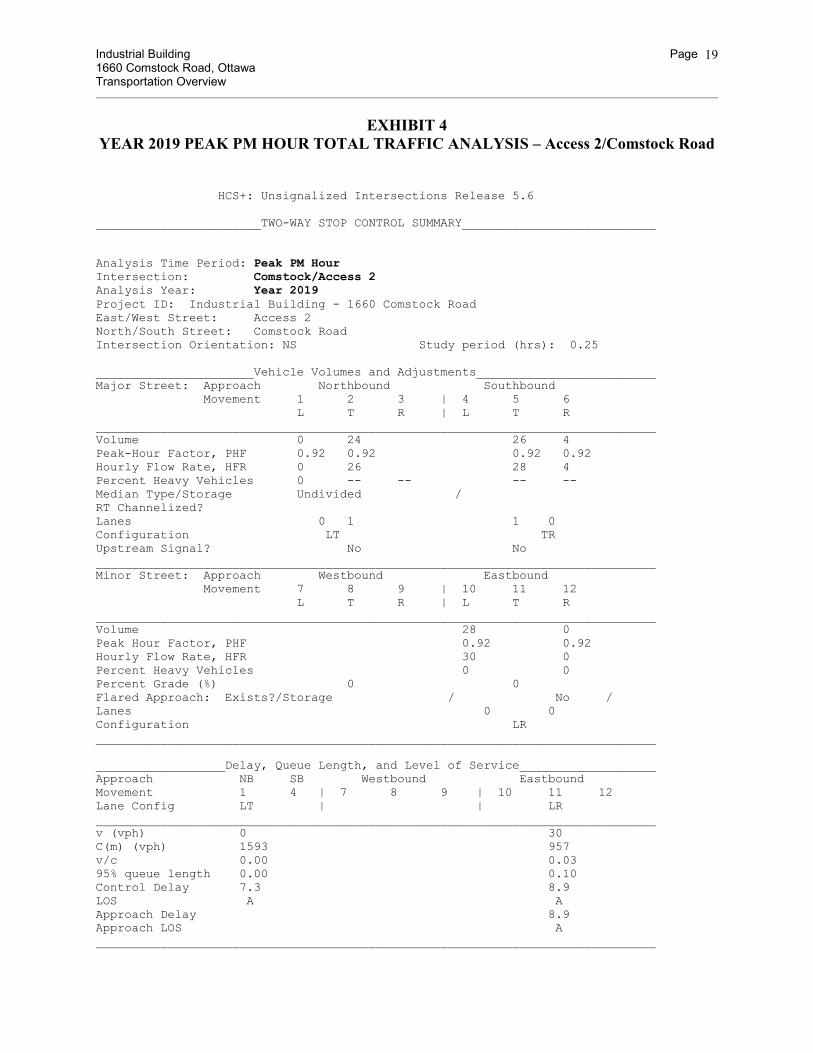
EXHIBIT 4
YEAR 2019 PEAK PM HOUR TOTAL TRAFFIC ANALYSIS – Access 2/Comstock Road
HCS+: Unsignalized Intersections Release 5.6 _______________________TWO-WAY STOP CONTROL SUMMARY___________________________ Analysis Time Period: Peak PM Hour Intersection: Comstock/Access 2 Analysis Year: Year 2019 Project ID: Industrial Building - 1660 Comstock Road East/West Street: Access 2 North/South Street: Comstock Road Intersection Orientation: NS Study period (hrs): 0.25 ______________________Vehicle Volumes and Adjustments_________________________ Major Street: Approach Northbound Southbound Movement 1 2 3 | 4 5 6 L T R | L T R ______________________________________________________________________________ Volume 0 24 26 4 Peak-Hour Factor, PHF 0.92 0.92 0.92 0.92 Hourly Flow Rate, HFR 0 26 28 4 Percent Heavy Vehicles 0 -- -- -- -- Median Type/Storage Undivided / RT Channelized? Lanes 0 1 1 0 Configuration LT TR Upstream Signal? No No ______________________________________________________________________________ Minor Street: Approach Westbound Eastbound Movement 7 8 9 | 10 11 12 L T R | L T R ______________________________________________________________________________ Volume 28 0 Peak Hour Factor, PHF 0.92 0.92 Hourly Flow Rate, HFR 30 0 Percent Heavy Vehicles 0 0 Percent Grade (%) 0 0 Flared Approach: Exists?/Storage / No / Lanes 0 0 Configuration LR ______________________________________________________________________________ __________________Delay, Queue Length, and Level of Service___________________ Approach NB SB Westbound Eastbound Movement 1 4 | 7 8 9 | 10 11 12 Lane Config LT | | LR ______________________________________________________________________________ v (vph) 0 30 C(m) (vph) 1593 957 v/c 0.00 0.03 95% queue length 0.00 0.10 Control Delay 7.3 8.9 LOS A A Approach Delay 8.9 Approach LOS A ______________________________________________________________________________
Industrial Building Page 1660 Comstock Road, Ottawa Transportation Overview
20
EXHIBIT 5
YEAR 2019 PEAK AM HOUR TOTAL TRAFFIC ANALYSIS – Access 3/Algoma Road
HCS+: Unsignalized Intersections Release 5.6 _______________________TWO-WAY STOP CONTROL SUMMARY___________________________ Analysis Time Period: Peak AM Hour Intersection: Algoma/Access 3 Analysis Year: Year 2019 Project ID: Industrial Building - 1660 Comstock Road East/West Street: Access 3 North/South Street: Algoma Road Intersection Orientation: EW Study period (hrs): 0.25 ______________________Vehicle Volumes and Adjustments_________________________ Major Street: Approach Eastbound Westbound Movement 1 2 3 | 4 5 6 L T R | L T R ______________________________________________________________________________ Volume 121 230 Peak-Hour Factor, PHF 0.92 0.92 Hourly Flow Rate, HFR 131 249 Percent Heavy Vehicles -- -- -- -- Median Type/Storage Undivided / RT Channelized? Lanes 1 1 Configuration T T Upstream Signal? No No ______________________________________________________________________________ Minor Street: Approach Northbound Southbound Movement 7 8 9 | 10 11 12 L T R | L T R ______________________________________________________________________________ Volume 1 2 Peak Hour Factor, PHF 0.92 0.92 Hourly Flow Rate, HFR 1 2 Percent Heavy Vehicles 100 100 Percent Grade (%) 0 0 Flared Approach: Exists?/Storage No / / Lanes 0 0 Configuration LR ______________________________________________________________________________ __________________Delay, Queue Length, and Level of Service___________________ Approach EB WB Northbound Southbound Movement 1 4 | 7 8 9 | 10 11 12 Lane Config | LR | ______________________________________________________________________________ v (vph) 3 C(m) (vph) 606 v/c 0.00 95% queue length 0.01 Control Delay 11.0 LOS B Approach Delay 11.0 Approach LOS B ______________________________________________________________________________
Industrial Building Page 1660 Comstock Road, Ottawa Transportation Overview
21
EXHIBIT 6
YEAR 2019 PEAK PM HOUR TOTAL TRAFFIC ANALYSIS – Access 3/Algoma Road
HCS+: Unsignalized Intersections Release 5.6 _______________________TWO-WAY STOP CONTROL SUMMARY___________________________ Analysis Time Period: Peak PM Hour Intersection: Algoma/Access 3 Analysis Year: Year 2019 Project ID: Industrial Building - 1660 Comstock Road East/West Street: Access 3 North/South Street: Algoma Road Intersection Orientation: EW Study period (hrs): 0.25 ______________________Vehicle Volumes and Adjustments_________________________ Major Street: Approach Eastbound Westbound Movement 1 2 3 | 4 5 6 L T R | L T R ______________________________________________________________________________ Volume 213 145 Peak-Hour Factor, PHF 0.92 0.92 Hourly Flow Rate, HFR 231 157 Percent Heavy Vehicles -- -- -- -- Median Type/Storage Undivided / RT Channelized? Lanes 1 1 Configuration T T Upstream Signal? No No ______________________________________________________________________________ Minor Street: Approach Northbound Southbound Movement 7 8 9 | 10 11 12 L T R | L T R ______________________________________________________________________________ Volume 1 2 Peak Hour Factor, PHF 0.92 0.92 Hourly Flow Rate, HFR 1 2 Percent Heavy Vehicles 100 100 Percent Grade (%) 0 0 Flared Approach: Exists?/Storage No / / Lanes 0 0 Configuration LR ______________________________________________________________________________ __________________Delay, Queue Length, and Level of Service___________________ Approach EB WB Northbound Southbound Movement 1 4 | 7 8 9 | 10 11 12 Lane Config | LR | ______________________________________________________________________________ v (vph) 3 C(m) (vph) 555 v/c 0.01 95% queue length 0.02 Control Delay 11.5 LOS B Approach Delay 11.5 Approach LOS B ______________________________________________________________________________
Industrial Building Page 1660 Comstock Road, Ottawa Transportation Overview
22
EXHIBIT 7
YEAR 2013 PEAK AM HOUR EXISTING TRAFFIC ANALYSIS – Comstock/Algoma
HCS+: Unsignalized Intersections Release 5.6 _______________________TWO-WAY STOP CONTROL SUMMARY___________________________ Analysis Time Period: Peak AM Hour Intersection: Algoma/Comstock Analysis Year: Year 2013 Project ID: Industrial Building - 1660 Comstock Road East/West Street: Algoma Road North/South Street: Comstock Road Intersection Orientation: EW Study period (hrs): 0.25 ______________________Vehicle Volumes and Adjustments_________________________ Major Street: Approach Eastbound Westbound Movement 1 2 3 | 4 5 6 L T R | L T R ______________________________________________________________________________ Volume 9 64 6 19 154 35 Peak-Hour Factor, PHF 0.92 0.92 0.92 0.92 0.92 0.92 Hourly Flow Rate, HFR 9 69 6 20 167 38 Percent Heavy Vehicles 15 -- -- 15 -- -- Median Type/Storage Undivided / RT Channelized? Lanes 0 1 0 0 1 0 Configuration LTR LTR Upstream Signal? No No ______________________________________________________________________________ Minor Street: Approach Northbound Southbound Movement 7 8 9 | 10 11 12 L T R | L T R ______________________________________________________________________________ Volume 9 0 28 22 1 13 Peak Hour Factor, PHF 0.92 0.92 0.92 0.92 0.92 0.92 Hourly Flow Rate, HFR 9 0 30 23 1 14 Percent Heavy Vehicles 15 15 15 15 15 15 Percent Grade (%) 0 0 Flared Approach: Exists?/Storage No / No / Lanes 0 1 0 0 1 0 Configuration LTR LTR ______________________________________________________________________________ __________________Delay, Queue Length, and Level of Service___________________ Approach EB WB Northbound Southbound Movement 1 4 | 7 8 9 | 10 11 12 Lane Config LTR LTR | LTR | LTR ______________________________________________________________________________ v (vph) 9 20 39 38 C(m) (vph) 1293 1446 833 642 v/c 0.01 0.01 0.05 0.06 95% queue length 0.02 0.04 0.15 0.19 Control Delay 7.8 7.5 9.5 11.0 LOS A A A B Approach Delay 9.5 11.0 Approach LOS A B ______________________________________________________________________________
Industrial Building Page 1660 Comstock Road, Ottawa Transportation Overview
23
EXHIBIT 8
YEAR 2013 PEAK PM HOUR EXISTING TRAFFIC ANALYSIS – Comstock/Algoma
HCS+: Unsignalized Intersections Release 5.6 _______________________TWO-WAY STOP CONTROL SUMMARY___________________________ Analysis Time Period: Peak PM Hour Intersection: Algoma/Comstock Analysis Year: Year 2013 Project ID: Industrial Building - 1660 Comstock Road East/West Street: Algoma Road North/South Street: Comstock Road Intersection Orientation: EW Study period (hrs): 0.25 ______________________Vehicle Volumes and Adjustments_________________________ Major Street: Approach Eastbound Westbound Movement 1 2 3 | 4 5 6 L T R | L T R ______________________________________________________________________________ Volume 12 159 2 24 101 18 Peak-Hour Factor, PHF 0.92 0.92 0.92 0.92 0.92 0.92 Hourly Flow Rate, HFR 13 172 2 26 109 19 Percent Heavy Vehicles 15 -- -- 15 -- -- Median Type/Storage Undivided / RT Channelized? Lanes 0 1 0 0 1 0 Configuration LTR LTR Upstream Signal? No No ______________________________________________________________________________ Minor Street: Approach Northbound Southbound Movement 7 8 9 | 10 11 12 L T R | L T R ______________________________________________________________________________ Volume 6 0 19 42 0 8 Peak Hour Factor, PHF 0.92 0.92 0.92 0.92 0.92 0.92 Hourly Flow Rate, HFR 6 0 20 45 0 8 Percent Heavy Vehicles 15 15 15 15 15 15 Percent Grade (%) 0 0 Flared Approach: Exists?/Storage No / No / Lanes 0 1 0 0 1 0 Configuration LTR LTR ______________________________________________________________________________ __________________Delay, Queue Length, and Level of Service___________________ Approach EB WB Northbound Southbound Movement 1 4 | 7 8 9 | 10 11 12 Lane Config LTR LTR | LTR | LTR ______________________________________________________________________________ v (vph) 13 26 26 53 C(m) (vph) 1381 1328 745 565 v/c 0.01 0.02 0.03 0.09 95% queue length 0.03 0.06 0.11 0.31 Control Delay 7.6 7.8 10.0+ 12.0 LOS A A B B Approach Delay 10.0+ 12.0 Approach LOS B B ______________________________________________________________________________
Industrial Building Page 1660 Comstock Road, Ottawa Transportation Overview
24
EXHIBIT 9
YEAR 2019 PEAK AM HOUR TOTAL TRAFFIC ANALYSIS – Comstock/Algoma HCS+: Unsignalized Intersections Release 5.6 _______________________TWO-WAY STOP CONTROL SUMMARY___________________________ Analysis Time Period: Peak AM Hour Intersection: Algoma/Comstock Analysis Year: Year 2019 Project ID: Industrial Building - 1660 Comstock Road East/West Street: Algoma Road North/South Street: Comstock Road Intersection Orientation: EW Study period (hrs): 0.25 ______________________Vehicle Volumes and Adjustments_________________________ Major Street: Approach Eastbound Westbound Movement 1 2 3 | 4 5 6 L T R | L T R ______________________________________________________________________________ Volume 9 88 26 53 206 35 Peak-Hour Factor, PHF 0.92 0.92 0.92 0.92 0.92 0.92 Hourly Flow Rate, HFR 9 95 28 57 223 38 Percent Heavy Vehicles 15 -- -- 15 -- -- Median Type/Storage Undivided / RT Channelized? Lanes 0 1 0 0 1 0 Configuration LTR LTR Upstream Signal? No No ______________________________________________________________________________ Minor Street: Approach Northbound Southbound Movement 7 8 9 | 10 11 12 L T R | L T R ______________________________________________________________________________ Volume 11 0 31 22 1 13 Peak Hour Factor, PHF 0.92 0.92 0.92 0.92 0.92 0.92 Hourly Flow Rate, HFR 11 0 33 23 1 14 Percent Heavy Vehicles 15 15 15 15 15 15 Percent Grade (%) 0 0 Flared Approach: Exists?/Storage No / No / Lanes 0 1 0 0 1 0 Configuration LTR LTR ______________________________________________________________________________ __________________Delay, Queue Length, and Level of Service___________________ Approach EB WB Northbound Southbound Movement 1 4 | 7 8 9 | 10 11 12 Lane Config LTR LTR | LTR | LTR ______________________________________________________________________________ v (vph) 9 57 44 38 C(m) (vph) 1232 1387 717 509 v/c 0.01 0.04 0.06 0.07 95% queue length 0.02 0.13 0.20 0.24 Control Delay 7.9 7.7 10.3 12.6 LOS A A B B Approach Delay 10.3 12.6 Approach LOS B B ______________________________________________________________________________
Industrial Building Page 1660 Comstock Road, Ottawa Transportation Overview
25
EXHIBIT 10
YEAR 2019 PEAK PM HOUR TOTAL TRAFFIC ANALYSIS – Comstock/Algoma
HCS+: Unsignalized Intersections Release 5.6 _______________________TWO-WAY STOP CONTROL SUMMARY___________________________ Analysis Time Period: Peak PM Hour Intersection: Algoma/Comstock Analysis Year: Year 2019 Project ID: Industrial Building - 1660 Comstock Road East/West Street: Algoma Road North/South Street: Comstock Road Intersection Orientation: EW Study period (hrs): 0.25 ______________________Vehicle Volumes and Adjustments_________________________ Major Street: Approach Eastbound Westbound Movement 1 2 3 | 4 5 6 L T R | L T R ______________________________________________________________________________ Volume 12 198 5 29 111 18 Peak-Hour Factor, PHF 0.92 0.92 0.92 0.92 0.92 0.92 Hourly Flow Rate, HFR 13 215 5 31 120 19 Percent Heavy Vehicles 15 -- -- 15 -- -- Median Type/Storage Undivided / RT Channelized? Lanes 0 1 0 0 1 0 Configuration LTR LTR Upstream Signal? No No ______________________________________________________________________________ Minor Street: Approach Northbound Southbound Movement 7 8 9 | 10 11 12 L T R | L T R ______________________________________________________________________________ Volume 26 0 55 42 0 8 Peak Hour Factor, PHF 0.92 0.92 0.92 0.92 0.92 0.92 Hourly Flow Rate, HFR 28 0 59 45 0 8 Percent Heavy Vehicles 15 15 15 15 15 15 Percent Grade (%) 0 0 Flared Approach: Exists?/Storage No / No / Lanes 0 1 0 0 1 0 Configuration LTR LTR ______________________________________________________________________________ __________________Delay, Queue Length, and Level of Service___________________ Approach EB WB Northbound Southbound Movement 1 4 | 7 8 9 | 10 11 12 Lane Config LTR LTR | LTR | LTR ______________________________________________________________________________ v (vph) 13 31 87 53 C(m) (vph) 1368 1276 658 473 v/c 0.01 0.02 0.13 0.11 95% queue length 0.03 0.07 0.45 0.38 Control Delay 7.7 7.9 11.3 13.6 LOS A A B B Approach Delay 11.3 13.6 Approach LOS B B ______________________________________________________________________________


![The Interregnum (1649-1660) The “Interregnum” Period [ 1649-1660 ] †The Commonwealth (1649-1653) †The Protectorate (1654-1660)](https://static.documents.pub/doc/80x56/56649e725503460f94b718c7/the-interregnum-1649-1660-the-interregnum-period-1649-1660-the.jpg)


