67
0
| Date post: | 04-Dec-2015 |
| Category: |
Documents |
| Upload: | joel-garcia |
| View: | 10 times |
| Download: | 4 times |

0

The Salaverry Basin
A Study on the Hydrocarbon Potential of
the Salaverry Basin
by
PARSEP
Proyecto de Asistencia para La Reglamentación del Sector Energético del Perú
TEKNICA PERUPETRO S.A. Gary Wine (Project Leader) Elmer Martínez (Senior Geophysicist/Coord.) Joe Arcuri (Senior Geophysicist) Carlos Monges (Senior Geologist) Ysabel Calderón (Junior Geologist) Carlos Galdos (Junior Geophysicist)
May 2001 On the Cover: Outcrop near Malabrigo just to theeast of the Salaverry Basin,showing the contact of CretaceousGoyllar Gp., overlying thedeformed Lower Jurassicmetamorphic rocks of the ColanGroup.
1

HYDROCARBON POTENTIAL OF THE SALAVERRY OFFSHORE BASIN
TABLE OF CONTENTS
TABLE OF CONTENTS ................................................................................................... 2
LIST OF FIGURES........................................................................................................... 3
LIST OF TABLES ............................................................................................................. 4
ENCLOSURES .................................................................................................................. 4
APPENDICES ................................................................................................................... 5
1.0 INTRODUCTION...................................................................................................... 6
2.0 SCOPE OF PROJECT.............................................................................................. 7
3.0 PREVIOUS WORK IN THE STUDY AREA ......................................................... 8
4.0 REGIONAL FRAMEWORK.................................................................................. 9 4.1 Tectonic Reconstruction and Basin Framework .................................................... 13 4.2 The Basement of Salaverry and Trujillo Basins .................................................... 14 4.3 Basement of Northwest Peru ................................................................................. 14 4.4 The Problem of Two Different Basements ............................................................ 15 4.5 Evidence for the Suture.......................................................................................... 16 4.6 Well Lobos 1X: Correlation of the Upper Cretaceous and Paleocene Rocks........ 16 4.7 Geological Overview of the Salaverry Basin......................................................... 17
5.0 STRATIGRAPHY ................................................................................................... 24 5.1 Economic Basement............................................................................................... 24 5.2 Middle Eocene ....................................................................................................... 24 5.3 Upper Eocene......................................................................................................... 24 5.4 Oligocene ............................................................................................................... 25 5.5 Lower Miocene ...................................................................................................... 25 5.6 Middle Miocene ..................................................................................................... 25 5.7 Upper Miocene to Pliocene.................................................................................... 25 5.8 Plio – Quaternary ................................................................................................... 26
6.0 WELL SUMMARY ................................................................................................. 27 6.1 BALLENA 1X ....................................................................................................... 27
6.1.1 Lithological/Reservoir Discussion.................................................................. 29 6.1.2 Hydrocarbons Shows ....................................................................................... 29
6.2 DELFIN 1X ........................................................................................................... 29 6.2.1 Lithological/Reservoir Description................................................................. 29
2

6.2.2 Hydrocarbon Shows........................................................................................ 32
7.0 GEOCHEMISTRY.................................................................................................. 33 7.1 Oil seeps and Crude oil characterization (modified after Repsol 1997a) ............... 33 7.2 Previous Studies..................................................................................................... 34 7.3 Conclusions............................................................................................................ 37
8.0 GEOPHYSICS ......................................................................................................... 38 8.1 Introduction............................................................................................................ 38 8.2 Seismic Data Base.................................................................................................. 38 8.4 Structures ............................................................................................................... 39 8.5 Seismic Stratigraphic Units.................................................................................... 39
8.5.1 Upper Miocene Top (eUMT).......................................................................... 39 8.5.2 Intra Upper Miocene Channels (eCH) ............................................................ 40 8.5.3 Middle Miocene Marker (eMMM) ................................................................. 40 8.5.4 Upper Eocene Top (eUET) ............................................................................. 40 8.5.5 Basement......................................................................................................... 40
9.0 PROSPECTS............................................................................................................ 42
10.0 CONCLUSIONS .................................................................................................... 43 10.1 Regional Geology ................................................................................................ 43 10.2 Stratigraphy.......................................................................................................... 44 10.3 Geochemistry ....................................................................................................... 44 10.4 Prospects .............................................................................................................. 44
11.0 REFERENCES....................................................................................................... 45
LIST OF FIGURES Figure 1: Basin Map of Northern Peru Highlighting the location of the Salaverry Basin. 6 Figure 2: Regional map of the Salaverry/Trujillo area with bathymetry, geology and
available seismic lines. For the legend of this map refer to Enclosure 1 and Appendix 1................................................................................................................ 10
Figure 3: Stratigraphic column of the Salaverry in comparison with the other offshore basins of northern Peru ............................................................................................. 11
Figure 4: Regional time-structure map on basement of study area showing major tectonic elements. This map was generated utilizing the Ribiana/Digicon 1993 seismic survey........................................................................................................................ 12
Figure 5: Dip line 93-30 across the Sechura/’Salaverry’ Basin....................................... 18 Figure 6: Dip line L93-38 across the Salaverry Basin..................................................... 18 Figure 7: Dip line L93-43 across the Salaverry Basin..................................................... 19 Figure 8: Dip line L93-49 across the Salaverry Basin..................................................... 19 Figure 9: Dip line L93-45 across the Trujillo and Salaverry Basin................................. 21
3

Figure 10: Strike line L93-68 across the structural high separating the Sechura and Salaverry Basins........................................................................................................ 21
Figure 11: N-S seismic line through the Lobos well in the Trujillo Basin. Note the difference in character of the Cretaceous section in this with figure with that of the Salaverry pre-Tertiary sequences in Figures 5-10 .................................................... 22
Figure 12: Seismic Line 96-105 through Ballena 1X Well ............................................. 27 Figure 13: Seismic line C-2030, through the Delfin 1X well .......................................... 30 Figure 14: (left) A Lower Eocene sandstone reservoir that intersected in the Delfin 1X
well............................................................................................................................ 30 Figure 15: (right) Mud log of the 3600 to 4500’ section where gas shows were
encountered. .............................................................................................................. 30 Figure 16: Location of analyzed oil seeps ....................................................................... 33 Figure 17: Time structure map on Basement (left) .......................................................... 41 Figure 18: Time structure map on Inter Upper Miocene Channel Top (right) ................ 41
LIST OF TABLES
Table 1: From Ballena 1X – Biostratigraphy table (Summary from Appendix B:
Paleoenvironmental analyses of the Delfin 1X and Ballena 1X wells in Carlos Azalgara (1993) ........................................................................................................ 28
Table 2: From Ballena 1X – Biostratigraphy table (Summary from Appendix B: Paleo-environmental analysis of the Delfin 1X and Ballena 1X wells in C. Azalgara (1993)........................................................................................................................ 31
Table 3: Details on seismic surveys utilized in this study ............................................... 38
ENCLOSURES 1. Regional location map with geology, locations, and seismic 2. Two way time structure basement and NW Peru Offshore Regional Tectonic
elements 3. Upper Miocene 2WT Structure Map 4. Intra Upper Miocene Channel 2WT Structure Map 5. Middle Miocene Marker 2WT Structure Map 6. Upper Eocene 2WT Structure Map 7. Basement 2WT Structure Map 8. Upper Eocene Top to Basement Isochron 9. Representative Seismic Line across Salaverry Basin 10. Well synthetics of Ballena 1X and Delfin 1X with well ties 11. Well logs
a. Ballena 1X b. Delfin 1X
4

12. CD with: a. Report “HYDROCARBON POTENTIAL OF THE SALAVERRY
OFFSHORE BASIN” b. Enclosures 1-11 (.cgm and .emf formats) c. Appendices 1-2 d. Ballena 1X and Delfin 1X Well LAS Files
13. Exabyte Tape (8mm) with Seismic SEGY Data
APPENDICES 1. Geological Legend to Enclosure 1 and Figure 2 2. Informe del Trabajo de Reconocimiento de la Geologia de las Áreas de Paita,
Bayovar, Valle del Rio Chicama, Malabrigo y Puemape
5

HYDROCARBON POTENTIAL OF THE SALAVERRY OFFSHORE BASIN
1.0 INTRODUCTION
This project was initiated by PERUPETRO and completed by the PARSEP Group to investigate the hydrocarbon potential of the Salaverry Basin, which is one of several offshore basins located in northwest Peru (Fig.1). PARSEP is a joint venture between the governments of Peru and Canada and stands for “Proyecto de Asistencia para La Reglamentación del Sector Energético del Perú”. The parties comprising PARSEP are: the Canadian International Development Agency (CIDA), Canadian Petroleum Institute (CPI), Teknica Overseas Ltd. (TOL), and PERUPETRO. The technical work on this project is being done by personal from TOL and PERUPETRO. Data utilized in the project was supplied by PERUPETRO and consisted of 3800 km. of seismic data in SEGY format in the Salaverry Basin. The data set used was from the Digicon/Ribiana speculative program acquired in 1993. This was a 10,000 km plus survey extending from Ecuador to south of the Lima basin. The survey data outside of the study area was reviewed and utilized in the interpretation of the regional geology.
Figure 1: Basin Map of Northern Peru Highlighting the location of the Salaverry Basin
6

Data from the Trujillo Basin, which is available in a separate report generated by PARSEP and completed in April 2001, was also utilized to formulate the conclusions reached in this study.
2.0 SCOPE OF PROJECT
Initially, the project was to include a comprehensive evaluation of both the Salaverry and Trujillo basins. A delay, however, in obtaining the necessary seismic data in SEGY format over the Salaverry basin unfortunately resulted in the two being done in separate reports. The report begins with an overview section on regional geology. This was compiled primarily through the interpretation of the regional Petroperu/Ribiana/Digicon 1993 offshore seismic speculative survey. Additionally, all available published data and Perupetro archived data, and a PARSEP sponsored field trip that covered the coastal areas from Paita to Trujillo, (Appendix 2) were also utilized to formulate ideas on a regional basis. Of great assistance to the group in the completion of our regional interpretation were the insightful contributions made by Dr. Tony Tankard (structural specialist) who also helped by reviewing and critiquing on, our work. The remainder of the report focuses on the Salaverry basin. Many of the geological concepts presented in this report are derived from the extensive study done previously by the PARSEP Group on the Trujillo Basin (PARSEP, 2001). The reader is referred to this report for a more comprehensive review on the general area. In the seismic interpretation of the Salaverry basin, five two-way time structure maps on; a) Upper Miocene Channel (Enclosure 3); b) Intra Upper Miocene Channel (Fig. 18, Enclosure 4); c) Middle Miocene Marker (Enclosure 5), d) Top Eocene (Enclosure 6); and e) Basement (Fig. 17, Enclosure 7); and one isochron map on the Top Eocene to Basement interval (Enclosure 8), were constructed. One of the secondary objectives of this report was to compile a summary and synthesis of all data and technical reports relevant to the Salaverry Basin. The purpose of this is to allow a third party evaluation team to make a meaningful interpretation of the same area without having to go through and review all existing reports and literature. To further facilitate this process, a corrected and edited digital data set is included with this report consisting of well curve LAS (Enclosure 12) and seismic SEGY (Enclosure 13) files, which represents all the digital data that was used by the group for the study. One of the ultimate goals of this project was to make recommendations to Perupetro concerning block size, configuration and location for tendering purposes. As was suggested by Perupetro, these recommendations were presented in a separate memo. .
7

. 3.0 PREVIOUS WORK IN THE STUDY AREA
The following is a chronological listing and summary of all the significant exploration and research activities in the Salaverry Basin and surrounding area: 1971 - The earliest data of the offshore forearc, south of the Talara Basin is related to the drilling of two exploratory wells, Ballena 1X and Delfin 1X by Occidental del Peru in the Trujillo Basin. Both wells were drilled to basement and had total depths of 3198 and 8743 feet respectively (Fig.2). 1972 - The Nazca Plate Project was initiated, which collected dredge samples, and gravity, magnetic and seismic data in the offshore. 1973 - Petroperu sponsored a Seiscom-Delta seismic survey, which included gravity and magnetic data. A total of 9700 km of 2D seismic data covering the Trujillo and Salaverry Basin was acquired (Fig. 2). 1982 - Petroperu sponsored a Compagnie Générale de Geophysique (CGG) seismic, gravity, and magnetic survey. A total of 3250 km of 2D seismic data was acquired over the Salaverry and Trujillo Basins (Fig.2). 1986 - Leg 112 of the Ocean Drilling Project acquired additional seismic reflection profiles, reprocessed seismic acquired during the Nazca Plate Project and drilled and cored 10 sites within the Peru forearc. 1993 - A speculative 2D seismic and gravity survey sponsored by Petroperu and Ribiana Inc. from Houston was conducted by Digicon Geophysical Corp. and LCT. The project area extended from south of the Pisco Basin to the northern offshore boundary with Ecuador. Of the 10,000 km of total data acquired during the project, 3800 km of this data is within the Salaverry Basin. 1996-2000 - Repsol Exploracion Peru was the operator of the license block Z-29 in the Trujillo Basin. In 1996 Repsol contracted Digicon Geophysical Corp to acquire 4020 km of 2D seismic data and Austin Exploration Inc to collect 4017 km of gravity and 4001 km of magnetic data. In 1998 Western Geophysical acquired the second seismic survey for Repsol, which consisted of 945 km of 2D data (Fig.2). In 1999, Repsol drilled two exploratory wells, Morsa 1X and Lobos 1X (Fig.2). Morsa 1X encountered numerous oil shows but no reservoir and was drilled to a total depth of 1281 meters in metamorphic basement. Lobos 1X was drilled to 2469 meters and abandoned after reaching rocks of Campanian age. Important geological, geochemical and well log data were acquired from these two wells that has been used to further progress the understanding of the Salaverry/Trujillo area.
8

4.0 REGIONAL FRAMEWORK The north Peruvian forearc area contains the Tumbes, Talara, Sechura, Trujillo and Salaverry basins. The southern part of the forearc has the Lima, East Pisco, West Pisco and Arequipa basins. In this report, we will focus on the northern forearc basins (Fig. 1). The following discussion reviews the stratigraphy and structure of these basins. The oldest Cenozoic sediments in this northern forearc area are of inferred Paleocene age; Taipe (Thesis in progress) and Jacay (pers. comm., 2000) discuss the results of the Paita section (Appendix 2). The Lobos 1X well, drilled by Repsol in the offshore Trujillo Basin in 1999, encountered 208 m of Paleocene rocks. Previous work has suggested that the oldest Tertiary rocks of the forearc basins, south of Talara, are probably of Early to Middle Eocene age. The northernmost Tumbes basin is a Neogene pull-apart depression controlled by a SW-trending regional strike-slip fault system that continues into Ecuador. Southward, this thick upper Oligocene to Pliocene section rests with angular unconformity on the shallow marine Paleogene sediments of Talara basin (Fig. 3). The highly oil-prone Talara Basin contains sediments of the Cretaceous Albian to Late Eocene age (Fig. 3); this thick section unconformably overlies a basement consisting of metamorphosed and deformed upper Paleozoic rocks. A Tertiary cover succeeds the Cretaceous section in the rift basins; however, over structural horsts the pre-Tertiary has largely been eroded so that Tertiary rocks locally overlie basement. The Talara Basin fill has the thickest accumulation of Eocene sediments of the Peruvian forearc system, but lacks Miocene and Pliocene deposits. This lower Neogene section was probably removed by erosion as a result of structural inversion and uplift attributed to Middle-Late Miocene compression (Azalgara, 1993). During the Late Miocene and Pliocene, the entire area remained emergent. The Sechura basin contains an interpreted Paleocene to Miocene section (Fig. 3). This Cenozoic cover rests unconformably on thick succession of coarse-grained Maastrichtian sediments that outcrop at Paita Peninsula. Fifteen kilometers eastward, massive limestone banks of late Campanian age are exposed at Cerro La Mesa. Time equivalent marine units outcrop in the northern part of the onshore Lancones basin. Paleozoic metamorphic rocks of the Amotape, Paita and Illescas blocks form the underlying basement of both basins. The Salaverry and Trujillo basins are filled with Tertiary sediments (Fig. 3) above a metamorphic, volcano-sedimentary Mesozoic basement belonging to the Andean domain (Chicama and Goyllarisquizga groups respectively). This Mesozoic succession is older and compositionally different to those documented at Paita and Lancones, indicating a different provenance. These rocks are exposed at the Malabrigo and Puemape locations, along the coast north of Trujillo city (Fig. 2) and in the Río Chicama valley, northeast of the same locality.
9

Figure 2: Regional map of the Salaverry/Trujillo area with bathymetry, geology and available seismic lines. For the legend of this map refer to Enclosure 1 and Appendix 1.
20
0
200
200
2
2
00
200
200
200
200
500
500
500
500
500
500
500
100
0
10
00
1000
1000
1000
1000
1000
1000
1500
150
0
150
0
1500
1500
1500
1500
1500
000
2000
2000
20
00
2000
2000
2000
2000
2500
2500
250
0
2500
2500
2500
2500
350
0
350
0
3500
3500
3500
3500
3500
400
0
40
00
4000
4000
4000
4000
4000
30
00
3000
3000
3000
3000
3000
3000
10
0
100
10
0
100
100
100
Delfin (OX
Ballena (OXY) 1
Inca 5-1 1
PG-11N-X
Pabur X-1La Casita 55X-1
Morsa N X
obos 1X
PeninularBayovar
Isla Lobosde Tierra
Isla bosde Af
Y) 1
orte 1
L
Louera
096-053
096-053A
096-05
096-057
096-05
9
096-0
61
096-063
096-0
65
096-06
7
096-069
096-0
71
096-07
3
096-0
75
096-07
096-079
096-08
1
096-0
83
096-08
5
096-08
7
096-08
9 096
-089A
096-0
91
096-09
3 096-0
93A
096-0
95
096-09
7
096-097B
096-
09
96-101
096-10
3
096-1
05
096-10
7
096-1
09
096-1
09A
096-1
096-
13
096-1
5
096-018 096-01
9
096-020
096-020A
096-021
096-022
096-023
096-024
096-0
25
096-026
096-027
096-028
096-02
9 096
-029A
096-031 096-
031A
096-03
096-03
5
096-037
096-039
096-0
41
096-04
3
096-0
45
096-047 096-04
7A
096-0
49
096-051
096-0
1
096-002 096-002A
096-002B
096-0
3
096-0
04
096-004A
096-0
5
096-006
096-006A
096-0
7
096-008
096-008A
096-0
9
096-0
9A
096-010
096-01
096-012
096-012A
096-012B
096-0
13
096-014
096-01
5
096-016A
096-0
17
S29-
98-FS
-01
S29-98-FS-02S29
-98-FS
-03
29-98-FS-0
S29-9
8-FS-0
5
S29-98-FS-
06S29
-98-FS-
S29-98-FS-08
S29-98-FS-10
S29-98-FS-12
S29
N 01
S29-98-LN-02
S29-9
8-LN-
03
S29-98-LN-04
S29-98
-LN-05
S29-98-LN-06
S29-
98-LN-
07
S29-98-LN-08
S29-9
8-LN-0
9
S29-98-LN-10
S29-9
8-LN-1
S29-98
-LN3
S29-9
8-LN-1
5
S29-9
8-LN-1
7A
S29-9
8-LN-1
9
S29-98-LN-21
S29-98
-LN-23
S29-98-LN-25
S29-98-LN-27
S29-9
8-LO-0
1
S29-98-LO-0
S29-98-LO-04
S29-98-LO-06
S29-98-LO-08
S29-98-LO-10
S29LO-12
S-98-LO-14
S29-LO-16
S29-9
8-LS-0
1
S29-98-LS-02
S9-
S-03
S29-98
-LS-05
S29-98-LS-06
S29-98
-LS-07
S29-98-LS-08B
S29-98
-LS-09
S29-98-LS-10
S29-9
8-LS-1
S29-98-LS-12
S29-9
8-LS-1
3
S29-98
-LS-15
S29-9
8-M
S29-98-MN-02
S29-98
-MN-03
S29-98-MN-04
S29-9
8-MN-0
5
S29-98
-MN-07
S29-
98-MN-
09
S29-9
8-ON-01
S29-98-ON-02
S29-98-
ON-03
S29-98-ON-04
S29-9
8-ON-0
5
S29-98-ON-0
6
C-
93
5
7
9
0
11
1
1
3
0
0
0
0
0
0 1
S
4
07
-98-L
-
1
-1
2B
B
-98-
29
98-
298-
L
1
N-01
C-1455
C-146
0
C-1480
1610
C-1615
W
C-16
25W
C-1635
W
C-165
0W
C-16
75W
C-1680
C-1725N
C-1751
C-1815W
C-18
25W
C-1875W
C-189
0
C-1900A
C-1900A1
C-1990A2
C-2010
C-2015
W
C-20
20
C-206
5 C-
2075
C-2080
C-208
0E
C-2210
C-2220
C-2220E
C-22
25W
C-2235W
C-226
0
C-2260E
C-2420
C-2460
C-2490
93-69
93-70
93-66
93-67
93-68
93-44
93-45
93-46
93-47
93-48
93-49
93-50
93-51
93-52
93-53
93-54
93-55
93-56
93-57
93-58
93-59
93-60
93-61
93-62
93-63
93-64
93-65
93-30
93-31
-32
93-33
93-34
93-35
93-36
93-37
93-38
93-39
93-40
93-41
93-42
93-43
93-16
93-17
93-18
93-19
9
21
93-23
93-24
93-25
93-26
93-27
93-28
93-29
D-1200
D-1275
D-1300
D-1350
D-1375
D-1375A
D-14
00
D-1415
D-1425
D-1435
D-145
0
D-1450
A
D-146
5
D-1475
D-1485
D-1500
D-1525
D-1550
D-15
75
D-160
0
D-1615
D-16
25
-1635
D-1650
-1665
D-167
5
D-168
5
D-1700
D-1725
A
D-1725B
D-1725C
D-1750
D-175
1
D-180
0
1815
D-1825
D-183
5 D-
1850
D-1865
D-187
5
D-18
85
D-1900
D-200
0
D-2015
D-202
0
D-202
5
D-2035
D-205
0
D-2065
D-2075
D-208
5 D-2200
D-2215
D-2225
D-2225A
D-223
5 D-
2250
D-2265
D-2275
D-2285 D-
2400
D-2415
D-2425
D-2435 D
-2450
D-2475
D-260
0
D-2625
D-2650
D-280
0
D-2850
D-1300
D-1350
D-1500
D-2800
D-2850
D-30
00
D
D
D-
PeA
PeA
PeA
PeA
PeA
PeA
PeA
PeB-gn
PeA
PeA
PeA
PeA
PeAPeA
PeA
PeB
PeA
PeA
PeA
PeA
PeA
PeA
PeA
PeA
PeA
PeA
O
OO
O
O
O O
O
OO
O
O
O
O
O
O
O
O
OOO
O
O
O
O
OO
O
O
SD
SD
Dc-gr
Dc-gr
Dc-gr
Dc-gr
Dc-grDc-gr
Dc-gr
Dc-gr
Dc-gr
Dc-gr
Dc-gr
Ci
Ci
Ci
Ci
Ci
Ci
CsP
CsP
CsP
Csp-V
Csp-V
Csp-V
Csp-V
Csp-V
Csp-V
Ps-cPs-c
Ps-c
Ps-c
Ps-c
Ps-c
Ps-cPs-c
Ps-c
Ps-c
Ps-c
Ps-c
Ps-c
Ps-c
Ps-c
Ps-c
Ps-c
Ps-c
Ps-c
Ps-c
Ps-c
Ps-c
Ps-cPs-c
Ps-c
Ps-c
Ps-c
Ps-c
Ps-c
Ps-c
Ps-c
Ps-c
Ps-c
PmTr-gr
TrsJi
TrsJi
TrsJi
TrsJiTrsJi TrsJi
TrsJi
TrsJi
TrsJi
TrsJi
TrsJi
TrsJiTrsJi
TrsJiTrsJi
TrsJi
TrsJi
TrsJi
TrsJi
TrsJi
TrsJi
TrsJiTrsJi
TrsJiTrsJi
TrsJi
TrsJi
TrsJi
TrsJi
TrsJi
TrsJiTrsJi
TrsJi
TrsJi
TrsJi
TrsJi
TrsJi
TrsJi
TrsJi
TrsJi
TrsJi
TrsJi
TrsJi
TrsJiTrsJi
TrsJi
TrsJi
TrsJi
TrsJi
Ji-vs
Ji-vs
Ji-vs
Ji-vs
Ji-vs
Ji-vs
Ji-vs
Ji-vs
Ji-vsJi-vs
Ji-vs
Ji-vs
Ji-vs
Ji-vs
Ji-vs
Ji-vs
Ji-vs
Ji-vs
Ji-vs
Ji-vsJi-vs
Ji-vs
Ji-vs
Ji
Ji
Ji
Ji
Ji
Ji
Ji
Ji
Ji
Js-c
Js-c
Js-cJs
Js-c
Js-c
Js-c
Js-c
Js
Js
Js
Js
Js
Js JsJsJs
Js
Js
Js
JsJs
Js
Js
Js
Js
Js
Js
Js
JsJs
JsJs
JsJs
JsJs
JsJs
Js
Js
Js
Js
Js
Js
Js
JsJs
Js
Js
Js
Js
Js
Js
Js
JsJs
Js
Js-c
JskiJski
Jski
Jski Jski
Jski
JsKi-vs
Jski
Jski
Ki
Ki
Ki
Ki
Ki
Ki
Ki
Ki
KiKi
Ki
KiKi
Ki
Ki
Ki
KiKiKi
Ki
Ki
Ki
Ki
Ki
Ki
Ki
KiKi
KiKi
Ki
Ki
KiKi
Ki
Ki
Ki Ki
Ki
Ki
KiKi
KiKi
KiKiKi
Ki
Ki
KiKi
Ki
Ki
Ki
Ki
Ki
Ki
KiKiKi
Ki
Ki
KiKi
Ki KiKiKi
KiKiKi
KiKi
KiKi
Ki
Ki
Ki
KiKi
KiKi
KiKi
Ki
Ki
Ki KiKi
KiKi
Ki
Ki
Ki
KiKiKi
Ki
KiKiKi
Ki
Ki
KiKiKi Ki
KiKi
KiKi
Ki
Ki
Ki
KiKi
Ki
Ki
Ki
Ki
Ki
Ki
KiKi Ki
Ki
Ki
Ki Ki
Ki
KiKi
Ki
Ki
Ki
Ki
Ki
Ki
Ki
Ki
Ki
Ki
Ki
Ki
Ki
Ki
Ki
KiKi
Ki
Ki-cKi
Ki-c
Ki-c
Ki-c
Ki-c
Ki-c
Kis-vs
Kis-vs
Kis
Kis
Kis
Kis
KisKis
KisKis
Kis
Kis
Kis
Kis
Kis
Kis
KisKis
Kis
Kis
Kis
Kis
Kis
Kis
KisKis
KisKis
Kis
Kis
Kis
Kis
KisKis
Kis
Kis
Kis
KisKis
Kis
Kis
Kis
Kis
Kis
KisKis
Kis
Kis
KisKis
KisKisKis
Kis
KisKis
Kis
Kis
Kis
KisKis
KisKis
Kis
Kis
Kis Kis
Kis
KisKis
Kis
Kis
KisKis
Kis
Kis
Kis
Kis
Kis
Kis Kis
Kis
Kis
Kis KisKis
Kis
Kis
KisKis-vsKis-vs
Kis-vsKis-vsKis-vs
Kis-vs
Kis-vsKis-vs
Kis-vs
Kis-vs
Kis-vs
Kis-vs
Kis-vs
Kis-vs
Kis-vs
Kis-vs
Kis-vs
Kis-vs
Kis-vs
Kis-vsKis-vs
Kis
Kis-vs
Kis-vs
Kis-vs
Kis-vsKis-vs
Kis-vs
Kis
Kis-vs
Kis-vsKisKis-vs
Kis-vs
Kis-vs
Kis-vs
Kis-vs
Kis-vs
Kis-vs
Kis-vs
Kis-vs
Kis-vsKis-vsKis-vs
Kis-vs
Kis-vs
Kis-vsKis-vs
Kis-vs
Kis-vsKis-vs
Kis-vs
Kis-vs
Kis-vs
Kis-vs
Kis-vs
Kis-vs
Kis-vsKis-vs
Kis-vsKis-vs
Kis-vs
Kis-vs
Kis-vs
Kis-vsKis-vs
Kis-vsKis-vs
Kis-vsKis-vs
Kis-vs
Kis-vs
Kis-vs
Kis-vs
Kis-vs
Kis-vs
Kis-vsKis-vs
Kis-vs
Kis-vs Kis-vsKis-vs
Kis-vsKis-vs
Kis-vsKis-vs
Kis-vsKis-vsKis-vsKis-vs
Kis-vs Kis-vs
Kis-vs
Kis-vs
Kis-vs
Kis-vsKis-vs
Kis-vs
Kis-vs
Kis-vs
Kis-vs
Kis-vs
Kis-vs
Kis-vs
Kis-vs
Kis-vs
Kis-vs
Kis-vsKis-vs
Kis-vs
Kis-vs
Ks
Ks
Ks
P-c
P-c
P-c
P-c
P-c
P
P-c
NQ
NQ
NQ
NQ
NQ
NpNp
Nmp
Np
Nmp
Np
Np
Nmp
Nmp
Nmp
Np
NpNp
NpNp
Pom
Pom
Pom
Pom
Kp-gr
Kp-gr
Kp-gr
Kp-to
Kp-to
Kp-grKp-gr
Kp-to
Kp-toKp-to
Kp-toKp-gr
Kp-to
Kp-to
Kp-toKp-toKp-to Kp-to
Kp-toKp-to
Kp-to
Kp-toKp-to
Kp-to
Kp-mzg
Kp-mzg
Kp-mzg Kp-mzgKp-mzg
Kp-mz
Kp-mzg
Kp-mz
Kp-to/gd
Kp-to/gd
Kp-to/gd
Kp-mz
Kp-mz
Kp-to/gr
Kp-to/gr
Kp-mzgKp-mzg
Kp-mzg
Kp-mzg
Kp-mzgKp-mzg Kp-to/gr
Kp-to/gr
Kp-mzgKp-to/gr
Kp-gr
Kp-tg
Kp-gr
Kp-grKp-gr
Kp-gr Kp-tgKp-mz
Kp-tg
Kp-tg
Kp-to/gd
Kp-to/gd
Kp-gr
Kp-to/gdKp-to/gd
Kp-mzg
Kp-to/gd
Kp-mzg
Kp-to
PpePpe
Pi-ag
Nm-v
Nm-v
Nm-v
Nm-v
Nm-vNm-v
Nm-v
Nm-v
Nm-v
Nm-vNm-v
Nm-v
Nm-v
Nm-v
Nm-v
Nm-v
Nm-vs
Nm-v
Nm-v
Nm-v
Nm-vs
PePe-toPe-to
Pe-toPe-to Pe-to P-da
P-da
P-da
P-da
P-da
P-da
P-an
P-an
P-da
P-da
P-da
P-an
P-da
P-da
P-daP-da
P-da
P-da
P-an
P-an
P-da
P-daP-daP-da
P-da
P-da
P-da
P-mzgr-sy
P-mzgr-sy
P-mzgr-Pu
P-gr/mzgr-Pu
P-mzgr-Sg
P-gr/mzgr-Pu
P-mzgr-Sg
P-gr/mzgr-Pu
P-gd
P-gd
P-mzgr-Sg
P-mzgr-Pu
P-mzgr-Pu
P-mzgr-Sg
P-mzgr-Pu
P-mzgr-PuP-gr
P-mzgr-Pu
P-mzgr-Pa
P-gdi
P-ad-Sy
P-mzgr-Pu
P-mzgr-SgP-mzgr-Sg
P-mzgr-Sg
Pi
Pi
Pi
-82.0 -81.5 -81.0 -80.5 -80.0 -79.5 -79.0 -78.5 -78.0 -77.5
-5.5 -5.5
-6.0 -6.0
-6.5 -6.5
-7.0 -7.0
-7.5 -7.5
-8.5 -8.5
-9.0 -9.0
-9.5 -9.5
10.0 -10.
10.5 -10.
11.0 -11.
11.5 -11.
Puerto Eten
Puemape
Malabigo
Trujillo
Chiclayo
10

11
Figure 3: Stratigraphic column of the Salaverry in comparison with the other offshore basins of northern Peru
STAGES
MIO
CE
NE
OLIGOCENE
UPPEREOCENE
MIDDLEEOCENE
LOWEREOCENE
PALEOCENE
MAESTRICH
CAMPANIAN
SANTONIAN
TURONIAN
CENOMAN
ALBIAN
APTIAN
NEOCOM
MIDDLEEARLY
LATE
PALEOZOIC
PRE CAMBRIAN
PAL
EO
GE
NE
CR
ETA
CEO
US
JURASSIC
TRIASSIC
UP
PE
RLO
WE
R
TALARAN S
CHIRA
VERDUN
TALARA SSTALARA SHALE
ECHINO PARIÑAS
OSTREAS PALEGREDA
MOGOLLONS.CRISTOBALB. SALINA
SALINA
BALCONESMESA
MAL PASO GR.
REDONDOTABLONES
MUERTOPANANGA?
AMOTAPE GR.
?
SECHURANW E
ZAPOTALMONTERA
HEATH
BALCONES
TORTUGA
COPASOMBRERO
MUERTOPANANGA
GOYLLAR GR ?
COLAN ?
AMOTAPE GR.
PAITA ILLESCASCOMPLEX
?
LANCONESWEST
LANCONESEAST
CELICAECUADOR
LAGUNITOS(SOUTH TALARA BASIN)
CHIRAVERDUN
REDONDOTABLONES
MUERTOPANANGAGIGANTAL
COPASOMBRERO
AMOTAPE GR. AMOTAPE GR. AMOTAPE GR. AMOTAPE GR.
? ? ?
MUERTOPANANGAGIGANTAL
LAS LOMAS CASMA GR.
LLAMAS VOLC
CATAMAYO
SACAPALCA
EL NARANJO
ALAMORGR.
VOLC.ARC
CELICA
CELICA
CHIRA
VERDUN
TALARA SHALE
CHACRAPARIÑAS
PALEGREDA
SALINA
BALCONES
ANCHA - PETACAS
REDONDO
CASANGA
S
MIRADORCHIRA
VERDUN
TRUJILLOBASIN
SALAVERRYBASIN
UPPER
MIDDLE
LOWER
PLIOCENE PLIOCENE
UPPER MIOCENE
MIDDLE MIOCENE
LOWER MIOCENE
UPPEREOCENE
MIDDLEEOCENE
LOWEREOCENE
PALEOCENE
MAESTRICH
CAMPANIAN
SANTONIAN
TURONIAN
CENOMAN
ALBIAN
AMOTAPE GR.
?
PLIOCENE
UPPER MIOCENE
MIDDLE MIOCENE
LOWER MIOCENE
UPPEREOCENE
MIDDLEEOCENE
GOYLLAR GR
COLAN
?
MARAÑON COMPLEX
LA MESA
CENIZO
LOMA BLANCA
MANCORA

12
Figure 4: Regional time-structure map on basement of study area showing major tectonic elements. This map was generated utilizing the Ribiana/Digicon 1993 seismic survey.
igure 4: Regional time-structure map on basement of study area showing major tectonic elements. This map was generated utilizing the Ribiana/Digicon 1993 seismic survey.
Sechura Basin
Salaverry Basin

4.1 Tectonic Reconstruction and Basin Framework The northwest coast of Peru and southwest Ecuador were both involved in post-Aptian plate convergence and subduction which is expressed in a system of NE-striking, right-lateral strike slip faults, such as the Guayaquil-Dolores fault system. Jaillard et al. (1995) interpreted the tectonic evolution of the area and documented accretion of oceanic crust against an older, inner magmatic arc. In their interpretation, the Progreso Basin of Ecuador is confined by two NW-trending faults, interpreted here as left-lateral faults related to the Guayaquil-Dolores system. The northwest coastal basins of Peru are not yet fully integrated into the overall regional tectonic framework. However, an allochthonous plate accreted to the Paleozoic Amotape-Tahuin metamorphic basement (Amotape-Tahuín Block-BAT) during Late Cretaceous – early Paleogene time (Jaillard et el., 1994). Furthermore, a suture between the accreted BAT and the continental Andean plates is expressed as a fault, as is shown by the presence of ultra-basic gabbros reported in Tambo Grande and Puerto Eten localities (J. Jacay, pers. comm., 2000). As part of the present study, we attempted to trace this fault zone into the offshore seismic data set available for Trujillo, Salaverry and Sechura Basins. The Trujillo Basin is a wrench-type basin developed as a series of “en echelon” narrow transtensional gashes attributed to left-lateral displacement along a subduction-parallel, NNW-trending slip fault during the Tertiary. This strike-slip fault is essentially an antithetic shear or Riedel structure related to the right-lateral Guayaquil-Dolores fault zone, reflecting subduction of the Nazca plate. This tectonic reconstruction (Fig. 4) shows the narrow NNW-oriented troughs of the Trujillo Basin as a suite of en echelon strike-slip gashes comprising the overall fault zone. These strike-slip basins are characteristically narrow and relatively deep, and are connected via basement horsts or extensional faults, depending on whether the strike-slip faults are left stepping or right stepping (A. Tankard, pers. comm., 2001). The Salaverry Basin on the other hand formed as a result of a reverse reactivation of the eastern-most basin bounding faults of the Trujillo Basin during late Miocene to Pliocene times. This inversion resulted in the creation of a positive ridge, the Salaverry High (Fig. 3) and the subsidence of the intervening area between it and the coast, the Salaverry Basin. The eastern shelf of the Salaverry Basin contains several small intrusions along its eastern edge that are evident in a number of the 1993 Digicon/Ribiana 2D seismic data set (Figs. 5 and 7). Lower to Middle Eocene, neritic to bathyal sedimentary rocks have been found above the economic basement in the wells Ballena, Delfin and Morsa. However, the Lobos well penetrated a Paleocene, Maastrichtian and Campanian section of coarse clastics. The well was terminated in the Campanian without reaching basement. The seismic data over the Lobos structure shows a small but unexplored Cretaceous sub-basin. Upper Eocene to Pliocene deep marine facies constitutes the sedimentary fill of the basin. In the Salaverry/Trujillo area, four compressive events and two extensional episodes, probably generated by wrench tectonics, have been previously documented by Azalgara, 1993. Through the work of this project, we differ slightly in our interpretation and believe the second compressive event to be of Late Eocene to Oligocene in age.
13

These four compressive events are dated as:
1. Paleocene (suturing of allochthonous terrains) 2. Middle Eocene? (Late Eocene to Oligocene – PARSEP) 3. Upper-Middle to late Miocene 4. Middle Pliocene,
and the two extensional episodes took place in:
1. Middle Eocene 2. Late Pliocene
4.2 The Basement of Salaverry and Trujillo Basins Evidence based on examination of coastal outcrops, well logs and cuttings descriptions, and seismic data indicate that the economic basement of the Cenozoic Salaverry-Trujillo basin is Mesozoic. The strongest reflector in the 1993 Digicon seismic is well correlated across the entire Salaverry-Trujillo basin complex, and corresponds to a Mesozoic unconformity. At the coastal Malabrigo locality (Fig.2), deformed metamorphic volcaniclastic rocks of Jurassic age have a penetrative cleavage and are cut by volcanic sills and dikes; these may be equivalent to the Lower Jurassic Colan Group (J.Jacay, pers. comm., 2000). Cretaceous clastic rocks with Goyllarisquizga Group affinities succeed the deformed Jurassic series (See Foto No. 9 in Appendix 2). The presence of igneous intrusives in the Mesozoic is confirmed in the geological maps of the coastal area (Enclosure 1 and Fig. 2), which are also visible in a number of seismic lines (Digicon/Ribiana 93 survey) across the Salaverry basin. Lithified fine-grained, transitional to shallow marine, sediments of Cretaceous age crop out at the Puemape locality, 60 km northwest of Malabrigo (See Fig. 5 in Appendix 2). The wells Ballena, Delfin and Morsa Norte penetrated economic basement. In Ballena and Delfin, the basement was reported as metamorphic rocks of questionable Paleozoic age. Metamorphic basement was reached at a depth of 1170 m. in the Morsa Norte 1X well. The cuttings descriptions suggest that the basement consists of schists. A single piston core sampled the basement at a depth of 1265 m., recovering an altered andesite-type volcanic rock. The FMI images show that the basement is characterized by a layered pattern, suggestive of original sedimentary bedding, with abundant vertical to sub-vertical fractures (Repsol Report, 1999f). This description is similar to that of the Jurassic metamorphic rocks at the Malabrigo locality mentioned above. 4.3 Basement of Northwest Peru A deformed Paleozoic metamorphic basement intruded by granites is present at Bayovar and Paita Peninsulas, as well as in Sechura, Lancones and Talara Basins (Enclosure 1 and Fig. 2). Gneisses, schists, and quartzites are the main lithologies reported in this region. A thick section of predominantly non-metamorphic coarse clastics of Maastrichtian age, and finer grained Paleocene sediments overlie this basement at La Tortuga, Perico and Cenizo beaches at the western edge of the Paita High (Appendix 2). About 15 km to the east, Middle to Upper Campanian carbonates are exposed at Cerro La Mesa. Eocene (?) conglomerates outcrop along the road between Paita and La Tortuga. The Maastrichtian succession is divided into two formations, La Tortuga of Early Maastrichtian age and
14

Cenizo of Middle Maastrichtian age. La Tortuga Formation is reported to be 4000 m. thick, and is predominantly coarse-grained sandstone, which was deposited in alluvial, fan delta, and beach paleo-environments. The structural framework and sedimentary facies indicate a relatively small, rapidly subsiding, pull-apart type of basin. The well La Casita Z2-75-55-1X drilled offshore, south of Paita Peninsula, by Belco Petroleum in 1974 (Fig. 2), penetrated 650 ft of dark brown Paleocene shales, and a 2300 ft. thick Campanian – Lower Maastrichtian section of indurated dark gray shales with interbedded sandstone layers. At total depth, the well penetrated 20 ft. of quartzitic basement. 4.4 The Problem of Two Different Basements A Mesozoic Andean-type suite of rocks form the basement of the Salaverry and Trujillo Basins, and probably the Sechura South onshore Basin. The basement rocks consist of slightly metamorphosed, volcaniclastic assemblages and intrusive batholiths. In contrast, the northwestern basins (North Trujillo, offshore Sechura South, Sechura North, Lancones, Talara, Tumbes) were formed in a Paleozoic basement consisting of highly metamorphosed, igneous intrusives with heterogeneous lithologies, which have no obvious Andean affinities. The Cretaceous section at the beach of Paita and in Lancones Basin is compositionally different from its counterparts in the western Andes, and younger than the section described at Malabrigo and Puemape on the coast between Chiclayo and Trujillo cities (Enclosure 1 and Fig. 2). Furthermore, this Upper Cretaceous section has nowhere been found overlying the Lower Cretaceous formations typical of the Andean domain. These characteristics partly support the interpretation of Jaillard (1993) of an allochthonous terrain that was apparently accreted to the continental margin of northern Peru during the latest Cretaceous- earliest Tertiary. Previous published papers suggest that these two separate basement domains were separated by a SW-oriented suture close to the northern boundaries of the Salaverry and Trujillo Basins, as well as the southern parts of the Lancones and Sechura Basins. The presence of ultra-basic gabbros at Puerto Eten and Tambo Grande (J. Jacay, pers. comm., 2000) likewise indicates the presence of a NE-trending, crustal-penetrating fault that acted as a conduit for ultra-basic intrusion. These characteristics are suggestive of a mechanical boundary or suture between two distinct basement blocks, one of which is interpreted as an accreted terrain, which at times probably had a strike-slip sense of displacement. Basin formation took advantage of pre-existing structural weaknesses along this terrain boundary. The wells Inca 5-1, PG-11 and Pabur X1, located in the southern portion of the Sechura basin (Fig. 2) have a thin Cenozoic section over the basement without any Cretaceous basin developed. The offshore well La Casita 55-X1 and the onshore well Viru 69-X-1 (Fig. 2) penetrated into an Upper Cretaceous and Paleocene section that indicates the development of a tectonic basin during those times. Below, we have listed what the available data give us in term of basement characteristics in five wells of the south part of Sechura basin:
15
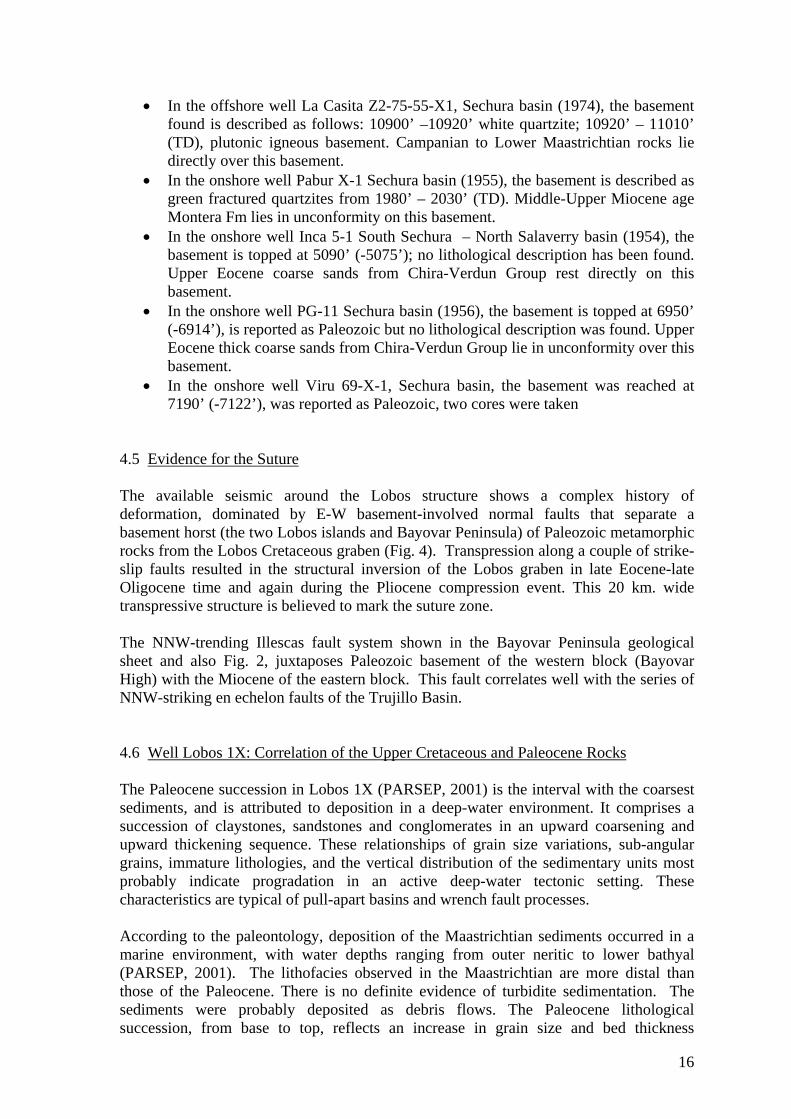
• In the offshore well La Casita Z2-75-55-X1, Sechura basin (1974), the basement found is described as follows: 10900’ –10920’ white quartzite; 10920’ – 11010’ (TD), plutonic igneous basement. Campanian to Lower Maastrichtian rocks lie directly over this basement.
• In the onshore well Pabur X-1 Sechura basin (1955), the basement is described as green fractured quartzites from 1980’ – 2030’ (TD). Middle-Upper Miocene age Montera Fm lies in unconformity on this basement.
• In the onshore well Inca 5-1 South Sechura – North Salaverry basin (1954), the basement is topped at 5090’ (-5075’); no lithological description has been found. Upper Eocene coarse sands from Chira-Verdun Group rest directly on this basement.
• In the onshore well PG-11 Sechura basin (1956), the basement is topped at 6950’ (-6914’), is reported as Paleozoic but no lithological description was found. Upper Eocene thick coarse sands from Chira-Verdun Group lie in unconformity over this basement.
• In the onshore well Viru 69-X-1, Sechura basin, the basement was reached at 7190’ (-7122’), was reported as Paleozoic, two cores were taken
4.5 Evidence for the Suture The available seismic around the Lobos structure shows a complex history of deformation, dominated by E-W basement-involved normal faults that separate a basement horst (the two Lobos islands and Bayovar Peninsula) of Paleozoic metamorphic rocks from the Lobos Cretaceous graben (Fig. 4). Transpression along a couple of strike-slip faults resulted in the structural inversion of the Lobos graben in late Eocene-late Oligocene time and again during the Pliocene compression event. This 20 km. wide transpressive structure is believed to mark the suture zone. The NNW-trending Illescas fault system shown in the Bayovar Peninsula geological sheet and also Fig. 2, juxtaposes Paleozoic basement of the western block (Bayovar High) with the Miocene of the eastern block. This fault correlates well with the series of NNW-striking en echelon faults of the Trujillo Basin. 4.6 Well Lobos 1X: Correlation of the Upper Cretaceous and Paleocene Rocks The Paleocene succession in Lobos 1X (PARSEP, 2001) is the interval with the coarsest sediments, and is attributed to deposition in a deep-water environment. It comprises a succession of claystones, sandstones and conglomerates in an upward coarsening and upward thickening sequence. These relationships of grain size variations, sub-angular grains, immature lithologies, and the vertical distribution of the sedimentary units most probably indicate progradation in an active deep-water tectonic setting. These characteristics are typical of pull-apart basins and wrench fault processes. According to the paleontology, deposition of the Maastrichtian sediments occurred in a marine environment, with water depths ranging from outer neritic to lower bathyal (PARSEP, 2001). The lithofacies observed in the Maastrichtian are more distal than those of the Paleocene. There is no definite evidence of turbidite sedimentation. The sediments were probably deposited as debris flows. The Paleocene lithological succession, from base to top, reflects an increase in grain size and bed thickness
16

attributed to erosion of high tectonic relief and progradation. The high content of feldspars and igneous rock fragments observed in all the samples, reflects an immature provenance and possibly arid climate (lack of chemical weathering) and short distances of transport; most tectonically active settings are characterized by short-headed depositional systems. This interpretation is further supported by the predominance of sub-rounded to angular grains. We compare the Upper Cretaceous and Paleocene succession drilled in the Lobos 1X and La Casita 55-X1 wells with the section at the western edge of Paita High. They are similar in terms of basement affinity, age, grain size, lithological maturity, and the apparent short distances of transport. One significant difference, however, is the interpreted water depth of the depositional environment in either succession. However, these localities are 200 km apart. The above observations suggest that the Lobos pre-Cenozoic rocks have more affinity with the Paita succession than with the Lower Cretaceous section of the Andean margin. Of course, additional work is needed to place these interpretations in their regional context. 4.7 Geological Overview of the Salaverry Basin Historically, the Salaverry Basin has been described as a basin separate from that of the Sechura. This was later challenged by F. Zuniga-Rivero et al (1998), who in their study, saw no tectonic or structural boundary between the two and accordingly treated the two basins as one. Contrary to the above, this evaluation found a very prominent structural ridge separating the two basin (Figs. 4 and 10), which is supportive of the earlier interpretation. This high was formed predominantly by uplifts between Late Miocene and Pliocene times which is coincidental with the uplift (inversion) seen along the Salaverry High, the north-south trending intervening ridge separating the Salaverry Basin from the Trujillo Basin (Figs. 4 and 9). Lower to Middle Miocene sediments are seen onlapping this high, indicating that it was also an ancestral feature but with a relief of a somewhat more subtle nature. The Salaverry Basin in pre-latest Miocene time was the shallow eastern shelf area of the much deeper Trujillo basin to the west. The same can be said for the southern part of the Sechura Basin. The monotony of this shelf area is broken occasionally by small half grabens of limited areal extent. An example of this can be seen in Figure 8. A significant Late Miocene uplift created the now prominent Salaverry High that presently separates the Trujillo Basin from the Salaverry Basin. This was further accentuated with additional uplift during Pliocene time. These uplifts created a rather simple depression, which was filled by sediments of Upper Miocene to Recent age. The Salaverry Basin is consequently a very young basin containing sediments generally no older than Middle Miocene in age. For example, the isochron map of the Eocene to Basement interval (Enclosure 8) shows the Eocene section to be limited to the Trujillo Basin. The Eocene to Base Upper Miocene package, on the other hand extends into the Salaverry Basin but only along its westernmost flank. Structurally the basin is quite simple and has the geometry of an almost symmetrical, elongated oval. The basin is punctuated by a series of NW-SE to N-S trending wrench
17

eUET
eeMMT
Basement
eUMT
Figure 5: Dip line 93-30 across the Sechura/’Salaverry’ Basin
eCH
Basement
eUMT
Figure 6: Dip line L93-38 across the Salaverry Basin
18

Basement
eUMT
Figure 7: Dip line L93-43 across the Salaverry Basin
Basement
eUMT
eMMT
Figure 8: Dip line L93-49 across the Salaverry Basin
19


Figure 10: Strike line L93-68 across the structural high separating the Sechura and Salaverry Basins.
21
Figure 9: Dip line L93-45 across the Trujillo and Salaverry Basin
Basement
Salaverry Basin
Basement
Salaverry Basin
eUMT
Salaverry High
Sechura/Salaverry High
eUMT
eCH
eUET
Trujillo Basin
eMMT
Sechura Basin
eCH
eMMT

22
Cretaceous
Basement
Eocene
Figure 11: N-S seismic line through the Lobos well in the Trujillo Basin. Note the difference in character of the Cretaceous section in this figure with that of the Salaverry pre-Tertiary sequences in Figures 5-10
-S seismic line through the Lobos well in the Trujillo Basin. Note the difference in character of the Cretaceous section in this figure with that of the Salaverry pre-Tertiary sequences in Figures 5-10
faults. In the northern part of the basin a very prominent WNW-ESE trend is present (Fig. 18), which cuts only the shallow section and does not affect basement (Fig. 17). faults. In the northern part of the basin a very prominent WNW-ESE trend is present (Fig. 18), which cuts only the shallow section and does not affect basement (Fig. 17). Another interesting feature about the Salaverry Basin is in the abundance of intrusive bodies seen emplaced within the Tertiary section. These are best displayed in Figures 5 and 7. Additionally, the isolated patches of highly serrated, rugged terrain underlying the Tertiary in the eastern Salaverry Basin (Fig. 6) may be indicative of volcanic flows.
Another interesting feature about the Salaverry Basin is in the abundance of intrusive bodies seen emplaced within the Tertiary section. These are best displayed in Figures 5 and 7. Additionally, the isolated patches of highly serrated, rugged terrain underlying the Tertiary in the eastern Salaverry Basin (Fig. 6) may be indicative of volcanic flows. Previously, it was speculated that a thick sedimentary package of Cretaceous rocks was present beneath the young Tertiary cover of the Salaverry Basin. This study concludes that the underlying sequences are probably metasediments of Mesozoic age and represents economic basement for the following reasons.
Previously, it was speculated that a thick sedimentary package of Cretaceous rocks was present beneath the young Tertiary cover of the Salaverry Basin. This study concludes that the underlying sequences are probably metasediments of Mesozoic age and represents economic basement for the following reasons.
1. The Ballena 1X well found the basal Tertiary sequences overlying a basement composed of quartz biotite gneiss. Reflectors beneath this Tertiary contact can clearly been seen in Figure 9, extending from the well to the Salaverry Basin beneath the Tertiary. This study finds it difficult to interpret any significant structural feature that would separate the two areas. Consequently, it was concluded that rocks interpreted previously as Cretaceous sediments by other
1. The Ballena 1X well found the basal Tertiary sequences overlying a basement composed of quartz biotite gneiss. Reflectors beneath this Tertiary contact can clearly been seen in Figure 9, extending from the well to the Salaverry Basin beneath the Tertiary. This study finds it difficult to interpret any significant structural feature that would separate the two areas. Consequently, it was concluded that rocks interpreted previously as Cretaceous sediments by other

studies, must have the affinities similar to those penetrated by the Ballena 1X well.
2. The seismic character of the reflections beneath the Salaverry basin are of low
frequency, and sometimes continuous, but as equally, chaotic. Many of these reflectors may not be sedimentary in nature, but rather seismic multiples generated when the signal hits the hard basement surface. Furthermore, this character is very different in appearance from the more continuous, higher frequency reflectors seen within the Cretaceous section in the vicinity of the Lobos 1X well located northeast of the Salaverry Basin (Fig.11).
3. Fieldwork preformed by Petroperu in the coastal areas of the Trujillo Basin
generally found most of the Cretaceous sediments to be highly indurated and with TAI’s of 5. This latter point indicates that these sediments have experienced a very high thermal history.
4. Fieldwork by PARSEP (Appendix 2) found intruded (gabbro dykes), foliated
Jurassic metasediments along the coastal areas that could be projected into the subsurface beneath the Tertiary unconformity.
5. The proliferation of intrusive bodies seismically identified within the Salaverry
basin.
23

5.0 STRATIGRAPHY Overlying economic basement of Mesozoic age, four main sedimentary sequences have been recognized in the geological evolution of the Salaverry Basin, the Lower Miocene, Middle Miocene, Upper Miocene and Plio-Quaternary. To the west of the basin along the Salaverry High, sediments of Upper Eocene age are seen onlapping basement and further west yet in the much deeper Trujillo Basin, rocks of Oligocene and Lower to Middle Eocene are also encountered. Although Eocene through Oligocene rocks have not been interpreted in the Salaverry Basin, they have been included in following section for consistency 5.1 Economic Basement The Economic Basement of the Salaverry Basin has been penetrated in two wells, the Delfin 1X and Ballena 1X and is interpreted to be of possible Cretaceous age. Seismically, the top of Economic Basement is very well defined and throughout the Salaverry area, is considered for most part to be immediately underlying the Tertiary. A more detailed description on this topic of basement can be found in the preceding sections - 4.2 The Basement of the Salaverry and Trujillo Basins; and 4.7 Geological Overview of the Salaverry Basin. 5.2 Middle Eocene This section is found only in the Trujillo Basin and is mainly constituted by fine-grained sediment (silty claystones and micritic limestones). In the Morsa 1X well, this age represents the onset of sedimentation which occurred in a relatively deep marine environment. As this area was a paleo-high, only thin beds of sandstone were deposited. The abundance of radiolarians and deep-water benthonic forams found in the Delfin 1X well (Table 2) suggests that cold-water upwelling was in affect off the Peruvian shelf during Middle Eocene time. 5.3 Upper Eocene The Upper Eocene is found only in the Trujillo Basin and the western reaches of the Salaverry High. In the Trujillo Basin well, Lobos 1X, this unit is constituted by gray to olive gray silty claystones and micritic limestones deposited in a deep-water environment. In the Morsa 1X well, hemipelagic sedimentation in relatively well oxygenated waters as suggested by low TOC contents. The presence of conglomerates near the base may be interpreted as the result of some catastrophic events that affected the Peruvian continental margin or explained as the distal part of an incised valley on a sub-aerially exposed continental shelf. In comparison the Upper Eocene section of the Sechura and Talara basins is comprised mainly of shallow marine clastic sediments.
24

5.4 Oligocene Some evidences of Oligocene sediments have been found in the well Lobos 1X with a single specimen of Cyclusphaera doubingerii at 595 m. (Table 4) that ranges in age from Oligocene to Eocene. No samples were recovered above 520 m. In the Morsa Norte 1X, well the interval 833-1031 m. (Table 3) brings a microfauna assemblage that gives a range within the Oligocene-Eocene. However, there are no clear evidences of fauna exclusive of biochronozones P22 to P18 from the Oligocene. In Delfin 1X well (Table 2) the nannofossil Helicosphaera recta (P18-P19) was found at 1485.6 m, this specimen defines the Middle Oligocene in Ecuador. The Oligocene represents a wedge of sediments that is interpreted to pinchout along the eastern boundaries of the Trujillo Basin. 5.5 Lower Miocene Sediments of Lower Miocene age have been found in wells Ballena 1X (450.6 – 825 m. in Table 1), Delfin 1X (782.4 – 1467.4 m. in Table 2). In the Ballena well, fine sandstones interbedded with silty limestones and mudstones and layers of iron nodules predominate at the lower part, above 566 m. are mainly dolomitised limestones, interbedded with sandstones, siltstones and calcareous mudstones. As a whole, the interval shows a deepening upward sequence. In the Delfin well the lithology is mainly brown mudstone interbedded with dolomitised micritic limestone (Table 2), with a coarse sand layer noted at 1248 m. In Morsa well the rock type is a calcareous sandy mudstone with a relatively high content of pyrite that may be associated with anoxic conditions on the sea bottom. This is corroborated by the relatively high TOC contents over the complete section (Geochem Group Ltd., 1999a). 5.6 Middle Miocene Three wells of the four wells drilled in the area found the Middle Miocene section. In the Ballena well (344 – 450.6 m. in Table 1), the lithology is a micritic brown dolomitised limestone interbedded with silty limestone and fine to medium quartz sandstone; most of the fauna encountered have affinities with those found in California, Ecuador and Venezuela. In the Delfin well (368.4 – 782.4 m in Table 2), the upper part of the interval corresponds to a probable early Upper Miocene age; the fauna is similar to that described in the Upper Miocene of Ecuador and Middle to Upper Miocene of California. In the Morsa well, the top of the carbonate section was picked as the top of the Middle Miocene from the occurrence of Globorotalia mayeri (bichronozone N14 - top of Serravalian). 5.7 Upper Miocene to Pliocene In the Ballena well (231.4 – 344 m. in Table 1), siltstone to coarse sandstone interbedded with brown limestone is the predominant lithology of the section. In the Delfin well (228.3 – 368.4 m. in Table 2), fine sand interbedded with micritic limestone grading upward to coarse sand and siltstone with a lack of preserved fossils, high clastic content and presence of authigenic limestone, suggest a rapid transportation of shallow water sediments into deep water. Authigenic limestone indicates a cold-water upwelling at the
25

Peruvian coast. In the Morsa well (203? – 540 m. Table 3), this interval is described as a gray to olive silty claystone with interbedded thin micritic limestone and a lack of fauna. 5.8 Plio – Quaternary A relatively thick wedge of sediments occurs on the present continental slope west of the Morsa Norte 1X well, reaching a maximum thickness of 500 ms TWT. It is seen pinching out on the modern day upper slope. This wedge is a basinward progradation of the outer continental shelf and slope, and because of erosion and sediment bypass, most of the pre-existing shallow areas have little sediment of this age. The principal of site of Plio-Quaternary sediment preservation within the inner shelf area is in the Salaverry basin.
26

6.0 WELL SUMMARY Within the Salaverry/Trujillo area four wells have been drilled, Ballena 1X and Delfin 1X drilled by Occidental in 1971 and Morsa North 1X and Lobos 1X by Repsol in 1999. All but Lobos 1X TD’d in basement, which was abandoned in the Cretaceous. The following section summarizes the salient points pertinent to the two wells most closely associated with the Salaverry Basin, Ballena 1X and Delfin 1X. 6.1 BALLENA 1X The Ballena 1X well was drilled by Occidental Peru in 1971 and was the first well drilled in this region. The nearest well control at the time of drilling was the Inca 5-1 well which was drilled in 1954 and located onshore just over 300 km to the north (Fig. 2). The Ballena 1X well was drilled to basement and had a total depth of 3198 feet. Although the well was the first in the area, it was not actually drilled in either the Trujillo or Salaverry Basins but rather on the Salaverry High. This high is a northwest trending elongate basement feature that experienced several pulses of late Miocene – Pliocene uplift/inversion, and now separates the Trujillo Basin to the west from the Salaverry Basin to the East. Intersecting the Ballena 1X well is the seismic line L96-105 (Fig. 6).
Basement
Upper Miocene
Middle Miocene
Eocene
Alternative Eocene Top
Middle Miocene Marker
Salaverry High
Trujillo Basin
Figure 12: Seismic Line 96-105 through Ballena 1X Well
27

It should be noted that the top of the Eocene as depicted on the Seismic line L96-105 (Fig. 12), is tied to the biostratigraphic data for both the Delfin and Ballena 1X wells. A purely seismic interpretation could have picked the Top of the Eocene to occur at a lower depth west of SP 1350.
Table 1: From Ballena 1X – Biostratigraphy table (Summary from Appendix B: Paleoenvironmental analyses of the Delfin 1X and Ballena 1X wells in Carlos Azalgara (1993) N O
N UB
LB
DEPTH (m)
BIOMARKERS AND NOTES EPOCH Series
PERIOD SYSTEM
231.4 (760’)
Interval top and age based on the occurrence of nannofossils Reticulofenestra pseudoumbilica (CN9-CN11), Sphenolithus neoabies (CN10?-CN11) and associated flora at 760’. Paleoenvironment: Outer neritic, 300 – 600 ft. Lithology: Siltstone to coarse sandstone interbedded with calcareous brown limestone. Shells with rare coral fragments at the top of the interval. Benthonics: Many species noted in this interval are known from the middle and upper Miocene of California an also show affinities with the Manabi basin of coastal Ecuador. Planktonics: Extremely rare and non-diagnostic. Remarks: Occurrence of reworked Eocene nannofossils indicates that downslope transport was prevalent
Lower Pliocene/ Upper Miocene
Neogene
344 (1130’)
Interval top and age based on the occurrence of nannofossil Helicosphaera californiana (CN3-CN5) and the associated flora. Paleoenvironment: Outer Neritic – upper Bathyal, 300’ – 1500’. Lithology: Micritic brown dolomitised limestone interbedded with silty limestone and fine to medium quartz sandstone. Planktonic: Extremely rare and non-diagnostic. Benthonics: Many of the species; Siphonodosaria advena, Buliminella subfusiformis, Uvigerina cf. californica, cf. parva, Valvulineria cf. robusta at 1300’ and Uvigerina peregrina, Bolivina cf. marginata and cf. cochei at 1390’ are known from the Miocene of California and Ecuador. The faunal assemblage also shows an affinity to the Agua Salada Fm. of Venezuela.
Middle Miocene
Neogene
450.6 (1480’) 825.0 (2710’)
Interval top and age based on planktonic Praeorbulina glomerosa (N7-N8.5) at 1480’ and the nannofossil assemblage at 1830’. Paleoenvironment: Middle Neritic to Upper Bathyal, 180’ to 1500’. Lithology: Dolomitised limestone, interbedded with sandstone, siltstone and calcareous mudstone. Below 566.2m (1860’), clastic material increases. At 685m (2250’), sandstone is interbedded with silty limestone and mudstone and layers of iron nodules occur. Nannofossils: common occurrence of Discoasterdeflandrei (CP18-CN3) and other rare occurrences Dr. Okada assigned lower Miocene age (CN1-CN3). This age is also supported at 1630’ by the diatom zone, Denticulopsis nicobarica. Benthonics: A slight change in the fauna, in diversity and abundance at 1480’. New species include Baggina robusta, Uvigerina cf. ornata, Brizalina cf. granti, cf. pozonensis, Bolivina cf. rankini, etc. At 548m (1800’) new species were noted Amphimorphina cf. amchitakaensis, Nodosaria stainforthi, Bulimina cf. rostrata Bolivina cf. brevior and floridana. Rare radiolarians (phacodiscids), fish otoliths and pyritized diatoms occur sporadically below 1480’. Below 602.7m (1980’), “bone fragments” occur. All faunal elements disappear below 739.8m (2430’). Remarks: As a whole, the interval shows a deepening upward sequence. Above this Lower Miocene interval, the well shows an apparent shallowing upward sequence.
Lower Miocene
Neogene
855 (2808)
Based on Repsol Report. The coarse grained lithology of this sequence prevented H.Okada from dating it (C.Azalgara, 1993)
Eocene Paleogene
963 (3163’)
Basement. TD.: 975m (3202.7’)
N:INNER NERITIC; ON:OUTER NERITIC; UB:UPPER BATHYAL; LB:LOWER BATHYAL
28
The well encountered rocks of Tertiary age overlying basement, which was identified as a Quartz Biotitic Gneiss of Paleozoic (?) age. A summary on the reevaluation of the samples and cores from this well to refine the paleo-bathymetry, depositional environments and age of the sediments, was done in 1990 and recorded in the thesis of C. Azalgara (1993). These results are presented in Table 1. 6.1.1 Lithological/Reservoir Discussion Dark brown dense, authigenic carbonates (dolomicrite, lime micrite and calcareous mudstone) were the most prevalent lithologies noted in the well. The composition of the diagenetic carbonates varies from calcite to dolomite. Organic-rich mudstones derived from coastal upwelling make up the bulk of the sediments. Sediments of this type accumulate on the outer shelf and upper slope, which is seaward of the high-productivity surface waters of the inner shelf. Coarse clastics have been described in the well from various reports, but upon examination of the well logs, there is little to indicate that there is much of anything with reservoir potential. 6.1.2 Hydrocarbons Shows No indications of hydrocarbons were found in this well. 6.2 DELFIN 1X The Delfin 1X well was the second well drilled by Occidental Peru in the region and was spudded immediately following the Ballena 1X abandonment. The well was drilled to metamorphic basement and a total depth of 8743 feet. It was abandoned as a dry hole on September 1971. The well when drilled was based on a prospect defined with a very coarse seismic grid and subsequent seismic acquired over the area now show there is no structural closure at the Delfin location. The well location is spotted on seismic line C-2030 that is shown in Figure 13. 6.2.1 Lithological/Reservoir Description In the Delfin 1X well, the Middle Eocene and Upper Eocene/Lower Oligocene sequences for most part consist primarily of interbedded limestone, mudstone and siltstone. It should be noted that the Delfin 1X well was the only well in the area to have conclusively encountered sediments of Oligocene age (not seismically mapped). Of importance to the economic development of the region are the sandstone intervals that were encountered within the Eocene/Oligocene section. The most significant is shown in Figure 14 where a 100 plus foot sand with porosities that in places exceed 20%, was intersected approximately 350 feet above basement. Under trapping conditions, this sandstone could make an excellent hydrocarbon reservoir.
29

Figure 13: Seismic line C-2030, through the Delfin 1X well
Basement
Upper Miocene
Middle Miocene
Eocene
Middle Miocene Marker
Figure 14: (left) A Lower Eocene sandstone reservoir that intersected in the Delfin 1X well.
140
Figure 15: (right) Mud log of the 3600 to 4500’ section where gas shows were encountered.
40DT (us/ft)
2 3RHOB (gr/cc)
0 200GR (GAPI)
0 100CALI (IN)
0.2 100SN (ohmm)
0.2 100ILD (ohmm)
0 50SP (mV)
8300
8400
8500
Sdst, fn-cse, predom crs rrd-subang clr-milky unconsol qtz, minor amnt fn-med gry SS, mica, friable, intebed med gry siltst and gry brn silty sh, tr pyrite
30

Table 2: From Ballena 1X – Biostratigraphy table (Summary from Appendix B: Paleo-environmental analysis of the Delfin 1X and Ballena 1X wells in C. Azalgara (1993)
N:INNER NERITIC; ON:OUTER NERITIC; UB:UPPER BATHYAL; LB:LOWER BATHYAL
N ON
UB
LB
DEPTH (m)
BIOMARKERS AND NOTES EPOCH Series
PERIOD
228.3 (750’)
Interval Top and age: nannofossil Reticulofenestra pseudoumbilica (CN9 – CN11) at 274m (900 ft). Paleonvironment: indeterminate, probably outer shelf or deeper ,+300’. Lithology: Fine to coarse sand and siltstone. Below 317m (1040’), sand interbedded with dolomitised micritic brown limestone. Non-in situ planktonic: forams occur. Lack of preserved fossils, high clastic content and presence of authigenic limestone along with rare shell fragments suggest that deposition was rapid with transportation of shallow water sediments into deep water. The presence of authigenic limestone which forms off the Peruvian coast during cold-water upwelling supports this interpretation.
Lower Pliocene/ Upper Miocene
Neogene
368.4 (1210’)
Top of the sequence is based on the presence of R.pseudoumbilica (CN9 -CN11) with the first appearance of Discoaster quinqueramus (CN9) at 1210’. Lithology: Fine sandstone/siltstone interbedded with dolomitised limestone. Abundant glauconite at 673m (2210’). Nannofossils: are common. Three samples were examined in this interval. D. quinqueramus occurs only at 1210 ft. It restricts the age to late upper Miocene. However, the floral assemblages below suggest the lower part of this interval is middle to upper Miocene (CN5-CN9). A middle Miocene age at 2130 ft is supported by the diatom zonal range of Coscinodiscus lewisianus through Craspedodiscus coscinodiscus (Schrader and Castañeda, 1990). Planktonics: are very rare. At 728m (2390’) a questionable specimen of the lower Miocene species Catapsydrax dissimilis was noted. Benthonics: are infrequent to 441m (1450’). Below, they increase in abundance with the first upper Miocene species, Bulliminella ecuadorana. Diatoms: are rare with an increase at 542m (1780’). This interval shows a shallowing upward sequence above the glauconite, below this level deep open marine conditions and a distinct bathyal fauna is developed. In the upper interval clastics and organic debris dominate. Paleoenvironment: Probably Upper Bathyal (600’-1500’)
Upper Miocene/ Middle Miocene (CN5? – CN9)
Neogene
782.4 (2570’)
The top interval is based on the first occurrence of several benthic forams at 2570’, Catapsydrax dissimilis at 819m (2690’), and these nannofossils: Discoaster deflandrei (CP19-CN3), Discoaster variabilis (CN3-CN11.25) and Helicosphaera ampliaperta (CP19.75-CN3) at 810m (2660’), with Triquetrorhabdulus cf. carinatus (CP18.5-CN1.3) at 1230m (4040’). Lithology: Brown mudstone interbedded with dolomitised micritic limestone; coarse sand at 1248m (4100’). Planktonics: are rare, at 819m (2690’), Catapsidrax dissimilis s.s. (P17-N6) first appears supporting a lower Miocene age. Dr Okada assigned a late lower Miocene age to 810m (2660’) and a range of early to late lower Miocene to 1230m (4040’). Diatoms: are rare with occasional fish teeth, otoliths and pellets. Middle to Paleoenvironment: Upper Bathyal (600’-4000’).
Lower Miocene
Neogene
1467.4 (4820’) 1768.7 (5810’)
Interval top and age based on the occurrence of these nannofossils Sphenolitus distentus (CP16-CP19A), Sphenolithus predistentus (CP13.5-CP18?) and Helicosphaera recta (CP18-CP19) at 1485.6m (4880’) along with the first radiolarians at 4820’. These species are Oligocene in age and have been reported from the middle Oligocene of Ecuador. Remarks: At 1714 m (5630’), abundant calcite marks the transition between the Oligocene and Eocene. This boundary represents a major hiatus. Interbedded siltstone and calcareous brown mudstone with brown calcite marking the base. Paleoenvironment: Middle to Upper Bathyal, 600’ to 4000’.
Middle Oligocene
Paleogene
1802.2 (5920’)
Top interval and age based on the occurrence of Planktonic species Globigerina pomeroli (?P11-P17) at 5920’ and Morozovella densa (P8.25-P14) at 1829.6m (6010’) with a middle Eocene (CP14B) nannofossil flora at 1875.3m (6160’). Deep-water benthonic forams are common at the top of the interval: Discorbis cf. samanica, Giroydina cf. altispira, cf. girardana, Bulimina microcostata, etc. At 6460’, these species occur: Gyroidina cf. chirana, Bulimina cf. peruviana, cf. brevis and Uvigerina cf. mantaensis. Many of these forms show affinities to the Eocene Chira Formation fauna of Peru. Paleoenvironment: The lower portion of this well shows a distinct deepening during the Eocene from inner shelf to bathyal conditions. Remarks: There is an abundance of radiolarians above; deep marine lower Oligocene sediments rest unconformably on marine Eocene sediments.
Middle Eocene
Paleogene
31

6.2.2 Hydrocarbon Shows Although no shows of oil were noted in the drilling of the Delfin 1X well, a number of gas shows were encountered in thin, tight fractured dolomites at the following depths, 3612, 3615, 3758-3763, 3790, 3796 and 4975 to 4988 feet. All but the latter interval are displayed within Figure 15 and can readily be identified by the deflections to the right on the three gas curves of the mud log.
32

7.0 GEOCHEMISTRY 7.1 Oil seeps and Crude oil characterization (modified after Repsol 1997a) The neighboring Trujillo Basin is well known for the occurrence of natural oil seeps in its northern sector. The most spectacular one is the offshore seepage a few kilometers west of Isla Lobos de Afuera, (Fig. 16), which occurs over a 5 x 3 km area as a thin iridescent film, showing patches of gas bubbles and having an oily odor over a wide distance. This seep has historically been known since the time of the first travelers of the Spanish Colony in the XVI century. In their evaluation of the Z-29 Trujillo Block, Repsol identified numerous other seeps in the area, the locations of which are presented in Figure 17. Figure 16: Location of analyzed oil seeps The geochemical study of the seep samples from the Trujillo Basin, the oil samples from the Talara producing fields and asphalt seeps, was conducted by Repsol/Corelab in
SALAVERRY Basin
23500
3000 500
000
1000
200
1500
4000
200
200
200
200
200
200
200
500
500
500
500
500
500
1000
1000
1000
1000
1000
1000
1000
150
0
1500
1500
1500
1500
1500
1500
2000
2000
2000
2000
2000
2000
2000
2500
2500
2500
2500
2500
2500
2500
3500
3500
3500
3500
3500
3500
4000
4000
4000
4000
4000
4000
3000
3000
3000
3000
3000
3000
100
100
100
100
100
100
Delfin (OXY) 1
Ballena (OXY) 1
Inca 5-1 1
PG-11N-X
Pabur X-1La Casita 55X-1
Morsa Norte 1X
Lobos 1X
PeninularBayovar
Isla Lobosde Tierra
Isla Lobosde Afuera
Puerto Eten
Puemape
Malabrigo
Trujillo
Chiclayo
33

1996/97, to define the characteristics of the oils, to group them into genetically distinct oil families and to establish the correlation oil samples with the potential source rocks. The geochemical investigation on the Trujillo oil seeps and Talara crude oils conducted by Corelab reveals three different source rocks contributing to the region: 1) The extracted oils from the seeps samples near Isla de Lobos, were derived from a source rock with mixed organic facies containing abundant marine algal organic matters, and the source rock is probably of Late Cretaceous age. 2) The oil seep from the southern part of the Trujillo Basin is considered to be sourced by a mixed organic facies with significant terrigenous organic matter deposited under anoxic condition. The source rock of this oil seep is believed to be different from that of the extracted oils from northern oil seeps, but no age is suggested for its source. 3) The crude oils from the Portachuelo, Inca and Lagunitos wells are interpreted to have been sourced by a mixed organic facies with abundant algal and terrigenous matter, and the source rock is assumed to be Upper Cretaceous or Tertiary age. 7.2 Previous Studies A number of geochemical studies were completed in the Salaverry/Trujillo area by Repsol in association with their evaluation of Lote Z29 as well as by several others different groups in the period before. The more significant of these studies and their conclusions are noted below. The reader is referred to these reports directly for additional information pertaining to the geochemical aspects of the region.
1. Amoco Geochemical Study (1992 - as referenced by Repsol, 1997) a. The geochemical study carried out by Amoco involved a suite of fifty-four
(54) core samples from the onshore Talara and Progreso basins. All core samples were analyzed for TOC, pyrolysis and maturity at Corelab in Houston.
b. Most samples contain Type III kerogen, and this combined with low TOC’s indicate low oil and gas generation capacity.
c. From this study, only 10 samples showed some hydrocarbon source potential with high TOC's values corresponding to the Lower Cretaceous Muerto Fm. from Lomitos-3835 and Ono-4000 wells in onshore Talara.
2. Core Laboratories, Inc - Geochemical Evaluation of Selected Well and Oil
Samples from Peru (October 1996) a. In this study, geochemical analyses were done on: 1) Cretaceous and
Tertiary rock samples from five wells (SBX-1, La Casita, Inca-5-1, Viru-69-1X, and Delfin 20-1X; 2); extracted hydrocarbons (oily material) obtained from 10 sea water samples; 3) an offshore oil seep from Way Point 005; 4) seven crude oils tested from three wells (five samples from the Portachuelo well, one sample from the Inca well, and one sample from the Lagunitos well; and 5) two oil seep extracts from Reventazon.
34

b. The extracted oils from the 10 water samples and the one cotton swab were derived from a source rock with mixed organic facies containing abundant marine algal organic matter, and the source rock is probably of late Cretaceous age. The oil seep from the Way Point 005 is considered to be sourced by a mixed organic facies with significant terrigenous organic matter deposited under anoxic conditions, but no age is suggested for its source. The crude oils from the Portachuelo, Inca, and Lagunitos wells are interpreted to have been sourced by a mixed organic facies with abundant algal and terrigenous organic matter and the source rock is of Tertiary age.
c. Corelab have also indicated that the different oil groups are moderately mature to mature (Ro between 0.70 and 0.80).
3. Repsol - Hydrocarbon Potential Review (September 1997)
a. This report consisted of an extensive review and analysis on the Trujillo basin geochemistry and its modeling. Repsol concluded that several thick and extensive marine shaly intervals could qualify as the sources of the numerous surface oil seeps described in the offshore Trujillo Basin area. These shaly sections are associated with the following stratigraphic intervals:
-Muerto Fm. (Lower Cretaceous) -Redondo Fm. (Upper Cretaceous) -Pariñas- Talara Fm. (Lower-Middle Eocene) -Verdun Fm. (Upper Eocene) -Montera Fm. (Middle Miocene)
b. In summary, the source rock evaluation conducted by Repsol on the Cretaceous and Tertiary intervals of the five wells, revealed only the presence of poor to marginal gas source rock potential. Only the Upper Eocene Verdun Fm and the Middle Miocene Montera Fm from the Delfin 20-x-l well, show immature oil and gas source rock potential (0.32-0.43% Ro), containing low yield Type II/III kerogens (formed by partly oxidized amorphous organic matter). These Upper Miocene source rocks when adequately mature would generate minor oil and mainly gas.
c. A series of four BasinMod burial history models were constructed for each depocenter in the Trujillo. These models have been superceded by a later work by Repsol (Repsol 2000b) after the drilling of the Lobos and Morsa 1X.
4. Geochem Group Ltd. – A Geochemical Evaluation of Well Lobos Z29M-9-1X,
Offshore Peru (October 1999) a. The analyzed intervals were consistently poor (occasionally very poor)
essentially Type III source rocks whose potential is for gas or at best for gas with associated light liquids. Moreover, they are immature above 1700 meters and effectively immature below this depth.
b. C1-C7 light hydrocarbons headspace gas data indicate good shows of extremely dry gas throughout the analyzed section. Neither these data nor the (limited) C15+ hydrocarbons data provide evidence of migrated liquid hydrocarbons.
35

5. Core Laboratories, Inc - Geochemical Evaluation and Correlation of the Morsa
Norte Crude Oil (May 1999) a. The Morsa Norte oil is a heavily biodegraded crude oil. Biodegradation
has affected its gross composition, as well as its gas chromatography (GC), and saturate and aromatic biomarker compositions. The oil is heavy (API gravity was not determined). Based on the characteristics discussed above, it can be said that the original oil prior to alteration in the reservoir, was much lighter. It is suggested that the maturity of the Morsa Norte oil is about 0.75% Ro equivalent.
b. The source rock of the Morsa Norte oil is considered to be marine with Type II/III kerogen comprising mixed organic facies (marine-terrestrial organic matter).
c. The presence of oleanane suggests the source rock for the oil is middle/late Cretaceous or Tertiary in age.
6. Geochem Group Ltd. - A Geochemical Evaluation of Well Morsa Norte Z29M-
37-1X, Offshore Peru (October 1999) a. In this study, one oil sample and two oil extracts, recovered from water
from MDT samples in the Morsa Norte 1X were evaluated for Repsol by Corelab
b. The oil sample recovered from water in the Morsa well is biodegraded oil and has a moderately heavy gross composition. The oil was derived from a marine source rock with a mixed organic facies containing predominantly marine organic matter and minor but significant terrigenous/higher plant organic matter. The oil appears to be mature. The oil correlates with the Morsa Norte oil seep and the crude oils from the Portachuelo, Inca, and Lagunitos wells. It is suggested that the source rock of these oils is probably Tertiary and Miocene.
c. The two oil extracts recovered from water are biodegraded oils and have heavy gross compositions. The oils were derived from a marine source rock with predominantly marine organic matter and minor terrigenous/higher plant organic matter. The oils are probably mature. The oils correlate with the genetic oil Group 1 represented by a number of oil seeps from seawater. The source rock for this group of oils is probably of middle/late Cretaceous in age. This conclusion should also be considered tentative. The Cretaceous Muerto-Pananga is another possible candidate.
7. Repsol – Block Z29M Offshore Peru. Source Rock Characteristics, Maturity
Modeling and Oil to Source Correlation (March 2000) a. This is a very comprehensive summary and the most recent geochemical
study done on the region utilizing all of the available data. b. Included in this report are the latest basin modeling studies utilizing the
well data from Lobos and Morsa Norte. c. The conclusions reached in this study are as follows:
i. The Lower Miocene and Upper Eocene source rocks are immature in the studied area.
36

ii. The only possible mature source rock, capable of producing significant quantities of hydrocarbons is, by analogy of what has been found in the Talara basin, the Lower Cretaceous Muerto Formation.
iii. In the case that the Muerto Fm. is not present in the Morsa graben, or is barren of organic matter, the oil found in well Morsa Norte -1X and in the surface oil seeps may correspond to small amounts of hydrocarbons generated by Upper Eocene source rocks.
7.3 Conclusions In our review of all the geochemical data and reports available, we see no reason to differ in our opinions or refute the conclusions presented by Repsol in their final Geochemical Report (2000b). As the consequences of supporting the statements above we must conclude that any oil reservoired in the Salaverry basin would have to be sourced from the depocenters located in the Trujillo Basin region to the west. To further support this supposition, the surface geological work done by Petroperu during the 1980’s in their attempt to evaluate the hydrocarbon potential of the Salaverry Basin concluded that the Cretaceous rocks of Andean affinity outcropping east of the Salaverry Basin, although containing good source rocks, typically had TAI’s of around 5 and were consequently spent.
37

8.0 GEOPHYSICS 8.1 Introduction The first seismic surveys in the Salaverry Basin were carried out in 1973 and 1974 by Petroleos del Perú S.A. and Delta Exploration Company. The program was a joint acquisition for both the Salaverry and the Trujillo Basins, of which 255 line km were exclusively in the Salaverry Basin. In an attempt to explore the continental shelf and continental margin of the Peruvian coast, Petroleos del Perú and RIBIANA INC undertook, in 1993, a massive seismic acquisition program extending from the Ecuador border in the north to the Pisco basin in the south. The Salaverry Basin received 3800 line km, which make up the bulk of this report. Other than geophysical studies, the Salaverry basin has not seen any other exploration activity. All geological information has been extrapolated from the adjacent Trujillo Basin wells, which offer a direct tie to most of the stratigraphic sequences. In total, five seismic horizons were correlated and mapped throughout the basin: Upper Miocene Top, Intra Upper Miocene Channel, Middle Miocene Marker, Upper Eocene Top and Basement. A two-way time structural map for each of these horizons is presented in Enclosures 3 to 7. The Basement and Intra Upper Miocene Channel maps are also presented in Figures 17 and 18. Furthermore, one isochron map was made that included the Basement-Upper Eocene interval and is included in this report as Enclosure 8. A seismic montage depicting the general present-day basin configuration was made (Enclosure 9) and is comprised of four regional E-W trending seismic lines, as well as one regional basin-wide profile. 8.2 Seismic Data Base For the purpose of this project, Perupetro supplied the seismic information in Exabyte 8mm SEGY format, which was in turn loaded in, and interpreted using GeoQuest software.
SURVEY SOURCE QUALITY KM RIBIANA-93 Airgun Very-good 3800 DELTA-73 Vapor chock Good-poor 255
Table 3: Details on seismic surveys within the study area
In terms of data quality, the RIBIANA-93 migrated data utilized in this interpretation was of excellent quality. The DELTA-73 survey is of much poorer quality, aggravated by navigation and processing errors and was consequently not used in the interpretation.
38

8.3 Seismic Interpretation Data loading, preparation of synthetic seismograms, horizons identification and seismo-stratigraphic interpretation and correlation, began in February 2001 and was completed in April 2001. 8.4 Structures The only significant structure mapped persistent through the entire sedimentary section was the Ballena Structure (Fig. 17). Two other structural culminations were also mapped but their sedimentary section was thin and sediments of Middle Miocene age are seen to outcrop on the sea-floor. A more detailed description on the nature of these structures was covered in the preceding section, - 4.7 Geological Overview of the Salaverry Basin. 8.5 Seismic Stratigraphic Units From the work done by Repsol (2000a) on the Morsa 1X and Lobos 1X wells it was possible to establish biostratigraphically controlled formation tops by tying this geological control to synthetic seismograms. An attempt was made to utilize the major sedimentary sequences boundaries identified on seismic which were typically found to be bounded by significant erosional unconformity surfaces. Additionally, one reflector, the Middle Miocene Marker because of its regional continuity and importance to one of the mapped stratigraphic/structural prospects, was also picked. The stratigraphic horizons established picked with their equivalent formation top are as follows::
1. eUMT - Upper Miocene Top 2. eCH - Intra Upper Miocene Channel 3. eMMM - Middle Miocene Marker 4. eUET - Upper Eocene Top 5. eB - Tertiary Basement
8.5.1 Upper Miocene Top (eUMT) This reflector is readily identifiable and very continuous across the basin. The Morsa Norte 1X well intersected this unit, immediately below the Plio-Quaternary sediments. The lower boundary of the Upper Miocene is present as an unconformity surface, which is seen truncating the underlying reflectors. The overlying package to the sea floor is a wedge of sediments that represents the basinward progradation of the outer continental shelf and slope and is Pliocene to Quaternary in age. The time-structure map of the Upper Miocene event (Enclosure 3) clearly shows that this unit is continuous throughout both the Salaverry and Trujillo Basins although absent through erosion on several prominent structural culminations. In the depocenter of the Salaverry Basin, the base of this reflector attains has a TWT of 1150 ms (around 1300
39

m), whereas along the basinal flanks, it is much shallower. This elevation change attests to the young age of the basin. 8.5.2 Intra Upper Miocene Channels (eCH) The Intra Upper Miocene Channel event is floored by a highly discordant or eroded surface forming spectacular submarine canyons in much the same manner as the younger Upper Miocene event. This boundary represents the unconformity surface separating Upper Miocene and Middle Miocene sediments. These canyon features have a strong E-W orientation and a similar distribution although slightly more than that of the Upper Miocene Top and occur primarily in the northern half of the study area. The sedimentary fill is characterized by U-shaped continuous, low amplitude, high frequency reflectors with internal chaotic character. The 2WT structure map on this reflector that is presented in Figure 18 and Enclosure 4 when compared to the 2WT structure map on Basement (Fig. 17 and Enclosure 7) shows how the Salaverry Basin attenuated through further subsidence related to the uplift of the Salaverry high in Upper Miocene time. 8.5.3 Middle Miocene Marker (eMMM) The Middle Miocene section is restricted to the western part of the Salaverry Basin, (Salaverry High). During Middle Miocene time the Salaverry Basin was the shallow shelfal area of the Trujillo Basin and this reflector is seen onlapping Basement. This is a well-defined continuous seismic reflector with a strong impedance contrast and is easily identifiable throughout most of the Trujillo Basin. This particular reflector essentially is found within the middle of the Middle Miocene and is tied to the Morsa Norte 1X well at 275 ms. A TWT map on this reflector is presented in Enclosure 5. 8.5.4 Upper Eocene Top (eUET) The Upper Eocene section, although complete in the Trujillo Basin, is mostly absent in Salaverry basin due to non-deposition. All four wells drilled in the area encountered rocks of this age. The mapped surface represents the erosionally truncated surface of the Eocene, which is overlain by rocks of Miocene or Oligiocene in age. A time-structure map on the Eocene Top is presented in Enclosure 6. 8.5.5 Basement A very stong and continuous reflector defines the base of the Tertiary section in the Salaverry Basin. Here, we have interpreted the Tertiary to be overlying metasediments of Mesozoic age which are believed to represent economic basement, as projected from fieldwork done in the coastal areas and well control. A more through discussion on this is given in the preceding sections - 4.2 The Basement of the Salaverry and Trujillo Basins; and 4.7 Geological Overview of the Salaverry Basin. A time-structure map on Basement is presented in Figure 17 and Enclosure 7.
40

Figure 17: Time structure map on Basement (left) Figure 18: Time structure map on Inter Upper Miocene Channel Top (right)
Morsa Structure
Sechura/Salaverry Structure
41
Ballena Structure

9.0 PROSPECTS In the evaluation of the Salaverry basin, no prospects of any significance were noted despite the fact that three large closures were mapped. The three structures from north to south have been designated as: 1) Sechura/Salaverry (Fig. 18) ; 2) Morsa Norte (Fig. 18); and 3) Ballena (Fig. 17). The Sechura/Salaverry closure at basement level (Fig. 17), is at best a flat that plunges rapidly to the west into the Trujillo Basin At the top of Middle Miocene level the structure is breached. Within the mid-Middle Miocene section, the structure contracts and migrates northwestward. This latter closure was defined previously in the Trujillo Basin Study as the Leon Graben Central Prospect. The Morsa Norte Structure is principally within the Trujillo Basin where it was tested by Repsol in 1999 with the Morsa Norte 1X well. At shallower levels the structure extends into the Salaverry Basin but here it is breached near the top of the Middle Miocene level and consequently, offers little in terms of prospectivity. The third structure, the Ballena, represents the best defined structure mapped within the boundaries of the Salaverry Basin and was formed as a result of the Salaverry High uplift. The Ballena 1X well, however, tested this feature in a near crestal position without any shows of hydrocarbon or significant reservoir development.

10.0 CONCLUSIONS The Salaverry Basin Project conducted by PARSEP took approximately two months to complete and was an extension to the previously completed Trujillo Basin project (PARSEP, 2001). During this time virtually all the available geologically data, which included government, industry and academic reports, and well data, was utilized within the project area as well as regionally. Additionally, a PARSEP sponsored field trip (Appendix 2) was conducted to the in the Salaverry/Trujillo area to help formulate and confirm a number of the conclusions reached in this report. Geophysically, all the available SEGY seismic data that was available was reviewed and interpreted. It is this latter work on which the foundations for the conclusions reached on regional geology and hydrocarbon prospectivity of the Salaverry Basin was made. 10.1 Regional Geology
1. The Salaverry/Trujillo area is divided into two geological provinces represented by two distinctively different basement types. The suture between these two provinces is believed to be a 20 km zone of northwest trending strike slip faults in the offshore to the south and onshore through the Bayovar Peninsula, to the north (Fig. 4). A Mesozoic Andean-type suite of rocks form the basement of the Salaverry and Trujillo Basins, and probably the Sechura South onshore Basin; they consist of slightly metamorphosed, volcaniclastic assemblages and intrusive batholiths. In contrast, the northwestern basins (North Trujillo, offshore Sechura South, Sechura North, Lancones, Talara, Tumbes) were formed in a Paleozoic basement consisting of mid to highly metamorphosed, igneous intrusives with heterogeneous lithologies, which have no obvious Andean affinities.
2. With respect to the Cretaceous to early Tertiary (Paleocene) section intersected in the
Lobos well, it is postulated that this succession has more affinity with those seen to the north in Paita and in the Lancones basin than within the Lower Cretaceous section of the Andean margin bordering the Salaverry Basin. These characteristics together with the different basement types partly support the interpretation of Jaillard (1993) of an allochthonous terrain that was apparently accreted to the continental margin of northern Peru during the latest Cretaceous- earliest Tertiary.
3. The evolution of the Salaverry basin in Tertiary time began as the eastern shelf area of
the deeper Trujillo Basin to the west. The basin itself is a very young feature that was formed following a late Miocene uplift, which created the Salaverry High, a positive area separating the Salaverry and the Trujillo Basins. The Salaverry Basin experienced further subsidence during Pliocene times with renewed uplift of the Salaverry High.
43

10.2 Stratigraphy
1. Overlying economic basement of Mesozoic age, four main sedimentary sequences have been recognized in the geological evolution of the Salaverry Basin, the Lower Miocene, Middle Miocene, Upper Miocene and Plio-Quaternary.
2. To the west of the basin along the Salaverry High, sediments of lower Middle Miocene
and Upper Eocene age are seen onlapping basement and further west yet in the much deeper Trujillo Basin, rocks of Oligocene and Lower to Middle Eocene are also encountered.
10.3 Geochemistry
1. No mature source rock can be postulated for the Salaverry Basin. Any hydrocarbon charge received in the basin would have to have migrated eastward from the deeper depocenters of the Trujillo Basin.
10.4 Prospects
1. No prospects of any significance were mapped.
44

11.0 REFERENCES
Azalgara, C. (1993). Structural Evolucion of The Offshore Forearc Basins of Peru, including the Salaverry, Trujillo, Lima, West Pisco and East Pisco Basins. (M. A. Thesis) Rice University
Caldas, J., Palacios, O., Pecho, V., and Vela, C., (1980). Geología de los Cuadrángulos de: Bayovar,
Sechura, La Redonda, Pta. La Negra. Lobos de Tierra, Las Salinas y Morrope. Instituto Geologico, Minero y Metalúrgico, Boletin Serie A, N` 32, Lima, Peru.
Corelab (1996) Geochem Evaluation of Selected: wells, seeps, and oil samples from Peru Core
Laboratories Corelab (1999) Geochemical Evaluation and Correlation of the Morsa Norte crude oil. Core
Laboratories Corelab (1999a). Petrographic report for Repsol Exploracion Peru, Morsa Norte Z29M-37-1X,
Offshore Peru. Core Laboratories, Advanced Technology Center, Carrollton, Texas. Corelab (1999b). Petrographic report for Repsol Exploracion Peru, Lobos Z29M-9-1X, Offshore Peru.
Core Laboratories, Advanced Technology Center, Carrollton, Texas. Geochem Group Limited (1999a). A geochemical evaluation of well Morsa Norte Z29M-37-1X,
offshore Peru. Geochem Group Limited, Petroleum Geochemistry Division. Geochem Group Limited (1999b). A geochemical evaluation of well Lobos Z29M-9-1X, offshore
Peru. Geochem Group Limited, Petroleum Geochemistry Division. Gaviño, C. (1987) Evaluación Geologica de la Cuenca Salaverry. Estudio Petrográfico (Areas Rio La
Leche y Alto Chicama) PETROPERU. Harrison, D.J. and Jones, P.A. (1999a). Morsa Norte Z29M-37-1X wellsite biostratigraphy of the
interval 480-1281 m TD. Robertson Research International Limited. Harrison, D.J. and Jones, P.A. (1999b). Lobos Z29M-9-1X wellsite biostratigraphy of the interval 530-
2469 m TD. Robertson Research International Limited. Jaillard, E. (1994). Kimmeridgian to Paleocene tectonic and geodynamic evolution of the Peruvian
(and Ecuadorian) margin. In: J.A. Salfity (Ed.), Cretaceous tectonics of the Andes, International Monograph Series, Earth Evolution Sciences.
Minguito, M, Machin, J, Cakebread-Brown, J, and Beroiz, C, (1997). Trujillo Basin, Block Z29,
Hydrocarbon Potential Review. Repsol Exploracion Madrid. Muro, M. (1988) Análisis petrográfico en 155 muestras de Campo secciones estratigráficas rios Zaña –
Jequetepeque. PETROPERU.
45

46
Oxidental Peruana (1971) Final Well Report Ballena 8-X-1. Oxidental Peruana (1971) Final Well Report Delfin 20-X-1. PARSEP (2001) Remaining undiscovered hydorcarbon potential of the Trujillo Offshore Basin. Quesada, S., Ferrando, R., and Bottinga, R (2000). Source Rock Characteristics, Maturity Modelling
and Oil to Source Correlation. Repsol Exploracion Sucursal del Perú. Repsol Exploracion Madrid, (1996). Trujillo Basin, Block Z-29, Source Potential Geochemical
Modeling. Repsol Exploración Perú (1997) Amplitude vs Offset (AVO) study for marine seismic survey, Block
Z29. Veritas Repsol Exploración Perú (1999). Informe final del sondeo Morsa Norte Z29M-37-1X. Repsol
Exploración, Sucursal del Perú. Repsol Exploración Perú (1999). Informe final del sondeo Lobos Z29M-9-1X. Repsol Exploración,
Sucursal del Perú. Repsol Exploracion Peru, (1999). Post Mortem Summary Well Morsa Norte Z29M-37-1X. Repsol Exploracion Peru, (1999). Post Mortem Summary Well Lobos Z29M-9-1X. Repsol Exploracion Peru (1999) Mapping and Significance of Amplitude Anomalies in the Lobos
Basin Floor Turbidite. Sotomayor, J., Chambers, A. and Molina, F. (1999). Well Lobos Z29M-9-1X-Integrated interpretation
study: Petrophysical interpretation, geological interpretation, structural analysis and geological model. Exploration Technical Direction, Repsol-YPF, Madrid.
Tarazona, A. (1987) Análisis visual de kerogeno en 52 muestras de campo Formaciones: Chicama,
Chimu, Santa, Carhuaz, Farrat, Inca, Chulec, Pariatambo. Cuenca Salaverry. PETROPERU. Torres, J, and Fontecha, B. (2000). Stratigraphy and semidementology of wells Morsa Norte Z29M-37-
1X and Lobos Z29M-9-1X. Apex Petroleum, Inc. Colorado. Vergara, J., Vargas, L. (1989) Secciones Estratigráficas medidas en el valle del Rio Zaña (Cuenca
Salaverry). PETROLEOS DEL PERU. Vargas, L., Uyen, D. (1987) Secciones Estratigráficas del Rio Chicama (Cuenca Salaverry).
PETROLEOS DEL PERU.

APPENDIX 1 Geological Legend For Enclosure 1 and Figure 2
(From Ingemmet 1:1,000,000 Map – 1995)

1
APPENDIX 2
INFORME DEL RECONOCIMIENTO GEOLOGICO DE CAMPO DE LAS ÁREAS DE
PAITA, BAYOVAR, VALLE DEL RÍO CHICAMA, MALABRIGO Y PUEMAPE
Por: YSABEL CALDERON
Revisado: Ing. CARLOS MONGES
Proyecto PARSEP LIMA 2 DE ENERO DEL 2001

2
INFORME DEL RECONOCIMIENTO GEOLOGICO DE CAMPO DE LAS ÁREAS DE PAITA, BAYOVAR, VALLE DEL RÍO CHICAMA,
MALABRIGO Y PUEMAPE
TABLA DE CONTENIDO
INTRODUCCION ........................................................................................................ 3
OBJETIVO .................................................................................................................. 3
AREAS DE PAITA Y BAYOVAR................................................................................ 4
Ubicación y Accesibilidad .........................................................................................................4
Aspectos Geológicos...................................................................................................................4 Estratigrafía.................................................................................................................................4
PALEOZOICO ....................................................................................................................4 CRETACEO ........................................................................................................................4
Campaniano medio-superior (Formación La Meza) .....................................................................4 Maastrichtiano inferior (Formación La Tortuga) .........................................................................4 Maastrichtiano medio (Formación El Cenizo) ............................................................................5 Paleoceno (Formación Balcones) .............................................................................................5 Eoceno Inferior (Formación Salina-Mogollón) (?).......................................................................5 Eoceno Superior (Formación Verdún) (?) ..................................................................................5
Geologia Estructural .....................................................................................................................5
AREAS DE VALLE DEL RIO CHICAMA, MALABRIGO Y PUEMAPE.................... 11
Ubicacion y accesibilidad ...............................................................................................................11
Aspectos Geológicos ......................................................................................................................11 Estratigrafía...............................................................................................................................11 Geologia Estructural ...................................................................................................................11
CONCLUSIONES ..................................................................................................... 12

3
INFORME DEL RECONOCIMIENTO GEOLOGICO DE CAMPO DE LAS ÁREAS DE PAITA, BAYOVAR, VALLE DEL RÍO CHICAMA,
MALABRIGO Y PUEMAPE INTRODUCCION
La evaluación de las cuencas de offshore, Salaverry y Trujillo, que viene conduciendo el grupo de trabajo del Proyecto PARSEP motivó la realización de este trabajo de reconocimiento geológico, cuyo fin fue la observación y toma de datos de los afloramientos de rocas del Paleozoico, Jurásico, Cretáceo y Terciario localizados entre Paita y Trujillo. La utilización de estos datos con la información geológica, geofísica y geoquímica disponibles y que viene trabajando el grupo, permitirá elaborar un mejor modelo geológico que replantee el potencial de hidrocarburos de estas dos cuencas.
El viaje se realizó entre el 12 y 17 de Diciembre, recorriendo mas de 1,600 kms que comprendieron las
localidades de Paita, La Tortuga, Península de Bayovar, Playa Tantaleán, Valle de Chicama, Punta Moreno, El Cruce, Malabrigo y Puemape.
Participaron en este viaje los geólogos Javier Jacay (Guia de Campo de la empresa MINPETROL),
Rolando Bolaños, Carlos Monges, Gary Wine e Ysabel Calderón del Proyecto PARSEP. El recorrido del viaje se inició en la localidad de Paita el día 13 de Diciembre donde se apreciaron los afloramientos del Paleozoico, Cretaceo (Fm La Meza, Fm Tortuga, Fm Cenizo) y del Terciario (Fm Balcones). Bayovar fue el siguiente punto de estudio donde se observaron afloramientos reportados como de la Formación Verdún (?) del Eoceno superior. El recorrido al Valle del río Chicama, donde se apreciaron diversas facies de formaciones desde el Titoniano hasta el Valanginiano, se realizó el dia 15 de diciembre. Durante el último día de campo se hizo un reconocimiento de las áreas costeras de Malabrigo y Puemape, donde se observaron secuencias del Grupo Goyllarizquisga discordante sobre secuencias metamorfizadas identificadas como de la Formación Colán del Jurásico Inferior de la costa.
OBJETIVO
El objetivo principal de este reconocimiento geológico fue el de observar y analizar directamente las relaciones estratigráficas de la series expuestas en las diferentes localidades seleccionadas, identificar y reconocer los modelos sedimentarios de cada una de ellas, observar su grado y tipo de deformación tectónica y en algunos de los casos el grado de metamorfismo que afectó a las rocas. Esta experiencia visual transformada en información geológica es de tremenda utilidad al momento de trabajar la interpretación de las secciones sísmicas y en la concepción regional del área de estudio.

4
AREAS DE PAITA Y BAYOVAR
Ubicación y Accesibilidad
Las dos áreas de estudio se encuentran ubicadas en la Costa Noroeste del Perú. La principal ruta de acceso a estas localidades es por la carretera Panamericana Norte. A partir de esta, salen numerosos ramales afirmados, los mismos que cruzan el área (Figuras No 1 y No 2). Desde la ciudad de Piura se toma la carretera a Paita, unos 5 kilómetros antes de esta ciudad se toma el desvío al sur que lleva directamente al poblado La Tortuga. Desde aquí se puede bajar a la playa donde hay excelentes exposiciones, a lo largo de 5 kilómetros, de rocas del Cretáceo superior (Fms. Tortuga y Cenizo) y Paleoceno (Fm. Balcones) El área de la Península de Bayovar es accesible saliendo de Piura tomando la carretera Panamericana en dirección al sur hasta encontrar a unos 85 kms el desvío a Bayovar, desde este punto en dirección al oeste se recorren unos 60 kms, sobre una carretera en regulares condiciones que atraviesa un árido y salino desierto y que está interrumpida en varios puntos por el avance de medanos de arena.
Aspectos Geológicos
Estratigrafía PALEOZOICO
Serie metamórfica deformada a partir de secuencias sedimentarias areno- pelíticas que han sido transformadas a esquistos de bajo grado, filitas y cuarcitas. (J. Jacay). Estas se exponen en el sector de la Playa Tantalean (Bayovar). Los niveles pelíticos son los que mayormente han sufrido los efectos del metamorfismo regional y térmico. Las filitas están constituidas por finas laminaciones negro-azulinas, mayormente fisibles y astillosas con superficie lustrosa. CRETACEO Campaniano medio-superior (Formación La Meza)
Formación conocida también como Caliza La Meza, se le encuentra en el cerro La Meza, ubicado al Sureste de Paita. Afloran Calizas masivas que presentan un fracturamiento vertical columnar. Según estudios microscópicos de INGEMMET, revelan que se trata de una caliza biosparítica que contienen un 40% de aloquímicos como bioclastos de foraminíferos, ostracodos, restos de lamelibranquios remplazados por calcita y un 60% de ortoquímicos en forma de esparita y micrita. (Figura No 3). Esta formación corresponde al Campaniano superior. (Foto N° 0) Maastrichtiano inferior (Formación La Tortuga)
Se trata de secuencias conglomerádicas que afloran en las playas del sur de la gran Península de Paita. La Serie Maastrichtiana aflora discordante sobre el Paleozoico indiferenciado y las mejores exposiciones se encuentran en las playas La Tortuga, El Cenizo, Punta Perico y Playa Perico.
La ocurrencia de potentes conglomerados y brechas del Maastrichtiano temprano (?) indicaría la ocurrencia de un evento tectónico importante representado en los depósitos gruesos de la Fm. La Tortuga a lo largo de la costa de Paita. Este evento tectónico fue seguido probablemente por el levantamiento de la cuenca. (Figura 4)
Niveles intercalados con brechas pasan gradualmente a depósitos marinos. Esta secuencia esta conformada por lutitas marinas, areniscas de playa y brechas de cono aluvial, el cambio

5
transicional a areniscas más finas va indicando el grado de profundización del ambiente de depositación. (Foto N° 1)
En esta área se pueden ver también zonas de paleo corrientes. (Foto N° 2) Maastrichtiano medio (Formación El Cenizo)
Secuencia de areniscas grises, negras y gris amarillentas masivas con lentes y horizontes conglomerádicos transgresivos, descansan en discordancia angular sobre la Formación Tortuga. Esta serie representa un ciclo de plataforma litoral (J.Jaillard, 1997) Edad probable Maastrichtiano medio. El espesor de esta formación es de aproximadamente 200 m. (Foto N° 3 ) TERCIARIO Paleoceno (Formación Balcones)
Una potente secuencia (500 m) de clásticos finos gris oscuros, de ambiente de plataforma con un nivel basal de brechas que descansan en discordancia angular sobre la Formación Cenizo, identifican este ciclo de probable edad Paleoceno. (Foto N° 4 )
Eoceno Inferior (Formación Salina-Mogollón) (?) Abanicos aluviales atribuidos al Salina-Mogollón de edad Eoceno temprano son reportados en la sección de La Tortuga (J.Jaillard, 1998). Cerca de cerro Blanco sobre la carretera camino a la localidad de La Tortuga aparecen afloramientos de conglomerados que por tipo de facies podrían atribuirse al Salina.Mogollón. Facies clásticas marinas litorales mas finas infrayacen a estos conglomerados y descansan en discordancia angular sobre rocas metamórficas del Paleozoico indiferenciado. (Foto N° 5). Eoceno Superior (Formación Verdún) (?)
La denominación corresponde a IDDINGS y OLSSON (1928) quienes describieron unas areniscas macizas y lutitas yesíferas en los alrededores de Verdún en la región de Talara y que afloran en la zona de Pariñas. La edad correspondiente a esta formacion es Eoceno superior
En el área de la Península de Bayovar la Fm. Verdún está mapeada en varios sitios como en
la parte superior de la playa Tantalean (Hojas 12ª y 12b de Bayovar y Sechura). En las proximidades de la playa se puede apreciar areniscas calcáreos que descansan directamente sobre las rocas metamórficas, con facies coquiniferas amarillentas no muy compactas (!), con abundantes fragmentos fosiles, suprayaciendo a esta secuencia se encuentran areniscas muy friables(!) con estructuras sedimentarias de corriente de alta energía muy notorias, con laminación y estratificación cruzada festoneada de alto angulo. Las estructuras sedimentarias parecen ser de un ambiente de barras de canales entrecruzados. La poca compactación de los sedimentos y las facies coquiníferas con bivalvos fósiles tipo “Spondilus” hacen dudar que esos afloramientos sean del Eoceno superior. Podrían corresponder a sedimentos del Cuaternario. (Fotos N° 6 y 7).
Geologia Estructural
Los Macizos de Paita e Illescas (Bayovar) son dos accidentes tectónicos de importancia regional en lo que se refiere a las cuencas de la costa norte del Perú. La Silla de Paita es una protuberancia geográfica de la costa norte actual, con un núcleo de rocas metamórficas Paleozoicas intruída por granitos pre-Mesozoicos. Este macizo esta circundado por remanentes de rocas del Cretáceo superior de diferente composición litológica y diferente ambiente de deposición que las series equivalentes de dominio Andino. La serie del Cretáceo inferior (Grupo Goyllarisquizga) que aflora a lo largo de las estribaciones nor-occidentales de los Andes ha sido diferenciada de la serie Cretácica de la Costa por varios autores. Estas notorias diferencias han sugerido establecer la

6
hipótesis de que las cadena Paleozoica de los Amotapes, la Silla de Paita y el Macizo de Illescas podrían ser micro-continentes alóctonos con raíz de corteza oceánica acrecionados a la placa continental en diferentes eventos y tiempos, quizás hacia el límite Cretáceo-Terciario. Mediciones de paleo-corrientes realizadas a la serie Cretácica de La Tortuga indican una dirección de aporte del oeste hacia el este, completamente opuesto a la configuración de la cuenca Cretácica Andina.
En el área de Bayovar el Macizo de Illescas tiene la forma estructural de un gran anticlinorio
con eje noroeste-sureste. Esta constituido por un complejo metamórfico igneo con rocas de probable edad pre-Cambriana consistentes en gneises anfibolitas y tonalitas, superpuesto por una serie paleozoica que incluye cuarcitas, filitas, microesquistos, migmatitas.

7
Figura No 1 Mapa de Ubicación del área de Paita y localidades visitadas

8
Figura No 2 Mapa de Ubicación del área de Bayovar y localidades visitadas.

9
Figura No 3 Formación La Meza. Columna realizada en estudios previos.

10
Figura No 4 Formación La Tortuga, Cenizo, Balcones y Mogollón. Columna realizada en estudios
previos.

11
AREAS DE VALLE DEL RIO CHICAMA, MALABRIGO Y PUEMAPE
Ubicacion y accesibilidad
Zona ubicada a una distancia de 59 Km, al NNE de la ciudad de Trujillo, en el curso medio del Valle del río Chicama. La principal vía terrestre es la carretera Panamericana de la cual parten varios ramales, para esta zona se tomó la carretera Chicama-Sayapullo, que asciende por el valle de Chicama. (Figura N 5)
Aspectos Geológicos
Estratigrafía
En el área del Valle de Chicama se pudo apreciar a lo largo de este, las secuencias Jurásico-Cretácicas y en Puerto de Mal Abrigo las secuencias que pertenecerían al Colan (según T. Mourier, 1988) seguidas de una secuencia Volcanosedimentaria perteneciente a la Formación Tinajones, sobre el cual descansa en forma discordante las areniscas cuarcíticas que pertenecen al Grupo Goyllarisquizga.
Las secuencias presentes en el valle de Chicama, segun nuevos estudios realizados (Tesis J. Jacay) en el
área se optó por una nueva denominación, tomadas de los afloramientos de los alrededores del poblado de Punta Moreno. Al sur de dicho pueblo aflora la primera unidad del Grupo Chicama constituida por una secuencia rítmica de areniscas y microconglomerados volcanoclásticos y de lutitas. Las areniscas son generalmente de coloración gris verdoso a gris marrón y de granulometría variada. En esta secuencia denominada Formacion Punta Moreno, se realizó un análisis de facies anteriormente. En este lugar se puede apreciar secuencias turbidíticas definidas por la ritmicidad de la sedimentación.
La formación Sapotal, la cual se observa en la quebrada que está próxima al poblado de El Cruce,
muestra una secuencia de lutitas negras gris azuladas con delgadas intercalaciones de areniscas gris amarillentas. Esta secuencia es bastante fosilífera habiendose encontrado Substeueroceras y Neocomites (praeneocomiensis) comunes del Titoniano superior. Sugiere un sistema de prodelta que prograda sobre la serie de turbiditas infrayacentes.
La secuencia de cuarcitas en bancos potentes, denominada formación Tinajones muestra una gradación a
areniscas volcanoclásticas en facies de canales de llanura deltaica, alternando en la parte superior con cuarcitas de estratificación cruzada con lutitas, evidencia de tectónica sinsedimentaria. (Figura No 6)
Del Grupo Goyllarisquizga se pudo apreciar a la formación Chimu representada por areniscas de grano
medio a grueso.
Geologia Estructural Las rocas de las series Jurásica y Cretácica observadas en el Valle del Chicama están fuertemente plegadas obedeciendo a esfuerzos probablemente de transpresión (?) debido a la acción de un sistema de fallas de rumbo dextrales E-O que generaron la deflexión de Cajamarca. (Ver figura ¿?- Mapa geológico entre el área de Cajamarca y Trujillo)
Las estructuras plegadas consisten en una serie de anticlinales y sinclinales bien desarrollados y de
pliegues secundarios. Alguno de los cuales se pudo apreciar durante el transcurso de acceso por el valle de Chicama.

12
CONCLUSIONES
1. La participación de geólogos de diversas especialidades trajo consigo la combinación de diversos
criterios los cuales contribuyeron con el objetivo del trabajo de reconocimiento geológico.
2. La cuenca donde se depositaron las rocas de la Formación Tortuga se formó posiblemente como un ‘pull apart basin’’, con la participación de fallas transcurrentes que afectaron al Paleozoico y que fueron reactivándose al mismo tiempo de la sedimentación.
3. Con respecto a la formación denominada Verdún en Bayovar, se puede decir que parece ser una buena
roca reservorio, sin embargo está en discusión la edad exacta de esta formación en la localidad de la playa Tantaleán.
4. Por otro lado las secuencias encontradas en Puerto Malabrigo tienen un grado de metamorfismo bastante
alto. El tope de estas secuencias posiblemente se vea reflejado como un fuerte reflector sísmico en las líneas sísmicas que cruzan de oeste a este la cuenca costa-fuera de Salaverry.

13
Figura No 5 Mapa de Ubicación del área de Chicama

Figura No 6. Valle del Chicama. Columna realizada en estudios previos

15
Foto No 0 Fm La Meza en el Area de Paita. Cerro La Meza
Foto No 1 Formación Tortuga, secuencia grano decreciente. Localidad Paita. Playa Tortuga

16
Foto No 2 Formación Tortuga. Playa Tortuga. Depositación de paleocorrientes.
Foto No 3 Contacto discordante entre la Formacion La Tortuga y El Cenizo. Playa El
Cenizo

17
Foto No 4 Contacto discordante en la Formacion El Cenizo y Balcones. Playa El Perico
Foto No 5 Fm Salina Mogollon(?) . Camino a la Playa Tortuga

18
Foto No 6 Terrazas del Terciario(?) sobre el Basamento Paleozoico. Playa Tantalean
Foto No 7 Terciario(?) sobre el Basamento Paleozoico. Playa Tantalean

19
Foto No 8 Valle del Chicama. Secuencias turbiditicas de la Formacion Punta Moreno
Foto No 9 Punta Mal Abrigo. Contacto entre la Formación Colán y la Base del Grupo Goyllar


