Initial Core Descriptions Introduction to making physical observations and documenting a stratigraphic sequence On the Cutting Edge-Teaching Climate Change: Lessons from the Past une 25, 2014 Lake E Teachers Workshop also at tp://lrc.geo.umn.edu/laccore/assets/pdf/sops/icd.pdf Julie Brigham-Grette UMass- Amherst
Transcript
Initial Core DescriptionsIntroduction to making physical observations and documenting
a stratigraphic sequence
On the Cutting Edge-Teaching Climate Change: Lessons from the Past
environments• Dynamic environmental systems • Integrate environmental and climatic
change on a variety of time scales• They collect sediments, organic matter
in response to their surroundings• Sediments produce a continuous
archive of change; layer upon layer, they record of Earth’s natural experiments in change.
Earth Scientists – Time lords! Sediment cores allow one to understand past change and system dynamics and to use this information to improve predictions about the future!
www.bbc.co.uk/doctorwho
Climate Today
Climate of Past
Climate Future
years
decades
centuries
Millennia
Today
Back inTime
Leng
th o
f cor
eGeochronology
• Age/Time• Resolution
Learning Goals• Concepts of the recent geologic record
– causality at a distance, cyclic causality, environmental time delays
• How to describe sediments – standardized approach to physical descriptions– Photographic and written documentation– Making observations and documenting those observations in
meaningful way– Concept of particle size and sedimentary structures for
understanding depositional environments– Facies model development
Difference between weather and climate (ave of > 3 decades)
Regional climate change vs global climate change
The approach – lake sediments (Lake E example)
Proxies of climate Modeling and prediction of future change
today
Back in tim
e
• Sedimentation rates and the geochronology of the core are fundamental to understanding all of the physical properties and quantifying the climate/environmental history. How can studies of the sedimentology and sediment flux rates be used with other proxies to best constrain the chronology?
• What are the hydrological, biological, and geochemical controls on changes in sediment texture as they relate to changes in climate?
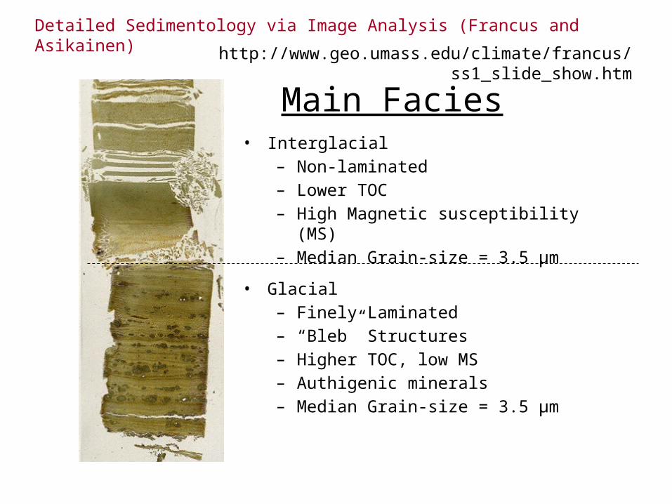
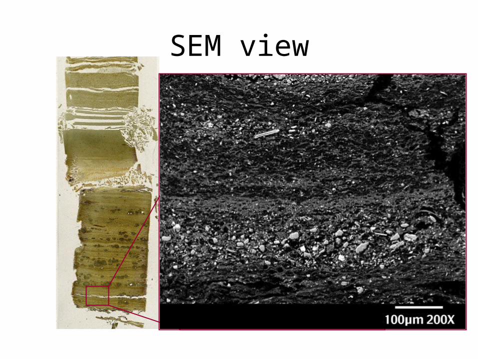
• What are the lake processes and climatic conditions that produce laminated, non-laminated and weakly laminated units throughout the core?
Science questions should drive analysis(ask students to develop their own)
ADD YOUR OWN QUESTIONS:
• How can the core stratigraphy be characterized into recognizable facies assemblages related to changes in climate?
• What fundamental changes can we observe in the lake sedimentology .
• What processes cause these changes as they relate to climate history and landscape change?
• Is there a fundamental change in the sediment properties and biogenic sedimentation
(or organic matter) with changes in land use, or external and internal forcing over time?
• Characterization of primary controls on sediment character, flux rates and the proportions of clastic vs. biogenic deposition
• Quantification of the relationship between sedimentology and climate change (hydrology, lake ice cover history, terrestrial vs aquatic inputs etc.)
• Paleoclimate proxy development by comparisons between physical properties, sedimentology, and scanned data sets.
Terms - learning the lingo • Age resolution – years/cm• Lithostratigraphy
– layering based on physical, lithic properties and petrology
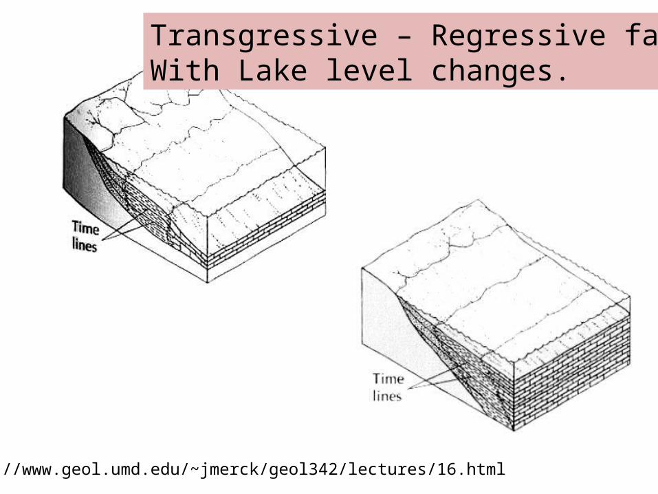
• Particle size/grain size• Facies
– Sediments deposited in particular environment or process ; a vertical succession of facies suggest lateral migration of the depositional environment
• Laminae/varves – Thin layers, if annual = varves
• Lets add more……..
Kurupa Lake core. Photo: Darrell Kaufman
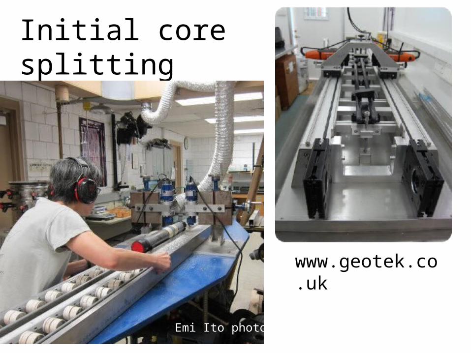
Initial core splitting
Emi Ito photo
www.geotek.co.uk
Blades cut only the core liner on either side. Sediment is cut with SS wire.
Split cores
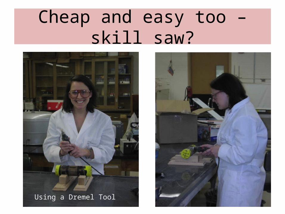
Initial core splitting
Cheap and easy too – skill saw?
Using a Dremel Tool
100 cm
Lake Sediment Core Processing SchemeExample from ICDP Lake El‘gygytgyn Project
surfacecleaning
whole-coremagn. suscept.
(on site)
line scan pictureswith MSCL
susceptibility and
color spectrawith SCLP3
1. line scan picture & surface relief2. XRF light elements
• X-rays (use your local health clinic?)• XRF scanning for major elements (ITRAX)
Geotek.co.uk
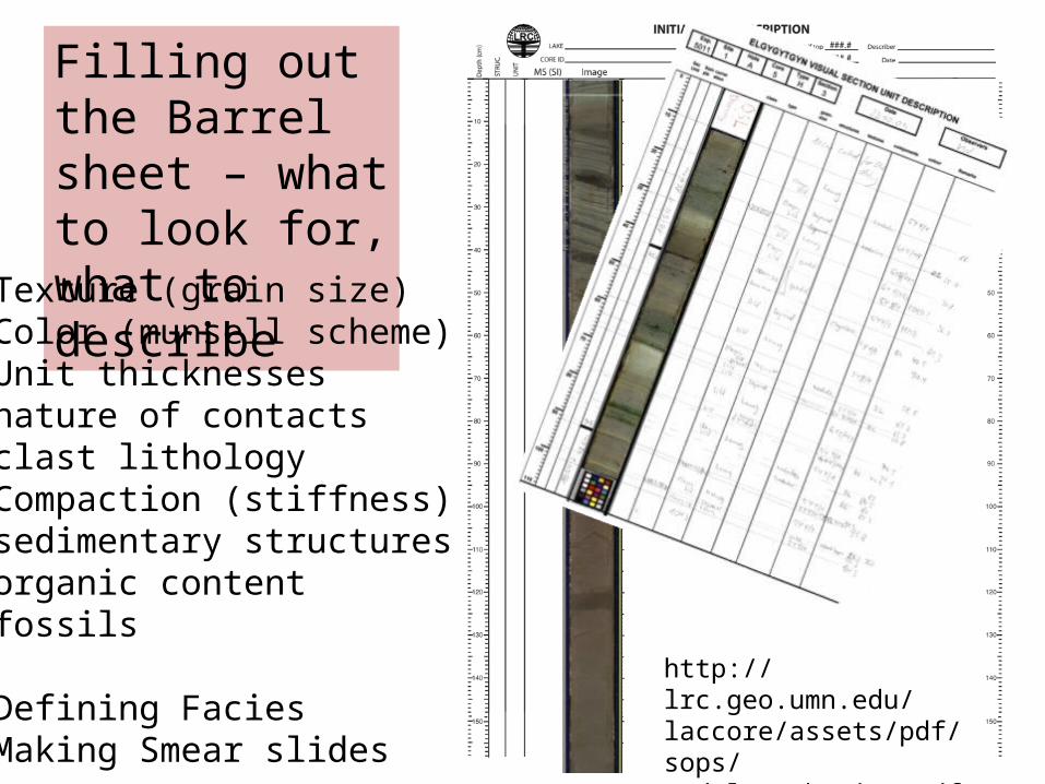
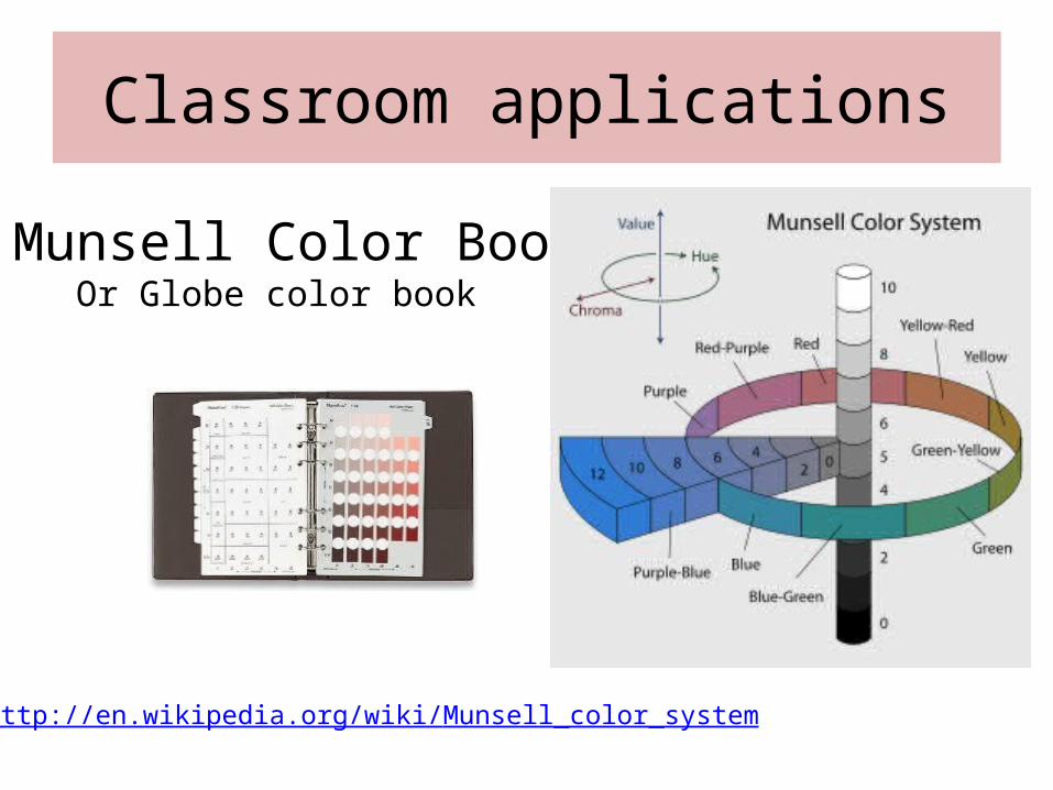
Filling out the Barrel sheet – what to look for, what to describeTexture (grain size)Color (munsell scheme)Unit thicknessesnature of contacts clast lithologyCompaction (stiffness)sedimentary structuresorganic contentfossils
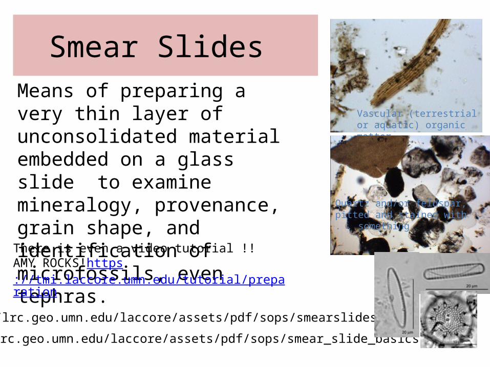
Smear Slides Means of preparing a very thin layer of unconsolidated material embedded on a glass slide to examine mineralogy, provenance, grain shape, and identification of microfossils, even tephras.
Should develop a common language and facies description
From mud to seeing fine laminae
Gravity Core GC-K05-03 Svalbard REU
1 yr?
L Poppick, BatesXrays done at Umass Health Center
Lake E Pliocene and xrays
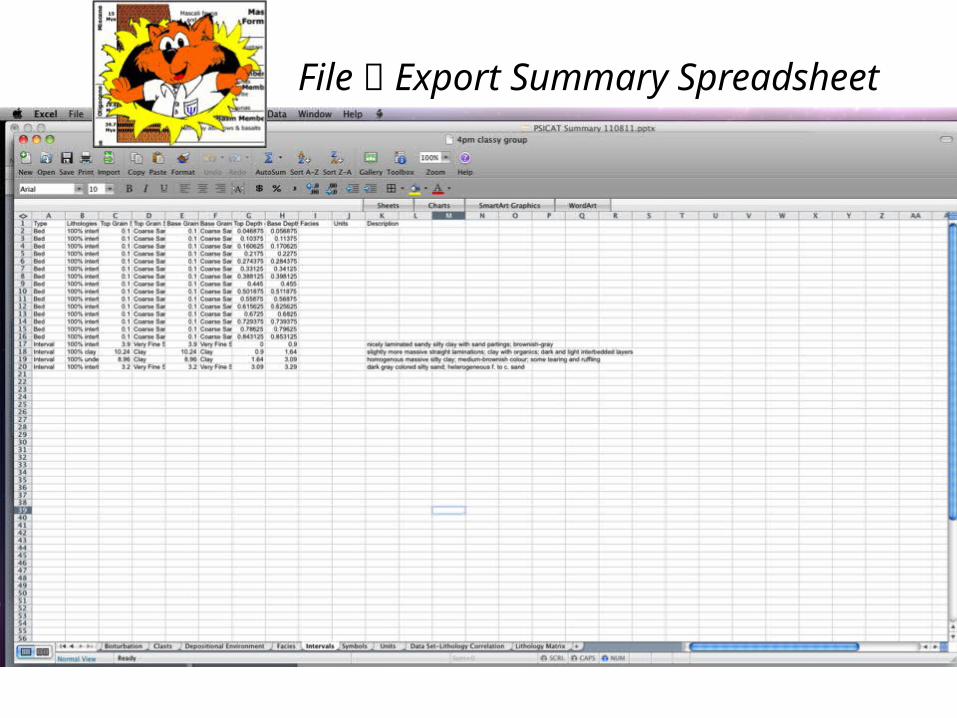
PSICAT – simple software for constructing stratigraphic columns
http://portal.chronos.org/psicat-site/
PSICAT, CHRONOS's Paleontological Stratigraphic Interval Construction and Analysis Tool, is a stand-alone Java based graphical editing tool for creating and viewing stratigraphic column diagrams from drill cores and outcrops. It is customized to the task of working with stratigraphic columns and captures data digitally as you draw and edit the diagram.
Initial developed by Josh Reed for ANDRILL Project.