Initial Environmental Examination Project Number: 49469-007 October 2018 India: Mumbai Metro Rail Systems Project Prepared by Mumbai Metropolitan Region Development Authority, Government of India for the Asian Development Bank.
Transcript
Initial Environmental Examination
Project Number: 49469-007 October 2018
India: Mumbai Metro Rail Systems Project
Prepared by Mumbai Metropolitan Region Development Authority, Government of India for the Asian Development Bank.
CURRENCY EQUIVALENTS (as of 14 August 2018)
Currency unit – rupee (₹)
₹ 1.00 = $0.0142908181
$1.00 = ₹ 69.975000
LIST OF ABBREVIATIONS
ADB - Asian Development Bank AFC - Automatic Fare Collection ATS - Automatic Train Supervision ATO - Automatic Train Operation ATP - Automatic Train Protection ASI - Archaeological Survey of India BEST - Brihanmumbai Electric Supply & Transport BIA - Bureau of Indian Standards CAP - Corrective Action Plan CBTC - Communication Based Train Control CATC - Continuous Automatic Train Control System CGWA - Central Ground Water Authority CoC - Conditions of Contract
CPCB - Central Pollution Control Board CRZ - Coastal Regulation Zone CRRI - Central Road Research Institute CTS - comprehensive transportation study DMRC - Delhi Metro Rail Corporation EIA - Environment Impact Assessment CMW - Environmental Management Cell EMP - Environmental Management Plan EMOP - Environmental Monitoring Plan EPC - Engineering, Procurement and Construction GC - General Consultant GoM - Government of Maharashtra GIS - Gas Insulated Switchgear GRC - Grievance Redressal Committee FLGRC - Field Level Grievance Redress Committee SLGRC - Senior Level Grievance Redress Committee GSS - Grid sub-station
IEE - initial environmental examination JICA - Japan International Cooperation Agency MCGM - Municipal Corporation of Greater Mumbai MCZMA - Maharashtra Coastal Zone Management Authority MoEFCC - Ministry of Environment, Forest and Climate Change MMR - Mumbai Metropolitan Region MMRDA - Mumbai Metropolitan Region Development Authority MSL - mean sea level MSW - Municipal Solid Waste MRTS - mass rapid transit system NGO - Non-government organization PAPs - Project Affected Persons PHPDT - Peak Hour Peak Direction Traffic PIU - project implementation unit PPE - personnel protective equipments PPP - Public Private Partnership
RAP - Resettlement Action Plan RSS - Receiving sub-station
SHE - Safety, Health and Environment SCADA - Supervisory Control and Data Acquisition SPS - Safeguard Policy Statement of ADB TMC - Thane Municipal Corporation
WEIGHTS AND MEASURES
dB(A) - decibel acoustic km - kilometer km/h - kilometer per hour kV - Kilo volt(s) kVA - kilo Volt-Amps kW - kilowatt m - meter mm - millimeter MVA - Megavolt Ampere m3 - cubic meter mg/l - milligrams per liter MW - megawatt rpm - revolutions per minute μg/m3
- microgram per cubic meter
NOTES
(i) The fiscal year (FY) of the Government of India ends on 31 March. FY before a calendar year denotes the year in which the fiscal year ends, e.g., FY2017 ends on 31 March 2018.
(ii) In this report, "$" refers to US dollars This initial environmental examination report is a document of the borrower. The views expressed herein do not necessarily represent those of ADB's Board of Directors, Management, or staff, and may be preliminary in nature. In preparing any country program or strategy, financing any project, or by making any designation of or reference to a particular territory or geographic area in this document, the Asian Development Bank does not intend to make any judgments as to the legal or other status of any territory or area.
TABLE OF CONTENTS
Page
EXECUTIVE SUMMARY 1
A. INTRODUCTION 3
1. Background 3 2. Project Proponent 5 3. Environmental Safeguards Categorization 5 4. Preparation and Objectives of the IEE 6 5. Scope and Methodology of the IEE Study 6 6. Extent of the IEE 7 7. Structure of the IEE Report 7
B. POLICY, LEGAL AND ADMINISTRATIVE FRAMEWORK 8
1. The National (India) Environmental Laws and Regulations 8 2. ADB Safeguards Policy Statement and Requirements 12 3. International and Regional Agreements and Conventions 12
C. PROJECT DESCRIPTION 14
1. Project Rational and Objectives 14 2. Advantage of a Metro System 15 3. Project Location 16 4. Details of the Project Components 17 5. Cost Estimate 30 6. Implementation Plan and Schedule 30
1. Impacts and Mitigation Measures during Project Location and Design Phase 51 2. Impacts and Mitigation Measures During Installation Phase 52 3. Impacts and Mitigation Measures during Operation Phase 56 4. Induced Development 59 5. Expected Benefits from the Project 60
F. ANALYSIS OF ALTERNATIVES 62
1. Introduction 62 2. Different Modes of Transport and Need to Increase Public Transport Share 62 3. No Project Alternative 63
G. CONSULTATIONS, PARTICIPATION AND INFORMATION DISCLOSURE 64
1. Consultations 64 2. Information Disclosure 67
H. GRIEVANCE REDRESS MECHANISM 68
I. ENVIRONMENTAL MANAGEMENT PLAN 70
1. Introduction 70 2. Objectives of Environmental Management Plan 70 3. Institutional Mechanism and Arrangement for Implementation of EMP 70 4. Mitigation Measures 71 5. Environmental Monitoring and Reporting Program 71 6. Environmental Reporting System 82 7. Training and Capacity Building Programs 82
8. Environmental Management Budget and Resources 82
APPENDIX 2: Letter from MoEFCC indicating Exemption of Metro Projects from EIA Notification, 2006 89
APPENDIX 2A: MOEFCC Notification of Eco-Sensitive Zone Around SGNP 90
APPENDIX 3: Test Reports on Environmental Quality Monitoring 91
APPENDIX 4: Details of the Sensitive Receptors along Lines 92
APPENDIX 5: Record of Public Consultations 117
APPENDIX 6: Outline of an Environmental Monitoring Report 131
APPENDIX 7: MMRDA SHE MANUAL 134
LIST OF TABLES
Table 1: Mumbai Metro Rail Master Plan Corridor ............................................................ 3 Table 2: Summary of Relevant Environmental Legislation ................................................ 8 Table 3: Applicable Permits and Clearances Required for the Project .............................10 Table 4: Salient Features of Mumbai Metro Line 2A.........................................................17 Table 5: Salient Features of Mumbai Metro Line 2B.........................................................20 Table 6: Salient features of Mumbai Metro Line 7 ............................................................23 Table 7: Power Demand Estimation (MVA) .....................................................................29
Table 8: Sources of Power Supply ...................................................................................30
Table 9: Summary Cost Estimates ($ million)...................................................................30 Table 10: Environmental Attributes and Frequency of Monitoring ....................................31 Table 11: Details of Sampling / Monitoring Locations .......................................................31 Table 12: Soil Quality in the Project Area of Line 2B ........................................................34 Table 13: Soil Quality in the Project Area of Line 7 and 2A ..............................................34 Table 14: Physico-chemical Characteristics of Ground Water along the Proposed Alignment
of Line 2A .................................................................................................................37 Table 15: Physico-chemical Characteristics of Ground Water along the Proposed Alignment
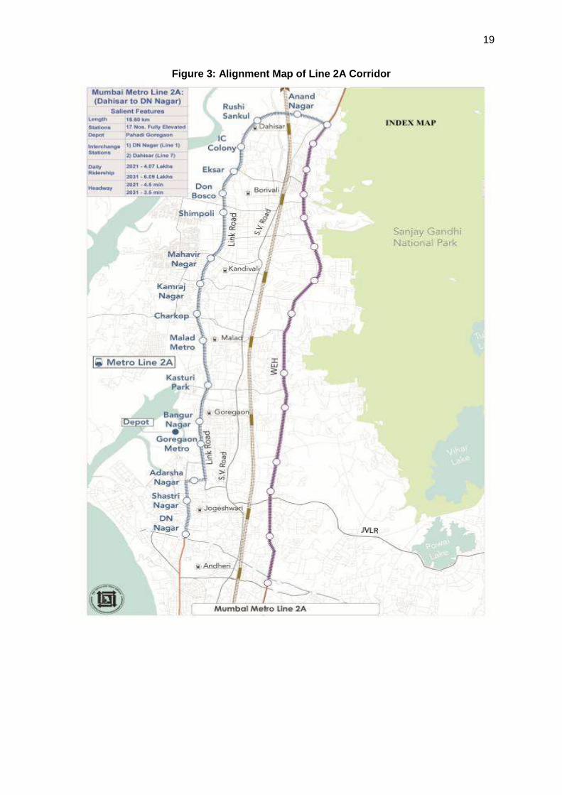
of Line 2B .................................................................................................................38 Table 16: Physico-chemical Characteristics of Ground Water along the Proposed Alignment
of Line 7 ....................................................................................................................39 Table 17: Physico-chemical Characteristics of Surface Water along the Proposed Alignment
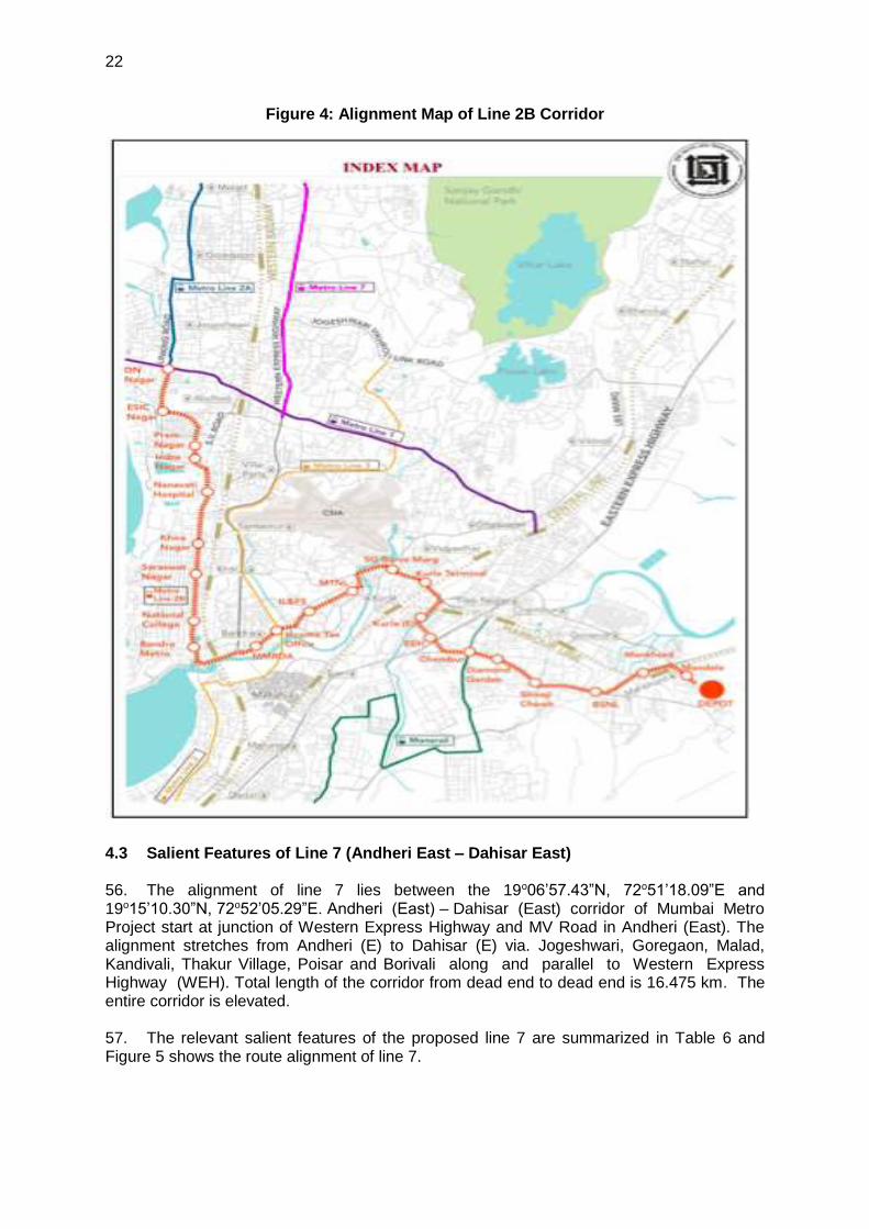
of Line 7 and Line 2A ................................................................................................39 Table 18: Average Monthly Temperature data for Mumbai ..............................................41 Table 19: Monthly Average Rainfall Data for Mumbai ......................................................41 Table 20: Air Quality Monitoring Data along the Proposed Alignment of Line 2B (December
2015) ........................................................................................................................43 Table 21: Air Quality Monitoring Data along the Proposed Alignment of Line 7 and 2A (2015)
.................................................................................................................................44 Table 22: Noise Levels along Proposed Alignment of Line 2A (2015) ..............................45 Table 23: Noise Levels along Proposed Alignment of Line 2B (2015) ..............................46 Table 24: Noise Levels along Proposed Alignment of Line 7 (May 2016) .........................47 Table 25: List of Sensitive Receptors along the Project Line 2A ......................................50 Table 26: List of Sensitive Receptors along the Project Line 2B ......................................50 Table 27: List of Sensitive Receptors along the Project Line 7 .........................................50 Table 28: Average Noise Levels Generated by the Operation of Various Construction
Equipment ................................................................................................................54 Table 29: Increase In Noise Levels Due to Increased Vehicular Movement .....................55
Table 30: Maximum Exposure Periods Specified By OSHA .............................................55 Table 31: Exterior Noise Levels in Metro Stations ............................................................57 Table 32: Interior Noise Levels In Metro Trains ................................................................57 Table 33: List of Sensitive Receptors within 100 m along the Project Lines .....................57 Table 34: Water Requirement At Stations ........................................................................58 Table 35: Details of Public Consultation for Project Lines 7 and 2A .................................65 Table 36: Details of Public Consultation for Project Lines 2B ...........................................66 Table 37: Environmental Management Plan Matrix .........................................................73 Table 38: Environmental Monitoring Plan (for each Line) .................................................80 Table 39: Cost of EMP Implementation* ..........................................................................83
LIST OF FIGURES
Figure 1: Index Map of Mumbai Metro Rail Transport Project ........................................... 4 Figure 2: Index Map of Mumbai Metro Rail Project and Project Lines ..............................16 Figure 3: Alignment Map of Line 2A Corridor ...................................................................19 Figure 4: Alignment Map of Line 2B Corridor ...................................................................22 Figure 5: Alignment Map of Line 7 Corridor ......................................................................25 Figure 6: Rail design showing the elastomeric and rail pads to control noise and vibration
.................................................................................................................................26 Figure 7: Typical Cross Section of the Ballastless Track on Viaduct ................................26 Figure 8: Typical 3 Car Composition Metro Driving Trailer Car ........................................27 Figure 9: Typical Metro Trailer Car ...................................................................................28 Figure 10: Geological Map of Mumbai .............................................................................33 Figure 11: National Seismic Activity Map .........................................................................35 Figure 12: Hydrogeological Map of Mumbai .....................................................................36 Figure 13: Windrose Plot for Mumbai (all year) ................................................................42 Figure 14: Status of Air Quality along the Proposed Alignment of Line 2B (2015) ............43 Figure 15: Status of Air Quality along the Proposed Alignment of Line 7 (2016) ..............45 Figure 16: Measured Noise Level along the Proposed Alignment of Line 2A (2016) ........46 Figure 17: Measured Noise Level along the Proposed Alignment of Line 2B (2016) ........47 Figure 18: Measured Noise Level along the Proposed Alignment of Line 7 (2016) ..........48 Figure 19: Grievance Redress Mechanism ......................................................................69 Figure 20 : List of Educational Institutions along the alignment ..................................... 110 Figure 21 : List of Health Centres................................................................................... 112 Figure 22 : Places of Worship along the proposed alignment ......................................... 114 Figure 23 : Parks and Gardens along the proposed alignment ....................................... 116
EXECUTIVE SUMMARY 1. This initial environmental examination (IEE) has been prepared for Mumbai Metro Rail Systems Project (the Project) in Maharashtra state of India. The objective of the Project is to improve urban traffic and transportation in Mumbai Metropolitan Region by providing a safe and high capacity transport through a modern metro system. The Mumbai Metro Rail Systems Project will finance rolling stock, signaling and telecommunication, and train access systems to make operational about 58 kilometers (km) of a section of the metro rail system in Mumbai city, covering Lines 2A, 2B, and 7. The project will also cover capacity and institutional development for establishing a metro rail operations organization. 2. The Government of Maharashtra (GoM) has approached Asian Development Bank for financial support to assist in the implementation of (i) Line 2A from Dahisar (Charkhop) to DN Nagar; (ii) Line 2B from DN Nagar–Bandra–Mandale; and (iii) Line 7 from Dahisar (E) to Andheri (E). The aggregate length of these lines is about 58 km. Mumbai Metropolitan Region Development Authority (MMRDA) is presently implementing the civil works on these lines using state funds. ADB funding would be used to finance the rolling track, signaling, and platform access systems, which are mainly plant supply and installation contracts.
3. According to the legislative provisions, rules and regulations in India, the metro rail projects does not require to conduct an EIA or seek environmental clearance from the Government. The project scope for ADB’s financing involves specific items of goods supply for Lines 2A, 2B and 7 of the Mumbai Metro Rail network. No civil works are financed by ADB. The key long-term environmental impact anticipated is noise and vibration from the operation of the rolling stock. However, given the existing noisy conditions of the project area due to heavy road traffic, the incremental impacts are expected to be minimal. Some occupational health and safety impacts may also be experienced during installation and operation of the rolling stock and signaling and telecommunication systems. However, it is expected to be minor and easily mitigated. Hence, the project is categorized as “B” for environment safeguards requiring an IEE. Accordingly, this IEE report, including an environmental management plan (EMP) and environmental monitoring plan (EMOP), has been prepared for all three Lines. This IEE has been prepared to fulfill ADB Safeguard Policy Statement (SPS) 2009 requirements for category B project. 4. The ongoing civil works for the three elevated lines is considered an “existing facility” in accordance with the ADB SPS since it includes an existing structure, currently under construction, which is financed by the government. As required by ADB SPS, an environmental audit has been carried out for the ongoing civil works to check compliance with the ADB SPS. The audit identified a number of areas for improvement. Hence, a corrective action plan (CAP) has been prepared to make the civil works component compliant with the ADB SPS.
5. In addition to the EMP and EMOP prepared as part of IEE, MMRDA has a comprehensive safety, health, and environment manual (SHE manual), which is attached to all contracts. The EMP is a plan for mitigating all anticipated environment impacts during project construction and operation. Specific mitigation measures with details on location, time, and the responsible agency for implementation are given in the EMP. The EMOP is a plan for monitoring the quality of air, water, noise, and soil. The contractor may outsource these monitoring activities to laboratories that are approved by the National Accreditation Board for Laboratories. The project implementation unit (PIU) will carry out the compensatory afforestation activities and maintenance or through specialized agencies that can carry out tree plantation, maintenance, monitoring, and reporting. The SHE is a manual with a comprehensive list of rules to be followed to maintain proper safe and healthy conditions at all project sites including active construction and installation sites, camp sites and nearby areas including managing environmental issues arising due to construction and installation works.
2
6. No environmental clearance is required for any of the metro rail lines since this is exempted by the Government of India. Coastal Regulation Zone clearance is required for Line 2A and 2B, which is obtained. Forest clearances for Line 2B are required, which is under process. Tree cutting permits have been processed and obtained for Line 2A and Line 7, and will be obtained for Line 2B before the start of construction works. Permits, certificates, no-objection letters, etc., for activities such as casting yards, concrete batching plants, operation of equipment and machinery, sourcing of ground water, etc., must be obtained by the contractor before the implementation of the respective construction activity. 7. During the earlier planning stages of the project, the feasibility of several metro corridors was considered by MMRDA based on comprehensive traffic studies and engineering studies. The criteria for selecting the final alignment included traffic demand/ridership, accessibility and integration with existing public transport nodes, available right of way within major roads, ground conditions, capital and operating costs, availability of land for the depot and stations as well as minimum disturbance/avoidance of heritage structures. The selected alignments follow the central median of a major road. Station locations have been selected to maximize ridership and ease intermodal connections.
8. Meaningful consultations have been conducted during project preparation, and all concerns voiced by affected persons and stakeholders have been incorporated in the project design. MMRDA has instituted a grievance redress mechanism that is being followed under this project. 9. The EMP has been prepared in conjunction with MMRDA’s SHE Manual and it forms part of the contract document of the contractors. Contractors have also prepared project specific SHE Plan as well as construction EMPs. General consultant is submitting quarterly and semi-annual environmental monitoring reports. MMRDA will submit semi-annual environmental monitoring reports to ADB and these will be disclosed publicly at the ADB website.
10. The project is currently at investment stage, and although no major changes in the project design and location are anticipated, this IEE may need updating in case of any change in project components or design.
3
I. INTRODUCTION
A. Background 1. This initial environmental examination (IEE) has been prepared for the Mumbai Metro Rail Systems Project (the Project) in Maharashtra state of India. 2. Mumbai, the financial capital of India, has witnessed phenomenal growth in population and employment and the trend is expected to continue in the future. The job opportunities it offers have served as a major attraction for immigration from hinterland of Maharashtra as well as from all parts of the country. Mumbai Metropolitan Region (MMR) is one of the fastest growing metropolitan regions in India. It comprises of 7 municipal corporations, 13 municipal councils, and 996 villages and extends over an area of 4,355 square kilometer (km). MMR is projected to have population of 34.0 million and employment (both formal and informal) of 15.3 million in 2031. The dominant feature of the passenger movements in Mumbai is overwhelming dependence of travel on public transport modes and walk.
3. Mumbai has a very good transportation system but has not been able to keep pace with rising demand. The carrying capacity of the bus and rail system has increased considerably but has been always on lower side than what is needed. Though metro for Mumbai had been planned for last 50-60 years, something concrete did not come up until MMRDA prepared the Master Plan of Mumbai Metro network in 2003. The Master Plan for Mumbai Metro, along with phased implementation, was approved by the Authority of The Mumbai Metropolitan Region Development Authority (MMRDA), in its 110th meeting held on 28 May 2004. The Master Plan includes nine corridors covering a length of 146.5 km (Table 1), out of which 32.5 km is proposed underground and rest is elevated.
6. Teen Hath Naka- Kasarwadavali (Thane)-Bhiwandi-Kalyan
8.50 11.00 19.50
7. SEEPZ-Kanjurmarg 0.00 18.00 18.00
8. Andheri (E) – Dahisar (E) 8.50 13.30 21.80
9. Sewri-Prabhadevi 3.50 0.00 3.50
Total 32.50 114.00 146.50
Source: Mumbai Metro Master Plan (2013)1
4. As part of the World Bank-assisted Mumbai Urban Transport Project, MMRDA also prepared a comprehensive transportation study (CTS) for MMR in 2005–2008, for the period up to 2031. The CTS sets out timeline goals for transportation and serves as the sector road map. The long-term goal is focused on increasing the metro and suburban rail. This approach will reduce road vehicle modes, reduce vehicle emissions, and improve urban environment and quality of urban life. Figure 1 shows the network map of the Mumbai Metro Rail Transport System.
1 Details of the MRTP are available at MMRDA official website https://mmrda.maharashtra.gov.in/mumbai-metro-
rail-project#.
4
Figure 1: Index Map of Mumbai Metro Rail Transport Project
Source: Mumbai Metropolitan Region Development Authority
5. Of the planned metro rail developments in the CTS for Mumbai, one key line of about 11 km between Andheri and Ghatkopar was awarded and completed in 2014 on a Public Private Partnership (PPP) model. Line 3 from Colaba–Bandra–Santacruz Electronics Export Processing Zone, which is an underground line of about 34 km, is being implemented with
5
Japan International Cooperation Agency (JICA) assistance, for which civil works contracts are already awarded in the second quarter of 2016.2 For other lines, MMRDA is examining proposals to other agencies, such as the ADB, JICA, Asian Infrastructure Investment Bank, New Development Bank, and others. 6. The lines proposed for financial assistance by ADB are: (i) Line 2A from Dahisar (Charkhop) to DN Nagar; (ii) Line 2B from DN Nagar–Bandra–Mandale; and (iii) Line 7 from Dahisar (E) to Andheri (E). The aggregate length of these lines is about 58 km. MMRDA is presently implementing the civil works on these lines using state funds. ADB funding would be used to finance the rolling track, signaling, and platform access systems, which are mainly plant supply and installation contracts.
7. This report deals with the IEE for the three lines proposed for ADB financing under Mumbai Metro Rail Systems Project and all discussion hereafter refer to these three lines. The detailed project reports for these lines have been prepared by Delhi Metro Rail Corporation (DMRC) in 2015. 8. The objective of the Project is to improve urban traffic and transportation in MMR by providing a safe and high capacity transport through a modern metro system. The Project will finance rolling stock, signaling and telecommunication, and train access systems to make operational about 58 km of a section of the metro rail system in Mumbai city, covering Lines 2A, 2B, and 7. The planned activities under proposed Project are: (i) constructing 16.475 km elevated metro line with 16 elevated stations and 1 depot; (ii) installing continuous automatic train control system based on communication based train control system and other systems related to the metro operation; and (iii) procuring a total of 90 modern coaches.
9. The impact of the Project is improved urban mobility in MMR and outcome is increased use of rail-based urban transit system in Mumbai city.
B. Project Proponent
Project Name : Mumbai Metro Rail Systems Project Name of Proponent/s : Mumbai Metropolitan Region Development Authority
400051, Maharashtra, India 10. The MMRDA is the executing agency of the Project. The MMRDA is a body of the Government of Maharashtra that is responsible for the infrastructure development of the MMR. MMRDA was established on 26 January 1975 in accordance with the Mumbai Metropolitan Development Act, 1974. Since its inception, MMRDA is engaged in long term planning, promotion of new growth centers, implementation of strategic projects, and financing infrastructure development. The objective in establishing MMRDA was to make MMR a destination for economic activity by promoting infrastructure development and improving the quality of life. The MMRDA prepares plans, formulates policies and programs, implements projects, and helps in directing investments in the MMR. C. Environmental Safeguards Categorization 11. The environmental screening has been carried out for the proposed Project as per ADB SPS 2009. The project scope for ADB’s financing involves specific items of goods supply for Lines 2A, 2B and 7 of the Mumbai Metro Rail network. The ongoing civil works are financed by MMRDA. In accordance with the SPS they are considered “associated facilities” since they 2 The metro rail line numbers are a legacy of previous studies, and do not reflect priority of importance or
sequencing.
6
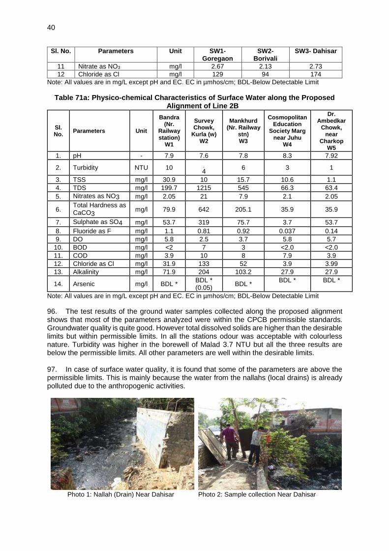
are not funded under the project, but the viability and operation of the facility (civil works cnmponents) and the ADB project depend exclusively on each other. Hence, an environmental due diligence review has been carried out for the ongoing civil works and corrective measures have been proposed for environment safeguard related activities that need improvement. 12. A Rapid Environmental Assessment checklist (Annexure 1) has screened the activities in the lines proposed for ADB funding considering the aspects of project siting, potential environmental impacts including climate change and disaster risk. The key long-term environmental impact anticipated is noise and vibration from the operation of the rolling stock. However, given the existing noisy conditions of the project area due to heavy road traffic, the incremental impacts are expected to be minimal. Some occupational health and safety impacts may also be experienced during installation and operation of the rolling stock and signaling and telecommunication systems. However, it is expected to be minor and easily mitigated. Hence, the project is categorized as “B” for environment safeguards which requires an IEE including EMP as per ADB SPS 2009. D. Objectives of the IEE 13. As part of detailed project report preparation for Mumbai Metro Rail Systems Project, MMRDA has prepared environmental impact assessments (EIAs) for each of the project lines in anticipation of environmental assessment studies being required by future donor or multi-lateral development banks. 14. This IEE has been prepared in accordance with environmental safeguards requirements of international financial institutes in particular ADB’s SPS 2009. It aims to ensure good environmental practices. The specific objectives of this IEE are to:
• provide an environmental baseline description of the Project;
• identify and describe the potential environmental impacts of the Project;
• design mitigation measures to minimize adverse environmental impacts;
• describe the public consultation process and grievance redress mechanism;
• provide an environmental and social management and monitoring plan for the project (including defining institutional responsibilities, capacity building and training, and the required budget); and
• provide due diligence on ongoing works.
E. Scope and Methodology of the IEE Study 15. The scope of this IEE is based on ADB’s SPS 2009 requirements. In India, metro and rail projects are exempted from the requirements of the Environment (Protection) Act 1986. Therefore, EIA for the metro rail projects is not required under environmental regulation of the Government of India. 16. This IEE has been prepared to fulfill policy requirements of project lender (ADB). The IEE includes EMP and EMOP for all three lines for project implementation and monitoring, consistent with the requirements of the ADB. The purpose of this IEE is to assess potential environmental, health, safety, and social risks and impacts of the proposed ADB intervention in Mumbai city of India and propose suitable mitigation measures where required.
17. The IEE followed a number of steps:
• Review of available baseline reports, and technical reports/studies related to proposed Project;
• Conduct field visits to collect primary or secondary data relevant to the Project areas to establish the baseline environmental and social condition;
7
• Assess the potential impacts on environmental and social attributes due to the location, design, installation and operation of the Project through field investigations and data analysis;
• Explore opportunities for environmental enhancement and identify measures;
• Prepare an environment management plan (EMP) outlining the measures for mitigating the impacts identified including the institutional arrangements;
• Identify critical environmental and social parameters required to be monitored
subsequent to the implementation of the Project and prepare an and
Environmental Monitoring Plan (EMOP);
• Carry out consultation with key stakeholders and administrative authorities to identify their perception on the Project, introduce project components and anticipated impacts; and,
• Disclose the IEE at MMRDA and ADB websites.
18. This IEE study has been conducted based on review of EIAs conducted by MMRDA as part of feasibility study, primary data collected from site visits (including consultations) and secondary information collected from various sources. During site visit, the specialists has conducted consultations with key stakeholders and local executive powers for their opinions on the Project. Formal public consultations at key locations along the proposed alignment of the metro lines have also been conducted. The results of the consultations as well as an evaluation of the institutional framework have been incorporated into this assessment.
F. Extent of the IEE 19. The scope of this IEE is limited to the areas where project facilities will be installed i.e. alignment through which metro lines will pass, and area where depots will be located. This IEE has been prepared based on the proposed alignments and the nature of construction and operation of metro rails. The corridor of impact is taken as 10 meters either side of the alignment. However, the study area impact zone is considered up to 5 km on both sides of the project alignments to allow for a larger analysis of land use and other environmental features and the area of influence (within 100 m periphery) of proposed depots. Assessment is carried out on the following environment components: terrestrial and aquatic ecology, soil, water, air, noise, and socio-economic aspects.
G. Structure of the IEE Report 20. In line with the requirements of the ADB SPS 2009, this IEE Report has been organized into sections which covers (i) project description; (ii) description of the baseline environment; and (iii) impact assessment and mitigation measures. The IEE report has following contents:
• Executive Summary
• Introduction
• Policy, Legal, and Administrative Framework
• Description of the Project
• Description of the Environmental
• Anticipated Environmental Impacts and Mitigation Measures
• Consultations, Participation and Information Disclosure
• Grievance Redress Mechanism
• Environmental Management Plan, and
• Conclusion and Recommendation.
8
II. POLICY, LEGAL AND ADMINISTRATIVE FRAMEWORK 21. India has well defined institutional and legislative framework. The legislation covers all components of environment viz. air, water, soil, terrestrial and aquatic flora and fauna, natural resources, and sensitive habitats. India is also signatory to various international conventions and protocols. The environmental legislations in India are framed to protect the valued environmental components and comply with its commitment to international community under above conventions and protocols. ADB has also defined its Environmental and Social Safeguard policy requirements. This assessment is about the applicability of above laws and regulations, conventions, protocols, and safeguards. 22. The laws, regulations, policies and guidelines applicable to this project based on the location, design, construction and operation are summarized in the subsequent sections in following order:
• National (India) Environmental Legislation and Legal Administrative Framework,
• ADB Safeguards Policy Statement Requirements, and
• Summary of international treaties and applicability to the project.
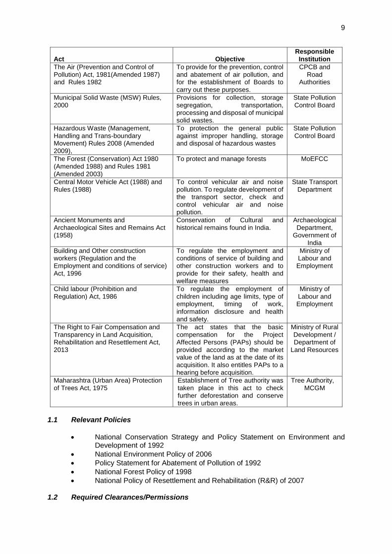
A. The National (India) Environmental Laws and Regulations 23. The Government of India’s environmental legal framework comprises a set of comprehensive acts and regulations aimed at conserving various components of the biological and physical environment including environmental assessment procedures and requirements for public consultation. The policies and requirements which are most relevant in the context of this project are provided in Table 2 below.
Table 2: Summary of Relevant Environmental Legislation
Act Objective Responsible Institution
Environment (Protection) Act (1986) and Rules (1986)
To protect and improve the overall environment
MoEFCC
Environmental Impact Assessment (EIA) Notification under Environmental Protection Rules (2006, 2009, 2011) and relevant Office Memorandums (OM)
To provide guidance on environmental clearance requirements and clarification on related specific technical issues
MoEFCC
Coastal Regulation Zone (CRZ) Notification, 2011
To ensure livelihood security to the fishing communities and other local communities living in the coastal areas; To conserve and protect coastal stretches and; To promote development in a sustainable manner based on scientific principles, taking into account the dangers of natural hazards in the coastal areas and sea level rise due to global warming.
MCZMA
The Wildlife Protection Act (1972 and amended in 1993)
To protect wild animals and birds through the creation of National Parks and Sanctuaries
MoEFCC
The Water (Prevention and Control of Pollution) Act 1972 (Amended 1988) and Rules 1974
To provide for the prevention and control of water pollution and the maintaining or restoring of wholesomeness of water.
CPCB
9
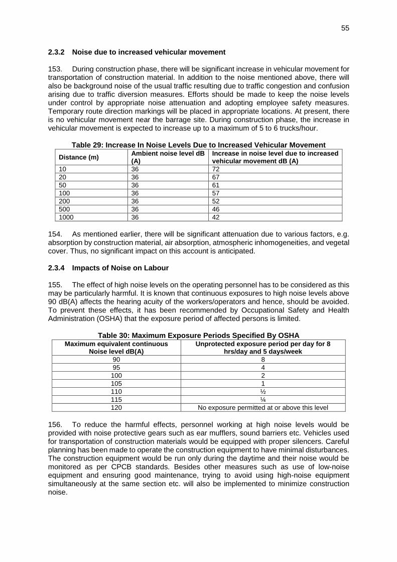
Act Objective Responsible Institution
The Air (Prevention and Control of Pollution) Act, 1981(Amended 1987) and Rules 1982
To provide for the prevention, control and abatement of air pollution, and for the establishment of Boards to carry out these purposes.
CPCB and Road
Authorities
Municipal Solid Waste (MSW) Rules, 2000
Provisions for collection, storage segregation, transportation, processing and disposal of municipal solid wastes.
To protection the general public against improper handling, storage and disposal of hazardous wastes
State Pollution Control Board
The Forest (Conservation) Act 1980 (Amended 1988) and Rules 1981 (Amended 2003)
To protect and manage forests MoEFCC
Central Motor Vehicle Act (1988) and Rules (1988)
To control vehicular air and noise pollution. To regulate development of the transport sector, check and control vehicular air and noise pollution.
State Transport Department
Ancient Monuments and Archaeological Sites and Remains Act (1958)
Conservation of Cultural and historical remains found in India.
Archaeological Department,
Government of India
Building and Other construction workers (Regulation and the Employment and conditions of service) Act, 1996
To regulate the employment and conditions of service of building and other construction workers and to provide for their safety, health and welfare measures
Ministry of Labour and Employment
Child labour (Prohibition and Regulation) Act, 1986
To regulate the employment of children including age limits, type of employment, timing of work, information disclosure and health and safety.
Ministry of Labour and Employment
The Right to Fair Compensation and Transparency in Land Acquisition, Rehabilitation and Resettlement Act, 2013
The act states that the basic compensation for the Project Affected Persons (PAPs) should be provided according to the market value of the land as at the date of its acquisition. It also entitles PAPs to a hearing before acquisition.
Ministry of Rural Development / Department of
Land Resources
Maharashtra (Urban Area) Protection of Trees Act, 1975
Establishment of Tree authority was taken place in this act to check further deforestation and conserve trees in urban areas.
Tree Authority, MCGM
1.1 Relevant Policies
• National Conservation Strategy and Policy Statement on Environment and Development of 1992
• National Environment Policy of 2006
• Policy Statement for Abatement of Pollution of 1992
• National Forest Policy of 1998
• National Policy of Resettlement and Rehabilitation (R&R) of 2007
1.2 Required Clearances/Permissions
10
24. For implementation of metro rail projects in India, required clearances/ permissions related to environment, social and forests have been summarized in Table 3.
Table 3: Applicable Permits and Clearances Required for the Project Sl. No.
Permissions/ Clearances
Acts/Rules/Notifications/ Guidelines
Concerned Agency
Responsibility
A. Pre-construction Stage
1. Permission for felling of trees
Maharashtra (Urban Area) Protection of Trees Act, 1975
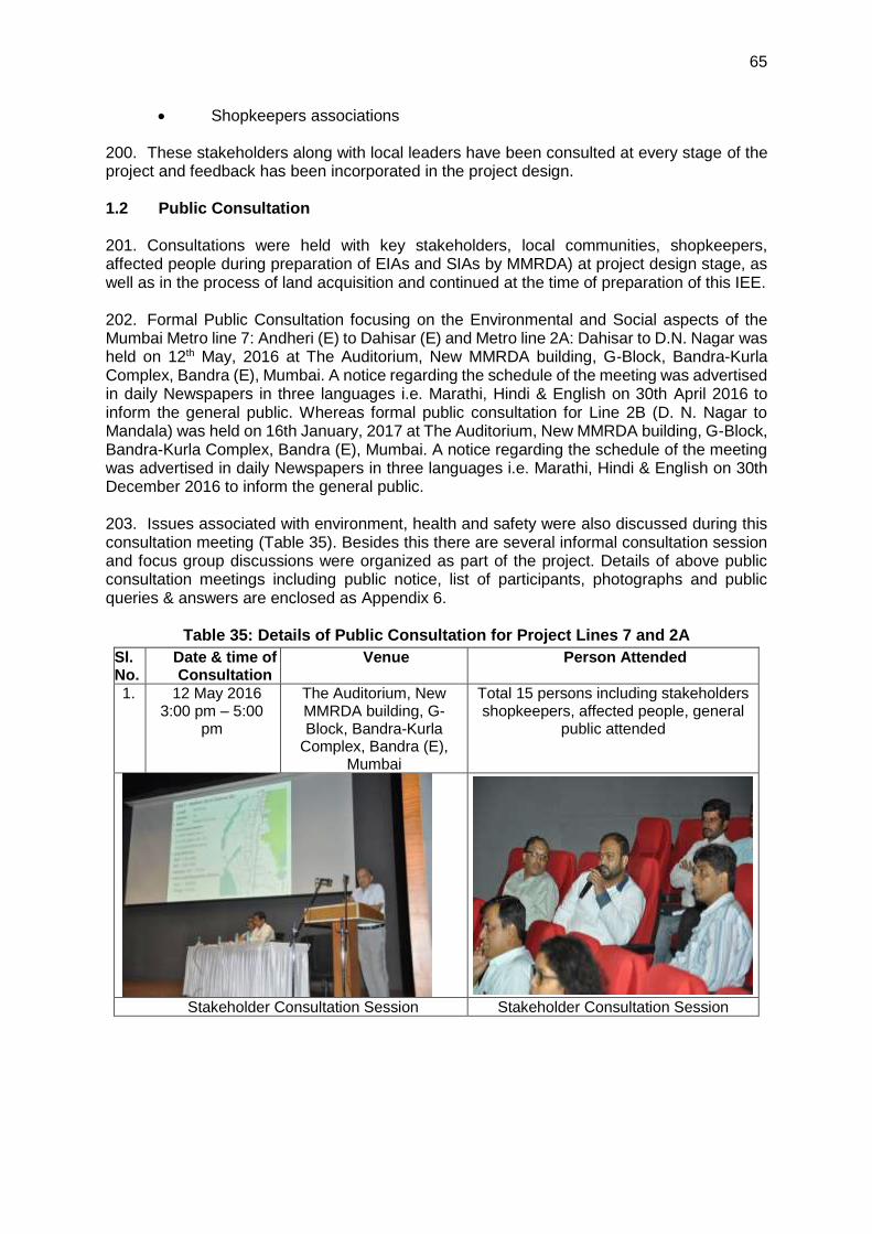
Tree Authority, MCGM
MMRDA
B. Implementation Stage
1. Consent to Establish & Operate for Ready Mix Concrete plant & casting yard
Air (Prevention and Control of Pollution) Act 1981
Maharashtra State Pollution Control Board
Contractor
2. Permission for withdrawal of groundwater
Environment (Protection) Act, 1986
CGWA Contractor
3. Permission for sand mining from river bed
Environment (Protection) Act, 1986
Mining Department/
MoEFCC
Contractor
4. Authorization for Disposal of Hazardous Waste
Hazardous Waste (Management and Handling) Rules 1989
Maharashtra State Pollution Control Board
Contractor
5. Disposal of bituminous and other wastes
Hazardous Waste (Management and Handling) Rules 1989
Maharashtra State Pollution Control Board
Contractor
6. Consent for disposal of sewage from labour camps.
Water (Prevention and Control of Pollution) Act 1974
Maharashtra State Pollution Control Board
Contractor
7. Pollution Under Control Certificate
Central Motor and Vehicle Act, 1988
Department of Transport, Govt. of Maharashtra
authorized testing centers
Contractor
8. Employing Labour/ workers
The Building and Other Construction Workers (Regulation of Employment and Conditions of Service) Act, 1996
District Labour Commissioner
Contractor
9. Roof Top Rain Water Harvesting (RWH)
Central Groundwater Authority (CGWA) Guidelines
Central Ground Water Authority
Contractor
10. Permission for use of fresh water for construction and drinking purpose.
Environment (Protection) Act, 1986
MCGM Contractor
25. As per the Government of India EIA Notification 2006, all railways projects in India are exempted from requirements of preparing EIA, therefore environmental clearance for the lines proposed under the Project is not required. Letter issued by MoEFCC on this is provided in Appendix 1. 26. Before the start of civil works for the any section of the project the project proponent (MMRDA) must obtain necessary clearances / permits from statutory authorities.
11
1.3 Institutional Administrative Framework 27. The administrative framework in India for implementation and monitoring of Metro Rail Projects involves following agencies. 28. Ministry of Environment, Forest and Climate Change (MoEFCC): MoEFCC is apex body in India responsible protection and enforcement of laws and regulations. In view of the growing importance of environmental affairs, the Government of India set up a Department in November 1980 under the portfolio of the Prime Minister. The Department, later renamed as the MoEFCC, plays a vital role in environmental management for sustained development and for all environmental matters in the country.
29. The major responsibilities of MoEFCC includes - Environmental resource conservation and protection, Environmental Impact Assessment of developmental projects, Co-ordination with the other ministries and agencies, voluntary organizations and professional bodies on environmental action plans, Policy-planning, Promotion of research and development, manpower planning and training and creation of environmental awareness; Liaison and coordination with international agencies involved in environmental matters. 30. Developmental project proponents are also required to submit Environmental Impact Statements/Assessments to establish that preventive measures are planned by installing adequate pollution control and monitoring equipment, and that effluent discharged into the environment will not exceed permissible levels. The MoEFCC appraises these statements/ assessments and approves the project from the environmental angle. The respective State Pollution Control Board is to give a No Objection Certificate (NOC) before the EIA exercise is undertaken.
31. Maharashtra State Pollution Control Board (MPCB): Maharashtra Pollution Control Board was established on 7th September 1970 under the provisions of Maharashtra Prevention of Water Pollution Act, 1969. The Water (Prevention & Control of Pollution) Act, 1974 that is a central legislation was adopted in Maharashtra on 01/06/1981 and accordingly Maharashtra Pollution Control Board was formed under the provisions of section 4 of Water (Prevention & Control of Pollution) Act, 1974. The Air (Prevention & Control of Pollution) Act 1981 was adopted in the Maharashtra in 1983 and initially, some areas were declared as Air Pollution Control Area on 02/05/1983. The entire state of Maharashtra has been declared as Air Pollution Control Area since 06/11/1996. The Board is also functioning as the State Board under section 5 of the Air (Prevention & Control of Pollution) Act, 1981. The prime objective of all these Acts is maintaining, restoring and preserving the wholesomeness of quality of environment and prevention of hazards to human beings and terrestrial flora and fauna. 32. Central Ground Water Board: The CGWB is responsible for the development, dissemination of technologies, and monitoring of India's groundwater resources, including their exploration, assessment, conservation, augmentation, protection from pollution and distribution. The CGWB, under the Ministry of Water Resources, was established in 1970. Various activities related to regulation and control of ground water development in the country is the responsibility of the Central Ground Water Authority (CGWA) specifically constituted under the Environmental (Protection) Act, 1986. The CGWA has identified over exploited-areas across India where groundwater withdrawal is regulated. To date, 43 critical/ overexploited notified areas have been identified in 10 states. Construction of new ground water structures is prohibited in the notified areas while permission of drilling tube wells is being granted only to the government agencies responsible for drinking water supply.
33. Mumbai Metropolitan Region Development Authority (MMRDA): Established in 1975, MMRDA is a body of the Government of Maharashtra that is responsible for the infrastructure development of the Mumbai Metropolitan Region. MMRDA has established a
12
Project Implementation Unit (PIU) for the speedy and effective execution of the project. To oversee the implementation of the Environmental and Social safeguards, a dedicated cell has been integrated into the PIU to work on these specific aspects of the project. The Environmental Cell is headed by Joint Project Director (Environment) who is reporting to the Director (Projects), Metro PIU within MMRDA. B. ADB Safeguards Policy Statement and Requirements 34. The Asian Development Bank has defined its Safeguard requirements under its ‘Safeguard Policy Statement 2009 (SPS 2009). The prime objectives of safeguard policy are to: (i) avoid adverse impacts of projects on the environment and affected people, where possible; and (ii) minimize, mitigate, and/or compensate for adverse project impacts on the environment and affected people when avoidance is not possible. This policy requires assessment, mitigation and commitment towards environmental protection. The extent of assessment depends on the category of the project. ADB’s SPS 2009 classify a project depending on following three categories.
• Category A: A proposed project is classified as category A if it is likely to have significant adverse environmental impacts that are irreversible, diverse, or unprecedented. These impacts may affect an area larger than the sites or facilities subject to physical works. An environmental impact assessment is required.
• Category B: A proposed project is classified as category B if its potential adverse environmental impacts are less adverse than those of category A projects. These impacts are site-specific, none or very few of them are irreversible, and in most cases mitigation measures can be designed more readily than for category A projects. An initial environmental examination is required.
• Category C: A proposed project is classified as category C if it is likely to have minimal or no adverse environmental impacts. No environmental assessment is required although environmental implications need to be reviewed.
35. Category of the Project as per SPS. The project has been evaluated considering the outcome of latest ADB’s Rapid Environmental Assessment Checklist (Annexure 2). The lines proposed under the Project for ADB financing neither passes through nor located close to any other environmentally sensitive or protected areas. As no civil works are financed by ADB, the key long-term environmental impact anticipated is noise and vibration from the operation of the rolling stock. However, given the existing noisy conditions of the project area due to heavy road traffic, the incremental impacts are expected to be minimal. Some occupational health and safety impacts may also be experienced during installation and operation of the rolling stock and signaling and telecommunication systems. However, it is expected to be minor and easily mitigated. Hence, the project is categorized as “B” for environment safeguards. C. International and Regional Agreements and Conventions 36. India is a party and signatory to several international and regional environmental agreements to which the MoEFCC is the National Focal Point. Key international agreements that India is signatory to and relevant for the project are provided below:
• Convention Relative to the conservation of Flora and Fauna in their Natural State (1933)
• International Plan Protection Convention (1951)
• Convention on Wetlands of International Importance, Especially as Waterfowl Habitat (Ramsar, 1971)
13
• Convention concerning the Protection of the World Cultural and Natural Heritage (Paris, 1972)
• Convention in International Trade in Endangered Species of Wild Fauna and Flora (Washington, 1973)
• Convention on Migratory Species of Wild Animals (Bonn, 1979)
• Convention on the Prior Informed Procedure for Certain Hazardous Chemicals and Pesticides in International Trade (PIC or Rotterdam, 1990)
• United Nations Framework Convention on Climate Change (Rio De Janeiro, 1992)
• Convention on Biological Diversity (Rio De Janeiro, 1992)
• Protocol to the United Nations Convention on Climate Change (Kyoto, 1997)
37. The interventions proposed under the Project shall be implemented in compliance with applicable international/regional conventions and declarations to which India is a party.
14
III. PROJECT DESCRIPTION A. Project Rational and Objectives 38. Mumbai Metropolitan Region (MMR) is one of the fastest growing metropolitan regions in India. It comprises of 7 municipal corporations, 13 municipal councils and 996 villages and extends over an area of 4,355 sq.km. MMR is projected to have population and employment (both formal and informal) as 34.0 million and 15.3 million respectively in 2031. The dominant feature of the passenger movements in Mumbai is overwhelming dependence of travel on public transport modes and walk. In MMR, public transport systems are overcrowded, and the road network is congested as there is a large gap between the demand and supply. 39. Four-fold growth of population since 1951 has been largely accommodated in the suburbs while the highest concentration of jobs has remained in the Island City. The physical characteristics of the City are such that the suburbs have been constrained to spread northwards only, and all transport facilities are concentrated within three narrow corridors. Today’s major challenge is to provide connectivity and promote growth by providing adequate inputs to the infrastructure, which would improve the quality of life of the residents.
40. Comprehensive Transportation Study (CTS) for Mumbai Metropolitan Region estimated total daily demand of 34.3 million trips by all modes of which 60% are by walk. Among the total trips by mechanized modes, 73% trips are by public transport and 9% by para-transit modes and balance 18% by private transport mode. 41. Mumbai Suburban rail system is still the major source of long distance inter – intra region travel whereas BEST buses provide for the cross movements. Para Transit modes offers door to door service.
42. Due to extensive reach across the Mumbai Metropolitan Region, and intensive use by the local urban population, the Mumbai Suburban Railway suffers from severe overcrowding. Over 4,500 passengers are packed into a 9-car rake during peak hours, as against the rated carrying capacity of 1,700, having Dense Crush Load of 14 to 16 standing passengers per square meter of floor space. 43. To decongest the existing suburban rail systems and provide connecting at macro and micro level within MMR, MMRDA envisaged a transit network of about 667 km in 32 transit
links. This includes i) metro network (251 km), ii) monorail network (179 km), and iii)
suburban rail network (237 km).
44. Mumbai has a very good transportation system but has not been able to keep pace with rising demand. The carrying capacity of the bus and rail system has increased considerably but has been always on lower side than what is needed. Though metro for Mumbai had been talked for last 50-60 years, but something concrete did not come up till MMRDA got prepared Master Plan of Mumbai Metro network in 2003. The Master Plan includes 9 corridors covering a length of 146.5 km (Table 1), out of which 32.5 km is proposed underground and rest is elevated. 45. The aims of a metro rail project are to: (i) mitigate climate change and pollution (air and noise) by providing more environmentally sustainable transport means, (ii) contribute to the economic growth by reducing urban congestion and thus increasing labour productivity and (iii) improve the livelihood of socially disadvantaged population by enhancing their mobility and thus their access to education, jobs and other services.
15
46. Of the planned metro rail developments in the CTS for Mumbai, one key line of about 11 km between Andheri and Ghatkopar was awarded and completed in 2014 on a PPP model. Line 3 from Colaba – Bandra – Santacruz Electronics Export Processing Zone (SEEPZ), which is an underground line of about 34 km, is being implemented with Japan International Cooperation Agency (JICA) assistance, for which civil works contracts are already awarded in the second quarter of 2016. 3 For other lines, MMRDA is examining proposals to other agencies, such as the ADB, JICA, Asian Infrastructure Investment Bank, New Development Bank (NDB), and others. 47. The lines proposed for financial assistance by ADB are: (i) line 2A from Dahisar (Charkhop) to DN Nagar; (ii) line 2B from DN Nagar – Bandra – Mandale; and (iii) line 7 from Dahisar (E) to Andheri (E). The aggregate length of these lines is about 58 km. MMRDA has already commenced the civil works of these lines using state funds. ADB funding would be used to finance the rolling track, signaling, and platform access systems – mainly plant supply and installation contracts.
48. The impact of the project is that the urban mobility in Mumbai Metropolitan Region improved and outcome will be use of rail-based urban transit system in Mumbai city increased. The outputs of the proposed ADB projects are:
• Output 1. Rolling stock procured. A total of 378 standard-gauge rolling stock carriages, comprising of 63 train sets in a configuration of 6-cars each, will be procured, tested, and commissioned for operation. The rolling stock will have built-in safety features; design features for the elderly, children, women, and differently abled; and will be energy efficient. The rolling stock supplier will have an obligation under the supply and installation contracts to remedy defects, supply spares parts, and provide training to Metro organization maintenance staff for a period of 2 years after the date of supply.
• Output 2. Signaling, control and telecommunications systems supplied. This include the design, supply, installation, testing and commissioning of a modern signaling and train control system using radio communications-based train control with moving block including computer-based interlocking and automatic train protection. Stations will have platform access systems and automatic platform edge doors fitted for the elderly, children, women, and differently abled for high level of operational safety.
• Output 3. Institutional support for metro operations and multimodal integration provided. Support will be provided for the metro rail operations organization which will operate and manage the system. This will serve as a template for integrated operations for future lines. Gender equality and social inclusion actions for metro rail organization will be developed. Support for the training center in the form of special software, computer-based tutorials, simulators, other training aids, and equipment procured. Non-motorized and electric vehicles at select stations will be piloted to enhance last mile connectivity.
B. Advantage of a Metro System 49. Metro systems have an advantage over other modes because they provide higher carrying capacity, faster, smoother, and safer travel, occupy less space, and are non- polluting and energy-efficient. To summarize the benefits, a metro rail system:
3 The metro rail line numbers are a legacy of previous studies, and do not reflect priority of importance or
sequencing.
16
• requires 1/5th energy per passenger km compared to road-based system
• causes no air pollution in the city
• causes lesser noise level
• occupies no road space if underground and only about 2 meters width of the
road if elevated
• carries same amount of traffic as 5 lanes of bus traffic or 12 lanes of private
motor cars (either way), if it is a light capacity system.
• is more reliable, comfortable and safer than road-based system
• reduces journey time by anything between 50% and 75% depending on road
conditions. C. Project Location 50. The proposed Project is located in Mumbai city of Maharashtra State in India. Figure 2 show the layout of overall Mumbai Metro Rail Network also showing locations of the project lines. The black line corresponds to line 2A, the pink line corresponds to line 2B, and the blue line (north-south direction) corresponds to line 7.
Figure 2: Index Map of Mumbai Metro Rail Project and Project Lines
17
D. Details of the Project Components 51. The salient features of the lines proposed under ADB financing are summarized in following sections. 4.1 Salient Features of Line 2A (Dahisar East – D.N. Nagar) 52. Dahisar (E) – D.N. Nagar corridor of Mumbai Metro Project start at Western Express Highway with its station named as Dahisar (East) and platform located above the already proposed Dahisar (East) metro station for Andheri (E) – Dahisar corridor. The alignment stretches from Dahisar (E) to D.N. Nagar via Dahisar (W), Rushi Sankul, I.C. Colony, Don Bosco, Charkop, Kasturi Park, Oshiwara and runs on link road. The length of Dahisar (E)-D.N. Nagar Metro corridor is 18.589 Kms. The entire corridor will be elevated. 53. The relevant salient features of the proposed Line 2A are summarized in Table 4 and Figure 3 shows the route alignment of Line 2A.
Table 4: Salient Features of Mumbai Metro Line 2A
Gauge (Nominal): 1435 Mm Route Length: 18.589 Km (Completely Elevated) Number of Stations: 17 (All Elevated) Traffic Projection:
Year Total Trip Average Lead (Km) PHPDT
2016 270215 6.02 8270
2019 352782 6.25 10213
2021 407826 6.41 11560
2031 609847 6.33 15565
Train Operation:
Particulars 2021 2031
Cars/Trains 6 6
Head Way (Minutes) 5.5 5.5
Max. PHPDT Demand 18086 18584
PHPDT Capacity Available 19156* 19156*
* @ 6 Persons Per Square Meter of Standee Area
Year Headway (Min) No. Of Rakes No. Of Car Per Rake
No. Of Coaches
2021 5.5 15 6
80
2031 5.5 15 90
i. Design Speed ii. Maximum Operating Speed iii. Schedule (Booked) Speed
90 Kmph 80 Kmph 32 Kmph
Traction Power Supply: a. Traction System Voltage 25 kV AC b. Current Collection Over Head Catenary c. Receiving Sub Stations One at Mumbai Exhibition ground and second one in
Maintenance depot at Dahisar. Power Demand Estimation (MVA)
Load Year
2021 2031
Traction 10.83 11.06
Auxiliary 10.69 12.97
Total 21.52 24.03
18
Rolling Stock: a. 3.20 M Wide Rolling Stock with Stainless Steel Body b. Axle Load 17 T c. Seating Arrangement Longitudinal d. Capacity of 6 Coach Unit
i. with 6 Standees / Sqm. 1756 ii. with 8 Standees / Sqm. 2244
e. Class of Accommodation One (Air Conditioned)
Signaling, Telecommunication and Train Control:
a) Type of signaling “CATC‟ (Continuous Automatic Train Control System) based on “CBTCS” (Communication based Train Control System) which includes ATP (Automatic Train Protection), ATO (Automatic Train Operation) and ATS (Automatic Train Supervision) sub-systems using radio communication between Track side and Train.
b) Telecommunication i. Integrated System with Optic Fiber cable, SCADA, Train Radio, PA system etc.
ii. Train information system, Control telephones and Centralized Clock System.
Fare Collection: Automatic Fare Collection System with POM and Smart Card etc. Standby Power backup System: In the unlikely event of simultaneous tripping of all the input power sources or grid failure, the power supply to stations as well as to trains will be interrupted. It is, therefore, proposed to provide a standby DG set of 180 kVA capacity at the elevated stations to cater to the essential services such as
(i) Essential lighting, (ii) Signaling & telecommunications, (iii) Fire fighting system, (iv) Lift/elevator
operation, (v) Fare collection system Silent type DG sets with low noise levels are proposed, which do not require a separate room for installation.
19
Figure 3: Alignment Map of Line 2A Corridor
20
4.2 Salient Features of Line 2B (D.N. Nagar - Mandala)
54. The alignment D.N.Nagar-Mandala lies between the 1907’48.70”N, 7249’54.57”E and
1902’53.71”N, 7256’27.07”E.. The alignment starts at Cosmopolitan Education Society Marg and then passes through Gulmohor road, S.V. road and enters BKC from where it passes through Santacruz Chembur Link road, Mother dairy road, S.G Barve marg, V.N.Purav Marg, Sion-Panvel expressway and ends at the south of Sion Panwel Expressway (Yashwantrao Chavan Marg). Total length of the corridor from dead end to dead end is 23.643 km. The entire corridor proposed is elevated. 55. The relevant salient features of the proposed line 2B are summarized in Table 5 and Figure 4 shows the route alignment of line 2B.
Table 5: Salient Features of Mumbai Metro Line 2B
Gauge (Nominal): 1435 Mm Route Length: 23.643 Km (Completely Elevated) Number of Stations: 22 (All Elevated) Traffic Projection:
Year Total Trip Average Lead (Km) PHPDT
2021 89043 11.09 35141
2031 1049100 9.71 38509
Train Operation:
Particulars 2021 2031
Cars/Trains 6 6
Head Way (Minutes) 6 5.5
Max. PHPDT Demand 72308 74217
PHPDT Capacity Available 70240 76625
* @ 6 Persons Per Square Meter of Standee Area
Year Headway (Min) No. Of Rakes No. Of Car Per Rake
No. Of Coaches
2021 6 39 6 234
2031 5.5 40 240
i. Design Speed ii. Maximum Operating Speed iii. Schedule (Booked) Speed
90 Kmph 80 Kmph 32 Kmph
Traction Power Supply:
a. Traction System Voltage 25 kV AC b. Current Collection Over Head Catenary c. Receiving Sub Stations One near MMRDA Station and second in Maintenance depot
at Mandala. Power Demand Estimation (MVA)
Load Year
2021 2031
Traction 19.65 21.53
Auxiliary 11.86 16.06
Total 31 31.51 37.59
Rolling Stock:
a. 3.20 M Wide Rolling Stock with Stainless Steel Body b. Axle Load 17 T c. Seating Arrangement Longitudinal
21
d. Capacity of 3 Coach Unit with 6 Standees / Sqm. 900
e. Class of Accommodation One (Air Conditioned)
Signaling, Telecommunication and Train Control: a) Type of signaling “CATC‟ (Continuous Automatic Train Control System) based on
“CBTCS” (Communication based Train Control System) which includes ATP (Automatic Train Protection), ATO (Automatic Train Operation) and ATS (Automatic Train Supervision) sub-systems using radio communication between Track side and Train.
b) Telecommunication i. Integrated System with Optic Fiber cable, SCADA, Train Radio, PA system etc.
ii. Train information system, Control telephones and Centralized Clock System.
Fare Collection: Automatic Fare Collection System with POM and Smart Card etc. Standby Power backup System: In the unlikely event of simultaneous tripping of all the input power sources or grid failure, the power supply to stations as well as to trains will be interrupted. It is, therefore, proposed to provide a standby DG set of 180 kVA capacity at the elevated stations to cater to the essential services such as
(i) Essential lighting, (ii) Signaling & telecommunications, (iii) Fire fighting system, (iv) Lift/elevator
operation, (v) Fare collection system Silent type DG sets with low noise levels are proposed, which do not require a separate room for installation.
22
Figure 4: Alignment Map of Line 2B Corridor
4.3 Salient Features of Line 7 (Andheri East – Dahisar East) 56. The alignment of line 7 lies between the 19o06’57.43”N, 72o51’18.09”E and 19o15’10.30”N, 72o52’05.29”E. Andheri (East) – Dahisar (East) corridor of Mumbai Metro Project start at junction of Western Express Highway and MV Road in Andheri (East). The alignment stretches from Andheri (E) to Dahisar (E) via. Jogeshwari, Goregaon, Malad, Kandivali, Thakur Village, Poisar and Borivali along and parallel to Western Express Highway (WEH). Total length of the corridor from dead end to dead end is 16.475 km. The entire corridor is elevated. 57. The relevant salient features of the proposed line 7 are summarized in Table 6 and Figure 5 shows the route alignment of line 7.
23
Table 6: Salient features of Mumbai Metro Line 7
Gauge (Nominal): 1435 Mm Route Length: 16.475 Km (Completely Elevated) Number of Stations: 16 (All Elevated)
Traffic Projection:
Year Total Trip Average Lead (Km) PHPDT
2021 528690 6.58 18086
2031 667698 6.04 18584
Train Operation:
Particulars 2021 2031
Cars/Trains 6 6
Head Way (Minutes) 5.5 5.5
Max. PHPDT Demand 18086 18584
PHPDT Capacity Available 19156* 19156*
* @ 6 Persons Per Square Meter of Standee Area
Year Headway (Min) No. Of Rakes No. Of Car Per Rake
No. Of Coaches
2021 5.5 15 6
80
2031 5.5 15 90
i. Design Speed ii. Maximum Operating Speed iii. Schedule (Booked) Speed
90 Kmph 80 Kmph 32 Kmph
Traction Power Supply: a. Traction System Voltage 25 kV AC b. Current Collection Over Head Catenary c. Receiving Sub Stations One at Mumbai Exhibition ground and second one in
Maintenance depot at Dahisar. Power Demand Estimation (MVA)
Load Year
2021 2031
Traction 10.83 11.06
Auxiliary 10.69 12.97
Total 21.52 24.03
Rolling Stock:
a. 3.20 M Wide Rolling Stock with Stainless Steel Body b. Axle Load 17 T c. Seating Arrangement Longitudinal d. Capacity of 6 Coach Unit
i. with 6 Standees / Sqm. 1756 ii. with 8 Standees / Sqm. 2244
e. Class of Accommodation One (Air Conditioned)
Signaling, Telecommunication and Train Control: a) Type of signaling “CATC‟ (Continuous Automatic Train Control System) based on
“CBTCS” (Communication based Train Control System) which includes ATP (Automatic Train Protection), ATO (Automatic Train Operation) and ATS (Automatic Train Supervision) sub-systems using radio communication between Track side and Train.
b) Telecommunication iii. Integrated System with Optic Fiber cable, SCADA, Train Radio, PA system etc.
24
iv. Train information system, Control telephones and Centralized Clock System.
Fare Collection: Automatic Fare Collection System with POM and Smart Card etc. Standby Power backup System: In the unlikely event of simultaneous tripping of all the input power sources or grid failure, the power supply to stations as well as to trains will be interrupted. It is, therefore, proposed to provide a standby DG set of 180 kVA capacity at the elevated stations to cater to the essential services such as
(i) Essential lighting, (ii) Signaling & telecommunications, (iii) Fire fighting system, (iv) Lift/elevator
operation, (v) Fare collection system Silent type DG sets with low noise levels are proposed, which do not require a separate room for installation.
25
Figure 5: Alignment Map of Line 7 Corridor
3.2 Track Design Criteria 58. Standard gauge 1435mm will be used to comply with India’s no “right-of-way”11 reserved or metro system that often have sharp curves. Standard gauge permits adoption for sharper curves as compared to broad gauge that requires more land acquisition along alignments. Standard gauge also allows “off-the-shelf” rolling stock, subject to constant upgrades and promote India’s export of technology to other countries that uses standard gauge. 59. Ballast-less track will be used, except in the depot to minimize regular maintenance and train downtime. The track will be joint-less to minimize vibration and noise level. Rails will be made of 1080 Head Hardened material complying with India Rail Standard T-12-96 except in the depot which will be of 880 grade. The rail design also incorporates elastomeric pad and rail pads to control noise, vibration, and passenger riding comfort.
26
60. Figure 6 to Figure 9 shows the plans and cross sections of various project facilities and components.
Figure 6: Rail design showing the elastomeric and rail pads to control noise and vibration
Figure 7: Typical Cross Section of the Ballast less Track on Viaduct
27
2.3 Rolling Stock Requirement 61. It is proposed to run services for 19 hours of the day (5 am to midnight) with a station dwell time of 30 seconds. Make up time of 5-10% with 8-12 % coasting. Maximum permissible speed has been assumed to be 85 Km/hr. To meet the projected traffic demand, the possibility of running trains with composition of 6 coach trains with different headway has been examined. 6 coaches are required to meet the projected PHPDT Demand for 2031. 62. The Coach will be of stainless steel, approximately 22 m long, 3.2 m wide and 3.9 high. Overall length of a train of 6 coaches will be about 132 m. The axle load will be 17 tonnes. The coaches will be fitted with asynchronous 3 phase AC squirrel cage induction motors. Trains will have regenerative braking system to save energy cost.
63. Current will be drawn through overhead catenary. Train will be air conditioned and provided with automatic door closing and opening system. The coaches will have longitudinal seats with seating 50 passengers and 250 standees (With 6 persons per sq.m). With dense crush density of 8 passengers per sq.m, standees will go up to 325. 64. Maximum design speed will be 90 kmph. Maximum acceleration is proposed to be 0.8 m / sec / sec. and maximum deceleration 1.2 m / sec / sec.
Figure 8: Typical 3 Car Composition Metro Driving Trailer Car
28
Figure 9: Typical Metro Trailer Car
3.5 Signaling 65. The signaling system shall provide the means for an efficient train control, ensuring safety in train movements. It assists in optimization of metro infrastructure investment and running of efficient train services on the network. 66. Metro carries large number of passengers at a very close headway requiring a very high level of safety enforcement and reliability. At the same time heavy investment in infrastructure and rolling stock necessitates optimization of its capacity to provide the best services to the public. These requirements of the metro are planned to be achieved by adopting ‘CATC’ (Continuous Automatic Train Control System) based on “CBTC” (Communication based Train Control System) which includes ATP (Automatic Train Protection), ATO (Automatic Train Operation) and ATS (Automatic Train Supervision) sub-systems using radio communication between Track side and Train. 67. The Telecommunication system acts as the communication backbone for Signaling systems and other systems such as SCADA – Supervisory Control and Data Acquisition RT and Automatic Fare Collection- AFC etc. and provides Telecommunication services to meet operational and administrative requirements of the metro network. The Telecommunication facilities proposed are helpful in meeting the requirements for:
(i.) Supplementing the Signaling system for efficient train operation. (ii.) Exchange of managerial information (iii.) Crisis management during emergencies (iv.) Passenger information system
3.6 Automatic Fare Collection
29
68. Automatic Fare Collection system is proposed. AFC system proves to be cheaper than semi-automatic (Manual System) in long run due to reduced manpower cost of ticketing staff, reduced maintenance in comparison to paper ticket machines, overall less cost of recyclable tickets (Smart Card / Token) in comparison to paper tickets and prevention of leakage of revenue. The proposed ticketing system shall be of Contact less Smart Token / Card type. The equipment for the same shall be provided at each station counter / booking offices and at convenient locations and will be connected to a local area network with a computer in the Station Master’s room. Equipment and installation cost of Contactless Smart Card / Token based AFC system is similar to magnetic ticket-based AFC system. 3.7 Choice of Control Gates 69. Retractable flap type or Turnstile type Control Gates are proposed. 3.8 Passenger Operated Machines 70. Space for provision of Passenger Operated Machines (Automatic Ticket Dispensing Machines) in future has been earmarked at the stations. It is proposed to provide sufficient number of POMs so that passengers get issued token to the maximum extent by these machines. 3.9 Power Requirements and Sources of Power 71. Electricity is required for operation of Metro system for running of trains, station services (e.g. lighting, lifts, escalators, signaling & telecom, firefighting etc.) and workshops, depots & other maintenance infrastructure within premises of metro system. The power requirements of a metro system are determined by peak-hour demands of power for traction and auxiliary applications. Broad estimation of auxiliary and traction power demand is made based on the following requirements:
1. Specific energy consumption of rolling stock – 80 KWh/1000 GTKM 2. Regeneration by rolling stock – 30% 3. Elevated/at –grade station load – initially 350 kW, which will increase to 500
kW in 2031 4. Depot auxiliary load - initially 2000 kW, which will increase to 2500 kW in 2031.
72. Keeping in view of the train operation plan and demand of auxiliary and traction power, power requirements projected for 2021 and 2031 are summarized in Table 7 below:
Table 7: Power Demand Estimation (MVA)
Corridor
Load Year
2021 2031
Andheri to Dahisar 16 Stations (16.47 km)
Traction 10.83 11.06
Auxiliary 10.69 12.97
Total 21.52 24.03 24.03
73. Keeping in view the reliability requirements, two Receiving Sub-stations are proposed to be set up for the line. These receiving substations will be constructed as part of the metro project by MMRDA. It is proposed to build Gas Insulated Switchgear (GIS) type switchgear mainly due to less space requirements. Typical GIS 110/220 kV GIS substation requires approximately 4000 sq. m. (50mx80m) land. The locations of RSS will be finalized prior to start of the construction work. This is an economical solution without compromising reliability. It is proposed to avail power supply for traction as well as auxiliary services from the following grid sub-stations of TATA Power Company Limited at 110 kV voltages through cable feeders:
30
Table 8: Sources of Power Supply Corridor Grid sub-station (GSS) (Input
voltage) Location of RSS of Metro Authority
Approx. distance b/w GSS & RSS
Andheri to Dahisar 16 Stations (16.47 km)
220 or 110 or 66 kV Grid Sub Station (GSS) Near Andheri by Tata Power
RSS Near Andheri Station
4km
110 kV Grid Sub Station (GSS) Near Dahisar by Tata Power
RSS Near Dahisar Depot
4km
E. Cost Estimate 74. The total capital cost of the Project at May 2018 price level works out to US$ 1415.10 million. Table 9 present the summary of detailed cost estimates by expenditure category.
A. Base Costb 1. Traction and power 155.37 2. Equipment 100.45 3. Systemsc 37.31 4. Design and implementation consultants 85.97 5. Rolling stock 713.73 5. Signaling and telecommunications 174.03 7. Institutional support 12.00 8. Project Management 10.00 Subtotal (A) 1,288.86 B. Contingenciesd 52.00 C. Financial Charges During Implementatione 74.24 Total (A+B+C) 1,415.10 a Includes taxes and duties of about $168 million. Such amount does not represent an excessive share of the project cost.
b In May 2018 prices. C Includes automatic fare collection, central control, security equipment d Physical contingencies computed at 2% for supply items. Price contingencies computed at average of 2% on foreign exchange costs and 5.5% on local currency costs; includes provision for potential exchange rate fluctuation under the assumption of a purchasing power parity exchange rate. e Includes interest and commitment charges. Interest during construction for the OCR loan(s) has been computed at the 5-year US dollar fixed swap rate plus an effective contractual spread of 0.5% and maturity premium of 0.1%. Commitment charges for the OCR loan are 0.15% per year to be charged on the undisbursed loan amount.} Source: Mumbai Metropolitan Region Development Authority and Asian Development Bank
F. Implementation Plan and Schedule 75. The project will be implemented under EPC contracts. There will be several packages for different components such as system contracts, supply and installations, rolling stocks etc. It is estimated that project will be implemented over a period of 52 months. For ADB financed components, the project is currently at bidding stage. The operation of Lines is expected to start by 2023. 76. As the implementing agency (as well as a Borrower), MMRDA will take full responsibility of the implementation of the Project. The Planning Department of MMRDA will be the interface between MMRDA and lenders, and also the internal coordinator among the functional departments to lead the preparation and implementation of the Project.
31
IV. DESCRIPTION OF THE ENVIRONMENT
77. The collection of current baseline information on biophysical, social, and economic aspects of the project area provides an important reference for conducting an IEE. The description of environmental settings includes the characteristic of area in which the project activities would occur and likely to be affected by project related impacts. Compiled existing baseline conditions include primary data on air quality, water quality, noise, soil, ecology and biodiversity, and socio- economic aspects. Secondary data were also collected from published source and various government agencies. 78. The data on water, air, noise quality, and were collected through field monitoring conducted in between 2015-2017. Climatological data was collected from India Meteorological Department. Efforts have been made to compile the available data from literature, books, maps and reports. The methodology adopted for data collection is highlighted wherever necessary. Environmental attributes and frequency of baseline surveys are presented in Table 10 and monitoring locations are presented in Table 11. The detailed analysis reports received from the monitoring laboratory are provided in Appendix 3, whereas summary from the reports are discussed in respective sections.
Table 10: Environmental Attributes and Frequency of Monitoring
Sl. No Attribute Parameter Source
Land Environment
1 Geology Geological Status Literature review
2 Seismology Seismic Hazard Literature review
Water Environment
3 Ground Water Physical, Chemical and Biological parameters
Socio-economic profile Field Studies, Literature review.
Ecology & Biodiversity
8 Trees Number Field Studies
Table 11: Details of Sampling / Monitoring Locations
Sl. No
Monitoring Requirement No. of locations / samples
Line 2A Line 2B Line 7
1. Ground water 04 06 03
Surface water 03 03 03
2 AAQ Monitoring – PM10, PM2.5, SO2, NOx, CO
03 02 03
3 Noise Level – 24 Hourly 10 10 10
4 Soil Analysis – General Physical, Chemical, Heavy Metals
03 03 03
79. The proposed project is located in Mumbai city of Maharashtra State. The basic environmental settings of the Mumbai area are discussed in this section.
32
A. Physical Environment 1.1. Physiography
80. Mumbai lies at the mouth of the Ulhas River on the western coast of India, in the coastal region known as the Konkan. It sits on Salsette Island (Sashti Island), which it partially shares with the Thane district. Mumbai is bounded by the Arabian Sea to the west. Many parts of the city lie just above sea level, with elevations ranging from 10 m to 15. The physiographic feature of the Mumbai district is broad and flat terrain flanked by north – south trending hill ranges. The hill ranges from almost parallel ridges in the eastern and western part of the area. The Powai - Kanheri hill ranges are the other hill extending in the eastern and central part running NNE-SSW. The maximum elevation of the area is 450 m above mean sea level at some of the peaks of hill ranges. Trombay Island has north - south running hills with maximum elevation of 300 m above msl. Malbar, Colaba, Worli and Pali hills are the isolated small ridges trending north - south in the western part of the district. The Powai - Kanheri hills form the largest hilly terrain in the central part of the Salsette Island and are the feeder zone for the three lakes viz., Powai, Vihar and Tulsi. There are a number of creeks, dissecting the area. Among them, Thane is the longest creek. Other major creeks are Manori, Malad and Mahim which protrudes in the main land and give rise to mud flangs and swamps. The area is drained by Mahim, Mithi, Dahisar and Polsar rivers. These small rivers near the coast, form small rivulets which intermingle with each other resulting in swamps and mud flats in the low-lying areas. 81. Dahisar River crosses the alignment at Borivali near Sanjay Gandhi National Park. It runs below the western express highway from East to West direction. It is originated from Tulsi Lake, 375 feet from MSL situated in the Sanjay Gandhi National park and meets Arabian Sea at Manori. Elevation at the location where WEH and Dahisar river crosses is 63 feet from MSL and the area does not fall under low lying area hence do not cause water clogging during heavy monsoon.
1.2 Geology and Soils 82. The entire Greater Mumbai area is occupied by Deccan basalt flows and the associated pyroclastics and the plutonic rocks of upper cretaceous to palaeogene age. The Deccan basalt of Mumbai Island is considered to be the youngest basalt of Eocene age. Overall the geology around Mumbai indicates presence of ultrabasic, basic and acid differentiates with intertrappean beds, agglomerates and tuffs. The ultrabasic differentiates are of limited occurrence. Acid rocks include rhyolite and quartz trachyte. The agglomerate and tuff include reworked material as indicated by current bedding and graded bedding. The basalt flows of the area have been grouped into compound flows (i.e pahoehoe type), simple flows and flows which do not fall in the above categories and hence termed as unclassified flows. The basaltic flows are typically of quartz and hypersthenes normative with minor amount of olivine theolites. The lava of Mumbai is intern intruded by columnar jointed medium grained doleritic dykes. 83. The Deccan Trap basalt has been classified as Sahyadri Group which has been divided into three formations viz. the lower most Upper Ratangarh Formation followed by Elephanta Formation and topmost Borivali Formation. The Upper Ratangarh Formation is restricted to two patches, one from Kurla to Mulund and the other at SE of Kurla. The middle formation i.e. Elephanta Formation comprising of simple and compound flows occur as small isolated patches in the SE corner of the city near Thane creek and covers very negligible area. The rest of the area is covered by rocks of Borivali Formation where it is not occupied by alluvium. Normally, alluvium is restricted to the western half of the area. Laterite occurs as small isolated patches in the area north and east of Mulund. Bauxite occurs within the Laterite in an irregular shape and is not of any economic importance. The Geological features of the Mumbai are shown in the Figure 10.
33
Figure 10: Geological Map of Mumbai
84. The predominant soil cover in Mumbai city is sandy due to proximity of sea whereas in the suburban district, the soil cover is alluvial and loamy. The underlying rock of the region is composed of black Deccan basalt flows, and their acidic and basic variants dating back to the late Cretaceous and early Eocene eras. 85. Soil samples were collected from representative locations all along the alignments of project lines and tested from chemical properties (nutrients) as well as for heavy metal contamination. Testing results are presented in Table 13 whereas laboratory testing reports are provided in Appendix 3. It can be seen from the results that soil quality in the project area is well within the permissible limits, Indian Standards (BIS) limits (IS 2720) for chemical properties. Heavy metals were not detected in the tested samples.
Table 12: Soil Quality in the Project Area of Line 2B S. No.
Parameters Bandra (Near Rly
Stn.)
Survey Chowk, Kurla (W)
Mankhurd (Near Rly
Stn.)
Cosmopolitan Education
Society Marg (Near Juhu)
Dr. Ambedkar
Chowk, charkop
1 pH 7.81 8.14 7.9 8.58 7.81
2 Texture
i) Sand (%) 79.21 10.7 81.0 88.97 85.57
ii) Silt (%) 15.44 9.3 14.51 6.01 7.15
iii) Clay (%) 5.35 80 4.49 5.02 7.28
3 Nitrogen (kg/ha) 3014 874.0 1475.0 1610.89 2117
4 Phosphorous (kg/ha) 203 268.8 198.9 15.73 11.78
5 Potassium (meq/100gm)
2.72 5.88 4.78 0.36 1.17
6 Calcium (meq/100gm) 24.19 0.6 3.64 35.65 31.14
7 Magnesium (meq/100gm)
3.03 0.3 2.59 8.81 32..7
8 Sodium (meq/100gm) 2.22 6.08 4.50 1.6 2.91
9 Organic Matter (meq/100gm)
303 2.32 2.72 1.72 1.82
Source: Year 2006 (DPR)
Table 13: Soil Quality in the Project Area of Line 7 and 2A
Test Parameters
Soil Samples Units
Test
Method Chainage
-16200
Chainage -11475
Chainage -7820
Chainage -4520
Chainage -100
pH (10% Solution)
6.7 6.9 6.9 6.8 6.7 -- APHA
Total Kjeldhal Nitrogen
479 733 433 708 746 mg/Kg APHA
Phosphorous 98 57 62 39 62 mg/Kg APHA
Potassium 2837 3174 2836 3221 3242 mg/Kg AAS
Calcium 106 113 126 104 88 mg/Kg APHA
Magnesium 72 117 102 95 94 mg/Kg APHA
Sodium 108 156 137 142 124 mg/Kg AAS
Organic 2.9 4.8 2.96 1.55 2.6 % APHA
Source: Soil Testing Carried Out during DPR, February 2016. Note: Chainage is measured from Andheri end of the alignment in (m)
1.3 Seismicity 86. Mumbai lies in the Bureau of Indian Standards (BIS) 1893:2002 Seismic Zone III, which means the city is at moderate risk. The last time Mumbai witnessed seismic activity was in 2005. Three consecutive tremors of 4-5 magnitudes were witnessed. Mumbai lies over more than 23 seismic fault lines. Major fault lines lie along the Thane creek, Ulhas river, the Manori and Malad creeks and the lakes. To the west, a fault line stretches from Colaba to Vasai, touching Malabar hill. The seismic zoning map of India showing Mumbai region is given in the Figure 11. 87. The proposed alignment is away from the fault lines. The project site hasn’t encountered any seismic activity since last decade but hazard management plan will be prepared for any emergency.
35
Figure 11: National Seismic Activity Map
1.3 Water Resources, Hydrology, and Water Quality 88. Under colonial rule, tanks were the only source of water in Mumbai, with many localities having been named after them. The Municipal Corporation of Greater Mumbai (MCGM) supplies potable water to the city from six lakes, most of which comes from the Tulsi and Vihar lakes. The Tansa Lake supplies water to the western suburbs and parts of the island city along the Western Railway. The water is filtered at Bhandup, which is Asia's largest water filtration plant. India's first underground water tunnel was completed in Mumbai to supply water to the Bhandup filtration plant. 89. About 700 million litres of water, out of a daily supply of 3500 million litres, is lost by way of water thefts, illegal connections and leakages, per day in Mumbai. Sewage treatment is carried out at Worli and Bandra and disposed of by two independent marine outfalls of 3.4 km and 3.7 km at Bandra and Worli respectively. While Thane Municipal Corporation (TMC)
PROJECT LOCATION
36
receive water from Bhatsa Dam, Maharashtra Industrial Development Corporation (MIDC), MCGM, STEM Water Distribution and Infra Co. Pvt. Ltd.
90. The entire Mumbai district is underlain by basaltic lava flows of upper Cretaceous to lower Eocene age. The shallow Alluvium formation of recent age also occurs as narrow stretch along the major river flowing in the area. Hydrogeological map of Mumbai is in Figure 12.
Figure 12: Hydrogeological Map of Mumbai
91. Hard Rock Areas: Deccan Trap Basalt: The 'Pahoehoe' flow in the district consists of highly vesicular bottom layer having closely spaced horizontal joints but the thickness is generally less. The vesicles are generally filled with secondary minerals and green earths. In such cases, they do not serve as aquifer. However, such vesicular zones are weathered in most part of the area, thus, making them moderately permeable. But if, vesicles are not filled, they act as highly permeable aquifers. The simple and compound "Pahoehoe" flow comprises a basal vesicular zone, middle relatively massive portion followed by a vesicular top. The vesicles of "Pahoehoe" flows are generally not interconnected and thus there is a variation in water holding capacity from the base to the top of the flow. 92. The ground water exists in fractures, joints, vesicles and in weathered zone of Basalt. The occurrence and circulation of ground water is controlled by vesicular unit of lava flows and through secondary porosity and permeability developed due to weathering, jointing, fracturing etc., of Basalt. The ground water occurs under phreatic, semi confined and confined conditions. The leaky confined conditions are also observed in deeper aquifers. Generally, the phreatic aquifer ranges down to depth of 15 m below ground level (bgl). The water bearing zone down to depth of 35 m bgl forms the semi-confined aquifer and below this deeper aquifer
37
down to depth of 60 m bgl is observed. The yield of the dug wells varies from 10 to 1000 m3/day, whereas that of borewells ranges between 50 and 1000 m3/day. It is expected that the potential of deeper aquifers would be much more limited as compared to the unconfined/phreatic aquifer. 93. Yield of Wells: River Alluvium patches along the course of rivers and Marine Alluvium in the coastal area, are highly potential aquifer but with limited areal extent. The ground water occurs under water table condition in sandy / gritty layers. The alluvial fill of low lying areas underlain by weathered basalt has relatively better ground water potential.
94. Ground Water Quality: The ground water samples were collected from borewells at selected locations and surface water from small streams along the alignment of project lines for analysis of physico-chemical characteristics. Sampling was done in 2016 (during DRP preparation). 95. The collected samples were analyzed as per the Bureau of Indian Standards (BIS) limits (IS 10500-91, revised 2003) for drinking water. The physico-chemical characteristics of water samples collected are summarized in the following tables and laboratory testing reports are provided in Appendix 3.
Table 14: Physico-chemical Characteristics of Ground Water along the Proposed
Alignment of Line 2A Physical
Parameters Results As per Indian
standard (BIS 10500-1991) Permisible (Acceptable)
Sample Don Bosco School
Kandivalli Malad West
Adarsh Nagar
Colour, Hazen Colourless Colourless Colourless Colourless 5 (15) Max
Note: All values are in mg/L except pH and EC. EC in µmhos/cm; BDL-Below Detectable Limit
39
Table 16: Physico-chemical Characteristics of Ground Water along the Proposed Alignment of Line 7
Physical Parameters Results i. Limits Permisible (Acceptable)
Sample Hotel Shere Punjab
Andheri GW1
Borewell Malad GW2
Hotel Ramdev
GW3
Colour, Hazen Colourless Colourless Colourless 5 (15) Max
Odour Un objectionable
Un objectionable
Un objectionable
Un objectionable
Taste Agreeable Agreeable Agreeable Agreeable
Turbidity, NTU 2.6 3.7 3.4 1 (5) Max
PH 7.79 7.86 7.82 6.5-8.5 Max
Total Hardness as Caco3, Mg/l 172 189 158 200 (600) Max
Chloride as Cl, Mg/l 118 137 128 250 (1000) Max
Total Iron as Fe, Mg/l 0.08 0.06 0.04 0.3 Max
Total Dissolved Solids, Mg/l 1247 1359 1179 500 (2000) Max
Sulphates as So4, Mg/l 134 156 116 200 (400) Max
Nitrates as No3, Mg/l 37.4 41.2 36.1 45 Max
Fluorides as F, Mg/l 2.36 2.81 2.49 1.0 (1.5) Max
Lead as Pb, Mg/l BDL BDL BDL 0.01 Max
Copper as Cu,Mg/l BDL BDL BDL 0.05 (1.5) Max
Manganese as Mn,Mg/l BDL BDL BDL 0.1 (0.3) Max
Phenolic Compound as C6H5OH,Mg/l
BDL BDL BDL 0.001 (0.002) Max
Mercury as Hg,Mg/l BDL BDL BDL 0.001 Max
Cadmium as Cd,Mg/l BDL BDL BDL 0.01 Max
Selenium as Se, Mg/l BDL BDL BDL 0.01 Max
Arsenic as As,Mg/l BDL BDL BDL 0.05 Max
Cyanide as Cn,Mg/l BDL BDL BDL 0.05 Max
Zinc as Zn, Mg/l 1.08 1.17 0.96 5 (15) Max
Detergent as MBAS, Mg/l BDL BDL BDL 0.2 (1.0) Max
Chromium as Cr+6 ,Mg/l BDL BDL BDL 0.05 Max
Total Alkalinity as Caco3,Mg/l 153.6 161.4 147.2 200 (600) Max
Aluminum as Al,Mg/l BDL BDL BDL 0.03(2) Max
Boron as B, Mg/l BDL BDL BDL 0.5(1) Max
Coliform, MPN/100Ml E-Coli/Ml
Nil Negative
Nil Negative
Nil Negative
10 Max Negative
BDL-Below Detectable Limit
Table 17: Physico-chemical Characteristics of Surface Water along the Proposed Alignment of Line 7 and Line 2A
Sl. No. Parameters Unit SW1- Goregaon
SW2- Borivali
SW3- Dahisar
1 Temperature 0C 32 32 32
2 pH - 6.93 7.36 6.78
3 Colour Hazen 1 1 1
4 Turbidity NTU 25.3 17 32.9
5 TSS mg/l 120 60 132
6 Nitrite as NO2 mg/l <0.005 <0.005 <0.005
7 O & G mg/l <0.5 <0.5 <0.5
8 Total Hardness as CaCO3 mg/l 193 126 218
9 Sulphate as SO4 mg/l 27 24 26.4
10 Fluoride as F mg/l 2.6 2.5 2.4
40
Sl. No. Parameters Unit SW1- Goregaon
SW2- Borivali
SW3- Dahisar
11 Nitrate as NO3 mg/l 2.67 2.13 2.73
12 Chloride as Cl mg/l 129 94 174
Note: All values are in mg/L except pH and EC. EC in µmhos/cm; BDL-Below Detectable Limit
Table 71a: Physico-chemical Characteristics of Surface Water along the Proposed Alignment of Line 2B
Sl. No.
Parameters Unit
Bandra (Nr.
Railway station)
W1
Survey Chowk,
Kurla (w) W2
Mankhurd (Nr. Railway
stn) W3
Cosmopolitan Education
Society Marg near Juhu
W4
Dr. Ambedkar
Chowk, near
Charkop W5
1. pH - 7.9 7.6 7.8 8.3 7.92
2. Turbidity NTU 10 4
6 3 1
3. TSS mg/l 30.9 10 15.7 10.6 1.1
4. TDS mg/l 199.7 1215 545 66.3 63.4
5. Nitrates as NO3 mg/l 2.05 21 7.9 2.1 2.05
6. Total Hardness as CaCO3
mg/l 79.9 642 205.1 35.9 35.9
7. Sulphate as SO4 mg/l 53.7 319 75.7 3.7 53.7
8. Fluoride as F mg/l 1.1 0.81 0.92 0.037 0.14
9. DO mg/l 5.8 2.5 3.7 5.8 5.7
10. BOD mg/l <2 7 3 <2.0 <2.0
11. COD mg/l 3.9 10 8 7.9 3.9
12. Chloride as Cl mg/l 31.9 133 52 3.9 3.99
13. Alkalinity mg/l 71.9 204 103.2 27.9 27.9
14. Arsenic mg/l BDL * BDL * (0.05)
BDL * BDL * BDL *
Note: All values are in mg/L except pH and EC. EC in µmhos/cm; BDL-Below Detectable Limit
96. The test results of the ground water samples collected along the proposed alignment shows that most of the parameters analyzed were within the CPCB permissible standards. Groundwater quality is quite good. However total dissolved solids are higher than the desirable limits but within permissible limits. In all the stations odour was acceptable with colourless nature. Turbidity was higher in the borewell of Malad 3.7 NTU but all the three results are below the permissible limits. All other parameters are well within the desirable limits. 97. In case of surface water quality, it is found that some of the parameters are above the permissible limits. This is mainly because the water from the nallahs (local drains) is already polluted due to the anthropogenic activities.
Photo 1: Nallah (Drain) Near Dahisar Photo 2: Sample collection Near Dahisar
41
1.4 Meteorology and Climate 98. Mumbai has a tropical climate, specifically a tropical wet and dry climate under the Köppen climate classification, with seven months of dryness and peak of rains in July. The cooler season from December to February is followed by the summer season from March to June. The period from June to about the end of September constitutes the south-west monsoon season, and October and November form the post-monsoon season. 99. Between June and September, the south-west monsoon rains lash these cities. Pre-monsoon showers are received in May. Occasionally, north-east monsoon showers occur in October and November. 100. Temperature: The average annual temperature in Mumbai city is 27.2°C. In the Island City, the average maximum temperature is 31.2 °C, while the average minimum temperature is 23.7°C. In the suburbs, the daily mean maximum temperature range from 29.1°C to 33.3°C, while the daily mean minimum temperature ranges from 16.3°C to 26.2°C. The record high is 42.2°C set on 14 April 1952, and the record low is 7.4°C set on 27 January 1962. The temperature data for Mumbai has been taken. The month-wise minimum and maximum temperatures have been given in Table 18.
Table 18: Average Monthly Temperature data for Mumbai
Month Mean Daily Maximum Temperature, oC
Mean Daily Minimum Temperature, oC
January 30.7 16.8
February 31.2 17.8
March 32.5 21.0
April 33.0 23.9
May 33.3 26.3
June 32.1 26.0
July 30.0 24.9
August 29.6 24.7
September 30.4 24.3
October 33.2 23.4
November 33.5 20.9
December 32.0 18.6
Annual 31.8 22.4
Source: India Meteorological Department, Government of India
101. Rainfall: Between June and September, the south-west monsoon rains lash the city. Pre-monsoon showers are received in May. Occasionally, north-east monsoon showers occur in October and November. The maximum annual rainfall ever recorded was 3,452 mm for 1954. The highest rainfall recorded in a single day was 944 mm on 26 July 2005. The average total annual rainfall is 2,146.6 mm for the Island City, and 2,457 mm for the suburbs. The detail of rainfall at Mumbai is given in Table 19.
Table 19: Monthly Average Rainfall Data for Mumbai Month Rainfall (mm) Peak Rainfall
Source: India Meteorological Department, Govt. of India
102. Humidity: Usually mornings are more humid than the afternoons. In the period from June to October the relative humidity is above 75 per cent. The driest part of the year is the afternoons during the period from November to February with relative humidity between 50 and 65 per cent. 103. Wind: Wind speed and wind direction play a major role in the dispersion of air pollutants. The stronger the winds the greater will be the dilution and dissipation of pollutants. The predominant wind direction is south/south-west in monsoon and north/north-east in winter. The windrose diagrams are prepared for all year (Figure 13) showing wind speed and direction.
Figure 13: Windrose Plot for Mumbai (all year)
Source: IEM Data Base (https://mesonet.agron.iastate.edu)
1.5 Ambient Air Quality 104. The atmospheric concentrations of air pollutants were monitored at selected locations by setting up ambient air quality monitoring stations. The monitoring stations were selected to generate the representative samples for air quality covering residential, institutional and industrial area along the project line corridors. All the locations selected are along the existing roads with traffic. 105. The monitoring was carried out for Particulate Matter (PM10 and PM2.5), Sulphur Dioxide (SO2), Oxides of Nitrogen (NOx) and Carbon Monoxide (CO). Respirable Dust Sampler 460 BL was deployed to monitor RPM, SPM, SO2 and NOx. The sampler was placed to obtain 8 hourly average values of the above said parameters with continuous sampling and
based on hourly concentrations. The parameters were monitored and analyzed as per CPCB (Central Pollution Control Board) and NAAQ (National Ambient Air Quality) standards.
106. One grab sample was collected at each monitoring station for analyzing CO and the spot concentration of CO was recorded using Indicator Tube Technique. The results of air quality measured in the study area in comparison with NAAQ standards are given in Table 20 and 21 and laboratory testing reports are provided in Appendix 3. Figure 14 present the graphical distribution of ambient air quality. 107. The results of air monitoring for Line 7 show that the maximum average values of PM2.5 were 53.19µg/m3 and minimum of 46.25µg/m3. The PM10 values are below permissible level (60µg/m3). Also, the PM10 values are below permissible level (100µg/m3). The maximum (95.83µg/m3) and a minimum (83.33µg/m3) in the study area. The SOx and NOx values recorded at all the study areas is lower than the permissible limit. The range of SOx varied from 19.44µg/m3 to 23.61µg/m3 while NOx varied from 20.77 µg/m3 to 24.98 µg/m3. 108. The average values of PM10 and PM 2.5 are due to the busy main road where lot of vehicular movement is observed. It include BEST buses, transportation vehicle, truck, tempo, rickshaws etc. even contributing NOx and SOx values also. 109. All the other parameters are well below the permissible limits. The metro project incorporates all the mitigation measures during the construction and operational phase thereby not deteriorating the existing air quality.
Table 20: Air Quality Monitoring Data along the Proposed Alignment of Line 2B (December 2015)
Concentration of Air Pollutants Sulphur Dioxide SO2
Oxides of Nitrogen
(Nox)
Particulate Matter (PM10)
Carbon Monoxide
(CO)
Units µg/m3 µg/m3 µg/m3 µg/m3
Standards 80 80 100 2000
Location
1 D.N.Nagar 46.5 67.2 263 1840
2 Nanavati Hospital 32.3 43.1 184 1570
3 National College 34.7 48.6 198 1620
4 Kurla East 52.6 65.7 218 1810
5 Shivaji Chowk 57.2 49.6 219 1720
6 Mankhurd 46.1 67.8 239 1450
Min 32.3 43.1 184 1450
Max 57.2 67.8 263 1840
Avg 44.9 57 220 1.7
Source: Field monitoring conducted in December 2015
Figure 14: Status of Air Quality along the Proposed Alignment of Line 2B (2015)
44
Table 21: Air Quality Monitoring Data along the Proposed Alignment of Line 7 and 2A (2015) Concentration of Air
Source: Field monitoring conducted in February 2015
45
Figure 15: Status of Air Quality along the Proposed Alignment of Line 7 (2016)
1.6 Acoustics Environment Quality 110. Noise Quality: The ambient noise level survey was conducted along the alignment with an objective to establish the baseline noise levels and assess the impacts of total noise expected due to the operation of the proposed metro lines. 111. At each ambient noise monitoring station, equivalent (Leq) noise level has been recorded at hourly intervals for 24 hours. Readings were taken by keeping the noise recording instrument on for fifteen (15) minutes for each reading. Hourly Noise levels were recorded as per standard practice. Sampling duration was taken on hourly basis in order to have an assessment of the day time and night time noise levels. The results of the noise quality has been reported as Lday, Lnight, LDN. The noise levels so obtained are summarized in Table
22 and 23 and presented graphically in Figure 16. The laboratory testing reports are provided in Appendix 3.
Table 22: Noise Levels along Proposed Alignment of Line 2A (2015)
Location Location Leq (Day) Leq (Night) LDN
Permissible Noise Level (CPCB Standards)
Industrial Area 75 70 ---
Commercial Area 65 55 ---
Residential Area 55 45 ---
Silence Zone 50 40 ---
Schools Near Don Bosco School 80.7 72.1 81.2
Residential Area Near IC Colony Dahisar 76.3 69.5 77.6
High Traffic area Mahatma Gandhi- Link Road Chawk
78.6 72.4 80.3
Residential Area Lotus Building Link Road 80.5 73.9 80.2
Recreation areas Inorbit Mall Link Road 78.7 72.2 80.2
College Near Oriental College 83.3 73.5 83.4
High Traffic area Near DN Nagar Station 81.52 72.64 82.84
School Near Vidya Mandir High School, Dahisar
72.71 65.47 75.17
Recreation areas Near Rani Lakshmi Bai Joggers Park
73.85 67.12 76.37
Residential Area Near Polaris tower 73.68 67.28 76.42
Source: Field monitoring conducted in December 2015
46
Figure 16: Measured Noise Level along the Proposed Alignment of Line 2A (2016)
Table 23: Noise Levels along Proposed Alignment of Line 2B (2015) Location L Max L Min Leq L10 L50 L90
D.N.Nagar Day 77.6 53.0 72.4 75.4 65.4 62.7
Night 66.7 42.6 58.9 62.1 56.3 51.2
Prem Nagar Day 85.3 54.0 72.8 78.1 66.1 61.0
Night 71.8 44.9 63.7 66.5 52.9 47.9
Nanavati Hospital Day 78.6 53.1 70.5 73.4 64.7 56.6
Night 69.9 43.5 61.2 66.4 53.0 49.3
National College Day 81.8 54.9 71.2 74.6 66.8 61.7
Night 73.2 50.1 63.7 69.2 61.6 56.8
Bandra Day 88.5 51.4 72.9 76.1 69.6 65.0
Night 79.7 44.2 70.4 74.4 65.8 53.2
MTNL Station Day 80.3 64.1 72.2 76.0 70.4 67.2
Night 76.3 53.6 71.7 73.4 68.0 60.9
Kurla East Day 81.9 54.8 73.3 76.1 67.6 61.8
Night 78.7 48.6 62.1 71.2 58.5 51.4
Eastern Express Highway
Day 82.1 50.8 71.7 74.4 70.7 66.5
Night 78.8 46.1 64.4 71.5 61.0 57.1
Shivaji Chowk Day 83.7 56.3 72.4 75.6 71.2 64.2
Night 77.4 47.1 64.9 67.8 63.5 52.7
Mankhurd Day 87.4 65.9 81.3 84.9 80.3 74.6
Night 82.0 56.3 68.5 72.4 65.1 64.6
Source: Field monitoring conducted in December 2015 \
47
Figure 17: Measured Noise Level along the Proposed Alignment of Line 2B (2016)
Table 24: Noise Levels along Proposed Alignment of Line 7 (May 2016)
Zone Location Leq Day
Leq Night
LDN
Permissible Noise Level
(CPCB Standards)
Industrial Area 75 70 ---
Commercial Area 65 55 ---
Residential Area 55 45 ---
Silence Zone 50 40 ---
Schools Near Vallabh Bhai Patel Vidhyalay 77.40 68.30 77.70
Biodiversity sensitive area
Near Sanjay Gandhi National Park 73.11 69.52 78.10
Residential Area Near Tata Power Residential Colony 72.8 69.8 77.30
Helthcare Institutions
Near Aalap Hospital 79.7 77.7 85.10
Residential Area Near Shahid Vijay Salaskar Udhyan 73.5 71.8 78.60
Recreation areas Near Oberoi Mall 73.7 70.6 77.70
Schools Near St. Pius School 73.2 71.9 77.90
Residential Area Near Lodha Fiorenza 80.9 79.5 85.30
High Traffic area Near Jogeshwari Vikhroli Link Road 72.5 69.9 77.70
High Traffic area Near WEH Metro Station 80.0 77.7 84.50
Source: Field monitoring conducted in May 2016
48
Figure 18: Measured Noise Level along the Proposed Alignment of Line 7 (2016)
112. The observed noise levels are higher than the permissible limits of CPCB at all locations which may be mainly due to heavy traffic movement on the Western and Eastern Express highways and other activities on the roads. 113. Vibrations: The sources of the vibration during construction of a metro line is mainly due to operation of machineries for foundation of viaduct piers during construction phase and due to running of metro train during operation phase. Since the proposed Mumbai metro lines (2A, 2B and 7) include construction of elevated metro routes along existing highways, impacts of vibrations during construction are not anticipated. Therefore, vibration monitoring has not been conducted.
114. In order to establish the baseline vibration levels, MMRDA is carrying out a Noise, Vibration, and Privacy Study along corridors of project lines. The results of this study will be used to model and predict the impacts of noise and vibration due to operation of metro rail. The results of the study are expected within 2018 and will be incorporated in the IEE as soon as they are available. B. Ecological Environment 115. There are no environmentally sensitive zones within direct impact zone of the proposed metro lines. Sanjay Gandhi National Park earlier known as Borivali National Park is the nearest reserve area which is about 425 m (buffer zone) and 1000 m (core zone) away from the nearest point of the proposed metro line 7 alignment. As per notification of Sanjay Gandhi national park dated 5th December 2016 (extract provided in Appendix 2A) ESZ is spread to an extent of 100 m to 4 km from the boundary of SGNP. However, as per the said notification construction of Mumbai Metro Rail is a permissible activity. 116. Since the scope of ADB financed project includes rolling stock and telecommunications system (no civil works) therefore impacts on ecological environment is not expected.
No
ise
Le
vels
in d
B
Locations
Day Time LeqdB(A)Night Time LeqdB(A)Lnd
49
C. Socio-economic Environment 3.1 Demography 117. Socially and culturally the project area is cosmopolitan in nature. According to the 2011 census, the population of Mumbai was 12,479,608. The population density is estimated to be about 20,482 persons per square kilometer. The literacy rate of Greater Mumbai is 94.7%, higher than the national average of 86.7%. The sex ratio was 838 (females per 1,000 males) in the island city, 857 in the suburbs, and 848 as a whole in Greater Mumbai, all numbers lower than the national average of 914 females per 1,000 males. The low sex ratio is partly because of the large number of male migrants who come to the city to work. 118. Sixteen major languages of India are also spoken in Mumbai, most common being Marathi, Hindi, Gujarati and English. Mumbai suffers from the same major urbanization problems seen in many fast-growing cities in developing countries: widespread poverty and unemployment, poor public health and poor civic and educational standards for a large section of the population. With available land at a premium, Mumbai residents often reside in cramped, relatively expensive housing, usually far from workplaces, and therefore requiring long commutes on crowded mass transit, or clogged roadways. Many of them live in close proximity to bus or train stations although suburban residents spend significant time travelling southward to the main commercial district. With a literacy rate of 69%, the slums in Mumbai are the most literate in India.
3.2 Literacy and Education 119. As per census 2011, the literacy rate in Mumbai is 90.54 for males and 86.03 for females. For Mumbai suburban a literacy rate of 94.28 for males and 86.93 for females is recorded. As Per 2011 census, Greater Mumbai, the area under the administration of the MCGM, has a literacy rate of 94.7%, higher than the national average of 86.7%. 3.3 Socio-Economic Survey 120. A socio-economic survey was undertaken for the proposed corridor to assess the socio-economic conditions of project-affected families/people and to examine the impacts of the proposed metro alignment on their conditions. There can be two types of impacts on the PAPs. One is the displacement of residential house and another is displacement of commercial establishments. The survey has been undertaken on the corridors using structured questionnaire. Findings of this survey have been separately given in the Social Impact Assessment (SIA) reports for each line. 3.4 Archaeological Sites and Cultural Resources 121. The proposed alignments of Mumbai Metro Lines does not pass through or near any of the archaeological monuments or sites of historical and cultural heritage significance. Major architectural monuments are situated in island city. Proposed project lines lies in the Mumbai district and Mumbai suburban area where no major architectural site exists along the alignments. 122. There is no evidence of presence of any cultural resources on the alignment. 3.5 Sensitive Receptors 123. An inventory of the sensitive receptor like school, colleges, hospitals, places of worship, monuments/statue structures, high rise buildings etc. within 500 m on either side of metro line alignments has been prepared. In total there are 111 sensitive receptors within 100
m either side of the metro line alignments. The list of sensitive receptor is each line is tabulated in Table 25, 26 and 27.
Table 25: List of Sensitive Receptors along the Project Line 2A Sl. No. Description Within 500 m on
Either side Within 100 m on
Either side
1 School 19 09
2 Hospital 24 20
3 Temple / Mosque/ Church 18 08
4 Monuments/Statue 00 00
5 Nature Park 11 03
Total 72 40
Table 26: List of Sensitive Receptors along the Project Line 2B
Sl. No. Description Within 500 m on Either side
Within 100 m on Either side
1 School 31 17
2 Hospital 35 18
3 Temple / Mosque/ Church 49 13
4 Monuments/Statue 00 00
5 Nature Park 22 04
Total 137 52
Table 27: List of Sensitive Receptors along the Project Line 7
Sl. No. Description Within 500 m on Either side
Within 100 m on Either side
1 School 31 04
2 Hospital 26 06
3 Temple / Mosque/ Church 18 06
4 Monuments/Statue 00 00
5 Nature Park 11 03
6 High rise Buildings 13 00
Total 99 19
124. Detailed list of these receptors (location, distance, type etc.) along with maps showing location of sensitive receptor is prepared and enclosed as Appendix 5.
51
V. ANTICIPATED IMPACTS AND MITIGATION MEASURES
125. The potential impacts and risks were analyzed in the confines of the metro alignment’s direct impact area, which is defined in this study as 100 meters on both sides of the metro’s centerline. Influence area where most of the socio-economic and cumulative impacts will occur is defined as the entire confine of the area in Mumbai city. 126. There are no environmentally sensitive areas along the alignment of the proposed ADB financed three lines of Mumbai metro rail. Also, there are no impacts on historical monuments or cultural resources. Since the scope of ADB financed include goods supply and installation components, the key issues will be mostly related to noise and vibration impacts during operation of the metro and occupational health and safety risks during transport and installation of the rolling stock, signaling and telecommunications system. The significant impacts screened are:
• Occupational health and safety risks during transport and installation of the rolling stock, signaling and telecommunications system, and
• Noise and vibration impacts during operation of the metro rail. 127. Adverse impacts that are likely to result from the proposed ADB financed components have been listed under the following headings:
• Impacts due to transport and installations, and
• Impacts due to operation.
128. For each of these headings, potential impacts are evaluated and mitigating measures have been proposed. A. Impacts and Mitigation Measures during Project Location and Design Phase
129. During design phase, those impacts, which are likely to take place due to the design of the project, have been assessed. These impacts are:
• Noise from Rolling Stock and Vibrations. 1.1 Vibration and Noise from Metro Operation
130. The vibration is generally caused from rail-wheel interaction. This can be reduced by minimizing any surface irregularities on the wheel and rail. To minimize the vibration shock absorbing pad has to be provided and there has to be a distance between rail seat assembly and concrete plinth. 131. For elevated corridors, ballast less track structure is supported on two layers of rubber pads to reduce noise and vibrations. In addition, baffle wall as parapets will be constructed up to the rail level so as reduce sound levels. Noise at source will be controlled or reduced by incorporating suitable feature in the design of structures and layout of machines and by use of resilient mounting and dampers etc.
132. MMRDA through Central Road Research Institute (CRRI), New Delhi, India has conducted a detailed Noise, Vibration and Privacy study along metro rail corridor in Mumbai (Varsova-Andheri-Ghatkoper line) in order to evaluate impacts of road traffic and metro rail operation. The Report produced by CRRI (2013 version) based on field monitoring, modeling, and scientific evaluations recommended noise barriers and mitigation measures to reduce noise levels and airborne vibrations. 133. The study found that from metro operations the predicted noise level at a distance of 3 m is 76 dB(A) at straight section whereas at curve sections it is 78 dB(A). Similarly, at a
52
distance of 10 m the noise level will be 70 dB(A) at straight section whereas at curve section it is 73 dB(A). The distance is building distance from rail track.
134. Hourly exposure has been calculated at 66 dB(A) for base year and after 10 years (when number of trips increases) it will be 67.7 dB(A). Road Noise will be 82.2 dB(A) and Metro Noise will be 67.7 dB(A). Addition of both noise will be 82.4 dB(A), means hourly exposure increases = 0.2 dB(A) only from metro. 135. The study recommended that if not consider the hourly exposure values; if consider instantaneous values, then again after uses of noise barrier loudness will be reduce approx. 3.0 times. Following noise barriers are recommended with noise reduction possibilities.
Place of Noise Barrier Height of noise barrier Noise reduction
On the viaduct in front of yard 4m (3.5m Absorptive+0.5m transparent) green color
15 dB(A)
On washing yard (s curve) 5m (Aluminium foam noise barrier) yellow color
17 dB(A)
On the back side boundary wall 3m (100% absorptive) blue color) 13 dB(A)
On the both sides of metro yard shade
3m (100% absorptive) blue color) 13 dB(A)
136. The study found that noise reduction is possible from 13-17 dB(A) after installation of noise barrier. Therefore, study suggested that noise barrier is the best option to reduce the instantaneous noise generated by metro; tree plantation is not a scientific option for reduction of noise levels. 137. As part of detailed design by EPC contractor, a detailed noise assessment will be carried out and appropriate mitigation measures including possibilities of installing noise barriers at sensitive receptor locations shall be determined by GC and EPC contractor. B. Impacts and Mitigation Measures During Installation Phase 138. Although environmental hazards related to installation works are mostly of temporary nature. Appropriate measures should be included in the work plan and budgeted for contractor. The most likely negative impacts related to the transport and installation works are:
• Traffic diversion and risk to existing building,
• Dust generation,
• Impact due to supply of construction material,
• Noise and vibrations pollution,
• Impacts of labour camps,
• Health and safety of workers and communities.
2.1 Traffic Diversion and Risk to Existing Buildings 139. During construction period, complete/partial traffic diversions on road will be required, as most of the construction activities are on the part of Western Expressway and service road. Traffic would not get affected on the highway but on service roads, rather than completely blocking the roads it will be advisable to make the service roads as one way to allow for operation of traffic together with construction activities. Advance traffic updates/ information on communication systems will be an advantage to users of affected roads. 140. In order to retain satisfactory levels of traffic flow during the construction period; traffic management and engineering measures need to be taken. They can be road widening exercises, traffic segregation, one-way movements, traffic diversions on influence area roads,
53
acquisition of service lanes, etc. Maintenance of diverted roads in good working condition to avoid slow down and congestion shall be a prerequisite during construction period.
141. Various construction technologies are in place to ensure that traffic impedance is done at the minimum. They are:
• The requirement would be mainly along the central verge/ side of the road.
• As regards to the alignment cutting across a major traffic corridor, 'Box Girder Construction Technology’ would be applied to prevent traffic hold-ups or diversions of any kind.
142. Only temporary diversion plans will be required during construction of the Metro corridor. At the onset, all encroachments from road ROW will have to be removed. These encroachments vary from ‘on-street’ parking to informal activities. 143. Keeping in view the future traffic growth and reduction of carriageway due to Metro construction, implementation of traffic management/diversion plans shall become inevitable for ensuring smooth traffic movement and similar traffic diversion plans shall be formulated and followed during the execution stage. 144. Traffic Management Guidelines: The basic objective of the following guidelines is to lay down procedures to be adopted by contractor to ensure the safe and efficient movement of traffic and also to ensure the safety of workmen at construction sites.
• All construction workers should be provided with high visibility jackets with reflective tapes as most of viaduct and station works are on the right-of-way. The conspicuity of workmen at all times shall be increased so as to protect from speeding vehicular traffic.
• Warn the road user clearly and sufficiently in advance.
• Provide safe and clearly marked lanes for guiding road users.
• Provide safe and clearly marked buffer and work zones
• Provide adequate measures that control driver behaviour through construction zones.
• The primary traffic control devices used in work zones shall include signs, delineators, barricades, cones, pylons, pavement markings and flashing lights.
• Advance traffic updates/ information on communication systems for users of affected roads.
145. The rail corridor for both line 7 and 2A does not pose any serious risk to existing buildings for most of the alignment since there is a safe distance between buildings and the corridors. However there is a small section in both lines (mainly line 7) where the alignment is passing over some temporary shops. Special care has to be taken and protective measures have to be provided in these sections for safety of the shop building during construction. 2.2 Air Pollution due to Dust Emission 146. During installation phase incremental air quality levels (Suspended Particulate Matter) will be observed as per the routine experience during any such installation activity. 147. Transportation of equipments and establishment of the material will involve use of heavy machinery like cranes, compactors, rollers, water tankers, and dumpers. This activity is machinery intensive resulting in dust generation. However, this activity will be only short-term. Protective measures shall be undertaken during installation phase. Movement of trucks and other heavy equipment at work site would generate dust during installation phase. With the development of the activity the major issues related with ambient air quality will be the movements of vehicles and whereas post-installation activity will have movement of vehicular
54
traffic. All the measure will be taken to avoid any deviations in the air quality by adopting scientific methods, which includes mandatory EURO II certification to construction vehicles, dust entrapment, water sprinkling, etc. (ensure the contractor) Emission from above sources will have temporary but not significant impact on air quality.
148. Deterioration in ambient air quality during installation stage is expected to occur due to the transportation of equipmentsand material required for installations, various installation activities, vehicular emissions etc. However, implementation of appropriate measures (listed below) will help in keeping the air quality level below existing background levels. 149. Mitigation Measures: The main source of air pollution in the proposed project occurs only during installation. Transportation of materials and equipments is the major sources of dust. This can be reduced to a greater extent by optimized use of soil material within the vicinity. Water should be sprayed at the work site / vehicle movement areas regularly to reduce dust emissions. Adequate dust suppression measures particularly near habitation, such as water sprinkling, covering / area concealing etc. should be practiced to control fugitive dust during installation. All vehicles, equipment and machinery used for project work shall be regularly maintained to ensure that the pollution emission levels to meet the prescribed norms of CPCB. 150. Vehicles carrying earth, cement and other project material shall be suitably covered during transportation in order to reduce spreading of material all along the road. There will not be any built up pollutants in the long run. Green belt development will also serve an effective way to reduce air pollution. Some of the effective species which absorb air pollutants are Azadirachta indica, Terminalia chebula, Dalbergia sissoo, Albizia amara and Mangifera indica are proposed under greenery development.
2.3 Noise Levels 151. Noise will be generated by installation activities, mainly due to movement of vehicles transporting equipment/structures and operation of the equipment. However, it is expected that this will be far less in comparison to the noise generated by the civil works. If existing vehicular traffic is not properly diverted during installation works congestion and continuous honking habits will also lead to incremental noise levels which are of indirect nature. This will also pave way for vehicular air pollution which is also to be minimized effectively. The metro line construction is equipment intensive. 2.3.1 Noise Due to Operation of Construction Equipment 152. The major sources of noise during construction phase are due to operation of various construction equipment. The noise levels generated by various construction equipment are given in Table 28.
Table 28: Average Noise Levels Generated by the Operation of Various Construction
Equipment Equipment Noise level (dB(A))
Floating pontoon with mixer machine and crane 70
Winch machine 80
Transit mixer 75
Dumpers 75
Generators 85
Batching plant 90
Dredger 85
Booster pumps 85
55
2.3.2 Noise due to increased vehicular movement 153. During construction phase, there will be significant increase in vehicular movement for transportation of construction material. In addition to the noise mentioned above, there will also be background noise of the usual traffic resulting due to traffic congestion and confusion arising due to traffic diversion measures. Efforts should be made to keep the noise levels under control by appropriate noise attenuation and adopting employee safety measures. Temporary route direction markings will be placed in appropriate locations. At present, there is no vehicular movement near the barrage site. During construction phase, the increase in vehicular movement is expected to increase up to a maximum of 5 to 6 trucks/hour.
Table 29: Increase In Noise Levels Due to Increased Vehicular Movement
Distance (m) Ambient noise level dB (A)
Increase in noise level due to increased vehicular movement dB (A)
10 36 72
20 36 67
50 36 61
100 36 57
200 36 52
500 36 46
1000 36 42
154. As mentioned earlier, there will be significant attenuation due to various factors, e.g. absorption by construction material, air absorption, atmospheric inhomogeneities, and vegetal cover. Thus, no significant impact on this account is anticipated. 2.3.4 Impacts of Noise on Labour 155. The effect of high noise levels on the operating personnel has to be considered as this may be particularly harmful. It is known that continuous exposures to high noise levels above 90 dB(A) affects the hearing acuity of the workers/operators and hence, should be avoided. To prevent these effects, it has been recommended by Occupational Safety and Health Administration (OSHA) that the exposure period of affected persons is limited.
Table 30: Maximum Exposure Periods Specified By OSHA Maximum equivalent continuous
Noise level dB(A) Unprotected exposure period per day for 8
hrs/day and 5 days/week
90 8
95 4
100 2
105 1
110 ½
115 ¼
120 No exposure permitted at or above this level
156. To reduce the harmful effects, personnel working at high noise levels would be provided with noise protective gears such as ear mufflers, sound barriers etc. Vehicles used for transportation of construction materials would be equipped with proper silencers. Careful planning has been made to operate the construction equipment to have minimal disturbances. The construction equipment would be run only during the daytime and their noise would be monitored as per CPCB standards. Besides other measures such as use of low-noise equipment and ensuring good maintenance, trying to avoid using high-noise equipment simultaneously at the same section etc. will also be implemented to minimize construction noise.
56
2.4 Occupational Health and Safety 157. The rolling stocks and installations will require use of cranes and launchers. The Cranes and launchers are a major safety concern to workers as well as community. One accident case has already been reported taking place in MMRDA. Delhi Metro has faced two such incidents (a) launcher failure in Laxminagar (Oct, 2008) – 2 killed and 30 injured; (b) toppling of Crane in Zamrudpur (July 2009) – 6 killed and 15 injured. The MMRDC and general consultant will ensure that the operation of launchers and cranes by contractor should be only done under the strict supervision of a qualified engineer and a safety supervisor. Only qualified & trained crane/ launcher operators should be allowed. Proper examination of crane, launchers, labours & operators should take place before commencement of work. Workers will be provided with personnel protective equipments and work areas should be restrictied to public entry by proper fencing. 2.5 Community Health and Safety and Social Disturances 158. During metro line construction and installation impacts on community health and safety due to exposure to traffic, noise, dust and vibration disturbance and the risk of road traffic accidents are anticipated. 159. Also during installation phase social disturbances are anticipated particularly on access to and working of nearby buildings such as schools, hospitals, religious places, business, as the proposed alignment is passing over a few shops and also some structures are existing mainly at lending sites of the elevated stations. 160. To prevent community health and safety issues during installation, contractors in coordination with local administration and communities will implement measures such as provide the construction camps with facilities such as health care clinics, places of worship, and occasional entertainment, preparation and implementation of traffic management plan during installation, access to buildings, awareness and information sharing, and implementation of MMRDA SHE Manual.
161. In case of road closure or traffic diversion, the Contractor will ensure that information on the timing of construction works and notifications of road closure (if any) is provided via local media (radio, TV, newspaper etc.) or through the local community heads. C. Impacts and Mitigation Measures during Operation Phase 162. Along with many positive impacts, the project may cause the following negative impacts during operation of the project due to the increase in the number of passengers and trains at the stations:
• Noise and Vibrations,
• Water supply and sanitation at Stations,
• Station refuse disposal and sanitation,
• Pedestrianization and visual issues,
• Health and Safety. 3.1 Noise Levels 163. Operation phase is extremely important from environmental issue viz. noise levels. The noise will be generated due to friction of the rolling stocks on the tracks which will generate incremental noise levels. The major noise level generating activities includes 1. Approach and breaking of rolling stocks 2. Rolling stock leaving from station, 3. During its travel between two stations and 4. Announcements on the Metro station. These noise generations for all above
57
activities have been recorded from past experience from existing Metros in India as well as project authorities. The following data includes various noise levels in above activities. During the operation phase the main source of noise will be from running of metro trains. Noise radiated from train operations and track structures generally constitute the major noise sources. Airborne noise is radiated from elevated structures. The noise level at 2 m distance from the rail alignment is about 73 dB(A) which is higher than the CPCB permissible limit of 65 dB(A). The noise level reduces with distance logarithmically.
Table 31: Exterior Noise Levels in Metro Stations S. No Description Average Noise Levels (dB)A
Elevated tracks
1 Background Noise Level 64.0± 1.5
2 Train entering the PF (Max) 84.0± 1.5
3 Train leaving the PF (Max) 84.0± 0.5
4 Train stopping in PF 79.0± 0.0
5 Train stationary in PF 76.0± 0.5
6 Train starting from PF 78.5± 1.0
7 Train braking 86.0± 0.0
8 Announcement 74.0± 0.5
Overall 76.0± 7.0
Table 32: Interior Noise Levels In Metro Trains
S. No Description Average Noise Levels (dB)A
Elevated tracks
1 Train stationary 62.0± 1.0
2 Train starting 62.0± 1.0
3 Train motoring 70.0± 2.5
4 Train coasting 72.0± 2.0
5 Train at max. speed 78.0± 1.0
6 Train decelerating 69.0± 0.5
7 Train stopping 64.4± 1.0
8 Train braking 74.5± 1.0
9 W/R Noise 75.0± 1.5
10 Door operations (max.) -
Overall 69.0± 5.0
Source: Studies carried out by DMRC and CRRI for metro projects in India (to be confirmed by MMRDA)
164. Mitigation Measures: Establishment of tree cover all along the corridor will further reduce the noise levels during operation phase. In addition, an appropriate chronological land use planning would be made available to prevent and minimize noise and vibration impacts. 165. As part of the detailed design a noise modeling and assessment along the alignment should be conducted by the EPC contractor. At sensitive receptor locations along the alignment (where operational stage noise level is expected to be higher then permissible limits) suitable sound barriers should be provided during the detailed design stage. Following sensitive receptor locations (coming within 50 m of proposed metro alignment) will be considered for provision of noise barriers.
Table 33: List of Sensitive Receptors within 50 m along the Project Lines
Sl. No. Type of Receptor Within 50 m on Either side
Line 7 Line 2A Line 2B
1 School 0 6 12
2 Hospital 2 18 18
3 Temple / Mosque/ Church 4 4 9
4 Monuments/Statue 0 0 0
5 Nature Park 1 1 2
58
Sl. No. Type of Receptor Within 50 m on Either side
Line 7 Line 2A Line 2B
6 High rise Buildings 0 0 0
Total 7 29 41
3.2 Water and Sanitation Requirements at Stations 166. Public facilities such as water supply, sanitation and washrooms are very much needed at the stations. The water requirement for stations would be for drinking, toilets, cleaning and also for other purpose like AC. Water Demand as per existing Metro corridors (in India) is calculated and presented in Table 34. It is assumed that there would be similar water requirements in Mumbai Metro as well. Raw water should be treated and brought to national drinking water standards, before used for consumption. The water requirement for the stations will be met through the public water supply system or purpose built tubewells after taking necessary approvals from CGWA. In case of use of ground water adequate treatment will be given before supplying for public use.
Table 34: Water Requirement At Stations Sr. No.
Particular Water Demand for each station KLD
1 At Stations for Drinking Purpose 6
2 In Elevated stations for AC, cleaning, chiller and other purposes
17
Total 23
167. Thus there would be total water requirement of 322 KLD in 14 stations out of which 258 KLD of wastewater will be generate. However, arrangement of water will have to be made at each station separately with proper drainage system for wastewater. 168. Mitigation Measures: Wastewater generated at stations will be collected in septic tanks for and treated prior to disposal into municipal drainage system. Requisite approvals and permission will be taken by MMRDA for minucipal authority. Efforts should be made conserve the water by recycling water in the system. Also, as an environmental conservation measure, rainwater harvesting structure will also be constructed at stations and along the viaduct. 3.3 Solid Waste Generation at Stations 169. The collection and removal of refuse from stations in a sanitary manner is of great importance for effective vector control, nuisance abatement, aesthetic improvement and fire protection. The refuse from station includes:
170. As per the available data from Delhi Metro Phase I and II, the solid waste generation is about 0.8 – 1.2 cum/day at elevated stations. At elevated stations, the solid waste generation is more due to airborne dust compared to underground stations. Thus about 12 to 17 cum of solid waste will be generated from 14 stations of this corridor of line 7 of Mumbai metro. The maintenance of adequate sanitary facilities for temporarily storing refuse on the premises is considered a responsibility of the project authorities. The storage containers for this purpose need to be designed. However, it is suggested that the capacity of these containers should not exceed 50 litres and these should be equipped with side handles to facilitate handling. To avoid odour and the accumulation of fly-supporting materials, garbage containers should be washed at frequent intervals.
59
3.4 Aesthetics 171. The introduction of metro system implies a change in streets through which it will operate. An architecturally well designed elevated section can be pleasing to the eyes of beholders. Recent metro rail projects have attempted to incorporate this objective in their designs. Since a low profile would cause the least intrusion, the basic elevated section has been optimized at this stage itself. 3.5 Health and Safety 172. During operation accidents related to train operation like collision, derailment, fire, power outages, or operation stoppage may occur. Besides these other risks such as elevator/escalator breakdown, falling of passengers on rail track etc. may also occur. 173. Mitigation Measures: In the unlikely event of simultaneous tripping of all the input power sources or grid failure, the power supply to stations as well as to trains will be interrupted. A standby silent type DG set of adequate capacity at stations will sustain the following: essential lighting, signaling, and telecommunications, firefighting system, and lift/escalator operation
174. To provide a high level of safety with trains running at close headway ensuring continuous safe train separation, eliminate accidents continuous speed monitoring and automatic application of brake in case of disregard of signal / warning by the driver, and provides safety and enforces speed limit on section having permanent and temporary speed restrictions Automatic Train Protection and Automatic Train Supervision sub-systems will be installed. 175. CCTV system will provide video surveillance and recording function for the operations to monitor each station. The monitoring shall be possible both locally at each station and remotely from the OCC. 176. In view of the potential hazards from system failure resulting to accidents, both on- site and off-site emergency measures will be implemented. All trains will have public address systems to warn the passengers of any emergency situation. 177. In case of accidents and unlikely events, an emergency response plan has been prepared and included in the SHE Manual (A general SHE Manula is provided in Appendix 7). Contractors will follow and implement emergency response plan. D. Induced Development 178. Along with Metro routes, metro feeder routes will be developed. This will have a positive impacts in terms of enhanced connectivity and inclusion in the social mainstream. Metro feeder routes should be planned along major arterial and sub-arterial routes to reduce travel time to the nearest station. Better quality coaches & comfortable rides should be planned to enhance acceptability. 179. Besides this ancillary developments will take place along with metro corridor. Ancillary development should be controlled and only specific types of developments should be encouraged. A strict land use policy should be developed & followed by MMRDA before commencement of operational. It should be balanced and have reasonable mix of commercial, infrastructure and common spaces. 180. Ancillary development along the metro alignment will have positive effect on the social environment. There should be positive participation of the common people in the ancillary development process. An open, transparent & people-centric outlook has to be adopted.
60
E. Expected Benefits from the Project 181. Metro rail systems have an advantage over other modes of transport because they provide higher carrying capacity, faster, smoother, and safer travel, occupy less space, and are non-polluting and energy-efficient. To summaries the benefits a metro rail system:
• Reduced Air Pollution: Reduction in air pollution level is the single most important indications due to metro rail alignment. Air pollution reduction predicted that, the proposed metro alignment will reduce nearly 8-9 tonnes of air pollutants per day. Based on available data and assumptions, an attempt has been made to model the air quality scenario for future using Asian Development Bank's "Transport Emissions Model". On the basis of above referred assumptions, daily reduction of pollutants would be.
Sl. No. Pollutant Daily Reduction (in kg)
1 CO 5451.879
2 CO2 170973.967
3 NOx 695.498
4 VOC 663.202
5 Particulates 13.882
6 SO2 21.254
• Improved Aesthetics: The introduction of mass rapid transit system (MRTS) implies a change in streets through which it will operate. An architecturally well designed elevated section can be pleasing to the eyes of beholders. Recent MRTS projects have attempted to incorporate this objective in their designs. Since a low profile would cause the least intrusion, the basic elevated section has been optimized at this stage itself.
• Increased Employment Opportunities The project is likely to be completed in a period of about 4 years. During this period manpower will be needed to take part in various activities. About 1200 persons are likely to work during peak period of activity. In operation phase of the project about 35 persons per kilo meter length of the corridor, i.e. (approx. 560 persons) will be employed for operation and maintenance of the proposed system in shifts. Thus, the project would provide substantial direct employment. Besides, more people would be indirectly employed in allied activities and trades.
• Improved Economy: The proposed transport facility of MMRDA will facilitate sub-urban population to move quickly from Andheri to Dahisar. With the development of Line 7 corridor corridor, it is likely that more people will be involved in trade, commerce and allied services. MMRDA will, however, make it convenient for more people to move in the present suburban areas.
• Mobility Safety and Reduced Accidents: The metro network increases the mobility of people at faster rate. The proposed corridor will provide more people connectivity to other parts of the city. Metro journey is safe and result n reduced accidents on roads.
• Traffic Congestion Reduction To meet the forecast transport demand in 2026, it is estimated that the number of buses will have to be more. During this period personalised vehicles may also grow. Together, they will compound the existing problems of congestion and delay. The proposed development will reduce journey time and hence congestion and delay.
• Reduced Fuel Consumption: On implementation of the project, it is estimated that both petrol and diesel consumption will get reduced. The saving will be due to two factors namely Reduction in vehicles and decongestion on roads. On the basis of assumption of 132172 vehicle for 6.58 Km (Average trip length for the corridor in 2026) at the speed of 30 KM/hr, the daily reduction in fuel consumption would be approximately 62367 litre Petrol and 12281litre Diesel.
61
• Reduction in number of Buses/ Auto rickshaws/Taxis: At present the various modes coming to Metro Stations comprise of State Transport buses, Mini buses, Auto-rickshaws, Private cars, Two Wheelers and Bi-cycles. These can be classified in three groups of transport modes namely Public, IPT and Private. In public transport group there are Mini Buses (20 Seaters), and large buses of State Transport (50 Seaters) and Charted Buses hired by Schools and private offices. Generally the public transport in Mumbai comprises of the buses which are operated by the Transport Corporation. Auto-rickshaws are also an important part of public transports at Mumbai. After bus, it is these auto rickshaws which are the most important modes of public transport in Mumbai even though they are little expensive. Auto rickshaws are Intermediate Public Transport (IPT) Modes. Another public transport at Mumbai which can be ranked third among all is the cabs or taxis that run on the streets of Mumbai. After completion of Metro phase VII the efficient mode of travel will be made available to the commuters. This will reduce the number of buses, autos and taxis from the route.
• Improvement of Quality of Life: Development of Metro rail in the city would lead to overall improvement of quality of life of local populace by virtue of availability of better transport facility at competitive rates, better road safety, reduced pollution, improved general health etc.
62
VI. ANALYSIS OF ALTERNATIVES
A. Introduction 182. This section presents the symmetrically compared feasible alternatives to the proposed Mumbai metro rail project. Since the project is a new project, alternatives such as other sources of transport (road, mono-rail, suburban rail), proposed design etc. have been considered and analyzed for its likely impacts on various environmental parameters. Additionally, an evaluation of potential environmental impacts in terms of ‘with’ and ‘without’ project situation has been considered for the justification of the project. This section also presents a discussion on how environmental parameters were assigned due importance and considered in the analysis of alternatives. B. Different Modes of Transport and Need to Increase Public Transport Share 183. Several alternatives were considered by the MMRDA before arriving at the preferred mode of transport and technical design. The project is unique in the sense that alternative alignments were not evaluated, as it was the principal objective of the Comprehensive Mobility Plan to connect various parts of suburbs. 184. MMRDA has carried out a Comprehensive Traffic Study (CTS) in order to study the transport need of the city. The CTS has examined a range of alternatives for distribution of population and employment in the MCGM and Rest of the Region (RoR) in order to determine the sensitivity of the road and transit system networks, in terms of both need and priorities, to significantly different land development options or strategies.
185. Comprehensive Transportation Study (CTS) for Mumbai Metropolitan Region estimated total daily demand of 34.3 million trips by all modes of which 60% are by walk. Among the total trips by mechanized modes, 73% trips are by public transport and 9% by para-transit modes and balance 18% by private transport mode. 186. Mumbai Suburban rail system is still the major source of long distance inter – intra region travel whereas BEST buses provide for the cross movements. Para Transit modes offers door to door service.
187. Due to extensive reach across the Mumbai Metropolitan Region, and intensive use by the local urban population, the Mumbai Suburban Railway suffers from severe overcrowding. 188. Over 4,500 passengers are packed into a 9-car rake during peak hours, as against the rated carrying capacity of 1,700, having Dense Crush Load of 14 to 16 standing passengers per square metre of floor space.
189. To decongest the existing suburban rail systems and provide connecting at macro and micro level within MMR, MMRDA envisaged a transit network of about 667 km in 32 transit links comprised of metro network (251 km), monorail network (179 km), and suburban rail network (237 km). 190. The proposed project metro lines are part of MMRDA's Comprehensive Mobility Plan (CMP), which included strategies on motorized and non-motorized modes to enhance mobility and economic development. The metro was conceived in recognition to the heavy reliance of the population to private buses as public transport that is inadequate and routes are unregulated causing confusion and congestion.
63
191. No project scenario was considered and following alternatives were suggested with their limitations. These scenarios are suggested by keeping environmental issues in the view,
• Expansion of existing Railway line: MUTP II and III are plans for expansion of existing railway network. The crowded development and urbanization in Mumbai restricts the expansion of Train system due to lack of space.
• Elevated railway tracks above the existing local railway: This type of construction activity will require large amount of funding and will create disturbance in existing travel scenario of railway which is not at all feasible for the Mumbai & Thane city.
• Use of electric cars: Electric cars can be good alternatives which will provide transportation mode to the commuters travelling on Western Express Highway, LBS road, and also will be an eco-friendly mode of transportation. To implement this project it is necessary to encourage commuters to use the electric vehicles. This process will be a time consuming and the response for the project will solely depend on the commuters will.
192. The alternative probable corridors were discussed with representatives of local authorities and finally a network comprising of 215 km was selected as Master Plan for Mumbai Metro. The most important criteria in finalizing the Master plan were:
• To serve areas of population and employment concentration not served here to.
• To ensure regional linkages and connectivity to rail system proposed in adjoining regions like Thane and Navi Mumbai.
• Maximum inter-modal integration with existing and committed suburban rail network.
• Easy connectivity to depot sites.
• Feasibility of the minimum values for system parameters in terms of vertical curves, horizontal curves and gradients.
C. No Project Alternative 193. In case the proposed corridor is not constructed, the city will be deprived of the following benefits:
• Economic prosperity,
• Mobility and access to economic opportunities,
• Comfort and Safety, particularly for women and differently abled people,
• Traffic Congestion Reduction, Reduction in Number of Buses,
• Reduced Fuel Consumption, Reduced Air Pollution,
• Carbon Dioxide and Green House Gases (GHG) Reduction,
• Optimality in transportations
194. Since the positive impacts are more than a few negative impacts, consideration of ‘no development alternative’ is a non-starter and has thus not merited any further consideration.
64
VII. CONSULTATIONS, PARTICIPATION AND INFORMATION DISCLOSURE
A. Consultations 195. ADB SPS 2009 require projects to carry out meaningful public consultation on an ongoing basis. Public consultation will: (i) begin early and carry on throughout the project cycle; (ii) provide timely disclosure of relevant information, understandable and accessible to people; (iii) ensure a free and un-intimidated atmosphere without coercion; (iv) ensure gender inclusiveness tailored to the needs of disadvantaged and vulnerable groups; and (v) enable the incorporation of all relevant views of affected people, and stakeholders into project decision making, mitigation measures, the sharing of development benefits and opportunities, and implementation issues. 196. Public consultation and participation is a continuous two way process, involving, promoting of public understanding of the processes and mechanisms through which developmental problems and needs are investigated and solved. The public consultation, as an integral part of environmental and social assessment process throughout the project preparation stage not only minimizes the risks and unwanted political propaganda against the project but also abridges the gap between the community and the project formulators, which leads to timely completion of the project and making the project people friendly.
197. Public consultation/information is an integral part of the Mumbai metro project cycle. Public consultations with the people of different sections of the society along the project alignment, shopkeepers, and influential persons of the project area were made. Attention was given to potential vulnerable people like, squatters, encroachers, schedule caste, and other backward sections of the society were consulted to make them aware and identify adverse impacts of the project. 198. The consultation process in the project lines started early during the project design stage. MMRDA held extensive consultation with the local community to appraise them on the project benefits, resettlement and rehabilitation measures in the project, redressal of grievances etc. The Resettlement Policy Framework and Resettlement Action Plan have also been finalized on consultation with key stakeholders. 1.1 Identification of Stakeholders
199. Key stakeholders at central, state, district and local level have been consulted as part of the consultation process. Consultations were held with:
• Ministry of Environment, Forest and Climate Change (MoEFCC),
• Central Pollution Control Board,
• Maharashtra State Pollution Control Board,
• State Environmental Impact Assessment Authority
• Maharashtra Coastal Zone Management Authority
• Maharashtra Traffic Police Department
• Municipal Corporation of Greater Mumbai
• Municipal Corporation of Thane
• Brihanmumbai Electric Supply and Transport
• Mumbai Heritage Conservation Committee
• Central Ground Water Authority
• District Forest Office
• Delhi Metro Rail Corporation
• Indian Meteorological Department
• Non-government organizations
• Women groups
65
• Shopkeepers associations
200. These stakeholders along with local leaders have been consulted at every stage of the project and feedback has been incorporated in the project design. 1.2 Public Consultation
201. Consultations were held with key stakeholders, local communities, shopkeepers, affected people during preparation of EIAs and SIAs by MMRDA) at project design stage, as well as in the process of land acquisition and continued at the time of preparation of this IEE. 202. Formal Public Consultation focusing on the Environmental and Social aspects of the Mumbai Metro line 7: Andheri (E) to Dahisar (E) and Metro line 2A: Dahisar to D.N. Nagar was held on 12th May, 2016 at The Auditorium, New MMRDA building, G-Block, Bandra-Kurla Complex, Bandra (E), Mumbai. A notice regarding the schedule of the meeting was advertised in daily Newspapers in three languages i.e. Marathi, Hindi & English on 30th April 2016 to inform the general public. Whereas formal public consultation for Line 2B (D. N. Nagar to Mandala) was held on 16th January, 2017 at The Auditorium, New MMRDA building, G-Block, Bandra-Kurla Complex, Bandra (E), Mumbai. A notice regarding the schedule of the meeting was advertised in daily Newspapers in three languages i.e. Marathi, Hindi & English on 30th December 2016 to inform the general public.
203. Issues associated with environment, health and safety were also discussed during this consultation meeting (Table 35). Besides this there are several informal consultation session and focus group discussions were organized as part of the project. Details of above public consultation meetings including public notice, list of participants, photographs and public queries & answers are enclosed as Appendix 6.
Table 35: Details of Public Consultation for Project Lines 7 and 2A
Sl. No.
Date & time of Consultation
Venue Person Attended
1. 12 May 2016 3:00 pm – 5:00
pm
The Auditorium, New MMRDA building, G-Block, Bandra-Kurla
Complex, Bandra (E), Mumbai
Total 15 persons including stakeholders shopkeepers, affected people, general
Table 36: Details of Public Consultation for Project Lines 2B
Sl. No.
Date & time of Consultation
Venue Person Attended
1. 16 January 2017 11.00 AM
The Auditorium, New MMRDA building, G-Block, Bandra-Kurla Complex, Bandra (E), Mumbai
Total 23 persons including stakeholders shopkeepers, affected people, general public attended
Stakeholder Consultation Session MMRDA Team Responding Queries
204. The meetings started with introductions of officials and a power-point presentation on the project comprising of the Metro Master Plan, details including alignment, station locations and facilities, project status, method of construction, costs and financial obligations, measures that will be taken for traffic movement and minimising nuisance to public along the corridor, the environmental and social impacts and safeguards, clearances to be obtained, eligibility, entitlement and grievance redressal framework for R&R etc. was made. MMRDA technical experts presented the technical aspects of the project, whereas environmental and social aspects were presented by Shri. V.G. Patil and Shri Vikas Tondwalkar. 205. Various aspects to be covered in the EIA/IEE and EMP and project benefits like reduction of air and noise pollution, traffic congestion, road accidents, greenhouse gas (GHG) emissions and saving of travel time and reduction in vehicular traffic were presented by Shri. V.G. Patil. The social impacts including acquisition of land and R&R, overall social safeguards framework, eligibility and entitlements, institutional and grievance redressal mechanism etc. were presented by Shri. V. G. Patil and Shri Vikas Tondwalkar.
206. MMRDA addressed the questions raised by public during consultations and the same are also incorporated in the project design and policy formulation. 1.3 People’s Perception
207. The project has received acceptability among the local people as it will provide smooth flow of traffic and reduce travel time and fuel consumption and subsequently air emissions. The project will bring positive socioeconomic changes in the area. The detailed facts and perception of both the likely affected persons (APs) and other stakeholders are given below:
• It has been observed that by and large all the stakeholders involving local
people, affected persons and other stakeholders are aware of the project.
67
• Local people showed satisfaction during public consultations as the project will
provide hassle free movement in the congested part of the city.
• Local people requested that suitable mitigation measures should be taken to mitigate the adverse environmental impacts during the construction period due
to shifting of utilities, movement of heavy equipment and noise pollution etc.
• Suggestions were made to control air pollution (dust) during construction by sprinkling of water.
• Local people suggested that air and noise quality should be monitoring regularly during construction period.
• Concerns were raised on the possible impact of vibration.
• Although the project does not attract EIA Notification of 2009 (MoEFCC), pollution control related consents should be secured.
• Suitable safety measures should be taken in the project during construction
and operation phases.
• Removal of people (particularly from slum area) and demolition of properties for constructing the stations should not be taken before disbursement of
compensation and resettling the people.
• During construction phase, traffic on the roads should be managed in such a way that it should not cause congestion of traffic and accidents during
construction phase.
• Construction labour camps should not be located near the core city area that is frequented by the tourists.
208. MMRDA has addressed the issues raised by public and ensured people that adequate measures are incorporated in the design to minimize adverse environmental and social impacts. B. Information Disclosure 209. Information disclosure will follow the procedure for ADB SPS 2009 for environment Category B projects disclosure requirements. It is the policy of the ADB to have environmental assessment reports made available/accessible to the general public. 210. All environmental documents are subject to public disclosure, and therefore, will be made available to the public. This IEE will be disclosed on ADB website. MMRDA will ensure that meaningful public consultations, particularly with project affected persons’ are undertaken through the entire project cycle, the design, installation and operation phases.
68
VIII. GRIEVANCE REDRESS MECHANISM
211. Grievance Redress Mechanism (GRM) is an integral and important mechanism for addressing/resolving the concern and grievances in a transparent and swift manner. Grievances related to the implementation of the project, particularly regarding the environmental management plan, rehabilitation and resettlement, compensation etc. will be acknowledged, evaluated, and responded to the complainant with corrective action proposed. 212. Many minor concerns of peoples are addressed during public consultation process initiated at the beginning of the project. However, the most common reason for delay in implementation of projects in urban areas is grievances of people losing their land and residential and commercial structures. Resolving such cases in the Court of Law will be a very time-consuming process. Considering this and based on MMRDA’s past experiences of dealing with PAP grievances, a grievance redress mechanism has already been put in place in order to address the grievances of project affected persons. Such a redress mechanism available at the project level itself will mean that the complainants do not necessarily have to directly approach a Court of Law although availability of Grievance Redress Committee (GRC) mechanism will not bar them from doing so.
213. Like public consultation, grievance redress is a continuous process to be carried out during various stages of the project. Grievances with MMRDA projects are received, heard and disposed off in the following steps:
Step - I : Land and R&R Unit of PIU Step - II : Field Level Grievance Redress Committee (FLGRC) Step - III : Senior Level Grievance Redress Committee (SLGRC)
214. All the environmental and social related grievances are first addressed at the level of the Land and R&R Unit of PIU. The grievances, which are not resolved at the PIU level and involve legal issues related to Titleholders, will be dealt as per the mechanism provided under the concerned regulatory framework. For example, Grievances related to ownership rights and land compensation will be dealt as per RFCTLARR Act. All other grievances particularly of Non-Titleholders, which are not redressed by the Land and R&R Unit will be addressed through a two tier Field Level and Senior Level Grievance Redress Committees (FLGRC and SLGRC) specifically established for Metro projects constituting the following:
FLGRC : Dy. Collector working on deputation with MMRDA but not working on land acquisition and R&R of Metro project
SLGRC : Addl. Collector working on deputation with MMRDA but not working on land acquisition and R&R of Metro project
215. The GRCs will address all such grievances including those related to eligibility and entitlement as per the guidelines for their functioning. The FLGRC and SLGRC are one-person committees headed by an independent Chairperson with representatives from MMRDA and assisting NGO, PAP, and his or her representatives as respondents. The flow chart of grievance redress mechanism is presented in Figure 19. The environmental and social related grievances will be first addressed by the FLGRC whereas SLGRC will review decisions of FLGRC on grievance petitions filed by affected families / persons not satisfied with the FLGRC verdict.
69
Figure 19: Grievance Redress Mechanism
216. The following process is followed for consideration of various cases by both FLGRC and SLGRC:
(i.) GRCs function independently without any direct relationship with the concerned LA & R&R staff.
(ii.) All grievances are received in written form by GRCs and a separate record of the same, including contact details, is maintained.
(iii.) A separate file / processing document is created for each case, based on its category (project, location etc.) and all observations and documents related to the case are maintained in such file.
(iv.) Cases related to environment pollution, noise, eligibility, entitlements, disputes etc. are handled.
(v.) GRCs can seek necessary record / information (such as survey details, past written communication etc.) from the LA & R&R staff about the cases.
(vi.) Written notices are sent to the aggrieved persons and respondents to appear for hearing along with documents, and further dates are provided in case of genuine inconvenience to the party about the appointed date.
(vii.) Multiple hearings are conducted as per the requirements of cases and aggrieved persons (including their representatives) and respondents are heard and are provided opportunities to submit further documents / proofs.
(viii.) Project sites are visited and documents submitted by the parties are verified from appropriate sources, as may be considered necessary.
(ix.) In normal circumstances (excluding those requiring information from external agencies) the entire process is carried out in a time bound manner (On an average, it takes about 1-2 months for disposal of each case in GRC).
(x.) After due consideration of the cases, written and reasoned orders are passed under the signature of Head of concerned GRC.
(xi.) The Orders are sent to the Parties and LA & R&R Unit for implementation of the decisions.
Grievance Addressed
Judiciary
Grievance Addressed
Grievance Addressed
Competent Authority
MMRDA (LA & R&R Unit)
Compensation Assistance
Grievance Redress
Committee
Grievance
Project Affected People
70
IX. ENVIRONMENTAL MANAGEMENT PLAN
A. Introduction 217. The Environmental Management Plan (EMP) is the synthesis of all proposed mitigation and monitoring actions, set to a time-frame with specific responsibility assigned and follow-up actions defined. It contains all the information for the proponent, the contractor and the regulatory agencies to implement the project within a specified timeframe. 218. This EMP consists of a set of mitigation, monitoring and institutional measures to be taken for the project to avoid, minimize and mitigate adverse environmental and social impacts and enhance positive impacts. The plan also includes the actions needed for the implementation of these measures. The major components of the Environmental Management Plan are:
• Institutional arrangements to implement the EMP. • Mitigation of potentially adverse impacts;
• Environmental monitoring and monitoring of EMP implementation during project implementation and operation;
• Reporting mechanism; • Training and capacity building, and • Budget.
B. Objectives of Environmental Management Plan 219. The main objectives of this EMP are:
• To ensure compliance with ADB’s SPS requirements, and regulatory requirements of Maharashtra State and the Government of India;
• To formulate avoidance, mitigation measures for anticipated adverse environmental impacts during supply and installation, and operation, and ensure that socially acceptable, environmentally sound, sustainable and good practices are adopted; and
• To stipulate monitoring and institutional requirements for ensuring safeguard compliance.
C. Institutional Mechanism and Arrangement for Implementation of EMP 220. Responsibilities of various agencies involved in the project implementation are described in following paragraphs. 221. Environment Management Cell (EMC), MMRDA. MMRDA has an Environmental Management Cell (EMC) headed by a Joint Project Director (Environment) who is assisted by support staff to manage activities related to environment safeguards for all MMRDA projects including construction and installation works for line 2A, 2B and 7. The EMC will ensure compliance with all environmental safeguard requirements as stated in the IEE, EMP, EMOP, CAP, SHE manual, and loan covenants for the project. The EMC will (i) conduct regular site inspections; (ii) review and approve all environmental monitoring reports submitted by the contractors and GC including progress on the CAP; (iii) prepare and submit semi-annual environmental monitoring reports including progress on the CAP to ADB for disclosure on the ADB website; (iv) process required clearances and the tree cutting permit as stated above; and (v) implement the compensatory afforestation program.
222. General Consultants (GC). The GC will be responsible for supervising construction of line 2A, 2B and 7 which are “existing facilities” to the component on goods supply being financed by ADB. Supervision will include monitoring implementation of the EMP, EMOP, CAP and compliance to the SHE manual by the contractor. The GC team includes an environmental
71
expert who is supported by site level environmental focal persons for daily supervision and monitoring of on-site EMP and CAP implementation. All sub-plans such as construction camp layout, waste management, borrow area management, traffic management, tree plantation and others, prepared by the contractor, will be reviewed and approved by the GC. The GC reviews and verifies periodic environmental reports prepared by the contractor. Based on site inspections, review of environmental reports from the contractor the environmental expert will prepare semi-annual environmental monitoring reports including progress on the CAP for review and approval by the PIU. The GC will also carry out capacity building activities, as needed, on implementation of environment safeguards through training workshops and on-site training for the contractor. 223. Contractors. The contractors have appointed an environmental officer along with an environmental health and safety team to ensure proper implementation of the EMP, EMOP and SHE manual, which includes activities of the CAP, in accordance with the contract agreement. They will be responsible for obtaining permits, no-objection certificates, consent to establish and operate, etc. for crushing plants, batching plants, casting yards, and other machinery in a timely manner, and for preparing monthly reports on implementation of the EMP, EMOP and SHE manual for submission to the GC and PIU. 224. ADB’s Responsibilities
• Review IEE report and disclose the draft and final reports on ADB website as required;
• Issue project’s approval based on IEE report;
• Monitor implementation of the EMP through due diligence missions;
• Provide assistance to the EA, if required, in carrying out its responsibilities and for building capacity for safeguard compliance; and
• If necessary provide further guidance to the EA on the format, content, and scope of the EIA report and quarterly environmental monitoring reports for submission to ADB.
D. Mitigation Measures 225. The key anticipated adverse environmental impacts from project lines are:
• Occupational health and safety risks during transport and installation of the rolling stock, signaling and telecommunications system, and
• Noise and vibration impacts during operation of the metro rail.
226. The identified environmental issues and suggested mitigation measures with institutional arrangements for implementation, supervision and monitoring have been provided in a matrix format as presented in Table 37. This matrix together with MMRDA’s SHE Manual (Appendix 7) will be part of the contractor’s bidding documents. However, the key anticipated potential impacts and suggested mitigation measures specific to the project are summarized in following paragraphs. These mitigation measures will be implemented as part of the project. 227. MMRDA’s Safety, Health and Environment (SHE) Manual is part of Tender documents and the contractors will implement this SHE Manual. This SHE have been formulated in accordance with all applicable legislation and Indian statutory requirements listed as well as the international standards and guidelines including ILO and ISO certificate.
E. Environmental Monitoring and Reporting Program 228. Environmental Monitoring Plan (EMoP) is a companion document of the EMP. EMoP contains parameters, location, sampling and analysis methods, frequency, and compared to
72
standards or agreed actions that will indicate non-compliances and trigger necessary corrective actions. More specifically, the objectives of the EMoP are:
• Ensure that impacts do not exceed the established legal standards
• Check the implementation of mitigation measures in the manner described in
the EIA report
• Monitor implementation of the EMP
• Provide an early warning of potential environmental damage
• Check whether the proposed mitigation measures have been achieved the
intended results, and or/ other environmental impacts occurred
229. The monitoring plan will be used for performance monitoring of the project. A monitoring plan defining all parameters to be monitored, with tentative location, project stages for measurements, implementation and institutional responsibility for different environmental components is prepared for all stages of project and presented in Table 38.
73
Table 37: Environmental Management Plan Matrix Note: This EMP Matrix will form part of the contract document together with MMRDA’s Safety, Health & Environment (SHE) Manual Conditions of Contract (CoC) 2016 for all contractors. This EMP has been aligned with the SHE CoC wherever possible, and in places, cross referencing has been resorted to. MMRDA General SHE Manual is provided in Appendix .
Sl. No.
Activity Aspect /Parameter
affected
Impact
Mitigation measures
Responsibility
Implementation Supervision
Installation Phase
1. Coordinate with the Traffic Department on Traffic Management Plan
Land Nuisance congestion from
The Contractors will discuss and coordinate the implementation of the traffic re-routing scheme.
At the minimum, the traffic management plan will have the following components: project traffic, ensuring access to properties, accommodating pedestrians, parking, access by project vehicles, faulty traffic lights and problem interchanges, use of public roads, parking provision during installation, use of residential streets and traffic diversion due to temporary road closures, and construction and use of temporary access roads.
Contractor GC/ MMRDA/ Mumbai Traffic Police
2. Traffic diversion Air The under construction areas will be restricted for human and vehicular movements. This will result in detouring of vehicles and/or pedestrians, esp. In busy urban areas along Bandra Kurla Complex. This may also result into traffic congestion and air pollution from stagnated vehicles in urban areas. Primary pollutants will be NOx, CO, NMHC, Lead and VOCs.
Permission from Mumbai Traffic Police and Traffic police will be sought before commencement of work. Detours will be properly planned and enacted during non-peak hours only, if possible. Traffic marshals will be posted near such detours. Proper signage has to be posted informing motorists about detours following IRC norms.
Contractor GC/ MMRDA
74
Sl. No.
Activity Aspect /Parameter
affected
Impact
Mitigation measures
Responsibility
Implementation Supervision
Noise Barricading & detouring may result into traffic congestion in the urban areas. This will result into (a) noise from vehicular movement and (b) honking noise due to congestion.
Permission from BEST and Traffic police will be sought before commencement of work. Detours will be properly planned and enacted during non-peak hours only, if possible. Traffic marshals could be posted near busy intersections, to oversee the smooth flow of traffic.
Contractor GC/ MMRDA
Social Traffic diversion (esp. for public transport) will create inconvenience
Plans will be made to spare traffic diversion during peak hours (morning and evening peaks). Also separate arrangements for bus, auto and taxi parking bays will be made. Street furniture for pedestrians will be provided wherever possible.
Contractor GC/ MMRDA
Resource consumption
Detouring will increase the road length to be travelled by a car, thus, increasing the overall fuel consumption.
The detour will be planned to be optimum in terms of road length. The faster completion of works will also tend to reduce enhanced fuel consumption.
Contractor GC/ MMRDA / GoM
3. Use of Crane & Launchers for rolling stock and installations
Noise Operation of launchers and crane will generate noise which in times may go up to 85-90 dB (A). Legris & Poulin has found that the average daily noise exposure was approx. 84 to 99 dB (A) for heavy equipment, and 74 to 97 dB (A) for the crane operators.
The sensitive receptors (workers & external parties, if applicable) have to be isolated from heavy construction noise generated. This is possible by erecting reinforced 2 m tall GI sheet barrier around the area where heavy construction works is undertaken. Refer to SHE CoC clause 43.1. Workers working inside or near construction equipment should be provided with proper PPEs like ear plugs / muffs complying with IS 4869. Please refer to SHE CoC Cl. 39 for specs of PPEs.
SHE Manual provided in Appendix 7.
Contractor GC/ MMRDA
Health & Safety Cranes and launchers are a major safety concern. Once case has already been
Operation of launchers and cranes should be only done under the strict supervision of a qualified engineer and a safety
Contractor GC/ MMRDA
75
Sl. No.
Activity Aspect /Parameter
affected
Impact
Mitigation measures
Responsibility
Implementation Supervision
reported taking place in MMRDA. Delhi Metro has faced two such incidents (a) launcher failure in Laxminagar (Oct, 2008) – 2 killed and 30 injured; (b) toppling of Crane in Zamrudpur (July 2009) – 6 killed and 15 injured.
supervisor. Only qualified & trained crane/ launcher operators should be allowed. Proper examination of crane, launchers, labours & operators should take place before commencement of work. Refer to Cl. 21 (Lifting Appliances & Gear).
4. Hauling of rolling stocks to site
Air During transportation of segments, fugitive dust will be generated from re-suspension of dust from road surface. Plus, there will be air emission from trucks
Truck tyres will be washed to excess remove soil clinging to it. Near the entry/ exit points of the casting yards, water sprinkling will be undertaken. Trucks will need to have PUC certificate (refer to Cl. 47.3.5 SHE CoC) and conform to these norms.
SHE Manual provided in Appendix 7.
Contractor GC/ MMRDA
Noise Trucks carrying segments will result into high noise (typically in excess of 85 dB(A) at1 m distance, or 57 dB(A) at 10 m distance). The adverse impacts of noise will be most intense in the residential/urban areas.
The routing, timing and logistics of the haul truck movement should be planned to have minimal impacts on noise level.
Contractor GC/ MMRDA
Social Incessant movement of trucks could create social issues.
The local community has to be taken into confidence. Their advice has to be taken and incorporated in decision making.
Contractor GC/ MMRDA
Health & safety The movement of trucks will increase the traffic risk of the commuters.
The routing, timing and logistics of the haul truck movement will be planned to have minimal impacts on noise level.
Contractor GC/ MMRDA
76
Sl. No.
Activity Aspect /Parameter
affected
Impact
Mitigation measures
Responsibility
Implementation Supervision
Aesthetics Movement of trucks will create an aesthetic problem
Proper housekeeping activities have to be undertaken near the casting yard and nearby areas.
Contractor GC/ MMRDA
Operational Phase
5. Operation of metro trains
Noise The most significant source of noise will be rolling noise from contact between wheel and rail including noise from contact between the brake pad and wheel, followed by engine noise and aerodynamic noise. However, considering that the train generate a rolling noise of approx. 85 dB(A) at a ht. of approx. 8-12 m, the additional noise level will be approx. 55 - 60 dB(A) at a ht. of 1.5 m on ground. The noise level will be further reduced due to directivity, and conversion of frictional energy.
The noise level at the bottom of the line will be insignificant and could be marginally different from ambient (traffic) noise. Since the wrecks will be air conditioned and enclosed from all side, the impacts of noise on the travellers will be nominal.
Detailed noise assessment shall be carried out prior to start of construction work.
MMRDA GoM
Aesthetics Metro rail will increase the aesthetics of Mumbai
A proper housekeeping routine will be followed to enhance the aesthetics of metro rail station & depot
MMRDA GoM
Health and Safety
Risks and accidents related to train operation like collision, derailment, fire, power outages, or operation stoppage, elevator/escalator breakdown, falling on rail track accident etc.
Alternate source of power supply is provided to deal with power outage.
To provide a high level of safety with trains running at close headway ensuring continuous safe train separation, eliminate accidents continuous speed monitoring and automatic application of brake in case of disregard of signal / warning by the driver,
77
Sl. No.
Activity Aspect /Parameter
affected
Impact
Mitigation measures
Responsibility
Implementation Supervision
and provides safety and enforces speed limit on section having permanent and temporary speed restrictions Automatic Train Protection and Automatic Train Supervision sub-systems will be installed. CCTV system will provide video surveillance and recording function for the operations to monitor each station. The monitoring shall be possible both locally at each station and remotely from the OCC. To deal with risks from system failure resulting to accidents, both on- site and off-site emergency measures will be implemented. All trains will have public address systems to warn the passengers of any emergency situation. In case of accidents and unlikely events, an emergency response plan has been prepared and included in the SHE Manual (Appendix 7). Contractors will follow and implement emergency response plan.
6. Maintenance of trains in stabling yard
Surface water The wastewater discharges from workshops will have high oil & grease, high COD & TSS content
Effluent Treatment Plants (ETPs) are planned at Depots. This is in line with SHE CoC Cl. 48.9.
MMRDA GoM / BEST
7. Use of DG sets Air Emission from DG sets will create air pollution problems
(b) Primary power source will be power distribution company, DG sets will be used only for power back-ups. (c) Emission norms from DG will follow CPCB specification no. GSR 520(E) dt. 1-7-2003
MMRDA GoM
78
Sl. No.
Activity Aspect /Parameter
affected
Impact
Mitigation measures
Responsibility
Implementation Supervision
for DG sets rating < 800 KW, and GSR 489(E) dt. 09-07-2002 for DG sets > 800 KW under E (P) Rules, 1986. (d) Stack height of DG sets will be as per CPCB requirement [stack ht. = 0.2*(rating in kVA)0.5] (e) Fuels used for DG will be High Speed Diesel (Sulphur <1% mass/mass)7
Noise Noise & vibration will be generated from the use of DG sets
DG sets will be enclosed type, with noise levels approx. 75 dB (A) at a distance of 1m in compliance with GSR 371(E) dt. 17-05-2002. The DG sets will be mounted on damping skids, which will reduce the vibration generated from DG sets.
MMRDA GoM
Resources DG sets will consume Diesel (and in effect reduce the levels of a non-renewable resource)
DG sets will always be use as a power back up, and not the primary sources of power. This should be made mandatory for all Contractors.
MMRDA GoM
Aesthetics Operation of DG sets will cause an aesthetic issue
(a) PM content of DG sets smoke will be as pert the CPCB norms, thus the DG will emit dark smokes only during start-up & shut-down (b) Noise will be controlled using acoustic enclosure (c) DG sets will be additionally enclosed using GI sheet shuttering to keep them off from public views.
MMRDA GoM
8. Storage of Diesel Groundwater Diesel spillage (from underground or above ground storage facility) will affect groundwater quality adversely
Spillage will be controlled using methods mentioned in the environmental contingency plan (should follow Cl. 120, 125, 126 of Chapter V of Petroleum Rules, 2002).
MMRDA GoM
Health & safety Storage of Diesel will attract the provisions of Hazardous
Proper onsite emergency plan will be prepared and will be approved through
MMRDA GoM
79
Sl. No.
Activity Aspect /Parameter
affected
Impact
Mitigation measures
Responsibility
Implementation Supervision
Chemicals (Management & Handling) Rules and Petroleum Rules; as amended to date. It could cause serious damage to health & safety of workers / property if ignited.
MMRDA. If the diesel storage crosses the threshold limits permissions from Chief Controller of Explosives (CCoE). Proper fire protection norms have to be undertaken as per National Building Code, 2005 (if building)/ Oil Industry Safety Directorate Standard 117 (if installation).
SHE Manual (Appendix 7) will be refered for management of energy.
9. Development of feeder routes
Social Along with Metro routes, metro feeder routes will be developed. This will have a positive impacts in terms of enhanced connectivity and inclusion in the social mainstream
Metro feeder routes should be planned along major arterial and sub-arterial routes to reduce travel time to the nearest station. Better quality coaches & comfortable rides should be planned to enhance acceptability.
MMRDA GoM
Health & safety Better & frequent transport system will reduce risk of traffic accidents
The new feeder routes should (a) follow proper time table; (b) should have frequent services during the morning & evening peak; (c) should have a limited carrying capacity. The feeder buses should arrive and depart from designated „bus bays‟ or similar structures. Proper arrangements for road crossing should be established. The appointed personnel should assist passengers to reach their destinations. An easily accessible grievance redressal system should be established by MMRDA.
MMRDA GoM
Aesthetics Better designed coaches will enhance ride pleasure and aesthetics
The buses should be properly maintained from time to time in order to enhance the aesthetic value.
MMRDA GoM
80
Sl. No.
Activity Aspect /Parameter
affected
Impact
Mitigation measures
Responsibility
Implementation Supervision
10. Generation of employment
Social The proposed project will result into generation of employment
The employment generation capacity has to be enhanced, and spread horizontally amongst the different strata of society.
MMRDA GoM
11. Ancillary development along metro route
Land Ancillary developments will take place along with metro corridor
Ancillary development should be controlled and only specific types of developments should be encouraged. A strict land use policy should be developed & followed by MMRDA before commencement of operational. It should be balanced and have reasonable mix of commercial, infrastructure and common spaces.
MMRDA GoM / BEST
Social Ancillary development along the metro alignment will have positive effect on the social environment
There should be positive participation of the common people in the ancillary development process. An open, transparent & people-centric outlook has to be adopted.
MMRDA GoM
MMRDA –Mumbai Metropolitan Region Development Authority, GoM- Government of Maharashtra, MCGM –Municipal Corporation of Greater Mumbai, GC – General Consultant
Table 38: Environmental Monitoring Plan (for each Line) Environmental
Features Aspect to be Monitored Time and Frequency of Monitoring Location Monitoring Cost
(USD) Responsible
party (Implementation/
Supervision)
Pre-Installation stage
Noise and vibration assessment
Noise levels in dB(A) At 5 locations 24 hrs basis Project Site 3000*5 =15000 MMRDA
Vibration PPV mm/s At 5 location At key structure locations
40000*5*2=400000 MMRDA
Total 415000
Installation stage
81
Noise Noise levels in dB(A) Monthly or when complaint is received (48 samples in total on hourly basis for 24 hours)
Project Site 3000*48 =144000 Contractor & GC
Air Emission of dust and particulate matter as PM2.5 and PM10, NOx
and SOx, CO, O3 and Pb
24 hours continuous every month until the stations are completed (48 samples in total hourly basis for 24 hours)
Project Site 8000*48=384000 Contractor & GC
Water DO, Turbidity, Conductivity, pH, E.Coli, TSS, Oil and Grease and TDS
Quarterly (16 samples in total) Ground water at construction camps
4000*16=64000 Contractor & GC
Occupational Health and Safety
As specified in project OHS plan prepared by Contractor
Project site Weekly
Project Site Project Cost Contractor & GC
Total 592000
Operation Stage
Occupational Health and Safety
As specified in project OHS plan prepared by Contractor
Station and Depot Monthly
Project Site 50000 MMRDA
Water DO, Turbidity, Conductivity, pH, E.Coli, TSS, Oil and Grease and TDS
Six monthly Ground water at Station locations and depot
4000*6*2=48000 MMRDA
DO, Turbidity, Conductivity, pH, E.Coli, TSS, Oil and Grease and
TDS, BOD, Nh3-N, COD, total P and heavy metals
Quarterly (16 samples in total) Effluent from Stations and Depots
6000*16=96000 Contractor & GC
Noise Noise levels in dB(A) At least 2 times in a year for 3 years Alignment, Station 3000*3*2 =18000 MMRDA
Air Emission from DG sets (SPM, NOx and SOx)
At least 2 times in a year for 3 years Project site 8000*3*2=48000 MMRDA
Vibration PPV mm/s At least 2 times in a years for 3 years At key structure locations
40000*3*2=240000 MMRDA
Total 500000
Grand Total 1507000
Note: the cost estimate is tentative.
82
F. Environmental Reporting System 230. The monitoring plan covering various performance indicators, frequency and institutional arrangements of the project in the construction and operation stages, along with the estimated cost, is summarized in Table 39. 231. The reporting system will operate linearly with the contractor who is at the lowest rank of the implementation system reporting to the General Consultant (GC), who in turn shall report to the EMC of MMRDA. All reporting by the contractor and GC shall be on a quarterly basis. The MMRDA EMC will be responsible for preparing targets for each of the identified EMP activities.
232. The compliance monitoring and the progress reports on environmental components may be clubbed together and submitted to the EMC quarterly during the implementation period. The operation stage monitoring reports may be biannual provided the Project environmental completion report shows that the implementation was satisfactory. Otherwise, the operation stage monitoring reports will have to be prepared as specified in the said project environmental completion report. Responsibilities for overseeing will rest with the GC reporting to the EMC. 233. Photographic records will also be established to provide useful environmental and social monitoring tools. A full record will be kept as part of normal contract monitoring. Reporting and Monitoring Systems for various stages of construction and related activities have been proposed to ensure timely and effective implementation of the EMP.
234. The reporting system has been prepared for each of the stage of metro rail construction namely:
• Pre installation stage • Installation Stage
• Operation Stage
235. This reporting shall be done through: • Reporting by the Contractor to the GC • Reporting by GC to EMC,
• Reporting by EMC to ADB.
G. Training and Capacity Building Programs 236. MMRDA’s current capacity in monitoring of metro projects in adequate. However it is proposed to conduct a training program for EMC officials of MMRDA as well as general consultant and contractors environmental, health and safety officials particularly on ADB’s monitoring and reporting requirements. Training modules will be discussed and confirmed by MMRDA and ADB. A budget has been allocated in the EMP for the same. H. Environmental Management Budget and Resources 237. The preliminary estimated cost of the environmental management plan for ADB financed three lines including implementation and monitoring is US$ 0.08 million (INR 57.21 Lakh) as detailed in Table 39.
83
Table 39: Cost of EMP Implementation*
Sl. No. Item/Particular Cost Rs. Lakh
1. Air, Noise, vibration, Water, Waste Water, Solid waste, during installation and operation phases
45.21
2. Training and capacity building 12.0
Total 57.21
84
X. CONCLUSION AND RECOMMONDATION
238. ADB funding would be used to finance the rolling track, signaling, and platform access systems – mainly plant supply and installation contracts. 239. The ongoing civil works for three elevated lines is considered an “existing facility” in accordance with the ADB SPS since it includes an existing structure, currently under construction, which is financed by the government. As required by the ADB SPS an environmental audit has been carried out for the ongoing civil works to check compliance with the ADB SPS. The audit identified a number of areas for improvement. Hence, a corrective action plan (CAP) has been prepared to make the civil works component compliant with the ADB SPS.
240. The key long-term environmental impact anticipated is noise and vibration from the operation of the rolling stock. However, given the existing noisy conditions of the project area due to heavy road traffic, the incremental impacts are expected to be minimal. Some occupational health and safety impacts may also be experienced during installation and operation of the rolling stock and signaling and telecommunication systems. However, it is expected to be minor and easily mitigated. In addition to the EMP and EMOP prepared as part of IEE, MMRDA has a comprehensive safety, health, and environment manual (SHE manual), which is attached to all contracts. 241. Best available technology and best management practices are built-in to the project design. All project components will be implemented and monitored in line with the ADB SPS 2009 requirements. A semi-annual environmental monitoring report will be submitted to ADB and will be disclosed publicly at the ADB and MMRDA websites. 242. Due to the limited and manageable nature of impacts this IEE is adequate to comply with ADB’s SPS 2009 requirements and therefore further detailed environmental analysis for the proposed project is not required.
Instructions: (i) The project team completes this checklist to support the environmental classification of a
project. It is to be attached to the environmental categorization form and submitted to the Environment and Safeguards Division (SDES), for endorsement by Director, SDES and for approval by the Chief Compliance Officer.
(ii) This checklist focuses on environmental issues and concerns. To ensure that social
dimensions are adequately considered, refer also to ADB's (a) checklists on involuntary resettlement and Indigenous Peoples; (b) poverty reduction handbook; (c) staff guide to consultation and participation; and (d) gender checklists.
(iii) Answer the questions assuming the “without mitigation” case. The purpose is to identify
potential impacts. Use the “remarks” section to discuss any anticipated mitigation measures.
Country/Project Title: Sector Division:
Screening Questions Yes No Remarks
A. Project Siting Is the project area adjacent to or within any of the following environmentally sensitive areas?
Line 7 runs in a north-south direction with the Sanjay Gandhi National Park located on its east (see map in project description). The line runs completely outside the national park. The boundary of the national park is located at various distances from line 7 with a distance of 425m from the buffer zone and 1000m from the core zone of the park at the nearest point.
▪ Cultural heritage site
▪ Protected Area
▪ Wetland
▪ Mangrove
▪ Estuarine
▪ Buffer zone of protected area
▪ Special area for protecting biodiversity
B. Potential Environmental Impacts Will the Project cause…
▪ encroachment on historical/cultural areas; disfiguration of landscape by road embankments, cuts, fills, and quarries?
▪ encroachment on precious ecology (e.g. sensitive or protected areas)?
▪ alteration of surface water hydrology of waterways crossed by roads, resulting in increased sediment in streams affected by increased soil erosion at construction site?
▪ deterioration of surface water quality due to silt runoff and sanitary wastes from worker-based camps and chemicals used in construction?
INDIA / Mumbai Metro Rail Investment Project
Transport and Communications Division
86
Screening Questions Yes No Remarks
▪ increased local air pollution due to rock crushing, cutting and filling works, and chemicals from asphalt processing?
▪ risks and vulnerabilities related to occupational health and safety due to physical, chemical, biological, and radiological hazards during project construction and operation during project construction and operation?
There may be minimal health and safety risks when transporting the rolling stock and signaling and telecommunication equipment and installing them. Health and safety risks for passengers and metro staff will also exist during operation of the metro lines. Appropriate safety measures will be required during transportation and installation activities. The design of the rolling stock and signaling and telecommunications systems will include highest safety standards.
▪ noise and vibration due to blasting and other civil works?
▪ dislocation or involuntary resettlement of people?
▪ dislocation and compulsory resettlement of people living in right-of-way?
▪ disproportionate impacts on the poor, women and children, Indigenous Peoples or other vulnerable groups?
▪ other social concerns relating to inconveniences in living conditions in the project areas that may trigger cases of upper respiratory problems and stress?
▪ hazardous driving conditions where construction interferes with pre-existing roads?
▪ poor sanitation and solid waste disposal in construction camps and work sites, and possible transmission of communicable diseases (such as STI's and HIV/AIDS) from workers to local populations?
▪ creation of temporary breeding habitats for diseases such as those transmitted by mosquitoes and rodents?
▪ accident risks associated with increased vehicular traffic, leading to accidental spills of toxic materials?
▪ increased noise and air pollution resulting from traffic volume?
There could be long term increased noise and vibration during operation of the metro lines. However, considering the existing noisy environment, the incremental impacts are expected to be minimal. Appropriate mitigation measures will be included in project design as necessary.
▪ increased risk of water pollution from oil, grease and fuel spills, and other materials from vehicles using the road?
87
Screening Questions Yes No Remarks
▪ social conflicts if workers from other regions or countries are hired?
▪ large population influx during project construction and operation that causes increased burden on social infrastructure and services (such as water supply and sanitation systems)?
▪ risks to community health and safety due to the transport, storage, and use and/or disposal of materials such as explosives, fuel and other chemicals during construction and operation?
▪ community safety risks due to both accidental and natural causes, especially where the structural elements or components of the project are accessible to members of the affected community or where their failure could result in injury to the community throughout project construction, operation and decommissioning.
Transport, storage and installation of the rolling stock and telecommunication equipment could pose risks to traffic, commuters and people near the project site. Access to storage area and project site will be restricted and proper safety measures will be taken during transport and installation activities.
88
A Checklist for Preliminary Climate Risk Screening
Country/Project Title: INDIA / Mumbai Metro Rail Investment Project Sector: Transport Subsector: Rail transport (urban) Division/Department: SATC / SARD
Screening Questions Score Remarks4
Location and Design of project
Is siting and/or routing of the project (or its components) likely to be affected by climate conditions including extreme weather-related events such as floods, droughts, storms, landslides?
0 Rolling stock and signaling and telecommunication facilities will be installed on the elevated metro line, hence there will be no risk of floods.
Would the project design (e.g. the clearance for bridges) need to consider any hydro-meteorological parameters (e.g., sea-level, peak river flow, reliable water level, peak wind speed etc)?
0 There is no sea or large river at the project alignment.
Materials and Maintenance
Would weather, current and likely future climate conditions (e.g. prevailing humidity level, temperature contrast between hot summer days and cold winter days, exposure to wind and humidity hydro-meteorological parameters likely affect the selection of project inputs over the life of project outputs (e.g. construction material)?
0 The project does not include any civil works.
Would weather, current and likely future climate conditions, and related extreme events likely affect the maintenance (scheduling and cost) of project output(s)?
0 The project does not include any civil works.
Performance of project outputs
Would weather/climate conditions, and related extreme events likely affect the performance (e.g. annual power production) of project output(s) (e.g. hydro-power generation facilities) throughout their design life time?
0 The project does not include any civil works.
Options for answers and corresponding score are provided below:
Response Score
Not Likely 0
Likely 1
Very Likely 2
Responses when added that provide a score of 0 will be considered low risk project. If adding all responses will result to a score of 1-4 and that no score of 2 was given to any single response, the project will be assigned a medium risk category. A total score of 5 or more (which include providing a score of 1 in all responses) or a 2 in any single response, will be categorized as high-risk project. Result of Initial Screening (Low, Medium, High): Low Other Comments:_____________________________________________________________________ Prepared by: ____KARMA YANGZOM____________
Senior Environment Specialist, SATC
4 If possible, provide details on the sensitivity of project components to climate conditions, such as how climate parameters are considered in design
standards for infrastructure components, how changes in key climate parameters and sea level might affect the siting/routing of project, the selection of construction material and/or scheduling, performances and/or the maintenance cost/scheduling of project outputs.
89
APPENDIX 2: LETTER FROM MOEFCC INDICATING EXEMPTION OF METRO PROJECTS FROM EIA NOTIFICATION, 2006
90
APPENDIX 2A: MOEFCC NOTIFICATION OF ECO-SENSITIVE ZONE AROUND SGNP
91
APPENDIX 3: TEST REPORTS ON ENVIRONMENTAL QUALITY MONITORING
92
APPENDIX 4: DETAILS OF THE SENSITIVE RECEPTORS ALONG LINES 1. LINE 7 (ANDHERI EAST – DAHISAR CORRIDOR)
Table A: List of Educational Institutions along the Alignment
Sr. No.
Educational Institutions Locations Approx. Distance (m) from alignment
EI -1 Tridha steiner school Andheri East 279
EI -2 New Municipal school Jogeshwari East
290
EI -3 Infant jesus high school Jogeshwari East
83
EI -4 Ismail Yusuf College Jogeshwari East
110
EI -5 St Mary High School Jogeshwari East
138
EI -6 Shri Samarth Vidyalaya Goregaon East 173
EI -7 Pahadi Muncipal School Goregaon East 279
EI -8 St. Pius X College Goregaon East 260
EI -9 Vibgyor High School Malad East 233
EI -10
Lilliput Nursery Malad East 165
EI -11
St. Joseph High School Malad East 250
EI -12
St. George High School Malad East 290
EI -13
Muncipal School Malad East 290
EI -14
Uttkarsh Vidya Mandir Malad East 178
EI -15
St. Joseph's High School Malad East 130
EI -16
Sharda Gyanpeeth International School
Malad East 275
EI -17
Chilren's Academy School Kandivali East 200
EI -18
Shri Raghuvir Madhyamik Vidyalaya Kandivali East 220
EI -19
Thakur School & Jr. College Kandivali East 370
EI -20
Chilren's Academy School Kandivali East 150
EI -21
Nirmala Memorial College Kandivali East 235
EI -22
St john's High School Borivali East 196
EI -23
Muncipal School Dattapada Borivali East 360
EI -24
Xavier Child Development Center Borivali East 102
EI -25
Seth DM High School Borivali East 90
EI -26
Universal School Borivali East 313
93
EI -27
Shalendrs High School Dahisar East 97
EI -28
Poorna Prajna High School Dahisar East 400
EI -29
Sardar Vallabhbhai Patel Vidyalaya Dahisar East 73
EI -30
Vishwakarma High School Dahisar East 293
EI -31 Navjivan Vikas Mandal School Andheri East 200
94
Figure A: Educational Institutions along the Alignment
Table B: List of Hospitals & Polyclinics along the Alignment
95
Sr. No. Health and Care Locations Approx. Distance (m)
from alignment
HC-1 Shalyak hospital Jogeshwari East 53
HC-2 Rane hospital Jogeshwari East 172
HC-3 Balasaheb Thackerey Trauma Care Municipal Hospital
Jogeshwari East 50
HC-4 Riddhi vinayak critical care centre Malad East 291
HC-5 Asha hospital Malad East 290
HC-6 Datar Nursing Home Malad East 330
HC-7 Shraddha hospital Malad East 240
HC-8 Sanchaiti hospital Kandivali East 210
HC-9 Alap hospital Kandivali East 135
HC-10 Arogya Maternity Nursing Home Kandivali East 550
HC-11 Gokul hospital Kandivali East 313
HC-12 Vansh hospital Kandivali East 420
HC-13 Aditi hospital Kandivali East 380
HC-14 Sanjeevani Hospital Borivali East 140
HC-15 Sanjeenvan hospital Borivali East 196
HC-16 Narendra hospital Borivali East 35
HC-17 Pramar hospital Borivali East 132
HC-18 National hospital Borivali East 160
HC-19 Mohit hospital Borivali East 150
HC-20 Purnima hospital Borivali East 260
HC-21 Vasan eye care hosptal Borivali East 70
HC-22 Siddhi hospital Borivali East 84
HC-23 Mauli Nursing Home Borivali East 93
HC-24 Shantivan Hospital Borivali East 125
HC-25 Ashok hospital Dahisar East 180
HC-26 Elite hospital Dahisar East 182
96
Figure B: Hospitals & Polyclinics along the Alignment
97
Table C: List of Places of Worship along the Alignment
Sr. No.
Religious Places Locations Approx. Distance (m) from alignment
R-1 Jai Hanuman Sai Mandir Andheri East 50
R-2 Omkareshwar Charatable Trust Andheri East 90
R-3 Shree Ram Mandir & Dharmahalla Jogeshwari East 100
R-4 I.Y. Mosque Jogeshwari East 214
R-5 Aman Masjid Jogeshwari East 187
R-6 Masjid Madrasa Nurool Goregaon East 114
R-7 Shiva Dham Shamshan Bhoomi Goregaon East 150
R-8 Budha Vihar Goregaon East 110
R-9 Ashok Nagar Mandir Malad East 50
R-10 Rehmaniya Mosque Malad East 190
R-11 Sai Dham Mandir Kandivali East 30
R-12 Shree Gajanan Maharaj Mandir Borivali East 336
R-13 Omkaresh Temple Borivali East 73
R-14 Mahakali Mandir Borivali East 100
R-15 Ahle Sunnat Valjamal Masjid Dahisar East 16
R-16 Ismaiti Dahisar Jamatkhana Dahisar East 220
R-17 Madarsa Talimul Quran Dahisar East 277
R-18 Gaondevi Mandir Dahisar East 100
98
Figure C: Places of Warship along the Alignment
99
Table D: List of Parks & Gardens along the Alignment
Sr. No.
Parks and Gardens Locations Approx. Distance (m) from the alignment
1 Chhatrapati Rajaram Maharaj Udyan Jogeshwari East 30
2 Swatantryaveer Vinayak Damodar Savarkar Park
Goregaon East 100
3 Ambedkar Talav Udyan Goregaon East 100
4 Shahid Vijay Salaskar Udyan Malad East 88
5 Thakur Memorial Park kandivali East 64
6 Ambedkar Park kandivali East 320
7 Ful Palkru Udyan Borivali East 221
8 Sanjay Gandhi National Park Borivali East 100
9 Ratan Nagar Garden Borivali East 150
10 Green View Garden Borivali East 185
11 Aaji Aajoba Udyan Dahisar East 367
Figure D: Locations of Parks and Garderns along the Alignment
100
Table E: List of High rise Buildings along the Alignment
Highrise buildings
Name of the Building
Height of the building (m)
Area Distance from Alignment (m)
Type
Omkar Alta Monte Tower A
251 Malad East 179 Residential
Lodha Fiorenza 1
222 Near Hub Mall 107 Residential
Orchid Woods 190 Goregaon 560 Residential
Vasant Grandeur
172 Borivali 220 Residential
Oberoi Excusite 170 Goregaon 460 Residential
Oberoi Commrez
144 Goregaon 150 Commercial
Figure E: Locations of High rise Buildings along the Alignment
101
Table F: List of Old/ Dilapidated Buildings along the Alignment
Dilapidated buildings
Name of the Building Area Distance from Alignment (m)
Type
Vimla Bhuvan Andheri East 870 Residential
Narmada Niwas Jogeshwari East 440 Residential
Bhagvati Ashish CHSL Jogeshwari East 400 Residential
Sulochana Niwas Jogeshwari East 460 Residential
Karim Manjil Jogeshwari East 450 Residential
Dipti CHSL Goregaon East 600 Residential
Sukh Sadan Goregaon East 800 Residential
Figure F: Locations of Old/ Dilapidated Buildings along the Alignment
102
2. Line 2A (Andheri East – Dahisar Corridor)
Table 1: List of Educational Institutions Along Alignment
Sr. No.
Educational Institutions Locations Approx. Distance (m) from alignment
EI -1 St mary high school Dahisar East 20
EI -2 Sardar Vallabhbhai Patel Polytechnic College
I C Colony, Borivali West 100
EI -3 Don bosco high school Borivali West 30
EI -4 St. Lawrence School - School Borivali West 297
EI -5 V.K. Krishna Menon Academy Borivali West 293
EI -6 Ajmera Global School
Yogi Nagar, Borivali West 150
EI -7 Our Lady of Vailankanni High School
Link Rd, Borivali West Mumba 23
EI -8 Amity Global Business School Malad west 104
EI -9 Bangur Nagar Vidya Bhavan
Bangur Nagar, Goregaon West 241
EI -10 Guardian Preschool
Bangur Nagar, Goregaon West 65
EI -11 Vibgyor High school Goregaon West 30
EI -12
Chubby Cheeks Playgroup & Nursery Andheri West 85
EI -13 Hussain Allana English School Andheri West 165
EI -14
Oriental College Of Commerce & Management Andheri West 103
EI -15 City International School Andheri West 191
EI -16 St mary high school Dahisar East 20
EI -17
Sardar Vallabhbhai Patel Polytechnic College
I C Colony, Borivali West 100
EI -18 Don bosco high school Borivali West 30
EI -19 St. Lawrence School - School Borivali West 297
103
Fig. 1: Educational Institutions Along Alignment
104
Table 2: List of Health Care Facilities Along Alignment
Sr. No. Health and Care Locations Approx. Distance (m) from alignment
HC-1 Ashirwad nursing home & maternity Dahisar East 50
HC-2 Anand hospital Dahisar East 20
HC-3 Neuro clinic DR bhatjawle Borivali West 30
HC-4 Neoplus chilren hospital Borivali West 20
HC-5 Sai lee hospital Borivali West 30
HC-6 Mangalmurti dental clinic Borivali West 30
HC-7 Anurag Nursing Home Kandivali West 129
HC-8 Dr jaliwala laboratory Kandivali West 30
HC-9 Suburban clinic Kandivali West 30
HC-10 Arya women hospital Kandivali West 83
HC-11 Medinet health services pvt limited Kandivali West 60
HC-12 Zenith Hospital Malad west 50
HC-13 Dr Mathais clinic Malad west 45
HC-14 Children hospital Malad west 30
HC-15 Suburban daignostix Malad west 30
HC-16 DR Rai clinic Malad west 40
HC-17 Prarthana Hospital & ICU Goregaon West 35
HC-18 SRL Diagnostics Goregaon West 185
HC-19 Divine diagonostic Goregaon West 40
HC-20 Samarth ortho clinic Goregaon West 45
HC-21 Clear Vision Eye Care Andheri West 190
HC-22 Belle View Hospital Andheri West 30
HC-23 Chouhan Hospital Kandivali West 165
HC-24 Scident Dental Care Jogeshwari West 30
105
Fig. 2: Hospitals & Polyclinics Along Alignment
106
Table 3: List of Places Of Worship Along Alignment
Sr. No.
Religious Places Locations Approx. Distance (m) from alignment
R-1 Jai Hanuman Sai Mandir Andheri East 50
R-2 Omkareshwar Charatable Trust Andheri East 90
R-3 Shree Ram Mandir & Dharmahalla Jogeshwari East 100
R-4 I.Y. Mosque Jogeshwari East 214
R-5 Aman Masjid Jogeshwari East 187
R-6 Masjid Madrasa Nurool Goregaon East 114
R-7 Shiva Dham Shamshan Bhoomi Goregaon East 150
R-8 Budha Vihar Goregaon East 110
R-9 Ashok Nagar Mandir Malad East 50
R-10 Rehmaniya Mosque Malad East 190
R-11 Sai Dham Mandir Kandivali East 30
R-12 Shree Ggaodeajanan Maharaj Mandir Borivali East 336
R-13 Omkaresh Temple Borivali East 73
R-14 Mahakali Mandir Borivali East 100
R-15 Ahle Sunnat Valjamal Masjid Dahisar East 16
R-16 Ismaiti Dahisar Jamatkhana Dahisar East 220
R-17 Madarsa Talimul Quran Dahisar East 277
R-18 Gaondevi Mandir Dahisar East 100
107
FIG. 3: Places Of Worship Along Alignment
Table 4: List of Parks & Gardens
Sr. No.
Parks and Gardens Locations Approx. Distance (m) from the alignment
1 Chhatrapati Rajaram Maharaj Udyan Jogeshwari East 30
2 Swatantryaveer Vinayak Damodar Savarkar Park
Goregaon East 100
3 Ambedkar Talav Udyan Goregaon East 100
4 Shahid Vijay Salaskar Udyan Malad East 88
5 Thakur Memorial Park kandivali East 64
6 Ambedkar Park kandivali East 320
7 Ful Palkru Udyan Borivali East 221
8 Sanjay Gandhi National Park Borivali East 100
9 Ratan Nagar Garden Borivali East 150
10 Green View Garden Borivali East 185
11 Aaji Aajoba Udyan Dahisar East 367
108
FIG. 4: Parks & Gardens Along Alignment
109
3. Line 2B (Andheri East – Dahisar Corridor)
1. List of Educational Institutions along Alignment
Sr. No. Educational Institutions
Locations Approx. Distance (m) from alignment
EI -1 Pragat Vidya Mandir Andheri (W) 40
EI-2 C.P. Goenka International School
Vile Parle (W) 20
EI-3 Russell Square International College
Juhu 300
EI -4
NMIMS Mukesh Patel School of Technology, Management and Engineering
Vile Parle (W) 20
EI -5 Narsee Monjee Institute of Management Studies
Vile Parle (W) 20
EI -6 St, Xaviers High school Vile Parle (W) 260
EI -7 Municipal school Santacruz (W) 255
EI -8 Podar International School
Santacruz (W) 130
EI -9 R.N.Podar School Santacruz (W) 115
EI -10 Lilavatibai Podar Senior Secondary High School
Santacruz (W) 40
EI -11 Municipal High School Santacruz (W) 60
EI -12 St. Theresa’s Convent High School
Santacruz (W) 25
EI -13 Little Flower Academy Santacruz (w) 90
EI -14 Sacared Heart Boys High school
Khar 15
EI-15 Khar Education Society Khar 40
EI -16 Indian Institute of Planning and Management
Bandra (w) 15
EI -17 Gurunanak High School Bandra (w) 160
EI -18 MMK College of Commerce and Economics
Bandra (w) 140
EI -19 Bazar Road Mun. Urdu School
Bandra (w) 50
EI-20 Arya Vidya Mandir Bandra (E) 200
EI -21 Dhirubhai Ambani International School
Bandra (E) 380
EI -22 Anjuman Khairul Islam School
Kurla (W) 60
110
EI -23 Anjuman-I- Islam Urdu High School for boys
Kurla (W) 250
EI -24 Mahanagar Palika Hindi, Urdu, Marathi School
Acharya Vinobha bhave nagar,Kurla
130
EI -25 Nehru Nagar UP Mahanagarpalika School
Kurla 260
EI -26 Kedarnath English School
Kurla 30
EI -27 Kedarnath Vidya Prasarini’s Eng;lish hIgh School
Kurla 160
EI -28 BMC School, Chembur Naka
Chembur 60
EI -29 St. Gregorios High School
Chembur 100
EI -30 Tata Institute of Social Sciences
Deonar 50
EI-31 School of Health Systems Studies
Deonar 220
Figure 20 : List of Educational Institutions along the alignment
111
2. LIST OF HEALTH CARE FACILITIES ALONG ALIGNMENT
Sr. No. Health and Care Locations Approx. Distance (m) from alignment
HC-1 Sujay Hospital Vile Parle (W) 20
HC-2 Criticare Multispeciality Hospital & Research Center
Andheri (W) 15
HC-3 Pradhan Dental Centre Juhu 50
HC-4 The Medi Height Vile Parle (W) 80
HC-5 Diabetis care 365 Vile Parle (W) 30
HC-6 Global Hospital Research Centre BSES MG
Vile Parle (W) 285
HC-7 Dr. Balabhai Nanavati Hospital
Vile Parle (W) 15
HC-8 Kenia Eye Hospital Santacruz (W) 20
HC-9 Clinic & hospital Santacruz (W) 120
HC-10 Surya Children’s hospital
Santacruz (W) 20
HC-11 Asha Parekh Hospital Santacruz (W) 45
HC-12 B.C.J.Hospital & Aasha parekh research centre
Santacruz (W) 20
HC-13 Ramakrishna mission hospital
Khar (W) 215
HC-14 Suburban Diagnostic centers, Mumbai
Malad (W) 55
HC-15 Beams Hospital Khar (W) 100
HC-16 Hinduja Hospital Khar (W) 160
HC-17 Hinduja Healthcare Surgical
Khar (W) 250
HC-18 Dentappeal Multispeciality Dental Clinic
Bandra (W) 280
HC-19 Omnisleep Solutions Bandra (W) 240
HC-20 Parekh Eye Hospital Bandra (W) 155
HC-21 Guru Nanak Hospital Bandra (E) 180
HC-22 Asian Heart Institute & Research Centre
Bandra (E) 60
HC-23 Contemporary Hospital Bandra (E) 130
HC-24 Deshpande Hospital Kurla 300
HC-25 Guru Darshan Hospital Kurla 80
HC-26 Shushrut Hospital & Research Centre
Chembur (E) 140
HC-27 Mandakini Fertility Clinic & IVF Centre
Chembur (E) 60
112
HC-28 Surana Sethia hospital & research centre
Chembur (E) 240
HC-29 Sitla Hospital Chembur (E) 160
HC-30 Dr. Manek Hospital Chembur (E) 80
HC-31 Dr. Juvekar Nursing Home
Chembur (E) 120
HC-32 Venkateshwar Hospital Chembur (E) 90
HC-33 Joy Hospital Chembur (E) 275
HC-34 Homeoidealcure Chembur 40
HC-35 Nova Speciality Surgery Chembur (E) 55
Figure 21 : List of Health Centres
113
3. LIST OF PLACES OF WORSHIP ALONG ALIGNMENT
Sr. No. Religious Places Locations Approx. Distance (m) from alignment
R1 Madarsa Darus salam Ahle Hadees
Andheri (W) 140
R2 Anwarul Hasan Madarsa Arabiya
Andheri (W) 160
R3 Velankani Church Vile Parle (W) 170
R4 Hanuman Temple Vile Parle (W) 70
R5 St. Xaviers’s Church Vile Parle (W) 325
R6 Masjid Santacruz (W) 121
R7 Mosque Santacruz (W) 280
R8 St. Thomas Marthoma Syrian Chruch
Santacruz (W) 85
R9 Arya Samaj mandir Santacruz (W) 390
R10 Ramkrishna Math and Mission
Khar (W) 225
R11 Bohri Mosque Khar (W) 20
R12 Vizi Masjid Khar (W) 25
R13 Sacred hEarth Church Khar (W) 20
R14 Sai Baba Temple Khar (W) 150
R15 Khar Jama Masjid Khar (W) 10
R16 Raza Masjid Khar (W) 274
R17 Jain Mandir Bandra (W) 190
R18 Ram Mandir Bandra (W) 325
R19 Jamat E Jamuria Masjid Bandra (W) 200
R20 Madarasa Darul Falah Bandra (W) 215
R21 Jama Masjid Bandra (W) 10
R22 Darga Masjid Bandra (E) 290
R23 Garib Nawaz Masjid Bandra (E) 405
R24 Anjuman Masjid Bandra (E) 195
R25 Madrassa Darusslam Masjid
Bandra (E) 190
R26 Anjuman Noor-E-Mohammad Masjid
Bandra (E) 80
R27 Sunni Imman Masjid Santacruz (E) 215
R28 Gareeb Nawaz Masjid & Madarsa
Santacruz (E) 100
R29 Mohemmadi Masjid Santacruz (E) 10
R30 Mohammad Sunni Jama Masjid
Santacruz (E) 20
R31 Madarsa Masjid Kurla (W) 230
R32 Jama Masjid Kurla (W) 242
R33 Sunny Raza Jamma Masjid
Kurla (W) 215
R34 Mosque Kurla (W) 440
114
R35 Madina Masjid Kurla (W) 450
R36 Taximens Masjid Kurla (W) 330
R37 Masjid Ansari Kata Kurla 120
R38 Jamatur Rishad Masjid Kurla (W) 260
R39 Bridge Mosque Kurla (W) 15
R40 Siddiquiya Masjid Kurla (W) 280
R41 Pipe Road Masjid Kurla (W) 480
R42 Masjid Al Khaliliya Arabia
Kurla (W) 182
R43 Masjid Railway line Kurla (W) 235
R44 Sunni Raza Masjid and Madarsa
Kurla (E) 440
R45 Ajmeri Masjid Kurla (E) 300
R46 Lal Dongar Masjid Chembur (E) 415
R47 Our Lady of Perpetual Succor
Chembur 370
Church
R48 Mehaboob ilahi masjid Anushakti Nagar 430
R49 Anthony Church Mankhurd 20
Figure 22 : Places of Worship along the proposed alignment
115
4. LIST OF PARKS & GARDENS
Sr. No. Parks and Gardens Locations Approx. Distance (m) fromthe alignment
P1 Chitrakoot Garden Andheri (W) 280
P2 St. Dyaneshwar Udyan Andheri (W) 250
P3 KP Udyan Andheri (W) 30
P4 Tilak Udyan Juhu 290
P5 Ishwarlal Park Vile Parle (W) 85
P6 Sambhaji Udyan Santacruz (W) 270
P7 Juhu Garden Santacruz (W) 440
P8 V.Kadam Garden Khar (W) Below the alignment
P9 Madhu Park Khar (W) 195
P10 Patwardhan Park Khar (W) 350
P11 Nandadeep Park Bandra (E) 10
P12 Shree Udyan Bandra (E) 390
P13 City Park Bandra (E) 210
P14 Annabhau Sathe udyan Chembur 405
P15 Daimond Garden Chembur 15
P16 Chimni Garden Chembur 220
P17 SUV Garden Chembur 120
P18 Vindhya Park Anushakti Nagar 475
P19 Sahyadri Park Anushakti Nagar 460
P20 Patliputra Park Anushakti Nagar 390
P21 Nalanda Park Anushakti Nagar 260
P22 Shri Bindu Madhav Thackeray Udyan
Mankhurd 120
116
Figure 23 : Parks and Gardens along the proposed alignment
117
APPENDIX 5: RECORD OF PUBLIC CONSULTATIONS
Minutes of the Public Consultation Meeting Environmental and Social Aspects of the Mumbai Metro Line 7- Andheri (E) to
Dahisar (E) and Mumbai Metro Line 2A – Dahisar to D.N. Nagar projects
The work for Mumbai Metro Line – 7 Andheri (E) to Dahisar (E) and Mumbai Metro Line 2A – Dahisar to D.N. Nagar has been undertaken by MMRDA with the approval of Govt of Maharashtra and assistance of DMRC. These projects are designed to minimise the environmental and social impacts. The civil works for the project will be financed by MMRDA while financial assistance is being sought from ADB for the rolling stock, signalling, communications systems, E&M, AFC, etc. The EIA and SIA reports prepared for these projects are being revised incorporating alignment changes and specific site conditions. R&R of the PAPs of the project will be carried out as per the Mumbai Urban Transport Project (MUTP) Policy. Public consultations being held in accordance with the ADB’s Safeguards Policy for Information Disclosure, Consultation and Participation. Public Announcement in Newspapers: A public consultation meeting focussing on the environmental and social aspects of the Mumbai Metro line 7: Andheri (E) to Dahisar (E) and Metro line 2A: Dahisar to D.N. Nagar project was organised on May 12, 2016. A notice regarding the schedule of the meeting was advertised in prominent daily newspapers in three languages i.e. English, Hindi and Marathi on the 30th April, 2016 to inform the general public. The copies of the notices published in the newspapers are attached as Annexure-5(a). The details of the date, time and place of the Public consultation meeting were as follows:
Date Time Place
12/05/2016 3:00 p.m. to 5:00 p.m. The Auditorium, New MMRDA building, G-Block, Bandra Kurla Complex, Bandra (E), Mumbai - 400051.
The following officers from MMRDA and DMRC addressed the meeting:
Sr. No. Metro Representatives Designation
Shri P.R.K. Murthy Director (Projects) Metro, Metro PIU
The meeting started with introductions of officials and a power-point presentation on the project comprising of the Metro Master Plan, details including alignment, station locations and facilities, project status, method of construction, costs and financial obligations, measures that will be taken for traffic movement and minimising nuisance to public along the corridor, the environmental and social impacts and safeguards, clearances to be obtained, eligibility, entitlement and grievance redressal framework for R&R etc. was made. The technical aspects of the project were presented by Shri. P.K. Sharma and environmental and social aspects were presented by Shri. V.G. Patil. The consultation meeting was attended by fifteen persons. The list of attendees along with the attendance record consisting of their names, organisation represented and the contact
118
details is attached as Annexure – 1 (b). The photographs of the meeting are attached as Annexure – 1 (c). The details of the points raised by the public and the reply to their queries were as follows:
Sr. No.
The points that were raised by the Public Response provided by officers
1. Shri Ulhas Chaudhari from Paryawarniya Grahak Chalwal raised concerns regarding environmental effects and carbon emissions during the project execution caused by congestion, debris below the elevated structures viz a viz reduction after the project is implemented, . He also raised the question regarding the feasibility and need of the metro project viz a viz strengthening the existing western railway and public bus transport system run by the BEST in the city. He also raised concern on the water requirements and planning for its provision for the project. Drawing references of the previous infrastructure projects commissioned by various government bodies in the city, he pointed concerns on the quality, site management during and after the project implementation phases. He also submitted a detailed letter regarding his concerns.
The need for these metro projects was established based on comprehensive transport study and as a part of assessment and feasibility of these projects. An extensive EIA study was being carried out to assess the baseline conditions and projected impacts which would take into account the impacts and suggest mitigation measures. Such measures will be implemented.
2. Shri Sunil Sampatrao Shinde from the Aanyay Nivaran Samajik Santha raised concerns about awarding the contract to J.Kumar against whom FIR was launched by the Municipal Corporation of Greater Mumbai in case of some other work.
It was indicated that legal opinion was sought before awarding the contract to the said contractor.
List of Annexures:
Annex 1a : Advertisement were placed in English, Marathi and Hindi newspapers
Annex 1b : List of Attendees
Annex 1c : Photographs of the Public Consultation Meeting
Annex 1a: Newspaper Notice about Public Consultation
119
120
121
Annex 1b: List of Attendees
122
123
Annex 1c: Photographic Record of Public Consultation
124
Record of Public Consultation on Environmental and Social aspects of Mumbai Metro Line 2B and 4
held on 16th January, 2017 Metro Lines –
Line 2B - D. N. Nagar to Mandala Line 4 - Wadala-Ghatkopar-Mulund-Thane-Kasarwadavali The MMRDA has undertaken execution of Mumbai Metro Line 2B (D. N. Nagar to Mandala)
and Line 4 (Wadala-Ghatkopar-Mulund-Thane-Kasarwadavali) with the approval of Govt. of Maharashtra based on the Detailed Project Reports prepared by Delhi Metro Rail Corporation (DMRC). The funding for execution of these projects is expected to be obtained from various sources, including multilateral agencies.
As a part of the efforts to identify and apply appropriate environmental and social safeguards
framework for these projects and also to comply with the requirements of funding agencies, it is proposed to carry out Environmental Impact Assessment (EIA) & Social Impact Assessment (SIA) for these projects. In order to finalize the Terms of Reference (ToR) for EIA and also to obtain suggestions for carrying out SIA, a formal Public Consultation was organized to ascertain and consider views of the public on Environmental and Social aspects. Public Consultation :
The Public Consultation focusing on the Environmental and Social aspects of the Mumbai Metro Line 2B (D. N. Nagar to Mandala) & Line 4 (Wadala-Ghatkopar-Mulund-Thane-Kasarwadavali) project was held on 16th January, 2017.
A notice regarding the schedule of the meeting was advertised in daily Newspapers in three languages i.e. Marathi, Hindi & English on 30th December, 2016 to inform the general public. Copies of notices published in newspapers are attached as Annexure-I. The details of the date, time and venue of the Public Consultation meeting were as follows :
Date Time Venue
16/01/2017 11:00 am to 1:00 pm The Auditorium, New MMRDA building, G-Block, Bandra-Kurla Complex, Bandra (E), Mumbai-400051
The following officers from MMRDA addressed the meeting :
The meeting started with presentation of a short film providing brief information about
upcoming metro lines, highlighting the importance of Metro projects in Mumbai and their wide ranging benefits etc. followed by presentations on technical, environmental and social aspects. Shri. Basavraj Bhadragond presented the technical details of the project comprising of the Metro Master Plan, details of alignments, station locations and facilities, project status, design and construction, cost and financial analysis etc.
The various aspects to be covered in the EIA and EMP and project benefits like reduction of air and noise pollution, traffic congestion, road accidents, greenhouse gas (GHG) emissions and saving of travel time and reduction in vehicular traffic were presented by Shri. Vikas Tondwalkar. The social impacts including acquisition of land and R&R, overall social safeguards framework, eligibility and entitlements, institutional and grievance redressal mechanism etc. were presented by Shri. V. G. Patil. Copies of presentations made during consultation are attached as Annexure-II.
The Consultation meeting was attended by 23 persons. The list of attendees along with the attendance record consisting of their names, organization represented and the contact details are attached as Annexure-III. The photographs of the meeting are attached as Annexure-IV. The details of the queries raised by the public and replies given by the authority as follows:
Sr. No. Metro Representative Designation
1 Shri. Basavraj Bhadragond Chief Engineer
2 Shri. Vishram Patil Chief, SDC
3 Shri. Vikas Tondwalkar Joint Project Director (Environment)
125
Sr. No.
The queries raised by Public Response given by the MMRDA officials
1. Shri. Salim Ansari, a Kurla resident raised the point that as per MCGM DP, 1991, Metro-2 interchange facility was available at Kurla station. But now in the proposed alignment, the interchange facility is not available at Kurla station. It will be desirable to have this facility.
It is proposed to incorporate the final alignment in the DP. The matter of provision of interchange facility to Kurla station will be examined and will depend on the technical feasibility.
2. Smt. Namrata Bagde resident of Vikhroli pointed out that in MCGM old DP existing Metro line-1 and proposed Metro line-4 were shown having interchange facility at Ghatkopar. But in proposed line-4 alignment, Ghatkopar station is not considered. She suggested that such interchange facility will be very useful. Further, she wanted to know why this particular alignment was chosen for Metro-4 and why a depot for Line-4 should be located at Godrej land at Vikhroli when a depot at Owale is proposed. When the site survey will be initiated.
It is proposed to incorporate the final alignment in the DP. Given the distance between Line 1 & 4, it would be difficult to provide interchange facility. The alignment for Metro-4 was finalized based on consideration of various factors such as land availability, population density, technical requirements (curves) etc. Requirement of land for depot is generally large and its location depends on availability of Government land. While the main depot for Line-4 will be at Owale, a stabling yard for emergency purpose is proposed at Vikhroli in view of the long distance involved. MMRDA will appoint Consultants for Environmental Impact Assessment (EIA) & Social Impact Assessment (SIA) studies involving detailed surveys, which will commence in about a month’s time and all survey works are expected to be completed by May 2017.
3. Shri. R.H. Chenkar raised the concern that for depot at Owale, approx. 10,000 trees will have to be cut and other Government lands available along Ghodbunder road should be used for depot. He also raised the concern that in Owale area, about 50 % land is owned by tribal people, who carry out agriculture and animal husbandry activities and they would lose the source of livelihood since they would not be able to carry out any other economic activity.
MMRDA is going to carry out Environmental Impact Assessment and will try to minimize the tree loss. It is proposed to change the land use for Owale land and increase its development potential, which will be beneficial and the benefits can be shared among the land owners. Further, efforts will be made to examine availability of land along Ghodbunder road as suggested. Site survey will be done and land ownership details will be obtained. Once the census survey is completed, the details of the families affected will be known and further consultations will be carried out with them about the necessary social safeguards.
4. Shri. V. G. Patil resident of Thane raised the concern that at Owale, his 2-3 acre land of paddy fields and related business will be affected and he wanted agricultural land in compensation.
It is not possible to give agricultural land as compensation. However, development potential can be used by the owners. Further consultations with PAPs will be carried out after completion of census survey.
126
5. Shri. V. G. Patil resident of Thane raised the concern that instead of using their fertile land for depot other non-fertile land owned by the government should be used. He also suggested that advertisements regarding Public Consultation should be given in Thane newspapers and further Public Consultation for Metro line-4 should be carried out in Thane.
Efforts will be made to examine availability of non-fertile land as suggested. Further Public Consultation for Metro line-4 will be held in Thane.
6. Shri. B. C. Bhoir resident of Thane raised the concern that Owale area is a green zone and is adjoining to the Eco-sensitive area of Sanjay Gandhi National Park. Also, he pointed out that the local farmers/people were not taken into consideration while finalizing the plan for Metro line-4.
Efforts will be made to examine availability of alternative suitable land as suggested. The Public Consultation was being carried out to obtain the views and suggestions of all stakeholders.
7. Shri. Khan pointed out that approx. 15-16 lakh passengers travel from Kurla station per day but is not considered while deciding the alignment of Metro line-2B.
The matter of provision of interchange facility to Kurla station will be examined and will depend on the technical feasibility.
List of Annexures:
Annex 1a : Advertisement were placed in English, Marathi and Hindi newspapers
Annex 1b : List of Attendees
Annex 1c : Photographs of the Public Consultation Meeting
127
Annex 1a: Newspaper Notice about Public Consultation
128
Annex 1b: List of Attendees
129
130
Annex 1c: Photographic Record of Public Consultation
131
APPENDIX 6: OUTLINE OF AN ENVIRONMENTAL MONITORING REPORT 1. Introduction (Report Purpose, Brief project background including organizational set up, list of roads, planned project schedule etc., Details on Project Implementation Progress with details on current site works, location, earthworks, vegetation clearing, spoils disposal, establishment of construction camp and other construction related facilities (e.g., concrete mixing plant, asphalt batching plant, crushing plant, etc.), establishment and operation of quarry/borrow areas, etc., including locations, schedules, dates, etc., Schedule of construction activities for the subsequent months).
2. Compliance on Environment Safeguards Requirements (Status of compliance with ADB loan covenants: provide a list of environmental loan covenants and specify level of compliance). Status of compliance with government environmental requirements: provide a list of government environmental requirements (permits, etc.) for the project as well as construction-related facilities/ activities and specify level of compliance, indicate any required environmental permit/license/consent obtained to date and to be obtained (including schedule) for the project and construction related facilities/activities).
3. Changes in project scope (Such as change in alignment or footprint in case of horizontal infrastructure, implementation of additional Project component/s, etc. (with reference to the Project scope identified in the ADB-cleared environmental assessment report , i.e., IEE or EIA) and corresponding safeguard measures undertaken, if applicable).
4. Implementation of Environmental Management Plan (Indicate the manner by which EMP requirements are incorporated into contractual arrangements, such as with contractors or other parties. Summary of Environmental Mitigations and Compensation Measures Implemented. Based on EMP; may include measures related to air quality, water quality, noise quality, pollution prevention, biodiversity and natural resources, health and safety, physical cultural resources, capacity building, and others. Provide a table/matrix showing a summary of each environmental mitigation measure specified in the EMP.
EMP Requirement (list all mitigation
measures specified in the EMP)
Compliance Attained (Yes, No, Partial)
Comment on Reasons for Partial
or Non-Compliance
Issues for Further Action and Target
Dates
1.
2.
3.
4.
5.
etc.
132
5. Environmental Monitoring Activities (Compliance Inspections, Summary of Inspection Activities, Mitigation Compliance5 Mitigation Effectiveness 6. Findings of Environmental Monitoring Plan (EMOP) on quality of air, noise, water etc. and Results Assessment7)
6. Key Environmental Issues (Key Issues Identified (e.g., non-compliance to loan covenants, EMP and/or government environmental requirements, insufficient mitigation measures to address Project impacts, incidents, accidents, etc.) Actions Taken and Corrective Action Plan (specify actions taken and corrective action plans to be implemented to address non-compliance and other identified issues. Such action plan should provide details of specific actions to be undertaken to resolve identified issues, responsible persons who will carry out such actions and timeframe/target date to carry out and complete required actions. The action plan could be presented in a tabular/matrix form (see below). Timeframe and responsibilities for
5 Overall compliance with mitigation implementation requirements could be described in qualitative terms or be
evaluated based on a ranking system, such as the following: 1. Very Good (all required mitigations implemented) 2. Good (the majority of required mitigations implemented) 3. Fair (some mitigations implemented) 4. Poor (few mitigations implemented) 5. Very Poor (very few or no mitigations implemented)
Additional explanatory comments should be provided as necessary. 6 Effectiveness of mitigation implementation could be described in qualitative terms or be evaluated based on a
ranking system, such as the following: 1. Very Good (mitigations are fully effective) 2. Good (mitigations are generally effective) 3. Fair (mitigations are partially effective) 4. Poor (mitigations are generally ineffective) 5. Very Poor (mitigations are completely ineffective)
Additional explanatory comments should be provided as necessary.
7 Discharge levels should be compared to the relevant discharge standards and/or performance indicators noted
in the EMP. Any exceedences should be highlighted for attention and follow-up. In addition, discharge levels could be compared to baseline conditions (if baseline data is available) and described in qualitative terms or be evaluated based on a ranking system, such as the following:
1. Very Good (overall conditions are generally improved) 2. Good (conditions are maintained or slightly improved) 3. Fair (conditions are unchanged) 4. Poor (conditions are moderately degraded) 5. Very Poor (conditions are significantly degraded)
Additional explanatory comments should be provided as necessary.
133
reporting to ADB on the progress of implementation of corrective action plan should also be specified under this section.)
Issue Cause Required
Action Responsibility
Timing (Target Dates)
Description of Resolution and Timing (Actual)
Old Issues from Previous Reports
1.
2.
New Issues from this Report
1.
2.
Complaints: Details of Complaint/s (Provide details of any complaints that have been raised by the local population and other stakeholders regarding environmental performance and environmental impacts (complainant, nature of complaint, date complaint was filed, which office received the complaint, etc.) Action Taken (Document how the complaints were addressed or will be addressed by indicating the following:
i. names and designation of specific staff or officials within the Grievance Redress Committee, executing agency, project management unit, local government, contractor and/or supervision consultant involved in receiving, documenting, and resolving the complaint (s).
ii. specific actions taken to be taken to resolve the complaint and corresponding timeframe
7. Conclusion and Recommendation Overall Progress of Implementation of Environmental Management Measures8 Problems Identified and Actions Recommended Monitoring adjustment (recommended monitoring modifications based on monitoring experience/trends and stakeholders response) 8. Appendices Site Inspection / Monitoring Reports Source and Ambient Monitoring Results (Laboratory Analysis) Photographs Location Map of Sampling Stations Copies of Environmental Permits/Approvals Other relevant information/documents
8Overall sector environmental management progress could be described in qualitative terms or be evaluated
based on a ranking system, such as the following: 1. Very Good 2. Good 3. Fair 4. Poor 5. Very Poor
Additional explanatory comments should be provided as necessary.