Initial Environmental Examination September 2017 PHI: Integrated Natural Resources and Environmental Management Project Subproject: Rehabilitation of Tandacol Access Road Sitio Tandacol, Barangay Lilingayon, Valencia City, Bukidnon Prepared by the City of Valencia, Province of Bukidnon for the Asian Development Bank.
Transcript
Initial Environmental Examination
September 2017
PHI: Integrated Natural Resources and Environmental Management ProjectSubproject: Rehabilitation of Tandacol Access Road Sitio Tandacol, Barangay Lilingayon, Valencia City, Bukidnon
Prepared by the City of Valencia, Province of Bukidnon for the Asian Development Bank.
CURRENCY EQUIVALENTS
(as of 31 July 2017 Year)
The date of the currency equivalents must be within 2 months from the date on the cover.
Currency unit – peso (PhP) PhP 1.00 = $ 0.0198
$1.00 = PhP 50.45
ABBREVIATIONS
ADB Asian Development Bank
BDC Barangay Development Council BLLUPENTTRAS Bayawon Lucday Lungayan Pendonay Talaandig Tribal Association
BUSECO Bukidnon Second Electric Cooperative
CSC Construction Supervision Consultant CSO Civil Society Organization
DED Detail Engineering Design
DENR Department Of Environment And Natural Resources
ECA Environmentally Critical Area
ECC Environmental Compliance Certificate
ECP Environmentally Critical Project EHSM Environmental Health And Safety Manager EIA Environmental Impact Assessment EIS Environmental Impact Statement EMB Environmental Management Bureau
Subproject Management Unit Safeguard Policy Statement Social Safeguards Specialist
Technical Assistance
Total Dissolved Solids
Terms Of Reference
Total Suspended Particulates
Watershed Management Area
Watershed Management And Project Coordination Offices
iii
WEIGHTS AND MEASURES
˚C – degree centigrade
ha – hectare
km – kilometer m – meter
m asl – meter above sea level mm – millimeter
mg/L – milligram per liter mg/Nm3 – milligram per normal cubic meter
ppt – parts per thousand
μg/Nm3 – microgram per normal cubic meter µS/cm – microSiemens/cm
% – percent
NOTE
In this report, "$" refers to US dollars unless otherwise stated.
This initial environmental examination is a document of the borrower. The views expressed herein do not necessarily represent those of ADB's Board of Directors, Management, or staff, and may be preliminary in nature.
In preparing any country program or strategy, financing any project, or by making any designation of or reference to a particular territory or geographic area in this document, the Asian Development Bank does not intend to make any judgments as to the legal or other status of any territory or area.
iv
TABLE OF CONTENTS
I. EXECUTIIVE SUMMARY .................................................................................................. 1II. Policy, Legal, and Administrative Framework ............................................................... 3
A. Environmental Clearance Requirements........................................................................ 3 1. Government Environmental Laws, Regulations and Guidelines ................................ 3 2. ADB Environmental Assessment Requirements ........................................................ 5III. Description of the Project ................................................................................................ 6
A. Project Overview ............................................................................................................. 6B. Project Location .............................................................................................................. 7C. Project Rationale ............................................................................................................. 8D. Project Development Plan .............................................................................................. 9
1. Project Components .................................................................................................... 9 2. Description of the Project Phases ............................................................................. 11
E. Manpower Requirements .............................................................................................. 12F. Project Cost................................................................................................................... 12G. Project Duration and Schedule ..................................................................................... 13
IV. Description of the Environment .................................................................................... 14A. Elevation and Slope ...................................................................................................... 15B. Geology ......................................................................................................................... 16C. Soils ............................................................................................................................... 16D. Water Quality ................................................................................................................ 17E. Land Classification ........................................................................................................ 19F. Land Cover and Land Use ............................................................................................ 20I. Climate .......................................................................................................................... 22
1. Baseline Climate ....................................................................................................... 22 2. Climate Scenario for Bukidnon Province in 2020 and 2050 ..................................... 23
J. Natural Hazards ............................................................................................................ 25K. Biological Environment ................................................................................................. 26
1. Population.................................................................................................................. 27 2. Indigenous Peoples ................................................................................................... 27 1. Education................................................................................................................... 28 2. Health and Sanitation ................................................................................................ 28 3. Housing ..................................................................................................................... 29 4. Income and Expenditure ........................................................................................... 29 5. Commerce and Industry ............................................................................................ 29 6. Electricity ................................................................................................................... 30 7. Transportation System .............................................................................................. 30V. Anticipated Environmental Impacts and Mitigation Measures .................................. 30
A. Pre-Construction ........................................................................................................... 32 1. Confirmation of no required resettlement, relocations, and compensation ............. 32 2. Identification and prioritization of road section where re-gravelling will be done ..... 32 3. Preparation of detailed engineering designs and programs of work ........................ 32 4. Recruitment of workers ............................................................................................. 32
B. Construction .................................................................................................................. 33 1. Construction materials acquisition, transport access, and storage system ............. 33 2. Clearing and removal of obstructions ....................................................................... 33 3. Soil erosion ................................................................................................................ 33 4. Ground surface leveling and gravelling of existing road .......................................... 33 5. Civil works ................................................................................................................. 34
v
6. Implementation of noise and dust control measure.................................................. 34 7. Dust and noise from borrow pits ............................................................................... 34 8. Implementation of spoil management and control measure .................................... 34 9. Solid and liquid construction waste management system........................................ 34 10. Water quality ..........................................................................................................35 11. Construction drainage system ...............................................................................35 12. Workers health, safety and hygiene ......................................................................35 13. Traffic safety and management .............................................................................36 14. Ecological environment (Flora and Fauna) ...........................................................36 15. Damaged to properties ..........................................................................................36 16. Concrete washout ..................................................................................................36 17. Use of Hazardous Substances ..............................................................................36 18. Public safety ..........................................................................................................37
C. Operation and Maintenance (O&M) Phase .................................................................. 37 1. Operation of upgraded access road ......................................................................... 37VI. Information Disclosure, Consultation, and ParticipatioN .......................................... 37
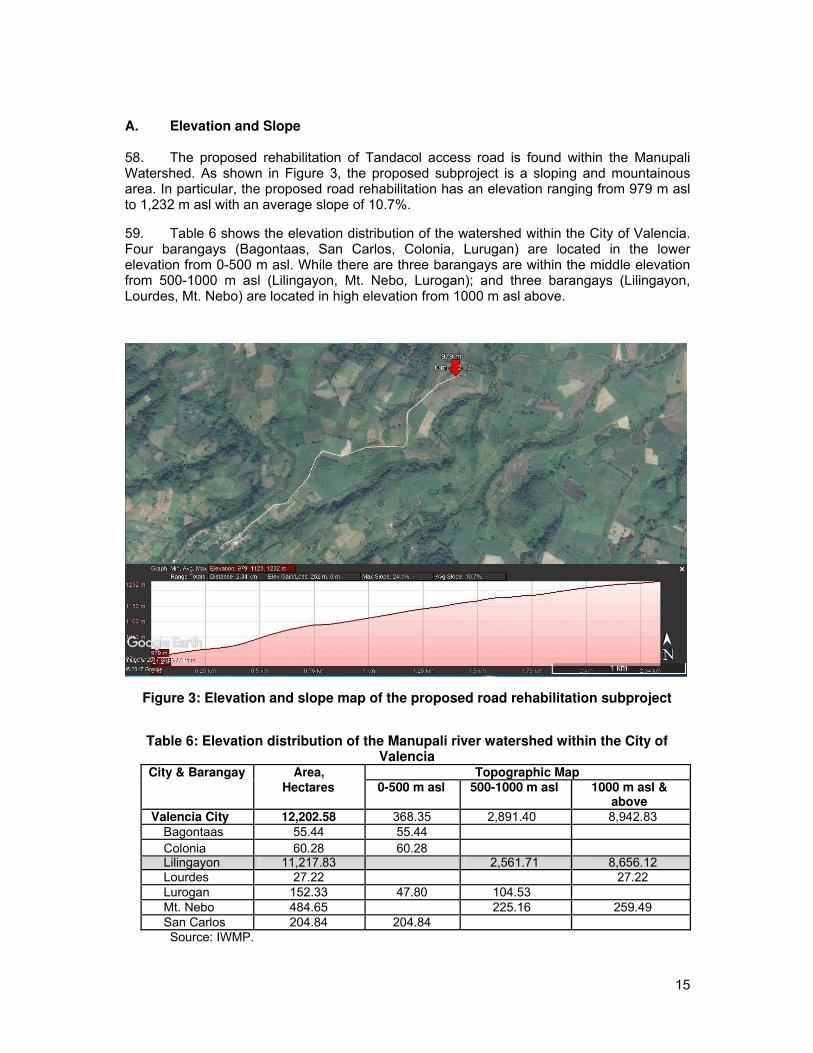
A. Stakeholder Consultations..............................................................................................37B. Information Disclosure ....................................................................................................41
VII. Grievance Redress Mechanism ....................................................................................41VIII. Environmental Management Plan ..........................................................................43
A. Implementation Arrangements ......................................................................................43B. Environmental Mitigation ...............................................................................................45C. Environmental Monitoring ..............................................................................................54
IX. Conclusion and Recommendation .............................................................................56A. Conclusion ....................................................................................................................56B. Recommendation ..........................................................................................................57
vi
LIST OF TABLES
Table 1: Summary List of ECP Types and ECA Categories ................................................................ 3
Table 2: Revised Guidelines for Coverage Screening and Standardized Requirements ......... 4
Table 3: Breakdown of cost estimates for the road rehabilitation project ..................................... 12
Appendix 3: Minutes of Council of Elders Meetings ............................................................................. 60
Appendix 4: The Council of Elders Resolution of Consent ................................................................ 64
Appendix 5: Minutes of Public Consultation and Attendance Sheet ............................................... 65
Appendix 6: Grievance Intake Form ........................................................................................................... 75
viii
I. EXECUTIIVE SUMMARY
1. This Initial Environmental Examination has been prepared for the Rehabilitation of Tandacol Access Road. This Subproject is the rehabilitation of the existing access road with an estimated length of 2.865 km, width of 4 m, and shoulder of one (1) meter on both sides. The main proponent of the project is the Local Government Unit of the City of Valencia, Bukidnon and assisted by the Department of Environment and Natural Resources – Integrated Natural Resources and Environmental Management Project. The project implementation will be co-managed by the City Environment and Natural Resources Office, Office of the City Planning and Development Coordinator and the City Engineering Office.
2. The objective of the Rehabilitation of Tandacol Access Road is uplifting the quality of life of the people thru the provision of all-year-round easy and affordable access thereby improving the prompt delivery of basic services, increasing economic opportunities and conditions. The proposed access road will support the Natural Resources Management (NRM) project activities of the constituents.
3. The Subproject has been categorized by ADB as Environment Category B and this IEE was prepared consistent with the environmental assessment requirements of ADB’s Safeguard Policy Statement of 2009. The IEE was carried out through screening and analysis of various environmental parameters, field investigations, stakeholder consultations, and review of other road project reports in the Philippines. The IEE covers the general environmental profile of City of Valencia rural infrastructure subproject and includes an assessment of the potential environmental impacts during different subproject phases and formulation of corresponding mitigation measures. The IEE was prepared by the LGU of City of Valencia with the cooperation of RPCO, PPMO, WMCPO and POs.
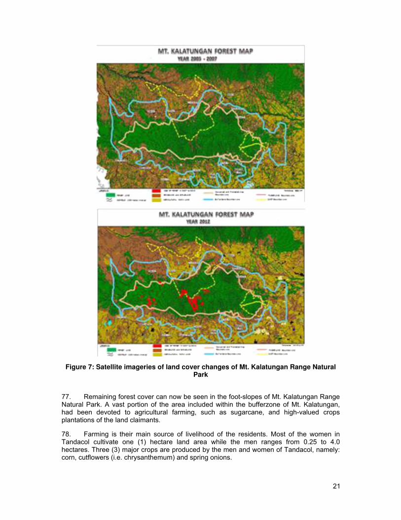
4. The total cost of the subproject is Twenty Million One Hundred Seventy Six Thousand Three Hundred Sixty Three and Seventy Seven Centavos (PhP 20,176,363.77). The project funding source is majority coming from the DENR – INREMP and LGU with a cost sharing of 80% and 20%, respectively. It will be assumed that the benefits of the subproject will be the reduction of travel time by 12 minutes, reduced transportation cost by 20 Pesos, increase number of trips by 4 and availability of infrastructure support for NRM projects and other agricultural livelihood projects of the community.
5. Major land use along the road rehabilitation project is agriculture. None of the subproject roads are located near or within ecologically sensitive areas.
6. The IEE, based on the screening of baseline environment and review of proposed civil works, has not identified any major environmental concerns due to proposed rehabilitation of Tandacol Acccess road given that all the proposed civil works are only asset preservation of existing roadway and are located within existing right of way. There will only be localized short-term impacts during construction activities due to implementation of civil works that will be addressed in the detailed design and through implementation of the mitigation and monitoring measures specified in the environmental management plan.
1
7. The IEE process included stakeholder participation and consultation to help LGUs achieve public acceptance of the Subproject. A series of consultations with its influence barangay (Sitio Tandacol, Barangay Lilingayon) of the local government of City of Valencia confirmed that the rehabilitation of the Tandacol Access road is essential for economic development.
8. A grievance redress mechanism will be established by the LGU of City of Valencia prior to commencement of site works to ensure that complaints of affected persons and other stakeholders regarding the project’s environmental performance are promptly addressed. Include Ips concern.
9. The IEE includes an environmental management plan which details the mitigation measures, environmental monitoring activities, institutional responsibilities, and environmental management capacity building. The LGU through the City Environment and Natural Resources Office, Office of the City Planning and Development Coordinator and the City Engineering Office, will ensure that relevant EMP provisions are included in bid and contract documents for detailed design, project supervision and civil works. During construction, they will closely conduct monitoring the contractor’s environmental performance and over-all EMP implementation. Semi-annual environmental monitoring reports will be submitted by LGU to
ADB and such reports will be posted on ADB’s website for public disclosure.
10. The major positive impact of the project will be economic and better accessibility. The subproject will directly benefit people located within the two barangays providing improved access and economic development. The subproject would also benefit the environment in terms of reduced soil erosion and landslides through slope stabilization measures and construction of retaining structures. Dust generation from the damaged roads will be reduced by the improvement of pavement. Health risk to the roadside communities and damage to the biological environment will be reduced due to pavement improvement and soil erosion control measures.
11. This Subproject will have overall beneficial impact and will have minor negative impacts that will be carefully monitored and adequately mitigated through implementation of the EMP.
2
II. POLICY, LEGAL, AND ADMINISTRATIVE FRAMEWORK
A.Environmental Clearance Requirements
1. Government Environmental Laws, Regulations and Guidelines
12. According to the EMB Memorandum Circular 005 – 2014, the environmental category of a project is decided based on the type of the project (whether it falls into ‘Environmental Critical Project’, ECP type), location of the project (whether it falls into ‘Environmental Critical Areas’, ECA category), and size of the project. A summary list of ECPs and ECA categories are presented in Table 1.
Table 1: Summary List of ECP Types and ECA Categories
A. List of ECPs
As declared by Proclamation No. 2146 (1981)
1. Heavy Industries – Non-ferrous Metal Industries, Iron and Steel Mills, Petroleum and Petro-chemical Industries including Oil and Gas, Smelting Plants
2. Resource Extractive Industries – Major Mining and Quarrying Projects, Forestry Projects (logging, major wood processing projects, introduction of fauna (exotic animals) in public and private forests, forest occupancy, extraction of mangrove products, grazing), Fishery Projects (dikes for/ and fishpond development projects)
3. Infrastructure Projects – Major Dams, Major Power Plants (fossil-fueled, nuclear 3efuell, hydroelectric or geothermal), Major Reclamation Projects, Major Roads and Bridges
4. All golf course projects
B. List of ECA Categories – As declared by Proclamation No. 2146 (1981)
1. All areas declared by law as national parks, watershed reserves, wildlife preserves, sanctuaries 2. Areas set aside as aesthetic potential tourist spots 3. Areas which constitute the habitat of any endangered or threatened species of Philippine
wildlife (flora and fauna) 4. Areas of unique historic, archaeological, or scientific interests 5. Areas which are traditionally occupied by cultural communities or tribes 6. Areas frequently visited and/or hard-hit by natural calamities (geologic hazards, floods,
typhoons, volcanic activity, etc.) 7. Areas with critical slopes 8. Areas classified as prime agricultural lands 9. Recharged areas of aquifers
10. Water bodies characterized by one or any combination of the following conditions: tapped for domestic purposes; within the controlled and/or protected areas declared by appropriate authorities; which support wildlife and fishery activities
11. Mangrove areas characterized by one or any combination of the following conditions: with primary pristine and dense young growth; adjoining mouth of major river systems; near or adjacent to traditional productive fry or fishing grounds; areas which act as natural buffers against shore erosion, strong winds and storm floods; areas on which people are dependent for their livelihood.
12. Coral reefs characterized by one or any combination of the following conditions: With 50% and above live coralline cover; Spawning and nursery grounds for fish; Act as natural breakwater of coastlines
13. Based on their type, size and location the projects have been classified into 3
major groups:
� Group I (ECPs): ECPs in either ECAs or NECAs – Environmentally Critical Projects in either Environmentally Critical Areas or Non-Environmentally Critical Areas.
3
These projects require the proponent to submit ‘Environmental Impact Statement’ report to secure ‘Environmental Compliance Certificate’ from DENR’s Environment Management Bureau (EMB). Table 2 gives the size of the road and bridge projects that fall in to Group 1.
� Group II (NECPs): NECPS in ECAs – Non Environmentally Critical Projects in Environmentally Critical Areas. These projects require proponent to submit either ‘Initial Environmental Examination’ Report or ‘Project Description Report ‘ based on the size of the project (see Table 2) to secure either ECC or ‘Certificate of Non Coverage’.
� Group III (Non Covered Projects): NECPs in NECS – Non Environmentally
Critical Projects in Non Environmentally Critical Areas. PDR required to be submitted for Enhancement Mitigation Projects for confirmation of benign nature of proposed activity, and CNC is required to be secured. All other projects shall be at the option of the proponent to prepare a PDR as a basis for CNC, should the proponent opt to secure one.
Table 2: Revised Guidelines for Coverage Screening and Standardized Requirements
Covered (Required to secure ECC) Not covered
(may secure CNC)
Projects within the
Project size
CATEGORY A: ECP CATEGORY B: Non-ECP CATEGORY D
INREMP Menu of parameters /
Project
Subprojects
Remarks
EIS EIS IEE Checklist Description (Part I
only)
3.1Dams, Water
Supply and
Flood Control
Project
3.1.1DAMS
>5 hectares
but Reservoir
(including those for
<25 hectares
flooded/inun
irrigation, flood
≤5 hectares
≥ 25 hectares OR OR
dated area
control, water source AND NONE
≥ 20 million m3 >5 million m3
or/and water
and hydropower ≤5 million m3
but storage
projects) including
<20 million
capacity
run-of-river type
m3
3.1.2Irrigation
≥1,000
>300 but
hectares
projects (distribution NONE <1,000 ≤300 hectares Service area
(service
system only) hectares
area)
With water
source (e.g.
infiltration
gallery, etc.)
3.1.3 Water Supply
and water Level III Level II / Level I
treatment
Projects (without NONE (Distribution Water refilling
facilities
dam) system only) station
including
desalination,
reverse
osmosis
(RO)
3.4 Roads and
Bridges
4
Covered (Required to secure ECC) Not covered
(may secure CNC)
Projects within the
Project size
CATEGORY A: ECP CATEGORY B: Non-ECP CATEGORY D
INREMP Menu of parameters /
Project
Subprojects
Remarks
EIS EIS IEE Checklist Description (Part I
only)
>50%
>50%
increase in
increase in
capacity (or in
capacity (or
terms of
in terms of
length/width) >50% increase in
length/width)
3.4.2 Roads, AND capacity (or in
AND
widening, >2km but terms of
NONE ≥20km,
rehabilitation and/or <20km, length/width) BUT ≤
(length with
improvement (length with 2km increase in
no critical
no critical length
slope) OR
slope) OR
≥10km
≥10km (length
(length with
with critical
critical slope)
slope)
3.4.3 Bridges and
≤50m
Regardless of
viaducts (including
≥5km but >50m but
≥10km length for
elevated roads), new <10km <5km
footbridges or for
construction
pedestrian only
>50%
3.4.4 Bridges and
≥50% increase in ≤50% increase in
increase in capacity (or in capacity (or in
viaducts (including
capacity (or terms terms of
elevated roads), NONE
in terms of length/width) length/width) but
rehabilitation and/or
length/width) but <total ≤2km increase in
improvement
OR ≥10km length of length
10km
3.6 Buildings
including
Housing, Storage
facilities and
Other Structures
Total/gross
3.6.2 Storage
floor area
>1 hectare
including
facilities with no
NONE ≥ 5 hectare but ≤ 1 hectare parking,
hazardous or toxic
<5 hectare
open space
materials.
and other
areas
14. This subproject is an improvement of existing barangay road which falls under the
group of Non-ECP. Currently, the City Government through the SPMU is securing the
Certificate of Non-Coverage (CNC) to the EMB.
2. ADB Environmental Assessment Requirements
15. According to ADB guidelines, the process of determining a project’s environment
category is to prepare a Rapid Environmental Assessment screening checklist, taking into
account the type, size, and location of the proposed project. Based on ADB’s Safeguard Policy Statement 2009 (SPS 2009), a project is classified as one of the four (4) environmental
categories (A, B, C or FI) as follows:
� Category A: Projects with potential for significant adverse environmental impacts that are irreversible, diverse or unprecedented. These impacts may affect an area larger than the sites or facilities subject to physical works. An environmental impact assessment is required.
5
� Category B: Projects judged to have some adverse environmental impacts, but of lesser degree and/or significance than those for category A projects. Impacts are site-specific, few if any of them are irreversible, and in most cases mitigation measures can be designed more readily than for Category A projects. An initial environmental examination (IEE) is required.
� Category C: Projects likely to have minimal or no adverse environmental impacts. No environmental assessment is required although environmental implications are still reviewed.
� Category FI: Projects are classified as category FI if they involve investment of
funds to or through a financial intermediary. Where the FI’s investment have minimal or no adverse environmental risks. The FI project will be treated as Category C. All other FI’s must establish and maintain an environmental and social management system and must comply with the environmental safeguards requirements specified in SPS 2009 if the FI’s subprojects have the potential for significant adverse environmental impacts.
16. According to Philippines environmental guidelines, the Project or Subproject can be
considered as either under Group II or III while ADB has categorized the Project as
environment Category B. Hence, this IEE has been prepared to meet the requirements of
both the ADB and the government. Upon ADB’s receipt of the final IEE from the proponent,
this will be publicly disclosed through posting on ADB’s website.
III. DESCRIPTION OF THE PROJECT A.Project Overview
17. The general objective of the proposed Rehabilitation of Tandacol Access Road is to uplift the socio-economic conditions of the beneficiaries of the influence area within the Manupali River Watershed. 18. To ensure accessibility of communities of basic social services delivery, repair and maintenance of roads and drainage systems are among the infrastructure concerns identified by the community and specifically expressed in their Barangay Development Plan for specific funding assistance by the local government unit. 19. The subproject proposal is the Rehabilitation of Tandacol Access Road which is located in barangay Lilingayon, Valencia City, Bukidnon. The subproject aims to improve the mobility of the rural community, and their access to the social services; provide them reliable access to markets; and support agricultural and rural development. There are 3 puroks in the influence area with 162 households. The project site of the NRM and RI components is within the Ancestral Domain claim of the Talaandig tribe and the Bayawon Lucday Lungayan Pendonay Talaandig Tribal Association (BLLUPENTTRAS) Indigenous Peoples Organization (IPO). The direct beneficiaries of the subproject are members of the said organization.
6
20. At present, the road condition that is covered by the proposed subproject is the most run-down section and in need of rehabilitation and improvement. The total length for rehabilitation is 2.865 kilometers. The subproject shall consist of the following works, namely: provision of 2.050 km concrete pavement (4m carriage way with 1.0 meter shoulders); road re-gravelling of 815 meters; provision of line canals; and, provision of Reinforced Concrete Pipe Culvert (RCPC) crossed drains. The project will be implemented by contract. The overall cost for the project is estimated to be PhP20,176,363.77, wherein 20% of the total cost (Php 4,035,272.75) is the counterpart equity to be providedby the LGU. Its estimated project duration is 259 calendar days. The subproject monitoring unit (SPMU) of the City of Valencia shall be the focal team to prepare the required documents, to coordinate with the Indigenous Peoples Organization, and the Barangay Government Unit (BGU) of Lilingayon, and to monitor and oversee project implementation Sitio Tandacol is a farming community. Most of the residents are farmers. Their land is dedicated to the cultivation of corn, cut flowers, vegetables, sugarcane, banana, and coffee.
B. Project Location
21. Valencia City is a 2nd class component city in the province of Bukidnon, Philippines and is composed of thirty-one (31) barangays. According to the 2010 census, the city has a population of 181,556 people. It has an average annual growth rate of 4.06%. Valencia attained its city status after the ratification of Republic Act 8985 in January 12, 2001. The city is the most
populous among all cities and municipalities, and is the 6th largest in terms of area in the province of Bukidnon. It is also the most populous inland city/municipality in Mindanao. 22. Barangay Lilingayon is located on the Western side of the City of Valencia, bounded on the North by Municipality of Lantapan, the West by the Municipalities of Talakag and Pangantucan, and to its South by Barangays Mt. Nebo, Lourdes and Guinoyuran. It comprises the largest local land area within the territorial jurisdiction of the City of Valencia covering 13,142 hectares. Of the total land area, 73.28% had been classified as timberland
while the remaining 26.72% is alienable and disposable. It is ranked 11th as most populated barangay with 6,397 individuals. Distance from the city proper is more or less 25 kilometers. 23. Sitio Tandacol is about 8 kilometers from Barangay proper with 162 households or a total of 817 constituents (Barangay profile 2015). The sitio comprises of three (3) puroks namely, puroks 13, 14 and 15; and is about 8 kilometers away from the barangay proper. Its total population is 817 where 433 are male and 384 are female, and a total of 162 households. The dominant ethnic group is Talaandig which accounts for 44.67% of the community population. This is followed by Cebuano, Boholano and Siquijudnon. 24. With the present area and population, the Internal Revenue Allotment (IRA) received by Barangay Lilingayon is on the average P2.5M, which is too small to provide basic services to the constituent, much more in relation to the improvement of infrastructure services.
25. The total length of the access road for rehabilitation is 2.865km and the whole stretch of the road is pestered by protruding rocks and surface runoff channels are in the middle of the road. Along the road are agricultural areas that are cultivated for sugarcane and high-value crops. The subproject will start after the Tandacol river spillway marked at station 0+000. The succeeding section from station 0+020 to 0+510 of the access road is characterized with gently sloping terrain at 5% slope. From station 0+800 to 1+200 is the most difficult ascent of the road section with a slope of 12%. At station 1+300 to 2+000 are the plantation areas of high-valued crops such as cutflowers and vegetables. Finally, approaching the community proper is at station 2+500 until 2+865 towards the Tandacol Elementary School which is endpoint of the subproject (Figure 1).
7
Figure 1: Road Location Map of the RI subproject
26. The proposed subproject site is an agricultural area. If the existing barangay road will be rehabilitated, there will be no endangered species or declared protected area of natural habitat that will be affected by the said subproject. 27. Based on the environmental characterization of the project site done during the field reconnaissance survey, the project was not located in an environmentally critical area and the field data were supplemented with secondary information gathered from the DENR Regional Office and CENRO and other relevant data such as watershed management plan, environmental reports and feasibility studies undertaken by national and local agencies. 28. A certification of the Watershed Management and Project Coordination Offices (WMPCO) described that the location of the proposed subproject is outside the protected area of the Mt. Kalatungan Range National Park (Appendix 1). It is still within the timberland area of the barangay, thus strengthening its eligibility and address the issues on possible threats to environmentally critical and sensitive areas.
C. Project Rationale
29. The only means of passage of the indigenous peoples was established foot trail in Sitio Tandacol. In 1983, a certain Talaandig Datu named Datu Tawantawan (whose Christian name was Mr. Saturnino Lungayan) asked for development project, a school building from then Governor Carlos O. Fortich of the Province of Bukidnon. The school was named Bagong Lipunan, of what is now the location of the current Tandacol Elementary School. In order for the construction activities to commence, there was a need to pioneer the opening of road that is wide enough to penetrate the said far-flung area. Hence, the Sitio Tandacol access road was constructed.
8
30. At present, the Sitio Tandacol access road is very much deteriorated. Travelling in or out of the Sitio is backbreaking to passengers and transport of high valued products will take lengthy time to reach its destination. It will also reduce its postharvest quality. The limited budget of the barangay to provide for road maintenance (beyond gravelling and scraping), coupled with occurrence of heavy rainfall during the wet season, are the twin culprits of the present road conditions.
D. Project Development Plan
1. Project Components
31. The whole stretch of the road is pestered by protruding rocks and surface runoff channels are in the middle of the road. The proposed subproject will have a total length of 2.865 km with the design width of 4 m carriageway and 1 m shoulder at both sides. The road rehabilitation primarily will be clustered into two parts: the 2.05 km length of steep road will be improved into concrete road while the remaining 0.815 km length flat surface will be subjected to re-gravelling or provision of surface coarse. The 2.05 km concrete road will start from sta. 0+000 after Sitio Tandacol Creek up to sta. 0+510; sta. 0+575 up to sta. 0+650; sta. 0+800 up to sta. 1+200; sta. 1+300 up to sta. 2+000; sta. 2+500 up to the end point at sta. 2+865. The re-gravelling of road will start sta. 0+510 up to 0+575; sta. 0+650 up to 0+800; sta. 1+200 up to sta. 1+200 up to sta. 1+300; sta. 2+000 up to the end of sta. 2+500. 32. Proposed scope of works is divided into four major Items: 1) Surface Re-gravelling;
2) Provision of Concrete Pavement; 3) Provision of Natural Line Canal; and 4) Provision of RCPC Cross Drains
33. Surface Re-gravelling or provision of re-gravelling 150 millimeter (mm) thick aggregate base course (item 201) and 150 mm thick. Aggregate surface course (item 300) including 1 meter gravel shoulder on both sides. It will also include Surplus Common Excavation, embankment, and sub-grade preparation (grading and compaction). 34. The provision of Portland Cement Concrete Pavement (PCCP) will be 150mm thick concrete pavement on 150mm thick aggregate base course with 1 meter aggregate surface course at both sides. Also included in the works are sub-grade preparation. 35. The provision of natural line canal will be 0.5 meter width side ditch excavation and compaction works. Also included the clearing and grubbing works. 36. The provision of Reinforced Concrete Pipe Culvert (RCPC) cross drains will primarily be made of 910 mm diameter size of pre-fabricated reinforced concrete pipe culvert, averagely to be installed by 8 pcs at every target station points. It will be placed 600 mm underground from the finished road surface line. Grouted riprap wall will be constructed at headwalls of the cross drain pipes. Also included in the works are the clearing and grubbing, excavation and backfill/fill cover. 37. The following are the major technical specifications of the project:
Clearing and Grubbing (Item 100)
This item shall consist of clearing, grubbing, removing and disposing all vegetation and debris as designated in the Contract, except those objects that are designated to remain in place or are to be removed in consonance with other provisions of this Specification. The work shall also include the preservation from injury or defacement of all objects designated to remain.
Excavation (Item 102)
9
This item shall consist of roadway and drainage and borrow excavation and the disposal of material in accordance with this Specification and in conformity with the lines, grades and dimensions shown on the Plans or established by the Engineer.
Structure Excavation (Item 103)
This item shall consist of the necessary excavation for foundation of culverts, underdrains, and other structures not otherwise provided for in the Specifications. Except as otherwise provided for pipe culverts, the backfilling of completed structures and the disposal of all excavated surplus materials, shall be in accordance with these Specifications and in reasonably close conformity with the Plans or as established by the Engineer.
Embankment (Item 104)
This item shall consist of the construction of embankment in accordance with this Specification and in conformity with the lines, grades and dimensions shown on the Plans or established by the Engineer.
Sub-grade Preparation (Item 105)
This item shall consist of the preparation of the sub-grade for the support of overlying structural layers. It shall extend to full width of the roadway. Unless authorized by the Engineer, sub-grade preparation shall not be done unless the Contractor is able to start immediately the construction of the pavement structure.
Aggregate Base Course (Item 201)
This item shall consist of furnishing, placing and compacting an aggregate base course on a prepared sub-grade/sub-base in accordance with this Specification and the lines, grades, thickness and typical cross-sections shown on the Plans, or as established by the Engineer.
Aggregate Surface Course (Item 300)
This item shall consist of a wearing or top course composed of gravel or crushed aggregate and binder material, whichever is called for in the bill of Quantities, constructed on a prepared base in accordance with this Specification and in conformity with the lines, grades and typical cross-sections shown on the Plans.
Portland Cement Concrete Pavement (Item 311)
This item shall consist of pavement of Portland Cement Concrete, with or without reinforcement, constructed on the prepared base in accordance with this Specification and in conformity with lines, grades, thickness and typical cross-section shown on the plans.
Pipe Culverts and Storms Drains (Item 500)
This item shall consist of the construction or reconstruction of pipe culverts and storm drains, hereinafter referred to as “conduit” in accordance with this Specification and in conformity with the lines and grades shown on the Plans or as established by the Engineer.
Stone Masonry (Item 506)
This item shall consist of stone masonry in minor structures, in headwalls for culverts, in retaining walls retaining walls at the toes of slopes, and at other places called for on
10
the Plans, constructed on the prepared foundation bed, in accordance with this Specification and in conformity with the lines, grades, sections, and dimensions shown on the Plans or as ordered in writing by the Engineer.
This proposed subproject will start from station 0+800 to 1+200 which is the most difficult ascent of the road section with a slope of 12%.
2. Description of the Project Phases
a. Pre-Construction Phase
38. The pre-construction phase involves the social preparation (to include organizational strengthening, planning, identification and prioritization of community needs) of the community for the entry of the project to the site, conduct of pre-engineering activities covering detailed survey works to determine alignment of roads and canal systems, preparation of the detailed engineering plans and programs of work, ROW negotiation, recruitment of work force and initial sourcing and procurement of construction materials. These activities will be conducted by the proponent technical staff, partner line agencies, NGO service providers, community beneficiaries especially the Peoples’ organizations and contractors. 39. The LGU is presently applying for the Special Land Use Permit to the DENR and also securing the Certificate of Non-Coverage to the EMB Region 10.
b. Construction Phase
40. The construction phase involves the mobilization of construction equipment, construction workers and materials to the specific project site after which the longer period of actual construction work will commence. The construction phase will end with the demobilization of construction equipment, workers and other construction paraphernalia from the construction site. Majority of these activities will be undertaken by the contractor and community residents under the close supervision of the Subproject Management Unit.
c. Operation Phase and Maintenance Phase
41. The operation and maintenance phase involves the actual maintenance of the rehabilitated access road during its expected economic life. This will involve the designation a spoils storage area of at least 25 meters away from water bodies for proper disposal of excavated materials, wetting areas of dust sources along vehicle route, and regular removal of debris, logs and other materials along drainage canals.
d. Abandonment Phase
42. This phase is included in the project demobilization. The proponent does not intend to abandon any facilities and unserviceable equipment used during construction. The project location will not be abandoned in disorderly condition but instead restored for functional use. Following the completion of the construction, the proponent will dismantle temporary shelters and the construction yard including unserviceable vehicles and equipment. 43. Wastes arising from the abandonment are expected to be minimal. These wastes could include small volumes of left over sand and gravel, re-bars and other steel materials (i.e., nails and welding roads) and lumber.
11
E. Manpower Requirements
44. Construction activities will require hiring of skilled and unskilled manpower. It is assumed that some skilled, semi-skilled and unskilled manpower will be available in the area. Skilled manpower may not be available in the locality thus it may be sourced from other nearby localities. Technical manpower will be a complementation of specialists to be provided by locally known engineering firms. 45. During the construction phase, a workforce consisting of contractual and regular laborers will be employed to carry out the construction of the proposed project. 46. The Contractor shall employ qualified and sufficient staff to carry out inspections, testing and monitoring for the project.
F. Project Cost
47. The Subproject Cost as estimated has the total amount of PhP 20,176,363.77 which includes the costs for the indirect cost and taxes aside from the direct cost (material+labor+equipment). The said direct cost has the amount of PhP 15,397,103.00. The overhead, contingencies and miscellaneous and contractor’s (OMC) profit will be 9% and 8% of the direct cost, respectively. Taxes will be in the fixed ratio of 12% as required by the government. 48. Following the agreed financing mix of the subproject, 80% of the total Subproject Cost as presented will be covered by the Project and the remaining 20% will be borne by the proponent LGU-Valencia as equity counterpart which will be appropriated by the Sangguniang Panglungsod (SP) from the City Development Fund. The amount of equity counterpart based from the presented subproject cost above is PhP 4,035,272,75. The estimated cost of the proposed subproject is Twenty Million One Hundred Seventy Six Thousand Three Hundred Sixty Three Pesos and Seventy Seven Centavos (PhP20,176,363.77). 49. Breakdown of cost estimates is presented in the table below.
Table 3: Breakdown of cost estimates for the road rehabilitation project Particulars Cost, Php
1. Direct Cost 15,397,103.00
2. Indirect Cost
Overhead, contingency and misc. (OCM )(9% 1,385,739.27
of direct cost)
Contractors profit (8% of direct cost) 1,231,768.24
VAT, (12% of DC+OCM+CP) 2,161,753.26
TOTAL IDC 4,779,260.77
TOTAL PROJECT COST 20,176,363.77
Grant (80%) 16,141,091.02
LGU Equity (20%) 4,035,272,75
50. The source of fund for the project will come from the National Government (through DENR-INREMP) and Local Government Unit for a cost sharing/financing mix of 80% of the total Subproject Cost or equivalent to PhP16,141,091.02 and the remaining 20% from the proponent LGU City of Valencia, Bukidnon as equity counterpart, appropriated by the Local Finance Committee from the LGU’s 20% Local Development Fund in the amount of PhP4,035,272,75.
12
51. Aside from the equity counterpart provided by the City of Valencia for proposed subproject, it also allocated an amount intended for the preparation of the project such as seminars, preparation of feasibility study (or subproject proposal document) and detailed engineering, survey of the project site and evaluation by the personnel from different sectors who are involved in the planning and implementation of the subproject.
52. During the operation and maintenance period, the LGU shall ensure that a supplemental budget to the existing operation and maintenance expenses of the entire municipality’s road and network facilities shall be allocated just for this new road subproject.
G. Project Duration and Schedule
53. After the provision of technical workshop provided by the National Project Coordinating Office (NPCO) in March and April 2017, the SPMU started the finalization and completion of the Subproject Proposal Document (SPD). The completed SPD was submitted to the Provincial Project Management Offices (PPMO) thru the CESM for review in May 2017 and concurrence by thru the Regional Project Coordinating Offices (RPCO) in June 2017. When found substantial enough, it was endorsed to the PPMC for the request of approval. During these stages, the detailed engineering design (DED) was simultaneously prepared by the LGU Engineering Unit (March-April 2017). The DED shall then be translated into a Bidding Document once the SPD is approved by the council. Procurement period should take three months to comply with the ADB Procurement Guidelines, thus the Subproject is expected to be awarded on the month of November 2017. The construction as indicated in the prepared Bar Chart of Construction Schedule will take eight months. The construction will be on November 2017 until August 2018.
54. After the target completion of construction works, the LGU will prepare the completion documents on September 2018 and the turn-over ceremonies shall also take place at the same time. Finally, maintenance and sustainability activities will be performed October 2018 which will include the adaptation of the required MOA for maintenance of the facility and sustainability training which will be provided by the NPCO. See the table below for the illustration of the indicative implementation schedule.
Table 4: Implementation Schedule
RI Subproject
Milestones 2017 2018
M A M J J A S O N D J F M A M J J A S O N D
SPD Finalization
Final Review of SPD
SPD
Approval
DED Preparation
Procurement Stage
Construction Stage
Completion and Turn-
over
O&M Activities
13
IV. DESCRIPTION OF THE ENVIRONMENT
55. The Manupali Watershed is typical for a large watershed (about 50,000 ha) in the country. It is situated in the southeastern part of the Province of Bukidnon within the coordinates 7⁰57’00” – 8⁰07’50” North latitude and 124⁰51’40” – 125⁰06’00” East longitude. It is bounded on the northeast by the City of Malaybalay, on the south by the northern part of the City of Valencia and on the west by the Municipality of Talakag. The Manupali River flowing south-easterly serves as the common boundary of the Municipality of Lantapan and the City of Valencia.
56. The Manupali River watershed is one of the major subwatersheds in the City of Valencia. It covers seven (7) barangays with a total land area of 12,202 ha. In particular, Barangay Lilingayon covers 11,217 hectares or 91% of the watershed area in City of Valencia. Table 5 shows the barangays covered by the Manupali river watershed within the political jurisdiction of the City of Valencia.
Table 5: Profile of the Manupali river watershed in the City of Valencia
City of Valencia Total Watershed Barangay Watershed Area per
Sub-Watershed Area Sub- total Covered Barangay (hectares)
(ha)
Manupali river sub- 12,202.58
Bagontaas 55.44
watershed
Colonia 60.28
Lilingayon 11,217.83
Lourdes 27.22
Lurogan 152.33
Mt. Nebo 484.65
San Carlos 204.84
Source: IWMP.
57. Figure 2 shows the location of the Manupali river relative to the upper Bukidnon river basin and the administrative boundary map of the watershed.
Figure 2: Location map of the Manupali river watershed in the upper Bukidnon river basin
14
A. Elevation and Slope
58. The proposed rehabilitation of Tandacol access road is found within the Manupali Watershed. As shown in Figure 3, the proposed subproject is a sloping and mountainous area. In particular, the proposed road rehabilitation has an elevation ranging from 979 m asl to 1,232 m asl with an average slope of 10.7%. 59. Table 6 shows the elevation distribution of the watershed within the City of Valencia. Four barangays (Bagontaas, San Carlos, Colonia, Lurugan) are located in the lower elevation from 0-500 m asl. While there are three barangays are within the middle elevation from 500-1000 m asl (Lilingayon, Mt. Nebo, Lurogan); and three barangays (Lilingayon, Lourdes, Mt. Nebo) are located in high elevation from 1000 m asl above.
Figure 3: Elevation and slope map of the proposed road rehabilitation subproject
Table 6: Elevation distribution of the Manupali river watershed within the City of Valencia
City & Barangay Area, Topographic Map
Hectares 0-500 m asl 500-1000 m asl 1000 m asl &
above
Valencia City 12,202.58 368.35 2,891.40 8,942.83
Bagontaas 55.44 55.44
Colonia 60.28 60.28
Lilingayon 11,217.83 2,561.71 8,656.12
Lourdes 27.22 27.22
Lurogan 152.33 47.80 104.53
Mt. Nebo 484.65 225.16 259.49
San Carlos 204.84 204.84
Source: IWMP.
15
B. Geology
60. The land formation that characterizes the larger part of Barangay Lilingayon is situated along the upper slopes of Mt. Kalatungan mountain ranges is generally underlain by the Quaternary, Volcanic (QV) Pliocene (9,458.71 hectares) while the lower slopes is underlain by the Quaternary, Volcanic and Pyroclastic (QVP) Pliocene covering 1,759.11 hectares. 61. Quaternary Volcanic (QV) which is observed to occur on mountainous to very rough terrain, mainly under virgin forest, have very low potential in agriculture on account of their location in very steep slopes. Pyroclastic are landforms that have soils with highest agricultural potentials. Basalts on the other hand, give rise to soil with favorable properties and high potential for agricultural uses. The basalt flow varies from porphyritic plagioclase to pyroxene basalts. It is brittle and is sometimes vesicular in alternating layers, suggesting different times of deposition. 62. Pyroclastic are accumulation of airfall from volcanic ejecta (eruptions debris) which blanketed the area around volcanoes during eruptions in distant past and which characterizes the soils of most of the watershed. Recent alluvial deposits line the rivers and creeks of the watershed. Alluvials are nutrient-rich soil deposits made up of loose aggregate of volcanic rocks, tuffaceous sand and other minerals washed down by streams from higher elevations of the watershed. Figure 4 shows the two (2) types of geologic characteristic in the Manupali river watershed. QV areas is highlighted in green, while QVP in yellow.
Figure 4: Geology map of the manupali river watershed
C. Soils
63. Soils of the watershed are generally clayey due to the extent of fine-grained volcanic rocks, various sedimentary derivatives and pyroclastic. The most dominant in the watershed
16
is Adtuyon Clay which forms 41.45% of the total area. It is followed by Mountain Soil (22.54%). La Castellana Clay constitutes the smallest fraction occupying only 0.68% of the watershed area. It is confined in Lower Lilingayon located in the southern part of the watershed (Figure 5).
Figure 5: Soil map of the manupali river watershed
D. Water Quality
64. The proposed rehabilitation access road subproject is passing across the Tandacol river which is one of the tributaries of the Manupali Watershed. The Tandacol river has still no water classification pursuant to DAO No. 34, Series of 1990 and DENR Memorandum Circular No. 09, Series of 2001. In the absence of water classification and in accordance with the Manual of Procedure for Water Classification, the Tandacol river is assumed to be a Class A waters since most of the upstream stations are under this classification. A “Class A” waters intended beneficial use is public water supply class which is usually sources of water supply that will require complete treatment (coagulation, sedimentation, filtration, and disinfection) in order to meet the National Standards for Drinking Water.
17
65. Based on the Manupali Watershed Management Plan (2015), some water quality parameters are presented in Table 7.
Table 7: Water quality assessment of the Manupali mainstream
Note: *The allowable temperature increase over the average ambient temperature for each month is 3°C . This rise shall be bas ed on the average of the maximum daily temperature readings recorded at the site but upstream of the mixing zone over a period of one (1) month”.
66. The average pH level test result is 7.16. The result pass the Class A waters quality standard for pH level which set the range within 6.5 – 8.5 for Class A waters. The pH state of surface water is especially important since aquatic organisms have an unusually low tolerance thriving on very narrow pH ranges. 67. Water temperature is a controlling factor for aquatic life: it controls the rate of metabolic activities, reproductive activities and therefore, life cycles. If stream temperatures increase, decrease or fluctuate too widely, metabolic activities may speed up, slow down, malfunction, or stop altogether. The Manupali River conformed to the standard with an average temperature at 26.75°C taken from the upstream of Manupali River. 68. The Biochemical Oxygen Demand, or BOD, means a measure of the approximate quantity of dissolved oxygen required by bacteria to stabilize organic matter in wastewater or surface water. The consequences of increasing BOD are similar as those for low dissolved oxygen in which aquatic organisms become stressed, suffocate, and die. The BOD of Manupali River is 6.8 mg/L which is beyond the standard set by the DENR for Class A water (5 mg/L). 69. Dissolved oxygen (DO) is the amount of oxygen that is dissolved in water and is essential to healthy streams and lakes. Dissolved Oxygen is one of the water quality parameters used as an indicator of how polluted the water is and how well the water can support aquatic plant and animal life. The average Dissolved Oxygen of the samples taken in the upstream of Manupali River is 93.19% (7.7 mg/L). The samples passed the required minimum value of 70% set by the DENR for Class A waters. 70. TSS measures the amount of undissolved solid particles in water such as level of siltation, decaying plant and animal matter, and domestic wastes. For water bodies used for water supply the standard for TSS is 50 mg/L for Class A (DAO 34). The Manupali River has high TSS levels of 100.4 mg/L, indicating low water quality during wet season which implies that water from the watershed is not recommended for drinking purposes. It is expected because of the influence of its land cover and land use, and high discharge during rainy season. 71. The average Nitrate level of Manupali River is 1.93 mg/L. As for this parameter the Manupali River passed the required minimum standard set by the DENR for class A waters.
18
72. Phosphorus is an essential nutrient for plants and animals. In addition, phosphorus is a limiting nutrient (nutrient in short supply) in most fresh waters. The DENR standard for Class A water for this parameter is set at 0.5 mg/L. The Manupali River passed this standard with an average level of 0.47 mg/L. 73. Calcium and magnesium dissolved in water are the two most common minerals that make water “hard.” Hardness are classified as <17.1 (soft), 17.1-60 (slightly hard); 60-120 (moderately hard); 120-180 (hard); >180 (very hard). Water hardness of Manupali River is 0 mg/L therefore it is soft. 74. Bacteriological examination of water sample shows that the samples have higher coliform and it is not recommended for human consumption. Other than the laboratory analysis, observations made are the presence of large scale commercial piggeries and poultries inside the watershed and other agent coming from agricultural areas. The
laboratory analysis disclosed that the mainstream have a total coliform of 16x103 and fecal
coliform of 92x102 which is far beyond the standard of 1,000 MPN/100mL.
E. Land Classification
75. The distribution of Alienable and Disposable lands to forestlands is halved inside the Manupali river watershed at 49.76% and 50.24%, respectively. The forested portions of the watershed are mostly confined in higher elevation of the protected areas. Forestland covers a total of 9,125 hectares while A&D land covers 3,077 hectares. In Barangay Lilingayon, 78% (8,774 ha) is classified as forestland while 22% (2,443 ha) is alienable and disposable lands (Table 8 and Figure 6).
Table 8: Land classification of barangays covered in the Manupali river watershed
City & Barangay Area Land Classification
A & D Forestland
Valencia City 12,202.58 3,077.32 9,125.25
Bagontaas 55.44 55.44
Colonia 60.28 60.28
Lilingayon 11,217.83 2,443.30 8,774.53
Lourdes 27.22 27.22
Lurogan 152.33 152.33
Mt. Nebo 484.65 161.15 323.51
San Carlos 204.84 204.84
19
Figure 6: Land classification map of the manuali river watershed
F. Land Cover and Land Use
76. Unrestrained access to forestlands has greatly altered the land use pattern and vegetative cover of the Manupali river watershed in recent years. In the early 60s and 70s, over 60% of the entire watershed was still covered with primary forest. Intensive logging operations that continued until the early 1980s caused the large scale removal of the primary forest. In recent years, the expansion of areas for agricultural purposes around the slopes and foothills of Mt. Kalatungan had been alarming based on the land use change analysis between 2007 and 2012 (Figure 7). The conversion of forest areas for high value crop production and “kaingin” or shifting cultivation are alarmingly scaling up the upper reaches of the protected areas.
20
Figure 7: Satellite imageries of land cover changes of Mt. Kalatungan Range Natural Park
77. Remaining forest cover can now be seen in the foot-slopes of Mt. Kalatungan Range Natural Park. A vast portion of the area included within the bufferzone of Mt. Kalatungan, had been devoted to agricultural farming, such as sugarcane, and high-valued crops plantations of the land claimants. 78. Farming is their main source of livelihood of the residents. Most of the women in Tandacol cultivate one (1) hectare land area while the men ranges from 0.25 to 4.0 hectares. Three (3) major crops are produced by the men and women of Tandacol, namely: corn, cutflowers (i.e. chrysanthemum) and spring onions.
21
79. It must be noted that the proposed road rehabilitation project is traversing forestland within the Manupali Watershed. However, the Tandacol access road is about 2 km away from the Mt. Kalatungan Buffer Zone and about 6 km away from Mt. Kalatungan Range Natural Park. The actual land use types along the subproject road are mostly agricultural lands planted of sugarcane, cutflowers, and spring onions.
I. Climate
1. Baseline Climate
80. Based on Modified Corona’s Classification System, the Manupali river watershed belongs to Type III climate, where there is no very pronounced maximum rain period while dry season is short lasting only from one to three months. This climatic type is intermediate between the preceding two types (Climatic type I and II, although it has shorter dry season. Areas of this climatic type are partly shielded from the northwest monsoon but are exposed to the southwest monsoon and are also benefited by the rainfall caused by the tropical cyclones.
81. Records from PAGASA shows that total annual average rainfall for the period of 1981-2010 is 1,703.3 mm. Further, PAGASA reveals that from June to November, which is rainy season, the average rainfall per month is 184.43 mm. From December to May, which is dry season, the average rainfall per month is 95.66 mm. 82. Meanwhile, the area has an annual mean temperature of 26.8 °C while the average relative humidity is 81%. The hottest months are April, May, and June while the coldest months are December, January, and February. These observations were obtained from the nearest PAGASA station in Lumbia Airport.
83. The southwest and the northeast monsoon systems influenced the rainfall pattern that is responsible for the tropical storms that batter the entire region during the rainy season. The southwest monsoon sets in during late May and peaks during the months of November and December (Figure 8). The northeast monsoon then comes in during late October and intensifies in January and February. Overall, the area is seldom visited by storms and/or typhoons. From 1948 to 2009, only one tropical storm and one typhoon passed through the Province of Bukidnon, which affected the area. On average, the area is visited by 2 typhoons per year. It is during January and October when a number of cyclones would cross the watersheds whereas the remaining months are almost free of tropical cyclones.
22
Figure 8: Record of tropical cyclones that passed through the region covering the influence watersheds during the period 1948 – 2009 (PAGASA)
2. Climate Scenario for Bukidnon Province in 2020 and 2050
85. PAGASA-DOST projected the climate changes using the CNCM3 model scenarios. Based on projections, the province will be affected by changes in rainfall in various seasons, and increasing occurrences of extreme events in 2020 and 2050. The projected monthly rainfall change in 2020 and 2050 under the CNCM3 model scenario in the province are presented in Table 9. 86. The simulated monthly rainfall ranges from 71 mm to 626 mm. The mean monthly rainfall of two scenarios (A1B and A2) was significantly different from each period. The driest month, April, still sees below 150 mm of precipitation per month. The wettest months are November and December with a monthly mean of more than 300 mm (Figure 9). 87. In particular, the monthly precipitation fluctuated each month for two periods. However, the most distinct changes are predicted to be in the 2050s period under A2 scenario where most likely longer dry months. Other periods closely followed the trends and patterns. Overall, a decrease of annual rainfall was predicted in each scenario for two periods as much as 40% compared to the observed scenario (Table 10).
Table 9: Projected monthly rainfall based on CNCM3 model with A1b and A2 scenarios for 2020s and 2050s periods in Bukidnon Province
Month Observed
A1B A2
2020
2050 2020
2050
Jan 295.5 335.7 160.6 290.1 206.9
Feb 224.1 390.4 106.1 116.9 197.6
Mar 190.4 200.0 106.4 196.5 191.0
Apr 148.3 66.5 108.6 132.9 99.5
May 208.9 304.0 261.9 176.5 98.9
23
Jun 278.9 167.5 311.1 271.7 71.2
Jul 337.7 146.6 368.8 335.8 97.0
Aug 378.4 391.4 412.0 208.6 128.5
Sep 236.4 226.6 271.6 333.4 176.2
Oct 273.2 132.8 271.8 366.6 207.6
Nov 314.2 456.9 304.8 274.4 285.5
Dec 436.7 626.2 351.5 382.4 204.8
Total 3322.7 3444.6 3035.1 3085.9 1964.5
Min 148.3 66.5 106.1 116.9 71.2
Max 436.7 626.2 412.0 382.4 285.5
SD 82.21 161.18 107.73 89.91 63.93
Ave 276.9 287.1 252.9 257.2 163.7
Source: DOST PAGASA.
Monthly
Rainfall
(mm)
700.0
600.0
500.0
400.0
300.0
200.0
100.0
0.0
Jan Feb Mar Apr May Jun Jul Aug Sep Oct Nov Dec
Observed
2020 (A1B) 2050 (A1B)
2020 (A2) 2050 (A2)
Figure 9: : Monthly rainfall based on CNCM3 model for 2020s and 2050s periods in Bukidnon Province
Table 10: Change anomalies of rainfall in Bukidnon Province based on CNCM3 model
Month
A1B A2
2020
2050 2020
2050
Jan 13.6 -45.7 -1.8 -30.0
Feb 74.2 -52.6 -47.8 -11.8
Mar 5.0 -44.1 3.2 0.3
Apr -55.1 -26.8 -10.4 -32.9
May 45.5 25.4 -15.5 -52.7
Jun -39.9 11.5 -2.6 -74.5
Jul -56.6 9.2 -0.5 -71.3
Aug 3.4 8.9 -44.9 -66.0
Sep -4.2 14.9 41.0 -25.5
24
Oct -51.4 -0.5 34.2 -24.0
Nov 45.4 -3.0 -12.7 -9.1
Dec 43.4 -19.5 -12.4 -53.1
Total 3.7 -8.7 -7.1 -40.9
J. Natural Hazards
88. In general, the country experiences an average of 20 typhoons and most of which
pass through Visayas and Luzon every year. Situated close to what could be the
southernmost rim of the Philippine typhoon belt, the province received 11 typhoon hits over
a 20-year period (Table 11). The floods of 2009 and 2011 have already provided a tragic
illustration of what can happen. While the province is free from the direct effects of tropical
cyclone, its weather, particularly manifestation of rainfall may be affected by tropical
cyclones passing close to the northeastern tip of Mindanao (UN-HABITAT and WFP, 2013).
Table 11:Total Annual Number of Typhoons in the Area
Year
Tropical Period
Durations (days)
Cyclone
Begin Date
End Date
1991 TS Bebeng 4/23/91 4/26/87 4
1993 TD Bining 4/12/93 4/13/93 2
1993 TY Toyang 12/24/93 12/29/93 6
1996 TD Toyang 11/4/96 11/13/96 10
2002 TD Caloy 3/20/02 3/23/02 4
2003 TD Zigzag 12/24/03 12/27/03 4
2004 TD Pablo 9/15/04 9/17/04 3
2007 TY Lando 11/19/07 11/28/07 10
2008 TS Ambo 4/14/08 4/15/2008 2
2008 TD Rolly 11/8/08 11/09/2008 2
2008 TD Tonyo 11/13/08 11/16/2008 4
2011 TY Sendong 12/15/11
Source: WWF-BPI Business Risk Assessment as cited by UN-HABITAT, 2013
89. In particular, some areas inside the Manupali Watershed are vulnerable to natural hazards. Soft riverbanks, steep slopes with fragile substrate, low lying areas and unstable waterways pose risks to human lives in varying degrees. Among these are flooding, and rain-induced landslide. However, the entire Barangay Lilingayon is not susceptible to flooding. Generally, flooding in built-up areas is not a problem in the upland barangays as the terrain is slightly sloping and rain water are easily discharged to creeks and rivers. 90. For rain-induced landslide, the entire barangay wherein the proposed road access rehabilitation is located, is categorically low to moderate due to limestone and moderate slope conditions.
25
K. Biological Environment
1. Flora and Fauna Biodiversity
91. The Natural Parks in Bukidnon have six (6) major habitat types, ranging from lowland evergreen forest, which is the most species-rich forest formation; lower montane forest, upper montane (mossy) forest, grasslands, freshwater wetlands and caves. The lower montane forest is characterized by a two-layered canopy. Trees in this habitat type are shorter in height than those found in lowland residual dipterocarp forest. In the upper montane (mossy) forest, trees are gnarled and stunted with a more or less uniform height; trunks and branches are festooned and characterized by the presence of numerous species of mosses, lichens and ground epiphytic ferns. The bushland / grassland and cultivations are confined to the central lower portions of the park these forests and grasslands protect a sizable population of flora and fauna endemic to the Philippines, many of which are endangered like the Philippine eagle. 92. The Central Mindanao University has conducted an inventory and assessment of the endemic, endangered and economically important flora and fauna in selected mountains in Northern Mindnao (Table 12). The said inventory revealed that a total of 129 species of wildlife in Mt. Kalatungan – the highest among the mountains inventories. The biological importance and the high biodiversity value of Manupali Watershed are attributed to the fact that it is being straddled by two of the most significant Key Biodiversity Areas in the country - the Mt. Kitanglad Range Natural Park and the Mt. Kalatungan Range Natural Park. 93. Biodiversity in the area is monitored by the PASO Kalatungan through Biodiversity Monitoring System (BMS). Bantay Lasang was deployed by PASO to monitor the area and for law enforcement specifically in the apprehending unregulated hunting of wildlife and unauthorized cutting of trees. The honorarium of the Bantay Lasang is shouldered by the PASO with a counterpart of the LGU where the PA strides. 94. To monitor the Mt. Kalatungan Range Natural Park, PASO Kalatungan conducted a quarterly BMS which includes Focus Group Discussion among the community adjacent to the park to identify issues within the park. Major treats of Mt. Kalatungan as unique natural attraction is the wildlife hunting and extraction of flora like Nito (small rattan), Abaca, Anibong, Banag for commercial, food, roofing and medicine purposes. 95. Overall, the proposed road access rehabilitation is within the Manupali Watershed but outside the Mt. Kalatungan Range Natural Park buffer zone (about 2 km) and the Mt. Kalatungan Range Natural Park (about 6 km away). It must be noted that there are no trees at the easement and right of way of the proposed road rehabilitation project.
Table 12: Faunal species counts within the two key biodiversity area (Mt. Kitanglad and Mt. Kalatungan Mountain ranges)
Category Count
Mammals 63 species
Reptiles 25 species
Amphibians 26 species
Birds 168 species
Source: TA7716-PHI_TCR_Volume 3
26
L. Socio-Economic Conditions
1. Population
96. The City of Valencia is a 2nd class component city in the province of Bukidnon, Philippines and is composed of thirty-one (31) barangays. According to the 2010 census, the city has a total population of 181,556 people with 4.06% growthrate.
97. Based on the population projection by the National Statistic Office, Barangay Lilingayon has a total population of 7,393 for 2016 with a growth rate of 4.06%. The projected population for the year 2020 will reach to 9,310 (Table 13).
Table 13: Projected Population of Barangay Lilingayon from 2016-2020
Year Projected Population
2016 7,939
2017 8,262
2018 8,597
2019 8,946
2020 9,310
Source: CLUP, 2010-2020.
98. In particular, Sitio Tandacol (the subproject influence area) is located in the south-eastern part of Barangay Lilingayon. The sitio consists of 3 puroks, namely; puroks 13, 14, and 15 and is about 8 kilometers away from the barangay proper. Its total population is 817, where 433 are male and 384 are female, and a total of 162 households (Table 14).
Table 14: Total Population, Households in the Influence Areas
Purok Population Total no. of HH
Male Female
Purok 13 120 116 42
Purok 14 158 144 60
Purok 15 155 124 60
Total 433 384 162
Source: Barangay Lilingayon Profile, 2014.
99. Based on the Barangay Lilingayon’s profile 2015, the barangay has a total population of 6,640 and the total land area of the barangay is 13,142 hectares. The population density for 2015 is 0.51 persons per hectare. This density will increase to 0.7 persons per hectare for 2020.
2. Indigenous Peoples
100. The sitio which is inhabited by Indigenous People group belongs to Talaandig tribe (BLLUPENTTRAS), with its Ancestral Domain claim covering more or less 5,000 hectares. It has already filed its Certificate of Ancestral Domain Title (CADT) Claim in 1995 which is still pending at the NCIP (Table 15).
27
Table 15: Tenurial Instruments of Barangay Lilingayon
People’s Tenurial Total Area Location
Organization Instruments
BLLUPENTTRAS CADT Claim 5,000 more or Sitio Tandacol less
KALAHEI PACBRMA Sitio Cambangon
101. The dominant ethnic group is Talaandig in Sitio Tandacol, which accounts for 45% of the total population. Table 16 also shows that because of intermarriage, other non-IP groups such as Cebuano, Boholano and Siquijudnon, is part of the community.
Table 16: Ethnic Groups of Sitio Tandacol
Ethnic Group Purok 13 P14 P15 Total
Manobo 1 0 0 1
Talaandig 50 169 146 365
Boholano 6 1 0 7
Cebuano 159 116 113 388
Siquijudnon 1 0 0 1
Source: Barangay Lilingayon profile, 2014.
1. Education
102. Barangay Lilingayon has 1 private elementary school, 4 public elementary school and 1 public high school. Overall, most of the children are enrolled in Kindergarten and Elementary education level. 103. The Sitio Tandacol has one (1) pre-school and one (1) public elementary school which serve the pre-school children and grades 1-6 pupils. However, the school participation rate decreases in the high school and decreases further at the college level. One reason for this is due to the distance of the public high school from the sitio which is 8 kilometers and the transportation is costly and difficult especially during rainy days.
2. Health and Sanitation
104. Barangay Lilingayon has one (1) barangay health station and one (1) health nutrition center located at the Barangay proper. It has 19 Barangay Health Workers, 1 Barangay Nutrition Scholar and 1 midwife. 105. Based on the City Statistics books 2015, top leading causes of mortality at Barangay Lilingayon are pneumonia, hacked wounds, cerebrovascular accidents, acute myocardial infection, diabetes mellitus, hypertension, gun shot, sepsis, liver failure and seizure disorder and top leading causes of morbidity are cough and colds, fever, injuries, diarrhea and dengue.
28
106. Based on their 2014 barangay profile, Barangay Lilingayon has 1,024 households who have access to piped water system; 93 households from well, and 150 household still use springs as their water source. Sitio Tandacol as reflected on the Barangay profile, have access to level 2 potable water supply and more than 50% of the households in the area have access to the piped water system.
3. Housing
107. Based on the barangay profile 2014, the barangay has a total of 831 households living on wood dwelling units, 94 have concrete houses, 193 have semi-concrete houses and 374 have makeshift. Table 17 shows the different types of dwelling units in Barangay Lilingayon.
Table 17: Types of Dwelling Units in Barangay Lilingayon
Types of dwelling unit Total no. of Households
Concrete 94
Semi Concrete 193
Wood 831
Makeshift 374
Source: Barangay Lilingayon Profile, 2015.
4. Income and Expenditure
33
108. Barangay Lilingayon operated calendar year 2016 with the budget of Php5,597,648.57 which was taken from tax revenues and incomes from its IRA share, LGU subsidy/barangay aid, fees and other service income. Its expenditures totalled to 5,249,733.44 (Table 18). Twenty percent of the total income (or Php1,119,529.71) is utilized for the repair and maintenance of barangay roads. With the implementation of the subproject, annual expenses for this item will allow the barangay to allocate this amount to increase other basic support services, such as health, education, and agriculture.
Table 18: Income and Expenditures of Barangay Lilingayon
Sources of Income Income
Tax revenue: 93,041.57
General Income:
Barangay fees 121,861.00
Other service income 7,640.00
LGU Subsidy/Barangay aid 1,200,000.00
IRA 4,175,106.00
TOTAL INCOME 5,597,648.57
Expenses: 5,249,733.44
Source: Barangay Lilingayon Statement of Income & Expenses, 2016.
5. Commerce and Industry
109. Sitio Tandacol is a farming community. Most of the residents are farmers. Their land is dedicated to the cultivation of sugarcane, vegetables, cut flowers, banana, corn, and other high valued crops.
29
6. Electricity
110. The electric power needs of the influence area are provided by Bukidnon Second Electric Cooperative (BUSECO). Based on the Barangay profile, 41% of the households in the barangay have access to electricity. Unfortunately due to its distance from the barangay proper and high cost of connection, only 90 households in Sitio Tandacol who have electric connection. Many households still have no electric connections.
7. Transportation System
111. The Barangay Lilingayon is 25 kilometers away from the City proper and the main mode of transportation from the City to the Barangay proper is by means of jeepneys, motorcycles (habal-habal/skylab) and private vehicles. Likewise, Sitio Tandacol (the direct beneficiary) is 8 kilometers away from the Barangay proper and is accessible by vehicles but not all residents except a few who own motorcycles, travel by 4 wheel drive Mini Truck, habal-habal and finally, by foot, still persist. Transfer of agricultural products from production area to center of sitio is by animal, usually horse and transported further to Valencia City proper or other places of trade by jeepney, habal-habal or private vehicle.
V. ANTICIPATED ENVIRONMENTAL IMPACTS AND MITIGATION MEASURES
112. The IEE, based on the screening of baseline environment and review of proposed civil works, has not identified any major environmental concerns due to proposed Rehabilitation of Tandacol Access Road given that all the proposed civil works are only asset preservation of existing roadway and are located within existing right of way. There will only be localized short-term impacts during construction activities due to implementation of civil works that will be addressed in the detailed design and through implementation of the mitigation and monitoring measures specified in the environmental management plan. These construction related impacts can be mitigated by 1) the contractors’ work practices, especially those related to the systematized demolition procedure consistent with approved standard safety requirements; 2) cooperation by the local authorities with the contractor in terms of use of public space and utilities; 3) project management’s strict enforcement of the correct construction practices and standards; 4) the incorporation of the mitigation measures identified in the IEE into the bid documents and specifications; and 5) close monitoring of the contractor’s implementation of the required mitigation measures. 113. The potential environmental impacts resulting from implementation of civil works are expected to be minor and likely short-term since the improvement works will not involve widening and alignment adjustments (Table 19). Detailed environmental mitigation measures have been prepared for all the identified impacts and presented in the environmental management plan under Chapter VIII.
30
Table 19: Assessment of Potential Environmental Impacts
Potential Environmental Impacts or Values
E m ba nk m en t Sub
-gr
adeP
repa
ratio
n M a s o n r y G r a v e l l i n g
the Subproject construction would likely
create:
Land surface disturbance – surface
scrapping, top soil erosion, and vegetative moderate moderate minor minor minor minor minor
clearing
Affects temporal water regime: decrease
water quantity and quality and flow
regularity or seasonality due to altered
minor minor minor minor minor minor minor
drainage patterns, water way configuration,
sedimentation, turbidity, as well as river flow
diversion
Altered or impaired hydrology of the
immediate area: increase peak and flood minor minor minor minor minor minor minor
flows and irregular streamflow
Decrease in downstream natural resources’ minor minor minor minor minor minor minor
economic and social values/uses
Decrease site’s attraction in terms of losing
some geological or geomorphological
values, particularly those of known local, minor minor minor minor minor minor minor
national or international nature conservation
importance
Vegetation loss affecting rare species
habitats, particularly of known local, national none none none none none none none
or international nature conservation
importance
Adverse impact on local and transient fauna
species (those species whose range may
include the project site), particularly those of None none none none none none none
known local, national or international nature
conservation importance.
Bio-invasion of new strain of pests, weeds
none none none none none none none
or rare diseases
Frequent incurrence and increased intensity
none none none none none none none
of grassfire
Contamination of the immediate and/or
broader environment cause by the storage
minor minor minor none minor none minor
or use of chemicals needed for the
construction works
Air particulate emissions which may cause
atmospheric / environmental pollution
impacting on human health and livelihood at minor minor moderate minor minor minor minor
local or larger scale during construction
phase
Excessive solid waste accumulation during
minor minor minor minor minor minor minor
infrastructure construction
Increase in noise and/or vibration during
minor minor minor minor minor minor minor
construction
Unnatural lighting effects that may impact
upon flora and fauna, or deplete the sense none none none none none none none
of naturalness of the area
Natural landscape fragmentation and
none none none none none none none
discontinuity
Adverse impact on land use and the
amenity values of adjacent or downstream
areas (including the integrity of agricultural minor minor minor minor minor minor minor
land, or other industry that the local
community may depend on)
Adverse impact on existing or potential
recreational value and quality of known
minor minor minor minor minor minor minor
traditional experience associated to site
natural setting
Adverse impact or alter on-sites’ visual
value and its surrounding area –from minor minor minor minor minor minor minor
different vantage points
Rating: None= no adverse impact; Minor= slight negative impact and momentary; Moderate=slight negative impact for a year but not damaging enough to cause ecological, health and economic disturbance.
31
114. During operation, the project is expected to benefit the environment and socio-economic conditions of the subproject areas through increased delivery of agricultural products, increased tourism, improved access and economic development, reduced dust due to asset preservation, improved road safety due to installation of safety signs, and others.
116. Environmental impacts and proposed mitigation measures during subproject pre-construction, construction and operation phases are described under Chapter VIII. Detailed environmental mitigation measures have been prepared for all the identified impacts and presented in the environmental management plan.
A. Pre-Construction
1. Confirmation of no required resettlement, relocations, and compensation 117. This will be undertaken prior to the commencement of any civil works. The proponent shall conduct consultation meetings with directly affected barangays and concerned Pos’, and information awareness campaign regarding subproject location.
2. Identification and prioritization of road section where re-gravelling will be done
118. Identification and prioritization of road sections will be give information and participation of the community, particularly women and marginalized sectors. A subproject site validation will be facilitated to ensure that the INREMP validation process on subproject implementation is being complied with and hold consultative meetings with balanced representation of men and women and affected persons on the subproject components and management plan.
3. Preparation of detailed engineering designs and programs of work
119. The detailed engineering designs and programs of work for the subproject will be prepared by the LGU for the completion of the proposed upgraded access road. The detailed designs shall include the identification of spill management prevention and emergency response plans for all construction sites, locate aggregate borrow pits and rock supply areas away from human settlements with fencing and access barriers, and specific plan to notify and provide them schedule to minimize disruption to normal commercial and residential activities. 120. The LGU with assistance from TA-PMIC will ensure that relevant provisions of the EMP in terms of implementation of environmental mitigation measures, monitoring activities, supervision and reporting are included for civil works and construction supervision.
4. Recruitment of workers
123. The potential impact of the subproject will be hiring of skilled local workers and other unskilled jobs. A robust “local first” hiring policy will be designed and be implemented in coordination with local officials and community leaders especially at the barangay and municipal levels. The Contractor will be required to follow the “local first” hiring policy.
32
B. Construction
1.Construction materials acquisition, transport access, and storage system
124. The contractors will source construction materials under their own arrangements. Uncontrolled sourcing of such materials could lead to environmental impacts such as the loss of topsoil or the disfigurements of the landscape from borrow pits. Earthen embankments and material stockpiles will be susceptible to erosion, particularly during the rains and re-suspension of dust during the dry seasons. 125. Local roads will be damaged during transportation of borrow materials and by the construction equipment. These roads include those which are leading to the project site. In order to reduce impact on all borrow sites, contractors will water the local roads close to the settlements used by the borrow trucks. As much as possible, contractors will not make use of productive agricultural land. In case this is unavoidable, the contractor will obtain consent from the land owner and will restore the site to its original condition after completion of civil works.
2. Clearing and removal of obstructions 126. The contractors will initiate clearing and removal of obstructions on the existing road that would result to damaged landscape. It must be noted that there are no affected trees on the proposed access road rehabilitation project. However, vegetation (mostly grasses) in the site is common and will recover after the construction. The contractors will not use or permit the use of wood as a fuel for the execution of any part of the works. The contractor will be required to minimize damage and cutting of surrounding vegetation during slope formation, and prevent erosion and protect the cut slope with temporary or permanent drainage as soon as practicable after cutting. If new erosion occurs accidentally, back fill immediately to restore original contours.
3. Soil erosion 127. Soil erosion and unstable side slopes susceptible to landslides are noticed along subproject road. The impact of soil erosion and unstable side slope are increased run off and sedimentation causing a greater flood hazard to the downstream, loss of topsoil affects the growth of vegetation that causes ecological imbalances, and development of unsightly cuts and fills that have been riddled by uncontrolled erosion and gullying. Construction activities should be taken up only during dry season. 128. During operation, silt load in the river is expected to be minor due to slope protection structures installed. The contractor will also be required to make additional measures to minimize erosion and landslides during construction phase such as 1) minimize damage and cutting of surrounding vegetation during slope formation, 2) prevent erosion and protect the cut slope with temporary drainage as soon as practicable after cutting, and 3) If new erosion occurs accidentally, back fill immediately to restore original contours.
4. Ground surface leveling and gravelling of existing road
129 During ground surface 33efuellin and gravelling of existing road, the potential impacts would be minor and short-termed to the terrestrial resources as well as to the quality of surface water in the river. The contractor will be required to do the following: 1) the construction site should be located away from forested or plantation areas, 2) all construction fluids such as oils, and fuels should be stored and handled away from forested and plantation areas, 3) no waste of any kind is to be discarded on land or in forests/plantations, 4) erosion channels must be built around aggregate stockpile areas to contain rain-induced erosion, 5) earthworks should be conducted during dry periods, 6) no waste of any kind is to be thrown in surface
33
waters, 7) no washing or repair of machinery near surface waters, 8) pit latrines to be located away from surface waters, 9) no unnecessary earthworks in or adjacent to water courses, 10) no aggregate mining from rivers or lakes, and 11) minimize the use of heavy equipment at steep slopes.
5. Civil works 130. Since the subproject will mainly involve concrete pavement (with no road widening and realignments), main impacts on land during construction are from air pollution, land and water contamination, and traffic and access problems. The contractor will apply stated mitigating measures during concrete pavement and stone masonry activities such as 1) piling of aggregates at sites should be used/or removed promptly, or covered and placed in non-traffic areas, and 2) all spills should be cleaned immediately and handled as per hazardous waste management plan, and according to government regulations.
6. Implementation of noise and dust control measure 131. During construction, air quality will certainly decrease by exhaust emissions from construction equipment, dust generated from haul roads, unpaved roads, exposed soils and material stock piles. 132. To mitigate the declining air quality problem during construction, the following will be implemented: 1) regularly apply wetting agents to exposed soil and construction roads, 2) cover or keep moist all stockpiles of construction aggregates, and all truckloads of aggregates, 3) minimize the time for excavations and exposed soil are left open or exposed, 4) backfill immediately after work is completed, 5) restrict working time between 7:00 am and 5:00 pm, 6) maintain equipment in proper working condition, 7) replace unnecessarily noisy vehicles and machinery, 8) vehicles and machinery to be turned off when not in use, and 9) construct temporary noise barriers around excessively noisy activity areas if possible.
7. Dust and noise from borrow pits 133. Noise and dust may be generated from borrow pits. The contractor will ensure the following mitigating measures: 1) provision of noise control measures to comply with national standards, watering of the earth roads close to the settlements, use covered truck, 2) secure appropriate environmental permits, 3) the borrow and material dumping sites must be access controlled to keep away unauthorized entry of people, grazing cattle and any other stray animals, and 4) protective gear like ear plugs will be provided to operating personnel if they are exposed to noise levels beyond threshold limits.
8. Implementation of spoil management and control measure 134. The contractor will ensure that there will be no contamination of land and surface waters from excavated spoils, and construction wastes. The uncontaminated spoils will be disposed of in municipal or provincial designated sites, which must never be in or adjacent surface water. On the other hand, suspicious contaminated soil will be tested, and disposed of in designated sites identified as per government regulations.
9. Solid and liquid construction waste management system 135. Solid and liquid construction wastes management system will be facilitated to avoid contamination of land and surface water from the construction wastes. The management of general solid and liquid wastes of construction will follow government regulations to include covering, collecting, handling, transporting, recycling, and disposing waste created from construction activities and the work force. A schedule of solid and liquid waste pickup and
34
disposal will be established and followed to ensure construction sites are as clean as possible. All solid wastes will be separated and recyclables be donated to the barangay. There will be no site-specific landfills established by the contractors. All solid waste will be collected and removed from the work camps and disposed in local waste disposal sites.
10. Water quality 136. The subproject has potential impacts on water quality due to washing of equipment (i.e. vehicles and concrete mixers), and leakage and spills from discharge from worker camps to the water resources. To mitigate, there should be a 1) set up proper and adequate sanitary facilities, 2) ensure strict observance of proper waste handling and disposal and proper sanitation including by the contractors and its workers, 3) provide wastewater treatment facility (e.g., septic tank), and 4) trucks and other vehicle maintenance should be strictly controlled to prevent the discharge of waste into the river system. Wastewater from the construction works containing high concentration of suspended solids should be treated through sedimentation tanks. 5) The discharge of cement-laden water and slurry during concrete mixing may contaminate water resources and damage productive land in the surrounding areas. To mitigate possible effects of cement-laden water and slurry, the Contractor shall i) collect and retain all the concrete washout water and solids in leak proof containers, so that this does not reach the soil surface and then migrate to surface waters or into the ground water, ii) recycle the collected concrete washout water and solids, and/or iii) use of a washout pit made with a plastic lining that can be dug into the ground or built above grade.
11. Construction drainage system 137. The contractor shall construct drainage systems to facilitate drainage and rain water natural channels. The contractor will also provide adequate short-term drainage away from construction sites to prevent ponding and flooding.
12. Workers health, safety and hygiene 138. Construction sites are likely to have public health impacts. Contractors will ensure that no untreated wastewater is discharged in the river and that no site-specific landfills will be established at the construction camps. There will be a potential for diseases to be transmitted, exacerbated by inadequate health and safety practices. The contractor will therefore be required to recruit or designate a health and safety officer to address such concerns in the work sites and liaise/work with the nearby communities. 139. Mitigation measures include: 1) proper fencing, protective barriers, and buffer zones should be provided around all construction sites, 2) sufficient signage and information disclosure, and supervisors and night guards should be placed, 3) worker and public safety guidelines should be followed, 4) provide adequate sanitation and waste disposal at construction sites, 5) the contractor will not hire children and pregnant women, 6) standing water suitable for disease vector breeding should be filled in, 7) worker education and awareness seminars for construction hazards should be given at the beginning of the construction phase. A construction site safety program should be developed and distributed to workers, 8) appropriate safety clothing, footwear, gloves, hard hats, eye protection and other PPE should be mandatory for all construction workers, 9) adequate medical services must be on site or nearby all construction site, 10) drinking water must be provided at all construction sites, 11) sufficient lighting be used during necessary night work, and 12) all construction sites should be examined daily to ensure unsafe conditions are removed.
35
13. Traffic safety and management 140. Throughout the construction period, the contractor should ensure that affected people are provided adequate and safe access to properties (structures, land, etc.). During construction, the contractor is responsible for ensuring that all construction vehicles observe speed limits on the construction sites and to provide adequate signage, barriers, and flag persons for traffic control. Sign postings such as ‘men working’, ‘Keep left/right’, ‘construction ahead’, and ‘speed limit’, should be used for traffic management and road safety. As much as possible, road works will be confined to one half of the road width at each section to provide access to pedestrian and vehicles during construction works.
14. Ecological environment (Flora and Fauna) 141. Rehabilitation work will directly cause minor degradation of the local ecology through the clearance of small areas of vegetation (mainly grasses) at major work sites. A short-term impact on ecology along the rehabilitated road is likely to occur in worksites during the construction period due to minor vegetation clearance (mainly grasses, not trees). Vegetative cover stripped from the locations described above will be kept for slope protection. 142. Meanwhile, the potential impacts from construction worker camps are poaching of edible animals and birds of the locality in spite of prohibitions. The contractors’ will be responsible for providing adequate knowledge to the workers regarding the protection of fauna. In short, all workers will be prohibited from hunting wild animals.
15. Damaged to properties 143. Another potential impact during construction is damaged to properties (structures, irrigation, farmland) and access roads due to civil works, transport of materials and other project-related activities. To address this impact, the contractor will immediately repair and/or compensate for any damage that it causes to properties (houses, farmlands, aquaculture ponds, irrigation canals, and others), community facilities such as water supply, power supply, communication facilities and the like. Access roads used for transport of construction materials and other construction-related activities will be maintained by the Contractor in at least in their pre-project condition for the duration of construction.
16. Concrete washout 144. The discharge of cement-laden water and slurry during concrete mixing may contaminate water resources and damage productive land in the surrounding areas. To mitigate possible effects of cement-laden water and slurry, the Contractor shall 1) collect and retain all the concrete washout water and solids in leak proof containers, so that this does not reach the soil surface and then migrate to surface waters or into the ground water, 2) recycle the collected concrete washout water and solids, and/or 3) use of a washout pit made with a plastic lining that can be dug into the ground or built above grade.
17. Use of Hazardous Substances
145. Storage and use of fuel, lubricant and other toxic and hazardous chemicals will have potential impacts on soil surface and groundwater contamination. To address this impact, vehicle maintenance and 36efuelling will be confined to areas in construction sites designed (with concrete flooring, drainage leading to oil and water separator, etc.) to contain spilled lubricants and fuels. Spill waste will be disposed to sites approved by the concerned government agency and following national regulations. Adequate precaution will be taken to prevent oil/lubricant/ hazardous substances contamination of channel beds. Spillage if any will
36
be immediately cleared with utmost caution to leave no traces. All areas intended for storage of hazardous materials will be quarantined and provided with adequate facilities to combat emergency situations such as fire, spills, etc. in compliance with all the applicable statutory stipulation. The personnel in-charge of these sites will be properly trained and these areas will be access controlled and entry will be allowed only under authorization. Hazardous wastes will be collected, stored, transported and disposed consistent with national regulations to ensure that these will not cause pollution of surrounding areas.
18. Public safety 146. `Some of the mitigation measures that should be implemented are as follows: To mitigate this impact, the following should be addressed by the Contractor: 1) installation of sturdy fencing around excavation areas and construction sites, 2) provision of proper signage and lighting at night at the periphery of the construction site to warn and direct traffic and pedestrians, 3) deployment of security personnel in hazardous areas to restrict public access, 4) imposition of speed limits for construction vehicles along residential areas and where there are other sensitive receptors, and 5) orientation of drivers on safe driving practices to minimize accidents and to prevent spill of hazardous substances and other construction materials during transport.
C. Operation and Maintenance (O&M) Phase
1. Operation of upgraded access road 147. The rehabilitation of Tandacol access road will have potentials impacts both positive and negative to the area. The negative impacts will directly involve the increased risk of accident or injury, air pollution and noise, and unplanned urbanization. However, the positive impacts will mainly focus on increased delivery of agricultural products, provide access to natural resources management project sites, and open for tourism businesses. To mitigate these impacts, the LGU of Valencia City and other concerned agencies shall initiate and implement the following: 1) set speed limit when passing through populated area, 2) provide appropriate warning signs and lighting, 3) regular removal of debris, logs and other materials along drainage canals to avoid clogging, 4) regular vegetation control along run-off area to ensure free flow, 5) ensure that existing environmental management policies are effectively implemented and proper coordination involves different agencies, 6) adherence to land use and zoning regulations, and 7) promote tourism in the area through advertisement from the local and nationwide venue.
VI. INFORMATION DISCLOSURE, CONSULTATION, AND PARTICIPATION
A. Stakeholder Consultations
148. The IEE process included stakeholder participation and consultation to help LGUs achieve public acceptance of the Subproject. A series of consultations with the residents of Sitio Tandacol, Barangay Lilingayon, members of the Bayawon Lucday Lungayan Pendonay Talaandig Tribal Association, and the local government unit of the City of Valencia confirmed that the rehabilitation of Tandacol access road is essential for economic development. 149. During the consultation together with the Indigenous Peoples Organization and meeting with the Barangay Development Council (BDC), the Rehabilitation of Tandacol Access Road was identified as one of the priority projects of the community. The consultation
37
with the IPO was conducted together with NCIP for field based investigation of the proposed subproject in February 2016. A copy of the resolution issued by the BLLUPENTTRAS is shown in Appendix 2.
150. Another consultation was conducted by the local government of Valencia with Lilingayon, Mt. Council of Elders, and NCIP on March 24, 2017 in Valencia City. With this meeting, the rehabilitation of the Sitio Tandacol access road was identified as one of the priority projects, and is considered their most urgent need. This consultation/meeting ensures that issues, concerns, and fears that the subproject may take away or encroach on their Ancestral Domain are clarified. Their traditional judicial system will be recognized and respected, as the frontline in dispute resolutions. Regular monitoring will be performed throughout the course of the subproject implementation with LGU, BGU, and the DENR. A copy of the minutes and resolution is shown in Appendices 3 and 4. 151. The proponent with technical assistance from consultants made another public consultation on July 24, 2017 at Sitio Tandacol Hall, Lilingayon. The presentation of the Subproject was focused on describing the objective of the consultations, project description, proposed civil works, and anticipated environmental impacts and their mitigation measures. The consultations went very well and effective and the discussions were documented. The results of the consultation were positive, with local people considering that the road will bring significant economic benefits to the barangays and increase trade flows. Concerns on the subproject mainly revolved on its construction phase which can be mitigated. No long term negative environmental impact assessed by the participants. Majority of the respondents cited ease of transport as one of the direct benefits of the road; majority of them as well are not anticipating any negative impact of the subproject to the environment. Details of the consultations and issues raised during these consultations are given in Table 20. Minutes of the meeting and attendance during the consultation is presented in Appendix 5.
152. With the involvement of the LGU in the subproject activities of INREMP particularly in the implementation of rural infrastructure support facilities, they dedicated time and effort in participating with orientation, consultation, planning and training activities. Indeed, a resolution was crafted affirming the interest of the local government unit to apply, negotiate, avail financing grant from the INREMP of the DENR thru the municipal development fund office, and undertake other acts necessary for the effective implementation of the rehabilitation of Tandacol access road.
Table 20: Summary of Stakeholder Views of the Rehabilitation of Tandacol Access Road
Group represented: local residents, IP leader, barangay official, MPDO
Questions Responses
The following are the responses of the participants when asked what benefits they’re expecting to gain from the subproject: It will provide work for the men, such as mason (skilled worker);
Benefits from the road It will give additional income for those who will be hired by the
rehabilitation project; expressed by on-site Ease of product transport from farm to market thus minimizing
and off-site delivery travel time of goods; stakeholders Save in Transportation Cost;
It will be easier for vehicles (ambulance) during health emergencies, e.g. during childbirth, to transport the patient to the nearest medical facility;
38
It will be convenient for teachers from the DepEd to travel to and
from Sitio Tandacol to barangay proper, as well as, students in the
secondary level (e.g. high school) to attend school located at the
barangay proper;
Increased frequency of visits by agriculture technicians (City
Agriculture office), social welfare officers (DSWD, CSWDO),
community healthcare workers (BHW), energy providers (e.g.
BUSECO) so that they can provide regular monitoring and technical
assistance to the community;
Beneficial for business people, such as middlemen or buyers of their
products, e.g. 39omprador;
Monitoring of forest resources by the DENR and City ENRO would be
easier;
Beneficiaries Response
Project Management Team
Response
Consultation with council of Yes this is very important.
elders, Barangay and LGU with At this stage the tribe must
the contractor before project express to the contractor
implementation especially with their concerns with respect
respect to customs and traditions to their customs and
Pre- construction of the tribe, such conduct of traditions such conduct of
phase issues ritual; ritual, as well as, the hiring
As to hiring of workers, locals of workers;
- Respect to tribal should be given priority based on
customs & traditions;
skill;
- Hiring of workers Women will also be hired as
- Sacred sites of the workers, but not the same
tribe workload as that of the men;
Hiring of outside workers,
especially the skilled labor, found
no opposition as long as they
shall respect and adhere to the
customs and traditions of the
tribe;
There will be no sacred sites that
will be affected in the
implementation of the project.
PO Suggestion/s:
The contractor may accidentally BLGU and City LGU to
spill diesel in nearby lots while request to the contractor to
refueling their heavy vehicles. practice proper solid waste
segregation and dispose
waste, preferably outside
The contractor embanking the
the barangay. In addition,
the contractor to put up
excavated soil anywhere by the signage at the temporary
road. facility and in other
Construction phase conspicuous places on
issues proper waste segregation
and disposal;
Request the contractor,
whoever it may be, to
excavate slowly and
Concrete/ cement improper cautiously and embank the
handling soil immediately to road
sections that need to be
filled;
PO and BLGU would
ensure that the contractor
39
Contractor washing their will not mix cement in
equipment on the nearby water nearby surface water.
surface. Contractor should be
advised to have their own
mixing board;
Contractor should also be
Delays in construction due to
advised to pour concrete
one line at a time, so as not
force majeure to hinder transport of goods
and services; or delay the
commute of students, and
the daily business of the
rest of the community;
Noise, dust,
vehicle/machinery fumes,
generated during
construction, found no
opposition from the
community, as they
manifested that they can
sacrifice these temporary
nuisance as long as their
road will be rehabilitated;
Weather-related delays,
such as heavy rainfall, can
be considered but delays
due to laziness is not
acceptable.
Improper waste disposal on the PO Suggestion/s:
road as there will be increase of PO member suggested that
people passing by. maintenance activities
Possible increase of vehicles
should be regularly
conducted. They can
utilizing the road, that may result Another PO member
to accidents because vehicle suggested that road safety
riders may increase their speed signs such as speed limits
since the road would already be should be put up along the
in a good condition. road, especially in blind
curve sections;
The barangay IPMR
George Antihao, manifested
that there will be a
Operation and
Improved condition of road
monitoring team consisting
of the LGU, BLGU and IPO.
maintenance phase
provides opportunity for illegal
He also expressed that the
issues
loggers to access forestry
monitoring and
resources. maintenance of the road
can be delegated to the
City-paid job orders; and
Improved condition of road finally, it shall already the
provides opportunity for entry of responsibility of the
non-Ips/mainstream population barangay to regularly
into the community maintain the road thru the
barangay road maintenance
(BRM) program;
There is an organized group
called bantay lasang
volunteers (BLV) that will
monitor, e.g. conduct foot
patrol, the park and its
40
resources; these resources
should be protected and
collecting them for
commercial use is
absolutely prohibited; Outsiders should always
ask permission or observe
respect of customs and
traditions when inside the
ancestral domain
claim/territory; Barangay to monitor
activities within its
jurisdiction which is easier because of improved road
facility.
Aside from the anticipated issues and its corresponding mitigations/ responses mentioned on the previous table, the TA-PMIC also identified
Suggested impact
mitigation measures potential issues and mitigation measures that the subproject might
face. These issues and measures are all captured on the Environmental Mitigation Monitoring Plan as provided in annex 5.
B. Information Disclosure
153. After study completion, the IEE documenting the mitigation measures and consultation process will be submitted to ADB for posting on their website of the DENR-FMB, and in conspicuous places at the City of Valencia, Bukidnon, and Barangay Lilingayon. The Provincial Environmental and Natural Resource Officer, and DENR regional office, will also ensure that the concerned offices/agencies make them available to the public. More informal and vigorous level of disclosure and consultation will be done during implementation through:
� The preparation and dissemination of a brochure in local languages, explaining the affected peoples’ entitlements and the procedures for obtaining compensation for temporary disturbances, trees, crops, and land for construction camps and recording grievances; and
� Setting up a formal grievance redress committee with a representation from the affected people. Field consultant in association with the Contractor will be responsible for managing the effective grievance redress program.
VII. Grievance Redress Mechanism
154. The Local Government Unit of the City of Valencia has properly conducted the38 consultations with the different stakeholders of the subproject site. However, it still has to make room for possible issues, concerns, or grievances and disputes arising from the communities in relation to the project implementation. Thus, it sets up a Grievance Redress Mechanism to provide a venue for resolving grievances and disputes even at the lowest level. This will be done to resolve disputes as early and as quickly as possible before it escalates to an unmanageable level. 155. Since, the community consultations were conducted smoothly and no adverse or violent reactions have been noted, there are only minor grievances that are anticipated which may arise. These are listed below:
1) Road accessibility related grievances – This may include complaints from communities using the roads under repair or construction due to temporary
41
obstruction, which may cause delay in travel time and other inconveniences of the travelling public.
2) Construction related grievances – Community members may demand to be hired as part of the labor force in the project construction/implementation. This may also include complaints of community members regarding noise, drainage, and etc.
156. If case grievances and disputes do arise, there are existing groups in the area which can be tapped to form part of the GRM. In fact, different active groups exist in the area such as the Barangay Development Council (BDC) with its Lupon which is mainly in-charge of settling disputes related to barangay administration, and the IP Chieftain and IP Mandatory Representative, which also takes care of resolving disputes relating to the indigenous people residing in the barangay. 157. A subproject-specific grievance redress mechanism will be established at the PPCO to receive, evaluate and facilitate the complaints/grievances of affected persons on the subproject’s environmental performance. This mechanism will be disclosed to the host communities before start of civil works. 158. The grievance redress committee (GRC) will be chaired by the PPCO head. Members will include the following: (i) designated GRM officer of PPCO, (ii) contractor’s highest official at the site such as the Construction Manager or the Construction Superintendent; and (iii) barangay chairperson. For the quick filing of complaints, the GRC will use the attached grievance intake form (Appendix 6). The PPCO’s GRM officer will be responsible for registration of grievances and communication with the aggrieved party. 159. The steps to be followed in filing complaints and the procedures for redress are the following:
(i) complainant will provide the background and file the complaint verbally or in writing to the PPCO, and the PPCO’s GRM officer will assist the complainant in filling-up the grievance intake form;
(ii) within 2 working days, the GRM Officer, contractor’s representative, and complainant will discuss if the complaint can be resolved without calling for a GRC meeting;
(iii) within 3 days of lodging the complaint, the PPCO’s GRM officer will provide the complainant a written feedback on the process, steps and timeframe for resolving the complaint.
(iv) if the complaint cannot be resolved, a GRC meeting with the complainant will be called within 5 working days;
(v) the GRC will have 15 working days to resolve the complaint; (vi) the complainant will receive feedback from the PPCO’s GRM officer within 5
working days after the various steps of the GRM are completed; and (vii) if unsatisfied with the decision, the existence of the GRC will not impede the
complainant’s access to the Government’s judicial, administrative remedies or through concerned government agencies (e.g., Community Environment and Natural Resources Office and Provincial Environment and Natural Resources Office of DENR, Regional offices of the Environmental Management Bureau, etc.)
160. The GRC will receive, follow-up and prepare monthly reports regarding all complaints, disputes or questions received about the Project and corresponding actions taken to resolve the issues. These reports will be included in the semi-annual environmental monitoring reports to be submitted to ADB.
42
Grievance Among IPs
161. Giving primacy to the traditional conflict resolution system, grievances will be handled following the procedure outlined below. In resolving disputes among the indigenous peoples, the determination or decision is usually reached through dialogue and consensus. There may be several conflict resolution sessions according to the specific tribe’s customary laws before
the dispute may be resolve. Thus, there is no clear definite timeline on when the conflict or dispute should be settled at the level of the clan and the Council of Elders.
a. Dispute/grievance will be resolved first among the members of the clan; b. If the said grievance/dispute is not resolved at the clan level, this will be brought
to the level of the Council of Elders (COE); and c. If still unresolved at the COE level, the said dispute/grievance will be submitted to
the NCIP Regional Hearing Officer (RHO), for resolution, where the decision will be final and executory. The dispute/ grievance will be heard and adjudicated in accordance with the Rules on Pleadings, Practice and Procedures before the NCIP.
VIII. Environmental Management Plan
A. Implementation Arrangements
162. Institutions responsible for executing and monitoring the implementation of the EMMP are presented in the table below.
Table 21: Responsibilities for EMMP Implementation
Agency Responsibilities
LGU of City of Valencia, � Executing agency with overall responsibility for project construction
Bukidnon and operation
� Ensure that sufficient funds are available to properly implement the
EMMP
� Ensure that Project implementation complies with Government environmental policies and regulations
� Ensure that the Project, regardless of financing source, complies
with the provisions of the EMMP and ADB Safeguard Policy
Statement 2009
� Obtain necessary environmental approval(s) from the Environmental Management Bureau and/or other concerned government agencies
prior to commencement of civil works
� Ensure that tender and contract documents for design, supervision
and civil works include the relevant EMMP requirements
� Establish an environmental grievance redress mechanism, as
described in the IEE, to receive and facilitate resolution of affected
peoples’ concerns
� Submit semi-annual monitoring reports on EMMP implementation to
ADB. Existing ADB Project � Project management office with direct responsibility for the
Management Office implementation of civil works, engineering designs and project coordination
� Ensure that EMMP design measures are incorporated in the
detailed design
43
Table 21: Responsibilities for EMMP Implementation
Agency Responsibilities
� Ensure that EMMP provisions are strictly implemented and
monitored during various project phases (design/pre-construction, construction and operation) to mitigate environmental impacts to
acceptable levels
� Include relevant provisions of the EMMP in the bid and contract 40
documents for design, civil works and supervision. PPMO and Watershed � Closely monitor contractor’s environmental performance and over- Management And Project all implementation of the EMMP
Coordination Offices (WMPCO) � Prepare semi-annual environmental monitoring reports on status of EMMP implementation for submission to ADB
� Based on the results of EMMP monitoring, identify environmental corrective actions and prepare a corrective action plan, as
necessary, for submission to ADB
� Responsible for coordinating with EMB, Local Government Units
(LGU), and other concerned agencies related to environmental aspects for maintaining project`s compliance with environmental permits.
Technical Assistance – Project � Engage environment specialists who will undertake supervision and
Management Implementation monitoring of EMMP implementation and contractor’s
Consultants (TA-PMIC), and environmental performance
National Projects Coordinating � As part of day-to-day project supervision, closely supervise and
Office (NPCO) monitor the contractor’s implementation of mitigation measures
specified in the EMMP
� Assist SPMU and WMPCO in preparing semi-annual environmental monitoring reports on status of EMMP implementation. Such report will include results of ambient environmental monitoring to be
conducted by the contractors. Contractors � Recruit qualified environmental and safety officer to ensure
compliance with environmental statutory requirements, contractual obligations and EMMP provisions
� Provide sufficient funding and human resources for proper and
timely implementation of required mitigation and monitoring
measures in the EMMP
� Implement additional environmental mitigation measures, as
necessary, to avoid, minimize and/or compensate for adverse
impacts due to construction works and related activities performed
by the contractor. EMB – DENR � Review and approve environmental assessment reports required by
the Government � Undertake monitoring of the project’s environmental performance
based on their mandate. ADB � Conduct periodic site visits to assess status of EMMP
implementation and over-all environmental performance of the
Project � Review environmental monitoring reports submitted by the
executing agency to ensure that adverse impacts and risks are
properly addressed
� Publicly disclose through posting on ADB’s website environmental monitoring reports, corrective action plans, new or updated IEE (if any) prepared by the executing agency during project implementation.
44
B. Environmental Mitigation
163. Table 22 presents environmental mitigation measures to address anticipated adverse impacts of the Subproject. The EMMP also shows responsibilities for implementation of mitigation measures and corresponding supervision and monitoring.
Ground surface leveling Degradation of All construction sites should be Contractor LGU of Part of the
and gravelling of terrestrial and located away from forested or Valencia contractor’ existing road aquatic resources, plantation areas as much as City / s contract
and decreased possible. WMPCO
water quality All construction fluids such as PPMO
oils, and fuels should be stored
and handled away from forested
and plantation areas.
No waste of any kind is to be
discarded on land or in
forests/plantations.
Erosion channels must be built
around aggregate stockpile areas
to contain rain-induced erosion.
Earthworks should be conducted
during dry periods.
All construction fluids such as
oils, and fuels should be stored
and handled with extra care away
from surface waters.
No waste of any kind is to be
thrown in surface waters.
No washing or repair of
machinery near surface waters.
Pit latrines to be located away
from surface waters.
No unnecessary earthworks in or
adjacent to water courses.
No aggregate mining from rivers
or lakes.
Minimize the use of heavy
equipment at steep slopes.
Civil works (Concrete Air pollution, land All construction sites should be Contractor LGU of Part of the
Pavement) and water located away from forested or Valencia contractor’ contamination, and plantation areas as much as City / s contract traffic & access possible. WMPCO
Implementation of noise Noise, Dust, Air Regularly apply wetting agents Contractor LGU of Part of the
and dust control Pollution to exposed soil and construction Valencia contractor’ measure roads. City / s contract
Cover or keep moist all WMPCO
stockpiles of construction PPMO
aggregates, and all truckloads
of aggregates.
Minimize the time for
excavations and exposed soil
are left open or exposed.
Backfill immediately after work
is completed.
As much as possible, restrict
working time between 07:00
and 17:00, in particular,
activities such as pile driving,
etc.
Maintain equipment in proper
working condition
Replace unnecessarily noisy
vehicles and machinery.
Vehicles and machinery to be
turned off when not in use.
Construct temporary noise
barriers.
Dust and noise from Noise, Dust provision of noise control Contractor LGU of Part of the
borrow pits measures to comply with Valencia contractor’ national standards, watering of City / s contract the earth roads close to the WMPCO
settlements, use covered truck, PPMO
secure appropriate
environmental permits,
the borrow and material
dumping sites must be access
controlled to keep away
unauthorized entry of people,
grazing cattle and any other
stray animals, and
protective gear like ear plugs
will be provided to operating
personnel if they are exposed to
noise levels beyond threshold
limits.
Implementation of spoil Contamination of Uncontaminated spoil to be Contractor LGU of Part of the
management and land and surface disposed of in government – Valencia contractor’ control measure waters from designated sites, which must City / s contract
excavated spoil, never be in or adjacent surface WMPCO
and construction waters. Designated sites must be PPMO
waste clearly marked and identified.
Spoil must not be disposed of on
sloped land, near cultural
property or values, ecologically
important areas, or on/near any
other socially or ecologically
sensitive feature.
Where possible spoil should be
used at other construction sites,
or disposed in spent quarries or
borrow pits.
A record of type, estimated
volume, and source of disposed
spoil must be recorded.
Uncontaminated spoil to be
disposed of in government –
designated sites, which must
never be in or adjacent surface
waters. Designated sites must be
clearly marked and identified.
Spoil must not be disposed of on
sloped land, near cultural
property or values, ecologically
important areas, or on/near any
other socially or ecologically
sensitive feature.
Where possible spoil should be
used at other construction sites,
or disposed in spent quarries or
borrow pits.
A record of type, estimated
volume, and source of disposed
spoil must be recorded.
Contaminated spoil disposal must
follow government regulations
including handling, transport,
treatment (if necessary), and
disposal.
Suspected contaminated soil
must be tested, and disposed of
in designated sites identified as
per government regulations.
Before treatment or disposal
contaminated spoil must be
covered with plastic and isolated
from all human activity.
Solid and liquid Contamination of Management of general solid and Contractor LGU of Part of the
construction waste land and surface liquid waste of construction will Valencia contractor’ management system waters from follow government regulations to City / s contract
construction waste include covering, collecting, WMPCO
Construction drainage Loss of drainage Provide adequate short-term Contractor LGU of Part of the
system and rain water drainage away from construction Valencia contractor’ natural channels sites to prevent ponding and City / s contract flooding. WMPCO
Prevent borrow pits and quarries PPMO
to be filled with water. Pump
periodically to infiltration areas or
nearby water courses.
Install temporary storm drains or
ditches for construction sites
Ensure connections among
surface waters (ponds, streams)
are maintained or enhanced to
sustain existing storm water
storage capacity.
Protect surface waters from silt
and eroded soil.
Water quality Water and soil Set up proper and adequate Contractor SPMU Part of the
sanitary facilities, PPMO Contractor’ Ensure strict observance of s contract proper waste handling and
Traffic safety and Road accidents All construction vehicles observe Contractor LGU of Part of the
management speed limits on the construction sites Valencia contractor’ and to provide adequate signage, City / s contract barriers, and flag persons for traffic WMPCO
control. Sign postings such as ‘men PPMO
working’, ‘Keep left/right’,
‘construction ahead’, and ‘speed
limit’, should be used for traffic
management and road safety. As
much as possible, road works will be
confined to one half of the road width
at each section to provide access to
pedestrian and vehicles during
construction works.
Ecological environment Minor vegetation Construction vehicles will operate Contractor LGU of Part of the
(Flora and Fauna) loss within the corridor of impact to Valencia contractor’ avoid damaging soil and City / s contract vegetation. WMPCO
Avoid soil compaction around PPMO
trees. Generally the rule will be to
avoid driving heavy equipment or
trucks anywhere into the 'drip-
line' of a tree.
In case, no trees will be removed
without prior approval of
concerned government agency.
The contractor will not use or
permit the use of wood as a fuel
for the execution of any part of
the works.
No work camps will be located in
ecologically sensitive sites such
as protected and conservation
areas, or densely vegetated site.
Workers shall be prohibited from
hunting/trapping wildlife.
Damaged to properties Land The contractor will immediately Contractor SPMU Part of the
repair and/or compensate for any PPMO Contractor’ damage that it causes to properties s contract (houses, farmlands, aquaculture
ponds, irrigation canals, and others),
community facilities such as water
supply, power supply,
communication facilities and the like.
Access roads used for transport of
construction materials and other
construction-related activities will be
maintained by the Contractor in at
least in their pre-project condition for
the duration of construction.
Concrete washout Soil and water The Contractor shall 1) collect and Contractor SPMU Part of the
contamination retain all the concrete washout water PPMO Contractor’ and solids in leak proof containers, s contract so that this does not reach the soil
surface and then migrate to surface
waters or into the ground water, 2)
recycle the collected concrete
washout water and solids, and/or 3)
use of a washout pit made with a
plastic lining that can be dug into the
ground or built above grade.
Use of Hazardous People, land and Vehicle maintenance and refueling Contractor SPMU Part of the
Substances water will be confined to areas in PPMO Contractor’ construction sites designed (with s contract concrete flooring, drainage leading to
164. Table 23 presents the environmental monitoring activities to be undertaken during various project phases. Monitoring of the contractor’s environmental performance in terms of implementation of mitigation measures during construction phases shall be undertaken by the community at the barangay level, and SSE. The ESS shall be assisted by TA-PMIC in preparing semi-annual environmental monitoring reports. Such report will be submitted by the proponent to ADB and will be publicly disclosed on ADB’s website. The monitoring reports shall describe in detail the status of EMP implementation and compliance issues as well as corrective actions, if any. 165. The ESS during project implementation will be required to organize a community level environmental monitoring. Prior to commencement of site works, the ESS and SSS shall undertake consultations with affected residents, barangay and/or officials to encourage them to participate in the community level environmental monitoring program. The locals shall be allowed to freely participate during the environmental monitoring to be conducted by the LGU together with SSS and ESS. The SSE, ESS and WMPCO shall provide orientation on how to undertake monitoring using the community level construction monitoring form, as shown in Table 24.
Table 23: Environmental Monitoring Activities
Activities Location Means of Frequency of Responsible Monitoring
Monitoring Monitoring Unit Cost Pre-
Construction
Completion of Final location Review of the SPD Prior to issuance of SPMU, CESM, INREMP
the Subproject of the NOL PPMO, RPCO, Project Cost Documents subproject with SSS and
ESS, ADB
Completion of Final location Review of detailed Prior to approval of SPMU, CESM, INREMP
detailed of the design detailed design PPMO, RPCO, Project Cost engineering subproject documentation with SSS and
design in ESS, ADB
accordance with
EMP
requirements
Completion of Final location Confirm IEE report Prior to issuance of SPMU, CESM, INREMP
social and of the and disclosed to NOL PPMO, RPCO, Project Cost environmental subproject the public with SSS and
safeguards ESS, ADB
Establishment Final location Confirm GRM is Prior to start of site SPMU, CESM, INREMP
of grievance of the established and works PPMO, RPCO, Project Cost redress subproject disclosed to the with SSS and
mechanism public ESS, ADB
Construction
Implementation As indicated in Site visit, ocular Monthly and as SPMU, CESM, INREMP
of construction IEE EMMP inspections, part of regular PPMO, RPCO, Project Cost56
phase Table 22 for interviews with project supervision with SSS and
environmental specific local residents, ESS, ADB
mitigation mitigation coordination with Random checks
54
measures measures concerned and to validate
specified in IEE (e.g., barangay/s complaints
EMP subproject
road, borrow
sites,
construction/
workers’
camps, air and
noise, water
contamination
and others)
Table 24: Community level construction monitoring form
COMMUNITY LEVEL CONSTRUCTION MONITORING FORM
Subproject Name:
Location:
Reporting Period:
Impact/ Mitigation Measures Compliance Comment on Reasons for Partial or Non- Attained (Yes, No, Compliance
or Partial)
1
2
3
Recommendation/s:
Signature: Date:
166. The NPCO shall submit the following environmental reporting documentation to ADB:
Environmental Monitoring Reports: Semi-annual environmental monitoring reports will be submitted by NPCO to ADB. The report, which will be prepared by ESS with assistance for TA-PMIC, will provide the following information:
55
Background/Context of the monitoring report (adequate information on the project, including physical implementation progress of project activities, scope of monitoring report, reporting period, and the monitoring requirements including frequency of submission as agreed upon);
Compliance with applicable government laws, regulations and requirements;
Changes in project scope and adjusted safeguard measures, if applicable; Monitoring parameters/indicators and methods based on the monitoring
plan/program in the EMP; Monitoring results compared against the objectives of safeguards or
desired outcomes documented (e.g. environmental impacts avoided or minimized, etc.);
If noncompliance or any major gaps identified, include a corrective action plan;
Records on disclosure of monitoring information to affected communities; Summary of environmental mitigations and compensation measures
implemented; Identification of key issues, or complaints from affected people, or
recommendations for improvement; Monitoring adjustment measures recommended based on monitoring
experience/trends and stakeholders response; Information about actual institutional arrangement for implementing the
monitoring program/plan provided or adjusted, as may be required; Proposed items of focus for the next report and due date.
Project Completion Report: One (1) year after completion of the construction, the
NPCO through its ESS shall submit a Project Completion Report which will include the overall environmental performance of the Subproject.
IX. CONCLUSION AND RECOMMENDATION
A. Conclusion
167. The present IEE reviewed the general environmental profile of the subproject, covering about 2.865 km with a design width of 4 m carriageway, 1 m shoulder at both sides and screened them to assess potential impacts. The IEE reveals that no major negative environmental impacts are likely to occur due to the construction activities and normal operations after the proposed rehabilitation. Implementation of appropriate mitigation measures during construction and operation phases will minimize the negative impacts of the project to acceptable levels. To ensure that these mitigation measures are implemented and negative impacts avoided, the measures will be included in the civil works bid and contract specifications of the project. 168. Rural infrastructures like roads and water supply projects, arguably are vital structures needed to spur economic development in Sitio Tandacol, Brgy. Lilingayon, Valencia City, Bukidnon and its adjacent areas, with full potentials and opportunities owing to its varied development zones and natural resources. 169. The Rehabilitation of Tandacol Access Road subproject for one, shall be a crucial infrastructure for uplifting the quality of life of the people by providing an all-year-round easy and affordable access, improving the prompt delivery of basic services, increasing economic
56
opportunities, and supporting the NRM project activities of the constituents, thus supporting the developing economy of the barangay cascading benefits to the entire municipality.
170. Hence, the Subproject will have overall beneficial impact and will have minor negative impacts that will be carefully monitored and adequately mitigated through implementation of the EMP.
B. Recommendation
171. The main goal of the project is to support the NRM activities of the IPO. However, the end goal of the subproject is to provide an all-year-round easy and affordable access thereby improving the prompt delivery of basic services, increasing economic opportunities and conditions and uplifts the quality of life of the inhabitants, especially the constituents. 172. The project will have a direct benefit of savings in transportation cost of agricultural and non - agricultural products, savings of passenger transportation expense and increase Net Value Added from the agricultural production because of the availability of appropriate technologies to farmers. Some of the indirect benefits is creation of jobs in the influence areas and improve economic situation of the influence barangays, good transportation for all women and children in going to public premises like schools, market and hospitals and increase farm produce. 173. The performance indicators that the project will be effective to the influences area are on socioeconomic, agricultural and environmental specifically reduce transportation cost of 20%, high agricultural traffic savings in transportation cost and high Non-Agricultural traffic savings in transportation cost. Whereas, performance indicators that the project will be effective to the NRM site will be increased production of farmlands, increased number of hectares cultivated lands and easier access to transport inputs from market to farm. 174. The Proposed rehabilitation of the Tandacol Access Road will boost the economic activities of the influence area which is currently experiencing stagnation due mainly to inaccessibility. With the project, socio-economic services will be easier not only for the public sector but also to private and semi-private providers. This will entice the community to gradually shift current farming activities in the Forest Protection Zone, and instead, concentrating their activities in the forestland of the WMA. In this way, the people will become the guardian of the natural resources of the upper slopes of the WMA guaranteeing stable supply of water and other natural resources in the lower portion of the watershed.
57
Appendix 1: A WMPCO Certification of Project Location
Appendix 4: The Council of Elders Resolution of Consent
64
Appendix 5: Minutes of Public Consultation and Attendance Sheet
Public Consultation
Sitio Hall, Sitio Tandacol Brgy. Lilingayon, Valencia City, Bukidnon
July 24, 2017
The public consultation started at 11 o’clock in the morning, with opening prayer lead by Ms. Haydee C. Jabonero and the singing of the national anthem conducted by Ms. Debrah Lao.
The rationale of the activity was given by PPMO RI Engineer Cesar G. Nuarin, Jr.
Engr. Nuarin: Mag e-explain kung anong mangyayari sa pag trabaho ng tandacol access road. Kukunin po namin ang inyong saloobin tungkol po sa pag rehabilitate. I-explain ng LGU ang description of works.
The project description and components was presented by the city government of Valencia thru Engr. Carmen Doña.
Engr. Doña: Ang ngalan sa atong project kay Rehabilitation of Tandacol Access Road. Magsugod kini sa spillway padulong hangtud sa eskwelahan (Tandacol Elementary School). Ang ka tas-on sa atong dalan kay 2,685 meter. Ang concrete 2kms lang. Ang road width 4m, nga adunay 0.15m thickness; naa pud 1m shoulder. Ang atong dalan dili concrete tanan. Ang gravel road 815 meters labi na sa bahin nga dili kayo sakahon. Ang project cost kay 20,176,363.77 Million Pesos. Ang mga funding agencies mao ang INREMP—DENR, LGU ug ADB.
The typical design of the roadway section for standard gravel road and Portland cement concrete pavement (PCCP) was also presented thru visual aid.
Engr. Doña: Sa bahin sa program of works, kani ang maoy mga trabaho-on. Naay surface graveling, concreting, line canals, ug RCPC. Claro na? Naa moy lain nga pangutana?
Ms. Sumile: Sulod sa 2.8 ka kilometer maam? 2 km lang ang sementohon. Asa dapit ang sementohon?
Engr. Doña: Katong flat dili sementohon, ang pasaka maoy sementohon.
At this point, CESM consultants were called to facilitate the conduct of stakeholder participation and consultation lead by Engr. Jemuel Perino.
Engr. Perino: Kani atong gihimo karon…sumpay lang ni sa atong gihimo adtong una. Para ni sa inyong tanan kay kung moabot ang panahon nga magtrabaho na ang project. Ipa undang kung wala mo nakonsultata. Tungod niini, storyahi ang uban miyembro sa brgy nga wala diri.
65
Engr. Jem: Aduna bay inyong nahunahunaan nga benepisyo aning kalsada?
Mr. Lauriano Domaque Jr. Datu _____, Tribal Chieftain : Trabaho sa mga tawo. Dako ang benepisyo labi na sa kabalo motrabaho sama sa mason.. naay ikadugang nga income.
Engr. Jem: Kinsa ang mogamit aning kalsada?
Engr. Jem: Aduna bay lahi mogamit sa kalsada? Ang LGU?
In chorus: mogamit…
Engr. Jem: sa mga gatanom og bulak og utanon?
In chorus: mogamit…
66
Engr. Jem: kinsa pa?
In chorus: mga comprador sa bulak, mga taga DepEd, DENR…
Engr. Jem: ang taga BUSECO?
In chorus: mogamit…
Datu Lauriano Domaque Jr., BLLUPPENTTRAS Tribal Chieftain: labi na sa mga manganak, makasulod na ang ambulance… bago-o lang namo na gi scrapan pero daot na.
Engr. Jem: Mga kadaot?
In chorus: Wala… dugay rana namo nga pangandoy sir.
Engr. Jem: Mobilization phase. Magbuhat og kampo bunkhouse… makig estorya sa inyo, CoE ug sa brgy… Gipahindoman ang INREMP nga apil ang mga babae makatrabaho. Kung dili moapil ang mga babae, dili makapasar ang kontraktor. Magbutang og kampo… labi na adtong mga skilled… naa gyud silay mga tawo nga Mauban diri. Naa bay problema ani? Naay makasagol sa inyo nga trabahante? Kampo para sa mga tawo, makinaryas, etc…
Ms. Sumile: wala sir oi.
Engr. Jem: unsay gusto ninyo nga pamaagi sa paganhi sa LGU ug kontraktor. Unsa inyong sugyot?
In chorus: metingon, og ritual..
Engr. Jem: talaandig tribe apil ang CoE metingon.
Engr. Jem: mahuman ang kampo, ayha magsugod og trabaho. Pagtrabaho, abog.
Ms. Sumili: wala gyud mi problema ana sir.
67
In chorus: mapasaylo ra.
Engr. Jem: ang mga saba?
In chorus: Madawat ra.
Engr. Jem: pinaspasay, masirad-an ang parte sa kalsada. Ang mga
estudyante? Tagaan gayud og agianan. Dili sila malangan.
Engr. Jem: makahilo ang aso sa mga sakyanan. Adunay hilo, sa used oil, etc.
In chorus: naanad na. walay problema ana.
Engr. Jem: bisag gabii magtrabaho sila…
Ok ra.
Engr. Jem: maglubog ang sapa inig trabaho.
In chorus: wala nay isda.. dili man
Engr. Jem: kung naay manganak?
In chorus: dayongan gayud.
Engr. Jem: dili kaha maapekto ang paglahi sa panahon?
Ms. Biso: Kung tinuoray nga hinungdan, mapasaylo ra.
Engr. Jem: Naay drainage ang kalsada. Usahay mababagan ang drainage. Unsay inyong mahimo ana?
In chorus: pahinaan.
Engr. Jem: kung bago na ang kalsada, paspas na ang dagan sa mga motor. Sa uban nga LGU, tagaan nila og speed limit. Epektibo ba na?
Datu Laureano Dumaque: butangan og warning device.. speed limit labi na sa kadtong mga blind curve.
Engr. Jem: Makagawas ang mga kalasanon diha mga tanom og mananap. Dali raba ang pagpagawas?
Datu Laurenao Dumaque: Naa may grupo nga mobadlong niini. Mag unsa man ang tribo kung walay lasang… dili gubaon sama sa pagpanguha og orchid.
Engr. Jem: diba naa man tay mga KBL?
In chorus: Naa.
Engr. Jem: Paghuman sa kalsada, daghan na ang mosulod diri sa inyo. Dili makadaot sa kultura?
68
Datu Laureanoo Dumaque: Layo ra kayo ang kostumbre ang FB. Kung mangadto didto sa among mga…
Engr. Jem: Sa paganhi sa kontraktor, ang atong CoE maoy magpasabot sa ila sa atong mga kostumbre kauban ang mga barangay.
Engr. Jem: sa pagturn over, ang pag mentinar, naay responsibilidad ang komunidad ug brgy. Dili ba kini issue?
IPMR George Antihao: naay mga JO sa city nga ga maintain sa kalsada. 4 sila kabuok.
Engr. Jem: maagian ba ang mga talamdanon? Burial grounds? Na aba tay dapat likayan?
Datu Laureano Dumaque: dako na daan ang dalan og wala nay maagian nga mga talamdanon.
Engr. Jem: Ipadayon ba ang desinyo nga gi esplekar ganina?
In chorus: padayon.
Aduna bay maapektohan nga tanom? Balay? Ang mga dalan nga agian, possible nga madaot.
IPMR George Antihao: Risgo na sa brgy ang pagaayo. Trabaho sa BRM.
Ms. Biso: Kanusa sugdan?
Engr. Cesar: ang ating ginawa ngayon ay isa sa proseso. Pag inaprobahan, mag bi bidding.
Ngayong taon na ito, masisimulan.
Ms. Debrah Lao: kani nga konsultasyon, mao pud ang among isubmit didto lakip sa atong proposal.
69
C-ENRO Julius Parian: Gamay nalang siguro nga paabot para maka comply ang LGU sa mga document og proseso. Tabangi pud mi ninyo og follow up didto. Naa mi gihimo nga temporary schedule… naa pa pud bidding… paabot lang ta og gamay2 nga panahon. Magpasalamat ta kang Engr. Jem para mapangutana mo sa inyong mga opinion. Ang benepisyo nga makuha nato—mapadali ang pagpaggawas sa produkto. Mapaabot og dali ang serbisyo sa LGU.
Closing remarks: Datu Juanito “Uba” Bayawun, BLLUPENTTRAS President: Salamat kayo sa DENR, LGU Valencia ug INREMP. Nagpasalamat mi kay hapit na ipanganak ang among gihandom nga dalan. Dako mi og pasalamat sa inyo.
With no other concerns the public consultation ended at 11:55 in the morning.
Prepared by:
Certified true and correct by:
DEBRAH LILY C. LAO
PDO-1, City ENRO
JULIUS M. PARIAN
City ENR Officer
Originally Signed:
70
71
72
73
74
Appendix 6: Grievance Intake Form
Name of Project, Subproject and Location
Project (indicate name of project) welcomes complaints, suggestions, comments and queries regarding the project implementation and its stakeholders. We encourage persons with grievance to provide their name and contact information to enable us to get in touch with you for clarification and feedback.
Should you choose to include your personal details but want that information to remain confidential, please inform us by writing/typing "(CONFIDENTIAL)" above your name.
Thank you.
Contact Information
Name Gender □ Male
□ Female
Home Address Age
Phone No.
City/Province Email
Complaint/Suggestion/Comment/Question Please provide the details (who, what, where and how) of your grievance below:
75
How do you want us to reach you for feedback or update on your comment/grievance?
Portion to be filled in by PPCO staff (designated Grievance Redress Mechanism Officer):
Date received:
76
Received __ In person __ mail __ email __ fax __ phone __