Initial Environmental Examination: Project 1 Transmission Development June 2014 Sri Lanka: Green Power Development and Energy Efficiency Improvement Investment Program Prepared by Ceylon Electricity Board, Ministry of Power and Energy, Democratic Socialist Republic of Sri Lanka for the Asian Development Bank.
Transcript
Initial Environmental Examination: Project 1 Transmission Development
June 2014
Sri Lanka: Green Power Development and Energy Efficiency Improvement Investment Program
Prepared by Ceylon Electricity Board, Ministry of Power and Energy, Democratic Socialist Republic of Sri Lanka for the Asian Development Bank.
This Initial Environmental Examination Report is a document of the borrower. The views expressed herein do not necessarily represent those of ADB's Board of Directors, Management, or staff, and may be preliminary in nature. Your attention is directed to the “terms of use” section of this website. In preparing any country program or strategy, financing any project, or by making any designation of or reference to a particular territory or geographic area in this document, the Asian Development Bank does not intend to make any judgments as to the legal or other status of any territory or area.
Table of Contents
EXECUTIVE SUMMARY 1 1.0 INTRODUCTION 3
1.1 Background 3 1.2 Scope of Work and Methodology Adopted 4 1.3 Applicable Environmental and other Legislations 5
2.0 DESCRIPTION OF THE PROJECT 6 2.1 The Project 6 2.2 Type of Project 7 2.3 Justification of the Project 7 2.4 Location 9 2.5 Size and Magnitude of the Operation 19 2.6 Implementation Plan 21
3.0 DESCRIPTION OF ENVIRONMENT 23 3.1 Anuradhapura District 23 3.2 Gampaha District 26 3.3 Trincomalee District 29 3.4 Puttlam District 34 3.5 Colombo District 37 3.6 Kalutara District 40
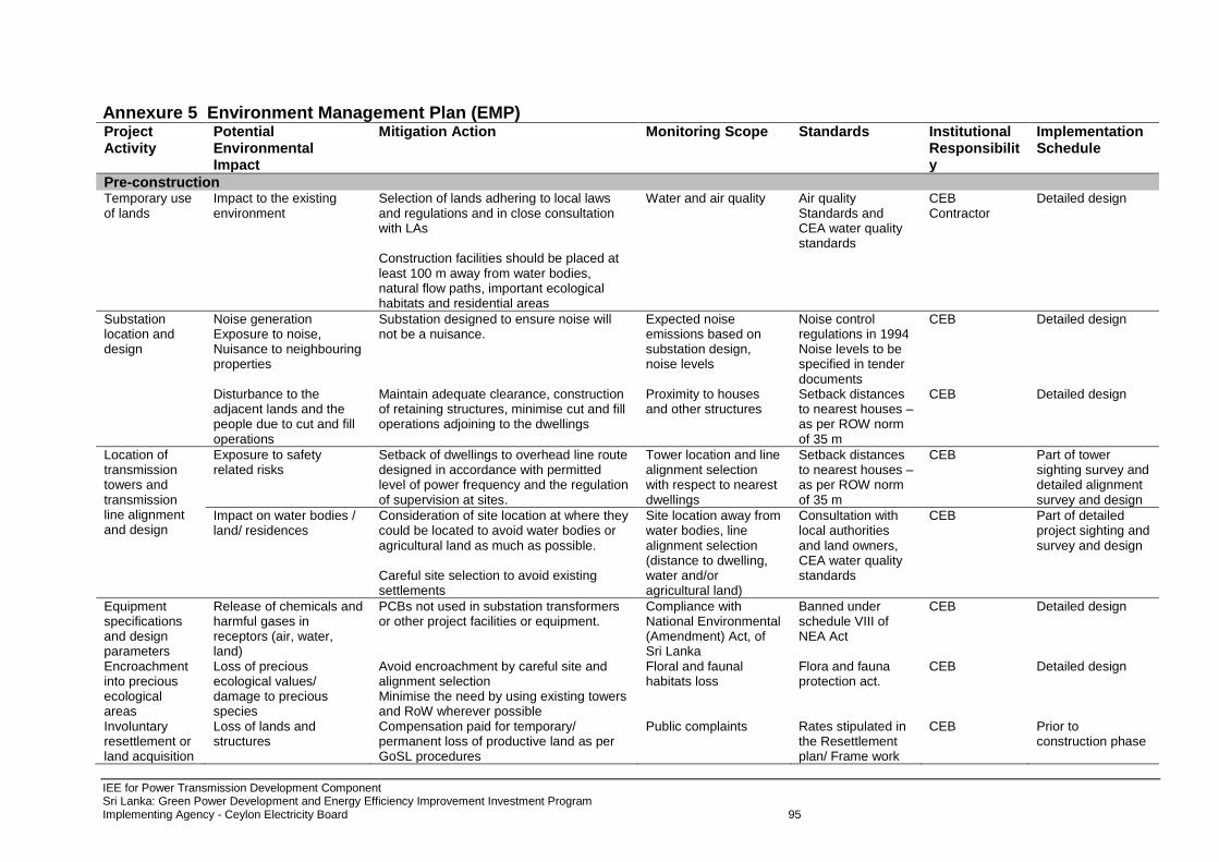
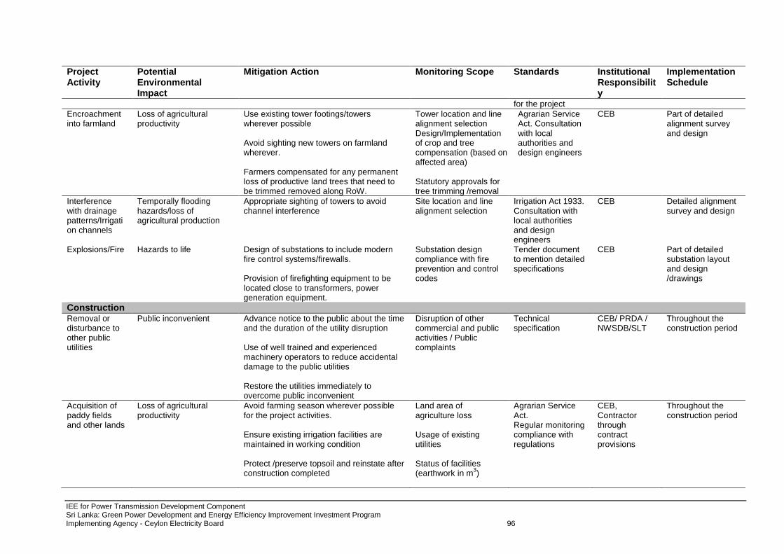
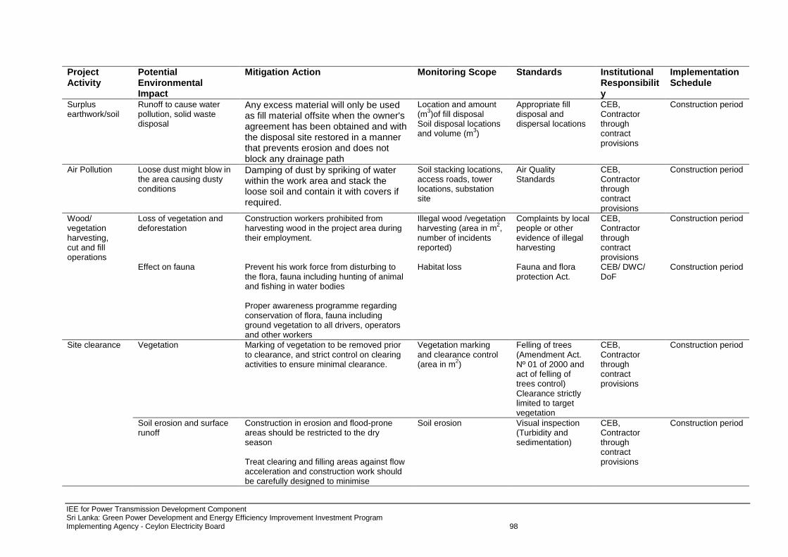
4.0 SCREENING OF POTENTIAL ENVIRONMENTAL IMPACT AND MITIGATION MEASURES 44 4.1 CEB’S Approach for Route Selection 44 4.2 Alternatives for Subproject Components 44 4.3 Environment Impacts and Mitigation Measures 47 4.4 Environmental Management Plan 56
5.0 INSTITUTIONAL REQUIREMENT AND ENVIRONMENTAL MONITORING PROGRAMME 61 5.1 Institutional arrangements 61 5.2 Monitoring of Environmental Management Plan (EMP) 62 5.3 Environmental Management Plan Budget Costs 63 5.4 Critical Environmental Review Criteria 64 5.5 Associated Facilities 65
6.0 GRIEVANCE REDRESS MECHANISM 66 6.1 Awareness of Stakeholders 66 6.2 The Grievance Redress Mechanism and PUCSL 66
7.0 PUBLIC CONSULTATION AND INFORMATION DISCLOSURE 69 7.1 Consultation Findings 69
8.0 FINDINGS AND RECOMMENDATIONS 72 9.0 CONCLUSIONS 73 Annexure 1 Applicable Environmental Policy and Procedures 74 Annexure 2 Alternative Site Analysis for Grid Substations 87 Annexure 3 Alternative Route Analysis for Transmission Lines 91 Annexure 4 Inventorisation along the Transmission Lines 93 Annexure 5 Environment Management Plan (EMP) 95 Annexure 6 Environmental Parameters and Periodicity for Environmental Monitoring Plan 102 Annexure 7 Granting of Necessary Wayleaves for Electricity Networks in Sri Lanka - Guidelines for
ADB – Asian Development Bank CCD – Coast Conservation Department CEA – Central Environment Authority, Government of Sri Lanka CEB – Ceylon Electricity Board DC or D/C – double circuit DPR – detailed project report DSD – Divisional Secretariat Divisions EA – executing agency EARF – Environmental Assessment and Review Framework EIA – Environmental Impact Assessment EMoP – Environmental Monitoring Plan EMP – Environmental Management Plan EHV – extra high voltage GHG – greenhouse gas GND – Gram Niladhari Divisions GoSL – Government of Sri Lanka GRC – Grievance Redress Committee GRM – Grievance Redress Mechanism IA – implementing agency IEE – Initial Environmental Examination LILO – line–in-line-out MFF – multitranche financing facility MOPE – Ministry of Power and Energy PAA – Project Approving Authority PCB – polychlorinated biphenyl PMU – project management unit REA – Rapid Environment Assessment ROW – right of way RP – Resettlement Plan SC or S/C – single circuit SF6 – sulphur hexafluoride SPS – Safeguard Policy Statement
WEIGHTS AND MEASURES ha (hectare) – unit of area km (kilometer) – 1,000 meters kV – kilovolt (1,000 volts) kW – kilowatt (1,000 watts) MW – megawatt
NOTE{S}
In this report, "$" refers to US dollars. “SLRs” refers to Sri Lankan rupees
IEE for Power Transmission Development Component Sri Lanka: Green Power Development and Energy Efficiency Improvement Investment Program Implementing Agency - Ceylon Electricity Board 1
EXECUTIVE SUMMARY 1. ADB is proposing to extend USD 440 million loan (including $60 million in co-financing) to
Sri Lanka’s power sector for Green Power Development and Energy Efficiency Improvement Investment Program with a focus to develop hydropower and identify the transmission and distribution projects for evacuation of renewable energy (wind) parks/ projects and overall improvement of energy efficiency and capacity development.
2. The Grid Sub Station Development (transmission) subprojects of Component B of the
Green Power Development and Energy Efficiency Improvement Investment Program include: - Construction of 220/33 kV Kerewalapitiya GSS; - Construction of 220 (132)/33 kV Kappalturai GSS and rehabilitation at Trincomalee
GSS; - Augmentation of 132/33 kV Old Anuradhapura GSS; - Augmentation of 132/33 kV Katunayake GSS; - Construction of Kesbewa GSS and other associated lines upgradation; - Construction of 132/33 kV Kalutara GSS; and - Augmentation of 132/33 kV Madampe GSS.
3. The selected lands for Kappalturai and Kesbewa GSS’s are located in government lands.
Augmentation GSS sub-projects utilise current CEB/Government land. CEB has identified a land belonging to a private individual for Kalutara GSS. The extent of the land is not sufficient for the construction of the GSS, therefore, CEB expects the balance land to be acquired from the National Aquatic Resources Agency (NARA). Kesbewa GSS land is a degraded open land with grasses and few shrubs. Some trees have to be removed from the lands identified for Kappalturai and Kalutara GSS.
4. Impacts are manageable and can be managed cost effectively - environmental impacts are likely to result from the proposed project development. Careful mitigation and monitoring, specific selection criteria and review/assessment procedures for candidate subprojects have been specified to ensure that minimal impacts take place. The detailed design would ensure inclusion of any such environmental impacts, that could not be specified or identified at this stage, are taken into account and mitigated where necessary. Those impacts can be reduced through the use of mitigation measures such as correction in work practices at the construction sites, or through the careful selection of sites and access routes.
5. The proposed project will have number of positive impacts and negative impacts to the
existing environment as follows:
Significant improvement of the quality and reliability of the electricity supply to the project affected area according to current demand is the main positive impact.
Removal of trees for the transmission line is the main negative impact to the proposed project area.
Environment pollution due to cut and fill operations, transportation of construction materials, disposal of debris, disturbance to the farming activities, nuisance from dust, noise, vehicle fumes, black smoke, vibration etc. due to construction activities are the short term negative impacts due to proposed project.
There will be loss of agricultural productivity due to obstruction and reduce the land of paddy fields as well as cutting of home gardens of coconut and timber trees which will be compensated based on established rates by CEB.
6. Benefits far outweigh negative impacts - The proposed project will improve operational
efficiency and quality of power, reliability of the system and at the same time will reduce losses. Supply of power to both the local areas and regions will boost economic development of the area by strengthening the power transmission infrastructure. Overall,
IEE for Power Transmission Development Component Sri Lanka: Green Power Development and Energy Efficiency Improvement Investment Program Implementing Agency - Ceylon Electricity Board 2
the major social and environmental impacts associated with transmission projects are limited to the construction period and can be mitigated to an acceptable level by implementation of recommended measures and by best engineering and environmental practices.
7. Various mitigation measures to be taken prior to the project activities are listed in the
project's IEE. Potential adverse environment impacts associated with transmission lines has been avoided or minimised through careful route selection. The alignment is sited away from major settlements, whenever possible, to account for future urban expansion. Forests areas and thick vegetation areas are avoided wherever possible; however, route alignment passes through scrublands, cultivated paddy fields, rubber cultivations, rubber plantations, tea cultivations etc. No land acquisition is required for placing transmission towers on private land. However, physical damage to the crops during the construction phase of the project will be compensated at the time of damage as per GoSL norms. Associated impacts on agricultural land will be restricted to the construction phase and will be temporary in nature. Agricultural land will not be lost permanently at the base of the transmission tower. After construction, agricultural land within the transmission corridors can be used again for farming purpose.
8. Since the project does not involve activities that have significant adverse impact, an initial
assessment has been done to determine the extent of impact as per the ADB’s Safeguard Policy Statement 2009 guidelines. Although the overall Tranche 1 environment category is “A” due to other projects, the environmental classification for this sub-project Component “B” is “Category B”. The IEE report conforms to the Ministry of Environment and Natural Resources guidelines and regulations and are consistent with ADB Operations Manual F1/BP and F1/OP (2003), ADB’s Draft Good Practice Sourcebook, December 2012 and the ADB’s Safeguard Policy Statement 2009.
IEE for Power Transmission Development Component Sri Lanka: Green Power Development and Energy Efficiency Improvement Investment Program Implementing Agency - Ceylon Electricity Board 3
1.0 INTRODUCTION
1.1 Background 1. Sri Lanka has experienced high economic growth in the recent past. With the end of civil conflict in 2009, the country requires sustained focus on post-conflict infrastructure development to remove disparities in economic and social status of the poorer Eastern and Northern provinces. Asian Development Bank’s (ADB) focus on development of power sector infrastructure in partnership with other development partners, contributes to the provision of reliable, adequate, and affordable power supply for sustainable economic growth and poverty reduction in Sri Lanka. 2. The power sector has undergone significant policy level and structural changes in the recent past:
Sri Lanka Electricity Act passed in parliament in 2009;
Assumption of the role of electricity regulator in April, 2009 by the Public Utilities Commission of Sri Lanka (PUCSL);
Creation of Functional Business Units (FBU’s) within the CEB with one unit each for generation and transmission and 4 geographical units for distribution function; and
All FBU’s have been issued licenses by the Public Utilities Commission of Sri Lanka (PUCSL) and they have been filing the tariff petitions since 2010.
3. Sri Lanka’s electricity industry is managed by the Ministry of Power & Energy (MoPE). All electricity utilities remain under direct or indirect state ownership, whereas, there is significant private sector participation in power generation. The institutions listed in Table 1 are active in the electricity industry whereas Table 2 lists the regulatory and facilitation agencies in Sri Lanka. Table 1: Institutions in the energy supply industry Institution Functions and other information
Government
Ministry of Power and Energy (MOPE) Energy policy, project implementation and monitoring, supervision of state-owned electricity utilities.
Ministry of Petroleum and Petroleum Resource Development (MOPPRD)
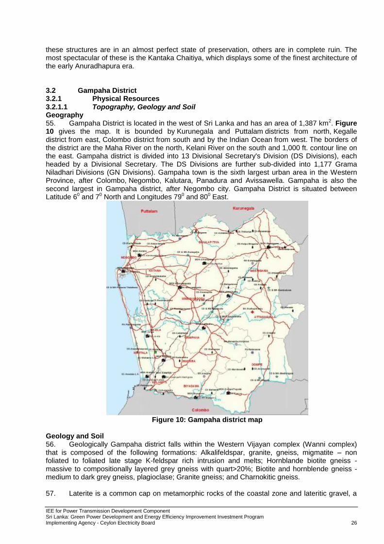
Petroleum industry project implementation and monitoring, supervision of state-owned petroleum corporation, petroleum resource development and exploration.
Electricity utilities Ceylon Electricity Board (CEB) State-owned corporation, engaged in power generation (one license, 23 power plants),
transmission (one license), and distribution (four licenses, about 4.5 million customers).
Lanka Electricity Company (Pvt) Ltd (LECO)
State-owned company, engaged in power distribution (one license, 450,000 customers) along western and southern coastal regions.
Independent Power Producers (IPPs) Ten thermal IPPs to grid, two thermal IPPs in Jaffna mini-grid
Each IPP an individual company, eight diesel power plants and two combined cycles on the main grid, two diesel power plants on the Jaffna mini-grid.
About 100 small renewable energy IPPs (also known as Small Power Producers, SPPs)
Each SPP an individual company, small hydro (about 95), rice-husk (2), and waste-heat (1).
About 300 community small hydro-based distribution cooperatives
About 5000 households are served, in total.
About 120,000 solar home systems Serving an equal number of households.
Table 2- Regulatory and Facilitation Agencies Institution Functions and other information Sri Lanka Sustainable Energy Authority (SEA)
Policy, promotion and regulatory functions of (i) renewable energy (ii) energy efficiency, and (iii) energy planning, (iv) energy fund management.
Public Utilities Commission of Sri Lanka (PUCSL)
Infrastructure regulatory commission presently empowered to regulate (i) electricity industry (ii) bunker and lubricating oil industries. In future, Petroleum Industry regulation is likely to be assigned to PUCSL.
4. Ceylon Electricity Board (CEB) is a corporate body established for development and coordination of the generation, transmission, and distribution of electrical energy in Sri Lanka. It holds six separate licenses for these activities. The license for generation division caters for 66% of the power to the grid. The transmission network consists of 55 GSS (132/33 kV, 220/132/33 kV, 220/132 kV and 132 /11 kV) and 2,236 km of HV Lines (both 220 kV and 132 kV) approximately.
IEE for Power Transmission Development Component Sri Lanka: Green Power Development and Energy Efficiency Improvement Investment Program Implementing Agency - Ceylon Electricity Board 4
5. The island is divided into four regions for power distribution, supply and sales, where each distribution division holds a license. These distribution licenses cover more than 97% of the geography of Sri Lanka. Lanka Electricity Company Ltd. (LECO), which is a subsidiary of CEB, covers the remaining areas catering to 478,500 customers. Electricity Distribution Network of CEB consists of MV lines (33 kV and 11 kV), primary substations (33 kV/11 kV), distribution substations (33 kV/400 V and 11kV/400 V), and LV lines (400 V). 6. ADB is proposing to extend USD 440 million loan (including USD 60 million in co-finance) to Sri Lanka’s power sector for green power development and energy efficiency improvement. The specific focus of this assistance is to identify the transmission and distribution projects which could be funded through the proposed loan. The projects identified for the ADB financing are focused on evacuation projects for renewable energy (wind) parks/ projects and overall improvement of energy efficiency. 7. The proposed project will assist GoSL to develop a least-cost project implementation of the following project components: (i) Hydropower generation developed and connected to the grid in the Central Province -
this includes a 30 MW, run-of-river hydropower station at Moragolla in the Central Province1 including a 132 kV associated transmission infrastructure to connect the station to the grid that will increase clean and low cost base load power generation.
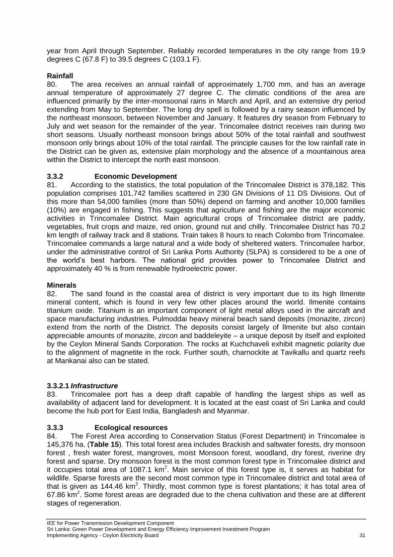
(ii) Transmission infrastructure capacity for absorbing increase in power demand and future renewable generation capacity enhanced - this comprises the construction and augmentation of a 220/132 kV and 132/33 kV grid substations and 220 kV and 132 kV transmission lines in Eastern, Northern, North Central, North Western, Southern, Western and Uva provinces that will absorb increase in power demand and ensure system’s stable operation with addition of intermittent wind and solar generation.
(iii) Efficiency of medium voltage network improved - this involves the construction of 33 kV lines and reactive power management through installation of switched capacitor banks in the MV network to address overloading of conductors, voltage drop in MV lines and poor power factor.
(iv) Demand-side management for energy efficiency improved - demand-side management (DSM) interventions will be introduced, resulting in energy savings (e.g. efficient lighting, improved domestic metering, and use of smart grid technologies).
(v) Capacity development support provided to CEB - the investments will be reinforced by financing for non-physical capacity development components including: (a) energy efficiency related institutional capacity of CEB, (b) preparation of new sub-projects (for the second tranche), and (c) implementation supervision.
1.2 Scope of Work and Methodology Adopted 8. The broad scope of the Environmental Assessment study is: i. To conduct field visits to collect data relevant to the study area and also collect secondary data
so as to establish the baseline environmental status of the study area; ii. To assess the impacts on environmental attributes due to the location, design, construction and
operation of the proposed project; iii. To prepare a mitigation plan outlining the measures for protecting the environment including
institutional arrangement and environmental monitoring; iv. To identify critical environmental attributes required to be monitored subsequent to the
implementation of the proposed project; v. To carry out consultation with local people so as to identify the public perception of the project;
and vi. To establish the Environment Monitoring Plan (EMoP) for the CEB to submit environmental
monitoring reports to ADB at regular intervals.
1 The detailed engineering design of this hydropower station, including safeguard assessments and preparation of relevant bidding
documents, is included in the scope of Loans 2733/2734(SF)-SRI: Sustainable Power Sector Support Project.
IEE for Power Transmission Development Component Sri Lanka: Green Power Development and Energy Efficiency Improvement Investment Program Implementing Agency - Ceylon Electricity Board 5
9. This report is prepared on the basis of survey, field study and with the help of available secondary data. The alignment of line may slightly vary after the exact demarcation of tower location. Accordingly, the field surveys were undertaken to assess physical and biological environment. Detailed assessment of the baseline environment has been conducted for the distance up to 500 m on the either side of proposed alignment and data collection from secondary source has been done to support the findings of the field survey. The field studies were supported by data collected from secondary sources such as internet, forest atlas. 10. The IEE report comprises baseline data on existing physical, ecological, economic, and social condition, together with the anticipated environmental impacts and proposed mitigation measures. Observations were made through transect walk along the transmission line tower locations, as well as in and around the proposed premises for new GSSs from 01 November 2013 to 30 January 2014. Public consultations were held with the project affected communities, stakeholders, and government officers that relate to existing environmental conditions around the transmission lines and substations and the potential impacts that could happen due to project implementation. In addition, secondary data was collected from published data from GoSL documents, 2001 population census statistics data, as well as from authorities such as CEB, MoPE and other departments. 11. Based on the CEA (Central Environmental Authority) Guidelines of GoSL, the proposed transmission projects are categorised as “prescribed”. CEB will seek ToR for preparing the Environment Impact Assessment (EIA) in prescribed format from CEA for seeking approval and the environmental clearances for the transmission projects from relevant PAA. An initial assessment has been done in this report to determine the extent of impacts as per the ADB’s Safeguard Policy Statement 2009. This IEE report conforms to the Ministry of Environment and Natural Resources guidelines and regulations and is consistent with ADB Operations Manual F1/BP and F1/OP (2003), draft Good Practise Sourcebook (2012)2 and the ADB’s Safeguard Policy Statement (SPS) 2009.
12. Although the overall environment category for Tranche 1 projects is Category ‘A”, the environmental classification for the sub-project Component B is “Category B” and does not require an EIA. 1.3 Applicable Environmental and other Legislations 13. A large number of recurrent and non-recurrent activities under establishment of transmission lines and substations are presently not covered by the National Environmental Act (NEA). Annexure 1 indicates the applicable laws and regulations, which are necessary for the proposed project activities.
2 A Good Practice Sourcebook (Draft Working Document), December 2012
IEE for Power Transmission Development Component Sri Lanka: Green Power Development and Energy Efficiency Improvement Investment Program Implementing Agency - Ceylon Electricity Board 6
2.0 DESCRIPTION OF THE PROJECT
2.1 The Project 14. The Grid Sub Station Development (transmission) subprojects of Component B of the Green Power Development and Energy Efficiency Improvement Investment Program include:
Construction of 220/33 kV Kerewalapitiya GSS; Construction of 220 (132)/33 kV Kappalturai GSS and rehabilitation at Trincomalee GSS; Augmentation of 132/33 kV Old Anuradhapura GSS; Augmentation of 132/33 kV Katunayake GSS; Construction of 132/33 kV Kesebewa GSS and other associated lines upgradation; Construction of 132/33 kV Kalutara GSS; and Augmentation of 132/33 kV Madampe GSS.
2.1.1 Component B.I. Construction of 220/33 kV Kerewalapitiya GSS 15. Kerawalapitiya power plant (capacity 300 MW) which is about 10 km North of Colombo city, presently serves the Kotugoda GS through a 220 kV line. Kerawalapitiya does not have a grid substation. The entire output of the power plant is fed to the Kotugoda GSThis new grid substation is proposed to connect to the existing 220 kV bus bar of the Kerawalapitiya Combined Cycle Power Plant. 2.1.2 B.II. 220 (132)/33 kV Kappalturai GSS and rehabilitation at Trincomalee GSS. 16. Construction of a new Kappalturai Grid Substation (GSS) includes (a) Installation of 2x60 MVA, 132/33 kV transformers (b) Construction of 4x132 kV single bus bar transmission line bays, 2x132 kV single bus bar transformer bays, 1x132 kV single bus bar arrangement with bus section, 2x33 kV transformer bays (GIS), 16x33 kV feeder bays (GIS), 1x33 kV single bus bar including bus section (GIS). Construction of double in and out connection to Kappalturai GS from New Anuradhapura-Trincomalee 132 kV transmission line. (Zebra, double circuit line of 1 km). Transformers are initially operated at 132/33 kV and later upgrade to 220/33 kV operation. 2.1.3 B.III. Augmentation of 132/33 kV Old Anuradhapura GSS. 17. Augmentation of old Anuradhapura 132/33 kV grid substation includes 3x31.5 MVA 132/33 kV Transformers, 3x132 kV single bus transformer bays, 2x132 kV single bus transmission line bays, 132 kV single bus arrangement including bus section, 3x33 kV transformer bays, 12x33 kV feeder bays, 33 kV single bus arrangement including 2x33 kV bus sections. 18. It also includes Augmentation of New Anuradhapura 220/132/33 kV Grid Substation - New Anuradhapura grid substation (two 132 kV double bus transmission line bays) and construction of 132 kV Zebra 1 km double circuit transmission line to connect Puttalam-New Anuradhapura transmission line 2.1.4 B.IV. Augmentation of 132/33 kV Katunayake GSS. 19. Augmentation of Katunayake Grid Substation includes (a) Installation of 31.5 MVA transformer (b) Construction of 1x132 kV Single Bus bar Transformer bay, 1x 33 kV Transformer bay, 4x33 kV feeder bays and 1x33 kV bus section bay. 2.1.5 B.V. Construction of 132/33 kV Kesebewa GSS and associated transmission lines. 20. Kesbewa 132/33 kV grid substation (2x31.5 MVA 132/33 kV transformer, 2x132 kV single bus transformer bays, 2x132 kV single bus transmission line bays, 132 kV single bus arrangement including bus section, 2x33 kV transformer bays, 8x33 kV feeder bays and 1x33 kV single bus arrangement including bus section)). 21. Single in-and-out connection from Pannipitiya - Matugama 132 kV transmission line and reconstruction of Pannipitiya - Panadura Transmission line, 12.3 km 132 kV Zebra transmission line
IEE for Power Transmission Development Component Sri Lanka: Green Power Development and Energy Efficiency Improvement Investment Program Implementing Agency - Ceylon Electricity Board 7
2.1.6 B.VI. Construction of 132/33 kV Kalutara GSS (2x31.5 MVA TF. 22. Kalutara Grid Substation (2x31.5MVA 132/33 kV transformer, 2x132 kV Single Busbar transformer bay, 2x132 kV Single Busbar Transmission Line bays, 1x132 kV Single Busbar including bus section, 2x33 kV transformer bay, 8x33 kV feeder bays, 1x33 kV Single Bus bar including bus section). Construction of 132 kV single in and out connection from Pannipitiya-Matugama 132 kV Transmission line to connect Kalutara Grid Substation (Double circuit, 6 km, Zebra). 2.1.7 B.VII. Augmentation of 132/33 kV Madampe GSS (add 31.5 MVA TF) 23. Augmentation of Madampe Grid Substation: 2x31.5 MVA to 3x31.5 MVA 132/33 kV transformers, one 132 kV S/B transformer bay, one 33 kV transformer bay, one 33 kV bus section bay including bus bar, 4x33 kV feeder bays. 2.2 Type of Project 24. The project implementation will lead to development of transmission projects, which involve evacuation of power from clean energy sources (wind, solar, small hydro) and overall network efficiency improvement. CEB’s transmission planning wing has identified a list of projects, based on the Long term Transmission Development Plan 2011-2020 and Long Term Generation Development Plan 2013-2032, which are critical for the overall development of the power system. Considering the requirements of Sri Lanka’s power system with medium to long term, the prioritization of projects for the proposed loan has been undertaken based on following principles for sequence of preference criteria for transmission projects:
Transmission projects associated with evacuation of clean energy, specifically from the wind and solar projects/ proposed parks have been given the highest preference
Augmentation of transmission capacities associated with renewable park evacuation projects
Transmission projects required for network efficiency improvement – loss reduction, etc. 2.3 Justification of the Project 25. Due to the fast emerging energy demand from the area, there is a distinct necessity for strengthening and expanding the transmission network in the northern and eastern region. Under the adopted standards, the forecast loading of each GSS is compared with the firm capacity and the necessary transformer augmentations as well as construction of new substations. It is a standard adopted by CEB that, loading of each transformer should not exceed 120% of its capacity under single transformer outage conditions. 26. The key objective of the project is to improve the reliability of the transmission system and cater to the growing demand in the region. The justification for the all subprojects is given as follows: B.I Kerawalapitiya 220 kV Grid Substation- As per the current load forecast, Kotugoda grid
substation will be 105.4% loaded under outage of 60 MVA transformer by year 2018. Since Kotugoda grid substation is located at a highly industrialized area in the country it should be able to cater the demand under outage of one unit. The energy demand at present in Wattala, Handala and Kerawalapitiya areas is 81 GWh and the estimated load growth is 7%. These areas are mainly fed by Kotugoda Grid Substation. Proposed grid substation will also improve the voltage profile of 33 kV distribution systems and therefore improve the quality of supply in and around Wattala, Handala and Kerawalapitiya areas.
B-II. 220(132)/33 Kappalturai and Trincomalee Grid Substation: In order to meet the growing electricity demand in Nilaweli, Kappalturai areas and the proposed Kappalturai special economic zone, it is proposed to construct a new grid substation at Kappalturai with 2x60 MVA transformers and sixteen 33 kV feeders in the year 2017. Proposed grid substation will also improve the voltage profile of the 33 kV distribution systems and therefore improve the quality of supply in and around the Nilaweli and Kappalturai areas. This new grid substation is proposed to connect initially to the existing New Anuradhapura-Trincomalee 132 kV
IEE for Power Transmission Development Component Sri Lanka: Green Power Development and Energy Efficiency Improvement Investment Program Implementing Agency - Ceylon Electricity Board 8
transmission lines using double in and out connection. The energy demand at present in Trincomalee area is about 190 GWh. Trincomalee town, Nilaweli, Tokyo Cement Company and Prima Company are the places mainly fed by Trincomalee Grid Substation. At present the capacity of the Trincomalee grid substation is 59 MVA. According to the above forecast Trincomalee grid substation should be augmented to 94.5 MVA by 2015 and to 126 MVA by 2022. However, it is difficult to augment the existing grid substation due the limitation of space and several other practical difficulties.
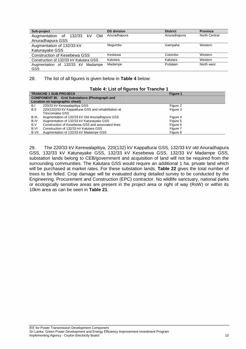
B-III. Augmentation of old Anuradhapura 132/33 kV Grid Substation. Augmentation of the Anuradhapura Grid Substation with 3x31.5 MVA transformers is being done to ensure the quality and reliability of the electricity supply and cater to the growing demand Anuradhapura grid substation is situated in the North Central Province of the country. The annual energy demand of the grid substation is 138 GWh and estimated load growth at present is about 5%. Anuradhapura Grid Substation consists of 2x10 MVA transformers commissioned in 1969 & 1975 and a 31.5 MVA transformer commissioned in 1996. Further, the Anuradhapura Grid Substation is fed from New Anuradhapura-Puttalam 132 kV double circuit transmission lines. The existing Anuradhapura Grid Substation feeds Nochchiyagama, Periyankulama, Horowpathana, Medawachchiya and Mihintale areas and some parts of Vavuniya area. No rehabilitation or any augmentation work has been carried out at this grid substation since 1996. It is reported that this 132/33 kV grid substation has many operational problems. Almost all the equipment in the grid is now 40 years old and spares are not available for most of the equipment. Old Anuradhapaura Grid Substation will be fed from New Anuradhapura Switching Station from a 132 kV double circuit transmission line. Therefore to transfer the Puttalam 132 kV transmission line it is required to construct two 132 kV transmission line bays at New Anuradhapura switching station and construct 1 km double circuit 132 kV transmission line from Anuradhapura to New Anuradhapura. It will improve the quality and reliability of the electricity supply in Nochchiyagama, Periyankulama, Horowpathana, Medawachchiya and Mihintale areas.
B-IV. Augmentation of 132/33 kV Katunayake GSS. The energy demand at present in Negombo, Katunayake Industrial Zone, airport areas fed by Katunayake Grid Substation.is about 20 GWh with 61% Load factor. The estimated load growth is 7%. With the future Air Port and Aviation Expansion Project (15 MVA) and Hotel Complex at Katunayake Zone (5 MVA), the load will increase in future. Currently, loading of each transformer unit at Katunayake Grid Substation is around 22.6 MVA. This is about 72% loading of the total transformer capacity. In the absence of single unit out of two transformers, the other transformer will be loaded up to 144% which will gives rise to technical failures and hence economic losses. Therefore, the addition of third transformer with 31.5 MVA capacity is indispensable under these circumstances.
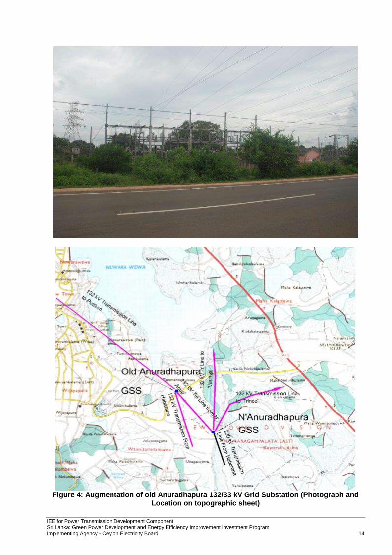
B-V. Construction of 132/33 kV Kesebewa GSS and associated transmission lines. To cater to the growing demand for electricity in Kesbewa, Piliyandala, Kahathuduwa and Dampe areas by providing quality and reliable power supply. The annual energy demand, at present in, Kesbewa, Piliyandala, Kahathuduwa and Dampe areas is 106 GWh and the estimated load growth is 5%. These areas are mainly fed by Panadura and Ratmalana Grid Substations. According to the present distribution feeding arrangement around 59% of Kesbewa, Piliyandala, Kahathuduwa and Dampe area loads are fed from Panadura grid substation and the remaining loads are fed from Ratmalana grid substation. The loading of Ratmalana grid substation presently exceeds 115% under outage of one transformer. Also the loading of Panadura grid substation will exceed 89% under outage of one transformer in 2014, even after the commissioning of its 3rd transformer. In order to meet the growing electricity demand Kesbewa, Piliyandala, Kahathuduwa and Dampe areas and thereby to relieve loading of Ratmalana and Panadura Grid Substations, it is proposed to construct a new grid substation at Kesbewa with two 31.5 MVA transformers and eight 33 kV feeders in the year 2018. Proposed grid substation will also improve the voltage profile of 33 kV distribution systems and reduce distribution losses and therefore improves the quality of supply in and around Kesbewa, Piliyandala, Kahathuduwa and Dampe areas. To support this, there are two interconnections proposed:
IEE for Power Transmission Development Component Sri Lanka: Green Power Development and Energy Efficiency Improvement Investment Program Implementing Agency - Ceylon Electricity Board 9
o This new grid substation is proposed to connect to the national power system by constructing a 1 km double circuit, Zebra, 132 kV transmission line as a single in-and-out connection to Pannipitiya - Matugama 132 kV transmission line.
o The existing two circuits of 132 kV transmission lines from Pannipitiya grid substation to Matugama grid substation are Goat conductors with the rating of 115 MVA. As per the present transmission network configuration, these transmission lines transmit power to the load centers in Western Province, South and Southern Province through Panadura, Horana and Mathugama grid substations. Further, a new grid substation at Kalutara will be connected to the same transmission line by 2017. Since this transmission line is passing through Kesbewa area and there is no path to construct new transmission lines from existing Pannipitiya switching station, the only option to connect Kesbewa grid substation to the national grid is connecting as a single in-and-out connection to the existing line. According to the system studies, under outage of one circuit of this transmission line the other circuit will be overloaded in 2017 when Kesbewa grid substation connected. Therefore this line should be reconstructed with a high capacity conductor. Hence it is proposed to reconstruct Pannipitiya - Matugama (up to Panadura T point) 12.3 km, 132 kV transmission line with Zebra conductor.
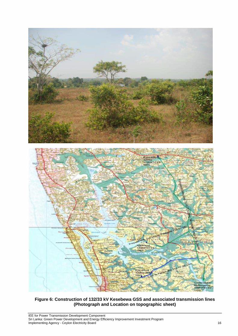
COMPONENT B.VI. Construction of 132/33 kV Kalutara GSS (2x31.5 MVA TF) In order to meet the growing electricity demand while minimizing distribution losses and relieve loading of Panadura Grid Substations, it is proposed to construct a new grid substation at Kalutara with two 31.5 MVA transformers and eight 33 kV feeders in the year 2013. This new grid substation is proposed to connect to the existing Pannipitiya- Matugama 132 kV Transmission line using single in and out connection. By considering the present 33 kV distribution systems, Kalutara Area is mainly fed by Panadura & Matugama Grid Substations. Long 33 kV lines cause higher distribution losses.
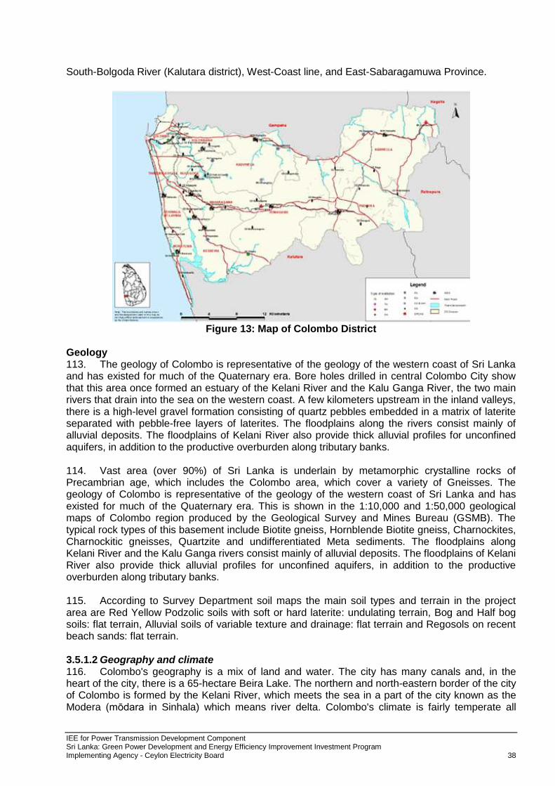
COMPONENT B.VII. Augmentation of 132/33 kV Madampe GSS (add 31.5 MVA TF) - Madampe grid substation mainly feeds Madampe, Bingiriya, Chilaw, Kuliyapitiya and Naththandiya areas. As per the current estimates, the energy demand in Wennappuwa, Chilaw and Kuliyapitiya areas are 142 GWh, 345 GWh and 233 GWh respectively. According to CEB’s load forecast, the loading of Madampe substation will be 81% loaded in 2017 and 162% under outage of one transformer. It is proposed to install an additional 31.5 MVA transformer to the Madampe GS and four 33 kV feeders in order to meet the growing electricity demand while minimizing distribution losses and relieve overloading of Madampe Grid Substations under outage of one transformer.
COMPONENT B.VII. Augmentation of 132/33 kV Madampe GSS (add 31.5 MVA TF) - Madampe grid substation mainly feed to Madampe, Bingiriya, Chilaw, Kuliyapitiya and Naththandiya areas. As per the current estimates, the energy demand in Wennappuwa, Chilaw and Kuliyapitiya areas are 142 GWh, 345 GWh and 233 GWh respectively. According to CEB’s load forecast, the loading of Madampe substation will be 81% in 2017 and 162% under outage of one transformer. It is proposed to install an additional 31.5MVA transformer to the Madampe GS and four 33 kV feeders in order to meet the growing electricity demand while minimizing distribution losses and relieve overloading of Madampe Grid Substations under outage of one transformer.
2.4 Location 27. The proposed sub-projects are located in different area of the country including Western, North Central, and Central provinces. Table 3 indicates details of the proposed sub-project locations:
Table 3: Different locations of proposed subprojects. Sub-project DS division District Province
220/33 kV Kerewalapitiya GSS Wattala Gampaha Western
Construction of 220 (132)/33 kV Kappalturai GSS & Rehabilitation at Trincomalee GSS
Tricomalee Trincomalee Eastern
IEE for Power Transmission Development Component Sri Lanka: Green Power Development and Energy Efficiency Improvement Investment Program Implementing Agency - Ceylon Electricity Board 10
Sub-project DS division District Province
Augmentation of 132/33 kV Old Anuradhapura GSS
Anuradhapura Anuradhapura North Central
Augmentation of 132/33 kV Katunayake GSS
Negumbo Gampaha Western
Construction of Kesebewa GSS Kesbewa Colombo Western
Construction of 132/33 kV Kalutara GSS Kalutara Kalutara Western
Augmentation of 132/33 kV Madampe GSS
Madampe Puttalam North west
28. The list of all figures is given below in Table 4 below:
Table 4: List of figures for Tranche 1 TRANCHE 1 SUB-PROJECS Figure 1
COMPONENT BI. Grid Substations (Photograph and Location on topographic sheet)
B.I 220/33 kV Kerewalapitiya GSS Figure 2 B.II 220(132)/33 kV Kappalturai GSS and rehabilitation at
Trincomalee GSS Figure 3
B.III. Augmentation of 132/33 kV Old Anuradhapura GSS Figure 4 B.IV Augmentation of 132/33 kV Katunayake GSS Figure 5 B.V Construction of Kesebewa GSS and associated lines Figure 6 B.VI Construction of 132/33 kV Kalutara GSS Figure 7 B.VII Augmentation of 132/33 kV Madampe GSS Figure 8
29. The 220/33 kV Kerewalapitiya, 220(132) kV Kappalturai GSS, 132/33 kV old Anuradhapura GSS, 132/33 kV Katunayake GSS, 132/33 kV Kesebewa GSS, 132/33 kV Madampe GSS, substation lands belong to CEB/government and acquisition of land will not be required from the surrounding communities. The Kalutara GSS would require an additional 1 ha. private land which will be purchased at market rates. For these substation lands, Table 22 gives the total number of trees to be felled. Crop damage will be evaluated during detailed survey to be conducted by the Engineering, Procurement and Construction (EPC) contractor. No wildlife sanctuary, national parks or ecologically sensitive areas are present in the project area or right of way (RoW) or within its 10km area as can be seen in Table 21.
IEE for Power Transmission Development Component Sri Lanka: Green Power Development and Energy Efficiency Improvement Investment Program Implementing Agency - Ceylon Electricity Board 11
Figure 1: Transmission Map of Sri Lanka including details of Proposed Transmission
Projects
IEE for Power Transmission Development Component Sri Lanka: Green Power Development and Energy Efficiency Improvement Investment Program Implementing Agency - Ceylon Electricity Board 12
Figure 2: Kerawalapitiya 220 kV Grid Substation (Photograph and Location on topographic sheet)
IEE for Power Transmission Development Component Sri Lanka: Green Power Development and Energy Efficiency Improvement Investment Program Implementing Agency - Ceylon Electricity Board 13
Figure 3: 220(132)/33 Kappalturai and Trincomalee Grid Substation (Photograph and Location on topographic sheet)
IEE for Power Transmission Development Component Sri Lanka: Green Power Development and Energy Efficiency Improvement Investment Program Implementing Agency - Ceylon Electricity Board 14
Figure 4: Augmentation of old Anuradhapura 132/33 kV Grid Substation (Photograph and
Location on topographic sheet)
IEE for Power Transmission Development Component Sri Lanka: Green Power Development and Energy Efficiency Improvement Investment Program Implementing Agency - Ceylon Electricity Board 15
Figure 5: Augmentation of 132/33 kV Katunayake GSS (Photograph and Location on topographic sheet)
IEE for Power Transmission Development Component Sri Lanka: Green Power Development and Energy Efficiency Improvement Investment Program Implementing Agency - Ceylon Electricity Board 16
Figure 6: Construction of 132/33 kV Kesebewa GSS and associated transmission lines (Photograph and Location on topographic sheet)
IEE for Power Transmission Development Component Sri Lanka: Green Power Development and Energy Efficiency Improvement Investment Program Implementing Agency - Ceylon Electricity Board 17
Figure 7: Construction of 132/33 kV Kalutara GSS (Photograph and Location on topographic sheet)
IEE for Power Transmission Development Component Sri Lanka: Green Power Development and Energy Efficiency Improvement Investment Program Implementing Agency - Ceylon Electricity Board 18
Figure 8: Augmentation of 132/33 kV Madampe GSS (Photograph and Location on
topographic sheet)
IEE for Power Transmission Development Component Sri Lanka: Green Power Development and Energy Efficiency Improvement Investment Program Implementing Agency - Ceylon Electricity Board 19
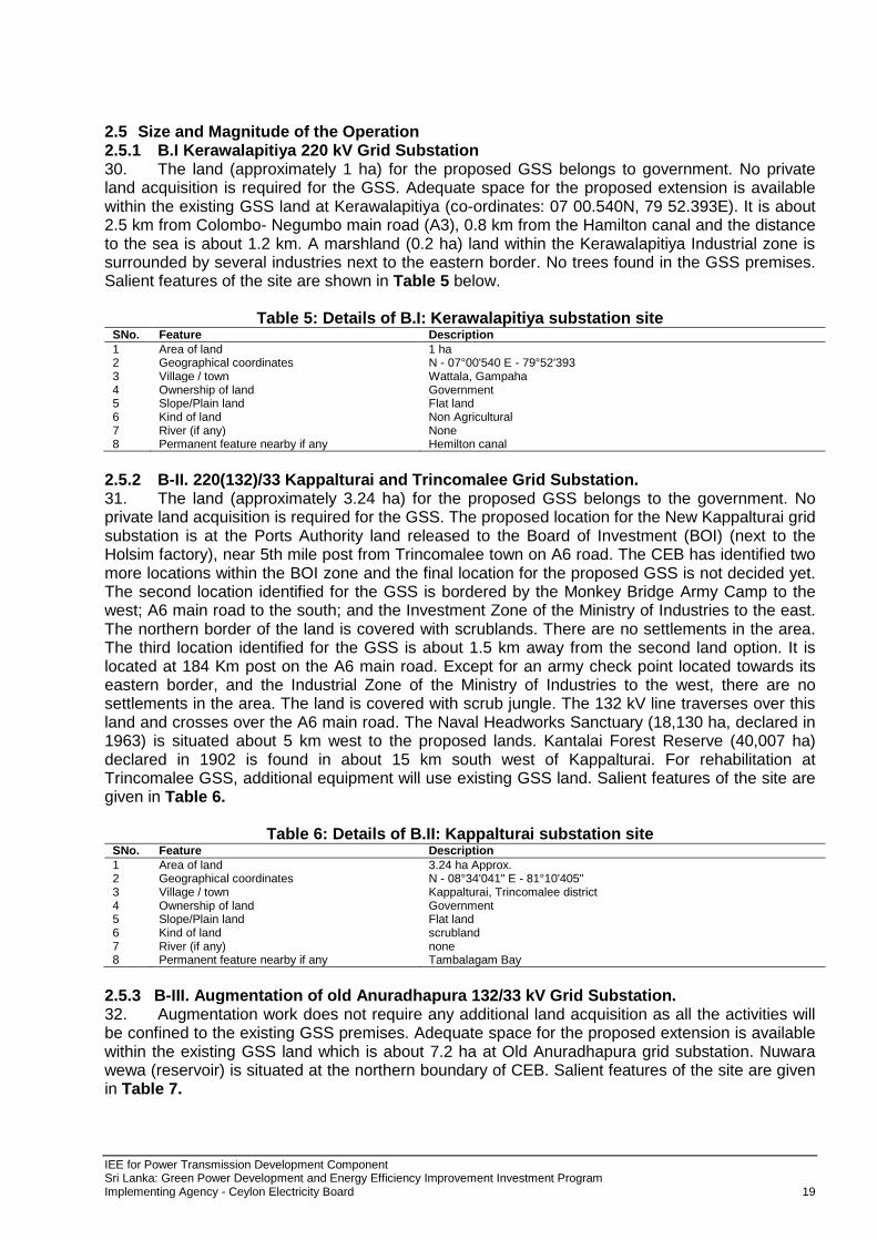
2.5 Size and Magnitude of the Operation 2.5.1 B.I Kerawalapitiya 220 kV Grid Substation 30. The land (approximately 1 ha) for the proposed GSS belongs to government. No private land acquisition is required for the GSS. Adequate space for the proposed extension is available within the existing GSS land at Kerawalapitiya (co-ordinates: 07 00.540N, 79 52.393E). It is about 2.5 km from Colombo- Negumbo main road (A3), 0.8 km from the Hamilton canal and the distance to the sea is about 1.2 km. A marshland (0.2 ha) land within the Kerawalapitiya Industrial zone is surrounded by several industries next to the eastern border. No trees found in the GSS premises. Salient features of the site are shown in Table 5 below.
Table 5: Details of B.I: Kerawalapitiya substation site
SNo. Feature Description
1 Area of land 1 ha 2 Geographical coordinates N - 07°00'540 E - 79°52'393 3 Village / town Wattala, Gampaha 4 Ownership of land Government 5 Slope/Plain land Flat land 6 Kind of land Non Agricultural 7 River (if any) None 8 Permanent feature nearby if any Hemilton canal
2.5.2 B-II. 220(132)/33 Kappalturai and Trincomalee Grid Substation. 31. The land (approximately 3.24 ha) for the proposed GSS belongs to the government. No private land acquisition is required for the GSS. The proposed location for the New Kappalturai grid substation is at the Ports Authority land released to the Board of Investment (BOI) (next to the Holsim factory), near 5th mile post from Trincomalee town on A6 road. The CEB has identified two more locations within the BOI zone and the final location for the proposed GSS is not decided yet. The second location identified for the GSS is bordered by the Monkey Bridge Army Camp to the west; A6 main road to the south; and the Investment Zone of the Ministry of Industries to the east. The northern border of the land is covered with scrublands. There are no settlements in the area. The third location identified for the GSS is about 1.5 km away from the second land option. It is located at 184 Km post on the A6 main road. Except for an army check point located towards its eastern border, and the Industrial Zone of the Ministry of Industries to the west, there are no settlements in the area. The land is covered with scrub jungle. The 132 kV line traverses over this land and crosses over the A6 main road. The Naval Headworks Sanctuary (18,130 ha, declared in 1963) is situated about 5 km west to the proposed lands. Kantalai Forest Reserve (40,007 ha) declared in 1902 is found in about 15 km south west of Kappalturai. For rehabilitation at Trincomalee GSS, additional equipment will use existing GSS land. Salient features of the site are given in Table 6.
Table 6: Details of B.II: Kappalturai substation site SNo. Feature Description
1 Area of land 3.24 ha Approx. 2 Geographical coordinates N - 08°34'041" E - 81°10'405" 3 Village / town Kappalturai, Trincomalee district 4 Ownership of land Government 5 Slope/Plain land Flat land 6 Kind of land scrubland 7 River (if any) none 8 Permanent feature nearby if any Tambalagam Bay
2.5.3 B-III. Augmentation of old Anuradhapura 132/33 kV Grid Substation. 32. Augmentation work does not require any additional land acquisition as all the activities will be confined to the existing GSS premises. Adequate space for the proposed extension is available within the existing GSS land which is about 7.2 ha at Old Anuradhapura grid substation. Nuwara wewa (reservoir) is situated at the northern boundary of CEB. Salient features of the site are given in Table 7.
IEE for Power Transmission Development Component Sri Lanka: Green Power Development and Energy Efficiency Improvement Investment Program Implementing Agency - Ceylon Electricity Board 20
Table 7: Details of B.III.: Old Anuradhapura 132/33 kV GSS
SNo. Feature Description
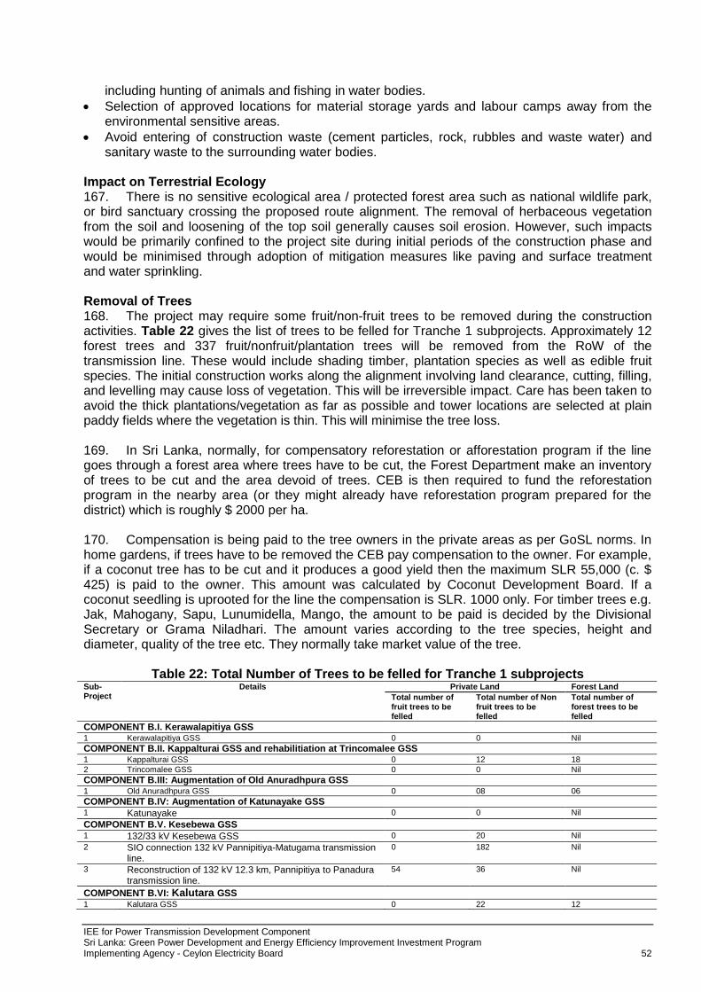
1 Area of land 7.2 ha 2 Geographical coordinates N - 08°18'276" E - 80°26'670" 3 Village / town Ghanikulama, Anuradhapura district 4 Ownership of land Government 5 Slope/Plain land Flat Land 6 Kind of land Non Agricultural 7 River (if any) None 8 Permanent feature nearby if any Nuwara Wewa (Reservoir)
2.5.4 B-IV. Augmentation of 132/33 kV Katunayake GSS. 33. Augmentation work does not require any additional land acquisition as all the activities will be confined to the existing GSS premises within the BOI zone at Katunayake. Adequate space for the proposed extension is available within the existing GSS land which is about 1.2 ha (coordinates: 07 10.511N, 79 53.505E). The eastern boundary of the GSS adjoins a branch of Dandugam oya/ stream. The GSS is located about 1 km east to the Katunayake International Airport and 3.5 km from the Colombo-Negombo main road (A3). No trees are found within the GSS premises. Salient features of the site are given in Table 8.
Table 8: Details of B.IV: 132/33 kV Katunayake GSS
SNo. Feature Description
1 Area of land 1.2 ha 2 Geographical coordinates N - 07°10' 511" E - 79°53'505" 3 Village / town Katunayake, Gampaha district 4 Ownership of land Government 5 Slope/Plain land Flat land 6 Kind of land Non Agricultural 7 River (if any) None 8 Permanent feature nearby if any Negombo Lagoon
2.5.5 B-V. Construction of 132/33 kV Kesebewa GSS and associated transmission lines. 34. CEB had identified 1.2 ha in a 30 ha land belongs to the government in Regidale estate in Kahapola, Madapatha. It is an open / barren land previously allocated for a housing scheme. The rest of the land has allocated to the Zoological Gardens. About 12 trees and some shrubs have to be removed for land preparation for the GSS. Salient features of the site are given in Table 9.
Table 9: Details of B.V.: 132/33 kV Kesebewa GSS
SNo. Feature Description
1 Area of land 2 ha 2 Geographical coordinates N - 06°45'421" E - 79°55'923" 3 Village / town Madapatha, Colombo district 4 Ownership of land Government 5 Slope/Plain land Flat land 6 Kind of land Non Agricultural 7 River (if any) Bolgoda river 8 Permanent feature nearby if any Bolgoda Lagoon
35. A transmission line, 3.5 km, from the GSS will traverse through barren lands, home gardens, marshlands, vegetable plots in low-lying areas of Bolgoda River up to the connecting tower of existing transmission line from Panniptiya GSS to Matugama GSS. Construction of 3.5 km line to the existing Pannipitiya- Matugama 132 kV line will involve land acquisition. The line passes through marshlands, home gardens and low-lying areas adjacent to Bolgoda River. No significant environmental issues with the project recognized. Details regarding the transmission lines, location of the towers resulting from the surveys undertaken by CEB are presented in Annexure 3 and a summary in Table 10 below.
Table 10: B.V. Reconstruction of Pannipitiya-Panadura transmission line details
SNo. Detail Description
1 Line Length estimated 12.3 km. 2 Total Tower locations 46 nos.
IEE for Power Transmission Development Component Sri Lanka: Green Power Development and Energy Efficiency Improvement Investment Program Implementing Agency - Ceylon Electricity Board 21
SNo. Detail Description
3 Total Nos. of Railway Crossing 0 nos. 4 Total Nos. of road crossings 16 times. 5 Total Nos. of HT line crossings 06 6 Nos. of forest trees to be felled 36 nos 7 No of fruit trees to be felled 54 nos 8 Distance from nearest Wildlife sanctuary/ National
Park Bellanwila- Attidiya Sanctuary, 5 km to the Pannipitiya GSS, 13 km to the Panadura GSS
2.5.6 COMPONENT B.VI. Construction of 132/33 kV Kalutara GSS (2x31.5 MVA TF. 36. Approximately, 1 hectare of land is required for the proposed GSS. CEB has identified a land belonging to a private individual located in the Panapitiya village in the Diyagama Grama Niladhari Division in the Kalutara Divisional Secretariat Division who is willing to sell 0.09 Ha of land (coordinates 06 39.819N, 79 58.850E). Additional land will be obtained by CEB from National Aquatic Resources Agency (NARA) land adjacent to the private land. No forest compensation is required as this land is utilized for the construction of ponds and offices for fish breeding. A marsh land and a flood retention barrier is constructed close to the land. The land is situated about 5 km of the Kalutara- Horana road (B224) and about 1 km from Kalu Ganga (River). Salient features of the site are given in Table 11.
Table 11: Details of B.VI.: Kalutara substation site
SNo. Feature Description
1 Area of land 1 ha Approx. 2 Geographical coordinates N - 06°37'819" E - 79°58'850" 3 Village / town Panapitiya, Kalutara district 4 Ownership of land Private/ Govt 5 Slope/Plain land Sloping land 6 Kind of land Non Agricultural 7 River (if any) Kalu Ganga (River) 8 Permanent feature nearby if any Kalu Ganga
2.5.7 COMPONENT B.VII. Augmentation of 132/33 kV Madampe GSS (add 31.5 MVA TF) 37. Augmentation work does not require any additional land acquisition as all the activities will be confined to the existing GSS premises situated close to the Chilaw- Kurunegala road (B247), about 3 km from Colombo- Negumbo road. (A3). Adequate space for the proposed extension is available within the existing GSS land (about 1 ha.) at Suduwella, Madampe (coordinates 07 29.847E, 79 51.120E). A Teak tree and Rain tree have to be cut down to get the space for the augmentation work. Salient features of the site are given in Table 12.
Table 12: Details of B.VII.: Madampe substation site
SNo. Feature Description
1 Area of land 1 ha 2 Geographical coordinates N - 07°29'847" E - 79°51'120" 3 Village / town Madampe, Puttalam district 4 Ownership of land Government 5 Slope/Plain land Flat land 6 Kind of land Non Agricultural 7 River (if any) None 8 Permanent feature nearby if any Chilaw Lagoon
2.6 Implementation Plan 38. The construction of substation involves utilisation of government lands for Kerawalapituya, Kappalturai, Keseewa, Anuradhapura, where private land purchase option for 1 ha. land at Kalutara. In case of construction of new transmission line, the project would involve survey work, forest work and clearance, design and engineering of plant equipment, floating tenders for procurement, civil work related to 132 kV line and 132/33 kV GSS testing and commissioning. Total project work is expected to complete in 36 months. The total project cost including interest during construction (IDC) etc. is 67.71 million. The overall project implementation schedule for the project is attached in Table 13.
IEE for Power Transmission Development Component Sri Lanka: Green Power Development and Energy Efficiency Improvement Investment Program Implementing Agency - Ceylon Electricity Board 22
Table 13: Overall Project Implementation Schedule
IEE for Power Transmission Development Component Sri Lanka: Green Power Development and Energy Efficiency Improvement Investment Program Implementing Agency - Ceylon Electricity Board 23
3.0 DESCRIPTION OF ENVIRONMENT 3.1 Anuradhapura District 3.1.1 Physical Resources 3.1.1.1 Topography, Geology and Soil 39. Anuradhapura is one of the ancient capitals of Sri Lanka, famous for its well-preserved ruins of ancient Sri Lankan civilization. The city, now a UNESCO World Heritage Site, lies 205 km north of the current capital Colombo in Sri Lanka's North Central Province, on the banks of the historic Malvathu Oya (Figure 9). It is one of the oldest continuously inhabited cities in the world and one of the eight World Heritage Sites of Sri Lanka. From the 4th century BC, it was the capital of Sri Lanka until the beginning of the 11th century AD. During this period, it remained one of the most stable and durable centres of political power and urban life in South Asia. The ancient city, considered sacred to the Buddhist world, is surrounded by monasteries covering an area of over 40 km².
Figure 9: Anuradhapura district map
3.1.1.2 Water Resources 40. The total area of the district is 7,179 km2. Of these 6,664 km2 comprises of terrestrial lands and rest 515 km2 is covered by inland waters. This 515 km2 extend of inland waters consists of 2600 small, intermediate and large-scale tanks. Major water resource of district are Kala Oya, Mee Oya, Yan Oya and Malwathu oya. In addition to Oyas, 14 large-scale tanks, 79 medium scale tanks and 2510 small tanks are located in the district. The soil of the district is highly fertile due to reddish brown earth, low humid clays, and alluvial soil. 3.1.1.3 Climate 41. The west part of the district, receives very less precipitation (1000 mm-1500 mm) than east part of district (1500-2000 mm). Highest precipitation is received in inter monsoon period from October to December. Throughout the year district has high temperature (29 °C - 30 °C). But, from December to January, temperature goes down to 26 °C.
3.1.2 Ecological Resources 42. Anuradhapura is a district located entirely within the dry zone of Sri Lanka. The natural forest cover in the district is 36.6%. Several Forest Reserves, National Parks and Sanctuaries are
IEE for Power Transmission Development Component Sri Lanka: Green Power Development and Energy Efficiency Improvement Investment Program Implementing Agency - Ceylon Electricity Board 24
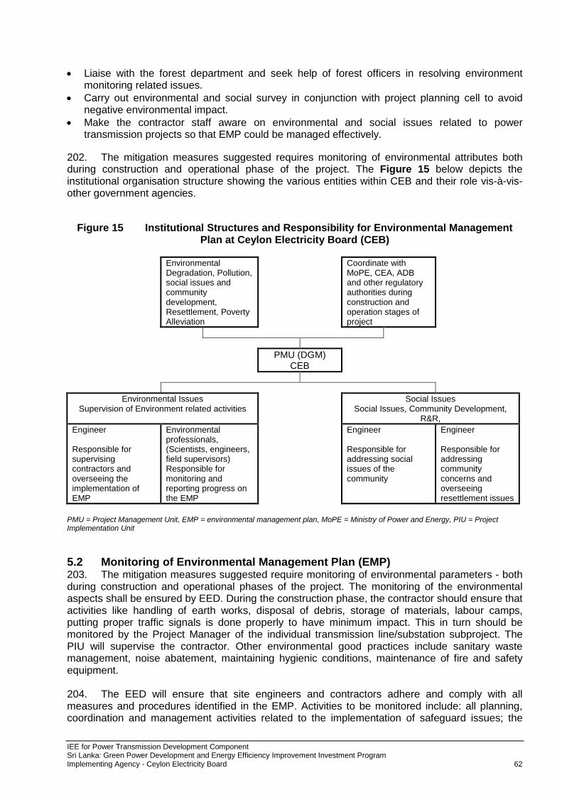
located in the district, e.g. Blocks 3 & 4 of Wilpattu National Park (48,234 ha), Padawiya Proposed Forest Reserve (97,901 ha), Padawiya Tank Sanctuary (6,475 ha), Ethakaduwa Proposed Forest Reserve (7,689 ha), Ritigala Strict Nature Reserve (1,528.2 ha), Mihintale Forest Reserve (3,308 ha), Mihintale Sanctuary (999.6 ha) and Yoda Ela Forest Reserve (2288 ha). The most common forest type is the dry-mixed evergreen forest. Riverine forests are found along streams such as Malwathu oya. Anuradhapura district is home to most of the faunal species found commonly in island’s dry zone. The scrublands, dry-mixed evergreen forests, man- made reservoirs, riverine forests, flood plains, paddy fields, chena and many other different habitat types found in the district supports the existence of a wide variety of fauna. These range from a wide variety of small animals to larger animals like the Asian Elephant. The Grey Langur, Toque Monkey and Spotted Deer are some of the common mammals found in the district while the endemic Sri Lanka Jungle Fowl and Sri Lanka Grey Hornbill are among the recorded birds in the district. Ritigala which is one of the three strict nature reserves in the country is located in the Anuradhapura district. The biodiversity in the Ritigala mountains represents a unique composition with many species usually found in the wet zone of Sri Lanka. This unique composition of biodiversity adds a rich value to the biodiversity of Anuradapura district. The day gecko species Cnemespis ritigalensis is an endemic gecko which is found only from the forests in Ritigala area. According to the National Red List 2012 of Sri Lanka, Anuradhapura district is home to eight freshwater fish species, three amphibian species, 15 reptile species, seven bird species and 24 mammal species which have been identified to be threatened with extinction in the national level. 3.1.3 Social and Cultural Development 43. Anuradhapura district is the capital of northwestern province which consists of 22 DS Division, 18 Local Government Authority and 694 Gram Niladhari Divisions. 3.1.3.1 Population 44. The population of the Anuradhapura district by 2008 amounted to 886,945. The population density of Anuradhapura district is 100/km2. The male population representing 49.04% amounts to 434,936 persons. The female population accounts for 452,009. On a community basis, Sinhalese accounts for 808,859 persons. This is 91.20% of the total population of the district. Muslims accounts for 72,289 persons and Tamils accounts for 4,502 persons. A minority of 1,295 persons belong to other religions. In categorizing the population on the basis of religions, 803,459 persons are Buddhists, 72,328 belong to Islam and Hindus and Christians account for 3,844 and 7,128 respectively. 3.1.3.2 Employment 45. 24,592 of the population are employed in various industries. 7,632 persons are employed in 3,453 small-scale industries, while 9,710 persons are employed in 53 large-scale industries. 3.1.4 Economic Development 46. For the economic development of the district, there are 55 State financial institutions and 110 private institutions. In the year 2008, 812,554 hectares were cultivated in the Anuradhapura district and the paddy harvest accrued amounted to 12,357 metric tons. 31,092 main irrigation schemes helped in this regard. In addition to paddy cultivation, a land area of 6324 hectares was cultivated with vegetable, additional crops, and pulses. The harvest reaped from these cultivations amounted to 3,513,000 Kgs. As per the land utilization in the district in the year 2008, 128,719.79 hectares were used for paddy cultivation and 59,084.05 hectares was used for Chena cultivation. 3.1.4.1 Health and Educational Facilities 47. During the last four years, the health sector received unprecedented boost in the Anuradhapura district. One surgery hospital, 3 base hospitals, 4 district hospitals, 7 central hospitals, 24 rural hospitals, 20 clinics were established in the district recently. The total number of schools in the district amount to 544, with 9,228 teachers serving in these schools. The student population amounts to 174,359 students.
IEE for Power Transmission Development Component Sri Lanka: Green Power Development and Energy Efficiency Improvement Investment Program Implementing Agency - Ceylon Electricity Board 25
3.1.4.2 Sites of Cultural, Archaeological and Historical Significance 48. Sri Maha Bodhi Tree is the oldest historically authenticated tree in the world (2,250 years). The great ancient Sinhalese Buddhist monuments of Anuradhapura are clustered around this Peepal tree (Ficus religiosa) called Sri Maha Bodhi, a sampling of the Peepal Tree at Buddha Gaya, Northern India in whose shelter Gautama Buddha attained supreme enlightenment. The sapling was brought to Sri Lanka by Buddhist nun Sanghamitta, the daughter of King Asoka of India in the 3rd Century B.C. To the north of the well-protected and well-adorned tree are three great monasteries: the Mahavihara, the Abhayagiri and the Jetavana. 49. Aukana Buddha, the 13 meter high statue carved out of solid granite, goes back to the 5th century, to the reign of King Dathusena. (about 50 km south of Anuradhapura). Guard stone at Thuparama Temple is considered to be the oldest dagoba in Sri Lanka and is believed to enshrine the collar bone relic of Lord Buddha. The guard stones like these are generally found in pairs at the entrance to temples, palaces and other revered sites. Isurumuniya Lovers Isurumuniya temple built in the 3rd century B.C. is noted for its rock carvings. 50. Ruwanveli Seya, the most popular stupas at Anuradhapura, Ruwanveli Seya, raised in the 2nd century B.C. this dagoba is supposed to have the perfect water bubble shape. Abhayagiri is the largest monastery complex in the Anuradhapura kingdom. Founded in the second century BC by king Valagamba (also known as Vattagamini Abhaya) was an international institution by the first century AD. Covering an area of 200 ha., the monastery includes full components of a Buddhist temple as well as other buildings. The stupa at Abhayagiri is 108m tall and one of the tallest brick buildings of the ancient world. 51. The finest Buddha sculpture in Sri Lanka, the Samadhi Statue (3- century AD) is among its many fine stone carvings. Ritigala, a beautifully paved footpath, several elevated platforms, ruins of an old hospital and remains of a terraced pond were unearthed at this 180 BC Buddhist monastery at the foothill of 600m high Ritigala Rock. Dating back to around 350 B.C, it is one of the oldest historical places mentioned in the ancient chronicles situated about 50 km southeast of Anuradhapura. Anuradhapura preservation area 52. In the late 1990’s it was felt that the issues related to urban development exerted undue pressure on Anuradhapura. The lack of development of other urban centres of the region meant that employment opportunities were available mostly in Anuradhapura only. The sacred area also offered much in the way of employment in the UNESCO-sponsored Cultural Triangle projects and other informal employment in the sacred area. Accordingly, the Greater Anuradhapura Development Scheme that was prepared at the turn of this century took into consideration a large area covering almost 5% of the area of Sri Lanka. Intensive concentration on urban development was ironically considered as a strategy to save Anuradhapura and Mihintale from cracking down under pressure. The planning concept applied was in fact an extension of that used centuries ago. A third ring was added to the two concentric rings of ancient Anuradhapura. Whereas the first ring surrounding the ancient city was the monastic ring, and the second ring the forest monastic ring the third ring of the modern times was an agro-based industrial ring. 53. Mihintale is one of the key religious’ sites and is regarded as the birthplace of Buddhism in Sri Lanka. It is located about 10 miles east of Anuradhapura along Anuradhapura – Trincomale major road and it is also at the junction of Kandy – Jaffna road. Mihintale was originally known as Missaka Pakbata and Sila Kuta (peak). In the northern peak of this mountain, the Tera Mahinda after arrival to the island of Sri Lanka and below Sila Kuta is the vast table land Ambathala and the whole of this area is included in the cultural triangle. 54. In 247 B.C. Buddhism was first introduced to Sri Lanka on the mountain of Mihintale. Since then, various kings of Sri Lanka have blessed this rock with magnificent masterpieces of architecture. These include a hospital, a monastic complex, stupas and dagobas. While some of
IEE for Power Transmission Development Component Sri Lanka: Green Power Development and Energy Efficiency Improvement Investment Program Implementing Agency - Ceylon Electricity Board 26
these structures are in an almost perfect state of preservation, others are in complete ruin. The most spectacular of these is the Kantaka Chaitiya, which displays some of the finest architecture of the early Anuradhapura era. 3.2 Gampaha District 3.2.1 Physical Resources 3.2.1.1 Topography, Geology and Soil Geography 55. Gampaha District is located in the west of Sri Lanka and has an area of 1,387 km2. Figure 10 gives the map. It is bounded by Kurunegala and Puttalam districts from north, Kegalle district from east, Colombo district from south and by the Indian Ocean from west. The borders of the district are the Maha River on the north, Kelani River on the south and 1,000 ft. contour line on the east. Gampaha district is divided into 13 Divisional Secretary's Division (DS Divisions), each headed by a Divisional Secretary. The DS Divisions are further sub-divided into 1,177 Grama Niladhari Divisions (GN Divisions). Gampaha town is the sixth largest urban area in the Western Province, after Colombo, Negombo, Kalutara, Panadura and Avissawella. Gampaha is also the second largest in Gampaha district, after Negombo city. Gampaha District is situated between Latitude 60 and 70 North and Longitudes 790 and 800 East.
Figure 10: Gampaha district map
Geology and Soil 56. Geologically Gampaha district falls within the Western Vijayan complex (Wanni complex) that is composed of the following formations: Alkalifeldspar, granite, gneiss, migmatite – non foliated to foliated late stage K-feldspar rich intrusion and melts; Hornblande biotite gneiss - massive to compositionally layered grey gneiss with quart>20%; Biotite and hornblende gneiss - medium to dark grey gneiss, plagioclase; Granite gneiss; and Charnokitic gneiss. 57. Laterite is a common cap on metamorphic rocks of the coastal zone and lateritic gravel, a
IEE for Power Transmission Development Component Sri Lanka: Green Power Development and Energy Efficiency Improvement Investment Program Implementing Agency - Ceylon Electricity Board 27
pebbly and often sandy, loose, brown to reddish soil, is found both as a capping and also adjacent to the laterite. Quaternary deposits include alluvium beach rock, dune sands, marsh and lagoonal deposits, as well as coral, old beach, and shoreline deposits. Except for beach rocks crops along the shoreline, the quaternary deposits are mainly superficial and unconsolidated, resting on the eroded and uneven surface of the Proterozoic rocks. These deposits are of great importance as they form very good aquifers. The thickness of these formations is highly variable but rarely exceeds 30 m. Geomorphology 58. The district slopes gently in a northeast direction towards the Negombo lagoon, where one of the largest wetlands in Sri Lanka, known as Muthurajawela, is located. The Muthurajawela marsh is the largest saline coastal peat bog in Sri Lanka. 3.2.1.2 Climate 59. The Gampaha District is located in the wet zone and receives rain from both the southwest and northeast monsoons. In Gampaha, the average annual rainfall is 2,540 mm and the average annual temperature varies from 29o C to 35o C. The relative humidity average is 76% during the day and 89% during the night.
3.2.1.3 Drainage, Rivers and Irrigation 60. The drainage pattern is important as most of the industrial effluents are discharged into rivers or water bodies in Gampaha district. The area is drained principally by the Maha Oya and the Attanagalu Oya and in the extreme southeast by the Kelni Ganga. Much of the area is comprised of coastal low lands under 100 msl. The Attanagalu Oya brings significant discharges of agricultural and industrial effluent and sewage in to Muthurajawela-Negombo lagoon system. Although the Muthurajawela marsh has considerable capacity to remove excess nutrients and toxic substance, the marsh itself is under intense pressure from surrounding industries, low-cost housing along its borders, and land reclamation. 3.2.1.4 Hydrogeology 61. Groundwater in the area occurs in four main forms: Shallow sand aquifer - high yielding; Laterite -low to moderate yielding; Weathered crystalline rock - moderate to high yielding; and Crystalline deeper fracture zone (hard rock aquifers) - low yielding. High yielding wells in the shallow sand aquifer have been recorded in parts of the district. Clay content of the sand varies and a number of clay horizons are noticed among the lithological descriptions. Parts of the district is underlain by the laterite aquifer that are easily accessible using dug wells as well as shallow ‘tube’ wells. However, the vesicular laterite aquifer of the southwest wet zone is over exploitation in the area of Gampaha and adjacent districts. The rapid expansion of industrial estates, urban housing schemes, and bottled water projects in this area is causing a tremendous pressure on this limited resource. Enhanced nitrate levels have been observed for a number of the domestic wells around Gampaha and its suburbs. The weathered area of the metamorphic hard rock is the most productive of the aquifers underlying in the district Yield analysis indicates that well yields are typically 100 to 900 l/m at depths ranging from 15 to 28 m. 3.2.2 Economic development 62. Major crops cultivated in Gampaha are paddy, coconut, rubber, vegetables, fruits and flowers. Large areas still exist under agricultural production, paddy cultivation, taking a prominent place. major fruit crops which are grown in Gampaha district are, Pineapple – 10.62 km2 and the production is about 10,000 MT, Banana – 14.18 km2 and the production is about 10210 MT, Rambutan – 7.97 km2 and the production is about 6376 MT and Papaya – 0.98 km2 and the production is about 588 MT. 63. However, there are drastic trends to move out from agricultural employments in past few decades because of high input costs and lack of labour due to less interest in farmers and young generations on agricultural activities, have been resulted many owners to abandon the paddy land.
IEE for Power Transmission Development Component Sri Lanka: Green Power Development and Energy Efficiency Improvement Investment Program Implementing Agency - Ceylon Electricity Board 28
Further, the recent escalation of land prices are a threat to these cultivable land, and the government has brought in strict legislature to prevent paddy land being sold for commercial construction. 3.2.2.1 Minerals 64. Gampaha district mainly contains sedimentary limestones, graphite bearing rocks, Feldspar, magnetite and gem occurrences. 3.2.2.2 Industry 65. Industrial development is concentrated in the lower part of the Attanagalu Oya catchment. Only a minor percentage of these industries have any form of wastewater treatment facilities and, when available, it is limited to primary treatment. Industrial effluents together with sewage from industrial estates are mostly discharged into the Attanagalu Oya or its tributaries. Sludge produced in the existing treatment plants is deposited in marshy low-lying areas as landfill. 3.2.2.3 Infrastructure 66. Bandaranaike International Airport is located in Katunayake, in the Gampaha district. It is the major airport in the Sri Lanka. It is administered by Airport and Aviation Services (Sri Lanka) Ltd. It is the hub of Sri Lankan Airlines, the national carrier of Sri Lanka.
3.2.3 Ecological Resources 3.2.3.1 Forests 67. Forest covers 0.5% of land area in the district (details in Table 14). Depletion of forests is a serious environmental problem. Most of the forest areas are sparse forest, lowland forest, and riverine dry forest. Gampaha district has a total forest cover of 7.74 km2. Considering the total area of coastal habitats; it is divided as, Mangrove - 0.85 km2, Salt marshes - 6.47 km2, Dunes - 0.53 km2 and Estuaries - 32.89 km2. Muthurajawela Marsh and Negombo Lagoon are located in the Gampaha district. Muthurajawela wetland is located at mainly sea level in the Gampaha District, Western Province, about 20-30 km. North of Colombo. It is categorized under Ramsar Wetland Sanctuary. The wetland represents a large area of brackish marshes, mangrove swamps and fresh water marshes merging into an estuarine lagoon about 32 km2 to the northwest. The marshes cover an area of approximately 31 km2. The lagoon opens to the sea at its northern end and receives fresh river water input from the Ja-Ela and the Dandugam Oya. 68. Muthurajawela harbors over 194 species of Flora distributed over seven major vegetation types which includes marsh, lactic flora, shrub land, reed, swamp, grasslands, stream bank and mangrove forest. A total of 194 species of vegetation belonging to 66 families have been recorded which include one endemic species (Phoenix zelanica). Among the different types of vegetation, the shrub land consists of 115 species with the mangrove forest and stream bank consisting of just 23 species each. But now, most of these species are under threats. The vertebrate fauna includes 40 species of fish, 14 species of reptiles, 102 species of birds and 22 species of mammals. Among the total vertebrate species documented 17 are endemic while 26 are nationally endangered. Among the invertebrates documented 48 species are butterflies and 22 species are dragonflies.
Table 14: Name, category and the extent of Forest Reserves in Gampaha district Name Category Extent (ha)
IEE for Power Transmission Development Component Sri Lanka: Green Power Development and Energy Efficiency Improvement Investment Program Implementing Agency - Ceylon Electricity Board 29
3.2.3.2 Land use 69. About 40.1% of the district’s 141,890 ha. is home gardens. 3.2.4 Social and Cultural Development 3.2.4.1 Population and Community 70. Gampaha District's population was 2,294,641 in 2012. The majority of the population are Sinhalese, with a minority Sri Lankan Moor and Sri Lankan Tamil population. The population density of Gampaha district is 1700/km2. The male population representing 48.60% amounts to 1,115,349 persons. The female population accounts for 1,179,292. On a community basis, Sinhalese accounts for 2,079,115 persons. This is 90.61% of the total population of the district. Muslims accounts for 95,501 persons and Tamils accounts for 80,071 persons. In categorizing the population on the basis of religions, 1,640,166 persons are Buddhists, 114,851 belong to Islam and Hindus and Christians account for 52,221 and 486,173 respectively. 3.2.4.2 Health and Educational Facilities 71. Within the Gampaha district, one teaching hospital; Ragama, three district base hospitals; Gampaha, Negambo and Kiribathgoda, one base hospital; Wattala, four district hospitals and several rural and peripheral hospitals are present. 72. Total number of schools in Gampaha district is 539.most of them are categorized under national and secondary schools. 3.2.4.3 Sites of Cultural, Archaeological and Historical Significance 73. Before 1815, major area of Gampaha district was a dense forest. The 5th Governor of Ceylon, Sir Edward Barnes made a visit to Gampaha in 1825, on the way to observe the construction work of the Negombo-Colombo road. The British colonists built Henarathgoda railway station in 1864, which act as a key factor for the progress and recognition of the town. In 1867, the first rubber tree of Sri Lanka was planted in Henarathgoda botanic gardens. 74. Some other important cultural and historical sites located in the Gampaha district are, Attanagalle Viharaya (Temple forest garden), Varana Gal Viharaya (Rock outcrops and caves) and Maligatenna and Pilikuttuwa monasteries (Caves, forest). 3.3 Trincomalee District 3.3.1 Physical Resources 3.3.1.1 Topography, Geology and Soil
Geography 75. Trincomalee District is located in the east of Sri Lanka in the Eastern Province (Figure 11). Located on the east coast of the island overlooking the Trincomalee Harbour, 113 miles south of Jaffna and 69 miles north of Batticaloa, Trincomalee has been one of the main centres of Tamil language speaking culture on the island for over two millennia. 76. It has an area of 2,727 km2. Trincomalee district has 11 DS Divisions, 230 Grama Niladhari Divisions, 621 Villages having a population of 414,320 with a total number of families: 106,437. Trincomalee District which is in the Northern part of the Eastern Province is bounded in the North by Yan Oya, by Anuradhapura and Polonnaruwa Districts in the West and by Verugal Ganga in the South.
IEE for Power Transmission Development Component Sri Lanka: Green Power Development and Energy Efficiency Improvement Investment Program Implementing Agency - Ceylon Electricity Board 30
Figure 11: Trincomalee district map
Geology and Soil 77. Mainly 5 major soil groups found in Trincomalee District as Alluvial soils 35 %, Reddish Brown Earth 30%, Sandy Regosols 10 %, Erosion remnants 10 %, non-classic brown alkaline saline and soil with gravel 15%. Considering the geomorphology in Trincomalee district, 5 main types are classified as; Hills and cliffs, Dunes, Estuaries, lagoons and Thona, Beach bars and spits and Beaches/shorelines. Soil 78. The topography of the area is flat, with undulating hills reaching 100 m above mean sea level. The coastal zone of the area consists of rock cliffs made up of metamorphosed sediments of rocks from the Pre-Cambrian age belonging to the Highland Series. The Highland series consist of quartzites, Schists and Crystalline limestones. Climate 79. Trincomalee features a tropical wet and dry climate (AS) under the Köppen climate classification. The city features a dry season from March through June and a wet season for the remainder of the year. The city sees on average roughly 1,570 millimetres (62 in) of precipitation annually. Average temperatures in Trincomalee range from around 26 degrees C (79 F) in December and January to approximately 30 degrees C (86 F) during the warmest months of the
IEE for Power Transmission Development Component Sri Lanka: Green Power Development and Energy Efficiency Improvement Investment Program Implementing Agency - Ceylon Electricity Board 31
year from April through September. Reliably recorded temperatures in the city range from 19.9 degrees C (67.8 F) to 39.5 degrees C (103.1 F). Rainfall 80. The area receives an annual rainfall of approximately 1,700 mm, and has an average annual temperature of approximately 27 degree C. The climatic conditions of the area are influenced primarily by the inter-monsoonal rains in March and April, and an extensive dry period extending from May to September. The long dry spell is followed by a rainy season influenced by the northeast monsoon, between November and January. It features dry season from February to July and wet season for the remainder of the year. Trincomalee district receives rain during two short seasons. Usually northeast monsoon brings about 50% of the total rainfall and southwest monsoon only brings about 10% of the total rainfall. The principle causes for the low rainfall rate in the District can be given as, extensive plain morphology and the absence of a mountainous area within the District to intercept the north east monsoon. 3.3.2 Economic Development 81. According to the statistics, the total population of the Trincomalee District is 378,182. This population comprises 101,742 families scattered in 230 GN Divisions of 11 DS Divisions. Out of this more than 54,000 families (more than 50%) depend on farming and another 10,000 families (10%) are engaged in fishing. This suggests that agriculture and fishing are the major economic activities in Trincomalee District. Main agricultural crops of Trincomalee district are paddy, vegetables, fruit crops and maize, red onion, ground nut and chilly. Trincomalee District has 70.2 km length of railway track and 8 stations. Train takes 8 hours to reach Colombo from Trincomalee. Trincomalee commands a large natural and a wide body of sheltered waters. Trincomalee harbor, under the administrative control of Sri Lanka Ports Authority (SLPA) is considered to be a one of the world’s best harbors. The national grid provides power to Trincomalee District and approximately 40 % is from renewable hydroelectric power. Minerals 82. The sand found in the coastal area of district is very important due to its high Ilmenite mineral content, which is found in very few other places around the world. Ilmenite contains titanium oxide. Titanium is an important component of light metal alloys used in the aircraft and space manufacturing industries. Pulmoddai heavy mineral beach sand deposits (monazite, zircon) extend from the north of the District. The deposits consist largely of Ilmenite but also contain appreciable amounts of monazite, zircon and baddeleyite – a unique deposit by itself and exploited by the Ceylon Mineral Sands Corporation. The rocks at Kuchchaveli exhibit magnetic polarity due to the alignment of magnetite in the rock. Further south, charnockite at Tavikallu and quartz reefs at Mankanai also can be stated.
3.3.2.1 Infrastructure 83. Trincomalee port has a deep draft capable of handling the largest ships as well as availability of adjacent land for development. It is located at the east coast of Sri Lanka and could become the hub port for East India, Bangladesh and Myanmar. 3.3.3 Ecological resources 84. The Forest Area according to Conservation Status (Forest Department) in Trincomalee is 145,376 ha. (Table 15). This total forest area includes Brackish and saltwater forests, dry monsoon forest , fresh water forest, mangroves, moist Monsoon forest, woodland, dry forest, riverine dry forest and sparse. Dry monsoon forest is the most common forest type in Trincomalee district and it occupies total area of 1087.1 km2. Main service of this forest type is, it serves as habitat for wildlife. Sparse forests are the second most common type in Trincomalee district and total area of that is given as 144.46 km2. Thirdly, most common type is forest plantations; it has total area of 67.86 km2. Some forest areas are degraded due to the chena cultivation and these are at different stages of regeneration.
IEE for Power Transmission Development Component Sri Lanka: Green Power Development and Energy Efficiency Improvement Investment Program Implementing Agency - Ceylon Electricity Board 32
85. As a district located in the dry zone of the island, Trincomalee is home to a faunal composition representing the dry zone fauna of Sri Lanka. Most of the species of fauna common in this zone can be found in Trincomalee district too. This includes animals ranging from small insects to larger mammals such as the Asian Elephant. Protected area network within the district provides suitable habitats for these animals. The coastal habitats, shallow seas and the islands in the area are also highly ecologically important due to the presence of coral reefs and other shallow sea fauna including the rare and relict species like Lingula. 86. The oceans adjoining the district are very popular destinations for whales, dolphins and sea bird watching. Trincomalee district is known to support the existence of 38 nationally threatened vertebrates as of 2012. These vertebrates includes 2 freshwater fish species, 2 amphibian species, 2 reptile species, 26 bird species and 6 mammal species. However the faunal composition of these areas is largely under studied. Several species of reptiles and dragonflies which have been recorded from Trincomalee district in the past are currently considered to be data deficient as no or very few subsequent records are available. The dragonfly Hemianax ephippiger, the snake Dendrelaphis oliveri (Oliver’s bronze back) and the two skinks Nessia deraniyagalai (Deraniyagala’s snakeskink) and Lygosoma singha (Taylor’s skink) are such species.
Table 15: Name, category and the extent of Forest Reserves in Trincomalee district Name Category Extent (ha)
Chundankadu FR 5690.3 Chundankadu PR 8443.7 Great Sober Island S 64.5 Kantalai FR 37479.3 Little Sober Island S 6.5 Mahaweli Ganga PR 6475.0 Mahaweli Ganga North and South FR 8642.1 Pankulam-Northern Block PR 52355.9 Pigeon Island S 4.7 Seruwila-Allai S 15540.0 Trinconmalee Naval Headworks S 18130.3 Vappiah-Verugal FR 4344.7 Kinniya PR 14.2
Rivers and streams 87. Trincomalee District receives much of its water from the central highlands and particularly during the dry season, water may become limited. The water is found as surface water and groundwater. Much of the District is covered by the Mahaweli river basin, the Yan Oya, Kunchikulan Aru, Pankulam Aru, Pan Oya and Kantale Oya. 3.3.4 Social and Cultural Development 3.3.4.1 Population 88. The population of the Trincomalee district by 2012 amounted to 378,182. The population density of Trincomalee district is 140 /km2. The male population representing 49.54% amounts to 187,357 persons. The female population accounts for 190.825. On a community basis, Sinhalese accounts for 101,991 persons. This is 26.96% of the total population of the district. Muslims accounts for 152,854 persons and Tamils accounts for 122,080 persons. In categorizing the population on the basis of religions, 98,772 persons are Buddhists, 159,251 belong to Islam and Hindus and Christians account for 98,133 and 21,892 respectively. 3.3.4.2 Road and rail 89. Trincomalee is on the eastern end of the A6 and A12 highways in Sri Lanka, as well as the northern end of the A15. The city is also served by Sri Lanka Railways. Trincomalee Railway Station is the terminus of Trincomalee-bound rail services, the majority of which originate from Colombo Fort. The station lies close to the northern coast and beaches of the city.
IEE for Power Transmission Development Component Sri Lanka: Green Power Development and Energy Efficiency Improvement Investment Program Implementing Agency - Ceylon Electricity Board 33
3.3.4.3 Health Facilities Health Facilities 90. Only the urban DS Divisions have medical facilities and rural communities are relatively poorly served. Health facilities includes one general hospital; Trincomalee, two district hospitals; Kinniya and Muttur, one base hospital; Kantale, three rural hospitals; Gomarankadawala, Serunuwara and Nelaveli. Most abundant facility is central dispensaries, situated in different locations of the district. 3.3.4.4 Educational Facilities 91. Government maintains a network of primary and secondary schools in Trincomalee District. Within the district, altogether 269 schools are established, including 11 schools up to secondary education to G.C.E (A/L) Science, 54 schools up to secondary education to G.C.E (A/L) Arts & Commerce, 90 schools up to Secondary Education and 114 schools up to primary education.
92. The Naval and Maritime Academy of the Sri Lanka Navy and the Air Force Academy of the Sri Lanka Air Force is situated in Trincomalee. It was first established in 1967, and gained university status in 2001. The Eastern University of Sri Lanka, which has its main campus in Batticaloa also has a campus in Trincomalee. 93. There are other colleges such as T/R.K.M.Sri Koneswara Hindu College, Zahira College, Trincomalee, St Joseph Collage, Trincomalee, T/Sri Shanmuga Hindu Ladies College, T/St Mary's College, Orr's Hill Vivekananda College, T/Vikneswara Mahavidyalayam, Sinhala central college at Trincomale town, Naamahal Vidyalayam, Trincomalee, Kalaimahal Vidyalayam, Trincomalee, St Francis Xavier School, T/Nalanda College, China Bay, T/Siraj Muslim maha vidyalayam,
T/vipulananda college, Jesuit Academy of Trincomalee.
3.3.4.5 Archaeological, Cultural and Historical significant sites: 94. The district was captured by Portuguese in the 16th century. The destruction and looting of the Koneswaram Temple by Constantine De Susa on a New Year day in the beginning of 1620 was a turning point in the history of the District. The Dutch conquered this district from Portuguese in 1693 and it fell into the hands of British in 1796. 95. There are several Hindu historical sites in Trincomalee district. The Koneshvaram temple attracted pilgrims from all parts of India. This Hindu temple was also documented in several late medieval texts such as the Konesar Kalvettu and the Dakshina Kailasa Puranam. 96. The Hot Springs - Among the sights of the place are the seven hot springs of Kanniyayi, on the road to Trincomalee. The water is mildly hot; the temperature varies but slightly in each. In effect, a public bathing resort, the use of the springs is controlled by the neighboring Mari Amman Kovil who holds the lease of the wells. The site of the springs is crown land. The Dutch Fort - Fort Fredrick was built in 1623 by the Portuguese and captured in 1639 by the Dutch. It then went through a phase of dismantling and reconstruction and was attacked and captured by the French in 1672. Hindu historical sites - The Konēsvaram temple attracted pilgrims from all parts of India. The Konēsvaram shrine itself was demolished in 1622 by the Portuguese (who called it the Temple of a Thousand Columns), and who fortified the heights with the materials derived from its destruction. Some of the artefacts from the demolished temple were kept in the Lisbon Museum including the stone inscription by Kulakottan (Kunakottan) It has an emblem including two fish and is engraved with a prophesy stating that, after the 16th century, westerners with different eye colours will rule the country for 500 years and, at the end of it, rule will revert back to Vadugus. The Hindu temple was also documented in several late medieval texts such as the Konesar Kalvettu and the Dakshina Kailasa Puranam.
IEE for Power Transmission Development Component Sri Lanka: Green Power Development and Energy Efficiency Improvement Investment Program Implementing Agency - Ceylon Electricity Board 34
3.4 Puttlam District 3.4.1 Physical Resources 3.4.1.1 Geography 97. Puttalam is a district situated near to the west coast of Sri Lanka (Figure 12). It has an area of 3,072 km2. The district capital is Puttalam, which borders the Kala Oya and Modaragam Aru in the north, Anuradhapura District and Kurunegala District in the east, Ma Oya in the south, and the Indian Ocean in the west. Puttalam is well known for its picturesque lagoons, popular for shallow sea fishing and prawn farming activities. The town of Kalpitiya, and the Kalpitiya Peninsula, is located in this district. Local authorities of Puttalam Urban Council and Puttalam Pradeshiya Sabha and electorates of Puttalam and a small portion of Anamaduwa are included into the administrative area of Puttalam divisional secretariat. Puttalam D.S. has 86 villages within 22 Grama Niladari divisions. 16 out of 22 G.N. divisions are situated in Puttalam electorate and the rest located in Anamaduwa electorate.
3.4.1.2 Climate 98. Most of the district lies in the dry zone, except for the southern tip, which extends into the wet zone. Annual rainfall of the southern part of the district is in the range of 1000 mm to 1250 mm and this decreases gradually towards the north of the district. Most of the rain occurs in the Maha Season (October to January). The average daily temperature exceeds 27o C.
Figure 12: Puttalam district map
3.4.1.3 Topography, Geology and Soil Geology 99. The coastal belt zone of the project area north of Mondel is underlain by the unconsolidated Miocene sedimentary sequence while the rest of the district is underlain by Precambrian Western Vijayan complex. The main rock types within the district are described as follows:
IEE for Power Transmission Development Component Sri Lanka: Green Power Development and Energy Efficiency Improvement Investment Program Implementing Agency - Ceylon Electricity Board 35
Quaternary Laterite and laterite gravel, red and brown earth, partly consolidated sands and clay
Miocene Limestone, sandstone and mudstone
Jurassic Sandstone, shale and limestone
Precambrian Precambrian Metamorphic rocks of the Vijayan complex
Recent Deposits: Alluvial deposits are found on the flood plains of streams. Collovial deposits are generally found in the lower slopes of ridges and valley terrain. Unconsolidated sands and sand dunes occur extensively along the coast with well-developed dunes rising above 10 m as found in the coastal belt from Udappu to Kalpitiya. These sand dunes are very important as they contain pockets of fresh water. Tidal flat deposits are confined to only a few locations in the lagoonal sediments such as the southern boundary of the Puttalam lagoon where the Kalpitiya peninsular joins the mainland. The soil mantle carpeting the entire district is composed of varying soil types, each is related to the climate and the parent geological formation.
Quaternary Deposits: A succession of sands, clays, sandy clays, gravels, and pebble deposits of marine, littoral, and continental origin exists along the coast from Maha Oya to Modargam Aru. This succession extends inland from 1 to 3 km in the south, increasing to 5 to 13 km in the north. The western coastal belt of the district, north of Mundel is covered by the Miocene Sedimentary sequence, which extends 10 km inland and wedges over the crystalline basement rocks. The underlying Precambrian granitic rocks and the overlying quaternary sands and clays are both unconfined within the Miocene succession.
Jurassic Sedimentary Deposits: Isolated and very small sedimentary basins have been recognized within the metamorphic terrain at Pallama, Andigama, and Tabbowa areas. These sedimentary basins of Jurassic age are not exposed and have been identified only in drill cuttings and drill cores. In the Tabbowa area, a sequence of loosely consolidated arkosic sandstones, grits, and shale with occasional limestone lenses has been identified. The sand stone is distinctly reddish and medium grained in texture.
Precambrian Metamorphic: Rocks of the Vijayan series occupy the eastern portion covering over seventy percent of the district. These rocks are overlain by a weathered mantel beneath a thin surface soil layer. The main rock types in the Precambrian complex are granites, granite gneisses, migmatites and migmatitic gneisses and hornblende biotite gneisses with quartzites, calc gneisses, amphibolites, pegmatites, and charnockites as minor rock types. The crystalline basement rocks of the western Vijyan series in the Puttalam District appear to have been deformed more than once, as indicated by the structural features in the exposed rock faces of many rock quarries. The Precambrian basement is directly overlain by the Miocene formation in the west.
Soil 100. Two kinds of soils found in the district. The southern part contains brown colored gravel based soil and the northern part contains latasol soil. Latasol is known as the oldest soil of its kind. It was developed in an entirely different climate situation than present days. It permits easy seepage of water. It is not very nutritious except for the cultivation of Citrus family, cashew and lpil plantation. Geomorphology 101. Aerial photos and relief maps reveal that three distinct geomorphic zones can be identified in the Puttalam District. Zone 1 is a flat coastal strip: A narrow belt forms the western boundary, having a width of 1 to 2 km in the south and widening to 8 to 12 km in the north. The elevation of the belt starts at sea level and rises to an elevation of about 20 m as one moves inland. However, close to the sea at Aruwakalu an uplifted Sri Lanka - Upgrading and Modernization of the Hydro-Meteorological Information System limestone block rising to about 6 m and parallel to the coast
IEE for Power Transmission Development Component Sri Lanka: Green Power Development and Energy Efficiency Improvement Investment Program Implementing Agency - Ceylon Electricity Board 36
breaks the monotonous flatness of the belt and extends as a ridge to Kudramalai. A series of very low and rounded ridges and runnels running parallel to the coastline are also visible in a few locations. Zone 2 is undulating low ridges: An area of broadly undulating and widely set low ridges bounded by Mahaoya in the south, Maha Kumbukkadawels in the north, and Pallama in the east. These broad ridges are generally aligned in a north–south direction and are structurally disturbed by a transversal fracture system, which has developed into fracture valleys having a general east–west alignment. Zone 3 is monadknocks and rock knobs: The eastern most area of the district comprising of monadknocks and turtle backed rock outcrops of high relief rises from 20 m to 110 m msl. 3.4.1.4 Drainage 102. In the coastal strip north of Puttalam, a few man-made lakes and a number of natural lakes (villus) and marshes are found. Due to the very low relief (flatness) of the area, the area drains very slow through meandering streams, villus, and marshes before entering the sea. Major streams such as the Maha Oya and Deduru Oya, which flow east to west, are located in the southern part of the district. These two streams together with their tributaries drain the area to the west. Kala Oya and Mee Oya are the major streams to the north, which originate in the dry zone and have very low flows. Depressions around the Pallama area support the formation of swamps as a result of floodwaters. The mature topography and the meandering river courses have given rise to ox-bow lakes along the Deduru Oya. The lower flood plains encompassing the subdued coastal stretch are subjected to frequent flooding, especially from torrential monsoonal rains. The rural population depends on groundwater with the exception of the few perennial streams and major irrigation reservoirs in the area; all other surface water sources dry up. 3.4.1.5 Biodiversity 103. Puttalam district is located in the dry and semi-arid zones of the country. It consists of around 15% of natural dry-mixed evergreen forest as of 1998 (IUCNSL and MOENR, 2007) and diverse coastal habitats. It is home to some specific fauna as well as species common throughout the dry zone of Sri Lanka. Puttalam district is a district with a considerably rich avifauna with wetland areas to where lots of migrant birds visit every year. The Annawilundawa tank sanctuary which is located within the district has been even declared as a wetland with international importance due to this reason. Chilaw coastal areas, Navadankulama tank, Puttalama salterns and Kalpitiya area are some of very popular birding localities in the district. As Puttalam district is the southernmost area in the north western semi-arid zone of the country some of the bird species which are mainly found in the Indian avifauna zone of Sri Lanka (Kotagama and Ratnavira, 2010) can also be found in Puttalama district. Some of them are Eurasian Collared Dove (Strptopelia decaocto), Black Drongo (Dicrurus macrocercus) and Grey Francolin (Francolinus pondicerianus). Apart from birds Puttalam is also a home to many other vertebrate species as well as invertebrates. National Redlist 2012 of Sri Lanka has stated that 27 threatened vertebrate species including 7 endemics have been recorded from the Puttalam district. 3.4.2 Social and Cultural Development 3.4.2.1 Population and Community 104. The population of the Puttalam district by 2012 amounted to 760,778. The population density of Puttalam district is 250/km2. The male population representing 48.48% amounts to 368,860 persons. The female population accounts for 390,916. On a community basis, Sinhalese accounts for 559,031 persons. This is 73.48% of the total population of the district. Muslims accounts for 146,820 persons and Tamils accounts for 50,026 persons. In categorizing the population on the basis of religions, 328,450 persons are Buddhists, 152,280 belong to Islam and Hindus and Christians account for 28,812 and 249,006 respectively. Internally Displaced Persons: 105. The D.S. division of Puttalam and three other neighboring D.S. divisions within the Puttalam electorate and partly Anamaduwa electorate provided refuge to the evicted Muslims from Northern Province around October 1990. The settling of these people in the said D.S. divisions created
IEE for Power Transmission Development Component Sri Lanka: Green Power Development and Energy Efficiency Improvement Investment Program Implementing Agency - Ceylon Electricity Board 37
umpteen problems to the people referred to as Host community in the area. Competitions and sharing the resources available, water, land and problems in the economic activities of the Host community propped up. Even after the end of the war, the vast majority of the IDPs have opted to stay in Puttalam which create more problems to the Host community. 3.4.2.2 Economy 106. Puttalam is a business center catering to other D.S. divisions as well. Through the production of solar salt approximately 10,000 persons are employed in salt related activities. The coastal population is involved in fishing in the lagoon. Although the division is not considered as a major agricultural area, coconut plantation in the south, cashew and paddy are cultivated in northern part of the division. 107. There are no major industries specific to Puttalam. Some home based products from coconut kernel are active within the division. Micro and small level industries are found in the division. Especially a soft drink producing plant, garment factories and snack (mixture) production are well known small industries. Large level industries such as cement, salt and gravel brick/ tile factories are situated in the district. 3.4.2.3 Health and Educational Facilities Education 108. From pre-schools to Maha Vidyalaya (secondary colleges) including two National schools are functioning in this D.S. division. Among these formal educational institutions, ‘President’s Science College’ which is the first in Sri Lanka also situated in this division. A study center of Open University of Sri Lanka and the vocational training institute which provides tertiary education with many private owned academic institutions provides somewhat educational facilities to the people in this division. 3.4.2.4 Sites of Cultural, Archaeological and Historical Significance 109. The district secretary’s administrative office which is known as ‘kachcheri’ was constructed during the period of Dutch administration of the maritime province. This two story building with timber and the rafters and beams without joint can be seen. 110. Presentation of a trumpet and two Royal insignias of the Kandyan king Sri Veera Parakrama Narendrasinhe to the Mohideen Jumma (Grand Mosque) Masjid of Puttalam when he visited in 1720 A.D. and was very warmly received by the people of Puttalam. St. Clement Catholic Church situated in Puttalam – Colombo main road. A Catholic burial ground situated in front of the urban council administrative building. The house belongs to E.S.M. Cassim Marikkar family in the North road. 111. Although most of the historic monuments of Puttalam have eroded in the passage of time the simple way of life of the people of Puttalam, their hospitality, tolerance and compromise with all the communities living in this area announces the potential development of this area as a most desirable destination for people within the country and outside. 3.5 Colombo District 3.5.1 Physical Resources 3.5.1.1 Topography, Geology and Soil 112. Colombo is the most highly populated district in Sri Lanka. According to the census reports in 2001 the population was 2,251,274. Colombo district is divided into 13 Divisional Secretariat Divisions and their activities are coordinated and supervised by the Colombo District Secretariat. Colombo district is a combined mixture of mountains, plains and marsh lands. north and east parts of the district are mountainous whereas east and south-east parts are surrounded by marsh lands. City of Colombo is connected by a network of canals and at the heart of the city is the Beira Lake (Figure 13). The boundaries of the Colombo district are North-Kelani River (Gampaha district),
IEE for Power Transmission Development Component Sri Lanka: Green Power Development and Energy Efficiency Improvement Investment Program Implementing Agency - Ceylon Electricity Board 38
South-Bolgoda River (Kalutara district), West-Coast line, and East-Sabaragamuwa Province.
Figure 13: Map of Colombo District
Geology 113. The geology of Colombo is representative of the geology of the western coast of Sri Lanka and has existed for much of the Quaternary era. Bore holes drilled in central Colombo City show that this area once formed an estuary of the Kelani River and the Kalu Ganga River, the two main rivers that drain into the sea on the western coast. A few kilometers upstream in the inland valleys, there is a high-level gravel formation consisting of quartz pebbles embedded in a matrix of laterite separated with pebble-free layers of laterites. The floodplains along the rivers consist mainly of alluvial deposits. The floodplains of Kelani River also provide thick alluvial profiles for unconfined aquifers, in addition to the productive overburden along tributary banks. 114. Vast area (over 90%) of Sri Lanka is underlain by metamorphic crystalline rocks of Precambrian age, which includes the Colombo area, which cover a variety of Gneisses. The geology of Colombo is representative of the geology of the western coast of Sri Lanka and has existed for much of the Quaternary era. This is shown in the 1:10,000 and 1:50,000 geological maps of Colombo region produced by the Geological Survey and Mines Bureau (GSMB). The typical rock types of this basement include Biotite gneiss, Hornblende Biotite gneiss, Charnockites, Charnockitic gneisses, Quartzite and undifferentiated Meta sediments. The floodplains along Kelani River and the Kalu Ganga rivers consist mainly of alluvial deposits. The floodplains of Kelani River also provide thick alluvial profiles for unconfined aquifers, in addition to the productive overburden along tributary banks. 115. According to Survey Department soil maps the main soil types and terrain in the project area are Red Yellow Podzolic soils with soft or hard laterite: undulating terrain, Bog and Half bog soils: flat terrain, Alluvial soils of variable texture and drainage: flat terrain and Regosols on recent beach sands: flat terrain. 3.5.1.2 Geography and climate 116. Colombo's geography is a mix of land and water. The city has many canals and, in the heart of the city, there is a 65-hectare Beira Lake. The northern and north-eastern border of the city of Colombo is formed by the Kelani River, which meets the sea in a part of the city known as the Modera (mōdara in Sinhala) which means river delta. Colombo's climate is fairly temperate all
IEE for Power Transmission Development Component Sri Lanka: Green Power Development and Energy Efficiency Improvement Investment Program Implementing Agency - Ceylon Electricity Board 39
throughout the year. From March to April the temperature averages around 310 Celsius. The only major change in the Colombo weather occurs during the monsoon seasons from May to August and October to January. Colombo sees little relative diurnal range of temperature, although this is more marked in the drier winter months, where minimum temperatures average 220 Celsius. Rainfall in the city averages around 2,400 mm a year. 3.5.2 Economic Development 117. The majority of Sri Lankan corporations have their head offices in Colombo. Some of the industries include chemicals, textiles, glass, cement, leather goods, furniture, and jewellery. In the city centre is located South Asia's second tallest building – The World Trade Centre. The 40 story Twin Tower complex is the centre of important commercial establishments, situated in the Fort district, the city's nerve centre. Right outside the Fort area is Pettah which is derived from the Sinhalese word pita, which means out or outside as it is outside the Fort. 118. Pettah is more crowded than the fort area. Pettah's roads are always packed and pavements are full of small stalls selling products ranging from delicious sherbat to shirts. Main Street consists mostly of clothes shops and the cross roads, which are literally known as Cross Streets where each of the five streets specializes in a specific business - First Cross Street is mostly for electronic goods shops; the Second cross street is mostly for cellular phones and fancy goods. At the end of the main street further away from Fort is the Sea Street, Sri Lanka's gold market. This mile-long street is full of jewellery shops. The Colombo Metropolitan Region (CMR) encompasses the country's administrative capital Kotte and Colombo. Found within the borders of the CMR is 80% of the country's industries and over 60% of all vehicles plying Sri Lankan roads. The per capita income of the Western Province stood at USD 3,808, making it one of the most prosperous regions in South Asia. 119. Colombo district has relatively high proportion of modern facilities such as teaching, provincial, and base hospitals while in Gampaha and Kalutara Districts these facilities are very limited. For example, there are 610 hospital beds per every 100,000 population in Colombo district, compared with 260 beds in Gampaha and 210 in Kalutara. In terms of doctors per 100,000 populations, Colombo district average is 68 while the average for Gampaha and Kalutara are 17 and 22 respectively. 3.5.3 Ecological resources The forest cover in Colombo district is 1,832 ha (2.7%). This forest area includes mainly the lowland rain forest formation. In addition, several wetlands are found e.g. Muthurajawela, Bellanwila-Attidiya, and Sri J'Pura Bird Sanctuary (Table 16).
Table 16. Name, category and extent of forests areas in Colombo district. Name Category Extent (ha)
Bellanwila-Attidiya S 60.0 Getamarawa-Dunkolahena PR 129.7 Indikada Mukalana PR 747.5 Kananpella FR 263.5 Miriyagalla FR 123.1 Sri Jayawardenapura Bird S 449.2 Muthurajawella S 0.0 Labugama-Kalatuwawa (Col/Kal/Rat districts) FR 2150.1
3.5.3 Biodiversity 120. As the district with highest urbanization and population density Colombo has very little natural habitats left. Still, the remaining habitats harbour a considerable faunal diversity within them. The wetland areas such as Bellanwila-Attidiya Sanctuary, Thalangama Environmental Protection Area, Jayawardenapura marshes, Bolgoda wetlands support the existence of many species of fauna that associates wetlands. According to a recent study conducted, the Bellanwila-Attidya Sanctuary and the vicinity areas provides habitat for many animal species including 75
IEE for Power Transmission Development Component Sri Lanka: Green Power Development and Energy Efficiency Improvement Investment Program Implementing Agency - Ceylon Electricity Board 40
butterflies, 22 fish, 11 amphibians, 27 reptiles, 78 birds and 14 mammals. The mammals which has been recorded even includes threatened species such as the Fishing Cat. Many migrant birds also visit the wetlands in the Colombo district including uncommon migrants like the Glossy Ibis which is a regular visitor to both Bellanwila-Attidiya and Thalangama area. The few remaining forest patches, especially associated to the Buddhist monasteries and the sub-urban home gardens are also important in sustaining the fauna in the district. Apart from the large vertebrates Colombo district is also important in invertebrate diversity. Few nationally critically endangered dragonflies such as Agriocnemis femina and Cyclogomphus gynostylus has been recorded from the wetlands in the district and a small marsh in close to Hanwella city in Colombo district is the only known locality of the recently recorded Archibasis oscillans hanwellanensis. However due to the rapid on going urbanization many of the faunal species recorded from the district are under threat. The National Redlist 2012 of Sri Lanka states that 20 species of freshwater fish, 13 species of amphibians, 5 species of reptiles, 13 species of birds and 7 species of mammals recorded from the district are under the threat of extinction at the national level. 3.5.4 Social and cultural Profile 121. The Colombo Metropolitan Region, defined by the districts of Colombo, Gampaha and Kalutara, has an estimated population of 5,648,000, and covers an area of 3,694.20 km². As per the Provincial Gross Domestic Product-2010, the Western Province, which includes the cities of Colombo, Gampaha and Kalutara recorded GDP per capita of USD 3,808, the highest recorded GDP per capita for any region in South Asia. Colombo has the highest degree of infrastructure - electricity, water and transport etc. The majority of the major shopping malls in Sri Lanka are located in the city apart from that, many luxurious hotels, clubs and restaurants are situated in the city. In recent times, there's been an outpour of high rise condominiums in the city, mainly due to very high land prices. 3.5.4.1 Population 122. Colombo district's population was 2,309,809 in 2012 according to the census of population and housing. The ethnic composition is 76.6% Sinhalese, 12.2% Tamil, 9% Muslim and 3% others. The literacy rate of the population aged 10 years and over is 93.6% (male 94%, female 93.1%). The labour force participation rate, expressed as the percentage of employed aged 10 years and over, is 47.5%. Employment rate is 93.6% and unemployment rate is 6.4%. The people tend to be engaged in craft and craft related work, manufacturing and wholesale and retail trade. The total number of households in the district is 555,926, 86.8% are permanent houses, 11.2% are semi-permanent houses, 0.3% are improvised houses and 1.8% are not classified. Out of the occupied housing units, 71.6% are single houses, 9.2 % are flats, 6.4% are row houses/line rooms, and 1.5% are huts. 3.5.4.2 Sites of Cultural, Archaeological and Historical Significance 123. Colombo District was part of the pre-colonial Kingdom of Kotte. The district then came under Portuguese, Dutch and British control. In 1815 the British gained control of the entire island of Ceylon. They divided the island into three ethnic based administrative structures: Low Country Sinhalese, Kandyan Sinhalese and Tamil. Colombo District was part of the Low Country Sinhalese administration. In 1833, in accordance with the recommendations of the Colebrooke-Cameron Commission, the ethnic based administrative structures were unified into a single administration divided into five geographic provinces. Colombo District, together with Kalutara, Puttalam, Seven Korales (present day Kurunegala District), Three Korales, Four Korales and Lower Bulatgama (present day Kegalle District) formed the new Western Province. At the time that Ceylon gained independence, Colombo was one of the two districts located in the Western Province. Parts of the district were transferred to newly created Gampaha District in September 1978. 3.6 Kalutara District 3.6.1 Physical Resources 3.6.1.1 Topography, Geology and Soil
IEE for Power Transmission Development Component Sri Lanka: Green Power Development and Energy Efficiency Improvement Investment Program Implementing Agency - Ceylon Electricity Board 41
124. Kalutara District is located in the south west of Sri Lanka and has an area of 1,598 km2. (Figure 14) Roughly the population is calculated at 761 persons per km. It is divided into 14 Divisional Secretary's Division (DS Divisions). The DS Divisions are further sub-divided into 762 Grama Niladhari Divisions (GN Divisions). Kalutara District is bordered by the sea to the west, Ratnapura District to the East, Galle District to the South and Colombo District to the North. The capital city Kalutara is located 40 km south of Colombo. Kalutara town is of special importance as a capital to Kalutara district, where not only the main service center of the district is located but also a town of religious importance due to the location of the sacred Kalutara Bo Tree and other religious buildings.
Figure 14: Kalutara district map
3.6.1.2 Climate 125. Kalutara District is in the wet zone and the main characteristics of the climate are high rainfall, high temperature and high humidity throughout the year. The monsoon seasons extending from May to August and October to January include heavy rains, slightly lower temperatures periods of lower humidity. On average, the temperatures are always high, on average, the warmest month is January, and the coolest month is September. Average temperature is about 27 °C and annual rainfall varies within 1500- 2200mm. 3.6.1.3 Geology and Soil 126. Red- yelllow- podzolic soils with soft or hard laterite and bog soils are recorded from Kalutara district. Generally, majority of the lands of the Kalutara district are high elevated ones. But it is estimated that 7.28 % of the total land area of the Kalutara district has been inundated during the flood occurred in June, 2008 (mainly in low lying areas). Highest percentage of flooded area covered by paddy fields (about 52.67 %) and followed by Rubber (25.34%), Home gardens
IEE for Power Transmission Development Component Sri Lanka: Green Power Development and Energy Efficiency Improvement Investment Program Implementing Agency - Ceylon Electricity Board 42
(15.8%) and it can be observed that somewhere of all class A and B roads and minor road of the district have been submerged by flood water. 3.6.2 Economic development 127. The labor force participation rate expressed as the percentage of employed and unemployed persons to the population aged 10 years and over, is 44.5%. The largest share of the employed population is engaged in an elementary occupation and skilled agricultural fisheries. The employment rate is 89.7% and the unemployment rate is 10.3%. 128. The main source of income for the people is agriculture. Although paddy cultivation is practiced, the yield is extremely poor. Horticulture at the domestic level is practiced extensively. The most common fruit grown in the district is Mangostine. Toward the interior, rubber and cinnamon are grown to a large extent. 129. The total number of household in the district is 269,864. Of the total, 78.5% are permanent houses, 20.1% are semi-permanent houses, 0.4% is improvised houses and 1.0% is not classified. 72.5% of households have electricity and the remaining 27.5% use kerosene for lighting. Minerals 130. In Kalutara district, Meegahatenna which is located in the south of Agalawatte, was one of the sites of graphite mines which produce some of the highest quality graphite in the world. High quality graphite are also found in 56 km2 area located in Matugama in Kalutara district. 3.6.3 Ecological resources 131. Kalutara district has several types of land type as lowland rain forests, sparse forests and riverine forests. Total area of the Low land rain forests is about 140.21 km2 and total area of the sparse forests is 45.75 km2
(Table 17).
Table 17. Name, category and the extent of Forest Reserves in Kalutara district Name Category Extent (ha)
FR- Forest Reserve, PR- Proposed Forest Reserve, OSF- Other State Forest
Rivers and streams 132. Maguru ganga starts from Dothalugala kanda in Sinharaja reservation area and from there, it joins with the Ratnapura district boundary and stretches towards the north western direction and then extends through the highest mountain rangers of the Kalutara district and pass through the Thikel Kanda, Dothalan kanda, Rusigala, Dalukgala and came along with the Halukiridola a certain extent up to the Kukulu ganga and again extends along the north western direction. Kalu ganga also carry a heavy flow of water.
3.6.4 Social and Cultural Development 3.6.4.1 Population
IEE for Power Transmission Development Component Sri Lanka: Green Power Development and Energy Efficiency Improvement Investment Program Implementing Agency - Ceylon Electricity Board 43
133. Kalutara District's population was 1,217,260 in 2012. The majority of the population is Sinhalese, with a minority Sri Lankan Moor and Sri Lankan Tamil population. The population density of Kalutara district is 760/ km2. The male population representing 48.53% amounts to 590,736 persons. The female population accounts for 626,524. On a community basis, Sinhalese accounts for 1,054,878 persons. This is 86.66% of the total population of the district. Muslims accounts for 112,276 persons and Tamils accounts for 47,973 persons. In categorizing the population on the basis of religions, 1,016,632 persons are Buddhists, 114,422 belong to Islam and Hindus and Christians account for 39,773 and 46,109 respectively. 3.6.4.2 Health Facilities 134. In Kalutara district, 95.3% of households have access to sanitary latrines and 84.5% of households have access to safe drinking water. 135. Within the district one general hospital is established; Kalutara / Nagoda hospital, two base hospitals are there as; Panadura and Horana, six district hospitals are there and several rural hospitals and Peripheral Units also present. 3.6.4.3 Educational Facilities 136. Total number of government schools in the Kalutara district is about 414 and sixteen out of this are national schools, fourteen of them are provincial schools and others are categorized under primary and secondary schools. 3.6.4.4 Sites of Cultural, Archaeological and Historical Significance 137. Kalutara district is endowed with a proud historical heritage. It has been reported that in the past Kalutara district had been divided into 5 divisions called Kalutara thotamuna,Panadura totamuna, Pasyodun Koralaya east, Pasyodun Koralaya west and Rigam Koralaya. According to historical documents it was identified as “Pas Yoththa”, during the period when Sri Lanka was administered under the regime of Ruhunu, Maya, Pihiti, at the time Kalutara district belonged to the Maya Rata. 138. Fa hein caves are considered as a very important historical site in the Kalutara district. The cave is important for the Late Pleistocene human skeletal remains. Radiocarbon dating indicated that the cave had been occupied from about 33,000 to 4,750 years ago. At the same time, it is mentioned that those caves are named after the Buddhist monk Fa hein.
IEE for Power Transmission Development Component Sri Lanka: Green Power Development and Energy Efficiency Improvement Investment Program Implementing Agency - Ceylon Electricity Board 44
4.0 SCREENING OF POTENTIAL ENVIRONMENTAL IMPACT AND MITIGATION
MEASURES 4.1 CEB’S Approach for Route Selection 139. At the planning stage itself, one of the factors that govern the establishment of the transmission sub-projects is the infringement of populated/forest/cultivated area and scarce land. Wherever such infringements are substantial, different alternative options are to be considered. During route alignment, all possible efforts are made to avoid the populated/forest/cultivated area infringement completely or to keep it to the barest minimum. Whenever it becomes unavoidable due to the geographical locations/terrain, mitigation costs involved towards avoidance needs to be worked out. While identifying the transmission system for a generation project or as a part of distribution grid, preliminary route selection is done by CEB based on the interpretation and walk over surveys according to the 1:50,000 maps/topographical maps of the area. 140. For selection of optimum route, the following points are taken into consideration: (i) The route of the proposed transmission lines does not involve any human habitation (ii) Any monument of cultural or historical importance is not affected by the route of the
transmission line (iii) The proposed route of transmission line does not create any threat to the survival of any
community with special reference to Tribal Community (iv) The proposed route of transmission line does not affect any public utility services like
playgrounds, schools, other establishments etc. (v) The line route does not pass through any sanctuaries, protected park etc. (vi) The line route does not infringe with area of natural resources. 4.2 Alternatives for Subproject Components 4.2.1 Grid Substations 1. For selection of appropriate site for substation, the following points are taken into consideration: i) Site selection should consider seismicity and geography of the local area; the area should
not be prone to landslide or be unstable. ii) Construction activities do not adversely affect the population living near the proposed
substations and does not create any threat to the survival of any community with special reference to tribal community etc.
iii) The location of substation does not affect any monument of cultural or historical importance.
iv) No resettlement of households by the substation site, no loss of livelihoods, siting of transformers away from schools, hospitals and other sensitive receptors, with due consultation with the community and local government units concerned.
v) Transformers and other equipment specifications compliant with GoI rules/regulations & International Electro-technical Commission (IEC) standards shall be followed.
vi) Construction techniques and machinery selection shall be made with a view to minimize ground disturbance.
vii) While planning for substations, drainage lines shall also be marked and studied to avoid seepage/leakages and pollution of water sources and springs etc.
viii) Substation location/design to ensure that noise will not be a nuisance to neighbouring properties. Provision of noise barriers near substation sites will be made.
ix) Substation design will comply with the limits of electromagnetic interference within floor area. Security fences will be erected around substations. Warning signs shall be displayed.
x) CEB shall adopt good practices and shall always strive for a high standard of house-keeping for its substations and ancillary facilities.
xi) CEB shall incorporate the best technical practices to deal with environmental issues in its
IEE for Power Transmission Development Component Sri Lanka: Green Power Development and Energy Efficiency Improvement Investment Program Implementing Agency - Ceylon Electricity Board 45
working. xii) Design of substations shall be made so as to include modern fire control systems/firewalls.
Provision of fire-fighting equipment would be made to be located close to transformers, switchgears etc.
4.2.2 Transmission Lines 141. CEB usually undertakes route selection for transmission line in close consultation with representatives from Divisional Secretaries, Ministry of Land, Agrarian Service Department, Department of Survey, Forest Department, and the local community. Although under National law, CEB has the right of way, yet it considers alternative alignments during site selection, with minor alterations often added to avoid environmentally sensitive areas and settlements at the implementation stage.
As a principle, alignments are generally cited at-least 500 m away from major towns, whenever possible, to account for future urban expansion and at-least 50 m away from any houses or structures.
Similarly, plantations/forests are avoided to the maximum extent possible. When it is not possible, a route is selected in consultation with the Divisional Secretaries that causes minimum damage to existing plantation/forest resources.
Alignments are selected to avoid wetlands and unstable areas for both financial and environmental reasons.
In addition, care is also taken to avoid/minimise protected parks/forests, bird sanctuaries and any other forest area rich in wild life.
142. Keeping above in mind, CEB officials have selected the most optimum option which can be taken up for detailed survey and assessment of environmental and social impacts for their proper management. Annexure 2 gives the alternative analysis for the GSSs and the Annexure 3 gives the details of the transmission line that is being reconstructed in the subproject. Annexure 4 gives the inventorisation along the transmission line under the subproject. Table 18 gives the summary of the final evaluation of the site selection.
Table 18: Summary of final alternative taken for Project Consideration
SN Project Component Alternative Chosen Reason
COMPONENT B.I. Kerawalapitiya GSS
1 Kerawalapitiya GSS Existing GSS
COMPONENT B.II. Kappalturai GSS and rehabilitiation at Trincomalee GSS
1 Kappalturai GSS Land near BOI zone No forest areas and no houses nearby
2 Rehabilitation at Trincomalee GSS Existing GSS
COMPONENT B.III: Augmentation of Old Anuradhpura GSS
1 220/132/33 kV Old Anuradhpura GSS
Existing GSS
COMPONENT B.IV: Augmentation of Katunayake GSS
1 132/33 kV GSS at Katunayake Existing GSS
COMPONENT B.V: Kesebewa GSS
1 132/33 kV Kesebewa GSS Land at Regidale estate The Government land is an open/ abandoned land suitable for a GSS
Passes through paddy fields, home gardens and housing scheme.
Least number of trees to be cut.
3 Reconstruction of 132 kV 12.3 km, Pannipitiya to Panadura transmission line.
Old RoW for 132 kV line. Existing RoW
COMPONENT B.VI. Construction of 132/33 kV Kalutara GSS
1 220/132/33 kV Kalutara GSS Area near NARA land The land private and government. No other vacant land nearby
COMPONENT B.VII: Augmentation of Madampe GSS
1 132/33 kV GSS at Madampe Existing GSS
For some of the transmission line and substation sub-projects, the substation specific topography survey and the transmission line route survey works are underway. The data regarding soil, topography, contour, land cutting and filling required, distance from water body and distance from major roads, details of forest/non-forest, fruit/non-fruit trees can be being affected, land details are being collected by CEB. If sites are changed other than those indicated here, supplementary information will be supplied for each of these subprojects by CEB to ADB for prior approval before contract award.
IEE for Power Transmission Development Component Sri Lanka: Green Power Development and Energy Efficiency Improvement Investment Program Implementing Agency - Ceylon Electricity Board 46
2. For some of the proposed sub-projects, CEB is in the process of collecting additional information and has taken up detailed survey. These alternative transmission line alignments and substation sites will be studied by the CEB officials in detail for least techno-economic costs and least environment and social impacts before they are proposed to ADB for funding under Tranche 1. 4.2.3 Reasons for the final selection 143. Considering the various reasons based on information in the Annexures 2, 3, and 4 the alternative selected were found to be most suitable as they involved lesser populated area, plantation/forest areas, and minimum RoW problems. 4.2.4 Distance from Sensitive Receptors 144. Distance from various receptors is give in Table 19 below:
Table 19: Approximate distance of Tranche-1 subprojects from sensitive receptors
For some of the transmission line and substation sub-projects, the substation specific topography survey and the transmission line route survey works are underway. The data regarding soil, topography, contour, land cutting and filling required, distance from water body and distance from major roads, details of forest/non-forest, fruit/non-fruit trees can be being affected, land details are being collected by CEB. If sites are changed other than those indicated here, supplementary information will be supplied for each of these subprojects by CEB to ADB for prior approval before contract award.
145. Total land requirement for Tranche 1 subprojects is given in Table 20 below:
SNo. Name of Subproject Primary School
Secondary School
Temple Primary Clinic (PHC)
Main Hospital
Population/ Inhabitant (in pockets)
Metal access path to the Site
COMPONENT B.I. Kerawalapitiya GSS
1 Kerawalapitiya GSS 2.2 km 3.5 km 2.5 km from Elakanda Shanthi Mawath Temple
2 km 4.5 km Base Hospital, Welisara
1km, 1200 persons (238 households)
2 km from Colombo- Katunayake Expressway
COMPONENT B.II. Kappalturai GSS and rehabilitiation at Trincomalee GSS
1 Kappalturai GSS 2 km 5km 2.5 km 4.5 km 07 km Trincomalee
100 m (15 scattered households )
50 m from A6 road
COMPONENT B.III: Augmentation of Old Anuradhpura GSS
1 Old Anuradhpura GSS 1 km 2.5 km 0.5 km 1 km Ghanikulama
3 Reconstruction of 132 kV 12.3 km, Pannipitiya to Panadura transmission line.
1.25 km Erawwala
2.25 km Attygalle Maha Vidyalaya
100 m to Duwa tempple
3.2 km Wetara 2.5 km Maharagama cancer hospital
500m(200 houses)
50 m to A4 Ratnapura road
COMPONENT B.VI: Augmentation of Old Anuradhpura GSS
1 Kalutara GSS 1.2 km 3.5 km 2 km 2 km Panapitiya
8 km Nagoda General Hospital
500m (30 houses) 8 km from A2 Galle road
COMPONENT B.VII: Augmentation of Madampe GSS
1 Madampe GSS 0.5km Madampe
2 km Madampe Maha Vidyalaya
1.5 km 1 km Madampe
3 km Base Hospital Madampe
0.5 km (300 houses)
Next to B247 road
IEE for Power Transmission Development Component Sri Lanka: Green Power Development and Energy Efficiency Improvement Investment Program Implementing Agency - Ceylon Electricity Board 47
Table 20: Total land* required for Tranche 1 subprojects SNo. Project Total Land Area Private Land Government/Forest land
COMPONENT B.II. Kappalturai GSS and rehabilitiation at Trincomalee GSS 1 Kappalturai GSS 3.24 ha - Nil
2 Trincomalee GSS
COMPONENT B.III: Augmentation of Old Anuradhpura GSS
1 Old Anuradhpura GSS 7.2 ha - Secondary forest
COMPONENT B.IV: Augmentation of Katunayake GSS
1 Katunayake 1.2 ha - Nil
COMPONENT B.V: Kesebewa GSS
1 132/33 kV Kesebewa GSS 2 ha - Nil
2 SIO connection 132 kV Pannipitiya-Matugama transmission line 3.6 km
10.8 ha Nil
3 Reconstruction of 132 kV 12.3 km, Pannipitiya to Panadura transmission line.
36.9 ha. 0.03 km ROW
18.2 Nil
COMPONENT B.VI. Kalutara GSS 1 Kalutara GSS 1 ha Nil
COMPONENT B.VII: Augmentation of Madampe GSS
1 Madampe GSS 1 ha - Nil
For some of the transmission line and substation sub-projects, the substation specific topography survey and the transmission line route survey works are underway. The data regarding soil, topography, contour, land cutting and filling required, distance from water body and distance from major roads, details of forest/non-forest, fruit/non-fruit trees can be being affected, land details are being collected by CEB. If sites are changed other than those indicated here, supplementary information will be supplied for each of these subprojects by CEB to ADB for prior approval before contract award.
4.2.5 Reserve Forest/Protected Areas/National Park/Sanctuary 146. The nearest protected area is 5 km from the project site and not in the vicinity. Details provided below in Table 21.
Table 21: Distance from WLS and National Parks for all Tranche 1 subprojects SNo Sub-Project Nearest
Aerial Distance
Wildlife Sanctuary Designated For IUCN Category*
COMPONENT B.I. Kerawalapitiya GSS
1 GSS 12 km Muthurajawela Marsh Nature Reserve
Wetland habitats/ Birds Less than VI
COMPONENT B.II. Kappalturai GSS and rehabilitiation at Trincomalee GSS
COMPONENT B.III: Augmentation of Old Anuradhpura GSS
1. GSS 9 km Mihintale Sanctuary Dry-mixed Evergreen forest habitat
Less than VI
COMPONENT B.IV: Augmentation of Katunayake GSS
1. GSS 07 km Muthurajawela Marsh Nature Reserve
Wetland habitats/ Birds Less than VI
COMPONENT B.V: Kesbewa GSS
1. GSS 12 km Bellanwila-Attidiya Sanctuary, Sri Jayewardenepura Bird Sanctuary
Wetland habitat/ Birds Less than VI 2. Pannipitiya-Matugama
T/L 5 km
3. Pannipitiya-Panadura T/L
10 km
COMPONENT B.VI: Augmentation of Kalutara GSS
1. GSS 50 km Hikkaduwa Sanctuary Marine Habitat Less than VI
COMPONENT B.VII: Augmentation of Madampe GSS
1. GSS 22 km Anavilundawa Sanctuary Wetland habitat/ Birds Less than VI
* IUCN protected area categories are categories used to classify protected areas in a system developed by the International Union for the Conservation of Nature (IUCN).
4.3 Environment Impacts and Mitigation Measures 4.3.1 Environment problems due to project location and design 147. Potential adverse environment impacts associated with transmission lines has been avoided or minimised through careful route selection. The alignment is sited away from major settlements, whenever possible, to account for future urban expansion. Forests areas and thick
IEE for Power Transmission Development Component Sri Lanka: Green Power Development and Energy Efficiency Improvement Investment Program Implementing Agency - Ceylon Electricity Board 48
vegetation areas are avoided wherever possible; however route alignment passes through scrub lands, cultivated and abandoned paddy fields, rubber plantations, tea cultivations etc. Alignment in this project has avoided wetlands and geologically unstable areas, which can also pose foundation related problems. No land acquisition is required for placing transmission towers on private land. However, physical damage to the crops during the construction phase of the project will be compensated at the time of damage as per GoSL norms. Associated impacts on agricultural land will be restricted to the construction phase and will be temporary in nature. Agricultural land will be lost permanently at the base of the transmission tower. After construction, agricultural land within the transmission corridors can be used again for farming purpose. 4.3.2 Environmental Impacts Associated with Pre-Construction Stage 4.3.2.1 Acquisition of Paddy Fields and Other Lands 148. There may be loss of agricultural productivity due to obstruction and reduce the land of paddy fields. Thus following measures will have to be taken prior to the project activities:
Avoid farming season wherever possible in the planning of project activities,
Ensure existing irrigation facilities are maintained in working condition,
Protect /preserve topsoil and reinstate after construction is completed,
Repair /reinstate damaged bunds etc. after construction is completed, and
Compensation for temporary loss in agricultural production. 4.3.2.2 Impacts on Temporary Use of Land 149. The mobilisation of construction equipment and construction materials will require space for storage and parking of construction vehicles and equipment, construction material storage yards, disposal sites, and labour camps for human resource to avoid environmental impact and public inconvenience. These locations must comply with the local laws and regulations and need approval from authorities to utilise these facilities (access roads, telecommunication, and pipe borne water supply). It is important that selection of temporary lands is done at least 500 m away from highly populated areas, water bodies, natural flow paths, agricultural lands, important ecological habitats and residential areas. Removal of trees and green cover vegetation should be minimised during preparation of access road and other facilities. 4.3.3 Environmental Problems Associated with Construction and Operation Stage 150. The project activities during construction phase will involve clearing of trees along the route alignment wherever required, excavation for installation of towers, erection of towers, civil works related to transmission line and line stringing. For substation, it will involve excavation for building and equipment foundations, civil works and erection of equipment. During the operation phase, most of the construction phase impacts will get stabilised and the impacts will be restricted only to the operation and maintenance of the project. 151. The impacts on the environment from various activities of the project can be categorised as follows:
Impact on Physical Resources - Impact on Topography - Impact on Climate
Impact on Environmental Resources - Impact on Air Quality - Impact on Noise Levels - Impact on Surface Water Quality - Impact on Ground Water Quality - Impact on Soils and Geology
IEE for Power Transmission Development Component Sri Lanka: Green Power Development and Energy Efficiency Improvement Investment Program Implementing Agency - Ceylon Electricity Board 49
- Health and Safety - Agriculture - Socio-economics - Resettlement and Rehabilitation - Cultural sites - Traffic and Transport - Interference with other utilises and traffic
152. The impacts of the project activities on various environmental attributes are discussed in subsequent sections. 4.3.3.1 Impact on Physical Resources Impact on Topography 153. During the construction of the transmission line and substation, the topography will change due to excavation and erection of tower, fill and cut for levelling the tower erection place. The most prominent impact on the surface topography will be due to the removing of the trees at the tower erection site and all along the Right of Way (35 m, RoW for both 132 kV and 220 kV lines as prescribed by CEB) for construction facilitation. This will lead to change in the surface features only. The impact will be irreversible as the present features along the 35 m RoW will be changed due to presence of the transmission line. 154. No topographical changes are envisaged during the operation phase of the transmission line and the substation. The existing access routes will be utilised during the operation and maintenance of the transmission lines. Impact on Climate 155. The study area along the RoW is predominantly tea/coconut/rubber plantation/paddy plantation and home gardens in the project area. However, impact on the climate conditions from the proposed projects both during the construction and operation phases will not be significant. 4.3.3.2 Impact on Environmental Resources Impact on Air Quality 156. During the construction phase, the activity would involve excavation for the tower erection, movement of transporting vehicles carrying the construction materials etc. along the haul road (through un-built roads, but are not maintained). At majority of locations, movement of heavy vehicles may not be possible; from approach road to construction site material will be head loaded. All these activities would give rise to emission of dust particles thereby affecting air quality marginally at the site which although will be transitory in nature. Sprinkling of water during excavation will reduce the dust emission to a great extent. 157. The construction of transmission line and the substation will not have any negative impact on the air quality of the region during the operation phase. Impact on Noise Levels During the construction phase, the major sources of noise pollution are movement of vehicles transporting the construction material and equipment to the site. Most of the access roads along the alignment are motorable. The major work of the construction is expected to be carried out during the daytime. The noise produced during the construction will have negligible impact on the residents as the predominant land use along most part of the alignment are paddy fields/ coconut trees, tea and rubber plantations area. There will be very limited presence of population being exposed to noise generated during the construction phase. The sites of subprojects are located in Pradeshiya Shaba, Urban or Municipal Council areas. The surrounding land area considered as
IEE for Power Transmission Development Component Sri Lanka: Green Power Development and Energy Efficiency Improvement Investment Program Implementing Agency - Ceylon Electricity Board 50
'Low Noise area' for Pradeshiya Sabah and 'Medium Noise area' for Urban or Municipal councils according to the Gazette Notification No.924/12, 1996 on National Environmental (noise control) regulations No. 1. Under this regulation maximum permissible noise levels for low noise area at boundaries are 55 dB(A) and 45 dB(A) for day time (06 00h – 18 00h) and night time (18 00h – 06 00h) respectively. For medium noise area these values are 63 db (A) and 50 db (A) for day time and night time, respectively. However, for construction activities in any area, the maximum permissible noise levels at boundaries are 75 dB(A) and 50dB(A) for day time (06 00h – 21 00h) and night time (2100h – 0600h) respectively. 158. Following measures will help to keep noise and vibration in acceptable level during construction phase:
Contractor shall equip their heavy construction equipment and plants with exhaust silencers to limit the engine noise so as not to exceed 75 db (compacters, loaders, vibrators and cranes) and regularly maintain all construction vehicles and machinery that should meet the National Emission Standards.
Contractor shall limit working time for activities that create noise only from 6.00 am to 6.00 pm except for construction site near public sensitive receptors. Construction related activities closer to sensitive receptors have to be scheduled in coordination with the relevant authorities.
Contractor and its suppliers of construction materials should strictly implement noise control regulations stipulated by the CEA in 1996 (Gazette Extra Ordinance, No 924/12 mentioned above) for all construction vehicles and equipment.
159. During the operation phase of the project, there will be corona noise from the conductors which will be felt only up to 15 to 30 m area, hence the ambient noise level meets the CEA standard for residential areas (55 dB(A) during daytime and 45 dB(A) during night time ). Impact on Surface Water Quality 160. The construction and operation of the transmission lines will not have any major impact on the surface and ground water quality in the area. Contamination of water bodies may result due to spilling of construction materials and surface runoff from the construction site joining the water body. There may be increase in the turbidity levels temporarily where the proposed alignment is crossing and if the surface runoff during construction meets the river. This can be avoided by careful selection of the tower site and the access roads so that the surface runoff does not meet the river. 161. Proposed activities will create temporary impacts to the existing drainage system in the area including irrigation canals, natural flow paths, and also earth and line drains. Stagnation of water will also create temporary breeding sites to mosquitoes, which will have direct impact on public health. Thus incorporation of following measures will minimise anticipated impact due to obstruction of natural flow paths and existing drainage:
Provisions of temporary drainage facilities to the particular locations if existing drains are obstructed due to construction activities.
Maintenance of all drainage paths by avoiding blockages at all times
Contractor should minimise excavation of beds of any streams, irrigation systems, and other water resources available in the project affected area.
The working area should have a specific setback buffer zone 100 m from any watercourses to avoid any pollution and impact to aquatic habitat in the area.
162. Care shall be taken to locate the temporary construction worker sheds away from the water bodies. Adequate drinking water facilities, sanitary facilities, and drainage in the temporary sheds of the construction workers should be provided to avoid the surface water pollution. Provision of adequate washing and toilet facilities should be made obligatory. This should from an integral component in the planning stage before commencement of construction activity. Impact on Ground Water Quality
IEE for Power Transmission Development Component Sri Lanka: Green Power Development and Energy Efficiency Improvement Investment Program Implementing Agency - Ceylon Electricity Board 51
163. Ground water pollution can take place, if chemical substances and oily waste get leached by precipitation of water and percolate to the ground water table. For transmission line construction activity, no chemical substance or oil is used hence there is no impact on ground water quality. The silt discharge from the earthwork around water bodies, oil, grease and fuel release from the construction vehicles/equipment and spoil from construction and other construction related activities such as raw sewerage from worker accommodation sites will mix with runoff water. This situation will increase during the rainy season and have a critical impact on surface and ground water. Thus following measures will be required in order to prevent deterioration of water from the construction and construction related activities:
All construction vehicles and equipment should be maintained in proper conditions without any leakage,
Contractors shall use silt traps and erosion control measures where the construction is carried out in close proximity to the water bodies to avoid entering of cement particles, rock, rubbles and waste water to the surrounding water bodies,
Construction activities should be restricted to dry season,
Waste oil should be collected properly and disposed to the approved location by Local Authorities (LA) / CEA.
Impact on Soil and Geology 164. Project activities including excavation, cut and fill operations, removal of trees and green cover vegetation etc., will enhance the soil erosion during the rainy season. Removal of trees and green cover vegetation will reduce infiltration rate of rainwater. The impact on soils will be due to the soil erosion at the tower construction site and along the access routes. Excavation activity and land clearance in the erosion prone areas have to be minimised while conducting site selection for towers. Levelling and stabilisation of tower construction sites will be done after completion of construction activity that will avoid increased acceleration of surface runoff and damage to the topsoil. The impact associated with landslides due to excessive erosion and other civil works can be avoided or minimised by following mitigation measures:
Maximum effort should be taken to minimise removal of trees and green cover vegetation.
Minimise obstruction or destruction to natural drainage pattern of the surrounding area.
Proper treatment of clearing and filling areas against flow acceleration.
Turfing work should be taken prior to rainy season around the substation.
Contractors shall restrict cut and fill operation around sharp/deep slope areas.
Piling activities will be restricted to non-rainy season otherwise piled materials will spread all over the area and contaminate close by water bodies.
Top soil (2-3 cm from the top of the soil), which is removed during construction from the cultivated lands must be stored separately for future utilisation of cultivated lands near tower leg locations.
4.3.3.3 Impact on Ecological Resources 165. There is no national wildlife park, bird sanctuary, wetland in the the vicinity of the grid substations and its associated lines. The study area has sparse forest and plantations area. The ecological impacts are briefly described in the following sections. Effect on Flora and Fauna 166. Considerable amount of trees will be removed from the project area for RoW (total 35m for both 132 kV and 220 kV (as per CEB norms) for the transmission line. None of the declared environmentally sensitive areas is located within the project-affected area. It is not expected that any flora and fauna that are rare, endangered, endemic or threatened will be affected. Migratory paths of small mammals and reptiles may be affected due to construction activities. However, noise, vibration and emission from construction vehicles, equipment will occur during construction and pre-construction stages in temporary manner. The impacts related to above activities are temporary and can be mitigated through following measures:
Strict attention on worker force regarding disturbance to surrounding habitats, flora and fauna
IEE for Power Transmission Development Component Sri Lanka: Green Power Development and Energy Efficiency Improvement Investment Program Implementing Agency - Ceylon Electricity Board 52
including hunting of animals and fishing in water bodies.
Selection of approved locations for material storage yards and labour camps away from the environmental sensitive areas.
Avoid entering of construction waste (cement particles, rock, rubbles and waste water) and sanitary waste to the surrounding water bodies.
Impact on Terrestrial Ecology 167. There is no sensitive ecological area / protected forest area such as national wildlife park, or bird sanctuary crossing the proposed route alignment. The removal of herbaceous vegetation from the soil and loosening of the top soil generally causes soil erosion. However, such impacts would be primarily confined to the project site during initial periods of the construction phase and would be minimised through adoption of mitigation measures like paving and surface treatment and water sprinkling. Removal of Trees 168. The project may require some fruit/non-fruit trees to be removed during the construction activities. Table 22 gives the list of trees to be felled for Tranche 1 subprojects. Approximately 12 forest trees and 337 fruit/nonfruit/plantation trees will be removed from the RoW of the transmission line. These would include shading timber, plantation species as well as edible fruit species. The initial construction works along the alignment involving land clearance, cutting, filling, and levelling may cause loss of vegetation. This will be irreversible impact. Care has been taken to avoid the thick plantations/vegetation as far as possible and tower locations are selected at plain paddy fields where the vegetation is thin. This will minimise the tree loss. 169. In Sri Lanka, normally, for compensatory reforestation or afforestation program if the line goes through a forest area where trees have to be cut, the Forest Department make an inventory of trees to be cut and the area devoid of trees. CEB is then required to fund the reforestation program in the nearby area (or they might already have reforestation program prepared for the district) which is roughly $ 2000 per ha.
170. Compensation is being paid to the tree owners in the private areas as per GoSL norms. In home gardens, if trees have to be removed the CEB pay compensation to the owner. For example, if a coconut tree has to be cut and it produces a good yield then the maximum SLR 55,000 (c. $ 425) is paid to the owner. This amount was calculated by Coconut Development Board. If a coconut seedling is uprooted for the line the compensation is SLR. 1000 only. For timber trees e.g. Jak, Mahogany, Sapu, Lunumidella, Mango, the amount to be paid is decided by the Divisional Secretary or Grama Niladhari. The amount varies according to the tree species, height and diameter, quality of the tree etc. They normally take market value of the tree.
Table 22: Total Number of Trees to be felled for Tranche 1 subprojects Sub-Project
Details Private Land Forest Land
Total number of fruit trees to be felled
Total number of Non fruit trees to be felled
Total number of forest trees to be felled
COMPONENT B.I. Kerawalapitiya GSS
1 Kerawalapitiya GSS 0 0 Nil
COMPONENT B.II. Kappalturai GSS and rehabilitiation at Trincomalee GSS
1 Kappalturai GSS 0 12 18
2 Trincomalee GSS 0 0 Nil
COMPONENT B.III: Augmentation of Old Anuradhpura GSS
3 Reconstruction of 132 kV 12.3 km, Pannipitiya to Panadura transmission line.
54 36 Nil
COMPONENT B.VI: Kalutara GSS
1 Kalutara GSS 0 22 12
IEE for Power Transmission Development Component Sri Lanka: Green Power Development and Energy Efficiency Improvement Investment Program Implementing Agency - Ceylon Electricity Board 53
Sub-Project
Details Private Land Forest Land
Total number of fruit trees to be felled
Total number of Non fruit trees to be felled
Total number of forest trees to be felled
COMPONENT B.VII: Augmentation of Madampe GSS
1 Madampe 0 3 0
For some of the transmission line and substation sub-projects, the substation specific topography survey and the transmission line route survey works are underway. The data regarding soil, topography, contour, land cutting and filling required, distance from water body and distance from major roads, details of forest/non-forest, fruit/non-fruit trees can be being affected, land details are being collected by CEB. If sites are changed other than those indicated here, supplementary information will be supplied for each of these subprojects by CEB to ADB for prior approval before contract award.
Effect on Local Road Network 171. Transformers, tower material, substation equipment, iron bars, concrete materials, equipment etc. will be transported through the provincial and local road network to the project site. Transporting of large quantities of materials using heavy vehicles could exceed the carrying capacity of the road. This would lead to physical damages to local road network. Thus, it will be necessary to obtain consent from Road Development Authority (RDA) or Provincial Road Development Authority (PRDA) to use local roads prior to transportation. In addition, contractor should properly maintain all road sections, which will be utilised for the construction related activities. Disposal of Debris 172. Because of construction related activities, spoil and debris will generate during the construction stage. Improper disposal of the debris will have an impact on the surrounding ecology, public health, and scenic beauty. Following measures will minimise the impacts associated with disposal of debris:
Spoil materials (soil, sand, rock etc.) generated from construction activities shall be used wherever possible for site levelling, back - filling etc. Dismantled and demolished structural materials should not be dumped at agricultural lands.
Dumped materials could interfere with the drainage pattern of the area, any water bodies, agricultural lands, marshlands and down slope or any environmental sensitive area and therefore must be handled properly.
173. During operation phase, corridor along the alignment will be chopped of vegetation and lopping of trees will be done for maintenance purpose. This will also reduce the chances of fires due to electric sparks. Impact on Aquatic Ecology 174. No significant impacts on aquatic ecology of the river are envisaged, as there will be careful selection of the tower sites near the river, to avoid river pollution and disturbance to the aquatic fauna of the area. Ornithology 175. For the proposed GSS’s and two transmission line routes, there are no sanctuaries or national parks designated to birdlife adjoining these locations. 4.3.3.4 Impact on Human Environment Health and Safety 176. Health and safety impacts will be in terms of risk of accidents and exposure to electromagnetic fields along the alignment. The accidents may be caused due to electrocution, lightening, fires and explosions. To avoid this, the houses will be allowed within the RoW of the project, only if the stipulated safety clearance specified within CEB norms is met with (specified in Annexure 1). Necessary training regarding safety aspects to the personnel working at the line will be provided by the contractor. Personal protective equipment like safety gloves, helmet, mufflers etc. will be provided during construction period and during the maintenance work. First aid facilities
IEE for Power Transmission Development Component Sri Lanka: Green Power Development and Energy Efficiency Improvement Investment Program Implementing Agency - Ceylon Electricity Board 54
will be made available with the labour gangs and doctors called in from nearby towns when necessary. Workers are also covered by the statutory workmen compensation as per GoSL laws by the contractor. 177. Project activities may create accidental damage to public and the construction workers. Therefore, contractors should take necessary action to enhance personal safety during the construction through following measures:
Organise awareness programmes relevant to personal safety of the workers and public in the area.
Installation of warning signs to particular locations such as transverse points of local road network by transmission lines.
Provide protective safety belts, footwear, helmets, goggles, eye-shields, and clothes to workers depending on their duty.
Arrangement of proper first aid unit and transport facilities to take injured people to the hospitals.
Agriculture 178. Permanent and temporary loss of agricultural land occurs due to tower location in the agricultural field and loss of crop for access route etc. There will not be any land acquisition for the tower erection. As far as possible, any prime agricultural land will be avoided and the construction will be done after crop harvesting. Socio-Economics 179. Construction of transmission line will generate local employment, as number of unskilled labours (men/women) will be required at the time of construction activities. Local employment during this period will increase the income and socio-economic standards of the residents of the project area. Temporary Outage of the Electricity 180. Temporary disconnection of power supply will occur during the construction activities. Thus public and the industrial places, which are located in project-affected area, will face inconvenience for short periods. The following measures will have to be taken:
Advance notice to the public about the time and the duration of the utility disruption, and
Restore the utilities immediately to overcome public inconvenience. Resettlement and Rehabilitation 181. For the construction of GSS at Kalutara approx. 1 ha. land will be required from an adjoining private land which will be purchased at market rates; whereas the proposed new GSS’s such as Kerawalapitiya, Kappalturai and Kesebewa are being proposed in government lands where acquisition of land will not be required from the surrounding communities. For augmentation sub-projects, it is a CEB/government land and hence no land acquisition is required. Overall, all the lands proposed for the project are vacant and besides the purchase value of 1 ha. land being paid to affected persons, there is no physical resettlement and rehabilitation involved in the project. Cultural Sites 182. There are no archaeological, historical, or cultural important sites along the route alignment; and hence, the impacts on these sites are not envisaged. Traffic and Transport 183. During the construction phase, traffic disturbance needs to be minimised by avoiding high-density areas, using proper traffic signs, ensuring proper access roads and avoiding road blockage. Interference with Other Utilities and Traffic 184. As per regulations enacted by GoSL, it is mandatory for CEB to seek clearance prior to
IEE for Power Transmission Development Component Sri Lanka: Green Power Development and Energy Efficiency Improvement Investment Program Implementing Agency - Ceylon Electricity Board 55
construction from railways, telecommunications and wherever necessary from aviation authorities that are likely to be affected by the construction of transmission lines. The transmission lines affect nearby telecommunication circuits by causing electrical interference and induced voltage which may occur to nearby telecom circuit and suggested necessary protection measures will need to be adopted. This may require measures like rerouting of the telecom circuits, conversion of overhead telecom circuits into cables etc. to minimise the interference. The exact cost to mitigate the impacts of induction in neighbouring telecom circuits would vary from case to case. Wherever transmission line crosses the railways, clearance is taken from that department. In general, the system is planned and executed in such a way that adequate clearance is maintained between transmission lines on the one hand, and railways, civil aviation and defence installations on the other. Wherever the transmission lines passes near the airport, the towers beyond specified height are painted in alternate orange and white stripes for easy visibility and warning lights are placed on the top of these towers. 4.3.3.5 Waste Disposal Solid Waste Disposal 185. The solid waste generation will be at the location of the tower erection site which will include metal scraps, wooden packing material etc. Wooden waste and metal scrap will be collected and disposed of offsite in compliance with applicable regulations and rules. Sanitary Waste Disposal at Construction Sites and Labour Camps 186. The labour camps at the site of tower erection will be temporary in nature and the human excreta will not be significant to cause contamination of ground water. Those places where most labour will be staying will be near hamlets, which shall use the community services for solid waste, water and sanitation. Adequate drinking water facilities, sanitary facilities, and drainage in the temporary sheds of the construction workers should be provided to avoid the surface water pollution. Provision of adequate washing and toilet facilities by the contractor to the workers should be made obligatory. This should from an integral component in the planning stage before commencement of construction activity. 187. There should be proper solid waste disposal procedure to enhance sanitation of workers who stay in camps. Thus, possibilities of infecting water borne diseases or vector borne diseases (Parasitic infections) will be eliminated by adopting proper solid waste disposal procedure. Unacceptable solid waste disposal practices such as open dumping of solid waste and poor sanitation facilities will lead to pollution of surrounding environment, contamination of water bodies and increase adverse impact to the aquatic; terrestrial lives and general public inhabited in the area. Surrounding of labour camps, garbage disposal sites and material storage yards provide favourable habitats for vectors of diseases such as mosquitoes, rats and flies. 188. Thus following measures are needed to protect and enhance the quality of environment during the construction stage:
A better way to overcome garbage disposal as mentioned above is by reducing or avoiding the construction of labour camps, thus the selection of majority of skilled and unskilled workers from the project influence area will be a proper measure in this regard.
Contractor should provide adequate facilities to manage its wastes in accordance with the guidance given by the CEA.
Provision of the solid waste disposal, sanitation, and sewage facilities at all sites of the construction/labour camps to avoid or minimise health hazards and environmental pollution.
Contractor should handle and manage waste generated from the construction/labour camps without contamination to natural environment and it will reduce risk to public who stay close to sites. In addition, contractor should be responsible to enhance the quality of environment.
Adequate supply of water should be provided to the urinals, toilets, and washrooms of the workers’ accommodation.
Contractor should provide garbage bins to all workers’ accommodation and construction sites, for dumping wastes regularly in a hygienic manner with the help of Public Health Inspector
IEE for Power Transmission Development Component Sri Lanka: Green Power Development and Energy Efficiency Improvement Investment Program Implementing Agency - Ceylon Electricity Board 56
(PHI) in the area.
These camps should have a specific setback buffer zone of 100 m from any watercourses to avoid any pollution and impact to aquatic habitat in the area.
Liquid Waste Disposal 189. There will be no oil or chemical waste generated during the construction of transmission line, hence no mitigation is required. 4.3.4 Environmental impacts associated with operational stage Electric shock 190. This may lead to death or injury to the workers and public in the area. This can be minimised or avoided by:
Security fences around substation.
Establishment of warning signs.
Careful design using appropriate technologies to minimise hazards. Noise Generation 191. Nuisance to the community around the site can occur during the project implementation stage. Provision of appropriate noise barriers will be essential in this regard. Maintenance of Transmission Line and Substation 192. Possible exposure to electromagnetic interference could occur during these activities. Design of transmission line should comply with the limits of electromagnetic interference from overhead power lines. Oil Spillage 193. Contamination of water on land/nearby water bodies by the transformer oil can occur during operation due to leakage or accident. Substation transformers are normally located within secure and impervious areas with a storage capacity of 110% spare oil. All chemicals, oils, and fuels to be kept in bunded area of 110% volume and plant refuelling away from watercourses. Also proper drainage facilities will be constructed during the construction stage to avoid overflow or contamination with natural flow paths especially during the rainy season. Sulphur Hexa fluoride (SF6) Leakage 194. SF6 is a non-toxic greenhouse gas used as a dielectric in circuit breakers, switch gear, and other electrical equipment. Very high grade sealing system and erection methodology is followed to keep the loss of SF6 within 0.1% every year. SF6 handling is part of each contract technical specifications, and required design and routine test are done after manufacturing of the circuit breaker and gas insulated switchgear. SF6 gas handling system for evacuation and storage is always used for the maintenance of the circuit breaker and gas insultated switchgear. SF6 gas leakage records will be maintained in each substation. This allows tracking of any release of SF6 gas to the atmosphere.
4.4 Environmental Management Plan 195. The Environmental Management Plan (EMP) has been prepared for the sub-project that discusses the anticipated impacts, monitoring requirements, and development of mitigation measures with respect to the following stages: (i) pre-construction, (ii) construction, and (iii) operation and maintenance. Detailed, site-specific mitigation measures and monitoring plans were developed and will be implemented during the project implementation phase.
196. The EMP for the project is attached as Annexure 5, which identifies feasible and cost - effective measures to be taken to reduce potential significant, adverse, impacts to acceptable levels. Here, proper mitigation measures are proposed for each potential impact, including details
IEE for Power Transmission Development Component Sri Lanka: Green Power Development and Energy Efficiency Improvement Investment Program Implementing Agency - Ceylon Electricity Board 57
on responsible parties for implementation of mitigation measures and supervision. A summary environmental impact matrix and the mitigation measures are given in Table 23 below.
IEE for Power Transmission Development Component Sri Lanka: Green Power Development and Energy Efficiency Improvement Investment Program Implementing Agency - Ceylon Electricity Board 58
Table 23: Environmental Impact Matrix Sl. Nº Environmental
attribute Potential impacts Nature of
impact Magnitude of impacts Mitigation measures Implementation &
Monitoring Low Medium High
A. Physical Resources
1. Topography Change in the surface features and present aesthetics due to the construction of the project.
Direct/Local/ irreversible
X The surface soil will be restored to normal slope after tower erection. If there is any excess soil, it shall be disposed off at suitable location. Any loss of vegetation will be attended by CEB as per existing GoSL norms Within the substation, the excess soil will be disposed off in consultation with CEB as per EMP. The compensatory afforestation of equivalent area of forest land in RoW will be undertaken by the Forest Department to compensate for the loss on CEB expenses to minimise the impact of loss of vegetation as per existing norms under the Forest (Conservation) Act 2002.
During construction phase
2. Climate No impacts on the climatic conditions
Direct/Local/ irreversible
X No measure impact on the climatic conditions, hence no mitigation is required
Monitoring of SF6 gas from Electrical Substations
Direct/Local/ irreversible
X Proper record of all SF6 leakages in substations shall be kept for record
During construction and operation
B. Environmental Resources
1. Air Quality Project will have marginal impact on air quality during the construction period due to increase in the dust emission.
Direct/Local/ reversible
X Water sprinking at construction site, limited bare soils, proper maintenance of vehicles etc.
During construction activity
2. Noise Noise due to general construction activities.
Direct/Local/ reversible
X Restriction of noise generating activities at night. Installation of screens to reduce construction and operational noise to be installed for neighbouring community. Use of personal protective equipment like ear plugs, mufflers etc. for workers.
During construction activity
Noise arising from corona noise from conductors
Direct/Local/ reversible
X Monitoring of possible corona noise to identify and correct problems.
During operational phase
3. Surface and Ground Water quality
Runoff from the construction site
Direct/Local/ reversible
X Careful siting of towers and access roads.
Before and during construction activity
IEE for Power Transmission Development Component Sri Lanka: Green Power Development and Energy Efficiency Improvement Investment Program Implementing Agency - Ceylon Electricity Board 59
Sl. Nº Environmental attribute
Potential impacts Nature of impact
Magnitude of impacts Mitigation measures Implementation & Monitoring Low Medium High
Domestic wastewater from construction sites
Direct/Local/ reversible
X For transmission line, domestic wastewater treatment may be done by digging small ditches for waste water and then covering it with top soil once the construction team moves to next location. For substation site, the contractor shall provide soak pits for construction workers at the site.
During construction and operation
4. Soils and Geology
Soil erosion due to tower erecting and clearing of vegetation in the RoW and access roads.
Direct/Local/ reversible
X Avoiding sites, which are prone to the soil erosion. Levelling of construction sites. Adoption of proper slope protection measures. Use of few access roads. Rehabilitation and stabilisation of disturbed land.
During and after the construction activity
Damage due to seismic activity
Direct/regional/ reversible
X Site selection and proper tower foundation design considering the geological conditions and seismicity of the area.
Before the construction activity.
C. Ecological Resources
1. Terrestrial Ecology
Loss of vegetation Direct/Local/ irreversible
X Location of towers on non-cultivable land area. Selection of few access roads. Compensation for crop and trees (including plantation and home gardens) to villagers. The tree planting for forest land diverted to non-forest and trees felled will be done by the forest department and paid by CEB.
Before the construction phase
2. Terrestrial Fauna
Disturbance to the local fauna during construction
Direct/Local/ reversible
X Wildlife routes and their habitats has been avoided as far as possible during the route selection. Minimise encroachments, and indirect impacts.
Before and during construction phase
Disturbance to the local fauna during operation
Direct/Local/ reversible
X Monitoring of line especially for bird strikes during the operation and use of deflectors, cable bollards, other measures, if required.
During operation phase
3. Aquatic Ecology Runoff water from GSS construction site and labor camps.
Direct/Local/ reversible
X Appropriate setback for all construction and camp sites and proper disposal of wastewater waste to avoid polluting the river and streams. Care to avoid harming the aquatic ecology during
During construction and operational phase
IEE for Power Transmission Development Component Sri Lanka: Green Power Development and Energy Efficiency Improvement Investment Program Implementing Agency - Ceylon Electricity Board 60
Sl. Nº Environmental attribute
Potential impacts Nature of impact
Magnitude of impacts Mitigation measures Implementation & Monitoring Low Medium High
construction of tower bases
D. Human Environment
1 Health and Safety
Fires, explosion and other accidents at the route alignment of transmission line.
Direct/Local X Use of personal protective equipment during construction. By lopping and chopping of trees fire hazards will be avoided during maintenance period. Regular inspection of lines for faults prone to accidents.
During construction and operation phase
Exposure to electromagnetic fields
Direct/Local/ continuous
X Alignment route away from the settlement. Houses will be allowed in the RoW of the alignment only if the relevant safety clearance is met with. No mitigation required.
Before and after the construction phase.
2. Agriculture Permanent and temporary loss of agriculture land due to tower erection and due to access routes.
Direct/Local/ reversible
X Avoid prime agriculture/plantation land and home gardens. Assessment of land required and compensation. Construction activity after crop harvesting and selection of few access routes.
Before and during construction phase.
3. Socio-economics
Beneficial impacts from rural and urban electrification. Job opportunities during construction phase
Direct/regional X Unskilled labor and indirect benefits. Overall economic growth of the region.
During operational phase
4. Resettlement Resettlement of the house falling along the RoW.
Direct/Local/ reversible
X Route alignment is selected in such a way that there is no resettlement issue.
Before the construction phase.
5. Cultural sites No archaeological, historical or cultural important sites are affected by the construction of the lines.
Direct/Local/ reversible
X Archaeological, historical or cultural important sites avoided, hence no mitigation required
During Design.
6. Traffic and Transportation
Traffic congestion due to movement of construction vehicles
Direct/Local/ reversible
X Avoid high density traffic areas, proper traffic signs at the construction site, ensuring availability and maintenance of proper access roads
During construction phase
7. Solid Waste Generation
Probability of surface and ground water pollution
indirect/Local/ reversible
X Minimisation, reuse and recycle whenever possible. Separated wooden and scrap will be collected and disposed of in compliance with applicable regulations and rules.
During operation phase
IEE for Power Transmission Development Component Sri Lanka: Green Power Development and Energy Efficiency Improvement Investment Program Implementing Agency - Ceylon Electricity Board 61
5.0 INSTITUTIONAL REQUIREMENT AND ENVIRONMENTAL MONITORING PROGRAMME
5.1 Institutional arrangements 197. According to the National Environmental Act (NEA), there exists a mandatory requirement to obtain the environmental clearance from the Central Environmental Authority or a Project Approving Agency (PAA) which is authorised under the NEA for any kind of power plants of prescribed capacity and transmission lines over 50 kV in capacity, and above 10 km in length. In most cases, Central Environmental Authority (CEA) designates the Ministry of Power and Energy as the PAA for the environmental approval process for transmission line. Therefore, the Ministry of Power and Energy has established an environment cell in the Planning Division to implement the requirements of NEA. CEB will be the Executing agency (EA) and the Implementing Agency (IA) for generation projects (Tranches 1 and 2). The Project Management Unit3 headed by a Deputy General Manager, reports to the General Manager of CEB with appropriate staffing to represent the EA since the time of previous loans. 198. PMU has designated Environment Officer of Energy and Environment Division (EED) who has oversight responsibilities for monitoring for all sub-projects in areas such as Environment, R&R and Social safeguards. To assist EED in these specialist functions, CEB will hire appropriate Environment and Social Consultants at PIU level, as deemed necessary or as stipulated by CEA’s environmental clearance to assist EED in day-to-day coordination and reporting for various subproject activities. 199. The duties of the EED will include at a minimum: (i) oversight of field offices and construction contractors for monitoring and implementing mitigation measures; (ii) liaising with the field offices and contractors and seeking their help to solve the environment-related issues of subproject implementation; and (iii) preparation of environmental management reports every 6 months (as required by ADB). EED must coordinate with PIUs for monitoring as well as designing appropriate mitigation measures to address environmental and social issues4. 200. The duties of the Environment Division at the corporate level:
Monitoring and implementation of mitigation measures during design, construction and operation phases of the project.
Coordinate the preparation of suitable environmental management reports at various project sites.
Advising and coordinating field environmental management cells activity towards effective environment management.
Liaise with the Ministry of Power and Energy (MoPE) and Central Environmental Authority (CEA), and other relevant agencies and seek their help to solve the environment related issues of the project implementation.
Advice project planning cell on environmental and social issues to avoid negative environmental impacts.
Provide training and awareness on environmental and social issues related to power transmission projects to the project staff.
201. The duties of the Environment Division at the Field level:
Implement the environment policy guidelines and environmental good practices at the sites.
Advising and coordinating the field offices activity towards effective environment management.
3 PMU provides Institutional support for financial management and institutional capacity development to all PIUs.
4 ADB advises that all EAs develop in-house capability for environmental, health, and safety (EHS) program consistent
with international best practices. The EHS program should include accounting for environmental benefits resulting from investment projects within three months of loan approval. The monitoring agency shall report on semi-annual basis directly to ADB and determine whether sound environmental management practices have been achieved, and suggest suitable recommendations and remedial measures for midterm correction and improvement.
IEE for Power Transmission Development Component Sri Lanka: Green Power Development and Energy Efficiency Improvement Investment Program Implementing Agency - Ceylon Electricity Board 62
Liaise with the forest department and seek help of forest officers in resolving environment monitoring related issues.
Carry out environmental and social survey in conjunction with project planning cell to avoid negative environmental impact.
Make the contractor staff aware on environmental and social issues related to power transmission projects so that EMP could be managed effectively.
202. The mitigation measures suggested requires monitoring of environmental attributes both during construction and operational phase of the project. The Figure 15 below depicts the institutional organisation structure showing the various entities within CEB and their role vis-à-vis- other government agencies.
Figure 15 Institutional Structures and Responsibility for Environmental Management Plan at Ceylon Electricity Board (CEB)
Environmental Degradation, Pollution, social issues and community development, Resettlement, Poverty Alleviation
Coordinate with MoPE, CEA, ADB and other regulatory authorities during construction and operation stages of project
PMU (DGM) CEB
Environmental Issues Supervision of Environment related activities
Social Issues Social Issues, Community Development,
R&R,
Engineer Responsible for supervising contractors and overseeing the implementation of EMP
Environmental professionals, (Scientists, engineers, field supervisors) Responsible for monitoring and reporting progress on the EMP
Engineer Responsible for addressing social issues of the community
Engineer Responsible for addressing community concerns and overseeing resettlement issues
PMU = Project Management Unit, EMP = environmental management plan, MoPE = Ministry of Power and Energy, PIU = Project Implementation Unit
5.2 Monitoring of Environmental Management Plan (EMP) 203. The mitigation measures suggested require monitoring of environmental parameters - both during construction and operational phases of the project. The monitoring of the environmental aspects shall be ensured by EED. During the construction phase, the contractor should ensure that activities like handling of earth works, disposal of debris, storage of materials, labour camps, putting proper traffic signals is done properly to have minimum impact. This in turn should be monitored by the Project Manager of the individual transmission line/substation subproject. The PIU will supervise the contractor. Other environmental good practices include sanitary waste management, noise abatement, maintaining hygienic conditions, maintenance of fire and safety equipment. 204. The EED will ensure that site engineers and contractors adhere and comply with all measures and procedures identified in the EMP. Activities to be monitored include: all planning, coordination and management activities related to the implementation of safeguard issues; the
IEE for Power Transmission Development Component Sri Lanka: Green Power Development and Energy Efficiency Improvement Investment Program Implementing Agency - Ceylon Electricity Board 63
identification of corrective and preventive actions; records of health and safety matters and training activities; consultations with project affected people (as and when needed, particularly during the implementation); feedback, trouble shooting and project related grievances; preparation of progress and monitoring reports as required by the ADB; and verifying the projects overall compliance with safeguard measures and its progress towards achieving the intended loan outcomes.
Environmental Parameters to be Monitored 205. To ensure that project would not generate negative impacts to the overall environment quality, monitoring of environmental parameter has to be performed by CEB/Contractor as per contract provisions. The monitoring activities of the project include site supervision, verification of permits, monitoring of water quality, soil, noise and air. Monitoring of the quality of water, soil, air and noise during the construction stage is the responsibility of the contractor by the approved government agency. The measurement of environmental parameters and its periodicity for the Project is summarised in Annexure 6.
Reporting 206. Mitigation measures related to construction as specified in the EMP will be incorporated into civil works contracts, and their implementation will be primarily the responsibility of the contractors. In addition, contractors will be required to submit monthly progress reports on the implementation of EMP measures to PIU/PMU. The PMU will report to the ADB on progress achieved against the EMP activities and milestones on a half-yearly basis. Progress reports will include a description of implementable activities and their status; identify the responsible parties involved in their implementation; and provide project management schedules and timeframes for doing so, along with their associated costs.
207. The EED after interaction with Project managers of PIUs will prepare and submit performance monitoring reports to the ADB twice in a year. This report will include the results of environmental monitoring to demonstrate that sound environmental management practices are applied, and the set environments targets are achieved. The environmental monitoring report will be submitted by the PIU to the PMU, which will include the result of environmental monitoring into its environmental report. An illustrative Environmental reporting format is attached in Annexure 8.
208. In case the implementation of EMP measures is not satisfactory, CEB may engage external qualified experts to verify monitoring reports and assess the significant impacts and risks. These external monitoring experts will recommend actions for CEB to enhance environmental compliance. ADB will continue to monitor project compliance with ADB safeguard plans and requirements on an on-going basis throughout the duration of the contract.
5.3 Environmental Management Plan Budget Costs 209. The compliance with the EMP has been prepared based upon optimum and reasonable costs that are derived upon minimisation of mitigation measures on a “least-cost” basis. Without such expenditures, the project might generate significant environmental impacts, causing the biophysical environment in the area to deteriorate and indirectly depressing the economies of local communities. The main benefits of the mitigation plan are (i) ensuring that environmental standards are met during design, construction, and operation of the project; (ii) providing offsets to negate project impacts especially ecological impacts.
210. From the total project cost of USD 67.71 million (including IDC and contingencies), USD 0.55 million has been included as the Environmental Mitigation and Social issues (which includes EMP costs) as shown in Table 24. The compliance costs for minimisation of mitigation measures for the EMP has been arrived based on optimum and “least-cost” basis. Typically, the EMP costs will include:
i. compensation for private land and fruit/non-fruit trees for proposed ROW/substation site,
IEE for Power Transmission Development Component Sri Lanka: Green Power Development and Energy Efficiency Improvement Investment Program Implementing Agency - Ceylon Electricity Board 64
ii. compensation for crops in ROW, tower sites and substation sites, iii. cost of compensatory afforestation, iv. cost for implementation of environmental mitigation measures, and v. cost towards monitoring costs, independent audit costs for the project.
Table 24: Summary of Estimated Costs including for Environmental Monitoring Plan
(EMP) Implementation (in million USD)
Breakup Tranche 1 B.I B.II B.III B.IV B.V B.VI BVII Total USD Million
Base Cost
Civil works and erection 1.78 2.71 2.32 0.52 2.99 2.23 0.52 13.08
Total 10.05 15.21 12.62 3.06 12.94 10.79 3.03 67.71 Source: DPR reports from CEB
# Consists of all EMP, Environmental Monitoring, Social and R&R, Compensation costs
LEGEND: COMPONENT B.I. Construction of Kerawalapitiya GSS COMPONENT B.II. Construction of Kappalturai GSS and rehabilitiation at Trincomalee GSS COMPONENT B.III: Augmentation of Old Anuradhpura GSS COMPONENT B.IV: Augmentation of Katunayake GSS COMPONENT B.V: Construction of Kesebewa GSS COMPONENT B.VI: Construction of 132/33 kV Kalutara GSS COMPONENT B.VII: Augmentation of 132/33 kV Madampe GSS
5.4 Critical Environmental Review Criteria (i) Loss of irreplaceable resources
211. The transmission/electrification projects do not involve any large-scale excavation and land lost is insignificant. The EMP includes compensation for the loss by minimising the impact of loss of vegetation as per existing norms under the Forest (Conservation) Act, 2002. There will be no net biodiversity loss in this project due to the afforestation being done by Department of Forests. (ii) Accelerated use of resources for short-term gains 212. The project will not use any natural resources occurring in the area during construction as well as its operation cum maintenance phases. The construction material such as tower material, cement etc. shall come from factories mostly from abroad, while the excavated soil shall be used for backfilling and revetment to restore the surface. Thus, the project shall not cause any accelerated use of resources for short-term gains. (iii) Endangering of species 14. Very few endemic species of flora and fauna exist in the project area and adjoining forest areas, but the project activities will not threaten or cause their extinction. Habitat in the project area is not critical because in Sri Lanka elephants5 often raid crop lands, paddy fields, home gardens etc. outside protected areas. There are many elephants in protected areas but they visit outside
5 According to the National Redlist (2012) elephants are endangered species.
IEE for Power Transmission Development Component Sri Lanka: Green Power Development and Energy Efficiency Improvement Investment Program Implementing Agency - Ceylon Electricity Board 65
the protected areas mainly for food. But these areas are not critical habitat since the elephants only occasionally visit these human habitation. (iv) Promoting undesirable rural-to urban migration 213. The project will not cause any submergence or loss of land holdings that normally trigger migration. It also does not involve acquisition of any private land holdings. Hence, there is no possibility of any migration. (v) Increase in affluent/poor income gap 214. The project will increase availability and reliability of power. Power is a key input to the economic development of any area. Experience indicates that economic development leads to generation of more jobs, which in turn should raise the living standards of poor. Thus, the project will contribute to reduction of affluent/poor income gap by providing opportunities for employment and rural based economic activities.
5.5 Associated Facilities 215. 220/33 kV Kerewalapitiya GSS will connect to the existing 220 kV bus bar of the Kerawalapitiya Combined Cycle Power Plant. Anuradhapura GSS, Kappalthura GSS are proposed to be connected to new generation facilities sometime in future in line with CEB’s long term generation plan 2013-2032.
IEE for Power Transmission Development Component Sri Lanka: Green Power Development and Energy Efficiency Improvement Investment Program Implementing Agency - Ceylon Electricity Board 66
6.0 GRIEVANCE REDRESS MECHANISM
6.1 Awareness of Stakeholders 216. During Public consultation sessions of the IEE study, the discussions with groups and individuals were conducted to make them aware of the proposed project. Thus, the project-affected community residing beside the proposed transmission line has gained a reasonable knowledge about the potential grievances, which will arise in the future.
217. A community awareness programme must be conducted one month prior to construction by the Project Implementation Unit (PIU) of CEB regarding the scope of the project, procedure of construction activities, utility of resources, identified impacts and mitigation measures. These awareness programmes will help the community to resolve problems, and clarify their distrusts related to the proposed project at initial stage.
218. The Community should be informed about the Grievance Redress Mechanism (GRM), which is already established by the Public Utilities Commission of Sri Lanka (PUCSL), procedure for making complaints, including the place and the responsible person to contact in practical way in this regard. Almost all the stakeholders related to the GRM will also be aware of the established grievance process, the requirement of grievance mechanism, goals, benefits, relevant laws regulations etc. PUCSL Act lays down procedures for Grievance Redressal for transmission lines as attached in Annexure 7.
6.2 The Grievance Redress Mechanism and PUCSL 219. The Grievance Redress Mechanism (GRM) for the infrastructure development project provides an effective approach for complaints and resolution of issues made by the affected community in a reliable way. This mechanism will remain active throughout the life cycle of the project. The Public Utilities Commission of Sri Lanka (PUCSL) Act creates an environment for all inhabitants of Sri Lanka and the contributors to its development, to have access to essential infrastructure and utility services in the most economical manner within the boundaries of the sustainable development agenda of the country. PUCSL’s mission is to regulate all the utilities within its purview to ensure safe, reliable and reasonably priced infrastructure services for existing as well as future consumers in the most equitable and sustainable manner. Figure 16 depicts the PUCSL hierarchy.
220. All the members in PUCSL need to be informed by the PIU regarding procedures of GRM. The information should include procedures of taking/ recording complaints, handling of on-the-spot resolution of minor problems, taking care of complainants and provisions of responses to distressed stakeholders etc. PUCSL has a standard mechanism of (i) informing the affected people GRM and its functions, (ii) how peoples representatives in the GRC will be selected, (iii) procedure and the mechanisms adopted for making the complaints, (iv) supporting the complainants in communicating their grievance and attending the GRM meetings and (v) implementing compliance to a GRMs' decision, its monitoring and communication to the people. Periodic meetings of PUCSL are to be conducted by the PIU so that all the members of the PUCSL are familiar with the problems and responses received by individuals in the PUCSL.
221. CEB does not have any specific Environment or Social Safeguards Policy regarding generation/transmission/distribution subprojects currently. ADB procedures require CEB to establish a Grievance Redress Mechanism (GRM) having suitable grievance redress procedure to receive and facilitate resolution of affected peoples’ concerns, complaints, and grievances about the subproject’s environmental performance. The GRM will aim to provide a time-bound and transparent mechanism to voice and resolve social and environmental concerns linked to the project. A common GRM will be in place for social, environmental or any other grievances related to the project. The GRM will provide an accessible and trusted platform for receiving and facilitating resolution of affected persons’ grievances related to the project. The GRM procedure for the
IEE for Power Transmission Development Component Sri Lanka: Green Power Development and Energy Efficiency Improvement Investment Program Implementing Agency - Ceylon Electricity Board 67
project is outlined below, which follows a time-bound schedule, with responsible persons identified to address grievances and seek appropriate persons’ advice at each stage, as required.
Figure 16: Responsibility Hierarchy of PUCSL
222. The grievance mechanism will be scaled to the risks and adverse impacts on environment due the subproject type, size, type of area (sensitive area) and impacts. It should address affected people's concerns and complaints promptly, using a transparent process that is gender responsive, culturally appropriate, and readily accessible to all segments of the affected people at no costs and without retribution. This GRM would consist of a Grievance Redress Committee (GRC) headed by the Project Head. The committee would consist of the following constitution as listed in Table 25.
Table 25: Constitution of Grievance Redress Committee
1 Project Head, CEB
2 Division Secretary or their nominee
3 Representative of Gram Niladhari/Council
4 Women representative of village/council
5 Representative of EPC* contractor
6 Environment Officer at PMU or nominee * (EPC) - Engineering, Procurement and Construction Contractor
223. This Grievance Redress Mechanism (GRM) would provide an effective approach for resolution of complaints and issues of the affected person/community. Project Management Unit (PMU) shall formulate procedures for implementing the GRM, while the PIUs shall undertake GRM’s initiatives that include procedures of taking/recording complaints, handling of on-the-spot resolution of minor problems, taking care of complainants and provisions of responses to distressed stakeholders etc. paying particular attention to the impacts on vulnerable groups.
224. Grievances of affected persons (APs) will first be brought to the attention of the Project head of the PIU. Grievances not redressed by the PIU will be brought to the Grievance Redress Committee (GRC) set up to monitor subproject Implementation for each subproject affected area. The GRC will determine the merit of each grievance, and resolve grievances within an outer time
IEE for Power Transmission Development Component Sri Lanka: Green Power Development and Energy Efficiency Improvement Investment Program Implementing Agency - Ceylon Electricity Board 68
limit of three months of receiving the complaint. The proposed mechanism does not impede access to the country’s judicial or administrative remedies. The AP has the right to refer the grievances to an appropriate courts of law/PUCSL if not satisfied with the redress at any stage of the process. 225. The PIU will keep records of all grievances received including: contact details of complainant, date that the complaint was received, nature of grievance, agreed corrective actions and the date these were effected, and final outcome. The flow chart showing Grievance Redress Mechanism is presented in Figure 17.
( * ) Affected Persons can approach the court of law/PUCSL at time during the Grievance redress process.
Head of Field Office
(PIU), CEB
Grievance
Redress
Committee
Grievance
Addressed
Court of Law *
Affected Persons
On the spot/Minor
Grievance resolution
Not Addressed
Not Addressed
Grievance resolution
IEE for Power Transmission Development Component Sri Lanka: Green Power Development and Energy Efficiency Improvement Investment Program Implementing Agency - Ceylon Electricity Board 69
7.0 PUBLIC CONSULTATION AND INFORMATION DISCLOSURE
226. In line with National Environmental Act (2002) in Sri Lanka, public consultation and information disclosure will be undertaken through public notice prior to the approval by CEA for the particular project. According to ADB SPS 2009, public consultation and information disclosure is to be made during the initial stages by the client itself. This activity supports the view to understand the public’s perception of the project and respond to their concerns and suggestions during the early stages of the project design. Incorporation on the environmental concerns to the decision making process through the public consultation will avoid or minimise conflict situation during the implementation process. 227. Public consultations were conducted in project-affected area between 1 November 2013 to 25 January 2014. The community aired their opinions freely on the project, its impact, and suggestions for mitigating adverse impacts. People participated in voluntary public consultation sessions to express their views about the proposed project. Comments from all community member including women, and any disadvantaged groups, if encountered, were encouraged to participate. Table 26 indicates a summary of public consultations conducted during the field survey. The transcript of these discussions will help CEB and the EPC contractor conduct a proper needs assessment to ensure the issues raised by people are addressed appropriately.
Table 26: Public Consultation
SNo Name of the
Component /Site
Name of the Village, Gramasevaka Division, District, Province
Distance from
Project Location
Names of the Participants
1 Kerewalapitya GSS
Existing GSS, No settlements in high security zone
Site inside existing CEB GSS and hence no consultations conducted.
2 Kappalturai GSS Sumedhankarapura, 5th Km
Post, Araliya Mawatha, Town & Gravets DSD [100 meters from the proposed location]
7.1 Consultation Findings Construction of 132/33 kV GSS at Kappalturai and rehabilitation of Trincomalee GSS. 228. The local population has no objection to the project. When the area is cleared for the GSS, it would prevent threats from wild elephants and protect cultivations. Villagers may be able to find employment during project construction period and as security guards. Outside people may often
IEE for Power Transmission Development Component Sri Lanka: Green Power Development and Energy Efficiency Improvement Investment Program Implementing Agency - Ceylon Electricity Board 70
come to the village; access roads would be improved. Land values will increase. People may lose their private land if access road is widened. One encroacher fears that he may lose his cultivation plot of 1 acre. There are 5 households (HHs) who are squatters living on the border of the land identified for the GSS. They claim that they have been living there for the past 6-7 years and one squatter HH since 1993. They await receiving land permits from the government. There are 10 other HHs living by the side of the access road to the identified land. They claim that they have been living in the village for several years. One HH is women headed. They have government land permits. A provincial councillor helped them to get electricity and to get their access road gravelled. Augmentation of Katunayake GSS 229. The proposed GSS will not have any impact because the distance between the GSS and the village is 300 meters separated by a marshy land. There are about 500 HHs in this village. Average size of land owned by a HH is 10-15 perches. Village is very closer to the export promotion zone. About 20 HHs are very poor and their only income source is the sale of discarded materials from the factories in the export promotion zone. Factories in the export promotion zone are not willing to employ people from the village because they think that they would instigate in workers’ strikes and take frequent leave. Employees are recruited from distant areas. Only limited opportunities are given for women in the village. However, 70% of men and 50% of women are engaged in some form of economic activity. Drinking water is scarce because of high salinity level in the water. There is a community water supply project which provides water for about 130 HHs. It provides water only for 1 hour in the nights. HHs have to pay Rs.800 per month. There are 3 pre-schools in the village. Also there are 2 secondary schools in Andiambalama. Facilities are good, but getting children admitted to schools is difficult. Villagers are taking action with the support of police to prevent any anti-social activities in the area. They want to ensure the safety of women and girls in particular who return to their boarding houses late in the night. The nearest hospital is located within the export promotion zone. It provides free treatment only to the factory workers. Outsiders have to pay for treatment. Negombo hospital is 8 Km away while Minuwangoda hospital is 7 km away. A maternity clinic is held in Andiambalama which is 1 km away. There is a large population which has migrated from other areas live here because of their employment in the export promotion zone. The community water supply society, united funeral aid society and Samurdhi society are the CBOs that function in this village. Samurdhi society runs a revolving loan fund. Funeral aid society helps the bereaved families in a funeral. Only development project that was implemented closer to our village is the Colombo-Katunayake highway. CBO leaders and village youth take leadership in community matters. New Kesebewa 132/ss kV grid substation (GSS) and reconstruction of transmission line. Kesbewa GSS, SIO connection (3.6 km) from Pannipitiya-Matugama and reconstruction of
T/L from Pannipitiya to Panadura (12.3 km) 230. The local population has no objection to this development project, but they have will object to the project if the T/L goes over their houses and private land. People have only limited land. Some have only 7-8 perches. Therefore they would not allow the lines to go over their houses. One HH will oppose the project because lines are planned to be installed over their private property thus causing damages to several of their valuable trees such as 10-15 coconut trees, 15-20 godapara trees, 25-30 arecanut trees, 2 jak trees, 3 breadfruit trees and 20-25 ginikuuru trees They felt that water stream inside the land will run out water when the trees are fell down. T/L was there at the time of building the houses. People took precautions not to build storied houses and plant tall trees. People did not have any problem in getting their house plans approved from the authorities. Land value is low because of the T/L. They have no objection provided the line does not go over their private property. The present T/L goes over government land but closer to the property boundaries. However, they are afraid of lightening as it has damaged trip switches, coconut trees etc. earlier. Also, they felt that there are usually sounds from the T/L when it is raining and are afraid if it will affect their health and be risky. They had built houses under the line because of scarcity of land. Since the land parcels are small in size, we cannot avoid the line area when building houses. They wanted the lines to be installed over paddy fields located closer to the land identified for the GSS as at the time they had purchased this land, there was no T/L. Towers
IEE for Power Transmission Development Component Sri Lanka: Green Power Development and Energy Efficiency Improvement Investment Program Implementing Agency - Ceylon Electricity Board 71
are installed in their home gardens. CEB did not pay any compensation for them. CEB had advised them not to build storied houses and plant tall trees like jak and coconut under the lines. Land value has decreased due to placement of towers in the land. Their trees, television sets, electricity meters usually get burnt due to lightening. CEB should consider their safety when lines are erected closer to their homes. T/L goes over about 15 households in this area. They are always conscious when it is raining and lightening, do not come out of their houses, and do not operate electrical appliances during that time. They feel if their properties are going to be affected, they should be paid compensation. There are about 800 HHs living within 3 GNDs in this area. Some HHs have been living here for generations while others have settled after buying land from auctions. This area is surrounded by Blogoda river from 3 sides. Paddy fields are abandoned because their yields are very low. Businesspersons buy these paddy lands, fill them up and build hotels. There are several garment factories. Around 500 people are working in them. Also there are 10-15 fibre manufacturing factories. A finance company planned to construct a middle class housing scheme with all the service centres on part of the land identified for the GSS but it was never realized. Construction of 132/33 kV Kalutara GSS 231. It is good that electricity supply has increased in this area. The village is always threatened by lightening due to electricity towers and one woman died. Every year we experience lightening affecting our houses and trees in the months of April, May and November. Steps should be taken by CEB to minimize such lightening threats. People should be paid compensation if the project causes damages to trees and crops. There are about 600 HHs. 99% is Sinhalese Buddhists. The cooperative store, hospital and 2 schools are located within a range of 1-2 Km. Land belonging to HHs is private. Some go for rubber tapping in the surrounding estates. Others would go for work in shops and restaurants in the nearby towns like Kalutara and Horana. About 15 HHs do not have a permanent house because they do not have a stable income. 65% of the males and 40% of the females are employed. Drinking water is obtained from private wells. There are 4 pre-schools in the village. Primary education in the schools at Panapitiya, Diyagama, Ukgalbada is quite good. Panapitiya and Galpatha hospitals are located 2 km away. Maternity care clinics are conducted in the Pulungaswewa community centre. Young people have a better knowledge because of internet and media. But, the older generation has very limited knowledge. There is a funeral aid society, temple trustee society, Samurdhi society and elders’ society. These CBOs conduct pilgrimages, religious events and shramadana campaigns. The chief incumbent of the temple and its trustees take leadership in community issues.
IEE for Power Transmission Development Component Sri Lanka: Green Power Development and Energy Efficiency Improvement Investment Program Implementing Agency - Ceylon Electricity Board 72
8.0 FINDINGS AND RECOMMENDATIONS
232. Impacts are manageable and can be managed cost effectively - Environmental impacts are likely to result from the proposed transmission system development. Careful mitigation and monitoring, specific selection criteria and review/assessment procedures for candidate subprojects have been specified to ensure that minimal impacts take place. The detailed design would ensure inclusion of any such environmental impacts that could not be specified or identified at this stage, are now taken into account and mitigated where necessary. Those impacts can be reduced through the use of mitigation measures such as correction in work practices at the construction sites, or through the careful selection of sites and access routes.
233. The selected lands for nearly all GSS’s subprojects is located within the government/CEB. The acquisition of land/purchase of land from private persons at prices based on market rates. will be required from the surrounding communities in Kalutara GSS partially upto 1 ha. only. Larger extent of all transmission line interconnections with proposed GSS’s run through paddy fields, cultivated lands, uncultivated lands and lesser extent runs through human settlements. For transmission line, there is no alternative but to reconstruct the old 12.3 km 132 kV Zebra transmission line between Pannipitiya - Panadura Transmission line.
234. The proposed project will have number of positive impacts and negative impacts to the existing environment as follows:
Significant improvement of the quality and reliability of the electricity supply to the project affected area according to current demand is the main positive impact.
Removal of trees for the transmission line corridor is the main negative impact to the proposed project area.
Environment pollution due to cut and fill operations, transportation of construction materials, disposal of debris, disturbance to the farming activities, nuisance from dust, noise, vehicle fumes, black smoke, vibration etc. due to construction activities are the short term negative impacts due to proposed project.
235. No reliable baseline information of water air and noise /vibration in these areas with respect to transmission line and substation is available. Therefore, collection of baseline parameters of water, air, soil, and noise / vibration is being recommended to conduct sampling at locations as mentioned in EMoP. Establishment of baseline parameters is essential to monitor changes of the quality of water, air, soil and noise during the construction and operation periods.
236. Proper GRM will have to be implemented through PUCSL to overcome public inconvenience during the proposed project activities
237. Benefits far outweigh negative impacts - The proposed project will improve operational efficiency and quality of power, reliability of the system and at the same time will reduce losses. Supply of power to the region will boost economic development of the area by strengthening the power transmission infrastructure. Overall, the major social and environmental impacts associated with transmission projects are limited to the construction period and can be mitigated to an acceptable level by implementation of recommended measures and by best engineering and environmental practices. The impact matrix depicts that the project will not have significant negative environmental impacts and the project would help in improving the socio-economic conditions of this developing state. Although the overall Tranche 1 environment category is “A” due to other projects, the environmental classification for this sub-project Component “B” is “Category B” as per ADB SPS 2009 guidelines. No detailed EIA study is therefore required.
IEE for Power Transmission Development Component Sri Lanka: Green Power Development and Energy Efficiency Improvement Investment Program Implementing Agency - Ceylon Electricity Board 73
9.0 CONCLUSIONS
238. Based on the NEA, the proposed project will be categorised as “prescribed” and accordingly, approval and the environmental clearance for the project will be required by CEA. In accordance with the ADB’s SPS 2009, the proposed construction of new grid substations of Kesebewa, Kerawalapitiya, and Kappalturai, their associated construction of transmission lines; and augmentation of Old Anuradhapura and Katunayake fall under “Category B”. Thus, an IEE report has been prepared for the project for meeting ADB’s SPS 2009 guidelines. The environmental approval process under the NEA is also under progress. 239. The IEE performed is adequate for purposes of project implementation. Based on the environmental assessment and surveys conducted for the project, the potential adverse environmental impacts can be mitigated to an acceptable level by adequate implementation of the mitigation measures identified in the EMP. Adequate provisions are being made in the project to cover the environmental mitigation and monitoring requirements, and their associated costs. 240. The proposed project will improve operational efficiency and quality of power, reliability of the system and at the same time will reduce losses. Supply of power to the region will boost economic development of the area by strengthening the power transmission infrastructure. The impact matrix depicts that the project will not have significant negative environmental impacts and the project would help in improving the socio-economic conditions of this developing state. Overall, the major social and environmental impacts associated with transmission projects are limited to the construction period and can be mitigated to an acceptable level by implementation of recommended measures and by best engineering and environmental practices. As the Component B sub-project’s falls in “Category B” as per the ADB’s guidelines, no detailed EIA study is required.
IEE for Power Transmission Development Component Sri Lanka: Green Power Development and Energy Efficiency Improvement Investment Program Implementing Agency - Ceylon Electricity Board 74
Annexure 1 Applicable Environmental Policy and Procedures
Name Scope and Objectives Key Areas Operational Agencies / Key
Players Agrarian Services Act (Nº 58 of 1979) Agrarian Development Act Nº 46 of 2000
To provide secure background to farmers and their agricultural premises
Regulates the acquisition of land that belongs to paddy and other activities, which are related to agricultural areas.
The Ministry of Agriculture Development and Agrarian Services
Ceylon Electricity Board Act , 1969
To provide for the establishment of an electricity board for the development and co - ordination of generation
Enters with joint schemes by such board with any government department or approved body for the generation of electrical energy, the irrigation lands, control of floods or other like objects, and to make provision for all matters connected there with or incidental thereto.
Ceylon Electricity Board
Electricity Act 2009 To provide reliable and cheap electrical energy
Regulates the generation, transmission, transformation, distribution, supply and use of electrical energy
Ceylon Electricity Board
Fauna and Flora Protection (Amendment) Act 1993 (Nº 49 of 1993).
To provide greatest protection to fauna and flora
Makes provision for the establishment of protected areas, regulates human involvements to such areas and their fauna and flora.
Department of Wild Life and Department of Forest
Felling of Trees (Amendment Act Nº 01 of 2000 and Act to Amend felling of trees control)
The control removal of trees. Regulates the removal of trees relevant to type and the compensation
Department of Forest
Fisheries and Aquatic Resources Act 1996
To provide for the management, regulation , conservation and development of fisheries and aquatic resources
Restricts detrimental or risk activities for aquatic fauna and flora
National Aquatic Resources Research & Development Agency (NARA) and CEA
Flood Act Nº 22 of 1955 Protection of areas subject to flood
Flood prevention Department of Irrigation
Forest Ordinance Act Nº 13 of 1966 Forest (Amendment) Act Nº 65 of 2009
Conservation, protection and management of forest and forest resources for control of felling and transport of timber
Definition of Conservation Forest, Reserve Forest, Village forests
Forest Department
Irrigation Clauses Act 1973
To provide regulations for the construction of structures across the irrigation canals and water resources.
Regulates the construction of structures across the irrigation canals and water resources.
Department of Irrigation
Land Acquisition (Amendment) Act, Nº 13 of 1986
Establishes the procedure to be followed by the competent authorities for the acquisition of land for public purpose.
It includes, among other matters: investigations for selecting land to be carried out by a district officer appointed by the Minister; issue of notice of intended acquisition indicating the compensation to be paid for any damage caused during investigations; issue of notice of acquisition of land or servitude for a public purpose.
Department of Valuation
Monuments and Archaeological Sites and remains Act, 1958. Act Nº24 of 1958 Antiques Ordinance, 1960
An Act to provide for the preservation of ancient and historical monuments and archaeological sites and remains of national importance
For the regulation of archaeological excavations and for the protection of sculptures, carvings and other like objects etc.
IEE for Power Transmission Development Component Sri Lanka: Green Power Development and Energy Efficiency Improvement Investment Program Implementing Agency - Ceylon Electricity Board 75
Name Scope and Objectives Key Areas Operational Agencies / Key
Players Motor Traffic Act Nº 60 of 1979
To provide sustainable approach for vehicle traffic
Regulates vehicle traffic during transportation of construction materials and the construction activities
National Environmental Act Nº 47 of 1980, amendment Nº 56 of 1988, and other amendments
Provide protection, management, enhancement of the environment with prevention and control of pollution
Regulates sustainable utilisation of almost all natural resources such as water, soil and air
Central Environmental Authority (CEA)
National Environmental (Protection & Quality) Regulations, No 01 1990.
To provide for the prevention and control of water pollution and enhancing the quality of water
Controls sewage and effluents into inland surface water
CEA
National Environmental (Ambient Air Quality) Regulations, 1994.
To provide for the prevention and control of air pollution
Controls emissions of air pollutants
CEA
National Environmental (Noise Control) Regulations Nº1 1996
To provide maximum allowable noise levels
Regulates noise pollution CEA
National Involuntary Resettlement Policy
Land Acquisition Act does not deal with the broader social and economic impacts of the project. Thus, this policy was established to overcome these impacts.
To monitor land replacement, income restoration, relocation assistance and allowances, consultation and grievance redress, assistance to vulnerable groups and provision of resettlement sites and services.
Government of Sri Lanka / Land Acquisition and Resettlement Committee (LARC)
Public Utilities Commission of Sri Lanka Act , Nº 35 of 2002
Create an environment for all inhabitants of Sri Lanka and the contributors to its development, to have access to essential infrastructure and utility services in the most economical manner within the boundaries of the sustainable development agenda
Regulate all the utilities within the purview of the Public Utilities Commission of Sri Lanka, to ensure safe, reliable and reasonably priced infrastructure services for existing as well as future consumers in the most equitable and sustainable manner.
The Public Utilities Commission of Sri Lanka
Soil Conservation (Amendment) Act Nº 24 of 1996
Act for conservation of soil resources and productive capacity of land
Degraded Land, prevent damage against salinity, water logging, drought, floods
Soil Conservation Board
Sri Lanka sustainable energy Authority Act, Nº 35 of 2007
To develop renewable energy resources; to declare energy development areas; to implement energy efficiency measures and conservation programmes; to promote energy security
Reliability and cost effectiveness in energy delivery and information management, function as a National Technical Service Agency of Clean Development Mechanism (CDM) in Sri Lanka that provides technical assistance to the Designated National Agency for Clean Development Mechanism and project developers, on energy sector clean development project activities
Sri Lanka Sustainable Energy Authority
ASSESSMENT OF LEGAL AND INSTITUTIONAL FRAMEWORK
Sri Lankan Environmental Legislation The requirement for Environmental Assessment in Sri Lanka is established by the National Environment Act No. 47 (1980), and the amendment to the act 1988, Act No. 56 Section 23A, for EPL procedure and the EIA regulation under Part 4C, under the provision of section 23Z. The
IEE for Power Transmission Development Component Sri Lanka: Green Power Development and Energy Efficiency Improvement Investment Program Implementing Agency - Ceylon Electricity Board 76
procedures are defined in the environmental impact assessment (EIA) Regulations Gazette No. 772/22 (1993). The Prescribed Projects set out in the Gazette Extra Ordinary No. 772/22 of 24th June 1993, No: 1104/22 dated 6th November 1999, and No: 1108/1 dated 29th November 1999 for which environmental assessment is mandatory, and described as below: Part I: Projects and undertakings if located wholly or partly outside the coastal zone as defined by Coast Conservation Act No. 57 of 1981.
Reclamation of Land, wetland area exceeding 4 hectares.
Extraction of timber covering land area exceeding 5 hectares
Conversion of forests covering an area exceeding 1 hectare into non-forest uses.
Clearing of land areas exceeding 50 hectares.
Installation of overhead transmission lines of length exceeding 10 kilometers and voltage above 50 Kilovolts
All renewable energy based electricity generating stations exceeding 50 Megawatts
Involuntary resettlement exceeding 100 families other than resettlement effected under emergency situations.
Development of all Industrial Estates and Parks exceeding an area of 10 hectares
PART III: All projects and undertaking listed in Part I above irrespective of their magnitudes and irrespective of whether they are located in the coastal zone or not, if located wholly or partly within the areas specified in part III of the Schedule. 1. Within 100 m from the boundaries of or within any area declared under i. the National Heritage Wilderness Act No. 3 of 1988; ii. the Forest Ordinance (Chapter 451;
whether or not such areas are wholly or partly within the Coastal Zone as defined in the Coast Conservation Act, No. 57 of 1981
2. Within the following areas whether or not the areas are wholly or partly within the Coastal zone: iii. any erodable area declared under the Soil Conservation Act (Chapter 450) iv. any flood area declared under the Flood Protection Ordinance (Chapter 449) and any flood
protection area declared under the Sri Lanka Land Reclamation and Development Corporation Act, 15 of 1968 as amended by Act, No. 52 of 1982.
v. 60 meters from the bank of a public stream as defined in the Crown Lands Ordinance (Chapter 454) and having a width of more than 25 meters at any point of its course.
vi. any reservation beyond the full supply level of a reservoir. vii. any archaeological reserve, ancient or protected monument as defined or declared under the
Antiquities Ordinance (Chapter 188). viii. any area declared under the Botanic Gardens Ordinance (Chapter 446). ix. within 100 meters from the boundaries of, or within, any area declared as a Sanctuary under
the Fauna and Flora Protection Ordinance (Chapter 469). x. within 100 meters form the high flood level contour of, or within, a public lake as defined in the
Crown Lands Ordinance (Chapter 454) including those declared under section 71 of the said Ordinance.
xi. Areas declared under the Urban Development Authority Act No 41 of 1978 and Act No. 4 of 1982 section 29 (this indicates in its definition that laws are valid to the areas of the Local authorities).
The requirement for EIA and the level of study required are determined by the Central Environment Authority (CEA) after submission by the proponent of a Project Information Document (PID), plus supporting information, if relevant. There are two possible outcomes: Categorical Exclusion: The activity is not on the list of prescribed projects in the EIA regulations, is not in or near a sensitive area, has not been the subject of public protest, and it is clear from the PID and supporting information that the project will have no significant environmental impacts. Environmental clearance is granted (with or without conditions) and the project may proceed.
IEE for Power Transmission Development Component Sri Lanka: Green Power Development and Energy Efficiency Improvement Investment Program Implementing Agency - Ceylon Electricity Board 77
Environmental Assessment: All other projects require Environmental Assessment and the CEA establishes a Scoping Committee to decide on the level of study (IEE or EIA) and prepare Terms of Reference (ToR). Alternatively, if the project lies wholly within the jurisdiction of a single government agency, only if it is a gazetted PAA agency. CEA may refer the project to this authority (as the Project Approving Agency) to administer the EIA process. A Technical Review Committee (TRC) reviews the completed IEE or EIA report and recommends whether environmental approval shall be granted; the final decision is made by CEA. There are further compliance requirements prescribed by other certain legislation, in particular the Coast Conservation Act, which requires clearance by the Coast Conservation Department (CCD) for any development activity or structure in the coastal zone6. An Environmental Protection License (EPL) from CEA, is required for the operation of the completed facilities (A list has been published by CEA). No development or encroachment of any kind is permitted in archaeological reserves declared under the Antiquities Ordinance No. 9 of 1940 as amended (Section 34). The Director General of Archaeology is empowered to conduct an Archaeological Impact Assessment of areas that may be affected by development or other projects proposed by the government or any person. No construction activities are permitted in national reserves (under the jurisdiction of the Department of Wildlife Conservation - the Fauna and Flora Protection Ordinance No. 2 of 1937, as amended) and forest reserves (under the jurisdiction of the Forest Department – see the Forest Ordinance of 1907 as amended). Sanctuaries, also declared under the Fauna and Flora Protection Ordinance, may include privately-held land. Clearance from the Department of Wildlife Conservation is required if construction is proposed in sanctuaries. Construction within 1 mile (1.6 km) radius of a national reserve, sanctuary or buffer zone needs permission from the Department of Wildlife Conservation (see the Fauna and Flora Protection Ordinance No. 2 of 1937, as amended). Any development activity within a fishery reserve7 requires the permission and approval of the Director of Fisheries and Aquatic Resources (see the Fisheries and Aquatic Resources Act No. 2 of 1996). Any construction taking place in close proximity to a forest reserve must be approved and cleared by the Forest Department. Using paddy land for a purpose other than agricultural cultivation without the written permission of the Commissioner General is a punishable offence under the Agrarian Development Act No. 46 of 2000 (Section 32). In addition to environmental clearance, approval from the local authorities and CEA for site clearance; and consent from all relevant Pradeshiya Sabhas, Provincial Councils, and Divisional Secretaries shall be obtained before construction begins. Clearance shall be obtained for the proposed development activities, if the area is declared under the UDA Act or Sri Lanka Land Reclamation and Development Corporation (SLLR and DC) Act. A summary of Government environmental compliance requirements applicable to the project is presented in Table 1.
6 The coastal zone is defined in the Coast Conservation Act No. 57 of 1981 “as the area lying within a limit of 300
meters landward from mean high water line (MHWL). In the case of rivers, streams, lagoons or any other body of water connected to the sea, either permanently or periodically, the landward boundary extends to a limit of 2 km measured perpendicular to the straight base line drawn between the natural entrance points thereof and includes waters of such rivers, streams and lagoons or any other body of water so connected to the sea.” 7 Certain areas adjoining earmarked reservoirs and water bodies can be declared as a fishery reserve with the
concurrence of the Ministry of Wildlife and Natural Resources.
IEE for Power Transmission Development Component Sri Lanka: Green Power Development and Energy Efficiency Improvement Investment Program Implementing Agency - Ceylon Electricity Board 78
Table 1: Summary of Environmental Compliance Requirements of the Project Components for EARF Consideration Subproject Subcomponent Applicable Legislation Statutory
Requirement Authorizing Body
1. New Transmission lines, Distribution lines, substations
All subcomponents in sensitive areas
National Environment Act (NEA) Environmental Clearance (EC)
Central Environment Authority (CEA)
All subcomponents falling within the coastal zone
Coast Conservation Act Clearance Coastal Conservation Department (CCD)
All subcomponents that require site clearance
Municipal Councils Ordinance No. 29 of 1947, the Urban Councils Ordinance No. 61 of 1939 and the Pradeshiya Sabha Act No. 15 of 1987 as amended
Clearance Municipal Councils, Urban Councils and Pradeshiya Sabhas
All subcomponents that require cutting of trees
Felling of Trees (Control) Act No 9 of 1951
Tree-cutting Permit Forest Department
All subcomponents within a 1 mile (1.6 km) radius of a national reserve, sanctuary, or buffer zone
Fauna and Flora Protection Ordinance No. 2 of 1937 as amended
Clearance Department of Wildlife Conservation
All subcomponents in close proximity of a reserve forest
Forests Ordinance No. 16 of 1907 as amended
Clearance Forest Department
All subcomponents in and around fishery reserves
Fisheries and Aquatic Resources Act No. 2 of 1996
Clearance Director of Fisheries and Aquatic Resources
All subcomponent in proximity of archaeological reserves
Antiquities Ordinance No. 9 of 1940 as amended
Clearance Department of Archaeology
All subcomponent in and around irrigation development
Irrigation Development Act Clearance Director, Irrigation Department
All subcomponent in and archaeological reserves around UDA declared areas
UDA Act No. 41 1978 and No. 4 of 1982
Clearance Regional Director UDA
2 Solar Park, Wind Farm
All subcomponents in sensitive areas
NEA EC CEA
All subcomponents falling within the coastal zone
Coast Conservation Act Clearance CCD
All subcomponents that require site clearance
Municipal Councils Ordinance No. 29 of 1947, the Urban Councils Ordinance No. 61 of 1939 and the Pradeshiya Sabha Act No. 15 of 1987 as amended
Clearance Municipal Councils, Urban Councils and Pradeshiya Sabhas
All subcomponents that require cutting of trees
Felling of Trees (Control) Act No. 9 of 1951
Tree-cutting Permit Forest Department
All subcomponents within a 1 mile (1.6 km) radius of a national reserve, sanctuary, or buffer zone
Fauna and Flora Protection Ordinance No. 2 of 1937 as amended
Clearance Department of Wildlife Conservation
All subcomponents in close proximity of a reserve forest
Forests Ordinance No. 16 of 1907 as amended
Clearance Forest Department
All subcomponents in and around fishery reserves
Fisheries and Aquatic Resources Act No. 2 of 1996
Clearance Director of Fisheries and Aquatic Resources
All subcomponent in proximity of archaeological reserves
Antiquities Ordinance No. 9 of 1940 as amended
Clearance Department of Archaeology
All subcomponents in and around fishery reserves
Fisheries and Aquatic Resources Act No. 2 of 1996
Clearance Director of Fisheries and Aquatic Resources
All subcomponent in proximity of archaeological reserves
Antiquities Ordinance No. 9 of 1940 as amended
Clearance Department of Archaeology
CCD= Coastal Conservation Department, CEA = Central Environment Authority, EC = Environmental Clearance, NEA = National Environment Act, UDA = Urban Development Authority.
Table 2 summarizes the application procedures for the main environmental permits. Table 2: Summary of Procedure for Obtaining Environmental Permits Required by the Government of Sri Lanka Legislation Regulatory, Agency Summary of Procedure Time scale
National Environmental Act No. 47 of 1980 and amended Act No. 56 of 1988; Government Gazette No. 772/22 of 24th June 1993 and No. 859/14 of 23rd February
Central Environmental Authority (CEA)
1. Proponent to submit Project Information Document to CEA
During Feasibility Stage
2. CEA to designate Project Approving Authority (PAA)
36 days
IEE for Power Transmission Development Component Sri Lanka: Green Power Development and Energy Efficiency Improvement Investment Program Implementing Agency - Ceylon Electricity Board 79
Legislation Regulatory, Agency Summary of Procedure Time scale
1995 3. PAA to appoint scoping committee; Issue of Terms of Reference (ToR) for the EIA/IEE
4. Proponent to conduct the environmental assessment and submit report to PAA
One and half years
5. PAA to check adequacy 14 days
6. For EIA, report will be open for public comments
30 days
7. Technical Review Committee (TRC) to review report and forwarding comments
36 days
8. PAA to recommend to CEA issuance of Clearance
2. Coast Conservation Department Permit
Under Section 5, 14, 15 and 16 of Coast Conservation Act No. 57 of 1981
Coast Conservation Department (CCD)
1. Proponent to submit application to CCD During Feasibility Stage 2. CCD to issue ToR for EIA/IEE
About 14 days
3. Proponent to conduct the environmental assessment and submit report to CCD
One and half years
4. For EIA, CCD will (i) invite Coast Conservation Advisory Council for comments; and (ii) open report for public comments
120 days (maximum)
5. CCD to review comments
6. CCD to issue permit
3. Environmental Protection License (EPL)
National Environmental Act No. 47 of 1980 amended by Acts No. 56 of 1988 and No. 53 of 2000; Gazette Notification No. 1533/16 dated 25.01.2008
CEA 1. Proponent to submit application to CEA Minimum of 30 days prior to the commencement of operation
2. CEA to conduct field inspection and verification from relevant authorities
14 days
CEA to prepare Inspection Report with Recommendations
14 days
TRC to review report
Proponent to pay license fee
CEA to issue EPL
4. Archaeological Impact Assessment Survey
Under Section 47 read with Section 43(b) of Antiquities (Amendment) Act No. 24 of 1998; Gazette Notification No. 1152/14 dated 04.10.2000
Department of Archaeology
Proponent to submit application to Department of Archaeology.
During Feasibility Stage
DA Regional Office to conduct Preliminary Observation and submit report to Department of Archaeology.
About 30 days
(i) If there are no antiquities according to the recommendation and observation report, land will be released for the project.
(ii) If the preliminary observation report has proposed to carry out an archaeological impact assessment survey, steps will be taken to conduct the survey including scoping with other agencies.
30 days
Department of Archaeology to call for quotations and award contract for Archaeological Impact Assessment (AIA) survey
Selected agency to conduct AIA survey and submit report to Department of Archaeology
42 days
Department off Archaeology to submit AIA report to Minister in charge of approval
About 30 days
Department of Archaeology to issue approval
5. Clearance from Department of Forest Conservation
Under the ordinance enacted in 1907 No. 16, and subsequent amendment No. 23, 1995 and No. 65 of 2009.
Department of Forest Conservation (DFC)
Proponent to submit application to DFC During Feasibility Stage
District Forest Office along with the DFC officials to conduct preliminary observation and submit report to Conservator General of DFC for approval
About 60 days
(i) If the project is located within the core protected area, the application will be rejected;
60 days
If the project will utilize resources from the forest (timber or related) the application will be rejected (even if it is located outside the boundary and the buffer);
If the project is outside the boundaries and buffers of any Forest Reserves (FRs), DFC‟s consent will be released.
IEE for Power Transmission Development Component Sri Lanka: Green Power Development and Energy Efficiency Improvement Investment Program Implementing Agency - Ceylon Electricity Board 80
Legislation Regulatory, Agency Summary of Procedure Time scale
DFC will refer to CEA if the proposed activities will cause negative impacts on forest conservation areas and there will be extraction of resources involved.
30 days
- Under NEA, EIA will be conducted - DFC will become the project approving agency
116 days
DFC will release the approval with the concurrence of the CEA.
Notes: CEA = Central Environmental Authority, PAA = Project Approving Agency, CCD = Coast Conservation Department, ToR =Terms of Reference, EPL = Environment Protection License, EIA = Environmental Impact Assessment, IEE = Initial Environmental Examination, DA =Department of Archaeology, AIA = Archaeological Impact Assessment, UDA= Urban Development Authority, SLLR&DC = Sri Lanka Land Reclamation and Development Corporation, DFC = Department of Forest Conservation.
APPLICABLE INTERNATIONAL ENVIRONMENTAL AGREEMENTS In addition to national rules and regulations, international conventions such as the International Union for Conservation of Nature and Natural Resources (IUCN), Convention on International Trade in Endangered Species of Wild Fauna and Flora (CITES), Convention on Migratory Species of Wild Animals (CMS) and Ramsar Convention on Wetlands of International Importance are applicable for selection and screening of subprojects under restricted/sensitive areas. Sri Lanka is a party to these conventions. A. International Union for Conservation of Nature and Natural Resources (IUCN). The IUCN Red List of Threatened Species (also known as the IUCN Red List or Red Data List), founded in 1963, is a comprehensive inventory of the global conservation status of plant and animal species. The IUCN is an authority on the conservation status of species. A series of Regional Red Lists are produced by countries or organizations, which assess the risk of extinction to species within a political management unit. The IUCN Red List is set upon precise criteria to evaluate the extinction risk of thousands of species and subspecies. These criteria are relevant to all species and all regions of the world. The aim is to convey the urgency of conservation issues to the public and policy makers, as well as help the international community to try to reduce species extinction. B. Convention on Migratory Species of Wild Animals (CMS). CMS was adopted in 1979 and entered into force on 1 November 1983. CMS, also known as the Bonn Convention, recognizes that local authorities must be the protectors of migratory species that live within or pass through their national jurisdictions, and aims to conserve terrestrial, marine, and avian migratory species throughout their ranges. Migratory species threatened with extinction are listed on Appendix I of the Convention. CMS parties strive towards strictly protecting these species, conserving or restoring the places where they live, mitigating obstacles to migration and controlling other factors that might endanger them. Migratory species that need or would significantly benefit from international cooperation are listed in Appendix II of the Convention, and CMS encourages the range states to conclude global or regional agreements. C. Convention on International Trade in Endangered Species of Wild Fauna and Flora (CITES). It is an international agreement between governments. Its aim is to ensure that international trade in specimens of wild animals and plants does not threaten their survival. CITES was first formed, in the 1960s. Annually, international wildlife trade is estimated to be worth billions of dollars and includes millions of plant and animal specimens. The trade is diverse, ranging from live animals and plants to a vast array of wildlife products derived from them, including food products, exotic leather goods, wooden musical instruments, timber, tourist curios and medicines. Levels of exploitation of some animal and plant species are high and the trade in them, together with other factors, such as habitat loss, is capable of heavily depleting their populations and even bringing some species close to extinction. Many wildlife species in trade are not endangered, but the existence of an agreement to ensure the sustainability of the trade is important in order to safeguard these resources for the future. Because the trade in wild animals and plants crosses borders between countries, the effort to regulate it requires international cooperation to safeguard certain species from over-exploitation.
IEE for Power Transmission Development Component Sri Lanka: Green Power Development and Energy Efficiency Improvement Investment Program Implementing Agency - Ceylon Electricity Board 81
D. Ramsar Convention on Wetlands of International Importance 1971. The Convention on Wetlands of International Importance, called the Ramsar Convention, is an intergovernmental treaty that provides the framework for national action and international cooperation for the conservation and wise use of wetlands and their resources. The Ramsar Convention is an international treaty for the conservation and sustainable utilization of wetlands The Ramsar Convention is the only global environmental treaty that deals with a particular ecosystem. According to the Ramsar list of Wetlands of International Importance, there are five designated wetlands in Sri Lanka need to be protected. Activities undertaken in the proximity of Ramsar wetlands shall follow the guidelines of the convention. Sri Lanka presently has 5 sites designated as Wetlands of International Importance, with a surface area of 32,372 hectares. E. United Nations Educational, Scientific and Cultural Organization (UNESCO) World Heritage Convention. The most significant feature of the 1972 World Heritage Convention is that it links together in a single document the concepts of nature conservation and the preservation of cultural properties. The Convention recognizes the way in which people interact with nature, and the fundamental need to preserve the balance between the two. The convention defines the kind of natural or cultural sites, which can be considered for inscription on the World Heritage List. The convention sets out the duties of states parties in identifying potential sites and their role in protecting and preserving them. By signing the Convention, each country pledges to conserve not only the World Heritage sites situated on its territory, but also to protect its national heritage. The states parties are encouraged to integrate the protection of the cultural and natural heritage into regional planning programs, set up staff and services at their sites, undertake scientific and technical conservation research, and adopt measures, which give this heritage a function in the day-to-day life of the community. It also encourages states parties to strengthen the appreciation of the public for World Heritage properties and to enhance their protection through educational and information programs.
IEE for Power Transmission Development Component Sri Lanka: Green Power Development and Energy Efficiency Improvement Investment Program Implementing Agency - Ceylon Electricity Board 82
SYSTEM DESIGN STANDARDS FOLLOWED BY CEB FOR SETBACKS ETC.
IEE for Power Transmission Development Component Sri Lanka: Green Power Development and Energy Efficiency Improvement Investment Program Implementing Agency - Ceylon Electricity Board 83
IEE for Power Transmission Development Component Sri Lanka: Green Power Development and Energy Efficiency Improvement Investment Program Implementing Agency - Ceylon Electricity Board 84
IEE for Power Transmission Development Component Sri Lanka: Green Power Development and Energy Efficiency Improvement Investment Program Implementing Agency - Ceylon Electricity Board 85
IEE for Power Transmission Development Component Sri Lanka: Green Power Development and Energy Efficiency Improvement Investment Program Implementing Agency - Ceylon Electricity Board 86
Note 1 These clearances are possible for situations where sky cradle can be used for conductor erection and maintenance. These clearances allow for the positioning of Sky cradle and erection of temporary scaffoldings under a live circuit. 2 Clearances shall be defined in a way that the upper conductor at its maximum temperature and coincides with the lower conductor, which at its minimum temperature and deflected by an angle of 450degrees. 3 Clearances shall be defined with the conductor at its specified maximum temperature and deflected by any angle up to 450 degrees. 4 To account for minor variations in ground topography and foundation installation, the transmission line profile shall be plotted with an additional clearance of 0.3m over those specified in the above table.
IEE for Power Transmission Development Component Sri Lanka: Green Power Development and Energy Efficiency Improvement Investment Program Implementing Agency - Ceylon Electricity Board 87
Annexure 2 Alternative Site Analysis for Grid Substations Component B.I. Construction of 220/33 kV Kerewalapitiya GSS
S No Description Site - A Site – B Site - C
1. Land Details
1.a Area of land 1 Ha Approx.
1.b Slope/Plain land Flat terrain
1.c Approximate amount of land cutting required None
2. Ownership of land (Private / Forest/ Other Govt. Department/ Other)
Government Private Land not taken No site available
3. Private land (in ha.)
(i) Agriculture - Irrigated - Non – irrigated
None
(ii) Non - Agriculture/ Private Waste land. NIL
(iii) House or Building - Residential - Non – Residential
Non– Residential
4. Distance from nearest (With name )
4.a River (Name/Distance) NA
4.b Highway 2 km, Colombo- Katunayake Expressway
4.c Forest Area Scrub area
4.d Village / town Kerawalapitiya
4.e Market/Area of Economic Activity Urban Area
5. Road accessibility A3 Negumbo road
6. EHV Line Passing Nearby (Distance) No
7. HT line Passing Nearby Yes
8. No. of Forest Trees :- - Trees to be felled - Trees to be lopped
None
9. No. of private trees
Fruit Trees: - Trees to be felled - Trees to be lopped
None
Non - Fruit Trees: - Trees to be felled - Trees to be lopped
None
10. Distance from mountaineous/coastal area 1.2 km
11. Distance from cultivated area 50 m
12. Altitude of GSS site 6 m
13. Distance from nearest airport 19 km
14. Distance from nearest religious or archaeological sites Kelaniya Rajamaha Viharaya 12 km
Alternative Selected Yes
B.II. 220 (132)/33 kV Kappalturai GSS and rehabilitation at Trincomalee GSS S No Description Site – A Site – B Site - C
1 Land Details
1.a Area of land 3.24 Ha 2 ha 2 ha
1.b Slope/Plain Land Flat terrain Flat terrain Flat terrain
1.c Approximate amount of land cutting required None None None
2. Ownership of land (private / forest/ Governemnt department/other)
BOI Land - Government Port Authority land-Government Port Authority land-Government
8. No. of Forest Trees - Trees to be felled - Trees to be lopped
20 32 45
9. No. of private trees
Fruit Trees: -Trees to be felled -Trees to be lopped
None None None
Non - Fruit Trees: -Trees to be felled -Trees to be lopped
20 32 45
IEE for Power Transmission Development Component Sri Lanka: Green Power Development and Energy Efficiency Improvement Investment Program Implementing Agency - Ceylon Electricity Board 88
S No Description Site – A Site – B Site - C
10. Distance from mountainous/coastal area 3 km 3 .2 km 3.5 km
11. Distance from in cultivated area 1.2 km 1.2 km 1.2 km
12. Altitude of GSS site 41 m 26 m 23 m
13. Distance from nearest airport 4 km, Trincomalee air port
3.2 km, Trincomalee air port 3.4 km, Trincomalee air port
14. Distance from nearest religious or archaeological sites
8 km from Koneshwaram temple
9.6 km from Koneshwaram temple 10 km from Koneshwaram temple
Alternative Selected Yes
B.III. Augmentation of 132/33 kV Old Anuradhapura GSS S No Description Site – A Site – B Site - C
1 Land Details Existing Site Existing site
1.a Area of land 7.2 Ha
1.b Slope/Plain land Flat terrain
1.c Approximate amount of land cutting required None
2. Ownership of land (private / forest/ Govt. department/ other)
Government
3. Private land (in ha.)
(i) Agriculture - Irrigated - Non – irrigated
None
(ii) Non - Agriculture/ Private Waste land
(iii) House or Building: -Residential -Non – Residential
CEB buildings
4. Distance from nearest (With name )
4.a River (Name/Distance) 7 km to Kala oya
4.b Highway A 13 Galkulama- A'pura road
4.c Forest Area None
4.d Village / town Gnanikkulama
4.e Market/Area of Economic Activity Urban
5. Road accessibility A 13
6. EHV Line Passing Nearby (Distance) Yes
7. HT line Passing Nearby Yes
8. No. of Forest Trees :- -Trees to be felled -Trees to be lopped
08
9. No. of private trees
Fruit Trees: -Trees to be felled -Trees to be lopped
Non - Fruit Trees: -Trees to be felled -Trees to be lopped
None
10. Distance from coastal/ mountainous area None
11. Distance from in cultivated area Paddy fields, 700 m
12. Altitude of GSS site 102
13. Distance from nearest airport 2.5 km to A'Pura air port
14. Distance from nearest religious or archaeological sites
8 km to Sacred city, A'Pura
Alternative Only Option A
B.IV. Augmentation of 132/33 kV Katunayake GSS. S No Description Site – A Site – B Site - C
1. Land Details Existing Site Exiting Site
1.a Area of land 1.2 ha
1.b Slope/plain land Flat terrain
1.c Approximate amount of land cutting required None
2. Ownership of land (private / forest/ govt. department/ Other)
Government
3. Private land (in ha.)
(i) Agriculture :- - Irrigated - Non – irrigated
(ii) Non - Agriculture/ private waste land.
(iii) House or Building: - Residential - Non – Residential
Non – Residential
4. Distance from nearest (With name )
4.a River (Name/Distance)
4.b Highway
4.c Forest Area None
4.d Village / town
4.e Market/Area of Economic Activity
5. Road accessibility 0.5 km to B 208 Airport road
6. EHV Line Passing Nearby (Distance) Yes
7. HT line Passing Nearby Yes
8. No. of Forest Trees : None
IEE for Power Transmission Development Component Sri Lanka: Green Power Development and Energy Efficiency Improvement Investment Program Implementing Agency - Ceylon Electricity Board 89
S No Description Site – A Site – B Site - C
- Trees to be felled - Trees to be lopped
9. No. of private trees .
Fruit Trees: - Trees to be felled - Trees to be lopped
Non - Fruit Trees: - Trees to be felled - Trees to be lopped
None
10. Distance from mountainous/coastal area Not Applicable
11. Distance from the cultivated area 6 km paddy area
12. Altitude of GSS 10 m
13. Distance from nearest airport 1.5 km to Katunayake International Airport
14. Distance from nearest religious or archaeological sites
6 km to St' Joseph church
Alternative Selected Selected
B.V. Construction of Kesebewa GSS and associated transmission lines S No Description Site – A Site – B Site - C
1. Land Details
1.a Area of land 2 ha
1.b Slope/plain land Flat terrain
1.c Approximate amount of land cutting required None
2. Ownership of land (private / forest/ govt. department/ Other)
Government Private land No land available
3. Private land (in ha.)
(i) Agriculture :- - Irrigated - Non – irrigated
Abandoned field
(ii) Non - Agriculture/ private waste land.
(iii) House or Building: - Residential - Non – Residential
Non – Residential
4. Distance from nearest (With name )
4.a River (Name/Distance) 1 km to Bolgoda river
4.b Highway B 216, 1.5 km
4.c Forest Area None
4.d Village / town Madapatha
4.e Market/Area of Economic Activity Urban
5. Road accessibility Piliyandala- Madapatha road
6. EHV Line Passing Nearby (Distance) Yes
7. HT line Passing Nearby Yes
8. No. of Forest Trees : - Trees to be felled - Trees to be lopped
None
9. No. of private trees .
Fruit Trees: - Trees to be felled - Trees to be lopped
Non - Fruit Trees: - Trees to be felled - Trees to be lopped
08
10. Distance from mountainous/coastal area 7 km to thee coast
11. Distance from the cultivated area 0.5 km to paddy fields
12. Altitude of GSS 30 m
13. Distance from nearest airport 10 km to Ratmalanaa airport
14. Distance from nearest religious or archaeological sites
12 km to Bellanwila Rajamaha Viharaya
Alternative Selected Selected
B.VI. Construction of 132/33 kV Kalutara GSS S No Description Site – A Site – B Site - C
1. Land Details
1.a Area of land 1 ha Approx.
1.b Slope/plain land Slope land
1.c Approximate amount of land cutting required Cutting and filling required
2. Ownership of land (private / forest/ govt. department/ Other)
Private/ Government No land available No land available
3. Private land (in ha.) 0.09 ha
(i) Agriculture :- - Irrigated - Non – irrigated
(ii) Non - Agriculture/ private waste land.
(iii) House or Building: - Residential
Non – Residential
IEE for Power Transmission Development Component Sri Lanka: Green Power Development and Energy Efficiency Improvement Investment Program Implementing Agency - Ceylon Electricity Board 90
S No Description Site – A Site – B Site - C
- Non – Residential
4. Distance from nearest (With name )
4.a River (Name/Distance) 1 km to Kalu Ganga
4.b Highway B 224 Horana- Kalutara road
4.c Forest Area None
4.d Village / town Panapitiya
4.e Market/Area of Economic Activity Urban
5. Road accessibility B 224 from Kautara
6. EHV Line Passing Nearby (Distance) Yes
7. HT line Passing Nearby Yes
8. No. of Forest Trees : - Trees to be felled - Trees to be lopped
None
9. No. of private trees None,
Fruit Trees: - Trees to be felled - Trees to be lopped
Non - Fruit Trees: - Trees to be felled - Trees to be lopped
40
10. Distance from mountainous/coastal area 5 km to the sea, Kalutara
11. Distance from the cultivated area 0.5 km, Paddy, vegetable
12. Altitude of GSS 12 m
13. Distance from nearest airport 25 km to Ratmalana airport
14. Distance from nearest religious or archaeological sites
4.5 km to Kalutara temple
Alternative Selected Selected
B.VII. Augmentation of 132/33 kV Madampe GSS S No Description Site – A Site – B Site - C
1. Land Details Existing Site Exising Site Existing Site
1.a Area of land 1 ha Approx.
1.b Slope/plain land Flat terrain
1.c Approximate amount of land cutting required None
2. Ownership of land (private / forest/ govt. department/ Other)
Government
3. Private land (in ha.)
(i) Agriculture :- - Irrigated - Non – irrigated
(ii) Non - Agriculture/ private waste land.
(iii) House or Building: - Residential - Non – Residential
Residential
4. Distance from nearest (With name )
4.a River (Name/Distance) 4.2 km Maha oya
4.b Highway B 247, Kurunegala road
4.c Forest Area None
4.d Village / town Suduwella
4.e Market/Area of Economic Activity Urban
5. Road accessibility B 247
6. EHV Line Passing Nearby (Distance) Yes
7. HT line Passing Nearby Yes
8. No. of Forest Trees : - Trees to be felled - Trees to be lopped
None
9. No. of private trees None,
Fruit Trees: - Trees to be felled - Trees to be lopped
Non - Fruit Trees: - Trees to be felled - Trees to be lopped
None
10. Distance from mountainous/coastal area 8 km to the coast
11. Distance from the cultivated area 1 km paddy fields
12. Altitude of GSS 16 m
13. Distance from nearest airport 36 km, Katunayake International Airport
14. Distance from nearest religious or archaeological sites
16 km Sri Devagiri Rajamaha Viharaya
Alternative Selected Selected
IEE for Power Transmission Development Component Sri Lanka: Green Power Development and Energy Efficiency Improvement Investment Program Implementing Agency - Ceylon Electricity Board 91
Annexure 3 Alternative Route Analysis for Transmission Lines B.V. Construction of Kesbewa GSS and associated transmission lines Reconstruction of 132 kV 12.3 km, Pannipitiya to Panadura transmission line
SNo Description Original Route – A
1. Length of line 12.30 km
2. Canal / River crossings Yes Maha Oya at (P3-P4, P4-P5,P5-P6, P6-P7, P8-P9) & Kibul Katuwe Ela at (P7 –P8) &
3. (i) Forest Area (in Hectare) (ii) Wild life Sanctuary/National Park (in Hectare) (iii) Distance from nearest Wildlife sanctuary/ National Park
None
4. Development of Tower site - Number of towers - Land to be acquired for tower base
46 4600 m
2
5. Land Strata 06 (Paddy, Vegitable garden, Water bodies, Home garden, Cinnamon Cultivation & Abandon Paddy field )
7. Private land (in ha.) (i) Agriculture:- - Irrigated - Non-irrigated (ii) Non-Agriculture / Private Waste land. (iii) House or Building: - Residential - Non-Residential
18.02ha (paddy lands & vegetable gardens) 14.87 ha home garden 8.4 ha uncultivated land
8. EHV Line Crossing None
9. HT line crossings (P12-P13), (P2-P3), (P4-P5),(P5-P6),(P9-P10) & (P10-P11)
10. No. of Forest Trees :- a) Trees to be felled b) Trees to be lopped
(a)10
11. No. of private trees (i) Fruit Trees: a) Trees to be felled b) Trees to be lopped (ii) Non-Fruit Trees: a) Trees to be felled b) Trees to be lopped
(i a) 54 (i b) 5 (ii a) 26 (ii b) 02
12. Length of line in mountainous area None
13. Length of line in coastal area None
14. Length of line in cultivated area 9.38 km
15. Length of line in un-cultivated area 2.40
16. Highest altitude en-route the line 29 m
17. Distance from nearest airport 7 km
18. Distance from nearest religious or archaeological sites 75 m to Sri Wejessiriwardanaramaya 25 m to temple behind in Pannipitiya GSS
19. Name of villages involved/Name of District Pannipitiya, Erewwela, Pelanwatta, Gorakapitiya, Siddamulla, Nampamunuwa, Mawittara, Kudamaduwa, Honnattara, Horathuduwa, Polgasowita, Halpita , Ambalangoda
20. Land to be permanently acquired: - Area (in ha) - Cost.
None
Alternative chosen A
B.V. 132 kV Kesbewa proposed GSS to Pannipitiya- Matugama Tx line connecting point Construction of 132 kV 3.7 km from Kesbewa GSS to 132 kV Pannipitiya - Mathugama transmission line
Sr. No Description Route – A Route – B Route – C
1. Length of line 3.7 km None None
2. Canal / River crossings Yes Branch of the Bolgoda River at (P2-P3)
3. (i) Forest Area (in Hectare) (ii) Wild life Sanctuary/National Park (in Hectare) (iii) Distance from nearest Wildlife sanctuary/
None
IEE for Power Transmission Development Component Sri Lanka: Green Power Development and Energy Efficiency Improvement Investment Program Implementing Agency - Ceylon Electricity Board 92
Sr. No Description Route – A Route – B Route – C
National Park
4. Development of Tower site - Number of towers - Land to be acquired for tower base
11 1100 m
2
5. Land Strata 03 Barren land, Agricultural Plantation & Marsh
7. Private land (in ha.) (i) Agriculture:- - Irrigated - Non-irrigated (ii) Non-Agriculture / Private Waste land. (iii) House or Building: - Residential - Non-Residential
Agricultural land 3.35 ha Non residential 1.57 ha
8. EHV Line Crossing None
9. HT line crossings Yes (P3-P4)
10. No. of Forest Trees :- a) Trees to be felled b) Trees to be lopped
(a) 68 (b) 12
11. No. of private trees (iii) Fruit Trees: c) Trees to be felled d) Trees to be lopped (iv) Non-Fruit Trees: c) Trees to be felled d) Trees to be lopped
(ia) 42 (i b) 12 (ii a) 72 (ii b) 18
12. Length of line in mountainous area None
13. Length of line in Marsh area 1.15 km
14. Length of line in cultivated area 2.10 km
15. Length of line in un-cultivated area 0.45 km
16. Highest altitude en-route the line 7m
17. Distance from nearest airport 8 km
18. Distance from nearest religious or archaeological sites
1.20 km to temple in Kedelpitiya
19. Name of villages involved/Name of District Kahapola, Madapatha Jamburaliya, Polduwa watta Kesbewa-Bandaragama road, Heraliyawala
20. Land to be permanently acquired: - Area (in ha) - Cost.
None
Alternative chosen A
IEE for Power Transmission Development Component Sri Lanka: Green Power Development and Energy Efficiency Improvement Investment Program Implementing Agency - Ceylon Electricity Board 93
Annexure 4 Inventorisation along the Transmission Lines B.V. Construction of 132/33 kV Kesebewa GSS and associated transmission lines
Reconstruction of 132 kV 12.3 km, Pannipitiya to Panadura transmission line.
No.
Kilometre
Distance (km)
Nº of Districts and Names
Nº of villages and names
Ownership of Land (Private, Government, Forest)
Use of Land (Agricultural, Plantation, barren/fallow)
B.V. Kesbewa proposed GSS to Pannipitiya- Matugama Tx line connecting point Construction of 132 kV 3.7 km from Kesbewa GSS to Pannipitiya to Mathugama transmission line
No. Kilometre Distance (km)
Nº of Districts and Names
Nº of villages and names
Ownership of Land (Private, Government, Forest)
Use of Land (Agricultural, Plantation, barren/fallow)
Name of crops
Number of trees under cutting/ trimming
From To
1 0.00 0.68 0.68 01 Colombo
Kahapola, Madapatha
Government & Private
Home garden & Agriculture
Godapara 26
Alstonia 71
Kenda 05
Dawata 20
Jak 01
Coconut 12
Goraka 3
Cashew 2
IEE for Power Transmission Development Component Sri Lanka: Green Power Development and Energy Efficiency Improvement Investment Program Implementing Agency - Ceylon Electricity Board 94
No. Kilometre Distance (km)
Nº of Districts and Names
Nº of villages and names
Ownership of Land (Private, Government, Forest)
Use of Land (Agricultural, Plantation, barren/fallow)
Name of crops
Number of trees under cutting/ trimming
From To
Areca nut 42
2 0.68 1.18 0.50 01 Colombo
Jamburaliya, Polduwa watta
Government & Private
Home garden & marshland
None
3 1.18 1.90 0.72 01 Colombo
Jamburaliya, Near bridge 20/3 Kesbewa-Bandaragama road
Government & Private
Marshlands
None
4 1.90 2.7 1.80 01 Colombo
Heraliyawala Private Cinnamon, vegetable gardens
None
IEE for Power Transmission Development Component Sri Lanka: Green Power Development and Energy Efficiency Improvement Investment Program Implementing Agency - Ceylon Electricity Board 95
Annexure 5 Environment Management Plan (EMP) Project Activity
Selection of lands adhering to local laws and regulations and in close consultation with LAs Construction facilities should be placed at least 100 m away from water bodies, natural flow paths, important ecological habitats and residential areas
Water and air quality Air quality Standards and CEA water quality standards
CEB Contractor
Detailed design
Substation location and design
Noise generation Exposure to noise, Nuisance to neighbouring properties
Substation designed to ensure noise will not be a nuisance.
Expected noise emissions based on substation design, noise levels
Noise control regulations in 1994 Noise levels to be specified in tender documents
CEB Detailed design
Disturbance to the adjacent lands and the people due to cut and fill operations
Maintain adequate clearance, construction of retaining structures, minimise cut and fill operations adjoining to the dwellings
Proximity to houses and other structures
Setback distances to nearest houses – as per ROW norm of 35 m
CEB Detailed design
Location of transmission towers and transmission line alignment and design
Exposure to safety related risks
Setback of dwellings to overhead line route designed in accordance with permitted level of power frequency and the regulation of supervision at sites.
Tower location and line alignment selection with respect to nearest dwellings
Setback distances to nearest houses – as per ROW norm of 35 m
CEB Part of tower sighting survey and detailed alignment survey and design
Impact on water bodies / land/ residences
Consideration of site location at where they could be located to avoid water bodies or agricultural land as much as possible. Careful site selection to avoid existing settlements
Site location away from water bodies, line alignment selection (distance to dwelling, water and/or agricultural land)
Consultation with local authorities and land owners, CEA water quality standards
CEB Part of detailed project sighting and survey and design
Equipment specifications and design parameters
Release of chemicals and harmful gases in receptors (air, water, land)
PCBs not used in substation transformers or other project facilities or equipment.
Compliance with National Environmental (Amendment) Act, of Sri Lanka
Banned under schedule VIII of NEA Act
CEB Detailed design
Encroachment into precious ecological areas
Loss of precious ecological values/ damage to precious species
Avoid encroachment by careful site and alignment selection Minimise the need by using existing towers and RoW wherever possible
Floral and faunal habitats loss
Flora and fauna protection act.
CEB Detailed design
Involuntary resettlement or land acquisition
Loss of lands and structures
Compensation paid for temporary/ permanent loss of productive land as per GoSL procedures
Public complaints
Rates stipulated in the Resettlement plan/ Frame work
CEB Prior to construction phase
IEE for Power Transmission Development Component Sri Lanka: Green Power Development and Energy Efficiency Improvement Investment Program Implementing Agency - Ceylon Electricity Board 96
Use existing tower footings/towers wherever possible Avoid sighting new towers on farmland wherever. Farmers compensated for any permanent loss of productive land trees that need to be trimmed removed along RoW.
Tower location and line alignment selection Design/Implementation of crop and tree compensation (based on affected area) Statutory approvals for tree trimming /removal
Agrarian Service Act. Consultation with local authorities and design engineers
CEB Part of detailed alignment survey and design
Interference with drainage patterns/Irrigation channels
Temporally flooding hazards/loss of agricultural production
Appropriate sighting of towers to avoid channel interference
Site location and line alignment selection
Irrigation Act 1933. Consultation with local authorities and design engineers
CEB Detailed alignment survey and design
Explosions/Fire Hazards to life Design of substations to include modern fire control systems/firewalls. Provision of firefighting equipment to be located close to transformers, power generation equipment.
Substation design compliance with fire prevention and control codes
Tender document to mention detailed specifications
CEB Part of detailed substation layout and design /drawings
Construction Removal or disturbance to other public utilities
Public inconvenient Advance notice to the public about the time and the duration of the utility disruption Use of well trained and experienced machinery operators to reduce accidental damage to the public utilities Restore the utilities immediately to overcome public inconvenient
Disruption of other commercial and public activities / Public complaints
Technical specification
CEB/ PRDA / NWSDB/SLT
Throughout the construction period
Acquisition of paddy fields and other lands
Loss of agricultural productivity
Avoid farming season wherever possible for the project activities. Ensure existing irrigation facilities are maintained in working condition Protect /preserve topsoil and reinstate after construction completed
Land area of agriculture loss Usage of existing utilities Status of facilities (earthwork in m
3)
Agrarian Service Act. Regular monitoring compliance with regulations
CEB, Contractor through contract provisions
Throughout the construction period
IEE for Power Transmission Development Component Sri Lanka: Green Power Development and Energy Efficiency Improvement Investment Program Implementing Agency - Ceylon Electricity Board 97
Repair /reinstate damaged bunds etc. after construction completed Compensation for temporary loss in agricultural production
Implementation of Crop compensation (amount paid, dates, etc.)
Temporary outage of the electricity
Loss of power supply to the local community when distribution lines crossing the new transmission line are switched off
Advance notice to the public about the time and the duration of the utility disruption Restore the utilities immediately to overcome public inconvenient.
Houses and commercial premises of power disruption
Regular monitoring during the period of strengthening the conductors
Contractor CEB
Throughout the construction period
Equipment layout and installation
Noise and vibrations Selection of construction techniques and machinery to minimise ground disturbance.
Construction techniques and machinery
Minimal ground disturbance
CEB, Contractor through contract provisions
Construction period
Substation construction
Loss of soil Fill for the substation foundations obtained by creating or improving local drain system.
Borrow area sighting (area of site in m
2 and
estimated volume in m
3)
Laws and regulations of respective LAs
CEB, Contractor through contract provisions
Construction period
Water pollution Construction activities involving significant ground disturbance (i.e. substation land forming) not undertaken during the monsoon season.
Seasonal start and finish of major earthworks (pH, BOD/COD, Suspended solids, other)
Timing of major disturbance activities - prior to start of construction activities
CEB, Contractor through contract provisions
Construction period
Construction schedules
Noise nuisance to neighbouring properties
Construction activities only undertaken during the day and local communities informed of the construction schedule.
Timing of construction (noise emissions, [dB(a)])
Daytime construction only
CEB, Contractor through contract provisions
Construction period
Nuisance to elephants if the line construction crosses their migratory path
Restrict construction work during the known period of migration by the elephants
Timing of Construction Construction with due care during the period of migration of elephants
CEB, Contractor
Construction period
Provision of facilities for construction workers
Contamination of receptors (land, water, air)
Construction workforce facilities to include proper sanitation, water supply and waste disposal facilities.
Amenities for Workforce facilities
Presence of proper sanitation, water supply and waste disposal facilities
CEB, Contractor through contract provisions
Construction period
IEE for Power Transmission Development Component Sri Lanka: Green Power Development and Energy Efficiency Improvement Investment Program Implementing Agency - Ceylon Electricity Board 98
Runoff to cause water pollution, solid waste disposal
Any excess material will only be used as fill material offsite when the owner's agreement has been obtained and with the disposal site restored in a manner that prevents erosion and does not block any drainage path
Location and amount (m
3)of fill disposal
Soil disposal locations and volume (m
3)
Appropriate fill disposal and dispersal locations
CEB, Contractor through contract provisions
Construction period
Air Pollution Loose dust might blow in the area causing dusty conditions
Damping of dust by spriking of water within the work area and stack the loose soil and contain it with covers if required.
Soil stacking locations, access roads, tower locations, substation site
Air Quality Standards
CEB, Contractor through contract provisions
Construction period
Wood/ vegetation harvesting, cut and fill operations
Loss of vegetation and deforestation
Construction workers prohibited from harvesting wood in the project area during their employment.
Illegal wood /vegetation harvesting (area in m
2,
number of incidents reported)
Complaints by local people or other evidence of illegal harvesting
CEB, Contractor through contract provisions
Construction period
Effect on fauna Prevent his work force from disturbing to the flora, fauna including hunting of animal and fishing in water bodies Proper awareness programme regarding conservation of flora, fauna including ground vegetation to all drivers, operators and other workers
Habitat loss Fauna and flora protection Act.
CEB/ DWC/ DoF
Construction period
Site clearance Vegetation Marking of vegetation to be removed prior to clearance, and strict control on clearing activities to ensure minimal clearance.
Vegetation marking and clearance control (area in m
2)
Felling of trees (Amendment Act. Nº 01 of 2000 and act of felling of trees control) Clearance strictly limited to target vegetation
CEB, Contractor through contract provisions
Construction period
Soil erosion and surface runoff
Construction in erosion and flood-prone areas should be restricted to the dry season
Treat clearing and filling areas against flow acceleration and construction work should be carefully designed to minimise
Soil erosion Visual inspection (Turbidity and sedimentation)
CEB, Contractor through contract provisions
Construction period
IEE for Power Transmission Development Component Sri Lanka: Green Power Development and Energy Efficiency Improvement Investment Program Implementing Agency - Ceylon Electricity Board 99
Noise, vibration and operator safety, efficient operation Noise, vibration, equipment wear and tear
Construction equipment to be well maintained. Proper maintenance and turning off plant not in use.
Construction equipment - estimated noise emissions and operating schedules
Technical specifications, safety regulations, Noise control regulations in 1994
CEB, Contractor through contract provisions
Construction period
Construction of roads for accessibility
Increase in airborne dust particles Increased land requirement for temporary accessibility
Existing roads and tracks used for construction and maintenance access to the site wherever possible. New access ways restricted to a single carriageway width within the RoW.
Access roads, routes (length and width of new access roads to be constructed)
Use of established roads wherever possible Access restricted to single carriageway width within RoW
CEB, Contractor through contract provisions
Construction period
Transportation and storage of materials
Nascence to the general public
Transport loading and unloading of construction materials should not to cause nuisance to the people by way of noise, vibration and dust. Avoid storage of construction materials beside the road, around water bodies, residential or public sensitive locations Construction materials should be stored in covered areas to ensure protection from dust, emissions and such materials should be bundled in environment friendly and nuisance free manner
Water and air quality
National Environment Act Laws and regulations of respective LAs National Emission Standards and CEA water quality standards
CEB/ CEA/LAs Construction period
Trimming/cutting of trees within RoW
Fire hazards Loss of vegetation and deforestation
Trees allowed growing up to a height within the RoW by maintaining adequate clearance between the top of tree and the conductor as per the regulations. Trees that can survive pruning to comply should be pruned instead of cleared. Felled trees and other cleared or pruned vegetation to be disposed of as authorised by the statutory bodies.
Species-specific tree retention as approved by statutory authorities (average and maximum tree height at maturity, in metres) Disposal of cleared vegetation as approved by the statutory authorities (area
Felling of trees (Amendment Act. No 01, of 2000 and act of felling of trees control) Presence of target species in RoW following vegetation clearance.
CEB, Contractor through contract provisions
Construction period
IEE for Power Transmission Development Component Sri Lanka: Green Power Development and Energy Efficiency Improvement Investment Program Implementing Agency - Ceylon Electricity Board 100
Injury and sickness of workers and members of the public
Contract provisions specifying minimum setback requirements for construction camps from water bodies, reserved areas etc. Contractor to prepare and implement a health and safety plan. Contractor to arrange for health and safety awareness programmes
Contract clauses (number of incidents and total lost-work days caused by injuries and sickness)
Health and safety regulations
CEB (Contractor through contract provisions)
Construction period
Nuisance to nearby properties
Losses to neighbouring land uses/ values
Contract clauses specifying careful construction practices. As much as possible existing access ways will be used. Productive land will be reinstated following completion of construction Compensation will be paid for loss of production, if any.
Contract clauses Design basis and layout Reinstatement of land status (area affected, m
2)
Implementation of Tree/Crop compensation (amount paid)
Incorporating good construction management, design engineering practices Consultation with affected parties immediately after completion of construction and after the first harvest
CEB (Contractor through contract provisions)
Construction period
Operation and Maintenance Phase Electric shock Death or injury to the
workers and public
Security fences around substation Establishment of warning signs Careful design using appropriate technologies to minimise hazards
Proper maintenance of fences and sign boards Usage of appropriate technologies (lost work days due to illness and injuries)
Periodic maintenance Number of programmes and percent of staff /workers covered
CEB
Throughout the operation
Noise generation
Nuisance to the community around the site
Provision of noise barriers Noise level Noise level (db)- Once a year
CEB
Throughout the operation
Maintenance of Transmission line
Exposure to electromagnetic interference
Transmission line design to comply with the limits of electromagnetic interference from overhead power lines
Required ground clearance (metres)
Ground clearance - CEB Throughout the operation
Substation maintenance
Exposure to electromagnetic
Substation design to comply with the limits of electromagnetic interference within floor
Required vibrations level, instrumentation
Technical specifications
CEB Throughout the operation
IEE for Power Transmission Development Component Sri Lanka: Green Power Development and Energy Efficiency Improvement Investment Program Implementing Agency - Ceylon Electricity Board 101
Oil spillage Contamination of land/nearby water bodies
Substation transformers located within secure and impervious bundled areas with a storage capacity of at least 100% of the capacity of oil in transformers and associated reserve tanks.
Substation bounding (“as-built” diagrams)
National Environment Act, Bounding capacity and permeability
CEB Throughout the operation
IEE for Power Transmission Development Component Sri Lanka: Green Power Development and Energy Efficiency Improvement Investment Program Implementing Agency - Ceylon Electricity Board 102
Annexure 6 Environmental Parameters and Periodicity for Environmental Monitoring Plan Environmental component
Project stage Parameters to be monitored
Location Frequency Standards Rate (LKR) Implementation Supervision
1. Air Quality A. Pre-construction stage (The project after assign to contractor)
CO, Pb, PM10, TSPM
Inside and outside (0.5 km) of the proposed substation
A single time – more than one sample from neighbouring area outside substation
NAAQS of Sri Lanka
Per sample LKR 9,000
Contractor by engaging approved monitoring agency(Sri Lankan Government)
Contractor/CEB/CEA
B. Construction Stage
CO, Pb, PM10, TSPM
Inside and outside (0.5 km) of the proposed substation
1 time in 3 months – more than one sample from neighbouring area outside substation
NAAQS of Sri Lanka
Per sample LKR 9,000
Contractor by engaging approved monitoring agency(Sri Lankan Government)
Contractor/CEB/CEA
C. Operation Stage
CO, Pb, PM10, TSPM
Inside and outside (0.5 km) of the proposed substation
A single time – more than one sample from neighbouring area outside substation
NAAQS of Sri Lanka
Per sample LKR 9,000
CEB by engaging approved monitoring agency(Sri Lankan Government)
CEB/CEA
2. Water Quality A. Pre-construction stage (The project after assign to contractor)
EC, TSS, DO, BOD, P
H Oil and
grease, Pb, E
Surface water body and nearest wells (2 wells) around the substation
A single time CEA Water Quality Regulations
Per sample LKR 14,000
Contractor by engaging approved monitoring agency(Sri Lankan Government)
Contractor/CEB/CEA
B. Construction Stage
EC, TSS, DO, BOD, P
H Oil and
grease, Pb, E
Surface water body and Nearest wells (2 wells) around the substation
1 time in 3 months
CEA Water Quality Regulations
Per sample LKR 14,000
Contractor by engaging approved monitoring agency(Sri Lankan Government)
Contractor/CEB/CEA
C. Operation Stage
EC, TSS, DO, BOD, P
H Oil and
grease, Pb, E
Surface water body and nearest wells (2 wells) around the substation
1 time in year
CEA Water Quality Regulations
Per sample LKR 14,000
CEB by engaging approved monitoring agency(Sri Lankan Government)
CEB/CEA
3. Noise/ Vibration
A. Pre-construction stage (The project
Noise level (dB level)
Inside and outside (0.5 km) of the
A single time – more than
National Environmental
Per sample LKR 6,500
Contractor by engaging approved monitoring
Contractor/CEB/CEA
IEE for Power Transmission Development Component Sri Lanka: Green Power Development and Energy Efficiency Improvement Investment Program Implementing Agency - Ceylon Electricity Board 103
Environmental component
Project stage Parameters to be monitored
Location Frequency Standards Rate (LKR) Implementation Supervision
after assign to contractor)
proposed substation
one sample from neighbouring area outside substation
(Noise Control) Regulations, NAAQS
agency(Sri Lankan Government)
B. Construction Stage
Noise level (dB level)
Inside and outside (0.5 km) of the proposed substation
2 times year - – more than one sample from neighbouring area outside substation
National Environmental (Noise Control) Regulations, NAAQS
Per sample LKR 6,500
Contractor by engaging approved monitoring agency(Sri Lankan Government)
Contractor/CEB/CEA
C. Operation Stage
Noise level (dB level)
Inside and outside (0.5 km) of the proposed substation
3 times year- – more than one sample from neighbouring area outside substation
National Environmental (Noise Control) Regulations, NAAQS
Per sample LKR 6,500
CEB by engaging approved monitoring agency(Sri Lankan Government)
CEB/CEA
4. Soil A. Pre-construction stage (The project after assign to contractor)
IEE for Power Transmission Development Component Sri Lanka: Green Power Development and Energy Efficiency Improvement Investment Program Implementing Agency - Ceylon Electricity Board 104
Pb- Lead PM10- Particulate Matter <10 TSPM- Total suspended Particulate Matter EC- Electrical Conductivity DO- Dissolved Oxygen TSS- Total Suspended Solis BOD- Biological Oxygen Demand NAAQS- National Air Quality Standards CEA- Central Environmental Authority NWQS- National Water Quality Standards CEB- Ceylon Electricity Board Notes: Transport and Accommodation cost, NBT, VAT etc are not included for the EMoP. Rates valid for the period of 60 days. Information based on the quotation provided by NBRO (National Building Research Organisation).
IEE for Power Transmission Development Component Sri Lanka: Green Power Development and Energy Efficiency Improvement Investment Program Implementing Agency - Ceylon Electricity Board 105
Annexure 7 Granting of Necessary Wayleaves for Electricity Networks in Sri Lanka - Guidelines for Licensees, Divisional Secretaries and Landowners and/or Occupiers
(A DOCUMENT OF THE PUBLIC UTILITIES COMMISSION OF SRI LANKA dated 27th August 2009) INTRODUCTION
The enactment of the Sri Lanka Electricity Act Nº 20 of 2009 (SLEA) has vested powers with the Public Utilities Commission of Sri Lanka (the Commission) to regulate the electricity industry of Sri Lanka.
Acting on the powers derived, PUCSL has granted licenses to the Ceylon Electricity Board (CEB) and Lanka Electricity Company (Pvt) Ltd (LECO). Accordingly, it has become their statutory duty to develop, maintain and operate efficient and economical systems for transmission and distribution of electricity.
Transmission networks are owned and operated by the CEB, whereas the distribution systems are owned and operated by CEB and LECO.
With more than 80% of the population having access to electricity in Sri Lanka, electricity transmission and distribution systems have been made available in almost all areas where there is human habitat. In the process, electric lines and associated equipment are (such as poles, conductors, reclosers, sectionalisers, various types of switches, metering equipment, staywires, transformers, etc.) installed over or under private lands.
GoSL target is to provide electricity to all by 2015 and with the economic development taking place, demand for electricity is growing at a steady pace. This will necessitate the licensees to use more and more private lands in future as well, to install their networks.
The licensees need to have access to these lands for the purposes of erecting, inspecting, maintaining, repairing, adjusting, altering, replacing or removing the lines or other equipment.
In these Guidelines, 'wayleave' in relation to a land means such interest in the land as consists of a right of a licensee, to install and keep installed, an electric line: on, under, or over that land; and to have access to that land for the purposes of inspecting, maintaining, adjusting, repairing, altering, removing or replacing such electric line.
This document is intended to provide general guidance to: a) electricity licensees (CEB/LECO) who will be the applicants for the grant of wayleave; b) the land owners/occupiers whose land is or may be the subject of such application; and c) Divisional Secretaries (who are empowered to act as representatives of the Commission)
In terms of Section 3(5) of Schedule I of SLEA, the Commission is empowered to appoint a person to act on behalf of the Commission to carry out specified functions relating to the grant of wayleave clearances.
Accordingly, in terms of the Gazette Extraordinary Nº 1604/6 dated 1st June 2009, the Divisional Secretaries are appointed as representatives of the Commission, hereinafter referred to as "the Person Appointed by the Commission". Pursuant to the appointment as representatives of the Commission, the Divisional Secretaries are mandated to:
a) Look in to issues/objections of the relevant clearing of way‐leaves and installation of electrical lines on lands owned by private parties by giving such parties fair hearing on behalf of the Commission and make recommendations to the Commission; and
b) Receive and acknowledge such issues/objections on the above from the relevant parties in writing on behalf of the Commission and to take appropriate actions as per above.
PROCEDURES TO BE FOLLOWED UNDER SLEA
The Sections 3 to 7 of Schedule I of the SLEA govern the wayleave clearances whereas the Sections 7 to 10 of Schedule II govern the entry into premises.
There are two possible scenarios relevant to the grant of a wayleave: for the installation of a new electric line/apparatus; or when there is a request by a landowner/occupier to remove an existing line/apparatus. The Person Appointed by the Commission would also have to consider the matters referred to it in relation to the removal of trees which are/may obstruct, interfere or cause a danger to an electric line or plant.
1. Entry into Any Land or Premises
Where a licensee wishes to enter a land or premises for the purpose of installing an electric line/plant, minimum of three (3) days notice (specimen notice: appendix 1) stating the nature and extent of the work intended to be carried out, has to be given to the occupier if the land is occupied and to the owner if it is not occupied.
In cases where the land is not occupied and the name and the address of the owner cannot be ascertained, the notice referred to above should be exhibited at a conspicuous position of the land.
If the land/premises is used/reserved for a public purpose, then the notice has to be given to the officer
IEE for Power Transmission Development Component Sri Lanka: Green Power Development and Energy Efficiency Improvement Investment Program Implementing Agency - Ceylon Electricity Board 106
or any other person in charge of that land/premises.
Licensee shall issue written authorisation to the person who is exercising the powers to enter the land/premises.
If by way of entering the land/premises, if any damage is caused to the land or to any movable or immovable property or caused any disturbance to any person, then he/she may claim compensation from the licensees. The Commission will determine the extent of compensation to be paid.
Where the efforts made by a licensee to enter any premises under the powers conferred to it by the SLEA were unsuccessful, the permission should be sought by applying to the Magistrate’s Courts having jurisdiction over the place and its decision shall be final.
2. Obtaining a Wayleave for a New Electricity Line/Plant
All efforts should be made by the licensee who requires the wayleave, to enter into an agreement with the landowner/occupier to obtain such wayleave. The terms and conditions of the agreement shall include, among others, the period for which the wayleave is granted
(if it is not permanent) and the compensation to be paid by the licensee for the disturbances
and/or damages caused by the installation of the new line/plant.
Where the licensee is unable to reach an agreement with the landowner/occupier in relation to obtaining the wayleave, it shall give the landowner/occupier a minimum of twenty one (21) days notice (specimen notice: appendix 4) requiring the grant of wayleave.
If the landowner/occupier fails to grant the wayleave within the period specified in the notice or grants the wayleave subject to the terms and conditions which are not acceptable to the licensee, within seven (7) days from the expiry of the period specified in the notice, the licensee may make an application to the Person Appointed by the Commission requiring the grant of the wayleave. (particulars to be submitted along with an application to grant of wayleave.
In the application, it is necessary for the licensee to prove that the acquisition of the wayleave is necessary to carry out its licensed activities and most importantly that it has taken all possible measures to reach an agreement, but have been unsuccessful.
The application shall not be considered, if the proposed line is to be installed over a land which is covered by an authorised dwelling or permission has been granted to construct a dwelling.
On the receipt of a successful application, the Person Appointed by the Commission will hold an inquiry, to provide an opportunity for the occupier or the land owner (where the occupier is not the owner) to be heard, and forward his/her recommendations to the Commission relating to the application within fourteen (14) days of the receipt of such application.
Within six (6) weeks of the application, considering the recommendation of the Person Appointed by the Commission: a) the Commission may either authorise or prohibit the licensee any of the acts mentioned in the notice
(issued to the land owner or occupier) either unconditionally or subject to such terms, conditions and stipulations as it thinks fit; or
b) if the Commission is satisfied that the acquisition of that wayleave is necessary for carrying on of the activities authorised by the license of the licensee, recommend to the Minister to acquire the wayleave under the Land Acquisition Act.
If the Commission's recommendation to acquire the wayleave is approved, the Minister may by an Order published in the Gazette acquire the wayleave under the Land Acquisition Act and transfer to the licensee. Wayleave acquired through the Land Acquisition Act shall not be subject to any provision of any enactment and shall bind any person who has been the owner/occupier of the land over which wayleave has been granted.
In addition, the Person Appointed by the Commission will also recommend to the Commission the amounts of compensation payable to the owner or occupier of the land. Licensee is bound to pay compensation, as determined by the Commission, to the owner or occupier of the land. If the owner is unknown or the ownership is subject to dispute, licensee will deposit the sum to be paid as compensation in the district courts and inform the relevant parties accordingly or exhibit that notice at a conspicuous position of the land.
Any person who is aggrieved by the Commission's determination on the subject of compensation could institute action in a Court of proper jurisdiction against the licensee.
3. When a Request is made by the Owner/Occupier of a Land to Remove an Existing Electricity Line
or Plant
Where an existing wayleave: a) is determined by the expiration of the period specified in the agreement;
IEE for Power Transmission Development Component Sri Lanka: Green Power Development and Energy Efficiency Improvement Investment Program Implementing Agency - Ceylon Electricity Board 107
b) is terminated according to a term contained in the wayleave agreement; or c) ceases to be binding following a change in ownership or occupancy, d) the landowner/occupier may request for the removal of the electricity line/apparatus by giving three
(3) months’ notice.
On receipt of such notice, the licensee is required to comply with the notice and remove the electricity line/apparatus before the end of the specified period. However if it does not want to comply with the request, all efforts should be made by the licensee to enter into a fresh agreement with the landowner/occupier in order to secure such wayleave.
Where the licensee is unable to reach an agreement with the landowner/occupier in relation to securing the wayleave, an application would have to be forwarded to the Person Appointed by the Commission to secure the wayleave (as explained in previous section), within three (3) months of the notice. (particulars to be submitted along with an application to secure the wayleave
In the application, it is necessary for the licensee to prove that the wayleave is necessary to carry out its licensed activities and most importantly that it has taken all possible measures to reach an agreement, but have been unsuccessful.
On the receipt of a successful application, the Person Appointed by the Commission will hold an inquiry, to provide an opportunity for the occupier or the land owner (where the occupier is not the owner) to be heard, and forward his/her recommendations to the Commission relating to the application within fourteen (14) days of the receipt of such application.
Within six (6) weeks of the application, considering the recommendation of the Person Appointed by the Commission: a) the Commission may either authorise or prohibit the licensee to keep installed the electricity
line/apparatus specified in the notice issued by the land owner/occupier either unconditionally or subject to such terms, conditions and stipulations as it thinks fit; or
b) if the Commission is satisfied that the acquisition of that wayleave is necessary for carrying on of the activities authorised by the license of the licensee, recommend to the Minister to acquire the wayleave under the Land Acquisition Act.
If the licensee is prohibited to keep installed the electricity line/apparatus specified in the notice, the licensee will be required to remove the electricity line/apparatus within one (1) month from the date of the Commission's decision or such longer period as the Commission may specify.
4. Removal of Trees which are/may Obstruct, Interfere an Electric Line/Plant or Constitute an
Unacceptable Danger to Public (flow diagram showing the procedure: Appendix 8)
When a tree is in close proximity to an electricity line/plant installed or to be installed and if the licensee is of the opinion that it will obstruct or interfere with the installation, maintenance or working of an electric line/plant or is a source of danger to public, a notice is required to be issued to the occupier of the land with a copy to the owner (where the occupier is not the owner) of the land requiring him/her to fell or lop the tree or cut back its roots, within a period of three (3) days.
If the occupier complies with the notice, licensee shall pay the reasonable expenses incurred by him/her in complying with the requirements of the notice.
If within three (3) days of the notice the requirements of the notice are not complied with and neither the owner nor occupier of the land gives a counter‐notice, the licensee may cause the tree to be felled or lopped or its roots to be cut back so as to prevent it from obstructing or interfering with the installation, maintenance or working of an electric line/plant or being a source of danger to public. In doing so, the licensee shall: a) Do it in accordance with good arboricultural practices and so as to do as little damages as possible
to trees, fences, hedges and growing crops; b) Cause the felled trees, lopped boughs or root cuttings to be removed in accordance with the
direction of the owner or occupier; and c) make good any damage caused to the land
However, if a counter‐notice is received objecting to the requirements of the notice within the three (3) days, the matter shall be referred to the Person Appointed by the Commission to hold an inquiry, where all parties will be heard. (particulars to be submitted along with such referral: appendix 9)
On the receipt of such referral, the Person Appointed by the Commission will hold an inquiry, and forward his/her recommendations to the Commission within fourteen (14) days of the receipt of such referral.
Upon receipt of the recommendation of the Person Appointed by the Commission, the Commission may make an order:
a) allowing the licensee to cause the tree to be felled or lopped or its roots to be cut back, after notifying
IEE for Power Transmission Development Component Sri Lanka: Green Power Development and Energy Efficiency Improvement Investment Program Implementing Agency - Ceylon Electricity Board 108
any person by whom a counter notice was given; and b) determining any question as to what expenses (if any) are to be paid to the licensee by the owner or
occupier of the land.
IEE for Power Transmission Development Component Sri Lanka: Green Power Development and Energy Efficiency Improvement Investment Program Implementing Agency - Ceylon Electricity Board 109
A8.2 Table: Progress of Environmental Management Plan
SN
o.
Environmental components related to project
activities
Compliance Explanation (in case of done or not done
justification necessary)
PRECONSTRUCTION STAGE
YES NO
1 Site preparation work completed by PIU
including necessary clearance.
CONSTRUCTION STAGE
2 PCBs not used in transformers or other project facilities or equipment Processes, equipment and systems not to use chlorofluorocarbons (CFCs), including halogen Use of PCBs and CFCs in the existing systems should be phased out and to be disposed of in a manner consistent with the requirements of the government.
AIR, CUTTING FILLING, LANDFILL
WASTE WATER TREATMENT
3 Careful site selection to avoid existing settlements.
4 Involuntary resettlement or land acquisition.
IEE for Power Transmission Development Component Sri Lanka: Green Power Development and Energy Efficiency Improvement Investment Program Implementing Agency - Ceylon Electricity Board 110
SN
o.
Environmental components related to project
activities
Compliance Explanation (in case of done or not done
justification necessary)
5 Avoid encroachment into precious ecological areas by careful siting and alignment selection.
6 Avoid encroachment into forestland.
7 Avoid encroachment into farmland.
8 Better design to ensure noise will not be a nuisance.
9 Appropriate placement of equipment to avoid drainage/channel interference.
10 Equipment specification with respect to potential pollutants.
11 Construction technique and machinery selection to minimize noise disturbance.
12 Construction activities to be scheduled to avoid disturbance to farming activity.
13 Construction equipment to be well maintained and turn of the plant not in use to avoid noise, vibration and operator safety.
14 Existing roads and tracks used for construction and maintenance access to the line.
15 Marking of vegetation to be removed prior to site clearance and strict control on clearance activities to ensure minimal clearances.
16 For power evacuation line, trees allowed growing up to a height within the ROW by maintaining adequate clearance between the top of tree and the regulator as per the regulations. Trees that can survive pruning should be pruned instead of clearing.
17 Construction workers prohibited from harvesting wood in the project area.
18 Dispose scrap materials such as batteries, transformers, conductors, capacitors etc. in environmentally sound manner.
19 Tree clearances/cutting as per forest/tree cutting act clearance.
20 Excavated earth to be stored and reused for back filling.
21 Fuels and other hazardous materials to be stored above high flood level.
22 Noisy construction activities shall be carried out during day time.
23 Construction workforce facilities to include proper sanitation, water supply and waste disposal facilities.
24 Existing irrigation facilities are to be maintained. Use existing access roads for transportation of materials Protect/preserve top soil and reinstate after construction is completed Repair/reinstate damaged bunds etc. after construction.
25 Take measures to prevent erosion and /or silt run off. Limit site clearing to work area Regeneration of vegetation to stabilize work areas on completion. Avoidance of excavation in wet season. Water courses protected from siltation through use of bunds and sedimentation ponds.
26 Careful construction practices to avoid loss to neighboring properties. Productive land to be reinstated after construction Compensation for loss of production.
27 Existing borrow sites will be used to source aggregates therefore no need to develop new sources for aggregates.
IEE for Power Transmission Development Component Sri Lanka: Green Power Development and Energy Efficiency Improvement Investment Program Implementing Agency - Ceylon Electricity Board 111
SN
o.
Environmental components related to project
activities
Compliance Explanation (in case of done or not done
justification necessary)
28 Ensure health and safety of workers.
29 Training to the EA environmental monitoring personnel.
30 Effective environmental monitoring system using checklist.
31 Hiring of Environment and Social Consultant (s) by EA for implementation and monitoring of EMP.