Initiation and Deformation of the Jurassic-Cretaceous Bowser Basin: Implications for Hydrocarbon Exploration in North-Central British Columbia 1 By J.W.F. Waldron 2 , J.-F. Gagnon 2 , W. Loogman 2 and C.A. Evenchick 3 KEYWORDS: Hazelton Group, Bowser Basin, Bowser Lake Group, structure, folds INTRODUCTION The Bowser Basin is a large (~53 000 km 2 ) sedimen- tary basin located over the Stikine Terrane in the north-cen- tral Cordillera of British Columbia (Fig. 1). The basin is filled by up to ~6 km of Jurassic to Cretaceous sedimentary rocks, mainly assigned to the Bowser Lake Group but po- tentially also including upper units of the Early to Middle Jurassic Hazelton Group, as well as Cretaceous strata of the Skeena Group in the southern part of the basin (Tipper and Rich ards, 1976; Ricketts et al. , 1992; Bassett and Kleinspehn, 1997; Evenchick and Thorkelson, 2005). The economic significance of the basin includes, at the base, mineralized units (e.g., the Eskay Creek Au-Ag deposit; Anderson, 1993; Roth et al., 1999). Higher in the succes- sion, the Bowser Lake Group contains significant coal beds and units with potential as petroleum source and reservoir rocks. The structure of the basin, dominated by folds, pro- vides numerous potential traps. The petroleum potential of the basin has been discussed by Osadetz et al. (2003), and Evenchick et al. (2003). The aims of this study are to 1) improve understanding of the structural and sedimentological conditions during the initiation of Bowser Basin subsidence; and 2) examine the Cretaceous-Tertiary deformation of the basin, with the goal of distinguishing and understanding deformation epi- sodes in the Skeena fold belt. Organic-rich shale units at the base of the succession deposited in the Bowser Basin were investigated by Ferri and Boddy (2005), who reported total organic carbon contents up to 6% in samples from mature to overly mature parts of the basin; they suggested that origi- nal organic contents may have been 2–4 times greater, rep- resenting the greatest source potential in the basin. An im- proved understanding of the stratigraphic and structural relationships of these rocks (objective 1) is therefore im- portant for an assessment of the petroleum potential of the basin. Structurally, the Skeena fold belt contains over- printed folds of at least two generations, producing dome- and-basin fold-interference patterns (e.g., Evenchick 1991, 2001). Structural domes represent potential traps; an im- proved understanding of the origin and timing of folding, and the relationships between folds and faults (objective 2), may as sist in the lo ca tion of such structures in the subsurface. Field work in 2005 fo cused on se lected re gions (Fig. 1), chosen on the basis of previous mapping by Greig and Evenchick (1993), Evenchick et al. (2000), Evenchick (2001) and Evenchick and Thorkelson (2005) as displaying either field relations at the base of the Bowser succession or potential overprinting relationships between folds of dif- ferent generations, or both. The results presented here are preliminary, and are based entirely on field results; thin- section, paleontological and analytical work will be carried out later in the project. REGIONAL STRATIGRAPHIC UNITS Units of the Stikine Terrane underlying the Bowser Lake Group represent a variety of Late Paleozoic to early Mesozoic arc environments, and are dominated by volcanic rocks. The Triassic (Carnian-Norian) Stuhini Group is characterized by pyroxene-phyric basalt, whereas Early to early Middle Jurassic volcanic and volcaniclastic rocks of the overlying Hazelton Group include bimodal lavas and abun dant volcaniclastic rocks (An der son, 1993). Interfingering with these, distinctive mixed sedimentary and volcanic successions of Early Jurassic to early Middle Jurassic (Pliensbachian to Bajocian) age have historically been assigned to the upper Hazelton Group and have been given a variety of formation names (e.g., Thomson et al., 1986; for a review, see also Marsden and Thorkelson, 1992). In the vicinity of the study areas, the term Salmon River Formation has been applied to these strata (Ander- son, 1993; Greig and Evenchick, 1993; Lewis, 1996), and they are largely within the belt of the Eskay Creek and Troy Ridge facies of Anderson (1993). As elsewhere, the unit is characterized in the study areas by very thinly bedded, blocky, siliceous, very fine brown sandstone and siltstone, including fine, pale-coloured tuffaceous mudstone, which locally imparts a conspicuous striped appearance (Fig. 2). These strata are known informally as ‘pyjama beds’. At many locations visited in this study, the lower and upper Hazelton rocks are separated by a mappable angular unconformity. In contrast, the contact between the Spatsizi Formation (and its equivalents) and the overlying Bowser Lake Group is typically broadly concordant and appears transitional in many locations, though affected by later de- formation. Hence, for the purposes of understanding basin evolution, it is helpful to treat the upper Hazelton and Bow- ser Lake groups together. The informal term ‘Bowser suc- Geological Fieldwork 2005, Paper 2006-1 349 1 Geoscience BC contribution GBC013; ESS contribution #2005442 2 Department of Earth and Atmospheric Sciences, University of Alberta, Edmonton AB ([email protected]) 3 Geological Survey of Canada, Vancouver, BC This publication is also available, free of charge, as colour digital files in Adobe Acrobat PDF format from the BC Ministry of Energy, Mines and Petroleum Resources internet website at http://www.em.gov.bc.ca/Mining/Geolsurv/Publications/catalog /catfldwk.htm
Transcript
Initiation and Deformation of the Jurassic-Cretaceous Bowser Basin:Implications for Hydrocarbon Exploration
in North-Central British Columbia1
By J.W.F. Waldron2, J.-F. Gagnon2, W. Loogman2 and C.A. Evenchick3
KEYWORDS: Hazelton Group, Bow ser Ba sin, Bow serLake Group, struc ture, folds
INTRODUCTION
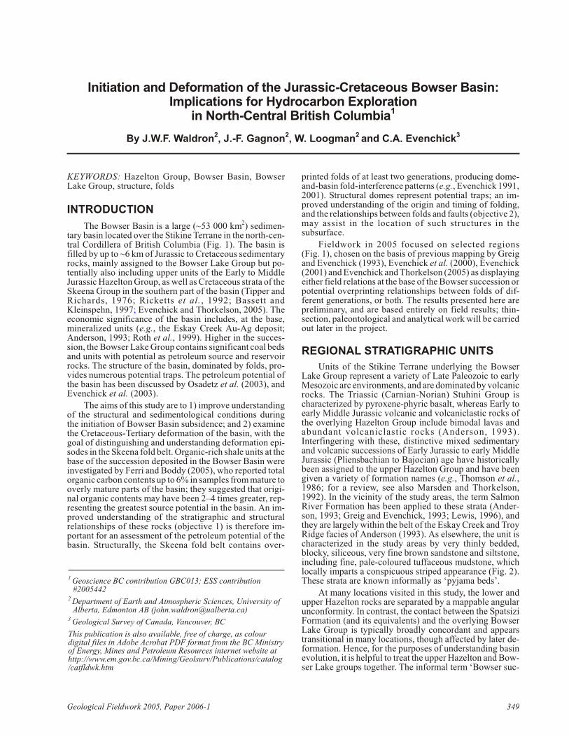
The Bow ser Ba sin is a large (~53 000 km2) sed i men -tary ba sin lo cated over the Stikine Terrane in the north-cen -tral Cor dil lera of Brit ish Co lum bia (Fig. 1). The ba sin isfilled by up to ~6 km of Ju ras sic to Cre ta ceous sed i men taryrocks, mainly as signed to the Bow ser Lake Group but po -ten tially also in clud ing up per units of the Early to Mid dleJu ras sic Hazelton Group, as well as Cre ta ceous strata of theSkeena Group in the south ern part of the ba sin (Tip per andRich ards, 1976; Ricketts et al., 1992; Bassett andKleinspehn, 1997; Evenchick and Thorkelson, 2005). Theeco nomic sig nif i cance of the ba sin in cludes, at the base,min er al ized units (e.g., the Eskay Creek Au-Ag de posit;An der son, 1993; Roth et al., 1999). Higher in the suc ces -sion, the Bow ser Lake Group con tains sig nif i cant coal beds and units with po ten tial as pe tro leum source and res er voirrocks. The struc ture of the ba sin, dom i nated by folds, pro -vides nu mer ous po ten tial traps. The pe tro leum po ten tial ofthe ba sin has been dis cussed by Osadetz et al. (2003), andEvenchick et al. (2003).
The aims of this study are to 1) im prove un der stand ingof the struc tural and sedimentological con di tions dur ingthe ini ti a tion of Bow ser Ba sin sub si dence; and 2) ex am inethe Cre ta ceous-Ter tiary de for ma tion of the ba sin, with thegoal of dis tin guish ing and un der stand ing de for ma tion ep i -sodes in the Skeena fold belt. Or ganic-rich shale units at the base of the suc ces sion de pos ited in the Bow ser Ba sin werein ves ti gated by Ferri and Boddy (2005), who re ported to talor ganic car bon con tents up to 6% in sam ples from ma ture to overly ma ture parts of the ba sin; they sug gested that orig i -nal or ganic con tents may have been 2–4 times greater, rep -re sent ing the great est source po ten tial in the ba sin. An im -proved un der stand ing of the strati graphic and struc turalre la tion ships of these rocks (ob jec tive 1) is there fore im -por tant for an as sess ment of the pe tro leum po ten tial of theba sin. Struc tur ally, the Skeena fold belt con tains over -
printed folds of at least two gen er a tions, pro duc ing dome-and-ba sin fold-in ter fer ence pat terns (e.g., Evenchick 1991, 2001). Struc tural domes rep re sent po ten tial traps; an im -proved un der stand ing of the or i gin and tim ing of fold ing,and the re la tion ships be tween folds and faults (ob jec tive 2), may as sist in the lo ca tion of such struc tures in thesubsurface.
Field work in 2005 fo cused on se lected re gions(Fig. 1), cho sen on the ba sis of pre vi ous map ping by Greigand Evenchick (1993), Evenchick et al. (2000), Evenchick(2001) and Evenchick and Thorkelson (2005) as dis play ing ei ther field re la tions at the base of the Bow ser suc ces sion or po ten tial over print ing re la tion ships be tween folds of dif -fer ent gen er a tions, or both. The re sults pre sented here arepre lim i nary, and are based en tirely on field re sults; thin-sec tion, paleontological and an a lyt i cal work will be car riedout later in the pro ject.
REGIONAL STRATIGRAPHIC UNITS
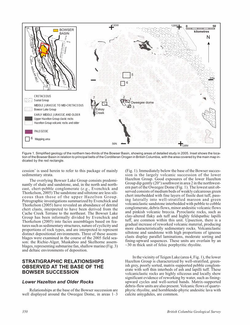
Units of the Stikine Terrane un der ly ing the Bow serLake Group rep re sent a va ri ety of Late Pa leo zoic to earlyMe so zoic arc en vi ron ments, and are dom i nated by vol ca nic rocks. The Tri as sic (Carnian-Norian) Stuhini Group ischar ac ter ized by pyroxene-phyric ba salt, whereas Early toearly Mid dle Ju ras sic vol ca nic and volcaniclastic rocks ofthe over ly ing Hazelton Group in clude bi modal lavas andabun dant volcaniclastic rocks (An der son, 1993).Interfingering with these, dis tinc tive mixed sed i men taryand vol ca nic suc ces sions of Early Ju ras sic to early Mid dleJu ras sic (Pliensbachian to Bajocian) age have his tor i callybeen as signed to the up per Hazelton Group and have beengiven a va ri ety of for ma tion names (e.g., Thomson et al.,1986; for a re view, see also Mar sden and Thorkelson,1992). In the vi cin ity of the study ar eas, the term SalmonRiver For ma tion has been ap plied to these strata (An der -son, 1993; Greig and Evenchick, 1993; Lewis, 1996), andthey are largely within the belt of the Eskay Creek and TroyRidge fa cies of An der son (1993). As else where, the unit ischar ac ter ized in the study ar eas by very thinly bed ded,blocky, si li ceous, very fine brown sand stone and siltstone,in clud ing fine, pale-col oured tuffaceous mudstone, whichlo cally im parts a con spic u ous striped ap pear ance (Fig. 2).These strata are known in for mally as ‘py jama beds’.
At many lo ca tions vis ited in this study, the lower andup per Hazelton rocks are sep a rated by a mappable an gu larun con formity. In con trast, the con tact be tween the SpatsiziFor ma tion (and its equiv a lents) and the over ly ing Bow serLake Group is typ i cally broadly con cor dant and ap pearstran si tional in many lo ca tions, though af fected by later de -for ma tion. Hence, for the pur poses of un der stand ing ba sinevo lu tion, it is help ful to treat the up per Hazelton and Bow -ser Lake groups to gether. The in for mal term ‘Bow ser suc -
Geo log i cal Field work 2005, Pa per 2006-1 349
1 Geoscience BC contribution GBC013; ESS contribution#2005442
2 Department of Earth and Atmospheric Sciences, University ofAlberta, Edmonton AB ([email protected])
3 Geological Survey of Canada, Vancouver, BC
This publication is also available, free of charge, as colourdigital files in Adobe Acrobat PDF format from the BC Ministry of Energy, Mines and Petroleum Resources internet website athttp://www.em.gov.bc.ca/Mining/Geolsurv/Publications/catalog/catfldwk.htm
ces sion’ is used herein to re fer to this pack age of mainlysed i men tary strata.
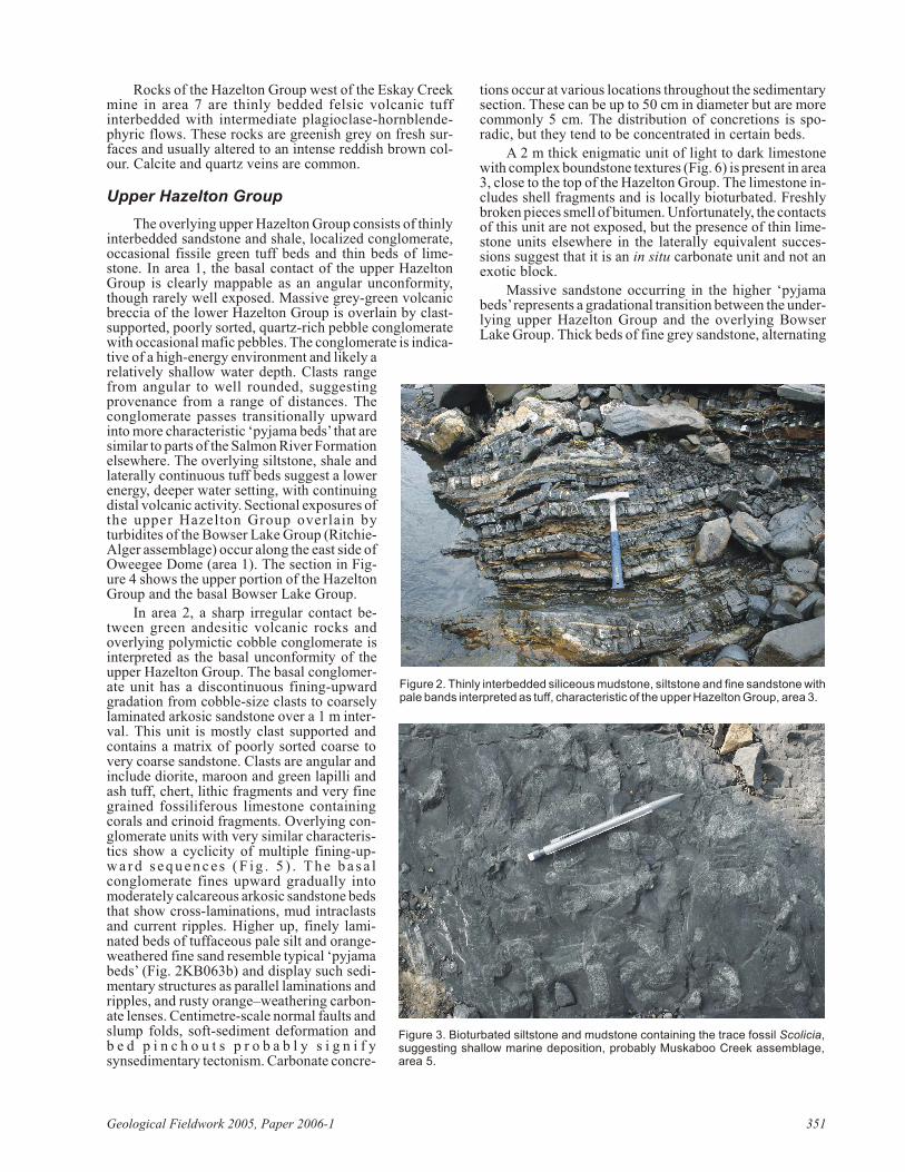
The over ly ing Bow ser Lake Group con sists pre dom i -nantly of shale and sand stone, and, in the north and north -east, chert-peb ble con glom er ate (e.g., Evenchick andThorkelson, 2005) The sand stone and siltstone are less si li -ceous than those of the up per Hazel ton Group.Petrographic in ves ti ga tions sum ma rized by Evenchick andThorkelson (2005) have re vealed an abun dance of de tri talchert clasts, in ter preted to have been de rived from theCache Creek Terrane to the north east. The Bow ser LakeGroup has been in for mally di vided by Evenchick andThorkelson (2005) into fa cies as sem blages based on fea -tures such as sed i men tary struc tures, na ture of cyclicity and pro por tions of rock types, and are in ter preted to rep re sentdis tinct depositional en vi ron ments. Three of these as sem -blages were ex am ined in the course of the 2005 field sea -son: the Richie-Alger, Muskaboo and Skelhorne as sem -blages, rep re sent ing sub ma rine fan, shal low ma rine (Fig. 3) and deltaic en vi ron ments of de po si tion.
STRATIGRAPHIC RELATIONSHIPSOBSERVED AT THE BASE OF THEBOWSER SUCCESSION
Lower Hazelton and Older Rocks
Re la tion ships at the base of the Bow ser suc ces sion arewell dis played around the Oweegee Dome, in ar eas 1–3
(Fig. 1). Im me di ately be low the base of the Bow ser suc ces -sion is the largely vol ca nic suc ces sion of the lowerHazelton Group. Good ex po sures of the lower HazeltonGroup dip gently (20°) south west in area 2 in the north west -ern part of the Oweegee Dome (Fig. 1). The low est unit ob -served con sists of me dium beds of weakly cal car e ous green chert interbedded with fine lay ers of fis sile dust tuff, pass -ing lat er ally into well-strat i fied ma roon and greenvolcaniclastic sand stone interbedded with peb ble to cob blecon glom er ate, de bris flows, mi nor andesitic vol ca nic flows and pink ish vol ca nic brec cia. Pyroclastic rocks, such asclay-al tered flaky ash tuff and highly feldspathic lapillituff, are com mon within this unit. Upsection, there is agrad ual in crease of re worked vol ca nic ma te rial, pro duc ingmore char ac ter is ti cally sed i men tary rocks. Volcaniclasticsiltstone and sand stone with high pro por tions of ig ne ousclasts dis play par al lel lami na tions, mod er ate sort ing andfin ing-up ward se quences. These units are over lain by an~30 m thick unit of fel sic por phy ritic rhy o lite.
In the vi cin ity of Teigen Lake (area 4, Fig. 1), the lower Hazelton Group is char ac ter ized by well-strat i fied, green -ish grey, poorly sorted, ma trix-sup ported peb ble con glom -er ate with soft thin interbeds of ash and lapilli tuff. Thesevolcaniclastic rocks are highly si li ceous and lo cally showsig nif i cant ev i dence of re work ing by wa ter, such as fin ing-up ward cy cles and well-sorted bands. Ma trix-sup portedde bris-flow units are also pres ent. Vol ca nic flows of quartz-phyric rhy o lite, and hornblende-phyric andesitic lava withcal cite amygdules, are com mon.
350 Brit ish Co lum bia Geo log i cal Sur vey
LIM
IT OF CORDILLERAN D
EF
OR
MAT
ION
FO
RE
LAN
D B
ELT
FO
RE
LAN
D B
ELTIN
TERM
ON
TANE BELT
INTER
MO
NTAN
E BELTO
MIN
EC
A B
ELT
INTER
MO
NTAN
E BELT
CO
AS
T BE
LT
CO
AS
T BE
LT
INS
ULA
R B
ELT
FO
RE
LAN
D B
ELT
60°N
49°N
120°
WA
LBE
RTA
BR
ITIS
H C
OLU
MB
IA
BOWSERBASIN
CO
AS
T BE
LT
1122
33
44
55
66
77
Oweegee domeOweegee dome
EskayCreekEskayCreek
12
3
4
5
6
7
Oweegee dome
EskayCreek
CRETACEOUS
Sustut Group
MIDDLE JURASSIC TO MID-CRETACEOUS
Bowser Lake Group
EARLY MIDDLE JURASSIC AND OLDER
Upper Hazelton Group clastic rocks
Hazelton Group volcanic rocks and older
Mapping area
PALEOZOIC
6
57N
o56No128W
kilometres
500130W 128W
N
Fig ure 1. Sim pli fied ge ol ogy of the north ern two-thirds of the Bow ser Ba sin, show ing ar eas of de tailed study in 2005. In set shows the lo ca -tion of the Bow ser Ba sin in re la tion to prin ci pal belts of the Cordilleran Orogen in Brit ish Co lum bia, with the area cov ered by the main map in -di cated by the red rect an gle.
Rocks of the Hazelton Group west of the Eskay Creekmine in area 7 are thinly bed ded fel sic vol ca nic tuffinterbedded with in ter me di ate plagioclase-hornblende-phyric flows. These rocks are green ish grey on fresh sur -faces and usu ally al tered to an in tense red dish brown col -our. Cal cite and quartz veins are com mon.
Upper Hazelton Group
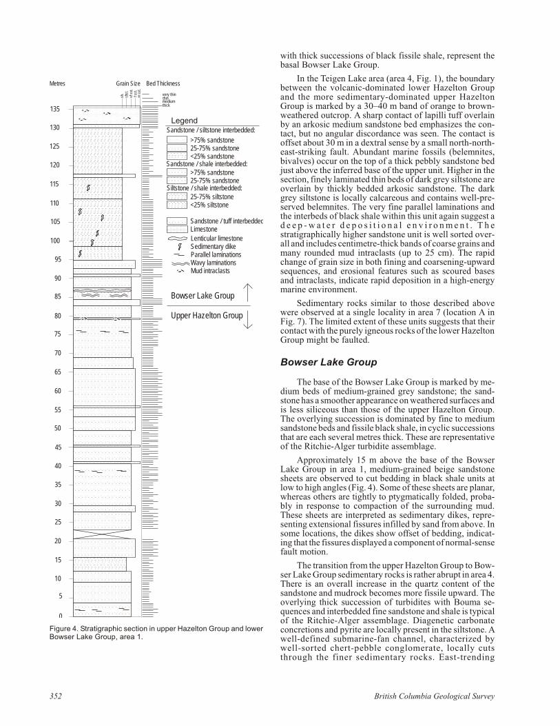
The over ly ing up per Hazelton Group con sists of thinly interbedded sand stone and shale, lo cal ized con glom er ate,oc ca sional fis sile green tuff beds and thin beds of lime -stone. In area 1, the basal con tact of the up per HazeltonGroup is clearly mappable as an an gu lar un con formity,though rarely well ex posed. Mas sive grey-green vol ca nicbrec cia of the lower Hazelton Group is over lain by clast-sup ported, poorly sorted, quartz-rich peb ble con glom er atewith oc ca sional mafic peb bles. The con glom er ate is in dic a -tive of a high-en ergy en vi ron ment and likely arel a tively shal low wa ter depth. Clasts rangefrom an gu lar to well rounded, sug gest ingprov e nance from a range of dis tances. Thecon glom er ate passes tran si tion ally up wardinto more char ac ter is tic ‘py jama beds’ that aresim i lar to parts of the Salmon River For ma tion else where. The over ly ing siltstone, shale andlat er ally con tin u ous tuff beds sug gest a loweren ergy, deeper wa ter set ting, with con tin u ingdis tal vol ca nic ac tiv ity. Sec tional ex po sures of the up per Hazelton Group over lain byturbidites of the Bow ser Lake Group (Ritchie-Alger as sem blage) oc cur along the east side of Oweegee Dome (area 1). The sec tion in Fig -ure 4 shows the up per por tion of the HazeltonGroup and the basal Bow ser Lake Group.
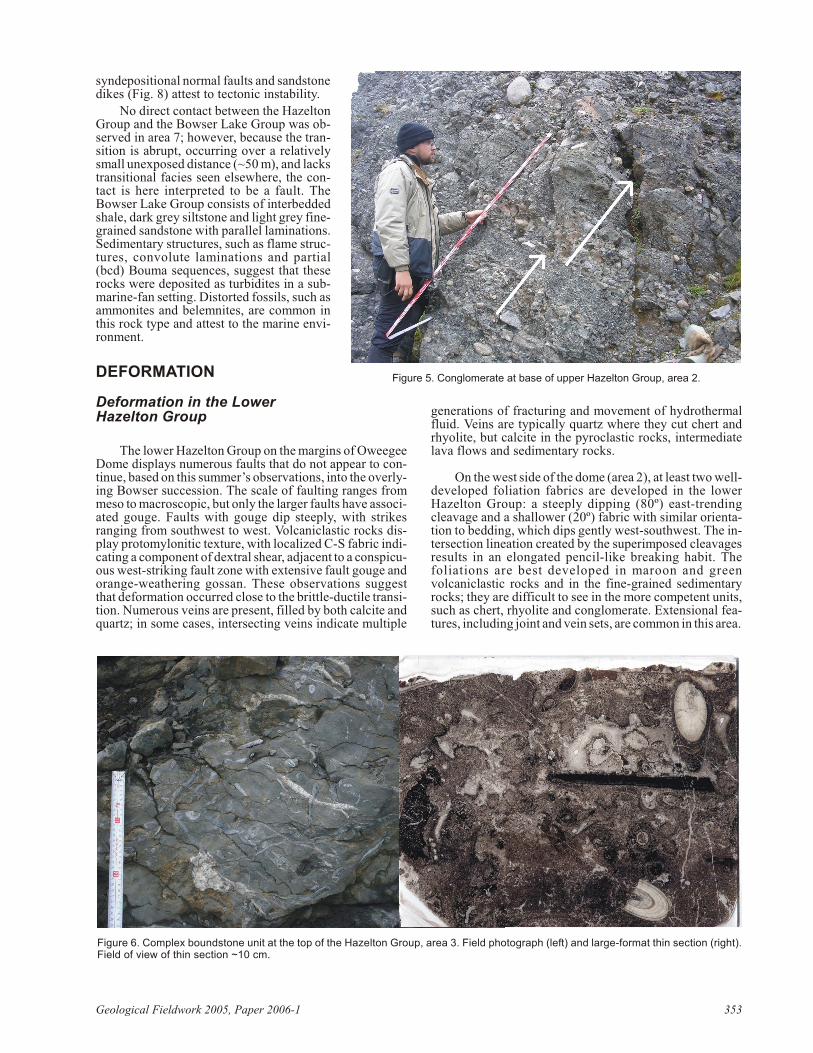
In area 2, a sharp ir reg u lar con tact be -tween green andesitic vol ca nic rocks andover ly ing polymictic cob ble con glom er ate isin ter preted as the basal un con formity of theup per Hazelton Group. The basal con glom er -ate unit has a dis con tin u ous fin ing-up wardgra da tion from cob ble-size clasts to coarselylam i nated arkosic sand stone over a 1 m in ter -val. This unit is mostly clast sup ported andcon tains a ma trix of poorly sorted coarse tovery coarse sand stone. Clasts are an gu lar andin clude diorite, ma roon and green lapilli andash tuff, chert, lithic frag ments and very finegrained fossiliferous lime stone con tain ingcor als and cri noid frag ments. Over ly ing con -glom er ate units with very sim i lar char ac ter is -tics show a cyclicity of mul ti ple fin ing-up -w a r d s e q u e n c es ( F ig . 5 ) . T h e b a s a lcon glom er ate fines up ward grad u ally intomod er ately cal car e ous arkosic sand stone beds that show cross-lami na tions, mud intraclastsand cur rent rip ples. Higher up, finely lam i -nated beds of tuffaceous pale silt and or ange-weath ered fine sand re sem ble typ i cal ‘py jamabeds’ (Fig. 2KB063b) and dis play such sed i -men tary struc tures as par al lel lami na tions andrip ples, and rusty or ange–weath er ing car bon -ate lenses. Centi metre-scale nor mal faults and slump folds, soft-sed i ment de for ma tion andb e d p i n c h o u t s p r o b a b l y s i g n i f ysynsedimentary tectonism. Car bon ate con cre -
tions oc cur at var i ous lo ca tions through out the sed i men tary sec tion. These can be up to 50 cm in di am e ter but are morecom monly 5 cm. The dis tri bu tion of con cre tions is spo -radic, but they tend to be con cen trated in cer tain beds.
A 2 m thick enig matic unit of light to dark lime stonewith com plex boundstone tex tures (Fig. 6) is pres ent in area 3, close to the top of the Hazelton Group. The lime stone in -cludes shell frag ments and is lo cally bioturbated. Freshlybro ken pieces smell of bi tu men. Un for tu nately, the con tacts of this unit are not ex posed, but the pres ence of thin lime -stone units else where in the lat er ally equiv a lent suc ces -sions sug gest that it is an in situ car bon ate unit and not anex otic block.
Mas sive sand stone oc cur ring in the higher ‘py jamabeds’ rep re sents a gradational tran si tion be tween the un der -ly ing up per Hazelton Group and the over ly ing Bow serLake Group. Thick beds of fine grey sand stone, al ter nat ing
Geo log i cal Field work 2005, Pa per 2006-1 351
Fig ure 2. Thinly interbedded si li ceous mudstone, siltstone and fine sand stone with pale bands in ter preted as tuff, char ac ter is tic of the up per Hazelton Group, area 3.
Fig ure 3. Bioturbated siltstone and mudstone con tain ing the trace fos sil Scolicia,sug gest ing shal low ma rine de po si tion, prob a bly Muskaboo Creek as sem blage,area 5.
with thick suc ces sions of black fis sile shale, rep re sent thebasal Bow ser Lake Group.
In the Teigen Lake area (area 4, Fig. 1), the bound arybe tween the vol ca nic-dom i nated lower Hazelton Groupand the more sed i men tary-dom i nated up per HazeltonGroup is marked by a 30–40 m band of or ange to brown-weath ered out crop. A sharp con tact of lapilli tuff over lainby an arkosic me dium sand stone bed em pha sizes the con -tact, but no an gu lar dis cor dance was seen. The con tact isoff set about 30 m in a dextral sense by a small north-north -east-strik ing fault. Abun dant ma rine fos sils (bel em nites,bi valves) oc cur on the top of a thick peb bly sand stone bedjust above the in ferred base of the up per unit. Higher in thesec tion, finely lam i nated thin beds of dark grey siltstone are over lain by thickly bed ded arkosic sand stone. The darkgrey siltstone is lo cally cal car e ous and con tains well-pre -served bel em nites. The very fine par al lel lami na tions andthe interbeds of black shale within this unit again sug gest ad e e p - w a t e r d e p o s i t i o n a l e n v i r o n m e n t . T h estratigraphically higher sand stone unit is well sorted over -all and in cludes centi metre-thick bands of coarse grains and many rounded mud intraclasts (up to 25 cm). The rapidchange of grain size in both fin ing and coars en ing-up wardse quences, and ero sional fea tures such as scoured basesand intraclasts, in di cate rapid de po si tion in a high-en ergyma rine en vi ron ment.
Sed i men tary rocks sim i lar to those de scribed abovewere ob served at a sin gle lo cal ity in area 7 (lo ca tion A inFig. 7). The lim ited ex tent of these units sug gests that theircon tact with the purely ig ne ous rocks of the lower Hazelton Group might be faulted.
Bowser Lake Group
The base of the Bow ser Lake Group is marked by me -dium beds of me dium-grained grey sand stone; the sand -stone has a smoother ap pear ance on weath ered sur faces and is less si li ceous than those of the up per Hazelton Group.The over ly ing suc ces sion is dom i nated by fine to me diumsand stone beds and fis sile black shale, in cy clic suc ces sions that are each sev eral metres thick. These are rep re sen ta tiveof the Ritchie-Alger turbidite as sem blage.
Ap prox i mately 15 m above the base of the Bow serLake Group in area 1, me dium-grained beige sand stonesheets are ob served to cut bed ding in black shale units atlow to high an gles (Fig. 4). Some of these sheets are pla nar,whereas oth ers are tightly to ptygmatically folded, prob a -bly in re sponse to com pac tion of the sur round ing mud.These sheets are in ter preted as sed i men tary dikes, rep re -sent ing extensional fis sures infilled by sand from above. Insome lo ca tions, the dikes show off set of bed ding, in di cat -ing that the fis sures dis played a com po nent of nor mal-sense fault mo tion.
The tran si tion from the up per Hazelton Group to Bow -ser Lake Group sed i men tary rocks is rather abrupt in area 4. There is an over all in crease in the quartz con tent of thesand stone and mudrock be comes more fis sile up ward. Theover ly ing thick suc ces sion of turbidites with Bouma se -quences and interbedded fine sand stone and shale is typ i calof the Ritchie-Alger as sem blage. Diagenetic car bon atecon cre tions and py rite are lo cally pres ent in the siltstone. Awell-de fined sub ma rine-fan chan nel, char ac ter ized bywell-sorted chert-peb ble con glom er ate, lo cally cutsthrough the finer sed i men tary rocks. East-trending
Fig ure 4. Strati graphic sec tion in up per Hazelton Group and lowerBow ser Lake Group, area 1.
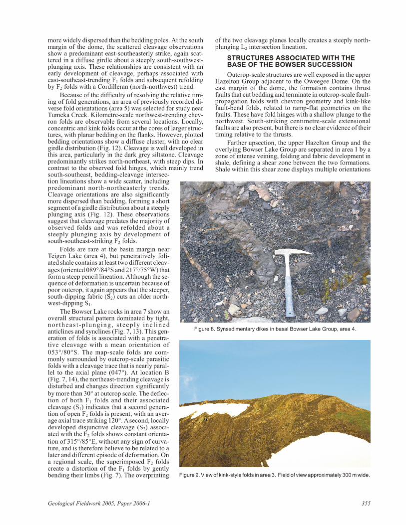
syndepositional nor mal faults and sand stone dikes (Fig. 8) at test to tec tonic in sta bil ity.
No di rect con tact be tween the HazeltonGroup and the Bow ser Lake Group was ob -served in area 7; how ever, be cause the tran -si tion is abrupt, oc cur ring over a rel a tivelysmall un ex posed dis tance (~50 m), and lacks tran si tional fa cies seen else where, the con -tact is here in ter preted to be a fault. TheBow ser Lake Group con sists of interbeddedshale, dark grey siltstone and light grey fine-grained sand stone with par al lel lami na tions.Sed i men tary struc tures, such as flame struc -tures, con vo lute lami na tions and par tial(bcd) Bouma se quences, sug gest that theserocks were de pos ited as turbidites in a sub -ma rine-fan set ting. Dis torted fos sils, such asammonites and bel em nites, are com mon inthis rock type and at test to the ma rine en vi -ron ment.
DEFORMATION
Deformation in the LowerHazelton Group
The lower Hazelton Group on the mar gins of OweegeeDome dis plays nu mer ous faults that do not ap pear to con -tinue, based on this sum mer’s ob ser va tions, into the over ly -ing Bow ser suc ces sion. The scale of fault ing ranges frommeso to mac ro scopic, but only the larger faults have as so ci -ated gouge. Faults with gouge dip steeply, with strikesrang ing from south west to west. Volcaniclastic rocks dis -play protomylonitic tex ture, with lo cal ized C-S fab ric in di -cat ing a com po nent of dextral shear, ad ja cent to a con spic u -ous west-strik ing fault zone with ex ten sive fault gouge andor ange-weath er ing gos san. These ob ser va tions sug gestthat de for ma tion oc curred close to the brit tle-duc tile tran si -tion. Nu mer ous veins are pres ent, filled by both cal cite andquartz; in some cases, in ter sect ing veins in di cate mul ti ple
gen er a tions of frac tur ing and move ment of hy dro ther malfluid. Veins are typ i cally quartz where they cut chert andrhy o lite, but cal cite in the pyroclastic rocks, in ter me di atelava flows and sed i men tary rocks.
On the west side of the dome (area 2), at least two well-de vel oped fo li a tion fab rics are de vel oped in the lowerHazelton Group: a steeply dip ping (80º) east-trendingcleav age and a shal lower (20º) fab ric with sim i lar ori en ta -tion to bed ding, which dips gently west-south west. The in -ter sec tion lineation cre ated by the su per im posed cleav agesre sults in an elon gated pen cil-like break ing habit. Thefoliations are best de vel oped in ma roon and greenvolcaniclastic rocks and in the fine-grained sed i men taryrocks; they are dif fi cult to see in the more com pe tent units,such as chert, rhy o lite and con glom er ate. Extensional fea -tures, in clud ing joint and vein sets, are com mon in this area.
Geo log i cal Field work 2005, Pa per 2006-1 353
Fig ure 5. Con glom er ate at base of up per Hazelton Group, area 2.
Fig ure 6. Com plex boundstone unit at the top of the Hazelton Group, area 3. Field pho to graph (left) and large-for mat thin sec tion (right).Field of view of thin sec tion ~10 cm.
Deformation in the Bowser Succession
REGIONAL FOLDS AND CLEAVAGE
Oweegee Dome Area
Pre vi ous map ping was car ried out in the OweegeeDome area by Greig and Evenchick (1993). The au thorshave ex am ined se lected ar eas in de tail (Fig. 1), con firm ingthe map-scale struc tures shown by them. Folds, with wave -lengths es ti mated to range from hun dreds of metres to kilo -metres, oc cur in the Bow ser Lake Group over ly ing theOweegee Dome. In gen eral, the am pli tude of fold ing in -creases away from the mar gins of the dome, sug gest ing thatshort en ing in higher parts of the stra tig ra phy is bal anced byfaults or duc tile shear ing deeper in the suc ces sion. At leastsome of the folds are there fore prob a bly de tach ment folds(e.g., Jamison, 1987) re lated to shear ing in the lower shalystrata of the Bow ser Lake Group. Most folds trend south-
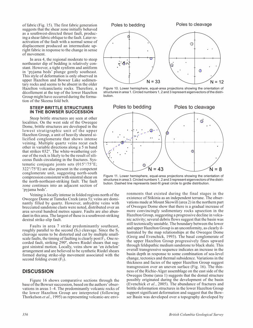
south east in this area and plunge gently; south-south westand north-north east-plung ing folds are pres ent lo cally. Fig -ure 9 dis plays a typ i cal kink-fold pair, with fold hingesplung ing gently north-north west. Smaller folds, withwave lengths of metres to tens of metres, are lo cally abun -dant, par tic u larly in area 3. Plots of poles to bed ding fromse lected ar eas around the Oweegee Dome clearly show gir -dle dis tri bu tions re lated to the pre dom i nant fold axes thattrend south-south east (Fig. 10, 11), con sis tent with the ma -jor struc tures mapped by Greig and Evenchick (1993).
Cleav age is very spo rad i cally de vel oped around theOweegee Dome; cleav age ori en ta tions are also plot ted inFig ures 10 and 11. Lo cal pen cil fab ric was ob served, re sult -ing from si mul ta neous split ting of the rock along tec toniccleav age and a strong bed-par al lel fab ric. On the east mar -gin of the dome, a ma jor ity of cleav age ori en ta tions strikesouth-south east and could be con sis tent with an ax ial-pla -nar re la tion ship to the main folds. How ever, they are much
354 Brit ish Co lum bia Geo log i cal Sur vey
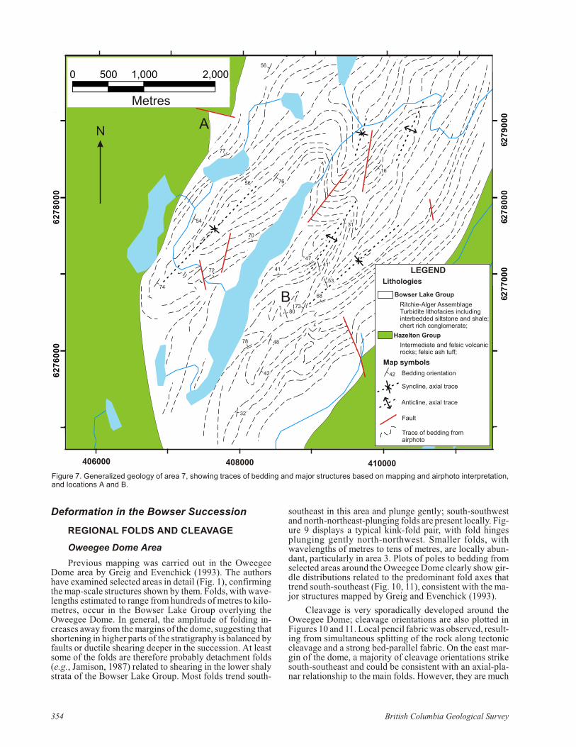
Fig ure 7. Gen er al ized ge ol ogy of area 7, show ing traces of bed ding and ma jor struc tures based on map ping and airphoto in ter pre ta tion,and lo ca tions A and B.
more widely dis persed than the bed ding poles. At the southmar gin of the dome, the scat tered cleav age ob ser va tionsshow a pre dom i nant east-south east erly strike, again scat -tered in a dif fuse gir dle about a steeply south-south west-plung ing axis. These re la tion ships are con sis tent with anearly de vel op ment of cleav age, per haps as so ci ated witheast-south east-trending F1 folds and sub se quent refoldingby F2 folds with a Cordilleran (north-north west) trend.
Be cause of the dif fi culty of re solv ing the rel a tive tim -ing of fold gen er a tions, an area of pre vi ously re corded di -verse fold ori en ta tions (area 5) was se lected for study nearTumeka Creek. Kilo metre-scale north west-trending chev -ron folds are ob serv able from sev eral lo ca tions. Lo cally,con cen tric and kink folds oc cur at the cores of larger struc -tures, with pla nar bed ding on the flanks. How ever, plot tedbed ding ori en ta tions show a dif fuse clus ter, with no cleargir dle dis tri bu tion (Fig. 12). Cleav age is well de vel oped inthis area, par tic u larly in the dark grey siltstone. Cleav agepre dom i nantly strikes north-north east, with steep dips. Incon trast to the ob served fold hinges, which mainly trendsouth-south east, bed ding-cleav age in ter sec -tion lineations show a wide scat ter, in clud ingpre dom i nant north-north east erly trends.Cleav age ori en ta tions are also sig nif i cantlymore dis persed than bed ding, form ing a shortseg ment of a gir dle dis tri bu tion about a steeply plung ing axis (Fig. 12). These ob ser va tionssug gest that cleav age pre dates the ma jor ity ofob served folds and was re folded about asteeply plung ing axis by de vel op ment ofsouth-south east-strik ing F2 folds.
Folds are rare at the ba sin mar gin nearTeigen Lake (area 4), but penetratively fo li -ated shale con tains at least two dif fer ent cleav -ages (ori ented 089°/84°S and 217°/75°W) that form a steep pen cil lineation. Al though the se -quence of de for ma tion is un cer tain be cause ofpoor out crop, it again ap pears that the steeper,south-dip ping fab ric (S2) cuts an older north -west-dip ping S1.
The Bow ser Lake rocks in area 7 show anover all struc tural pat tern dom i nated by tight,nor th eas t -p lung ing , s t eep ly in c l inedanticlines and syn clines (Fig. 7, 13). This gen -er a tion of folds is as so ci ated with a pen e tra -tive cleav age with a mean ori en ta tion of053°/80°S. The map-scale folds are com -monly sur rounded by out crop-scale par a siticfolds with a cleav age trace that is nearly par al -lel to the ax ial plane (047°). At lo ca tion B(Fig. 7, 14), the north east-trending cleav age isdis turbed and changes di rec tion sig nif i cantlyby more than 30° at out crop scale. The de flec -tion of both F1 folds and their as so ci atedcleav age (S1) in di cates that a sec ond gen er a -tion of open F2 folds is pres ent, with an av er -age ax ial trace strik ing 120°. A sec ond, lo cally de vel oped dis junc tive cleav age (S2) as so ci -ated with the F2 folds shows con stant ori en ta -tion of 315°/85°E, with out any sign of cur va -ture, and is there fore be lieve to be re lated to alater and dif fer ent ep i sode of de for ma tion. Ona re gional scale, the su per im posed F2 foldscre ate a dis tor tion of the F1 folds by gentlybend ing their limbs (Fig. 7). The over print ing
of the two cleav age planes lo cally cre ates a steeply north-plung ing L2 in ter sec tion lineation.
STRUCTURES ASSOCIATED WITH THEBASE OF THE BOWSER SUCCESSION
Out crop-scale struc tures are well ex posed in the up perHazelton Group ad ja cent to the Oweegee Dome. On theeast mar gin of the dome, the for ma tion con tains thrustfaults that cut bed ding and ter mi nate in out crop-scale fault-prop a ga tion folds with chev ron ge om e try and kink-likefault-bend folds, re lated to ramp-flat ge om e tries on thefaults. These have fold hinges with a shal low plunge to thenorth west. South-strik ing centi metre-scale extensionalfaults are also pres ent, but there is no clear ev i dence of theirtim ing rel a tive to the thrusts.
Far ther upsection, the up per Hazelton Group and theover ly ing Bow ser Lake Group are sep a rated in area 1 by azone of in tense vein ing, fold ing and fab ric de vel op ment inshale, de fin ing a shear zone be tween the two for ma tions.Shale within this shear zone dis plays mul ti ple ori en ta tions
Geo log i cal Field work 2005, Pa per 2006-1 355
Fig ure 8. Synsedimentary dikes in basal Bow ser Lake Group, area 4.
Fig ure 9. View of kink-style folds in area 3. Field of view ap prox i mately 300 m wide.
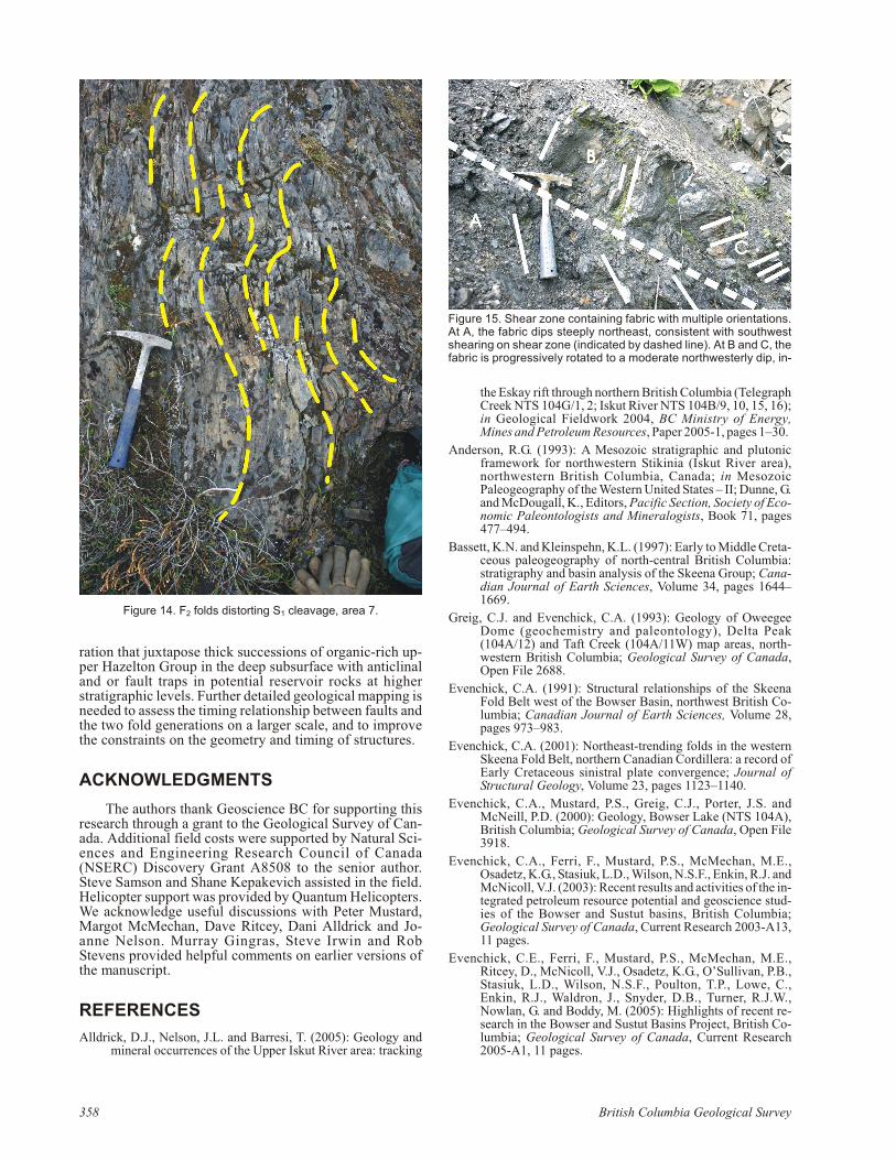
of fab ric (Fig. 15). The first fab ric gen er a tionsug gests that the shear zone ini tially be havedas a south west-di rected thrust fault, pro duc -ing a shear fab ric oblique to the fault. Later re -ac ti va tion of the fault with a nor mal sense ofdis place ment pro duced an in ter me di ate up -right fab ric in re sponse to the change in senseof move ment.
In area 4, the re gional mod er ate to steepnorth easter dip of bed ding is rel a tively con -stant. How ever, a tight synform and antiformin ‘py jama beds’ plunge gently south east.This style of de for ma tion is only ob served inup per Hazelton and Bow ser Lake sed i men -tary rocks and seems to be ab sent in the olderHazelton volcaniclastic rocks. There fore, adécollement at the top of the lower HazeltonGroup might have oc curred dur ing the for ma -tion of the Skeena fold belt.
STEEP BRITTLE STRUCTURESIN THE BOWSER SUCCESSION
Steep brit tle struc tures are seen at otherlo cal i ties. On the west side of the OweegeeDome, brit tle struc tures are de vel oped in thelow est strati graphic unit of the up perHazelton Group, a unit of heavily sheared si -lici fied con glom er ate that shows in tensevein ing. Mul ti ple quartz veins re cut eachother in vari able di rec tions along a 5 m bandthat strikes 032°. The white-weath er ing col -our of the rock is likely to be the re sult of si li -ceous flu ids cir cu lat ing in the frac tures. Sys -tem atic con ju gate joints sets (015°/75°E;322°/75°E) are also pres ent in the com pe tentcon glom er ate unit, sug gest ing north-southcom pres sion con sis tent with sinistral shear on the north-north east-strik ing fault. The faultzone con tin ues into an ad ja cent sec tion of‘py jama beds’.
Vein ing is lo cally in tense in folded re gions north of theOweegee Dome at Tumeka Creek (area 5); veins are dom i -nantly filled by quartz. How ever, anhydrite veins withbrecciated sand stone clasts were noted, dis trib uted over anarea sev eral hun dred metres square. Faults are also abun -dant in this area. The larg est of these is a south west-strik ingdextral strike-slip fault.
Faults in area 7 strike pre dom i nantly south east,roughly par al lel to the sec ond (S2) cleav age. Since the S1
cleav age seems to be dis torted and cut by mul ti ple small-scale faults, the tim ing of fault ing is clearly post F1. One re -corded fault, strik ing 290º, shows Riedel shears that sug -gest sinistral mo tion. Lo cally, veins show an ‘en échelon’ar range ment and are be lieved to be syn thetic Riedel shearsformed dur ing strike-slip move ment as so ci ated with thesec ond fold ing event (F2).
DISCUSSION
Fig ure 16 shows com par a tive sec tions through thebase of the Bow ser suc ces sion, based on the au thors’ ob ser -va tions in ar eas 1–4. The pre dom i nantly vol ca nic rocks ofthe lower Hazelton Group are in ter preted (fol low ingThorkelson et al., 1995) as rep re sent ing vol ca nic-arc en vi -
ron ments that ex isted dur ing the fi nal stages in theex is tence of Stikinia as an in de pend ent terrane. The ob ser -va tions made at Mount Skowill (area 2) in the north ern partof Oweegee Dome show that there is a grad ual in crease ofmore con vinc ingly sed i men tary rocks upsection in theHazelton Group, sug gest ing a pro gres sive de cline in vol ca -nic ac tiv ity; sev eral de bris flows sug gest that the ba sin wasstill tec toni cally un sta ble. The bound ary be tween the lowerand up per Hazelton Group is an un con formity, as clearly il -lus trated by the map re la tion ships at the Oweegee Dome(Greig and Evenchick, 1993). The basal con glom er ate ofthe up per Hazelton Group pro gres sively fines up wardthrough feldspathic me dium sand stone to black shale. Thisover all transgressive se quence in di cates an in crease in theba sin depth in re sponse to some com bi na tion of sea-levelchange, tec ton ics and ther mal sub si dence. Vari a tions in thethick ness and fa cies of the up per Hazelton Group sug gesttrans gres sion over an un even sur face (Fig. 16). The thin -ness of the Richie-Alger as sem blage on the east side of theOweegee Dome (area 1) sug gests that the domal struc turepos si bly orig i nated dur ing the de vel op ment of the ba sin(Evenchick et al., 2005). The abun dance of frac tures andbrit tle de for ma tion struc tures in the lower Hazelton Groupsup port sig nif i cant de for ma tion and sug gest that the Bow -ser Ba sin was de vel oped over a to pog ra phy de vel oped by
356 Brit ish Co lum bia Geo log i cal Sur vey
1
2
N
N = 33
1
2
3
N
N = 12
Poles to bedding Poles to cleavage
3
Fig ure 10. Lower hemi sphere, equal-area pro jec tions show ing the ori en ta tion ofstruc tures in area 1. Cir cled num bers 1, 2 and 3 rep re sent eigenvectors of the dis tri -bu tion.
1
2
3
N
N = 43
1
2
3
N
N = 8
Poles to bedding Poles to cleavage
Fig ure 11. Lower hemi sphere, equal-area pro jec tions show ing the ori en ta tion ofstruc tures in area 3. Cir cled num bers 1, 2 and 3 rep re sent eigenvectors of the dis tri -bu tion. Dashed line rep re sents best-fit great cir cle to gir dle dis tri bu tion.
fault ing of the un der ly ing Stikinia Terrane. Tec tonic in sta -bil ity con tin ued dur ing de po si tion of the early Bow serLake Group, in di cated by an abun dance of synsedimentarydikes.
Fol low ing de po si tion of the Bow ser Lake Group, ma -jor de for ma tion by fold ing oc curred. Cleav age was also de -vel oped lo cally in the shaly units. Most of the mapped ar eas show some in di ca tion of over printed fold gen er a tions and,in most ar eas, ei ther north east or north west-trending foldspre dom i nate, con firm ing the ob ser va tions of Evenchick(2001). Where ev i dence for over print ing is pres ent, the au -thors noted a con sis tent over print ing of gen er ally north -east-trending early folds or north east-strik ing cleav age bylater folds, with less well de vel oped cleav age, that dis play‘Cordilleran’ north west or south east trends. These re sultsare con sis tent with ear lier in ter pre ta tions (Evenchick,2001) that the north east-trending folds were re lated to anearly phase of Me so zoic sinistral transpression in the de vel -op ment of the Cor dil lera. The Cordilleran F2 folds in creasein am pli tude with strati graphic height above the base of theBow ser suc ces sion, sug gest ing that de tach ment oc curred at this level, in ad di tion to those be low and above in ter pretedby Evenchick (1991). Low-an gle thrusts that post date S1
cleav age, ob served near the base of the suc ces sion, wereprob a bly de vel oped as a re sult of this pro cess.
At sev eral lo ca tions, mi nor extensional struc tureswere ob served that ap pear to post date F2 fold ing. The au -thors spec u late that these de vel oped dur ing Ce no zoic ex -ten sion, or per haps dextral transtension.
North east-trending F1 and S1 struc tures are much morein tensely de vel oped in area 7 than else where. This area co -in cides with the re gion of back-arc ex ten sion, or Eskay rift(e.g. An der son, 1993; Alldrick et al., 2005), a ma jor struc -ture in the un der ly ing Hazelton Group that con trols the dis -tri bu tion of fa cies and min er al iza tion. The au thors spec u -late that the faults as so ci ated with ex ten sion were in verteddur ing the early stages of short en ing in the Bow ser Ba sin,and that the north east-trending struc tures roughly fol lowpre-Bow ser extensional fea tures in un der ly ing Stikinia.Since the Eskay Creek mine is lo cated in a fault-boundedanticline, un der stand ing the tim ing of the dif fer ent struc -tural el e ments that char ac ter ize the Bow ser Lake rocks ispo ten tially use ful for pre dict ing the lo ca tion of the Eskayho ri zon (and pos si ble min eral de pos its) that might oc cur inthe shal low subsurface. In ad di tion, in ver sion struc tures are likely to prop a gate through out the over ly ing Bow ser suc -ces sion, pro vid ing po ten tial tar gets for hy dro car bon ex plo -
Geo log i cal Field work 2005, Pa per 2006-1 357
1
23
N
N = 49
1
2
3
N = 14
Poles to bedding Poles to cleavage Bedding-cleavage intersection lineation
N
2
3
N
N = 57
1
Fig ure 12. Lower hemi sphere, equal-area pro jec tions show ing the ori en ta tion of struc tures in area 5. Cir cled num bers 1, 2 and 3 rep -re sent eigenvectors of the dis tri bu tion. Dashed line rep re sents best-fit great cir cle to gir dle dis tri bu tion.
1
2
3
NEqual Area(Schmidt)
Axial N = 28
1
2
3
NEqual Area(Schmidt)
Axial N = 78
1
2
3
NEqual Area(Schmidt)
Axial N = 66
N=78 N=66 N=28
Poles to bedding Poles to cleavage Bedding-cleavageintersection lineation
Fig ure 13. Lower hemi sphere, equal-area pro jec tions show ing the ori en ta tion of struc tures in area 7. Cir cled num bers 1, 2 and 3 rep -re sent eigenvectors of dis tri bu tion. Dashed line rep re sents best-fit great cir cle to gir dle dis tri bu tion.
ra tion that jux ta pose thick suc ces sions of or ganic-rich up -per Hazelton Group in the deep subsurface with an ti cli naland or fault traps in po ten tial res er voir rocks at higherstrati graphic lev els. Fur ther de tailed geo log i cal map ping isneeded to as sess the tim ing re la tion ship be tween faults andthe two fold gen er a tions on a larger scale, and to im provethe con straints on the ge om e try and tim ing of struc tures.
ACKNOWLEDGMENTS
The au thors thank Geoscience BC for sup port ing thisre search through a grant to the Geo log i cal Sur vey of Can -ada. Ad di tional field costs were sup ported by Nat u ral Sci -ences and En gi neer ing Re search Coun cil of Can ada(NSERC) Dis cov ery Grant A8508 to the se nior au thor.Steve Sam son and Shane Kepakevich as sisted in the field.He li cop ter sup port was pro vided by Quan tum He li cop ters.We ac knowl edge use ful dis cus sions with Pe ter Mus tard,Margot McMechan, Dave Ritcey, Dani Alldrick and Jo -anne Nel son. Murray Gingras, Steve Irwin and RobStevens pro vided help ful com ments on ear lier ver sions ofthe manu script.
REFERENCES
Alldrick, D.J., Nel son, J.L. and Barresi, T. (2005): Ge ol ogy andmin eral oc cur rences of the Up per Iskut River area: track ing
the Eskay rift through north ern Brit ish Co lum bia (Tele graph Creek NTS 104G/1, 2; Iskut River NTS 104B/9, 10, 15, 16);in Geo log i cal Field work 2004, BC Min is try of En ergy,Mines and Pe tro leum Re sources, Pa per 2005-1, pages 1–30.
An der son, R.G. (1993): A Me so zoic strati graphic and plutonicframe work for north west ern Stikinia (Iskut River area),north west ern Brit ish Co lum bia, Can ada; in Me so zoicPaleogeography of the West ern United States – II; Dunne, G. and McDougall, K., Ed i tors, Pa cific Sec tion, So ci ety of Eco -nomic Pa le on tol o gists and Min er al o gists, Book 71, pages477–494.
Bassett, K.N. and Kleinspehn, K.L. (1997): Early to Mid dle Cre ta -ceous paleogeography of north-cen tral Brit ish Co lum bia:stra tig ra phy and ba sin anal y sis of the Skeena Group; Ca na -dian Jour nal of Earth Sci ences, Vol ume 34, pages 1644–1669.
Greig, C.J. and Evenchick, C.A. (1993): Ge ol ogy of OweegeeDome (geo chem is try and pa le on tol ogy), Delta Peak(104A/12) and Taft Creek (104A/11W) map ar eas, north -west ern Brit ish Co lum bia; Geo log i cal Sur vey of Can ada,Open File 2688.
Evenchick, C.A. (1991): Struc tural re la tion ships of the SkeenaFold Belt west of the Bow ser Ba sin, north west Brit ish Co -lum bia; Ca na dian Jour nal of Earth Sci ences, Vol ume 28,pages 973–983.
Evenchick, C.A. (2001): North east-trending folds in the west ernSkeena Fold Belt, north ern Ca na dian Cor dil lera: a re cord ofEarly Cre ta ceous sinistral plate con ver gence; Jour nal ofStruc tural Ge ol ogy, Vol ume 23, pages 1123–1140.
Evenchick, C.A., Mus tard, P.S., Greig, C.J., Por ter, J.S. andMcNeill, P.D. (2000): Ge ol ogy, Bow ser Lake (NTS 104A),Brit ish Co lum bia; Geo log i cal Sur vey of Can ada, Open File3918.
Evenchick, C.A., Ferri, F., Mus tard, P.S., McMechan, M.E.,Osadetz, K.G., Stasiuk, L.D., Wil son, N.S.F., Enkin, R.J. and McNicoll, V.J. (2003): Re cent re sults and ac tiv i ties of the in -te grated pe tro leum re source po ten tial and geoscience stud -ies of the Bow ser and Sustut bas ins, Brit ish Co lum bia;Geo log i cal Sur vey of Can ada, Cur rent Re search 2003-A13,11 pages.
Evenchick, C.E., Ferri, F., Mus tard, P.S., McMechan, M.E.,Ritcey, D., McNicoll, V.J., Osadetz, K.G., O’Sullivan, P.B.,Stasiuk, L.D., Wil son, N.S.F., Poulton, T.P., Lowe, C.,Enkin, R.J., Waldron, J., Snyder, D.B., Turner, R.J.W.,Nowlan, G. and Boddy, M. (2005): High lights of re cent re -search in the Bow ser and Sustut Bas ins Pro ject, Brit ish Co -lum bia; Geo log i cal Sur vey of Can ada, Cur rent Re search2005-A1, 11 pages.
358 Brit ish Co lum bia Geo log i cal Sur vey
Fig ure 14. F2 folds dis tort ing S1 cleav age, area 7.
Fig ure 15. Shear zone con tain ing fab ric with mul ti ple ori en ta tions.At A, the fab ric dips steeply north east, con sis tent with south westshear ing on shear zone (in di cated by dashed line). At B and C, thefab ric is pro gres sively ro tated to a mod er ate north west erly dip, in -
Evenchick, C.A. and Thorkelson, D.J. (2005): Ge ol ogy of theSpatsizi River map area, north-cen tral Brit ish Co lum bia;Geo log i cal Sur vey of Can ada, Bul le tin 577.
Ferri, F. and Boddy, M. (2005): Geo chem is try of Early to Mid dleJu ras sic or ganic-rich shales, intermontane bas ins, Brit ishCo lum bia; in Sum mary of Ac tiv i ties 2005, BC Min is try ofEn ergy, Mines and Pe tro leum Re sources, pages 132–151.
Greig, C.J. and Evenchick, C.A. (1993): Ge ol ogy of OweegeeDome (geo chem is try and pa le on tol ogy), Delta Peak(104A/12) and Taft Creek (104A/11W) map ar eas, north -west ern Brit ish Co lum bia; Geo log i cal Sur vey of Can ada,Open File 2688.
Jamison, R.J. (1987): Geo met ric anal y sis of fold de vel op ment inoverthrust ter ranes; Jour nal of Struc tural Ge ol ogy, Vol ume9, pages 207–219.
Lewis, P.D., Toma, A. and Tosdal, R.M., Com pil ers (1996):Metallogenesis of the Iskut River area, north west ern Brit ishCo lum bia; Uni ver sity of Brit ish Co lum bia, Min eral De positRe search Unit, Spe cial Pub li ca tion 1, 325 pages plus mapsat 1:50 000 scale (CD-ROM).
Mar sden, H. and Thorkelson, D.J. (1992): Ge ol ogy of theHazelton vol ca nic belt in Brit ish Co lum bia: im pli ca tions for
the Early to Mid dle Ju ras sic evo lu tion of Stikinia; Tec ton ics, Vol ume 11, pages 1266–1287.
Osadetz, K.G., Evenchick, C.A., Ferri, F., Stasiuk, L.D. and Wil -son, N.S.F. (2003): In di ca tions for ef fec tive pe tro leum sys -tems in Bow ser and Sustut bas ins, north-cen tral Brit ishCo lum bia; in Geo log i cal Field work 2002, BC Min is try ofEn ergy, Mines and Pe tro leum Re sources, Pa per 2003-1,pages 257–264.
Ricketts, B.D., Evenchick, C.A., An der son, R.G. and Murphy,D.C. (1992): Bow ser Ba sin, north ern Brit ish Co lum bia:con straints on the tim ing of ini tial sub si dence and Stikinia –North Amer ica terrane in ter ac tions; Ge ol ogy, Vol ume 20,pages 1119–1122.
Roth, T., Thomp son, J.F.H. and Barrett, T.J. (1999): The pre ciousmetal – rich Eskay Creek de posit, north west ern Brit ish Co -lum bia; in Vol ca nic-As so ci ated Mas sive Sul fide De pos its:Pro cesses and Ex am ples in Mod ern and An cient Set tings,Barrie, C.T. and Hannington, M.D., Ed i tors, Re views in Eco -nomic Ge ol ogy, Vol ume 8, pages 357–373.
Tip per, H.W. and Rich ards, T.A. (1976): Ju ras sic stra tig ra phy andhis tory of north-cen tral Brit ish Co lum bia; Geo log i cal Sur -vey of Can ada, Bul le tin 270.
Fig ure 16. Com par a tive strati graphic sec tions through the up per Hazelton Group in ar eas 1–4.
Thomson, R.C., Smith, P.L. and Tip per, H.W. (1986): Lower toMid dle Ju ras sic (Pliensbachian to Bajocian) stra tig ra phy ofthe north ern Spatsizi area, north-cen tral Brit ish Co lum bia;Ca na dian Jour nal of Earth Sci ences, Vol ume 23, pages1963–1973.
Thorkelson, D.J., Mortensen, J.K., Mar sden, H. and Tay lor, R.P.(1995): Age and tec tonic set ting of Early Ju ras sic vol ca nism
along the north east ern mar gin of the Hazelton Trough,north ern Brit ish Co lum bia; in Ju ras sic Magmatism and Tec -ton ics of the North Amer i can Cor dil lera, Miller, D.M. andBusby, C., Ed i tors, Geo log i cal So ci ety of Amer ica, Spe cialPa per 299, pages 83–94.