Insights from low-temperature thermochronometry intotranspressional deformation and crustal exhumationalong the San Andreas fault in the westernTransverse Ranges, California
Nathan A. Niemi,1 Jamie T. Buscher,2 James A. Spotila,3 Martha A. House,4
and Shari A. Kelley5
Received 21 May 2013; revised 21 October 2013; accepted 28 October 2013; published 20 December 2013.
[1] The San EmigdioMountains are an example of an archetypical, transpressional structuralsystem, bounded to the south by the San Andreas strike-slip fault, and to the north by theactive Wheeler Ridge thrust. Apatite (U-Th)/He and apatite and zircon fission track ages wereobtained along transects across the range and from wells in and to the north of the range.Apatite (U-Th)/He ages are 4–6Ma adjacent to the San Andreas fault, and both (U-Th)/Heand fission track ages grow older with distance to the north from the San Andreas. The youngages north of the San Andreas fault contrast with early Miocene (U-Th)/He ages from MountPinos on the south side of the fault. Restoration of sample paleodepths in the San EmigdioMountains using a regional unconformity at the base of the Eocene Tejon Formation indicatesthat the San Emigdio Mountains represent a crustal fragment that has been exhumed morethan 5 km along the San Andreas fault since late Miocene time. Marked differences in thetiming and rate of exhumation between the northern and southern sides of the San Andreasfault are difficult to reconcile with existing structural models of the western TransverseRanges as a thin-skinned thrust system. Instead, these results suggest that rheologicheterogeneities may play a role in localizing deformation along the Big Bend of the SanAndreas fault as the San Emigdio Mountains are compressed between the crystallinebasement of Mount Pinos and oceanic crust that underlies the southern San Joaquin Valley.
Citation: Niemi, N. A., J. T. Buscher, J. A. Spotila, M. A. House, and S. A. Kelley (2013), Insights from low-temperature
thermochronometry into transpressional deformation and crustal exhumation along the San Andreas fault in the westernTransverse Ranges, California, Tectonics, 32, 1602–1622, doi:10.1002/2013TC003377.
1. Introduction
[2] Spatial and temporal changes in plate boundary defor-mation are reflective of the complex relationship betweenthe deep lithosphere and brittle upper crust [Molnar, 1988;Bourne et al., 1998]. At transpressive plate margins, ruggedmountain chains can straddle the main fault trace, suggesting
that a direct correlation exists between oblique plate motionand tectonic deformation [Sanderson and Marchini, 1984;Teyssier et al., 1995]. Surface features including en echelonfolds, flower structures, and pop-ups found less than 20 kmfrom the main fault strand (i.e., near field) are believed to re-flect upper crustal shortening from fault geometry variations[Sylvester, 1988; Bürgmann, 1991; Vauchez and Nicolas,1991]. Analog and numerical models illustrate that contrac-tional strain scales with convergence, with plate motionobliquities >20° generating significant near-field upper-crustal shortening [Wilcox et al., 1973; Odonne and Vialon,1983; Tikoff and Teyssier, 1994; Dewey et al., 1998;Fossen and Tikoff, 1998], while thermochronometry studiesof active orogens demonstrate that rapid exhumation can befocused along tranpressional fault zones with high plateobliquity [e.g., Fitzgerald et al., 1993; Tippett and Kamp,1993; Foster et al., 1994; Spotila et al., 2001; Thomson,2002]. Despite this broad understanding of the relationshipbetween plate obliquity and near-field crustal deformation,a detailed understanding of the spatial and temporal distribu-tion of crustal deformation along transpressive plate bound-aries is often obscured by complex fault geometries andtranslation along strike-slip fault zones [Spotila et al., 2007b,2007a]. For example, strike-slip fault bends that are typified
Additional supporting information may be found in the online version ofthis article.
1Department of Earth and Environmental Sciences, University ofMichigan, Ann Arbor, Michigan, USA.
2Dipartimento di Scienze della Terra, dell’Ambiente e delle Risorse,Università di Napoli Federico II, Napoli, Italy.
3Department of Geosciences, Virginia Polytechnic Institute and StateUniversity, Blacksburg, Virginia, USA.
4Natural Sciences Division, Pasadena City College, Pasadena,California, USA.
5Department of Earth and Environmental Science, NewMexico Instituteof Mining and Technology, Socorro, New Mexico, USA.
Corresponding author: N. A. Niemi, Department of Earth and EnvironmentalSciences, University of Michigan, 2534 C. C. Little Bldg., 1100 N. UniversityAve., Ann Arbor, MI 48109-1005, USA. ([email protected])
by near-fieldmountainous terrain can havemaximum topogra-phy away from highly contractional fault corners, suggestingthat deformation is variable along strike [Anderson, 1990;Bourne et al., 1998; Teyssier et al., 2002]. Crustal shorteningfound at fault bends can also be transient, ultimately leadingto the propagation of new fault strands and the migration ofstep over faults [Wakabayashi et al., 2004], and thus crustal
slivers found adjacent to strike-slip fault zones can be in theerosional downwearing stage of mountain building despite arugged appearance, having translated away from the activeuplift zone [e.g., Buscher and Spotila, 2007].[3] The primary driver of crustal strain and subsequent
topographic response along strike-slip faults is yet to be un-ambiguously assigned to a unique tectonic process. Someauthors suggest that the evolution of transform fault zonesis controlled by the interplate strength of the main fault strand[e.g., Mount and Suppe, 1987; Zoback et al., 1987; Bunds,2001], with strong faults distributing strain to far-field thrustsand weak fault zones experiencing near-field uplift andstrike-slip faulting in the borderlands [e.g., Cowgill et al.,2004a, 2004b]. The presence of rugged terrain at fault inter-sections along strike-slip fault zones suggests that secondarystructures may play a dominant role on near-field deformationand exhumation, as shown by heterogeneous deformation atrestraining bends considered to be mechanically stable [e.g.,Yule and Sieh, 2003; Dair and Cooke, 2009]. The distributionof near-field deformation may also be related to across-strikevariations in lithospheric strength [Griscom and Jachens,1990; Magistrale and Sanders, 1996; Wakabayashi et al.,2004; Molnar and Dayem, 2010], with crustal shortening fo-cused where strong basement is juxtaposed against weak crust.Because each of these factors may influence deformationalong strike-slip faults, case studies are needed that best eluci-date the primary controls on transpressive deformation.[4] The SanEmigdioMountains are located along thewestern
“Big Bend” of the San Andreas fault, a 300 km restrainingbend with high obliquity (>20°) along the Pacific-NorthAmerica plate boundary [Hill and Dibblee, 1953]. The rangeis considered to be topographically continuous with the ruggedTransverse Ranges to the east (San Gabriel/San BernardinoMountains), and exhibits a similar progressive increase inelevation from the mountain front in the southern SanJoaquin Valley to the modern trace of the San Andreas fault(Figures 1a and 1b). Although high elevations along the traceof the San Andreas fault imply near-field deformation consis-tent with a “weak fault” [Cowgill et al., 2004a, 2004b], activecrustal shortening at the range front along both blind and emer-gent thrust faults (Figures 1b and 2) [Keller et al., 1998] is con-sistent with the development of a far-field thrust systemassociated with a “strong” San Andreas fault [Cowgill et al.,2004a]. In addition to displaying behavior consistent withexpectations for both “weak” and “strong” faults, the SanEmigdio Mountains are also subject to structural complexitiesand rheologic heterogeneities. The intersection of secondarystructures, including the Garlock and Lockwood Valleystrike-slip faults, with the San Andreas fault may play a rolein localizing crustal shortening, thus obscuring the role of theSan Andreas fault in controlling near-field mountain building[e.g., Buscher and Spotila, 2007]. Further, the crystalline base-ment of the San Emigdio Mountains primarily consists ofgneiss, granitoids, and schists emplaced at variable times andcrustal depths [Dibblee, 1973; Ross, 1989; Pickett andSaleeby, 1994; Chapman et al., 2010], possibly generatingzones of weakness that could alter block uplift paths and bulklithospheric strength. The deformation observed in the SanEmigdio Mountains is likely controlled by all of the abovefactors, and constraining the spatial and temporal variationsin crustal shortening is a necessary step toward elucidatingthe relative magnitude of each. Such an understanding is key
Figure 1b
San JoaquinValley Sierra Nevada
Mojave
Coast Ranges
Transverse Ranges
Los AngelesBasin
San EmigdioMountains
San Andreas faultGarlock fault
120°W 119°W 118°W34
°N35
°N
119°30'W 119°15'W 119°W 118°45'W
34°4
5'N
35°N
35°1
5'N
San JoaquinValley
San Emigdio Mtns Tehachapi Mtns
San Gabriel Mtns
Mt. Pinos
PT
WWF
WRT
SAF
GF
BPFLVF
FMT
Figure 2.
b
Historic
Ml 4.5 - Mw 7.5
HoloceneLate QuaternaryQuaternary
Most Recent Fault Rupture
Historic Earthquakes
1952 Kern Countyearthquakes
Pacific Ocean
a
Figure 1. (a) The San Emigdio Mountains lie at the westernend of the Big Bend of the San Andreas fault, at the southernend of the San Joaquin Valley, just west of the intersectionof the San Andreas and the Garlock faults. These mountainsare considered part of the western Transverse Ranges(WTR), but are the only mountain range in the WTR attachedto the North American plate. (b) Map of historic recordedearthquakes [Hutton et al., 2010] and recently active faults[Jennings, 1994; Dart et al., 2000] in the vicinity of the SanEmigdio Mountains. Dashed circles are earthquakes associ-ated with the 1952 Mw 7.5 Kern County earthquake.Abbreviations for faults are BPF, Big Pine fault; FMT,Frazier Mountain thrust; GF, Garlock fault; LVF, LockwoodValley fault; PT, Pleito thrust; SAF, San Andreas fault;WRT, Wheeler Ridge thrust; and WWF, White Wolf fault.
NIEMI ET AL.: EXHUMATION ALONG THE SAN ANDREAS FAULT
1603
to resolving deformation in transpressional settings and thestructural geometries associated with fault bends along theSan Andreas and other transpressional plate boundary faults[Anderson, 1990; Fitzgerald et al., 1993; Tippett and Kamp,
1993; Foster et al., 1994; Yule and Sieh, 2003; Cunningham,2007; Dair and Cooke, 2009; Benowitz et al., 2011, 2013].To quantify the tectonic deformation of the San EmigdioMountains and help distinguish the long-term drivers of
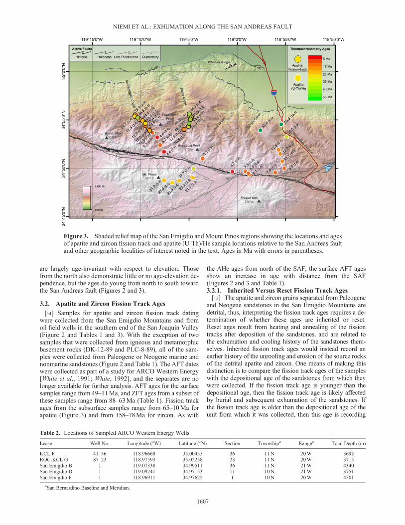
Figure 2. Geologic map of the San Emigdio Mountains, California, and adjacent regions, showing loca-tions of important tectonic features, and surface and subsurface low-temperature thermochronometry samplelocations. Abbreviations on the map for geologic structures are DKS, Devil’s Kitchen syncline; LLA, LosLobos anticline; PS, Pleito syncline; WRA, andWheeler Ridge anticline. (U-Th)/He samples are labeled withcomplete sample names. Surface fission track samples are shown by sample group, DK and PLC, and werecollected sequentially from north to south in 1989. Sample numbers are a composite of sample group, num-ber, and year collected, e.g., DK-1-89 (Table 1). Subsurface samples are from wells indicated on the Figure(Tables 2 and 3). The photograph in Figure 7 was taken from the viewpoint marked by the large “V” symbolin the west-central portion of the figure. Geology modified from [Dibblee, 1973; Ross, 1989; Chapman andSaleeby, 2012].
NIEMI ET AL.: EXHUMATION ALONG THE SAN ANDREAS FAULT
1604
landscape development from the gross distribution of struc-tures seen at the surface, we have analyzed bedrock and detri-tal samples using low-temperature thermochronometry.
2. Geologic Setting
[5] The San Emigdio Mountains are an east-west trendingmountain range that lies at the southern end of the SanJoaquin Valley (Figure 1a). Although physiographically in-cluded as part of the Transverse Ranges of southernCalifornia due to its orientation, geologically, the SanEmigdio Mountains are an extension of the southern SierraNevada [e.g., Ross, 1989]. The range lies at the western endof the Big Bend of the San Andreas fault (SAF), and isbounded on nearly all sides by active faults, includingthe Carrizo segment of the SAF to the west and south[~34mm/yr, Sieh and Jahns, 1984; Salyards, 1989]; theGarlock fault to the southeast [~7.6mm/yr, McGill et al.,2009], and a series of both emergent and blind faults to thenorth that dip southward underneath the range [Dibblee,1973; Davis, 1983; Keller et al., 1998] (Figure 2).[6] Evidence of active crustal shortening in the range is pro-
vided by historic seismicity, including the 1952 Mw 7.3 KernCounty earthquake (Figure 1b) [Gutenberg, 1955; Richter,1955; Bawden et al., 1997], modern geodetic measurementsof strain across the region [Bawden et al., 1997], and activefolding of Quaternary sediments along the northern range frontabove blind thrust faults (Figure 2) [Medwedeff, 1988; Kelleret al., 1998, 2000]. Paleoseismic studies and surface rupturesassociated with the 1857M 7.9 Fort Tejon earthquake recorddextral strike-slip faulting along the San Andreas fault to thesouth of the range [Sieh, 1978; Lindvall et al., 2002].[7] South of the San Emigdio Mountains, the San Andreas
fault traverses a series of valleys with mean valley floor ele-vations near 1500m. From these valleys, the peaks of theSan Emigdio Mountains rise sharply to ~2000m. The highestportion of the range is underlain by plutonic and metamor-phic rocks of Cretaceous age (Figure 2). These rocks repre-sent two intrusive suites of differing ages and origin,separated by the Pastoria fault (Figure 2). To the north andeast, gneisses and mafic intrusive rocks of the Tehachapi-San Emigdio complex represent deep levels of the SierraNevada batholith [Ross, 1989; Pickett and Saleeby, 1994].Intrusion and peak metamorphism occurred in the earlyCretaceous, and the complex was subsequently rapidlyunroofed in the Late Cretaceous [Saleeby et al., 1987;Saleeby et al., 2007]. Granitic and granodioritic rocks to thesouth and east of the Pastoria fault are Late Cretaceous inage (Figure 2 and Table 1) and represent significantly higherbatholithic levels of the Sierran arc [Chapman et al., 2011;Chapman et al., 2012].[8] Unconformably overlying the basement is a sequence of
marine and nonmarine sedimentary rocks ranging in age fromEocene to Quaternary [McGill, 1951; Dibblee, 1973; Nilsenet al., 1973; DeCelles, 1988; Rhoades and DeCelles, 1995;Critelli and Nilsen, 2000; Keller et al., 2000]. These stratahave been folded and faulted over the southern edge of theSan Joaquin Valley, such that the oldest strata are exposed justbelow the highest peaks of the range, and the youngest rocksare exposed ~2000m lower, on the edge of the valley floor(Figure 2) [Dibblee, 1961; Davis, 1983; Medwedeff, 1988;Namson and Davis, 1988b; Keller et al., 1998]. A detailed
record of changes in depositional environment, sea level, andtectonic boundary conditions through late Cenozoic time ispreserved in this stratigraphic sequence [e.g., DeCelles,1988; Goodman and Malin, 1992]. Major transitions in tec-tonic boundary conditions interpreted from this record are achange from Oligocene-early Miocene regional extension tomiddle Miocene strike-slip dominated deformation, followedby a later transition to compressional dominated deformationin Pliocene time [Goodman and Malin, 1992].[9] The San Andreas fault juxtaposes the Frazier Mountain–
Mount Pinos block against the southern edge of the SanEmigdio Mountains (Figure 2). The Frazier Mountain–Mount Pinos block is comprised primarily of gneisses ofProterozoic age, intruded by Cretaceous granitoids of thePeninsular Ranges batholith [Carman, 1964; Ross, 1972;Kellogg et al., 2008]. Overlying the basement rock areOligocene–Miocene strata of the Plush Ranch Formation[Carman, 1964], which were deposited during an episode ofextension in the California borderlands in early Miocene time[Bohannon, 1976; Cole and Stanley, 1995]. The PlioceneQuatal Formation unconformably overlies both basementand pre-Pliocene Cenozoic strata, and preserves evidence ofmodest contractional shortening over the last 5Ma [Kelloggand Minor, 2005].[10] Correlation of igneous basement, and Oligo-Miocene
sedimentary and volcanic strata suggest that the FrazierMountain–Mount Pinos block shares an affinity with theOrocopia and Chocolate mountains of southeastern California[Crowell and Walker, 1962; Powell, 1981; Ballance et al.,1983; Frizzell and Weigand, 1993; Matti and Morton, 1993],although direct correspondence between specific igneousand sedimentary units remains equivocal [Ross, 1972; Lawet al., 2001].
3. Low-temperature ThermochronometryData Sets
[11] We present 16 new apatite (U-Th)/He (AHe) agesfrom the San Emigdio Mountains (Figures 2 and 3 andTable 1). We combine these data with seven publishedAHe ages from the San Emigdio Mountains and MountPinos [Spotila et al., 2007b] (Figures 2 and 3 and Table 1)and previously unpublished fission track data produced un-der contract to ARCO Western Energy [White et al., 1991].The fission track data set includes 19 apatite (AFT) and 4 zir-con (ZFT) ages from sedimentary and igneous rocks in theSan Emigdio Mountains, and 13 apatite and 6 zircon fissiontrack ages from subsurface samples collected from wells inthe southern San Joaquin basin [White et al., 1991](Figures 2 and 3; Tables 2 and 3; Appendix A. Track lengthdata are available in Table A2. Many apatite grains were alsoanalyzed by electron microprobe to determine the affect of ap-atite chemistry on annealing [Ketcham, 2005] (Table S1)).AHe and AFT ages were used to constrain the timing and rateof exhumation along the western end of the Big Bend of theSan Andreas fault. The suite of thermochronometers used inthis study have closure temperatures of ~70°C (AHe), ~110°C (AFT), and ~250°C (ZFT), dependent on cooling rate, grainsize, and radiation damage [Gleadow and Duddy, 1991;Tagami et al., 1996; Farley, 2000, 2002; Shuster et al.,2006; Flowers et al., 2007]. The temperature range coveredby these thermochronometers is broad, and is sensitive to the
NIEMI ET AL.: EXHUMATION ALONG THE SAN ANDREAS FAULT
1605
thermal history of erosional exhumation in the upper severalkilometers of the Earth’s crust.
3.1. (U-Th)/He Apatite Ages
[12] Apatite for (U-Th)/He thermochronometry was sepa-rated from samples collected both north of the San Andreasfault, in the San Emigdio Mountains, and south of the SanAndreas fault, fromMount Pinos. Both igneous and metamor-phic rocks were sampled in the San Emigdio Mountains(Figure 2 and Table 1), with all rocks having Cretaceous crys-tallization or peak metamorphic ages (Figure 2 and Table 1).
On the south side of the San Andreas fault, samples were col-lected from granitoids with Late Cretaceous crystallizationages (Figure 2 and Table 1).[13] Apatite (U-Th)/He ages from samples in the San
Emigdio Mountains range from 59–4.2Ma (Table 1), whilethose from Mount Pinos range from 38–22Ma (Table 1).On both sides of the fault, the AHe ages are significantlyyounger than the crystallization or peak metamorphic agesof the rocks from which they were collected, signifying thatthese ages record a postintrusion or postmetamorphic coolingevent. AHe ages from samples south of the San Andreas fault
Table 1. (U-Th)/He and Fission Track Analyses
Longitude Latitude Elevation Mean Age Lithologic Unita Lithologic Unit Ageb
Sample (°W) (°N) (m) (Ma) (Ma)
Apatite (U-Th)/He AgesEMIG-1 119.00860 34.82730 1646 4.2 ± 2.4 Quartzofeldspathic gneiss of Pastoria Creek 112TG-1 118.98615 34.82765 1933 7.5 ± 1.3 Granodiorite of Lebec (landslide?) 88–92TG-2 118.98072 34.82440 1790 8.7 ± 1.5 Metasediments of Salt Creek (landslide?) PzTG-3 118.97838 34.82193 1628 5.7 ± 1.0 Metasediments of Salt Creek PzTG-5 118.92276 34.84550 1428 11.7 ± 2.0 Granodiorite of Lebec 88–92TG-7 118.91516 34.88740 974 38.5 ± 6.6 Quartzofeldspathic gneiss of Pastoria Creek 112TG-8 118.92447 34.90891 695 59.0 ± 10.1 Quartzofeldspathic gneiss of Pastoria Creek 112NNGR-1 118.96017 34.89861 1241 55.6 ± 9.3 Quartzofeldspathic gneiss of Pastoria Creek 112NNGR-5 118.92595 34.85773 1595 12.9 ± 2.2 Granodiorite of Lebec 88–92NNGR-6 118.92897 34.86483 1522 12.6 ± 2.1 Granite of Brush Mountain 105NNSC-1 119.05969 34.84976 1873 5.1 ± 0.9 Granodiorite of Lebec 88–92NNSE-2 119.12646 34.86158 1402 4.4 ± 0.7 Metasediments of Salt Creek Pz–MzNNSE-3 119.13305 34.87295 1287 5.2 ± 0.9 Quartz diorite-tonalite of Antimony Peak 135NNSE-4 119.13811 34.88657 1179 4.4 ± 0.7 Quartzofeldspathic gneiss of Pastoria Creek 112NNSE-5 119.14586 34.89428 1100 6.7 ± 1.1 Quartzofeldspathic gneiss of Pastoria Creek 112SEGR-9 118.93487 34.82565 1420 7.9 ± 1.3 Granodiorite of Lebec 88–92SEGR-10 118.91890 34.83282 1651 9.6 ± 1.5 Granodiorite of Lebec 88–92PINOS-1 119.07547 34.83247 1903 37.7 ± 5.7 Granite of Cerro Noreste (landslide?) 67.2PINOS-2 119.07652 34.81684 2049 23.2 ± 3.5 Granite of Cerro Noreste 67.2PINOS-3 119.10011 34.81163 2244 22.9 ± 3.4 Granite of Cerro Noreste 67.2PINOS-4 119.11190 34.80838 2402 27.0 ± 4.1 Granite of Mount Pinos 76.1PINOS-5 119.12631 34.81228 2537 21.9 ± 3.3 Granite of Cerro Noreste 67.2PINOS-6 119.07835 34.81814 2049 21.7 ± 3.3 Granite of Cerro Noreste 67.2
aLithologic unit designations from Ross [1989],Dibblee [1973], Saleeby et al. [2007], and Chapman and Saleeby [2012], with the exception of the PINOSseries of samples, which are from Kellogg and Miggins [2002] and Kellogg [2003].
bLithologic unit ages are crystallization or peak metamorphic ages for plutonic and metamorphic rocks [James, 1986; Saleeby et al., 1987; James andMattinson, 1988; Pickett and Saleeby, 1994; Kellogg, 1999; Kellogg and Miggins, 2002; Saleeby et al., 2007; Chapman et al., 2012], with the exceptionof the Metasediments of Salt Creek, which are constrained only to be of Paleozoic age [Chapman and Saleeby, 2012; Chapman et al., 2012]. Ages ofsedimentary rocks are given as the ages of the upper and lower bounding stratigraphic contacts [Nilsen et al., 1973].
NIEMI ET AL.: EXHUMATION ALONG THE SAN ANDREAS FAULT
1606
are largely age-invariant with respect to elevation. Thosefrom the north also demonstrate little or no age-elevation de-pendence, but the ages do young from north to south towardthe San Andreas fault (Figures 2 and 3).
3.2. Apatite and Zircon Fission Track Ages
[14] Samples for apatite and zircon fission track datingwere collected from the San Emigdio Mountains and fromoil field wells in the southern end of the San Joaquin Valley(Figure 2 and Tables 1 and 3). With the exception of twosamples that were collected from igneous and metamorphicbasement rocks (DK-12-89 and PLC-8-89), all of the sam-ples were collected from Paleogene or Neogene marine andnonmarine sandstones (Figure 2 and Table 1). The AFT dateswere collected as part of a study for ARCO Western Energy[White et al., 1991; White, 1992], and the separates are nolonger available for further analysis. AFT ages for the surfacesamples range from 49–11Ma, and ZFT ages from a subset ofthese samples range from 88–63Ma (Table 1). Fission trackages from the subsurface samples range from 65–10Ma forapatite (Figure 3) and from 158–78Ma for zircon. As with
the AHe ages from north of the SAF, the surface AFT agesshow an increase in age with distance from the SAF(Figures 2 and 3 and Table 1).3.2.1. Inherited Versus Reset Fission Track Ages[15] The apatite and zircon grains separated from Paleogene
and Neogene sandstones in the San Emigdio Mountains aredetrital, thus, interpreting the fission track ages requires a de-termination of whether these ages are inherited or reset.Reset ages result from heating and annealing of the fissiontracks after deposition of the sandstones, and are related tothe exhumation and cooling history of the sandstones them-selves. Inherited fission track ages would instead record anearlier history of the unroofing and erosion of the source rocksof the detrital apatite and zircon. One means of making thisdistinction is to compare the fission track ages of the sampleswith the depositional age of the sandstones from which theywere collected. If the fission track age is younger than thedepositional age, then the fission track age is likely affectedby burial and subsequent exhumation of the sandstones. Ifthe fission track age is older than the depositional age of theunit from which it was collected, then this age is recording
Table 2. Locations of Sampled ARCO Western Energy Wells
Lease Well No. Longitude (°W) Latitude (°N) Section Townshipa Rangea Total Depth (m)
KCL F 41–36 118.96660 35.00455 36 11N 20W 3693ROC-KCL G 87–23 118.97593 35.02258 23 11N 20W 3715San Emigdio B 1 119.07338 34.99511 36 11N 21W 4340San Emgidio D 1 119.09241 34.97153 11 10N 21W 3751San Emigdio F 1 118.96911 34.97625 1 10N 20W 4501
aSan Bernardino Baseline and Meridian.
5 Ma
ApatiteFission-track
Apatite(U-Th)/He
15 Ma
25 Ma
35 Ma
45 Ma
55 Ma
Historic Holocene QuaternaryLate Pleistocene
Figure 3. Shaded relief map of the San Emigdio and Mount Pinos regions showing the locations and agesof apatite and zircon fission track and apatite (U-Th)/He sample locations relative to the San Andreas faultand other geographic localities of interest noted in the text. Ages in Ma with errors in parentheses.
NIEMI ET AL.: EXHUMATION ALONG THE SAN ANDREAS FAULT
1607
information about an earlier exhumational event that affectedthe source rock. In addition, tracks that reside in the partialannealing zone for extended periods of time will have shortmean track lengths of 10–13μm.[16] Absolute depositional ages for the sandstones in the
San Emigdio Mountains can be derived from the benthic
foraminiferal zones of these strata, which are well known inCalifornia [Kleinpell, 1938; Mallory, 1959; Almgren et al.,1988]. These zones have been tied to an absolute timescalethrough magnetostratigraphy (Figure 4) [e.g., Prothero,2001]. The majority of AFT ages for samples included in thisstudy are younger than the depositional age of the rock fromwhich they were collected, but this is not universally the case(Figure 4). Five of the samples yield mean apatite fissiontrack ages that are older than their associated depositionalage, and the spread of grain ages from all of the apatite sam-ples includes ages that are both older and younger than thedepositional age of the sample. The scatter in grain ages iscaused largely by variations in apatite chemistry (TableS1). In particular, high Cl content can retard annealing. Themean track lengths of the surface samples are generally inthe 11.8–12.9μm range, consistent with burial and residenceat temperatures of 60°C–80°C during Eocene–Miocene time(Table A2). Thus, the apatite fission track ages appear to re-cord the postdepositional thermal history of the sandstones.[17] Zircon fission track ages from both surface and sub-
surface samples are uniformly older than the strata fromwhich they were collected (Figure 4), and presumably recordthe thermal history of the source terrane from which theywere derived [White et al., 1991]. The fission track agespresent in the zircon population suggest that they recordeither crystallization ages of Late Cretaceous granitoidssouth of the Pastoria fault (Figure 2) [Ross, 1989], or rapid
Table 3. Apatite and Zircon Fission Track Ages for Well Samples
Depth AFT Age ZFT AgeSample (m) (Ma) (Ma) Stratigraphic Age
Apatite Fission-track AgeZircon Fission-track AgeBorehole Zircon Fission-track Age
Standard error on meanfission-track age
Spread of all measuredfission-track ages
Figure 4. Comparison of apatite (AFT) and zircon (ZFT) fission track ages from surface and subsurfacesamples with stratigraphic age. Samples that plot to the lower left of the diagonal line in the right panel ofthe figure have younger AFT or ZFT ages than stratigraphic ages, and must have experienced partialannealing. Samples that plot to the upper right of the line have AFT or ZFT ages older than the stratigraphicage and likely have inherited ages. Stratigraphic age is plotted as a function of lithostratigraphic position forclarity (a sample collected from the base of the Tejon Fm. is plotted with an older stratigraphic age than asample collected from the top of the Tejon Fm.); however, the error in stratigraphic age for all samples isconsidered to be the bounding lithologic contacts. The mean AFT age for the majority of samples is youngerthan the stratigraphic age, and all but one AFT sample yielded measured ages younger than the strati-graphic age, indicating that the AFT ages are a result of partial annealing. This interpretation is supportedby both ZFT surface and subsurface samples, which yield exclusively Mesozoic ages. If the observed 40–50Ma AFT ages were derived from an Eocene source, Cenozoic ZFT ages would also be expected.Geologic time scale from Gradstein et al. [2004]. Benthic foraminiferal zones and time scale forCalifornia from Kleinpell [1938], Mallory [1959], Almgren et al. [1988] and Prothero [2001].Lithostratigraphy for the San Emigdio Mountains from Nilsen [1973].
NIEMI ET AL.: EXHUMATION ALONG THE SAN ANDREAS FAULT
1608
exhumation of the Tehachapi and San Emigdio basement inLate Cretaceous time [Saleeby et al., 2007; Chapman et al.,2011, 2012], consistent with detrital zircon U-Pb geochro-nology that demonstrates a Sierran affinity source for theTejon Formation in the San Emigdio Mountain [Lechlerand Niemi, 2011].[18] A comparison of AFT and ZFT ages with depth for the
subsurface samples confirms that the AFT ages are likely par-tially to fully reset (Figure 5). Cretaceous ZFT ages show asystematic increase in age with depth, potentially recordingsequential exhumation of the Tehachapi Mountains [Whiteet al., 1991], while the AFT ages are Paleocene to Miocenein age and young with depth (Figure 5a). The track lengthsare generally short (10.1–13.3 μm). Mean Cl contents are<0.4 wt %, although one sample has a mean chlorine contentof 0.6 wt %. Temperature plotted as a function of downholedepth (Figure 5b), indicates that temperatures at or abovethe annealing temperature of fission tracks in apatite arereached in the lower portions of the wells.[19] We conclude that the apatite fission track ages from all
of the surface samples are the product of full or partialannealing due to postdepositional burial and that the resultingapatite fission track ages record the exhumation of thePaleogene section. The zircon fission track ages, on the otherhand, appear to be entirely inherited, and reflect an earliercooling event that affected the source rocks of the sand-stones. The thermal histories of these zircons are not further
considered in the discussion of the tectonic evolution oftranspression along the San Andreas fault.
4. Thermochronologic Data Interpretation
[20] One of the most commonmethods used to evaluate therate and timing of rock exhumation from low-temperaturethermochronometry data is to plot thermochronologic agesversus sample elevation [e.g., Fitzgerald et al., 1986]. Suchplots have as an inherent assumption that the modern eleva-tion difference between samples is identical to the paleodepthdifferences between the samples, or to put it another way,that the samples were exhumed from beneath horizontaltopography with no significant tilting or deformation of theexhumed crust [e.g., Stockli et al., 2000] or without signifi-cant deflection of isotherms [Stüwe et al., 1994]. Given theassumptions inherent in this analysis, the slope of a linethrough sample ages in elevation space represents an exhu-mation rate, and a break in slope a change in exhumation rateor fossil partial annealing zone (PAZ; AFT)) or partial reten-tion zone (PRZ; (U-Th)/He) [Fitzgerald et al., 1986; Stockliet al., 2000]. Samples from north and south of the SanAndreas will be interpreted in this context, and then modifi-cations to this approach will be presented.
4.1. Mount Pinos Apatite (U-Th)/He Data
[21] Samples collected from the Mount Pinos region yield asteep, nearly elevation-invariant, slope in age-elevation space,indicating that these samples may record the rapid exhumationof an intact crustal section (Figure 6a). One exception is thetopographically lowest sample, which is significantly olderthan topographically higher samples. This sample, however,may have been collected from a large landslide block[Kellogg, 2003]. Discarding this sample, the steep slope ofthe age-elevation relationship suggests rapid exhumationbegan by the early Miocene (~22Ma). The timing of suchan exhumational event is speculative, as no clear break inslope is preserved, and no reliable geologic datum can beestablished to demonstrate that sample elevation is a reliableproxy for sample depth. However, geologic mapping sug-gests broad, open folding of Cenozoic strata across theadjacent Lockwood Valley [Kellogg and Minor, 2005], indi-cating that large scale tilting of the Mount Pinos block sinceearly Miocene cooling is unlikely. Thus, we interpret thethermochronometry data as recording rapid crustal coolingin early Miocene time.[22] Palinspastic restoration of the San Andreas fault sys-
tem and cross fault correlation of both basement geology[Crowell and Walker, 1962; Powell, 1981; Matti andMorton, 1993] and late Oligocene to early Miocene sedimen-tary and volcanic strata [Ballance et al., 1983; Frizzelland Weigand, 1993] place the Mount Pinos and FrazierMountain region in the vicinity of the Orocopia Mountainsof southeastern California prior to the initiation of a transformplate boundary. Sedimentary strata of the Plush Ranch andSimmler formations in the Mount Pinos region [Bohannon,1976; Cole and Stanley, 1995] and of the DiligenciaFormation in the Orocopia Mountains [Law et al., 2001] pre-serve evidence of extensional tectonism and basin formationin early Miocene time, consistent with thermochronologicaldata from the footwall of the Orocopia detachment fault[Jacobson et al., 2007]. Thus, rapid exhumation of theMount Pinos region in early Miocene time is best explained
0 50 100 150 200
Dep
th (
m)
1500
2000
2500
3000
3500
4000
4500
5000
Age (Ma)
a
b
Figure 5. (a) Plot of apatite and zircon fission track ageswith depth for subsurface sandstone samples recovered fromboreholes in the southern San Joaquin Valley (Figure 2 andTables 2 and 3). Zircon fission track ages are Mesozoic inage and are older at greater depths, perhaps reflecting a con-tribution of zircons from younger source terranes throughtime. Apatite fission track samples are generally Cenozoicin age and are younger with increased depth, suggesting thatthe deeper samples are undergoing partial annealing. (b) Plotof estimated temperature with depth in the wells. The closuretemperature of fission tracks in apatite is estimated to be100° ± 20°C [Wagner, 1968; Naeser and Faul, 1969], whilethat in zircons is estimated to be ~250°C [Tagami et al.,1996]. Tracks in apatite grains below ~1.5 km depth in thesewells are currently annealing, while tracks in zircons are not,in agreement with the age-depth relationships plotted in (a).
NIEMI ET AL.: EXHUMATION ALONG THE SAN ANDREAS FAULT
1609
as the result of the expansion of early Miocene Basin andRange extension in southwestern Arizona and southeasternCalifornia westward toward the plate boundary duringthe transition from subduction to transform fault motion[Tennyson, 1989]. The low-temperature thermochronologicdata fromMount Pinos do not preserve evidence for a youngerphase of exhumation, consistent with the nature of diffusecontractional deformation observed in the region south of theSAF since late Miocene time [Kellogg and Minor, 2005].
4.2. San Emigdio Mountains (U-Th)/He and FissionTrack Data
[23] In contrast with the samples from Mount Pinos, whichyield a narrow range of ages, thermochronologic ages fromthe San Emigdio Mountains span from Cretaceous toPliocene. The ages are progressively older with distance awayfrom the SanAndreas fault (Figure 3), but do not show a clearlyinterpretable relationship in age-elevation space (Figure 6a).Samples at the highest elevations record the youngest coolingages, while samples lower in elevation record older ages.Such an inverse age-elevation relationship is difficult to inter-pret without invoking a complex and nonmonotonic crustalthermal regime [Behr and Platt, 2012], or decreasing reliefthrough time [Benowitz et al., 2012]. Given the relatively
well-constrained geologic history of the region, comprised ofdeposition and burial throughout much of the Cenozoic,followed by late (post middle Miocene) exhumation, neitherof these solutions is particularly viable for this region.Alternatively, this age-elevation relationship can be explainedif the crustal section from which the samples were collectedwas tilted or deformed during or after the cooling eventrecorded by the thermochronologic ages. One method to pro-duce interpretable cooling age information from such a dataset is to plot the cooling ages with respect to a common datumthat may not be horizontal presently, but likely was nearly hor-izontal, prior to the onset of cooling and exhumation. Examplesof such datums are low-relief geomorphic surfaces [e.g., Clarket al., 2005; Clark and Bilham, 2008] or stratigraphicunconformities [e.g., Reiners et al., 2000]. In the case of thesamples from the San Emigdio Mountains, we propose thebasal Tertiary unconformity as a predeformation datum againstwhich to plot the thermochronologic data (Figure 7). Thisunconformity is developed on the igneous and metamorphicbasement rocks of the southern Sierra Nevada (Figure 2)[Ross, 1989; Chapman and Saleeby, 2012], and is overlainby the Eocene Tejon Formation (Figure 2) [Nilsen et al.,1973]. The basal member of the Tejon Formation, the UvasConglomerate Member, contains clasts of the underlying
0
0.5
1
1.5
2
2.5
3
San Emigdio Mtns
San Emigdio Mtns
Mt. Pinos
Ele
vatio
n (k
m)
Dep
th B
elow
Bas
al U
ncon
form
ity (
km)
Age (Ma)Age (Ma)
(U-Th)/He Ages
Apatite Fission-track Ages
Salt and San Emigdio Creeks
Pleito and San Emigdio Creeks
Grapevine Canyon region
(U-Th)/He Ages
Apatite Fission-track Ages
San Emigdio Mtns Thermochronology
Landslide block
-2.5
-0.5
1.5
3.5
5.5
7.5
9.50 20 40 600 20 40 60
a b
Figure 6. (a) Plot of apatite (U-Th)/He and fission track ages as a function of elevation for all surface sam-ples collected. Samples from the San Emigdio Mountains, on the northern side of the San Andreas fault,display an inverse age-elevation relationship, apparently younging with increased elevation. Samples fromMount Pinos, on the southern side of the San Andreas fault are fairly age-invariant with elevation, with theexception of the lowest sample, which may have been collected from a large landslide block [Kellogg,2003]. The age-elevation relationship from Mount Pinos is consistent with rapid cooling at ~20–25Ma,but such an interpretation of the data is neither unique nor definitive. The age-elevation relationship ofsamples from the San Emigdio Mountains plotted in present-day elevations is not interpretable in a tectoniccontext. (b) Apatite (U-Th)/He and fission track ages from the San Emigdio Mountains plotted againstdistance from the basal Tertiary unconformity (Figure 7). In this reference frame, thermochronologic datafrom two transects reveal a more typical age-depth relationship, recording slow cooling and the preserva-tion of a partial He retention zone or partial fission track annealing zone, followed by increased rates ofcooling and exhumation. The eastern transect, subparallel to and west of Grapevine Canyon andInterstate 5 (Figure 2) records exhumation of the basement rocks of the San Emigdio Mountains beginningat ~12–14Ma. The western transect, along San Emigdio Creek (Figure 2) records rapid exhumationbeginning at ~6Ma. Note that the two linear trends of ages on the western transect are defined by twoseparate thermochronometric systems. Since apatite fission track ages record a higher closure temperaturethan apatite He ages, the intersection of the two age trends along the western transect likely represents themaximum age at which rapid exhumation began.
NIEMI ET AL.: EXHUMATION ALONG THE SAN ANDREAS FAULT
1610
igneous and metamorphic rocks, indicating that the TejonFormation was deposited directly on the basement [Nilsenet al., 1973]. Although this unconformity may have had someamount of relief on it at the time of the Uvas Conglomerate de-position, the position of the San Emigdio Mountains at or nearsea level through much of Eocene and Oligocene time suggeststhat this unconformity can be considered approximatelypaleohorizontal [Nilsen et al., 1973].[24] To plot the thermochronologic data with respect to
depth below (or distance above), the basal Tertiary unconfor-mity, a plane representing the unconformity above the groundsurface was projected from existing geologic maps [Dibblee,1973]. The strike and dip of the plane were extracted fromstructural attitudemeasurements [Dibblee, 1973]. The locationof the plane in space was determined from digitization of thebasal unconformity from geologic maps [Dibblee, 1973] andextraction of point elevations along this unconformity fromthe National Elevation Dataset [Gesch et al., 2002]. AHe sam-ple locations were recorded in the field using a handheld GPSreceiver. Locations of AFT samples were measured from
sample positions recorded on 1:24,000 topographic fieldmaps. The Z coordinates of all samples were defined byintersecting the horizontal sample location with the ⅓ arc secNational Elevation Dataset [Gesch et al., 2002]. The perpen-dicular distance from each sample location to the unconfor-mity plane was then calculated (Figure 8). Given the naturalvariation in observed structural attitudes, depth above or belowthe unconformity was calculated from a dip of 45° ± 5°, andplotted as an error range in the depth estimate (Figure 6b).[25] Thermochronologic data from the San Emigdios are
plotted against distance from the Tertiary basal conformity intwo transects, one at the eastern edge of the range, and a sec-ond near the center of the range (Figures 2 and 6b). Samplesfrom sedimentary strata in the San Emigdio Mountains areconfined to the southern limb of the Devil’s Kitchen synclineto avoid potential complications in plotting sample distanceand age across a major fold. Although the transect crossesfaults in the Mesozoic basement rocks, these faults areunrelated to late Cenozoic development of the San EmigdioMountains, but reflect instead a period of Late Cretaceous
Figure 7. Photograph looking east at the Devil’s Kitchen Syncline and Eagle Rest Peak from San EmigdioMountain (photograph was taken from viewpoint marked in Figure 2). Basal unconformity of Cenozoic sed-imentary strata on Cretaceous basement is shown at the lower right of the photograph. Sedimentary strata dip~45°N off of basement toward the San Joaquin Valley, seen in far distance in photograph. Strikes and dips ofsedimentary strata, and lithologic contacts, modified from Dibblee [1973] and Ross [1989]. Dashed lines aretopographic ridges that may partially obstruct the view. Unit labels as in Figure 2.
Figure 8. Apatite (U-Th)/He and fission track ages are plotted as distance from the Tertiary basal unconfor-mity in Figure 6b. The base of the Tertiary section in the San Emigdio Mountains is comprised of the UvasConglomerateMember of the Tejon Sandstone, and contains clasts of the underlying basement rocks, indicat-ing that it is conformable on the basement [Dibblee, 1973; Nilsen et al., 1973]. The Uvas Conglomerate ispresent along the base of the Tertiary section from Grapevine Canyon to San Emigdio Canyon (Figure 2),and is overlain by a conformable Tertiary section that dips ~45°N (see also Figure 7). A three-dimensionalplane was fit through the basal unconformity using strike and dip data from published geologic mapping[Dibblee, 1973]. The orthogonal distance from each sample location to this plane was calculated, and errorbounds on this distance were determined by calculating the distance from the samples to the plane over arange of dips from 40° to 50°. Abbreviations as in Figures 1 and 2, with the exception of XKg and Kg, whichrepresent basement rocks generically on the southern and northern sides of the San Andreas, respectively, andQTu, which is undivided Quaternary and Tertiary rocks. Cross section is approximately located along SanEmigdio Creek (see Figures 2 and 3) and is modified after [Dibblee, 1961].
NIEMI ET AL.: EXHUMATION ALONG THE SAN ANDREAS FAULT
1611
exhumation of the basement core of the range [e.g., Saleebyet al., 2007; Chapman et al., 2011, 2012].[26] When plotted in this manner, the age-depth relation-
ships of the thermochronologic data reveal time-temperaturepath forms associated with crustal cooling and inferredexhumation [e.g., Reiners et al., 2000; Stockli et al., 2000].Both the eastern (Grapevine Canyon) and central (Salt/SanEmigdio/Pleito Creek) transects yield similar patterns ofcooling, with apparent burial during Eocene–Miocene time,followed by relatively rapid exhumation from the middle tolateMiocene until the present (Figure 6b). The eastern transectalong Grapevine Canyon indicates a change in cooling rate inmiddle Miocene time at approximately 12–13Ma. The centraltransect appears to continue cooling through the middleMiocene at a constant rate, and then experiences rapid coolingat ~6Ma. The time of change in cooling rate along the centraltransect is difficult to define, since the two cooling slopesare defined exclusively by separate thermochronometers (theolder, slower cooling slope is comprised entirely of AFT ages,while the younger, rapid cooling slope is comprised of AHeages; Figure 6b). Thus, the available data constrain recent ex-humation of the San Emigdio Mountains to have initiated noearlier than 12Ma, and no later than ~6Ma.
5. Discussion
5.1. Tectonic Implications ofThermochronometric Data
[27] Geochronologic, thermochronometric, and thermoba-rometric studies of the igneous rock suite that comprisesthe basement of the San Emigdio and adjacent Tehachapi
mountains reveal relatively high-pressure (8–10kbar) andhigh-temperature (590°–700°C) metamorphism of the SanEmigdio schist in the San Emigdio Mountains [Chapmanet al., 2011]. Rapid exhumation of this schist occurs shortlyafter peak metamorphic conditions are reached, and the base-ment of the San Emigdio and Tehachapi mountains is cooledat rates approaching 800°C/Myr at ~80Ma [Saleeby et al.,2007; Chapman et al., 2012]. This exhumation is postulatedto result from the extensional collapse of the southern SierraNevada above the underplated Rand, Orocopia, and SanEmigdio schists during shallow-slab subduction [Saleebyet al., 2007; Chapman et al., 2010, 2012]. Apatite and zircon(U-Th)/He thermochronometry from the southern SierraNevada and Tehachapi mountains indicate that the igneousbasement was at shallow crustal levels by early Eocene time[Saleeby et al., 2007; Maheo et al., 2009; Chapman et al.,2012], consistent with deposition of the Uvas ConglomerateMember of the Tejon Formation onto igneous basement in theSan Emigdio Mountains in the Eocene (Figure 2) [Dibblee,1973; Chapman and Saleeby, 2012].[28] Basin formation and sedimentary deposition contin-
ued in the region of the San Emigdio Mountains throughoutmuch of the Cenozoic [e.g., Nilsen et al., 1973], progres-sively burying the basement. The stratigraphic record of con-tinuous deposition and short mean track lengths clearlyimplies the development of partial retention and annealingzones in which sample ages are progressively reset with in-creased burial and heating (Figure 6b) [Stockli et al., 2000].Samples that display a steep depth-elevation relationshipare inferred to record renewed tectonic exhumation of theSan Emigdio Mountains in late Miocene time (Figure 6b),
Figure 9. Present active faults of the San Andreas fault system (left) showing the positions of the SanEmigdio Mountains, Mount Pinos, and Frazier Mountain, along with key markers used to palinspasticallyrestore motion on the San Andreas fault [e.g., Powell and Weldon, 1992;Matti and Morton, 1993; Powell,1993], including basement terrane correlations from the Chocolate Mountains [Dillon and Ehlig, 1993], aunique Triassic monzogranite pluton [Frizzell et al., 1986], and the Mint Canyon paleochannel [Ehlig et al.,1975; Ehlert, 2003;Darin and Dorsey, 2013]. Restoration of these markers places Mount Pinos and FrazierMountain adjacent to the northern San Gabriel Mountains in middle Miocene time (right) [Nourse, 2002]when the San Emigdio Mountains began to be exhumed. Prior to ~12Ma, right-lateral slip on the ClemensWell–Fenner–San Francisquito fault placed Proterozoic basement rocks of Frazier Mountain outboard of atrend of similar-aged rocks in the Chocolate and Orocopia Mountains [Powell, 1981]. SEM, San EmigdioMountains; MtP, Mount Pinos; FM, Frazier Mountain; SGM, San Gabriel Mountains; SBM, SanBernardino Mountains; SJM, San Jacinto Mountain; OM, Orocopia Mountains; and CM, ChocolateMountains. CH-CF, Chino Hills–Cristianitos fault; CWF, Clemens Well fault; EF, Elsinore fault; GF,Garlock fault; PMF, Pinto Mountain fault; SAF, San Andreas fault; SFF, San Francisquito fault; SGF,San Gabiel fault; and SJF, San Jacinto fault. Base map of faults modified after Darin and Dorsey [2013].
NIEMI ET AL.: EXHUMATION ALONG THE SAN ANDREAS FAULT
1612
consistent with a shift to more terrestrial dominated deposi-tional systems in the late Miocene [Kellogg et al., 2008].[29] Middle to lateMiocene exhumation of the San Emigdio
Mountains corresponds with a significant reorganization of thePacific–North America plate boundary. Around 12Ma, trans-form motion associated with the San Andreas fault systemstepped inboard, from the previously active Clemens Well–Fenner–San Francisquito fault system to the more northerly-trending San Andreas–San Gabriel fault system (Figure 9)[Powell and Weldon, 1992; Matti and Morton, 1993; Powell,1993]. This reorganization is coincident with the onset of con-tinental extension across the central Basin and Range [Snowand Wernicke, 2000; Niemi et al., 2001] and the establishmentof left-lateral slip on the Garlock fault [Burbank and Whistler,1987; Monastero et al., 1997; Blythe and Longinotti, 2013].Reorganization of the plate boundary occurred again in the lateMiocene, with the abandonment of the San Gabriel strand ofthe San Andreas fault and the development of the modern plateboundary fault system [Powell and Weldon, 1992], along withthe initiation of extension in the Gulf of California [Oskinet al., 2001; Oskin and Stock, 2003], and the onset ofdeformation in the Eastern California Shear Zone [Dokkaand Travis, 1990; Guest et al., 2007; Mahan et al., 2009].Taken together, these observations suggest that exhumationof the San Emigdio Mountains in late Miocene time waslikely driven by the formation and reorganization of the SanAndreas fault system, and the evolution of the Big Bendin the San Andreas fault [Bohannon and Howell, 1982],leading to transpression at the southern margin of the SanJoaquin Valley.
5.2. Structural Geometry of the SanEmigdio Mountains
[30] The San Andreas fault has played a central role in theunderstanding of structural geometries that accommodatetranspressional deformation. A critical aspect of such struc-tural models is if and how contractional structures intersectand interact at depth with the primary strike-slip fault[Woodcock and Fischer, 1986]. In many cases, and particu-larly along the southern San Andreas fault, an antilistric geom-etry has been proposed, in which reverse or thrust faults thataccommodate regional shortening steepen with depth andmerge into the main strike-slip fault plane [Sanderson andMarchini, 1984; Sylvester, 1988; Woodcock and Schubert,1994; Spotila and Sieh, 2000; Woodcock and Rickards,2003]. Despite both field and analog modeling evidencefor the prevalence of such antilistric fault geometries intranspressional settings [e. g., McClay and Bonora, 2001],the existence of a well-developed, apparently thin-skinnedfold and thrust belt underlying the San Emigdio Mountains[Namson and Davis, 1988b; Suppe and Medwedeff, 1990;Mueller and Suppe, 1997; Mueller and Talling, 1997; Kelleret al., 1998] has led to proposals that the western TransverseRanges lie above a regional decollement that accommodatesshortening throughout the western Transverse Ranges, andinto which the San Andreas fault merges (Figure 10) [e. g.,Yeats, 1981;Namson and Davis, 1988a]. The low-temperaturethermochronometry data presented here offer an opportunityto test the viability of this structural model.[31] Low-temperature thermochronometry ages north of the
San Andreas fault are as young as Pliocene, and imply rapidexhumation over the past few million years. This timing of
exhumation of the San Emigdio Mountains is consistent withthe timing of shortening across Lockwood Valley, south ofthe San Andreas fault [Kellogg andMinor, 2005], but the mag-nitude of exhumation is markedly different on either side ofthe San Andreas, with Mount Pinos preserving low-tempera-ture thermochronometry ages that reflect regional earlyMiocene extension. These ages limit post earlyMiocene exhu-mation to less than 2–3 km, assuming a paleogeothermalsimilar to the 30°C/km observed today adjacent to theMojave strand of the SAF [Lachenbruch et al., 1995]. In con-trast, restored depths of samples in the southern San EmigdioMountains may exceed 5 km, based on structural restoration,the thickness of the Cenozoic sedimentary section, andthermochronometric constraints (Figure 6b). The localizationof deformation and exhumation is also quite different on op-posing sides of the San Andreas fault. In the San EmigdioMountains, rapid exhumation and deformation is localizedwithin a few km of the trace of the San Andreas fault, withprogressively less exhumation observed farther north fromthe San Andreas, and active sediment deposition ongoing inthe southern San Joaquin Valley (Figure 2). In contrast, defor-mation across the Frazier Mountain–Mount Pinos region iswidespread, but modest, extending tens of kilometers southof the trace of the San Andreas as broad, open folds inPliocene sedimentary rocks [Kellogg and Minor, 2005].[32] These observations strongly suggest that shortening
and exhumation of the Frazier Mountain–Mount Pinos re-gion and of the San Emigdio Mountains are not tied to a sin-gle, regional decollment (Figure 10a) [Namson and Davis,1988a]; instead, the structural behavior of the two sides ofthe San Andreas faults is discrete [e.g., Rust, 1998]. In partic-ular, young thermochronometry ages along the trace of theSan Andreas in the San Emigdio Mountains suggest verticalexhumation along the San Andreas itself, consistent with anantilistric fault geometry, in which the vertical componentof fault motion would be greatest near the trace of the masterstrike-slip fault (Figure 10b) [e.g., Spotila and Sieh, 2000].The distribution of deformation may also be in part controlledby rheologic heterogeneities across the San Andreas fault,as the tectonically dismembered southern Sierra Nevadabatholith that comprises the San Emigdio Mountains[Chapman and Saleeby, 2012; Chapman et al., 2012] is com-pressed between the Proterozoic basement of the FrazierMountain–Mount Pinos block and the oceanic (?) crust thatunderlies the southern San Joaquin Valley (Figure 10b).However, the overall geometry of transpressional faults inthe western Transverse Ranges appears to conform broadlyto the antilistric geometries that have been proposed for thesouthern San Andreas fault in the eastern Transverse Ranges[e.g., Sylvester, 1988], implying that this is a common featureof transpressional tectonics throughout the Big Bend region ofthe San Andreas fault.
5.3. Strain Partitioning in the WesternTransverse Ranges
[33] The increase in rock uplift toward the San Andreas faultin the San Emigdio Mountains mimics a commonly observedpattern of vertical deformation associated with transpression.Concentrations of rugged topography and exhumation occuralong much of the San Andreas fault zone [Spotila et al.,2007b, 2007a], as well as other continental transforms, includ-ing the Denali fault [Fitzgerald et al., 1993], Alpine fault
NIEMI ET AL.: EXHUMATION ALONG THE SAN ANDREAS FAULT
1613
[Tippett and Kamp, 1993], and Karakoram fault [Foster et al.,1994]. These field examples fit with experimental and theoret-ical studies that predict intense vertical deformation will benarrowly focused within transpressive fault zones [Wilcoxet al., 1973; Fossen and Tikoff, 1998]. Near-field rock upliftalong strike-slip faults results in combination from the me-chanics of wrenching and strain-partitioning [Tikoff andTeyssier, 1994; Spotila et al., 2007a], as well as secondary
deformation due to geometric irregularities along the faulttrace [Cowgill et al., 2004a; Wakabayashi et al., 2004;Buscher and Spotila, 2007].[34] The pattern of rock uplift and style of deformation in
the San Emigdio Mountains are very similar to the patternobserved in the San Bernardino Mountains, farther southalong the San Andreas fault [Spotila et al., 1998]. In bothcases, rock uplift increases both toward the fault and toward
Figure 10. Cross sections through the San Emigdio Mountains showing representations of the interac-tions between thrust faults and the San Andreas fault at depth. (a) A cross section modified after Namsonand Davis [1988a] showing thrust faults soling into a master detachment fault that offsets the SanAndreas fault and continues southward under the Los Angeles Basin. (b) An alternate representation inwhich deformation is largely confined to a wedge north of the San Andreas fault that is sandwiched betweenrigid lithospheric blocks comprised of Proterozoic gneiss (to the south) and Mesozoic ophiolite (to thenorth; see text for discussion). This schematic cross section is consistent with significant differences in ex-humation history across the San Andreas fault, as demonstrated by low-temperature thermochronologicdata, and implies an inverse flower-structure geometry with the San Emigdios being pushed northward overthe southern edge of the San Joaquin Valley. The cross section is located approximately along GrapevineCanyon (see Figures 2 and 3) and is modified from interpretations and data published by Chapman andSaleeby [2012], Goodman and Malin [1992], and Kellogg [2003].
NIEMI ET AL.: EXHUMATION ALONG THE SAN ANDREAS FAULT
1614
the apex of the fault bend, resulting in a symmetrical bulls-eye pattern of vertical strain (as inferred from cooling ages;Figure 3). As in the San Emigdio Mountains, basement rockuplift in the San Bernardino Mountains has been accom-plished via antilistric thrust faults that steepen toward theSan Andreas fault, merging with it at depth into a crustal-scale flower structure [Spotila and Sieh, 2000]. A key differ-ence in the San Emigdio Mountains, however, is the presenceof the thick on-lapped Cenozoic sedimentary sequence,which enables more confident reconstruction of the flower-structure geometry (Figure 10b). The antilistric geometry isconsistent with the conceptual model of flower or palm-shaped structures that are predicted to be the typical modeof uplift along strike-slip faults [Sanderson and Marchini,1984; Sylvester, 1988; Woodcock and Schubert, 1994;Woodcock and Rickards, 2003].[35] The primary far-field driver of vertical deformation in
the San Emigdio Mountains is likely the obliquity to platemotion of this segment of the San Andreas fault. The traceof the fault through the San Emigdio Big Bend is on average37°, convergently oblique to far-field plate motion [Spotilaet al., 2007b], thus creating a pure shear-dominated conditionthat is ideal for strain partitioning and concentrated near-fieldrock uplift [Tikoff and Teyssier, 1994; Fossen and Tikoff,1998]. An additional driver of shortening along this segmentmay be the slip transfer from the intersecting Garlock fault. Ifleft slip along the Garlock fault does not decay rapidlyenough to the west, this slip could induce convergence northof the intersection in the San Emigdio Mountains and diver-gence along the Mojave segment of the San Andreas fault tothe southeast (Figure 1). This pattern of faulting mimics thatobserved in the San Bernardino Mountains, where thefocused bulls-eye of rock uplift occurs at the apex of the faultbend north of San Gorgonio Pass, ~15 km northwest of theintersection of the left-lateral Pinto Mountain fault [Spotilaand Sieh, 2000]. This is geometrically similar to what weobserved in the San Emigdio Mountains, where significantexhumation occurs along the San Emigdio Creek transect,at the apex of a small inflection in the trace of the SanAndreas fault, approximately 15 km west of the intersectionwith the Garlock. Without detailed slip-rate data alongthe conjugate left-lateral faults, however, the magnitude ofexcess strain associated with the fault intersections cannotbe readily determined.[36] If the highly convergent fault bends and focused rock
uplift in the San Emigdio and San Bernardino Mountains are,in fact, partially driven by the intersection with the conjugateleft-lateral faults, this implies that the loci of transpressionhave been fixed relative to the structural geometries situatedto the east of the San Andreas fault zone [Spotila and Sieh,2000]. In other words, the welts of deforming crust would re-main pinned to the fault confluence and associated bendssince the onset of deformation in the late Miocene, ratherthan migrating away from the bend to the southeast. Theabrupt southeastern boundary of transpressive deformationin the San Emigdio Mountains is consistent with this kine-matic interpretation (Figure 3). This differs from the patternof transpressional deformation in the Santa Cruz Mountainsfarther north along the San Andreas fault, where deformedcrust on either side of the fault is interpreted to translatebilaterally away from the bend, resulting in trailing, decayingmountain ranges to the northwest and southeast [Anderson,
1990]; although models wherein one side of the Santa CruzMountains is fixed relative to the fault have also been pro-posed [Bürgmann et al., 1994].[37] An additional control on transpressive deformation
along the San Emigdio Mountains may be lithosphere-scalemechanical heterogeneity. The stark difference in the patternof transpressive deformation on either side of the SanAndreas fault may be linked to differing crustal rheologies.Whereas there is a tight concentration of rock uplift in theSan Emigdio Mountains immediately adjacent to the SAF thatis temporally linked to SAF evolution, no such Late Miocenedeformation is observed to the southwest of the San Andreasfault, based on our limited data. Convergent deformation sincethe late Miocene has been broadly distributed over tens ofkilometers along thrust faults and low-amplitude folds in theLockwood Valley area [Kellogg and Minor, 2005]. The topo-graphic welts that occur in this area (Mount Pinos and FrazierMountain) do not coincide with zones of focused exhumation.This difference may stem from the mechanical response ofdistinct rock types on either side of the San Andreas fault.To the southwest, the crust consists of Mesozoic PeninsularRanges batholith intruded into Proterozoic gneiss with crustalaffinities to the Chocolate and Orocopia Mountains. This rela-tively strong group of rock types consists of homogeneous,undeformed plutons intruded into old, cold basement.This package is then stacked atop Cretaceous Pelona/Randschist via the Vincent thrust [Namson and Davis, 1988a](Figure 10), which may impart a tendency to fail along broad,low-angle, regional decollements due to fault reactivation. Incontrast, the San Emigdio block consists of a narrow slice ofsouthern Sierran basement, consisting of tonalite and maficgneiss. The San Emigdio block represents reconstructedlithosphere that experienced Late Cretaceous extensionalcollapse and underplating, and thus may be warm and weak[Chapman et al., 2010]. This narrow strip of southernSierran basement is sandwiched between the San Andreasfault and the southern San Joaquin Valley, which is likely un-derlain by strong ophiolitic oceanic lithosphere or transitionalcrust related to back-arc spreading [Holbrook and Mooney,1987; Goodman and Malin, 1992]. We hypothesize that theSan Emigdio Mountains have been more intensely deformed,because they are weaker than the lithospheric blocks thatbound them to the north and south. Eventually, the narrowSan Emigdio sliver will be fully exhumed due to SanAndreas fault transpression, resulting in collision of the strongPinos block and San Joaquin Valley and a concomitant struc-tural reorganization.[38] The potential role of lithospheric heterogeneity in
dictating patterns of strain along the San Andreas fault is anintriguing example of the influence of material propertieson tectonic deformation. Preexisting weaknesses are wellknown to influence structural patterns in various tectonic re-gimes. For example, the geometry of ancient orogenic belts isknown to influence the location of crustal rifts (and viceversa) [Dunbar and Sawyer, 1989; Ring, 1994; Vauchezet al., 1997; Corti et al., 2007] In this case, patterns of previ-ous deformation influence subsequent deformation, due tothe damage imparted on the lithosphere. In the case of theSan Emigdio Mountains, it is not preexisting structure, butrather an optimal orientation of a weaker package of rock thatmay be dictating deformation. In this sense, it may be moreanalogous to how weak stratigraphy (e.g., shale, halite, and
NIEMI ET AL.: EXHUMATION ALONG THE SAN ANDREAS FAULT
1615
anhydrite) controls the formation of regional decollmentsin fold and thrust belts, such as the Zagros Mountains[Sherkati et al., 2006]. Unlike foreland thrust belts, whichby their nature tend to form in mechanically stratified mate-rial, our proposed tectonic inheritance along the SanAndreas fault may be more circumstantial, depending on aunique juxtaposition of weaker and stronger vertical pack-ages of rock. Still, it illustrates that lithospheric heterogeneitymay impart an added complex control on the nature of defor-mation associated with transpressive continental transforms.
6. Conclusions
[39] Low-temperature thermochronometry data from thewestern Transverse Ranges record rapid exhumation in lateMiocene time in the San Emigdio Mountains, north of theBig Bend of the San Andreas fault, consistent with active short-ening and exhumation of the range by thrusting over the southernmargin of the San Joaquin Valley. This pattern and timing ofdeformation contrasts with observations from the southern sideof the San Andreas fault in the Mount Pinos and FrazierMountain regions, where low-temperature thermochronometrydata record early Miocene cooling, presumed to result fromregional extension in southern California at that time. Thesedata suggest that transpressional deformation is effectivelydecoupled between the two sides of the San Andreas fault,and that shortening associated with transpression in the westernTransverse Ranges is accommodated almost solely within theSan Emigdio Mountains. Such an asymmetric deformationfield is commonly observed in transpressional settings, andmay be a key feature that permits accommodation of obliqueconvergence. Rheologic heterogeneity may play an importantrole in this strain localization, as the relatively weak, previouslyextended and deeply exhumed crust of the San EmigdioMountains is squeezed between Proterozoic basement of theFrazier Mountain and Mount Pinos block, and the oceanic ortransitional crust that underlies the southern San JoaquinValley. Such a pattern of deformation affords an explanationfor the antilistric fault geometries observed and implies thatthe western Big Bend of the San Andreas is moving northwardwith continued convergence such that the San EmigdioMountains may eventually be completely exhumed along theSan Andreas fault.
Appendix A: Analytical Methods
A1. (U-Th)/He Analysis
[40] Samples for AHe analysis were collected from plutonicand metamorphic rocks, primarily granitoids, that yielded rel-atively large, euhedral apatite crystals. Apatite grains for AHeanalysis were handpicked from mineral separates producedusing standard density and magnetic techniques prepared byApatite to Zircon, Inc. Prior to analysis, apatite grains were se-lected on the basis of euhedral morphology and were scannedfor visible inclusions of high U or Th-rich phases under a 120times binocular microscope using crossed polars. Grains werealso measured for alpha-ejection correction [Farley et al.,1996]. A mass-weighted average grain radius was determinedfor the alpha-ejection correction for aliquots containingmultiple grains. Analyses of multigrain aliquots (Table A1)were undertaken at Virginia Tech. These aliquots wereoutgassed in a resistance furnace at 940°C for 20min and
analyzed for 4He by 3He spike and quadrupole mass spectrom-etry. Analyses of single grains were undertaken at Caltech.Laser heating was performed to outgas helium following themethods of House et al. [2000] and McDowell et al. [2005].U and Th concentrations were measured at Yale Universityfor samples outgassed at Virginia Tech and at Caltech for sam-ples outgassed at Caltech by inductively coupled plasma massspectrometry following apatite grain dissolution and applica-tion of a spike containing 235U and 230Th. Replicate analyseswere conducted to the limit of apatite quantity and quality,with a minimum of two replicates analyzed for each sample(Table A1). Errors in the He ages are based on propagationof the analytical uncertainties in U, Th, and He measurementsand are reported as 3% (1σ) based on the reproducibility oflaboratory standards [Farley, 2000, 2002]. Errors onmean agesare reported at 1σ as standard errors. The standard error islarger than the analytical error alone and reflects uncertaintiesdue to nonanalytical sources, such as grain size variation andzonation and other factors that may contribute to uncertaintiesin the alpha-ejection correction [e.g., House et al., 2001;Farley and Stockli, 2002]. Age accuracy was checked by mea-surement of known standards, including Durango fluorapatitewith a known age of 31.4Ma [McDowell et al., 2005]. Fourout of a total of 60 replicate analyses were excluded frommeanage determinations (Table A1). These analyses were presum-ably contaminated by excess 4He derived from undetectedU- and Th-rich inclusions.
A2. Fission Track Analysis
[41] Apatite and zircon separates for fission track analyseswere prepared from subsurface samples at Southern MethodistUniversity using standard heavy liquid and magnetic separa-tion techniques. Separates from surface samples were pro-duced by Geochron Laboratories. Most of the samplesyielded sufficient quantities of apatite and zircon for fissiontrack dating purposes.[42] Samples containing sufficient material were prepared
for fission track dating following the external detectormethod (EDM) of Naeser [1979]. Apatite grains weremounted in an epoxy wafer, polished to expose the grains,and etched for 25 s in a 5M solution of nitric acid to revealthe fission tracks. The slides were examined to assess polishand etch quality. The apatite grain mounts were covered withmuscovite detectors and placed in a reactor package withDurango apatite (Baron collection) and Mount Dromedaryapatite age standards, and NBS (SRM 962) and Corning(CN-6) fission track glass standards (Table A2). Zircongrains were mounted in FEP Teflon tape, polished to exposethe grains, and etched in a sodium hydroxide-potassiumhydroxide mixture at 230 °C. In a number of cases, multiplezircon populations (recognized on the basis of morphologyand etching characteristics) were present within a sample.Multiple mounts were made and each mount was etched fora different amount of time in an attempt to attain optimumetch conditions for each population. The zircon grain mountswere covered with muscovite detectors and placed in a reac-tor package with Fish Canyon, Mount Warning, and MountDromedary zircon age standards, and NBS (SRM 692) andCorning (CN-5) fission track glass standards (Table A3).[43] Fiduciary holes were punched through the muscovite
detectors into the EDM mounts with a microprobe needle
NIEMI ET AL.: EXHUMATION ALONG THE SAN ANDREAS FAULT
1616
Table A1. (U-Th)/He Raw Analysesa
No. U Th He Radius Length Mass Raw Age Corr. Age ErrorSample Grains (ppm) (ppm) (nmol/g) (μm) (μm) (g) Ft (Ma) (Ma) (1σ)
aSamples were laser heated at the California Institute of Technology, Pasadena (Caltech) Noble Gas Laboratory following methods outlined inHouse et al.[2000] and McDowell et al. [2005]. Helium ages are corrected for alpha ejection [Farley et al., 1996]. U and Th concentrations are computed from samplemass calculated from grain size measurements or from Ca concentration. Ft is a mass-weighted value [Farley et al., 1996]. Errors on single replicate analysesare 6% (2σ) and represent uncertainty on reproducibility of laboratory standards [Farley, 2000; Farley, 2002].
bThese replicates were excluded from calculations of the mean age of samples in Table 1.
NIEMI ET AL.: EXHUMATION ALONG THE SAN ANDREAS FAULT
1617
and the muscovite detector was removed from the slides. Theslides were etched in 48% hydrofluoric acid for 13min to revealinduced fission tracks. The muscovite detectors from the glassstandards and the age standards were etched in hydrofluoric acidfor 45min and 13min, respectively. Neutron fluxes for the reac-tor runs were determined from the age standards using theaccepted ages of 27.9 ± 0.7Ma for Fish Canyon Tuff,22.8 ± 0.5Ma for Mount Warning zircon, 98.7 ± 1.1Ma forMount Dromedary apatite, and 31.4 ± 0.5Ma for Durangoapatite [Green, 1985]. The flux gradient was verified using
the glass standards using the zeta calibration [Hurford andGreen, 1983]. At least 15 to 20 apatite grains were examinedin each sample when possible (Table A2).[44] Since different apatite morphologies were noted in
some samples, individual grain ages were calculated in orderto determine whether one or more age populations were pres-ent. Individual grain ages were calculated using the formulaof Price and Walker [1963]. The χ2 statistic was used to de-termine whether the individual ages belong to a single agepopulation [Galbraith, 1981]. Mixed ages caused by partial
NIEMI ET AL.: EXHUMATION ALONG THE SAN ANDREAS FAULT
1618
annealing or by variations in provenance are indicated whenthe χ2 statistic does not pass at the 5% probability level. If theindividual grain ages pass the χ2 test, then a conventional ageestimate using the sum of the spontaneous and induced countsfor all the grains is calculated, and the errors in the age are com-puted using the methods of Galbraith and Laslett [1985] andGalbraith [1984]. In cases where the sample fails the χ2 test,the mean grain age is more appropriate, since the failure indi-cates that the variation is greater than that due to Poissoncounting error and a Gaussian component may be present.[45] For samples containing abundant apatite, grain mounts
for track-length studies were prepared as described previously.Themounts were examined with a microscope fitted with a 100times oil immersion lens, a drawing tube, and a digitizing tab-let. This system allows the track lengths to be measured to ap-proximately ±0.2μm. Only confined tracks, those completelyenclosed within the crystal, were measured (Table A2).Fission track length distributions from the deepest sample(DK-11-89) were modeled to invert for a thermal history usingthe software program HeFTy [Ketcham, 2005] (Figure A1).Since no kinetic parameters were available for these data, thefission track annealing model of Laslett et al. [1987] wasapplied, assuming constant initial fission track lengths of16.3μm. (U-Th)/He data from the nearby sample NNSE5 wereused as added age constraints. Together, the inversion suggeststhe onset of exhumation at ~ 6Ma (Figure A1).
[46] Acknowledgments. This work was funded by NSF grants EAR-02229628 (J.A.S.) and EAR-0229317 (M.A.H.). We thank T. Gurer for fieldassistance and L. Hedges and K. Farley for (U-Th)/He sample preparationand analysis. B. Avdeev assisted with HeFTy modeling of apatite fission trackdata. J. Saleeby provided useful discussions on the geology of the plutonic andmetamorphic rocks in the San Emigdio Mountains. Subsurface fission tracksamples are from wells that were operated by ARCO Western Energy.Surface fission track samples were collected by L. A. White and T. W.Dibblee, Jr. All fission track analyses were performed by S.A.K. under contractto ARCOWestern Energy, now BP America, who graciously agreed to releasethese data for publication. The Wildlands Conservancy granted access to theWind Wolves Preserve for work in the northern San Emigdio Mountains.Thoughtful and constructive reviews by Jeff Benowitz and Sarah Roeske aregreatly appreciated.
ReferencesAlmgren, A. A.,M. V. Filewicz, and H. L. Heitman (1988), Lower Tertiary fo-raminiferal and calcareous nannofossil zonation of California; an overviewand recommendation, in Paleogene Stratigraphy, West Coast of NorthAmerica, Field Trip Guidebook - Pacific Section, Society of EconomicPaleontologists and Mineralogists, vol. 58, edited by M. V. Filewiczand R. L. Squires, pp. 83–106, Pacific Section SEPM (Society forSedimentary Geology), Santa Barbara, Calif.
Anderson, R. S. (1990), Evolution of the northern Santa-CruzMountains by ad-vection of crust past a San Andreas fault bend, Science, 249(4967), 397–401.
Ballance, P. F., D. G. Howell, and K. Ort (1983), Late Cenozoic wrenchtectonics along the Nacimiento, South Cuyama, and La Panza faults,California, indicated by depositional history of the Simmler Formation,in Tectonics and Sedimentation Along Faults of the San Andreas System,edited by D. W. Anderson and M. J. Rymer, pp. 1–9, Soc. Econ.Paleontol. and Mineral., Pac. Sect., United States (USA).
Bawden, G. W., A. Donnellan, L. H. Kellogg, D. Dong, and J. B. Rundle(1997), Geodetic measurements of horizontal strain near the White WolfFault, Kern County, California, 1926–1993, J. Geophys. Res., 102(B3),4957–4967.
Behr, W. M., and J. P. Platt (2012), Kinematic and thermal evolution duringtwo-stage exhumation of a Mediterranean subduction complex, Tectonics,31, TC4025, doi:10.1029/2012TC003121.
Benowitz, J. A., P. W. Layer, P. Armstrong, S. E. Perry, P. J. Haeussler,P. G. Fitzgerald, and S. VanLaningham (2011), Spatial variations in focusedexhumation along a continental-scale strike-slip fault: The Denali fault of theeastern Alaska Range, Geosphere, 7(2), 455–467.
Benowitz, J. A., P. J. Haeussler, P. W. Layer, P. B. O’Sullivan,W. K. Wallace, and R. J. Gillis (2012), Cenozoic tectono-thermal historyof the Tordrillo Mountains, Alaska; Paleocene-Eocene ridge subduction,decreasing relief, and late Neogene faulting, Geochem. Geophys.Geosyst., 13, Q04009, doi:10.1029/2011GC003951.
Benowitz, J. A., P.W. Layer, and S. Vanlaningham (2013), Persistent long-term(c. 24Ma) exhumation in the eastern Alaska Range constrained by stackedthermochronology, in Advances in 40Ar/39Ar Dating: From Archeology toPlanetary Sciences, Spec. Publ. Geol. Soc. London, vol. 378, edited by F.Jourdan, D. F. Mark, and C. Verati, Geological Society of London,London, U. K., doi:10.1144/SP378.12.
Blythe, A. E., and N. Longinotti (2013), Exhumation of the southern SierraNevada–eastern Tehachapi Mountains constrained by low-temperaturethermochronology: Implications for the initiation of the Garlock fault,Lithosphere, 5, 321–327.
Bohannon, R. G. (1976), Mid-Tertiary nonmarine rocks along the SanAndreas fault in southern California, PhD thesis, 622 pp., University ofCalifornia at Santa Barbara, Santa Barbara, CA.
Bohannon, R. G., and D. G. Howell (1982), Kinematic evolution of thejunction of the San Andreas, Garlock, and Big Pine faults, California,Geology, 10(7), 358–363.
Bourne, S. J., T. Arnadottir, J. Beavan, D. J. Darby, P. C. England,B. Parsons, R. I. Walcott, and P. R. Wood (1998), Crustal deformationof the Marlborough fault zone in the South Island of New Zealand:Geodetic constraints over the interval 1982–1994, J. Geophys. Res.,103(B12), 30,147–30,165.
Bunds, M. P. (2001), Fault strength and transpressional tectonics along theCastle Mountain strike-slip fault, southern Alaska, Geol. Soc. Am. Bull.,113(7), 908–919.
Burbank, D. W., and D. P. Whistler (1987), Temporally constrained tectonicrotations derived from magnetostratigraphic data: Implications for the ini-tiation of the Garlock Fault, California, Geology, 15(12), 1172–1175.
Bürgmann, R. (1991), Transpression along the southern San Andreas fault,Durmid Hill, California, Tectonics, 10(6), 1152–1163.
Bürgmann, R., P. Segall, R. Arrowsmith, and T. Dumitru (1994), Slip rates andearthquake hazard along the Foothills thrust belt in the southern Santa CruzMountains, California, Abstr. Programs Geol. Soc. Am., 26(7), 191.
Buscher, J. T., and J. A. Spotila (2007), Near-field response to transpressionalong the southern San Andreas fault, based on exhumation of the northernSan Gabriel Mountains, southern California, Tectonics, 26, TC5004,doi:10.1029/2006TC002017.
Carman, M. F., Jr. (1964), Geology of the Lockwood Valley area Kern andVentura counties, California, Spec. Rep. Calif. Div. Mines Geol., 81, 1–62.
Chapman, A. D., and J. B. Saleeby (2012), Geologic map of the San EmigdioMountains, southern California, Geological Society of America Maps &Charts, 101, scale 1:40,000, 3 p. text.
Chapman, A. D., S. Kidder, J. B. Saleeby, and M. N. Ducea (2010), Role ofextrusion of the Rand and Sierra de Salinas schists in Late Cretaceous ex-tension and rotation of the southern Sierra Nevada and vicinity, Tectonics,29, TC5006, doi:10.1029/2006TC002017.
Chapman, A. D., P. I. Luffi, J. B. Saleeby, and S. Petersen (2011),Metamorphic evolution, partial melting and rapid exhumation above an
Age (Ma)05101520
Tem
p (C
)
0
50
100
150
200
Figure A1. HeFTy model of sample DK-11-89, one of thestructurally deepest samples, inverting apatite fission tracklengths and (U-Th)/He to derive possible cooling paths.Black line – best fit cooling path; dark gray lines – good fitcooling paths; light gray swath – range of acceptable fitcooling paths. Best fit and good fit paths imply the onset ofexhumation at ~6Ma.
NIEMI ET AL.: EXHUMATION ALONG THE SAN ANDREAS FAULT
1619
ancient flat slab: Insights from the San Emigdio Schist, southernCalifornia, J. Metamorph. Geol., 29, 601–626.
Chapman, A. D., J. B. Saleeby, D. J.Wood, A. Piasecki, S. Kidder,M. N. Ducea,and K. A. Farley (2012), Late Cretaceous gravitational collapse of the south-ern Sierra Nevada batholith, California, Geosphere, 8(2), 314–341.
Clark, M. K., and R. Bilham (2008),Miocene rise of the Shillong Plateau andthe beginning of the end for the eastern Himalaya, Earth Planet. Sci. Lett.,269(3–4), 336–350.
Clark, M. K., M. A. House, L. H. Royden, K. X. Whipple, B. C. Burchfiel,X. Zhang, and W. Tang (2005), Late Cenozoic uplift of southeasternTibet, Geology, 33(6), 525–528.
Cole, R. B., and R. G. Stanley (1995), Middle Tertiary extension recorded bylacustrine fan-delta deposits, Plush Ranch basin, western TransverseRanges, California, J. Sediment Res. B, 65(4), 455–468.
Corti, G., J. van Wijk, S. A. P. L. Cloetingh, and C. K. Morley (2007),Tectonic inheritance and continental rift architecture: Numerical and ana-logue models of the East African rift system, Tectonics, 26, TC6006,doi:10.1029/2006TC002086.
Cowgill, E., J. R. Arrowsmith, A. Yin, X. F.Wang, and Z. L. Chen (2004a), TheAkato Tagh bend along the Altyn Tagh fault, northwest Tibet 2: Active defor-mation and the importance of transpression and strain hardening within theAltyn Tagh system, Geol. Soc. Am. Bull., 116(11–12), 1443–1464.
Cowgill, E., A. Yin, J. R. Arrowsmith,W. X. Feng, and S. H. Zhang (2004b),The Akato Tagh bend along the Altyn Tagh fault, northwest Tibet 1:Smoothing by vertical-axis rotation and the effect of topographic stresseson bend-flanking faults, Geol. Soc. Am. Bull., 116(11–12), 1423–1442.
Critelli, S., and T. H. Nilsen (2000), Provenance and stratigraphy of theEocene Tejon Formation, western Tehachapi Mountains, San EmigdioMountains, and southern San Joaquin Basin, California, Sediment Geol.,136(1–2), 7–27.
Crowell, J. C., and J. W. R. Walker (1962), Anorthosite and related rocksalong the San Andreas fault, southern California, Univ. Calif. Publ.Geol. Sci., 40, 219–288.
Cunningham, D. (2007), Structural and topographic characteristics ofrestraining bend mountain ranges of the Altai, Gobi Altai and easternmostTien Shan, in Tectonics of Strike-Slip Restraining and Releasing Bends,edited by W. D. Cunningham and P. Mann, pp. 219–237, GeologicalSociety of London, London.
Dair, L., and M. L. Cooke (2009), San Andreas fault geometry through theSan Gorgonio Pass, California, Geology, 37(2), 119–122.
Darin, M. H., and R. Dorsey (2013), Reconciling disparate estimates of totaloffset on the southern San Andreas fault, Geology, 41(9), 975–978,doi:10.1130/G34276.1.
Dart, R. L., M. N. Machette, D. Burns, G. D. Faneros, J. D. Little, andJ. R. Davis (2000), Digital database of faults from the fault activity mapof California and adjacent areas, CD-ROM 2000–006.
Davis, T. L. (1983), Late Cenozoic structure and tectonic history of thewestern “Big Bend” of the San Andreas fault and adjacent San EmigdioMountains, PhD thesis, 580 pp., University of California at Santa Barbara,Santa Barbara, CA.
DeCelles, P. G. (1988), Middle Cenozoic depositional, tectonic, and sealevel history of southern San Joaquin Basin, California, Am. Assoc.Petrol. Geol. Bull., 72(11), 1297–1322.
Dewey, J. F., R. E. Holdsworth, and R. A. Strachan (1998), Transpression andtranstension zones, in Continental Transpressional and TranstensionalTectonics, vol. 135, edited by R. E. Holdsworth, R. A. Strachan, and J.F. Dewey, pp. 1–14, Geological Society, London, Special Publications.
Dibblee, T. W., Jr. (1961), Geologic structure of the San Emigdio Mountains,Kern County, California, in Geology and Paleontology of the SouthernBorder of the San Joaquin Valley, Kern County, California, Field tripGuidebook, edited by T. W. Dibblee Jr., pp. 2–28, Pacific Section, Societyof Economic Paleontologists and Mineralogists, California.
Dibblee, T. W., Jr. (1973), Geologic maps of the Santiago Creek, Eagle RestPeak, Pleito Hills, Grapevine, and Pastoria Creek quadrangles, Kern County,California, U. S. Geological Survey Open-file Rep., 73–57, scale 1:1:24,000.
Dillon, J. T., and P. L. Ehlig (1993), Displacement on the southern SanAndreas fault, in The San Andreas Fault System: Displacement,Palinspastic Reconstruction, and Geologic Evolution, Geological Societyof America Memoir 178, edited by R. E. Powell, R. J. Weldon II, and J. C.Matti, pp. 199–216, Geological Society of America, Boulder, Colo.
Dokka, R. K., and C. J. Travis (1990), Role of the eastern California shearzone in accommodating Pacific-North American plate motion, Geophys.Res. Lett., 17(9), 1323–1326.
Dunbar, J. A., and D. S. Sawyer (1989), How preexisting weaknesses controlthe style of continental breakup, J. Geophys. Res., 94(B6), 7278–7292.
Ehlert, K. W. (2003), Tectonic significance of the middle Miocene MintCanyon and Caliente formations, southern California, in Evolution ofRidge Basin, Southern California: An Interplay of Sedimentation andTectonics, edited by J. C. Crowell, pp. 113–130, Geological Society ofAmerica, Boulder, Colo.
Ehlig, P. L., K. W. Ehlert, and B. M. Crowe (1975), Offset of the upperMiocene Caliente and Mint Canyon formations along the San Gabrieland San Andreas faults, Spec. Rep. Calif. Div. Mines Geol., 118, 83–92.
Farley, K. A. (2000), Helium diffusion from apatite: General behavior as il-lustrated by Durango fluorapatite, J. Geophys. Res., 105(B2), 2903–2914.
Farley, K. A. (2002), (U-Th)/He dating: Techniques, calibrations, and appli-cations, Rev. Mineral. Geochem., 47, 819–843.
Farley, K. A., and D. F. Stockli (2002), (U-Th)/He dating of phosphates:Apatite, monazite, and xenotime, Rev. Mineral. Geochem., 48, 559–577.
Farley, K. A., R. A. Wolf, and L. T. Silver (1996), The effects of long alpha-stopping distances on (U-Th)/He ages, Geochim. Cosmochim. Acta,60(21), 4223–4229.
Fitzgerald, P. G., M. Sandiford, P. J. Barrett, and A. J. W. Gleadow (1986),Asymmetric extension associated with uplift and subsidence in theTransantarctic Mountains and Ross Embayment, Earth Planet. Sci. Lett.,81(1), 67–78.
Fitzgerald, P. G., E. Stump, and T. F. Redfield (1993), Late Cenozoic upliftof Denali and its relation to relative plate motion and fault morphology,Science, 259(5094), 497–499.
Flowers, R. M., D. L. Shuster, B. P. Wernicke, and K. A. Farley (2007),Radiation damage control on apatite (U-Th)/He dates from the GrandCanyon region, Colorado Plateau, Geology, 35(5), 447–450.
Fossen, H., and B. Tikoff (1998), Forward modeling of non-steady-statedeformations and the “minimum strain path”: Reply, J. Struct. Geol.,20(7), 979–981.
Foster, D. A., A. J. W. Gleadow, and G. Mortimer (1994), Rapid Plioceneexhumation in the Karakoram (Pakistan), revealed by fission-trackthermochronology of the K2 gneiss, Geology, 22(1), 19–22.
Frizzell, V. A., Jr., and P. W. Weigand (1993), Whole-rock K-Ar ages andgeochemical data from middle Cenozoic volcanic rocks, SouthernCalifornia; A test of correlations across the San Andreas Fault, in TheSan Andreas Fault System: Displacement, Palinspastic Reconstruction,and Geologic Evolution, edited by R. E. Powell, R. J. Weldon II, and J.C. Matti, pp. 273–287, Geological Society of America, Boulder, Colorado.
Frizzell, V. A., Jr., J. M. Mattinson, and J. C. Matti (1986), DistinctiveTriassic megaporphyritic monzogranite: Evidence for only 160 kmoffset along the San Andreas fault, southern California, J. Geophys. Res.,91(B14), 14.
Galbraith, R. F. (1981), On statistical models for fission track counts, J. Int.Assoc. Math. Geol., 13(6), 471–478.
Galbraith, R. F. (1984), On statistical estimation in fission track dating, J. Int.Assoc. Math. Geol., 16(7), 653–669.
Galbraith, R. F., and G. M. Laslett (1985), Some remarks on statistical estima-tion in fission-track dating, Nucl. Tracks Radiat. Meas., 10(3), 361–363.
Gesch, D., O. Oimoen, S. Greenlee, C. Nelson, M. Steuck, and D. Tyler(2002), The National Elevation Dataset, Photogramm. Eng. RemoteSens., 68, 5–32.
Gleadow, A. J. W., and I. R. Duddy (1991), A natural long-term annealingexperiment for apatite, Nucl. Tracks Radiat. Meas., 5, 169–174.
Goodman, E. D., and P. E. Malin (1992), Evolution of the southern SanJoaquin Basin and mid-Tertiary “transitional” tectonics, centralCalifornia, Tectonics, 11(3), 478–498.
Gradstein, F. M., J. G. Ogg, and A. G. Smith (Eds) (2004), A GeologicalTime Scale 2004, pp. 589, Cambridge Univ. Press, Cambridge, U. K.
Green, P. F. (1985), Comparison of zeta calibration baselines for fission-track dating of apatite, zircon and sphene, Chem. Geol., 58(1–2), 1–22.
Griscom, A., and R. C. Jachens (1990), Crustal and lithospheric structurefrom gravity and magnetic studies, in The San Andreas Fault System,California, edited by R. E. Wallace, pp. 239–259, U. S. GeologicalSurvey Professional Paper 1515, Washington, D. C.
Guest, B., N. Niemi, and B. Wernicke (2007), Stateline fault system: A newcomponent of the Miocene-Quaternary Eastern California shear zone,Geol. Soc. Am. Bull., 119(11), 1337–1347.
Gutenberg, B. (1955), The first motion in longitudinal and transverse wavesof the main shock and the direction of slip, in Earthquakes in Kern County,California, During 1952, edited by G. B. Oakeshott, pp. 165–170,California Division of Mines and Geology, Sacramento, Calif.
Hill, M. L., and T. W. Dibblee (1953), San Andreas, Garlock, and BigPine faults, California—A study of the character, history, and tectonicsignificance of their displacements, Geol. Soc. Am. Bull., 64(4),443–458.
Holbrook, W. S., andW. D. Mooney (1987), The crustal structure of the axisof the Great Valley, California, from seismic refraction measurements,Tectonophysics, 140(1), 49–63.
House, M. A., K. A. Farley, and D. Stockli (2000), Helium chronometry ofapatite and titanite using Nd-YAG laser heating, Earth Planet. Sci. Lett.,183(3–4), 365–368.
House,M. A., B. P.Wernicke, and K. A. Farley (2001), Paleo-geomorphologyof the Sierra Nevada, California, from (U-Th)/He ages in apatite, Am. J. Sci.,301(2), 77–102.
NIEMI ET AL.: EXHUMATION ALONG THE SAN ANDREAS FAULT
1620
Hurford, A. J., and P. F. Green (1983), The zeta age calibration of fission-track dating, Chem. Geol., 41(4), 285–317.
Hutton, K., J. Woessner, and E. Hauksson (2010), Earthquake monitoring inSouthern California for seventy-seven years (1932–2008), Bull. Seismol.Soc. Am., 100(2), 423–446.
Jacobson, C. E., M. Grove, A. Vucic, J. N. Pedrick, and K. A. Ebert (2007),Exhumation of the Orocopia Schist and associated rocks of southeasternCalifornia: Relative roles of erosion, synsubduction tectonic denudation,and middle Cenozoic extension, in Convergent Margin Terranes andAssociated Region: A Tribute to W. G. Ernst, edited by M. Cloos et al.,pp. 1–37, Geological Society of America.
James, E. W. (1986), U/Pb age of the Antimony Peak Tonalite and its rela-tion to Rand Schist in the San Emigdio Mountains, California, Abstr.Programs Geol. Soc. Am., 18(2), 121.
James, E. W., and J. M. Mattinson (1988), Metamorphic history of theSalinian Block: An isotopic reconnaissance, in Metamorphism andCrustal Evolution of the Western United States, edited by W. G. Ernst,pp. 938–952, Prentice-Hall, Englewood Cliffs, N. J.
Jennings, C. W. (1994), Fault activity map of California and adjacent areaswith locations and ages of recent volcanic eruptions, Geologic DataMap, 6, scale 1:500000.
Keller, E. A., R. L. Zepeda, T. K. Rockwell, T. L. Ku, and W. S. Dinklage(1998), Active tectonics at Wheeler Ridge, southern San Joaquin Valley,California, Geol. Soc. Am. Bull., 110(3), 298–310.
Keller, E. A., D. B. Seaver, D. L. Laduzinsky, D. L. Johnson, and T. L. Ku(2000), Tectonic geomorphology of active folding over buried reversefaults: San Emigdio Mountain front, southern San Joaquin Valley,California, Geol. Soc. Am. Bull., 112(1), 86–97.
Kellogg, K. S. (1999), Geologic map of the Lockwood Valley quadrangle,Ventura County, California, U. S. Geol. Surv. Open File Rep., OF 99–0130,scale 1:24000, 8 p. text.
Kellogg, K. S. (2003), Geologic map of the Cuddy Valley quadrangle, Kernand Ventura Counties, California, U. S. Geol. Surv. Open File Rep., OF03–0153, scale 1:24,000, 17 p. text.
Kellogg, K. S., and D. P. Miggins (2002), Geologic map of the SawmillMountain quadrangle, Kern and Ventura Counties, California, U. S.Geol. Surv. Open File Rep., OF 02–406, scale 1:1:24,000.
Kellogg, K. S., and S. A. Minor (2005), Pliocene transpressional modifica-tion of depositional basins by convergent thrusting adjacent to the “BigBend” of the San Andreas fault: An example from Lockwood Valley,Southern California, Tectonics, 24, TC1004, doi:10.1029/2003TC001610.
Kellogg, K. S., S. A. Minor, and P. M. Cossette (2008), Geologic map of theeastern three-quarters of the Cuyama 30′ × 60′ quadrangle, California,Scientific Investigations Map, 3002, scale 1:100,000.
Ketcham, R. A. (2005), Forward and inverse modeling of low-temperaturethermochronometry data, Rev. Mineral. Geochem., 58, 275–314.
Kleinpell, R. M. (1938), Miocene Stratigraphy of California, pp. 450,American Association of Petroleum Geologists, Tulsa, Okla.
Lachenbruch, A. H., J. H. Sass, G. D. Clow, and R. Weldon (1995), Heatflow at Cajon Pass, California, revisited, J. Geophys. Res., 100(B2),2005–2012.
Laslett, G. M., P. F. Green, I. R. Duddy, and A. J. W. Gleadow (1987),Thermal annealing of fission tracks in apatite, Chem. Geol., 65(1), 1–13.
Law, R. D., K. Eriksson, and C. Davisson (2001), Formation, evolution, andinversion of the middle Tertiary Diligencia basin, Orocopia Mountains,southern California, Geol. Soc. Am. Bull., 113(2), 196–221.
Lechler, A. R., and N. A. Niemi (2011), Sedimentologic and isotopic con-straints on the Paleogene paleogeography and paleotopography of thesouthern Sierra Nevada, California, Geology, 39(4), 379–382.
Lindvall, S. C., T. K. Rockwell, T. E. Dawson, J. G. Helms, andK. W. Bowman (2002), Evidence for two surface ruptures in the past500 years on the San Andreas fault at Frazier Mountain, California, Bull.Seismol. Soc. Am., 92(7), 2689–2703.
Magistrale, H., and C. Sanders (1996), Evidence from precise earthquake hy-pocenters for segmentation of the San Andreas fault in San Gorgonio Pass,J. Geophys. Res., 101(B2), 3031–3044.
Mahan, K. H., B. Guest, B. Wernicke, and N. A. Niemi (2009), Low-temperature thermochronologic constraints on the kinematic historyand spatial extent of the Eastern California shear zone, Geosphere,5(6), 483–495.
Maheo, G., J. Saleeby, Z. Saleeby, and K. A. Farley (2009), Tectonic controlon southern Sierra Nevada topography, California, Tectonics, 28, TC6006,doi:10.1029/2008TC002340.
Mallory, V. S. (1959), Lower Tertiary Biostratigraphy of the CaliforniaCoast Ranges, vol. 416, American Association of Petroleum Geologists,Tulsa, Okla.
Matti, J. C., and D. M. Morton (1993), Paleogeographic evolution of the SanAndreas fault in Southern California: A reconstruction based on a newcross-fault correlation, in The San Andreas Fault System: Displacement,Palinspastic Reconstruction, and Geologic Evolution, edited by R. E.
Powell, R. J. Weldon II, and J. C. Matti, pp. 107–159, GeologicalSociety of America Memoir 178, Boulder, Colo.
McClay, K., and M. Bonora (2001), Analog models of restraining stepoversin strike-slip fault systems, Am. Assoc. Petrol. Geol. Bull., 85(2), 233–260.
McDowell, F. W., W. C. McIntosh, and K. A. Farley (2005), A precise 40 Ar/ 39
Ar reference age for the Durango apatite (U-Th)/He and fission-track datingstandard, Chem. Geol., 214(3–4), 249–263.
McGill, J. T. (1951), Quaternary geology of the north-central San EmigdioMountains, California, PhD thesis, 204 pp, University of California atLos Angeles, Los Angeles, Calif.
McGill, S. F., S. G. Wells, S. K. Fortner, H. A. Kuzma, and J. D. McGill(2009), Slip rate of the western Garlock fault, at Clark Wash, near LoneTree Canyon, Mojave Desert, California, Geol. Soc. Am. Bull., 121,536–554.
Medwedeff, D. A. (1988), Structural analysis and tectonic significance of late-Tertiary and Quaternary, compressive-growth folding, San Joaquin Valley,California, PhD thesis, 184 pp, Princeton University, Princeton, N. J.
Molnar, P. (1988), Continental tectonics in the aftermath of plate-tectonics,Nature, 335(6186), 131–137.
Molnar, P., and K. E. Dayem (2010), Major intracontinental strike-slip faultsand contrasts in lithospheric strength, Geosphere, 6(4), 444–467.
Monastero, F. C., A. E. Sabin, and J. D. Walker (1997), Evidence for post-early Miocene initiation of movement on the Garlock fault from offset ofthe Cudahy Camp Formation, east-central California, Geology, 25(3),247–250.
Mount, V. S., and J. Suppe (1987), State of stress near the San Andreas fault:Implications for wrench tectonics, Geology, 15(12), 1143–1146.
Mueller, K., and J. Suppe (1997), Growth of Wheeler Ridge anticline,California: Geomorphic evidence for fault-bend folding behaviour duringearthquakes, J. Struct. Geol., 19(3–4), 383–396.
Mueller, K., and P. Talling (1997), Geomorphic evidence for tear faultsaccommodating lateral propagation of an active fault-bend fold, WheelerRidge, California, J. Struct. Geol., 19(3–4), 397–411.
Naeser, C. W. (1979), Fission-track dating and geologic annealing of fissiontracks, in Lectures in Isotope Geology, edited by E. Jäger and J. C.Hunziker, pp. 154–169, Springer-Verlag, New York.
Naeser, C. W., and H. Faul (1969), Fission track annealing in apatite andsphene, J. Geophys. Res., 74(2), 705–710.
Namson, J. S., and T. L. Davis (1988a), Structural transect of the westernTransverse Ranges, California: Implications for lithospheric kinematicsand seismic risk evaluation, Geology, 16(8), 675–679.
Namson, J. S., and T. L. Davis (1988b), Seismically active fold and thrustbelt in the San Joaquin Valley, central California, Geol. Soc. Am. Bull.,100(2), 257–273.
Niemi, N. A., B. P. Wernicke, R. J. Brady, J. B. Saleeby, and G. C. Dunne(2001), Distribution and provenance of the middle Miocene EagleMountain Formation, and implications for regional kinematic analysisof the Basin and Range province, Geol. Soc. Am. Bull., 113(4),419–442.
Nilsen, T. H., T. W. Dibblee Jr., andW. O. Addicott (1973), Lower and mid-dle Tertiary stratigraphic units of the San Emigdio and western TehachapiMountains California, U. S. Geol. Surv. Bull., 1372-H, H1–H23.
Nourse, J. A. (2002), Middle Miocene reconstruction of the central and easternSan Gabriel Mountains, Southern California, with implications for evolutionof the San Gabriel Fault and Los Angeles Basin, inContributions to CrustalEvolution of the Southwestern United States, edited by A. P. Barth,pp. 161–185, Geological Society of America, Boulder, Colo.
Odonne, F., and P. Vialon (1983), Analog models of folds above a wrenchfault, Tectonophysics, 99(1), 31–46.
Oskin, M., and J. Stock (2003), Marine incursion synchronous with plate-boundary localization in the Gulf of California, Geology, 31(1), 23–26.
Oskin, M., J. Stock, and A. Martin-Barajas (2001), Rapid localization ofPacific-North America plate motion in the Gulf of California, Geology,29(5), 459–462.
Pickett, D. A., and J. B. Saleeby (1994), Nd, Sr, and Pb isotopic characteris-tics of Cretaceous intrusive rocks from deep levels of the Sierra Nevadabatholith, Tehachapi Mountains, California, Contrib. Mineral. Petrol.,118(2), 198–215.
Powell, R. E. (1981), Geology of the crystalline basement complex, easternTransverse Ranges, southern California: Constraints on regional tectonicinterpretation, PhD thesis, 441 pp, California Institute of Technology,Pasadena, Calif.
Powell, R. E. (1993), Balanced palinspastic reconstruction of pre-lateCenozoic paleogeology, Southern California: Geologic and kinematicconstraints on evolution of the San Andreas fault system, in The SanAndreas Fault System: Displacement, Palinspastic Reconstruction, andGeologic Evolution, edited by R. E. Powell, R. J. Weldon II, andJ. C. Matti, pp. 1–106, Geological Society of America, Boulder, Colo.
Powell, R. E., and R. J. I. Weldon (1992), Evolution of the San Andreas fault,Annu. Rev. Earth Planet. Sci., 20, 431–468.
NIEMI ET AL.: EXHUMATION ALONG THE SAN ANDREAS FAULT
1621
Price, P. B., and R. M. Walker (1963), Fossil tracks of charged particles inmica and the age of minerals, J. Geophys. Res., 68(16), 4847–4862.
Prothero, D. R. (2001), Chronostratigraphic calibration of the Pacific CoastCenozoic: A summary, in Book - Pacific Section, Society of EconomicPaleontologists and Mineralogists, vol. 91, pp. 377–394, Tulsa, Okla.
Reiners, P. W., R. Brady, K. A. Farley, J. E. Fryxell, B. Wernicke, andD. Lux (2000), Helium and argon thermochronometry of the Gold ButteBlock, South Virgin Mountains, Nevada, Earth Planet. Sci. Lett.,178(3–4), 315–326.
Rhoades, M. L., and P. G. DeCelles (1995), The provenance of middleTertiary sandstones of the San Emigdio Range and Tehachapi Range,southern California, Am. Assoc. Petrol. Geol. Bull., 79(4), 596.
Richter, C. F. (1955), Foreshocks and aftershocks, in Earthquakes in KernCounty California During 1952, edited by G. Oakeshott, pp. 177–198,California Division of Mines and Geology, San Francisco.
Ring, U. (1994), The influence of preexisting structure on the evolution ofthe Cenozoic Malawi Rift (East African rift system), Tectonics, 13(2),313–326.
Ross, D. C. (1972), Petrographic and chemical reconnaissance study of somegranitic and gneissic rocks near the San Andreas fault from Bodega Headto Cajon Pass, California, U. S. Geol. Surv. Prof. Pap., 698, 92.
Ross, D. C. (1989), The metamorphic and plutonic rocks of the southernmostSierra Nevada, California, and their tectonic framework, U. S. Geol. Surv.Prof. Pap., 1381, 159 p.
Rust, D. (1998), Contractional and extensional structures in the transpressive“Big Bend” of the San Andreas fault, southern California, in ContinentalTranspressional and Transtensional Tectonics, edited by R. E.Holdsworth, R. A. Strachan, and J. F. Dewey, pp. 119–126, GeologicalSociety of London, London, U. K.
Saleeby, J. B., D. B. Sams, and R. W. Kistler (1987), U/Pb zircon, strontium,and oxygen isotopic and geochronological study of the southernmost SierraNevada batholith, California, J. Geophys. Res., 92(B10), 10,443–10,466.
Saleeby, J., K. A. Farley, R. W. Kistler, and R. J. Fleck (2007), Thermal evo-lution and exhumation of deep-level batholithic exposures, southernmostSierra Nevada, California, in Convergent Margin Terranes and AssociatedRegion: A Tribute to W. G. Ernst, edited by M. Cloos et al., pp. 39–66,Geological Society of America.
Salyards, S. L. (1989), Dating and characterizing late Holocene earthquakesusing paleomagnetics, PhD thesis, 434 pp, California Institute ofTechnology, Pasadena, CA, United States, (USA).
Sanderson, D. J., and W. R. D. Marchini (1984), Transpression, J. Struct.Geol., 6(5), 449–458.
Sherkati, S., J. Letouzey, and D. Frizon de Lamotte (2006), Central Zagros fold-thrust belt (Iran): New insights from seismic data, field observation, andsandbox modeling, Tectonics, 25, TC4007, doi:10.1029/2004TC001766.
Shuster, D. L., R. M. Flowers, and K. A. Farley (2006), The influence of nat-ural radiation damage on helium diffusion kinetics in apatite, Earth Planet.Sci. Lett., 249(3–4), 148–161.
Sieh, K. E. (1978), Slip along the San Andreas fault associated with the great1857 earthquake, Bull. Seismol. Soc. Am., 68(5), 1421–1447.
Sieh, K. E., and R. H. Jahns (1984), Holocene activity of the San Andreasfault at Wallace Creek, California, Geol. Soc. Am. Bull., 95(8),883–896.
Snow, J. K., and B. Wernicke (2000), Cenozoic tectonism in the centralBasin and Range: Magnitude, rate, and distribution of upper crustal strain,Am. J. Sci., 300(9), 659–719.
Spotila, J. A., and K. Sieh (2000), Architecture of transpressional thrustfaulting in the San Bernardino Mountains, southern California, fromdeformation of a deeply weathered surface, Tectonics, 19(4), 589–615.
Spotila, J. A., K. A. Farley, and K. Sieh (1998), Uplift and erosion of the SanBernardino Mountains associated with transpression along the San Andreasfault California, as constrained by radiogenic helium thermochronometry,Tectonics, 17(3), 360–378.
Spotila, J. A., K. A. Farley, J. D. Yule, and P. W. Reiners (2001), Near-fieldtranspressive deformation along the San Andreas fault zone in southernCalifornia, based on exhumation constrained by (U-Th)/He dating,J. Geophys. Res., 106(B12), 30,909–930,922.
Spotila, J. A., N. Niemi, R. Brady, M. House, J. Buscher, and M. Oskin(2007a), Long-term continental deformation associated with transpressiveplate motion: The San Andreas fault, Geology, 35(11), 967–970.
Spotila, J. A., M. A. House, N. A. Niemi, R. C. Brady, M. Oskin, andJ. T. Buscher (2007b), Patterns of bedrock uplift along the San Andreas faultand implications for mechanisms of transpression, in ExhumationAssociated with Continental Strike-Slip Fault Systems, edited by S. M.Roeske et al., pp. 15–33, Geological Society of America, Boulder, Colo.
Stockli, D. F., K. A. Farley, and T. A. Dumitru (2000), Calibration of theapatite (U-Th)/He thermochronometer on an exhumed fault block, WhiteMountains, California, Geology, 28, 983–986.
Stüwe, K., L. White, and R. Brown (1994), The influence of eroding topog-raphy on steady-state isotherms; Application to fission track analysis,Earth Planet. Sci. Lett., 124(1–4), 63–74.
Suppe, J., and D. A. Medwedeff (1990), Geometry and kinematics of fault-propagation folding, Eclogae Geol. Helv., 83(3), 409–454.
Sylvester, A. G. (1988), Strike-slip faults, Geol. Soc. Am. Bull., 100(11),1666–1703.
Tagami, T., A. Carter, and A. J. Hurford (1996), Natural long-term annealingof the zircon fission-track system in Vienna Basin deep borehole samples:Constraints upon the partial annealing zone and closure temperature,Chem. Geol., 130(1–2), 147–157.
Tennyson, M. E. (1989), Pre-transform early Miocene extension in westernCalifornia, Geology, 17(9), 792–796.
Teyssier, C., B. Tikoff, and M. Markley (1995), Oblique plate motion andcontinental tectonics, Geology, 23(5), 447–450.
Teyssier, C., B. Tikoff, and J. Weber (2002), Attachment between brittle andductile crust at wrenching plate boundaries, in Continental Collision andthe Tectono-sedimentary Evolution of Forelands, edited by G. Bertotti,K. Schulmann, and S. Cloetingh, pp. 93–117, EGU.
Thomson, S. N. (2002), Late Cenozoic geomorphic and tectonic evolution ofthe Patagonian Andes between latitudes 42°S and 46°S: An appraisalbased on fission-track results from the transpressional intra-arc Liquine-Ofqui fault zone, Geol. Soc. Am. Bull., 114(9), 1159–1173.
Tikoff, B., and C. Teyssier (1994), Strain modeling of displacement-fieldpartitioning in transpressional orogens, J. Struct. Geol., 16(11), 1575–1588.
Tippett, J. M., and P. J. J. Kamp (1993), Fission track analysis of the lateCenozoic vertical kinematics of continental Pacific crust, South Island,New Zealand, J. Geophys. Res., 98(B9), 16,119–16,148.
Vauchez, A., and A. Nicolas (1991), Mountain building: strike-parallelmotion and mantle anisotropy, Tectonophysics, 185(3–4), 183–201.
Vauchez, A., G. Barruol, and A. Tommasi (1997), Why do continents break-up parallel to ancient orogenic belts?, Terra Nova, 9(2), 62–66.
Wagner, G. A. (1968), Fission track dating of apatites, Earth Planet. Sci.Lett., 4(5), 411–415.
Wakabayashi, J., J. V. Hengesh, and T. L. Sawyer (2004), Four-dimensionaltransform fault processes: Progressive evolution of step-overs and bends,Tectonophysics, 392(1–4), 279–301.
White, L. A. (1992), Thermal and unroofing history of the westernTransverse Ranges, California; results from apatite fission trackthermochronology, PhD thesis, 574 pp, University of Texas at Austin,Austin, TX, United States, (USA).
White, L. A., S. A. Kelley, and J. D. Corrigan (1991), Thermal and structuralhistory of the San Emigdio Mountains, southern San Joaquin Basin,California, based on fission-track analysis, Am. Assoc. Petrol. Geol. Bull.,75(3), 692.
Wilcox, R. E., T. P. Harding, and D. R. Seely (1973), Basic wrench tecton-ics, Am. Assoc. Petrol. Geol. Bull., 57(1), 74–96.
Woodcock, N. H., and M. Fischer (1986), Strike-slip duplexes, J. Struct.Geol., 8(7), 725–735.
Woodcock, N. H., and B. Rickards (2003), Transpressive duplex and flowerstructure; Dent fault system, NW England, J. Struct. Geol., 25(12),1981–1992.
Woodcock, N. H., and C. Schubert (1994), Continental strike-slip tectonics,in Continental Deformation, edited by P. L. Hancock, pp. 251–263,Pergamon Press, Oxford.
Yeats, R. S. (1981), Quaternary flake tectonics of the California TransverseRanges, Geology, 9(1), 16–20.
Yule, D., and K. Sieh (2003), Complexities of the San Andreas fault near SanGorgonio Pass: Implications for large earthquakes, J. Geophys. Res.,108(B11), 2548, doi:10.1029/2003JB002394.
Zoback, M. D., et al. (1987), New evidence on the state of stress of the SanAndreas fault system, Science, 238(4830), 1105–1111.
NIEMI ET AL.: EXHUMATION ALONG THE SAN ANDREAS FAULT